Embed Size (px)
Citation preview

IEEE P
roof
IEEE JOURNAL OF SELECTED TOPICS IN APPLIED EARTH OBSERVATIONS AND REMOTE SENSING 1
Satellite Gravimetric Estimation of GroundwaterStorage Variations Over Indus Basin in Pakistan
Naveed Iqbal, Faisal Hossain, Hyongki Lee, and Gulraiz Akhter
Abstract—Like other agrarian countries, Pakistan is now heav-ily dependent on its groundwater resources to meet the irrigatedagricultural water demand. Groundwater has emerged as a majorsource with more than 60% contribution in total water supplies.In the absence of groundwater regulation, the uneven and over-exploitation of groundwater resource in Indus Basin has causedseveral problems of water table decline, groundwater mining, anddeterioration of groundwater quality. This study evaluates thepotential of Gravity Recovery and Climate Experiment Satellite(GRACE)-based estimation of changes in groundwater storage(GWS) as a cost-effective approach for groundwater monitoringand policy recommendations for sustainable water management inthe Indus basin. The GRACE monthly gravity anomalies from 2003to 2010 were analyzed as total water storage (TWS) variations.The variable infiltration capacity hydrological model-generatedsoil moisture and surface runoff were used for the separation ofTWS into GWS anomalies. The GRACE-based GWS anomaliesare found to favorably agree with trends inferred from in situpiezometric data. A general depletion trend is observed in UpperIndus Plain (UIP) where groundwater is found to be declining at amean rate of about 13.5 mm per year in equivalent height of waterduring 2003–2010. A total loss of about 11.82 km3 per year freshgroundwater stock is inferred for UIP. Based on TWS variationsand ground knowledge, the two southern river plains, Bari andRechna are found to be under threat of extensive groundwater de-pletion. GRACE TWS data were also able to pick up signals fromthe large-scale flooding events observed in 2010 and 2014. Theseflooding events played a significant role in the replenishment ofthe groundwater system in Indus Basin. Our study indicates thatthe GRACE-based estimation of GWS changes is skillful enoughto provide monthly updates on the trend of the GWS changes forresource managers and policy makers of Indus basin.
Index Terms—Gravity Recovery and Climate Experiment Satel-lite (GRACE), groundwater, Indus basin, Pakistan, remote sensing.
I. INTRODUCTION
THE socio-economic development of an agrarian countrylike Pakistan is dependent on its water resources. Indus
basin is the major source of groundwater which contributes
Manuscript received September 20, 2015; revised December 24, 2015, March15, 2016, and May 19, 2016; accepted May 26, 2016. This work was supportedby the NASA SERVIR program under Grant NNX12AM85AG, NASA WA-TER under Grant NNX15AC63G, and NASA GRACE program under GrantNNX12AJ95G.
N. Iqbal and G. Akhter are with the Earth Sciences, Quaid-E-AzamUniversity, Islamabad 45320, Pakistan (e-mail: [email protected];[email protected]).
F. Hossain is with the Civil and Environmental Engineering, University ofWashington, Seattle, WA 98195 USA (e-mail: [email protected]).
H. Lee is with the Civil and Envornmental Engineering, University of Hous-ton, Houston, TX 77204 USA (e-mail: [email protected]).
Color versions of one or more of the figures in this paper are available onlineat http://ieeexplore.ieee.org.
Digital Object Identifier 10.1109/JSTARS.2016.2574378
more than 60% in the total water supplies. More than 80%of the groundwater originates from Upper Indus Plain (UIP)consisting of four riverine plains (known locally as “doabs”).The term doab is specifically defined as the floodplain locatedbetween two rivers and is a fertile ground for irrigated agricul-tural production. The irrigated agricultural requirements mainlydepend on the groundwater supplies for more than 90% of agri-cultural production in Pakistan [1]. The Indus Basin IrrigationSystem (IBIS) is the world’s largest well-connected irrigationsystem which was constructed after Indus Water Treaty in 1960[2]. The seepage from contiguous IBIS has played its major roleto naturally replenish the groundwater system.
After 2000, major groundwater development was initiatedwhere the total number of tube wells installed in Punjab Provincecrossed 0.94 million in just one decade (2000–2010) [3]. Theindiscriminate pumping of groundwater using these wells hascaused several management problems. Water table depletion,salt water up-coning, water quality deterioration, and ground-water mining have become problematic issues in the doab areas[4]–[9]. In fresh groundwater areas of Punjab, the imbalancebetween abstraction and recharge has caused water table deple-tion [4]. In Central Punjab, a thin layer of fresh groundwaterexists over the saline water due to recharge. As a result ofoverexploitation, the downward gradient has caused salt waterintrusion in fresh groundwater layer [4]. The percentage of areawith shallow water table (< 6 m) has considerably decreaseddue to groundwater mining. On the other hand, the percentageof the area with ground water table at depths below 6 m hasrapidly increased. The water table depletion of about 2–3 m peryear has resulted groundwater mining in different fresh ground-water areas of Punjab Province [4]. The groundwater is mainlypumped to meet the agricultural, domestic, and industrial needsfor over 80 million population [3] in the Punjab Province. Thefarmers use groundwater as a main source of continuous sup-ply for the production of wheat, rice, sugarcane, potatoes, othercash, and fodder crops. In Pakistan, the rice crop is irrigated by atraditional flood irrigation method which requires a lot of waterto meet the standing water demand in the fields. During summerperiod in the rice growing areas, almost 90% demand of irriga-tion is met from groundwater supply. In future, the groundwaterwill become more expensive and could adversely impact foodsecurity [4].
Sustainable groundwater resource management requires theroutinely updated (high frequency) knowledge about character,dynamics, and behavior of the groundwater system at appropri-ate spatial scales [10]. Many physical groundwater models suchas Visual Mod Flow [11] and FeFlow [12] have been applied tostudy the groundwater system in Indus basin. But these studies
1939-1404 © 2016 IEEE. Personal use is permitted, but republication/redistribution requires IEEE permission.See http://www.ieee.org/publications standards/publications/rights/index.html for more information.
IEEE P
roof
2 IEEE JOURNAL OF SELECTED TOPICS IN APPLIED EARTH OBSERVATIONS AND REMOTE SENSING
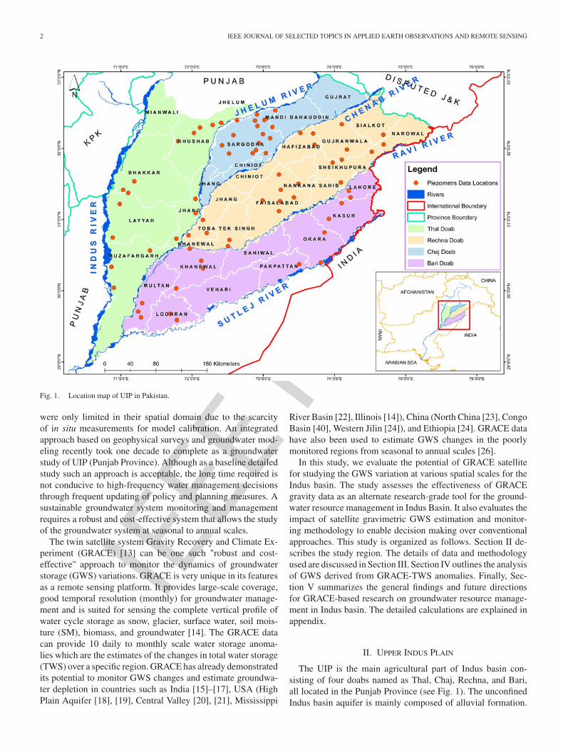
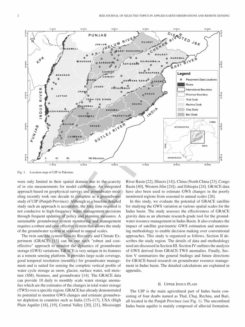
Fig. 1. Location map of UIP in Pakistan.
were only limited in their spatial domain due to the scarcityof in situ measurements for model calibration. An integratedapproach based on geophysical surveys and groundwater mod-eling recently took one decade to complete as a groundwaterstudy of UIP (Punjab Province). Although as a baseline detailedstudy such an approach is acceptable, the long time required isnot conducive to high-frequency water management decisionsthrough frequent updating of policy and planning measures. Asustainable groundwater system monitoring and managementrequires a robust and cost-effective system that allows the studyof the groundwater system at seasonal to annual scales.
The twin satellite system Gravity Recovery and Climate Ex-periment (GRACE) [13] can be one such "robust and cost-effective" approach to monitor the dynamics of groundwaterstorage (GWS) variations. GRACE is very unique in its featuresas a remote sensing platform. It provides large-scale coverage,good temporal resolution (monthly) for groundwater manage-ment and is suited for sensing the complete vertical profile ofwater cycle storage as snow, glacier, surface water, soil mois-ture (SM), biomass, and groundwater [14]. The GRACE datacan provide 10 daily to monthly scale water storage anoma-lies which are the estimates of the changes in total water storage(TWS) over a specific region. GRACE has already demonstratedits potential to monitor GWS changes and estimate groundwa-ter depletion in countries such as India [15]–[17], USA (HighPlain Aquifer [18], [19], Central Valley [20], [21], Mississippi
River Basin [22], Illinois [14]), China (North China [23], CongoBasin [40], Western Jilin [24]), and Ethiopia [24]. GRACE datahave also been used to estimate GWS changes in the poorlymonitored regions from seasonal to annual scales [26].
In this study, we evaluate the potential of GRACE satellitefor studying the GWS variation at various spatial scales for theIndus basin. The study assesses the effectiveness of GRACEgravity data as an alternate research-grade tool for the ground-water resource management in Indus Basin. It also evaluates theimpact of satellite gravimetric GWS estimation and monitor-ing methodology to enable decision making over conventionalapproaches. This study is organized as follows. Section II de-scribes the study region. The details of data and methodologyused are discussed in Section III. Section IV outlines the analysisof GWS derived from GRACE-TWS anomalies. Finally, Sec-tion V summarizes the general findings and future directionsfor GRACE-based research on groundwater resource manage-ment in Indus basin. The detailed calculations are explained inappendix.
II. UPPER INDUS PLAIN
The UIP is the main agricultural part of Indus basin con-sisting of four doabs named as Thal, Chaj, Rechna, and Bari,all located in the Punjab Province (see Fig. 1). The unconfinedIndus basin aquifer is mainly composed of alluvial formation.
IEEE P
roof
IQBAL et al.: SATELLITE GRAVIMETRIC ESTIMATION OF GROUNDWATER STORAGE VARIATIONS OVER INDUS BASIN IN PAKISTAN 3
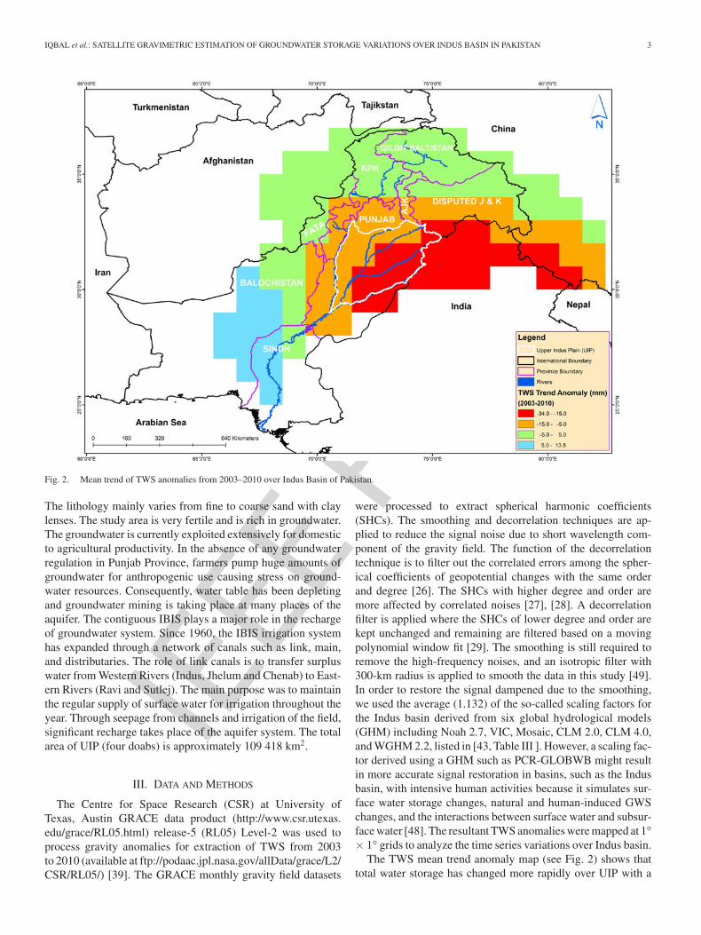
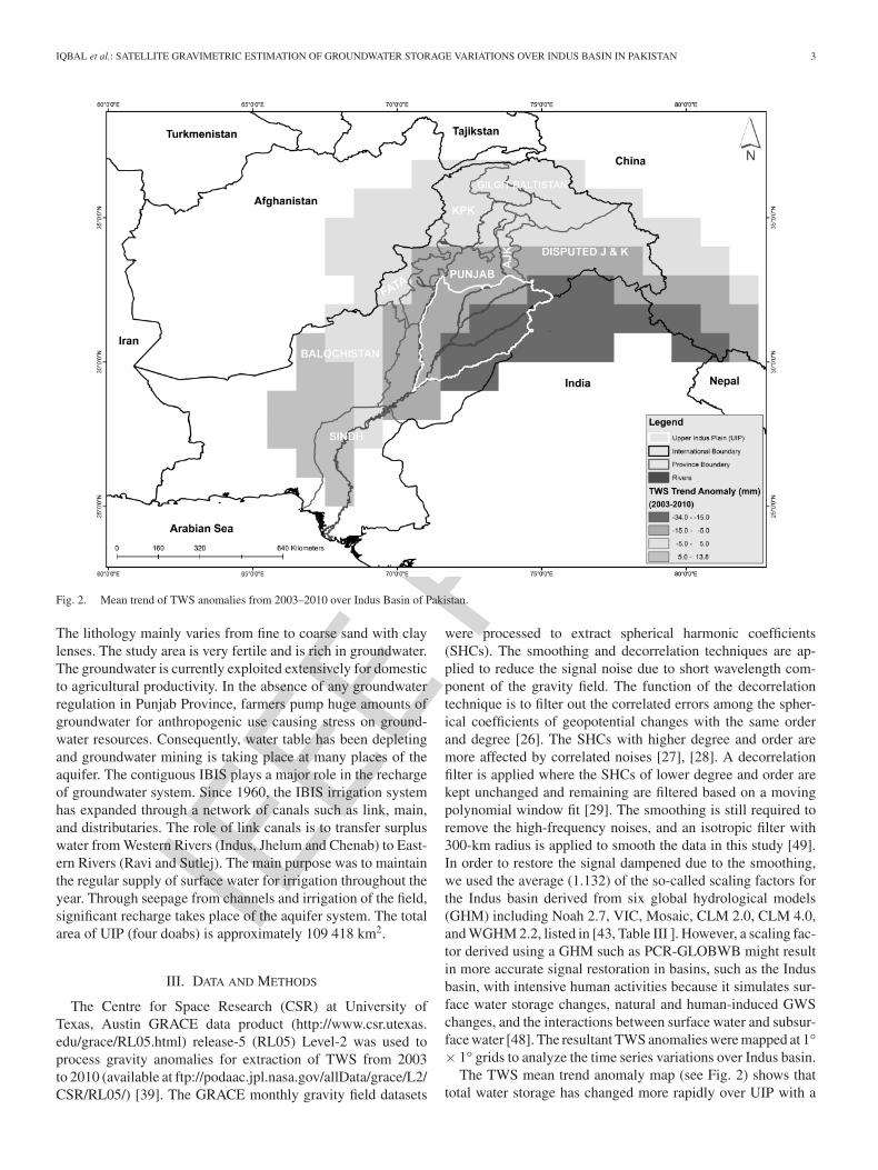
Fig. 2. Mean trend of TWS anomalies from 2003–2010 over Indus Basin of Pakistan.
The lithology mainly varies from fine to coarse sand with claylenses. The study area is very fertile and is rich in groundwater.The groundwater is currently exploited extensively for domesticto agricultural productivity. In the absence of any groundwaterregulation in Punjab Province, farmers pump huge amounts ofgroundwater for anthropogenic use causing stress on ground-water resources. Consequently, water table has been depletingand groundwater mining is taking place at many places of theaquifer. The contiguous IBIS plays a major role in the rechargeof groundwater system. Since 1960, the IBIS irrigation systemhas expanded through a network of canals such as link, main,and distributaries. The role of link canals is to transfer surpluswater from Western Rivers (Indus, Jhelum and Chenab) to East-ern Rivers (Ravi and Sutlej). The main purpose was to maintainthe regular supply of surface water for irrigation throughout theyear. Through seepage from channels and irrigation of the field,significant recharge takes place of the aquifer system. The totalarea of UIP (four doabs) is approximately 109 418 km2.
III. DATA AND METHODS
The Centre for Space Research (CSR) at University ofTexas, Austin GRACE data product (http://www.csr.utexas.edu/grace/RL05.html) release-5 (RL05) Level-2 was used toprocess gravity anomalies for extraction of TWS from 2003to 2010 (available at ftp://podaac.jpl.nasa.gov/allData/grace/L2/CSR/RL05/) [39]. The GRACE monthly gravity field datasets
were processed to extract spherical harmonic coefficients(SHCs). The smoothing and decorrelation techniques are ap-plied to reduce the signal noise due to short wavelength com-ponent of the gravity field. The function of the decorrelationtechnique is to filter out the correlated errors among the spher-ical coefficients of geopotential changes with the same orderand degree [26]. The SHCs with higher degree and order aremore affected by correlated noises [27], [28]. A decorrelationfilter is applied where the SHCs of lower degree and order arekept unchanged and remaining are filtered based on a movingpolynomial window fit [29]. The smoothing is still required toremove the high-frequency noises, and an isotropic filter with300-km radius is applied to smooth the data in this study [49].In order to restore the signal dampened due to the smoothing,we used the average (1.132) of the so-called scaling factors forthe Indus basin derived from six global hydrological models(GHM) including Noah 2.7, VIC, Mosaic, CLM 2.0, CLM 4.0,and WGHM 2.2, listed in [43, Table III ]. However, a scaling fac-tor derived using a GHM such as PCR-GLOBWB might resultin more accurate signal restoration in basins, such as the Indusbasin, with intensive human activities because it simulates sur-face water storage changes, natural and human-induced GWSchanges, and the interactions between surface water and subsur-face water [48]. The resultant TWS anomalies were mapped at 1°× 1° grids to analyze the time series variations over Indus basin.
The TWS mean trend anomaly map (see Fig. 2) shows thattotal water storage has changed more rapidly over UIP with a
IEEE P
roof
4 IEEE JOURNAL OF SELECTED TOPICS IN APPLIED EARTH OBSERVATIONS AND REMOTE SENSING
decrease of 18.54 mm per year (2.03 km3/year) as comparedto whole Indus basin (6.52 mm/year) from 2003 to 2010. Itindicates that UIP is playing an important role in the overallhydrology of Indus basin. The major reason of this significantchange in the variation of TWS over UIP is the extensive use ofgroundwater for anthropogenic activities. The maximum vari-ations in TWS anomalies ranging from −34 to −15 mm areobserved in the Southern part of UIP as compared to Northernpart (−15 to −5 mm). This indicates that the total water storagehas decreased more in two Northern doabs (Bari and Rechna)over the period 2003–2010 (see Fig. 2). The changes in TWS arebasically the sum of variations in all hydrological componentsof water cycle [14]
ΔTWS =ΔGW+ΔSM+ΔSW+ΔSWE+ΔBIO (1)
where GW refers to the change (Δ) in groundwater, SM is theSM contribution, SW and SWE are the surface water and snowwater equivalent or glacier variations, and BIO represents thevariations in the biosphere, respectively.
The topography of the study region is plain with warm cli-mate and snow is uncommon. Therefore, SM may have a majorimpact on TWS variation in the semiarid regions. Global LandData Assimilation System (GLDAS) model-simulated SM in-formation has been used in past studies to remove SM effect[31]. In the present study, variable infiltration capacity (VIC ver-sion 4.0.6) model-derived SM and surface runoff informationover Indus basin is used for the separation of GWS anomalies.In comparison with GLDAS, the VIC model output is Indusbasin specific (0.1° × 0.1°) with greater accuracy. VIC is amacroscale semidistributed hydrological model [31]. It is ex-tensively used to study hydrology, water and energy budgets,and climate change impact assessment [33]–[38]. As a basicfeature, it simulates water balance at daily to subdaily timesteps at each grid cell scale [32]. Recently, the VIC model wasapplied on Ganges–Brahmaputra–Meghna river basins for thesimulation of daily runoff and stream flow fluxes [33]. Thestudy revealed that VIC is capable of capturing daily fluxes ofrunoff and stream flow dynamics. In our study, the VIC modelwas setup at the grid size of 0.1° for daily time steps consid-ering two soil layers with total 1-m thickness (first layer =0.3 m and second layer = 0.7 m). The digital elevation model(90 m) derived from the Shuttle Radar Topographic Missionwas used for topography. The global land cover classification(version-1, 400 m) data sets are used in the model for land coverdetails of Indus basin (https://Ita.cr.urgs.gov/GLCC). For soilinformation, we used harmonized world soil database (version-1.2, approx. 1 km) developed by World Food and AgricultureOrganization (http://www.fao.org/soils-portal/soil-survey/soil-maps-and-databases/harmonized-world-soil-database-v12/en/).
The climatological information was derived from Trop-ical Rainfall Measurement Mission (TRMM) and GlobalSurface Summary of the Day of National Climatic DataCenter maintained through the global network of the WorldMeteorological Organization. The TRMM daily data product32B4RT (0.25° resolution) (http://pmm.nasa.gov/data-access/downloads/trmm) was used for precipitation data. Thesetup was run for daily simulation of SM and surface runoff
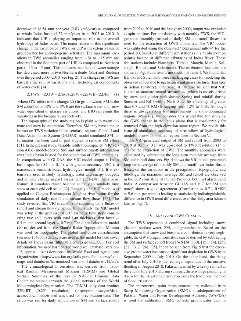
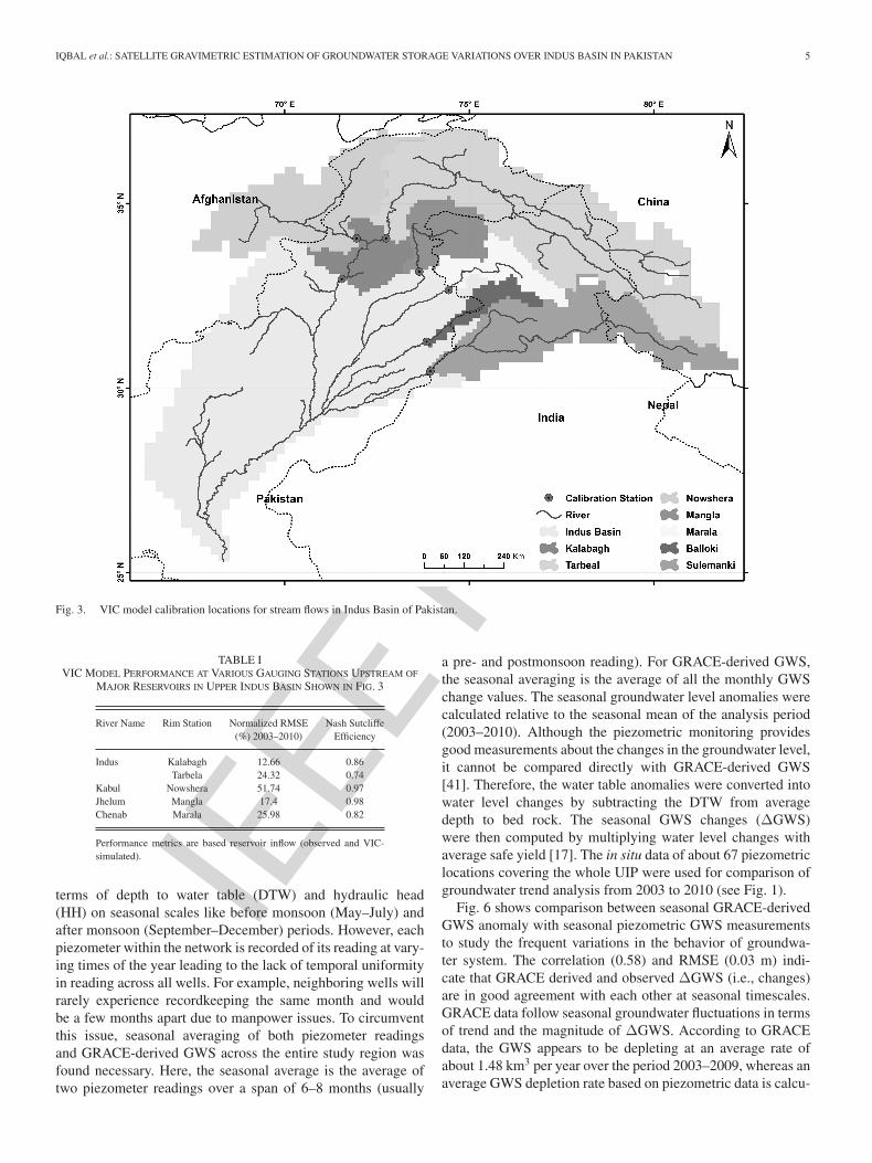
from 2002 to 2010 and the first year (2002) output was excludedas spin-up time. For consistency with monthly TWS, the VIC-generated monthly (instead of daily) SM and runoff fluxes areused for the extraction of GWS anomalies. The VIC modelwas calibrated using the observed "total annual inflow" for theperiod 2003–2010 at different rim stations (in situ observationpoints) located at different tributaries of Indus River. Theserim stations include: Nowshera, Tarbela, Mangla, Marala, Kal-abagh, Balloki, and Suleimanki. The calibration locations areshown in Fig. 3 and results are shown in Table I. We found thatBalloki and Sulemanki were challenging cases for modeling theobserved inflow due to upstream regulation structures (barragesin Indian Territory). Otherwise, it can also be seen that VICis able to simulate annual streamflow (which is mostly drivenby snow and glacier melt during Spring and rainfall duringSummer and Fall) with a Nash–Sutcliffe efficiency of greaterthan 0.7 and % RMSE ranging from 12% to 50%. Althoughthere is always room for improvement in snow-dominatedregions [45]–[47], we consider this acceptable for studyingthe GWS change in the Indus plains that is considerably farremoved from the high-elevation snow region. We revisit thisissue of simulation accuracy of streamflow of hydrologicalmodels in snow-dominated regions later in Section V.
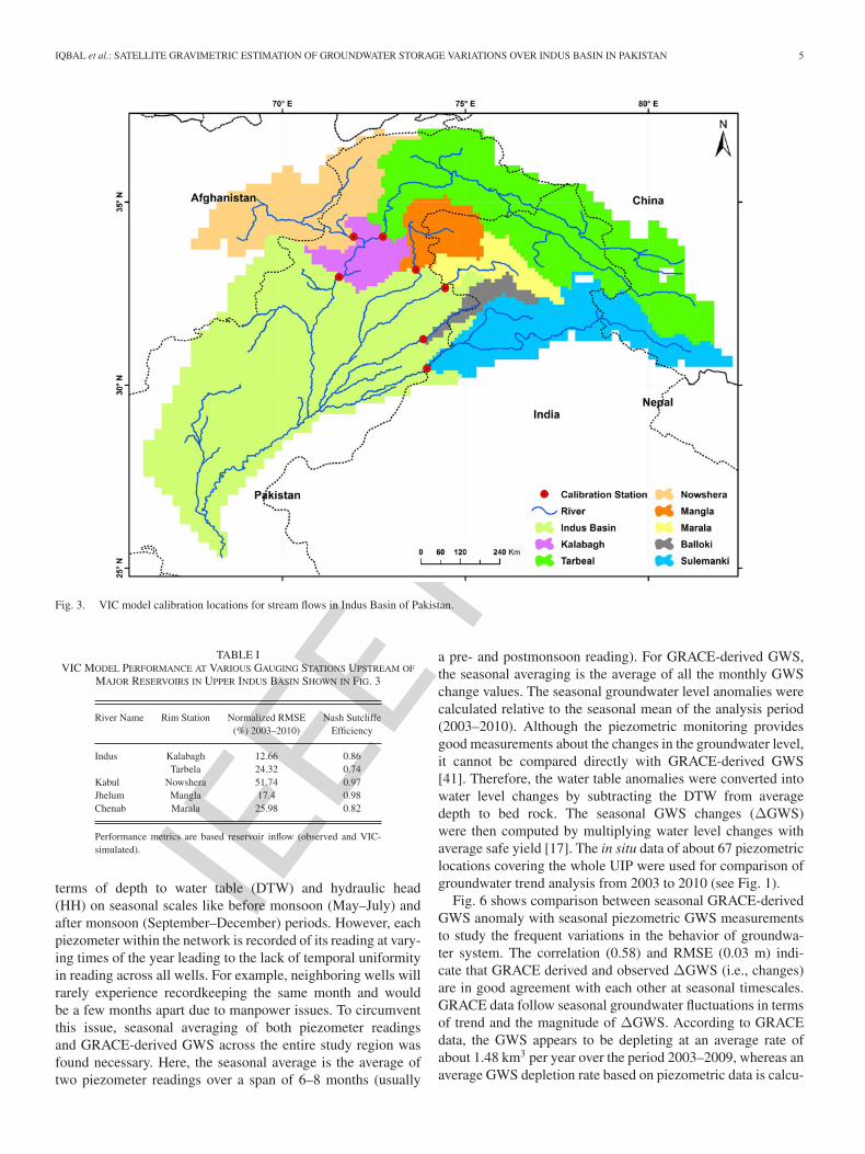
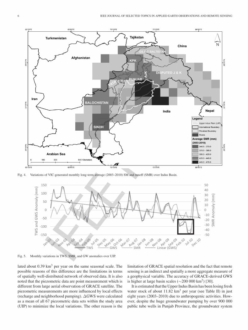
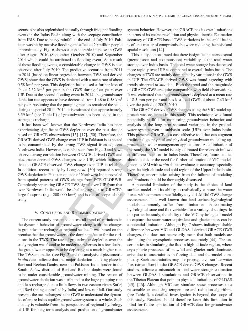
The VIC-generated output of SM and runoff from 2003 to2010 at 0.1° × 0.1° was up-scaled to TWS resolution (1° ×1°) for the extraction of GWS. The monthly anomalies werecalculated by subtracting the long-term monthly average fromSM and runoff data sets. Fig. 4 shows the VIC model-generatedlong-term average of monthly SM and runoff over Indus Basin.Based on the variations in the precipitation, topography, andlithology, the maximum average SM and runoff are observedin the UIP consisting of Punjab Province both in Pakistan andIndia. A comparison between GLDAS and VIC for SM andrunoff shows a good agreement (Correlation = 0.71, RMSE= 9.6 mm per month) leading to statistically indistinguishabledifference in GWS trend differences over the study area (shownlater as Fig. 7).
IV. ANALYZING GWS CHANGES
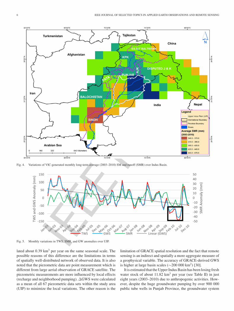
The TWS represents a combined signal including snow,glaciers, surface water, SM, and groundwater. Based on theassumption that snow and biosphere contribution is very negli-gible, the GW storage information can be derived by subtractingthe SM and surface runoff from TWS [34], [30], [15], [14], [23],[21], [31], [24], [35]. It can be seen from Fig. 5 that the exces-sive groundwater has caused significant depletion in GWS fromSeptember 2009 to July 2010. On the other hand, the risingtrend after July 2010 is the recharge impact due to the massiveflooding in August 2010. Pakistan was hit by a heavy rainfall atthe end of July 2010. During summer, there is huge pumping indoabs for the irrigation of rice crop using the traditional methodof flood irrigation.
The piezometric point measurements are collected fromScarp Monitoring Organization (SMO); a subdepartment ofPakistan Water and Power Development Authority (WAPDA)is used for calibration. SMO collects groundwater data in
IEEE P
roof
IQBAL et al.: SATELLITE GRAVIMETRIC ESTIMATION OF GROUNDWATER STORAGE VARIATIONS OVER INDUS BASIN IN PAKISTAN 5
Fig. 3. VIC model calibration locations for stream flows in Indus Basin of Pakistan.
TABLE IVIC MODEL PERFORMANCE AT VARIOUS GAUGING STATIONS UPSTREAM OF
MAJOR RESERVOIRS IN UPPER INDUS BASIN SHOWN IN FIG. 3
River Name Rim Station Normalized RMSE Nash Sutcliffe(%) 2003–2010) Efficiency
Indus Kalabagh 12.66 0.86Tarbela 24.32 0.74
Kabul Nowshera 51.74 0.97Jhelum Mangla 17.4 0.98Chenab Marala 25.98 0.82
Performance metrics are based reservoir inflow (observed and VIC-simulated).
terms of depth to water table (DTW) and hydraulic head(HH) on seasonal scales like before monsoon (May–July) andafter monsoon (September–December) periods. However, eachpiezometer within the network is recorded of its reading at vary-ing times of the year leading to the lack of temporal uniformityin reading across all wells. For example, neighboring wells willrarely experience recordkeeping the same month and wouldbe a few months apart due to manpower issues. To circumventthis issue, seasonal averaging of both piezometer readingsand GRACE-derived GWS across the entire study region wasfound necessary. Here, the seasonal average is the average oftwo piezometer readings over a span of 6–8 months (usually
a pre- and postmonsoon reading). For GRACE-derived GWS,the seasonal averaging is the average of all the monthly GWSchange values. The seasonal groundwater level anomalies werecalculated relative to the seasonal mean of the analysis period(2003–2010). Although the piezometric monitoring providesgood measurements about the changes in the groundwater level,it cannot be compared directly with GRACE-derived GWS[41]. Therefore, the water table anomalies were converted intowater level changes by subtracting the DTW from averagedepth to bed rock. The seasonal GWS changes (ΔGWS)were then computed by multiplying water level changes withaverage safe yield [17]. The in situ data of about 67 piezometriclocations covering the whole UIP were used for comparison ofgroundwater trend analysis from 2003 to 2010 (see Fig. 1).
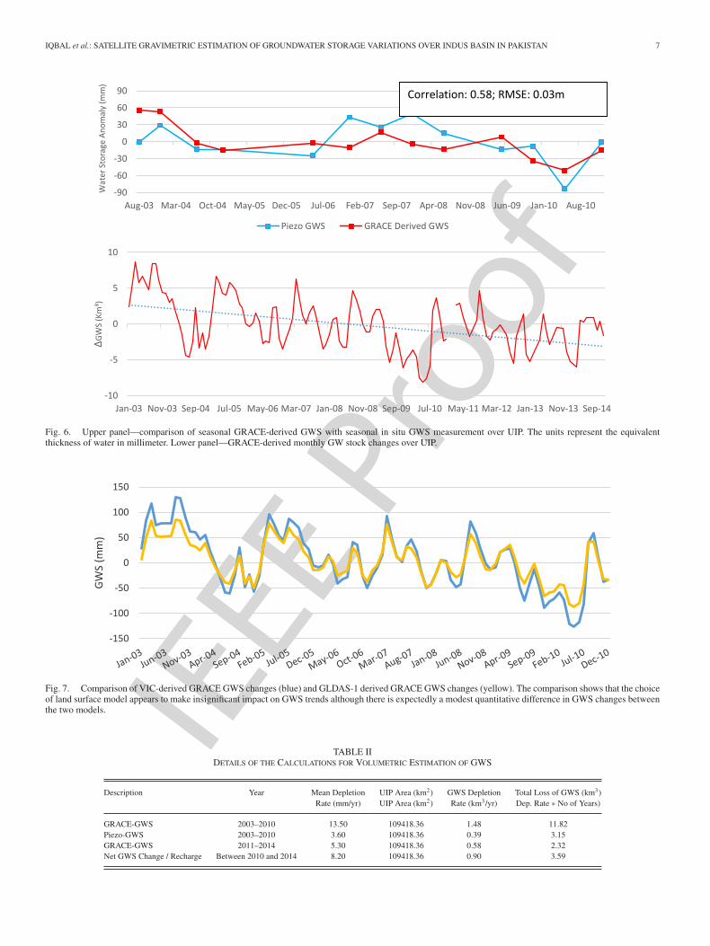
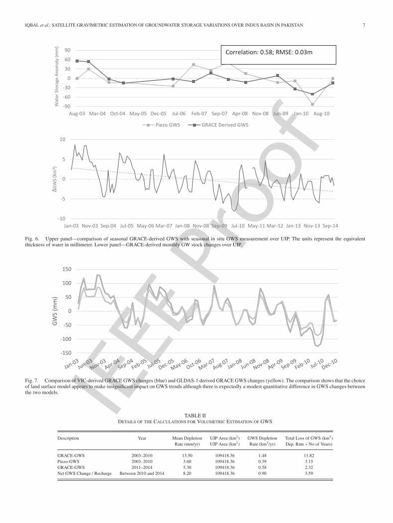
Fig. 6 shows comparison between seasonal GRACE-derivedGWS anomaly with seasonal piezometric GWS measurementsto study the frequent variations in the behavior of groundwa-ter system. The correlation (0.58) and RMSE (0.03 m) indi-cate that GRACE derived and observed ΔGWS (i.e., changes)are in good agreement with each other at seasonal timescales.GRACE data follow seasonal groundwater fluctuations in termsof trend and the magnitude of ΔGWS. According to GRACEdata, the GWS appears to be depleting at an average rate ofabout 1.48 km3 per year over the period 2003–2009, whereas anaverage GWS depletion rate based on piezometric data is calcu-
IEEE P
roof
6 IEEE JOURNAL OF SELECTED TOPICS IN APPLIED EARTH OBSERVATIONS AND REMOTE SENSING
Fig. 4. Variations of VIC-generated monthly long-term average (2003–2010) SM and runoff (SMR) over Indus Basin.
Fig. 5. Monthly variations in TWS, SMR, and GW anomalies over UIP.
lated about 0.39 km3 per year on the same seasonal scale. Thepossible reasons of this difference are the limitations in termsof spatially well-distributed network of observed data. It is alsonoted that the piezometric data are point measurement which isdifferent from large aerial observation of GRACE satellite. Thepiezometric measurements are more influenced by local effects(recharge and neighborhood pumping). ΔGWS were calculatedas a mean of all 67 piezometric data sets within the study area(UIP) to minimize the local variations. The other reason is the
limitation of GRACE spatial resolution and the fact that remotesensing is an indirect and spatially a more aggregate measure ofa geophysical variable. The accuracy of GRACE-derived GWSis higher at large basin scales (∼200 000 km2) [30].
It is estimated that the Upper Indus Basin has been losing freshwater stock of about 11.82 km3 per year (see Table II) in justeight years (2003–2010) due to anthropogenic activities. How-ever, despite the huge groundwater pumping by over 900 000public tube wells in Punjab Province, the groundwater system
IEEE P
roof
IQBAL et al.: SATELLITE GRAVIMETRIC ESTIMATION OF GROUNDWATER STORAGE VARIATIONS OVER INDUS BASIN IN PAKISTAN 7
Fig. 6. Upper panel—comparison of seasonal GRACE-derived GWS with seasonal in situ GWS measurement over UIP. The units represent the equivalentthickness of water in millimeter. Lower panel—GRACE-derived monthly GW stock changes over UIP.
Fig. 7. Comparison of VIC-derived GRACE GWS changes (blue) and GLDAS-1 derived GRACE GWS changes (yellow). The comparison shows that the choiceof land surface model appears to make insignificant impact on GWS trends although there is expectedly a modest quantitative difference in GWS changes betweenthe two models.
TABLE IIDETAILS OF THE CALCULATIONS FOR VOLUMETRIC ESTIMATION OF GWS
Description Year Mean Depletion UIP Area (km2) GWS Depletion Total Loss of GWS (km3)Rate (mm/yr) UIP Area (km2) Rate (km3/yr) Dep. Rate ∗ No of Years)
GRACE-GWS 2003–2010 13.50 109418.36 1.48 11.82Piezo-GWS 2003–2010 3.60 109418.36 0.39 3.15GRACE-GWS 2011–2014 5.30 109418.36 0.58 2.32Net GWS Change / Recharge Between 2010 and 2014 8.20 109418.36 0.90 3.59

IEEE P
roof
8 IEEE JOURNAL OF SELECTED TOPICS IN APPLIED EARTH OBSERVATIONS AND REMOTE SENSING
seems to be also replenished naturally through frequent floodingevents in the Indus Basin along with the seepage contributionfrom IBIS. Due to heavy rainfall at the end of July 2010, Pak-istan was hit by massive flooding and affected 20 million peopleapproximately. Fig. 6 shows a considerable increase in GWSafter August 2010 (September–October 2010) and September2014 which could be attributed to flooding event. As a resultof these flooding events, a considerable change in GWS is alsoobserved after July 2010. The predictive scenarios from 2011to 2014 (based on linear regression between TWS and derivedGWS) show that the GWS is depleted with a mean rate of about0.58 km3 per year. This depletion has caused a further loss ofabout 2.32 km3 per year in the GWS during four years overUIP. Due to the second flooding event in 2014, the groundwaterdepletion rate appears to have decreased from 1.48 to 0.58 km3
per year. Assuming that the pumping rate has remained the sameduring the period 2011–2014, it is estimated that approximately3.59 km3 (see Table II) of groundwater has been added in thestorage as recharge.
It has been well known that the Northwest India has beenexperiencing significant GWS depletion over the past decadebased on GRACE observations [15]–[17], [50]. Therefore, theGRACE-derived GWS change over UIP in Pakistan is expectedto be contaminated by the strong TWS signal from adjacentNorthwest India. However, as can be seen from Figs. 5 and 6, weobserve strong correlation between GRACE-derived GWS andpiezometer-derived GWS changes over UIP, which indicatesthat the GRACE-observed TWS change over UIP is reliable.In addition, recent study by Long et al. [50] reported strongGWS depletion in Pakistan outside of Northwest India revealedfrom spatial patterns of GWS change from PCR-GLOBWB.Completely separating GRACE TWS signal over UIP from thatover Northwest India would be challenging due to GRACE’slarge footprint (e.g., 200 000 km2) and is out of scope of thisstudy.
V. CONCLUSION AND RECOMMENDATIONS
The current study presented an overall trend of variations inthe dynamic behavior of groundwater along with the changesin groundwater recharge at regional scales. It was based on thepremise that the groundwater is the dominant factor for the vari-ations in the TWS. The rate of groundwater depletion over thestudy region was found to be moderate, whereas in a few doabs,the groundwater appears to be depleting at a much higher rate.The TWS anomalies (see Fig. 2) and the analysis of piezometricin situ data indicate that the major depletion is taking place inBari and Rechna Doabs, near the Pakistan–India border in theSouth. A few districts of Bari and Rechna doabs were foundto be under considerable groundwater mining. The reason ofgroundwater depletion was attributed to the huge pumping rateand less recharge due to little flows in two eastern rivers Sutlejand Ravi (being controlled by India) and low rainfall. Our studypresents the mean changes in the GWS to understand the dynam-ics of entire Indus aquifer groundwater system as a whole. Sucha study is valuable from the perspective of regional hydrologyof UIP for long-term analysis and prediction of groundwater
system behavior. However, the GRACE has its own limitationsin terms of its coarse resolution and physical inertia. Estimationaccuracy of GRACE-based TWS variations in the small basinsis often a matter of compromise between reducing the noise andspatial resolution [14].
This study demonstrated that there is significant interseasonal(premonsoon and postmonsoon) variability in the total waterstorage over Indus basin. The total water storage has decreasedmore rapidly over UIP as compared to overall Indus basin. Thechanges in TWS are mainly dominated by variations in the GWSin UIP. The GRACE-derived GWS was found agreeing withtrends observed in situ data. Both the trend and the magnitudeof GRACE-GWS are quite comparable with field observations.It was estimated that the groundwater is depleted at a mean rateof 8.5 mm per year and has lost total GWS of about 7.43 km3
over the period of 2003–2010.The GRACE-derived GWS changes using the VIC model ap-
proach was evaluated in this study. This technique was foundpotentially skillful for monitoring groundwater behavior andanalysis of the long-term seasonal variations in the ground-water system even at subbasin scale (UIP) over Indus basin.This presents GRACE as a cost effective tool that can augmenttraditional geophysical and physical groundwater modeling ap-proaches in water management applications. As a limitation ofthis study, the VIC model is only calibrated for reservoir inflowsat different locations in Indus basin. Therefore, future studiesshould consider the need for further calibration of VIC model-generated SM with in situ data to evaluate its accuracy especiallyover the high-altitude and cold region of the Upper Indus basin.Therefore, uncertainties arising from the failures of modelingand products should be thoroughly discussed
A potential limitation of the study is the choice of landsurface model and its ability to realistically capture the waterfluxes with commensurate fidelity to yield skillful GWS changeassessments. It is well known that land surface hydrologicalmodels commonly suffer from limitations in estimatinghydrological state and flux variables for a variety of settings. Inour particular study, the ability of the VIC hydrological modelto capture the snow water equivalent and glacier mass can bea potential limitation. Although Fig 7 shows indistinguishabledifference between VIC and GLDAS-1 derived GRACE GWSchanges, this does not necessarily mean that both models aresimulating the cryospheric processes accurately [44]. The un-certainties in simulating the flux in high-altitude region, wherecryospheric processes of snowfall and glacier melt dominate,arise due to uncertainties in forcing data and the model com-plexity. Such uncertainties may also propagate via surface waterflux (streamflow) in the GRACE-derive GWS changes. Recentstudies indicate a mismatch in total water storage estimationbetween GLDAS-1 simulations and GRACE observations inthe Tibetan Plateau that point to physical limitations of GLDAS[45], [46]. Although VIC can simulate snow processes to areasonable extent using temperature and radiation algorithms(see Table I), a detailed investigation is beyond the scope ofthis study. Readers should therefore keep this limitation inmind for future application of GRACE data for groundwaterassessments.
IEEE P
roof
IQBAL et al.: SATELLITE GRAVIMETRIC ESTIMATION OF GROUNDWATER STORAGE VARIATIONS OVER INDUS BASIN IN PAKISTAN 9
The detailed study of GWS variations at each doab level couldbe more useful for the operational adoption of GRACE technol-ogy. For effective groundwater resource management in IndusBasin, the doab level GWS information is more desirous fromthe groundwater manager’s perspective. For this purpose, furtherdoab-level study is required to evaluate the potential and accu-racy of GRACE at such small but effective spatial scales. Thespatial downscaling of GRACE signal using Synthetic ApertureRadar and satellite radar altimetry should there be pursued [42].
With the wide applicability of GRACE as an effective toolfor understanding the basin scale hydrology and estimatinggroundwater water storage variations, the confidence ofend-user community can now be raised. The interest and needfor GRACE-based operational water resource management atsmall basins is poised to be scaled up. It is anticipated thatthe GRACE follow-on (GRACE-FO) mission will meet therequirement of water resource managers in terms of spatialresolution enhancement and continuous data availability. It willhelp to promote GRACE as more reliable and successful toolfor groundwater resource management.
ACKNOWLEDGMENT
The authors would like to thank Dr. C. K. Shum of Ohio StateUniversity for providing the GRACE data processing program,and also thank Pakistan Council of Research in Water Resources(PCRWR), which is the home of first author, and Quaid-i-AzamUniversity. This study was made possible because of generoussupport provided by University of Washington Global Affairsand VISIT program that provided the training to first author onGRACE data.
APPENDIX
Calculations Procedure for GRACE Derived GWS Anomalies1) Slope Equation
b =
∑(T − T̃
) (GW − G̃W
)
∑(T −T̃ )2
T = Time (days)T̃ = Mean of time (days)GW = Groundwater anomalies (days)G̃W = Mean of groundwater anomalies (days)
2) b. GWS estimation (km3)
GSEG= GAG∗Area(UIP)
whereGSEG = GRACE GWS anomalies (Volume in km3)GAG = GRACE groundwater anomalies (height in m)Area (UIP) = Area of UIP (109 418.35 km2)Calculations Procedure for Piezometric in situ Data Anoma-
lies1) Groundwater Level Change
GLCP = DTB − DTW,
whereGLCP = Piezometric groundwater level changes (m)
DTW = Depth to water table (m)DTB = Depth to bedrock (Average DTB for UIP = 400 m)
2) Groundwater Level Anomalies
GLAP = GLCP M − GLCP ,
whereGLAP = Piezometric groundwater level anomalies(monthly in meters)GLCPM = Long-term mean of piezometric monthlygroundwater level changes (m)GLCP = Piezometric groundwater level changes (m)
3) GWS anomalies
GSAP = GLAP ∗SY ,
whereGSAP = Piezometric GWS anomalies (m)GLAP = Piezometric groundwater level anomalies (m)SY = Average specific yield (for UIP SY = 0.12)a
4) GWS estimation (km3)
GSEP = GSAP ∗Area(UIP),
whereGSEP = Piezometric GWS anomalies (Volume in km3)GSAP = Piezometric GWS anomalies (m)Area (UIP) = Area of UIP (109 418.35 km2)a—Note: A spatially variable specific yield map is not avail-
able. Only specific yield values over different flood plains (pointmeasurements at only few locations) in the UIP are availablebased on the geological investigations and pumping tests con-ducted by USGS (United States Geological Survey) in collab-oration with WAPDA (Pakistan Water and Power DevelopmentAuthority) in 1960s [9].
REFERENCES
[1] A.S. Qureshi, P. Mccornick, M. Qadir, and Z. Aslam, “Managing salinityand waterlogging in the Indus Basin of Pakistan,” Agricultural Water Man-age., vol. 95. no. 1, pp. 1–10, Jan. 2008, doi: 10.1016/j.agwat.2007.09.014.
[2] J. L. Wescoat Jr., S. J. Halvorson, and D. Mustafa, “Water management inthe Indus Basin of Pakistan: A half-century perspective,” Water Resour.Develop., vol. 16, no. 3, pp. 391–406, Sep. 2000.
[3] Government of Punjab, Pakistan Development Statistics, Bureau of Statis-tics, Government of Punjab, Lahore, Pakistan, 2012, p. 48.
[4] A. S. Qureshi, P. G. McCornick, A. Sarwar, and B. R. Sharma, “Challengesand prospects of sustainable groundwater management in the Indus Basin,Pakistan,” Water Resour. Manage., vol. 24, no. 8, pp. 1551–1569, Jun.2010, doi:10.1007/s11269-009-9513-3.
[5] B. A. Chandio and B.E. Larock, “Three-dimensional model of a skimmingwell,” J. Irrig. Drain Eng., vol. 110, no. 3, pp. 275–288, Sep. 1984,doi:10.1061/(ASCE)0733-9437(1984)110:3(275).
[6] S. Khan, T. Rana, H. F. Gabriel, and M. K. Ullah, “Hydrogeologic assess-ment of escalating groundwater exploitation in the Indus Basin, Pakistan,”Hydrogeol. J., vol. 16, no. 8, pp. 635–1654, Jul. 2008.
[7] M.M. Saeed and M. Ashraf, “Feasible design and operational guidelinesfor skimming wells in the indus basin,” Pakistan. Agri. Water Manage.,vol. 74, no. 3, pp. 165–188, Jan. 2005.
[8] A. B. Sufi, M. Latif, G. V. Skogerboe, “Simulating skimming well tech-niques for sustainable exploitation of groundwater,” Irrig. Drain Syst.,vol. 12, no. 3, pp. 203–226, 1998.
IEEE P
roof
10 IEEE JOURNAL OF SELECTED TOPICS IN APPLIED EARTH OBSERVATIONS AND REMOTE SENSING
[9] G. D. Bennett, A. Rehman, L. A. Sheikh, and S. Ali, “Analysis of aquifertests in the Punjab region of West Pakistan,” USGS, Washington, DC,USA, Water Supply Paper 1608-G, 1967.
[10] A. I. J. M. van Dijk, L. J. Renzullo, and M. Rodell, “Use of GRACE terres-trial water storage retrievals to evaluate model estimates by the Australianwater resources assessment system,” Water Resour. Res., vol. 47, no. 11,Nov. 2011, doi: 10.1029/2011WR010714.
[11] G. Mujtaba, Z. Ahmad, and D. Ophori, “Management of groundwater re-sources in Punjab, Pakistan, using a groundwater flow model,” J. Environ.Hydrol., vol. 16, no. 1, pp. 1–14, Dec. 2008.
[12] A. Ashraf and Z. Ahmad, “ Regional groundwater flow modeling of UpperChaj Doab of Indus Basin, Pakistan using finite element model (Feflow)and geoinformatics,” Geophys. J. Int. (GJI), vol. 173, no. 1, pp. 17–24,Apr. 2008, doi:10.1111/j.1365-246X.2007.03708.x.
[13] S. Swenson, P. J.-F. Yeh, J. Wahr, and J. Famiglietti, “A comparison ofterrestrial water storage variations from GRACE with in situ measure-ments from Illinois,” Geophys. Res. Lett., vol. 33, no. 16, Aug. 2006,doi:10.1029/2006GL026962.
[14] L. Longuevergne, B. R. Scanlon, and C. R. Wilson, “GRACE Hydro-logical estimates for small basins: Evaluating processing approaches onthe high plains aquifer, USA,” Water Resour. Res., vol. 46, no. W11517,pp. 1–15, Nov. 2010.
[15] M. Rodell, I. Velicogna, and J. S. Famiglietti, “Satellite-based esti-mate of groundwater depletion in India,” Nature, vol. 460, Aug. 2009,doi:10.1038/nature08238.
[16] V.M. Tiwari, J. Wahr, and S. Swenson, “Dwindling groundwater resourcesin northern India, from satellite gravity observations,” Geophys. Res. Lett.,vol. 36, Sep. 2009, Art. no. L18401, doi:10.1029/2009GL039401.
[17] J. Chen, J. Jin, Z. Zizhan and N. Shengnan, “Long-term groundwatervariations in northwest India from satellite gravity measurements,” GlobalPlanetary Change, vol. 116, pp. 130–138, 2014.
[18] G. Strassberg, B. R. Scanlon, and M. Rodell, “Comparison of seasonalterrestrial water storage variations from GRACE with groundwater-levelmeasurements from the High Plains Aquifer (USA),” Geophys. Res. Lett.,vol. 34, no. 14, Jul. 2007, Art. no. L14402, doi:10.1029/2007GL030139.
[19] G. Strassberg, B. R. Scanlon, and D. Chambers, “Evaluation of groundwa-ter storage monitoring with the GRACE satellite: Case study of the HighPlains aquifer, central United States,” Water Resour. Res., vol. 45, May2009, Art. no. W05410, doi:10.1029/2008WR006892.
[20] J. S. Famiglietti, M. Lo, S. L. Ho, J. Bethune, K. J. Anderson, T. H.Syed, S. C. Swenson, C. R. de Linage, and M. Rodell, “Satellites mea-sure recent rates of groundwater depletion in California’s central val-ley,” Geophys. Res. Lett., vol. 38, Feb. 2011, Art. no. L03403, doi:10.1029/2010GL046442.
[21] B.R. Scanlon, L. Longuevergne, and D. Long, “Ground referencingGRACE satellite estimates of groundwater storage changes in the Cal-ifornia Central Valley, USA,” Water Resour. Res., vol. 48, Apr. 2012, Art.no. W04520, doi: 10.1029/2011WR011312.
[22] M. Rodell et al., “Estimating groundwater storage changes in the MissippiRiver Basin (USA) using GRACE,” Hydrogeol. J. vol. 15 no. 1, pp. 159–166, Feb. 2007.
[23] W. Feng, et al., “Evaluation of groundwater depletion in North China usingthe Gravity Recovery and Climate Experiment (GRACE) data and ground-based measurements,” Water Resour. Res., vol. 49, no. 4, pp. 2110–2118,Apr. 2013, doi:10.1002/wrcr.20192.
[24] J. P. Moiwo, W. Lu, and F. Tao, “GRACE, GLDAS and measured ground-water data products show water storage loss in Western Jilin, China,”Water Sci. Technol., vol. 65, no. 9, pp. 1606–1614, 2012.
[25] J. L. Awange et al., “Characterization of Ethiopian mega hydrogeologicalregimes using GRACE, TRMM and GLDAS datasets,” Adv. Water Resour.,vol. 74, pp. 64–78, Dec. 2014, doi:10.1016/j.advwatres.2014.07.012.
[26] B. Wouters et al., “GRACE, time-varying gravity, Earth systemdynamics and climate change,” Rep. Prog. Phys., vol. 77, no. 11,Oct. 2014, Art. no. 116801, doi:10.1088/0034-4885/77/11/116801.
[27] C. K. Shum et al., “Inter-annual water storage changes in Asia fromGRACE data,” in Proc. Chapter 6 Climate Change Food Security SouthAsia (Ed-Rattan Lal), R. Lal, Ed. Berlin, Germany: Springer, 2011, ch. 6,doi:10.1007/978-90-481-9516-9_6.
[28] C. Kummerow, B. William, K. Toshiaki, S. James, and J. Simpson,“The tropical rainfall measuring mission (TRMM) sensor package,”J. Atmos. Oceanic Tech., vol. 15, no. 3, pp. 809–8017, 1998, http:((dx.doi.org(10.1175(1520- 0426(1998)015(0809:TTRMMT(2.0.CO;2.
[29] J. Kusche, “Approximate decorrelation and non-isotropic smoothing oftime variable GRACE-type gravity field models,” J. Geodesy, vol. 81,no. 11, pp. 733–749, Feb. 2007, doi:org/10.1007/s00190-007-01.
[30] X. J. Duan, J. Y. Guo, C. K. Shum, and W. ven der Wal, “On thepostprocessing removal of correlated errors in GRACE temporal grav-ity field solutions,” J. Geodesy, vol. 83, no. 11, pp. 1095–1106, Jun. 2009,doi:10.1007/s00190-009-0327-0.
[31] S. Swenson and J. Wahr, “Monitoring changes in continental water storagewith GRACE,” Space Sci. Rev., vol. 108. no. 1, pp. 345–354, 2003.
[32] M. Rodell and J. S. Famiglietti, “An analysis of terrestrial water stor-age variations in Illinois with implications for the Gravity Recoveryand Climate Experiment (GRACE),” Water Resour. Res., vol. 37, no. 5,pp. 1327–1339, May 2001.
[33] X. Liang, D. P. Lettenmaier, E. F. Wood, and S. J. Burges, “A simplehydrologically based model of land surface water and energy fluxes forGSMs,” J. Geophys. Res., vol. 99, no. D7, pp. 14415–14428, Jul. 1994,doi:10.1029/94JD00483.
[34] A. H. M. Siddique-E-Akbor et al. “Satellite precipitation data drivenhydrologic modeling for water resources management in the Ganges,Brahmaputra and Meghna Basins,” Earth Interactions, vol. 18, no. 17,Aug. 2014, doi:10.1175/EI-D-14-0017.1.
[35] B. Zhang, P. Wu, X. Zhao, X. Gao, and Y. Shi, “Assessing the spatialand temporal variation of the rainwater harvesting potential (1971–2010)on the Chinese Loess Plateau using the VIC model,” Hydrol. Process.,vol. 28, pp. 534–544, 2014. doi: 10.1002/hyp.9608.
[36] G. Q. Wang et al., “Assessing water resources in China using PRECISprojections and VIC model,” Hydrol. Earth Syst. Sci. Discuss., vol. 8,pp. 7293–7317, 2011, doi: 10.5194/hessd-8-7293-2011.
[37] X. Xue et al. “New multisite cascading calibration approach for hydro-logical models: Case study in the red river basin using the VIC model,” J.Hydrol. Eng., doi: 10.1061/(ASCE)HE.1943-5584.0001282 , 05015019,Aug., 2015.
[38] Q. Zhao et al., “Coupling a glacier melt model to the variable infiltrationcapacity (VIC) model for hydrological modeling in north-western China,”J. Environ. Earth Sci., vol. 68, no. 1, pp. 87–101, Jan. 2015.
[39] B. Tapley et al., “GGM02—An improved Earth gravity field model fromGRACE,” J. Geodesy, vol. 79, no. 8, pp. 467–478, 2005.
[40] H. Lee, H. C. Jung, T. Yuan, R. E. Beighley, and J. Duan, “Con-trols of terrestrial water storage changes over the central Congo Basindetermined by integrating PALSAR ScanSAR, Envisat altimetry, andGRACE data,” in Proc. Remote Sens. ing Terrestrial Water Cycle, vol.206, AGU Geophysical Monograph, Hoboken, NJ, USA: Wiley, 2014,pp. 117–129.
[41] A. Y. Sun, R. Green, M. Rodell, and S. Swenson, “Inferring aquiferstorage parameters using satellite and in situ measurements: Estimationunder uncertainty,” Geophysical Res. Lett., vol. 37, no. 10, May 2010,doi:10.1029/2010GL043231.
[42] H. Lee, H.C. Jung, T. Yuan, and E. Beighley, “Estimating fine-resolutionterrestrial water storage changes over central Congo by integratingGRACE, PALSAR, and altimetry,” presented at the GRACE Science TeamMeeting, Austin, TX, USA, 2015.
[43] D. Long, L. Longuevergne, and B. R. Scanlon, “Global analysis of ap-proaches for deriving total water storage changes from GRACE satellites,”Water Res. Res., pp. 2574–2594, 2015. doi:10.1002/2014WR016853
[44] W. W. Imerzeel, L. P. H. van Beek, and, M. F. P. Bierkens, “Climatechange will affect the Asian water towers,” Science, vol. 328, no. 5984,pp. 1382–1385, , 2010 doi: 10.1126/science.1183188.
[45] Yang, P., and Y. Chen, “An analysis of terrestrial water storage variationsfrom GRACE and GLDAS: The Tianshan Mountains and its adjacentareas, central Asia,” Quaternary Int., vol. 358, pp. 106–112. 2015.
[46] T. Yang, C. Wang, Z. Yu, and F. Xu, “Characterization of spatio-temporalpatterns for various grace-and gldas-born estimates for changes of globalterrestrial water storage,” Global Planetary Change, vol. 109, pp. 30–37,2013.
[47] B. S. Naz, C. D. Frans, G. K. C. Clarke, P. Burns, and D. P. Lettenmaier,“Modeling the effect of glacier recession on streamflow response using acoupled glacio-hydrological model,” Hydrol. Earth Syst. Sci., vol. 18, no.2, pp. 787–802, 2014.
[48] D. Long et al., “Deriving scaling factor using a global hydrologicalmodel to restore GRACE signals for drought monitoring over China’sYangtze River basin,” Remote Sens. Environ., vol. 168, pp. 177–193,2015.
[49] J. Y. Guo, X. J. Duan, and C. Shum, “Non-isotropic filtering and leak-age reduction for determining mass changes over land and ocean usingGRACE data,” Geophys. J. Int., vol. 181, pp. 290–302, 2010.
[50] D. Long et al. “Have GRACE satellites overestimated groundwater de-pletion in the Northwest India Aquifer?” Sci. Rep., vol. 6, 2016, Art. no.24398.
IEEE P
roof
IQBAL et al.: SATELLITE GRAVIMETRIC ESTIMATION OF GROUNDWATER STORAGE VARIATIONS OVER INDUS BASIN IN PAKISTAN 11
Naveed Iqbal received the B.S. degree in physicsand mathematics from the Sargodha University ofPakistan, Sargodha, Pakistan, in 2004, and the M.S.degree in meteorology from the COMSAT Instituteof Information Technology, Islamabad, Pakistan. Heis currently working toward the Ph.D. degree in geo-physics at Quaid-E-Azam University, Islamabad in2012.
He is currently the Assistant Director of Geo-graphic Information Systems and Remote SensingDivision, Pakistan Council of Research in Water Re-
sources, Islamabad.
Faisal Hossain received the B.S. degree from the In-dian Institute of Technology, Varanasi, India, in 1996,the M.S. degree in Civil Engineering from the Na-tional University of Singapore, Singapore, in 1999,and the Ph.D. degree in Environmental Engineeringfrom the University of Connecticut, Storrs, CT, USA,in 2004.
He is currently an Associate Professor in the De-partment of Civil and Environmental Engineering,University of Washington, Seattle, WA, USA. His re-search interests include hydrologic remote sensing,
sustainable water resources engineering, transboundary water resources man-agement, and engineering education.
Hyongki Lee received the B.S. degree in civil engi-neering and M.S. degree in geomatics from YonseiUniversity, Seoul, Korea, in 2000, and 2002, respec-tively, and the Ph.D. degree in geodetic science fromOhio State University, Columbus, OH, USA, in 2008.
He is an Assistant Professor with the Departmentof Civil and Environmental Engineering, Universityof Houston, Houston, TX, USA. His research inter-ests include quantifying and characterizing terrestrialwater dynamics using satellite geodetic and remotesensing data for water resources management.
Gulraiz Akhter received his B.S in Physics in 1980 from Punjab University. HisMS and PhD is from Quaid-E-Azam University in 1984 and 2003, respectively.Both degrees are in the field of geophysics. He is a Member of Faculty ingeophysics with Quaid-E-Azam University, Islamabad, Pakistan.
IEEE P
roof
IEEE JOURNAL OF SELECTED TOPICS IN APPLIED EARTH OBSERVATIONS AND REMOTE SENSING 1
Satellite Gravimetric Estimation of GroundwaterStorage Variations Over Indus Basin in Pakistan
Naveed Iqbal, Faisal Hossain, Hyongki Lee, and Gulraiz Akhter
Abstract—Like other agrarian countries, Pakistan is now heav-ily dependent on its groundwater resources to meet the irrigatedagricultural water demand. Groundwater has emerged as a majorsource with more than 60% contribution in total water supplies.In the absence of groundwater regulation, the uneven and over-exploitation of groundwater resource in Indus Basin has causedseveral problems of water table decline, groundwater mining, anddeterioration of groundwater quality. This study evaluates thepotential of Gravity Recovery and Climate Experiment Satellite(GRACE)-based estimation of changes in groundwater storage(GWS) as a cost-effective approach for groundwater monitoringand policy recommendations for sustainable water management inthe Indus basin. The GRACE monthly gravity anomalies from 2003to 2010 were analyzed as total water storage (TWS) variations.The variable infiltration capacity hydrological model-generatedsoil moisture and surface runoff were used for the separation ofTWS into GWS anomalies. The GRACE-based GWS anomaliesare found to favorably agree with trends inferred from in situpiezometric data. A general depletion trend is observed in UpperIndus Plain (UIP) where groundwater is found to be declining at amean rate of about 13.5 mm per year in equivalent height of waterduring 2003–2010. A total loss of about 11.82 km3 per year freshgroundwater stock is inferred for UIP. Based on TWS variationsand ground knowledge, the two southern river plains, Bari andRechna are found to be under threat of extensive groundwater de-pletion. GRACE TWS data were also able to pick up signals fromthe large-scale flooding events observed in 2010 and 2014. Theseflooding events played a significant role in the replenishment ofthe groundwater system in Indus Basin. Our study indicates thatthe GRACE-based estimation of GWS changes is skillful enoughto provide monthly updates on the trend of the GWS changes forresource managers and policy makers of Indus basin.
Index Terms—Gravity Recovery and Climate Experiment Satel-lite (GRACE), groundwater, Indus basin, Pakistan, remote sensing.
I. INTRODUCTION
THE socio-economic development of an agrarian countrylike Pakistan is dependent on its water resources. Indus
basin is the major source of groundwater which contributes
Manuscript received September 20, 2015; revised December 24, 2015, March15, 2016, and May 19, 2016; accepted May 26, 2016. This work was supportedby the NASA SERVIR program under Grant NNX12AM85AG, NASA WA-TER under Grant NNX15AC63G, and NASA GRACE program under GrantNNX12AJ95G.
N. Iqbal and G. Akhter are with the Earth Sciences, Quaid-E-AzamUniversity, Islamabad 45320, Pakistan (e-mail: [email protected];[email protected]).
F. Hossain is with the Civil and Environmental Engineering, University ofWashington, Seattle, WA 98195 USA (e-mail: [email protected]).
H. Lee is with the Civil and Envornmental Engineering, University of Hous-ton, Houston, TX 77204 USA (e-mail: [email protected]).
Color versions of one or more of the figures in this paper are available onlineat http://ieeexplore.ieee.org.
Digital Object Identifier 10.1109/JSTARS.2016.2574378
more than 60% in the total water supplies. More than 80%of the groundwater originates from Upper Indus Plain (UIP)consisting of four riverine plains (known locally as “doabs”).The term doab is specifically defined as the floodplain locatedbetween two rivers and is a fertile ground for irrigated agricul-tural production. The irrigated agricultural requirements mainlydepend on the groundwater supplies for more than 90% of agri-cultural production in Pakistan [1]. The Indus Basin IrrigationSystem (IBIS) is the world’s largest well-connected irrigationsystem which was constructed after Indus Water Treaty in 1960[2]. The seepage from contiguous IBIS has played its major roleto naturally replenish the groundwater system.
After 2000, major groundwater development was initiatedwhere the total number of tube wells installed in Punjab Provincecrossed 0.94 million in just one decade (2000–2010) [3]. Theindiscriminate pumping of groundwater using these wells hascaused several management problems. Water table depletion,salt water up-coning, water quality deterioration, and ground-water mining have become problematic issues in the doab areas[4]–[9]. In fresh groundwater areas of Punjab, the imbalancebetween abstraction and recharge has caused water table deple-tion [4]. In Central Punjab, a thin layer of fresh groundwaterexists over the saline water due to recharge. As a result ofoverexploitation, the downward gradient has caused salt waterintrusion in fresh groundwater layer [4]. The percentage of areawith shallow water table (< 6 m) has considerably decreaseddue to groundwater mining. On the other hand, the percentageof the area with ground water table at depths below 6 m hasrapidly increased. The water table depletion of about 2–3 m peryear has resulted groundwater mining in different fresh ground-water areas of Punjab Province [4]. The groundwater is mainlypumped to meet the agricultural, domestic, and industrial needsfor over 80 million population [3] in the Punjab Province. Thefarmers use groundwater as a main source of continuous sup-ply for the production of wheat, rice, sugarcane, potatoes, othercash, and fodder crops. In Pakistan, the rice crop is irrigated by atraditional flood irrigation method which requires a lot of waterto meet the standing water demand in the fields. During summerperiod in the rice growing areas, almost 90% demand of irriga-tion is met from groundwater supply. In future, the groundwaterwill become more expensive and could adversely impact foodsecurity [4].
Sustainable groundwater resource management requires theroutinely updated (high frequency) knowledge about character,dynamics, and behavior of the groundwater system at appropri-ate spatial scales [10]. Many physical groundwater models suchas Visual Mod Flow [11] and FeFlow [12] have been applied tostudy the groundwater system in Indus basin. But these studies
1939-1404 © 2016 IEEE. Personal use is permitted, but republication/redistribution requires IEEE permission.See http://www.ieee.org/publications standards/publications/rights/index.html for more information.
IEEE P
roof
2 IEEE JOURNAL OF SELECTED TOPICS IN APPLIED EARTH OBSERVATIONS AND REMOTE SENSING
Fig. 1. Location map of UIP in Pakistan.
were only limited in their spatial domain due to the scarcityof in situ measurements for model calibration. An integratedapproach based on geophysical surveys and groundwater mod-eling recently took one decade to complete as a groundwaterstudy of UIP (Punjab Province). Although as a baseline detailedstudy such an approach is acceptable, the long time required isnot conducive to high-frequency water management decisionsthrough frequent updating of policy and planning measures. Asustainable groundwater system monitoring and managementrequires a robust and cost-effective system that allows the studyof the groundwater system at seasonal to annual scales.
The twin satellite system Gravity Recovery and Climate Ex-periment (GRACE) [13] can be one such "robust and cost-effective" approach to monitor the dynamics of groundwaterstorage (GWS) variations. GRACE is very unique in its featuresas a remote sensing platform. It provides large-scale coverage,good temporal resolution (monthly) for groundwater manage-ment and is suited for sensing the complete vertical profile ofwater cycle storage as snow, glacier, surface water, soil mois-ture (SM), biomass, and groundwater [14]. The GRACE datacan provide 10 daily to monthly scale water storage anoma-lies which are the estimates of the changes in total water storage(TWS) over a specific region. GRACE has already demonstratedits potential to monitor GWS changes and estimate groundwa-ter depletion in countries such as India [15]–[17], USA (HighPlain Aquifer [18], [19], Central Valley [20], [21], Mississippi
River Basin [22], Illinois [14]), China (North China [23], CongoBasin [40], Western Jilin [24]), and Ethiopia [24]. GRACE datahave also been used to estimate GWS changes in the poorlymonitored regions from seasonal to annual scales [26].
In this study, we evaluate the potential of GRACE satellitefor studying the GWS variation at various spatial scales for theIndus basin. The study assesses the effectiveness of GRACEgravity data as an alternate research-grade tool for the ground-water resource management in Indus Basin. It also evaluates theimpact of satellite gravimetric GWS estimation and monitor-ing methodology to enable decision making over conventionalapproaches. This study is organized as follows. Section II de-scribes the study region. The details of data and methodologyused are discussed in Section III. Section IV outlines the analysisof GWS derived from GRACE-TWS anomalies. Finally, Sec-tion V summarizes the general findings and future directionsfor GRACE-based research on groundwater resource manage-ment in Indus basin. The detailed calculations are explained inappendix.
II. UPPER INDUS PLAIN
The UIP is the main agricultural part of Indus basin con-sisting of four doabs named as Thal, Chaj, Rechna, and Bari,all located in the Punjab Province (see Fig. 1). The unconfinedIndus basin aquifer is mainly composed of alluvial formation.
IEEE P
roof
IQBAL et al.: SATELLITE GRAVIMETRIC ESTIMATION OF GROUNDWATER STORAGE VARIATIONS OVER INDUS BASIN IN PAKISTAN 3
Fig. 2. Mean trend of TWS anomalies from 2003–2010 over Indus Basin of Pakistan.
The lithology mainly varies from fine to coarse sand with claylenses. The study area is very fertile and is rich in groundwater.The groundwater is currently exploited extensively for domesticto agricultural productivity. In the absence of any groundwaterregulation in Punjab Province, farmers pump huge amounts ofgroundwater for anthropogenic use causing stress on ground-water resources. Consequently, water table has been depletingand groundwater mining is taking place at many places of theaquifer. The contiguous IBIS plays a major role in the rechargeof groundwater system. Since 1960, the IBIS irrigation systemhas expanded through a network of canals such as link, main,and distributaries. The role of link canals is to transfer surpluswater from Western Rivers (Indus, Jhelum and Chenab) to East-ern Rivers (Ravi and Sutlej). The main purpose was to maintainthe regular supply of surface water for irrigation throughout theyear. Through seepage from channels and irrigation of the field,significant recharge takes place of the aquifer system. The totalarea of UIP (four doabs) is approximately 109 418 km2.
III. DATA AND METHODS
The Centre for Space Research (CSR) at University ofTexas, Austin GRACE data product (http://www.csr.utexas.edu/grace/RL05.html) release-5 (RL05) Level-2 was used toprocess gravity anomalies for extraction of TWS from 2003to 2010 (available at ftp://podaac.jpl.nasa.gov/allData/grace/L2/CSR/RL05/) [39]. The GRACE monthly gravity field datasets
were processed to extract spherical harmonic coefficients(SHCs). The smoothing and decorrelation techniques are ap-plied to reduce the signal noise due to short wavelength com-ponent of the gravity field. The function of the decorrelationtechnique is to filter out the correlated errors among the spher-ical coefficients of geopotential changes with the same orderand degree [26]. The SHCs with higher degree and order aremore affected by correlated noises [27], [28]. A decorrelationfilter is applied where the SHCs of lower degree and order arekept unchanged and remaining are filtered based on a movingpolynomial window fit [29]. The smoothing is still required toremove the high-frequency noises, and an isotropic filter with300-km radius is applied to smooth the data in this study [49].In order to restore the signal dampened due to the smoothing,we used the average (1.132) of the so-called scaling factors forthe Indus basin derived from six global hydrological models(GHM) including Noah 2.7, VIC, Mosaic, CLM 2.0, CLM 4.0,and WGHM 2.2, listed in [43, Table III ]. However, a scaling fac-tor derived using a GHM such as PCR-GLOBWB might resultin more accurate signal restoration in basins, such as the Indusbasin, with intensive human activities because it simulates sur-face water storage changes, natural and human-induced GWSchanges, and the interactions between surface water and subsur-face water [48]. The resultant TWS anomalies were mapped at 1°× 1° grids to analyze the time series variations over Indus basin.
The TWS mean trend anomaly map (see Fig. 2) shows thattotal water storage has changed more rapidly over UIP with a

IEEE P
roof
4 IEEE JOURNAL OF SELECTED TOPICS IN APPLIED EARTH OBSERVATIONS AND REMOTE SENSING
decrease of 18.54 mm per year (2.03 km3/year) as comparedto whole Indus basin (6.52 mm/year) from 2003 to 2010. Itindicates that UIP is playing an important role in the overallhydrology of Indus basin. The major reason of this significantchange in the variation of TWS over UIP is the extensive use ofgroundwater for anthropogenic activities. The maximum vari-ations in TWS anomalies ranging from −34 to −15 mm areobserved in the Southern part of UIP as compared to Northernpart (−15 to −5 mm). This indicates that the total water storagehas decreased more in two Northern doabs (Bari and Rechna)over the period 2003–2010 (see Fig. 2). The changes in TWS arebasically the sum of variations in all hydrological componentsof water cycle [14]
ΔTWS =ΔGW+ΔSM+ΔSW+ΔSWE+ΔBIO (1)
where GW refers to the change (Δ) in groundwater, SM is theSM contribution, SW and SWE are the surface water and snowwater equivalent or glacier variations, and BIO represents thevariations in the biosphere, respectively.
The topography of the study region is plain with warm cli-mate and snow is uncommon. Therefore, SM may have a majorimpact on TWS variation in the semiarid regions. Global LandData Assimilation System (GLDAS) model-simulated SM in-formation has been used in past studies to remove SM effect[31]. In the present study, variable infiltration capacity (VIC ver-sion 4.0.6) model-derived SM and surface runoff informationover Indus basin is used for the separation of GWS anomalies.In comparison with GLDAS, the VIC model output is Indusbasin specific (0.1° × 0.1°) with greater accuracy. VIC is amacroscale semidistributed hydrological model [31]. It is ex-tensively used to study hydrology, water and energy budgets,and climate change impact assessment [33]–[38]. As a basicfeature, it simulates water balance at daily to subdaily timesteps at each grid cell scale [32]. Recently, the VIC model wasapplied on Ganges–Brahmaputra–Meghna river basins for thesimulation of daily runoff and stream flow fluxes [33]. Thestudy revealed that VIC is capable of capturing daily fluxes ofrunoff and stream flow dynamics. In our study, the VIC modelwas setup at the grid size of 0.1° for daily time steps consid-ering two soil layers with total 1-m thickness (first layer =0.3 m and second layer = 0.7 m). The digital elevation model(90 m) derived from the Shuttle Radar Topographic Missionwas used for topography. The global land cover classification(version-1, 400 m) data sets are used in the model for land coverdetails of Indus basin (https://Ita.cr.urgs.gov/GLCC). For soilinformation, we used harmonized world soil database (version-1.2, approx. 1 km) developed by World Food and AgricultureOrganization (http://www.fao.org/soils-portal/soil-survey/soil-maps-and-databases/harmonized-world-soil-database-v12/en/).
The climatological information was derived from Trop-ical Rainfall Measurement Mission (TRMM) and GlobalSurface Summary of the Day of National Climatic DataCenter maintained through the global network of the WorldMeteorological Organization. The TRMM daily data product32B4RT (0.25° resolution) (http://pmm.nasa.gov/data-access/downloads/trmm) was used for precipitation data. Thesetup was run for daily simulation of SM and surface runoff
from 2002 to 2010 and the first year (2002) output was excludedas spin-up time. For consistency with monthly TWS, the VIC-generated monthly (instead of daily) SM and runoff fluxes areused for the extraction of GWS anomalies. The VIC modelwas calibrated using the observed "total annual inflow" for theperiod 2003–2010 at different rim stations (in situ observationpoints) located at different tributaries of Indus River. Theserim stations include: Nowshera, Tarbela, Mangla, Marala, Kal-abagh, Balloki, and Suleimanki. The calibration locations areshown in Fig. 3 and results are shown in Table I. We found thatBalloki and Sulemanki were challenging cases for modeling theobserved inflow due to upstream regulation structures (barragesin Indian Territory). Otherwise, it can also be seen that VICis able to simulate annual streamflow (which is mostly drivenby snow and glacier melt during Spring and rainfall duringSummer and Fall) with a Nash–Sutcliffe efficiency of greaterthan 0.7 and % RMSE ranging from 12% to 50%. Althoughthere is always room for improvement in snow-dominatedregions [45]–[47], we consider this acceptable for studyingthe GWS change in the Indus plains that is considerably farremoved from the high-elevation snow region. We revisit thisissue of simulation accuracy of streamflow of hydrologicalmodels in snow-dominated regions later in Section V.
The VIC-generated output of SM and runoff from 2003 to2010 at 0.1° × 0.1° was up-scaled to TWS resolution (1° ×1°) for the extraction of GWS. The monthly anomalies werecalculated by subtracting the long-term monthly average fromSM and runoff data sets. Fig. 4 shows the VIC model-generatedlong-term average of monthly SM and runoff over Indus Basin.Based on the variations in the precipitation, topography, andlithology, the maximum average SM and runoff are observedin the UIP consisting of Punjab Province both in Pakistan andIndia. A comparison between GLDAS and VIC for SM andrunoff shows a good agreement (Correlation = 0.71, RMSE= 9.6 mm per month) leading to statistically indistinguishabledifference in GWS trend differences over the study area (shownlater as Fig. 7).
IV. ANALYZING GWS CHANGES
The TWS represents a combined signal including snow,glaciers, surface water, SM, and groundwater. Based on theassumption that snow and biosphere contribution is very negli-gible, the GW storage information can be derived by subtractingthe SM and surface runoff from TWS [34], [30], [15], [14], [23],[21], [31], [24], [35]. It can be seen from Fig. 5 that the exces-sive groundwater has caused significant depletion in GWS fromSeptember 2009 to July 2010. On the other hand, the risingtrend after July 2010 is the recharge impact due to the massiveflooding in August 2010. Pakistan was hit by a heavy rainfall atthe end of July 2010. During summer, there is huge pumping indoabs for the irrigation of rice crop using the traditional methodof flood irrigation.
The piezometric point measurements are collected fromScarp Monitoring Organization (SMO); a subdepartment ofPakistan Water and Power Development Authority (WAPDA)is used for calibration. SMO collects groundwater data in
IEEE P
roof
IQBAL et al.: SATELLITE GRAVIMETRIC ESTIMATION OF GROUNDWATER STORAGE VARIATIONS OVER INDUS BASIN IN PAKISTAN 5
Fig. 3. VIC model calibration locations for stream flows in Indus Basin of Pakistan.
TABLE IVIC MODEL PERFORMANCE AT VARIOUS GAUGING STATIONS UPSTREAM OF
MAJOR RESERVOIRS IN UPPER INDUS BASIN SHOWN IN FIG. 3
River Name Rim Station Normalized RMSE Nash Sutcliffe(%) 2003–2010) Efficiency
Indus Kalabagh 12.66 0.86Tarbela 24.32 0.74
Kabul Nowshera 51.74 0.97Jhelum Mangla 17.4 0.98Chenab Marala 25.98 0.82
Performance metrics are based reservoir inflow (observed and VIC-simulated).
terms of depth to water table (DTW) and hydraulic head(HH) on seasonal scales like before monsoon (May–July) andafter monsoon (September–December) periods. However, eachpiezometer within the network is recorded of its reading at vary-ing times of the year leading to the lack of temporal uniformityin reading across all wells. For example, neighboring wells willrarely experience recordkeeping the same month and wouldbe a few months apart due to manpower issues. To circumventthis issue, seasonal averaging of both piezometer readingsand GRACE-derived GWS across the entire study region wasfound necessary. Here, the seasonal average is the average oftwo piezometer readings over a span of 6–8 months (usually
a pre- and postmonsoon reading). For GRACE-derived GWS,the seasonal averaging is the average of all the monthly GWSchange values. The seasonal groundwater level anomalies werecalculated relative to the seasonal mean of the analysis period(2003–2010). Although the piezometric monitoring providesgood measurements about the changes in the groundwater level,it cannot be compared directly with GRACE-derived GWS[41]. Therefore, the water table anomalies were converted intowater level changes by subtracting the DTW from averagedepth to bed rock. The seasonal GWS changes (ΔGWS)were then computed by multiplying water level changes withaverage safe yield [17]. The in situ data of about 67 piezometriclocations covering the whole UIP were used for comparison ofgroundwater trend analysis from 2003 to 2010 (see Fig. 1).
Fig. 6 shows comparison between seasonal GRACE-derivedGWS anomaly with seasonal piezometric GWS measurementsto study the frequent variations in the behavior of groundwa-ter system. The correlation (0.58) and RMSE (0.03 m) indi-cate that GRACE derived and observed ΔGWS (i.e., changes)are in good agreement with each other at seasonal timescales.GRACE data follow seasonal groundwater fluctuations in termsof trend and the magnitude of ΔGWS. According to GRACEdata, the GWS appears to be depleting at an average rate ofabout 1.48 km3 per year over the period 2003–2009, whereas anaverage GWS depletion rate based on piezometric data is calcu-
IEEE P
roof
6 IEEE JOURNAL OF SELECTED TOPICS IN APPLIED EARTH OBSERVATIONS AND REMOTE SENSING
Fig. 4. Variations of VIC-generated monthly long-term average (2003–2010) SM and runoff (SMR) over Indus Basin.
Fig. 5. Monthly variations in TWS, SMR, and GW anomalies over UIP.
lated about 0.39 km3 per year on the same seasonal scale. Thepossible reasons of this difference are the limitations in termsof spatially well-distributed network of observed data. It is alsonoted that the piezometric data are point measurement which isdifferent from large aerial observation of GRACE satellite. Thepiezometric measurements are more influenced by local effects(recharge and neighborhood pumping). ΔGWS were calculatedas a mean of all 67 piezometric data sets within the study area(UIP) to minimize the local variations. The other reason is the
limitation of GRACE spatial resolution and the fact that remotesensing is an indirect and spatially a more aggregate measure ofa geophysical variable. The accuracy of GRACE-derived GWSis higher at large basin scales (∼200 000 km2) [30].
It is estimated that the Upper Indus Basin has been losing freshwater stock of about 11.82 km3 per year (see Table II) in justeight years (2003–2010) due to anthropogenic activities. How-ever, despite the huge groundwater pumping by over 900 000public tube wells in Punjab Province, the groundwater system
IEEE P
roof
IQBAL et al.: SATELLITE GRAVIMETRIC ESTIMATION OF GROUNDWATER STORAGE VARIATIONS OVER INDUS BASIN IN PAKISTAN 7
Fig. 6. Upper panel—comparison of seasonal GRACE-derived GWS with seasonal in situ GWS measurement over UIP. The units represent the equivalentthickness of water in millimeter. Lower panel—GRACE-derived monthly GW stock changes over UIP.
Fig. 7. Comparison of VIC-derived GRACE GWS changes (blue) and GLDAS-1 derived GRACE GWS changes (yellow). The comparison shows that the choiceof land surface model appears to make insignificant impact on GWS trends although there is expectedly a modest quantitative difference in GWS changes betweenthe two models.
TABLE IIDETAILS OF THE CALCULATIONS FOR VOLUMETRIC ESTIMATION OF GWS
Description Year Mean Depletion UIP Area (km2) GWS Depletion Total Loss of GWS (km3)Rate (mm/yr) UIP Area (km2) Rate (km3/yr) Dep. Rate ∗ No of Years)
GRACE-GWS 2003–2010 13.50 109418.36 1.48 11.82Piezo-GWS 2003–2010 3.60 109418.36 0.39 3.15GRACE-GWS 2011–2014 5.30 109418.36 0.58 2.32Net GWS Change / Recharge Between 2010 and 2014 8.20 109418.36 0.90 3.59
IEEE P
roof
8 IEEE JOURNAL OF SELECTED TOPICS IN APPLIED EARTH OBSERVATIONS AND REMOTE SENSING
seems to be also replenished naturally through frequent floodingevents in the Indus Basin along with the seepage contributionfrom IBIS. Due to heavy rainfall at the end of July 2010, Pak-istan was hit by massive flooding and affected 20 million peopleapproximately. Fig. 6 shows a considerable increase in GWSafter August 2010 (September–October 2010) and September2014 which could be attributed to flooding event. As a resultof these flooding events, a considerable change in GWS is alsoobserved after July 2010. The predictive scenarios from 2011to 2014 (based on linear regression between TWS and derivedGWS) show that the GWS is depleted with a mean rate of about0.58 km3 per year. This depletion has caused a further loss ofabout 2.32 km3 per year in the GWS during four years overUIP. Due to the second flooding event in 2014, the groundwaterdepletion rate appears to have decreased from 1.48 to 0.58 km3
per year. Assuming that the pumping rate has remained the sameduring the period 2011–2014, it is estimated that approximately3.59 km3 (see Table II) of groundwater has been added in thestorage as recharge.
It has been well known that the Northwest India has beenexperiencing significant GWS depletion over the past decadebased on GRACE observations [15]–[17], [50]. Therefore, theGRACE-derived GWS change over UIP in Pakistan is expectedto be contaminated by the strong TWS signal from adjacentNorthwest India. However, as can be seen from Figs. 5 and 6, weobserve strong correlation between GRACE-derived GWS andpiezometer-derived GWS changes over UIP, which indicatesthat the GRACE-observed TWS change over UIP is reliable.In addition, recent study by Long et al. [50] reported strongGWS depletion in Pakistan outside of Northwest India revealedfrom spatial patterns of GWS change from PCR-GLOBWB.Completely separating GRACE TWS signal over UIP from thatover Northwest India would be challenging due to GRACE’slarge footprint (e.g., 200 000 km2) and is out of scope of thisstudy.
V. CONCLUSION AND RECOMMENDATIONS
The current study presented an overall trend of variations inthe dynamic behavior of groundwater along with the changesin groundwater recharge at regional scales. It was based on thepremise that the groundwater is the dominant factor for the vari-ations in the TWS. The rate of groundwater depletion over thestudy region was found to be moderate, whereas in a few doabs,the groundwater appears to be depleting at a much higher rate.The TWS anomalies (see Fig. 2) and the analysis of piezometricin situ data indicate that the major depletion is taking place inBari and Rechna Doabs, near the Pakistan–India border in theSouth. A few districts of Bari and Rechna doabs were foundto be under considerable groundwater mining. The reason ofgroundwater depletion was attributed to the huge pumping rateand less recharge due to little flows in two eastern rivers Sutlejand Ravi (being controlled by India) and low rainfall. Our studypresents the mean changes in the GWS to understand the dynam-ics of entire Indus aquifer groundwater system as a whole. Sucha study is valuable from the perspective of regional hydrologyof UIP for long-term analysis and prediction of groundwater
system behavior. However, the GRACE has its own limitationsin terms of its coarse resolution and physical inertia. Estimationaccuracy of GRACE-based TWS variations in the small basinsis often a matter of compromise between reducing the noise andspatial resolution [14].
This study demonstrated that there is significant interseasonal(premonsoon and postmonsoon) variability in the total waterstorage over Indus basin. The total water storage has decreasedmore rapidly over UIP as compared to overall Indus basin. Thechanges in TWS are mainly dominated by variations in the GWSin UIP. The GRACE-derived GWS was found agreeing withtrends observed in situ data. Both the trend and the magnitudeof GRACE-GWS are quite comparable with field observations.It was estimated that the groundwater is depleted at a mean rateof 8.5 mm per year and has lost total GWS of about 7.43 km3
over the period of 2003–2010.The GRACE-derived GWS changes using the VIC model ap-
proach was evaluated in this study. This technique was foundpotentially skillful for monitoring groundwater behavior andanalysis of the long-term seasonal variations in the ground-water system even at subbasin scale (UIP) over Indus basin.This presents GRACE as a cost effective tool that can augmenttraditional geophysical and physical groundwater modeling ap-proaches in water management applications. As a limitation ofthis study, the VIC model is only calibrated for reservoir inflowsat different locations in Indus basin. Therefore, future studiesshould consider the need for further calibration of VIC model-generated SM with in situ data to evaluate its accuracy especiallyover the high-altitude and cold region of the Upper Indus basin.Therefore, uncertainties arising from the failures of modelingand products should be thoroughly discussed
A potential limitation of the study is the choice of landsurface model and its ability to realistically capture the waterfluxes with commensurate fidelity to yield skillful GWS changeassessments. It is well known that land surface hydrologicalmodels commonly suffer from limitations in estimatinghydrological state and flux variables for a variety of settings. Inour particular study, the ability of the VIC hydrological modelto capture the snow water equivalent and glacier mass can bea potential limitation. Although Fig 7 shows indistinguishabledifference between VIC and GLDAS-1 derived GRACE GWSchanges, this does not necessarily mean that both models aresimulating the cryospheric processes accurately [44]. The un-certainties in simulating the flux in high-altitude region, wherecryospheric processes of snowfall and glacier melt dominate,arise due to uncertainties in forcing data and the model com-plexity. Such uncertainties may also propagate via surface waterflux (streamflow) in the GRACE-derive GWS changes. Recentstudies indicate a mismatch in total water storage estimationbetween GLDAS-1 simulations and GRACE observations inthe Tibetan Plateau that point to physical limitations of GLDAS[45], [46]. Although VIC can simulate snow processes to areasonable extent using temperature and radiation algorithms(see Table I), a detailed investigation is beyond the scope ofthis study. Readers should therefore keep this limitation inmind for future application of GRACE data for groundwaterassessments.

IEEE P
roof
IQBAL et al.: SATELLITE GRAVIMETRIC ESTIMATION OF GROUNDWATER STORAGE VARIATIONS OVER INDUS BASIN IN PAKISTAN 9
The detailed study of GWS variations at each doab level couldbe more useful for the operational adoption of GRACE technol-ogy. For effective groundwater resource management in IndusBasin, the doab level GWS information is more desirous fromthe groundwater manager’s perspective. For this purpose, furtherdoab-level study is required to evaluate the potential and accu-racy of GRACE at such small but effective spatial scales. Thespatial downscaling of GRACE signal using Synthetic ApertureRadar and satellite radar altimetry should there be pursued [42].
With the wide applicability of GRACE as an effective toolfor understanding the basin scale hydrology and estimatinggroundwater water storage variations, the confidence ofend-user community can now be raised. The interest and needfor GRACE-based operational water resource management atsmall basins is poised to be scaled up. It is anticipated thatthe GRACE follow-on (GRACE-FO) mission will meet therequirement of water resource managers in terms of spatialresolution enhancement and continuous data availability. It willhelp to promote GRACE as more reliable and successful toolfor groundwater resource management.
ACKNOWLEDGMENT
The authors would like to thank Dr. C. K. Shum of Ohio StateUniversity for providing the GRACE data processing program,and also thank Pakistan Council of Research in Water Resources(PCRWR), which is the home of first author, and Quaid-i-AzamUniversity. This study was made possible because of generoussupport provided by University of Washington Global Affairsand VISIT program that provided the training to first author onGRACE data.
APPENDIX
Calculations Procedure for GRACE Derived GWS Anomalies1) Slope Equation
b =
∑(T − T̃
) (GW − G̃W
)
∑(T −T̃ )2
T = Time (days)T̃ = Mean of time (days)GW = Groundwater anomalies (days)G̃W = Mean of groundwater anomalies (days)
2) b. GWS estimation (km3)
GSEG= GAG∗Area(UIP)
whereGSEG = GRACE GWS anomalies (Volume in km3)GAG = GRACE groundwater anomalies (height in m)Area (UIP) = Area of UIP (109 418.35 km2)Calculations Procedure for Piezometric in situ Data Anoma-
lies1) Groundwater Level Change
GLCP = DTB − DTW,
whereGLCP = Piezometric groundwater level changes (m)
DTW = Depth to water table (m)DTB = Depth to bedrock (Average DTB for UIP = 400 m)
2) Groundwater Level Anomalies
GLAP = GLCP M − GLCP ,
whereGLAP = Piezometric groundwater level anomalies(monthly in meters)GLCPM = Long-term mean of piezometric monthlygroundwater level changes (m)GLCP = Piezometric groundwater level changes (m)
3) GWS anomalies
GSAP = GLAP ∗SY ,
whereGSAP = Piezometric GWS anomalies (m)GLAP = Piezometric groundwater level anomalies (m)SY = Average specific yield (for UIP SY = 0.12)a
4) GWS estimation (km3)
GSEP = GSAP ∗Area(UIP),
whereGSEP = Piezometric GWS anomalies (Volume in km3)GSAP = Piezometric GWS anomalies (m)Area (UIP) = Area of UIP (109 418.35 km2)a—Note: A spatially variable specific yield map is not avail-
able. Only specific yield values over different flood plains (pointmeasurements at only few locations) in the UIP are availablebased on the geological investigations and pumping tests con-ducted by USGS (United States Geological Survey) in collab-oration with WAPDA (Pakistan Water and Power DevelopmentAuthority) in 1960s [9].
REFERENCES
[1] A.S. Qureshi, P. Mccornick, M. Qadir, and Z. Aslam, “Managing salinityand waterlogging in the Indus Basin of Pakistan,” Agricultural Water Man-age., vol. 95. no. 1, pp. 1–10, Jan. 2008, doi: 10.1016/j.agwat.2007.09.014.
[2] J. L. Wescoat Jr., S. J. Halvorson, and D. Mustafa, “Water management inthe Indus Basin of Pakistan: A half-century perspective,” Water Resour.Develop., vol. 16, no. 3, pp. 391–406, Sep. 2000.
[3] Government of Punjab, Pakistan Development Statistics, Bureau of Statis-tics, Government of Punjab, Lahore, Pakistan, 2012, p. 48.
[4] A. S. Qureshi, P. G. McCornick, A. Sarwar, and B. R. Sharma, “Challengesand prospects of sustainable groundwater management in the Indus Basin,Pakistan,” Water Resour. Manage., vol. 24, no. 8, pp. 1551–1569, Jun.2010, doi:10.1007/s11269-009-9513-3.
[5] B. A. Chandio and B.E. Larock, “Three-dimensional model of a skimmingwell,” J. Irrig. Drain Eng., vol. 110, no. 3, pp. 275–288, Sep. 1984,doi:10.1061/(ASCE)0733-9437(1984)110:3(275).
[6] S. Khan, T. Rana, H. F. Gabriel, and M. K. Ullah, “Hydrogeologic assess-ment of escalating groundwater exploitation in the Indus Basin, Pakistan,”Hydrogeol. J., vol. 16, no. 8, pp. 635–1654, Jul. 2008.
[7] M.M. Saeed and M. Ashraf, “Feasible design and operational guidelinesfor skimming wells in the indus basin,” Pakistan. Agri. Water Manage.,vol. 74, no. 3, pp. 165–188, Jan. 2005.
[8] A. B. Sufi, M. Latif, G. V. Skogerboe, “Simulating skimming well tech-niques for sustainable exploitation of groundwater,” Irrig. Drain Syst.,vol. 12, no. 3, pp. 203–226, 1998.
IEEE P
roof
10 IEEE JOURNAL OF SELECTED TOPICS IN APPLIED EARTH OBSERVATIONS AND REMOTE SENSING
[9] G. D. Bennett, A. Rehman, L. A. Sheikh, and S. Ali, “Analysis of aquifertests in the Punjab region of West Pakistan,” USGS, Washington, DC,USA, Water Supply Paper 1608-G, 1967.
[10] A. I. J. M. van Dijk, L. J. Renzullo, and M. Rodell, “Use of GRACE terres-trial water storage retrievals to evaluate model estimates by the Australianwater resources assessment system,” Water Resour. Res., vol. 47, no. 11,Nov. 2011, doi: 10.1029/2011WR010714.
[11] G. Mujtaba, Z. Ahmad, and D. Ophori, “Management of groundwater re-sources in Punjab, Pakistan, using a groundwater flow model,” J. Environ.Hydrol., vol. 16, no. 1, pp. 1–14, Dec. 2008.
[12] A. Ashraf and Z. Ahmad, “ Regional groundwater flow modeling of UpperChaj Doab of Indus Basin, Pakistan using finite element model (Feflow)and geoinformatics,” Geophys. J. Int. (GJI), vol. 173, no. 1, pp. 17–24,Apr. 2008, doi:10.1111/j.1365-246X.2007.03708.x.
[13] S. Swenson, P. J.-F. Yeh, J. Wahr, and J. Famiglietti, “A comparison ofterrestrial water storage variations from GRACE with in situ measure-ments from Illinois,” Geophys. Res. Lett., vol. 33, no. 16, Aug. 2006,doi:10.1029/2006GL026962.
[14] L. Longuevergne, B. R. Scanlon, and C. R. Wilson, “GRACE Hydro-logical estimates for small basins: Evaluating processing approaches onthe high plains aquifer, USA,” Water Resour. Res., vol. 46, no. W11517,pp. 1–15, Nov. 2010.
[15] M. Rodell, I. Velicogna, and J. S. Famiglietti, “Satellite-based esti-mate of groundwater depletion in India,” Nature, vol. 460, Aug. 2009,doi:10.1038/nature08238.
[16] V.M. Tiwari, J. Wahr, and S. Swenson, “Dwindling groundwater resourcesin northern India, from satellite gravity observations,” Geophys. Res. Lett.,vol. 36, Sep. 2009, Art. no. L18401, doi:10.1029/2009GL039401.
[17] J. Chen, J. Jin, Z. Zizhan and N. Shengnan, “Long-term groundwatervariations in northwest India from satellite gravity measurements,” GlobalPlanetary Change, vol. 116, pp. 130–138, 2014.
[18] G. Strassberg, B. R. Scanlon, and M. Rodell, “Comparison of seasonalterrestrial water storage variations from GRACE with groundwater-levelmeasurements from the High Plains Aquifer (USA),” Geophys. Res. Lett.,vol. 34, no. 14, Jul. 2007, Art. no. L14402, doi:10.1029/2007GL030139.
[19] G. Strassberg, B. R. Scanlon, and D. Chambers, “Evaluation of groundwa-ter storage monitoring with the GRACE satellite: Case study of the HighPlains aquifer, central United States,” Water Resour. Res., vol. 45, May2009, Art. no. W05410, doi:10.1029/2008WR006892.
[20] J. S. Famiglietti, M. Lo, S. L. Ho, J. Bethune, K. J. Anderson, T. H.Syed, S. C. Swenson, C. R. de Linage, and M. Rodell, “Satellites mea-sure recent rates of groundwater depletion in California’s central val-ley,” Geophys. Res. Lett., vol. 38, Feb. 2011, Art. no. L03403, doi:10.1029/2010GL046442.
[21] B.R. Scanlon, L. Longuevergne, and D. Long, “Ground referencingGRACE satellite estimates of groundwater storage changes in the Cal-ifornia Central Valley, USA,” Water Resour. Res., vol. 48, Apr. 2012, Art.no. W04520, doi: 10.1029/2011WR011312.
[22] M. Rodell et al., “Estimating groundwater storage changes in the MissippiRiver Basin (USA) using GRACE,” Hydrogeol. J. vol. 15 no. 1, pp. 159–166, Feb. 2007.
[23] W. Feng, et al., “Evaluation of groundwater depletion in North China usingthe Gravity Recovery and Climate Experiment (GRACE) data and ground-based measurements,” Water Resour. Res., vol. 49, no. 4, pp. 2110–2118,Apr. 2013, doi:10.1002/wrcr.20192.
[24] J. P. Moiwo, W. Lu, and F. Tao, “GRACE, GLDAS and measured ground-water data products show water storage loss in Western Jilin, China,”Water Sci. Technol., vol. 65, no. 9, pp. 1606–1614, 2012.
[25] J. L. Awange et al., “Characterization of Ethiopian mega hydrogeologicalregimes using GRACE, TRMM and GLDAS datasets,” Adv. Water Resour.,vol. 74, pp. 64–78, Dec. 2014, doi:10.1016/j.advwatres.2014.07.012.
[26] B. Wouters et al., “GRACE, time-varying gravity, Earth systemdynamics and climate change,” Rep. Prog. Phys., vol. 77, no. 11,Oct. 2014, Art. no. 116801, doi:10.1088/0034-4885/77/11/116801.
[27] C. K. Shum et al., “Inter-annual water storage changes in Asia fromGRACE data,” in Proc. Chapter 6 Climate Change Food Security SouthAsia (Ed-Rattan Lal), R. Lal, Ed. Berlin, Germany: Springer, 2011, ch. 6,doi:10.1007/978-90-481-9516-9_6.
[28] C. Kummerow, B. William, K. Toshiaki, S. James, and J. Simpson,“The tropical rainfall measuring mission (TRMM) sensor package,”J. Atmos. Oceanic Tech., vol. 15, no. 3, pp. 809–8017, 1998, http:((dx.doi.org(10.1175(1520- 0426(1998)015(0809:TTRMMT(2.0.CO;2.
[29] J. Kusche, “Approximate decorrelation and non-isotropic smoothing oftime variable GRACE-type gravity field models,” J. Geodesy, vol. 81,no. 11, pp. 733–749, Feb. 2007, doi:org/10.1007/s00190-007-01.
[30] X. J. Duan, J. Y. Guo, C. K. Shum, and W. ven der Wal, “On thepostprocessing removal of correlated errors in GRACE temporal grav-ity field solutions,” J. Geodesy, vol. 83, no. 11, pp. 1095–1106, Jun. 2009,doi:10.1007/s00190-009-0327-0.
[31] S. Swenson and J. Wahr, “Monitoring changes in continental water storagewith GRACE,” Space Sci. Rev., vol. 108. no. 1, pp. 345–354, 2003.
[32] M. Rodell and J. S. Famiglietti, “An analysis of terrestrial water stor-age variations in Illinois with implications for the Gravity Recoveryand Climate Experiment (GRACE),” Water Resour. Res., vol. 37, no. 5,pp. 1327–1339, May 2001.
[33] X. Liang, D. P. Lettenmaier, E. F. Wood, and S. J. Burges, “A simplehydrologically based model of land surface water and energy fluxes forGSMs,” J. Geophys. Res., vol. 99, no. D7, pp. 14415–14428, Jul. 1994,doi:10.1029/94JD00483.
[34] A. H. M. Siddique-E-Akbor et al. “Satellite precipitation data drivenhydrologic modeling for water resources management in the Ganges,Brahmaputra and Meghna Basins,” Earth Interactions, vol. 18, no. 17,Aug. 2014, doi:10.1175/EI-D-14-0017.1.
[35] B. Zhang, P. Wu, X. Zhao, X. Gao, and Y. Shi, “Assessing the spatialand temporal variation of the rainwater harvesting potential (1971–2010)on the Chinese Loess Plateau using the VIC model,” Hydrol. Process.,vol. 28, pp. 534–544, 2014. doi: 10.1002/hyp.9608.
[36] G. Q. Wang et al., “Assessing water resources in China using PRECISprojections and VIC model,” Hydrol. Earth Syst. Sci. Discuss., vol. 8,pp. 7293–7317, 2011, doi: 10.5194/hessd-8-7293-2011.
[37] X. Xue et al. “New multisite cascading calibration approach for hydro-logical models: Case study in the red river basin using the VIC model,” J.Hydrol. Eng., doi: 10.1061/(ASCE)HE.1943-5584.0001282 , 05015019,Aug., 2015.
[38] Q. Zhao et al., “Coupling a glacier melt model to the variable infiltrationcapacity (VIC) model for hydrological modeling in north-western China,”J. Environ. Earth Sci., vol. 68, no. 1, pp. 87–101, Jan. 2015.
[39] B. Tapley et al., “GGM02—An improved Earth gravity field model fromGRACE,” J. Geodesy, vol. 79, no. 8, pp. 467–478, 2005.
[40] H. Lee, H. C. Jung, T. Yuan, R. E. Beighley, and J. Duan, “Con-trols of terrestrial water storage changes over the central Congo Basindetermined by integrating PALSAR ScanSAR, Envisat altimetry, andGRACE data,” in Proc. Remote Sens. ing Terrestrial Water Cycle, vol.206, AGU Geophysical Monograph, Hoboken, NJ, USA: Wiley, 2014,pp. 117–129.
[41] A. Y. Sun, R. Green, M. Rodell, and S. Swenson, “Inferring aquiferstorage parameters using satellite and in situ measurements: Estimationunder uncertainty,” Geophysical Res. Lett., vol. 37, no. 10, May 2010,doi:10.1029/2010GL043231.
[42] H. Lee, H.C. Jung, T. Yuan, and E. Beighley, “Estimating fine-resolutionterrestrial water storage changes over central Congo by integratingGRACE, PALSAR, and altimetry,” presented at the GRACE Science TeamMeeting, Austin, TX, USA, 2015.
[43] D. Long, L. Longuevergne, and B. R. Scanlon, “Global analysis of ap-proaches for deriving total water storage changes from GRACE satellites,”Water Res. Res., pp. 2574–2594, 2015. doi:10.1002/2014WR016853
[44] W. W. Imerzeel, L. P. H. van Beek, and, M. F. P. Bierkens, “Climatechange will affect the Asian water towers,” Science, vol. 328, no. 5984,pp. 1382–1385, , 2010 doi: 10.1126/science.1183188.
[45] Yang, P., and Y. Chen, “An analysis of terrestrial water storage variationsfrom GRACE and GLDAS: The Tianshan Mountains and its adjacentareas, central Asia,” Quaternary Int., vol. 358, pp. 106–112. 2015.
[46] T. Yang, C. Wang, Z. Yu, and F. Xu, “Characterization of spatio-temporalpatterns for various grace-and gldas-born estimates for changes of globalterrestrial water storage,” Global Planetary Change, vol. 109, pp. 30–37,2013.
[47] B. S. Naz, C. D. Frans, G. K. C. Clarke, P. Burns, and D. P. Lettenmaier,“Modeling the effect of glacier recession on streamflow response using acoupled glacio-hydrological model,” Hydrol. Earth Syst. Sci., vol. 18, no.2, pp. 787–802, 2014.
[48] D. Long et al., “Deriving scaling factor using a global hydrologicalmodel to restore GRACE signals for drought monitoring over China’sYangtze River basin,” Remote Sens. Environ., vol. 168, pp. 177–193,2015.
[49] J. Y. Guo, X. J. Duan, and C. Shum, “Non-isotropic filtering and leak-age reduction for determining mass changes over land and ocean usingGRACE data,” Geophys. J. Int., vol. 181, pp. 290–302, 2010.
[50] D. Long et al. “Have GRACE satellites overestimated groundwater de-pletion in the Northwest India Aquifer?” Sci. Rep., vol. 6, 2016, Art. no.24398.

IEEE P
roof
IQBAL et al.: SATELLITE GRAVIMETRIC ESTIMATION OF GROUNDWATER STORAGE VARIATIONS OVER INDUS BASIN IN PAKISTAN 11
Naveed Iqbal received the B.S. degree in physicsand mathematics from the Sargodha University ofPakistan, Sargodha, Pakistan, in 2004, and the M.S.degree in meteorology from the COMSAT Instituteof Information Technology, Islamabad, Pakistan. Heis currently working toward the Ph.D. degree in geo-physics at Quaid-E-Azam University, Islamabad in2012.
He is currently the Assistant Director of Geo-graphic Information Systems and Remote SensingDivision, Pakistan Council of Research in Water Re-
sources, Islamabad.
Faisal Hossain received the B.S. degree from the In-dian Institute of Technology, Varanasi, India, in 1996,the M.S. degree in Civil Engineering from the Na-tional University of Singapore, Singapore, in 1999,and the Ph.D. degree in Environmental Engineeringfrom the University of Connecticut, Storrs, CT, USA,in 2004.
He is currently an Associate Professor in the De-partment of Civil and Environmental Engineering,University of Washington, Seattle, WA, USA. His re-search interests include hydrologic remote sensing,
sustainable water resources engineering, transboundary water resources man-agement, and engineering education.
Hyongki Lee received the B.S. degree in civil engi-neering and M.S. degree in geomatics from YonseiUniversity, Seoul, Korea, in 2000, and 2002, respec-tively, and the Ph.D. degree in geodetic science fromOhio State University, Columbus, OH, USA, in 2008.
He is an Assistant Professor with the Departmentof Civil and Environmental Engineering, Universityof Houston, Houston, TX, USA. His research inter-ests include quantifying and characterizing terrestrialwater dynamics using satellite geodetic and remotesensing data for water resources management.
Gulraiz Akhter received his B.S in Physics in 1980 from Punjab University. HisMS and PhD is from Quaid-E-Azam University in 1984 and 2003, respectively.Both degrees are in the field of geophysics. He is a Member of Faculty ingeophysics with Quaid-E-Azam University, Islamabad, Pakistan.