Embed Size (px)
Citation preview
Research Journal of Recent Sciences _________________________________________________ ISSN 2277-2502
Vol. 4(ISC-2014), 255-260 (2015) Res. J. Recent. Sci.
International Science Congress Association 255
Satellite Data Based Groundwater Prospects Study in Gurgaon District,
Haryana, India Anup Kumar
1*, R.S.Hooda
1, Anuj Goyal
2 and Arun Goel
2
1Haryana Space Applications Centre (HARSAC), Deptt.of Science and Technology, Haryana, CCS HAU Campus, Hisar-125004, Haryana,
INDIA 2Department of Civil Engineering, National Institute of Technology, Kurukshetra-136119, Haryana, INDIA
Available online at: www.isca.in, www.isca.me Received 20th November 2014, revised 20th March 2015, accepted 6th April 2015
Abstract
Water is the prime natural resource for sustaining the life on the earth. The increasing population, urbanisation,
industrialisation and agricultural practices have put pressure on the availability and quality of water especially on
groundwater. For fulfilling the increasing demand of water in various sectors, there is need of searching, planning and
management of surface and groundwater resources. In the present technological era, the remote sensing satellite data are
highly useful for searching potential groundwater sites. In the study, IRS P6 LISS III satellite data of the year 2006 have been
used for groundwater prospects mapping in Gurgaon district of Haryana State. Gurgaon district is situated between the
latitudes 27039’58” N to 28
032’30”N and longitudes 76
039’10”E to 77
020’27”E and covering 1254 sq.km area. The climate of
the district is semi-arid type. The district has rocks of Delhi Super group comprising mainly quartzite and most part of the
district is covered with alluvium and sand of Quaternary age. The present study has been carried out with main objective to map
groundwater prospects in the district using satellite data. For achieving the objective, various thematic maps such as base map,
lithology, lineament, geomorphology and drainage have been prepared on 1:50,000 scale with the help of IRS P6 LISS III
satellite data of the year 2006, Survey of India (SOI) Toposheets and District Resource Map of Geological Survey of India (GSI)
in ArcGIS 9.3 software. All the thematic maps have been integrated and prepared groundwater prospects map. Field visit has
been done at selected locations to check the interpreted features. The field information has been incorporated in the pre-field
maps and finalized all the thematic maps as well as groundwater prospects map. In the district, major groundwater prospects
units are older alluvial plain, aeolian plain, sand dune complex, denudational hills and structural hills.The groundwater
prospects in older alluvial plain is good to very good; in aeolian plain the groundwater prospects is moderate to good while in
sand dune complex, denudational hills and structural hills the groundwater prospects is poor.The study provides the scenario of
groundwater potential for targeting groundwater exploration sites, planning and management in the district.
Keywords: Satellite, IRS, groundwater, prospects, Gurgaon, Haryana, India.
Introduction
Water is prime requirement for living beings on the planet earth.
Water is being 2/3rd
of the total area of the earth, but the
availability of fresh drinkable water is very less. In the present
developmental era, the use of water has increased many folds in
every sector which have put pressure on the availability and
quality of water especially the groundwater. In urban areas, the
recharge areas are decreasing because of pavement and the
groundwater withdrawal is increasing. For fulfilling the
increasing demand of water, there is need to search out new
potential groundwater sites as well as planning and management
using modern technologies. The remote sensing satellite data,
geographical information system (GIS) and global positioning
system (GPS) have potentiality in searching of groundwater
potential sites. Many workers have used remote sensing satellite
data in searching of potential zones in various types of terrain1-7
.
Study area: The study area Gurgaon district is situated between
latitudes 27039’58” N to 28
032’30”N and longitudes 76
039’10” E
to 77020’27” Ein southern part of Haryana state, India (figure-1).
The district covers 1254 sq.km area (figure-1). The climate of the
district is semi-arid type. Geologically, the district has rocks of
Delhi Supergroup comprising quartzite and Quaternary age
alluvium and sand.
Methodology
The present study has been carried out with main objective to
study the groundwater prospects in Gurgaon district with the help
of satellite data (figure-2). For achieving the objective, various
thematic maps such as base map (figure-3), lithology map (figure-
4), lineament map (figure-5), geomorphology map (figure-6) and
drainage map(figure-7) have been prepared on 1:50,000 scale
with the help of IRS P6 LISS III satellite data of the year 2006;
Survey of India (SOI) Toposheets and District Resource Map of
Geological Survey of India (GSI) in ArcGIS 9.3 software.
Lithology, lineament, geomorphology and drainage mapshave
been integrated and prepared groundwater prospects map (figure-
8). Field visit has been done at selected locations to check the

Research Journal of Recent Sciences ______________________________________________________________ ISSN 2277-2502
Vol. 4(ISC-2014), 255-260 (2015) Res. J. Recent. Sci.
International Science Congress Association 256
interpreted features. Field information has been incorporated in
the pre-field maps and finalised all the thematic maps and
accordingly the groundwater prospects map.
Figure-1
Location map showing the study area
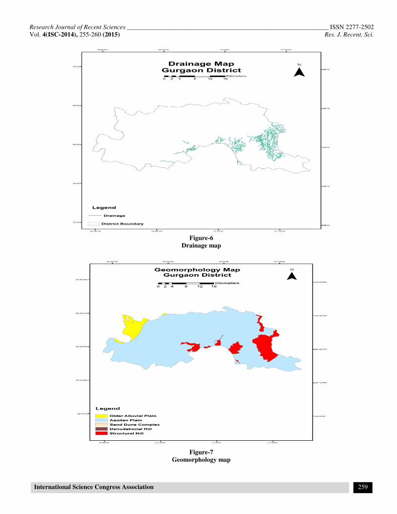
Results and Discussion
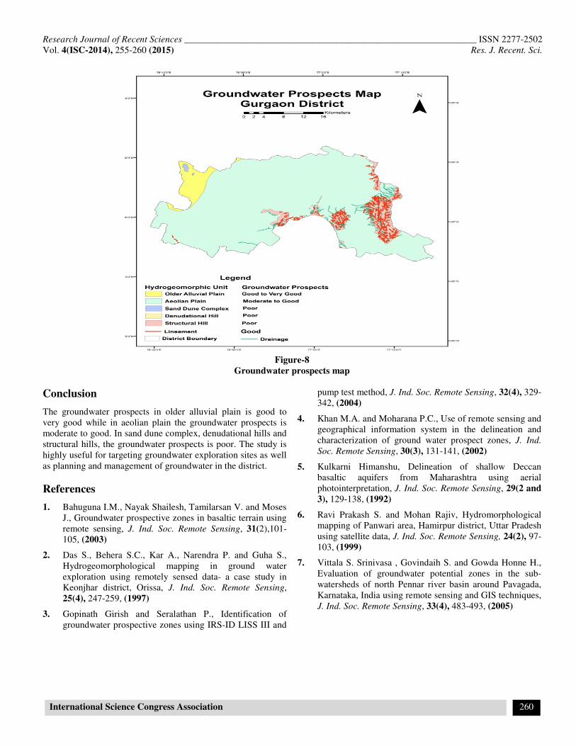
In the district, five ground water prospects zones-older alluvial
plain, aeolian plain, sand dune complex, denudational hills and
structural hills have been delineated.
Older alluvial plain: The alluvial plain is formed due to fluvial
activities. The groundwater prospects in the older alluvial plain is
good to very good. This hydro geomorphic unit covers60.83 sq.
km area which is 4.85% of the total area of the district (Table 1
and figure-8). The water table depth and well depth have been
observed 45m and 60m respectively (Table 2).
Aeolian plain: The aeolian plain is formed due to wind action.
The groundwater potential inaeolian plain is moderate to good.
This hydrogeomorphic unit covers 1064.04sq.km. area which is
84.85 % of the total area of the district (table 1 and figure-8). The
water table depthsand wells depth have been ranging between 40-
80m and 80-120m respectively in this hydro geomorphic unit
(table 2).
Sand d une complex: Sand dune complex is formed due the
wind action. This hydro geomorphic unit covers 2.43sq. km
which is 0.19% of the total area of the district (Table 1 and
Figure-8).The groundwater prospects in this hydro geomorphic is
poor.
Denudational hill: The denudational hill is formed due to
denudation of structural hill. The denudational hills cover2.43sq.
km which is 0.19% of the total area of the district (Table 1 and
Figure-8).The groundwater prospects in this hydrogeomoprhic
unit is poor except fractures and joints i.e. lineaments.
Structural hill: The structural hill is formed due to tectonic
activities and having large dimensions with structural features like
folds, faults and joints. The structural hills have poor groundwater
prospects except the weak zones like fractures and joints i.e.
lineaments. This hydro geomorphic unit covers 113.04 sq.km area
which is 9.02% of total area of the district (table 1 and figure-8).
Table-1
Groundwater Prospects in the Study Area
Hydro
geomorphic
Units
Groundwater
Prospects
Area
Covered
(Sq. Km)
Percent of
Total
Area
Aeolian Plain Moderate to
good 1064.04 84.85
Sand Dune
Complex Poor 2.43 0.19
Older Alluvial
Plain
Good to very
good 60.83 4.85
Denudational
Hills Poor 13.66 1.09
Structural
Hills Poor 113.04 9.02
Total 1254.00 100.00
Table-2
Wells Observation in the Hydro geomorphic Units
Hydrogeomorphic
Units Wells Observed
Water
Table
Depth
(m)
Wells
Depth
(m)
Aeolian Plain
12 Dug-cum-Tube
Well (DCT)/13
Tube-well (TW)
40-80 80-
120
Older Alluvial
Plain 1 TW 45 60
Sand Dune
Complex No well observed - -
Denudational Hills
Structural Hills No well observed - -
Research Journal of Recent Sciences ______________________________________________________________ ISSN 2277-2502
Vol. 4(ISC-2014), 255-260 (2015) Res. J. Recent. Sci.
International Science Congress Association 257
Figure-2
Satellite image of Gurgaon District
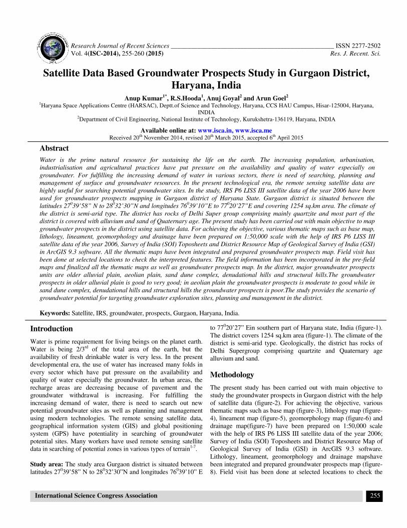
Figure-3
Base map

Research Journal of Recent Sciences ______________________________________________________________ ISSN 2277-2502
Vol. 4(ISC-2014), 255-260 (2015) Res. J. Recent. Sci.
International Science Congress Association 258
Figure-4
Lithology map
Figure-5
Lineament map
Research Journal of Recent Sciences ______________________________________________________________ ISSN 2277-2502
Vol. 4(ISC-2014), 255-260 (2015) Res. J. Recent. Sci.
International Science Congress Association 259
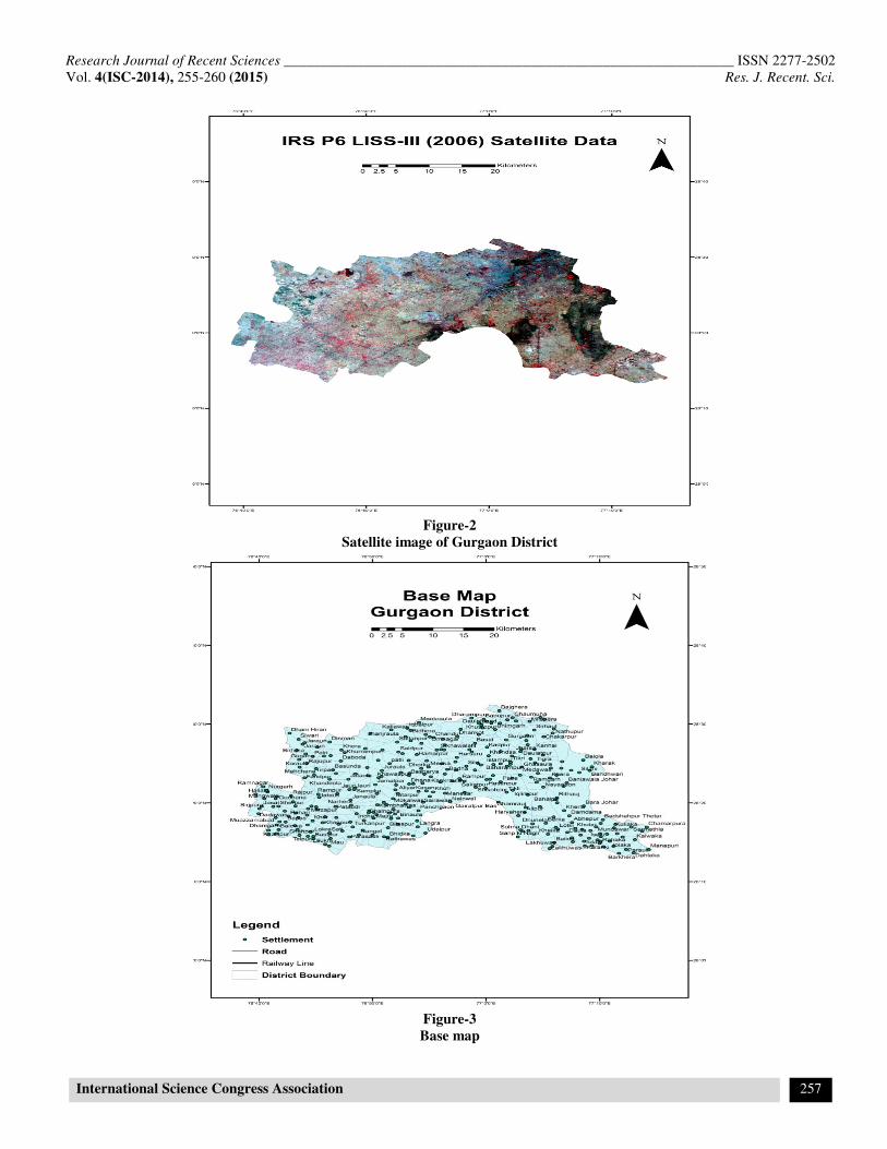
Figure-6
Drainage map
Figure-7
Geomorphology map
Research Journal of Recent Sciences ______________________________________________________________ ISSN 2277-2502
Vol. 4(ISC-2014), 255-260 (2015) Res. J. Recent. Sci.
International Science Congress Association 260
Figure-8
Groundwater prospects map
Conclusion
The groundwater prospects in older alluvial plain is good to
very good while in aeolian plain the groundwater prospects is
moderate to good. In sand dune complex, denudational hills and
structural hills, the groundwater prospects is poor. The study is
highly useful for targeting groundwater exploration sites as well
as planning and management of groundwater in the district.
References
1. Bahuguna I.M., Nayak Shailesh, Tamilarsan V. and Moses
J., Groundwater prospective zones in basaltic terrain using
remote sensing, J. Ind. Soc. Remote Sensing, 31(2),101-
105, (2003)
2. Das S., Behera S.C., Kar A., Narendra P. and Guha S.,
Hydrogeomorphological mapping in ground water
exploration using remotely sensed data- a case study in
Keonjhar district, Orissa, J. Ind. Soc. Remote Sensing,
25(4), 247-259, (1997)
3. Gopinath Girish and Seralathan P., Identification of
groundwater prospective zones using IRS-ID LISS III and
pump test method, J. Ind. Soc. Remote Sensing, 32(4), 329-
342, (2004)
4. Khan M.A. and Moharana P.C., Use of remote sensing and
geographical information system in the delineation and
characterization of ground water prospect zones, J. Ind.
Soc. Remote Sensing, 30(3), 131-141, (2002)
5. Kulkarni Himanshu, Delineation of shallow Deccan
basaltic aquifers from Maharashtra using aerial
photointerpretation, J. Ind. Soc. Remote Sensing, 29(2 and
3), 129-138, (1992)
6. Ravi Prakash S. and Mohan Rajiv, Hydromorphological
mapping of Panwari area, Hamirpur district, Uttar Pradesh
using satellite data, J. Ind. Soc. Remote Sensing, 24(2), 97-
103, (1999)
7. Vittala S. Srinivasa , Govindaih S. and Gowda Honne H.,
Evaluation of groundwater potential zones in the sub-
watersheds of north Pennar river basin around Pavagada,
Karnataka, India using remote sensing and GIS techniques,
J. Ind. Soc. Remote Sensing, 33(4), 483-493, (2005)