Embed Size (px)
Citation preview
Sanders County Subdivision Regulations
Adopted 08/22/2013 By Sanders County Commissioners
Land Services Department

Page 2 of 112 Revised and adopted by Sanders County Commissioners August 22, 2013

Page 3 of 112 Revised and adopted by Sanders County Commissioners August 22, 2013
TABLE OF CONTENTS
DEFINITIONS ....................................................................................................................................... 7 I. GENERAL PROVISIONS......................................................................................................... 16
I-A. Title ................................................................................................................................... 16 I-B. Authority ........................................................................................................................... 16 I-C. Purpose ............................................................................................................................ 16 I-D. Jurisdiction ....................................................................................................................... 16 I-E. Severability....................................................................................................................... 16
I-F. Conditions…………………………………………………………………………….16 II. GENERAL PROCEDURES ..................................................................................................... 16
II-A. Preliminary Plats .............................................................................................................. 16
II-A-1. Construction Timing ........................................................................................................ 16 II-A-2. Transfers of Title .............................................................................................................. 17 II-A-3. Permission to Enter ......................................................................................................... 18 II-A-4. Pre-application Process .................................................................................................. 18 II-A-5. Subdivision Application and Preliminary Plat Submittal ............................................... 20 II-A-6. Review Process ............................................................................................................... 21 II-B. Final Plats ........................................................................................................................ 22 II-B-1. Final Plat Contents .......................................................................................................... 22 II-B-2. Final Plat Initial Review ................................................................................................... 22 II-B-3. Restrictive Covenants – Approval, Content and Enforcement by Governing Body ... 23 II-B-4. Public Improvements Agreement; Guaranty ................................................................. 24 II-B-5. Amending Approved Preliminary Plats Before Final Plat Approval ........................... 25 II-B-6. Final Plat Approval .......................................................................................................... 26 II-B-7. Final Plat Filing ................................................................................................................ 26 II-B-8. Amending Filed Plats ...................................................................................................... 26
II-B-9. Exemptions from Amended Plat Review……………………………………….........27
III. REVIEW AND APPROVAL PROCEDURES FOR MINOR SUBDIVISIONS ....................... 27 III-A. First Minor Subdivision Review ...................................................................................... 27 III-A-1. First Minor Subdivision Application and Preliminary Plat Submittal ............................ 27 III-A-2. First Minor Subdivision Exceptions ................................................................................ 27 III-A-3. First Minor Subdivision Review Process ....................................................................... 28 III-A-4. First Minor Subdivision Governing Body Decision and Documentation……………...28 III-A-5. First Minor Subdivisions – Amended Applications........................................................ 31 III-A-6. First Minor Subdivision Final Plat ................................................................................... 32 III-B. Subsequent Minor Subdivisions ..................................................................................... 32

Page 4 of 112 Revised and adopted by Sanders County Commissioners August 22, 2013
IV. REVIEW AND APPROVAL PROCEDURES FOR MAJOR SUBDIVISIONS ...................... 32 IV-A. Review and Approval Procedures for Major Subdivisions ........................................... 32 IV-A-1. Subdivision Application and Preliminary Plat Submittal ............................................... 33 IV-A-2. Time Period for Approval, Conditional Approval, or Denial ......................................... 33 IV-A-3. Public Hearings and Notices – In General .................................................................... 33 IV-A-4. Governing Body Hearing ................................................................................................ 33 IV-A-5. Subsequent Public Hearing ............................................................................................ 35 IV-A-6. Governing Body Decision and Documentation ............................................................. 35 IV-A-7. Amended Applications .................................................................................................... 38 IV-B. Major Final Plats .............................................................................................................. 40
V. DIVISIONS OF LAND EXEMPT FROM SUBDIVISION REVIEW ........................................ 40 V-A. Purpose ........................................................................................................................... 40 V-B. General Criteria to Determine Whether a Proposal is an Attempt to Evade the MSPA V-C. Divisions of Land Entirely Exempt from the Requirements of These Regulations and
the Montana Subdivision and Platting Act [76-3-201, MCA] ...................................................... 40 V-D. Divisions of Land Which May be Exempt from Review and Surveying ...................... 42 V-E. Divisions of Land Exempt from Review but Subject to Survey Requirements ........... 43
V-E-1. Relocation of Common Boundary [76-3-207(1)(a), MCA] ............................................ 43 V-E-2. A Gift or Sale to a Member of the Immediate Family [76-3-207(1)(b), MCA] ............. 44 V-E-3. Divisions of Land Proposed for Agricultural Use Only [76-3-207(1)(c), MCA] ........... 45 V-E-4. Relocation of Common Boundaries Involving Platted Subdivisions [76-3-207 (1)(d), (e)
and (2)(a),MCA]………………. ...................................................................................................... 46
V-E-5. Aggregation of Lots or Parcels [76-3-207(1)(f), MCA]…………………………… ……….46 V-F. Procedures and Review of Subdivision Exemptions .................................................... 47 V-F-1. Submittal .......................................................................................................................... 47 V-F-2. Review .............................................................................................................................. 47 V-F-3. Appeals ............................................................................................................................ 48 V-G. Remaining Parcels of Land ............................................................................................ 48 V-H. Identification Codes ......................................................................................................... 48
VI. DESIGN AND IMPROVEMENT STANDARDS ..................................................................... 49 VI-A. Natural Environment ....................................................................................................... 49 VI-B. Lands Unsuitable for Subdivision ................................................................................... 49 VI-C. Floodplain Provisions ...................................................................................................... 49 VI-D. Improvement Design ....................................................................................................... 50 VI-E. Lots ................................................................................................................................... 50 VI-F. Blocks ............................................................................................................................... 50 VI-G. Streets and Roads ........................................................................................................... 51 VI-H. Drainage Facilities ........................................................................................................... 57

Page 5 of 112 Revised and adopted by Sanders County Commissioners August 22, 2013
VI-I. Water Supply Systems .................................................................................................... 57 VI-J. Sewage Treatment Systems .......................................................................................... 58 VI-K. Solid Waste ...................................................................................................................... 58 VI-L. Utilities .............................................................................................................................. 58 VI-M. Water Course and Irrigation Easements ....................................................................... 59 VI-N. Disposition of Water Rights ............................................................................................ 60 VI-O. Park Land Dedication – Cash in Lieu – Waivers -- Administration ............................. 60 VI-P. Fire Protection ................................................................................................................. 62 VI-Q. Special Requirements for Subdivisions Proposed in Areas of High Fire Hazard……62 VI-R. Noxious Weeds................................................................................................................ 64
VII. AREAS THAT WILL PROVIDE MULTIPLE SPACES FOR RECREATIONAL CAMPING
VEHICLES OR MOBILE HOMES ..................................................................................................... 64 VII-A. Definition .......................................................................................................................... 64 VII-B. Subdivisions That Will Provide Multiple Spaces for Recreational Camping Vehicles or
Mobile/Manufactured Homes ......................................................................................................... 64 VII-C. Procedures for Review .................................................................................................... 64 VII-C-1. Review and Approval ...................................................................................................... 64 VII-C-2. Improvements .................................................................................................................. 65 VII-C-3. Final Plan Review ............................................................................................................ 65 VII-C-4. DPHHS License ............................................................................................................... 65 VII-D. Design Standards for Subdivision Spaces Created by Rent or Lease ....................... 65 VII-D-1. Design Standards ............................................................................................................ 65 VII-D-2. Additional Provisions ....................................................................................................... 65 VII-E. Mobile/Manufactured Home Park Standards ................................................................ 66 VII-E-1. Mobile/Manufactured Home Spaces .............................................................................. 66 VII-E-2. Streets .............................................................................................................................. 67 VII-E-3. Electrical Systems ........................................................................................................... 67 VII-E-4. Gas Systems .................................................................................................................... 67 VII-F. Recreational Vehicle Park Standards ............................................................................ 67 VII-F-1. Recreational Vehicle Spaces ......................................................................................... 67 VII-F-2. Density.............................................................................................................................. 68
VIII. PLANNED UNIT DEVELOPMENTS ....................................................................................... 68 VIII-A. Purpose ............................................................................................................................ 68 VIII-B. Procedures ....................................................................................................................... 68 VIII-C. Standards ......................................................................................................................... 68 VIII-C-1. Design Standards ............................................................................................................ 68 VIII-C-2. Streets .............................................................................................................................. 68 VIII-C-3. Open Space ..................................................................................................................... 68

Page 6 of 112 Revised and adopted by Sanders County Commissioners August 22, 2013
IX. CONDOMINIUMS ..................................................................................................................... 69 IX-A. Procedures ....................................................................................................................... 69 IX-A-1. Review Where Land Will Not be Divided ....................................................................... 69 IX-A-2. Condominium Subdivisions Involving Land Divisions .................................................. 69 IX-B. Standards ......................................................................................................................... 69 IX-B-1. Design Standards ............................................................................................................ 69 IX-B-2. Unit Ownership Act .......................................................................................................... 69
X. ADMINISTRATIVE PROVISIONS ........................................................................................... 70 X-A. Fee Schedule ................................................................................................................... 70 X-A-1. Preliminary Plat Review .................................................................................................. 70 X-A-2. Exemptions ...................................................................................................................... 70 X-A-3. Final Plat Review and Inspection ................................................................................... 70 X-B. Variances ......................................................................................................................... 70 X-B-1. Variances Authorized ...................................................................................................... 70 X-B-2. Variances from Floodway Provisions Not Authorized .................................................. 70 X-B-3. Procedure ......................................................................................................................... 71 XI-B-4. Conditions ........................................................................................................................ 71 X-B-5. Statement of Facts .......................................................................................................... 71 X-C. Amendment of Regulations ............................................................................................ 71 X-D. Administration .................................................................................................................. 71 X-D-1. Enforcement ..................................................................................................................... 71 X-D-2. Violation and Penalties ................................................................................................... 71 X-D-3. Appeals ............................................................................................................................ 71
APPENDIX
A. Uniform Standards for Monumentation, Certificates of Survey, and Final Subdivision Plats
72
ADMINISTRATIVE MATERIALS
A. Subdivision Application and Materials 84 Part I General Description and Information Part II Preliminary Plat Form, Contents and Supplements Part III Environmental Assessment Part IV Summary of Probable Impacts Part V Community Impact Report B. Final Plat Approval Form 99 C. Sample Certificates 100 D. Subdivision Improvements Agreement; Guaranty 105 E. Grant of Access Easement 112 F. Typical Asphalt Road Cross Sections
Typical Gravel Road Cross Section General Specifications & Inspection Requirements
F-1 F-2 F-3
Page 7 of 112 Revised and adopted by Sanders County Commissioners August 22, 2013
Definitions Whenever the following words or phrases appear in this text, they shall have the meaning assigned to them by this section. When not inconsistent with the context, words used in the present tense shall include the future; the singular shall include the plural, and the plural the singular; the word "shall" is always mandatory, and the word "may" indicates use of discretion in making decisions. ABUT: to physically touch or border upon; or share a common property line.
ACCESS, LEGAL: means that the road abuts a public easement or right-of-way or a private easement that provides the right of access to the lot from a public road.
ACCESS, PHYSICAL: means that a road conforming to local development standards provides access. ADJACENT LANDOWNER: The owner of record of a parcel of land that is lying near or close to land included within the boundaries of a preliminary plat.
ADJOINING LANDOWNER: The owner of record of a parcel of land that is immediately contiguous at any point with land included within the boundaries of a preliminary plat. .
AGRICULTURE: Montana Code Annotated contains definitions for the words “agriculture” and
“agricultural” as follows: 41-2-103, MCA. Definitions. As used in this part, the following definitions apply: (1) “Agriculture” means: (a) all aspects of farming, including the cultivation and tillage of the soil; (b)(i) dairying; and (ii) the production, cultivation, growing, and harvesting of any agricultural or horticultural commodities, including commodities defined as agricultural commodities in the federal Agricultural Marketing Act [12 U.S.C. 1141j(g)]; (c) the raising of livestock, bees, fur-bearing animals, or poultry; and (d) any practices, including forestry or lumbering operations, performed by a farmer or on a farm as an incident to or in conjunction with farming operations, including preparation for market or delivery to storage, to market, or to carriers for transportation to market. 81-8-701, MCA. Definitions. Unless the context requires otherwise, in this part the following definitions apply: (1) “Agricultural and food product” includes a horticultural, viticultural, dairy, livestock, poultry, bee, other farm or garden product, fish or fishery product, and other foods.
AGRICULTURE WATER USERS FACILITIES: those facilities which provide water for agricultural land as defined in 15-7-202, MCA, or which provide water for the production of agricultural products as defined in 15-1-101, MCA including but not limited to ditches, pipes, and head gates.
AVERAGE DAILY TRAFFIC (ADT): means the average number of vehicles crossing a specific point on a roadway during a 24-hour period.
BLOCK: A group of lots, tracts or parcels within well-defined and fixed boundaries, a tract or parcel of land bounded by public streets, streams, railroads, platted or unplatted lands or a combination thereof.

Page 8 of 112 Revised and adopted by Sanders County Commissioners August 22, 2013
BICYCLE: means a device propelled exclusively by human power upon which any person may ride, having either a single wheel or two (2) or three (3) wheels.
BIKEWAY: means any road, street, path, lane or way which is specifically designated in the approved transportation plan as being open to bicycle travel, regardless of whether such facilities are designated for the exclusive use of bicycles or are to be shared with other transportation modes.
CERTIFICATE OF SURVEY: A drawing of a field survey prepared by a registered land surveyor
for the purpose of disclosing facts pertaining to boundary locations that conforms to ARM 24.183.1104.
GROWTH POLICY, Comprehensive Plan, or Master Plan: Defined in Section 76-1-103, MCA, as a comprehensive development plan or any of its parts such as a plan of land use and zoning, of thoroughfares, of sanitation, of recreation and of other related matters.
CONDOMINIUM: A form of individual ownership with unrestricted right of disposal of one or
more units in a multiple unit project with the land and all other parts of the project held in common ownership or use with owners of the other units.
COVENANT: An agreement, in writing, of two or more parties by which any of the parties
pledges to the others that something is done or shall be done.
COVENANT OR DEED RESTRICTION: means an agreement or restriction of two (2) or more parties, by deed in writing, by which either of the parties pledges himself or herself to the other. DATE OF SUBMISSION: The date at which the preliminary plat, all required supplementary information and fees is received and certified as complete by the Land Services Department. DATE OF PRESENTATION: The date at which the major plat all required supplementary information and fees is received and certified as complete by the Land Services Department
DEDICATION: The deliberate appropriation of land by an owner for any general and public use,
reserving no rights which are incompatible with the full exercise and enjoyment of the public use to which the property has been devoted. [76-3-103(3) MCA]
DEQ: The Montana Department of Environmental Quality.
DESIGNATED AGENT: means the Sanders County Land Services Director.
DETENTION BASIN: A man-made or natural water collector facility designed to collect surface and sub-surface water in order to impede its flow and to release the same gradually at a rate not greater than that prior to the development of the property into natural or man-made outlets.
DIRECTOR: shall mean the county land services director, or designated representative, who is vested with the duty of administering subdivision and platting regulations within the unincorporated areas of the county.
DIVISION OF LAND: The segregation of one or more parcels of land from a larger tract held in
single or undivided ownership by transferring, or contracting to transfer, title to or possession of a portion of the tract or properly filing a certificate of survey or subdivision plat establishing the

Page 9 of 112 Revised and adopted by Sanders County Commissioners August 22, 2013
identity of the segregated parcels pursuant to the Montana Subdivision and Platting Act. Provided that where required by the Act the land upon which an improvement is situated has been subdivided in compliance with the Act, the sale, rent, lease or other conveyance of one or more parts of a building, structure, or other improvement situated on one or more parcels of land is not a division of land and is not subject to the terms of the Act. [76-3-103(4) MCA]
DRAINAGE: The removal of surface water or groundwater from land by drains, grading, or other means. DWELLING UNIT: Any building or portion thereof providing complete, independent and permanent living facilities for one family.
EASEMENT: A right to use land, other than as a tenant, for a specific purpose; such right being held by someone other than the owner. Authorization by a property owner for another to use the owner's property for a specified purpose.
ENGINEER (REGISTERED PROFESSIONAL ENGINEER): A person licensed in conformance
with the Montana Professional Engineers' Registration Act (Title 37, Chapter 67, MCA) to practice engineering in the State of Montana.
ENVIRONMENTAL ASSESSMENT: A written report that documents the environmental, social, cultural impacts and consequences of a proposed development project, as required in 76-3-603 MCA.
ENVIRONMENTAL CONSTRAINTS: Features, natural resources or land characteristics that are sensitive to improvements and may require conservation measures or the application of creative development techniques to prevent degradation of the environment or may require limited development, or in certain instances may preclude development.
FIRST MINOR SUBDIVISION: A proposed minor subdivision from a tract of record that has not been subdivided or created by a subdivision under the MSPA, Montana Subdivision and Platting Act, or has not resulted from a tract of record that has had more than five parcels created from that tract of record under 76-3-201 or 76-3-207 MCA, since July 1, 1973.
FLOOD: The water of any watercourse or drainage, which is above the bank or outside the
channel and banks of such watercourse, or drainage. [76-5-103(8) MCA] FLOOD OF 100 YEAR FREQUENCY: A flood magnitude expected to recur on the average of
one every 100 years, or a flood magnitude, which has a one percent chance of occurring in any, given year. [76-5-103(9) MCA]
FLOODPLAIN: The area adjoining the watercourse or drainage, which would be covered by the
floodwater of a flood of 100 year frequency. [76-5-103(10) MCA] FLOODWAY: The channel of a watercourse or drainage and those portions of the floodplain
adjoining the channel, which are reasonably required to carry and discharge the floodwater of any watercourse or drainage. [76-5-103(11) MCA]
FOREST LAND: means contiguous land of 15 acres or more, in one ownership, that is capable of producing timber that can be harvested in commercial quantity and is producing timber unless

Page 10 of 112 Revised and adopted by Sanders County Commissioners August 22, 2013
the trees have been removed by man through harvest, including clearcuts, or by natural disaster, including but not limited to fire. [15-44-102(5) MCA]
GOVERNING BODY: The Board of Commission of Sanders County. IMPROVEMENT AGREEMENT: A contractual agreement that may be required by the
governing body to ensure the construction of such improvements as required by local subdivision regulations. The improvement agreement may require collateral to secure the construction of such improvements, such as the deposit of certified funds, irrevocable letters of credit, performance or property bonds, private or public escrow agreements, or similar financial guarantees.
LANDOWNER: All individuals, groups, or parties with a title interest in the property. For purposes of 76-3-207, MCA, when a parcel of land for which an exemption from subdivision review is claimed is being conveyed under a contract-for-deed, the terms “property owner,” “landowner,” and “owner” mean the seller of the parcel under the contract-for-deed (24.183.1104 ARM). For all other purposes of these regulations, the terms “property owner,” “landowner,” and “owner” mean both the seller and the purchaser under a contract for deed.
LIMITED ACCESS: A way or means of allowing physical entrance to land at controlled
locations or points. A no-access easement may be placed on a plat as a means of limiting access.
LOCAL SERVICES: Any and all services or facilities that local government entities are authorized to provide. [ 76-3-510 MCA]
LOT: A parcel, plot, or other land area created by subdivision for sale, rent, or lease. LOT MEASUREMENTS: a. Lot Depth: The length of a line drawn perpendicularly to the front lot line and extending
to the rear lot line. b. Lot Width: The average width of the lot. c. Lot Frontage: The width of the front lot line. d. Lot Area: The area of a lot determined exclusive of street, highway, alley, road, or other
rights-of-way. LOT TYPES: a. Corner Lot: A lot located at the intersection of two streets. b. Interior Lot: A lot with frontage on only one street.
c. Through or Double-Frontage Lot: A lot who's front and rear lines both abut on streets. MAJOR SUBDIVISION: A subdivision that creates six or more lots.
MASTER PLAN: means the same as "comprehensive plan", or “Growth Policy,” when used within this chapter.
MINOR SUBDIVISION: A subdivision containing five or fewer parcels where proper access to
all lots is provided, where no land in the subdivision will be dedicated to public use for parks or playgrounds.

Page 11 of 112 Revised and adopted by Sanders County Commissioners August 22, 2013
MOBILE (MANUFACTURED) HOME: A detached residential dwelling unit, which may consist of two or more sections, fabricated at a factory and designed to be towed on its own chassis to a building site for occupation as a dwelling with or without a permanent foundation. The term includes, but is not limited to, “trailer homes,” “house trailers”and“manufactured homes” whether or not the unit has been constructed after July 1, 1976, in conformance with Federal Manufactured Home Construction and Safety Standards. The term does not include “modular” or “factory-built buildings” that are fabricated at a factory in accordance with the Uniform Building Code Standards applicable to site-built homes, and are transported to the site for final assembly on a permanent foundation.
MOBILE (MANUFACTURED) HOME SPACE: A designated portion of a mobile home park
designed for the accommodation of one mobile home and its accessory buildings or structures for the exclusive use of the occupants.
MOBILE (MANUFACTURED) HOME PARK: A tract of land providing two or more mobile home
lots for lease or rent to the general public. MOBILE (MANUFACTURED) HOME PAD: That area of a mobile home lot which has been
prepared for the placement of a mobile home. MONTANA DEPARTMENT OF ENVIRONMENTAL QUALITY MINIMUM STANDARDS:
Minimum standards as set forth by the Montana Department of Environmental Quality, adopted pursuant to Title 76, Chapter 4, Part I, MCA.
MONUMENT (PERMANENT MONUMENT): Any structure of masonry, metal, or other
permanent material placed in the ground, which is exclusively identifiable as a monument to a survey point, expressly placed for surveying reference.
MSPA: Montana Subdivision and Platting Act, Title 76, Chapter 3, MCA.
NATURAL ENVIRONMENT: The physical conditions which exist within a given area, including
land, air, water, mineral, flora, fauna, noise, and objects of historic or aesthetic significance. OPEN SPACE: An undeveloped land or water area devoid of buildings except where accessory
to the provision of recreation. OVERALL DEVELOPMENT PLAN: The plan of a subdivision design for a single tract proposed
to be subdivided by stages. PLANNED UNIT DEVELOPMENT (P.U.D.): A land development project consisting of residential
clusters, industrial parks, shopping centers, office building parks, or any combination thereof which comprises a planned mixture of land uses built in a prearranged relationship to each other and having open space and community facilities in a common ownership or use.
PLAT: A graphic representation of a subdivision showing the division of land into lots, parcels,
blocks, streets, and alleys, and other divisions and dedications. [76-3-103(11) MCA] a. Preliminary Plat: A neat and scaled drawing of a proposed subdivision showing the
layout of streets, alleys, lots, blocks, and other elements of a subdivision which furnish a basis for review by a governing body. [76-3-103(12) MCA]

Page 12 of 112 Revised and adopted by Sanders County Commissioners August 22, 2013
b. Final Plat: The final drawing of the subdivision and dedication required to the prepared for filing for record with the county clerk and recorder containing all elements and requirements set forth in these regulations and the Montana Subdivision and Platting Act. [76-3-103(6) MCA]
c. Amended Plat: The final drawing of any change to a platted subdivision filed with the county clerk and recorder required to be prepared for filing for record with the county clerk and recorder and containing all elements and requirements set forth in these regulations and the Subdivision and Platting Act. (Title 76, Chapter 3, MCA)
d. Vacated Plat: A plat which has been voided under the provisions of MCA 76-3-305, 7-5-2501, 7-5-2502, 7-14-2616 (1) and/or (2), 7-14-2617, 7-14-4114 (1) and/or (2), and 7-14-3115.
PRE-APPLICATION SKETCH (OR DRAWING): A legible drawing showing approximate boundaries, dimensions, areas, distances and other pertinent information of a proposed subdivision, all as more particularly set forth in section II-A-4(c).
PRIVATE IMPROVEMENT: Private improvements are the same types of improvements as
defined under PUBLIC IMPROVEMENTS, except the structure or facility has not been dedicated to the public or otherwise acquired by a government entity for public use.
PRIVATE ROAD: A road is private if its right-of-way has neither been dedicated nor acquired
for public use. A private road may be open to use by the general public or public access may be restricted.
PROPERTY OWNER: Any person, firm, corporation or other entity shown as being legal owner of a tract, parcel or lot in the records of the County Clerk & Recorder. PUBLIC HEALTH AND SAFETY: a condition of optimal well-being, free from danger, risk, or injury for a community at large, or for all people, not merely for the welfare of a specific individual or a small class of persons.
PUBLIC IMPROVEMENT: Any structure or facility constructed to serve the residents of a
subdivision or the general public such as parks, streets and roads, sidewalks, curbs and gutters, street lighting, utilities and systems for water supply, sewage disposal and drainage.
PUBLIC ROAD OR STREET: A dedicated right-of-way or public road easement. A road or street for which a municipality, county or a state or federal agency has maintenance responsibility RECREATIONAL CAMPING VEHICLE: A vehicular type unit primarily designed as temporary living quarters for recreational, camping, or travel use that either has its own motor power or is mounted on or drawn by another vehicle.
RECREATIONAL VEHICLE PARK: A place used for public camping where persons can rent
space to park individual camping trailers, pick-up campers, motor homes, travel trailers or automobiles for transient dwelling purposes.
RECREATIONAL VEHICLE SPACE: A designated portion of a recreational vehicle park designed for the placement of a single recreational vehicle and the exclusive use of its occupants.
Page 13 of 112 Revised and adopted by Sanders County Commissioners August 22, 2013
REVIEWING AUTHORITY: The DEQ or local Board of Health or Sanitarian as authorized under Title 76, Chapter 4, MCA.
RIGHT-OF-WAY: A strip of land dedicated or acquired for use as a public way.
ROADWAY: That portion of the road right-of-way which is improved or is proposed to be improved to carry traffic.
STATE: State of Montana. STREET TYPES: For purposes of these regulations, street types are defined as follows:
a. Alley: A street used primarily for vehicular access to the rear of properties that abut on and are served by public roads. Alley means minor rights-of-way, which are used primarily for vehicular service, access to the back or side of properties otherwise abutting on a street.
b. Arterial: A street or road having the primary function of moving traffic with emphasis on a
high level of mobility for through movement and the secondary function of providing access to adjacent land. Arterials generally carry relatively large volumes of traffic. Arterials have two to four lanes of moving traffic and should provide only limited access to abutting property.
c. Collector: A street or road having the equally important functions of moving traffic and
providing access to adjacent land. Collector streets have two moving traffic lanes and up to two parking lanes.
d. Local Streets: A street or road having the primary function of serving abutting properties,
and the secondary function of moving traffic. Local streets have two moving lanes of traffic, up to two parking lanes, and provide access to abutting properties.
e. Low Volume: A road servicing 3 or fewer residential lots with no possibility of further
subdivision.
f. Half-Street: A portion of the width of a street, usually along the outside perimeter of a subdivision, where the remaining portion of the street must be located on adjacent property.
g. Cul-de-sac: A street having only one outlet for vehicular traffic and terminating in a turn-
around area. h. Loop: A local street, which begins and ends on the same street, generally used for
access to properties. i. Frontage Access (Service Road): A local or collector street, usually parallel and adjacent
to an arterial or major collector, which provides access to abutting properties and controls traffic access to arterials or collectors.
j. Rural Lane: a road serving a very low density area. The maximum A.D.T. limits the
number of single family homes on this road to 20.

Page 14 of 112 Revised and adopted by Sanders County Commissioners August 22, 2013
SUBDIVIDER: Any person, firm or corporation, or other entity that causes land to be subdivided
or who proposes a subdivision of land. SUBDIVISION means a division of land or land so divided that it creates one or more parcels
containing less than 160 acres that cannot be described as a one-quarter aliquot part of a United States government section, exclusive of public roadways, in order that the title to or possession of the parcel may be sold or otherwise transferred and includes any resubdivision and a condominium. The term also means an area, regardless of its size, that provides or will provide multiple spaces for rent or lease on which recreational camping vehicles or mobile homes will be placed.
SUBDIVISION ADMINISTRATOR: The authorized agent who performs the duties of review and administration set forth in these regulations.
SUBSEQUENT MINOR SUBDIVISION: Any subdivision of five or fewer parcels that is not a first minor subdivision.
SURVEYOR (REGISTERED LAND SURVEYOR): A person licensed in conformance with the
Montana Professional Engineer's Registration Act (Title 37, Chapter 67, MCA) to practice surveying in the State of Montana.
SURVEYOR (EXAMINING LAND SURVEYOR): A registered land surveyor duly appointed by
the governing body to review surveys and plats submitted for filing. [76-3-103(5) MCA] SWALE: A drainage channel or depression designed to direct surface water flow.
TITLE REPORT (ABSTRACT OF TITLE, SUBDIVISION GUARANTEE, OR PLATTING REPORT): A report from a title service company on the condition of title to the property proposed for subdivision, which identifies the owners of record of the property, lien holders, encumbrances, easements and restrictions of record, and all other conditions of title of public record, and accompanied by a guarantee of the accuracy of the report from the title insurance agent or its underwriter.
TOPOGRAPHY: General term to include characteristics of the ground surface such as plains,
hills, mountains, slopes, and other physiographic features.
TOWNHOME OR TOWNHOUSE: means property that is owned subject to an arrangement under which persons own their own units and hold separate title to the land beneath their units, but under which they may jointly own the common areas and facilities. TRACT: Land area proposed to be subdivided. An individual parcel of land, irrespective of ownership, that can be identified by legal description, independent of any other parcel of land, using documents on file in the records of the county clerk and recorder’s office. [76-3-103(17)(a), MCA]
TRACT OF RECORD: A parcel of land that can be identified by legal description, independent
of any other parcel of land, using documents on file in the records of the county clerk and recorder's office. [76-3-103(16), MCA]

Page 15 of 112 Revised and adopted by Sanders County Commissioners August 22, 2013
TRAFFIC CONTROL DEVICES: shall mean all of, but shall not be limited to, the following: 1. Street name signs 2. Regulatory signs 3. Warning signs 4. Pavement markings 5. Channelization 6. Traffic signals 7. Guard rail
TRANSPORTATION PLAN: shall mean the county transportation plan, or any modification which may exist and has been adopted by the county commissioners.
UTILITY: means the following: telephone, natural gas, electricity, cable television, water and sewer. [76-3-103(13) & 7-1-13(22)(23) MCA]
VICINITY SKETCH: A map at a scale suitable to locate the proposed subdivision, showing the
boundary lines of all adjacent properties and streets and other information necessary to determine the general location of the proposed subdivision.
WATERCOURSE: Any natural stream, river, creek, drainage waterway, gully, ravine or wash in which water flows either perennially or ephemeral and has a definite channel bed and banks and includes any area adjacent therefore subject to inundation bay overflow. The term watercourse shall not be construed to mean any facility created exclusively for the conveyance of irrigation water.
WELL ISOLATION ZONE: Area within a 100 foot radius of a water well. WILDLIFE: Living things, which are neither human nor domesticated.
WILDLIFE HABITAT: Place or type of site where wildlife naturally lives and grows.

Page 16 of 112 Revised and adopted by Sanders County Commissioners August 22, 2013
I. GENERAL PROVISIONS I-A. Title These regulations will be known and may be cited as “The Subdivision Regulation of Sanders County” hereinafter referred to as “these regulations.” I-B. Authority Authorization for these regulations is contained in the Montana Subdivision and Platting Act (MSPA). [Title 76, Chapter 3, MCA] I-C. Purpose The purposes of these regulations are to promote the public health, safety, and general welfare by regulating the subdivision of land; to prevent the overcrowding of land; to lessen congestion in the streets and highways; to provide for adequate light, air, water supply, sewage disposal, parks and recreation areas, ingress and egress, and other public requirements; to require development in harmony with the natural environment; to promote preservation of open space; to promote cluster development approaches that minimize costs to local citizens and that promote effective and efficient provision of public services; to protect the rights of property owners; and to require uniform monumentation of land subdivisions and transferring interests in real property by reference to plat or certificate of survey [76-3-102, MCA]. Further, to support the purposes of 76-3-102, MCA, these regulations are intended to promote (76-3-501, MCA): 1. The orderly development of Sanders County. 2. The coordination of roads within subdivided land with other roads, both existing and planned. 3. The dedication of land for roadways and for public utility easements. 4. The improvement of roads.
5. The provision of proper physical and legal road access, including obtaining of necessary easements. [76-3-608(d) MCA]
6. The provision of adequate open spaces for travel, light, air, and recreation. 7. The provision of adequate transportation, water, drainage, and sanitary facilities. 8. The avoidance or minimizing of congestion. 9. The avoidance of subdivisions which would involve unnecessary environmental degradation. 10. The avoidance of danger or injury by reason of natural hazard or the
lack of water, drainage, access, transportation, or other public services.
11. The avoidance of excessive expenditure of public funds for the supply of public services.
12. The manner and form of making and filing of any plat for subdivided lands. [76-3-611 MCA]
13. The administration of these regulations by defining the powers and duties of approving authorities including procedures for the review and approval of all plats of subdivisions covered by these provisions. [76-3-504 MCA]

Page 17 of 112 Revised and adopted by Sanders County Commissioners August 22, 2013
I-D. Jurisdiction These regulations govern the subdivision of land within the jurisdictional area of the governing body of Sanders County. If a proposed subdivision lies within one mile of a third class city or town or within two miles of a second class city or within three miles of a first class city, the county governing body must submit the preliminary plat to the city or town governing body or its designated agent for review and comment. If a proposed subdivision lies partly within an incorporated city or town, the preliminary plat must be submitted to, and approved by, both the city or town and the county governing bodies. If a proposed subdivision is located in a rural school district, the governing body shall provide a summary of the information contained in the subdivision application and preliminary plat to school district trustees. [76-3-601(2)(b) MCA] When a proposed subdivision is also proposed to be annexed into a municipality, the governing body of the municipality shall combine public hearings and otherwise coordinate the subdivision review process and annexation procedures whenever possible. These regulations supplement all other regulations, and where they are at variance with other laws, regulations, ordinances, or resolutions, the more restrictive requirements shall apply. I-E. Severability Where a court of competent jurisdiction holds any word, phrase, clause, sentence, paragraph, section, or other part of these regulations invalid, such judgment shall affect only that part held invalid. I-F. Conditions Regulation of the subdivision of land and the attachment of reasonable conditions to land subdivision is an exercise of valid police power delegated by the State of Montana to Sanders County. Subdividers have the duty of complying with reasonable conditions for design, dedication, and improvements so as to conform to the physical and economic development of Sanders County and to the safety and general welfare of the future subdivision lot owners and of the community at large. II. GENERAL PROCEDURES (Applies to Sections III, IV, VII and IX) II-A. Preliminary Plats II-A-1. Construction Timing The subdivider may not proceed with any construction work on the proposed subdivision, including grading and excavation relating to public improvements, until the governing body has given conditional preliminary approval of the proposed subdivision plat. II-A-2. Transfers of Title Except as noted below, a final subdivision plat must be filed for record with the county clerk and recorder before title to the subdivided land can be sold or transferred in any manner. After the

Page 18 of 112 Revised and adopted by Sanders County Commissioners August 22, 2013
preliminary plat of a subdivision has been approved or conditionally approved, the subdivider may enter into contracts to sell lots in the proposed subdivision if all of the following conditions are met. [76-3-303 MCA] a. That under the terms of the contracts the purchasers of lots in the proposed subdivision make
any payments to an escrow agent, which must be a bank or savings and loan association chartered to do business in the State of Montana.
b. That under the terms of the contracts and the escrow agreement the payments made by
purchasers of lots in the proposed subdivision may not be distributed by the escrow agent to the subdivider until the final plat of the subdivision is filed with the county clerk and recorder.
c. That the contracts and the escrow agreement provide that if the final plat of the proposed
subdivision is not filed with the county clerk and recorder within two years of the preliminary plat approval, the escrow agent shall immediately refund to each purchaser any payments made under the contract.
d. That the contracts contain the following language conspicuously set out therein: “The real
property which is the subject hereof has not been finally platted, and until a final plat identifying the property has been filed with the county clerk and recorder, title to the property cannot be transferred in any manner.”
e. That the county treasurer has certified that all real property taxes and special assessments
assessed and levied on the land to be divided have been paid; [76-3-303(4) MCA] and f. A copy of the contracts and escrow agreement described above must be submitted to the
subdivision administrator. The purchase price may be blacked out. II-A-3. Permission to Enter
The Sanders County Commissioners or a representative of Land Services or its designated agent(s) may investigate, examine, and evaluate the site of the proposed subdivision to verify information provided by the subdivider and to subsequently monitor compliance with any conditions if the preliminary plat is approved conditionally. The submission of a subdivision application constitutes a grant of permission by the subdivider for the governing body and/or its agents. [76-3-601 MCA]
II-A-4. Pre-application Procedures
a. The subdivider shall meet with the subdivision administrator prior to submitting the required
preliminary plat. The purpose of this meeting is to discuss applicable subdivision regulations and standards. The meeting shall occur within 30 days after the subdivider submits a written, electronic or verbal request for the meeting to the subdivision administrator.
b. The subdivision administrator will notify the subdivider of the option of concurrent review of the
subdivision by the local government and the Montana Department of Environmental Quality (MDEQ).
c. The subdivider shall provide a sketch plan of the proposed subdivision for discussion. The
sketch plan must be a legible scale drawing showing the layout of proposed features in relation to the existing site conditions.

Page 19 of 112 Revised and adopted by Sanders County Commissioners August 22, 2013
i. The sketch plan may be drawn freehand on a print of a topographic map. Scale dimensions must be noted. A. The sketch plan must include pertinent information such as:
1. location; 2. approximate tract and lot boundaries of existing tracts of record; 3. description of general terrain; 4. natural features on the land, including water bodies, floodplains, geologic hazards, and soil types; 5. existing structures and improvements; 6. existing utility lines and facilities serving the area to be subdivided; 7. existing easements and rights of way; 8. existing conservation easements; 9. existing noxious weeds
B. Information on the current status of the site, including:
1. ownership information, such as deed, option to buy or buy-sell
agreement, including permission to subdivide; 2. water rights, including location of Agricultural Water Users Facilities;
3. existing covenants or deed restrictions; 4. rights of first refusal for the property.
ii. Information on the proposed subdivision, including:
A. tract and proposed lot boundaries;
B. proposed public and private improvements;
C. location of utility lines and facilities;
D. easements and rights of way;
E. parks and open space and proposed conservation easements and F. well isolation zone
d. At the pre-application meeting:
i. the subdivision administrator shall identify, for informational purposes, the state laws, local regulations that may apply to the subdivision review process.
ii. the subdivision administrator shall provide the subdivider with a list of public utilities,
local, state and federal agencies, and any other entities that have an interest in the proposed subdivision and that must be contacted for comment by the subdivider. The subdivision administrator shall also identify the timeframes that the public utilities, agencies, and other entities are given to respond; and

Page 20 of 112 Revised and adopted by Sanders County Commissioners August 22, 2013
iii. the subdivision administrator may identify particular additional information the subdivision administrator anticipates will be required for review of the subdivision application. This does not limit the ability of the subdivision administrator to request additional information at a later time.
e. Unless the subdivider submits a subdivision application within six months of this pre-
application meeting, the subdivider must request a new pre-application meeting prior to submitting the subdivision application.
II-A-5. Subdivision Application and Preliminary Plat Submittal [76-3-504(a), MCA] a. The subdivider shall submit, to the agent designated by the governing body one (1) copy of the complete subdivision application addressing these topics and containing the following materials determined necessary at the pre-application meeting. Once sufficiency has been determined, five (5) complete, bound copies shall be submitted for review.
1. A completed and signed Subdivision Application Form; 2. The required review fee; 3. A preliminary plat; 4. A Vicinity Sketch; 5. A topographic map; 6. A grading and drainage plan; 7. Engineering plans for all Public and Private Improvements; 8. Overall development plan, if development is in phases; 9. Abstract of Title (or Title Report);
10. Documentation of legal and physical access; 11. Documentation of existing easements, including those for Agricultural Water User
Facilities; 12. Existing covenants and deed restrictions 13. Existing water rights; 14. Existing mineral rights; 15. Proposed road plans and profiles; 16. Proposed easements; 17. Proposed disposition of water rights; 18. Proposed disposition of mineral rights; 19. Parkland dedication calculations; [76-3-603(2) MCA] 20. Environmental assessment and/or summary of probable impacts; [76-3-608(3)/76-3-603
MCA] 21. Transportation impact analysis or transportation plan; 22. Fire risk rating analysis and fire prevention plan; 23. Property owners’ association documents, including draft articles of incorporation,
declaration and bylaws; 24. FIRM or FEMA panel map and letter identifying floodplain status; 25. Required water and sanitation information, including well isolation zone; [76-3-622 MCA] 26. A form of Subdivision Improvements Agreement, if proposed; 27. Flood hazard evaluation; 28. Letter identifying and proposing mitigation for potential hazards or other adverse impacts
as identified in the pre-application meeting and not covered by any of the above required materials; and
Page 21 of 112 Revised and adopted by Sanders County Commissioners August 22, 2013
29. Such additional relevant and reasonable information as identified by the Subdivision Administrator during the pre-application meeting that is pertinent to the required elements of this section.
b. The following materials need to be submitted within 30 days of preliminary approval:
1. Subdivision Noxious Weed Revegetation Application
c. The following materials will need to be submitted with the final plat:
1. Lienholders’ acknowledgement of subdivision; 2. Approach, access, encroachment permits from Montana Department of Transportation or
the local jurisdiction. 3. Documentation that the noxious weeds have been treated.
II-A-6. Review Process For both minor and major subdivisions, the initial review process is as follows: a. Element Review [76-3-604 MCA]
i. Within 5 working days of receipt of a subdivision application and fee, date of receipt
being when the subdivision application and appropriate fee are delivered to the reviewing agency, the subdivision administrator shall determine whether the application contains all of the applicable materials required by section II-A-5 and shall give written notice to the subdivider of the subdivision administrator's determination.
A. If the subdivision administrator determines that elements are missing from the application, the subdivision administrator shall return the application and identify those elements in the notification, and no further action shall be taken on the application by the subdivision administrator until the application is resubmitted.
B. The subdivider may correct the deficiencies and resubmit the application.
C. If the subdivider corrects the deficiencies and resubmits the application the subdivision administrator shall have 5 working days to notify the subdivider whether the resubmitted application contains all the materials required by section II-A-5, as applicable.
D. This process shall be repeated until the subdivider submits an application containing all the materials required by section II-A-5, or the application is withdrawn.
b. Sufficiency Review
i. Within 15 working days after the subdivision administrator notifies the subdivider that the application contains all of the required elements as provided in subsection (a) above, the subdivision administrator shall determine whether the application and required elements contain detailed, supporting information that is sufficient to allow for the review of the proposed subdivision under these regulations and shall give written notification to the subdivider of the subdivision administrator's determination.

Page 22 of 112 Revised and adopted by Sanders County Commissioners August 22, 2013
A. If the subdivision administrator determines that the information in the application is not sufficient to allow for review of the proposed subdivision, the subdivision administrator shall identify specific required information in its notification and return the application to the subdivider, and no further action shall be taken on the application by the subdivision administrator until the material is resubmitted.
B. The subdivider may correct the deficiencies and resubmit the application, or withdraw the application.
C. If the subdivider corrects the deficiencies and resubmits the application in accordance with (i)(B) above, the subdivision administrator shall have 15 working days to notify the subdivider whether the resubmitted application and required elements contain detailed, supporting information that is sufficient to allow for review of the proposed subdivision under these regulations. D. This process shall be repeated until the subdivider submits an application that contains detailed, supporting information that is sufficient for review of the proposed subdivision under the provisions of these regulations, or the application is withdrawn.
ii. A determination that an application contains sufficient information for review as provided in this subsection (b) does not ensure that the proposed subdivision will be approved or conditionally approved by the governing body and does not limit the ability of the subdivision administrator or the governing body to request additional information during the review process.
iii. A determination of sufficiency by the subdivision administrator pursuant to this subsection does not limit the DEQ from requiring additional water and sanitation information as part of the DEQ review of water and sanitation information.
c. Applicable Regulations
Subdivision review and approval, conditional approval or denial shall be based on those regulations in effect at the time a subdivision application and preliminary plat is deemed to contain sufficient information for review. If regulations change during the element or sufficiency review, the determination of whether the application contains the required elements and sufficient information, and the subdivision review, shall be based on the new regulations.
II-B Final Plats II-B-1 Final Plat Contents The final plat submitted for approval must conform to the preliminary plat as previously reviewed and approved by the governing body and must incorporate all required modifications. The final plat and accompanying documents must comply with the Montana Uniform Standards for Final Subdivision Plats as provided for in Administrative Materials. Final plats of subdivisions approved for phased development may be filed sequentially in accordance with the approval. II-B-2 Final Plat Initial Review
Page 23 of 112 Revised and adopted by Sanders County Commissioners August 22, 2013
a. Final Plat Submittal
i. the final plat application;
ii. the final plat review fee;
iii. a statement from the project surveyor or engineer outlining how each condition of approval has been satisfied;
iv. a Title Report or updated Abstract dated no less than 30 days prior to the date of submittal;
v. the DEQ or local Environmental Health Department approval;
vi. the final Grading and Drainage Plan, including all road plans and profiles, state or local encroachment permits, and the Traffic Impact Analysis (if required);
vii. all engineering plans;
viii. any homeowner association documents, including bylaws, covenants, and/or declarations;
ix. Two 18” x 24” or larger mylar copies and one paper copy of the final plat, completed in accordance with the Uniform Standards for Final Subdivisions Plats as provided for in Administrative Materials.
b. Review by Subdivision Administrator
i. The subdivision administrator shall review the final plat to ascertain that all conditions and requirements for final plat approval have been met. The subdivision administrator will not accept, begin processing, nor schedule any actions on a final plat submittal until a complete application and fee, and copies of the final plat have been received. Final plat applications will not be considered complete by the subdivision administrator until all conditions of preliminary approval have been satisfied.
ii. If the subdivision administrator determines that the final plat differs from the approved or conditionally approved preliminary plat, the applicant shall be required to submit an amended application pursuant to Section II-B-5. iii. The subdivision administrator will require that final subdivision plats be reviewed for errors and omissions in calculation or drafting by an examining land surveyor before recording with the Clerk and Recorder. When the survey data shown on the plat meets the conditions pursuant to these regulations, the examining surveyor shall certify the compliance in a printed or stamped signed certificate on the plat. [76-3-611(2)(a) MCA]
II-B-3. Restrictive Covenants – Approval, Content and Enforcement by Governing Body a. The governing body requires that every restrictive covenant contain the following language: This (These) covenant(s) may not be repealed or amended without the prior written consent of the Sanders County Commissioners.

Page 24 of 112 Revised and adopted by Sanders County Commissioners August 22, 2013
b. If common property is to be deeded to a property owners’ association, the covenants and by-
laws which govern the association must, at a minimum, provide for the:
i. Formation of a property owners’ association concurrently with the filing of the final subdivision plat; Articles of Incorporation shall be filed with the Secretary of State’s office;
ii. Mandatory membership for each property owner. Purchasers of property may be required to sign a waiver of right to protest the formation of a maintenance district to maintain improvements;
iii. Perpetual reservation of the common property when required under 76-3-621(6) (a),
MCA;
iv. Payment of liability insurance premiums, local taxes, and the maintenance expenses of recreational or other facilities;
v. Provide for the placement of liens on the property of lot owners who are delinquent in the
payment of association fees and assessments;
vi. Adjustment of assessments to meet changing needs;
vii. Means of enforcing the covenants, and of receiving and processing complaints; viii. Transition of control of the association from the Declarant to the homeowners.
ix. Dissolution of the association and modification of the covenants and restrictions after
obtaining the governing body’s approval of the change; and
x. Regular maintenance of roads, parks, buildings, drainage facilities, and other facilities controlled by the association.
II-B-4. Public Improvements Agreement; Guaranty [76-3-507(4) MCA] As a condition of approval of the final plat, the subdivider must have installed all required improvements or have entered into a subdivision improvements agreement guaranteeing the construction, installation, and maintenance of all required improvements. The County Commissioners may require up to 100% completion of improvements related to public health and safety, such as roads, firefighting facilities and installation of utilities, before agreeing to the use of a subdivision improvements agreement. This requirement applies to preliminary plats approved prior to the adoption of these regulations. If 100% completion is required, engineering plans must be filed before approval of the final plat. A model subdivision improvements agreement and alternative methods of guaranteeing public improvements, the procedures and requirements for securing an agreement, and suggested conditions for maintenance are provided in Administrative Materials. If the subdivider chooses to enter into a subdivision improvements agreement, guaranteeing the public improvements through a bond or letter of credit, three bids for the cost of installation of the public improvements shall be obtained by the subdivider. The amount of the guarantee shall be calculated by multiplying 125% by the highest bid. As the public improvements are installed, the subdivider shall provide a letter to the governing body indicating such, and including a copy of the engineered plans. The county or consulting engineer designated by the governing body shall review
Page 25 of 112 Revised and adopted by Sanders County Commissioners August 22, 2013
and certify all public improvements have been installed in conformance with the plans and specifications. Prior to the release of the guarantee, a copy of the plans, stamped by the project surveyor or engineer in accordance with their licensing provisions, shall be filed in the clerk and recorder’s office with reference to the final subdivision plat II-B-5. Amending Approved Preliminary Plats Before Final Plat Approval a. If the subdivider proposes to change the preliminary plat after the preliminary plat approval but
before the final plat approval, the subdivider shall submit the proposed changes to the subdivision administrator for review.
i. Within 5 working days of receiving the proposed changes, the subdivision administrator
shall determine whether the changes to the preliminary plat are material pursuant to subsection (b) below.
ii. If the subdivision administrator determines the changes are material, the subdivision
administrator may require the subdivider to begin the subdivision review process again, starting with the pre-application meeting, and require payment of a new application fee
iii. If the subdivision administrator determines the changes are not material, the subdivision administrator shall accept the changes and notify the subdivider and the governing body of its decision.
b. The following changes, although not an exhaustive list, may be considered material:
i. configuration or number of lots;
ii. road layout;
iii. water and/or septic proposals;
iv. configuration of park land or open spaces;
v. easement provisions;
vi. designated access; or
vii. change to conditions of approval.
c. A subdivider, who’s proposed changes to the preliminary plat have been deemed material by
the subdivision administrator, may appeal the subdivision administrator's decision to the governing body by written notice within 10 working days. The subdivider may request a hearing, and may submit additional evidence to show that the changes to the preliminary plat are not material.
d. If the subdivider and subdivision administrator determine that a condition of approval is illegal
or impossible to comply with due to circumstances outside the subdivider’s control, economic hardship notwithstanding, the condition may be reviewed by the governing body through a properly noticed public hearing, if a hearing was required with the original submittal, in order to determine if the condition may be waived or amended.

Page 26 of 112 Revised and adopted by Sanders County Commissioners August 22, 2013
II-B-6. Final Plat Approval a. Approval by the Governing Body
The governing body shall examine every final subdivision plat and shall approve it if it conforms to the conditions of preliminary plat approval and to the terms of the MSPA and these regulations, or deny it pursuant to (ii) below.
i. If the final plat is approved, the governing body shall certify its approval on the face of the final plat. When applicable, a certificate of the governing body expressly accepting any dedicated land, easements, or improvements will be filed with the final plat.
ii. If the final plat is denied, the governing body shall write a letter stating the reason for denial and forward a copy to the subdivider. The governing body will return the final plat to the subdivider within 10 working days of the action. The subdivider may then make any necessary corrections and resubmit the final plat for approval.
b. Inaccurate Information
The governing body may withdraw approval of a final plat if it determines that material information provided by the subdivider is inaccurate.
II-B-7. Final Plat Filing After it is approved, the final plat may not be altered in any manner except as provided in II-B-8. The county clerk and recorder may not accept any plat for filing that does not include the governing body’s approval in proper form or that has been altered. The clerk and recorder may file an approved plat only if it is accompanied by the documents specified in the Montana Uniform Standards for Monumentation, Certificates of Survey, and Final Subdivision Plats. II-B-8. Amending Final Plats
a. Changes that materially alter any portion of the filed final plat, its land divisions, improvements
must be made by filing an amended plat showing all alterations. Any alteration which increases the number of lots or modifies six or more lots, or abandons or alters a public road right-of-way or parkland dedication must be reviewed and approved by the governing body.
b. An amended plat is subject to the procedures for reviewing major or minor subdivisions, as
appropriate. The governing body may not approve an amended final plat without the written consent of the owners and lienholders of all lots which will be modified by the proposed amendment. (Section IV-A of these regulations for major subdivisions or Sections III-A for minor subdivisions).
c. The governing body may not approve an amendment that will place a lot in non-conformance
with the design standards contained in Section VI of these regulations unless the governing body holds a public hearing on the amendment and issues a written variance from the standards pursuant to Section XI-B, Variances.
d. The governing body may not approve an amendment without the written consent of all affected
lot owners.

Page 27 of 112 Revised and adopted by Sanders County Commissioners August 22, 2013
e. The final amended plat submitted for approval must comply with the Montana Uniform
Standards for Monumentation, Certificates of Survey, and Final Subdivision Plats.
II-B-9 Exemptions from Amended Plat Review
Amended plats that show the relocation of common boundaries or the aggregation of five or fewer lots are exempt from subdivision review. These amended plats must be prepared following the requirements of the Montana Uniform Standards for Certificates of Survey [ARM 8.94.3002(1)(f)(v)]. III. REVIEW & APPROVAL PROCEDURES FOR MINOR SUBDIVISIONS Minor subdivisions are those subdivisions containing five or fewer lots where proper access to all lots is provided, and no land will be dedicated to public use for parks and playgrounds that are eligible for review under 76-3-505 or 76-3-609, MCA, shall be reviewed under the procedures set forth on the following pages. First minor subdivisions shall be reviewed pursuant to section III-A and subsequent minor subdivisions shall be reviewed pursuant to section III-B. III-A. First Minor Subdivision Review The pre-application process and initial review process set forth in Section II, General Procedures, apply to this section. III-A-1. First Minor Subdivision Application and Preliminary Plat Submittal
a. The subdivider shall submit to the governing body or to the agent designated by the governing body a subdivision application containing the materials identified in section II-A-5 and in the pre-application meeting, and
b. Sufficient documentary evidence from the public records demonstrating that the
subdivision will be the first minor subdivision from a tract of record; III-A-2. First Minor Subdivision Exceptions The following do not apply to first minor subdivisions:
a. preparation of an environmental assessment;
b. parkland dedication;
c. public hearing requirements; and
d. review of the subdivision application for the impact on agriculture, agricultural water user facilities, local services, the natural environment, wildlife, wildlife habitat, and public health and safety, if the subdivision is proposed in a jurisdictional area that has adopted zoning regulations that address those impacts.

Page 28 of 112 Revised and adopted by Sanders County Commissioners August 22, 2013
III-A-3. First Minor Subdivision Review Process
a. Time Period for Approval, Conditional Approval, or Denial
Within 35 working days, the governing body shall approve, conditionally approve or deny the proposed subdivision according to Section III-A-4 of these regulations, unless the subdivider and the subdivision administrator agree to an extension or suspension of the review period, not to exceed one year. The review period of 35 working days begins the day after the subdivision administrator notifies the subdivider or the subdivider’s agent in writing.
b. Public Agency and Utility Review
Review and comment by public agencies or utilities may not delay the governing body’s action on the subdivision application beyond the 35-working day review period. The governing body will make these comments available to the subdivider and to the general public upon request. If, during the review of the application, the subdivision administrator or the planning board contacts a public utility, agency, or other entity that was not included on the list provided during the pre-application meeting, the subdivision administrator shall notify the subdivider of the contact and the timeframe for response.
III-A-4. First Minor Subdivision Governing Body Decision and Documentation a. Prerequisites to Approval
The governing body may not approve or conditionally approve a subdivision application and preliminary plat unless the proposed subdivision: i. provides easements for the location and installation of any planned utilities;
ii. provides legal and physical access to each parcel within the subdivision and the
notation of that access on the applicable plat and any instrument transferring the parcel;
iii. assures that all required public or private improvements will be installed before final plat approval, or that their installation after final plat approval will be guaranteed as provided by section II-B-4 of these regulations;
iv. assures that the requirements of 76-3-504 (1)(j), MCA, regarding the disclosure and
disposition of water rights as set forth in Section VI-N have been considered and will be accomplished before the final plat is submitted; and
v. assures that the requirements of 76-3-504(1)(k) regarding watercourse and irrigation
easements as set forth in Section VI-M have been considered and will be accomplished before the final plat is submitted.
b. Consideration – Standards
In approving, conditionally approving, or denying a minor subdivision application, the governing body shall consider subsection (a) above and whether the proposed subdivision complies with:
i. these regulations, including but not limited to, the standards set forth in Section VI;

Page 29 of 112 Revised and adopted by Sanders County Commissioners August 22, 2013
ii. other applicable regulations;
iii. the MSPA, including but not limited to the following impacts: A impact on agriculture; B. impact on agricultural water user facilities; C. impact on local services; D. impact on the natural environment; E. impact on wildlife;
F. impact on wildlife habitat; and G. impact on public health and safety. iv. proposed mitigation. c. Consideration – Evidence
In making its decision to approve, conditionally approve, or deny a proposed first minor subdivision the governing body may consider and weigh the following, as applicable:
i. the subdivision application and preliminary plat;
ii. the summary of probable impacts and proposed mitigation;
iii. subdivision administrator's staff report and recommendations;
iv. any additional information authorized by law. Federal or state entities submitting written or oral comments on wildlife, wildlife habitat or the natural environment must provide scientific information or a published study that supports the comment or opinion in order for the governing body to include the agency comment in its written statement.
d. Water and Sanitation-Special Rules
i. Water and sanitation information provided during the application review process, including public comment, may be used as a basis for a conditional approval or denial of a subdivision only if the governing body finds that the application does not comply with previously adopted subdivision, floodplain or other regulations.
ii. For a proposed subdivision that will create one or more parcels containing less than 20
acres, the subdivider shall obtain approval by the DEQ as a condition of approval of the final plat.

Page 30 of 112 Revised and adopted by Sanders County Commissioners August 22, 2013
iii. The governing body shall make any public comment submitted, regarding water and sanitation information, available to the subdivider within 30 days after conditional approval or approval of the subdivision application and preliminary plat.
iv. The subdivider shall, as part of the subdivider's application for sanitation approval,
forward the comments or the summary provided by the governing body to the reviewing authority provided in Montana Code Annotated, Title 76, chapter 4, for subdivisions that will create one or more parcels containing less than 20 acres.
v. A subdivision cannot be approved if any of the features and improvements of the
subdivision encroach onto adjoining private property in a manner that is not provided for under Title 76, Chapter 3 and Chapter 4 or if the well isolation zone of any proposed well to be drilled for the proposed subdivision encroaches onto adjoining private property unless the owner of the private property authorizes the encroachment.
vi. It the water supply or wastewater treatment systems are shared, multiple users or
public, the subdivider must provide a statement of whether the systems will be public utilities as defined in Section 69-3-101 and subject to public services commission jurisdiction or exempt from public service commission jurisdiction. If exempt, exemption must be provided.
e. Documentation of Governing Body Decision [6-3-608(2) MCA]
i. In rendering its decision to approve, conditionally approve, or deny the proposed subdivision the governing body shall issue written findings of fact that discuss and weigh the proposed subdivision’s compliance with the above subsections.
ii. When the governing body approves, denies, or conditionally approves the proposed
subdivision, it shall, within 30 working days following the oral decision, send the subdivider a letter, with the appropriate signature, and make the letter available to the public. The letter shall:
A. contain information regarding the appeal process for the denial or imposition of
conditions;
B. identify the regulations and statutes that are used in reaching the decision to approve, deny, or impose conditions and explain how they apply to the decision;
C. provide the facts and conclusions that the governing body relied upon in making
its decision and reference documents, testimony, or other materials that form the basis of the decision; and
D. provide the conditions that apply to the preliminary plat approval and that must
be satisfied before the final plat may be approved.
E. set forth the time limit for approval, pursuant to subsection (f) below.
f. Subdivision Application and Preliminary Plat Approval Period

Page 31 of 112 Revised and adopted by Sanders County Commissioners August 22, 2013
i. Within 30 days of granting approval or conditional approval of the preliminary plat, the governing body shall provide the subdivider with a dated and signed statement of approval. The approval shall be in force for no more than three calendar years
A. At least 30 days prior to the expiration of the preliminary plat approval, the
governing body may, at its discretion and at the written request of the subdivider, extend its approval for a period of one additional year.
B. The governing body may extend the approval for more than one year if that
approval period is included as a specific condition of a written subdivision improvements agreement between the governing body and the subdivider, provided for in Section II-B-4.
ii. After the application and preliminary plat are approved, the governing body may not impose any additional conditions as a prerequisite to final plat approval unless the preliminary plat approval expires.
iii. The governing body may withdraw approval or conditional approval of an application
and preliminary plat if it determines that information provided by the subdivider, and upon which the approval or conditional approval was based, is inaccurate.
III-A-5. First Minor Subdivisions – Amended Applications a. If the subdivider changes the subdivision application or preliminary plat before the governing body makes its decision, the subdivider shall submit the amended application or preliminary plat to the subdivision administrator for review.
i. Within 5 working days of receiving the amended application or preliminary plat, the subdivision administrator shall determine whether the changes to the subdivision application or preliminary plat are material, as determined in subsection (c) below.
ii. The 35-working day review period is suspended while the subdivision administrator
considers the amended application or preliminary plat.
iii. If the subdivision administrator determines the changes are not material, the 35-working day review period resumes when the subdivision administrator mails notice of the decision to the subdivider.
iv. If the subdivision administrator determines the changes are material, the subdivision
administrator shall require the subdivider to schedule a new pre-application meeting and resubmit the application and preliminary plat as a new subdivision application.
b. By making changes to a pending subdivision application or preliminary plat, the subdivider
consents to suspension of the review period as provided in subsection (a)(ii). c. The following changes, although not an exhaustive list, may be considered material:
i. configuration or number of lots;
ii. road layout;

Page 32 of 112 Revised and adopted by Sanders County Commissioners August 22, 2013
iii. water and/or septic proposals;
iv. configuration of park land or open spaces;
v. easement provisions; and
vi. designated access. d. A subdivider whose subdivision application or preliminary plat has been deemed materially
changed by the subdivision administrator may appeal the subdivision administrator's decision to the governing body. The subdivider may request a hearing, and may submit additional evidence to show that the changes to the preliminary plat are not material.
i. The 35-working day review period is suspended until the governing body decision on
the appeal is made.
ii. If the governing body concludes that the evidence and information demonstrate that the changes to the subdivision application or preliminary plat are material, the governing body shall require the subdivision application and preliminary plat to be resubmitted pursuant to subsection (a)(iv).
iii. If the governing body concludes that the evidence and information demonstrate that the
changes to the subdivision application or preliminary plat are not material, the 35-working day review period resumes as of the date of the decision.
iv. By appealing the decision of the subdivision administrator, the subdivider agrees to
suspension of the 35-working day review period provided in subsection (d)(i). III-A-6. First Minor Subdivision Final Plat [76-3-609(4) MCA] The final plat must include the contents, and be submitted and reviewed in accordance with the appropriate requirements contained in Section II-B, Final Plats. III-B. Subsequent Minor Subdivisions A Subsequent Minor Subdivision is any subdivision with five or fewer lots that is not a first minor subdivision. Subsequent minor subdivisions shall have the same requirements as first minors but with an Environmental Assessment. No public hearing or park dedication. There is a 35 day review period. IV. REVIEW AND APPROVAL PROCEDURES FOR MAJOR SUBDIVISIONS IV-A. Review and Approval Procedures for Major Subdivisions Subdivisions that qualify for major subdivision review are those divisions of land containing six or more lots. The pre-application process and initial review process set forth in Section II, General Procedures, apply to this section.

Page 33 of 112 Revised and adopted by Sanders County Commissioners August 22, 2013
IV-A-1. Subdivision Application and Preliminary Plat Submittal The subdivider shall submit to the governing body or to the agent or agency authorized by the governing body a subdivision application containing the materials identified in Section II-A-5 and in the pre-application meeting. IV-A-2. Time Period for Approval, Conditional Approval, or Denial a. Within 60 working days, 80 working days for subdivisions of 50 lots or more, the governing
body shall approve, conditionally approve or deny the proposed subdivision according to Section IV-A-6 of these regulations, unless the subdivider and the subdivision administrator agree to an extension or suspension of the review period, or a subsequent public hearing is held pursuant to Section IV-A-5 of these regulations. The review period of 60 or 80 working days begins the day after the subdivision administrator notifies the subdivider or the subdivider’s agent in writing that the subdivision application is sufficient for review.
b. Public Agency and Utility Review
Review and comment by public agencies or utilities may not delay the governing body’s action on the subdivision application beyond the 60 or 80 working day review period. The governing body will make these comments available to the subdivider and to the general public upon request. If, during the review of the application, the subdivision administrator contacts a public utility, agency, or other entity that was not included on the list provided during the pre-application meeting, the subdivision administrator shall notify the subdivider of the contact and the timeframe for response.
IV-A-3. Public Hearings and Notices a. Hearings The governing body will hold a public hearing on the subdivision application when a hearing is
required by these regulations. b. Notice
i. The governing body shall give notice of the times, dates and locations of the hearings by publication in a newspaper of general circulation in the county not less than 15 days prior to the dates of the hearings.
ii. At least 15 days prior to the dates of the hearings, the governing body or designated
agent shall give notices of the hearings by certified mail to the subdivider, each adjoining landowner to the land included in the preliminary plat, and each purchaser under contract for deed of property immediately adjoining the land included in the preliminary plat.
IV-A-4. Governing Body Hearing a. After the subdivision application has been deemed to have all the required elements and to
contain sufficient information for review, and the subdivision administrator has prepared a staff

Page 34 of 112 Revised and adopted by Sanders County Commissioners August 22, 2013
report, the governing body shall schedule and hold a public hearing on the subdivision application.
b. The governing body shall determine whether public comments or documents presented for
consideration at the governing body's public hearing constitute either:
i. information or analysis of information that was part of the subdivision application that the public has had a reasonable opportunity to examine and on which the public has had a reasonable opportunity to comment, in which case the governing body shall proceed to its decision whether to approve, conditionally approve, or deny the proposed subdivision; or
ii. new information or analysis of information that has never been submitted as evidence,
in which case the governing body shall proceed as set forth in subsection (de) below.
c. A governmental entity that is or has been involved in an effort to acquire or assist others in acquiring an interest in the real property identified in the subdivision application shall disclose that the entity has been involved in that effort prior to submitting a comment, opinion or information.
d. If the governing body determines that public comments or documents presented at the hearing
constitute new information or an analysis of information regarding the subdivision application that has never been submitted as evidence, the governing body shall determine whether the public comments or documents are relevant and credible with regard to the governing body's decision, pursuant to this subsection and subsection (e) & (f) below.
i. If the governing body determines the information or analysis of information is either not
relevant or not credible, then the governing body shall approve, conditionally approve, or deny the proposed subdivision without basing its decision on the new information or analysis of information; or
ii. If the governing body determines the new information or analysis of information is
relevant and credible, then the governing body shall schedule a subsequent public hearing.
iii. At the subsequent hearing the governing body shall consider only the new information
or analysis of information that may have an impact on the findings and conclusions that the governing body will rely upon in making its decision on the proposed subdivision.
e. New information or analysis of information is considered to be relevant if it may have an impact
on the findings and conclusions that the governing body will rely upon in making its decision on the proposed subdivision.
f. New information or analysis of information is considered to be credible if it is based on one or
more of the following:
i. physical facts or evidence; ii. supported personal observations; iii. evidence provided by a person with professional competency in the subject matter; or

Page 35 of 112 Revised and adopted by Sanders County Commissioners August 22, 2013
iv. scientific data supported by documentation.
IV-A-5. Subsequent Public Hearing a. If a subsequent public hearing is held pursuant to section IV-A-4(b)(ii) above, it must be held
within 45 days of the governing body's determination to schedule a subsequent hearing. Only the new information or analysis of information shall be considered at the subsequent public hearing.
i. Notice of the time, date and location of the subsequent hearing shall be given by
publication in a newspaper of general circulation in the county not less than 15 days prior to the date of the subsequent hearing. ii. At least 15 days prior to the date of the subsequent hearing, notice of the subsequent
hearing shall be given by certified mail to the subdivider and each adjoining landowner to the land included in the preliminary plat.
b. If a subsequent public hearing is held, the 60 or 80 working day review period is suspended as
of the date of the governing body's decision to schedule a subsequent hearing. The 60 or 80 working day review period resumes on the date of the governing body's next scheduled public meeting for which proper notice for the public meeting on the subdivision application can be provided.
IV-A-6. Governing Body Decision and Documentation a. Prerequisites to Approval
The governing body may not approve or conditionally approve a subdivision application and preliminary plat unless the proposed subdivision:
i. provides easements for the location and installation of any planned utilities; ii. provides legal and physical access to each parcel within the subdivision and the
notation of that access on the applicable plat and any instrument transferring the parcel; iii. assures that all required public or private improvements will be installed before final plat
approval, or that their installation after final plat approval will be guaranteed as provided by section II-B-4 of these regulations;
iv. assures that the requirements of 76-3-504(1)(j) MCA, regarding the disclosure and
disposition of water rights as set forth in Section VI-N have been considered and will be accomplished before the final plat is submitted;
v. assures that the requirements of 76-3-504(1)(k) MCA regarding watercourse and
irrigation easements as set forth in Section VI-M have been considered and will be accomplished before the final plat is submitted; and
vi. provides for the appropriate park dedication or cash-in-lieu as set forth in Section VI-O. b. Consideration-Standards
Page 36 of 112 Revised and adopted by Sanders County Commissioners August 22, 2013
In approving, conditionally approving, or denying a subdivision application and preliminary plat, the governing body shall consider subsection (a) above, and whether the proposed subdivision complies with:
i. these regulations, including, but not limited to, the standards set forth in Section VI; ii. other applicable regulations; iii. the MSPA, including but not limited to the following impacts: A. impact on agriculture; B. impact on agricultural water user facilities; C. impact on local services; D. impact on the natural environment; E. impact on wildlife;
F. impact on wildlife habitat, and G. impact on public health and safety. iv. proposed mitigation.
c. Consideration-Evidence
In making its decision to approve, conditionally approve, or deny a proposed subdivision, the governing body may consider and weigh the following, as applicable:
i. the subdivision application and preliminary plat; ii. the environmental assessment; iii. the summary of probable impacts and mitigation;
iv. comments, evidence and discussions at the public hearing(s); Federal or state entities submitting written of oral comments on wildlife, wildlife habitat or the natural environment must provide scientific information or a published study that supports the comment or opinion in order for the governing body to include the agency comment in its written statement. v. subdivision administrator's staff report and recommendations; vi. any additional information authorized by law.
Notwithstanding the foregoing, the governing body may not consider any information regarding the subdivision application that is presented after the final public hearing (which may include a

Page 37 of 112 Revised and adopted by Sanders County Commissioners August 22, 2013
subsequent hearing if any) when making its decision to approve, conditionally approve, or deny the proposed subdivision. d. Water and Sanitation-Special Rules
i. Water and sanitation information provided during the application review process,
including public comment, may be used as a basis for a conditional approval or denial of a subdivision only if the governing body finds that the application does not comply with previously adopted subdivision, zoning, floodplain or other regulations.
ii. For a proposed subdivision that will create one or more parcels containing less than 20
acres, the subdivider shall obtain approval by the DEQ as a condition of approval of the final plat. This approval applies to the development of lots at the time of the approval and is no guarantee that a source of water or a location for a septic system or drain fields will be available when the lots are actually developed.
iii. The governing body shall collect public comments submitted regarding water and
sanitation information and shall make any comments submitted or a summary of the comments submitted available to the subdivider within 30 days after conditional approval or approval of the subdivision application and preliminary plat.
iv. The subdivider shall, as part of the subdivider's application for sanitation approval,
forward the comments or the summary provided by the governing body to the:
A. reviewing authority provided in Montana Code Annotated, Title 76, chapter 4, for subdivisions that will create one or more parcels containing less than 20 acres; and
B. local health department or board of health for proposed subdivisions that will
create one or more parcels containing 20 acres or more and less than 160 acres.
v. A subdivision cannot be approved if any of the features and improvements of that subdivision encroach onto adjoining private property in a manner that is not provided for under Title 76, Chapter 3 and Chapter 4 or if the well isolation zone of any proposed well to be divided for the proposed subdivision encroaches onto adjoining private property unless the owner of the private property authorizes the encroachment.
vi. If the water supply or wastewater treatment systems are shared, multiple user or public,
the subdivider must provide a statement of whether the systems will be public utilities as defined in Section 69-3-101 and subject to public service commission jurisdiction or exempt from public service commission jurisdiction. If exempt, an explanation for the exemption must be provided.
e. Documentation of Governing Body Decision
i. In rendering its decision to approve, conditionally approve, or deny the proposed
subdivision, the governing body shall issue written findings of fact that discuss and weigh the proposed subdivision’s compliance with the preceding subsections.
ii. When the governing body approves, denies, or conditionally approves the proposed
subdivision, it shall within 30 working days following the oral decision, send the
Page 38 of 112 Revised and adopted by Sanders County Commissioners August 22, 2013
subdivider a letter, with the appropriate signature, and make the letter available to the public. The letter shall:
A. contain information regarding the appeal process for the denial or imposition of
conditions; B. identify the regulations and statutes that are used in reaching the decision to
approve, deny, or impose conditions and explain how they apply to the decision;
C. provide the facts and conclusions that the governing body relied upon in making its decision and reference documents, testimony, or other materials that form the basis of the decision; and
D. provide the conditions that apply to the preliminary plat approval and that must
be satisfied before the final plat may be approved.
E. set forth the time limit for approval, pursuant to subsection (f) below.
f. Subdivision Application and Preliminary Plat Approval Period
i. Within 30 days of granting approval or conditional approval of the preliminary plat, the governing body shall provide the subdivider with a dated and signed statement of approval. The approval shall be in force for no more than three calendar years.
A. At least 30 days prior to the expiration of the preliminary plat approval, the
governing body may, at its discretion and at the written request of the subdivider, extend its approval for a period of one additional year.
B. The governing body may extend the approval for more than one year if a longer
approval period is included as a specific condition of a written Subdivision Improvements Agreement between the governing body and the subdivider, provided for in Section II-B-4.
ii. After the application and preliminary plat are approved, the governing body may not
impose any additional conditions as a prerequisite to final plat approval unless the preliminary plat approval expires, at which time a new application shall be required.
iii. The governing body may withdraw approval or conditional approval of an application
and preliminary plat if it determines that information provided by the subdivider, and upon which the approval or conditional approval was based, is inaccurate.
IV-A-7. Amended Applications a. If the subdivider changes the subdivision application or preliminary plat after the subdivision
administrator makes a determination of sufficiency pursuant to section II-A-6 but before the Governing hearing, the subdivider shall submit the amended application to the subdivision administrator for review.
i. Within 5 working days of receiving the amended application or preliminary plat, the
subdivision administrator shall determine whether the changes to the subdivision application or preliminary plat are material, pursuant to subsection (c) below.

Page 39 of 112 Revised and adopted by Sanders County Commissioners August 22, 2013
ii. The 60 or 80 working day review period is suspended while the subdivision administrator considers whether the changes to the subdivision application or preliminary plat are material.
iii. If the subdivision administrator determines the changes are not material, the 60 or 80 working day review period resumes when the subdivision administrator mails notice of the decision to the subdivider.
iv. If the subdivision administrator determines the changes are material, the subdivision
administrator shall either require the subdivider to schedule a new pre-application meeting and resubmit the application as a new subdivision application or obtain written permission from the subdivider for an additional 15-working day period to evaluate the sufficiency of the proposed.
b. By making changes to a pending subdivision application or preliminary plat, the subdivider consents to suspension of the review period as provided in subsections (a)(ii).
c. The following changes, although not an exhaustive list may be considered material:
i. configuration or number of lots; ii. road layout; iii. water and/or septic proposals; iv. configuration of park land or open spaces;
v. easement provisions; and vi. designated access.
d. A subdivider whose subdivision application or preliminary plat has been deemed materially
changed by the subdivision administrator may appeal the subdivision administrator's decision to the governing body by written notice within 10 working days. The subdivider may request a hearing, and may submit additional evidence to show that the changes to the preliminary plat are not material.
i. The 60 or 80 working day review period is suspended until the governing body decision
on the appeal is made. ii. If the governing body concludes that the evidence and information demonstrate that the
changes to the subdivision application or preliminary plat are material, the governing body shall determine whether the subdivision application should be resubmitted.
iii. If the governing body concludes that the evidence and information demonstrate that the
changes to the subdivision application or preliminary plat are not material, the 60 or 80 working day review period resumes as of the date of the decision.
iv. By appealing the decision of the subdivision administrator, the subdivider agrees to
suspension of the 60 or 80 working day review period provided in subsection (i) above.
Page 40 of 112 Revised and adopted by Sanders County Commissioners August 22, 2013
IV-B. Major Final Plats The final plat must have the contents, and be submitted and reviewed in accordance with the appropriate requirements contained in Section II-B, Final Plats. V. DIVISIONS OF LAND EXEMPT FROM SUBDIVISION REVIEW [76-3-504(P) MCA] V-A. Purpose The MSPA provides that certain divisions of land, which would otherwise constitute subdivisions, are exempt from local subdivision review and approval, unless the use of the exemption is an attempt to evade the MSPA. The exemptions are found in Part 2 of Title 76, Chapter 3. These regulations address the more commonly used exemptions. V-B. General Criteria to Determine Whether a Proposal is an Attempt to Evade the MSPA [76-
3-201 MCA] The governing body and its agents, when determining whether an exemption is claimed for the purpose of evading the MSPA, shall consider all of the surrounding circumstances. These circumstances include the nature of the claimant’s business, the prior history of the particular tract in question, the proposed configuration of the tracts if the proposed exempt transaction is completed and any pattern of exempt transactions that will result in the equivalent of a subdivision without local government review. V-C. Divisions of Land Entirely Exempt from the Requirements of These Regulations and the
Montana Subdivision and Platting Act [76-3-201 MCA] The governing body will examine the divisions of land set forth in this section to determine whether or not the requirements of the MSPA and these regulations apply to the division. The fee for this examination is set forth in Resolution 2008-01. The requirements of these regulations and the MSPA do not apply unless the method of disposition is adopted for the purpose of evading these regulations or the MSPA, or as otherwise specifically provided, when: a. A division of land is created by order of any court of record in this state or by operation of law
or that, in the absence of agreement between the parties to the sale, could be created by an order of any court in the state pursuant to the law of eminent domain, Title 70, Chapter 30. Before a court of record orders a division of land, the court shall notify the governing body of the pending division and allow the governing body to present written comments on the subdivision.
b. A division of land is created to provide security for mortgages, liens, or trust indentures for the purpose of construction, improvements to the land being divided, or refinancing purposes.
i. This Exemption Applies:
A. to a division of land of any size; B. if the land that is divided is only conveyed to the financial or lending institution to
which the mortgage, lien, or trust indenture was given, or to a purchaser upon foreclosure of the mortgage, lien, or trust indenture. A transfer of the divided

Page 41 of 112 Revised and adopted by Sanders County Commissioners August 22, 2013
land, by the owner of the property at the time the land was divided, to any party other than those identified in the preceding sentence subjects the division of land to the requirements of the MSPA and these regulations.
C. to a parcel that is created to provide security under this subsection. The
remainder of the tract of land, if applicable, is subject to the provisions of the MSPA and these regulations.
ii. Statement of Intent
Under policies by many lending institutions and federal home loan guaranty programs, a landowner who is buying a tract with financing or through a contract for deed is required to hold title to the specific site on which the residence will be built. The intended purpose of this exemption is to allow a person who is buying a tract using financing or contract for deed to segregate a smaller parcel from the tract for security for financing construction of a home on the property.
iii. Use of Exemption
This exemption is not available to simply create a parcel without review by claiming that the parcel will be used for security to finance construction of a home or other structure on the proposed lot.
This exemption may not be properly invoked unless (1) the claimant is purchasing a larger tract through financing or a contract for deed (and thus does not hold title) and (2) a lending institution requires the landowner to hold title to a small parcel of the tract because the smaller tract is required as security for a building construction loan.
iv. Required Materials
When this exemption is to be used, the landowner must submit to the subdivision administrator:
A. a statement of how many interests within the original tract will be created by use
of the exemption;
B. the deed, trust indenture or mortgage for the exempted interest (which states that the interest is being created only to secure a construction mortgage, lien, trust indenture or refinancing existing mortgage);
C. a statement explaining who will have title to and possession of the balance of the
original parcel after title to the exempted interest is conveyed; and D. a signed statement from a lending institution that the creation of the interest is
necessary to secure a loan. v. Rebuttable Presumptions
The use of this exemption is presumed to have been adopted for the purpose of evading the Act if:

Page 42 of 112 Revised and adopted by Sanders County Commissioners August 22, 2013
A. it will create more than one new building site; B. the financing is not for construction or improvements on the exempted parcel, or
for re-financing; C. the person named in the “statement explaining who would have possession of
the remainder parcel if title to the exempted parcel is conveyed” is anyone other than the borrower of funds for construction;
D. title to the exempted interest will not be initially obtained by the lending institution
if foreclosure occurs; E. there exists a prior agreement to default or a prior agreement to purchase only a
portion of the original tract; F. it appears that the principal reason the interest is being created is to create a
building site and using the interest to secure a loan is a secondary purpose; or G. the division of land is created for the purpose of conveyance to any entity other
than the financial or lending institution to which the mortgage, lien or trust indenture was given or to a purchaser upon foreclosure of the mortgage, lien or trust indenture.
c. A division of land creates an interest in oil, gas, minerals, or water that is severed from the
surface ownership of real property; d. A division of land creates cemetery lots; e. A division of land is created by the reservation of a life estate; f. A division of land is created by lease or rental for farming and agricultural purposes; g. A division of land is in a location over which the state does not have jurisdiction; or h. A division of land is created for public rights-of-way or public utility sites. A subsequent change
in the use of the land to a residential, commercial, or industrial use is subject to the requirements of the MSPA and these regulations.
V-D. Divisions of Land Which May be Exempt From Review and Surveying a. Generally condominiums, townhomes or townhouses are subject to review as subdivisions, but
under certain circumstances they may be exempt from review, provided they are constructed on land subdivided in compliance with these regulations and the MSPA, and:
i. The approval of the original subdivision of land expressly contemplated the construction
of the condominiums, townhomes or townhouses and 76-3-621, MCA, is complied with; or
ii. The condominium, townhome or townhouse proposal is in conformance with applicable
zoning regulations when local zoning regulations are in effect.

Page 43 of 112 Revised and adopted by Sanders County Commissioners August 22, 2013
b. A division of land created by lease or rental of contiguous airport related land owned by a city, county, the state, or a municipal or regional airport authority is not subject to the MSPA or these regulations, provided that the lease or rental is for onsite weather or air navigation facilities, the manufacture, maintenance, and storage of aircraft, or air carrier related activities.
c. A division of state-owned land is not subject to the MSPA or these regulations unless the
division creates a second or subsequent parcel from a single tract for sale, rent, or lease for residential purposes after July 1, 1974.
d. The MSPA and these regulations do not apply to deeds, contracts, leases, or other
conveyances which were executed prior to July 1, 1974. e. Instruments of transfer of land which is acquired for state highways may refer by parcel and
project number to state highway plans which have been recorded in compliance with 60-2-209, MCA, and are exempted from the surveying and platting requirements of the MSPA and these regulations. A survey or plat for the recordation of an instrument transferring title to a remainder that was created when the state obtained property for a highway right-of-way is not required. [44 A.G. Op. 25 (1992)] If such parcels are not shown on highway plans of record, instruments of transfer of such parcels shall be accompanied by and refer to appropriate certificates of survey and plats when presented for recording.
V-E. Divisions of Land Exempt from Review but Subject to Survey Requirements Unless the method of disposition is adopted for the purpose of evading these regulations or the MSPA, the following divisions of land are not subdivisions under these regulations and the MSPA, but are subject to the surveying requirements of 76-3-401, MCA. A division of land may not be made under this section unless the County Treasurer has certified that all real property taxes and special assessments assessed and levied on the land to be divided have been paid. The Clerk and Recorder shall notify the subdivision administrator if a land division described in this section or 76-3-207(1), MCA, is submitted to the Clerk and Recorder prior to the survey being submitted to the subdivision administrator for evasion review. The divisions or aggregations of tracts of record of any size, regardless of the resulting size of any lot created by the division or aggregation, are not subdivisions. V-E-1. Relocation of Common Boundary [76-3-207(1)(a) MCA] a. Statement of Intent
The intended purpose of this exemption is to allow a change in the location or the elimination of a boundary line between adjoining properties outside of a platted subdivision and to allow a one-time transfer of a tract to effect that relocation or elimination without subdivision review.
b. Required Information
Certificates of survey claiming this exemption must clearly distinguish between the existing boundary location and, in case of a relocation, the new boundary. This must be accomplished by representing the existing boundary with a dashed line and the new boundary, if applicable, with a solid line. The appropriate certification set forth in ARM 24.183.1104 (1)(f),found in Administrative Materials, must be included on the certificate of survey. Certificates of survey showing the relocation of common boundary lines must be accompanied by a quit claim or warranty deed or recordable agreement from adjoining property owners for the entire newly described parcel(s) or that portion of the tract(s) that is being affected.

Page 44 of 112 Revised and adopted by Sanders County Commissioners August 22, 2013
c. Use of Exemption
The proper use of the exemption for relocating common boundary lines is to establish a new boundary between adjoining parcels of land outside of a platted subdivision, without creating an additional parcel. The exemption may not be used if the division of land would result in the permanent creation of one or more additional parcels of land.
d. Rebuttable Presumptions
The use of this exemption is presumed to have been adopted for the purpose of evading the MSPA if the reviewing agent determines that the documentation submitted according to this section does not support the stated reason for relocation.
V-E-2. A Gift or Sale to a Member of the Immediate Family [76-3-207(1)(b) MCA] a. Statement of Intent
The intent of this exemption is to allow a landowner to convey one parcel outside of a platted subdivision to each member of his or her immediate family, without local subdivision review. A single parcel may be conveyed to each member of the immediate family under this exemption in each county where the landowner owns property. The term “immediate family” means the spouse, children (by blood or adoption), or parents of the grantor 76-3-103(8), MCA. This exemption may be used only by grantors who are natural persons and not by non-corporal legal entities such as corporations, partnerships, and trusts.
b. Required Information
A certificate of survey (or recording of an instrument of conveyance) that uses this exemption to create a parcel for conveyance to a family member must show the name of the grantee, relationship to the landowner, and the parcel to be conveyed under this exemption, and the landowner’, the certificate of survey or instrument of conveyance must be accompanied by a deed or other conveying document.
c. Use of Exemption
One conveyance of a parcel to each member of the landowner’s immediate family is eligible for exemption from subdivision review under the MSPA and these regulations. However, the use of the exemption may not create more than one new parcel per eligible family member.
d. Rebuttable Presumptions
i. Any proposed use of the family gift or sale exemption to divide a tract that was previously created through the use of an exemption will be presumed to be adopted for purposes of evading the MSPA.
ii. The use of the family gift or sale exemption to divide tracts that were created as part of
an overall development plan with such characteristics as common roads, utility easements, restrictive covenants, open space or common marketing or promotional plan raises a rebuttable presumption that the use of the exemption is adopted for purposes of evading the MSPA.

Page 45 of 112 Revised and adopted by Sanders County Commissioners August 22, 2013
iii. A transfer of a parcel of land by one family member to another, by quitclaim deed, followed by an attempted use of this exemption will result in the presumption the method of disposition is adopted for the purpose of evading the MSPA and these regulations.
iv. The use of the exemption to create more than one additional or remaining parcel of less
than 160 acres in size is presumed to be adopted for the purpose of evading the MSPA and these regulations.
V-E-3. Divisions of Land Proposed for Agricultural Use Only [76-3-207(1)(c) MCA] a. Statement of Intent
This exemption is intended to allow a landowner to create a parcel for gift, sale, or agreement to buy and sell, outside a platted subdivision, without local review if the parcel will be used only for the production of livestock or agricultural crops and no residential, commercial or industrial buildings, which require water or sewer, will be built on it.
b. Required Information
A certificate of survey that uses this exemption to create a parcel for agricultural use only requires a covenant running with the land in accordance with 76-3-207(1)(c) MCA, and a signed and acknowledged recitation of the covenant on the face of the survey set forth in ARM 24.183.1104(f)(iii), found in the Administrative Materials. The certificate of survey must be accompanied by a separate, recordable, document reciting the covenant.
c. Use of Exemption.
i. "Agricultural purpose,” for purposes of these evasion criteria, means the use of land for raising crops, livestock, or timber, and specifically excludes residential structures and facilities for commercially processing agricultural products. Agricultural lands are exempt from review by the DEQ, provided the applicable exemption under the Sanitation in Subdivisions Act is properly invoked by the property owner.
ii. Any change in use of the land for anything other than agricultural purposes subjects the
parcel to review as a minor subdivision.
iii. Residential, commercial, or industrial structures, including facilities for commercial processing of agricultural products, may not be utilized, constructed or erected on parcels created under this exemption unless the covenant is revoked.
d. Rebuttable Presumptions.
The following conditions must be met or the use of the exemption will be presumed to have been adopted for the purpose of evading the MSPA: i. The parties to the transaction must enter into a covenant running with the land and
revocable only by mutual consent of the governing body and the property owner that the divided land will be used exclusively for agricultural purposes. The covenant must be signed by the property owner, the buyer, and the members of the governing body.

Page 46 of 112 Revised and adopted by Sanders County Commissioners August 22, 2013
ii. The landowner must demonstrate that the planned use of the exempted parcel is for agricultural purposes and that no residential, commercial, or industrial buildings have been or will be built on it.
iii. The parcel must meet the criteria for an agricultural designation under section 15-7-202
MCA. V-E-4. Relocation of Common Boundaries Involving Platted Subdivisions [76-3-207 (1)(d),(e)
and (2)(a), MCA]
a. Statement of Intent
i. The MSPA allows certain revisions to subdivisions platted since July 1, 1973, which include relocation of common boundaries and the aggregation of lots for five or fewer lots within a platted subdivision or the relocation of a common boundary between a single lot in a platted subdivision and adjoining land outside a platted subdivision (but a restriction or requirement on either continues to apply), without review.
ii. If a change is made to a platted subdivision which results in an increase in the number
of lots or redesigns or rearranges six or more lots, the governing body must review and approve the amended plat and an amended plat must be filed with the clerk and recorder.
b. Use of Exemption
Relocation of a common boundary between a single lot in a platted subdivision and adjoining land outside a platted subdivision [76-3-207(1)(e), MCA] is allowed, because no additional parcels are created. Subdivision review is not necessary because the relocation does not create any additional division of land.
c. Rebuttable Presumption
i. If the resulting lots do not comply with existing zoning, covenants, and/or deed
restrictions, the use of the exemption will be presumed to have been adopted for the purpose of evading the MSPA.
V-E-5. Aggregation of Lots or Parcels [76-3-207(1)(f) MCA] a. Statement of Intent
Aggregation of parcels on a certificate of survey or of lots on a subdivision plat is allowed provided the boundaries of the original parcel or lot are eliminated and the boundaries of the larger aggregated parcel or lot are established.
b. Use of Exemption
This exemption may be used without a boundary line relocation but a restriction or requirement on the original platted lot or original unplatted parcel continues to apply. A notarized statement on the amended plat or certificate of survey must reflect these restrictions/requirements, including any applicable zoning, covenants and/or deed restrictions.
Page 47 of 112 Revised and adopted by Sanders County Commissioners August 22, 2013
c. Rebuttable Presumption
i. If a resulting lot is inconsistent with the approved conditions of subdivision approval, the use of the exemption will be presumed to have been adopted for the purpose of evading the MSPA.
ii. If the resulting lot or parcel does not comply with existing zoning, covenants, and/or
deed restrictions, the use of the exemption will be presumed to have been adopted for the purpose of evading the MSPA.
iii. If the amended plat or certificate of survey does not show fewer lots of parcels than
originally, the use of the exemption will be presumed to have been adopted for the purpose of evading the MSPA.
V-F. Procedures and Review of Subdivision Exemptions V-F-1. Submittal Any person seeking exemption from the requirements of the MSPA shall submit to the subdivision administrator (1) a certificate of survey or, if a survey is not required, an instrument of conveyance, and (2) evidence of and an affidavit affirming entitlement to the claimed exemption. For purposes of 76-3-207, MCA, when a parcel of land for which an exemption from subdivision review is claimed is being conveyed under a contract-for-deed, the terms “property owner,” “landowner,” and “owner” mean the seller of the parcel under the contract-for-deed. [ARM 24.183.1104] V-F-2. Review When a division of land for which an exemption is claimed is submitted to the subdivision administrator, the subdivision administrator shall cause the documents to be reviewed by the designated agents of the governing body (e.g., county attorney, sanitarian, treasurer, and clerk and recorder). The subdivision administrator and governing body agents shall review the claimed exemption to verify that it is the proper use of the claimed exemption and complies with the requirements set forth in the MSPA, the Montana Sanitation in Subdivisions Act, and these regulations. a. Landowners or their agents are encouraged to meet with the subdivision administrator to
discuss whether a proposed land division or use of an exemption is in compliance with the criteria in this Section V.
b. The subdivision administrator shall make a written determination of whether the use of the
exemption is intended to evade the purposes of the MSPA, explaining the reasons for the determination.
c. If the subdivision administrator finds that the proposed use of the exemption complies with the
statutes and the criteria set forth in this section, the subdivision administrator shall notify the governing body and advise the clerk and recorder to file the certificate of survey or record the instrument of conveyance and accompanying documents. If the subdivision administrator finds that the proposed use of the exemption does not comply with the statutes and the criteria in this Section V, the subdivision administrator shall advise the clerk and recorder not to file or record the documents, and the materials will be returned to the landowner.

Page 48 of 112 Revised and adopted by Sanders County Commissioners August 22, 2013
d. The subdivision administrator shall consider all of the surrounding circumstances when determining whether an exemption is claimed for the purpose of evading the MSPA. These circumstances may include but are not limited to: the nature of the claimant’s business, the prior history of the particular tract in question, the proposed configuration of the tracts if the proposed exempt transaction is completed, and any pattern of exempt transactions that will result in the equivalent of a subdivision without local government review.
V-F-3. Appeals a. Any person, whose proposed use of an exemption has been denied by the subdivision
administrator because the proposed division of land has been deemed an attempt to evade the MSPA, and these regulations, may appeal the subdivision administrator’s decision to the governing body. The person may request a hearing, and may submit additional evidence to show that the use of the exemption in question is not intended to evade the MSPA or these regulations, and, thereby rebut a presumption.
b. If the governing body concludes that the evidence and information overcome the presumption
that the exemption is being invoked to evade the MSPA or these regulations, it may authorize the use of the exemption in writing. A certificate of survey claiming an exemption from subdivision review, which otherwise is in proper form, and which the governing body has found not to be an attempt to evade the MSPA or these regulations, may be filed (or an instrument of conveyance recorded) if it is accompanied by written authorization of the governing body.
c. If the person proposing to use an exemption chooses not to rebut a presumption when the
subdivision administrator deems the use of the exemption an attempt to evade the MSPA and these regulations, or if the governing body determines that the proposed use of an exemption was for the purpose of evading the MSPA or these regulations, the landowner proposing to use the exemption may submit a subdivision application for the proposed land division.
V-G. Remaining Parcels of Land
Occasionally parcels of land are created after the rest of the land has been subdivided or after an exemption is used to divide the land. The term “remainder” has been used to refer to that portion of an original tract which is not itself created for transfer but which is left after other parcels are segregated for transfer.
A “remainder” less than 160 acres in size, contiguous to a proposed subdivision, will be considered a lot in that subdivision and will not evade review as a “remainder.” If an exemption by a certificate of survey is used, the remaining tract of land is a separate parcel which must be surveyed.
V-H. Identification Codes To assist in the implementation of this review process and to monitor those parcels by exemption the Clerk and Recorder may cause the following identification codes to be added to the numbering of recorded certificates of survey filed after the effective date of these regulations. CO … Court order [76-3-201(1)(a), MCA] ME … Mortgage Exemption [76-3-201(1)(b), MCA] LE … Life Estate [76-3-201(1)(e), MCA] RB … Relocation of Common Boundary [76-3-207(1)(a), MCA] FC … Family Conveyance [76-3-207(1)(b), MCA]

Page 49 of 112 Revised and adopted by Sanders County Commissioners August 22, 2013
AE … Agricultural Exemption [76-3-207(1)(c), MCA] OS … Occasional Sale (used prior to April 6, 1993) AL … Aggregation of Lots [76-3-207(e), MCA] VI. DESIGN AND IMPROVEMENT STANDARDS All subdivisions approved by the governing body must comply with the provisions of this section, except where granted a variance pursuant to Section X-B, Variances. The governing body may not grant variances from the provisions of Section X-B-2, Floodplain Provisions. For subdivisions created by rent or lease, planned unit developments, and condominiums, refer to sections VII, VIII & IX of these regulations. VI-A. Natural Environment The design and development of subdivisions must provide satisfactory building sites, which are properly related to topography, and should, to the extent possible, preserve the natural terrain, natural drainage, existing topsoil, trees and natural vegetation. VI-B. Lands Unsuitable for Subdivision The governing body may find land to be unsuitable for subdivision because of natural or human caused hazards identified during the subdivision review process. These lands must not be subdivided for building or residential purposes unless the hazards are eliminated or will be overcome by approved design and construction techniques. VI-C. Floodplain Provisions Land located in the floodway of a 100-year flood event as defined by Title 76, Chapter 5, MCA, or other land determined by the governing body to be subject to flooding may not be subdivided for building or residential purposes, or other uses that may increase or aggravate flood hazards. If any portion of a proposed subdivision is within 2,000 horizontal feet and 20 vertical feet of a live stream draining an area of 25 square miles or more, and no official floodway delineation or floodway studies of the stream have been made, the subdivider must furnish survey data to the Floodplain Management Section of the Water Resources Division of the Montana Department of Natural Resources and Conservation. Survey data must comply with the Standards for Flood Hazard Evaluations contained in the Administrative Materials of these regulations, including the calculated 100 year frequency water surface elevations and/or 100 year floodplain boundaries. This detailed evaluation must be performed by a licensed professional engineer experienced in this field of work. After the Floodplain Management Section of the Water Resources Division has prepared a report delineating the floodway, the subdivider must submit it to the subdivision administrator along with the Environmental Assessment required for the preliminary plat. The governing body must waive this requirement where the subdivider contacts the Water Resources Division and that agency states in writing that available data indicated that the proposed subdivision is not in a flood hazard area.
Page 50 of 112 Revised and adopted by Sanders County Commissioners August 22, 2013
VI-D. Improvement Design Engineering and survey plans, specifications, and reports required in connection with public improvements and other elements of the subdivision required by the governing body must be prepared by a registered engineer or a registered land surveyor as their respective licensing laws allow in accordance with the Montana Subdivision and Platting Act and these regulations. VI-E. Lots Each lot must contain a satisfactory building site and conform to health department regulations, zoning regulations and these regulations. a. No lot may be divided by a municipal or county boundary line.
b. No lot may be divided by a public road, alley or utility right-of-way or easement. c. Each lot must abut and have access to a public or private street or road. Alleys may not be
used to provide the primary means of access to a lot. d. Corner lots must have driveway access to the same street or road as interior lots. e. Corner lots must be of sufficient area to provide acceptable visibility for traffic safety. f. No lot may have an average depth greater than three times its average width. g. Side lot lines must be at substantially right angles to street or road lines and radial to curved
street or road lines. h. Through lots are prohibited except where essential to provide separation of residential
development from traffic arteries or to overcome specific disadvantages of topography or orientation.
VI-F. Blocks a. Blocks must be designed to assure traffic safety and ease of traffic control and circulation, to
accommodate the special needs of the use contemplated, and to take advantage of the limitations and opportunities of the topography.
b. Unless impractical, block length must not be more than 1,600 feet. c. Blocks must be wide enough to allow for two tiers of lots except where essential to provide
separation of residential development from traffic arteries or to overcome specific disadvantages of topography and orientation, or unless the governing body approves the design of irregularly shaped blocks indented by cul-de-sacs.
d. Rights-of-way for pedestrian walks, not less than ten feet wide, must be required where deemed
essential to provide circulation or safe access to schools, playgrounds, shopping, transportation, and other community facilities.

Page 51 of 112 Revised and adopted by Sanders County Commissioners August 22, 2013
VI-G. Streets and Roads AASHTO Guidelines for Geometric Design of Very Low Volume Roads and AASHTO Policy on Geometric Design of Highways and Streets shall be the preferred design standards for all subdivision roads. The Sanders County Commissioners reserve the right to require a professional engineer to provide design and construction specifications for roads and other improvements in areas of special concern due to but not limited to drainage, geology, soils and topography. In lieu of an engineer designed road, a standard county road cross-section, F-1 Administrative Materials, may be substituted. Proposed road engineering plans, profiles and calculations are subject to review and approval by an outside, independent consultant as may be required by the governing body. Costs associated with this review are the responsibility of the subdivider. All road construction shall meet the standards set forth in the latest edition of the Montana Public Works Standard Specification, unless otherwise indicated in these regulations. Any deviation from these standards must be approved by the County Commissioners. All subdivisions being proposed to utilize a public roadway will be required to waive the right to protest creation of a Rural Improvement District for the maintenance and improvement of those roads which will be in effect for 20 years from date of final plat.[ 76-3-608(7) MCA] a. Design
i. The arrangement, type, extent, width, grade, and location of all streets must be
considered in their relation to existing and planned streets, to topographical conditions, and to public convenience and safety, and in their relation to the proposed uses of the land to be served by them.
ii. Roads must meet the design specifications in Table 1.
iii. Where streets terminate, either a cul-de-sac or “T” turnaround must be provided at the
terminus. Cul-de-sacs and “T” turnarounds must conform to the design specifications set forth in Table 1.
iv. All streets must either be dedicated to the public or be private streets to be owned and
maintained by an approved property owners’ association, or have a recorded maintenance agreement.
v. Residential driveways must not have direct access to primary highways. Any vehicular
access onto a state highway must be approved and permitted by the Montana Department of Transportation. Access onto a county road must be approved and permitted through the county.
vi. Local streets should be designed so as to discourage through traffic.
vii. Whenever a subdivision abuts or contains an existing or proposed arterial highway or
major thoroughfare, the governing body may require frontage roads or other treatment as may be necessary to adequately protect residential properties and to separate arterial and local traffic.

Page 52 of 112 Revised and adopted by Sanders County Commissioners August 22, 2013
viii. Half streets are prohibited except when essential to the development of the subdivision
and when the governing body is assured that it will be possible to require the dedication of the other half of the street when the adjoining property is subdivided. When an existing half street is adjacent to a tract to be subdivided, the other half of the street must be platted within the new subdivision.
ix. The alignment of all streets and roads must ensure adequate sight distances.
x. Intersections. The following items apply to intersections:
A. Streets must intersect at 90 degree angles, except when precluded by topography. In no case may the angle of intersections be less than 60 degrees to the center line of the roadway being intersected.
B. Two streets meeting a third street from opposite sides must be offset at least 125 feet for local roads and 300 feet for arterials or collectors.
C. No more than two streets may intersect at one point. D. Intersections of local streets with major arterials or highways must be kept to a minimum
E. Intersection design must provide adequate visibility for traffic safety
as dictated by the designed operating speeds on the individual roadways. F. Hilltop intersections are prohibited, except when no alternatives exist. Intersections on local roads within 100 feet of a hilltop are prohibited. Intersections on arterial and collector roads within 200 feet of a hilltop are prohibited. If no alternative exists, additional traffic control devices may be required.
xi. All subdivision road approaches onto state highways must be permitted by MDT.
xii. All driveway and subdivision road approaches onto county roads shall be permitted
through the County and designed to prevent stormwater from draining on the surface of the county road.
xiii. Names of new streets aligned with existing streets must be the same as those of the
existing streets. Proposed street names must not duplicate or cause confusion with existing street names. All new road names must be approved by the Sanders County Rural Addressing Office prior to preliminary plat approval.
b. Improvement Standards
i. All roadway improvements including pavement, curbs, gutters, sidewalks, and drainage must be constructed in accordance with the specifications and standards prescribed in these regulations, using materials approved by the governing body or designated representative.

Page 53 of 112 Revised and adopted by Sanders County Commissioners August 22, 2013
ii. Roadway Specifications
A. Subgrades must be free of topsoil, sod, vegetation or organic matter, soft clay, and other substandard materials. Subgrades must be proof rolled in the presence of the road foreman or designated representative. Any soft/yielding areas will need to be reworked until such time as the full subgrade is firm and unyielding.
B. Base will consist of 12” pit run gravel
C. Surface will be determined as condition of preliminary approval, consisting of
specified material; gravel – 3 inches 1½ inch road mix; or chip seal – 1 inch; or asphalt – 2 inches hot mix
Material may be allowed to deviate from the above standards upon the granting of a variance to do so by the governing body. The following criteria shall be considered when reviewing a variance request: use of material from previously utilized pits approved by the county, satisfactory onsite material approved by the district road foreman or commercial pit material or Geotechnical materials study for a specific road design.
iii. Streets and roads must be designed to ensure proper drainage. This may require surface crowning, culverts, curbs and gutters, drainage swales and storm drains.
iv Subdivision roads and lot access driveways intersecting a paved county or state road
shall have a paved approach for a minimum of 25 feet from the edge of the pavement.
v. Where access from a public road to the subdivision will cross properties not owned by the subdivider, the subdivider must obtain proper easements, adequate in width to allow construction of the roadway.
Easements must be granted by each property owner through a signed and notarized document. (Administrative Materials contain a model road access easement).
The location of any road easement must be shown on the plat or on a supplemental map. The existence of easements must be noted on the face of the final plat and on any deeds or other instruments conveying lots within the subdivision.
vi. Existing trees and other vegetation must be preserved whenever possible. Plantings
may be required for buffering, screening, or soil erosion protection and are subject to approval by the governing body.
vii. Trees, brush and vegetation that interfere with sight paths for subdivision or driveway
approaches need to be removed or cut back to provide a 25 foot clear vision triangle. No materials over 36 inches in height are permitted within the clear vision triangle.
viii. All areas disturbed during construction shall be revegetated by the subdivider with a
weed free seed and fertilizer mix approved by the Weed Department. The subdivider shall address weed control during the revegetation process as noted in the Subdivision Noxious Weed & Revegetation Plan.

Page 54 of 112 Revised and adopted by Sanders County Commissioners August 22, 2013
ix. Street lights will be required in subdivisions proposed within or adjacent to areas with existing street lighting. Street lighting may be required in other areas when necessary to address a public safety concern.
x. Street or road signs and traffic control devices of the size, shape and height as
approved by the governing body must be placed at all intersections. Traffic control devices must conform to the standards contained in the Manual on Uniform Control Devices available from the Montana Department of Transportation.
xi. When required by the United States Postal Service, or the governing body, the
developer must provide an off-roadway area for mail delivery. It shall not be the responsibility of the County to maintain or plow any mail delivery area constructed within a County road right-of-way.
xii. All subdivision roads must have surfacing and maintenance programs in place that will
eliminate or substantially reduce the potential for dust pollution.
c. Inspection and Certification
i. All road construction shall be inspected by the County District Road Foreman at the following designated stages:
A. Pre-construction; B. Grub and Clear; (excavation, removal and disposal of topsoil, vegetation, roots,
stumps, organic matter, frozen material, refuse, construction debris or other man-made items within top 12 inches of subgrade)
C. Base material and compaction; (roadway layout and shaping, deposit and spread material in uniform layer, add water if necessary and compact)
D. Final Acceptance (application of required material and finishing) E. The Sanders County Commissioners reserve the right to require a professional engineer to provide construction observation and testing for roads and other improvements in areas of special concern.
ii. Roadway improvements designed by and constructed under the supervision of a registered professional engineer shall, upon completion, be certified by the engineer as meeting the standards herein as a condition of final plat approval. The governing body may require a one-year warranty period on all subdivision road improvements.
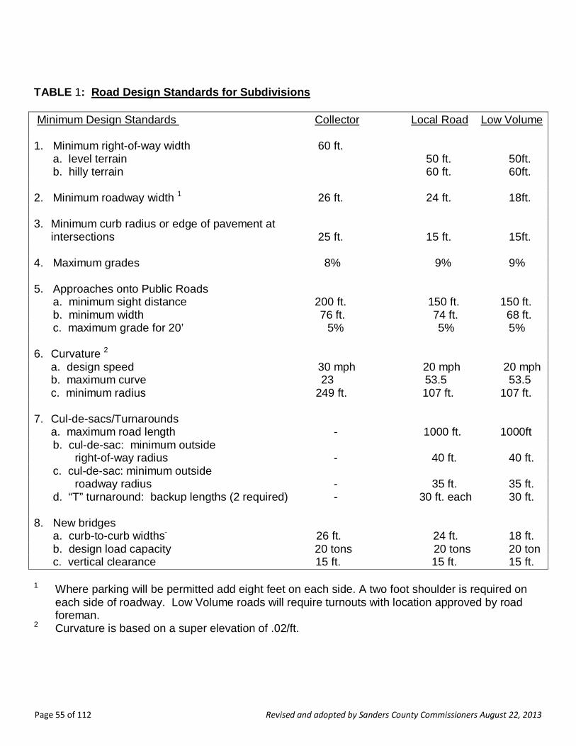
Page 55 of 112 Revised and adopted by Sanders County Commissioners August 22, 2013
TABLE 1: Road Design Standards for Subdivisions Minimum Design Standards Collector Local Road Low Volume
1. Minimum right-of-way width 60 ft. a. level terrain 50 ft. 50ft. b. hilly terrain 60 ft. 60ft. 2. Minimum roadway width 1 26 ft. 24 ft. 18ft. 3. Minimum curb radius or edge of pavement at
intersections 25 ft. 15 ft. 15ft. 4. Maximum grades 8% 9% 9% 5. Approaches onto Public Roads a. minimum sight distance 200 ft. 150 ft. 150 ft. b. minimum width 76 ft. 74 ft. 68 ft. c. maximum grade for 20’ 5% 5% 5% 6. Curvature 2
a. design speed 30 mph 20 mph 20 mph b. maximum curve 23 53.5 53.5 c. minimum radius 249 ft. 107 ft. 107 ft.
7. Cul-de-sacs/Turnarounds a. maximum road length - 1000 ft. 1000ft b. cul-de-sac: minimum outside right-of-way radius - 40 ft. 40 ft. c. cul-de-sac: minimum outside roadway radius - 35 ft. 35 ft. d. “T” turnaround: backup lengths (2 required) - 30 ft. each 30 ft. 8. New bridges a. curb-to-curb widths 26 ft. 24 ft. 18 ft. b. design load capacity 20 tons 20 tons 20 ton c. vertical clearance 15 ft. 15 ft. 15 ft. 1 Where parking will be permitted add eight feet on each side. A two foot shoulder is required on
each side of roadway. Low Volume roads will require turnouts with location approved by road foreman.
2 Curvature is based on a super elevation of .02/ft.

Page 56 of 112 Revised and adopted by Sanders County Commissioners August 22, 2013
OFF-SITE ROAD STANDARDS: Where primary access to the subdivision is to be provided by a road or roads not contained within the boundaries of the subdivision, access to the nearest publicly maintained road shall meet the following standards. (1) Right-of-way standards shall meet the standards of Section VI-G, Streets & Roads of these regulations. (2) Total improvements shall meet the standards of Section VI-G, Streets & Roads of these regulations.

Page 57 of 112 Revised and adopted by Sanders County Commissioners August 22, 2013
VI-H. Drainage Facilities a. The drainage system and facilities required for any surface run-off affecting the subdivision is
subject to approval by the governing body. Subdivisions containing lots less than 20 acres in size must also be approved by the Montana Department of Environmental Quality.
b. Curbs and gutters or swales will be required based on the character of the area, density of
development, and nature of adjoining properties. Curbs and gutters of adjoining properties must be extended in conformance with current specifications of local and state authorities.
c. Culverts and bridges of adequate size must be provided and installed by the subdivider where
drainage channels intersect any street right-of-way or easement. All culverts and bridges must be constructed and installed according to applicable local and state standards. Culverts and other drainage facilities must be large enough to accommodate potential run-off from upstream drainage areas.
d. The subdivider must provide suitable drainage facilities for any surface run-off affecting the
subdivision. These facilities must be located in street rights-of-way or in perpetual easements of appropriate area and volume.
e. Drainage systems must not discharge into any sanitary sewer facility. f. Grading and drainage systems must be designed and certified by a professional engineer or
an individual familiar with DEQ stormwater design standards. g. The governing body may require the subdivider to grant easements to prevent encroachment
or disruption of drainageways or facilities. Drainage easements must be shown on the plat and a signed statement granting the easements must appear on the plat.
h. Natural drainage ways shall be preserved except for necessary crossings in which the capacity
of existing drainage ways shall be preserved. Drainage ways shall remain clear and open and shall not be obstructed with fences, structures, etc. Lots shall be arranged to preserve and maintain these drainage channels.
I. During the construction of improvements in the subdivision, the subdivider shall be responsible
for installing temporary erosion and sedimentation control facilities to control surface runoff. No silt laden water or excess shall flow to downstream areas or surface waters. Such controls shall be in accordance with acceptable best management practices.
VI-I. Water Supply Systems a. The proposed method of supplying domestic water to each lot in the subdivision must comply
with the design standards adopted by the MDEQ and contained in the ARM 17.36.301, 17.36.302, 17.36.303, and 17.36.305. By this reference these DEQ standards are incorporated into and made a part of these regulations. Unless defined elsewhere in these regulations, the terms used in these standards will have the meanings assigned to them in ARM 17.36.101.
Page 58 of 112 Revised and adopted by Sanders County Commissioners August 22, 2013
b. Before the governing body will approve the final plat of a subdivision containing lots of less than 20 acres in size, the subdivision must have been approved by DEQ or other authorized reviewing authority under the Sanitation in Subdivisions Act sections 76-4-101 et seq., MCA.
c. Any central water supply system must provide adequate and accessible water for fire
protection. VI-J. Sewage Treatment Systems a. The proposed method of disposing of sewage from each lot in the subdivision must comply
with the design standards adopted by the Montana Department of Environmental Quality (DEQ) and contained in the Administrative Rules of Montana (ARM) 17.36.301, 17.36.302, 17.36.312, and 17.36.320 through 17.36.326. By this reference these DEQ standards are incorporated into and made a part of these regulations. Unless defined elsewhere in these regulations, the terms used in these standards will have the meanings assigned to them in ARM 17.36.101.
b. In addition, before the governing body will approve the final plat of a subdivision containing lots
of less than 20 acres in size, the subdivision must have been approved by DEQ or other authorized reviewing authority under the Sanitation in Subdivisions Act sections 76-4-101MCA.
VI-K. Solid Waste a. The proposed method of storing and disposing of solid waste generated within the subdivision
must comply with the standards adopted by the Montana Department of Environmental Quality (DEQ) and contained in the Administrative Rules of Montana (ARM) 17.36.309. By this reference this DEQ standard is incorporated into and made a part of these regulations. Unless defined elsewhere in these regulations, the terms used in these standards will have the meanings assigned to them in ARM 17.36.101.
b. In addition, before the governing body will approve the final plat of a subdivision containing lots
of less than 20 acres in size, the subdivision must have been approved by the Montana Department of Environmental Quality or other authorized reviewing authority under the Sanitation in Subdivisions Act sections 76-4-101 MCA.
VI-L. Utilities a. The subdivider must provide adequate and appropriate easements for the construction and
maintenance of utilities within the subdivision. The subdivider must obtain any easements necessary to extend utilities to the subdivision.
b. Utilities must be placed underground, wherever practical. Underground utilities, if placed in a
street right-of-way, must be located between the roadway and the right-of-way line to simplify location and repair of lines. Underground facilities must be installed after the street has been brought to grade and before it is surfaced.
c. Where practical, overhead utility lines must be located at the rear property line. d. Utility facilities must be designed by utility firms in cooperation with the subdivider. These
facilities are subject to all applicable laws, rules, and regulations of the appropriate regulatory authorities.
Page 59 of 112 Revised and adopted by Sanders County Commissioners August 22, 2013
e. Utility easements located between adjoining lots must be centered on lot lines. If easements
are placed in the street, they must be located between the roadway and the right-of-way line. f. Utility easements must be 15 feet wide unless otherwise specified by a utility company or
governing body. g. When a utility is to be located in an existing, dedicated right-of-way, a notice of utility
occupancy must be obtained from the governing body, or local or state highway department. h. In addition to showing the location of utility easements on the plat with dashed lines, the
following statement must appear on the final plat:
“The undersigned hereby grants unto each and every person, firm, or corporation, whether public or private, providing or offering to provide telephone, telegraph, electric power, gas, cable television, water or sewer service to the public, the right to the joint use of an easement for the construction, maintenance, repair and removal of their lines and other facilities, in, over, under and across each area designated on this plat as ‘Utility Easement’ to have and to hold forever.”
VI-M. Water Course and Irrigation Easements [76-3-504(1)(j)(k) MCA] a. Except as noted in b., below, the subdivider shall establish within the subdivision ditch
easements that:
i. are in locations of appropriate topographic characteristics and sufficient width to allow the physical placement and unobstructed maintenance of open ditches or below ground pipelines for the delivery of water for irrigation to persons and land legally entitled to the water under an appropriated water right or permit of an irrigation district or other private or public entity formed to provide for the use of the water right on the subdivision lots;
ii. are a sufficient distance from the centerline of the ditch to allow for construction, repair,
maintenance, and inspection of the ditch; and iii. prohibit the placement of structures or the planting of vegetation other than grass within
the ditch easement without the written permission of the ditch owner. b. The subdivider need not establish irrigation easements as provided above if:
i. the average lot size in the proposed subdivision will be one acre or less and the subdivider provides for disclosure, in a manner acceptable to the governing body, notifying potential buyers that lots within the subdivision are classified as irrigated land and may continue to be assessed for irrigation water delivery even though the water may not be deliverable to the lots; or
ii. the water rights have been removed from the land within the subdivision or the process
has been initiated to remove the water rights from the subdivided land; and iii. the fact the water rights have been or will be removed from the land within the
subdivision is denoted on the preliminary plat. If the removal of water rights has not been completed at the time the final plat is filed, the subdivider shall provide written

Page 60 of 112 Revised and adopted by Sanders County Commissioners August 22, 2013
notification to prospective buyers of the subdivider’s intention to remove the water right and shall document that intent, when applicable, in agreements and legal documents for related sales transactions.
c. The subdivider shall, unless otherwise provided under separate written agreement or filed
easement, show on the preliminary and final plat, and file and record with the county clerk and recorder, ditch easements for the unobstructed use and maintenance of existing water delivery ditches, pipelines, and facilities in the proposed subdivision that are necessary to convey water through the subdivision to lands adjacent to or beyond the subdivision boundaries in quantities and in a manner that are consistent with historic and legal rights. A minimum width of 10 feet is required on each side of irrigation canals and ditches for maintenance purposes.
VI-N. Disposition of Water Rights [76-3-504(1)(i), MCA] If a subdivision will create lots averaging less than five acres in size, the subdivider shall submit evidence with the final plat that the subdivider has: a. reserved all or a portion of the appropriation water rights owned by the owner of the land to be
subdivided and transfer these water rights to a single entity for use by landowners within the subdivision who have a legal right to the water and reserved and severed any remaining surface water rights from the land;
b. if the land to be subdivided is subject to a contract or interest in a public or private entity
formed to provide for the use of a water right on the subdivision lots, established a landowner’s water use agreement administered through a single entity. This agreement must specify how the water rights will be administered and describe the rights and responsibilities of landowners within the subdivision who have a legal right and access to the water; or
c. reserved and severed all surface water rights from the land proposed for subdivision. VI-O. Park Land Dedication – Cash in Lieu – Waivers – Administration [76-3-621 MCA] a. Except as provided below, the final plat of a residential subdivision must show that the
subdivider has dedicated to the governing body a cash or land donation equal to:
i. 11% of the area of the land proposed to be subdivided into parcels of one-half acre or smaller;
ii. 7.5% of the area of the land proposed to be subdivided into parcels larger than one-half
acre and not larger than one acre; iii. 5% of the area of the land proposed to be subdivided into parcels larger than one acre
and not larger than three acres; and iv. 2.5% of the area of the land proposed to be subdivided into parcels larger than three
acres and not larger than five acres.
b. A park dedication is not required for:
i. minor subdivisions;
Page 61 of 112 Revised and adopted by Sanders County Commissioners August 22, 2013
ii. subdivision lots larger than five acres; iii. nonresidential subdivision lots; iv. subdivisions in which parcels of land will not be created, other than subdivisions that will
provide permanent multiple spaces for recreational camping vehicles, mobile homes, or condominiums; or
v. subdivisions which will create only one additional parcel.
c. The governing body, in consultation with the subdivider and the planning board or park board that has jurisdiction, may determine suitable locations for parks and playgrounds and, giving due weight and consideration to the expressed preference of the subdivider, may determine whether the park dedication must be a land donation, cash donation, or a combination of both. When a combination of land donation and cash donation is required, the cash donation may not exceed the proportional amount not covered by the land donation.
d. The governing body will waive the park dedication requirement if it determines that:
i. A. the preliminary plat provides for a planned unit development or other development with land permanently set aside for park and recreational uses sufficient to meet the needs of the persons who will ultimately reside in the development; and
B. the area of the land and any improvements set aside for park and recreational
purposes equals or exceeds the area of the dedication required under subsection VI-O(a);
ii. A. the proposed subdivision will provide for the long-term protection of critical
wildlife habitat; cultural, historical, or natural resources; agricultural interests; or aesthetic values; and
B. the provision of this long-term protection will result in the reduction of the area of the land proposed to be subdivided by an amount equal to or exceeding the area that would have had to be dedicated under a above 76-3-620(d); or
iii. the area of the land proposed to be subdivided, by virtue of a combination of the
provisions of subparagraphs d (i) and (ii) above, is reduced by an amount equal to or exceeding the area of the dedication required under subparagraph a.
iv. A. the subdivider provides for land outside of the subdivision to
be set aside for park and recreational uses sufficient to meet the needs of the persons who will ultimately reside in the subdivision; and
B. the area of the land and any improvements set aside for park and recreational uses equals or exceeds the area of dedication required under subsection VI- O(a).
e. The local governing body may waive the park dedication requirement if:

Page 62 of 112 Revised and adopted by Sanders County Commissioners August 22, 2013
i. the subdivider provides land outside the subdivision that affords long-term protections of critical wildlife habitat, cultural, historical, or natural resources, agricultural interests, or aesthetic values; and
ii. The area of land to be subject to long-term protection, as provided in subsection (e)(i),
equals or exceeds the area of dedication required under subsection VI-O(a).
f. Subject to the approval of the local governing body and acceptance by the school district trustees, a subdivider may dedicate a land donation provided under subsection VI-O(a) to a school district, adequate to be used for school facilities or buildings.
g. The governing body will administer funds dedicated to the public under this section in accordance with section 76-3-621, MCA.
h. For the purposes of this park dedication requirement: i. “cash donation” means the fair market value of the unsubdivided, unimproved land; and ii. “dwelling unit” means a residential structure in which a person or persons reside. VI-P. Fire Protection [76-3-501(9)] All subdivisions must be planned, designed, constructed, and maintained so as to minimize the risk of fire and to permit the effective and efficient suppression of fires in order to protect persons, property, and forested areas. Measures must include: a. The placement of structures so as to minimize the potential for flame spread and to permit
adequate access for firefighting equipment.
b. The presence of adequate fire fighting facilities on site, including an adequate water supply and water distribution system to fight fires.
c. The availability, through a fire protection district or other means, of fire protection services
adequate to respond to fires that may occur within a subdivision. VI-Q. Special Requirements for Subdivisions Proposed in Areas of High Fire Hazard For areas identified as high wildfire hazard areas by the United States Forest Service, the Montana Department of Natural Resources and Conservation, a local fire protection authority, or in a local policy, the following apply: a. A Fire Prevention and Control Plan shall be required with the submission of any application for
preliminary plat approval. b. The Fire Prevention and Control Plan shall include the following items:
i. an analysis of the wildfire hazards on the site, as influenced by existing vegetation and topography;

Page 63 of 112 Revised and adopted by Sanders County Commissioners August 22, 2013
ii. a map showing the areas that are to be cleared of dead, dying, or severely diseased vegetation;
iii. a map of the areas that are to be thinned to reduce the interlocking canopy of trees; iv. identification of roads, driveways, and bridges sufficient for emergency vehicle access
and fire suppression activities. Slopes for all roads and driveways must be provided.
c. At least two entrance-exit roads must be provided to assure more than one escape route for residents and access routes by fire fighting vehicles. Bridges must be built to a design load of 20 tons, and must be constructed of non-flammable materials. Road rights-of-way must be cleared of slash.
d. Building sites must be prohibited on slopes greater than 25 percent and at the apex of “fire chimneys” (topographic features, usually drainageways or swales, which tend to funnel or otherwise concentrate fire toward the top of steep slopes).
e. The Fire Prevention and Control Plan shall be implemented before approval of the final plat,
and shall be considered part of the subdivider’s obligations for land development. The local fire chief, or designee, shall inspect and approve the implementation of the Fire Prevention and Control Plan. The Plan shall not be considered fully implemented until the fire chief has given written notice to the subdivision administrator that the Plan was completed as approved by the Sanders County Commissioners.
f. In subdivisions or planned unit developments, provisions for the maintenance of the Fire
Prevention and Control Plan shall be included in the covenants, conditions, and restrictions for the development. A homeowners’ association shall be formed and named as a beneficiary of such covenants, conditions, and restrictions.
g. Open space, park land, and recreation areas (including green belts, riding or hiking trails)
should be located, where appropriate, to separate residences and other buildings from densely forested areas.
h. A water supply of sufficient volume for effective fire control must be provided in accordance
with standards set by the fire district in which the project is located. * In the absence of such standards, the subdivider must at least provide the following for effective fire control:
a. A central water system with a minimum flow of 1,000 gallons per minute;
b. Where no central water system exists, cisterns, reservoirs or fill ponds must be provided at appropriate locations:
i. For single dwelling units: minimum capacity of 2,500 gallons;
ii. For 6 or more dwelling units: minimum capacity of 500 gallons per dwelling unit.

Page 64 of 112 Revised and adopted by Sanders County Commissioners August 22, 2013
VI-R. Noxious Weeds A weed control plan shall be developed and implemented for every new subdivision. An agreement with the Sanders County Commissioners shall be signed and implemented by the subdivider, and the Weed Plan must be recorded with the final plat. VII. AREAS THAT WILL PROVIDE MULTIPLE SPACES FOR RECREATIONAL CAMPING
VEHICLES OR MOBILE HOMES VII-A Definition A subdivision includes an area, regardless of its size, that provides or will provide multiple spaces for rent or lease on which recreational camping vehicles or mobile homes will be placed. The land is owned, however, as one parcel under single ownership (which can include a number of persons owning property in common). Plats are submitted to the subdivision administrator for review and filing with the Clerk & Recorder. VII-B. Subdivisions That Provide or Will Provide Multiple Spaces for Recreational Camping
Vehicles or Mobile/Manufactured Homes [76-3-103(15)] a. Recreational Camping Vehicles -- Definition
Developments which are subject to subdivision review because they will provide two or more spaces for recreational camping vehicles will be reviewed under section VII-F Recreational Vehicle Park Standards, below
b. Mobile Homes – Definition
Developments which are subject to subdivision review because they will provide two or more spaces for mobile homes will be reviewed under section VII-E Mobile Home Park Standards, below
c. Mobile Home/Recreational Vehicle Parks
i. Mobile Home and recreational vehicle parks will be reviewed under the procedures described in Section IV, Major Subdivisions, or Section III, Minor Subdivisions, as may be appropriate. The subdivider shall submit a final plat, following the Final Plat procedure in Section II.
ii. Mobile home and recreational vehicle parks are subject to the applicable standards
contained in Section VII. VII-C. Procedures for Review VII-C-1. Review and Approval Subdivisions which will provide multiple spaces for recreational camping vehicles or mobile homes lease are exempt from the surveying and filing must meet the requirements of the MSPA. They must be submitted for review and approved by the governing body before spaces may be rented or leased.
Page 65 of 112 Revised and adopted by Sanders County Commissioners August 22, 2013
a. Submittal
The subdivider shall submit a completed application in accordance with Section II-A-5. b. Review
The procedure used to review subdivisions for mobile home and recreational vehicle parks will depend on the number of spaces within the proposed subdivision. Proposed subdivisions containing six or more spaces must be reviewed pursuant to Section IV of these regulations. Proposed subdivisions containing five or fewer spaces must be reviewed pursuant to Section III of these regulations. The subdivider shall submit to the subdivision administrator the preliminary plat, profiles, tentative grades, and specifications for proposed improvements. The plat must show the space layout and the proposed location of the mobile home, recreational vehicle, or other unit on the land included in the plan.
VII-C-2. Improvements The subdivider shall install all required improvements before renting or leasing any portion of the subdivision. The governing body will inspect all required improvements in order to assure conformance with the approved construction plans and specifications. VII-C-3. Final Plan Review The subdivider shall submit a final plat to the subdivision administrator complying with the requirements of Final Plat in Section II. VII-C-4. DPHHS License If a subdivision that will provide multiple spaces for recreational camping vehicles or mobile homes is also a “trailer court”, ‘work camp”, “youth camp”, or “campground” as those terms are defined in section 50-52-102 MCA, the governing body will not grant final approval of the subdivision until the subdivider obtains a license for the facility from the Montana Department of Public Health and Human Services under Title 50, Chapter 52, MCA. VII-D. Design Standards for Subdivision Spaces Created by Rent or Lease VII-D-1. Design Standards Mobile home and recreational vehicle parks must comply with the provisions of Section VI, Design and Improvements Standards. VII-D-2. Additional Provisions The governing body may require provision for: a. storage facilities on the lot or in compounds located within a reasonable distance;
b. a central area for storage or parking of boats, trailers, or other recreational vehicles;
c. landscaping or fencing to serve as a buffer between the development and adjacent properties;
Page 66 of 112 Revised and adopted by Sanders County Commissioners August 22, 2013
d. an off-street area for mail delivery; and
e. street lighting. VII-E. Mobile/Manufactured Home Park Standards VII-E-1. Mobile/Manufactured Home Spaces a. Mobile/manufactured home spaces must be arranged to permit the safe and practical
placement and removal of mobile homes.
b. All mobile/manufactured homes must be located at least 25 feet from any property boundary line abutting upon a public street or highway right-of-way and at least 15 feet from other boundary lines of the park.
c. The mobile/manufactured home pad must be located at least 10 feet from the street that
serves it. d. The size of the mobile/manufactured home pad must be suitable for the general market to be
served and must fit the dimensions of mobile homes anticipated. e. A mobile/manufactured home pad may not occupy more than one-third (1/3) of the area of its
space. The total area occupied by a mobile/manufactured home and its roofed accessory buildings and structures may not exceed two-thirds (2/3) of the area of a space.
f. The governing body may require that the mobile/manufactured home pad be improved to
provide adequate support for the placement and tie-down of the mobile/manufactured home. g. No mobile/manufactured home or its attached structures, such as awnings and carports, may
be located within 20 feet of any other mobile/manufactured home or its attached structures. h. No detached structure, such as a storage shed, may be located within five feet of any
mobile/manufactured home or its attached structures. i. A minimum of two off-street parking spaces must be provided on or adjacent to each
mobile/manufactured home space. The driveway must be located to allow for convenient access to the mobile/manufactured home, and be a minimum of 10 feet wide.
j. One guest parking space must be provided for each 10 mobile/manufactured home spaces.
Group parking may be provided. k. The limits of each mobile/manufactured home space must be clearly marked on the ground by
permanent flush stakes, markers or other suitable means. Location of space limits on the ground must be approximately the same as those shown on the approved plans. Precise engineering of space limits is not required either on the plans or on the ground.
l. Each mobile/manufactured home must be skirted within 30 days after it is moved to a space
within the mobile/manufactured home park. The skirting must be of a fire-resistant material similar to that of the mobile/manufactured home exterior.

Page 67 of 112 Revised and adopted by Sanders County Commissioners August 22, 2013
VII-E-2. Streets Streets within a mobile/manufactured home park must meet the design standards specified in Section VI-H Streets and Roads. Streets must be designed to allow safe placement and removal of mobile homes. a. Streets must be designed to provide safe access to public roads. b. Roads within the recreational vehicle park must be designed to provide safe parking and
removal of recreational vehicles, and safe traffic circulation within the park.
c. One-way roads must be at least 15 feet wide; two-way roads must be at least 24 feet wide. VII-E-3. Electrical Systems Electrical system installation must be designed and constructed in accordance with the applicable codes adopted by the authority having jurisdiction. Where the state or other political subdivision does not assume jurisdiction, such installations must be designed and constructed in accordance with the applicable state electrical standards. VII-E-4. Gas Systems a. Gas equipment and installations must be designed and constructed in accordance with the
applicable codes adopted by the authority having jurisdiction. Where the state or other political subdivision does not assume jurisdiction, such installation must be designed and constructed in accordance with the appropriate provisions of the “National Fuel Gas Code” (NFPA Pamphlet 54-1981) and the “Standard for the Storage and Handling of Liquified Petroleum Gases” (NFPA Pamphlet 58-1981).
b. A readily accessible and identified shutoff valve controlling the flow of gas to the entire gas
piping system must be installed near to the point of connection of the liquified petroleum gas container.
c. Each mobile/manufactured home lot must have an accessible, listed gas shutoff installed.
Such valve must not be located under a mobile home. Whenever the mobile/manufactured home lot outlet is not in use, the shutoff valve must be plugged to prevent accidental discharge.
VII-F. Recreational Vehicle Park Standards VII-F-1. Recreational Vehicle Spaces a. Spaces in recreational vehicle parks must be arranged to allow for the safe movement of traffic
and access to spaces. b. Roads within recreational vehicle parks must be designed to provide safe traffic circulation and
parking.

Page 68 of 112 Revised and adopted by Sanders County Commissioners August 22, 2013
c. Recreational vehicles must be separated from each other and from other structures by at least 15 feet. Any accessory structures such as attached awnings must, for purposes of this separation requirement, be considered part of the recreational vehicle.
d. All recreational vehicle spaces must be located at least 25 feet from a public street or highway right-of-way. VII-F-2. Density The density must not exceed 25 recreational vehicle spaces per acre of gross site area. VIII. PLANNED UNIT DEVELOPMENTS VIII-A. Purpose The purpose of this section is to provide flexibility in applying certain subdivision standards, allowing the subdivider creativity in subdivision design. Section 76-3-103(10) MCA defines a planned unit development as “a land development project consisting of residential clusters, industrial parks, shopping centers or office building parks that compose a planned mixture of land uses built in a prearranged relationship to each other and having open space and community facilities in common ownership or use.” VIII-B. Procedures If the governing body designates the development plan a PUD, the preliminary plat may be submitted for review. Submittal must comply with requirements and procedures contained in the following Sections:
IV. Major Subdivisions II-B. Applicable sections for Final Plats VIII-C. Standards VIII-C-1. Design Standards PUDs must comply with the standards contained in Section IV Design and Improvement Standards. However, the governing body may modify the design and improvement standards contained in Section VI-E Lots, Section VI-F Blocks, Section VI-G Streets and Roads, and Section VI-O Park Land Dedication upon request of the subdivider when the plan for a PUD includes provisions for efficient traffic circulation, adequate light, air, and open space. In such cases, no application for a variance under Section X-B Variances of these regulations is necessary. VIII-C-2. Streets The arrangement, type, extent, width, grade and location of all streets must be considered in their relation to existing and planned streets to topographical conditions and to public convenience and safety.

Page 69 of 112 Revised and adopted by Sanders County Commissioners August 22, 2013
VIII-C-3. Open Space Each PUD must comply with the requirements of subchapter VI-O of these regulations. The open space must be: a. Held in common ownership by a property owners’ association; or b. Dedicated to public use, if acceptable to the governing body; or c. A combination of “a” or “b” above. The governing body may waive dedication or cash donation requirements when the subdivider agrees to create a property owners’ association for the proposed subdivision and the deed to the association land to be held in perpetuity for use as parks or playgrounds. IX. CONDOMINIUMS IX-A. Procedures Unless exempted by section 76-3-203 MCA, all condominium developments are subdivisions subject to the terms of the Montana Subdivision and Platting Act as follows: IX-A-1. Review Where Land Will Not Be Divided If no division of land will be created by a condominium subdivision, the subdivision must be reviewed under the procedures contained in Chapter VII, with the following exception: final approval will not be given until the subdivider has either installed all required improvements, or has entered into a subdivision improvements agreement pursuant to Section II-B-4 Public Improvements Agreement; Guaranty. IX-A-2. Condominium Subdivisions Involving Land Divisions If a proposed condominium development will involve a division of land, the subdivision must be reviewed under the procedures contained in Sections: IV. Review and Approval Procedures for Major Subdivisions II-B. Applicable sections for Final Plats. IX-B. Standards IX-B-1. Design Standards Condominium developments must comply with applicable standards contained in Section VI, Design and Improvement Standards. IX-B-2. Unit Ownership Act Condominium developments must comply with all provisions of the Unit Ownership Act, Sections 70-23-102 through 70-23-703, MCA.

Page 70 of 112 Revised and adopted by Sanders County Commissioners August 22, 2013
X. ADMINISTRATIVE PROVISIONS X-A. Fee Schedule [6-3-602 MCA] X-A-1. Preliminary Plat Review To cover costs of reviewing plans, advertising, holding public hearings, and other activities associated with the review of a subdivision proposal, the subdivider shall pay a non-refundable fee at the time of application for preliminary plat approval. The fees, payable to the county Land Services Department, are as follows: See Resolution 2013-20. X-A-2. Exemptions $100.00 See Resolution 2013-20. X-A-3. Final Plat Review and Inspection To cover the cost of on-site inspection of the subdivision and review of the final plat and supplementary materials the subdivider shall pay a non-refundable fee at the time of application for final approval to the county Land Services Department at the following rate: See Resolution 2008-1. X-B. Variances $50.00 See Resolution 2013-20. X-B-1. Variances Authorized The governing body may grant variances from Chapter VI, Design and Improvement Standards, of these regulations when, due to the characteristics of land proposed for subdivision, strict compliance with these standards would result in undue hardship and would not be essential to the public welfare. A variance will not be granted if it would have the effect of nullifying the intent and purpose of these regulations. The County Commissioners will conduct a public hearing on any variance request for all major subdivisions prior to taking action on the preliminary plat application. Such variances must not have the effect of nullifying the intent and purpose of these regulations. The governing body will not approve a variance unless it finds that:
a. The granting of the variance will not be detrimental to the public health, safety, or general welfare or injurious to other adjoining properties;
b. Due to the physical surroundings, shape, or topographical conditions of the property involved, strict compliance with the regulations will impose an undue hardship on the owner. Undue hardship does not include personal or financial hardship, or any hardship that is self imposed;
c. The variance will not cause a substantial increase in public costs; and d. The variance will not place the subdivision in nonconformance with any adopted zoning
regulations. X-B-2. Variances from Floodway Provisions Not Authorized
Page 71 of 112 Revised and adopted by Sanders County Commissioners August 22, 2013
The governing body will not by variance permit subdivision for building purposes in areas located within the floodway of a flood of 100-year frequency as defined by Title 76, Chapter 5, MCA. X-B-3. Procedure The subdivider shall include with the submission of the preliminary plat a written statement describing and justifying the requested variance and the facts of hardship upon which the request is based. The Sanders County Commissioners shall consider each requested variance at the public meeting or hearing on the preliminary plat. X-B-4. Conditions In granting variances, the governing body may impose reasonable conditions to secure the objectives of these regulations. X-B-5. Statement of Facts When a variance is granted, the motion of approval of the proposed subdivision must contain a statement describing the variance and the facts and conditions upon which the issuance of the variance is based. X-C. Amendment of Regulations Before the governing body amends these regulations it will hold a public hearing on the proposed amendment. Notice of the time and place of the public hearing must be published in a newspaper of general circulation in the county not less than 15 days or more than 30 days before the date of the hearing. X-D. Administration X-D-1. Enforcement Except as provided in 76-3-303 MCA, every final subdivision plat must be filed for record with the county clerk and recorder before title to the subdivided land can be sold or transferred in any manner. If unlawful transfers are made, the county attorney shall commence action to enjoin further sales or transfers and compel compliance with all provisions of the Montana Subdivision and Platting Act and these regulations. The cost of this action shall be imposed against the party not prevailing. X-D-2. Violation and Penalties Any person, firm, corporation, or other entity that violates any of the provisions of the Montana Subdivision and Platting Act or these regulations is guilty of a misdemeanor punishable by a fine of not less than $100 or more than $500 or by imprisonment in jail for not more than three months or by both fine and imprisonment. Each sale, lease, or transfer, or offer of sale, lease, or transfer of each separate parcel of land in violation of any provision of the Montana Subdivision and Platting Act or these regulations shall be deemed a separate and distinct offense. X-D-3. Appeals A decision of the governing body regarding a proposed subdivision may be appealed to the district court, as provided in 76-3-625 MCA.

Page 72 of 112 Revised and adopted by Sanders County Commissioners August 22, 2013
A. UNIFORM STANDARDS FOR MONUMENTATION,
CERTIFICATES OF SURVEY, AND FINAL SUBDIVISION PLATS
24.183.1101 UNIFORM STANDARDS FOR MONUMENTATION
1. The following standards govern the monumentation of land surveys: a. The terms "monument" and "permanent monument" as used in these regulations mean
any structure of masonry, metal or other permanent, durable material placed in the ground, which is exclusively identifiable as a monument to a survey point, expressly placed for surveying reference.
b. All metal monuments must be at least one-half inch in diameter and 18 inches in length
with a cap not less than 1 inch in diameter marked in a permanent manner with the license number of the surveyor in charge of the survey and either the name of the surveyor or the company employing the surveyor. Metal monuments marking a public land survey corner as described in 70-22-101, MCA, must be at least 24 inches long and 5/8 inch in diameter with an appropriately stamped metal cap at least 2 inches in diameter. A monument marking a public land survey corner may also consist of a cap as described in this rule set firmly in concrete.
c. Before a subdivision plat or certificate of survey may be filed for record the surveyor shall
confirm the location of as many monuments as, in the surveyor's professional judgment, are necessary to reasonably assure the perpetuation of any corner or boundary established by the survey and to enable other surveyors to reestablish those corners and boundaries and retrace the survey. The surveyor shall clearly identify on the face of the plat or certificate of survey all monuments pertinent to the survey, and the descriptions of these monuments must be sufficient to identify the monuments.
d. The surveyor shall set all monuments prior to the filing of a plat or certificate of survey
except those monuments that will be disturbed by the installation of improvements or that, because of severe weather conditions, may, in the surveyor's judgment, be more appropriately and accurately set after the weather has improved. In these two circumstances the surveyor may set monuments after the survey document is filed if the surveyor certifies on the survey document that the monuments will be set by a specified date. The surveyor shall set monuments, the placement of which has been deferred because of severe weather conditions, within 240 days of the date on which the survey document was filed.
i. If during the later monumentation of the corners of a plat or certificate of survey that
were not monumented before the plat or certificate was filed, the surveyor finds that it is necessary to set a reference monument to a corner, the surveyor shall prepare and file an amended certificate of survey or subdivision plat.
ii. The failure of the surveyor to set the monuments by the date certified on the record
of survey will be deemed a violation of these rules.
e. The surveyor shall set monuments at the following locations:

Page 73 of 112 Revised and adopted by Sanders County Commissioners August 22, 2013
i. At each corner and angle point of all lots, blocks and parcels of land created by the survey.
ii. At every point of intersection of the outer boundary of a subdivision with an existing
road right-of-way line of record or a road right-of-way line created by the survey.
iii. At every point of curve, point of tangency, point of reversed curve, point of compounded curve and point of intersection on each road right-of-way line created by the survey.
iv. At the intersection of a boundary line and a meander line. Meander line angle points
need not otherwise be monumented.
f. If the placement of a required monument at its proper location is physically impractical, the surveyor may set a reference or witness monument. This monument has the same status as other monuments of record if its location is properly shown. If the surveyor relies upon any existing monument in conducting a survey, he or she shall confirm the location of the monument and show and describe it on the resulting certificate of survey or subdivision plat.
24.183.1104 UNIFORM STANDARDS FOR CERTIFICATES OF SURVEY
1. A certificate of survey may not be filed by a county clerk and recorder unless it complies with
the following requirements:
a. A certificate of survey must be legibly drawn with permanent ink or printed or reproduced by a process guaranteeing a permanent record and must be 18 inches by 24 inches, or 24 inches by 36 inches. Margins must be a minimum ½ inch on all sides, including a 1 ½ inch margin on the binding side.
b. One signed copy on 3 mil or heavier matte stable-base polyester film or equivalent and
one signed reproducible copy on a stable-base polyester film or equivalent must be submitted.
c. If more than one sheet must be used to adequately depict the land surveyed, each
sheet must show the number of that sheet and the total number of sheets included. All certifications must be placed or referred to on one sheet.
d. A certificate of survey must show or contain on its face or on separate sheets referred to
on its face the following information. The surveyor may, at his or her discretion, provide additional information regarding the survey.
i. a title or title block including the quarter-section, section, township, range,
principal meridian and county, and, if applicable, city or town in which the surveyed land is located. Except as provided in (1)(f)(v), a certificate of survey must not bear the title "plat," “subdivision" or any title other than "Certificate of Survey";
ii. the name(s) of the person(s) who commissioned the survey, the name(s) of the
owner(s) of the land surveyed, if other than the person(s) commissioning the

Page 74 of 112 Revised and adopted by Sanders County Commissioners August 22, 2013
survey, the names of any adjoining platted subdivisions and the numbers of any adjoining certificates of survey previously filed;
iii. the date the survey was completed and a brief explanation of why the certificate
of survey was prepared, such as to create a new parcel, retrace a section line or retrace an existing parcel of land;
iv. a north arrow; v. a scale bar. The scale must be sufficient to legibly represent the required
information and data; vi. the location of, and other information relating to all monuments found, set, reset,
replaced or removed as required by ARM 24.183.1101;
A. If additional monuments are to be set after the certificate of survey is filed, these monuments must be shown by a distinct symbol, and the certificate of survey must contain a certification by the surveyor as to the reason the monuments have not been set and the date by which they will be set, as required by ARM 24.183.1101(1)(d).
B. All monuments found during a the survey that influenced the position of
any corner or boundary indicated on the certificate of survey must be clearly shown as required by ARM 24.183.1101(1)(c).
C. Witness and reference monuments must be clearly shown.
vii. the location of any section corners or corners of divisions of sections the
surveyor deems to be pertinent to the survey or was used as control in the survey;
viii. basis of bearings. For purposes of this rule the term "basis of bearings" means
the surveyor's statement as to the origin of the bearings shown in the certificate of survey. If the basis of bearing(s) refers to two previously monumented points in a previously filed survey document, then the two previously monumented points must be shown and described on the certificate of survey, the line marked by the two previously monumented points must be labeled “basis of bearing,” and the previously filed survey document name or number must be cited in the land surveyor’s statement as to the origin of the bearing(s). If the certificate of survey shows true bearings, the basis of bearings must describe the method by which these true bearings were determined;
ix. the bearings, distances and curve data of all boundary lines and all control or
pertinent lines used to determine the boundaries of the parcel(s) surveyed. If the parcel surveyed is bounded by an irregular shoreline or a body of water that is a riparian boundary, the bearings and distances of a meander traverse generally paralleling the riparian boundary must be given;
A. The courses along a meander line are shown solely to provide a basis for
calculating the acreage of a parcel that has one or more riparian boundaries as the parcel existed at the time of survey.

Page 75 of 112 Revised and adopted by Sanders County Commissioners August 22, 2013
B. For purposes of this rule a line that indicates a fixed boundary of a parcel
is not a "meander" or "meander line" and may not be designated as one. C. If a boundary, control, or pertinent line contains multiple segments of the
whole, then the overall distance must be shown, and each segment must at least include distance.
x. data on all curves sufficient to enable the re-establishment of the curves on the
ground. For circular curves, the data must at least include radius and arc length and either delta angle, radial bearings, or chord bearing and distance. All non-tangent points of intersection on the curve must show either the bearings of radial lines or chord length and bearing. Non-tangent curves must be so labeled;
xi. lengths of all lines shown to at least tenths of a foot, and all angles and bearings
shown to at least the nearest minute. Distance measurements must be stated in English units, but their metric equivalents, shown to the nearest hundredth of a meter, may be noted parenthetically;
xii. at least one record measurement reference for each line and curve, if available,
must be shown; xiii. a narrative legal description of the parcel(s) surveyed.
A. The land surveyor, at his or her discretion, may choose the form of the narrative legal description as follows:
I. If the parcel surveyed is either an aliquot part of a U.S. government
section or a U.S. government lot, the narrative legal description may be the aliquot part or government lot description of the parcel;
II. If the survey depicts the division of one or more parcel(s) shown on
a previously filed certificate of survey and the parcel number of the parcel(s) previously surveyed;
III. If the certificate of survey depicts the retracement of one or more
parcels shown on a previously filed certificate of survey, plat or amended plat, the narrative legal description may be the number of the previously filed certificate of survey or the name of the previously filed plat or amended plat, and the parcel number of the parcel(s) previously surveyed;
IV. If the certificate of survey creates or retraces one or more parcels,
the narrative legal description may be either the metes-and-bounds description of each individual parcel created by the surveyor the metes-and-bounds description of the perimeter boundary of the parcels surveyed; or
V. If the narrative legal description does not fall within
24.183.1104(1)(d)(xiii)(A)(I), (II), or (III), then the narrative legal

Page 76 of 112 Revised and adopted by Sanders County Commissioners August 22, 2013
description required by this subsection must conform with 24.183.1104(1)(d)(xiii)(A)(IV).
B. When the narrative legal description is metes-and-bounds, the point of
beginning, which is also the point of closure of the legal description of the parcel surveyed, must be labeled “Point of Beginning”. Alternative, the point of beginning may be labeled “POB” if the abbreviation is defined on the certificate of survey.
C. The requirement of this rule does not apply to certificates of survey that
depict a partial retracement of boundaries of an existing parcel or establish the location of lines or corners that control the location of an existing parcel.
iv. all parcels created or retraced by the certificate of survey designated by number
or letter, and the bearings, distances, curve data, and area of each parcel, except as provided in 24.183.1104(1)(f)(iii). If a parcel created by the survey is identifiable as a 1/32 or larger aliquot part of a U.S. government section or as a U.S. government lot, it may be designated by number or letter or by its aliquot part or government lot identification;
v. the location, bearings, distances, and curve data of any easement that will be
created by reference to the certificate of survey; xvi. the dated signature and the seal of the surveyor responsible for the survey. The
surveyor’s signature certifies that the certificate of survey has been prepared in conformance with applicable sections of the Montana Subdivision and Platting Act.
xvii. a memorandum of any oaths administered under 76-3-405, MCA. xviii. if applicable, the certificate of the examining land surveyor; and ix. space for the county clerk and recorder's filing information.
e. Certificates of survey that do not represent a division or aggregation of land, such as
those depicting the retracement of an existing parcel and those prepared for informational purposes, must contain a statement as to their purpose and must meet applicable requirements of this rule for form and content. If the purpose of a certificate of survey is stated as a retracement or partial retracement, and if multiple tracts of record contained within the parcel’s perimeter boundary on the certificate of survey are not individually shown, then the certificate of survey does not expunge the tracts of record unless it conforms to (1)(f)(iv) and contains the acknowledged certificate of the property owner(s) citing the applicable exemption in its entirety.
f. Procedures for divisions of land exempted from public review as subdivisions. If one or
more parcels on a certificates of survey is created by an exemption from subdivision review under 76-3-207, MCA, then, except as provided in 24.183.1104(1)(f)(iii) and (1)(f)(iv), the certificate of survey must establish the boundaries of the exemption parcel(s). The certificate of survey is not required to establish, but may establish, the

Page 77 of 112 Revised and adopted by Sanders County Commissioners August 22, 2013
exterior boundaries of the remaining portion of the parent tract of land. However, the certificate of survey must show portions of the existing unchanged boundaries sufficient to identify the location and extent of the exemption parcel to be created. Unsurveyed portions of the parent tract of land must be labeled, “NOT PART OF THIS CERTIFICATE OF SURVEY” or “NOT INCLUDED IN THIS CERTIFICATE OF SURVEY”. The certificate of survey must contain the acknowledge certificate of the property owner stating that the division of land is exempt from review as a subdivision and cite the applicable exemption in its entirety. The certificate of survey must meet the following requirements. i. if the exemption relied upon requires that the property owner enter into a
covenant running with the land, the certificate of survey may not be filed unless it bears a signed and acknowledged recitation of the covenant;
ii. if a certificate of survey invokes the exemption for gift(s) and sale(s) to members
of the landowner's immediate family, the certificate must indicate the name of the proposed grantee, the relationship of the grantee to the landowner and the parcel to be conveyed to the grantee;
iii. if a certificate of survey invokes the exemption for the relocation of common
boundary line(s): A. The certificate of survey must bear the signatures of all landowners whose
tracts of record will be altered by the proposed relocation. The certificate of survey must show that the exemption was used only to change the location of a boundary line or lines common to two or more tracts of record, and must clearly distinguish the prior boundary location or locations (shown, for example, by a dashed or broken line or with a notation) from the new boundary location or locations (shown, for example, by a solid line or notation);
B. The certificate of survey must show the boundaries of the area that is
being removed from one tract of land and joined with another tract of land. The certificate of survey may, but is not required to, establish the exterior boundaries of the resulting parcels. However, the certificate of survey must show portions of the existing unchanged boundaries sufficient to clearly identify both the location and the extent of the boundary relocation. Unsurveyed portions of the tracts of record must be labeled, “NOT A PART OF THIS CERTIFICATE OF SURVEY” or “NOT INCLUDED IN THIS CERTIFICATE OF SURVEY; and
C. Certificate of survey must contain the following notation: “The area that is
being removed from one tract of record and joined with another tract of record is not itself a tract of record. Said area shall not be available as a referenced legal description in any subsequent real property transfer after the initial transfer associated with the [certificate of survey or amended plat] on which said area is described, unless said area is included with or excluded from adjoining tracts of record.”
iv. if a certificate of survey invokes the exemption for aggregation of parcels, or lots:

Page 78 of 112 Revised and adopted by Sanders County Commissioners August 22, 2013
A. The certificate of survey must contain the signatures of all landowners whose
tracts of record will be altered by the proposed aggregation. The certificate of survey must show that the exemption was used only to eliminate the boundary line or lines common to two or more tracts of record, and must clearly distinguish the prior boundary location or locations (shown, by dashed or broken line(s) with a notation) from the new perimeter boundary location or locations (shown by solid line(s) with a notation); and
B. The certificate of survey must establish the perimeter boundary of the
resulting tract(s) or record.
v. a survey document that modifies lots in a filed subdivision and invokes an exemption from subdivision review under 76-3-201 or 76-3-207(1)(d), (e), or (f), MCA, must be entitled "amended plat of the (name of subdivision)," but for all other purposes must comply with the requirements for form and descriptive contents of certificates of survey contained in this rule;
vi. if the certificate of survey invokes an exemption from subdivision review under
76-3-207, MCA, the certificate of survey must contain, or be accompanied by, a certification by the county treasurer that all taxes and special assessments assessed and levied on the surveyed land have been paid;
vii. for purposes of this rule, when the parcel of land for which an exemption from
subdivision review is claimed is being conveyed under a contract-for-deed, the terms "property owner", "landowner" and "owner" mean the seller of the land under the contract-for-deed;
g. The land surveyor, at his or her discretion, may provide additional information on the certificate of survey regarding the survey.
h. Procedures for filing certificates of survey of divisions of land entirely exempted from the requirements of the Montana Subdivision and Platting Act (Act). The divisions of land described in 76-3-201, 76-3-205 and 76-3-209, MCA, and divisions of federally owned land made by a United States government agency are not required to be surveyed, nor must a certificate of survey or plat showing these divisions be filed with the clerk and recorder. A certificate of survey of one of these divisions may, however, be filed with the clerk and recorder if the certificate of survey meets the requirements for form and content for certificates of survey contained in this rule and contains a certificate of all the landowners citing the applicable exemption from the Act in its entirety, or, when applicable, that the land surveyed is owned by the federal government. The certificate of survey must establish the boundaries of the exemption parcel(s). the certificate of survey is not required to establish, but may establish, the exterior boundaries of the remaining portion of the parent tract of land. However, the certificate of survey must show portions of the existing unchanged boundaries sufficient to identify the location and extent of the exemption parcel to be created. Unsurveyed portions of the parent trac6 of land must be labeled, “NOT A PART OF THIS CERTIFICATE OF SURVEY” or “NOT INCLUDED IN THIS CERTIFICATE OF SURVEY”.

Page 79 of 112 Revised and adopted by Sanders County Commissioners August 22, 2013
24.183.1107 UNIFORM STANDARDS FOR FINAL SUBDIVISION PLATS
1. A final subdivision plat must comply with the following requirements;
a. The plat complies with the requirements contained in (2);
b. The plat is accompanied by documents listed in (4).
2. A plat must comply with the following requirements: a. A plats must be legibly drawn with permanent ink or printed or reproduced by a process
guaranteeing a permanent record and must be 18 inches by 24 inches or 24 inches by 36 inches. Margins must be a minimum ½ inch on all sides, with a 1 1/2-inch margin on the binding side.
b. One signed copy on 3 mil or heavier matte stable-base polyester film or equivalent and
one signed reproducible copy on a stable-base polyester film or equivalent must be submitted.
c. If more than one sheet must be used to adequately depict the land subdivided, each
sheet must show the number of that sheet and the total number of sheets included. Except as provided in (4)(b), all certifications must be placed on sheet number one of the plat.
d. A survey document that results in an increase in the number of lots or modifies six or
more lots on a filed plat must be entitled "amended plat of (lot, block and name of subdivision being amended," and unless it is exempt from subdivision review by 76- 3-201 or 76-3-207(1)(d),(e) or (f), MCA, must meet the filing requirements for final subdivision plats specified in this rule.
3. A final plat submitted for approval must show or contain, on its face or on separate sheets
referred to on the plat, the following information. The surveyor may, at his or her discretion, provide additional information regarding the survey.
a. A plat must show or contain the following information: i. a title or title block indicating the quarter-section, section, township, range,
principal meridian, county and, if applicable city or town, in which the subdivision is located. The title of the plat must contain the words "plat" and either "subdivision" or "addition";
ii. the name(s) of the person(s) who commissioned the survey and the name(s) of
the owner(s) of the land to be subdivided, if other than the person(s) commissioning the survey, the names of any adjoining plats, and the numbers of any adjoining certificates of survey previously filed;
iii. a north arrow; iv. a scale bar. The scale must be sufficient to legibly represent the required
information and data on the plat;

Page 80 of 112 Revised and adopted by Sanders County Commissioners August 22, 2013
v. The location of, and other information relating to all monuments found, set, reset, replaced or removed as required by ARM 24.183.1101;
A.. If additional monuments are to be set after the plat is filed, the location of
these monuments must be shown by a distinct symbol, and the plat must contain a certification by the surveyor as to the reason the monuments have not been set and the date by which they will be set as required by 24.183.1101(1)(d).
B. All monuments found during a survey that influenced the position of any
corner or boundary indicated on the plat must be clearly shown as required by ARM 24.183.1101(1)(c).
C. Witness and reference monuments must be clearly shown.
vi. the location of any section corner or corners of divisions of sections the land
surveyor deems to be pertinent to the survey or was used as control in the survey;
vii. basis of bearings. For purposes of this rule the term "basis of bearings" means
the surveyor's statement as to the origin of the bearings shown on the plat. If the basis of bearing(s) refers to two previously monumented points in a previously filed survey document, then the two previously monumented points must be labeled “basis of bearing,” and the previously filed survey document name or number must be cited in the land surveyor’s statement as to the origin of the bearing(s). If the plat shows true bearings, the basis of bearings must describe the method by which these true bearings were determined;
viii. the bearings, distances and curve data of all boundary lines and all control or
pertinent lines used to determine the boundaries of the subdivision. If the subdivision is bounded by an irregular shoreline or body of water that is a riparian boundary, the bearings and distances of a meander traverse generally paralleling the riparian boundary must be given;
A. The courses along a meander line are shown solely to provide a basis for
calculating the acreage of a parcel with one or more riparian boundaries as the parcel existed at the time of survey.
B. For purposes of this rule, a line that indicates a fixed boundary of a parcel is
not a "meander" or "meander line" and may not be designated as one. C. If a boundary, control, or pertinent line contains multiple segments of the
whole, then the overall distance must be shown, and each segment must at least include distance.
ix. data on all curves sufficient to enable the reestablishment of the curves on the ground.
For circular curves the data must at least include radius and arc length, and either delta angle, radial bearings, or chord bearings and distance. All non-tangent points of intersection on the curve must show either the bearings of radial lines or chord length and bearing. Non-tangent curves must be so labeled;

Page 81 of 112 Revised and adopted by Sanders County Commissioners August 22, 2013
x. lengths of all lines shown to at least tenths of a foot, and all angles and bearings shown to at least the nearest minute. Distance measurements must be stated in English units, but their metric equivalents, shown to the nearest hundredth of a meter, may be noted parenthetically;
xi. At least one record measurement reference for each line and curve, if available, must
be shown. xii. all lots and blocks in the subdivision, designated by number, the bearings, distances,
and curve data of each lot and block, the area of each lot, and the total area of all lots, (Excepted lands must be labeled "NOT INCLUDED IN THIS SUBDIVISION" or "NOT INCLUDED IN THIS PLAT”;
xiii. all existing rights-of-way for streets, alleys, avenues, roads and highways that adjoin or
are within the boundaries of the subdivision; their names and widths from public records (if ascertainable), bearings, distances, and curve data of their adjoining boundaries. If the existing right(s)-of way is contained within the boundaries of the subdivision, then the area of the portion of the right(s)-of way within the subdivision shall be shown;
xiv. all rights-of-way for streets, alleys, avenues, roads, and highways that will be created by
the filing of the plat; their names, widths, bearings, distances, curve data, and area; xv. Except as provided in (2)(d)(xiii) and (xiv), the location, bearings, distances, curve data,
and areas of all parks, common areas and other grounds dedicated for public use; xvi. the total area of the subdivision; xvii. a narrative legal description of the subdivision.
A. The land surveyor at his or her discretion, may choose the form of the narrative legal description as follows:
I. If the land to be subdivided is either an aliquot part of a U.S. government
section or a U.S. government lot; the narrative legal description may be the aliquot or government lot description of the land;
II. If the plat depicts the division of one or more parcels shown on a previously
filed certificate of survey or plat, the narrative legal description may be the number of the previously filed certificate of survey or name of the previously filed plat and the number of the parcel or lot previously surveyed;
III. The narrative legal description may be the metes-and-bounds description of
the perimeter boundary of the subdivision; or IV. If the narrative legal does not fall within (2)(e)(xvii)(A)(I) or (II), above, the
narrative legal description required by this subsection is the metes-and-bounds description of the perimeter boundary of the subdivision.
B. When the narrative legal description is metes and bounds, the point of beginning,
which is also the point of closure of the legal description of the subdivision surveyed,

Page 82 of 112 Revised and adopted by Sanders County Commissioners August 22, 2013
must be labeled “Point of Beginning”. Alternatively, the point of beginning may be labeled “POB” if the abbreviation is defined on the plat.
xviii. the dated signature and the seal of the surveyor responsible for the survey. The land
surveyor’s signature certifies that the plat has been prepared in conformance with the applicable sections of the Montana Subdivision and Platting Act (Act) and the regulations adopted under the Act.
xix. a memorandum of any oaths administered under 76-3-405, MCA; xx. the dated, signed and acknowledged consent to the subdivision of the owner of the land
being subdivided. For purposes of this rule when the parcel of land proposed for subdivision is being conveyed under a contract-for-deed, the terms "property owner" “landowner” and "owner" mean the seller under the contract-for-deed;
xxi. certification by the governing body that the final plat is approved; xxii. if applicable, the owner's certificate of dedication of streets, parks, playground
easements or other public improvements. xxiii. if applicable, a certificate of the governing body expressly accepting any dedicated land,
easements or improvements. An acceptance of a dedication is ineffective without this certification
xxiv. a certification by the county treasurer that all real property taxes have been paid and if
applicable, certification of the local health officer having jurisdiction xxv. the certificate of the examining land surveyor; xxvi. space for the clerk and recorder's filing information; xxvii. a minimum 2 inch x 4 inch blank space below the clerk and recorder’s filing information
for the recording numbers of the documents listed in (5). 4. If applicable, the following documents as specified by local government shall accompany the
approved final plat and shall be recorded or filed with the plat as specified by the clerk and recorder, and the recording or filing number(s) for each document may be written on the plat by the clerk and recorder; a. a title report or certificate of a title abstractor showing the names of the owners of record
of the land to be subdivided and the names of any lien holders or claimants of record against the land and the written consent to the subdivision by the owners of the land, if other than the subdivider, and any lien holders or claimants of record against the land;
b. any covenants or deed restrictions relating to the subdivision. c. for lots less than 20 acres in size, exclusive of public roadways, a certification from the
Montana Department of Environmental Quality stating that it has approved the plans and specifications for water supply and sanitary facilities pursuant to 76-4-104(2), MCA;
Page 83 of 112 Revised and adopted by Sanders County Commissioners August 22, 2013
d. a certificate from the subdivider indicating which required public improvements have been installed and a copy of any subdivision improvements agreement securing the future construction of any additional public improvement to be installed;
e. Unless otherwise provided by local subdivision regulations, copies of final plans,
profiles, grades and specifications for improvements, including a complete grading and drainage plan, with the certification of a registered professional engineer that all required improvements which have been installed are in conformance with the attached plans. Local subdivision regulations may authorize the subdivider, under conditions satisfactory to the governing body, to prepare these plans and specifications after the final plat has been filed or file them with a government official other than the county clerk and recorder, or both.
f. if a street created by the plat will intersect with a state highway, a copy of the state
highway access or encroachment permit; g. any other documents satisfying subdivision application approval required by the
governing body to be filed or recorded.

Page 84 of 112 Revised and adopted by Sanders County Commissioners August 22, 2013
A. SUBDIVISION PLAT APPLICATION PART I GENERAL DESCRIPTION AND INFORMATION 1. Name of the proposed subdivision: ____________________________________ 2. Location (City and/or County): _______________________________________ Legal description: ____1/4____1/4 of Section ____Township _____Range_____ 3. Type of water supply system:
a. _____Individual surface water supply from spring b. _____ Individual well
c. _____Service connection to multiple-family system d. _____Service connection to public system e. _____Extension of public main f. _____New public system g. _____ Multiple-family water supply system (3-14 connections and fewer than 25
people) _____Subject to the jurisdiction of the public service commission or
_____exempt from public service commission Explain: ____________________
________________________________________________________________
4. Type of wastewater treatment system:
a. _____Individual or shared on-site septic system b. _____Multiple-family on-site system (3-14 connections and fewer than 25 people) c. ______Service connection to multiple-family system d. ______Service connection to public system e. _____Extension of public main f. _____New public system ______Subject to the jurisdiction of the public service commission or
______exempt from the public service commission Explain: ________________
________________________________________________________________

Page 85 of 112 Revised and adopted by Sanders County Commissioners August 22, 2013
5. Descriptive Data:
a. Number of lots or rental spaces: _____ b. Total acreage in lots being reviewed: _____ c. Total acreage in streets or roads: _____ d. Total acreage in parks, open space, and/or common facilities: _____ e. TOTAL gross acreage of subdivision: _____ f. Minimum size of lots or spaces: _____ g. Maximum size of lots or spaces: _____
6. Indicate the proposed use(s) and number of lots or spaces in each:
_______Residential, single family _______Residential, multiple family _______Types of multiple family structures and numbers of each (e.g. duplex) _______Planned Unit Development (Number of units __________ ) _______Condominium (Number of units __________ ) _______Mobile Home Subdivision (Number of spaces __________ ) _______Recreational Vehicle Subdivision (Number of spaces __________ ) _______Commercial or Industrial _______Other (please describe) ______________________________________
7. Provide the following information regarding the development:
a. Current land us: ____________________________________________ b. If a tract of land is to be subdivided in phases, an overall development plan indicating
the intent for the development of the remainder of the tract. c. Drafts of any road maintenance agreement, covenants and restrictions to be included in
deeds or contracts for sale.

Page 86 of 112 Revised and adopted by Sanders County Commissioners August 22, 2013
Drafts of homeowners’ association bylaws and articles of incorporation, if applicable. (Submitting a draft copy of homeowners’ association bylaws and articles of incorporation is adequate for DEQ to initiate and complete its review of sanitary facilities, but a copy of the fully executed documents must be submitted before DEQ can issue final approval.)
Name, address, and telephone number of designated representative, if any (engineer, surveyor). _______________________________________ _______________________ Name Phone ______________________________________________________________________ Address (Street or P.O. Box, City, State, Zip Code) Name, address, and telephone number of owner(s). __________________________________ ________________________________ Name Signature of owner ______________________________________________________________________ Address (Street or P.O. Box, City, State, Zip Code) _____________________________ ________________________ Date Phone Name, address, and telephone number of subdivider if different than owner(s). _________________________________ ________________________________ Name Signature of subdivider ______________________________________________________________________ Address (Street or P.O. Box, City, State, Zip Code) _____________________________ ________________________ Date Phone OFFICE USE ONLY DATE RECEIVE__________________ ELEMENT REVIEW COMPLETE _______________ SUFFICIENCY REVIEW COMPLETE _________________ DECISION DUE _______________ AMOUNT DUE _________________________ AMOUNT RECEIVED ______________________

Page 87 of 112 Revised and adopted by Sanders County Commissioners August 22, 2013
PART II PRELIMINARY PLAT FORM, CONTENTS AND SUPPLEMENTS 1. Preliminary Plat Subdivision Application Form: The subdivider shall submit a completed subdivision application form that is signed by the landowner(s) of record AND 4 additional copies. 2. Preliminary Plat Review Fee: The subdivider shall submit the required review fee as identified in the pre-application meeting and in Resolution 2008-1 of the subdivision regulations. 3. Preliminary Plat Form, Contents, and Supplements: The subdivider shall submit 1-11” by 17” and 5-18” by 24” (or 24” by 36”) preliminary plat completed by a land surveyor. The following information must be provided on the preliminary plat or in supplements to the preliminary plat:
a. The subdivision or development name (the title must contain the words “plat” and/or “subdivision”)
b. The legal description, including Section, Township, and Range, and any underlying survey data;
c. A north arrow; d. The scale used on the plat; e. The certification of a professional land surveyor; f. The certification of a professional engineer (if the preliminary plat application or data
includes engineering plans or specifications); g. The names of all owners of record and the subdivider [if different from the owner(s)]; h. The date the preliminary plat is completed; i. Proposed lot layout with approximate dimensions and sizes; j. Lots and blocks identified by number or letter; k. The use of each lot, if other than for single-family residential; l. The exterior boundaries of the parcel proposed for subdivision with bearings, distances,
and curve data indicated outside of the boundary lines. When the plat is bounded by an irregular shoreline or body of water, the bearings and distances of a closing meander traverse shall be given;
m. All existing streets, roads, highways, avenues, alleys, and/or access easements within or adjacent to the subject property;
n. All proposed streets, roads, alleys, avenues, and easements; the width of the easement or right-of-way, grades, curvature of each;
o. Existing and proposed road and street names; p. Proposed location of intersections for any subdivision requiring access to state or local
streets, roads, avenues, alleys, or highways; q. The names of adjoining platted subdivisions and recording information from adjoining
subdivisions, certificates of survey, or unplatted lands; r. The approximate location of all section corners or legal subdivision corners of sections
pertinent to the subdivision boundary; s. Approximate area, location, boundaries, and dimensions of all parks, common grounds,
and other grounds dedicated for public use; t. The total gross area of the subdivision and the total net area, exclusive of public areas
and rights-of-way; u. Existing and proposed infrastructure and proposed utilities including:

Page 88 of 112 Revised and adopted by Sanders County Commissioners August 22, 2013
i. The approximate location, size, and depth of existing and proposed sanitary and storm sewers;
ii. The approximate location, size, and depth of existing and proposed water mains, lines, wells, and facilities; and
iii. The approximate locations of gas lines, fire hydrants or firefighting water storage facilities, electric and telephone lines, and street lights.
4. A vicinity sketch showing: a. The approximate locations of all existing buildings, structures, and other improvements; b. Ownership of lands immediately adjoining a subdivision, and existing buildings,
structures and other improvements on those lands; and c. Any existing or proposed zoning of the tract and adjacent lands, if applicable.
5. A topographic map: a. For any land area which will be subdivided or disturbed, contour intervals of 2’ where
the average slope is less than 10%; intervals of five feet where the average slope is greater than 10% and less than 15%; and intervals of ten feet where the average slope is 15% or greater.
b. Slopes greater than 25% shall be shown as no-build zones. 6. A grading and drainage plan that includes:
a. Proposed grades of all streets and roads; b. Proposed drainage facilities for all lots, blocks, and other areas displaying accurate
dimensions, courses, and elevations; c. Existing and proposed contours, using the contour requirements of a topography map; d. Graded slopes; e. Construction procedures, slope protection, or information describing the ultimate
destinations of storm runoff used to minimize erosion; and 7. Engineering plans for all public and private improvements, if required; 8. Overall development plan and if the improvements are to be completed in phases, the
approximate area of each phase shall be shown on the plat. 9. Documentation of legal and physical access; 10. Documentation of existing easements, including those for Agricultural Water User Facilities; 11. Existing covenants and deed restrictions; 12. Existing water rights; 13. Existing mineral rights; 14. A proposed road plan that includes:
a. For cul-de-sac streets: i. widths of turnaround radiuses; ii. minimum right-of-way widths at the turnarounds; iii. minimum pavement or road surface width at the turnarounds; iv. total lengths of the streets.
b. The locations and characteristics of bridges and culverts; c. Description of how the roads will be maintained.
15. Approach/access/encroachment permits from Montana Department of Transportation or the local jurisdiction;
16. Proposed easements; 17. Proposed disposition of water rights, as required by the subdivision regulations; 18. Proposed disposition of mineral rights; 19. Parkland dedication calculations; 20. Environmental Assessment and/or Summary of Probable Impacts including:
a. proof that the subdivider has submitted for review copies of the subdivision application and environmental assessment, if applicable, to the public utilities and agencies of the

Page 89 of 112 Revised and adopted by Sanders County Commissioners August 22, 2013
local, state, and federal government identified during the pre-application meeting or subsequently identified as having an interest in the proposed subdivision; and
21. Transportation Impact Analysis or Transportation Plan, if required; 22. Fire Risk Rating Analysis and Fire Prevention Plan as required in the subdivision regulations, if
required; 23. Weed Management Plan and Re-vegetation Plan, required at final plat; 24. Property owners’ Association Documents shall accompany the preliminary plat, and at a
minimum shall provide the information, form, and contents included in the subdivision regulations;
25. FIRM or FEMA panel map and/or letter identifying floodplain status and other hydrologic characteristics including surface water bodies, designated floodplain and areas of riparian resource, as required in the subdivision regulations.
26. Required water and sanitation information, including: a. Provide the following attachments to the preliminary plat:
i. A vicinity map or plan that shows: A. The location, within 100 feet outside of the exterior of the property line of
the subdivision and on the proposed lots, of: 1. floodplains; 2. surface water features; 3. springs; 4. irrigation ditches; 5. existing, previously approved, and for parcels less than 20 acres,
proposed water wells and wastewater treatment systems; 6. for parcels less than 20 acres, mixing zones identified as provided
in subsection (X); and 7. the representative drainfield site used for the soil profile description
as required under subsection (C)(4); and B. The location, within 500 feet outside of the exterior property line of the
subdivision, of public water and sewer facilities. ii. A description of the proposed subdivision’s water supply systems, storm water
systems, solid waste disposal systems, and wastewater treatment systems, as provided below, including whether the water supply and wastewater treatment systems are individual, shared, multiple user, or public as those systems are defined in rule published by the DEQ;
iii. A drawing of the conceptual lot layout at a scale no smaller than 1 inch equal to 200 feet that shows all information required for a lot layout document in rules adopted by DEQ pursuant to 76-4-104;
b. Water Supply
iv. Where a new system is proposed: a. Provide evidence of adequate water availability, unless cisterns
are proposed: i. obtained from well logs or testing of onsite or nearby wells; ii. obtained from information contained in published
hydrogeological reports; or iii. as otherwise specified by rules adopted by the DEQ
pursuant to 76-4-104; b. indicate who will install the system, who will bear the costs,
when it will be completed, and who will own it; c. provide all information required in ARM 17.36.330-336 and
Circular DEQ-3.

Page 90 of 112 Revised and adopted by Sanders County Commissioners August 22, 2013
d. Evidence of sufficient water quality in accordance with rule adopted by the DEQ pursuant to 76-4-104 MCA;
c. Wastewater Treatment System
i. For new onsite wastewater treatment systems, evidence of suitability that at a minimum includes: A. a soil profile description from a representative drainfield site identified on
the vicinity map, as provided in section C.1.(a)(i)(G), that complies with the standards published by DEQ;
B. demonstration that the soil profile contains a minimum of 4 feet of vertical separation distance between the bottom of the permeable surface of the proposed wastewater treatment system and a limiting layer; and
C. in cases in which the soil profile or other information indicates that ground water is within 7 feet of the natural ground surface, evidence that the ground water will not exceed the minimum vertical separation distance provided in section (ii) above.
1. For all new wastewater treatment systems a preliminary analysis of
potential impacts to ground water quality using as guidance rules adopted by the board of environmental review pursuant to 75-5-301 and 75-5-303 MCA related to standard mixing zones for ground water, source specific mixing zones, and nonsignificant changes in water quality. The preliminary analysis may be based on currently available information and must consider the effects of overlapping mixing zones from proposed and existing wastewater treatment systems within and directly adjacent to the subdivision. Instead of performing the preliminary analysis required under this subsection the subdivider may perform a complete nondegradation analysis in the same manner as is required for an application that is reviewed under Title 76, chapter 4.
d. Storm Water i. Describe measures for the collection and disposal of storm run-off from streets
and roads within the subdivision. ii. Indicate the type of road surface proposed. iii. Describe facilities for stream or drainage crossing (e.g., culverts, bridges). iv. Describe how surface run-off will be drained or channeled from parcels. iv. Indicate whether storm run-off will enter state waters and describe any proposed
treatment measures. (A storm-water discharge permit may be required) iv. Describe any existing or proposed stream bank or shoreline alteration, and any
proposed construction or modification of lake beds or stream channels. Provide information on location, extent, type, and purpose of alteration.
iv. Provide the grading and storm water or drainage plan as required.
e. Solid Waste i. Describe the proposed method of solid waste collection and disposal. ii. If use of an existing collection system or disposal facility is proposed, indicate the
name and location of the facility. 27. A form of Subdivision Improvements Agreement, if proposed; 28. Letter requesting a revocation of agricultural covenants, if required; 29. Letter indicating locations of cultural or historic resources, if present; 30. Variance request or approval;

Page 91 of 112 Revised and adopted by Sanders County Commissioners August 22, 2013
31. When required, a flood hazard evaluation which contains the following detailed information:[to be submitted to the Water Resources Division, Department of Natural Resources]: a. Certification by a registered professional engineer; b. An overall scaled plan view with identified scale for vertical and horizontal distance
showing the following: i. Watercourse ii. floodplain boundaries iii. location of property iv. contours v. cross-sections vi. bridges or other contractions in the floodplains vii. USGS gauging stations (if any);
c. The location and elevation of a temporary benchmark(s) established within the subdivision and referenced to mean sea level with appropriate elevation adjustment.
d. Cross-sectional information which contains the following information: i. Elevations and stations that are determined at points representing significant
breaks in ground slope and at changes in the hydraulic characteristics of the floodplain (i.e., points where ground cover, soil, or rock conditions change). Elevations must be reported in NAVD 88 or NGVD 29 datum.
ii. Each cross-section must cross the entire floodplain. The cross-section alignment should be perpendicular to the general flow of the watercourse (approximately perpendicular to contour lines). Occasionally, wide floodplains require a dog-leg alignment to be perpendicular to the anticipated flow lines. Shots should be taken at the water’s edge and measurements taken (if elevation shots cannot be taken) to determine the channel bottom shape. Cross sections must be accurately located on a USGS 7 ½ minute quad sheet.
iii. The number of cross-sections needed, and the distance between cross-sections, will vary depending on the site, the slope of the watercourse, the slope of the channel, and the hydraulic characteristics of the reach. A minimum of four cross sections are required over the entire reach with at least two cross-sections at the property where the elevations are desired. Additional cross-sections must be taken at bridges, control structures, or natural constrictions in topography. [Photogrammetric methods may be used in lieu of cross sections whenever appropriate and when reviewed and approved by the county.]
e. A description and sketch of all bridges within the reach, showing unobstructed waterway openings and elevations.
f. Elevation of the water surface is to be determined by survey as part of each valley cross section.
g. Supporting Documentation, such as engineering reports of computer computations, calculations, and assumptions that may include: i. Hydrology (research of published hydrology or calculations showing how
hydrology was derived) ii. Input files (hardcopy and on diskette) iii. Output files (diskette only)
32. Letter identifying and proposing mitigation for potential hazards or other adverse impacts as identified in the pre-application meeting and not covered by any of the above required materials; and
33. Such additional relevant and reasonable information as identified by the Subdivision Administrator during the pre-application meeting that is pertinent to the required elements of this section.
Page 92 of 112 Revised and adopted by Sanders County Commissioners August 22, 2013
PART III ENVIRONMENTAL ASSESSMENT Information specified in this Part must be provided in addition to that required in parts I and II of this application form, unless the proposed subdivision qualifies for an exemption under Section IV-A-1.b of the subdivision regulations. Describe the following environmental features, provide responses to each of the following questions and provide reference materials as required. 1. Surface Water
Locate on a plat overlay or sketch map:
a. Any natural water systems such as streams, rivers, intermittent streams, lakes or marshes (also indicate the names and sizes of each).
b. Any artificial water systems such as canals, ditches, aqueducts, reservoirs, and irrigation
systems (also indicate the names, sizes and present uses of each).
c. Time when water is present (seasonally or all year).
d. Any areas subject to flood hazard, or in delineated 100 year floodplain.
e. Describe any existing or proposed streambank alteration from any proposed construction or modification of lake beds or stream channels. Provide information on location, extent, type and purpose of alteration, and permits applied for.
2. Groundwater
Using available data, provide the following information: a. The minimum depth to water table and identify dates when depths were determined.
What is the location and depth of all aquifers which may be affected by the proposed subdivision? Describe the location of known aquifer recharge areas which may be affected.
b. Describe any steps necessary to avoid depletion or degradation of groundwater
recharge areas. 3. Topography, Geology and Soils
a. Provide a map of the topography of the area to be subdivided, and an evaluation of suitability for the proposed land uses. On the map identify any areas with highly erodible soils or slopes in excess of 15% grade. Identify the lots or areas affected. Address conditions such as: i Shallow bedrock ii Unstable slopes iii Unstable or expansive soils iv Excessive slope
Page 93 of 112 Revised and adopted by Sanders County Commissioners August 22, 2013
b. Locate on an overlay or sketch map: i Any known hazards affecting the development which could result in property
damage or personal injury due to: A. Falls, slides or slumps -- soil, rock, mud, snow. B. Rock outcroppings C. Seismic activity. D. High water table
c. Describe measures proposed to prevent or reduce these dangers.
d. Describe the location and amount of any cut or fill more than three feet in depth.
Indicate these cuts or fills on a plat overlay or sketch map. Where cuts or fills are necessary, describe plans to prevent erosion and to promote vegetation such as replacement of topsoil and grading.
4. Vegetation
a. On a plat overlay or sketch map: (i) Indicate the distribution of the major vegetation types, such as marsh, grassland,
shrub, coniferous forest, deciduous forest, mixed forest. (ii) Identify the location of critical plant communities such as: A. Stream bank or shoreline vegetation
B. Vegetation on steep, unstable slopes C. Vegetation on soils highly susceptible to wind or water erosion D. Type and extent of noxious weeds
b. Describe measures to:
(i) Preserve trees and other natural vegetation (e.g. locating roads and lot boundaries, planning construction to avoid damaging tree cover).
(ii) Protect critical plant communities (e.g. keeping structural development away from
these areas), setting areas aside for open space. (iii) Prevent and control grass, brush or forest fires (e.g. green strips, water supply,
access.) (iv) Control and prevent growth of noxious weeds
5. Wildlife
a. Identify species of fish and wildlife use the area affected by the proposed subdivision.
b. On a copy of the preliminary plat or overlay, identify known critical wildlife areas, such as big game winter range, calving areas and migration routes; riparian habitat and waterfowl nesting areas; habitat for rare or endangered species and wetlands.
c. Describe proposed measures to protect or enhance wildlife habitat or to minimize
degradation (e.g. keeping buildings and roads back from shorelines; setting aside wetlands as undeveloped open space).
Page 94 of 112 Revised and adopted by Sanders County Commissioners August 22, 2013
Part IV SUMMARY OF PROBABLE IMPACTS Summarize the effects of the proposed subdivision on each topic below. Provide responses to the following questions and provide reference materials as required: 1. Effects on Agriculture
a. Is the proposed subdivision or associated improvements located on or near prime
farmland or farmland of statewide importance as defined by the Natural Resource Conservation Service? If so, identify each area on a copy of the preliminary plat.
b. Describe whether the subdivision would remove from production any agricultural or
timber land. c. Describe possible conflicts with nearby agricultural operations (e.g., residential
development creating problems for moving livestock, operating farm machinery, maintaining water supplies, controlling weeds or applying pesticides; agricultural operations suffering from vandalism, uncontrolled pets or damaged fences).
d. Describe possible nuisance problems which may arise from locating a subdivision near
agricultural or timber lands.
e. Describe effects the subdivision would have on the value of nearby agricultural lands. 2. Effects on Agricultural Water User Facilities
a. Describe conflicts the subdivision would create with agricultural water user facilities (e.g. residential development creating problems for operating and maintaining irrigation systems) and whether agricultural water user facilities would be more subject to vandalism or damage because of the subdivision.
b. Describe possible nuisance problems which the subdivision would generate with regard
to agricultural water user facilities (e.g. safety hazards to residents or water problems from irrigation ditches, head gates, siphons, sprinkler systems, or other agricultural water user facilities).
3. Effects on Local Services
a. Indicate the proposed use and number of lots or spaces in each:
Residential, single family Residential, multiple family Types of multiple family structures and number of each (e.g. duplex, 4-plex) Planned unit development (No. of units) Condominium (No. of units) Mobile Home Park Recreational Vehicle Park Commercial or Industrial Other (Please describe )

Page 95 of 112 Revised and adopted by Sanders County Commissioners August 22, 2013
b. Describe the additional or expanded public services and facilities that would be demanded of local government or special districts to serve the subdivision. i. Describe additional costs which would result for services such as roads, bridges,
law enforcement, parks and recreation, fire protection, water, sewer and solid waste systems, schools or busing, (including additional personnel, construction, and maintenance costs).
ii. Who would bear these costs (e.g. all taxpayers within the jurisdiction, people
within special taxing districts, or users of a service)? iii. Can the service providers meet the additional costs given legal or other
constraints (e.g. statutory ceilings on mill levies or bonded indebtedness)? iv. Describe off-site costs or costs to other jurisdictions which may be incurred (e.g.
development of water sources or construction of a sewage treatment plant; costs borne by a nearby municipality).
c. Describe how the subdivision allows existing services, through expanded use, to operate
more efficiently, or makes the installation or improvement of services feasible (e.g. allow installation of a central water system, or upgrading a country road).
d. What are the present tax revenues received from the unsubdivided land?
i. By the County $ ii. By the municipality if applicable iii. By the school(s) $
e. Provide the approximate revenues received by each above taxing authority if the lots
are reclassified, and when the lots are all improved and built upon. Describe any other taxes that would be paid by the subdivision and into what funds (e.g. personal property taxes on mobile/manufactured homes are paid into the County general fund).
f. Would new taxes generated from the subdivision cover additional public costs? g. How many special improvement districts would be created which would obligate local
government fiscally or administratively? Are any boding plans proposed which would affect the local government's bonded indebtedness?
4. Effects on the Historic or Natural Environment
a. Describe and locate on a plat overlay or sketch map known or possible historic, paleontological, archaeological or cultural sites, structures, or objects which may be affected by the proposed subdivision.
b. How would the subdivision affect surface and groundwater, soils, slopes, vegetation,
historical or archaeological features within the subdivision or on adjacent land? Describe plans to protect these sites. i Would any stream banks or lake shorelines be altered, streams rechanneled or
any surface water contaminated from sewage treatment systems, run-off carrying sedimentation, or concentration of pesticides or fertilizers?

Page 96 of 112 Revised and adopted by Sanders County Commissioners August 22, 2013
ii Would groundwater supplies likely be contaminated or depleted as a result of the subdivision?
iii Would construction of roads or building sites require cuts and fills on steep
slopes or cause erosion on unstable, erodible soils? Would soils be contaminated by sewage treatment systems?
iv Describe the impacts that removal of vegetation would have on soil erosion,
bank, or shoreline instability. v Would the value of significant historical, visual, or open space features be
reduced or eliminated? vi Describe possible natural hazards the subdivision be could be subject to (e.g.,
natural hazards such as flooding, rock, snow or landslides, high winds, severe wildfires, or difficulties such as shallow bedrock, high water table, unstable or expansive soils, or excessive slopes).
c. How would the subdivision affect visual features within the subdivision or on adjacent
land? Describe efforts to visually blend the proposed development with the existing environment (e.g. use of appropriate building materials, colors, road design, underground utilities, and revegetation of earthworks).
5. Effects on Wildlife and Wildlife Habitat
a. Describe what impacts the subdivision or associated improvements would have on wildlife areas such as big game wintering range, migration routes, nesting areas, wetlands, or important habitat for rare or endangered species.
b. Describe the effect that pets or human activity would have on wildlife.
6. Effects on the Public Health and Safety
a. Describe any health or safety hazards on or near the subdivision, such as: natural hazards, lack of water, drainage problems, heavy traffic, dilapidated structures, high pressure gas lines, high voltage power lines, or irrigation ditches. These conditions, proposed or existing should be accurately described with their origin and location identified on a copy of the preliminary plat.
b. Describe how the subdivision would be subject to hazardous conditions due to high
voltage lines, airports, highways, railroads, dilapidated structures, high pressure gas lines, irrigation ditches, and adjacent industrial or mining uses.
c. Describe land uses adjacent to the subdivision and how the subdivision will affect the
adjacent land uses. Identify existing uses such as feed lots, processing plants, airports or industrial firms which could be subject to lawsuits or complaints from residents of the subdivision.
d. Describe public health or safety hazards, such as dangerous traffic, fire conditions, or
contamination of water supplies which would be created by the subdivision.

Page 97 of 112 Revised and adopted by Sanders County Commissioners August 22, 2013
PART V COMMUNITY IMPACT REPORT Provide a community impact report containing a statement of estimated number of people coming into the area as a result of the subdivision, anticipated needs of the proposed subdivision for public facilities and services, the increased capital and operating cost to each affected unit of local government. Provide responses to each of the following questions and provide reference materials as required. 1. Education and Busing
a. Describe the available educational facilities which would serve this subdivision. b. Estimate the number of school children that will be added by the proposed subdivision.
Provide a statement from the administrator of the affected school system indicating whether the increased enrollment can be accommodated by the present personnel and facilities and by the existing school bus system. If not, estimate the increased expenditures that would be necessary to do so.
2. Roads and Maintenance
a. Estimate how much daily traffic the subdivision, when fully occupied will generate on existing streets and arterials.
b. Describe the capability of existing and proposed roads to safely accommodate this
increased traffic. c. Describe increased maintenance problems and increased cost due to this increase in
volume.
d. Describe proposed new public or private access roads including: i. Measures for disposing of storm run-off from streets and roads. ii. Type of road surface and provisions to be made for dust. iii. Facilities for streams or drainage crossing (e.g. culverts, bridges). iv. Seeding of disturbed areas.
e. Describe the closing or modification of any existing roads. f. Explain why road access was not provided within the subdivision, if access to any
individual lot is directly from arterial streets or roads.
g. Is year-round access by conventional automobile over legal rights-of-way available to the subdivision and to all lots and common facilities within the subdivision? Identify the owners of any private property over which access to the subdivision will be provided.
h. Estimate the cost and completion date of the system, and indicate who will pay the cost
of installation, maintenance and snow removal.
Page 98 of 112 Revised and adopted by Sanders County Commissioners August 22, 2013
3. Water, Sewage, and Solid Waste Facilities
a. Briefly describe the water supply and sewage treatment systems to be used in serving the proposed subdivision (e.g. methods, capacities, locations).
b. Provide information on estimated cost of the system, who will bear the costs, and how the system will be financed.
c. Where hook-up to an existing system is proposed, describe estimated impacts on the
existing system, and show evidence that permission has been granted to hook up to the existing system.
d. All water supply and sewage treatment plans and specifications will be reviewed and
approved by the Department of Environmental Quality (DEQ) and should be submitted using the appropriate DEQ application form.
e. Describe the proposed method of collecting and disposing of solid waste from the
development. f. If use of an existing collection system or disposal facility is proposed indicate the name
and location of the facility. 4. Fire and Police Protection
a. Describe the fire and police protection services available to the residents of the proposed subdivision including number of personnel and number of vehicles or type of facilities for: i Fire protection -- is the proposed subdivision in an existing fire district? If not, will
one be formed or extended? Describe what fire protection procedures are planned?
ii Law --Enforcement protection – Which of --is the proposed subdivision within the jurisdiction of a County Sheriff or municipal policy department
b. Can the fire and police protection service needs of the proposed subdivision be met by
present personnel and facilities? If not, describe the additional expenses that would be necessary to make these services adequate, and who would pay the costs?
5. Payment for extension of Capital Facilities Indicate how the subdivider will pay for the cost of extending capital facilities resulting from expected impacts directly attributable to the subdivision

Page 99 of 112 Revised and adopted by Sanders County Commissioners August 22, 2013
B. FINAL PLAT APPROVAL FORM Date _______________
1. Name of Subdivision __________________________________________________ 2. Location: ______ 1/4 Section ______ Township _______ Range ________ For Amended Plats: Lot(s) ________ Block(s) _______________Subdivision 3. Name, address and telephone number of subdivider:
______________________________________________________________________ ______________________________________________________________________
4. Name, address and telephone number of persons of firms providing services and information (e.g.: surveyor, engineer, designer, planning consultant, attorney): __________________________________________________________________________________________________________________________________________________________________________________________________________________
5. Descriptive Data:
a. Gross area in acres _____ b. Number of lots or rental spaces _____ c. Existing zoning or other regulations____________________________________
6. Date Preliminary Plat Approved: _________________________________ 7. Any Conditions? _________ (If Yes, attach list of conditions.)
8. Any Deed Restrictions or covenants? ________ (If Yes, attach a copy.) 9. All improvements installed? ________ (If No, attach a subdivision improvements agreement or guarantees.)
10. List of materials submitted with this application:
a. ___________________________________________________________________ b. ___________________________________________________________________ c. ___________________________________________________________________ d. ___________________________________________________________________ e. ___________________________________________________________________
I do hereby certify that all the statements and information and the statements and information contained in all exhibits transmitted herewith are true. I hereby apply to the Board of Commissioners of Sanders County for approval of the final plat of _____________________________________ Subdivision Name _____________________________________ Subdivider Signature

Page 100 of 112 Revised and adopted by Sanders County Commissioners August 22, 2013
C. SAMPLE CERTIFICATES Certificate of Completion of Public Improvements Certificate of Surveyor – Final Plat Certificate of Dedication – Final Plat Certificate of Consent to Dedication by Encumbrances Certificate of Waiver of Park Land Dedication and Acceptance of Cash in Lieu Thereof Certificate of Examining Land Surveyor Where Required – Final Plat Certificate of County Treasurer Certificate of Final Approval-Land Services Dept. Certificate of Final Approval-Environmental Health Dept. Certificate of Final Plat Approval – County Certificate of Final Plat Approval – City Certificate of Filing by Clerk and Recorder

Page 101 of 112 Revised and adopted by Sanders County Commissioners August 22, 2013
Certificate of Completion of Public Improvements Agreement (To be submitted with application for approval of final subdivision plat) CERTIFICATE OF COMPLETION I, (Name of Subdivider), and I, (Name of Subdivider’s Registered Engineer), a registered professional engineer licensed to practice in the State of Montana, hereby certify that the following public improvements, required as a condition of approval of (Name of Subdivision), have been installed in conformance with the attached engineering specifications and plans: (List the improvements actually installed.) ________________________________ ________________________ Signature of Subdivider Date ________________________________ ________________________ Signature of Professional Engineer Date Registration No. ______________________ (Seal) Address_____________________________ Certificate of Surveyor – Final Plat STATE OF MONTANA ) ) ss. County of ___________ _____ ) I, (Name of Surveyor), a Professional Land Surveyor, do hereby certify that I have performed the survey shown on the attached plat of (Name of Subdivision); that such survey was made on (Date of Survey); that said survey is true and complete as shown and that the monuments found and set are of the character and occupy the positions shown thereon. Dated this ___________ day of ____________, 20 ___.
(Seal) (Signature of Surveyor)
Registration No. ___________ _________________(Address)
Page 102 of 112 Revised and adopted by Sanders County Commissioners August 22, 2013
Certificate of Dedication – Final Plat (I) (We), the undersigned property owner(s), do hereby certify that (I) (We) have caused to be surveyed, subdivided and platted into lots, blocks, streets and alleys, as shown by the plat hereto annexed, the following described land in (City and County if in Unincorporated Area), to-wit: (Exterior boundary description of area contained in plat and total acreage) The above described tract of land is to be known and designated as (Name of Subdivision), and the lands included in all streets, avenues, alleys, and parks or public squares shown on said plat are hereby granted and donated to the use of the public forever. Dated this __________ day of _______________________, 20 ___. (Acknowledged and notarized signatures of all record owners of platted property) Consent to Dedication by Encumbrances, If Any (I) (We), the undersigned encumbrance(s), do hereby join in and consent to the annexed plat and release (my) (our) respective liens, claims and encumbrances as to any portion of said lands shown on such plat as being dedicated to the use of the public forever. Dated this ______________ day of ____________________, 20 ___. (Acknowledged and notarized signatures of all encumbrances of record) Certificate of Waiver of Park Land Dedication and Acceptance of Cash in Lieu Thereof I, (Name of City or Town Clerk), (County Clerk and Recorder) of (Name of City or County), Montana, do certify that the following order was made by the (Governing Body) of (Name of City or County) at a meeting thereof held on the _________ day of ___________________, 20 ___, and entered into the proceedings of said Body to-wit: “Inasmuch as the dedication of park land within the platted area of (Name of Subdivision) is undesirable for the reasons set forth in the minutes of this meeting, it is hereby ordered by the (Name of Governing Body) that land dedication for park purposes be waived and that cash in lieu of park with the provisions of Title 76, Chapter 3, MCA.” In witness whereof, I have hereunto affixed the seal of (Name of City or County), Montana this ______ day of ___________________, 20 ___. (Seal) (Signature of Clerk)__________________

Page 103 of 112 Revised and adopted by Sanders County Commissioners August 22, 2013
Certificate of Examining Land Surveyor Where Required – Final Plat I, (Name of Examining Land Surveyor), acting as an Examining Land Surveyor for (City or County), Montana, do hereby certify that I have examined the final plat of (Name of Subdivision) and find that the survey data shown thereon meet the conditions set forth by or pursuant to Title 76, Chapter 3, Part 4, MCA. Dated this ________ day of __________________, 20 ___. (Signature)______________________ (Name of Surveyor)________________ Registration No. __________________
(City or County)___________________ Certificate of County Treasurer I hereby certify, pursuant to Section 76-3-611(1)(b) MCA, that all real property taxes assessed and levied on the land described below and encompassed by the proposed (Name of Subdivision) have been paid: (legal description of land) Dated this _______ day of ___________________, 20 ___. (seal) (Signature of County Treasurer) Treasurer, ____________________ County, Montana Certificate of Land Services Dept. Approved this ____ day of ________________, 20 __ ___________________________________________ Sanders County Land Services Certificate of Environmental Health Dept. Approved this ____ day of __________________, 20__ ____________________________________________ Sanders County Environmental Health

Page 104 of 112 Revised and adopted by Sanders County Commissioners August 22, 2013
Certificate of Final Plat Approval – County The County Commission of _________________ County, Montana does hereby certify that it has examined this subdivision plat and having found the same to conform to law, approves it, and hereby accepts the dedication to public use of any and all lands shown on this plat as being dedicated to such use, this _______ day of ________________, 20 ___. (Signatures of Commissioners) ATTEST: (Signature of Clerk and Recorder) __________________, Montana (Seal of County) Certificate of Final Plat Approval – City The (Commission) (Council) of the City (Town) of (Name of City or Town), Montana does hereby certify that it has examined this subdivision plat and, having found the same to conform to law, approves it, and hereby accepts the dedication to public use of any and all lands shown on this plat as being dedicated to such use, this __________ day of _______________, 20 ___. by (Signature of City or Town Clerk) (Signature of Mayor) Clerk Mayor Certificate of Filing by Clerk and Recorder STATE OF MONTANA ) ) ss. County of ________________ ) Filed for record this ________ day of _____________________, 20 ___, at _________ o’clock. (Signature of Clerk and Recorder) County Clerk and Recorder, __________________

Page 105 of 112 Revised and adopted by Sanders County Commissioners August 22, 2013
D. SUBDIVISION IMPROVEMENTS AGREEMENT; GUARANTY
MODEL SUBDIVISION IMPROVEMENT AGREEMENT The parties to this Subdivision Improvements Agreement (“this agreement”) are _______________ (“the subdivider”) and ________________ (“the City” or “the County”). WHEREAS, the subdivider desires to defer construction of improvements described in Attachment ( ); and WHEREAS, the purpose of this Agreement is to protect the City (or County) and is not intended for the benefit of contractors, suppliers, laborers or others providing work, services, or materials to the Subdivision, or for the benefit of lot or home buyers in the Subdivision; and WHEREAS, the mutual promises, covenants and obligations contained in this Agreement are authorized by state law and the City (or County) subdivision regulations. NOW THEREFORE THE PARTIES HEREBY AGREE AS FOLLOWS: 1. Effective Date: The effective date of this Agreement is the date that final subdivision
plat approval is granted by the City (or County). 2. Attachments: The Attachments cited herein are hereby made a part of this Agreement.
Subdivider’s Obligations
3. Improvements: The Subdivider shall construct and install, at his own expense, those subdivision
improvements listed in Attachment (__) of this Agreement. The Subdivider’s obligation to complete the improvements arises upon approval of the final subdivision plat, is not conditioned on the commencement of construction in the development or sale of any lots or improvements within the subdivision, and is independent of any obligations of the City (or County) contained in this Agreement.
4. Security: To secure the performance of his obligations under this Agreement, the Subdivider shall
deposit with the City (or County) on or before the effective date, an Irrevocable Letter of Credit (or other financial security acceptable to the local officials) in the amount of $________. The letter of credit shall be issued by __(lending institution)__, be payable at sight to the City (or County) at any time upon presentation of (1) a sight draft drawn on the issuing lending institution in the amount up to $ __________, (2) a signed statement or affidavit executed by an authorized City (or County) official stating that the Subdivider is in default under this Agreement; and (3) the original copy of the letter of credit.
5. Standards: The Subdivider shall construct the required improvements according to the standards
and specifications required by the City (or County) as specified in Attachment (__) of this Agreement.

Page 106 of 112 Revised and adopted by Sanders County Commissioners August 22, 2013
6. Warranty: The Subdivider warrants that each and every improvement shall be free from defects for a period of 1 year from the date that the City (or County) accepts the dedication of the last improvement completed by the Subdivider.
7. Commencement and Completion Periods: The Subdivider shall complete all of the required
improvements within (2) years from the effective date of this Agreement. 8. Compliance with Law: The Subdivider shall comply with all relevant laws, ordinances, regulations
and requirements in effect at the time of subdivision plat approval when meeting his obligations under this Agreement.
City’s (or County’s) Obligations 9. Inspection and Certification:
a. The City (or County) shall provide for inspection of the improvements as they are completed and, where found acceptable, shall certify those improvements as complying with the standards and specifications set forth in Attachment (__) of this Agreement. The inspection and certification shall occur within 14 days of notice by the Subdivider that the improvements are complete and that he desires City (or County) inspection and certification. Before requesting City (or County) certification of any improvement the Subdivider shall present to the City (or County) valid lien waivers from all persons providing materials or performing work on the improvement.
b. Certification by the City (or County) does not constitute a waiver by the City (or County) of the
right to draw funds under the letter of credit in the event defects in or failure of any improvement are found following the certification.
10. Notice of Defect: The City (or County) shall provide timely notice to the Subdivider whenever
inspection reveals that an improvement does not conform to the standards and specifications set forth in Attachment ( ), or is otherwise defective. The Subdivider shall have 30 days from the date the notice is issued to remedy the defect. The City (or County) may not declare a default under this Agreement during the 30 day remedy period unless the Subdivider clearly indicates he does not intend to correct the defect. The Subdivider shall have no right to correct the defect in, or failure of, any improvement found after the City (or County) accepts dedication of the improvements
11. Reduction of Security: After the acceptance of any improvement, the amount that the City (or
County) is entitled to draw on the letter of credit shall be reduced by an amount equal to 90 percent of the estimated cost of the improvement as shown in Attachment (__). At the request of the Subdivider, the City (or County) shall execute a certificate verifying the acceptance of the improvement and waiving its right to draw on the letter of credit to the extent of the amount. Upon the certification of all of the improvements the balance that may be drawn under the credit shall be available to the City (or County) for the one year warranty period plus an additional 90 days.
12. Use of Proceeds: The City (or County) shall use funds drawn under the letter of credit only
for the purposes of completing the improvements or correcting defects in or failure of the improvements.
Other Provisions

Page 107 of 112 Revised and adopted by Sanders County Commissioners August 22, 2013
13. Events of Default: The following conditions, occurrences or actions constitute a default by the Subdivider during the completion period:
a. failure to complete construction of the improvements within two years of final subdivision plat
approval;
b. failure to remedy the defective construction of any improvement within the remedy period;
c. insolvency of the Subdivider or the filing of a petition for bankruptcy;
d. foreclosure of the property or assignment or conveyance of the property in lieu of foreclosure. 14. Measure of Damages: The measure of damages for breach of this Agreement is the reasonable
cost of completing the improvements. For purposes of this Agreement the estimated cost of the improvements as specified in Attachment (__) is prima facie evidence of the minimum cost of completion. However, neither that amount nor the amount of the letter of credit establishes the maximum amount of the Subdivider’s liability. The City (or County) may complete all unfinished improvements at the time of default regardless of the extent to which development has taken place in the Subdivision or whether development ever was commenced.
15. Local Government Rights Upon Default:
a. Upon the occurrence of any event of default, the City (or County) may draw on the letter of credit to the extent of the face amount of the credit less the estimated cost [as shown in Attachment (__)] of all improvements previously certified by the City (or County). The City (or County) may complete improvements itself or contract with a third party for completion, or the City (or County) may assign the proceeds of the letter of credit to a subsequent subdivider who has acquired the Subdivision and who has the same rights of completion as the City (or County) if and only if the subsequent subdivider agrees in writing to complete the unfinished improvements.
b. In addition, the City (or County) may suspend final plat approval. During this suspension the
Subdivider may not sell, transfer or otherwise convey lots or homes within the Subdivision without the express approval of the City (or County) until the improvements are completed and certified by the City (or County).
16. Indemnification: The Subdivider agrees to indemnify and hold the City (or County) harmless for
and against all claims, costs and liability of every kind and nature, for injury or damage received or sustained by any person or entity in connection with, or on account of the performance of work under this Agreement. The Subdivider is not an employee or agent of the City (or County).
17. Amendment or Modification: The Parties to this Agreement may amend or modify this Agreement
only by written instrument executed on behalf of the City (or County) and by the Subdivider. 18. Attorney’s Fees: Should either party be required to resort to litigation, arbitration or mediation to
enforce the terms of this Agreement, the prevailing party, whether plaintiff or defendant, is entitled to costs, including reasonable attorney’s fees and expert witness fees, from the opposing party. If the court, arbitrator or mediator awards relief to both parties, each shall bear its own costs in their entirety.

Page 108 of 112 Revised and adopted by Sanders County Commissioners August 22, 2013
19. Third Party Rights: No person or entity who is not party to this Agreement has any right of action under this Agreement, except that if the City (or County) does not exercise its rights within 60 days following an event of default, a purchaser of a lot or home in the Subdivision may bring an action in mandamus to compel the City (or County) to exercise its rights.
20. Scope: The Agreement constitutes the entire agreement between the parties and no statement,
promise or inducement that is not contained in this Agreement is binding on the parties. 21. Time: For the purpose of computing the commencement and completion periods, and time
periods for City (or County) action, times in which war, civil disasters, acts of God or extreme weather conditions occur will not be included if the events prevent the Subdivider or the City (or County) from performing the obligations under this Agreement.
22. Assigns: The benefits of this Agreement to the Subdivider may not be assigned without the
express written approval of the City (or County). Such approval may not be withheld unreasonably, but any unapproved assignment is void. There is no prohibition on the right of the City (or County) to assign its rights under this Agreement.
The City (or County) shall release the original Subdivider’s letter of credit if it accepts a new security from any subdivider or lender who obtains the property. However, no action by the City (or County) constitutes a release of the original subdivider from his liability under this Agreement.
23. Severability: If any part, term or provision of this Agreement is held by the courts to be illegal the
illegality shall not affect the validity of any other part, term or provision, and the rights of the parties shall be construed as if the part, term or provision were never part of the Agreement.
Dated this ___ day of _____________, 20___. ________________________________ City (or County) Official ________________________________ Subdivider

Page 109 of 112 Revised and adopted by Sanders County Commissioners August 22, 2013
ACCEPTABLE FORMS OF IMPROVEMENTS GUARANTEES Comment: The following are acceptable means of guaranteeing subdivision improvements agreements, although others may also be acceptable. The irrevocable letter of credit is often the preferable guaranty because it is usually feasible for a subdivider to secure, and the local government can readily obtain funds to complete the required improvements should the subdivider fail to install the required the improvements. A suggested irrevocable letter of credit and commentary are included as part of this Appendix. The other common guaranties are also explained below. The subdivider shall provide one or more of the following financial security guarantees in the amount of 125 percent of the estimated total cost of installing all required improvements. 1. Letter of Credit
Subject to governing body approval, the subdivider shall provide the governing body a letter of credit from a bank or other reputable institution or individual certifying the following:
a. That the creditor guarantees funds in an amount equal to 125% of the cost, as approved by the
governing body, of completing all required improvements. b. That if the subdivider fails to complete the specified improvements within the required period,
the creditor shall immediately pay to the governing body upon presentation of a sight draft without further action, an amount of cash necessary to finance the completion of those improvements, up to the limit of credit stated in the letter.
c. That this letter of credit may not be withdrawn, or reduced in amount, until released by the governing body.
2. Escrow Account
The subdivider shall deposit cash, or collateral readily convertible to cash at face value, either with the governing body or in escrow with a bank. The use of collateral other than cash, and the selection of the bank where funds are to be deposited must be approved by the governing body.
Where an escrow account is to be used, the subdivider shall give the governing body an agreement with the bank guaranteeing the following:
a. That the funds in the escrow account are to be held in trust until released by the governing
body and may not be used or pledged by the subdivider as security for any obligation during that period.
b. That, should the subdivider fail to complete the required improvements, the bank shall immediately make the funds in escrow available to the governing body for completing these improvements.
3. Property Escrow
The subdivider may offer as a guarantee land or other property, including corporate stocks or bonds. The value of any real property to be used, accounting for the possibility of a decline in its value during the guarantee period, must be established by a licensed real estate appraiser or securities broker, as applicable, at the subdivider’s expense. The governing body may reject the use of property as collateral when the property value is unstable, when the property may be

Page 110 of 112 Revised and adopted by Sanders County Commissioners August 22, 2013
difficult to sell, or when other factors exist which will inhibit the exchange of the property for an amount of money sufficient to complete required improvements. When property is offered as an improvement guarantee, the subdivider shall:
a. Enter an agreement with the escrow agent instructing the agent to release the property to the
governing body in the case of default. The agreement must be placed on file with the county clerk and recorder.
b. File with the governing body an affidavit affirming that the property to be used as a guarantee is free and clear of any encumbrances or liens at the time it is to be put in escrow.
c. Execute and file with the governing body an agreement stating that the property to be placed in escrow as an improvement guarantee will not be used for any other purpose, or pledged as a security for any other matter until it is released by the governing body.
4. Sequential Development
Where a subdivision is to be developed in phased portions, the governing body may, at its discretion, waive the use of a guarantee on the initial portion, provided that the portion contains no more than 25 lots, or 50 percent of the total number of lots in the proposed subdivision, whichever is less. The governing body may grant final plat approval to only one portion at a time. The plat approval for each succeeding portion will be contingent upon completion of all improvements in each preceding portion and acceptance of those improvements by the governing body. Completion of improvements in the final portion of the subdivision must be guaranteed through the use of one of the other methods detailed in this section.
5. Surety Performance Bond
The bond must be executed by a surety company authorized to do business in the State of Montana and acceptable as a surety to the governing body and countersigned by a Montana agent. The bond must be payable to the County (City) of ____________. The bond must be in effect until the completed improvements are accepted by the governing body.
6. Special Improvements District
The governing body may enter into an agreement with the subdivider, and the owners of the property proposed for subdivision if other than the subdivider, that the installation of required improvements will be financed through a special or rural improvement district created pursuant to Title 7, Chapter 12, MCA. This agreement must provide that no lots within the subdivision shall be sold, rented, or leased, and no contract for the sale of lots executed, before the improvement district has been created.
If the proposed subdivision lies in an unincorporated area, the subdivider, or other owners of the property involved must also petition the board of county commissioners to create a rural improvement district pursuant to Section 7-12-2102 MCA.
An agreement to finance improvements through the creation of a special improvement district, or a petition to create a rural improvement district, constitutes a waiver by the subdivider or the other owners of the property of the right to protest, or petition against, the creation of the district under either Section 7-12-2109 or Section 7-12-4110 MCA. This waiver must be filed with the county clerk and recorder and shall be deemed to run with the land.

Page 111 of 112 Revised and adopted by Sanders County Commissioners August 22, 2013
MODEL IRREVOCABLE LETTER OF CREDIT
Letter of Credit No. ______ Name of Local Government____________________ Date______________________ ___Address_______________________________________________________________________ Gentlemen: We hereby establish in your favor our Irrevocable Letter of Credit # _____ for the account of __(Subdivider)__, available by your drafts at sight up to an aggregate amount of $ ______. Should __(Subdivider__ default or fail to complete the improvements under the terms specified in the attached subdivision improvements agreement for __(name of subdivision)__ we shall pay on demand your sight draft or drafts for such funds, to the limit of credit set forth herein, as are required to complete said improvements. All drafts must be presented prior to __expiration date__ and this Letter of Credit must accompany the final draft for payment. Drafts drawn hereunder must be by sight draft marked: “Drawn under __(lending institution)__, Letter of Credit # ________ dated __(date of Letter of Credit)__,” and the amount drawn endorsed on the reverse
hereof by the lending institution. Unless otherwise stated, this Letter of Credit is subject to the Uniform Customs and Practices for Commercial Documentary Credits (1983 Revision) International Chamber of Commerce. We hereby agree with the drawers, endorsers and bona fide holders of the drafts drawn under and in compliance with the terms of this Credit that these drafts shall be duly honored upon presentation to the drawee. This letter of credit may not be withdrawn or reduced in any amount prior to its expiration date except by your draft or written release. __(Lending Institution)__ __(Signature and Title of Official)__
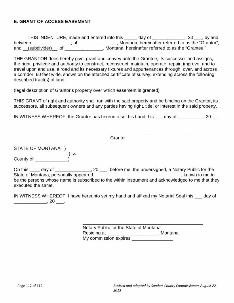
Page 112 of 112 Revised and adopted by Sanders County Commissioners August 22, 2013
E. GRANT OF ACCESS EASEMENT THIS INDENTURE, made and entered into this _____ day of _____________, 20 ___, by and between _______________, of _______________, Montana, hereinafter referred to as the “Grantor”, and __(subdivider)__ of _______________, Montana, hereinafter referred to as the “Grantee.” THE GRANTOR does hereby give, grant and convey unto the Grantee, its successor and assigns, the right, privilege and authority to construct, reconstruct, maintain, operate, repair, improve, and to travel upon and use, a road and its necessary fixtures and appurtenances through, over, and across a corridor, 60 feet wide, shown on the attached certificate of survey, extending across the following described tract(s) of land: (legal description of Grantor’s property over which easement is granted) THIS GRANT of right and authority shall run with the said property and be binding on the Grantor, its successors, all subsequent owners and any parties having right, title, or interest in the said property. IN WITNESS WHEREOF, the Grantor has hereunto set his hand this ___ day of __________, 20 __. ______________________________ Grantor STATE OF MONTANA ) ) ss. County of _____________) On this ____ day of ______________, 20 ___, before me, the undersigned, a Notary Public for the State of Montana, personally appeared __________________________________, known to me to be the persons whose name is subscribed to the within instrument and acknowledged to me that they executed the same. IN WITNESS WHEREOF, I have hereunto set my hand and affixed my Notarial Seal this ___ day of _____________, 20 ___. _______________________________________________ Notary Public for the State of Montana Residing at ____________________, Montana My commission expires ________________
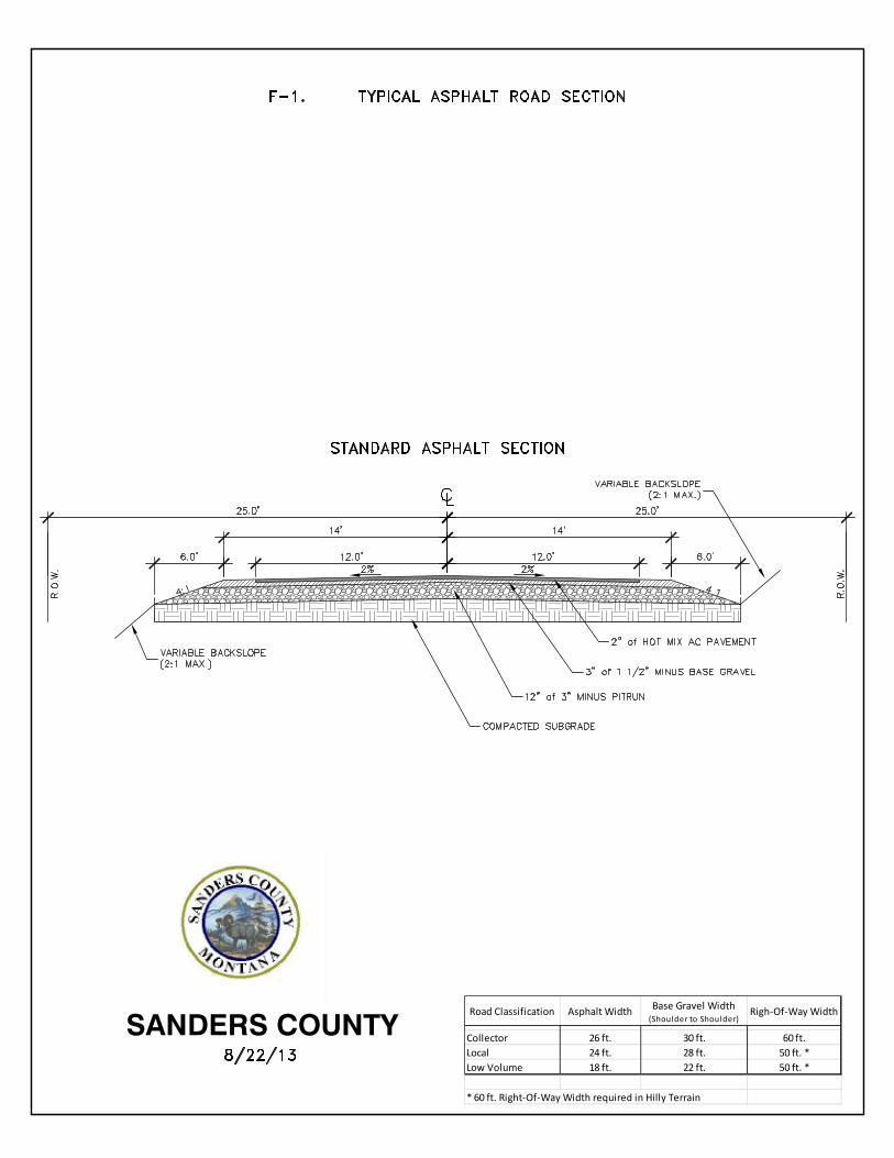
Road Classification Asphalt WidthBase Gravel Width
(Shoulder to Shoulder)Righ-Of-Way Width
Collector 26 ft. 30 ft. 60 ft.
Local 24 ft. 28 ft. 50 ft. *
Low Volume 18 ft. 22 ft. 50 ft. *
* 60 ft. Right-Of-Way Width required in Hilly Terrain
SANDERS COUNTY

Road ClassificationGravel Surface
WidthRigh-Of-Way Width
Collector 26 ft. 60 ft.
Local 24 ft. 50 ft. *
Low Volume 18 ft. 50 ft. *
* 60 ft. Right-Of-Way Width required in Hilly Terrain
SANDERS COUNTY

F-3. ROAD CONSTRUCTION GENERAL SPECIFICATIONS AND INSPECTION REQUIREMENTS
General Specifications
1. All work shall comply with the provisions of Section VI-G. Streets and Roads of the Sanders County Subdivision Regulations
2. All work shall meet the provisions of the latest edition of the Montana Public Works Standard Specifications (MPWSS)
3. Clear and grub to width necessary to construct typical road sections (See F-1 and F-2) 4. Subgrade:
a. Free of all topsoil, vegetation, roots, stumps, organic matter, frozen material, refuse, construction debris or other man-made items within top 12” of subgrade
b. Shape and compact subgrade surface c. Proof roll subgrade prior to placement of base
5. Base: a. Minimum of 12” of 3” minus “Pit Run” Gravel b. Shape for minimum 2% cross slope and compact base
6. Surface Course – Gravel a. Minimum of 3” of 1 ½” minus Base Gravel as surface course b. Uniform thickness across width of surface c. Shape for minimum 2% cross-slope for surface drainage and compact
7. Surface Course – Asphalt a. Minimum of 3” of 1 ½” minus Base Gravel placed over base b. Minimum of 2” of Hot Mix Asphalt Pavement as surface course c. Uniform thickness across width of surface d. Shape for minimum 2% cross-slope for surface drainage and compact
Inspection Requirements
All construction shall be inspected by the County District Road Foreman at the following stages. A. Pre-Construction B. Clearing and Grubbing: Subgrade shall be proof rolled in presence of Road Foreman prior to
placement of base material C. Base material A. Final Acceptance: After completion of surface course