Embed Size (px)
Citation preview
1
March 21, 2013
San Francisco Bay Area Water Trail
Site Description for
Alviso Marina County Park
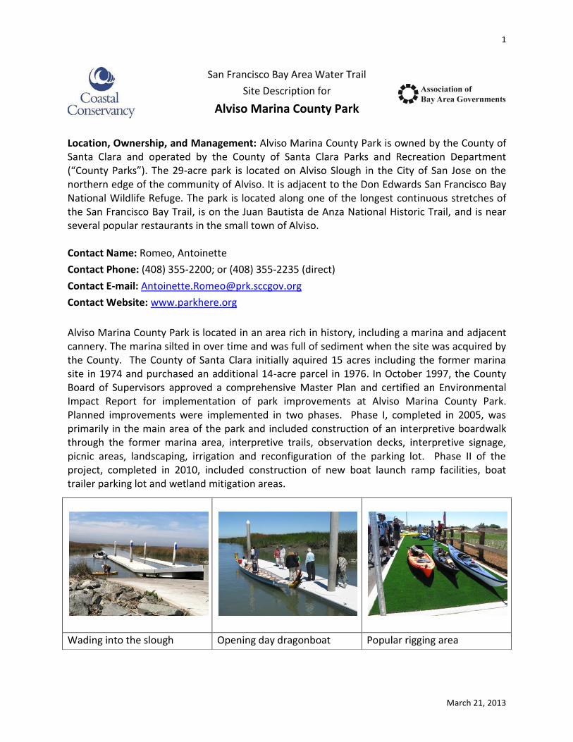
Location, Ownership, and Management: Alviso Marina County Park is owned by the County of Santa Clara and operated by the County of Santa Clara Parks and Recreation Department (“County Parks”). The 29-acre park is located on Alviso Slough in the City of San Jose on the northern edge of the community of Alviso. It is adjacent to the Don Edwards San Francisco Bay National Wildlife Refuge. The park is located along one of the longest continuous stretches of the San Francisco Bay Trail, is on the Juan Bautista de Anza National Historic Trail, and is near several popular restaurants in the small town of Alviso. Contact Name: Romeo, Antoinette
Contact Phone: (408) 355-2200; or (408) 355-2235 (direct)
Contact E-mail: [email protected]
Contact Website: www.parkhere.org
Alviso Marina County Park is located in an area rich in history, including a marina and adjacent cannery. The marina silted in over time and was full of sediment when the site was acquired by the County. The County of Santa Clara initially aquired 15 acres including the former marina site in 1974 and purchased an additional 14-acre parcel in 1976. In October 1997, the County Board of Supervisors approved a comprehensive Master Plan and certified an Environmental Impact Report for implementation of park improvements at Alviso Marina County Park. Planned improvements were implemented in two phases. Phase I, completed in 2005, was primarily in the main area of the park and included construction of an interpretive boardwalk through the former marina area, interpretive trails, observation decks, interpretive signage, picnic areas, landscaping, irrigation and reconfiguration of the parking lot. Phase II of the project, completed in 2010, included construction of new boat launch ramp facilities, boat trailer parking lot and wetland mitigation areas.
Wading into the slough Opening day dragonboat Popular rigging area

Site Description for Alviso Marina County Park 2
San Francisco Bay Area Water Trail March 21, 2013
The boat launch facility within the park officially opened on June 5, 2010, and has been in constant use since then. It is designed and managed for both motorized and non-motorized boat use, and is used by hunters, researchers, birders, fishermen and park visitors. A kiosk near the launch addresses topics of concern to these user groups. From the launch, which includes two boat launch ramps and both high and low-freeboard floats, boaters may travel along Alviso Slough through tall tules and past mudflats to the open Bay, four miles from the launch. From there, one can travel along the shoreline in either direction. Park staff maintains (or removes silt from )the boat launch ramp. County Parks has an after-hours Gate Key and Hang Tags program, allowing after-hours vehicle access to the launch area. Please visit www.parkhere.org for details. Layout of Alviso Marina County Park (part of official park brochure):
The boat launch is in the lower left-hand corner of the graphic.

Site Description for Alviso Marina County Park 3
San Francisco Bay Area Water Trail March 21, 2013
Facility Description: There are two main parking and visitor use areas within the park. Upon entering, one will see the main parking area (about 50 parking spaces) and find the restrooms in a permanent building on the right, with picnic tables and a drinking fountain nearby, and two clearly marked accessible parking spaces. This is where the Camp Host is located as well. There is a path of travel from the parking spaces to the restrooms, bathroom, and perimeter pathway that circles the park, passes by interpretive signs, and leads to the boat launch area. There are also five picnic tables.
A short stretch of road leads to the second parking area where the boat launch is. There are 25 parking spaces here, large enough for large vehicles and trailers, and one space is fully accessible. A path of travel that is diagonally striped on the pavement leads from this
accessible parking space to the launch area and the rigging area. There are two concrete boat launch ramps, and two floating docks. One of the floats is high-freeboard, and the other is low-freeboard. The slope of the boarding pier varies depending on the tide. Maximum and minimum slopes are not known at this time. The floats themselves are long enough and wide enough to serve boaters side by side or end to end. On one side of the boat launch is a “boat ready” area, and on the other side is a “boat tie down” area and a boat-washing spigot and rigging area.
Site Description for Alviso Marina County Park 4
San Francisco Bay Area Water Trail March 21, 2013
Other Identifying or General Information:
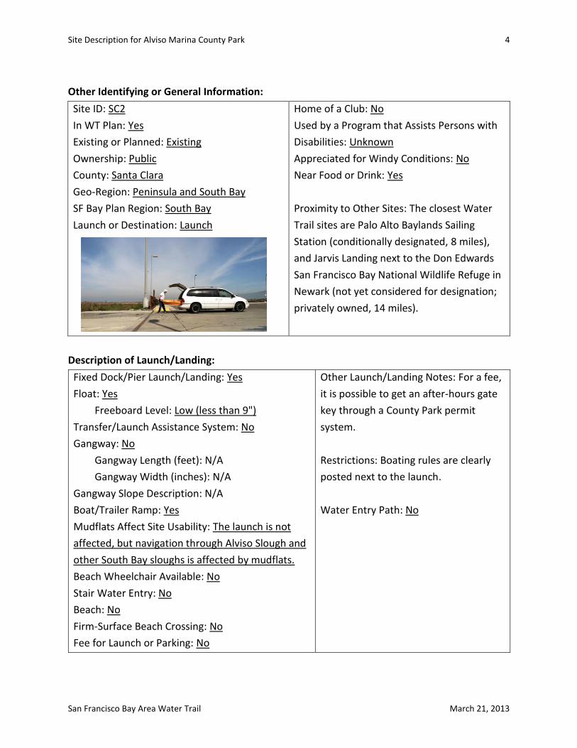
Site ID: SC2
In WT Plan: Yes
Existing or Planned: Existing
Ownership: Public
County: Santa Clara
Geo-Region: Peninsula and South Bay
SF Bay Plan Region: South Bay
Launch or Destination: Launch
Home of a Club: No
Used by a Program that Assists Persons with
Disabilities: Unknown
Appreciated for Windy Conditions: No
Near Food or Drink: Yes
Proximity to Other Sites: The closest Water
Trail sites are Palo Alto Baylands Sailing
Station (conditionally designated, 8 miles),
and Jarvis Landing next to the Don Edwards
San Francisco Bay National Wildlife Refuge in
Newark (not yet considered for designation;
privately owned, 14 miles).
Description of Launch/Landing:
Fixed Dock/Pier Launch/Landing: Yes
Float: Yes
Freeboard Level: Low (less than 9")
Transfer/Launch Assistance System: No
Gangway: No
Gangway Length (feet): N/A
Gangway Width (inches): N/A
Gangway Slope Description: N/A
Boat/Trailer Ramp: Yes
Mudflats Affect Site Usability: The launch is not
affected, but navigation through Alviso Slough and
other South Bay sloughs is affected by mudflats.
Beach Wheelchair Available: No
Stair Water Entry: No
Beach: No
Firm-Surface Beach Crossing: No
Fee for Launch or Parking: No
Other Launch/Landing Notes: For a fee,
it is possible to get an after-hours gate
key through a County Park permit
system.
Restrictions: Boating rules are clearly
posted next to the launch.
Water Entry Path: No

Site Description for Alviso Marina County Park 5
San Francisco Bay Area Water Trail March 21, 2013
Site Appears to be Suitable For:
Kayak: Yes
Windsurfer: No
Kiteboard: No
Whaleboat: Unknown
Stand Up Paddleboard: Yes
Canoe: Yes
Outrigger Canoe: Unknown
Sculling: Unknown
Rowboat/Dinghy: Yes
Dragonboat: Yes
Other: Unknown
Alviso Marina County Park boat launch on a calm and quiet day.

Site Description for Alviso Marina County Park 6
San Francisco Bay Area Water Trail March 21, 2013
Transportation and Parking:
General Spaces (number): 51-75 (both parking lots)
ADA Parking Spaces (number): 3 (2 in main parking lot; 1 in boat launch parking lot)
ADA Parking Description: There are two parking lots at Alviso Marina County Park. Although they are in close proximity to one another, one of the parking areas is directly adjacent to the launch facility. In this launch parking area, there are 25 boat-trailer-sized parking spaces and one of them is an ADA parking space, with a striped disembarcation area next to it, connecting to a path of travel marked on the pavement, leading to the launch. This parking space is as close to the launch as possible. The distance from this ADA
parking space to the launch is 112 feet, and the distance from this parking space to the restroom in the other parking lot is 707 feet. In the parking lot closest to the entrance to the park, there are two ADA parking spots. One is labeled van-accessible. These two spots are as close as possible to the restrooms. They connect to the sidewalk pathway (with sloped connection ramp) that leads to the accessible restrooms and drinking fountain. The distance from the parking spaces in this main parking lot to the launch facilities is 819 feet, and to the restroom is 163 feet.
Park hours: From 8:00 a.m. to sunset.
Overnight Parking Possibly Allowed: No, but see after-hours key program.
Overnight Parking Description: After-hours parking is allowed by permit only for the sole
purpose of launching or retrieving a vessel.
Loading/Unloading Area: Yes
San Francisco Bay Trail: Yes
Public Transportation: There is a VTA (Valley Transportation Authority) bus stop for bus route
#58.

Site Description for Alviso Marina County Park 7
San Francisco Bay Area Water Trail March 21, 2013
Path of Travel:
Distance to Launch from Parking Area (feet): 120
Distance to Launch from ADA Parking (feet): 112
Distance to Launch from ADA Restrooms (feet): 819
Distance from ADA Restrooms to ADA Parking (feet): 163
Path of Travel Exists: Yes
Path of Travel Description: Path of travel from boat-launch ADA parking spot to boat launch is
112' and marked with striped diagonal lines across the blacktop from disembarcation side of
parking space to the launch. This path is not physically separated from cars but it is clearly
striped. There is a loading/unloading area next to the boat launch, where a person with a
disability could exit a vehicle (as a passenger) and move safely onto the separated path of
travel. There is also a rigging area with Astroturf-like grass, and an accessible path from here
to the boat launch.
Other Site Amenities:
Total Restrooms: 2
Total ADA Restrooms: 2
Restroom Description: Restrooms are within
a permanent building that has separate
mens' and womens' bathrooms. The entry
doorway remains open during park open
hours. Inside the sink and hand-drying
machine are accessible, and there is one stall
(at least in the womens') that appears to be
accessible. A trash can also appears to be
accessible.
Boat Washing: Yes
Rigging/Staging Area: Yes
Picnic Tables: Yes
Benches: Yes
BBQ: No
Boat Storage: No
Boat Storage Description: N/A
Accessible restroom
Site Description for Alviso Marina County Park 8
San Francisco Bay Area Water Trail March 21, 2013
Overnight Accommodations:
Hotel: Unknown Hostel: No Ship: No Camping: No Other: No
Accommodations Description: There are no overnight accommodations at Alviso Marina
County Park, but there are several very large hotels not far away on 1st Street in San Jose, on
Gold Street in Alviso, and on Hwy 237 near Milpitas.
Additional Notes Related to Accessibility:
This site has, generally speaking, high levels of accessibility: restrooms, drinking fountain, parking spots (2 in main parking lot, 1 large enough for trailer in second parking lot), and path of travel from main parking lot's ADA parking spaces to restroom/drinking fountain/launch (although 818 feet to launch). Picnic tables, located near restroom, appear to not be accessible. There is a low boat-washing water spigot where a person could attach a hose and clean off a boat. Trash and recycling receptables seem to be at reachable heights. There are several benches in this same preparation area with enough space between the benches for a wheelchair, on a hard surface. There is a separated path of travel from this preparation area to the boat launch along a concrete path with a tactile rubber mat signaling the end of the path. The boat launch site was built in compliance with the 2010 ADA Standards.
Additional Notes on Use of Site (Boating and Non-Boating) and Existing and Planned
Management:
Hunting is allowed seasonally and in the vicinity to Alviso Slough. Hunting is managed by USFWS and only allowed within Don Edwards San Francisco Bay National Wildlife Refuge lands. Inquiries regarding hunting should be directed to the USFWS. For information on hunting within the Don Edwards San Francisco Bay National Wildlife Refuge, call 510-792-0222 or visit (http://www.fws.gov/refuge/Don_Edwards_San_Fransisco_Bay/hunting.html). Alviso Marina County Park has posted information on hunting, which is not permitted in the park.
Safety and Security, including Parking:
Tidal changes expose mudflats, which leave some boaters stranded and in need of rescue every year. The Park itself is patroled by County Parks rangers, and the City of San Jose police department after-hours. There is a Camp Host permanently on site. The parking areas are well lit.
Wildlife and Habitat Considerations:
Harbor seals and a variety of bird species that are protected under federal and state law actively use the surrounding area.
Site Description for Alviso Marina County Park 9
San Francisco Bay Area Water Trail March 21, 2013
Education, Outreach, and Stewardship, Including Signage:
The marina has numerous interpretive panels, covering relevant natural history topics and cultural history, and information regarding protection of sensitive species. A brochure is available in the kiosk to the right of the boat launch. It includes basic information about the park, a map, photos, and rules related to park use and protection of plant and wildlife species.
Other Existing or Anticipated Water Trail-Related Issues and Opportunities:
Santa Clara County Parks has a special permit program that allows park users to obtain a key to the entry gate for use after normal park hours (8:00 a.m. – sunset) for the sole purpose of launching or retrieving a vessel. There is a fee for this permit, which includes a gate key and vehicle hang tag. This after-hours permit is popular with those who wish to fish or hunt.
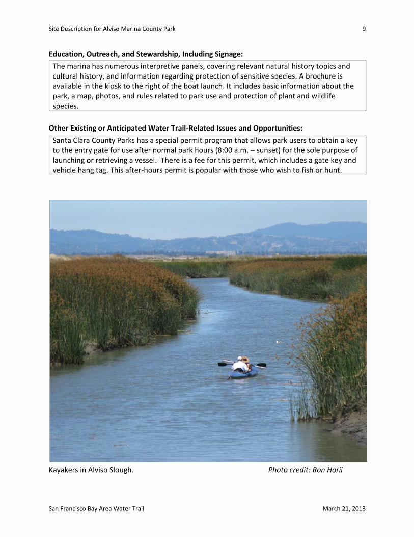
Kayakers in Alviso Slough. Photo credit: Ron Horii

Summary of Environmental Review based on
Water Trail (WT) Final EIR (Vol 1 and Vol 2) for
Alviso Marina County Park March 22, 2013
Resource Area Impacts Analysis Notes
Recreation References: WT DREIR, pp. 3-32 to 3-37. Also, see map for hunting locations within 4-mile buffer.
Potential for user conflict. However, site was planned and built with multiple boat types and multiple site users in mind; thus, conflicts not expected at trailhead or in slough. Potential for inadvertent entry into U.S. Fish and Wildlife (USFWS) hunting areas on a seasonal basis.
Mitigation Measure Rec M4-C is triggered by proximity of this trailhead to hunting (within 4 miles). Per the WT EIR, a sign onsite needs to warn of hunting in the vicinity and provide a means for boaters to know seasonal dates and location of permitted hunting (regulated by USFWS). An existing Hunting Information sign includes the USFWS phone number and website where visitors can obtain such information.
Navigational and Personal Safety References: WT DREIR pp. 3-38 to 3-51, and Figures 3.4.2-1 and 3.4.2-2.
This site is not near commercial shipping or ferry routes. Boaters should be aware of tides and extensive mud flats in the South Bay. The US Coast Guard VHS Channel (16) and other rescue numbers should be available to boaters on site to use in case of emergency.
Interpretive signs on site warn of low tides and potential for getting stuck in the mud. VHS Channel 16 is prominently posted as is the 911 phone number for boaters to use (Boating Rules sign). The large Hunting Information sign lets park users know that there is hunting nearby. See comment about Rec M4-C, above, regarding hunting.
Aesthetics References: WT DREIR pp. 3-56 to 3-68.
Alviso Marina County Park has both interpretive and informational/safety panels and signs for the benefit of site users. They currently blend well with the site.
The Water Trail will require the inclusion of a Water Trail identification sign at the site. A “sign program” will be developed with County Parks to ensure that the I.D. sign and additional educational information that the Water Trail requests be posted as part of designation do not result in sign clutter at the site.

Resource Area Impacts Analysis Notes
Biology- Vegetation References: WT DREIR pp. 3-69 to 3-92 and Table 3.7.2-1 and Table 3.7.2-2.
Alviso Slough is a brackish tidal slough that borders several former salt ponds. There is potential for a range of invasive plant species to “hitch” a ride on boats passing through the slough.
A boat rinse-off station is provided in a convenient location near the boat launch (bring your own hose). The WT website explains how WT users can help prevent the spread of invasive species by rinsing boats and equipment. An existing interpretive sign on site (“A healthy slough depends on you”) provides pertinent information about spread of seeds.
Biology – Rafting Waterfowl References: WT DREIR pp. 3-93 to 3-131 and Table 3.8.2-1, Figure 3.8.2-1.
This site provides access to areas where rafting waterfowl congregate in the South Bay.
Disturbance of rafting waterfowl is not addressed in existing signs on site, but is discussed in the Water Trail brochure (stay 820 feet away, do not paddle directly toward “rafts”), which will be provided in the kiosk on site. The site is four miles from the entrance to the Bay – not all paddlers will go beyond the mouth of the slough. Nonetheless, educational information about rafting waterfowl and other species, discussed below, should be readily available to site users.
Biology – California clapper rail and California black rail and high tide refugia References: WT DREIR pp. 3-93 to 3-131 and Figure 3.8.2-2.
The site is located near California clapper rail habitat, which exists along Alviso Slough and neighboring sloughs in the South Bay. Black rail are less of a concern in this slough environment of the South Bay. NMSBs could impact clapper rail if they paddle close to or directly toward slough edges.
Signage is needed to emphasize importance of not entering marsh (USFWS lands), keeping a 50-foot buffer from rail habitat (not entering channels less than 100-feet wide), importance of high-tide refugia, and that landing in marshes and on levees is prohibited. Water Trail brochure includes this information. A park interpretive sign gives same message, although without a buffer distance listed (A Healthy Slough…)
Biology –Western Snowy Plover References: WT DREIR pp. 3-93 to 3-131 and Figures 3.8.2-3
Western Snowy Plover and other shorebirds are known to breed in managed pond complexes or on their levees near Alviso Slough.
Pond A6 was breached and no longer provides breeding habitat, unless levees are being used. Boaters are not allowed to enter marshes on Refuge land and should not enter marshes elsewhere or get out onto levees. Disturbance of snowy plovers by NMSB users launching from Alviso Slough seems unlikely.
Resource Area Impacts Analysis Notes
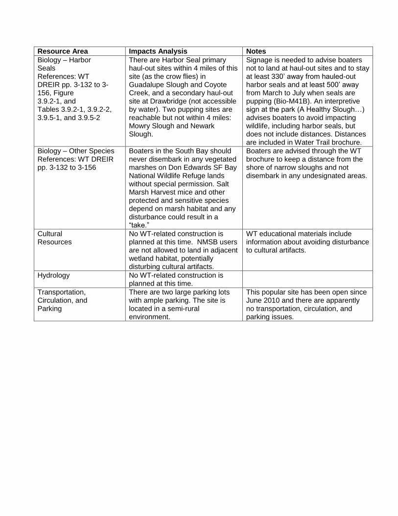
Biology – Harbor Seals References: WT DREIR pp. 3-132 to 3-156, Figure 3.9.2-1, and Tables 3.9.2-1, 3.9.2-2, 3.9.5-1, and 3.9.5-2
There are Harbor Seal primary haul-out sites within 4 miles of this site (as the crow flies) in Guadalupe Slough and Coyote Creek, and a secondary haul-out site at Drawbridge (not accessible by water). Two pupping sites are reachable but not within 4 miles: Mowry Slough and Newark Slough.
Signage is needed to advise boaters not to land at haul-out sites and to stay at least 330’ away from hauled-out harbor seals and at least 500’ away from March to July when seals are pupping (Bio-M41B). An interpretive sign at the park (A Healthy Slough…) advises boaters to avoid impacting wildlife, including harbor seals, but does not include distances. Distances are included in Water Trail brochure.
Biology – Other Species References: WT DREIR pp. 3-132 to 3-156
Boaters in the South Bay should never disembark in any vegetated marshes on Don Edwards SF Bay National Wildlife Refuge lands without special permission. Salt Marsh Harvest mice and other protected and sensitive species depend on marsh habitat and any disturbance could result in a “take.”
Boaters are advised through the WT brochure to keep a distance from the shore of narrow sloughs and not disembark in any undesignated areas.
Cultural Resources
No WT-related construction is planned at this time. NMSB users are not allowed to land in adjacent wetland habitat, potentially disturbing cultural artifacts.
WT educational materials include information about avoiding disturbance to cultural artifacts.
Hydrology No WT-related construction is planned at this time.
Transportation, Circulation, and Parking
There are two large parking lots with ample parking. The site is located in a semi-rural environment.
This popular site has been open since June 2010 and there are apparently no transportation, circulation, and parking issues.

½
Path:
S:\W
aterTr
ail\20
12_W
aterTr
ail_M
aps\S
ites\S
antaC
lara\A
lviso\S
C2_A
lviso
_Mari
na.m
xd
[«
[«
!!
!!
!(
S A N T A C L A R A
Palo Alto Baylands Preserve
Palo Alto Baylands Preserve
Ravenswood Open Space Preserve
Don Edwards NationalWildlife Refuge
Mountain View
NewarkSlough
Coyote CreekHaul-Out
Alviso Marina
To Jarvis Landing
To Alviso Marina
Don Edwards NationalWildlife Refuge
DrawbridgeHaul-Out
Guadalupe SloughHaul-Out
Palo AltoSailing Station
Al vi s o Slough
Coyote Slough
Text
Al v i so M a r in a L o ca t io n M a p
¹0 1
Miles(3/4/2013)
AlvisoMarina Protected
Areas Boundary
www.sfbaywatertrail.org
[§ [§
4 Mile Buffer(from Sailing Station) Pupping site
Primary or secondaryhaul out site
[« CA clapper rail
! Potential & ExistingWater Trail Sites
CA Harbor Seal data from Water Trail FEIRCA Clapper rail data generalized from2011 California Natural DiversityDatabaseWestern Snowy Plover data from WRA.
Potential Hunting Area
San Francisco Bay
PacificOcean
MarinCounty
AlamedaCounty
San MateoCounty
Santa ClaraCounty
Contra CostaCounty
San FranciscoCity and County
Location Map
0 5
Miles
Alviso Marina
¹
[«
[«
[«Western SnowyPlover