Embed Size (px)
Citation preview

Salmon and Steelhead Habitat Limiting Factors Report for the Entiat
Watershed
Water Resource Inventory Area (WRIA) 46
Prepared by: Carmen Andonaegui
Washington State Conservation Commission Headquarters Office: P.O. Box 47721
Olympia, Washington 98504-7721
Version 3 July 6, 1999

July 6, 1999 Entiat Habitat Limiting Factors 1
TABLE OF CONTENTS
TABLE OF CONTENTS................................................................................................................................ 1 LIST OF FIGURES ........................................................................................................................................ 3 LIST OF TABLES.......................................................................................................................................... 3 ACKNOWLEDGEMENTS............................................................................................................................ 4 SUMMARY.................................................................................................................................................... 5 BACKGROUND ............................................................................................................................................ 6
The Relative Role of Habitat in Healthy Populations of Natural Spawning Salmon.................................. 6 INTRODUCTION ........................................................................................................................................ 17
Salmonid Habitat in the Entiat River Watershed (WRIA 46) ................................................................... 17 Salmonid Distribution. .............................................................................................................................. 24
Conditions of Natural Spawning Populations ....................................................................................... 30 Historic Salmon Population Conditions............................................................................................ 30 Current Condition of Natural Spawning Populations. ...................................................................... 30
Identification of historic patterns of habitat alterations ........................................................................ 32 LIMITING FACTORS ................................................................................................................................. 44
Loss of Access to Spawning and Rearing Habitat ................................................................................... 44 Access to Spawning and Rearing Habitats............................................................................................ 44 Loss of Access ...................................................................................................................................... 44 Criteria for Evaluating Fish Blockages ................................................................................................. 44 Causes of Fish Blockages ..................................................................................................................... 44
Dams and Diversions. ....................................................................................................................... 44 Culverts. ............................................................................................................................................ 45 Dikes and Levees. ............................................................................................................................. 45 Other freshwater blockages............................................................................................................... 46
Data Sources ......................................................................................................................................... 46 Blockages in Priority Order .................................................................................................................. 46
Floodplains ............................................................................................................................................... 46 Functions of Floodplains....................................................................................................................... 46 Impairment of Floodplains by Human Activities.................................................................................. 47 Criteria for Evaluating Impaired Floodplain Functions ........................................................................ 48 Causes of Degraded Floodplains........................................................................................................... 48
Dikes. ................................................................................................................................................ 48 Upland land use................................................................................................................................. 49
Streambed Sediment Conditions............................................................................................................... 50 Streambed Sediment ............................................................................................................................. 50 Effects of Human Actions on Sediment Processes ............................................................................... 51 Criteria for Evaluating Changes to Sediment Processes ....................................................................... 51 Changes to Sediment Processes. ........................................................................................................... 51
Channel constrictions........................................................................................................................ 52 Flow alterations................................................................................................................................. 52 Flood plain development................................................................................................................... 53
Riparian Zone Conditions ......................................................................................................................... 53 Riparian Zone Functions....................................................................................................................... 53 Effects of Human Activities on Riparian Zones. .................................................................................. 54 Criteria for Evaluating Degraded Riparian Zones................................................................................. 54 Causes of Degraded Riparian Zones. .................................................................................................... 54
Removal of streamside vegetation. ................................................................................................... 54 Changes to streamside vegetation. .................................................................................................... 55 Road crossings. ................................................................................................................................. 55 Lack of bank stability........................................................................................................................ 56
Water Quality............................................................................................................................................ 56 Point Sources ........................................................................................................................................ 57
Industrial sources. ............................................................................................................................. 58

July 6, 1999 Entiat Habitat Limiting Factors 2
Sewer outfalls. .................................................................................................................................. 58 Reservoirs & artificial ponds. ........................................................................................................... 58
Non Point Sources ................................................................................................................................ 58 Storm water....................................................................................................................................... 60 Fine sediment. ................................................................................................................................... 60 Loss of riparian vegetation................................................................................................................ 61 Sediment contamination.................................................................................................................... 62 Wetland losses & alterations............................................................................................................. 62 Toxic chemicals. ............................................................................................................................... 62
Water Quantity.......................................................................................................................................... 63 Dams & diversions................................................................................................................................ 65 Impervious surfaces and /or storm water .............................................................................................. 65 Wetland loss and alteration ................................................................................................................... 66 Water withdrawals ................................................................................................................................ 66
Surface water. ................................................................................................................................... 67 Ground water. ................................................................................................................................... 67
Exotic and Opportunistic Species ............................................................................................................. 68 Non-native Fish..................................................................................................................................... 68 Non-native Plants.................................................................................................................................. 68 Removal of spawning salmon............................................................................................................... 69
Loss of nutrients................................................................................................................................ 69 Lake Habitat.............................................................................................................................................. 69
GLOSSARY ................................................................................................................................................. 70 LITERATURE CITATION.......................................................................................................................... 75

July 6, 1999 Entiat Habitat Limiting Factors 3
LIST OF FIGURES Figure 1. Relationship of Entiat River analysis zones, dominant channel types (Rosgen), channel gradients,
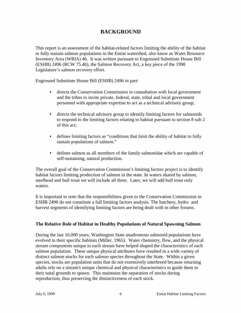
fish use, and major landmarks (USFS, 1996). ...................................................................................... 20 Figure 2. Transport, Transitional and Depositional Zones – Stratification of the Entiat Analysis Area
(USFS, 1996). ....................................................................................................................................... 22 Figure 3. Spring Chinook Distribution. ....................................................................................................... 25 Figure 4. Summer Steelhead Distribution.................................................................................................... 26 Figure 5. Sockeye Distribution. ................................................................................................................... 27 Figure 6. Late-run Chinook Distribution. .................................................................................................... 28 Figure 7. Summer Steelhead, Sockeye, Late-run Chinook, and Spring Chinook Distribution and Barriers.
.............................................................................................................................................................. 29 Figure 8. Mean Monthly Flows on the Entiat River Near Stormy Creek, Gage #1245288 (Chelan County
Conservation District, in press)............................................................................................................. 64
LIST OF TABLES Table 1. Entiat Valley History; Historical Overview of the Entiat Analysis Area (Chelan County
Conservation District, in prep.)............................................................................................................. 33 Table 2. A Timeline of Historic Events in the Entiat Watershed (USFS, 1996).......................................... 40 Table 3. Comparison of 1930’s Bureau of Fisheries Pool Observations to 1990’s Forest Service Pool
Observations, Entiat River (USFS, 1996). ............................................................................................ 43

July 6, 1999 Entiat Habitat Limiting Factors 4
ACKNOWLEDGEMENTS
I would like to acknowledge Phil Archibald, District Fish Biologist for the Wenatchee National Forest Entiat Ranger District, for his substantive comments well grounded in his years of experience working in the Entiat. Also I am grateful to Phil Jones, Coordinator of the Entiat Watershed Study for the Chelan County Conservation District, for placing at my disposal his considerable accumulation of work on the Entiat Comprehensive Resource Management Plan/Entiat Valley Watershed Study. As this report generates input from other individuals who harbor the technical expertise necessary to continue the process of refining the assessment of salmon habitat limiting factors in the Entiat watershed, I will happily expand this section to reflect my agencies appreciation of those individuals and the agencies they represent.

July 6, 1999 Entiat Habitat Limiting Factors 5
SUMMARY A lack of overwintering juvenile rearing habitat is most limiting to the ability of the habitat in the Entiat watershed to fully sustain salmon populations. This is a function of the alteration of the natural hydrologic and geomorphic processes in the watershed chiefly resulting from losses in floodplain connectivity and riparian zone conditions (USDA NRCS Stream Team, 1998; USFS, 1996; Rocky Reach Dam Hydroelectric Facility et al., 1998). Protection, rehabilitation and restoration of these habitats will presumably provide for other life cycle needs of salmonids, and fish and wildlife in general who are part of the Entiat watershed ecosystem. Securing protection of stream channel sections anywhere in the watershed that presently allow unrestricted stream channel diversity and floodplain function is the principle means to meeting this objective. This can be accomplished in conservation easements, easements, or direct purchases. The following list, taken from Exhibit D - Aquatic Species and Habitat Assessment: Wenatchee, Entiat, Methow and Okanogan Watersheds (Rock Island Dam Hydroelectric Facility et al, 1998), identifies stream reaches which should receive protection order of priority : 1) Riparian bottom land and side channels in the Stillwaters Reach (between the
terminal moraine and Preston Creek) 2) Riparian bottomland and side channels along the mainstem Entiat between Preston
Creek and Fox Creek 3) Riparian bottomlands in the lower Mad River, Stormy Creek and Roaring Creek Rehabilitation of altered stream reaches to increase functional overwintering juvenile rearing habitat is a second strategy. Engineered, structural instream improvements like bankside rootwad placements, rock weir placements, bioengineered riparian plantings, and many others offer short term improvements but maintenance costs may be substantial given the natural frequency of fires and floods in this watershed. The only realistic means to accomplish this is to have a combined short-term/long-term strategy (Rock Island Dam Hydroelectric Facility et al, 1998), Initially the focus should be structurally engineered and designed improvements like anchored large woody debris (LWD), boulder placement and side channel constructions. The long term approach is to secure riparian habitat in the Entiat watershed downstream of the Mad River confluence through conservation easements, easements, or direct purchases. This would allow for the recovery of the natural hydrologic and geomorphic processes. This recovery may be accelerated by implementing projects in the acquired riparian habitat which are designed to restore floodplain access and reestablish multi-species, multi-age class, native plant communities. Unscreened and inadequately screened surface water diversions (pumps and ditches) and improperly designed water diversions and dams pose a direct threat to salmonids. Placement or repair of properly functioning screens, and proper design and placement of surface water diversions, should also be considered as structural improvements that can result in a direct improvement to juvenile fish survival.
July 6, 1999 Entiat Habitat Limiting Factors 6
BACKGROUND This report is an assessment of the habitat-related factors limiting the ability of the habitat to fully sustain salmon populations in the Entiat watershed, also know as Water Resource Inventory Area (WRIA) 46. It was written pursuant to Engrossed Substitute House Bill (ESHB) 2496 (RCW 75.46), the Salmon Recovery Act, a key piece of the 1998 Legislature’s salmon recovery effort. Engrossed Substitute House Bill (ESHB) 2496 in part:
• directs the Conservation Commission in consultation with local government and the tribes to invite private, federal, state, tribal and local government personnel with appropriate expertise to act as a technical advisory group;
• directs the technical advisory group to identify limiting factors for salmonids to respond to the limiting factors relating to habitat pursuant to section 8 sub 2 of this act;
• defines limiting factors as “conditions that limit the ability of habitat to fully sustain populations of salmon.”
• defines salmon as all members of the family salmonidae which are capable of
self-sustaining, natural production. The overall goal of the Conservation Commission’s limiting factors project is to identify habitat factors limiting production of salmon in the state. In waters shared by salmon, steelhead and bull trout we will include all three. Later, we will add bull trout only waters.
It is important to note that the responsibilities given to the Conservation Commission in ESHB 2496 do not constitute a full limiting factors analysis. The hatchery, hydro and harvest segments of identifying limiting factors are being dealt with in other forums.
The Relative Role of Habitat in Healthy Populations of Natural Spawning Salmon During the last 10,000 years, Washington State anadromous salmonid populations have evolved in their specific habitats (Miller, 1965). Water chemistry, flow, and the physical stream components unique to each stream have helped shaped the characteristics of each salmon population. These unique physical attributes have resulted in a wide variety of distinct salmon stocks for each salmon species throughout the State. Within a given species, stocks are population units that do not extensively interbreed because returning adults rely on a stream's unique chemical and physical characteristics to guide them to their natal grounds to spawn. This maintains the separation of stocks during reproduction, thus preserving the distinctiveness of each stock.

July 6, 1999 Entiat Habitat Limiting Factors 7
Throughout the salmon’s life cycle, the dependence between the stream and a stock continues. Adults spawn in areas near their own origin because survival favors those that do. The timing of juveniles leaving the river and entering the estuary is tied to high natural river flows. It has been theorized that the faster speed during out-migration reduces predation on the young salmon and perhaps is coincident to favorable feeding conditions in the estuary (Wetherall, 1971). These are a few examples that illustrate how a salmon stock and its environment are intertwined throughout the entire life cycle. Salmon habitat includes the physical, chemical and biological components of the environment that support salmon. Within freshwater and estuarine environments, these components include water quality, water quantity or flows, stream and river physical features, riparian zones, upland terrestrial conditions, and ecosystem interactions as they pertain to habitat. However, these components closely intertwine. Low stream flows can alter water quality by increasing temperatures and decreasing the amount of available dissolved oxygen, while concentrating toxic materials. Water quality can impact stream conditions through heavy sediment loads, which result in a corresponding increase in channel instability and decrease in spawning success. The riparian zone interacts with the stream environment, providing nutrients and a food web base, woody debris for habitat and flow control (stream features), filtering runoff prior to surface water entry (water quality), and providing shade to aid in water temperature control. Salmon habitat includes clean, cool, well-oxygenated water flowing at a normal (natural) rate for all stages of freshwater life. In addition, salmon survival depends upon specific habitat needs for egg incubation, juvenile rearing, migration of juveniles to saltwater, estuary rearing, ocean rearing, adult migration to spawning areas, and spawning. These specific needs can vary by species and even by stock. When adults return to spawn, they not only need adequate flows and water quality, but also unimpeded passage to their natal grounds. They need deep pools with vegetative cover and instream structures such as root wads for resting and shelter from predators. Successful spawning and incubation depend on sufficient gravel of the right size for that particular population, in addition to the constant need of adequate flows and water quality, all in unison at the necessary location. Also, delayed upstream migration can be critical. After entering freshwater, most salmon have a limited time to migrate and spawn, in some cases, as little as 2-3 weeks. Delays can results in pre-spawning mortality, or spawning in a suboptimum location. After spawning, the eggs need stable gravel that is not choked with sediment. River channel stability is vital at this life history stage. Floods have their greatest impact to salmon populations during incubation, and flood impacts are worsened by human activities. In a natural river system, the upland areas are forested, and the trees and their roots stores precipitation, which slows the rate of storm water into the stream. The natural, healthy river is sinuous and contains large pieces of wood contributed by an intact, mature riparian zone. Both slow the speed of water downstream. Natural systems have floodplains that are connected directly to the river at many points, allowing wetlands to store flood water and later discharge this storage back to the river during lower flows. In a healthy river, erosion or sediment input is great enough to provide new

July 6, 1999 Entiat Habitat Limiting Factors 8
gravel for spawning and incubation, but does not overwhelm the system, raising the riverbed and increasing channel instability. A stable incubation environment is essential for salmon, but is a complex function of nearly all habitat components contained within that river ecosystem. Once the young fry emerge from the gravel nests, certain species such as chum, pink, and some chinook salmon quickly migrate downstream to the estuary. Other species, such as coho, steelhead, bulltrout, and chinook, will search for suitable rearing habitat within the side sloughs and channels, tributaries, and spring-fed "seep" areas, as well as the outer edges of the stream. These quiet-water side margin and off channel slough areas are vital for early juvenile habitat. The presence of woody debris and overhead cover aid in food and nutrient inputs as well as provide protection from predators. For most of these species, juveniles use this type of habitat in the spring. Most sockeye populations migrate from their gravel nests quickly to larger lake environments where they have unique habitat requirements. These include water quality sufficient to produce the necessary complex food web to support one to three years of salmon growth in that lake habitat prior to outmigration to the estuary. As growth continues, the juvenile salmon (parr) move away from the quiet shallow areas to deeper, faster areas of the stream. These include coho, steelhead, bulltrout, and certain chinook. For some of these species, this movement is coincident with the summer low flows. Low flows constrain salmon production for stocks that rear within the stream. In non-glacial streams, summer flows are maintained by precipitation, connectivity to wetland discharges, and groundwater inputs. Reductions in these inputs will reduce that amount of habitat; hence the number of salmon dependent on adequate summer flows. In the fall, juvenile salmon that remain in freshwater begin to move out of the mainstems, and again, off-channel habitat becomes important. During the winter, coho, steelhead, bulltrout, and remaining chinook parr require habitat to sustain their growth and protect them from predators and winter flows. Wetlands, stream habitat protected from the effects of high flows, and pools with overhead are important habitat components during this time. Except for bulltrout and resident steelhead, juvenile parr that have converted to smolts begin migrating downstream towards the estuary. Again, flows are critical, and food and shelter are necessary. The natural flow regime in each river is unique, and has shaped the population’s characteristics through adaptation over the last 10,000 years. Because of the close inter-relationship between a salmon stock and its stream, survival of the stock depends heavily on natural flow patterns. The estuary provides an ideal area for rapid growth, and some salmon species are heavily dependent on estuaries, particularly chinook, chum, and to a lesser extent, pink salmon. Estuaries contain new food sources to support the rapid growth of salmon smolts, but adequate natural habitat must exist to support the detritus-based food web, such as eelgrass beds, mudflats, and salt marshes. Also, the processes that contribute nutrients and woody debris to these environments must be maintained to provide cover from predators and to sustain the food web. Common disruptions to these habitats include

July 6, 1999 Entiat Habitat Limiting Factors 9
dikes, bulkheads, dredging and filling activities, pollution, and alteration of downstream components such as lack of woody debris and sediment transport. All salmonid species need adequate flow and water quality, spawning riffles and pools, a functional riparian zone, and upland conditions that favor stability, but some of these specific needs vary by species, such as preferred spawning areas and gravel. Although some overlap occurs, different salmon species within a river are often staggered in their use of a particular type of habitat. Some are staggered in time, and others are separated by distance. Chum and pink salmon use the streams the least amount of time of any salmonid in Washington state and do not occur in the Mid-Columbia Region. Chinook salmon have three major run types in Washington State – spring, summer and fall runs. Summer and fall runs of chinook are referred to as an “ocean-type” (Healey, 1983) meaning they spend less than one year in freshwater before migrating to the ocean as subyearlings. Most of their life is therefore spent in the ocean; spring chinook are considered “stream-type” (spending one or more years in freshwater). However, there is evidence that some subyearling summer chinook exhibit a slow rearing migration and forage behavior as they pass the reservoir system, thereby delaying their arrival at the estuaries until they are yearlings and of a larger size. The extent to which this is a phenomenon of the dam system or a natural influence is not known. Chapman et al. (1994) states that there is a lack of information to predict whether subyearlings survive better if they reach the estuary early and at small size, or if they remain in reservoirs and grow before reaching the estuary. Relative to run types, in the Mid-Columbia Region biologists have not detected significant genetic differences between the summer and fall runs; they are usually just referred to as summer chinook salmon or summer/fall chinook salmon (Chapman et al., 1994). Thus, these summer and fall chinook are not reproductively isolated (Federal Register 9/23/94). Rather, they are part of a larger Evolutionarily Significant Unit (ESU) that includes all late-run (summer and fall) ocean-type chinook salmon from the mainstem Columbia River and its tributaries (excluding the Snake River) between Chief Joseph and McNary dams (Waknitz et al., 1995). They are lumped into “late-run” chinook by the National Marine Fisheries Service (NMFS) and for the purposes of this document will be discussed as late-run chinook. Adult late-run chinook begin Columbia River entry in late May to early June (Mullan, 1987). They generally spawn from late September to mid-November. Eggs remain in the gravels over winter until emergence in mid-February through April. Outmigration from the natal tributaries has been strongly correlated to a subyearling size of about 80mm in length where growth rate is a factor of water temperature (Chapman et al, 1994). This is assuming adequate holding areas for fry. Therefore, timing of subyearlings outmigration from the mid-Columbia River tributaries is highly variable and occurs over a broad time period (February through August).

July 6, 1999 Entiat Habitat Limiting Factors 10
In the Mid-Columbia Region, juvenile spring chinook salmon (early-run) generally spend one year in freshwater before they migrate downstream (Mullan, 1987; Healey, 1991); most spend two years in the ocean before migrating back to their natal streams (Mullan, 1987). The adults enter the tributaries to the mid-Columbia River from late April through July, and hold in the deeper pools and under cover until onset of spawning. They may spawn near their holding areas or move upstream into smaller tributaries. Spawning occurs from late July in the upstream reaches, and continues downstream through September, usually peaking in late August (Chapman et al, 1995a). The eggs then remain over winter where they were laid in the gravels, with the young (fry) emerging that following spring in April and May (Peven 1992). These same young will remain in freshwater environments, not migrating out as smolts until the following spring. This extended period spent in the freshwater environment, both as adults and juveniles, makes spring chinook salmon typically more susceptible than the summer/fall (late-run) chinook salmon to impacts from habitat alterations that occur in the tributaries. Low flows in some areas, whether the result of natural or human-induced occurrences have a deleterious effect upon spring chinook salmonid spawning distribution, incubation survival, and late summer rearing habitat quality (Chapman et al, 1995a). Coho salmon have been extirpated from the Mid-Columbia River Region despite plantings of 46 million fry, fingerlings, and smolts from mid-Columbia River fish hatcheries between 1942 and 1975 (YIN et al., 1999). Because the historical stocks of coho were decimated in this region near the turn of the century, most life history information was obtained through affidavits from older residents. The historical information supports the fact that these fish were probably early-returning-type adults, ascending the mid-Columbia tributaries in August and September (Mullan, 1983). In the rest of Washington state, the onset of coho salmon spawning is tied to the first significant fall freshet. They typically enter freshwater from September to early December, but has been observed as early as late July and as late as mid-January (WDF et al, 1993). They often mill near the river mouths or in lower river pools until freshets occur. Spawning usually occurs between November and early February, but is sometimes as early as mid-October and can extend into March. Spawning typically occurs in tributaries and sedimentation in these tributaries can be a problem, suffocating eggs. As chinook salmon fry exit the shallow low-velocity rearing areas, coho fry enter the same areas for the same purpose. As they grow, juveniles move into faster water and disperse into tributaries and areas which adults cannot access (Neave, 1949). Pool habitat is important not only for returning adults, but for all stages of juvenile development. Preferred pool habitat includes deep pools with riparian cover and woody debris. All coho juveniles remain in the river for a full year after leaving the gravel nests, but during the summer after early rearing, low flows can lead to problems such as a physical reduction of available habitat, increased stranding, decreased dissolved oxygen, increased temperature, and increased predation. Juvenile coho are highly territorial and can occupy the same area for a long period of time (Hoar, 1958). The abundance of coho can be limited by the number of suitable territories available (Larkin, 1977). Streams with more structure (logs, undercut banks, etc.) support more coho (Scrivener and Andersen, 1982), not only because they provide more territories (useable habitat), but they also

July 6, 1999 Entiat Habitat Limiting Factors 11
provide more food and cover. There is a positive correlation between their primary diet of insect material in stomachs and the extent the stream was overgrown with vegetation (Chapman, 1965). In addition, the leaf litter in the fall contributes to aquatic insect production (Meehan et al, 1977). In the autumn as the temperatures decrease, juvenile coho move into deeper pools, hide under logs, tree roots, and undercut banks (Hartman, 1965). The fall freshets redistribute them (Scarlett and Cederholm, 1984), and over-wintering generally occurs in available side channels, spring-fed ponds, and other off-channel sites to avoid winter floods (Peterson, 1980). The lack of side channels and small tributaries may limit coho survival (Cederholm and Scarlett, 1981). As coho juveniles grow into yearlings, they become more predatory on other salmonids. Coho begin to leave the river a full year after emerging from their gravel nests with the peak outmigration occuring in early May. Coho use estuaries primarily for interim food while they adjust physiologically to saltwater. Sockeye salmon have a wide variety of life history patterns, including landlocked populations of kokanee which never enter saltwater. The distribution of sockeye salmon in the Mid-Columbia Region is limited to lakes Wenatchee (Wenatchee watershed) and Osoyoos (Okanogan watershed). Limited numbers of adults and juveniles are periodically detected however, in the Methow and Entiat rivers (Carie, 1996) and in isolated areas of the mid-Columbia River (Chapman et al, 1995b). Of the populations that migrate to sea, adult freshwater entry varies from spring for the Quinault stock, summer for Ozette stock, to June for mid-Columbia River stocks, and summer and fall for Puget Sound stocks. Spawners reach Wenatchee and Osoyoos lakes during July - September (Mullan, 1986). Both sockeye populations from the mid-Columbia basin begin spawning in September, with activity peaking in the Wenatchee system about the third week of September, and approximately a month later in the Okanogan River (Howell et al, 1985). Statewide, spawning ranges from September through February, depending on the stock. Sockeye spawning habitat varies widely. Some populations spawn in rivers (Cedar River) while other populations will also use the beaches of their natal lake (Lake Wenatchee), typically in areas of upwelling groundwater. The spawning beaches along lakes provide a unique habitat that is often altered by human activities, such as pier and dock construction, dredging, and weed control. Sockeye also spawn in side channels and spring-fed ponds. Principal spawning areas for Wenatchee River sockeye are in the lower 5.6 km (3.6 miles) of the Little Wenatchee River and in the lower 8 km (4.8 miles) of the White River. Okanogan River sockeye spawn in the mainstem Okanogan River from the head of Lake Osoyoos to the upstream outlet of Vaseux Lake in Canada (Howell et al, 1985). In the Mid-Columbia Region, after sockeye fry emerge from the gravel in early to late spring they move to the nursery lake for rearing, although some types of fry in western Washington migrate directly to the sea. Most sockeye reside in lakes Osoyoos and Wenatchee until the following spring although some remain for an additional year. Lake rearing in populations statewide ranges from 1-3 years. In the spring after lake rearing is

July 6, 1999 Entiat Habitat Limiting Factors 12
completed, juveniles migrate to the ocean where more growth occurs prior to adult return for spawning 1 to 3 (most 2 years) later (Schwartzbert and Fryer, 1988). Steelhead have the most complex life history patterns of any Pacific salmonid species (Shapovalov and Taft, 1954). In Washington, there are two major run types, winter and summer steelhead, depending on when they enter freshwater. Winter steelhead adults begin river entry in a mature reproductive state in December and generally spawn from February through May. Dominating inland areas such as the Columbia Basin, summer steelhead adults enter the river from about May through October with spawning occurring the following spring from about February through April. In the mid-Columbia River region, steelhead are all summer-run fish and spawning occurs between March and June, but has been know to occur as late as July (Fish and Hanavan, 1948). Fry emerge in late spring to August and begin dispersing downstream. In Washington, those juveniles that are anadromous (migrate to the ocean) usually spend 1-3 years in freshwater, with the greatest proportion spending two years (Busby et al, 1996). Peven (1990) has reported naturally produced juveniles in the mid-Columbia River tributaries spending between 1-7 years in freshwater before migrating to the ocean in April and May. This extended period of freshwater residency places a heavy reliance by steelhead on freshwater habitat conditions. In addition to the above-described relationships between various salmon species and their habitats, there are also interactions between the species that have evolved over the last 10,000 years such that the survival of one species might be enhanced or impacted by the presence of another. Pink and chum salmon fry are frequently food items of coho smolts, Dolly Varden charr, and steelhead (Hunter, 1959). Chum fry have decreased feeding and growth rates when pink salmon juveniles are abundant (Ivankov and Andreyev, 1971), probably the result of occupying the same habitat at the same time (competition). These are just a few examples. Most streams in Washington are home to several salmonid species, which together, rely upon freshwater and estuary habitat the entire calendar year. As the habitat and salmon review indicated, there are complex interactions between different habitat components, between salmon and their habitat, and between different species of salmon. For just as habitat dictates salmon types and production, salmon contribute to habitat and to other species.
Literature Cited Busby, P.J., T.C. Wainwright, G.J. Bryant, L.J. Lierheimer, R.S. Waples, F. W. Waknitz, and I.V. Lagomarsino. 1996. Status Review of West Coast Steelhead from Washington, Idaho, Oregon, and California. U.S. Dep. Commer., NOAA Tech. Memo. NMFS-NWFSC-27, 261 p. Carie, D. G. 1996. Spring and summer chinook salmon and sockeye salmon spawning ground surveys on the Entiat River, 1995. U. S. Fish and Wildlife Service, Leavenworth, WA.

July 6, 1999 Entiat Habitat Limiting Factors 13
Cederholm, C.J. and W.J.. Scarlett. 1981. Seasonal immigrations of juvenile salmonids into four small tributaries of the Clearwater River, Washington, 1977-1981, p. 98-110. In: E.L. Brannon and W.O. Salo (eds.). Proceedings of the Salmon and Trout Migratory Behavior Symposium. School of Fisheries, University of Washington, Seattle, WA. Chapman, D.W. 1965. Net production of juvenile coho salmon in three Oregon streams. Trans. Am. Fish. Soc. 94:40-52. Chapman, D.W., A. Giorgi, T. Hillman, D. Deppert, M. Erho, S. Hays, C. Peven, B. Suzumoto, R. Klinge. 1994. Status of summer/fall chinook salmon in the mid-Columbia Region. Don Chapman Consultants, Inc. Boise, ID, 411 p. Chapman, D.W., and four authors. 1995a. Status of spring chinook salmon in the mid-Columbia Region. Don Chapman Consultants, Inc. Boise, ID. Chapman, D.W., and seven authors. 1995b. Status of sockeye salmon in the mid-Columbia Region. Don Chapman Consultants, Inc. Boise, ID. Fish, F. F. and M. G. Hanavan. 1948. A report on the Grand Coulee Fish Maintenance Project 1939 – 1947. USFWS, Spec. Rept. 55. Hartman, G. F. 1965. The role of behaviour in the ecology and interaction of underyearling coho salmon (Oncorhynchus kisutch) and steelhead trout (Salmo gairdneri). J. Fish. Res. Board Can. 22:1035-1081. Healey, M.C. 1983. Coastwide contribution and ocean migration patterns of stream-and ocean-type chinook salmon Oncorhynchus tshawystcha. Canandian Field Naturalist 97-427-433. Healey, M. C. 1991. Life history of chinook salmon (Oncorhynchus tshawystcha). Pages 311 – 394 in C. Groot and L. Margolis, editors. Pacific Salmon Life Histories. University of British Columbia Press, Vancouver, B.C. Hoar, W.S. 1958. The evolution of migratory behaviour among juvenile salmon of the genus Oncorhynchus. J. Fish. Res. Board. Can. 15:391-428. Howell, P., K. Jones, D Scarnecchia, L. LaVoy. W. Kendrea, and D. Ortmann. 1985. Stock assessment of Columbia River anadromous salmonids; Vol. 1: chinook, soho, chum, and sockeye salmon stock summaries. Rep. For Bonneville Power Administration, 83-335, Portland, OR. Hunter, J.G. 1959. Survival and production of pink and chum salmon in a coastal stream. J. Fish. Res. Board Can. 16:835-886.

July 6, 1999 Entiat Habitat Limiting Factors 14
Ivankov, V.N. and V.L. Andreyev. 1971. The South Kuril chum (Oncorhynchus keta) ecology, population structure and the modeling of the population. J. Ichthyol. 11:511-524. Larkin, P.A. 1977. Pacific Salmon, p. 156-186. In: J.A. Gulland (ed.). Fish population dynamics. J. Wiley & Sons, New York, NY. Marshall, A.R., C. Smith, R. Brix, W. Dammers, J. Hymer, L. Lavoy. 1995. Genetic diversity units and major ancestral lineages for chinook salmon in Washington. In: Genetic Diversity Units and Major Ancestral Lineages of Salmonid Fishes in Washington. Wash. Dept. Fish and Wildlife. Technical Report Number RAD 95-02. Meehan, W.R., F.J. Swanson, and J.R. Sedell. 1977. Influences of riparian vegetation on aquatic ecosystems with particular reference to salmonid fishes and their food supply. P. 137-145. In: R.R. Johnson and D. A. Jones (eds.). Importance, Preservation and Management of Riparian Habitat: A Symposium held at Tucson, Arizona, July 9, 1977. U.S. Forest Serv. Gen Tech. Rep. RM-43 Miller, R. R. 1965. Quaternary freshwater fishes of North America. In: The Quaternary of the United States. Princeton University Press, Princeton, New Jersey. Pp. 569-581. Mullan, J.W. 1983. Overview of artificial and natural propagation of coho salmon (Onchorhynchus kisutch) on the mid-Columbia river. Fisheries Assistance Office, U.S. Fish and Wildlife Service, Leavenworth, WA. Mullan, J.W. 1986. Determinants of sockeye salmon abundance in the Columbia River, 1880’s – 1982: a review and synthesis. USFWS Biological Report 86(3), 111p. Mullan, J. W. 1987. Status and propagation of chinook salmon in the mid-Columbia River through 1985. U. S. Fish and Wildl. Serv. Biol. Rep. 87(3), 111p. Neave, F. 1949. Game fish populations of the Cowichan River. Bull. Fish. Res. Board Can. 84:1-32 Peterson, N.P. 1980. The role of spring ponds in the winter ecology and natural production of coho salmon (Oncorhynchus kisutch) on the Olympic Peninsula, Washington. M. Sc. Thesis. University of Washington Seattle, WA 96 p. Peven, C. M. 1990. The life history of naturally produced steelhead trout from the mid-Columbia River Basin. MS these, University of Washington, Seattle. Peven, C. M. 1992. Population status of selected stocks of salmonids from the mid-Columbia River Basin. Chelan County Public Utility District, Wenatchee, WA, 52 p. Scarlett, W.J. and C.J. Cederholm. 1984. Juvenile coho salmon fall-winter utilization of two small tributaries of the Clearwater River, Jefferson County, Washington, p. 227-242. In: J.M. Walton and D. B. Houston (eds.). Proceedings of the Olympic Wild Fish
July 6, 1999 Entiat Habitat Limiting Factors 15
Conference, March 23-25, 1983. Fisheries Technology Program, Peninsula College, Port Angeles, WA. Schwartzberg, M. and J. Fryer. 1988. Identification of Columbia basin sockeye salmon stocks based on scale pattern analyses, 1987. Tech. Rept. 88-2, Columbia River Inter-Tribal Fish Commission, Portland, OR. Scrivener, J.C. and B.C. Andersen. 1982. Logging impacts and some mechanisms which determine the size of spring and summer populations of coho salmon fry in Carnation Creek, p. 257-272. In: G.F. Hartman (ed.) Proceedings of the Carnation Creek Workshop: a ten year review. Pacific Biological Station, Nanaimo, BC. Shapovalov, L., and A.C. Taft. 1954. The life histories of the steelhead rainbow trout (Salmo gairdneri gairdneri) and silver salmon (Onchorhynchus kisutch) with special reference to Waddell Creek, California, and recommendations regarding their management. Calif. Dep. Fish Game Fish Bull. 98, 375 p. Simenstad, C.A. and E.O. Salo. 1982. Foraging success as a determinant of estuarine and near-shore carrying capacity of juvenile chum salmon (Oncorhynchus keta) in Hood Canal, Washington, p. 21-37. In: B.R. Meltreff and .A. Neve (eds.) Proceedings of the North Pacific Aquaculture Symposium. Alaska Sea Grant Rep. 82-2. Waknitz, F. W., G. M. Matthews, T. Wainwright, and G. A. Winans. 1995. Status review for mid-Columbia River summer chinook salmon. U.S. Department of Commerce, NOAA Technical Memorandum NMFS-NWFSC-22. Washington Dept. Fisheries, Washington Dept. Wildlife, and Western Washington Indian Tribes. 1993. 1992 Washington State salmon and steelhead stock inventory. Olympia, WA 212 p. Washington Dept. Fisheries, Washington Dept. Wildlife, and Western Washington Indian Tribes. 1994. 1992 Washington State Salmon and Steelhead Stock Inventory. Appendices. Olympia, WA Wetherall, J.A. 1971. Estimation of survival rates for chinook salmon during their downstream migration in the Green River, Washington. Doctoral dissertation. College of Fisheries, U. Wash. 170 p. Withler, I.L. 1966. Variability in life history characteristics of steelhead trout (Salmo gairdneri) along the Pacific coast of North America. J. Fish. Res. Board. Can. 23 (3): 365-393. YIN (Yakama Indian Nation) and the Washington Department of Fish and Wildlife. 1999. Mid-Columbia Coho Salmon Reintroduction Feasibility Project, Preliminary

July 6, 1999 Entiat Habitat Limiting Factors 16
Environmental Assessment DOE/EA-1282. Prepared for Bonneville Power Administration, Portland, OR, 67 p.

July 6, 1999 Entiat Habitat Limiting Factors 17
INTRODUCTION
The quantity and quality of aquatic habitat present in a any stream, river, lake or estuary is a reflection of the physical characteristics of the habitat that is present (e.g., depth, structure, gradient, and so on) as well as the quality of the waters the fish swim in (e.g., temperature and suspended sediment load). There are a number of processes that create and maintain these features of aquatic habitat. In general, the key processes regulating the condition of aquatic habitats are the delivery and routing of water (and its associated constituents such as nutrients), sediment, and wood. These processes operate over the terrestrial and aquatic landscape. For example, climatic conditions operating over very large scales can drive many habitat forming processes while the position of a fish in the stream channel can depend upon delivery of wood from forest adjacent to the stream. In addition, ecological processes operate at various spatial and temporal scales and have components that are lateral (e.g., floodplain), longitudinal (e.g., landslides in upstream areas) and vertical (e.g., riparian forest). The effect of each process on habitat characteristics is a function of variations in local geomorphology, climatic gradients, spatial and temporal scales of natural disturbance, and terrestrial and aquatic vegetation. For example, wood is a more critical component of stream habitat than in lakes where it is primarily an element of littoral habitats. In stream systems, the routing of water is primarily via the stream channel and subsurface routes whereas in lakes, water is routed by circulation patterns resulting from inflow, outflow and climatic conditions. Human activities degrade and eliminate aquatic habitats by altering the key natural processes described above. This can occur by disrupting the lateral, longitudinal, and vertical connections of system components as well as altering spatial and temporal variability of the components. In addition, humans have further altered habitats by creating new processes such as the actions of exotic species. The following sections identify and describe the major alterations of aquatic habitat that have occurred and why they have occurred. Salmonid Habitat in the Entiat River Watershed (WRIA 46) The Entiat River watershed, RM 0.0 –53.4, (Mullan et. al, 1992) is located in north-central Washington State in Chelan County. It originates in a glaciated basin near the crest of the Cascade Mountains and flows southeasterly, meeting the Columbia River near the town of Entiat, about 20 miles upstream from Wenatchee. The topography is extremely steep and dissected with the highest elevation in the watershed at 9,249 feet (Mt. Fernow) and the lowest elevation at approximately 700 feet at the confluence with the Columbia River (RM 484). Soils are generally highly erodable and unstable (USDA 1968 Soil Survey of Chelan Area, Washington). Vegetation ranges from semi-arid shrub steppe in the lower end of the watershed, through temperate forest, to alpine meadows in the upper reaches. The drainage area is about 268,000 acres of which approximately 224,000 acres (84%) are in public ownership, primarily National Forest. There are 1,300

July 6, 1999 Entiat Habitat Limiting Factors 18
acres of orchard land in the lower valley, much of it classified as prime agricultural land (USFS, 1996). Mean annual precipitation in the Entiat watershed, ranges from 90 inches in the moist alpine type higher elevations to less than 10 inches in the arid shrub steppe of the lowest elevations. Most winter precipitation falls as snow; however rain is not unusual. During the summer months thunderstorms frequently develop over the mountains, resulting in heavy downpours for brief period which occasionally result in flash floods at the mouths of narrow canyons. During the summer, mean temperatures in the lower Entiat watershed usually range between 60 and 70 degrees, decreasing to the 50’s at higher elevations. Nearly 10,000 years ago, the glacier that had covered the Entiat valley from the flank of Mt. Maude in the cascade mountains to Potato Creek, receded. Piles of rock and soil mark the farthest advance of that glacier at RM 15.1, forming the terminal moraine. Above the resulting terminal moraine, the valley is a characteristic glacial U-shape blanketed by till; below the moraine, the main valley and tributaries are in a typical stream incised v-shape. The lower Entiat River valley is further modified by a broad floodplain in which lies water-stratified silt, sand, gravel and cobbles. This floodplain is further altered by the backwatering effects of Lake Entiat, the reservoir for Douglas County Public Utility District’s Rocky Reach Dam Hydroelectric Facility on the Columbia River. A rim of snow-covered peaks supply the Entiat watershed’s headwaters . The two largest perennial tributaries are the North Fork Entiat (20% of flow) and the Mad River (14% of flow) which join the Entiat River at River Mile 33 and River Mile 10.5, respectively (Mullan et.al, 1992). Other perennial tributaries include Mud, Potato, and Roaring Creeks (which are known to experience interrupted flows at their confluences with the Entiat River during drought years), Stormy, Preston, Brennegan, McCrea, Burns, Fox, Tommy, Lake, Silver, Pope, Three and Duncan Creeks. There are more perennial tributaries in the upper Entiat watershed not listed here. The Entiat watershed also includes numerous intermittent tributaries that flow only during snow-melt and intense rainstorm events. These waters are all described in greater detail below, along with the salmonids they support. The data describing the salmonid distributions come from several sources, including Forest Service Stream Surveys, USFWS Mid-Columbia River Fishery Resource Office survey reports, Mullan et. al. 1992, WDFW field observations, and WDFW surveys conducted in conjunction with the development of the USFS Bull Trout Management Guide (Brown, 1993). The salmon distributions are based on current known distributions, and it is recognized that data are incomplete, resulting in the probable omission of some species distribution extents. Geologic, landform and soil features, combined with climatic factors, are strongly influencing ecological processes in this watershed. This relates to streamflow, sediment delivery, slope stability and channel condition, which relates to the ability of the habitat to fully sustain populations of salmon (USFS, 1996). When human induced changes to the landscape are introduced, further affects to the habitat can occur. In the Watershed Assessment for the Entiat Analysis Area (USFS, 1996), the Forest Service identified

July 6, 1999 Entiat Habitat Limiting Factors 19
some of the soil/water/fish-related resource linkages. From a fish habitat standpoint, these soil/water/fish-related resource issues are important to understanding the habitat capability of a stream reach and to identifying what methods can be effectively applied to improve habitat. Fish habitat restoration projects proposed for the Entiat watershed should be assessed in the context of these watershed conditions, reach capabilities and identified resource linkages (Figure 1).

July 6, 1999 Entiat Habitat Limiting Factors 20
Figure 1. Relationship of Entiat River analysis zones, dominant channel types (Rosgen), channel gradients, fish use, and major landmarks (USFS, 1996).
Figu
re 1
. R
elat
ions
hip
of E
ntia
t Riv
er a
naly
sis
zone
s, d
omin
ant c
hann
el ty
pes
(Ros
gen)
, cha
nnel
gra
dien
ts, f
ish
use,
and
maj
or la
ndm
arks
(U
SF
S, 1
996)
.

July 6, 1999 Entiat Habitat Limiting Factors 21
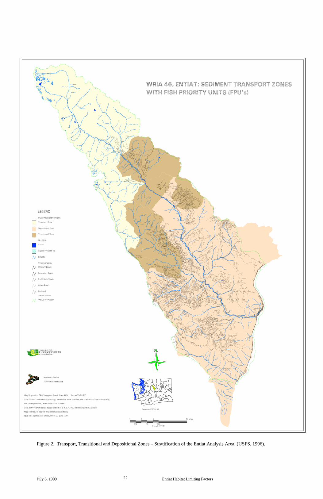
Furthermore, the 1996 USFS watershed report named landtype association and percent fine sediment in substrate gravels as analysis elements best used to stratify the Entiat watershed into three analysis zones: Transport, Transitional and Depositional (Figure 2). These analysis zones serve to characterize subwatersheds and evaluate ecosystem conditions within the Entiat watershed. They can also be used to define salmonid distribution as it relates to geology and hydrology.
July 6, 1999 Entiat Habitat Limiting Factors 22
Figure 2. Transport, Transitional and Depositional Zones – Stratification of the Entiat Analysis Area (USFS, 1996).
July 6, 1999 Entiat Habitat Limiting Factors 23
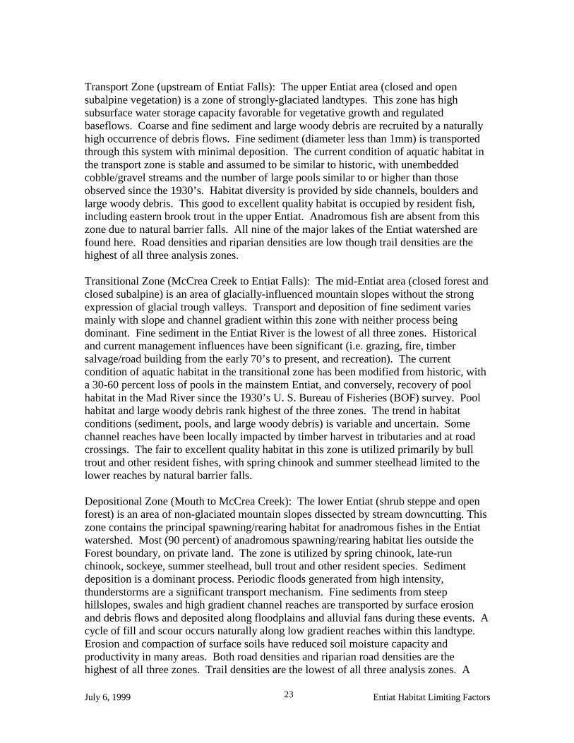
Transport Zone (upstream of Entiat Falls): The upper Entiat area (closed and open subalpine vegetation) is a zone of strongly-glaciated landtypes. This zone has high subsurface water storage capacity favorable for vegetative growth and regulated baseflows. Coarse and fine sediment and large woody debris are recruited by a naturally high occurrence of debris flows. Fine sediment (diameter less than 1mm) is transported through this system with minimal deposition. The current condition of aquatic habitat in the transport zone is stable and assumed to be similar to historic, with unembedded cobble/gravel streams and the number of large pools similar to or higher than those observed since the 1930’s. Habitat diversity is provided by side channels, boulders and large woody debris. This good to excellent quality habitat is occupied by resident fish, including eastern brook trout in the upper Entiat. Anadromous fish are absent from this zone due to natural barrier falls. All nine of the major lakes of the Entiat watershed are found here. Road densities and riparian densities are low though trail densities are the highest of all three analysis zones. Transitional Zone (McCrea Creek to Entiat Falls): The mid-Entiat area (closed forest and closed subalpine) is an area of glacially-influenced mountain slopes without the strong expression of glacial trough valleys. Transport and deposition of fine sediment varies mainly with slope and channel gradient within this zone with neither process being dominant. Fine sediment in the Entiat River is the lowest of all three zones. Historical and current management influences have been significant (i.e. grazing, fire, timber salvage/road building from the early 70’s to present, and recreation). The current condition of aquatic habitat in the transitional zone has been modified from historic, with a 30-60 percent loss of pools in the mainstem Entiat, and conversely, recovery of pool habitat in the Mad River since the 1930’s U. S. Bureau of Fisheries (BOF) survey. Pool habitat and large woody debris rank highest of the three zones. The trend in habitat conditions (sediment, pools, and large woody debris) is variable and uncertain. Some channel reaches have been locally impacted by timber harvest in tributaries and at road crossings. The fair to excellent quality habitat in this zone is utilized primarily by bull trout and other resident fishes, with spring chinook and summer steelhead limited to the lower reaches by natural barrier falls. Depositional Zone (Mouth to McCrea Creek): The lower Entiat (shrub steppe and open forest) is an area of non-glaciated mountain slopes dissected by stream downcutting. This zone contains the principal spawning/rearing habitat for anadromous fishes in the Entiat watershed. Most (90 percent) of anadromous spawning/rearing habitat lies outside the Forest boundary, on private land. The zone is utilized by spring chinook, late-run chinook, sockeye, summer steelhead, bull trout and other resident species. Sediment deposition is a dominant process. Periodic floods generated from high intensity, thunderstorms are a significant transport mechanism. Fine sediments from steep hillslopes, swales and high gradient channel reaches are transported by surface erosion and debris flows and deposited along floodplains and alluvial fans during these events. A cycle of fill and scour occurs naturally along low gradient reaches within this landtype. Erosion and compaction of surface soils have reduced soil moisture capacity and productivity in many areas. Both road densities and riparian road densities are the highest of all three zones. Trail densities are the lowest of all three analysis zones. A

July 6, 1999 Entiat Habitat Limiting Factors 24
significant portion of this zone has been recently impacted by a large, moderate-high intensity fire, posing a high risk of damage from flooding. Elimination of beaver, removal of large woody debris, riparian alterations and changes in upslope vegetation may have contributed to water table adjustments, instream flow regimes and alteration of riparian vegetation in some tributaries during drought cycles. The current condition of aquatic habitat in the depositional zone is fair to poor. Large woody debris and pool habitat rank lowest of the three zones. Pool habitat has been reduced by 90 percent in the lower-mid Entiat since the 1930’s BOF survey. The trend in habitat conditions is variable and uncertain, partially due to the frequency and extent of recent (1970, 1988 and 1994) wildfires which combined have burned over 60 % of the Entiat subbasin. Percent fine sediment in the lower mid-Entiat and lower Mad River are highest of all three zones but considered to have improved since the excessive fine sediment input of the post-fire floods of 1972 and 1974. The privately owned lower 20.1 miles of the Entiat River, containing more than 75 % of the riparian habitat for anadromous salmonids in the mainstem Entiat River (Rock Island Dam Hydroelectric Facility et al, 1998), was surveyed in 1995 by a Natural Resource Conservation Service (NRCS) “stream team”. Their report, the Entiat River Inventory and Analysis (USDA NRCS, 1998) and Mullan et al. (1992) both document the remarkable low habitat diversity present in this lower reach, specifically the lack of pools and large woody debris. These two factors are the primary limitations to natural production of salmon and steelhead on the lower Entiat River which is where most of the salmon and steelhead spawning and rearing occur in this watershed. Most of this impact can be related to flood control efforts undertaken in the Entiat Valley to protect infrastructure and agriculture in flood prone areas following the flood events of the 1940’s and 1970’s which typically invited settlement. As a result, virtually all of the lower 10 to 15 River Miles of the Entiat River has been effectively channelized; a U. S. Army Corps of Engineer’s flood control project with dike extends 10 River Miles up the Entiat River from the Columbia River confluence and the Entiat River Road further contributes to floodplain confinement, leaving few resting areas for both adult and juvenile salmon. Salmonid Distribution. In April of 1999, coordinating with the Chelan County Conservation District (CCCD) and the Chelan County Planning Department, Mike Rickel, CCCD Natural Resource Specialist and I met with Phil Archibald, Entiat Ranger District Fish Biologist and later that month with Bob Steele, WDFW Habitat Biologist. During these meetings both Archibald and Steele drew onto maps extents of spawning and rearing habitat, drawing from published data, and professional field experience. Figures 3- 6 illustrate these distributions by species. Figure 7 illustrates general distribution of salmon and steelhead and known barriers. The contact person for this data is myself, Carmen Andonaegui (509/682-8916), P.O. Box 1347, Chelan, WA, 98816, email: [email protected].

July 6, 1999 Entiat Habitat Limiting Factors 25
Figure 3. Spring Chinook Distribution.

July 6, 1999 Entiat Habitat Limiting Factors 26
Figure 4. Summer Steelhead Distribution.

July 6, 1999 Entiat Habitat Limiting Factors 27
Figure 5. Sockeye Distribution.

July 6, 1999 Entiat Habitat Limiting Factors 28
Figure 6. Late-run Chinook Distribution.

July 6, 1999 Entiat Habitat Limiting Factors 29
Figure 7. Summer Steelhead, Sockeye, Late-run Chinook, and Spring Chinook Distribution and Barriers.
July 6, 1999 Entiat Habitat Limiting Factors 30
Conditions of Natural Spawning Populations Historic Salmon Population Conditions. Information about pre-settlement salmonid species use and abundance in the Entiat watershed is derived from recorded entries by Euro-Americans relating to observations of numbers of native peoples, fish harvest, reliance on fish for food, and camp placement. Because Indian use of the Entiat watershed was limited to a single winter village and four summer camps at the mouth of the Entiat River (Smith, 1983) the pre-settlement data relating to the Entiat is meager. Work by Mullan et al. (1992) and others provides evidence that the Entiat supported runs of migratory spring and summer /fall chinook (Oncorhynchus tshawytscha), coho (O. kisutch), summer steelhead (O. mykiss), and bull trout (Salvelinus confluentus). Mullan et al (1992) concluded that the Entiat River was of modest importance to steelhead production historically. Calculations to estimate pre-settlement fish numbers in the Columbia Basin have been developed by many researchers including Mullan et al. (1992), Craig and Hacker (1940), and Schalk (1986) but they vary considerably based on the factors incorporated into the equations. Post-settlement, but prior to 1898, significant runs of chinook salmon, coho salmon, and steelhead trout occurred in the Entiat River (USDA, 1979). Beginning in the later quarter of the nineteenth century, lower river fisheries and upper river habitat degradation drastically increased and runs of Columbia River salmon declined throughout the Columbia River basin (Peven, 1992). On the Entiat River specifically, the first of three sawmills was in place at the mouth by 1888. By 1904 a hydropower station was built at that location. These fish passage barriers and the accompanying land uses, in combination with the lower Columbia River usages and to some degree oceanic conditions, contributed to the last sizeable chinook run in the Entiat occurring in 1904; very few fish remained by 1925. Stream surveys conducted in the 1930’s found the River almost devoid of salmon (USDA, 1979). All this had occurred even before construction began in 1937 on the Grand Coulee Dam which was to bar anadromous salmonids from 1,140 miles of potential spawning and rearing habitat (Fish and Hanavan, 1948). Current Condition of Natural Spawning Populations. Sockeye salmon are not indigenous to the Entiat River (Craig and Suomela, 1941). Following propagation at the Entiat National Fish Hatchery between 1941 and 1969, small numbers of sockeye adults have been observed on a discontinuous basis in the Entiat River during spawning ground surveys for chinook salmon and are documented in USFWS Mid-Columbia Fishery Resource Office spawning ground survey reports out of the Leavenworth office. It is presumed that the emerging sockeye fry move downstream into Lake Entiat to rear. Lake Entiat is the name given to the reservoir pool for Rocky Reach Dam. Coho salmon have been extirpated from the Mid-Columbia and Upper Columbia portions of the basin and therefore no longer occur in the Entiat watershed. Only 475 coho were counted at Rock Island Dam from 1933 (year Rock Island dam was constructed) to 1943. Despite releases of 46 million juveniles by hatcheries from 1942 to 1975, coho were not

July 6, 1999 Entiat Habitat Limiting Factors 31
re-established. The Yakama Indian Nation (YIN) has prepared a Preliminary Environmental Assessment (YIN 1999) on the feasibility of reintroducing coho salmon to the Mid-Columbia Region. The 1992 Washington State Salmon and Steelhead Stock Inventory (SASSI) lists only one stock of spring chinook in the Entiat; the Entiat Spring Chinook. This stock is listed as a depressed stock based on chronically low production. The stronghold of spring chinook spawning in the Entiat River basin is in the mainstem Entiat River from the terminal moraine (approximately RM 16) to Entiat Falls (approximately RM 34). The USFS reports the recent wild adult population in the Entiat averaged 437 (1962-1995 redd counts) with a high of 1344 adults in 1964 and a low of three adults in 1995. Entiat Hatchery spawning escapement has averaged approximately 500 fish per year for the same time period but has declined to fewer than 100 fish per year in the past two years (USFS 1996). Based upon dam count turnoff estimates from Rocky Reach dam to Wells dam, the average natural escapement to the Entiat River is reported as follows by Larry LaVoy (Wenatchee, Washington Department of Fish and Wildlife) in Rock Island, Rocky Reach and Wells Dam Hydroelectric Facilities, Application of Individual Incidental Take Permits filed with the National Marine Fisheries Service, July 30, 1998 (Rock Island Dam Hydroelectric Facility et al, 1998): 3,229 for the period 1960-1969, 2,965 for the period 1970-1979, 2,708 for the period 1980-1989, and 1,056 for the period 1990-1995. The Application’s authors report that these numbers should be corroborated by the redd count expansions that have been done recently by the USFWS Mid-Columbia Fishery Resource Office (FRO)in Leavenworth. In contrast, Mullan et al. (1992) reports that following reduction of harvest, the relocation of adult spring chinook from Rock Island Dam, and releases of hatchery juveniles to the Mid-Columbia tributaries from 1939-1943 counts of returning spring chinook increased at Rock Island Dam. Aside from some initial fluctuation of counts, Mullan (1987) concluded that the abundance of wild spring chinook has remained relatively stable from 1960 to 1987. SASSI (1992) does not identify the Entiat Summer Chinook as a mid-Columbia stock for the purpose of evaluating stock status and the USFS Integrated System Plan (ISP) is not considering it for objectives such as escapement goals. In the Entiat River late-run chinook spawn only in the mainstem Entiat from the confluence with the Columbia River up to the Preston Creek confluence (approximately RM 23). They are the only salmonid to also spawn in the mainstem Columbia River. Mullan et al. (1992) reports that following reduction of harvest pressure in the mid-1940’s, late-run chinook increased until 1957, then declined steadily despite little in-river harvest after 1963, with escapements remaining relatively stable from 1953 to 1987. In contrast, based upon redd count expansions, Rocky Reach Dam Hydroelectric Facility et al. (1998) reports late-run chinook escapement to the watershed averaged 37 for the period 1957-1966, 55 for the period 1967-1976, 9 for the period 1977-1986, and 11 for the period 1987-1991. It is suspected that late-run chinook were never a dominant life history strategy in the Entiat River system (Craig and Suomela, 1941) although they were depicted as the dominant upstream Columbia River run by early pioneers in the upper-Columbia. SASSI (1993) identifies only one stock of wild summer steelhead in the Entiat; the wild Entiat Summer Steelhead stock. It is listed as a depressed stock. From 1939 through
July 6, 1999 Entiat Habitat Limiting Factors 32
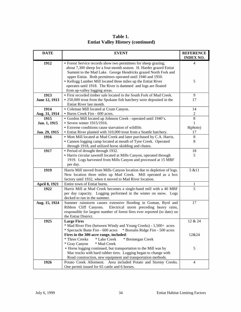
1943 all adult steelhead bound for the upper Columbia system were trapped at Rock Island Dam and distributed into the Methow, Wenatchee and Entiat River systems (SASSI, 1993). Annual counts of steelhead (which includes both wild and natural fish) at Rock Island Dam since 1933 show that numbers have increased since their depletion prior to 1933 (Peven, 1992; Mullan et al, 1992). Mullan et al. (1992) attributed this to the replacement of natural production (wild) with hatchery steelhead and favorable ocean conditions. Peven (1992) also attributes the increased numbers to increased ocean survival but also states that increases in the 1980’s could have been a result of an increase in the number of hatchery smolts being released. The Columbia Basin Salmon and Steelhead Production Plan for the Entiat River Subbasin (1990) estimated the Entiat River run of natural summer steelhead to be about 140 although the 1993 SASSI report stated that dam counts are often so confounded and misleading as to be useless for quantitative estimates at Entiat. This stock is still supplemented from hatchery stock collected at Wells Dam. Currently, and for at least the last twenty years, steelhead spawning in the Columbia River system are, and have been, predominately hatchery origin fish (MCHCP, 1998). Light (1987) estimated that 73% of the steelhead entering the Columbia River in 1987 were of hatchery origin. SASSI has established an interim escapement goal of 500 wild stock for the Entiat. Although spawning ground surveys for steelhead are not performed because steelhead spawn during high flows when water visibility and depth are not conducive to observing redds, it is possible to schedule observations during cooling trends in the spring when streams clear up and flows drop for a day or two. Phil Archibald, USFS Entiat Ranger District Fish Biologist, has had the opportunity to do this and identify steelhead redds in the mainstem Entiat River. In the absence of any other habitat limiting factor, steelhead in the Entiat watershed are presumed to spawn in the mainstem Entiat and all tributaries that do not present a barrier to movement upstream. Inferences on population size and potential production is then estimated from adult counts at Rocky Reach and Wells dams and yearly collection of smolts. Identification of historic patterns of habitat alterations A look at past environmental history will be useful in improving our knowledge of aquatic and estuarine ecosystems and provide a clearer picture of a naturally functioning ecosystem. Table 1 below (Chelan County Conservation District, in prep.) outlines a historical overview of the Entiat watershed. Table 2 chronicles a timeline of historic events in the Entiat watershed (USFS, 1996).

July 6, 1999 Entiat Habitat Limiting Factors 33
Table 1. Entiat Valley History; Historical Overview of the Entiat Analysis Area (Chelan County Conservation District, in prep.).
DATE EVENT REFERENCE
INDEX NO. Dec. 14, 1872 Ribbon Cliff Earthquake. 1
1888 Fire - Mad River Gorge to Blue Creek Meadows. 2 1890 Overuse of forage by sheep grazing. USDA photos of upper Entiat
region show 13,000 sheep grazing. There are reports of eight bands of 2,000 sheep grazing in the Mad River and Entiat range areas.
4 & 16
1892 • C.A. Harris sawmill (Grays Mill) located below the present day Numeral Mountain at the mouth of the Entiat River. Logs were harvested upriver, along the river banks and driven down the Entiat River during high water. • C.A. Harris plants orchard two miles above mouth of Entiat River.
5 & 16
21 1894
Oct. 27, 1894
• Major flood. • Grazing reports - 1,000 cattle and 400 horses graze year round, between the town of Entiat and Stormy Creek. In the head of Entiat Valley 13,000 sheep graze and in the foothills there were 150 hogs. • Irrigation ditch constructed for the 600-acre Entiat Improvement Co. Ranch. The intake was located above the present-day Naumes Orchard, four miles up the Entiat River, extending to the mouth of the River and toward Ribbon Cliff. Cattle ranged as far as Potato Creek. Corrals for summer grazing were located at Mud Creek. • The dam and bridge at C.A. Harris Mill washed out by flooding. • A.L. Rogers of Waterville files water rights on behalf of Entiat Improvement Company.
7
4 & 8
22
1898 • A dam/sawmill constructed one mile from the mouth of the Entiat River. • Reports show significant salmon and steelhead runs prior to 1898.
7
2 1902 Upwards of 60,000 sheep graze in the head of Mad River. 16 1904 • Gray constructs electric power plant at the mouth of the Entiat
River. • Construction of Knapp sawmill at Mills Canyon. Logs were harvested up valley. Mills Canyon originally named Gray’s Canyon and then Knapp Canyon. • The last (sizable) Chinook salmon run on the Entiat River. • Entiat Ranger District experiences heavy fire season.
8
3 & 8
2 25
1905 & 1906 Grays power plant experiences winter closures due to low water levels.
3
1906 Shift from cattle to apples hits the Valley. Orchard tracts begin to appear.
3
1908 • Sheep grazing allotments in Mad Lake area; included approximately 18,000 sheep. • Forest Service Supervisor, A.H. Sylvester, states at least ten-year period of overgrazing has occurred in Baldly Mountain and Snowbrushy Creek areas.
4
4
1909 C.A. Harris’s 2,000 horsepower electric plant constructed at present day Keystone Bridge 1 1/2 miles up the Entiat River. Puget Sound Power eventually buys plant and shuts it down in the 1950’s. Power provided from Wenatchee.
3 & 8
July 31, 1910 Signal/Tyee Peak Fire - 2,560 acres. 2
July 6, 1999 Entiat Habitat Limiting Factors 34
Table 1.
Entiat Valley History (continued)
DATE EVENT REFERENCE INDEX NO.
1912 • Forest Service records show two permittees for sheep grazing; about 7,300 sheep for a four-month season. H. Harder grazed Entiat Summit to the Mad Lake. George Hendricks grazed North Fork and upper Entiat. Both permittees operated until 1940 and 1950. • Kellogg Lumber Mill located three miles up the Entiat River operates until 1918. The River is dammed and logs are floated from up-valley logging areas.
4
5
1913 June 12, 1913
• First recorded timber sale located in the South Fork of Mud Creek. • 250,000 trout from the Spokane fish hatchery were deposited in the Entiat River last month.
9 17
1914 Aug. 31, 1914
• Coleman Mill located at Crum Canyon. • Burns Creek Fire - 600 acres.
14 2
1915 Jan. 1, 1915
Jan. 29, 1915
• Gordon Mill located up Johnson Creek - operated until 1940’s. • Severe winter 1915/1916. • Extreme conditions cause starvation of wildlife. • Entiat River planted with 310,000 trout from a Seattle hatchery.
8 1
8(photo) 17
1916 • Mott Mill located at Mud Creek and later purchased by C.A. Harris. • Cannon logging camp located at mouth of Tyee Creek. Operated through 1918, and utilized horse skidding and chutes.
8 8
1917 • Period of drought through 1932. • Harris circular sawmill located at Mills Canyon, operated through 1919. Logs harvested from Mills Canyon and processed at 15 MBF per day.
18 5
1919 Harris Mill moved from Mills Canyon location due to depletion of logs. New location three miles up Mud Creek. Mill operated as a box factory until 1932, when it moved to Mad River location.
5 &11
April 8, 1921 Entire town of Entiat burns. 1 1922 Harris Mill at Mud Creek becomes a single-band mill with a 40 MBF
per day capacity. Logging performed in the winter on snow. Logs decked to run in the summer.
5
Aug. 15, 1924 Summer rainstorm causes extensive flooding in Goman, Byrd and Ribbon Cliff Canyons. Electrical storm preceding heavy rains, responsible for largest number of forest fires ever reported (to date) on the Entiat District.
17
1925 Large Fires * Mad River Fire (between Windy and Young Creeks) - 1,500+ acres * Spectacle Butte Fire - 600 acres * Borealis Ridge Fire - 500 acres Fires in the 300-acre range, included: * Three Creeks * Lake Creek * Brennegan Creek * Gray Canyon * Mud Creek
• Horse logging continued, but transportation to the Mill was by Mac trucks with hard rubber tires. Logging began to change with Road construction, new equipment and transportation methods.
12 & 24
12&24 5
1926 Potato Creek Allotment. Area included Potato and Stormy Creeks. One permit issued for 65 cattle and 6 horses.
4

July 6, 1999 Entiat Habitat Limiting Factors 35
1928
Aug. 28, 1928
• Harris Mill purchased first shovel loader. • Forest Service land acquisition in T24, 26 and 27N, R20E, which expands range in Mud Creek and Moe and Crum Canyons. • Coal Oil Fire - 600+ acres, caused from coal oiling irrigation canal.
5 4
17 1929
Aug. 1, 1929 • Extreme fire season. • Upper Entiat River planted with 160,000 rainbow trout.
1 17
Table 1.
Entiat Valley History (continued)
DATE EVENT REFERENCE
INDEX NO. 1930 • Construction of fire lookouts begins.
• Entiat River survey shows the river is virtually devoid of salmon. 2
1932 Harris Mill at Mud Creek moved to mouth of Mad River (Ardenvoir) due to low water caused by the drought period. The Mill is steam-powered with a capacity of 60 MBF per day.
5
1935 By this year, three dams remain on the Entiat River, and 19 irrigation diversions still exist.
5
1939 • Harris Company entered into voluntary cooperative sustained -yield agreement, which reduced ponderosa pine harvest while increasing minor species. • New inventions bring about discontinuation of horse skidding.
5
5 1940 Truckloads of salmon planted into the Entiat River for four consecutive
years at several locations in Still Water Meadows vicinity. 8
1941 • Larch Lake Fire - 400 acres. • Introduction of contract loggers. • National Fish Hatchery fish culture began.
16 5
1946 Flood Control Act. 1948
June 8, 1948
• Harris Mill at Ardenvoir began conversion from box shooks to commercial lumber. • Worst flood in Entiat Valley history. Extensive damage from Ardenvoir to mouth of river, which was caused by a spring rainstorm. Several bridges were lost or damaged. • Army Corps of Engineers begin flood rehabilitation which includes channelization of the lower river.
5
1
1950 Coldest/snowiest year on record for 61 years. Coldest recorded day in history - February 1 at 24 degrees F below zero.
10
1953 Harris mill installed horizontal resaw, which increased production capacity to 70 MBF per day.
5
1955 Harris Mill increased to year-round production, processing more timber per employee than any other mill in the area.
5
1956
July 13, 1956
• In 1956-57, Mud Creek area is relogged. Trees too small by 1917 standards were cut under U.S. Forest Service marking rules. • Flash flood covers Highway 97 with up to four feet of mud, water and debris.
5
1
Sept. 1957 USGS establishes continuous recording stream gage on the Entiat near Ardenvoir (Gage #12452800; near Stormy Creek).
26

July 6, 1999 Entiat Habitat Limiting Factors 36
1958
Aug. 26, 1958 October 1958
• No. 1 hottest recorded year. • Potato Creek erosion control project covered 110-acre area. It resulted from the impacts of logging and grazing. • Entiat Fire 12,000 acres. Lightning caused. • USGS removes old stream gage on the Entiat River near Entiat. (Gage #12453000; located 0.25 miles above mouth of the River).
0 2 & 11
1 & 12
26
1960 Potato Creek Allotment permit - 219 cattle AUM. Intensive three-year development study initiated.
4
June 29, 1961 Nov. 11, 1961
• Tenas George Fire - 3,750 acres. Equipment caused. • Rocky Reach Dam commences commercial operation.
12 & 23 1
1962 Forest Mountain Fire - 520 acres. Lightning caused. 12 & 23
Table 1. Entiat Valley History (continued)
DATE EVENT REFERENCE
INDEX NO. 1964 • Potato Creek Allotment improvements include six stock ponds and
25 springs. Study shows that the Allotment could support 159 AUM for a 4.5 month season. • First steelhead planting in the Entiat River.
4
2 Aug. 26, 1966 Hornet Creek Fire #143 - 1,520 acres. Lightning caused. 12 & 23 Aug. 5, 1968 Harris Mill Fire #065 - 1,210 acres. Started at mill site and moved
to private, National Forest, BLM and county lands. 12 & 23
1970
July 7, 1970 Aug. 23, 1970
• Department of Game permitted cattle to graze in Mud Creek (Stepping C Ranch). Lands sold to City of Seattle in 1974. Through a tripartite exchange, lands became National Forest in 1995. • Mills Canyon fire - 933 acres, human caused. • Lightning storms cause major fires covering over 122,000 acres on Entiat and Chelan Districts. * Gold Ridge Fire - 16,100 acres. * Entiat/Slide Ridge Fire - 49,200 acres • Fires involve 25 percent of the Entiat watershed.
4
12 & 23 1
2 1971
April 1971 Nov. 18, 1971
• No. 1 record snowfall. • Agreement between Department of Game, Entiat Valley Stockman’s Association and Forest Service curtails grazing in Johnson Creek, Oklahoma Gulch and Entiat Breaks. • Corps of Engineers removes ten miles of river debris. • First helicopter fire salvage sale contract on Wenatchee National Forest and first in Washington State history.
10 4
2 1
March 1972
• Record high temps with 150 percent normal snowpack, which increased flow rates; McCrea Creek slope failure and debris- dam-break flood.
2
June 1972
June 10, 1972
• Record 1971-1972 snowpack combined with heavy rainfall results in severe flooding and streambank erosion (325 acres of agricultural land is damaged by floodwaters). • Preston Creek slides and floods; four people killed; mud & debris avalanches also occur in Brennegan, McCrea & Fox Creeks.
2
1 & 2
1972 • Preston Creek slide area debris removal. • Entiat River channel changed below Fox Creek to protect road. • Pack River purchases Harris’ Ardenvoir Mill. • Ardenvoir Mill begins to rely on logs from outside the Entiat basin to continue production levels.
2 11 5

July 6, 1999 Entiat Habitat Limiting Factors 37
1973 Aug. 23, 1973
• Drought forces cattle off federal rangelands early. • Northwest experiences worst drought in history.
1 1
Jan. 15, 1974
Jan. 16, 1972
Spring 1974
• Entiat River rises 1.5 feet as a result of three inches of rain in three days. • River ice jams blasted in Entiat River. Entiat River freezes from the bottom upward (termed "anchor ice"). • Above-average spring runoff causes severe bank erosion over entire basin.
1
2
Dec. 12, 1975 Ardenvoir Mill Fire, 150 mill workers affected. 1 1976
July 24, 1976 Oct. 24, 1976
• Ardenvoir Mill rebuilt. • Crum Canyon Fire #050 - 9,000 acres. • Entiat River planted with 570,000 salmon eggs. • Construction of spawning channel below Fox Creek.
11 12 1 1
June 13, 1977 Crum Canyon Flood. Second storm occurs on June 25. 1 1979 Ardenvoir Mill closes. 11
Table 1.
Entiat Valley History (continued)
DATE EVENT REFERENCE INDEX NO.
1983 • No. 1 wettest recorded year (from 1952). • Establishment of Mosquito Ridge Sheep Allotment, which covers an 11,600-acre area.
10 6
1984 Permit for 2,000 to 2,500 sheep on Mosquito Ridge Sheep Allotmemt from May 15 through August 31.
4
1987 No. 1 record year of consecutive days without precipitation - a total of 103 days (July 20 through October 30, 1987).
10
Sept. 4, 1988 Dinkelman Fire - 53,000 acres. Human-caused fire. 1 & 12 1989
Jan. 17, 1989
July 1989
Aug. 19, 1989
• Salvage logging operations allowed for only five percent ground disturbance, logging by helicopter, cable, or tractor on snow. • Hurricane-force winds cause massive blowdown in Lake Creek basin, and Young, Billy and Cougar Creeks. • Roaring Creek flood. • Dinkelman flood; Thousands of small chinook salmon and 10,000-50,000 non-game fish perish as a result.
1 & 15
1
1 1
July 24, 1990 Dick Mesa Fire #110 - 1,151 acres. Lightning caused. 12 Jan. 10, 1991 Ice dam in Entiat blasted. Largest build-up in 50 years. 1
May 1993 City of Seattle & USFS close riparian pastures in Mud & Potato Creeks. 6 1994
June 1994
July 24, 1994
October 1994
• City of Seattle closes Mud Creek lands to range due to overuse. • USFWS found bull trout populations in the Columbia River Population Segment (including Entiat System) to be warranted for listing as a threatened species. • Tyee Fire Complex #047 - 140,196 acres. Lightning caused. Total Entiat Dist. acres 85,968, accounts for 61% of fire area. • Fire involved 33% of Entiat watershed. • No. 1 wettest recorded month.
6 27
12
12 10
November 1994
• Tyee Fire salvage begins on private lands (most fire salvage activity on private lands completed by November 1996. • State department of Fish and Wildlife implements winter deer feeding program (continued winters of 95-96 & 96-97; discontinued winter 97-98).
17
28

July 6, 1999 Entiat Habitat Limiting Factors 38
August 1995 Sept. 1995
November 1995
• Tyee Fire salvage begins on National Forest System Lands • Tyee Fire Burned Area Emergency Rehabilitation work substantially completed; approximately $15,000,000 spent on revegetation and road/channel/slope stabilization work by several federal agencies. • City of Seattle-USFS land trade; City holdings in Entiat area traded for USFS lands in Cedar River watershed.
27 20
March 1996
May 1996
• New stream gage installed on the Entiat River near Entiat (Gage #12452990; located at Keystone Bridge, 1.5 miles above the mouth. • Reforestation work on Tyee Fire area continues with completion of 6,500 acres of tree planting in the spring of 1997 (5,000 acres in 1996; 1,800 acres in 1995).
26
27
June 17, 1996
Aug.-Oct. 1996
Aug. 26, 1997
• Oklahoma Gulch debris torrent/flood initiated by severe thunderstorm. • Three streambank restoration/fish habitat enhancement demonstration projects completed on the Entiat upstream of the Potato Creek moraine through cooperative effort of landowners, conservation groups and State/Federal agencies. • Potato Creek debris torrent/flood initiated by severe thunderstorm.
27
17
27
Table 1.
Entiat Valley History (continued)
DATE EVENT REFERENCE INDEX NO.
October 1997
Oct. 17, 1997
November 1997
• Approximately 12,145 acres of salvage logging have been completed on National Forest lands to date since 8/95; 14,560 acres were included in 10 salvage sales sold; completion anticipated in 1998 field season. • Upper Columbia Steelhead were listed as a proposed Endangered Species by NMFS. • Forest Service completes another group of watershed restoration projects targeted as road rehabilitation, a continuation of emphasis on road system rehabilitation started in 1992.
27
27
December 1997 Local deer population very low due to a combination of adverse conditions.
28
March 15, 1997 Snowpack well above average in the Entiat, as indicated by snow water content at the Pope Ridge Snowcourse at 175% of average, the peak accumulation on this date (1995 at 149% and 1996 at 146% in mid-March).
29
Reference Index for Entiat Valley History 1. Wenatchee World Newspaper 2. Entiat Cooperative River Basin Survey 3. Entiat School publication 4. Grazing publications/Albert Long’s notes 5. Soil Conservation publication (1958). January - February "Western Conservation Journal" 6. Entiat Ranger District - 2200 Grazing files 7. "Production and Habitat of Salmonids in mid-Columbia River Tributary Streams," USFWS 8. Albert Long, Entiat Valley historian 9. Entiat Ranger District timber atlas 10. NOAA Climate of Wenatchee, Washington, 1994 publication 11. Reflections, Images of our Past, WVC publication

July 6, 1999 Entiat Habitat Limiting Factors 39
12. Entiat District fire reports 13. Dinkleman Restoration Accomplishment Report 14. Power and sawmill literature 15. Entiat Ranger District fire occurrence map 16. Plummer Report 17. The Entiat Times (newspaper) 18. USDA Handbook - Climate Agricultural Atlas, 1941 Precipitation Almanac 19. An Historical Overview of the WNF, WA 20. WNF Supervisor’s Office historical files 21. Thesis of Lois Morrell Harmon 22. A History of the Famous Wenatchee, Entiat, Chelan and Columbia Valleys, by Lindsay Hull 23. Wenatchee National Forest Land and Resource Management Plan (1990) 24. Historical microfiche files 25. Wenatchee Republic Newspaper 26. USGS streamflow records 27. Entiat Ranger District files 28. Washington Department of Fish and Wildlife 29. Natural Resources Conservation Service (formally SCS) snow measurement data.
July 6, 1999 Entiat Habitat Limiting Factors 40
Table 2. A Timeline of Historic Events in the Entiat Watershed (USFS, 1996).

July 6, 1999 Entiat Habitat Limiting Factors 41
The following paragraphs identify alterations of habitat that have occurred in each sediment transport zone described earlier in this document. Transport Zone. No anadromous fish utilize this zone. Entiat Falls is a complete migration barrier. Rainbow and cutthroat trout dominate this aquatic zone (USFS, 1996). The fire regime in this high elevation zone tended to be infrequent fires of moderate to high intensity, which occurred as small isolated pockets or large patches resulting from stand replacement events. Sheep grazing historically along the upper ridges resulted in a network of trailing terraces, some of which are still evident today. This resulted in modifying the understory grassy communities to somewhat align with the terracing. Trapping has removed most beaver from the upper watershed diminishing the water storage capacity and altering the flow regimes to some degree. The extent to which removal of beaver from the upper watershed systems has affected the hydraulic regime has not been evaluated. Stream channels are mostly within wilderness or unroaded areas and have not been greatly impacted by past management, except in localized areas from historic concentrated sheep grazing. The current condition largely is believed to describe the past condition (USFS, 1996). Transitional Zone. The upper limit of anadromy in both the Entiat and the Mad Rivers occurs in this zone with spring chinook, late-run chinook, and summer steelhead being the anadromous species present. This zone is a bull trout stronghold although decreased from historical abundance (Brown, 1992). Significant populations of rainbow and cutthroat trout are found here as well. This zone is subject to high runoff from rapid melt or rain-on-snow events and characterized by rapid sediment transport in high gradient reaches. Altered ground cover as a result of moderate to heavy historic sheep grazing and timber harvest activities (including road building) dating back to the turn of the century, has not been adequate in some areas to protect the soil surface from erosional forces generated during convective storms and snowmelt-related events. Sheep grazing activities may also have contributed to the lowering of the water table in historically wet meadows as sheep competed with beaver for the more palatable willow, effectively reducing the beaver population (USDA, 1996). Increased surface erosion is a problem particularly along roads and areas detrimentally disturbed by displacement. Large fires have created debris slides on steep slopes draining the Entiat River. Fine sediment has accumulated in natural catchment basins in the Upper Mad and the Lake-Silver-Pope subwatershed and is transported mainly during extreme runoff events. Sediment transport dominates the remainder of this zone. Depositional Zone. Late-run summer chinook and summer steelhead spawn in the mainstem Entiat River within this zone. Spring chinook use this zone for rearing. Beaver were a dominant factor in many locations providing for maintenance of riparian areas and sustainability of low flows. Erosion and sedimentation occurred within a natural range, with “pulses” of sediment following fires. Fire-related events were a dominant disturbance mechanism in the lower watershed. In the non-federal lands along the lower mainstem, the Entiat river has been modified by development and by flood control work conducted following major events such as the 1948 Flood. Road construction and timber harvest within and adjacent to riparian areas has reduced the supply of large woody
July 6, 1999 Entiat Habitat Limiting Factors 42
debris and the occurrence of related channel features (e.g. pools). Table 3 (modified by Phil Archibald, USFS Entiat Ranger District, to include the 1995 NRCS stream team work) illustrates the calculated 91% loss of numbers of pools per mile in the lower 8 miles of the Entiat River since the 1935 U.S. Bureau of Fisheries (BOF) survey conducted on the mainstem Entiat and Mad Rivers during 1935-1937. This is a difference of 6.7 surveyed pools/mile to 0.5 surveyed pools/mile from 1935 to 1995. The flow regimes have changed due to a number of factors including elimination of beaver, riparian modification and changes in upslope vegetation and hydrologic regime, in part due to the effects of grazing, fire suppression (USDA, 1996) and timber harvest. The products of both natural and accelerated erosion are accumulating in many stream channels in this zone in the absence of major transport events. Roads represent a significant source of the accelerated erosion on federal lands. Roads also confine stream channels in narrow valley bottoms which leads to increased channel entrenchment and lowering of the water table. Aerial photos and other historic data will be used to help in this assessment.
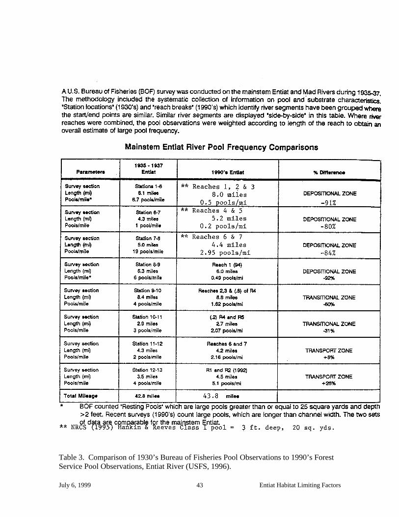
July 6, 1999 Entiat Habitat Limiting Factors 43
Table 3. Comparison of 1930’s Bureau of Fisheries Pool Observations to 1990’s Forest Service Pool Observations, Entiat River (USFS, 1996).

July 6, 1999 Entiat Habitat Limiting Factors 44
LIMITING FACTORS
Loss of Access to Spawning and Rearing Habitat Access to Spawning and Rearing Habitats Salmon are limited to spawning and rearing locations by natural features of the landscape. These features include channel gradient and the presence of certain physical features of the landscape (e.g., logjams). Flows can affect whether a landscape features functions as a barrier or whether it passes fish. For example, at low flows some falls may be impassable to some species at certain life stages but then become passable at higher flows. Lack of flows can also present a barrier, such as when extreme low flows occur in some channels or channel sections where at higher flows fish are not blocked.
Loss of Access Salmon can be restricted from utilizing formerly accessible habitat by man-made or artificial barriers. Throughout Washington, barriers have been constructed that have restricted or prevented juvenile and adult fish from gaining access to formerly accessible habitat. The most obvious of these barriers are dams and diversions with no passage facilities that prevent adult salmon from accessing historically used spawning grounds. Barriers can also prevent juveniles from accessing rearing habitat. For example, in tributaries, dikes and levees have blocked off historically accessible winter rearing habitat and holding areas such as overflow side channels. Poorly designed and/or placed culverts in streams have impacted the ability of juveniles to move into side tributaries that offer protection from strong flows and larger predators. Criteria for Evaluating Fish Blockages The Washington Department of Fish and Wildlife uses the 1998 Fish Passage Barrier Assessment and Prioritization Manual for evaluating fish passage blockages. Trainings are offered periodically. Absent another peer reviewed and scientifically defensible methodology, this evaluation process is recommended. Causes of Fish Blockages Dams and Diversions. Both adult and juvenile fish move up into irrigation ditches if they are not adequately screened. These irrigation diversion ditches can then become fish passage blockages when flows are reduced or eliminated in the ditch, stranding adults and juveniles. The Washington Department of Fish and Wildlife (WDFW) regulates the proper screening of diversions for the protection of fish life. Surface water diversions that are not adequately screened can allow fish to move into irrigation ditches, possibly becoming stranded, or be pulled into irrigation lines in gravity feed systems, or sucked into pump intakes, all resulting in direct mortality. In 1997 the WDFW Yakima Screen Shop completed their most recent ground survey inventory of irrigation structures in the Entiat Valley and

July 6, 1999 Entiat Habitat Limiting Factors 45
identified 6 surface water diversions (gravity irrigation ditch diversions) and 45 irrigation pumps currently being used. Two of the six ditch diversions and 8 of the 45 pump diversions were inadequately screened (Chelan County Conservation District, in prep.). Any additional diversions in the watershed outside those identified on the Entiat River itself need to be located and fitted with adequate screens. Placing adequate screens on the 10 diversions identified by the WDFW Yakima Screen Shop should be given high priority . John Easterbrooks, Fish Screening Program Manager, is the contact person for this data and can be reached at the Yakima Screen Shop in Yakima at 3705 West Washington Avenue, Yakima, 98903 (509/575-2734). It needs to be determined whether this 1997 Yakima Screen Shop inventory in inclusive of all water diversion functioning in the Entiat watershed or just those on the mainstem Entiat River (for a discussion on the Washington State Department of Ecology’s data relating to water diversions, see the section of this report under Water Quantity). Once identified, adequately screening water diversions is one of the easiest and most effective ways to reduce fish mortality. Sometimes small dirt and gravel dams or dikes are constructed and maintained in a channel to direct flows into ditches or pump station areas. These can create fish passage barriers during all or some flows to juvenile salmonids or adult salmonids or both. An inventory of these dams or dikes that act as fish blockages needs to be conducted in the Entiat watershed. An assessment of the extent to which those diversions act as blockages should be a part of the inventory. There are no power generating dams in place in the Entiat River watershed. Culverts. An improperly sized and/or placed culverts can act as fish passage blockages to adult or juvenile salmonids or both, during all or part of a year. Velocities within a culvert can exceed a fish’s swimming capabilities if it is sized too small or is too long in length. Low flows within a culvert can also impede a fishes progress blocking it from spawning or rearing habitat or stranding it in unsuitable habitat. Improperly placed culverts can create a height barrier to fish movement if they are perched above the streambed at the outlet or become perched due to scour actions. The USFS Stream Surveys contain information on culverts that are acting as fish barriers. Two private culverts on Stormy Creek have been identified as fish passage barriers that need replaced (USFS, 1996). This information needs to be incorporated into a database and mapped. In addition a culvert barrier survey needs to be completed for this watershed. Dikes and Levees. In 1948, following the worst flood in the Entiat Valley history, the U.S. Army Corps of Engineers began a flood control project which included the channelization and diking of the lower Entiat river. Side channel and overflow channels common to a low gradient floodplain were eliminated or blocked by the dike. Further discussion of the effects of this flood control project on floodplain function are contained in this report under the section on Floodplains, Causes of Degraded Floodplains, Dikes.

July 6, 1999 Entiat Habitat Limiting Factors 46
Other freshwater blockages. Low instream flows can act as fish passage blockages to adult or juvenile salmonids or both. This will be discussed in the Water Quantity section of this report. Data Sources An Olympia Technical Assistance Group organized under HB2496compiled a data set of fish passage barriers. This was inclusive of data available up to March 12, 1999 and incorporated the Washington State Department of Transportation (WSDOT) barrier culvert inventory, Thurston County and Jefferson County barrier culvert inventories, and the Wildlife Area Inventory unresolved fish passage problem database (UFPP) of the Washington Department of Fish and Wildlife (WDFW). The contact person for this data is WDFW Computer Information Consultant Brian Benson, 360/902-2570 (email: [email protected]). The USFS Wenatchee National Forest, Entiat Ranger District Stream Survey Reports also contains references to fish passage barriers. This information needs to be incorporated into a tabular format and mapped. Standardization of data and GIS protocols need to be discussed. During the April 1999 salmon and steelhead fish distribution mapping sessions with Phil Archibald, USFS, and Bob Steele, WDFW, fish passage barriers Archibald or Steele were aware of were mapped. These were comprised mostly of natural falls and do not reflect a comprehensive inventory of fish passage barriers in the Entiat watershed. This data is reflected in Figure 8 - Summer Steelhead, Sockeye, Late-run Chinook, and Spring Chinook Distribution and Barriers, page 29 of this report. Blockages in Priority Order No such prioritization exists in print; this list needs to be developed. Floodplains Functions of Floodplains Floodplains are portions of a watershed that are periodically flooded by the lateral overflow of rivers and streams. In general, most floodplain areas are located in lowland areas of river basins and are associated with higher order, low gradient streams. Floodplains are typically structurally complex, and are characterized by a great deal of lateral, aquatic connectivity by way of sloughs, backwaters, sidechannels, oxbows, and lakes. Often, floodplain channels can be highly braided (multiple parallel channels). One of the functions of floodplains is as aquatic habitat. Aquatic habitats in floodplain areas can be very important for some species and life stages such as summer steelhead and spring chinook salmon juveniles that often use the sloughs and backwaters of floodplains to overwinter since this provides a refuge from high flow events. Floodplains

July 6, 1999 Entiat Habitat Limiting Factors 47
also help dissipate water energy during floods by allowing water to escape the channel and inundate the terrestrial landscape. This lessens the impacts of floods on incubating salmon eggs. Floodplains also provide coarse beds of alluvial sediments through which subsurface flow passes. This acts as a filter of nutrients and other chemicals and so maintains high water quality. Impairment of Floodplains by Human Activities The highest priority for maintaining biological productivity will be to allow unrestricted stream channel diversity and flood plain function (Rock Island Dam Hydroelectric Facility et al., 1998). Large portions of the floodplains of many Washington rivers, especially those in the western part of the state, have been converted to urban and agricultural land uses. Much of the urban areas of the state are located in lowland floodplains, while land used for agricultural purposes is often located in floodplains because of the flat topography and rich soils deposited by the flooding rivers. The principle mean to secure this objective is to secure riparian habitat either in conservation agreements, easements or direct purchases. There are two major types of human impacts to floodplain functions. First, channels are disconnected from their floodplain. This occurs both laterally as a result of the construction of dikes and levees, which often occur simultaneously with the construction of roads, and longitudinally as a result of the construction of road crossings. Riparian forests are typically reduced or eliminated as levees and dikes are constructed. The second major type of impact is loss of natural riparian and upland vegetation. The natural late seral riparian vegetation in floodplain areas of the Entiat basin was a mix of hardwood trees and shrub understory, interspersed with ponderosa pines. Upland vegetation varied throughout the watershed, changing with the amount of rainfall, slope, elevation and aspect. Removal of upper watershed vegetation and conversion of riparian tree/shrub areas to pastures and orchards and impervious surfaces has occurred as floodplains have been converted to urban and agricultural uses. Loss of connectivity and elimination of floodplain forests has: 1) eliminated off-channel habitats such as sloughs and side channels, 2) increased flow velocity during flood events due to the constriction of the channel, 3) reduced subsurface flows, and 4) simplified channels since large woody debris (LWD) is lost and channels are often straightened when levees are constructed. Elimination of off channel habitats can result in the loss of important rearing habitats for juvenile salmonids such as sloughs and backwaters that function as overwintering habitat. The loss of LWD from channels reduces the amount of rearing habitat available for juveniles. Disconnection of the stream channels from their floodplain due to levee and dike construction increases water velocities which in turn increases scour of the streambed. Salmon that spawn in these areas can have reduced egg to fry survival due to scour. Removal of riparian zone vegetation can contribute to an increase in summer-time high stream temperatures and a decrease in winter-time low stream temperatures. This can stress both adult and juvenile salmon and/or lead to mortality of eggs, juveniles or adults. Temperatures at which increasing stress occurs vary with species of fish and life
July 6, 1999 Entiat Habitat Limiting Factors 48
cycle (egg, juvenile, adult). For example, Combs (1965) reports that chinook salmon eggs, if initially exposed to water temperatures less than 42.5 °F have experienced significant mortality. If water temperature is 42.5° F to 56° F for the first 72 hours after deposition, a subsequent drop in temperature below this threshold will not cause abnormal mortality. At the time summer chinook salmon are spawning in the Entiat River, water temperatures are very close to, and sometimes below, this lower threshold (Carie, 1998). In summer, canopy coverage provides shading and helps preserve and maintain cooler instream water temperatures. Other factors also affect instream temperatures to varying degrees such as stream width, channel complexity, streambed conditions, hydrology and ambient conditions. In the Entiat watershed, further investigation of winter low water temperatures as a factor limiting the ability of the habitat to sustain populations of salmonids, needs to be investigated. An evaluation of summer high temperatures is already being conducted as described in the Water Quality section of this report. Criteria for Evaluating Impaired Floodplain Functions Floodplain extent needs to be identified based on geomorphologic characteristics that consider flood prone areas and meander belt width. Once calculated, the extent to which floodplain function has been lost needs to be determined. This will require identifying the factors contributing to the loss of floodplain function for a given reach. Existing methods for evaluating impaired floodplain functions need to be reviewed and one selected that addresses causal mechanisms relative to watershed processes. Causes of Degraded Floodplains Dikes. Flood control dikes, gravel mining, and channel straightening associated with U.S. Army Corps of Engineers’ flood control projects, in addition to the placement of the Entiat River Road, have dramatically simplified habitat in the mainstem Entiat River downstream from Potato Creek Moraine. This has created a highly confined channel without an effective floodplain, resulting in a poor distribution of water velocities for lack of a well defined thalweg (the longitudinal line of deepest water within a stream. This in turn, is linked to the amount of bedload moving through the system which drops out at lowering velocities. The result is a loss of pool habitat and LWD recruitment. In combination with the removal of LWD and riparian vegetation, this constitutes a significant loss of salmonid rearing habitat and is the greatest impact to salmonid habitat in the mainstem Entiat downstream of Mad River. The early rearing habitat is fairly hostile now, primarily associated with rip-rap which affords little cover from avian or fish predation, high velocities, sedimentation, gravel scour and anchor ice. The late rearing habitat quality, including overwinter rearing habitat, is also impacted by the loss of in-channel diversity. The lack of cover, particularly as flows drop in the summer and fall, may be limiting the salmonid productivity (Rock Island Dam Hydroelectric Facility et al, 1998). The Corps of Engineers dike and any other dikes in the Entiat watershed need to be mapped. Flood-prone extents need to be defined and mapped so potential and past loss of floodplain capacity can be determined. This exercise would allow for the identification of land best suited for maximizing floodplain function within the current
July 6, 1999 Entiat Habitat Limiting Factors 49
landscape and with existing land uses. Rocky Reach Dam Hydroelectric Facility et al. (1998) identifies as the highest priority for maintaining biological productivity, allowing unrestricted stream channel diversity and floodplain function. The report also identifies stream reaches which should receive protection, ranked in biological priority. See the section of this document on Riparian Zone Conditions, Causes of Degraded Riparian Zones, Removal of Streamside Vegetation for this list of identified stream reaches which should receive protection. Upland land use. Land management practices in the past have resulted in a loss of upland vegetative cover, soil compaction and loss of water retention, all of which contribute to accelerating sediment and water delivery to stream channels. This in turn contributes to downstream flooding intensity, frequency and duration. Contributing factors include fire suppression, historic grazing and timber harvest impacts, road and trial construction, and the removal of beaver from the watershed. A strategy based on salmonid habitat restoration needs to be identified and incorporated into the watershed management process. The Technical Advisory Group should build on the analysis already done by the USFS as documented in the Entiat watershed analysis (USFS, 1996), while coordinating and consulting with the Entiat watershed steering committee. Road density & location. The USFS Entiat watershed analysis assesses road densities on national forest land within the Entiat watershed for sediment transport zones and individual Fish Production Units (FPU’s), which are subwatersheds. The analysis then draws linkages between road density and location with potential for sediment transport. Sediment transport and delivery drive many hydraulic processes and affect a watercourse’s ability to function. This analysis focuses on the restoration of watershed processes. The placement of the roads on forest service land as they affect floodplain function also needs to be evaluated prior to implementation of structural projects. In the lower 20.1 miles of the Entiat watershed, a multi-disciplinary “stream team” under the direction of NRCS conducted a Hankin and Reeves stream survey in 1995 of the Entiat River on private land (Chelan County Conservation Commission, in prep). This NRCS Entiat River Inventory and Analysis provides data on stream parameters and specific locations of stream channel components or lack thereof. This data needs to be correlated to the placement of the Entiat River Road which confines the Entiat River channel for approximately 30 miles of its length starting at the confluence with the Columbia River. The extent to which the Entiat River Road limits the ability to restore hydraulic processes in the lower 30 miles of the mainstem Entiat River needs to be assessed. The affect and cost of replacing stream components and maintaining those structures in the floodplain relative to the benefit to salmonid habitat restoration needs to be assessed also. Virtually all of the lower 21 miles has been effectively channelized with a flood control dike on one side and the Entiat River Road on the other. Channel confinement is defined as the limitation of the channel to move laterally. Channel constriction.

July 6, 1999 Entiat Habitat Limiting Factors 50
An inventory of stream channel crossings needs to be conducted. The inventory should identify the crossings as bridge or culvert crossings. The methodology described in the Fish Barrier Assessment and Prioritization Manual developed by the Washington Department of Fish and Wildlife (WDFW) should be considered for protocol. The data needs to be correlated to the extent the crossings are acting as constrictions within the meander zone and how the constrictions are affecting sediment transport, LWD movement, and channel meander within the floodplain. Constriction is defined as an obstruction narrowing a waterway that creates a backwater effect. Streambed Sediment Conditions Streambed Sediment The sediments present in an ecologically healthy stream channel are naturally dynamic and are a function of a number of processes which input, store, and transport the materials. Processes naturally vary spatially and temporally and depend upon a number of features of the landscape such as stream order, gradient, stream size, basin size, geomorphic context, and hydrological regime. In forested mountain basins, sediment enters stream channels from mass wasting (e.g., landslides and debris flows), surface erosion, and soil creep. Inputs of sediment to a stream channel in these types of basins usually occurs periodically during extreme events such as floods (increasing erosion) and mass wasting which are the result of climatic events (e.g., rainstorms, rain on snow). In lowland (higher order) streams, erosion is the major sediment source. Inputs of sediment in these basins tend to be more steady in time. Once sediment enters a stream channel it can either be stored or transported depending upon particle size, stream gradient, hydrological conditions, availability of storage sites, and channel form (e.g., amount of LWD). Finer sediments tend to be transported through the system as wash load or suspended load and so have relatively little effect on channel morphology. Coarser sediments (>2 mm diameter) tend to travel as bedload, and can have larger effects on channel morphology as they move downstream through the channel network. Based upon the 1995 stream channel inventory (Chelan County Conservation District, 1998) and work presented in Mullan et al. (1992), habitat diversity in lower Entiat River is remarkably low. Lack of pools and woody debris are identified as the primary limitations to natural production of salmon and steelhead on lower Entiat River (Rock Island Dam Hydroelectric Facility et al., 1998). Some parts of the channel network are more effective at storing sediment, while other parts of the network more effectively transport material. There are also strong temporal components to sediment storage and transport, such as seasonally occurring floods, which tend to transport more material. One channel segment may function as a storage site during one time of year and lose sediments at other times. In general, the coarsest sediments are found in upper watersheds while the finest materials are found in the lower reaches of a watershed. Storage sites include various types of channel bars, floodplain areas, and behind LWD.

July 6, 1999 Entiat Habitat Limiting Factors 51
Effects of Human Actions on Sediment Processes Changes in the supply, transport, and storage of sediments can occur as the direct result of human activities. Human actions can result in increases or decreases in the supply of sediments to a stream. Increases in sediment result from the isolation of the channel from the floodplain by development of lowland areas; this eliminates important storage areas for sediment. In addition, actions that destabilize the landscape in high slope areas such as logging or road construction increase the frequency and severity of mass wasting events. Finally, increases in the frequency and magnitude of flood flows increases erosion. Increases in the amount of coarse material tend to fill pools and aggrade the channel, resulting in reduced habitat complexity and reduced rearing capacity for some salmonids. Increases in total sediment supply to a channel increases the proportion of fine sediments in the bed which can reduce the survival of incubating eggs in the gravel and change benthic invertebrate production. Sediment supply can decrease in some cases. This occurs primarily as a result of disconnecting the channel from the surrounding landscape. A dam can block the supply of sediment from upper watershed areas while a levee can cutoff upland sources of sediment. Reduction in sediment supply can alter the composition of streambeds, which can in some cases reduce the amount of material suitable for spawning. In addition to affecting supply, human activities can also affect the storage and movement of sediment in a stream. An understanding of how sediment moves through a system is important for determining where sediment will have the greatest effect on salmonid habitat and for determining which areas will have the greatest likelihood of altering habitats. In general movement of sediment changes as a result of the isolation of the channel from its floodplain, and increases in the magnitude and frequency of flood flows. Larger and more frequent flood flows moves larger and greater amounts of material more frequently. This can increase bed scour, bank erosions, and alter channel morphology, and ultimately degrade the quality of spawning and rearing habitat. Channels become unstable and very dynamic compared to conditions without development. Human activities also change where sediments are stored. For example, increases in the magnitude and frequency of flood flows can more material through areas where it would have otherwise been stored. Criteria for Evaluating Changes to Sediment Processes To evaluate changes in sediment processes we will consider the following as indicators of human effects on sediment processes: 1) increases in sediment supply, 2) decreases in sediment supply, and 3) altered hydrological regimes. Changes to Sediment Processes. Dredging. Dredging to remove sediment or bedload material from a stream channel is often done in conjunction with diking and channel straightening to increase the water transport capacity
July 6, 1999 Entiat Habitat Limiting Factors 52
of a stream or stream reach. This offers a very short term solution to managing sediment loads since deposition rates of sediment and bedload material is a function of the streams capacity to move that material (velocity) and the input of material into the system. Dredging only changes velocities at the site of dredging without addressing the quantity of the input. Additionally, velocities will slow at the next channel constriction dropping the bedload material at that next downstream location, possibly still within the dredged section if that constriction occurs at the downstream end of the dredging project. In summary, dredging passes the problem downstream to the next slow stretch of stream, is expensive to maintain, eliminates salmonid habitat and can have direct mortality to salmonid eggs still in the gravel. Sections of streams within the Entiat watershed that are dredged need to be identified and mapped and hydrogeomorphically based alternatives recommended. This would include reestablishing a connection to the floodplain where appropriate and/or reducing bedload input in the drainage. Diking. Velocities within a diked portion of stream are altered and contribute to sediment deposition creating a need for dredging to maintain the diked portion of channel. This in turn perpetuates the condition of reduced channel complexity and loss of salmonid habitat. See discussion in section on Causes of Degradation of Floodplains, Dikes. Channel constrictions. A channel constriction (e.g., culvert, bridge or road encroachment, dike) may cause backwater conditions immediately upstream and contribute to gravel and/or sediment deposition. This can be beneficial, creating gravel spawning areas in the absence of sediment deposition, or negative, in the case of destabilizing the channel. As recommended in Causes of Degradation of Floodplains, Channel Constrictions, an inventory of constrictions needs to be conducted and an analysis of the effects the constrictions are having on sediment and gravel movement needs to be included in the assessment Flow alterations. The movement of sediment through a system is a function of a velocity. Higher flows can move larger sized particles which drop out first as flows decrease. Smallest particles are carried by flows the longest, staying suspended in the water column. Floodplains function to slow the flow of water by dispersing it over a larger area allowing bedload material to settle out. Again, flood prone areas need to be identified so as opportunities to restore or protect these areas become available, it can be recognized actions can be implemented Roads. The impacts of roads placed in the flood prone areas need to be evaluated and opportunities to restore functioning floodplain implemented. Roads concentrate surface water runoff and contribute to soil erosion and delivery of that material to streams. The USFS Entiat watershed analysis (1996) identified projects aimed at road rehabilitation. These rehabilitations have been ongoing since 1997, some of which have been completed and some of which are in process. The extent to which county roads and private roads are contributing to sediment delivery and altering bedload deposition patterns has not

July 6, 1999 Entiat Habitat Limiting Factors 53
been determined. To the extent these roads exist in floodways, constricting the floodplain, they are altering sediment transportation and deposition. See the section of this report on Floodplains, Causes of Degraded Floodplains, Road Density and Location for more discussion. Flood plain development. Floodplain area within the Entiat valley has been considerably impacted by past flood control practices and agricultural/residential/infrastructure development. Riparian bottomland and side channels in the Entiat mainstem reach between the terminal moraine and Preston Creek have been identified in Rocky Reach Dam Hydroelectric Facility et al. (1998) as having the highest priority for receiving protection. Bottomlands and side channels along the mainstem Entiat between Preston Creek and Fox Creek are second in importance with riparian bottomlands in the lower Mad River, Stormy Creek, and Roaring Creek listed as third in importance. Loss of these functioning floodplains to development will generate a presently unnecessary need for flood protection measures. Floodplain protection of infrastructure within these identified reaches will pass downstream bedload that might have settled out in these floodplains, exacerbating downstream problems. Erosive velocities that might have dissipated in these floodplains will be passed downstream increasing stress on stream banks and accelerating bank erosion. Floodplain protection in the form of dikes also present the possibility they will be overtopped, releasing concentrated flows which scour soils transporting it back into the channel downstream. Floodplain habitat can be secured through conservation easement, easements or direct purchases. Riparian Zone Conditions Riparian Zone Functions. Stream riparian zones are the area of living and dead vegetative material adjacent to and hydrologically influenced by a stream. They extend from the edge of the average high water mark of the wetted channel toward the uplands to a point where the zone ceases to have an influence on the stream channel. Riparian vegetation characteristics in ecologically healthy watersheds are strongly influenced by climate, channel geomorphology, and where the channel is located in the drainage network. For example, fires, severe windstorms, and debris flows can dramatically alter riparian characteristics. The width of the riparian zone and the extent of the riparian zone’s influence on the stream are strongly related to stream size and drainage basin morphology. In a basin unimpacted by humans, the riparian zone would exist as a mosiac of stands of trees of different acreage, ages (e.g. sizes), and species. Functions of riparian zones include providing hydraulic diversity, adding structural complexity, providing a refuge from predators and extreme environmental events, buffering the energy of runoff events and erosive forces, moderating temperatures, and providing a source of nutrients. They are especially important as the source of LWD in streams which directly influences several habitat attributes important to anadromous species. In particular, LWD helps control the amount of pool habitat and can serve as a site for sediment storage. Pools provide a refuge from predators and high-flow events for

July 6, 1999 Entiat Habitat Limiting Factors 54
juvenile salmon that rear for extended periods in streams while the gravels can provide sites for spawning and incubating. Effects of Human Activities on Riparian Zones. Riparian zones are impacted by all types of land use practices. In general, riparian forests can be removed to the stream bank, they can be broken longitudinally by stream crossings by roads, and their width can be reduced. Further, species composition can be dramatically altered when native trees are replaced by exotic species, shrubs, and or grasses. More mature stands of riparian vegetation provide a greater root mass and density of material that is more resistant to erosive forces by high magnitude floods. Once impacted, the recovery of a riparian zone can take many decades as the mature tree and shrub component reestablishes. In the Entiat watershed, conversion of native riparian vegetation to orchard crops and landscaped lawns represents the largest threat to riparian vegetation. Changes to riparian zones affect many attributes of stream ecosystems. For example, stream temperatures can increase due to the loss of shade, while streambanks can become more prone to erosion due to elimination of the trees and their associated roots. Perhaps the most important impact of changes to riparian zones is a decline in the frequency, volume and quantity of LWD due to altered recruitment from riparian forested areas. Loss of LWD results in a significant reduction in the complexity of stream channels including a decline of pool habitat and cover, which reduces the number of salmon juveniles that can rear and adult holding areas. Loss of LWD affects the amount of both overwintering and low velocity rearing areas.
Criteria for Evaluating Degraded Riparian Zones. There has been an extensive and vigorous debate over what constitutes an adequate riparian zone. The focus of the debate has generally been on defining a buffer width for each side of a stream channel. A buffer width needs to be calculated based on the geomorphology of the reach. Within this buffer width, manipulations that degrade instream conditions and negatively impact watershed processes need to be curtailed. Conflicts with adjacent streamside land use must be addressed in this process through a willing buyer/willing seller process or through easement purchases. Causes of Degraded Riparian Zones. Removal of streamside vegetation. Rock Island Dam Hydroelectric Facility et al. (1998) identified a need for woody debris recruitment in the lower Entiat River. The removal of streamside vegetation reduces this potential. The short term strategy is the placement of large wood in the channel with a long term strategy of securing riparian habitat in the Entiat downstream of the Mad River confluence. Conflicts with adjacent streamside land use must be addressed in this process through a willing buyer/willing seller process. Presently, orchardists consider streamside cottonwoods, which are stoloniferous and send extensive root systems into irrigated orchards, a nuisance. There is also a concern that cottonwoods may be a host for scale and that they restrict air flow, causing an increased likelihood of frost damage.

July 6, 1999 Entiat Habitat Limiting Factors 55
The loss of this large tree components of the riparian zones remove a critical source of woody debris recruitment, shade and bank stability. Some demonstration projects for revegetating with native shrubby species are needed to determine the extent to which the functions of mature cottonwoods within the riparian plant community can be replaced. Riparian buffer areas need to be identified and enhanced in conjunction with floodplain protection and restoration projects to maximize the benefit to lower Entiat River fish rearing areas. The Aquatic Species and Habitat Assessment: Wenatchee, Entiat, Methow, and Okanogan Watersheds completed in conjunction with mid-Columbia hydroelectric facilities’applications for incidental take permits under the Endangered Species Act (Rock Island Dam Hydroelectric Facility et al, 1998), identifies stream reaches which should receive protection, ranked in biological priority: 4) Riparian bottom land and side channels in the Stillwaters Reach (between the
terminal moraine and Preston Creek) 5) Riparian bottomland and side channels along the mainstem Entiat between Preston
Creek and Fox Creek 6) Riparian bottomlands in the lower Mad River, Stormy Creek and Roaring Creek Changes to streamside vegetation. As discussed above in Removal of streamside vegetation, the effect of the loss of the large tree component of the riparian plant community needs to be evaluated relative to the impacts on shade, streambank stability and large woody debris recruitment. Rock Island Dam Hydroelectric Facility et al. (1998) identifies a range of strategies recommended for habitat restoration in the Entiat watershed, most of which center on efforts to maintain or increase complexity of the stream channel and floodplain like the habitat protection strategy. Most of these efforts are on the lower reaches and aggradation zones. Simple structures such as low vortex rock weirs, bankside root and bole placements, and many other actions to encourage thalweg development, decrease the wetted width:depth ratio, and increase the frequency of pools would benefit all aquatic species. A multi-disciplinary team of fishery biologists, hydrologists, and fluvial geomorpologists should provide specific recommendations on the types of structures that would work best, based upon channel configuration. These benefits may be short-termed however, and maintenance costs would be substantial. The most feasible results for habitat restoration lie primarily in structure placement, as an immediate improvement, and riparian setbacks as the long-term solution. Road crossings. Stream crossings create constrictions in the stream channel and fix the stream meander in place at that point of crossing. Constrictions create backwaters which slow water velocities, dropping sediment and gravel on the upstream side of the constrictions. This can contribute to local scour along the banks immediately upstream of the constriction. As flows are concentrated passing through the constriction, local scour may occur along the bed or banks immediately downstream of the crossing. As soon as flows can again spread out, the water velocity decreases and again sediment and bedload material drop out contributing to local scour along banks at that location. Another condition of stream channels is the tendency to move its meanders downstream. A road crossing fixes that

July 6, 1999 Entiat Habitat Limiting Factors 56
meander pattern in place, essentially forcing it to thread itself through that crossing. This destabilizes the upstream reaches, placing additional stresses on upstream banks as the channel tries to compensate by extending its meanders laterally across the landscape. Stabilizing the banks to protect the road crossing structures passes that problem to the next closest, weak bank. The cause and effects of this destabilizing of the watercourse is compounded in a system with degraded riparian vegetation, confined floodplains and heavy bedload/sediment. The more stream crossings the more extreme the effects and the fewer the options for repair. Culverted road crossings can also become fish passage barriers if incorrectly sized, poorly placed or if bed downcutting perches the outlet. As recommended earlier in this document under Causes of Fish Blockages, Culverts, a stream crossing inventory is needed. The crossings need to be correlated to problems of local scour, sediment movements and other problems of stream instability. This information would contribute to ensuring success of projects involving the placement of structures within the channel and help identify potential problems in the future. Lack of bank stability. A watercourse is a moving, changing system. For example, heavy floods are channel changing events that occurred periodically prior to human influence. Part of this process included sloughing banks and the creation of new channels, all of which maintained channel complexity. Undercut banks with overhanging vegetation and tangled woody debris improve the ability of the stream to support salmonids. The extent to which a given reach of a stream meanders is partially controlled by the physical features of the landscape through which it passes (soils, gradient) and partially controlled by the moisture regime (hydrology). When one or more of these factors is decreased or increased, other factors will shift. For example, an increase of flows as a result of the loss of moisture holding capacity in the upper drainages can increase sediment delivery to the channel and increase water velocities in-stream. This in turn can increase stress on stream banks. If these stream banks have lost the root mass that once provided structural integrity to the soils they are doubly susceptible to the shear stress. This accelerates bank failure leading to many other problems in a domino effect of further destabilization of the system. Mass stabilization of banks can be counterproductive to maintaining fish populations if it leads to a decrease in stream complexity. The focus should be on identifying the cause of failure in the context of stream channel management. This places the focus on restoring watershed processes rather than placing it on symptoms of the true problem. Bank stabilization projects should only be undertaken for the purpose of protecting infrastructure and property when no other alternatives are available or feasible. Bank protection projects should also only be undertaken in conjunction with efforts to restore watershed processes that have been identified as contributing to the accelerated bank destabilization. Water Quality Water quality parameters such as temperature, dissolved oxygen, pH, turbidity, and suspended solids levels are linked to sediment; both water and sediment are excellent media for the uptake, storage, transportation, and concentration of dissolved and particulate materials. Natural rates of sediment delivery and routing within streams are essential to creating and maintaining salmonid habitat, but accelerated rates of sediment

July 6, 1999 Entiat Habitat Limiting Factors 57
erosion/deposition are usually detrimental to salmonid habitat. Human activities can affect sediment delivery and routing, and introduce potentially toxic substances to water and sediment that can have deleterious effects on salmonids and the food webs upon which they rely. In the federal Clean Water Act of 1977, federal Water Quality standards were set. Water quality standards are intended to be consistent with public health needs and public enjoyment of surface waters, and the propagation and protection of fish, shellfish, and wildlife. The State of Washington was delegated to administer the Washington State water quality program by the U.S. Environmental Protection Agency (EPA), in accordance with the federal Clean Water Act and after developing standards that met or exceeded the federal standards. These state water quality standards are outlined in Section 030 of Washington Administrative Code (WAC) Chapter 173-201A, Water Quality Standards for Surface Waters of the State of Washington, pursuant to the provisions of chapter 90.48 of the Regulatory Code of Washington (RCW). In the Entiat watershed, all surface waters within the Wenatchee National Forest, including the Entiat River from its headwaters to the Wenatchee National Forest Boundary (river mile 20.5), are classified as Class AA (extraordinary) waters. The remaining portion of the Entiat River from the Wenatchee National Forest Boundary (River Mile 20.5) to the confluence with the Columbia River is classified as a Class A (excellent) water, including all the tributaries feeding into this lower section of the Entiat River. Pursuant to these classifications, the water quality standards established for each respective class may not be exceeded. Section 303(d) of the 1977 Federal Clean Water Act requires the listing and monitoring of surface water body segments that are not expected to attain water quality standards after implementation of technology-based controls. Due to excursions beyond water quality standards, the lower reach of the Entiat has been on the State’s 303(d) list since 1992 (pH on the 1992 list; pH and temperature on the 1994 list; instream flows on the 1998 list). Regarding recordings of high instream temperatures that exceed state water quality standards, the USFS Entiat Ranger District recently completed development of a temperatures thermocline for the Mad River. This report concludes that the natural geology and hydrology of that system resulted in exceedences of State water quality standards without a factor of human influence (USFS, 1999). Point Sources A source of pollution may enter a surface water from a defined point such as a discharge pipe. Discharges into surface waters are regulated under WAC 173-201A and may not exceed established water quality criteria, except under specific conditions as outlined in the WAC 173-201A. Spills. There were no records of spills having affected water quality in the Entiat watershed. Such spills would have come from illegal disposal of pesticides/herbicides, accidental spills of pesticides/herbicides, or traffic accidents that might have lead to discharges of

July 6, 1999 Entiat Habitat Limiting Factors 58
gasoline or diesel into the ground or surface waters. These are still the only potential concerns identified at present. Industrial sources. The Needs Assessment for the Wenatchee Water Quality Management Area (DOE, 1996) listed facilities with general and individual wastewater discharge permits. Those that occur within the Entiat watershed (WRIA 46) need to be identified and mapped into GIS. The type and quantity of discharge needs to be included in the attached data record. An assessment of the extent to which the industrial discharges affect salmonids needs to be conducted. Sewer outfalls. The town of Entiat is listed in the Needs Assessment for the Wenatchee Water Quality Management Area (DOE, 1996) as having a minor, municipal NPDIS and state wastewater permit. It is presumed that this is for the discharge of treated effluent from the town’s wastewater treatment facility. No other references to sewer outfalls were identified in the literature. The town of Entiat’s NPDES permit was set to expire March 1, 1999. The status of that permit needs to be determined and the extent to which, if at all, that discharge affects salmonids needs to be assessed. Reservoirs & artificial ponds. Reservoirs and artificial ponds have the potential to affect water quality standards in-channel by increasing or decreasing temperatures and oxygen levels depending on the timing of the release of water into the channel and the temperature of the water being released into the channel. They may also act as fish passage barriers, creating a temperature gradient that may affect salmonid movement. There are no reservoirs in the Entiat watershed although the lowest 0.5 miles of the Entiat River is influenced by Lake Entiat water level, which serves as the pool for Rocky Reach Dam. In the Entiat watershed, there were no artificial ponds identified in the literature. Non Point Sources Nonpoint source is defined in WAC 173-20A-020 (Water Quality Standards for Surface Waters of the State of Washington) as “pollution that enters any waters of the state from any dispersed land-based or water-based activities, including but not limited to atmospheric deposition, surface water runoff from agricultural lands, urban areas, or forest lands, subsurface or underground sources, or discharges from boats or marine vessels not otherwise regulated”. DOE Environmental Investigations and Laboratory Services Program (EILS) has had an ambient water quality monitoring station (#46A070) in the Entiat watershed near the Keystone bridge, approximately 1.5 miles upstream from the Entiat river mouth, since 1978. The Chelan County Conservation District (CCCD), the USFS Entiat Ranger District, the DOE Central Regional Office (CRO), and the EILS are currently monitoring nine ambient stations in the Entiat River basin (DOE, 1996). The Entiat National Fish Hatchery monitors stream temperatures at the Hatchery year-round. The location of past present and planned water quality monitoring stations need to be mapped into GIS.

July 6, 1999 Entiat Habitat Limiting Factors 59
Associated data records detailing type of data collected, duration of data collection, entity responsible for recording station, etc, need to be attached to the locations. Roads. Surface water runoff patterns are altered as they intersect road surfaces. The extent to which that runoff carries pollutants like sediments and toxic chemicals into surface waters is affected by many factors. Roads placed on steep slopes may accelerate and concentrate surface flows increasing the rate of sediment into stream channels. Increasing road densities can be correlated to increasing instream sediment and flashy hydrology. Roads in stream meander belts can confine waterways contributing to increased instream velocities and accelerated bank erosion. The Entiat Watershed Assessment (USFS, 1996) assessed road and trails system impacts within the Transport, Transitional and Depositional zones on Forest Service lands. In the Transport zone there are 162.7 miles of trails – the highest of all three zones. The Forest Service associates localized compaction, damaged understory vegetation, erosion and degradation of bank stability with heavy recreational use in this zone. In the Transitional zone, they describe a moderately high road density (Mean = 3.2 mi/sq mile) with a relatively low number of road miles in the riparian corridor (8.7 = miles/fish productive units). The Depositional zone has been identified as having the highest road density (Mean = 3.5 mi/sq mile; range 1.4-7.3 mi/sq mile) and high number of road miles in the riparian corridor (Mean = 21 miles/fish productive units; Range 6.0-3.2 miles). The Forest Service assessment evaluated these road densities relative to percent fines, salmonid species present, and presence of salmonid species strongholds to arrive at geographic priorities based on Fish Production Units (FPU’s). FPU’s are the terminology used in the USFS Entiat Watershed Analysis (1996) for subwatersheds. Based on these assessments and prioritizations, road rehabilitation and obliteration can be implemented to reduce sedimentation concerns in Entiat watershed waters. These rehabilitations have been ongoing since 1997, some of which have been completed and some of which are in process. Septic. In 1974, R.W. Beck and Associates completed a Sewage Drainage Basin Plan for Chelan County, Washington. At that time, Beck and Associates expressed concern about the lack of public sewer systems outside incorporated areas. The performance of septic systems was of special concern along the Entiat River, as well as along Lake Chelan and Squilchuck Creek. With the growth in the Entiat experienced over the past several years there is a potential for a correlated increase in problems associated with septic systems. The Chelan County Health Department reported that there are now over 3,000 septic systems in the Entiat Valley and over one-half of these have been installed in the last 5 years. At this rate and under current County land use regulations, high density development of private lands on or near the river is possible (Chelan County Conservation District, in prep.). An assessment of County land use maps, zoning maps and development regulations need to be reviewed to determine the potential impact of development to salmonids in the Entiat watershed.

July 6, 1999 Entiat Habitat Limiting Factors 60
Storm water. Storm water is defined in WAC 173-201A-020 as “that portion of precipitation that does not naturally percolate into the ground or evaporate, but flows via overland flow, interflow, pipes and other features of a storm water drainage system into a defined surface water body, or constructed infiltration facility”. Table 2 in the Needs Assessment for the Wenatchee Water Quality Management Area (DOE, 1996) lists active state general permits for stormwater discharge, by county. Those permits that exist in the Entiat watershed need to at mapped with attached data. Fine sediment. High sediment levels in a given stream reach can create unsuitable habitat conditions for all life cycle stages of salmonids and for the insects (macroinvertebrates) upon which they feed. Salmonid embryos incubating in gravels are the least tolerant of sediment levels which may fill the spaces between the gravel (interstitial spaces) effectively suffocating the embryos. In general, Bjornn and Reiser (1991) recommend sediment composition for incubating salmonids contain less than 20% by volume of fines smaller than 6.4 and less than 12% by volume of fines smaller than 0.85mm. Adult salmonids all require gravels relatively free of silt for spawning activities and for juvenile salmonids riffles with less than 12% fine (<0.85 mm) sediment are recommended (Rock Island Dam Hydroelectric Facility et al., 1998). The USDA Entiat Cooperative River Basin Study (1979) attributed a portion of the problems of erosion and sedimentation to natural geologic processes and said erosion and sedimentation have been recognized as problems in the Entiat subbasin since at least 1970. The report continues, “Erosion and sedimentation from natural processes were soon supplemented by that caused from use of the land, including the grazing of livestock, fire timber harvest, and road building beginning in the late 1800’s.” The Entiat Watershed Analysis (1996) provides a review of quantitative and qualitative information about erosion and sedimentation in the Entiat subbasin and its tributaries. Sources reviewed include: the 1979 Entiat Cooperative River Basin Study, Production and Habitat of Salmonids in Mid-Columbia River Tributary Streams (Mullan et al. 1992), Wenatchee National Forest (WNF) Sediment Monitoring Reports (1993, 1994 & 1995), and the WNF Stream Survey Reports (1973 - 1995). These results are compiled in a table within that document. Sediment delivery rates vary with the extent of disturbance in a given area, which are especially exacerbated by intense wildfire and rainfall events and natural mass soil failures (Mullan et al., 1992). Mullan et al. (1992) described sediment as meaning “fine silt and clay particles” and referenced Everest et al. (1987) conclusion that there seems to be a broad middle ground between too much and too little sediment in salmonid habitat. Sediment transport rates are a product of the amount of sediment input into a system and a stream’s ability to transport the sediment downstream which is a function of velocity and gradient. For this reason, the WNF Entiat Watershed analysis (1996) stratified the Entiat watershed into three zones using two criteria: percent fine sediment in substrate gravels and landtype association. Descriptions of these zones are provided in the Introduction of this document under the section, Salmonid Habitat in the Entiat River

July 6, 1999 Entiat Habitat Limiting Factors 61
Watershed . They are the Transport Zone, the Transitional Zone and the Depositional Zone. Abundance of fine sediment content within a given reach should be evaluated within this context of landtype associations to assist in differentiating between the natural range of variability of fine sediment and an “excessive” amount of fine sediment. To assist in this evaluation, the 1996 Entiat Watershed Analysis developed criteria for assigning a “sediment deposition sensitivity rating” to each subbasin Fish Production Unit (FPU). FPU’s were then rated based on these criteria using data from fine sediment monitoring sampling where available, from visually estimated cobble embeddedness in other FPU’s, and from professional judgement based on knowledge of field conditions. Some of the findings from this exercise are as follows: • The natural range of variability of fine sediment loading in the Entiat River subbasin
is unknown. • Data from sediment core sampling indicates that the natural range of variability of
fine sediment loading in the Entiat subbasin may be very broad. • The level of fine sediment loading is above or at the upper limit of natural range of
variability in the Lower Entiat, Lower Mad, Stormy-Potato, Roaring-Tamarack, Lower Mid-Entiat, Mud Creek, Brennegan-Preston, and Mills-Dinkleman FPU’s.
• The Lower Mid-Entiat is the most significant sediment storage catch basin in the entire subbasin.
• Mud Creek is the second most significant sediment storage catch basin. • The two largest tributary systems, Mad River and North Fork Entiat, are sediment
transport systems where, based on present knowledge, accelerated erosion and fine sediment deposition in fish habitat are not considered to be problems.
The USFS Entiat Ranger District has been monitoring fine sediment (defined as less than or equal to 1mm in diameter) in four reaches of the Entiat River and one reach of the Mad River since 1993, using the McNeil core sampling method. These monitoring stations need to be mapped and the metadata for the data collected needs to be recorded. Loss of riparian vegetation. A riparian zone is identified by the presence of vegetation subject to the hydrology of the watercourse. The species composition, and width of a riparian buffer are dictated by the geology, hydrology and climate of the site (ie. soils, available moisture, aspect), given no human disturbance. The riparian zone provides multiple benefits which are interrelated, and whose effectiveness is dependent on the condition of the vegetation and soils (ie. temperature regulation, invertebrate production, bank stabilization, moisture storage, sediment filtration) within the riparian zone. For instance, a riparian zone recently burned by fire or damaged by floods will not be providing a high degree of functionality relative to temperature regulation or perhaps filtration of upland sediments. Decreasing the width of the riparian zone, the diversity of the species, or the age classes of the trees and shrubs can independently and together decrease its effectiveness. For example, instream water temperatures are a function of riparian cover to varying extents relative to stream width, channel complexity, streambed conditions, hydrology and ambient conditions, to name some factors. Temperatures at which increasing stress

July 6, 1999 Entiat Habitat Limiting Factors 62
occurs vary with species of fish (and sometimes subspecies) and life cycle (egg, juvenile, adult). Sufficiently high and low stream temperatures correlate to increasing stress and increasing mortality of eggs, juvenile and adult salmonids. In the summer, canopy coverage provides shading and helps preserve and maintain cooler instream water temperatures. Conversely, during winter, Combs (1965) reports that chinook salmon eggs, if initially exposed to water temperatures less than 42.5 °F have experienced significant mortality. At the time summer chinook salmon are spawning in the Entiat River, water temperatures are very close to, and sometimes below, this lower threshold (Carie, 1998). Canopy coverage can contribute to moderating instream water conditions year round, reducing the incidence of anchor ice formation, even with deciduous riparian vegetation in winter (Archibald, pers. conv., 1999). In the Entiat watershed, further investigation of winter low water temperatures as a factor limiting the ability of the habitat to sustain populations of salmonids, needs to be investigated. Sediment contamination. There were no records in the literature of sediment contamination having occurred within the Entiat watershed. Such contaminations would have come from illegal disposal of pesticides/herbicides, accidental spills of pesticides/herbicides, or traffic accidents that might have lead to discharges of gasoline or diesel into the ground or surface waters. These are still the only potential concerns identified at present. Wetland losses & alterations. Wetlands functions include reducing flood flows and flood frequencies, filtering sediments, nutrients and toxic chemicals, contributing to the maintenance of instream flows, and providing for juvenile salmonid habitat where they are in continuity with flowing water. As is typical in a landscape with steep slopes and rocky terrain, many wetlands in the Entiat watershed are closely associated with stream systems as above the Potato Creek terminal moraine (RM 16.1) where the gradient flattens and the valley bottom is less confined. Based on 1983, 1984, and 1990 aerial photographs, roughly 1.4% of the watershed is classified as wetland under the USFWS National Wetland Inventory (Rock Island Dam Hydroelectric Facility et al., 1998). Although the NWI is the best existing inventory of wetlands for the Entiat watershed, these maps do not include all forested or seasonal wetlands, which often can not be identified through high altitude aerial photography interpretation as was done with the NWI. A wetland functional assessment in the Entiat watershed could provide information on which wetlands are capable of providing specific benefits thereby helping to direct protection and restoration efforts where those benefits are most crucial to maintaining salmonid populations. Toxic chemicals. The Needs Assessment for the Wenatchee Water Quality Management Area (DOE, 1996) only identified three contaminated toxic chemical sites in the Wenatchee Water Quality Management Area (WQMA), none of which occur in the Entiat watershed. They qualified this statement by saying there are many leaking underground storage tanks throughout the WQMA, many in areas having shallow ground water which may interface with surface waters. If any additional toxic chemical contaminated sites are identified, they need to be mapped with associated data.
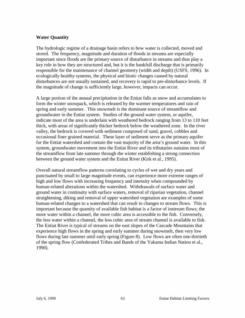
July 6, 1999 Entiat Habitat Limiting Factors 63
Water Quantity
The hydrologic regime of a drainage basin refers to how water is collected, moved and stored. The frequency, magnitude and duration of floods in streams are especially important since floods are the primary source of disturbance in streams and thus play a key role in how they are structured and, but it is the bankfull discharge that is primarily responsible for the maintenance of channel geometry (width and depth) (USFS, 1996). In ecologically healthy systems, the physical and biotic changes caused by natural disturbances are not usually sustained, and recovery is rapid to pre-disturbance levels. If the magnitude of change is sufficiently large, however, impacts can occur. A large portion of the annual precipitation in the Entiat falls as snow and accumulates to form the winter snowpack, which is released by the warmer temperatures and rain of spring and early summer. This snowmelt is the dominant source of streamflow and groundwater in the Entiat system. Studies of the ground water system, or aquifer, indicate most of the area is underlain with weathered bedrock ranging from 13 to 110 feet thick, with areas of significantly thicker bedrock below the weathered zone. In the river valley, the bedrock is covered with sediment composed of sand, gravel, cobbles and occasional finer grained material. These layer of sediment serve as the primary aquifer for the Entiat watershed and contain the vast majority of the area’s ground water. In this system, groundwater movement into the Entiat River and its tributaries sustains most of the streamflow from late summer through the winter establishing a strong connection between the ground water system and the Enitat River (Kirk et al., 1995). Overall natural streamflow patterns correlating to cycles of wet and dry years and punctuated by small to large magnitude events, can experience more extreme ranges of high and low flows with increasing frequency and intensity when compounded by human-related alterations within the watershed. Withdrawals of surface water and ground water in continuity with surface waters, removal of riparian vegetation, channel straightening, diking and removal of upper watershed vegetation are examples of some human-related changes to a watershed that can result in changes to stream flows. This is important because the quantity of available fish habitat is a factor of instream flows; the more water within a channel, the more cubic area is accessible to the fish. Conversely, the less water within a channel, the less cubic area of stream channel is available to fish. The Entiat River is typical of streams on the east slopes of the Cascade Mountains that experience high flows in the spring and early summer during snowmelt, then very low flows during late summer until early spring (Figure 8). Low flows are often one-thirtieth of the spring flow (Confederated Tribes and Bands of the Yakama Indian Nation et al., 1990).

July 6, 1999 Entiat Habitat Limiting Factors 64
Figure 8. Mean Monthly Flows on the Entiat River Near Stormy Creek, Gage #1245288 (Chelan County Conservation District, in press).
Figu
re 8
. M
ean
Mon
thly
Flo
ws
on th
e E
ntia
t Riv
er N
ear
Stor
my
Cre
ek, G
age
#124
5288
(C
hela
n C
ount
y C
onse
rvat
ion
Dis
tric
t, in
pre
ss).

July 6, 1999 Entiat Habitat Limiting Factors 65
Rearing habitat for juvenile salmonids may be limited during both the high and low flow stages. Newly emerged chinook fry rear in areas of low velocity, principally along shoreline margins and in backwater areas. In a pristine stream, high flows during the freshet create backwaters and flood shoreline vegetation to make low velocity rearing habitat (Confederated Tribes and Bands of the Yakama Indian Nation et al., 1990). Low flows naturally result in a reduction of total available rearing area as declining flows recede into a smaller channel area, no longer providing access to the shoreline edges that were available during high water flows. The DOE and WDFW conducted an instream flow study in the Entiat River using the Instream Flow Incremental Methodology (IFIM), producing a draft report dated March 1995 (Caldwell, 1995). The (IFIM) was developed in the late 1970’s by the U.S. Fish and Wildlife Service to correlate incremental changes in streamflow to the quantity of available fish habitat. Based on stream channel cross sectional measurements and stream flow measurements, an attempt is made to model the streams’ flows thereby generating an index of available habitat relative to different flows (chinook, steelhead and bull trout). Using results of the IFIM, DOE and WDFW recommended minimum instream flows for the Entiat River. Subsequently, it was recognized in DOE’s Draft Intitial Watershed Assessment for the Entiat Watershed (Kirk, 1995) that a comparison between recorded flow data for years 1957-1993 and recommended flows for the Entiat River indicated river flows remained below the recommended flows for much of any given year, during that period of record. The problem is that most of the annual flow is received during spring and early summer runoff, and is not available to meet recommended flows year round, much less to meet year round water uses. The Draft Assessment called for further analysis of the uncertainties associated with the actual versus the recommended flows. That process will be taken up in the Entiat Watershed Planning process (years 1999-2002) funded by a grant under House Bill 2514. The quantity of available fish habitat needs to be assessed in the context of the habitat quality, the fish species, and long-range management goals to determine its benefit to fish. Dams & diversions Dams serve to impede the flow of water and can reduce instream flows relative to the size of the surface water they feed. Conversely, during summer low flows, water stored behind dams may contribute to maintaining instream flows later into the year if allowed to slowly release water back into surface waters. The extent to which a dam functions to reduce or prolong instream flows should be evaluated in the context of its location in the landscape and the general basin hydrology. Dams may also act as fish passage barriers. This concern is discussed elsewhere in this document under Loss of Access to Spawning and Rearing Habitat, Causes of Fish Blockages, Dams and Diversion. For more discussion on diversions and how they affect water quantity, see Water Withdrawals , Surface Water below, also under this section on Water Quantity. Impervious surfaces and /or storm water

July 6, 1999 Entiat Habitat Limiting Factors 66
The conversion of natural land surfaces to surfaces that decrease the quantity and rate of water infiltration increase the quantity and rates of water delivery to receiving streams while likely increasing delivery of sediment and pollutants to those same waters. Roads, suburban/urban development, and soil compaction are examples of human disturbances that lead to decreased water infiltration. Impervious surfaces and/or storm water runoff are generally associated with urban development, suburban sprawl and road density. A determination needs to be made as to the significance the City of Entiat, the Entiat National Fish Hatchery and lower Entiat watershed roads may contribute to changes in instream water quantity issues. The USFS Entiat Watershed Analysis (1996) discusses road and trail densities and past grazing impacts on National Forest land as they may affect surface water runoff patterns relative to sediment delivery to surface waters. A conclusion regarding their effect on instream flows should be made if possible. Wetland loss and alteration A wetland’s size and juxtaposition in the landscape determines its significance regarding its affect on instream flows. Refer to the section Wetland loss and alteration under Water Quality for further discussion. Water withdrawals The Entiat River Subbasin Salmon and Steelhead Production Plan (Confederated Tribes and Bands of the Yakama Indian Nation et al., 1990) identified water withdrawals, both agricultural and domestic, as an issue of concern relative to their potential to exacerbate normal low flows of late summer in the Entiat river. At that time, at issue was a need to set minimum instream flows at levels that would protect not only existing fish production but potential fish production, where appropriate. Fish production can be correlated to the quantity and the quality of habitat available. The DOE is the state regulatory agency charged with administering all water rights and water claims in Washington. As staffing and budget permit, they are in the process of translating all paper copy information on water rights, water claims, water certificates, water permits and water applications into tabular databases. A database called WRATS was developed in the Olympia DOE headquarters office and is maintained by the Olympia headquarters office; Rick Shaeffer is the contact at (360/407-7294). The WRATS database includes information on water quantity associated with a given water right, claim, or certificate but does not include the specific locations (geospatial data) where that water right or claim is being withdrawn. In many cases this information was not specifically provided on the original application for a right or claim, especially for very old ones. Another database called GWIS was developed in the Yakima DOE Central Region office and is maintained in the regional office. The contact person for this data is Nicholas Riddle, DOE Central Regional Office, 15 West Yakima Avenue, Suite 200, Yakima, 98902 (509/575-2490). GWIS adds point locations for such things as gaging stations, pumps, wells, irrigation dams, points of diversions/withdrawals and points of use, to the extent this information is known. Known locations are derived only from hard copy records; there has been no ground survey work done to update or verify

July 6, 1999 Entiat Habitat Limiting Factors 67
these locations. This database is in varying degrees of completion. For the Entiat watershed (WRIA 46), all data from claims, permits, applications and certificates was entered into GWIS up through 1995. Since that year, no new data has been added and old data has not been edited. John Easterbrooks, Program Manager of the WDFW Yakima Screen Shop, has spent considerable energy compiling DOE’s data on water withdrawals in his work related to fish screening of water diversions (see the section of this report on Loss of Access to Spawning and Rearing Habitat, Causes of Fish Blockages, Dams and Diversions for more discussion). This effort needs to be built upon with the goal of developing a database with locations of surface and ground water withdrawal and a geospatial component to that data. The quantity information from DOE’s records need to be associated with this data. Surface water. Surface water withdrawals in the Entiat watershed are in the form of withdrawals by pump or ditch (gravity) for irrigation and for supply to the Entiat National Fish Hatchery. The Entiat Valley Watershed Study (Chelan County Conservation District, in prep.) provides an analysis and discussion of the intricacies of estimating water use from surface withdrawals, especially relative to the issue of instantaneous surface water irrigation use. Problems with relating this use to instream flows at any given point in time are many and complex and will be part of the review of the instream flow recommendations for the Entiat watershed under the HB2514 Watershed Planning process. The DOE regulates both the quantity of water diverted and the place of diversion (POD). Surface water diversions are mostly associated with water withdrawals for agricultural use in the Entiat watershed, typically irrigation, although sometimes for off-channel livestock watering. Depending on channel characteristics and hydrology, the POD can play an important part in contributing to low flows or lack of flows in a given reach of stream. Opportunities to change or combine POD’s, or convert open ditches to ground water withdrawals or piped systems should be considered where it is determined to improve salmonid habitat conditions. As an example, the Knapp-Wham irrigation system was recently converted to a pipeline system. Benefits realized on the Knapp-Wham system from the conversion include: decreased water loss, decreased water temperatures, less pathogen/seed pick-up, eliminated need for ditch bank repairs, and protection of system form side canyon washouts (Chelan County Conservation District, in prep.). Ground water. In the Entiat watershed, where alluvial and glacial sediments comprise the valley bottoms, the ground water is in continuity with the surface water and additional pumping of ground water will likely reduce flow in the Entiat River (Montgomery et al., 1995). The areas of valley bottoms that are in continuity with the surface waters need to be outlined and mapped. This information will aid in the assesment of the impacts ground water withdrawals have on water availability.

July 6, 1999 Entiat Habitat Limiting Factors 68
Exotic and Opportunistic Species Exotic species are those non-native species which colonize or invade habitats and may have deleterious effects on the native plants and wildlife. Managing and controlling exotic species is important for the maintenance of the integrity of ecosystems, including their function, composition and structure. The introduction of exotic species can result in the alteration of plant and animal communities and their inter-relationships. Like many areas that have experienced human activity, the Entiat watershed has a number of exotic species that have the potential to affect salmonid fish habitat and its ability to sustain salmon populations. Non-native Fish The mainstem of the Entiat River is inaccessible to anadromous fish above Entiat Falls, which presents a complete upstream migration barrier. Above this barrier, native resident salmonid populations (rainbow trout and cutthroat trout) have been supplemented by WDFW annual stocking programs although all agency stocking has ceased as of 1996. Also above the Falls, eastern brook trout were introduced earlier this century. This species is no longer stocked. A self-sustaining population exists but individuals are generally not found further than 2 miles downstream of Entiat Falls. Phil Archibald, USFS Entiat Ranger District Fish Biologist, believes this is a result of predation/interspecies competition (Archibald, pers. conv., 1999). The extensive trail system in the Entiat watershed has also facilitated extensive fish stocking elsewhere in the watershed in the past (USDA, 1996), much of this occurring in the high mountain lakes all of which are isolated from anadromous fish by natural topography. It is not believed that these fish which have been stocked above natural fish barriers have any impact on ability of the habitat to fully sustain populations of salmon (Archibald, pers. conv. 1999). In those areas of the watershed accessible to anadromous fish, the issue of non-native fish versus native fish is complicated because it is accepted that the native salmon and steelhead stocks (coho, summer steelhead and spring chinook) present prior to European settlement were eliminated from the Entiat by the 1930’s. Following the 1930’s, the Grand Coulee Maintenance Project began the stocking of salmonids which included, in the Entiat, sockeye, a species not native to the Entiat, and imports of coho, steelhead and chinook stock from co-mingled upriver stocks trapped at Rock Island Dam and stocks from the lower Columbia River. Mullan et.al. (1992) provides a discussion of genetic alteration and loss. Due to the complexity and potentially peripheral nature of this issue relative to the ability of the habitat to fully sustain salmon populations, the Technical Advisory Group needs to determine the extent genetic alteration and loss acts as a habitat limiting factor. Non-native Plants The USFS Entiat Watershed Assessment (1996) identified a number of exotic, invasive plant species present in the Entiat watershed, the most notable and widespread being: Bromus tectorum (cheatgrass), Centaurea diffusa (diffuse knapweed), and
July 6, 1999 Entiat Habitat Limiting Factors 69
Chrysanthemum leucanthimum (oxeye daisy). Linnaria dalmatica (dalmation toadflax), is a highly –invasive weed that is found in the Tommy Creek drainage, Other species know to occur within the Entiat watershed are Centaurea solstitialis (Yellowstar thistle), Cirsium arvense (Canada thistle), Cardaria draba (whitetop), Tanacetum vulgare (common tansy), Cystius scoparius (scotch broom), Hypericum perforatum (St. Johnswort), Verbascum thaspis (wooly mullen), and Rubus discolor (Himalayan blackberry). Orchard crops and grass lawns are other types of non-native plants that can displace native plant species and eliminate the function those native plant communities provide. Further discussion of how orchard crops and grass lawns affect the riparian environment is provided in the section of this report on Riparian Zone Conditions, Effects of Human Activities on Riparian Zones. Exotic plants, which were not originally present in the ecosystem, have the potential to displace native plants, reducing species diversity and plant community complexity. The extent to which this has occurred and affects the ability of the habitat to fully sustain populations of salmon needs to be evaluated by the Technical Advisory Group. Removal of spawning salmon The body of literature on the relative importance of the nutrient value of spawned out salmon carcasses to the sustainability of salmon populations needs to be reviewed for its applicability to the Entiat watershed. Salmon carcasses once presented a rich source of nutrients to the food webs of the freshwater tributaries. Nutrients incorporated into salmons’ bodies while they fed in the rich oceanic environment were carried back into the various watersheds in the flesh of the fish. When these breeding fish died after spawning, their rotting carcasses served as the food source for a variety of insects, mammals, birds, juvenile salmon and other fish species, serving as a foundation of the freshwater food cycle. Loss of nutrients. The extent to which the loss of this nutrient influx has affected the ability of the habitat of the Entiat watershed to fully sustain populations of salmon needs to be evaluated by the Technical Advisory Group. Lake Habitat During the Pleistocene Epoch a valley glacier nearly 25 miles long dominated the Entiat Basin. When the glacier receded, it left its imprint on the land in the form of hanging valleys where the upper portions of the drainages are perched above natural falls or chutes that serve as complete passage barriers to fish. The only lakes present in the Entiat watershed occur in the upper reaches of these drainages as glacial lakes and therefore remain completely inacessible to anadromous fish . These lakes include Ice Lakes (two), Larch Lakes (two), Myrtle Lake, Choral Lake, Fern Lake, Little Lakes (two) and Mad Lake (USDA, 1996).

July 6, 1999 Entiat Habitat Limiting Factors 70
GLOSSARY Adaptive management Monitoring or assessing the progress toward meeting objectives and incorporating what is learned into future management plans. Adfluvial Life history strategy in which adult fish spawn and juveniles subsequently rear in streams but migrate to lakes for feeding as subadults and adults. Compare fluvial. Anadromous Species that are hatched in freshwater, mature in saltwater, and return to freshwater to spawn. Aquifer Water-bearing rock formation or other subsurface layer. Bankfull discharge The 1.5-year return period event; roughly equivalent to the mean annual peakflow. Basin flow Portion of stream discharge derived from such natural storage sources as groundwater, large lakes, and swamps but does not include direct runoff or flow from stream regulation, water diversion, or other human activities. Bioengineering Combining structural, biological, and ecological concepts to construct living structures for erosion, sediment, or flood control. Biological Diversity (biodiversity) Variety and variability among living organisms and the ecological complexes in which they occur; encompasses different ecosystems, species, and genes. Biotic Integrity Capability of supporting and maintaining a balanced, integrated, adaptive community of organisms having a species composition, diversity, and functional organization comparable to that of natural habitat of the region; a system’s ability to generate and maintain adaptive biotic elements through natural evolutionary processes. Biological oxygen demand Amount of dissolved oxygen required by decomposition of organic matter. Braided stream Stream that forms an interlacing network of branching and recombining channels separated by branch islands or channel bars. Carrying capacity Maximum average number or biomass of organisms that can be sustained in a habitat over the long term. Usually refers to a particular species, but can be applied to more than one. Channelization Straightening the meanders of a river; often accompanied by placing riprap or concrete along banks to stabilize the system. Channel Complexity The mix of in-channel features important to the survival, growth, migration, and reproduction of salmonids. Complex channels are more productive for

July 6, 1999 Entiat Habitat Limiting Factors 71
salmonids than simple channels. The features described above collectively define complexity of a stream channel. Check dams Series of small dams placed in gullies or small streams in an effort to control erosion. Commonly built during the 1900s. Confinement The relationship of a channel to the valley walls or terrace. It describes how restrictive the valley’s walls are in limiting the channel’s lateral movement. Confluence Joining. Constriction An obstruction narrowing a waterway that creates a backwater at least during high flow events. Critical Stock A stock of fish experiencing production levels that are so low that permanent damage to the stock is likely or has already occurred. Depressed Stock A stock of fish whose production is below expected levels based on available habitat and natural variations in survival levels, but above the level where permanent damage to the stock is likely. Diversity Variation that occurs in plant and animal taxa (i.e., species composition), habitats, or ecosystems. See species richness. Ecological restoration Involves replacing lost or damaged biological elements (populations, species) and reestablishing ecological processes (dispersal, succession) at historical rates. Ecosystem Biological community together with the chemical and physical environment with which it interacts. Ecosystem management Management that integrates ecological relationships with sociopolitical values toward the general goal of protecting or returning ecosystem integrity over the long term. Endangered Species Act A 1973 Act of Congress that mandated that endangered and threatened species of fish, wildlife and plants be protected and restored. Endangered Species means any species which is in endanger of extinction throughout all or a significant portion of its range other than a species of the Class Insecta determined by the Secretary to constitute a pest whose protection under would provide an overwhelming and overriding risk to man. Escapement Those fish that have survived all fisheries and will make up a spawning population.

July 6, 1999 Entiat Habitat Limiting Factors 72
Estuarine A partly enclosed coastal body of water that has free connection to open sea, and within which seawater is measurably diluted by fresh river water. Eutrophic Water body rich in dissolved nutrients, photosynthetically productive, and often deficient in oxygen during warm periods. Compare oligotrophic. Evolutionary Significant Unit (ESU) A definition of a species used by National Marine Fisheries Service (NMFS) in administering the Endangered Species Act. An ESU is a population (or group of populations) that is reproductively isolated from other conspecific population units, and (2) represents an important component in the evolutionary legacy of the species. Floodplain Lowland areas that are periodically inundated by the lateral overflow of streams or rivers. Flow regime Characteristics of stream discharge over time. Natural flow regime is the regime that occurred historically. Fluvial Pertaining to streams or rivers; also, organisms that migrate between main rivers and tributaries. Compare adfluvial. Gabion Wire basket filled with stones, used to stabilize streambanks, control erosion, and divert stream flow. Geomorphology Study of the form and origins of surface features of the Earth. Glides Stream habitat having a slow, relatively shallow run of water with little or no surface turbulence. Healthy Stock A stock of fish experiencing production levels consistent with its available habitat and within the natural variations in survival for the stock. Hydrograph Chart of water levels over time. Hydrology Study of the properties, distribution, and effects of water on the Earth’s surface, subsurface, and atmosphere. Intermittent stream Stream that has interrupted flow or does not flow continuously. Compare perennial stream. Intraspecific interactions Interactions within a species. Limiting Factor Single factor that limits a system or population from reaching its highest potential. Macroinvertebrates Invertebrates large enough to be seen with the naked eye (e.g., most aquatic insects, snails, and amphipods).

July 6, 1999 Entiat Habitat Limiting Factors 73
Native Occurring naturally in a habitat or region; not introduced by humans. Non-Point Source Pollution Polluted runoff from sources that cannot be defined as discrete points, such as areas of timber harvesting, surface mining, agriculture, and livestock grazing. Parr Young trout or salmon actively feeding in freshwater; usually refers to young anadromous salmonids before they migrate to the sea. See smolt. Plunge pool Basin scoured out by vertically falling water. Redds Nests made in gravel (particularly by salmonids); consisting of a depression that is created and the covered. Riffle Stream habitat having a broken or choppy surface (white water), moderate or swift current, and shallow depth. Riparian type of wetland transition zone between aquatic habitats and upland areas. Typically, lush vegetation along a stream or river. Riprap Large rocks, broken concrete, or other structure used to stabilize streambanks and other slopes. Rootwad Exposed root system of an uprooted or washed-out tree. SASSI Salmon and Steelhead Stock Inventory completed in 1992, published in 1993. Shear Stress Hydraulic force of water created by its movement on a parallel submerged surface such as the bank. SSHIAP A salmon, steelhead, habitat inventory and assessment program directed by the Northwest Indian Fisheries Commission. Salmonid Fish of the family salmonidae, including salmon, trout chars, and bull trout. Salmon Includes all species of the family Salmonid Sinuosity Degree to which a stream channel curves or meanders laterally across the land surface. Smolt Juvenile salmon migrating seaward; a young anadromous trout, salmon, or char undergoing physiological changes that will allow it to change from life in freshwater to life in the sea. The smolt state follow the parr state. See parr.
July 6, 1999 Entiat Habitat Limiting Factors 74
Stock Group of fish that is genetically self-sustaining and isolated geographically or temporally during reproduction. Generally, a local population of fish. More specifically, a local population – especially that of salmon, steelhead (rainbow trout), or other anadromous fish – that originates from specific watersheds as juveniles and generally returns to its birth streams to spawn as adults. Stream order Classification system for streams based on the number of tributaries it has. The smallest unbranched tributary in a watershed is designated order 1. A stream formed by the confluence of 2 order 1 streams is designated as order 2. A stream formed by the confluence of 2 order 2 streams is designated order 3, and so on. Stream reach Section of a stream between two points. Sub Watershed One of the smaller watersheds that combine to form a larger watershed. Thalweg Portion of a stream or river with deepest water and greatest flow. Watershed Entire area that contributes both surface and underground water to a particular lake or river. Watershed rehabilitation Used primarily to indicate improvement of watershed condition or certain habitats within the watershed. Compare watershed restoration. Watershed restoration Reestablishing the structure and function of an ecosystem, including its natural diversity; a comprehensive, long-term program to return watershed health, riparian ecosystems, and fish habitats to a close approximation of their condition prior to human disturbance. Watershed-scale approach Consideration of the entire watershed in a project or plan. Weir Device across a stream to divert fish into a trap or to raise the water level or divert its flow. Also a notch or depression in a dam or other water barrier through which the flow of water is measured or regulated. Wild Stock A stock that is sustained by natural spawning and rearing in the natural habitat regardless of parentage (includes natives).

July 6, 1999 Entiat Habitat Limiting Factors 75
LITERATURE CITATION
Brown, L. G. 1992. Draft management guide for the bull trout Salvelinus confluentus (Suckley) on the Wenatchee National Forest. USFS, Wenatchee National Forest, Wenatchee, WA. Bjornn, T.C. and D. W. Reiser. 1991. Habitat requirements of salmonids in streams. American Fisheries Society Special Publication. 19:83-138. Caldwell, Brad. 1995. Draft Entiat and Mad Rivers Fish Habitat Analysis Using the Instream Flow Incremental Methodology. WA State Department of Ecology, Olympia. Tech. Rept. #95-166, 22 pp. Carie, D. G. 1998. Spring and summer chinook salmon spawning ground surveys on the Entiat River, 1997. USFWS, Mid-Columbia River Fishery Resource Office, Leavenworth, WA. Chelan County Conservation District. In press. Entiat valley watershed study; Comprehensive Resource Management Plan. Chelan, WA. Combs, B. D. 1965. Effect of temperature on development of salmon eggs. Progressive Fish Culturalist. 29(3):134-137. Confederated Tribes and Bands of the Yakama Indian Nation, Confederated Tribes of the Colville Indian Reservation, and Washington Department of Fish and Wildlife. 1990. Entiat River subbasin salmon and steelhead production plan. Columbia Basin System Planning, Northwest Power Planning Council, Portland, OR. 73 pp. Craig, J. A. and R. L. Hacker. 1940. The history and development of the fisheries of the Columbia River. Unpub. MS., U.S. Bur. of Fish., 16 pp. Craig, J. A. and A. J. Suomela. 1941. Time of appearance of the runs of salmon and steelhead trout native to the Wenatchee, Entiat, Methow, and Okanogan rivers. U.S. Fish and Wildlife Service, Olympia, WA. Ehinger, William. 1993. A Review of the Data from the Entiat River Basin Collected for the Ambient Monitoring Database. Washington Department of Ecology, Environmental Investigations and Laboratory Services Program, Ambient Monitoring Section, Olympia, WA. Everest, F. H., R. L. Beschta, J. C. Scrivener, K. V. Koski, J. R. Sedell, and C. J. Cederholm. 1987. Fine sediment and salmonid production: A paradox. pp. 98-142. In E. O. Salo and T. W. Cundy (eds.), Streamside management: Forestry and fishery interactions. Univ. of WA, Seattle.

July 6, 1999 Entiat Habitat Limiting Factors 76
Fish, F. F. and M. G. Hanavan. 1948. A report on the Grand Coulee Fish Maintenance Project 1939 – 1947. USFWS, Spec. Rept. 55. Kirk, T., P. Kerr, and H. Riddle. 1995. Draft initial watershed assessment, Water Resources Inventory Area 46, Entiat River watershed. WA Department of Ecology Open File Report 95-02, Olympia. 16 pp. Light, J. T. 1987. Coastwide abundance of North American steelhead trout. (Document submitted to annual meeting of the INPFC, 1987.) 18 pp. FRI-UW710. Fisheries Research Institute, University of Washington, Seattle. Mullan, J. W. 1987. Status and propagation of chinook salmon in the mid-Columbia River through 1985. U. S. Fish and Wildl. Serv. Biol. Rep. 87(3), 111 pp. Mullan, J. W., K. R. Williams, G. Rhoduc, T. W. Hillman, J. D. McIntyre. 1992. Production and habitat of salmonids in mid-Columbia River tributary streams. Monograph 1 U.S. Fish and Wildlife Service, Leavenworth, WA. Peven, C. M. 1992. Population status of selected stocks of salmonids from the mid-Columbia River Basin. Chelan County Public Utility District, Wenatchee, WA, 52 pp. Rock Island Dam Hydroelectric Facility, Rocky Reach Dam Hydroelectric Facility, and Wells Dam Hydroelectric Facility. 1998. Application for individual incidental take permits filed with the National Marine Fisheries Service (NMFS) July 30, 1998; Exhibit D - Aquatic Species and Habitat Assessment: Wenatchee, Entiat, Methow and Okanogan Watersheds, April 1998. Smith, A. H. 1983. The native peoples. Pp. 135 –326 In R. F. Schalk and R. R. Mierendorf, eds. Cultural resources of the Rocky Reach of the Columbia River, Vol. 1. WA State Univ., Pullman. Schalk, R. F. 1986. Estimating salmon and steelhead usage in the Columbia Basin before 1850: the anthropological perspective. Northwest Environmental J. 2(2): 1-29. U.S. Bureau of Fisheries. 1934/1935/1936. Entiat River physical stream survey report. U.S. Bureau of Fisheries. 1935/1936. Mad River physical stream survey report. USDA/USFS/NRCS. 1979. Entiat Cooperative River Basin Study. Wenatchee National Forest, Entiat Ranger District, Entiat, WA. 198 pp. USDA NRCS Stream Team. 1998. Entiat River inventory and analysis. Spokane, WA. 25 pp. USFS. 1996. Watershed Assessment Entiat Analysis Area, Version 2.0. Wenatchee National Forest, Entiat Ranger District, Entiat, WA.

July 6, 1999 Entiat Habitat Limiting Factors 77
USFS. 1999. 1998 Stream Temperature Monitoring Report; Entiat and Chelan Ranger Districts. Wenatchee National Forest, Entiat Ranger District, Entiat, WA. Washington Department of Fisheries, Washington Department of Wildlife, and Western Washington Indian Tribes. 1993. 1992 Washington State salmon and steelhead stock inventory. Olympia, WA. 212 pp. Washington State Department of Ecology. 1996. Watershed Approach to Water Quality Management; Needs Assessment for the Wenatchee Water Quality Management Area. Water Quality Program, WQ-96-08, Yakima, WA. YIN (Yakama Indian Nation) and the Washington Department of Fish and Wildlife. 1999. Mid-Columbia Coho Salmon Reintroduction Feasibility Project, Preliminary Environmental Assessment DOE/EA-1282. Prepared for Bonneville Power Administration, Portland, OR, 67 pp.