Embed Size (px)
Citation preview

June was warm, with temperatures averaging 3 to 6
degrees above normal. The greatest departures were in the
central Idaho mountains and the Hells Canyon area.
It was an unusually dry month, with most of southeast
Oregon and southwest Idaho receiving less than half of
normal rainfall. Precipitation was less than 5 percent of
normal in some parts of the Snake River Valley northeast of
Mountain Home, and the Camas Prairie.
The warmest weather occurred during the first 10 days
and the last 5 days of the month, when a very warm upper
level high pressure ridge centered over the southwestern
and central U.S. extended its influence into our area.
Between the warm spells, the ridge competed with a series of
three cool but relatively dry upper level troughs originating
over the Bering Sea and Gulf of Alaska.
The wettest of these systems brought measurable
precipitation to much of our area form the 14th through the
16th. Settling over the Pacific Northwest Coast, it affected
the weather as far south as northern California before it
finally moved inland and dissipated over northern Idaho on
the 21st.
By the 29th the Southwest Monsoon was already
underway, and some of this moisture drifted north and fed
into an upper level disturbance crossing southeast Oregon
and southwest Idaho.
During the evening of the 29th, a rogue thunderstorm
formed over east-central Malheur County and crossed the
Owyhee Mountains. As it descended on the lower Treasure
Valley, strong gusty outflow winds blew into Boise from the
west. A gust to 47 mph was measured at the Boise airport.
Other notable thunderstorms occurred on the 6th and 7th,
when gusts to around 60 mph were measured in the Magic
Valley just east of Jerome during the late evening. Thousands
of acres of crops were damaged as a result. Jerome was also
the site of a 50 mph thunderstorm gust during the early
evening of the 30th.
July's average temperatures were close to normal across
most of the area. An exception was Baker County, where a
couple of areas in the western half of the county, including
Baker City, averaged 2 to 4 degrees below normal.
The precipitation pattern was diverse, ranging from much
below to much above normal. Most of southeast Oregon and
southwest Idaho were dry, but there was a wet swath from
east-central Malheur County across the Treasure Valley to the
upper Weiser River and McCall areas. There was also a much
smaller area of above-normal precipitation in the Magic
Valley.
The showery weather lasted from the 9th through the 12th,
but most of the rain fell on the 10th. Some of the heavier
amounts that day include 1.4 inch at McCall, 0.95 inch near
Board Corral Mountain in Malheur County, 0.76 inch at Eagle,
0.74 inch at Star, 0.61 inch at Meridian, and half an inch at
Scott Mountain Lookout in Boise County. The 0.27 inch at the
Boise Airport set a new daily record.
During the early morning of the 10th, thunderstorms
produced quarter-inch hail at Emmett and half-inch hail near
Deer Creek Pass in Valley County. The low temperature of 47°
F on July 11th was the coolest July temperature in Boise since
2000.
SageWinds Season in Review
Season in Review P.1
Fall 2016 Outlook P.2
GOES-R: Next Generation Weather Satellite P.3
Meet & Greet P.4
What is NOAA Weather Radio? P.5
Fall Colors, First Snowfalls P.6
V O L U M E
IX ISSUE 3, SUMMER 2016
NATIONAL WEATHER SERVICE BOISE
AUTUMN Spotter Checklist
When should you call us?
SNOWFALL: 1” or greater.
HAIL: Pea size or larger.
REDUCED VISIBILITY: from
fog, blowing dust, rain, snow.
WIND: 40 mph+ or damage.
HEAVY RAIN: ½” or greater.
FLOODING: Any water where
it shouldn’t be, or overflowing
river/creek.
TORNADO or FUNNEL
CLOUD.
TRAVEL PROBLEMS due to
severe or hazardous weather.
ANY WEATHER RELATED
DAMAGE, DEATH, OR
INJURY.
How to contact us:
1-800-882-1428
@NWSBoise
/NWSBoise
Joel Tannenholz
Continued on next page...
National Weather
Service Boise
Staff
Meteorologist In Charge
Michael Cantin
Science Operations Officer
Tim Barker
Warning Coordination Meteorologist
Jay Breidenbach
Service Hydrologist
Troy Lindquist
Information Technology Officer
Jason Baker
Electronic Systems Analyst
Travis Mayer
Electronics Technicians
George Buckwold
Eric Johnson
Observing Program Leader
David Decker
Administrative Support
Kelly Jardine
Senior Meteorologists
Katy Branham
Les Colin
Dave Groenert
Stephen Parker
Bill Wojcik
Meteorologists
Jeanne Allen
Korri Anderson
Elizabeth Padian
Josh Smith
Joel Tannenholz
Fire Weather Meteorologists
Chuck Redman
Megan Thimmesch
Hydrometeorlogical Technician
Wasyl Hewko
Meteorologist Interns
Aviva Braun
Jessica Caubre
Want to help NOAA
weather scientists
with research?
If you own a smartphone or tablet
download the free mPING app in
the App Store or Google Play.
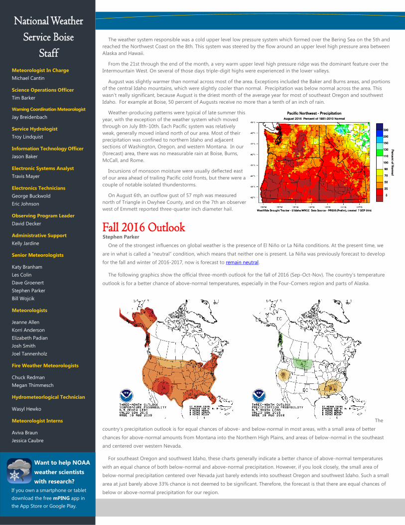
One of the strongest influences on global weather is the presence of El Niño or La Niña conditions. At the present time, we
are in what is called a “neutral” condition, which means that neither one is present. La Niña was previously forecast to develop
for the fall and winter of 2016-2017, now is forecast to remain neutral.
The following graphics show the official three-month outlook for the fall of 2016 (Sep-Oct-Nov). The country’s temperature
outlook is for a better chance of above-normal temperatures, especially in the Four-Corners region and parts of Alaska.
The
country’s precipitation outlook is for equal chances of above- and below-normal in most areas, with a small area of better
chances for above-normal amounts from Montana into the Northern High Plains, and areas of below-normal in the southeast
and centered over western Nevada.
For southeast Oregon and southwest Idaho, these charts generally indicate a better chance of above-normal temperatures
with an equal chance of both below-normal and above-normal precipitation. However, if you look closely, the small area of
below-normal precipitation centered over Nevada just barely extends into southeast Oregon and southwest Idaho. Such a small
area at just barely above 33% chance is not deemed to be significant. Therefore, the forecast is that there are equal chances of
below or above-normal precipitation for our region.
Stephen Parker
Fall 2016 Outlook
The weather system responsible was a cold upper level low pressure system which formed over the Bering Sea on the 5th and
reached the Northwest Coast on the 8th. This system was steered by the flow around an upper level high pressure area between
Alaska and Hawaii.
From the 21st through the end of the month, a very warm upper level high pressure ridge was the dominant feature over the
Intermountain West. On several of those days triple-digit highs were experienced in the lower valleys.
August was slightly warmer than normal across most of the area. Exceptions included the Baker and Burns areas, and portions
of the central Idaho mountains, which were slightly cooler than normal. Precipitation was below normal across the area. This
wasn’t really significant, because August is the driest month of the average year for most of southeast Oregon and southwest
Idaho. For example at Boise, 50 percent of Augusts receive no more than a tenth of an inch of rain.
Weather-producing patterns were typical of late summer this
year, with the exception of the weather system which moved
through on July 8th-10th. Each Pacific system was relatively
weak, generally moved inland north of our area. Most of their
precipitation was confined to northern Idaho and adjacent
sections of Washington, Oregon, and western Montana. In our
(forecast) area, there was no measurable rain at Boise, Burns,
McCall, and Rome.
Incursions of monsoon moisture were usually deflected east
of our area ahead of trailing Pacific cold fronts, but there were a
couple of notable isolated thunderstorms.
On August 6th, an outflow gust of 57 mph was measured
north of Triangle in Owyhee County, and on the 7th an observer
west of Emmett reported three-quarter inch diameter hail.

GOES-R: NOAA’s Next Generation of Weather Satellites
Weather is always changing and the better we can predict what’s coming, the better we
can prepare. The GOES-R series, NOAA’s next-generation geostationary weather satellites
will be a game-changer for weather forecasting. For the first time, GOES-R, which will be
called GOES-16 once it’s operational in space, will be able to monitor the Earth in near-real
time.
Using a powerful new instrument called the Advanced Baseline Imager, GOES-R gathers
data and imagery about weather over the Western Hemisphere as frequently as every 30
seconds. This enables NOAA to gather data with three times more channels, four times
better resolution, five times faster than before. Faster, more accurate data means better
observations of phenomena like severe storms, fire, smoke, aerosols, and volcanic ash.
But this is not the only new instrument aboard the satellite. GOES-R is flying another
powerful technology called the Geostationary Lightning Mapper. This instrument can not
only measure when lightning strikes the ground but also lightning activity in the clouds that
is charging the atmosphere. Researchers have found that an increase in lightning activity
may be a sign that tornadoes will form. GLM will change the way forecasters look at severe
weather to provide faster and more accurate warnings.
All of this new technology means forecasters at NOAA's National Weather Service will
have valuable tools to improve predictions of severe weather events like hurricanes,
providing faster warnings to emergency managers to help save lives and protect
communities.
Space Weather is serious business in the twenty first century as much of modern life relies
on sophisticated electronic systems. Working with other NOAA satellites, GOES-R will
observe space weather with a suite of instruments that collect information about radiation
hazards from the sun. Space weather can interfere with communications and navigation
systems, damage satellite electrical systems, cause risks to astronauts, and threaten power
utilities.
NOAA launched its first geostationary satellite more than 40 years ago. Since then, the
data from GOES satellites has been invaluable to countless industries like aviation, sea
transport and communications that rely on weather data. Sitting
22,300 miles above the Earth, the advanced technologies flying
on the GOES-R series of satellites take weather forecasting to
new heights.
GOES-R is planned for launch on November 4, 2016.
For more information on GOES-R, see www.goes-r.gov.
Capability Current GOES GOES-R
Full Hemisphere
Image
30 minutes 5 minutes
Imager Bands 5 16
Visible 1 km 0.5-1 km
Near Infrared None 1-2 km
Infrared 4-8 km 2 km
Lightning Mapper None Continuous
Why GOES-R?
Improved hurricane track & intensity forecasts.
Increased thunderstorm and tornado warning lead time.
Improved aviation flight route planning.
Improved air quality warnings and alerts.
Better data for long-term climate variability studies.
Improved solar flare warnings for communications and navigation
disruptions.
More accurate monitoring of energetic particles responsible for
radiation hazards to humans and space craft.
Better monitoring of space weather to improve geomagnetic storm
forecasting.
Visual and Infrared
Imagery
Lightning Mapping Space Weather
Monitoring
Solar Imaging

The National Weather Service (NWS) here in Boise, Idaho works hard every
day to keep the people of southwest Idaho and southeast Oregon safe.
However, we are not the only ones who work towards this goal on a daily basis.
One such individual is publicly-elected Judge Steve Grasty of Harney County.
Not only does he serve on the Harney County Court, but he serves as the
secondary Emergency Manager for the county. For this issue of Sage Winds, we
decided to sit down with Steve and get to know him just a bit better.
NWS: So Steve, how did you become interested in your line of work?
Steve: As an auto-parts shop owner in Burns, I got really involved with the
community, the Chamber of Commerce, our church, and a variety of other
things in Harney County. Eventually, I decided that it would be interesting to
see what I could do in public service, so my wife and I sold our business (in
1995). That evolved into me being appointed as a county commissioner and
eventually I ran for the office of county judge. I am now finishing up my 18th
year as county judge.
NWS: You also serve as secondary emergency manager to Harney County,
correct?
Steve: I do. For years, one of the three of us on the Harney County Court,
myself and two county commissioners, have served as the emergency
management coordinator; this was usually me. We did this work in conjunction
with the sheriff. I would do the paperwork and the sheriff would do the on-the-
ground work. It was a great way to coordinate our efforts and ensure that
there were no gaps in service during emergencies. About three years ago, we
contracted a gentleman to do the emergency management coordination and a
about a year ago, we hired a full-time employee, named Loren Emang.
However, if he’s out of the county, he transfers his calls to me, or in my
absence, to one of the commissioners.
NWS: Could you describe the nature of your work both as county judge and
as emergency manager when you are given that responsibility?
Steve: County resources are limited; therefore, during many emergencies,
once all available resources have been tapped, the county governing body has
a responsibility to put together an order for assistance to the state of Oregon.
This tells them that we have an emergency, that all of our resources have been
used, and that we need their help. They in turn may ask for federal assistance.
Otherwise, during an event, I’ve done everything from driving the pickup to
another county to collect and borrow sandbags to sandbag river banks for
example, to just being a gofer for the sheriff as we have dealt with individual
events. Most of the time during an event, we have the Red Cross, Oregon State
Emergency Management, and perhaps 4-5 other law enforcement entities here
working together. So as to not become chaotic, we check in 1-3 times per day
to ensure that we’re not duplicating anything. I help coordinate the event.
NWS: What impact does weather have on Burns emergency management
operations? What type of weather has the greatest impact on your community?
Steve: I can’t think of an emergency that we’ve had that there wasn’t some
relationship to weather. The big fires that we’ve had have been huge events
and knowing what the winds are going to do, what the humidity is and what we
anticipate for high and low temperatures over the next 24 hours – these details
are incredibly important and I think our relationship with NWS has been critical.
The other large event that we’ve dealt with in the county since I’ve been judge
was the spring 2011 flood event. This event was anticipated as we could see the
snowpack and we knew from NWS that we’d be dealing with a warming trend.
It was easy to understand that we were going to have quite a runoff here very
quickly. So we were able to prepare and
act ahead of the event because of the
forecasting provided to us.
I think our worst events are 1) when we
have both fire and wind and 2) when we
have warming trends and a sizeable
snowpack. But then the immediate events
that we have are localized high wind
events or isolated rain events when a tiny
drainage gets hit really hard. Sometimes
this can be a half an inch; other times, up
to several inches in less than an hour. That almost always takes out a county
road.
NWS: I know that the Steens Mountain is a high impact area for your
community.
Steve: The east side of the Steens Mountain has a 5,000 foot drop in less
than 3 miles. Boy, it doesn’t take a lot of rainfall on that to cause one heck of a
runoff at its base! NWS has always helped us immensely through these events.
NWS: You’ve beautifully summed up the National Weather Service’s
relationship with your county and community. We are proud to help you serve
the people of Harney County.
Steve: Thank you.
NWS: So how does your office reach out and notify your community of
critical weather events?
Steve: Notification is a challenge for us right now. Honestly, we are having
the most luck with Facebook and other social media platforms right now.
Today, we have been without a radio station for almost a year! I hear reports of
it coming back on air and I look forward to that occurring because in events like
we discussed before, it’s critical to have a local radio station. In the meantime,
we have invested in a reverse 911 system that in the event of a NWS
notification of heavy runoff on the Steens for example, we could actually
identify (with our GIS department) who we might want to notify and then send
a recorded message to that group of phone numbers so they know of the
imminent event. We are just starting to use it, so it’s still a little unfamiliar to us,
but as we get used to it, I think we’ll use it more.
NWS: That system sounds really promising.
Steve: One of the things you have to remember about Harney County is that
it is almost 150 miles north to south, and with the Steens out in the middle of it,
there’s no radio station that reaches all parts of the county. So, even with the
radio station going, we still have a gap in the ability to get the information out
there. We are always looking for ways to improve. We also have NOAA Weather
Radio available for the northern half of the county which is transmitted from
Burns Butte, but I’m not sure how many people use this resource. I may need to
look into how to raise awareness about this resource!
NWS: I know you plan of retiring soon – where will life’s journey bring you
next?
Steve: I have some interest in writing a book, particularly about the events of
January and February 2016 in Harney County. I’m not sure I’m a writer, but I’ll
make an attempt at it and hope for the best. The thing I know I’m going to do
is finish working on an old hotrod that I have been working on for 20 plus years
and it’s my intention to finish it up! Continued on next page...
Meet & Greet Aviva Braun
Steve Grasty

NOAA Weather Radio (NWR) broadcasts important weather information,
events and warnings 24/7/365. If you live in an area of Southwest Idaho or
Southeast Oregon that has coverage, you can listen with an AM receiver or
get an NWR receiver that will alarm when we issue warnings.
We have five radios in our area that are all remote controlled by the
Boise NWS office. Bogus Basin Ski Resort near the Doe Point chairlift
transmits to Boise and the Treasure Valley; Brundage Mountain Ski Resort
transmits to McCall and narrow parts of Cascade; Just north of the Flying J
on Flat Top Butte near Jerome transmits across the Magic Valley; Just south of Interstate 84 at exit 3 near Payette transmits to the area surrounding Ontario;
and lastly, Burns Butte near Burns Oregon transmits to most of northern Harney County.
We have eight assigned frequencies between 162.400 Mhz and 162.550 Mhz, and our licenses from the Federal Communications Commission allow us to
transmit up to 300 Watts. We visit each site three times a year to clean and calibrate the radios. Our radio placement on mountain and butte sites allow us to
get the most coverage, but many valleys get completely blocked out. These blockages are depicted in our coverage maps using 300 Watt output, the elevation
of the transmitter and the topography of the region.
We have designed our audio to play the short term forecast for your area, then the long term forecast, then an hourly roundup of observations near you.
During active weather, we play weather watches more frequently, and if a weather warning is going on in your area, it will play ONLY the information about that
weather threat. During periods of calm weather our broadcast loops around after less than 4 minutes.
Working together with the state of Idaho, we can also relay important messages over NWR like civil emergency messages, or child abduction emergency
messages. The Idaho State Alert and Warning System (ISAWS) relays our messages out to TV channels, local FM radio stations and even highway reader
boards. You can also sign up for ISAWS online and get watches and warnings sent directly to you by
going to: http://www.isaws.org. These technologies have not been implemented for our radios in
Southeast Oregon.
Much more information about the NOAA Weather Radio system can be found on the website:
http://www.weather.gov/nwr. On this site, you can provide outage reports, look at detailed coverage
maps and get setup instructions for NWR receivers.
What is NOAA Weather Radio? Travis Mayer
FOLLOW US on Twitter @NWSBoise and LIKE US on Facebook!
NWS: Wow! I wish you luck with both of those endeavors. So tell me, what do you view as one of your greatest accomplishments?
Steve: I’ve actually started a list because at some point, I want to document and leave for history what I think got done while I was in office. I will rarely take
credit for anything that has been achieved. Sometimes it’s county government, but typically it’s the community that has put in the work. The community has
stuck through hard economic times, and I think that’s a huge accomplishment for us as a whole. I think what is most dear to me is how the community has
stuck together and weathered tough times.
NWS: What a lovely answer! Well, thank you for your time today. It was a pleasure.
Steve: Thank you for having me.
NWR maintenance trips allow us to see some beautiful country.
Legend
Coverage Area
No Coverage

CoCoRAHS observers needed!
Calling all weather enthusiasts in
southeastern Oregon and
southern Idaho! We need more
weather observers interested in
taking daily measurements of
precipitation or snowfall.
If you would like to participate in
CoCoRaHS, please contact us at:
[email protected] or visit
http://www.cocorahs.org/
It’s hard to believe, but it’s time to
brush off the snow board and
snow stick. Snow measurement
time is right around the corner!
BE PREPARED! Fal l Safety Tips
Make sure you and your family are
prepared for an emergency,
whether it be flash flooding,
wildfires, floods, winds, winter
storms or power outages. Here is
a simple list of what you can do to
prepare for an emergency:
Prepare a Disaster Supply
Kit with a week’s worth of
food and water.
Create a Family Emergency
Plan, so you know how to
communicate to others.
Obtain a NOAA Weather
Radio.
Check weather.gov every
morning before you leave
home to make sure you are
prepared for what the
weather might bring.
Inspire others to take action
by showing your friends and
family how you are prepared.
You can tell them over the
phone or in person, or tweet,
or post about it.
Visit www.ready.gov for more
information.
Questions? Comments?
Suggestions?
Email:
The most influential factor for when leaves begin to change is the amount of sunlight hours in the day. So, fall colors begin
roughly the same time each year for a given location.
There are 3 types of pigments:
Chlorophyll: basic green
Carotenoids: yellow, orange & brown
Anthocyanins: red, blue & purple
Chlorophyll is necessary for photosynthesis (the
chemical reaction that turns sunlight into sugars for
plant growth).
Chlorophyll and a combination of the other two
pigments are present during the growing season but
chlorophyll is constantly being produced and broken
down, so leaves appear green (because there is more
sunlight in the growing season). As the amount of night hours increases in the fall, the production of chlorophyll slows down,
and eventually stops. This is when the carotenoids or anthocyanins (depending on the type of plant) begin to appear, giving
us those “fall colors”. Although the amount of sunlight hours is the driving factor for this change, the brilliance of the colors is
related to weather conditions. Temperature and moisture affect it the most. A warm wet spring, followed by a normal
summer, then warm and sunny fall days (and cool not freezing nights) tend to produce the most brilliant colors.
Source: USDA Forest Service
Elizabeth Padian
Why do leaves change color to give us the beautiful fall colors?
The earliest snowfall on record at Boise occurred on October 10, 2008, when 1.7 inches fell. The snow was mixed with rain,
and with a high that day of 45, none of the snow stayed on the ground. The latest measurable first snow, 0.3 of an inch, fell on
January 9, 1918. But the latest first snowfall of one inch or more was the 1.9 inches on April 6, 2003.
The average date for the first snowfall of trace or more is November 22nd. The average date for the first snowfall of one inch
or more is December 5.
The earliest date for a snow depth of 1 inch or more is November 2, 1956 (1 inch). The latest date is March 1, 2003 (also 1
inch). The average is December 9.
With an average annual snowfall of 19 inches, Boise is not especially snowy. For comparison, Pocatello averages 50 inches,
Reno 22 inches, Spokane 45 inches, and Salt Lake City 56 inches.
Joel Tannenholz
Boise's First Snowfalls and First Snows on the Ground
Earliest Average Latest
Boise Oct 10 (2008) Nov 22 Dec 31 (1958)
Burns Sep 29 (1971) Nov 7 Jan 1 (1977)
Baker City Oct 7 (1961) Nov 13 Dec 29 (1958)
McCall Sep 24 (1958) Nov 1 Dec 7 (1976)
Twin Falls Sep 17 (1965) Nov 14 Dec 21 (2002)
First Date for Measurable Snow?


![DeblurGAN-v2: Deblurring (Orders-of-Magnitude) Faster and ......In terms of the ef・…iency, DeblurGAN-v2 with MobileNet-DSC is 11 times faster than DeblurGAN [21], over 100 times](https://img.dokumen.tips/doc/110x75/61273ed7b487b16b907e1062/deblurgan-v2-deblurring-orders-of-magnitude-faster-and-in-terms-of-the.jpg)


![100+ Times Faster Weighted Median Filter [cvpr ‘14] Presenter: Chang-Ryeol Lee](https://img.dokumen.tips/doc/110x75/56649d705503460f94a52b92/100-times-faster-weighted-median-filter-cvpr-14-presenter-chang-ryeol.jpg)