Embed Size (px)
Citation preview

Revista de geomorfologie vol. 16, 2014, pp. 5-12
River channel dynamics in the contact area between the
Romanian Plain and the Curvature Subcarpathians
Florina GRECU1, Gabriela IOANA-TOROIMAC1, Paola MOLIN2, Francesco DRAMIS2
Abstract. The morphology of river channels results from the genetic and dynamic characteristics imposed by internal
and external morphogenetic forcings. We studied reaches of river courses cutting across the contact area between the
Romanian Plain (Carpathians foredeep) and the Curvature Subcarpathians, where active faults are located. In this area a
wide monocline of tilted foredeep deposits generated a glacis-like macro-landform at the mountain front that connects
the Subcarpathians with the Romanian Plain. The headwaters of studied rivers are located in the Subcarpathians
(Cricovul Dulce River) and in the Carpathians (Prahova, Buzău and Milcov rivers). More in detail, we investigated river
channels in plan view by morphometric and multi-temporal air-photo analysis to define the general trends of channel
evolution. The results of this study indicate a spatial and temporal variability in the intensity of fluvial dynamic
processes. The braided courses crossing the Subcarpathians and the piedmont plain have restrained their channels in
width, between 1980 and 2005: by 69% on Buzău R. (on 88 km) and 44% on Prahova R. (on 70 km). This evolution is
due to the absence of floods just before 2005 and to human factors (i.e. reservoir-dams on Buzău and mining activity on
both rivers). Beside these common aspects, the analysis of each river needs to be detailed in order to better understand
the responsible factors.
Keywords: river channels, longitudinal profile, channels pattern, braiding pattern, narrowing active channel.
1. Introduction
The morphology of river valleys results from the
genetic and dynamic characteristics imposed by the
geological factors (tectonics, structure, lithology), as
well as by the control variables related to the
external morphogenetic environment (Fig. 1), at
both regional and local scale.
In cross section, we focused on landforms
resulting from alternating erosion and accumulation
processes of the river. We took into consideration
mainly the modifications of the flow channel,
corresponding to flow transportation in normal/
mean conditions according to hydromorphological
criteria of J.L. Ballais (2011).
The highly complex fluvial morphodynamics,
due to the interaction of water as a shaping agent,
and the channel morphology, including alluvial
deposits, needs to be analysed in plan view, in
longitudinal profile and in cross-section (Grecu &
Palmentola, 2003), which partially corresponds with
2D and/or 3D analyses (Arnaud-Fassetta & Fort,
2004; Arnaud-Fassetta et al., 2005; Ioana-Toroimac,
2009; Ioana-Toroimac et al., 2010). So, the
morphometric features of the channel resulted from
different forcings determine the type of channel and
its evolution. More in detail, in plan view, we
classify channels as straight, meandered, braided,
and wandering following Leopold & Wolman
(1957), based on the sinuosity and the multiplicity
degree of the channel (Brice 1964; Schumm, 1977;
Richards 1985; Mac 1986; Ichim et al., 1989;
Bravard & Petit, 2002; Grecu & Palmentola, 2003;
Ielenicz, 2004; Charlton, 2008; Rădoane et al.,
2008, 2013; Malavoi & Bravard, 2010; Rinaldi et al.
2011 and others).
Our study relies on two hypotheses: 1) river
channels (inscribed into the flow channel) are the
most dynamic component of hydrosystems and 2)
they adjust easily to external forcings, both natural
and human. Therefore it is necessary, from time to
time, to establish the new features of river channels,
as a result of changing in external inputs.
A r t i c o l e / P a p e r s

Florina GRECU, Gabriela IOANA-TOROIMAC, Paola MOLIN, Francesco DRAMIS
6
2. Study area
We studied the contact area between the Romanian
Plain (Foredeep/Foreland unit) and the Curvature
Subcarpathians (Orogen unit).
The Romanian Carpathians are an arcuate mountain
chain, formed in response to the continental
collision between the European Plate and several
microplates during the Alpine orogeny (Schmid et
al., 1998; Maţenco & Bertotti, 2000 and references
therein; Csontos & Vörös, 2004). The main
depocentre in the Carpathians foredeep is the
Focşani Depression, where subsidence continues up
to present time (Tărăpoancă et al., 2003). During the
Pliocene–Quaternary, the western flank of the
Focşani depocentre was tilted as a consequence of
the uplift of the neighbouring Carpathian chain
(Maţenco et al., 2003; Tărăpoancă et al., 2003;
Necea et al., 2005; Leever et al., 2006; Maţenco et
al., 2007). This tilting generated a wide monocline
at the mountain front, connecting the Curvature
Subcarpathians with the Romanian Plain (Fielitz &
Seghedi, 2005; Necea et al., 2005). So the study
area is interesting because it is in between opposite
important regional vertical movements: the uplifting
chain and subsiding foredeep (about +/- 5
millimetres per year; Zugrăvescu et al., 1998) at less
than 100 km in distance (Fig. 2). It is also
characterized by the outcrop of rock types
susceptible to erosion: sand, clay, conglomerate and
marls that record the change from a marine to a
fluvial-lacustrine environment (Molin et al., 2012
and reference therein).
Fig. 1. Control variables related of the external morphogenetic environment (adapted from Knighton, 1984)
From a morphological point of view, the study
area includes Curvature Carpathians, Curvature
Subcarpathians and Romanian Plain. The contact
area between the Subcarpathians and the Romanian
Plain is represented by a piedmont belt (glacis-like
macro-landform associated with the monocline),
traditionally considered a part of the Romanian
Plain because of its very gentle slopes (Grecu,
2010). The subsidence of the Romanian Plain
coupled with the Carpathian and Subcarpathian
uplift induced a regional base level, lowering that
allowed the generation of fluvial terraces and
entrenched alluvial fans interacting with the
Quaternary climate changes. The element of
complexity is also due to local tectonic features, like
the anticlines relative to the so-called “Wallachian”
phase (Săndulescu, 1988). For example, the
anticlines Bucșani and Mărgineni, incised by the
Cricovul Dulce and Prahova valleys at the Tinosu
point, partially influenced upon the recent evolution
and configuration of river network.

River channel dynamics in the contact area between the Romanian Plain and the Curvature Subcarpathians
7
Fig. 2. Study area – Curvature Carpathians: active tectonics (left, within the frame, according to Zugrăvescu et al., 1998)
and elevation (right, adapted from SRTM)
Fig. 3. Studied rivers. A) Geographical position. I: Carpathians; II: Subcarpathians; III: Piedmont plain; IV: Lowland plain.
B) Morphometric data of river basins. L: river length; A: catchment area (AQUAPROIECT, 1992). C) Morphometric data of
rivers at gauging stations. GS: gauging station; LGS: length; AGS: area; HmGS: mean altitude (source: INMH, 1974); Q0: mean
annual discharge (data from National Institute of Hydrology and Water Management)
These regional features have an influence on
rivers crossing the Curvature area. Several rivers of
this area have concave and steep longitudinal
profiles and they are in a transient state of
disequilibrium as a consequence of a more recent
emersion of the Curvature Carpathians (Molin et al.,
2012). Moreover, other previous studies showed that
these rivers have the highest suspended sediments
loads in Romania (up to 25 tonnes per hectare per
year) (Mociorniţă & Birtu, 1987 cited by Zaharia et
al., 2011).
Our study focuses on four rivers flowing down
the Carpathians (like Prahova, Buzău and Milcov
rivers) or draining just the Subcarpathians (like
Cricovul Dulce River). The rivers cross the
Carpathian and Subcarpathian (Mesozoic, Paleogene

Florina GRECU, Gabriela IOANA-TOROIMAC, Paola MOLIN, Francesco DRAMIS
8
and Neogene) rocks with different hardness and
with great potential to generate landslides. All of
them are secondary or thirdly tributaries of the
Danube (Fig. 3). The most important (in terms of
watershed dimensions and discharge) is Buzău
River. Conversely, Milcov River has the smallest
drainage basin and discharge.
Besides the natural constraints, the studied rivers
are suffering from human recent interventions; some
of them will be presented as discussion parts of the
paper.
3. Methods and materials
The hydromorphological approach focuses on relief
forms of the flow channel generated by sediment-
charged water. In the framework of this
hydromorphological approach, we determined rivers
channel pattern based on two criteria: sinuosity and
multiplicity of the branches (Fig. 4). We consider
that multiple channel patterns correspond to more
than one branch. If the alluvial bars separating the
branches lack of vegetation, the channel is
considered active. This is the typical example of
braiding and wandering patterns.
In order to quantify channel evolution, we
compared topographic maps of 1980 (scale
1/25,000) and orthophotos of 2005 (scale 1/5,000).
The definition of the active channel on both
topographic maps and orthophotos could be
equivocal. On orthophotoplans, we delimited the
active channel using colours criteria, but there are
several errors related to sediments’ humidity, to the
hydrological regime phase and, in some cases, to the
riparian forest which makes it difficult to digitise its
precise limits. On topographic maps, the active
channel is represented by a peculiar symbol, but not
all channels are represented because of their scale.
Therefore, in order to quantify the braiding activity
of small rivers, we adopt another parameter: the
width of the active channel (according the methods
proposed by Peiry, 1988) (Fig. 4). The width is
measured along profiles crossing the channel on
both topographic maps and orthophotos.
4. Results and discussions
On the basis of these data and methods, we present
our results for the four rivers highlighting possible
common features.
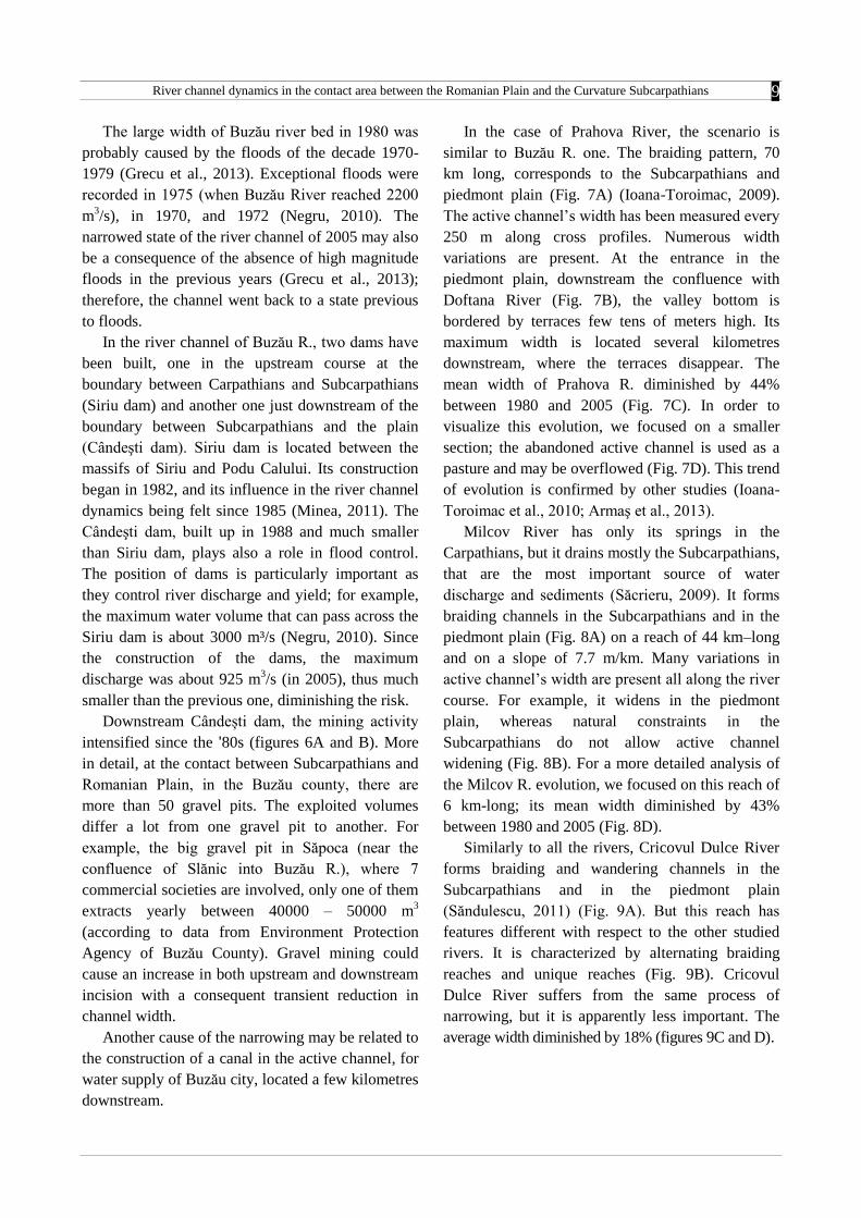
Buzău River forms a sinuous and unique pattern
in the Carpathians, a braiding one in the Subcarpathians
and piedmont plain, and a meandering one in the
lowlands (Fig. 5A). This is a general picture,
because the limits between these patterns are not
precise and there are also intermediary types. The
braiding pattern corresponds to a slope of 2.7 m/km
and it covers 88 km in length.
Fig. 4. Methods: sinuosity and braiding indices
Here, we measured its active channel’s width on
cross profiles located every 500 m on both
topographic maps and orthophotos. The results
show important variations of the active channel’s
width (Fig. 5B). For example, it widens at the
entrance in the piedmont plain – approximately at
the confluence with Slănic River (Fig. 5B). It
widens in the vicinity of confluences, which indicate
the role of tributaries in bringing yield in the main
channel. The width of the active channel started to
decrease since 1980, as showed by all the statistic
parameters (Fig. 5C). The results relative to the
2005 orthophotos indicate a much smaller variability
in channel width. The average width diminished by
69% in 25 years, between 1980 and 2005 . In order
to visualise this strong decrease, we focused on a 3
km-long reach in Fig. 5D. The inactive channel is
presently covered by pasture, which means that the
braiding channel could be easily reactivated in the
future during extreme floods.
The channel dynamic of Buzău R. appears to be
partially influenced by climatic factors acting on
short-term and by human-induced factors, mostly
dams and mining in the thalweg.
River channel dynamics in the contact area between the Romanian Plain and the Curvature Subcarpathians
9
The large width of Buzău river bed in 1980 was
probably caused by the floods of the decade 1970-
1979 (Grecu et al., 2013). Exceptional floods were
recorded in 1975 (when Buzău River reached 2200
m3/s), in 1970, and 1972 (Negru, 2010). The
narrowed state of the river channel of 2005 may also
be a consequence of the absence of high magnitude
floods in the previous years (Grecu et al., 2013);
therefore, the channel went back to a state previous
to floods.
In the river channel of Buzău R., two dams have
been built, one in the upstream course at the
boundary between Carpathians and Subcarpathians
(Siriu dam) and another one just downstream of the
boundary between Subcarpathians and the plain
(Cândeşti dam). Siriu dam is located between the
massifs of Siriu and Podu Calului. Its construction
began in 1982, and its influence in the river channel
dynamics being felt since 1985 (Minea, 2011). The
Cândeşti dam, built up in 1988 and much smaller
than Siriu dam, plays also a role in flood control.
The position of dams is particularly important as
they control river discharge and yield; for example,
the maximum water volume that can pass across the
Siriu dam is about 3000 m³/s (Negru, 2010). Since
the construction of the dams, the maximum
discharge was about 925 m3/s (in 2005), thus much
smaller than the previous one, diminishing the risk.
Downstream Cândești dam, the mining activity
intensified since the '80s (figures 6A and B). More
in detail, at the contact between Subcarpathians and
Romanian Plain, in the Buzău county, there are
more than 50 gravel pits. The exploited volumes
differ a lot from one gravel pit to another. For
example, the big gravel pit in Săpoca (near the
confluence of Slănic into Buzău R.), where 7
commercial societies are involved, only one of them
extracts yearly between 40000 – 50000 m3
(according to data from Environment Protection
Agency of Buzău County). Gravel mining could
cause an increase in both upstream and downstream
incision with a consequent transient reduction in
channel width.
Another cause of the narrowing may be related to
the construction of a canal in the active channel, for
water supply of Buzău city, located a few kilometres
downstream.
In the case of Prahova River, the scenario is
similar to Buzău R. one. The braiding pattern, 70
km long, corresponds to the Subcarpathians and
piedmont plain (Fig. 7A) (Ioana-Toroimac, 2009).
The active channel’s width has been measured every
250 m along cross profiles. Numerous width
variations are present. At the entrance in the
piedmont plain, downstream the confluence with
Doftana River (Fig. 7B), the valley bottom is
bordered by terraces few tens of meters high. Its
maximum width is located several kilometres
downstream, where the terraces disappear. The
mean width of Prahova R. diminished by 44%
between 1980 and 2005 (Fig. 7C). In order to
visualize this evolution, we focused on a smaller
section; the abandoned active channel is used as a
pasture and may be overflowed (Fig. 7D). This trend
of evolution is confirmed by other studies (Ioana-
Toroimac et al., 2010; Armaş et al., 2013).
Milcov River has only its springs in the
Carpathians, but it drains mostly the Subcarpathians,
that are the most important source of water
discharge and sediments (Săcrieru, 2009). It forms
braiding channels in the Subcarpathians and in the
piedmont plain (Fig. 8A) on a reach of 44 km–long
and on a slope of 7.7 m/km. Many variations in
active channel’s width are present all along the river
course. For example, it widens in the piedmont
plain, whereas natural constraints in the
Subcarpathians do not allow active channel
widening (Fig. 8B). For a more detailed analysis of
the Milcov R. evolution, we focused on this reach of
6 km-long; its mean width diminished by 43%
between 1980 and 2005 (Fig. 8D).
Similarly to all the rivers, Cricovul Dulce River
forms braiding and wandering channels in the
Subcarpathians and in the piedmont plain
(Săndulescu, 2011) (Fig. 9A). But this reach has
features different with respect to the other studied
rivers. It is characterized by alternating braiding
reaches and unique reaches (Fig. 9B). Cricovul
Dulce River suffers from the same process of
narrowing, but it is apparently less important. The
average width diminished by 18% (figures 9C and D).
Florina GRECU, Gabriela IOANA-TOROIMAC, Paola MOLIN, Francesco DRAMIS
10
Fig. 5. Buzău River dynamics. A) Longitudinal profile with channel patterns. B) Width of the braided active channel,
measured every 500 m, in 1980 and 2005. C) Active channel narrowing between 1980 and 2005. D) Active channel dynamics
at Buzău – Slănic confluence. 1: ancient/abandoned borrow pit; 2: borrow pit; 3: bridge; 4: built-up area; 5: artificial
channel; 6: active channel 2005; 7: active channel 1980

River channel dynamics in the contact area between the Romanian Plain and the Curvature Subcarpathians
11
Fig. 6. Mining activity on Middle Buzău River. A) Between km 52 and 68 (according to figure 5B): status compared to the one
of 2012. B) Between km 68 and 88 (according to figure 5B): active mining
(analysis based on topographic maps of 1980 and several orthophotos of ANCPI, 2014)
Fig. 7. Prahova River dynamics. A) Longitudinal profile with channel patterns. B) Width of the braided active channel,
measured every 250 m, in 1980 and 2005. C) Active channel narrowing between 1980 and 2005. D) Active channel dynamics
at Prahova – Doftana confluence. 1: ancient/abandoned borrow pit; 2: borrow pit; 3: bridge; 4: active channel 2005;
5: active channel 1980

Florina GRECU, Gabriela IOANA-TOROIMAC, Paola MOLIN, Francesco DRAMIS
12
Fig. 8. Milcov River dynamics. A) Longitudinal profile with channel patterns. B) Width of the braided active channel in 1980,
measured every 250 m. C) Width variations of a river reach between 1980 and 2005. D) Active channel narrowing of the river
reach from figure C between 1980 and 2005
6. Conclusions
The rivers crossing the study area form a unique,
sinuous channel in the Carpathians and just locally
in the Subcarpathians. They form braiding and
wandering channels in the Subcarpathians and in the
piedmont unit of the Romanian Plain; their origin,
length and width depend on the water and sediments
resources of each watershed. Downstream, crossing
the lowland units of the Romanian Plain, they form
meandering channels. In conclusion, channel pattern
is related to morphological units and the majority of
the rivers respect these patterns.
All the investigated braided rivers adjust to
external changes and suffer a narrowing process of
different intensities. A fluvial metamorphosis does
not occur, but this process is possible in the near
future as the narrowing continues at the present rate.
It is difficult to establish the role of each external
factor in this evolution, because their actions are
synchronous and simultaneous. We notice that
gravel mining is an important activity in Romania
and it probably plays an important role in channel’s
evolution. Beside these common aspects, the
analysis of each river needs to be detailed, because
each river is a unique example. These are only a few
examples, which show that it is necessary to
conduct the same study on all the major braided
rivers.
This study is important because it fills a lack of
studies on braiding activity of Romanian rivers and
it highlights the general process of narrowing of

River channel dynamics in the contact area between the Romanian Plain and the Curvature Subcarpathians
13
channels in the Subcarpathians and piedmont sectors
of their courses. Moreover, it could contribute to the
geoconservation of braided rivers which the
narrowing process, almost caused by human
activity, is progressively destroying.
This paper was presented at the 16th Joint
Geomorphological Meeting on Morphoevolution in
Tectonically Active Belts, Rome and Central
Apennine Mountains, Italy, 1-5 July 2012.
Fig. 9. Cricovul Dulce River dynamics. A) Longitudinal profile with channel patterns. B) Width of the braided active channel
in 1980, measured every 250 m. B) Width variations between 1980 and 2005 on a river reach. C) Active channel narrowing of
the river reach between 1980 and 2005. D) Active channel narrowing of the river reach from figure C between 1980 and 2005
Florina GRECU, Gabriela IOANA-TOROIMAC, Paola MOLIN, Francesco DRAMIS
14
REFERENCES
AQUAPROIECT, (1992), Atlasul Cadastrului Apelor din România, Ministerul Mediului, Bucharest, 694 p.
ANCPI, (2014), Geoportal, http://geoportal.ancpi.ro/geoportal/viewer/index.html, consulted on 10/01/2014
ARMAŞ, I., NISTORAN, D.E., OSACI-COSTACHE, G., BRAŞOVEANU, L., (2013), ”Morpho-dynamic evolution patterns of
Sub-carpathian Prahova River (Romania)”, Catena, 100: 83-99.
ARNAUD-FASSETTA, G., FORT, M., (2004), ”La part respective des facteurs hydroclimatiques et anthropiques dans l’évolution
récente (1956-2000) de la bande active du Haut Guil, Queyras, Alpes françaises du Sud”, Méditerranée, 1-2 : 143-156.
ARNAUD-FASSETTA, G., COSSART, E., FORT, M., (2005), ”Hydro-géomorphic hazards an impact of man-made structures
during the catastophic flood of June 2000 in the Upper Guil catchment (Queyras, Southern French Alps)”, Geomorphology,
66: 41-67.
BALLAIS J.L., CHAVE S., DUPONT N., MASSON E., PENVEN M.J., (2011), La méthode hydrogéomorphologique de
determination des zones inondables, Physio-géo,Géographie Physique et Environement, Collection « Ouvrages », 172 p.
BRAVARD, J.P., PETIT, F., (2002), Les cours d’eau. Dynamique du systeme fluvial, Editions Armand Colin, Paris, 222 p.
BRICE J.C., (1964), Channel patterns and terraces of the Loup River in Nebraska, United States Geological Society, Paper 422 D,
41 p.
CHARLTON, R., (2008), Fundamentals of fluvial geomorphology, Routlege, London-New York, 234 p.
CSONTOS, L., VÖRÖS, A., (2004), ”Mesozoic plate tectonic reconstruction of the Carpathian region. Palaeogeography,
Palaeoclimatology”, Palaeoecology, 210: 1-56.
FIELITZ, W., SEGHEDI, I., (2005), ”Late Miocene–Quaternary volcanism, tectonics and drainage system evolution in the East
Carpathians, Romania”, Tectonophysics, 410: 111-136.
GRECU, F., PALMENTOLA, G. (2003), Geomorfologie dinamică, Editura Tehnică, Bucharest, 392 p.
GRECU, F., (2010), Geografia câmpiilor României , Editura Universităţii din Bucureşti, Bucureşti, 258 p.
GRECU, F., IOANA-TOROIMAC, G., DOBRE, R., ZAHARIA, L., (2013), ”River channel recent dynamics in relation to floods in
the Curvature Carpathians”, Poster presentation within 8th Conference of International Association of Geomorphologists,
27-31.08, Paris.
ICHIM, I., BĂTUCĂ, D., RĂDOANE, M., DUMA, D., (1989), Morfologia şi dinamica albiilor de râu. Editura Tehnică, Bucharest,
408 p.
IELENICZ, M., (2004), Geomorfologie, Editura Universitară, Bucharest, 344 p.
IOANA-TOROIMAC, G., (2009), La dynamique hydrogeomorphologique de la rivière Prahova (Roumanie), PhD thesis in
Geography, University of Lille 1 and University of Bucharest, 341 p.
IOANA-TOROIMAC, G., DOBRE, R., GRECU, F., ZAHARIA, L. (2010), ”Evolution 2D de la bande active de la Haute Prahova
(Roumanie) durant les 150 dernières années”, Géomorphologie : relief, processus, environnement, 3 : 275-286.
I.N.M.H., (1974), Anuarul hidrologic, Institutul Naţional de Meteorologie şi Hidrologie, Bucureşti, 1356 p.
KNIGHTON, D., (1984), Fluvial forms and processes, Arnold, London, 218 p.
LEEVER, K.A., MAŢENCO, L., BERTOTTI, G., CLOETINGH, S., DRIJKONINGEN, G.G., (2006), ”Late orogenic vertical
movements in the Carpathian Bend Zone — seismic constraints on the transition zone from orogen to foredeep”, Basin
Research, 18, 521-545.
LEOPOLD, L.B., WOLMAN, M.G., (1957), River channel patterns: braided, meandering and straight. Rap. tech. US Geological
Survey, US government printing office, Washington, 76 p.
MAC, I., (1986), Elemente de geomorfologie dinamică, Editura Academiei, Bucharest, 215 p.
MALAVOI, J., R., BRAVARD, J.P., (2010), Eléments d’hydromorphologie fluviale, Onema, 224 p.
MAŢENCO, L., BERTOTTI, G., (2000), ”Tertiary tectonic evolution of the external East Carpathians (Romania)”, Tectonophysics
316: 255-286.
MAŢENCO, L., BERTOTTI, G., CLOETINGH, S., DINU, C., (2003), ”Subsidence analysis and tectonic evolution of the external
Carpathian–Moesian Platform region during Neogene times”, Sedimentary Geology, 156: 71-94.
MAŢENCO, L., BERTOTTI, G., LEEVER, K., CLOETINGH, S., SCHMID, S., TĂRĂPOANCĂ, M., DINU, C., (2007), ”Large-
scale deformation in a locked collisional boundary: interplay between subsidence and uplift, intraplate stress, and inherited
lithospheric structure in the late stage of the SE Carpathians evolution”, Tectonics, 26: TC4011.
MINEA, S., (2011), Râurile din bazinul Buzău. Consideraţii hidrografice şi hidrologice, Editura Alpha MDN, Buzău, 306 p.
MOLIN, P., FUBELLI, G., NOCENTINI, M., SPERINI, S., IGNAT, P., GRECU, F., DRAMIS, F., (2012), ”Interaction of mantle
dynamics, crustal tectonics and surface processes in the topography of the Romanian Carpathians: a geomorphological
approach”, Global and Planetary Change, 90-91: 58-72.
NECEA, D., FIELITZ, W., MAŢENCO, L., (2005), ”Late Pliocene–Quaternary tectonics in the frontal part of the SE Carpathians:
insights from tectonic geomorphology”, Tectonophysics, 410: 137-156.
NEGRU, O., (2010), ”Managementul inundațiilor în bazinul hidrografic Buzău, Proceedings of the Conference Water resources from
Romania. Vulnerability to the pressure of man’s activities, 184-188.
PEIRY, J.L., (1988), Approche géographique de la dynamique spatio-temporelle des sédiments d’un cours d’eau intra-montagnard :
l’exemple de la plaine alluviale de l’Arve (Haute-Savoie). PhD thesis in Geography, University of Lyon 3, 376 p.
RĂDOANE, M., RĂDOANE, N., CRISTEA, I., OPREA-GANCEVICI, D., (2008), ”Evaluarea modificărilor contemporane ale
albiei râului Prut pe graniţa românească”, Revista de Geomorfologie, 10: 57-73.
RĂDOANE, M., PERŞOIU, I., CRISTEA, I., CHIRILOAEI F., (2013), ”River channel planform changes based on successive
cartographic data. A methological approch”, Revista de Geomorfologie, 15: 69-88.
RICHARDS, K., (1985): Rivers. Form and Processes in Alluvial Channel – Methuen, London and New York, 360 p.
RINALDI, M., SURIAN, N., COMITI, F., BUSSETTINI, M., (2011), Guidebook for the evaluation of stream morphologivcal
conditions by the Morphological Quality Index (IQM), version 1, ISPRA-Istituto Superiore per la Protezione e la Ricerca
Ambientale, Roma, 84 p.

River channel dynamics in the contact area between the Romanian Plain and the Curvature Subcarpathians
15
SĂCRIERU, R., (2009), Bazinul morfohidrografic Milcov, Studiu geomorfologic, PhD thesis in Geography, University of Bucharest.
SĂNDULESCU, M., (1988), ”Cenozoic tectonic history of the Carpathians”, In: ROYDEN, L., HORVÁT, F. (Eds.), The Pannonian
Basin, American Association of Petroleum Geologists, Memoir, 45: 17–26.
SĂNDULESCU, V., (2011), Bazinul hidrografic Cricovul Dulce. Studiu geomorphologic, PhD thesis in Geography, University of
Bucharest.
SCHMID, S.M., BERZA, T., DIACONESCU, V., FROITZHEIM, N., FUEGENSCHUH, B., (1998), ”Orogenparallel extension in
the South Carpathians during the Paleogene”, Tectonophysics, 297: 209–228.
SCHUMM, S.A., (1977), The fluvial system, John Wiley & Sons Ltd, London, 388 p.
TĂRĂPOANCĂ, M., BERTOTTI, G., MAŢENCO, L., DINU, C., CLOETINGH, S., (2003), ”Architecture of the Focşani
depression: a 13 km deep basin in the Carpathians Bend zone (Romania)”, Tectonics, 22: 1074.
ZAHARIA, L., GRECU, F., IOANA-TOROIMAC, G., NECULAU, G., (2011), ”Sediment transport and river channel dynamics in
Romania – variability and control factors”, in MANNING, A.J., (ed.), Sediment transport in aquatic environments,
INTECH, Rijeka, 293-316.
ZUGRĂVESCU, D., POLONIC, G., HOROMNEA, M., DRAGOMIR, V., (1998), ”Recent vertical crustal movements on the
romanian territory, major tectonic compartinents and their relative dynamics”, Revue roumaine de géophysique, 42: 3-14.
1 University of Bucharest, Faculty of Geography
Department of Geomorphology-Pedology and Geomatics,
N. Bălcescu Blv, 1, 010074, Sector 1, Bucharest, Romania. [email protected], [email protected]
2 Roma Tre University, Department of Geological Sciences