Embed Size (px)
Citation preview

1
Risk
Management
Center
Hydro-Metrologic Modeling
Tools for Water Management
and Analysis
June 2016
William Charley
US Army Corps of Engineers
Hydrologic Engineering Center
Institute for Water Resources

Modeling in the 1930’s – 1950’s

More Recently….

Now

Computer Modeling Programs
Model Full Name Agency
VIC Variable Infiltration Capacity University of Washington
SSARR Streamflow Synthesis and Reservoir Regulation Corps of Engineers
Sacramento Sacramento Soil Moisture Accounting NOAA - NWS
SWMM Storm Water Management Model EPA
MIKE SHE Système Hydrologique Européen DHI
PRMS Precipitation Runoff Modeling System USGS
HSPF Hydrological Simulation Program – Fortran Stanford, EPA
SWAT Soil and Water Assessment Tool USDA, Texas A&M
HEC-HMS Hydrologic Modeling System Corps of Engineers

What is a “Computer Model”?
A computer model is the interaction of a
modeling program and its input data and
parameters, which attempts to accurately
simulate a system under given conditions
6

Since 1964, Technical Center of Expertise (TCX) in hydrologic engineering and planning
analysis executing a balanced program of technical assistance, research, software
development, training and special studies. Located in Davis, California.
Organization within the Institute for Water Resources.
Institute for Water Resources
Hydrologic Engineering Center
Training and
Software Support
Technical Assistance Research
Software Development

HEC Basic Precepts 'HEC Business Model'
HEC exists to help the Corps perform it's CW mission in
a world-class manner.
● The work of the Corps is performed at the field office level.
● HEC products and services are for field use and application.
● Generic Software can be used anywhere worldwide.
● Software is used worldwide for 5 major reasons.
Goal is to take "State-of-the-Art" and turn it into
"State-of-the-Practice".

Hydrologic Engineering Center
35 full-time professionals;
hydraulic engineers, a few
computer specialists, mostly
MS degrees, a few PhDs.
Five to ten University of
California – Davis students.
Primarily support USACE; some other Federal agencies;
growing international assistance; increasing number of
MoU's; visiting scholars – U.S. and international

HEC Software Activities
Solve problems in a general
manner for use everywhere.
Complete product line for
hydrologic engineering and
planning analysis in HEC
software library:
Hydrologic Statistics to River
Hydraulics to Reservoir
Analysis to Flood Risk
Management to Consequence
Analysis to Watershed and
System Analysis

HEC-HMS Hydrologic Modeling System
■ Computes
streamflow
throughout a river
basin given
precipitation and
watershed
characteristics.
■ Gaged or gridded rainfall is
the main input data

The Rainfall Runoff Process
Snow
Infiltration
Precipitation
Water Table
Lake
Spring
Surface
Transpiration
Evaporation
Condensation
Groundwater
River Ocean
runoff
Groundwater Flow

■ Industry standard hydrologic
modeling tool that is used worldwide.
■ Used by all District and some Division
Offices. Important tool for levee and
dam safety studies. Typical usage is
over 180 studies totaling 19M/year.
HEC provides HMS training to ~100
engineers annually
■ Certified for FEMA studies. Adopted
by multiple agencies.
■ Software provided free of charge
(paid by USA taxpayers)
■ ~ 27,000 downloads last year
HEC-HMS Hydrologic Modeling Software
Flood Event Modeling
Interior Drainage
Snowmelt
Reservoirs
Low Flow
Environmental

HEC-RAS River Analysis System
■ Computes river
velocities, stages,
profiles, and
inundated areas given
streamflow and
geometry.
■ Sediment Transport
■ Water Quality &
Temperature
■ Two-dimensional
capabilities added

River Modeling
Sediment – Water
Quality Modeling
Hydraulic Structures
Levee Failures
Floodplain Mapping
■ Industry standard hydraulic tool used
worldwide
■ Used by all District and Division Offices.
Important tool for dam and levee safety
studies. Used on over 300 studies totaling
$41M/year. HEC provides RAS training to
~150 engineers in annually and ~100,000
worldwide downloads/year
■ NWS, NRCS, USGS and FHWA adopted
RAS for 1D River Hydraulics. 80% of
FEMA Floodplain/Floodway analyses are
performed with HEC-RAS
HEC-RAS Hydraulic Modeling Software

HEC-RAS (River Analysis System)
Ohio and Mississippi Rivers
April/May 2011

HEC-RAS Mapper

18
HEC-RAS Mapper

■ Simulates reservoir operations
throughout a river basin given
streamflows and reservoir
operating rules and computes
downstream hydrographs.
■ Uses reservoir inflow and
downstream local hydrographs
computed by HEC-HMS.
■ The impact of the hydrographs
are then evaluated with HEC-
RAS and HEC-FIA.
Reservoir Operations with HEC-ResSim

HEC-FDA Flood Damage Reduction Analysis
Plan Evaluation and Plan Formulation Tool
Helps answer the question "Which proposed flood damage reduction plan is the best from an economic standpoint"?
● Evaluate the existing condition
● Analyze alternative damage reduction plans
Compare plans using Expected Annual Damage and damage reduction benefits
Since 1996, FDA uses risk analysis procedures

Economic / Impact Analysis
with HEC-FIA
Computes damages to
structures and other
contents of the floodplain
(including agricultural)
given river stages and
damage relationships.
Computes damages and
benefits between different
scenarios, and with and
without project conditions.

CWMS / HEC-RTS Corps Water Management System
Real-Time Simulation Real-Time Decision Support for Water Management
700+ Multipurpose Reservoirs and Flow Control Structures,
Weather Radar
Streamgages
Operational Decisions Inundation Forecasts
Real-Time Fully Integrated Hydrologic Models thousands of miles of Levees
To achieve the full range of authorized purposes from all of our projects
Floods to droughts and everything in between
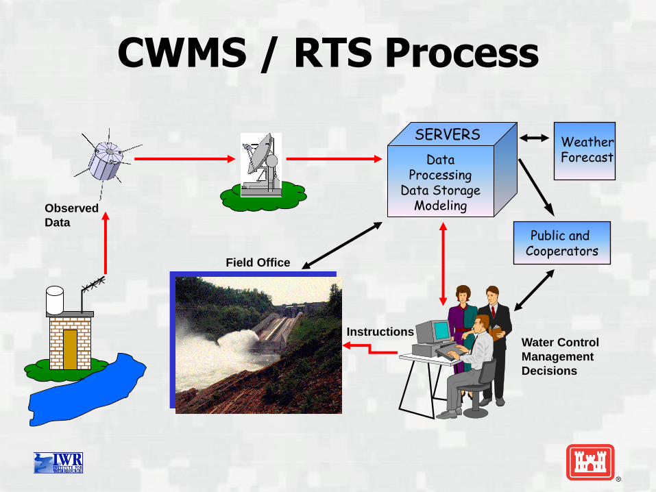
CWMS / RTS Process
Data Processing
Data Storage Modeling Observed
Data
Water Control
Management
Decisions
Instructions
SERVERS
Public and Cooperators
Field Office
Weather Forecast

Model Linking NEXRAD
MFP
HMS
ResSim
FIA RAS
Observed Precipitation
GageInterp
Observed Precipitation
Observed & Future Precipitation
Flow
Flow Flow
Stage
Inundation Map
• HEC-HMS computes forecasted flows from
• Observed precipitation from NEXRAD and rain gages
• Future precipitation forecasts and scenarios
• Observed flow
• ResSim simulates reservoir operations and downstream flows from HEC-HMS flows.
• HEC-RAS computes stages and inundation areas from ResSim flows.
• FIA computes damages and impacts from HEC-RAS stages or ResSim flows.
• Inundation areas and depths computed by RAS Mapper

HEC-RTS vs. CWMS
HEC-RTS
Real-Time Simulation
PC Database
HEC-DSS
CWMS Corps Water
Management System
Server Database
Oracle Database

Emergency planning & response
Project evaluation (new projects, alternative projects, modified regulation)
Post-event analyses (benefits)
Floodplain studies
USACE Infrastructure Strategy
Dam and Levee Safety Program
CWMS Opportunities

27
HEC-WAT Watershed Analysis Tool
An overarching
interface that allows
the PDT to perform
water resources
studies in a
comprehensive,
systems based
approach by building,
editing and running
models commonly
applied by multi-
disciplinary teams and
save and display data
and results in a
coordinated fashion.

28
Development of HEC-WAT Schematic
Stream
Alignment
Consequence
Areas
CCPs
Reservoirs

29
ResSim
Models
RAS Models
FIA Models
Development of HEC-WAT Model

30
HEC-WAT – Result Comparison

Typical HEC International Assistance
■ Off-The-Shelf-Training – Most common and cost effective form of outreach; two or more staff members present technical materials and conduct hands-on workshops regarding the HEC product suite.
■ Consulting/Capacity Building – HEC engineers work together with participants to build models of their water resource projects and systems, and assist in the analysis of results. Usually combined with training based on customized materials, and costs more due to planning and customization efforts.
■ Technical staff exchanges – Foster long-term relationships hosting groups for up to 1-2 weeks, or individuals for months; flexible approach to depth and breadth of interactions with HEC staff or regional partners.
■ Collaborations – HEC can partner with other groups or government agencies, such as USGS or USBR, to more comprehensively address a full range of water resource engineering needs.

International Efforts in Africa
■ Nairobi, Kenya
■ Addis Ababa, Ethiopia

Mekong River Commission, Phnom Penh, Cambodia University of Nairobi, Kenya
ITAIPU, Asuncion, Paraguay Ministry of Water, Kabul, Afghanistan

USACE
CEIWR-HEC
®
Questions?