Embed Size (px)
Citation preview

Small Communities Wastewater Risk Assessment
February 2000

Small Communities Wastewater Risk Assessment Summary Two previous investigations have been undertaken in order to identify unserviced communities that have a potential to impact on the downstream activities from wastewater generated from those communities. These assessments undertook a basic risk assessment of issues involved. The assessments also were fragmented along general purpose Council areas and used different methods of assessment. This assessment aims to consolidate the communities under review and use a more comprehensive needs analysis, and assessment methodology over both general purpose Council areas. With data connected into the Capital Expenditure program for the entire MidCoast Water operating area. The components of the needs analysis are as follows:
• Risk assessment • Stakeholder needs including community and regulators • Servicing options available.
The risk assessment is the first step and will be used to highlight areas to initially concentrate. The risk assessment methodology to be used in this assessment uses a dimensional matrix system based on ‘likelihood’ versus ‘severity’. The likelihood of a wastewater problem with existing development was assessed on the basis of the number of blocks. The larger the number of existing developed lots the greater the likelihood of an onsite wastewater problem. Severity was broken down into the following issues:
• Distance of existing development to downstream activity of: o Town water supply o Shellfish food production o Aquatic ecosystem o Recreational use o Agricultural use
• Size of lots • Site soil conditions, and • If development had town water supplied
Using the matrix methodology, the ranking of those small communities with a high risk, in order of ranking highest to lowest is as follows:

Small community No. of lots Greater Taree Bungay 73 Cedar Party 145 Crowdy Head 80 Forrest Downs 80 Great Lakes Coomba Park 497 North Arm Cove 493 Stroud Road 85 Allworth 123 Shearwater 120 North Pindimar 113 South Pindimar 155 Bundabah 115 Nerong 153 In the Greater Taree area there are significant ‘fringe’ areas. As stand alone schemes they are small but on the out skirts of towns currently serviced. The assessment system used does not have capacity to identify small urban lots as a need for servicing adjacent to existing sewerage services and on community expectations as being adjacent to ‘town’ provided with the same services. It is for this reason that these ‘fringe’ areas should be included in any servicing program in the following ranking: Minor Fringe Area No. of lots Greater Taree Glenthorne 26 North east Wingham 25 East Wingham 24 Wingham Industrial 24 Ritchie Cr 10 Kookaburra Dr 18 Harrington Industrial 11 Great Lakes Tea Gardens industrial 35 Order of costs for servicing program: Total centralised sewerage capital costs are as follows: Small Communities $46,060,000 Fringe Areas $3,110,000 Total onsite sewerage capital costs are as follows: Small Communities $15,630,000 Fringe Areas $1,230,000

It would be intended to concurrently investigate the supply of town water with the sewerage investigation for those small communities without town water, from the ranked priority list. Small community No. of lots Great Lakes Coomba Park 497 North Arm Cove 493 Allworth 123 North Pindimar 113 South Pindimar 155 Bundabah 115 Nerong 153 Order of costs for serving program: Total centralised water capital costs are as follows: Small Communities $6,250,000 Fringe Area Nil Total onsite water capital costs are as follows: Small Communities $8,880,000 Fringe Areas Nil Any scheme proceeding would need community as well as other stakeholder acceptance. It is intended to circulate this document to other stakeholders as well as issuing to the small communities a questionnaire for input into the process. Without stakeholder or community support for a centralised scheme, other onsite systems will need to be developed to minimse risk to downstream uses from the small communities.

1 Introduction Two previous investigations have been undertaken in order to identify unserviced communities that have a potential to impact on the downstream activities from wastewater generated from those communities. These assessments undertook a basic risk assessment of issues involved. The assessments also were fragmented along general purpose Council areas and used different methods of assessment. This assessment aims to consolidate the communities under review and use a more comprehensive risk assessment methodology over both general purpose Council areas. This investigation aims to objectively as possible undertake a risk assessment of the small communities on a uniform basis for the Great Lakes and Greater Taree areas. The risk assessment will be a recognised methodology. The outcome will be a ranking system for all small communities on their risks to downstream activities. From this ranking a list of priorities can be developed further and provide a starting point for community and other stakeholder consultation and needs assessment for wastewater and water services. A broad estimate of preliminary capital costs for conventional centralised sewerage system and upgraded onsite wastewater systems will be provided. It should be noted that centralised sewerage systems are not the only solution and that other alternative sewerage systems may also be viable, if any further investigation work proceeds alternatives will be considered. 2 Background Great Lakes Council Area The Council area is 3,373 square kilometers in area, comprising both coastal and forested rural hinterland. It is 85 kilometers at its widest point, 62 kilometers north to south , and has a total coastline of 145 kilometers. One third of the area is made up of national parks and state forests. These natural features have turned the Great Lakes into a major recreational area. Because of these geographic features, distinct communities have developed in the Council area. (Ref 1) Population growth has been strong in the area placing demand on existing infrastructure and the need for services. It is those distinct communities which are currently unserviced that will be examined in this risk assessment. There is limited rural residential development with most of the existing rural residential development being serviced by centralised sewerage services.

Greater Taree Council Area The Council area is 3732 square kilometers in area. The area is rich in agriculture such as dairy and beef production and timber. The Taree area is a center for manufacturing with a number of light industries. (Ref 2) Greater Taree therefore has a different community structure than the Great Lakes. Greater Taree is based on fringe small communities originating from a rural agricultural base serviced by the larger centers of Taree and Wingham. The rural climate has provided greater demand for rural residential development with strong growth being experienced in this style of development. (Ref 3) Existing Development All major urban areas have been serviced with centralised sewerage services in both Council areas. Currently, the management of wastewater from remaining unserviced small communities is the responsibility of the General Purposes Councils. The issue is whether to provide reticulated water supply and sewerage to all, some or none of these small communities and if so, in which order of priority. This is one of the major challenges facing MidCoast Water to balance the health, environmental, social and economic aspects. (Ref 4) 3 Current levels of Service The current service provision of centralised sewerage to urban areas is:
• 93.6% in the Greater Taree area, and • 95.4% in the Great Lakes area
After completion of the current schemes at Nabiac, Lansdowne, Coopernook and Manning Point the service provision for the combined MidCoast Water area will rise to 97.4%. This compares with:
• NSW Country median (50 % of Councils) at 90.4% • NSW Country top (20 % of Councils) at 96.8% • NSW Country bottom (80 % of Councils) at 80.2%
These high levels of service availability across MidCoast Water have been achieved at a price. The annual sewerage bill for sewerage residential properties in both general purpose Council areas’ is in the highest 20 % of NSW Country Council’s. (Ref 4)

4 Communities to be assessed A list of rural villages and rural residential areas were compiled for Greater Taree and Great Lakes Council areas and is detailed in Table 1. Populations covered by this assessment amount to:
• Greater Taree villages 1,000 people • Greater Taree rural residential 2,600 people • Great Lakes villages 2,600 people
No growth has been considered outside existing ‘village’ boundaries. Total lots shown in Table 1 are existing lots including those currently not built on. It should also be noted that the assessed lots is preliminary and will need to be more accurately detailed in later investigations. 5 Risk Assessment Methodology The risk assessment methodology uses a dimensional matrix system based on ‘likelihood’ versus ‘severity’ as presented in Appendix A. A hyperbolic ranking system is to be used to obtain a better scatter of risks. Likelihood The likelihood of a wastewater problem with existing development was assessed on the basis of the number of blocks. The larger the number of existing developed lots the greater the likelihood of an onsite wastewater problem. The range was set at 150 lots for high likelihood of problem based on existing experience, such as Nabiac, Coopernook and Lansdowne where a decision to provide a centralised sewerage system on the basis of onsite systems causing significant effluent problems, with that size development down to less than 24 lots for low likelihood of a problem. Severity Severity was broken down into the following issues:
• Distance of existing development to downstream activity of: o Town water supply o Shellfish food production o Aquatic ecosystem o Recreational use o Agricultural use
• Size of lots • Site soil conditions, and • If development had town water supplied
Downstream water usages were identified for known or likely to occur uses. These downstream usages were identified in the main classifications for water quality and in order of quality standards as detailed in ANZECC guidelines (Ref 2) as:-

♦ Town water Supply ♦ Shellfish food provision ♦ Aquatic Ecosystems ♦ Recreation and aesthetics ♦ Agriculture
The relative severity was moderated between the five parameters by reducing the distance of impact as one went down the list. For example highest risk was downstream water supply at upto 9.9 km, shellfish upto 4.9 km, aquatic ecosystem upto 0.9 km, recreational use upto 0.4 km, and agricultural use upto 0.1 km. The actual distances may not be technically correct and no one may know the technically correct number, this system merely provides a relativity between the five parameters. To some extent the distances are based on experience with monitoring of the Manning River. Physical site conditions such as lot size, site soil conditions and if town water is available all contribute to the capability of the onsite system to work and minimise risk. Thus the physical site condition issues amounted to a weighting of three parameters out of eight. With downstream use contributing a weighting of five possible parameters. The score for each of the eight parameters are added together to produce a total score. The maximum score possible is 190. The lowest level of high risk is considered to be a likelihood of 2, with severity of 5, which will produce a total score of 76. A total score of round 66 will be used as the cut off point, with scores below this level not considered further for a centralised sewerage system at this stage. For likelihood of 1, low, or less than 19 lots under this system it is not possible to pose a high risk due to the scale of development. This system looks at each development individually and does not take into account the combined or accumulated risk of development within the catchment. 6 Risk Assessment Table 2 details actual parameter data for each village. Table 3 provides the score for each parameter and total score. Figure 1 shows the graph of scores sorted from lowest to highest. Figure 1 indicates the top ranking communities can be further divided into three groups if required and that the score of 66 is an appropriate ‘cut off point’. The ranking of those small communities with a score greater than 66 in order of ranking highest to lowest is as follows: Greater Taree
• Group 1 Bungay • Group 2 Cedar Party
Crowdy Head • Group 3 Forrest Downs

Great Lakes
• Group 1 Coomba Park North Arm Cove Stroud Road
• Group 2 Allworth Shearwater
• Group 3 North Pindimar South Pindimar Bundabah Nerong
In the Greater Taree area there are significant ‘fringe’ areas as east Wingham, North east Wingham, Wingham industrial, Kookaburra Dr, Ritchie Cr, Glenthorne, and Harrington Industrial area. As stand alone schemes they are small but on the out skirts of towns currently serviced. The assessment system used does not have capacity to identify small urban lots as a need for servicing adjacent to existing sewerage services and on community expectations as being adjacent to ‘town’ provided with the same services. It is for this reason that these ‘fringe’ areas should be included in any servicing program in the following ranking:
• Glenthorne • North east Wingham • East Wingham • Wingham industrial • Ritchie Cr • Kookaburra Dr • Harrington Industrial
In the Great Lakes area the fringe area of Tea Gardens Industrial area should also be considered in the category of adjacent to town. 7 Options for Wastewater Management Options for the management of Wastewaters from small communities can be categorised broadly into what is known as:-
♦ ‘on site’ system ♦ ‘off site’ system, and ♦ combinations of both.
The need to properly manage ‘on site’ systems has been recognised by Government with recent regulatory controls covering these systems. This control is currently the responsibility of General purpose Councils.

The need to provide more affordable reticulated (or ‘off site’ systems) water supply and sewerage to small communities has produced a wider range of options. In planning decisions on which system(s) to implement, the most crucial part is the effluent management. What are we going to do with the final effluent from the system. Then work back through treatments then to collection and transport options. (Ref 4) 8 Costs of Wastewater Management If conventional technologies from larger water supply and sewerage systems are applied to small communities, then economics of scale can work against the small community. Data shows the cost of treatment per person for small populations can be 2 to 3 times the cost for large populations. While the cost of trunk mains for small populations can be up to 8 times the cost of large populations. (Ref 4) Costs of Centralised Wastewater Collection The cost of completed sewerage schemes in the MidCoast area were analysed for collection cost components and adjusted to current dollars. As a basis for preliminary estimates per lot, a low range of $11,500 and a high range of $14,500 are indicated for centralised wastewater collection systems. These ranges are based on similar technologies being applied to the smaller communities, ie centralised collection using gravity or modified gravity systems for urban size lots of approximately 20 m by 30 m, costing from $11,500 to $14,500 per lot for collection only. (Ref 4) For rural residential development where the average lot size is 80 m by 100 m the cost would be expected to be greater. There will be approximately three times the length of pipe compared with an urban size lot. This will not necessarily translate to a tripling in the costs and will also depend on transfer system to existing sewerage system. For the purposes of this simplistic analysis a cost figure of double the urban size lots will be used. Thus the upper cost will be expected to be approximately $29,000 per lot. The economics of sewering rural residential lots is marginal, particularly were no financial assistance from the NSW Government as is the case with urban size lots. Costs of Centralised Wastewater Treatment and Effluent Management Treatment costs have been allowed for each small community, this may include options of connecting into an existing system ie buy into the existing treatment system, or a stand alone treatment/effluent system or a grouped treatment/effluent system. The treatment costs of sewerage schemes in the MidCoast area were also identified, adjusted to current dollars, sized by equivalent persons (ep) and cost per ep calculated.

The cost of treatment for preliminary estimates at the small end of the graph would be from $640 to $920 per person. Allowing 2.5 ep per lot, this is a range from $1,600 to $2,300 per lot. (Ref 4) An allowance of a further 50% will be included for effluent management, this may include effluent reuse or discharge infrastructure. In the case of centralised systems the total system ranges for collection and treatment would be from $13,900 to $17,950 per lot. The collection component at 80-90% of the total, has the greatest potential to improve the affordability of small community systems. (Ref 4) Life cycle costing of operational costs is calculated on the basis of a 20 period, using a discount rate of 7%, reticulation operational costs of 1.8% of the reticulation capital cost, and treatment operational costs of 9% of the capital treatment cost. The life cycle cost of the operational component is $2,765 per lot for reticulation on urban size lots and $8,820 per lot for rural residential size lots, and $3,290 per lot for treatment. The total NPV of operational costs is $6,055 per lot for urban size lots and $12,110 per lot for rural residential size lots. Cost of Onsite Systems The costs of individual “on site” systems for preliminary estimates was assumed as $7,000 per lot. This was based on typical installation costs of domestic type systems. With adequate lot size and affordable site conditions, these ‘on-site’ systems can provide a satisfactory level of service. However a high frequency of failure of ‘on-site’ systems has been reported (Ref 6). It was concluded that the capital cost ranges from $7,000 for individual on site systems through to $16,800 per urban size lot for centralised systems using conventional technology. Currently ‘on-site’ systems are much lower in both capital and operating costs than conventional centralised systems. In the future it can be expected that the operating and management of ‘on-site’ systems will increase while the costs of centralised systems may reduce through newer technologies (Ref 4). Life cycle costing of operational costs is calculated on the same basis as in Section 8 above, with $250 per lot per year for 4 routine operational inspections, $200 per lot per year for power and replacement of consumables, and the NPV of $4,770 per lot for operational costs. Estimated Preliminary Costs on Priority Small Communities The estimated preliminary costs based on upper range for priority small communities identified in section 6 is as follows:

Small community
No. of lots
Centralised system capital cost
Centralised system NPV
On site system capital cost
On site system NPV
Government funding available
Greater Taree Bungay 73 $2,370,000 $3,013,000 $510,000 $858,000 No Cedar Party 145 $4,690,000 $5,969,000 $1,020,000 $1,712,000 No Crowdy Head 80 $1,420,000 $1,904,000 $560,000 $942,000 Yes Forrest Downs 80 $2,590,000 $3,296,000 $560,000 $942,000 No Great Lakes Coomba Park 497 $8,910,000 $11,919,000 $3,480,000 $5,851,000 Yes North Arm Cove
493 $8,840,000 $11,825,000 $3,450,000 $5,802,000 Yes
Stroud Road 85 $1,530,000 $2,045,000 $600,000 $1,005,000 Yes Allworth 123 $2,200,000 $2,945,000 $860,000 $1,447,000 Yes Shearwater 120 $3,890,000 $4,617,000 $840,000 $1,412,000 No North Pindimar 113 $2,030,000 $2,714,000 $790,000 $1,329,000 Yes South Pindimar 155 $2,790,000 $3,728,000 $1,090,000 $1,829,000 Yes Bundabah 115 $2,060,000 $2,756,000 $800,000 $1,349,000 Yes Nerong 153 $2,740,000 $3,666,000 $1,070,000 $1,800,000 Yes The estimated preliminary costs based on upper range for priority minor fringe areas in the Greater Taree area identified in section 6 is as follows: Minor Fringe Area
No. of lots
Centralised system capital cost
Centralised system NPV
On site system capital cost
On site system NPV
Government funding available
Greater Taree Glenthorne 26 $470,000 $620,000 $180,000 $300,000 possibly North east Wingham
25 $450,000 $600,000 $180,000 $290,000 possibly
East Wingham 24 $430,000 $580,000 $170,000 $280,000 possibly Wingham Industrial
24 $430,000 $580,000 $170,000 $280,000 No
Ritchie Cr 10 $180,000 $240,000 $70,000 $120,000 possibly Kookaburra Dr 18 $320,000 $430,000 $130,000 $210,000 possibly Harrington Industrial
11 $200,000 $260,000 $80,000 $130,000 No
Great Lakes Tea Gardens industrial
35 $630,000 $840,000 $250,000 $410,000 No
Total centralised sewerage capital costs are as follows: Greater Taree Small Communities $11,070,000 Greater Taree Fringe Areas $2,480,000

Great Lakes Small Communities $34,990,000 Great Lakes Fringe Area $630,000 Obviously all these small communities cannot be connected to a centralised sewerage service at once, it would be expected that over the next 10 years as funding permits work could be undertaken. 9 Town Water Supply It would be intended to concurrently investigate the supply of town water with the sewerage investigation for those small communities without town water, from the ranked priority list. This will involve the following small communities:
• Coomba Park • North Arm Cove • Allworth • North Pindimar • South Pindimar • Bundabah • Nerong
Costs of Centralised Water System Reticulation is estimated at $1,500 per lot for urban size lots and $4,800 per lot for rural residential size lots. Based on Manning District headworks expenditure in the 1980’s on reservoirs, delivery mains and pump stations, as well as the forecast expenditure on treatment expected in 2002, an estimated headworks component of $59,000,000 will have been expended on the water system. It is estimated there will be 25,850 lots, this provides an average capital cost of $2,282 per lot. Life cycle costing of operational costs is calculated on the same basis as in Section 8, with the treatment component at $15,000,000 and reservoirs, delivery mains and pump stations component at $44,000,000, and the NPV of $878 per lot for operational costs.

Cost of Onsite Water System For a 20 kL storage and pump the cost is $5,014 per lot (Ref 7) and life cycle costing of operational costs calculated on the same basis as in section 8 and the NPV of $710 per lot for operational costs. The estimated preliminary costs based on upper range for priority small communities identified in section 6 is as follows: Small community
No. of lots
Centralised system capital cost
Centralised system NPV
On site system capital cost
On site system NPV
Government funding available
Great Lakes Coomba Park 497 $1,880,000 $2,320,000 $2,490,000 $2,840,000 Yes North Arm Cove
493 $1,860,000 $2,290,000 $2,470,000 $2,820,000 Yes
Allworth 123 $470,000 $580,000 $620,000 $700,000 Yes North Pindimar 113 $430,000 $530,000 $570,000 $650,000 Yes South Pindimar 155 $590,000 $730,000 $780,000 $890,000 Yes Bundabah 115 $440,000 $540,000 $580,000 $660,000 Yes Nerong 153 $580,000 $710,000 $770,000 $880,000 Yes Total centralised water capital costs are as follows: Greater Taree Small Communities Nil Greater Taree Fringe Areas Nil Great Lakes Small Communities $6,250,000 Great Lakes Fringe Area Nil 10 Stakeholder Consultation Any scheme proceeding would need community as well as other stakeholder acceptance. It is intended to circulate this document to other stakeholders as well as issuing to the small communities the questionnaires contained in Appendix B for input into the process. Without stakeholder or community support for a centralised scheme, other onsite systems will need to be developed to minimse risk to downstream uses from the small communities.

References Ref 1 Great Lakes Community Profile 1999, Great Lakes Council Ref 2 Facts & Figures 1996, Greater Taree City Council Ref 3 Rural Villages Study 1996, Greater Taree City Council Ref 4 Small Communities Wastewater Risk Assessment 1999, MidCoast Water Ref 5 Australian Water Quality Guidelines for Fresh and Marine Waters 1992, ANZECC Ref 6 Water Service Association of Aust., Agriculture and Resource Management Council of Aust. And New Zealand 1999, Affordable Water Supply and Sewerage for Small Communities. Ref 7 Manning District Water Supply Augmentation, Stratgey Review Report Dept of Public Works & Services May 1999.

Appendix A Risk Assessment Methodology

Appendix A Risk Assessment Methodology Likelihood Severity For Existing Development:
• >150 lots high • 95 – 149 lots • 50 – 94 lots medium • 20 – 49lots • <19 lots low
Existing development distance from downstream activity ranked in order of highest severity to lowest by moderating distance downstream 1.1 Town water supply downstream of development:
• <9.9 km high • 10 – 19.9 km • 20 – 29.9 km medium • 30 – 49.9 km • > 50 km low
1.2 Shellfish food production downstream • <4.9 km high • 5 – 14.9 km • 15 – 29.9 km medium • 30 – 49.9 km • > 50 km low
1.3 Aquatic ecosystem downstream • <0.9 km high • 1 – 1.9 km • 2 – 3.9 km medium • 4 – 5.9 km • >6 km high
1.4 Recreational use downstream • <0.4 km high • 0.5 – 0.9 km • 1 – 1.9 km medium • 2 – 2.9 km • >3 km low
1.5 Agricultural use downstream • <0.1 km high • 0.2 – 0.5 km • 0.6 – 0.9 km medium • 1 – 1.9 km • > 2 km low
2.0 Size of lot • <700 m2 high • 701 – 1500 m2 • 1501 – 4000 m2 medium • 4001 – 8000 m2 • >8001 m2 low
3.0 Site soil conditions • clay/rock high • shale • clay/loam medium • loam • sand low
4.0 Town water supply available • NA high • Yes medium • No low

Appendix B Proposed Community Questionnaire Type 1 Villages Type 2 Rural Residential

Table 1 Greater Taree and Great Lakes Council Small Communities Greater Taree Area2
Village/Location Current Population1
Growth Trend
Existing houses3
Total Lots
Catchment
Moorland 150 Low 63 70 Pipeclay canal/Manning River
Johns River 100 Low 40 110 Stewarts River/Camden Haven
Mount George 120 Low 42 54 Manning River Crowdy Head 170 Low 73 80 Pacific Ocean Krambach 120 Low 49 64 Wallamba River/Wallis
Lake Croki 48 Low 20 27 Manning River Elands 70 Low 30 48 Dingo Creek/Manning
River Oxley Is 30 Low 12 16 Manning River East Wingham 60 Low 24 33 Manning River North East Wingham
60 Low 25 25 Manning River
Wingham Industrial NA Low 24 24 Manning River Kookaburra Dr 45 Low 18 18 Manning River Ritchie Cr 26 Low 10 10 Manning River Glenthorne 65 Low 26 26 Manning River Harrington Industrial
NA Low 11 11 Manning River
Colonial Leisure Village
60 Low 24 30 Manning River
Rural Residential Homestead/heritage Estate
195 Low 73 88 Wallamba River/Wallis Lake
Rainbow Flat 200 Low 69 83 Khappinghat Creek/ Saltwater Lagoon
Nabiac Rural 80 Low 32 50 Wallamba River/Wallis Lake
Sorrento Pl 110 Low 40 45 Manning River Cedar Party 390 Low 120 145 Dawson River/Manning
River Clovernook 160 Low 56 70 Ghinny Ghinny
Creek/Manning River Kolinda 95 Low 35 40 Manning River Warwiba 150 Low 53 66 Manning River Helmich Cl 160 Low 58 65 Manning River Bungay 240 Medium 67 73 Manning River Idlewoods 95 Low 45 55 Wallamba River/Wallis
Lake Diamond Beach 310 Medium 86 116 Saltwater Lagoon Forrest Downs 210 Medium 70 80 Manning River Manning Waters 120 Low 25 43 Manning River Malcolms Rd 10 Medium 3 33 Manning River Riverview Dr 60 Low 23 25 Manning River Abbott Rd 25 Low 10 10 Manning River

Great Lakes Area Allworth 180 Medium 83 123 Karuah River Limeburners Creek 90 Medium 42 62 Karuah River Booral 80 Low 39 58 Karuah River Stroud Road 110 Low 57 85 Karuah River Wards River 90 Low 45 67 Karuah River Coomba Park 520 Medium 227 497 Wallis Lake Coolongolook 120 Low 49 96 Coolongolook
River/Wallis Lake Wooton 40 Low 17 25 Coolongolook
River/Wallis Lake North Pindimar 120 Medium 57 113 Port Stephens South Pindimar 170 Medium 78 155 Port Stephens Bundabah 130 Medium 58 115 Port Stephens North Arm Cove 550 High 248 493 Port Stephens Tahlee 90 Low 41 82 Port Stephens Carrington 30 Low 14 28 Port Stephens Nerong 150 Medium 70 153 Myall Lake Seal Rocks 180 Medium 81 120 Pacific Ocean Tea Gardens Industrial
NA Medium 35 50 Port Stephens
Rural Residential Racecourse Estate 140 Low 65 75 Wallis Lake Shearwater Estate 180 Medium 80 120 Port Stephens Notes 1 Current populations is based on average Council area occupancy rates for existing houses 2 The villages or localities of Wherrol Flat, Killabakh, Burrell Creek, Waitu, Bobin, Hannam Vale, Dyers Crossing identified in Greater Taree City Council’s Rural Villages Study 1996 have been omitted from this assessment due to the size of development being in most cases less than 10 urban size blocks. 3 Lot numbers include allowance for existing non domestic development such as caravan parks and other commercial.

Table 2 Severity data used in Assessment Greater Taree Area Severity Distance to downstream activity in km: Physical attributes: Village/Location Water
supply Shellfish product
Aquatic system
Recreation use
Agriculture use
Size of lots m2
Soil type Town water provided
Moorland NA 14 8 8 0.2 600 Loam No Johns River NA 10 1.5 1.5 2 1000 Clay
loam No
Mount George 20 52 0.6 0.6 0.2 1000 Clay loam
No
Crowdy Head NA NA 0.6 0.6 2 600 Rock Yes Krambach NA 40 1.7 1.7 0.2 1000 Shale Yes Croki NA 0.1 0.1 0.1 0.2 600 Clay
loam Yes
Elands 30 50 3 3 2 700 Loam No Oxley Is NA 6.5 1.5 1.5 0.2 4000 Clay
loam Yes
East Wingham NA 32 0.2 0.2 1 800 Clay loam
Yes
North East Wingham
NA 34 0.3 0.3 0.2 900 Shale Yes
Wingham Industrial
NA 38 4 4 2 2500 Shale Yes
Kookaburra Dr NA 13 2.6 2.6 2 700 Shale Yes Ritchie Cr NA 25 0.1 0.1 2 700 Shale Yes Glenthorne NA 13 0.2 0.2 1 700 Clay
loam Yes
Harrington Industrial
NA 1 0.9 0.9 2 2000 Sand Yes
Colonial Leisure Village
NA 0.7 0.7 0.7 2 <700 Sand Yes
Rural Residential Homestead/Heritage Estate
NA 11 0.5 3.2 2 14,000 Shale Yes
Rainbow Flat NA NA 4 4 2 11,000 Shale Yes Nabiac Rural NA 26 2.2 2.2 0.2 20,000 Shale Yes Sorrento Pl NA 25 1.6 1.6 1 11,000 Shale Yes Cedar Party NA 20 1.5 1.5 2 14,000 Shale Yes Clovernook NA 8 5 5 2 13,000 Shale Yes Kolinda NA 7.5 2.5 2.5 2 11,000 Clay Yes Warwiba NA 7 1.7 1.7 1 13,000 Shale Yes Helmich Cl NA 34 3 3 2 5,000 Shale Yes Bungay 0.8 39 0.8 0.8 0.2 13,000 Shale Yes Idlewoods NA 13 4.5 4.5 2 9,000 Shale Yes Diamond Beach NA NA 2 2 2 12,000 Clay
loam Yes
Forrest Downs NA 18 0.9 0.9 2 8,000 Clay Yes Manning Waters NA 0.5 0.5 0.5 0.2 13,000 Clay
loam Yes
Malcolms Rd NA 8 2 2 0.2 10,000 Shale Yes

Riverview Dr NA 34 0.4 0.4 1 4,000 Shale Yes Abbott Rd NA 36 4 4 2 5000 Shale Yes Great Lakes Area Allworth NA 12 0.1 0.1 0.2 900 Clay
loam No
Limeburners Creek
NA 9 1.1 1.1 0.2 900 Shale No
Booral NA 22 0.5 0.5 0.2 2400 Shale No Stroud Road 7 38 0.4 0.4 0.2 800 Shale Yes Wards River 22 43 0.2 0.2 0.2 1000 Shale No Coomba Park NA 3 0.1 0.1 2 600 Clay No Coolongolook NA 10 0.5 0.5 1 2000 Clay
loam No
Wooton NA 20 10 10 1 1000 Clay loam
No
North Pindimar NA 0.1 0.1 0.1 2 800 Sand No South Pindimar NA 0.1 0.1 0.1 2 800 Sand No Bundabah NA 0.1 0.1 0.1 2 800 Sand No North Arm Cove NA 0.1 0.1 0.1 2 800 Rock No Tahlee NA 0.1 0.1 0.1 2 2000 Shale No Carrington NA 0.1 0.1 0.1 2 1000 Shale No Nerong NA NA 0.1 0.1 2 700 Shale No Seal Rocks NA NA 0.2 0.2 2 600 Sand No Tea Gardens Industrial
NA 4.3 1.6 1.6 2 1300 Sand Yes
Rural Residential
Racecourse Est NA 4.5 0.8 0.8 2 6000 Sand Yes Shearwater Est NA 4.3 0.8 0.8 2 5000 Shale Yes

Table 3 Risk Assessment Scores Greater Taree Area Severity Parameter 1.1 1.2 1.3 1.4 1.5 2 3 4 Total
Village/Location
Moorland NA 12 3 3 12 15 6 3 54 Johns River NA 8 8 6 2 8 6 2 40 Mount George 6 2 10 8 8 8 6 2 44 Crowdy Head NA NA 15 12 3 15 15 9 69 Krambach NA 4 8 6 8 8 8 6 48 Croki NA 10 10 10 8 10 6 6 60 Elands 8 2 6 2 2 10 4 6 40 Oxley Is NA 4 4 3 4 3 3 3 24 East Wingham NA 4 10 10 4 8 6 6 48 North East Wingham
NA 4 10 10 8 8 8 6 54
Wingham Industrial
NA 4 4 2 2 6 8 6 32
Kookaburra Dr NA 4 3 2 1 5 4 3 22 Ritchie Cr NA 3 5 5 2 5 4 3 27 Glenthorne NA 8 10 10 4 10 6 6 54 Harrington Industrial
NA 5 5 4 1 3 1 3 22
Colonial Leisure Village
NA 10 10 8 2 10 2 6 48
Rural Residential Homestead/Heritage Estate
NA 12 15 3 3 3 12 9 57
Rainbow Flat NA NA 6 3 3 3 12 9 36 Nabiac Rural NA 6 6 4 8 2 8 6 40 Sorrento Pl NA 6 8 6 4 2 8 6 40 Cedar Party NA 12 16 12 4 4 16 12 76 Clovernook NA 12 6 3 3 3 12 9 48 Kolinda NA 8 6 4 2 2 10 6 38 Warwiba NA 12 12 9 6 3 12 9 63 Helmich Cl NA 6 9 3 3 3 6 9 39 Bungay 15 6 15 12 12 3 12 9 84 Idlewoods NA 8 4 2 2 2 8 6 32 Diamond Beach NA NA 9 6 3 3 9 9 39 Forrest Downs NA 9 15 12 3 3 15 9 66 Manning Waters NA 10 10 8 8 2 6 6 50 Malcolms Rd NA 4 3 2 4 1 4 3 21 Riverview Dr NA 4 10 10 6 2 8 6 46 Abbott Rd NA 2 2 1 1 1 4 3 14 Great Lakes Area Allworth NA 12 15 15 12 12 9 3 78 Limeburners Creek
NA 8 8 6 8 8 8 2 48
Booral NA 6 10 8 8 6 8 2 48 Stroud Road 15 6 15 15 12 12 12 9 96 Wards River 6 4 10 10 8 8 8 2 56 Coomba Park NA 25 25 25 5 25 25 5 135 Coolongolook NA 8 10 8 4 6 6 2 44 Wooton NA 3 1 1 2 4 3 1 15 North Pindimar NA 15 15 15 3 12 3 3 66 South Pindimar NA 15 15 15 3 12 3 3 66 Bundabah NA 15 15 15 3 12 3 3 66 North Arm Cove NA 25 25 25 5 20 25 5 130 Tahlee NA 10 10 10 2 6 8 2 48 Carrington NA 5 5 5 1 4 4 1 25 Nerong NA NA 15 15 3 15 15 3 66 Seal Rocks NA NA 15 15 3 15 3 3 63 Tea Gardens Industrial
NA 10 8 6 2 8 2 6 42
Rural Residential
Racecourse Est NA 15 15 12 3 6 3 9 63 Shearwater Est NA 15 15 12 3 6 12 9 72

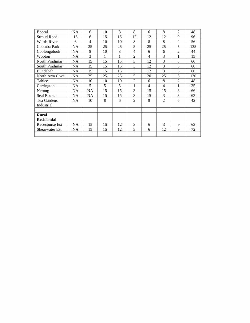
Risk Assessment
0
20
40
60
80
100
120
140
160
Abbott
Rd
Malcolm
s Rd
Harring
ton In
dustr
ialCarr
ington
Wing
ham In
dustr
ialRain
bow Flat
Helmich
Cl
John
s Rive
rNab
iac R
ural
Tea G
arden
s Ind
ustria
l
Coolon
goloo
kKram
bach
Colonia
l Leis
ure V
illage
Limeb
urners
Cree
kTah
leeMoo
rland
Glentho
rne
Homes
tead/H
eritag
e Esta
teW
arwiba
Racec
ourse
Est
North P
indim
arBun
daba
hCrow
dy H
ead
Cedar
Party
Bunga
y
North A
rm C
ove
Scor
e