Embed Size (px)
Citation preview
Riparian Vegetation inOregon's Western Cascade Mountains:
Composition, Biomass, and Autumn Phenology
Alsie G. Campbell and Jerry F. Franklin
Bulletin No 14 Coniferous Forest Biome Ecosystem Analysis Studies
.5.
F6
COMPACT
RIPARIAN VEGETATION IN OREGON'S WESTERN CASCADE MOUNTAINS:COMPOSITION, BIOMASS, AND AUTUMN PHENOLOGY
Alsie Gilbert CampbellResearch Associate, Coniferous Forest Biome
School of Forestry, Oregon State University, Corvallis, Oregon
Jerry F. FranklinForestry Sciences Laboratory, USDA Forest Service, Corvallis, Oregon
Bulletin No. 14Coniferous Forest Biome
Ecosystem Analysis StudiesU.S./International Biological Program

ii
This research was supported by Mclntire-Stennis Funds and by NationalScience Foundation grant no. GB-36810X to the Coniferous Forest Biome,Ecosystem Analysis Studies. This is contribution no. 345 from theConiferous Forest Biome. Any portion of this publication may be re-produced for purposes of the U.S. Government. Copies are availablefrom the Coniferous Forest Biome, University of Washington, AR-10,Seattle, WA 98195.
June 1979
111
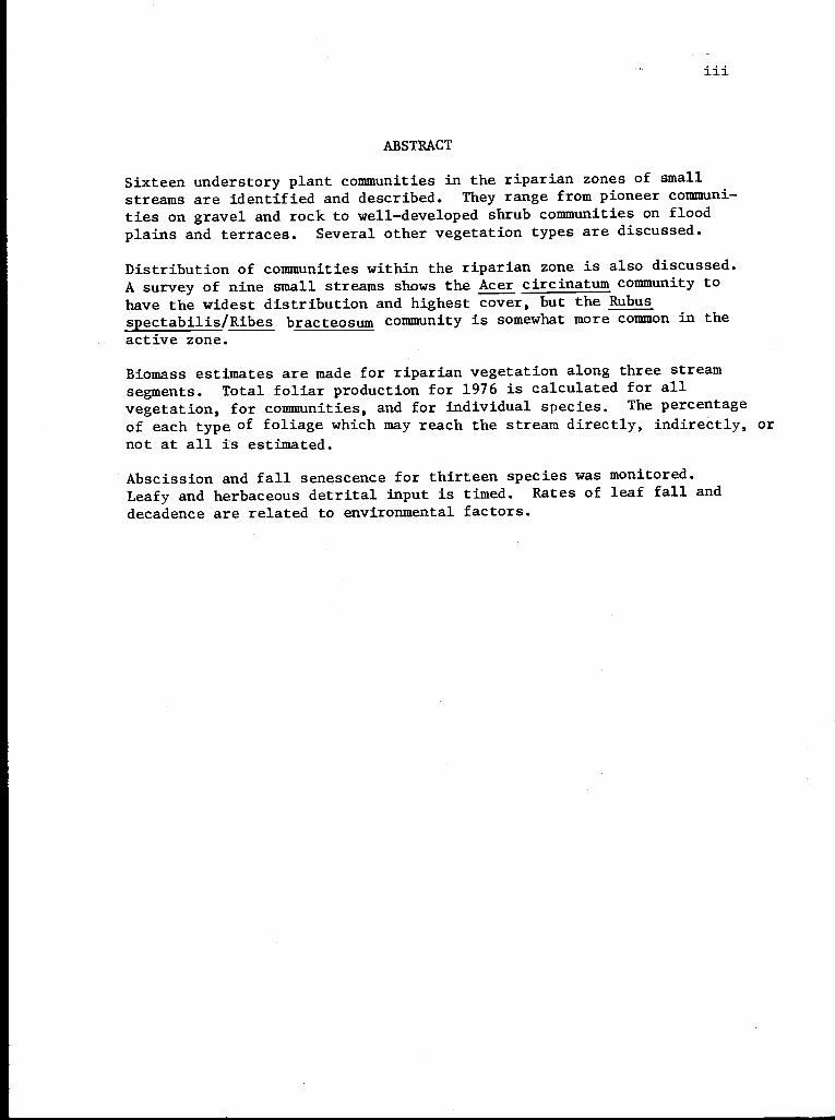
ABSTRACT
Sixteen understory plant communities in the riparian zones of smallstreams are identified and described. They range from pioneer communi-ties on gravel and rock to well-developed shrub communities on floodplains and terraces. Several other vegetation types are discussed.
Distribution of communities within the riparian zone is also discussed.A survey of nine small streams shows the Acer circinatum community tohave the widest distribution and highest cover, but the Rubusspectabilis/Ribes bracteosum community is somewhat more common in theactive zone.
Biomass estimates are made for riparian vegetation along three streamsegments. Total foliar production for 1976 is calculated for allvegetation, for communities, and for individual species. The percentageof each type of foliage which may reach the stream directly, indirectly, or
not at all is estimated.
Abscission and fall senescence for thirteen species was monitored.Leafy and herbaceous detrital input is timed. Rates of leaf fall anddecadence are related to environmental factors.
V
TABLE OF CONTENTS
Introduction 1
Study Areas 1
Location 1
Weather 2
Soils 2
Streams 3
Stream order 3
Streamside morphology 4
Methods 7
Community Description 7
Community Distribution 8
Biomass Estimates 8
Rating and Timing Leaf Fall and Senescence 10
Communities and Their Distribution 10
Descriptions of Communities 14
Small-herb pioneer communities 15
Wet-rock pioneer communities 17
Pioneer Boykinia elata 18
Pioneer Tolmiea menziesii 18
Rhyzomatous clans and communities 19
Petasites frigidus 19
Stachys cooleyae 21
Hydrolophyllum tenuipes 22
Well-developed herbaceous communities 22
Boykinia elata 22
Tolmiea menziesii 24
Mitella ovalis/Marchantia 25
Athyrium filix-femina 26
Mixed fern/mixed large-herb vegetation 27
Shrub communities 27
Rubus spectabilis/Ribes bracteosum 27
Oplopanax horridum 29
Acer circinatum 30
Topographic climax communities 31
Bryophyte/Montia parvifolia 31
Adiantum pedatum/precipice 34
Petasites frigidus/Brachythecium frigidum 34
Riparian Forest Succession 35
Community Ordination 36'Biomass Estimates 38
Aggregate Foliar Biomass 39
Biomass Production by Community 40
Large-herb communities 42
Shrubby communities 43
Medium-size-herb communities 43
Small-herb communities 43
Biomass Production by Species 44
Species common to WS 2 and Mack Creek old-growth 45
Species found chiefly in Mack Creek old-growth 47
Species found chiefly in the Mack Creek clearcut 48
Reliability of Biomass Estimates 49
vi
Autumn Phenology 52
Timing 52
Abscission Rates 54
Duration of Leaf Fall 57
Rate of Senescence in Herbaceous Plants 58
Other Sources of Litter 60
Summary 61
References 63
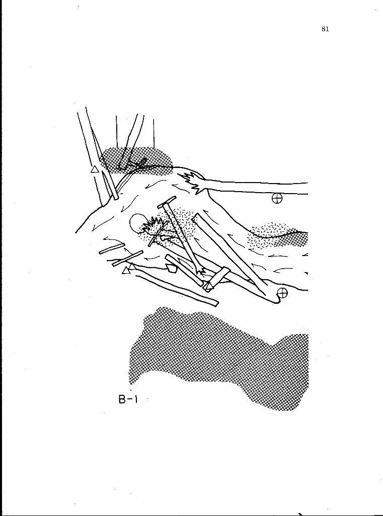
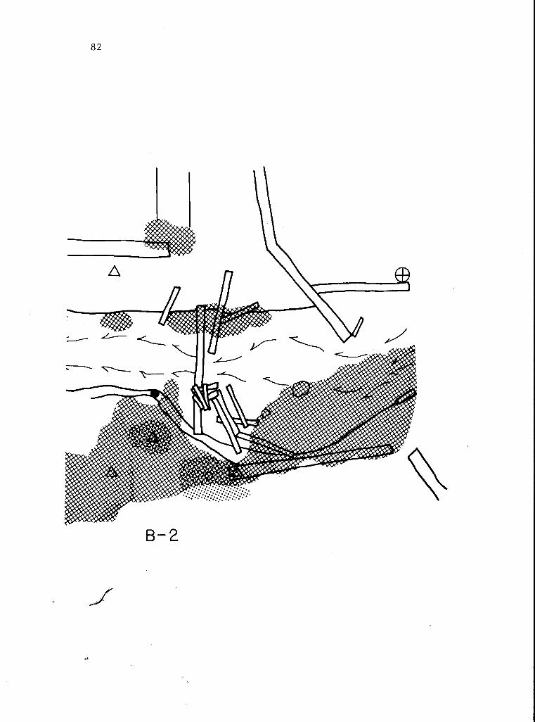
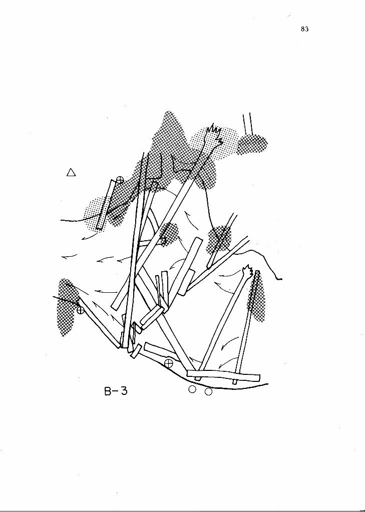
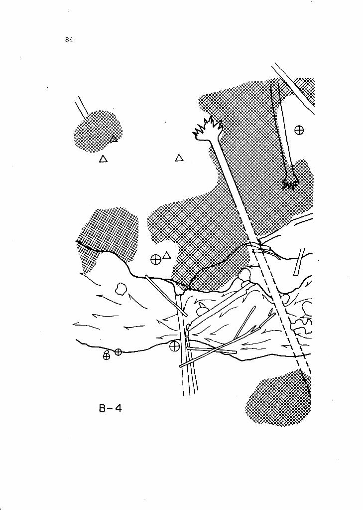
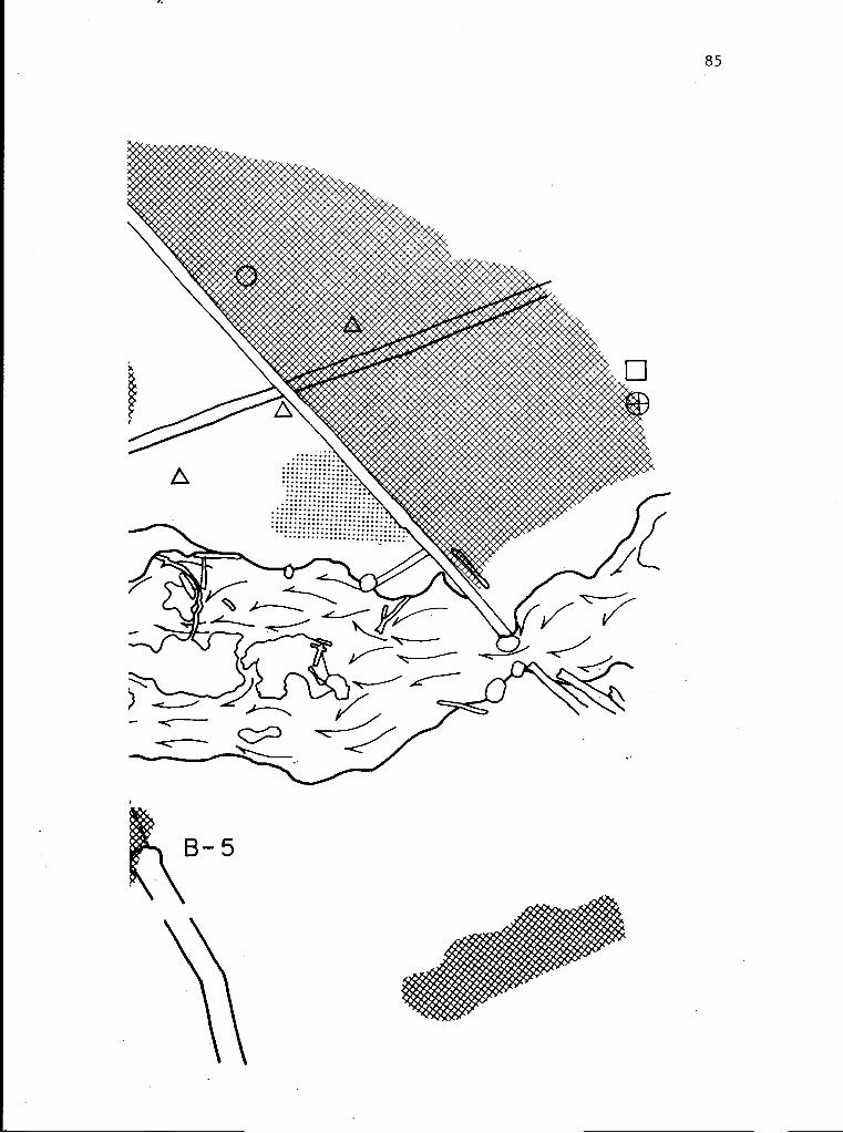
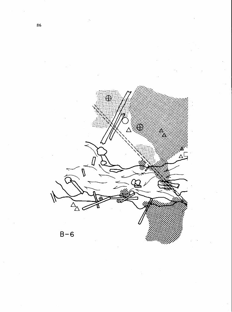
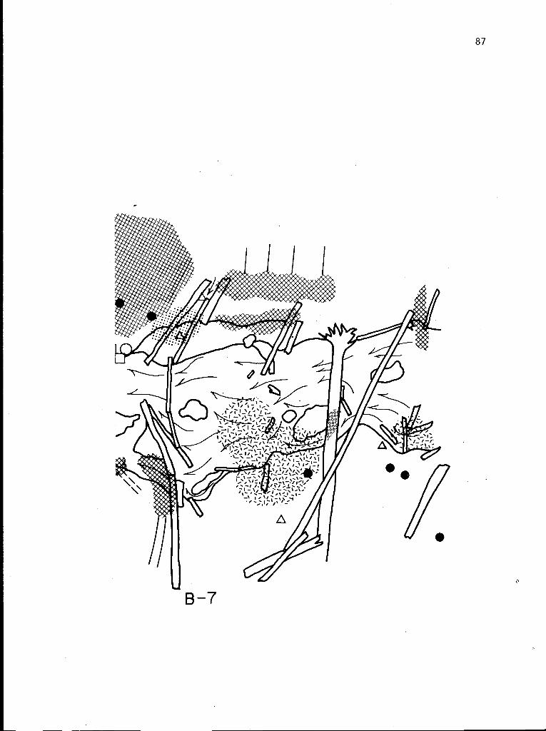
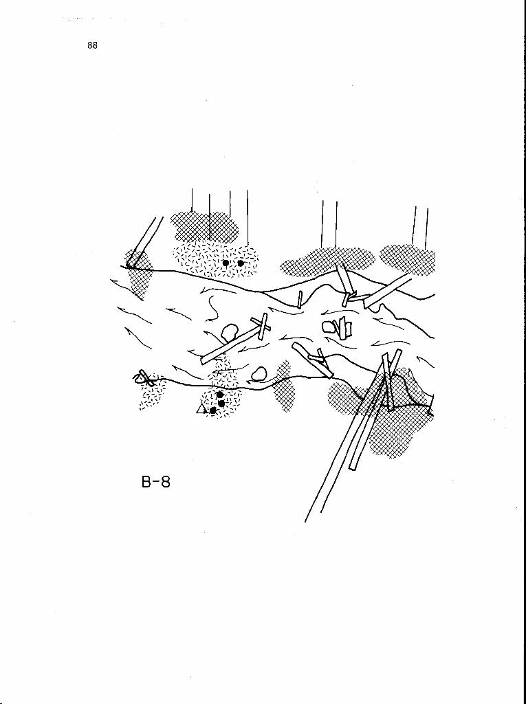
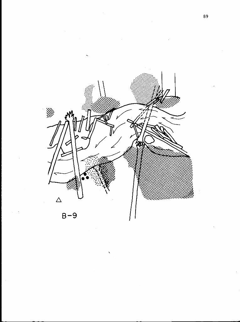
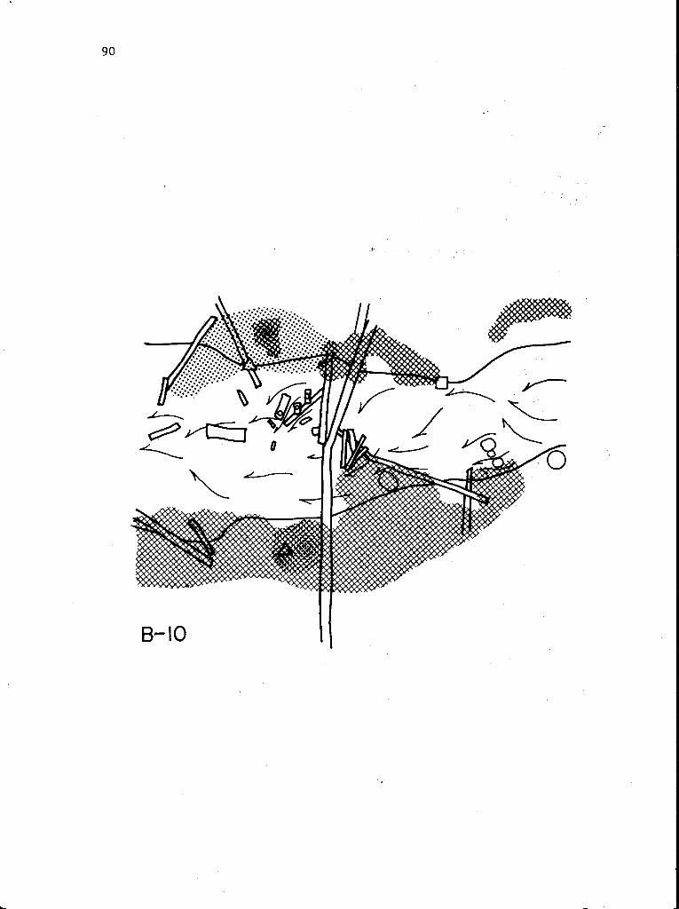
Appendix: Maps of Riparian Communities in Mack Creek Old-Growth 65
Map Overview 65
Symbols 67
Series A Key 68
Series B Key 80
Vii
LIST OF FIGURES
Figure 1Figure 2Figure 3Figure 4Figure 5Figure 6Figure 7Figure 8Figure 9Figure 10Figure 11Figure 12Figure 13Figure 14
LIST OF TABLES
Table 1Table 2Table 3Table 4Table 5Table 6Table 7Table 8Table 9Table 10Table 11Table 12Table 13Table 14Table 15Table 16Table 17Table 18Table 19Table 20Table 21Table 22Table 23Table 24Table 25Table 26Table 27Table 28
3
1011-12
1316-1720-2123-24
2829
30
32-3335
3939
404041
41
42
4445
464647
47
484857
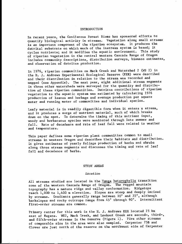
INTRODUCTION
In recent years, the Coniferous Forest Biome has sponsored efforts toquantify biological activity in streams. Vegetation along small streamsis an important component of the riparian ecosystem. It produces the
detrital substrate on which much of the instream system is based; it
cycles nutrients; and it modifies the aquatic environment. This study
of riparian vegetation in the central western Cascade Range of Oregonincludes community descriptions, distribution surveys, biomass estimates,
and observation of detritus production.
In 1976, riparian communities on Mack Creek and Watershed 2 (WS 2) inthe H. J. Andrews Experimental Ecological Reserve (EER) were describedand their distribution in relation to the stream was recorded and
mapped (see Appendix). The next year, eight additional stream segmentsin three other watersheds were surveyed for the quantity and distribu-
tion of these riparian communities. Detritus contributions of riparian
vegetation to the aquatic system was estimated by calculating 1976
production of leaves and herbage and average production per squaremeter and running meter of communities and individual species.
Leafy material is in readily digestible form when it enters a stream,
and it produces a surge of nutrient material, much of which breaksdown on the spot. To determine the timing of this nutrient input,
woody and herbaceous species were monitored through late summer andfall. Rate of decadence and rate of leaf fall were related to weather
and temperature.
This paper defines some riparian plant communities common to smallstreams in western Oregon and describes their habitats and distribution.It gives estimates of yearly foliage production of herbs and shrubs
along three stream segments and discusses the timing and rate of leaffall and decadence of herbs.
STUDY AREAS
Location
All streams studied are located in the Tsuga heterophylla transitionzone of the western Cascade Range of Oregon. The rugged mountaintopography has a mature ridge and valley conformation. Ridgetopsreach 1,000 to 1,400 m elevation. Slopes are steep and deeply incisedby streams. Gradients generally range between 10° and 35°, althoughbackslopes and rocky outcrops range from 45° through 90°. Intermittentfirst-order streams are common.
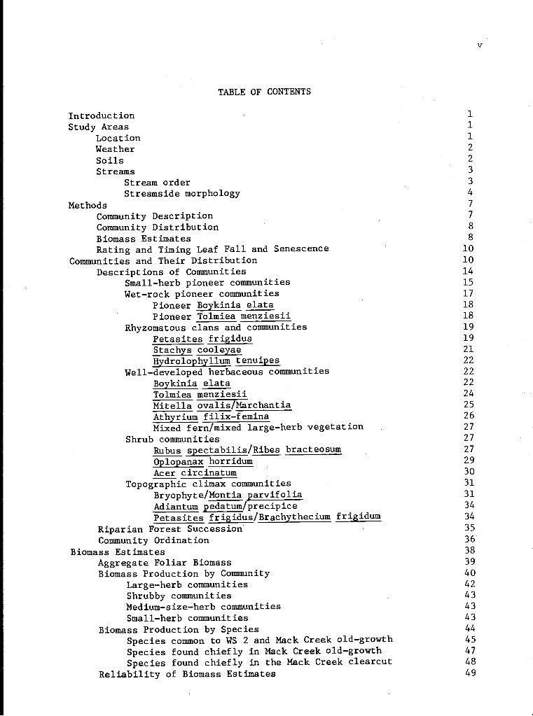
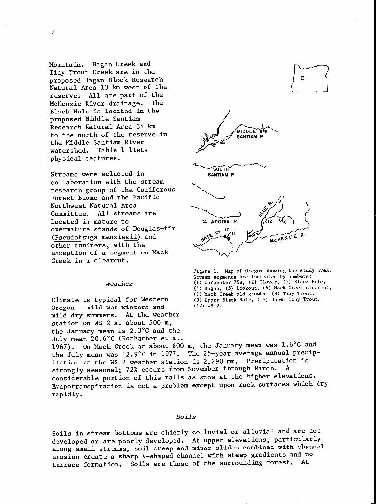
Primary center for this work is the H. J. Andrews EER located 75 kmeast of Eugene. WS2, Mack Creek, and Lookout Creek are second-, third-,and fifth-order streams in the reserve (Figure 1). Five other streamsof comparable size in the area were also sampled. Carpenter 75B andClover are just north of the reserve on the northwest side of Carpenter
2
Mountain. Hagan Creek andTiny Trout Creek are in theproposed Hagan Block ResearchNatural Area 13 km west of thereserve. All are part of theMcKenzie River drainage. The
Black Hole is located in theproposed Middle SantiamResearch Natural Area 34 kmto the north of the reserve inthe Middle Santiam Riverwatershed. Table 1 lists
physical features.
Streams were selected incollaboration with the streamresearch group of the ConiferousForest Biome and the PacificNorthwest Natural AreaCommittee. All streams arelocated in mature toovermature stands of Douglas-fir(Pseudotsuga menziesii) andother conifers, with theexception of a segment on MackCreek in a clearcut.
Weather
Climate is typical for WesternOregon---mild wet winters andmild dry summers. At the weatherstation on WS 2 at about 500 m,
Figure 1. Map of Oregon showing the study area.Stream segments are indicated by numbers:(1) Carpenter 75B, (2) Clover, (3) Black Hole,(4) Hagan, (5) Lookout, (6) Mack Creek clearcut,(7) Mack Creek old-growth, (8) Tiny Trout,(9) Upper Black Hole, (11) Upper Tiny Trout,(12) wS 2.
the January mean is 2.3°C and theJuly mean 20.6°C (Rothacher et al.1967). On Mack Creek at about 800 in, the January mean was 1.6°C andthe July mean was 12.9°C in 1977. The 25-year average annual precip-itation at the WS 2 weather station is 2,290 mm. Precipitation isstrongly seasonal; 72% occurs from November through March. A
considerable portion of this falls as snow at the higher elevations.Evapotranspiration is not a problem except upon rock surfaces which dryrapidly.
soils
Soils in stream bottoms are chiefly colluvial or alluvial and are notdeveloped or are poorly developed. At upper elevations, particularlyalong small streams, soil creep and minor slides combined with channelerosion create a sharp V-shaped channel with steep gradients and noterrace formation. Soils are those of the surrounding forest. At
SOUTHSANTIAM R.
3
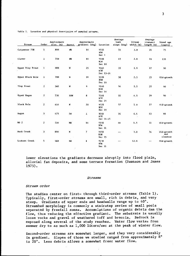
Table 1. Location and physical description of sampled streams.
Average AverageApproximate Approximate bank Stream transect Stand age
Stream Order elev. (m) Aspect gradient (deg) Location slope (deg) width (m) length (m) (years)
Carpenter 75B 1 800 NW 10 T15SR5E
33 3.0 21 75
Sec 1
Clover 1 750 NW 10 T15SR5E
45 2.8 19 135
Sec 10
Upper Tiny Trout 1 680 W 25 T16SR3E
33 1.9 17 90
Sec 13-14
Upper Black Hole 1 700 N 20 T12SR5E
38 2.5 25 Old-growth
Sec 19
Tiny Trout 2 560 W 9 T16SR3E
36 2.5 22 90
Sec 14
Upper Hagan 2 530 SSW 8 T16SR3E
32 4.5 29 90
Sec 14
Black Hole 2 610 N 20 T12SR5E
37 5.9 27 Old-growth
Sec 19
Hagan 3 475 SW 1 T16SR3E
36 6.4 43 90
Sec 14-15
WS 2 2 530 NW 14 T15SR5E
46 1.5 11 Old-growth
Sec 31
Mack Creek 3 800 N 7 T15S -- 3.0 36 Old-growthR5E and
Sec 35 clearcut
Lookout Creek 5 460 SW 1 T15SR5E
-- 12.0 -- Old-growth
Sec 31
lower elevations the gradients decrease abruptly into flood plain,
alluvial fan deposits, and some terrace formation (Swanson and James1975).
Streams
Stream order
The studies center on first- through third-order streams (Table 1).Typically, first-order streams are small, rich in debris, and verysteep. Gradients of upper ends and headwalls range up to 40°.Streambed morphology is commonly a stairstep series of small poolsseparated by freefall zones. Accumulations of organic debris dam theflow, thus reducing the effective gradient. The substrate is usuallyloose rocks and gravel of weathered tuff and breccia. Bedrock isexposed along several of the study reaches. Water flow varies fromsummer dry to as much as 1,000 liters/sec at the peak of winter flow.
Second-order streams are somewhat larger, and they vary considerablyin gradient. Slopes of those we studied ranged from approximately 8°to 20°. Less debris allows a somewhat freer water flow.
4
Third-order streams are large enough to influence the surroundingforest and to produce canopy openings. Gradients are less than smallerstreams; some occupy valley bottoms with slopes of about 1°. Organic
debris must be very large to remain in place through heavy winterflows, and less of the stream area is occupied by logs. Weatheredrock is the common substrate. Surface water flows all year. Winterhigh-water periods are brief, and water height is extremely variable.
Bedrock may be present regardless of order. Bedrock controls thegradient, forming a series of high falls and deep pools or, in somecases, a chute of uniform slope several meters long. Little organicdebris accumulates in the channel in areas of exposed bedrock.
Streamside morphology
Historically, riparian vegetation is defined as vegetation rooted atwater's edge. Plants rooted well back from the stream, however, alsoinfluence stream structure and chemistry, and the stream influencesvegetation well beyond its water line. We have defined the border of theriparian zone (the break) as the point beyond which shrubby vegetationno longer interacts with the stream.
The break is frequently marked by a change in slope or in vegetation,commonly the top of a cliff, a pile of debris, or an abruptly morexeric community. The zone varies greatly in width.
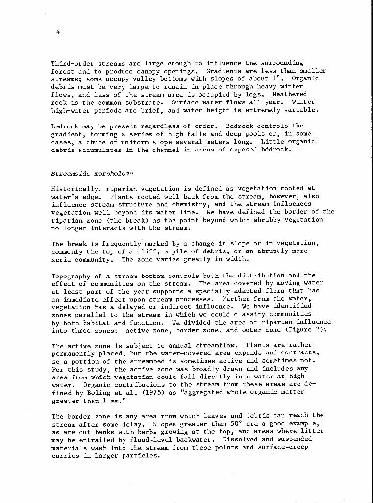
Topography of a stream bottom controls both the distribution and theeffect of communities on the stream. The area covered by moving waterat least part of the year supports a specially adapted flora that hasan immediate effect upon stream processes. Farther from the water,vegetation has a delayed or indirect influence. We have identifiedzones parallel to the stream in which we could classify communitiesby both habitat and function. We divided the area of riparian influenceinto three zones: active zone, border zone, and outer zone (Figure 2).
The active zone is subject to annual streamflow. Plants are ratherpermanently placed, but the water-covered area expands and contracts,so a portion of the streambed is sometimes active and sometimes not.For this study, the active zone was broadly drawn and includes anyarea from which vegetation could fall directly into water at highwater. Organic contributions to the stream from these areas are de-fined by Boling et al. (1975) as "aggregated whole organic mattergreater than 1 mm."
The border zone is any area from which leaves and debris can reach thestream after some delay. Slopes greater than 50° are a good example,as are cut banks with herbs growing at the top, and areas where littermay be entrailed by flood-level backwater. Dissolved and suspendedmaterials wash into the stream from these points and surface-creepcarries in larger particles.
5
I I
'
I
0 2 4 6m ACTIVE ZONE
OUTER ZONEBORDER ZONEACTIVE ZONE
BREAK
Figure 2. Position of the break and areas which can be designated active,border, and outer zones. The riparian zone as defined in this study extends
from break to break.
The outer zone is the area within riparian influence, by topography orvegetation or both, from which leaves cannot reach the stream.
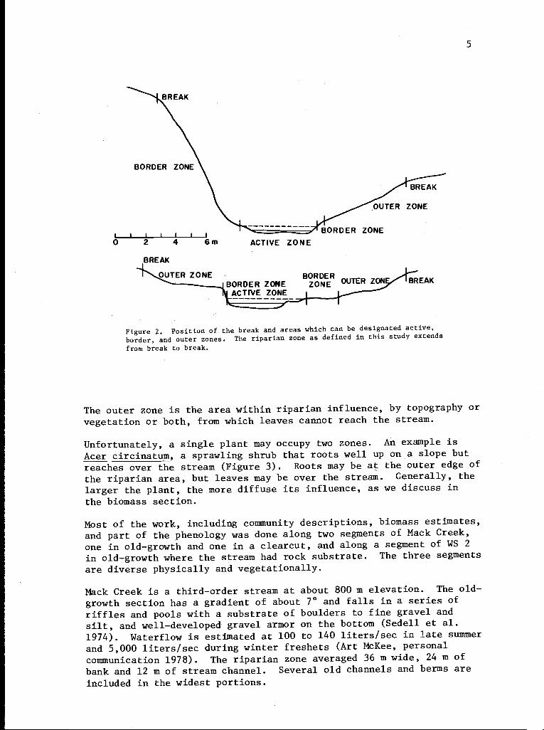
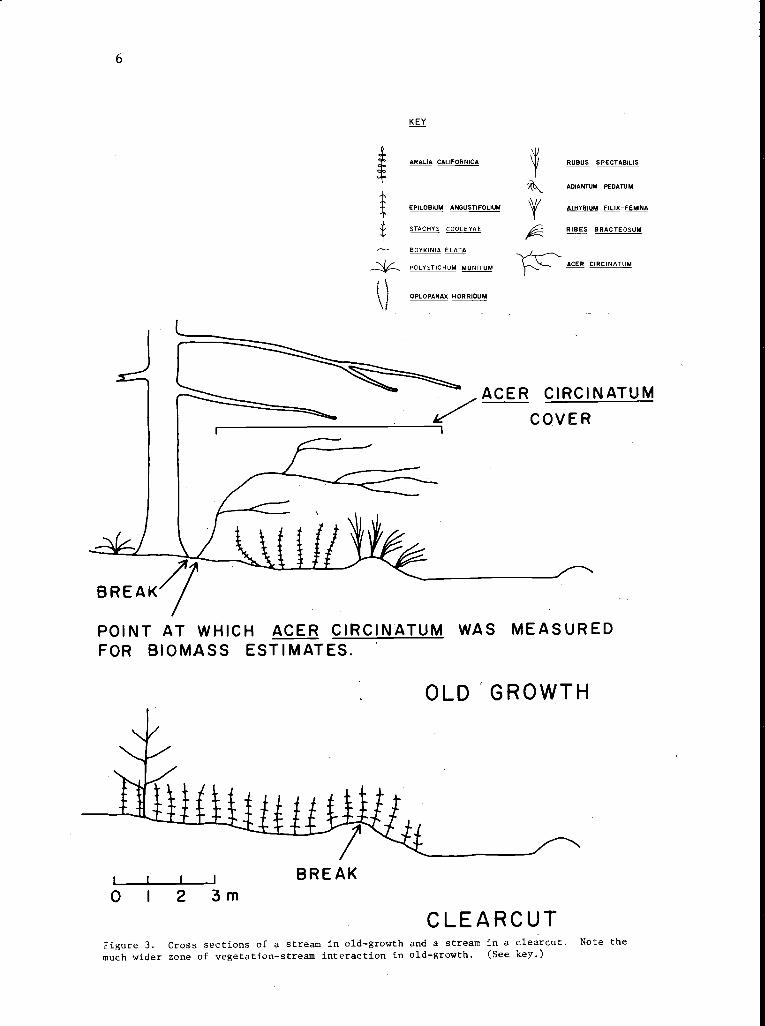
Unfortunately, a single plant may occupy two zones. An example isAcer circinatum, a sprawling shrub that roots well up on a slope butreaches over the stream (Figure 3). Roots may be at the outer edge ofthe riparian area, but leaves may be over the stream. Generally, thelarger the plant, the more diffuse its influence, as we discuss inthe biomass section.
Most of the work, including community descriptions, biomass estimates,and part of the phenology was done along two segments of Mack Creek,one in old-growth and one in a clearcut, and along a segment of WS 2in old-growth where the stream had rock substrate. The three segmentsare diverse physically and vegetationally.
Mack Creek is a third-order stream at about 800 m elevation. The old-growth section has a gradient of about 7° and falls in a series ofriffles and pools with a substrate of boulders to fine gravel andsilt, and well-developed gravel armor on the bottom (Sedell et al.1974). Waterflow is estimated at 100 to 140 liters/sec in late summerand 5,000 liters/sec during winter freshets (Art McKee, personalcommunication 1978). The riparian zone averaged 36 m wide, 24 m ofbank and 12 m of stream channel. Several old channels and berms areincluded in the widest portions.
6
I
OPLOPANAX HORRIOUM
RUBUS SPECTABILIS
ADIANTUM PEDATUM
ATHYRIUM FILIX-FEMINA
RISES BRACTEOSUM
ACER CIRCINATUM
ACER CIRCINATUM
COVERI
BREAK
POINT AT WHICH ACER CIRCINATUM WAS MEASUREDFOR BIOMASS ESTIMATES.
OLD 'GROWTH
1f
KEY
ARALIA CALIFORNICA
EPILOBIUM ANGUSTIFOLIUM
STACHYS COOLEYAE
BOYKINIA ELATA
POLYSTICHUM MUNITUM
L0
L12 3m
BREAK
CLEARCUTFigure 3. Cross sections of a stream in old-growth and a stream in a clearcut. Note themuch wider zone of vegetation-stream interaction in old-growth. (See key.)
The width of the riparian zone in the clear-cut section of Mack Creek
averages 11 m. Berms closely border the stream for most of its
length. Because there is no overstory, the riparian zone is narrowly
confined (Figure 3). Other physical characteristics of the clear-cut
segment of Mack Creek are similar to those of the old-growth section.
Watershed 2 is drained by a second-order stream with an averagegradient of 14° (Swanson, pesonal communication 1977). Streamflow
ranges from 0.1 liter/sec in late summer to 990 liter/sec at peak
flow (Harr 1976). Watershed 2 in the sampled area runs over bedrockscoured by a debris torrent in the late 1940's. There is little
gravel, and accumulations of fine particles are severely disturbed by
each high flow. The riparian zone, including 1.5 m of stream, averaged
11 m wide. Steep and often rocky side walls characterize the sampled
section.
METHODS
Community Description
Stand tables were developed for 16 communities found along Mack Creek,WS 2, and Lookout Creek. Because the communities differ physiogno-mically, they could be stratified by preliminary visual reconnaisance.For estimating cover in shrub communities, 10-m transects were locatedin six or more stands where the vegetation was homogeneous in the lowerstrata. Each stand was well within a community type. Shrub coverwas estimated in ten adjacent 1-m2 quadrats along each transect--atleast 60 samples from six stands. Herb cover was estimated in a 50-x 20-cm plot nested within each of the larger quadrats. Extremevariability in slope made it necessary to place all quadrats parallelto the ground surface.
Small herbaceous communities in the riparian zone are typically frag-mented. When possible, transects were composed of ten adjacent 20- x50-cm plots. More frequently the vegetation was isolated on rocks inthe active streambed, in cracks on a cliff face, or on small gravelbars. In these cases, quadrats were laid through the available vegeta-tion. Because stands were sampled with unequal numbers of quadrats,constancy was used in place of frequency. Cover estimates were madefor each quadrat. Cover classes were estimated at 1% intervals up to5%, and at 5% intervals thereafter. Substrate type, water and rockcover, slope, and relation to the stream were noted for all plots.Slopes over 60° in some communitie's required the use of climbing aids.
Conspicuous differences between communities made it possible to dis-pense with computer-assisted sorting. A simple application ofSorenson's modified Bray-Curtis (1957) ordination technique providedvisual dimension to intercommunity relations.
8
Community Distribution
Community distribution was surveyed on eight segments of representativefirst- through third-order streams. They are 75B, Clover, Upper TinyTrout, Tiny Trout, Upper Hagan, Hagan, the Black Hole and Upper BlackHole. Ten transects were established at 31.6-rn intervals on eachsegment. Each transect, 3.16 m wide, was composed of adjacent 10-m2plots (3.16 x 3.16 m). Transects ran from break to break and weretherefore different lengths. Cover, by community type, was estimatedwithin each plot to the nearest 5%. Where there was no recognizable(described) community, dominant vegetation was recorded.
Each plot was assigned a zone designation. Frequently the zone wasprorated because of abrupt changes in terrain. Slope, aspect, debriscover and class, major stem size, overstory cover, and substrate wererecorded. Data were then summarized for total and proportional coverby stream, stream order, and zone.
Biomass Estimates
A 290-m stretch of Mack Creek in old-growth, a 220-m stretch of MackCreek in a clearcut, and a 115-m stretch of WS 2 were systematicallysampled in late July and early August of 1976 for standing foliarbiomass of understory riparian species. We later stratified thesamples into appropriate groups to estimate the average for individualunderstory communities and vegetation types. Systematic samplingassured that each community was sampled in proportion to its occurrencein the stream sections. Depauperate stands are therefore included inthe average biomass estimates for communities in the correct proportion.
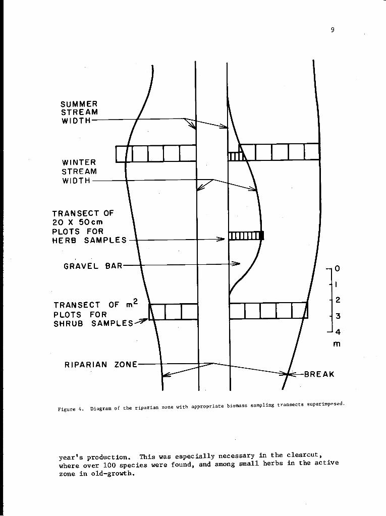
Transects were laid perpendicular from stream center to the break.On Mack Creek, transect lengths varied from 8 m to 39 m, plus about12 m of stream. On WS 2; transects varied from 4 m to 18 m. Herbaceouscommunities in the active zone and on cliff faces were sampled with a0.5-m wide transect in each 5 m of stream. Quadrats were adjacent20- x 50-cm plots. Shrub communities from water to the break weresampled with a 1-m wide transect in each 10-m interval. Quadratswere adjacent 1-m2 plots. All were a 10% sample (Figure 4). Eachquadrat was coded active, border, or outer riparian zone and assignedto a community. Quadrats were not included in communities if they werebare, sterile, debris covered, or such, but were included in overallaverages. In addition, slope was estimated with a clinometer, andaspect and surface cover were recorded.
All vegetation rooted within a quadrat was measured by species-specificunits suitable for conversion to biomass; for example, Rubus spectabiliswas measured for basal diameter, Epilobium angustifolium for height,and Adiantum pedatum for total length. We developed biomass estimationformulas for species limited to the riparian zone (Gholz et al. inpress). Equations for other species are those of Gholz, Russell(1973), Grier (1974), and Kessel (personal communication 1977). If wehad no equation for species of minor importance, we harvested the
9
SUMMERSTREAMWIDTH-
WINTERSTREAMWIDTH -
TRANSECT OF20 X 50cmPLOTS FORHERB SAMPLES-
GRAVEL BAR
I
I
000h1 LM
0
I
TRANSECT OFPLOTS FOR I
2
3SHRUB SAMPLES ------
4
m
RIPARIAN ZONE=BREAK
Figure 4. Diagram of the riparian zone with appropriate biomass sampling transects superimposed.
years production. This was especially necessary in the clearcut,where over 100 species were found, and among small herbs in the activezone in old-growth.
10
Biomass was calculated and summarized on the Oregon State University
computer with the help of Alfred T. Brown.
Rating and Timing Leaf Fall and Senescence
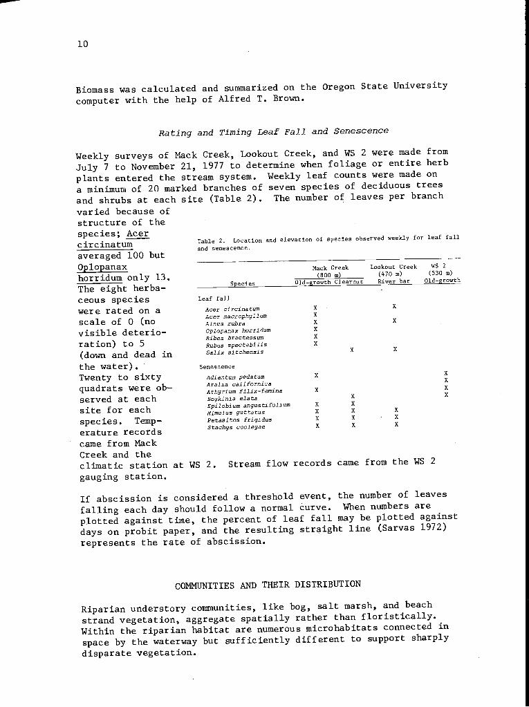
Weekly surveys of Mack Creek, Lookout Creek, and WS 2 were made fromJuly 7 to November 21, 1977 to determine when foliage or entire herbplants entered the stream system. Weekly leaf counts were made ona minimum of 20 marked branches of seven species of deciduous treesand shrubs at each site (Table 2). The number of leaves per branch
varied because ofstructure of thespecies; Acerc it c ina tum Table 2. Location and elevation of species observed weekly for leaf fall
and senescence.averaged 100 but
Oplopanax Mack Creek Lookout Creek WS 2
horridum only 13. (800 m) (470 m) (530 m)
The eight herba- Species Old-growth Clearcut River bar Old-growth
ceous species Leaf fall
were rated on a Acer circinatum X X
Acer macrophyllum X
scale of 0 (no Alnus rubra X X
visible deterio- Oplopanax horridum X
Ribes bracteosum Xration) to 5 Rubus spectabilis X
(down and dead in Salix sitchensis X X
the water).' Senescence
Twenty to sixty Adiantum pedatum X X
XAralia californicaquadrats were ob- Athyrium filix-femina X XXserved at each Boykinia elata X
Xsite for each Epilobium angustifoliumMimulus guttatus
X
X X X
species. Temp- Petasites frigidusaeleh
X
X
X
X
X
Xyys cooerature records
Stac
came from MackCreek and theclimatic station at WS 2. Stream flow records came from the WS 2
gauging station.
If abscission is considered a threshold event, the number of leaves
falling each day should follow a normal curve. When numbers are
plotted against time, the percent of leaf fall may be plotted againstdays on probit paper, and the resulting straight line (Sarvas 1972)
represents the rate of abscission.
COMMUNITIES AND THEIR DISTRIBUTION
Riparian understory communities, like bog, salt marsh, and beachstrand vegetation, aggregate spatially rather than floristically.Within the riparian habitat are numerous microhabitats connected in
space by the waterway but sufficiently different to support sharply
disparate vegetation.
11
Streamside vegetation patterns depend upon many factors: general
topography, stream gradient, and substrate type are important. Forest
fires, recent floods, and debris torrents leave clear evidence inpresent communities.
In spite of diverse elements, we find several general riparian vege-tation patterns, an obvious one connected with stream size. First-order
streams in mature stands tend to be totally dominated by the surround-
ing forest. The first-order stream is squeezed into a narrow strip,and riparian vegetation is distributed sparsely along the stream, like a
string of beads. Forest understory intrudes upon the riparian zone
and evergreen trees overtop all. Second- and third-order streams arelarge enough to exert more influence on the forest, creating andmaintaining open space.
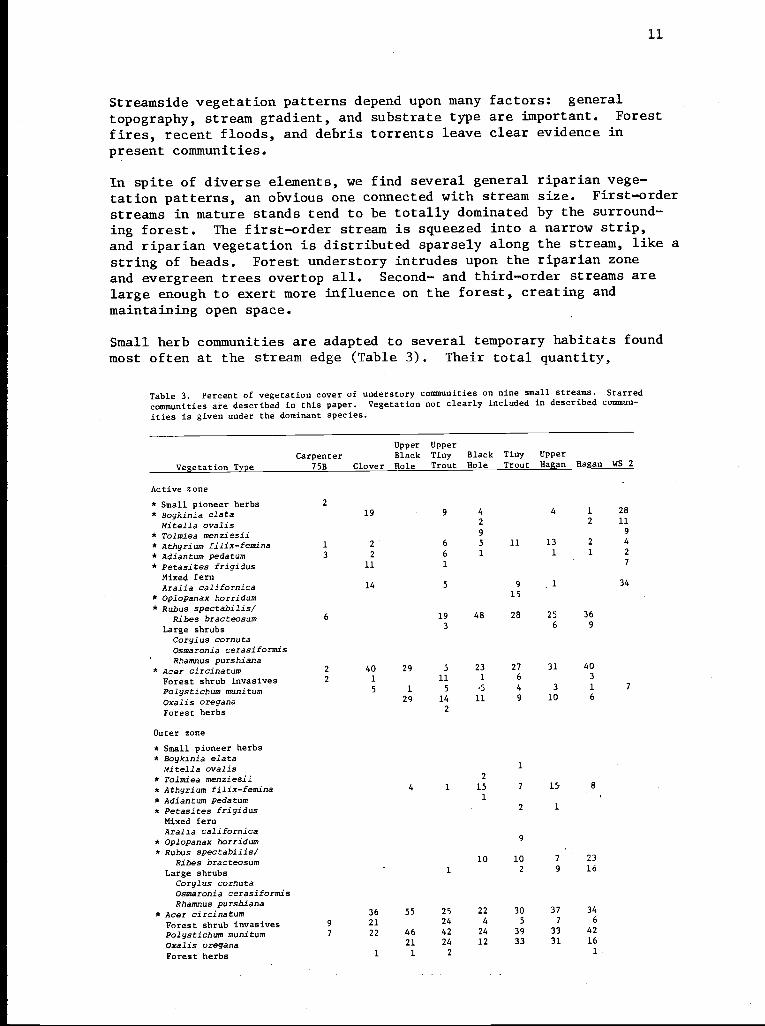
Small herb communities are adapted to several temporary habitats foundmost often at the stream edge (Table 3). Their total quantity,
Table 3. Percent of vegetation cover of understory communities on nine small streams. Starred
communities are described in this paper. Vegetation not clearly included in described commun-
ities is given under the dominant species.
Upper UpperCarpenter Black Tiny Black Tiny Upper
Vegetation Type 75B Clover Hole Trout Hole Trout Hagan Hagan WS 2
Active zone
* Small pioneer herbs 2
* Boykinia elate 19 9 4 4 1 28
Mitella ovalis 2 2 11
* Tolmiea menziesii 9 9
* Athyrium filix-femina 1 2 6 5 11 13 2 4
* Adiantum pedatum 3 2 6 1 1 1 2
* Petasites frigidus 11 1 7
Mixed fernAralia californica 14 5 9 1 34
* Oplopanax horridum 15
* Rubus spectabilis/Ribes bracteosum 6 19 48 28 25 36
Large shrubs 3 6 9
Corylus cornutaOsmaronia cerasiformis -
Rhamnus purshiana* Acer circinatum 2 40 29 5 23 27 31 40
Forest shrub invasives 2 1 11 1 6 3
Palystichum munitum 5 1 5 5 4 3 1 7
oxalis oregana 29 14 11 9 10 6
Forest herbs 2
Outer zone
* Small pioneer herbs* Boykinia elate
Mitella ovalis 1
* Tolmiea menziesii 2
* Athyrium filix-femina 4 1 15 7 15 8
* Adiantum pedatum 1
* Petasites frigidus 2 1
Mixed fernAralia californica
* Oplopanax horridum 9
* Rubus spectabilis/10 10 7 23Ribes bracteosum
Large shrubs 1 2 9 16
Corylus cornutaOsmaronia cerasiformisRhamnus purshiana
* Acer circinatum 6 5 5 2 0 7 4
Forest shrub invasives 9 21 24 4 5 7 6
Palystichum munitum 7 22 46 42 24 39 33 42
Oxalis oregana 21 24 12 33 31 16
Forest herbs 1 1 2 1

12
Table 3 (cont.)
CarpenterUpperBlack
UpperTiny Black Tiny Upper
Vegetation Type 75B Clover Hole Trout Hole Trout Hagan Hagan WS 2
Border zone
* Small pioneer herbs 8
* Boykinia elata 2 6
Miteila ovalis 2
* Tolmiea menziesii 4 7 3
* Athyrium filix-femina 2 100 14 17 16 19 27 3
* Adiantum pedatum 2 50 3 4 4
* Petasites frigidus 2 3
Mixed fern 18
Aralia californica 1 19 41 4 3 10
* Oplopanax horridum 15
* Rubus spectabilis/Ribes bracteosum 40 11 8 47 26
Large shrubs 38 1 3
Corylus cornutaOsmaronia cerasiformisRhamnus purshiana
* Acer circinatum 5 8 8 3 0 3 7
Forest shrub invasives 12 8 4 3 6 2 5
Polystichum munitum 4 39 2 16 7 45 30
Oxalis oregana 43 20 45 2
Forest herbs 1 14 3
Entire riparian zone
* Small pioneer herbs 2
* Boykinia elata 3 2 1 13
Mitella ovalis 1 1 5
* Tolmiea menziesii 4 1 1 5
* Athyrium filix-femina 1 5 3 13 8 15 8 5
* Adiantum pedatum 1 1 2 1 1 3,
* Petasites frigidus 1 2 2 1 4
Mixed fern 12
Aralia californica 4 3 2 1 17
* Oplopanax horridum 11
* Rubus spectabilis/Ribes bracteosum 2 6 21 13 13 25
Large shrubs 2 1 8 13
Corylus cornutaOsmaronia cerasiformisRhamnus purshiana
* Acer circinatum 2 5 5 9 3 4 6 7 9
Forest shrub invasives 5 17 20 2 5 5 5 4
Polystichum munitum 4 21 31 31 18 28 26 35 19
Oxalis oregana 21 21 15 27 28 14
Forest herbs 2 1 2
measured as a percent of the total riparian area, remains fairlyconstant on first- and second-order streams (except on bedrock, whereit is much higher). We believe two factors contribute to the general
constancy. First, the understory cover on first-order streams isgenerally low; second, a first-order stream may consist of stream edgesonly--the water course is essentially absent. Sites suitable forsmall herbs are, therefore, a high percent of the total riparianarea, but vegetation in general is sparse under old-growth canopies,and the two factors tend to cancel each other. Small herb cover
tends to drop on larger streams because suitable sites compose a verylow percent of the riparian area.
Similar patterns are shown by large herbs. First-order streams gen-erally do not support a high cover because of drought and competition.The second-order stream has a constant water supply and a somewhatlarger suitable area. On third-order streams, the area covered by
13
large herbs may increase, but the riparian zone increases
more; therefore the proportion of cover decreases.
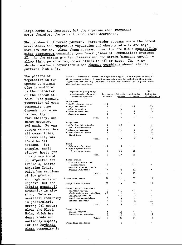
Shrubs show a different pattern. First-order streams where the forest
overshadows and suppresses vegetation and where gradients are high
have few shrubs. Along these streams, cover for the Rubus spectabilis/
Ribes bracteosum community (see Descriptions of Communities) averages
2%. As the stream gradient lessens and the stream broadens enough to
allow light penetration, cover climbs to 25% or more. The large
shrubs Osmaronia cerasiformis and Rhamnus purshiana showed similar
patterns (Table 4).
The pattern ofvegetation in re-sponse to streamsize is modifiedby the characterof the stream it-self. The preciseproportion of eachcommunity typedepends upon ele-vation, lightavailability, sed-iment movement,and such. No onestream segment hasall communities;no community wasfound on allstreams. Forexample, smallpioneer herbs (2%cover) are foundon Carpenter 75B(Table 3, EntireRiparian Zone),which has sectionsof low gradientand high sedimentdeposit, but theTolmiea menziesiicommunity is mis-sing. Tolmieamenziesii communityis particularlystrong (4% cover)along the BlackHole, which hasdense shade andnortherly aspect,but the Boykiniaelata community is
Table 4. Percent of cover for vegetation types in the riparian zone ofthree stream orders. Starred communities are described in this paper.Vegetation not clearly included in described communities is given underthe dominant species.
Vegetation grouped by WS 2,
physiognomic class of 1st-order 2nd-order 3rd-order 2nd-order
dominant species streams streams streams rock substrate
Small herb* Small pioneer herbs < 1 - - -
* Boykinia elata 1 1 < 1 13
Mitella ovalis - 1 - 5
* Tolmiea menziesii - 2 1 5
Oxalis oregana 5 2 1 -
Total 6 6 2 23
Large herb* Athyrium filix-femina 2 12 8 3
Aralia californica 1 1 17
* Adiantum pedatum 1 < 1 1 3
* Petasites frigidus 1 1 4
Mixed fern 12
Total 5 14 9 39
Shrub* Oplopanax horridum < 1 3 -* Rubus spectabilis/
Ribes bracteosum 2 16 25
Total 2 19 25
Large shrubsCorylus cornuta var.
californica < 1 1 < 1
Osmaronia cerasiformisRhamnus purshiana < 1 2 13
Total < 1 3 13
* Acer circinatum 26 31 37 9
Polystichum munitum 21 24 35 19
Forest shrub intrusivesBerberis nervosa 3 < 1 < 1Rhododendron macrophyllum < 1 - -Gaultheria shallon 2 < 1 1
Vaccinium parvifolium 3 4 4
Linnaea borealis 1 1
Total 9 4 5 1
Forest herbOxalis oregana 6 18 13
Vancouveria hexandra 1 3 1 2
Total 7 21 14 2
Pteridium aquilinum - 2 3
14
missing. The Boykinia elata community has greatest cover (3%) onClover Creek under a relatively open canopy.
The average total cover for all communities dominated by small herbsin nonbedrock segments (including Mack Creek), is just under 6%. The
total cover on WS 2, a bedrock-based stream scoured by a debris torrentin the late 1940's, increases dramatically to 23% (Table 4). The
large herb-dominated vegetation increases to 39%. Visual survey of
some segments of other streams not rigorously sampled suggests thatthese estimates are reasonable for other rock substrate streams.
Habitat type clearly is intrinsic to many of the following communitydescriptions. Habitat and distribution across the stream, therefore,will be covered under the community headings.
Descriptions of Communities
Sixteen potential communities have been identified, and stand tablesprepared. Several clans and other vegetation types are discussed.All of the communities described are seral, part of the permanentlyimmature vegetation of unstable habitats, and are composed of herbs or
shrubs. The overstory is treated as a constant factor and is notincluded in descriptions. Broadleaf riparian forests dominated byalder (Alnus rubra) and cottonwood (Populus trichocarpa), found onterraces of larger streams, are also not included in this study.
"Community" is used here to mean a repeating assemblage of plants. Amore precise terminology would require selection from the terms of
several theorists and might imply hierarchy where there is none.Clans are not necessarily part of synusiae, nor do synus-iae,particularly on smaller streams, always belong to the surroundingforest association. When descriptions have been assembled from awider area it will be possible to rank and classify them.
Because the moss flora of waterways is a broad subject, andbecause this study deals with vascular communities, only mosses withmajor cover values are recorded. Two communities are more properlyBryophyte communities and should be redefined on that basis later:Bryophyte/Montia parvifolia, found on summer dry rocks, and Petasitesfrigidus/Brachythecium frigidum, found in seeps. Detailed analysis
of moss species is needed for Bryophyte communities, where there areprobably several associations, and vasculars are unimportant. Only
mosses grow in numerous places on streams, particularly in old-growth
stands on rock faces and seepage areas.
These riparian communities are described and discussed in approxi-mate order of maturity:
Pioneer communitiesSmall-herb communityPioneer Boykinia elata communityPioneer Tolmia menziesii community
15
Rhyzomatous clans and communitiesPetasites frigidus clanStachys cooleyae clanMimulus guttatus clanPetasites frigidus communityStachys cooleyae communityHydrophyllum tenuipes community
Well-developed herbaceous communitiesBoykinia elata communityTolmiea menziesii communityMitella ovalis/Marchantia communityAthyrium filix-femina communityMixed fern-large herb vegetation
Shrub communitiesRubus spectabilis/Ribes bracteosum communityOplopanax horridum communityAcer circinatum community
Topographic climax communitiesBryophyte/Montia parvifolia communityAdiantum pedatum/precipice communityPetasites frigidus/Brachythecium frigidum community
Small-herb pioneer communities
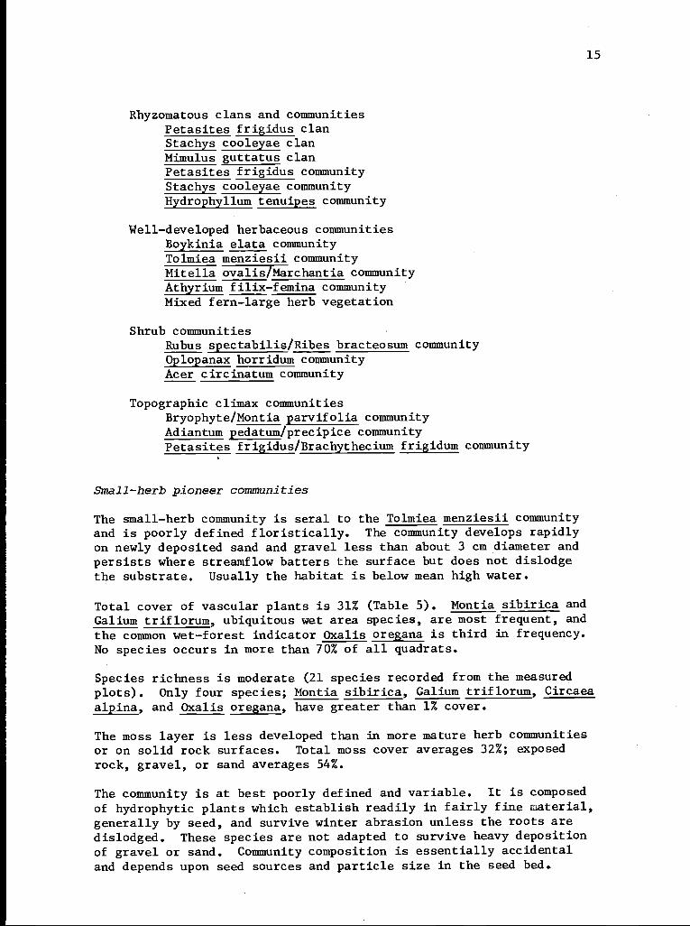
The small-herb community is seral to the Tolmiea menziesii communityand is poorly defined floristically. The community develops rapidlyon newly deposited sand and gravel less than about 3 cm diameter andpersists where streamflow batters the surface but does not dislodgethe substrate. Usually the habitat is below mean high water.
Total cover of vascular plants is 31% (Table 5). Montia sibirica andGalium triflorum, ubiquitous wet area species, are most frequent, andthe common wet-forest indicator Oxalis oregana is third in frequency.No species occurs in more than 70% of all quadrats.
Species richness is moderate (21 species recorded from the measuredplots). Only four species; Montia sibirica, Galium triflorum, Circaeaalpina, and Oxalis oregana, have greater than 1% cover.
The moss layer is less developed than in more mature herb communitiesor on solid rock surfaces. Total moss cover averages 32%; exposedrock, gravel, or sand averages 54%.
The community is at best poorly defined and variable. It is composedof hydrophytic plants which establish readily in fairly fine naterial,generally by seed, and survive winter abrasion unless the roots aredislodged. These species are not adapted to survive heavy depositionof gravel or sand. Community composition is essentially accidentaland depends upon seed sources and particle size in the seed bed.
16
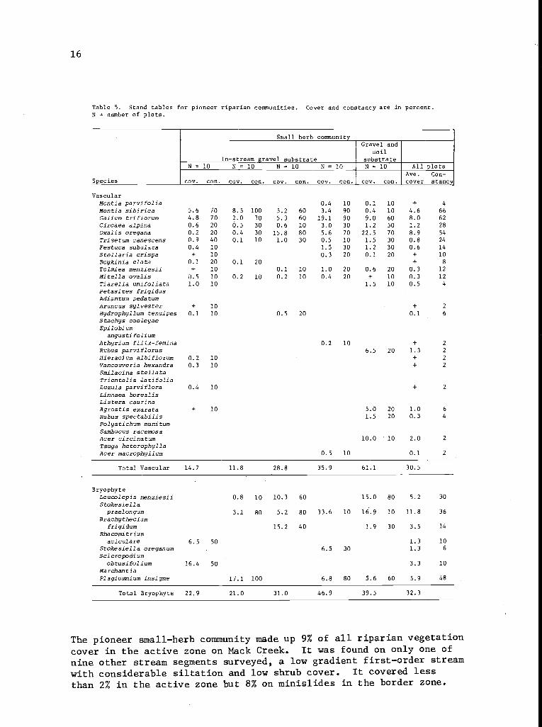
Table 5. Stand tables for pioneer riparian communities. Cover and constancy are in percent.N = number of plots.
Small herb communityGravel and
soilIn-stream gravel substrate substrate
N= 10 N = 10 N = 10 N = 10 N = 10 All plotsAve. Con-
Species cov. con. cov. con. cov. con. cov. con. cov. con. cover stance
VascularMontia parvifolia 0.4 10 0.1 10 + 4
Montia sibirica 5.6 70 8.5 100 5.2 60 3.4 90 0.4 10 4.6 66Galium triflorum 4.8 70 2.0 30 5.3 60 19.1 90 9.0 60 8.0 62
Circaea alpina 0.6 20 0.5 30 0.6 10 3.0 30 1.2 50 1.2 28
Oxalis oregana 0.2 20 0.4 30 15.8 80 5.6 70 22.5 70 8.9 54
Trisetum canescens 0.9 40 0.1 10 1.0 30 0.5 10 1.5 30 0.8 24
Festuca subulata 0.4 10 1.5 30 1.2 30 0.6 14
Stellaria crispa + 10 0.3 20 0.1 20 + 10
Boykinia elata 0.1 20 0.1 20 + 8
Tolmiea menziesii + 10 0.1 10 1.0 20 0.6 20 0.3 12
Mitella ovalis 0.5 10 0.2 10 0.2 10 0.4 20 + 10 0.3 12
Tiarella unifoliata 1.0 10 1.5 10 0.5 4
Petasites frigidusAdiantum pedatumAruncus sylvester + 10 + 2
Hydrophyllum tenuipes 0.1 10 0.5 20 0.1 6
Stachys cooleyaeEpilobium
angustifoliumAthyrium filix-femina .2 0 + 2
Rubus parviflorus 6.5 20 1.3 2
Hieracium albiflorum 0.2 10 + 2
Vancouveria hexandra 0.3 10 + 2
Smilacina stellataTrientalis .latifoliaLuzula parviflora 0.4 10 + 2
Linnaea borealisListera caurinaAgrostis exarata + 10 5.0 20 1.0 6
Rubus spectabilis 1.5 20 0.3 4
Polystichum munitumSambucus racemosaAcer circinatum 10.0 10 2.0 2
Tsuga heterophyllaAcer macrophyllum 0.5 10 0.1 2
Total Vascular 14.7 11.8 28.8 35.9 61.1 30.5
BryophyteLeucolepis menziesii 0.8 10 10.3 60 15.0 80 5.2 30
Stokesiellapraelongum 3.1 80 5.2 80 33.6 10 16.9 10 11.8 36
Brachytheciumfrigidum 15.2 40 1.9 30 3.5 14
Rhacomitriumaciculare 6.5 50 1.3 10
Stokesiella oreganum 6.5 30 1.3 6
Scleropodiumobtusifolium 16.4 50 3.3 10
MarchantiaPlagiomnium insigne 17.1 100 6.8 80 5.6 60 5.9 48
Total Bryophyte 22.9 21.0 31.0 46.9 39.5 32.3
The pioneer small-herb community made up 9% of all riparian vegetationcover in the active zone on Mack Creek. It was found on only one of
nine other stream segments surveyed, a low gradient first-order streamwith considerable siltation and low shrub cover. It covered less
than 2% in the active zone but 8% on minislides in the border zone.
17
Pioneer Boykinia elata community Pioneer Tolmiea menziesii comm nib
Bedrocksubstrate
Bedrock;large-boulders
N = 10 N = 10 All plots N= 10 N= 10 N=10 p ote
Species I cov. con. cov. con.
Ave.cover
Con-stancy cov. con. cov. con.cov. con.
Ave.
CoverCon-
stancY
VascularMontia parvifolia 0.1 10 5 0.3 20 18.0 80 2.0 40 6.8 47
Montia sibirica 1.4 40 0.1 10 1.1 20 0.9 23
Galium triflorum + 10 1.5 70 0.8 40 0.9 20 1.6 30 2.0 40 1.5 30
Circaea alpina 0.6 20 0.3 10 1.0 20 0.3 10 0.4 20 0.6 17
Oxalis oregana 0.8 40 0.8 20 0.1 20 0.6 27
Trisetum canescens 0.3 50 1.3 80 0.8 65 0.3 10 1.9 50 2.3 50 1.5 37
Festuca subulata 0.2 20 1.2 60 0.7 40 2.9 40 3.7 40 2.2 27
Stellaria crispa 0.5 10 0.1 20 0.2 10
Boykinia elata 39.0 100 70.5 100 54.8 100 0.1 20 0.9 40 0.3 20
Tolmiea menziesii 0.5 10 0.3 5 14.8 100 8.9 100 10.1 100 11.3 100
Mitella ovalis 6.9 80 3.3 50 5.1 65 0.1 10 0.4 30 0.2 13
Tiarella unifoliataPetasites frigidus 1.5 20 0.8 10
Adiantum pedatumAruncus sylvesterHydrophyllum tenuipesStachys cooleyaeEpilobium
angustifoliumAthyrium filix-feminaRubus parviflorusHieracium albiflorum 2 0 + 3
Vancouveria hexandraSmilacina stellata 0.1 10 + 5
Trientalis latifolia + 10 + 5
Luzula parvifloraLinnaea borealis 2.7 30 2.5 10 2.6 20
Listera caurina 0.2 30 0.1 15
Agrostis exarataRubus spectabilisPolystichum munitum 1.2 20 0.6 10
Sambucus racemosa 3.0 10 1.0 3
Acer circinatumTsuga heterophylla 1.0 10 0.3 3
Acer macrophyllum
Total Vascular 50.4 83.2 66.8 19.7 35.2 27.1 27.3
BryophyteLeucolepis menziesii 0.2 20 0.2 10 0.2 15
Stokesiellapraelongum 41.2 100 77.0 100 59.1 100 9.0 90 1.0 10 2.0 20 4.0 40
Brachytheciumfrigidum 27.7 100 4.5 70 16.1 85 41.5 100 57.5 100 63.0 100 54.0 100
Rhacomitriumaciculare 10.0 70 0.5 10 5.3 40 22.5 80 10.5 100 18.0 100 17.0 93
Stokesiella oreganumScleropodium
obtusifolium 10.7 70 5.4 35 5.0 70 6.5 90 4.0 40 5.1 67
Marchantia 1.0 10 0.5 5
Plagiomnium insigne
Total Bryophyte 80.1 92.9 66.5 78.0 75.5 87.0 80.1
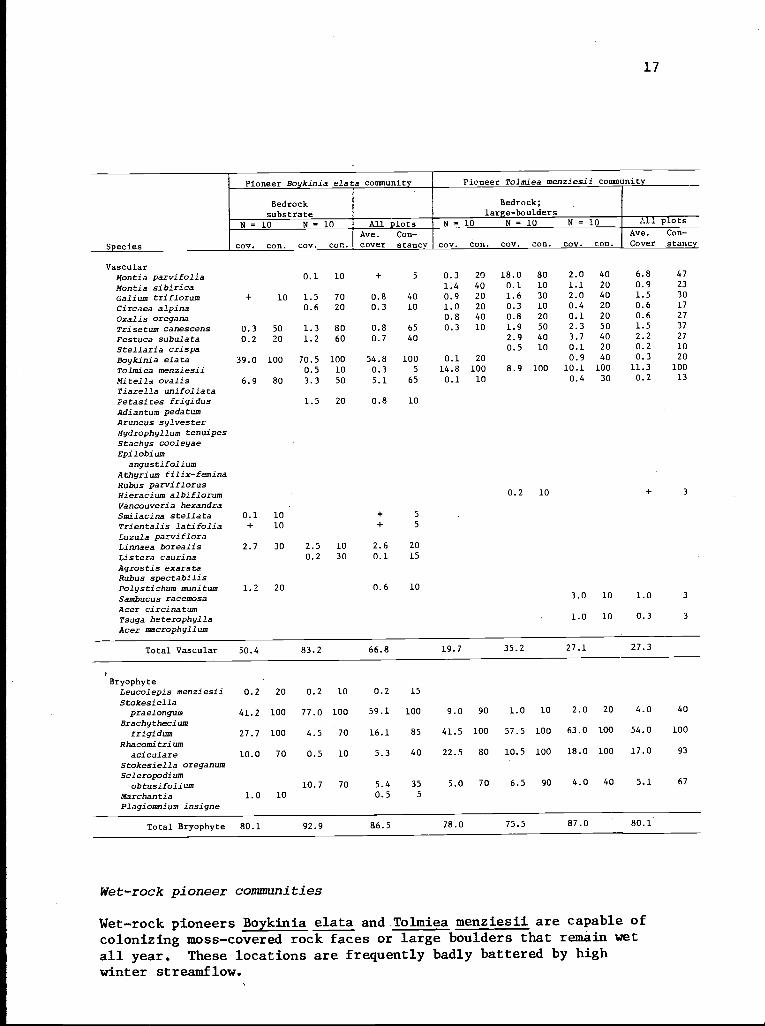
Wet-rock pioneer communities
Wet-rock pioneers Boykinia elata and Tolmiea menziesii are capable ofcolonizing moss-covered rock faces or large boulders that remain wetall year. These locations are frequently badly battered by highwinter streamflow.
18
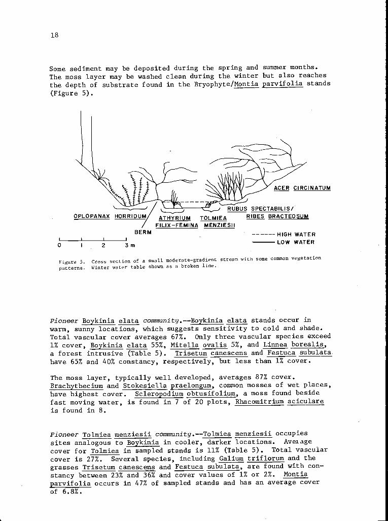
Some sediment may be deposited during the spring and summer months.
The moss layer may be washed clean during the winter but also reachesthe depth of substrate found in the Bryophyte/Montia parvifolia stands
(Figure 5).
-- J RUBUS SPECTABILIS/OPLOPANAX HORRIDUM ATHYRIUM TOLMIEA RIBES BRACTEOSUM
FILIX-FEMINA MENZIESIIBERM
I I I i
0 I 2 3 m
------HIGH WATERLOW WATER
Figure 5. Cross section of a small moderate-gradient stream with some common vegetation
patterns. Winter water table shown as a broken line.
Pioneer Boykinia elata community.--Boykinia elata stands occur inwarm, sunny locations, which suggests sensitivity to cold and shade.
Total vascular cover averages 67%. Only three vascular species exceed1% cover, Boykinia elata 55%, Mitella ovalis 5%, and Linnea borealis,a forest intrusive (Table 5). Trisetum canescens and Festuca subulatahave 65% and 40% constancy, respectively, but less than 1% cover.
The moss layer, typically well developed, averages 87% cover.Brachythecium and Stokesiella praelongum, common mosses of wet places,have highest cover. Scleropodium obtusifolium, a moss found besidefast moving water, is found in 7 of 20 plots, Rhacomitrium aciculareis found in 8.
Pioneer Tolmiea menziesii community.--Tolmiea menziesii occupiessites analogous to Boykinia in cooler, darker locations. Averagecover for Tolmiea in sampled stands is 11% (Table 5). Total vascularcover is 27%. Several species, including Galium triflorum and thegrasses Trisetum canescens and Festuca subulata, are found with con-stancy between 23% and 36% and cover values of 1% or 2%. Montiaparvifolia occurs in 47% of sampled stands and has an average coverof 6.8%.
19
In the moss layer, Brachythecium frigidum replaces Stokesiellapraelongum as dominant (100% frequency and 54% cover). Rhacomitriumaciculare, a species of splash zones, has 96% constancy and 17% cover.Total moss cover is 80%; the remainder is bare rock.
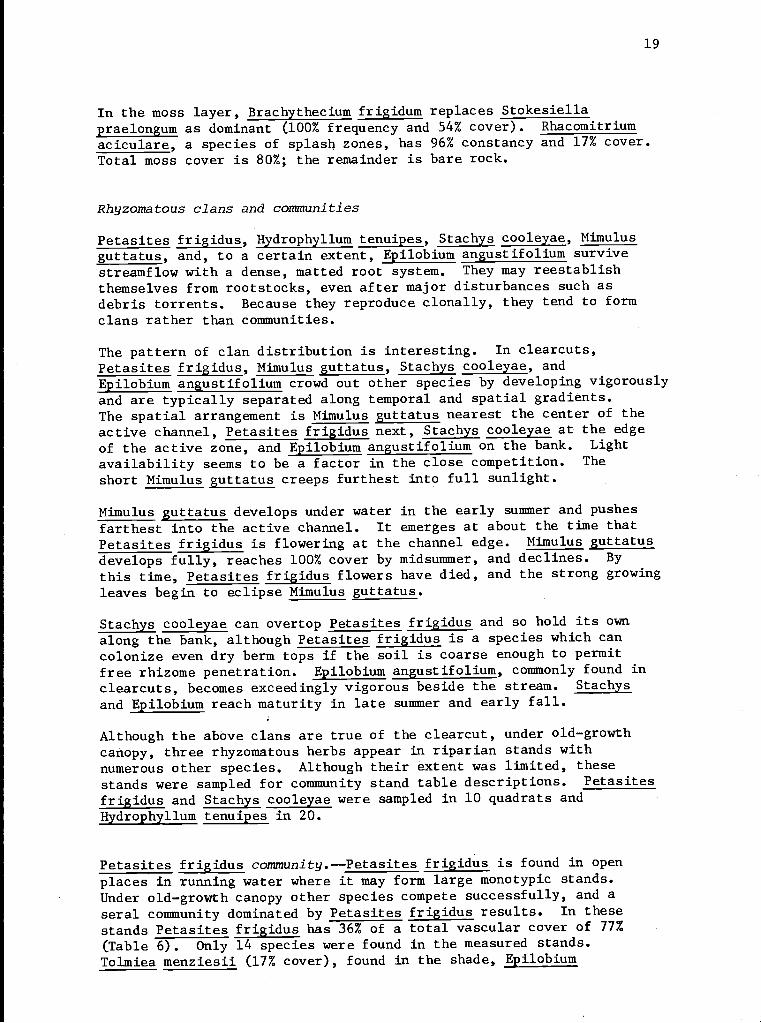
Rhyzomatous clans and communities
Petasites frigidus, Hydrophyllum tenuipes, Stachys cooleyae, Mimulusguttatus, and, to a certain extent, Epilobium angustifolium survivestreamflow with a dense, matted root system. They may reestablishthemselves from rootstocks, even after major disturbances such asdebris torrents. Because they reproduce clonally, they tend to formclans rather than communities.
The pattern of clan distribution is interesting. In clearcuts,Petasites frigidus, Mimulus guttatus, Stachys cooleyae, andEpilobium angustifolium crowd out other species by developing vigorouslyand are typically separated along temporal and spatial gradients.The spatial arrangement is Mimulus guttatus nearest the center of theactive channel, Petasites frigidus next, Stachys cooleyae at the edgeof the active zone, and Epilobium angustifolium on the bank. Lightavailability seems to be a factor in the close competition. Theshort Mimulus guttatus creeps furthest into full sunlight.
Mimulus guttatus develops under water in the early summer and pushesfarthest into the active channel. It emerges at about the time thatPetasites frigidus is flowering at the channel edge. Mimulus guttatusdevelops fully, reaches 100% cover by midsummer, and declines. Bythis time, Petasites frigidus flowers have died, and the strong growingleaves begin to eclipse Mimulus guttatus.
Stachys cooleyae can overtop Petasites frigidus and so hold its ownalong the bank, although Petasites frigidus is a species which cancolonize even dry berm tops if the soil is coarse enough to permitfree rhizome penetration. Epilobium angustifolium, commonly found inclearcuts, becomes exceedingly vigorous beside the stream. Stachysand Epilobium reach maturity in late summer and early fall.
Although the above clans are true of the clearcut, under old-growthcanopy, three rhyzomatous herbs appear in riparian stands withnumerous other species. Although their extent was limited, thesestands were sampled for community stand table descriptions. Petasitesfrigidus and Stachys cooleyae were sampled in 10 quadrats andHydrophyllum tenuipes in 20.
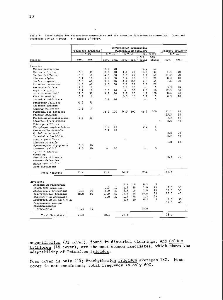
Petasites frigidus community.--Petasites frigidus is found in openplaces in running water where it may form large monotypic stands.Under old-growth canopy other species compete successfully, and aseral community dominated by Petasites frigidus results. In thesestands Petasites frigidus has 36% of a total vascular cover of 77%
(Table 6). Only 14 species were found in the measured stands.Tolmiea menziesii (17% cover), found in the shade, Epilobium
20
Table 6. Stand tables for Rhyzomatous communities and the Athyrium filix-femina community. Cover andconstancy are in percent. N = number of plots.
Rhyzomatous communitiesPetasites fridigus Hydrophyllum tenuipes Stachys cooleyae
N = 10 N = 10 N = 10 All plots N = 10
Species cov. con. cov. con. cov. con.
Ave.
coverCon-stancy cov. con.
VascularMontia parvifolia 0.3 20 0.2 10
Montia sibirica 0.3 30 0.5 40 1.1 20 0.8 30 4.3 50
Galium triflorum 3.8 60 4.3 60 5.8 20 5.1 40 11.2 90
Circaea alpina 0.1 10 1.1 30 0.4 20 0.8 25 0.3 10
Oxalis oregana 0.8 40 1.1 20 14.4 100 7.8 60 7.6 80
Tri se tum canescens 1.3 40 1.5 30 0.1 10 0.8 20
Festuca subulata 1.5 10 0.1 10 + 5 5.3 70
Boykinia elata 0.1 10 3.5 10 + 10 1.8 10 12.5 50
Tolmiea menziesii 17.0 90 4.2 20 2.2 20 3.2 20 0.6 20
Mitella ovalis 0.2 10 0.3 10 0.2 5 0.5 10
Tiarella unifoliata 0.1 10 + 5
Petasites frigidus 36.3 70
Adiantum pedatumAruncus sylvester 3.5 10Hydrophyllum tenuipes 36.9 100 56.5 100 46.7 100 11.1 60
Stachys cooleyae 25.5 30
Epilobium angustifolium 6.5 20 2.5 10
Athyrium filix-femina 8.6 40
Rubus parviflorusStreptopus amplexifolius 0.3 10 0.2 5
Vancouveria hexandra 0.1 10 + 5
Epilobium watsonii 2.2 30
Trientalis latifolia 8.2 50
Luzula parvifloraLinnaea borealis 1.0 10
Gymnocarpium dryopteris 5.0 10Anemone lyallii 1.0 10 + 10 + 5
Agrostis exarataViola sp.Osmorhiza chilensis 0.3 20
Anemone deltoideaRubus spectabilisAcer circinatum
Total Vascular 77.4 53.9 80.9 67.4 101.7
BryophyteRhizomnium glabescens 0.5 10 0.3 5
Leucolepis menziesii 1.5 10 0.5 20 1.0 15 7.5 30
Stokesiella praelongum 1.5 30 1.0 20 2.5 10 1.8 15 18.5 50
Brachythecium frigidum 18.0 60 17.0 60 22.2 90 19.6 75 12.0 40
Rhacomitrium aciculare 1.0 20 1.5 30 1.3 25
Scleropodium obtusifolium 0.3 10 0.2 5 8.5 50
Plagiomnium insigne 11.5 60
Rhytidiadelphustriquetrus 1.5 30 24.0
Total Bryophyte 21.0 20.5 27.5 58.0
angustifolium (7% cover), found in disturbed clearings, and Galium
triflorum (4% cover), are the most common associates, which shows the
adaptability of Petasites frigidus.
Moss cover is only 21%; Brachythecium frigidum averages 18%. Moss
cover is not consistant; total frequency is only 60%.
21
Athyrium filix-femina community
N = 10 N = 10 N = 10 N - 10 All plots
Species cov. con. cov. con. cov. con. cov. con.
Ave.cover
Con-stancy
VascularMontia parvifolia 0.1 10 + 3
Montia sibirica 0.4 20 2.0 60 1.9 50 0.1 10 1.1 35
Galium triflorum 1.5 30 0.6 20 0.2 20 1.5 30 1.0 25
Circaea alpina + 10 1.1 20 3.1 70 1.1 25
Oxalis oregana 3.3 30 1.6 60 15.8 100 5.2 48
Trisetum canescens 0.1 10 1.0 10 0.3 5
Festuca subulata 0.6 20 0.2 5
Boykinia elata 0.1 10 + 10 8.5 50 2.2 18
Tolmiea menziesii 2.5 10 1.4 30 3.8 40 7.9 80 3.9 40
Mitella ovalis 0.2 10 0.2 10 0.1 5
Tiarella unifoliataPetasites frigidusAdiantum pedatum 11.0 30 2.0 10 3.3 10
Aruncus sylvesterRydrophyilum tenuipes 0.3 10 1.5 10 0.5 5
Stachys cooleyae 6.5 30 1.6 8
Epilobium angustifolium 8.0 10 2.0 3
Athyrium filix-femina 76.0 100 28.0 100 77.0 100 5.5 40 46.6 85
Rubus parviflorus 40.0 100 10.0
Streptopus amplexifoliusVancouveria hexandra 5.0 10 1.3 3
Epilobium wetsoniiTrientalis latifoliaLuzula parviflora 5.0 20 1.3 5
Linnaea borealisGymnocarpium dryopteris 7.5 10 1.9 3
Anemone lyalliiAgrostis exarata 2.3 30 + 10 0.6 10
Viola sp. 1.6 20 0.4 5
Osmorhiza chilensis 0.2 10 + 3
Anemone deltoideaRubus spectabilis 10.0 20 2.5 5
Acer circina tum 10.0 100 2.5 3
Total Vascular 125.9 41.5 98.4 91.1 89.2
BryophyteRhizomnium glabescens 9.0 30 0.5 10 2.4 10
Leucolepis menziesii 0.5 10 0.9 20 0.2 10 1.0 20 0.7 15
33Stokesiella praelongum 0.5 10 4.0 20 15.0 50 20.5 50 10.0
Brachythecium frigidum 20.0 40 17.0 70 19.0 60 20.0 60 19.0 58
Rhacomitrium aciculareScleropodium obtusifolium 6.0 20 5.0 20 2.8 10
Plagiomnium insigne 2.0 30 0.5 8
Rhytidiadelphustriquetrus
Total Bryophyte 27.0 30.9 39.2 44.0 35.3
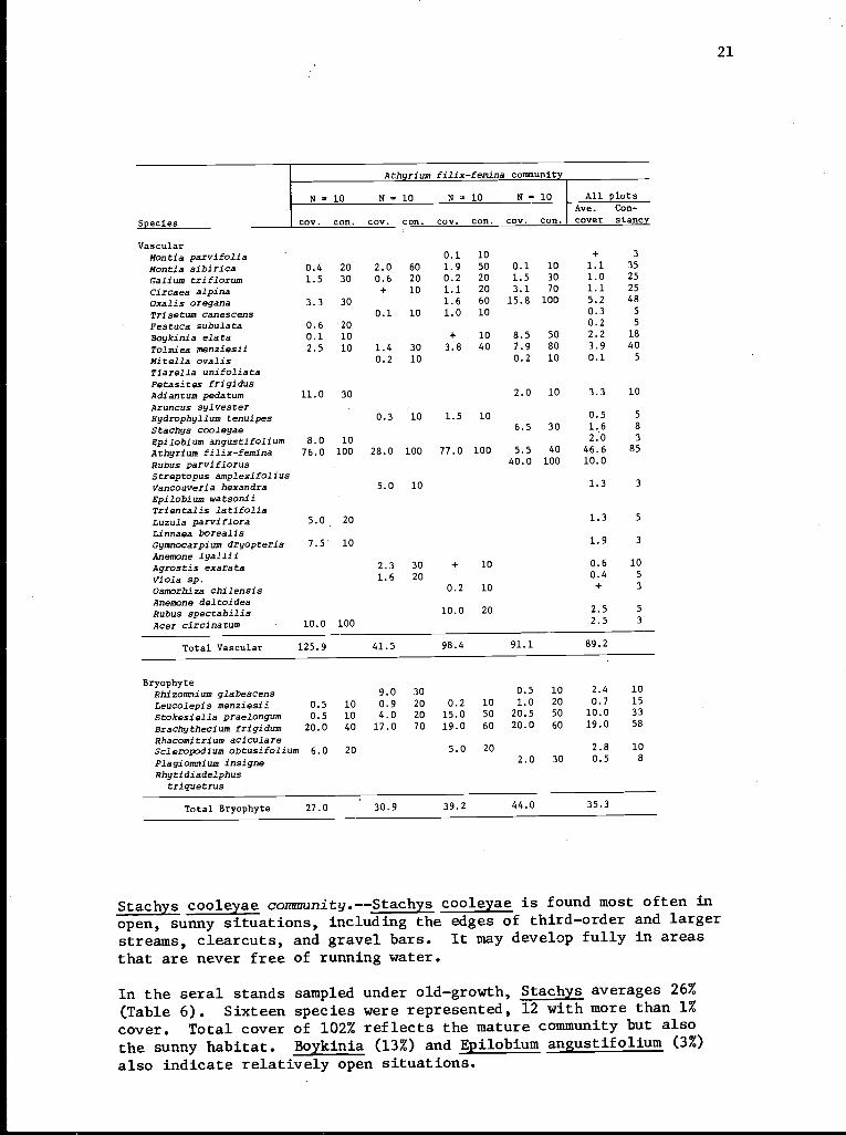
Stachys cooleyae community.--Stachys cooleyae is found most often in
open, sunny situations, including the edges of third-order and larger
streams, clearcuts, and gravel bars. It may develop fully in areas
that are never free of running water.
In the seral stands sampled under old-growth, Stachys averages 26%
(Table 6). Sixteen species were represented, 12 with more than 1%
cover. Total cover of 102% reflects the mature community but also
the sunny habitat. Boykinia (13%) and Epilobium angustifolium (3%)
also indicate relatively open situations.
22
Moss cover is 58%. Brachythecium frigidum, Stokesiella praelongumand Plagiomnium insigne, wet land species, each cover more than 10%.Frequency is low; Stokesiella occurs in only 50% of the sampledquadrats.
Hydrophyllum tenuipes community.--Hydrophyllum tenuipes dominates inthe shade along stream banks, generally where there is some soil,water speed is moderate at high flow, and where the water-free seasonis relatively long.
Hydrophyllum tenuipes contributes 47% cover out of a total of 67%
(Table 6). Measured plots had 15 species, five with more than 1%cover. Moss cover averages 24% with Brachythecium frigidum contribut-ing 20%.
Hydrophyllum tenuipes and its close relative Hydrophyllum fendleriare also found as common understory herbs in very wet forests. Low
incidence of Epilobium angustifolium and Boykinia elata indicate coolshaded conditions.
The community is closely related to the Athyrium filix-femina communitydescribed later and may belong to a complex of communities in whichAthyrium is the key species.
Well-developed herbaceous communities
Boykinia elata community.--The Boykinia elata community represents amid-seral successional stage on soil but is climax on wet logs in the
stream. Boykinia elata is sensitive to cold and shade and is confinedto elevations below 800 m. Stands are usually found on fine soil or
organic matter that is permanently wet. The substrate appears to
have little resistance to water action. The best examples of Boykiniaelata types are in scoured areas that have then remained undisturbedfor 10 years. Periodic flooding with no battering is common.
Total vascular cover in the herbaceous layer averages 110% (Table 7).
In addition, a high overstory of shrubs (or Aralia californica) is
not uncommon. Average shrub overstory is 33%. As might be expected,the total of vascular species increases to 29; however, four areoverstory and one, Rubus ursinus, intrudes from adjacent habitats.
Boykinia elata has 62% cover. Mitella ovalis, the most frequent
associate, has 13% cover. The aggressive and ubiquitous Petasitesfrigidus constitutes 11% cover.
The moss layer is 50%; low cover is caused by the basal diameters of
the vasculars. Important components almost exactly parallel theTolmiea menziesii community, but Leucolepis menziesii is more common.
23
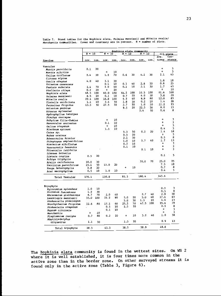
Table 7. Stand tables for the Boykinia elata, Tolmiea menziesii and Mitella ovalis/Marchantia communities. Cover and constancy are in percent. N - number of plots.
Boukinia data communityN - 10 N = 10 N - 10 N - 10 Al1 plots
Species coy. con. coy. con. coy. con. cov. con.
Ave.
coverCon-
stanc y
VascularMontia parvifolia 0.1 20 + 5
Montia sibirica + 10 + 3
Galium triflorum 2.4 50 1.2 70 0.6 30 4.1 30 2.1 45
Circaea alpinaOxalis oregana 4.0 40 3.1 30 1.8 18
Trisetum canescens 0.1 10 0.1 40 2.8 50 0.8 25
Festuca subulata 2.4 70 2.0 60 0.1 10 2.1 30 1.7 43
Stellaria crispa 0.2 20 + 20 + 10
Boykinia elate 68.5 100 60.0 100 64.5 100 53.5 100 61.6 100
Tolmiea menziesii 8.5 20 0.1 10 0.7 20 6.0 30 3.8 20
Mitella ovalis 20.4 100 16.8 100 4.2 60 9.9 80 12.8 85
Tiarella unifoliata 1.1 40 2.4 30 1.8 30 0.2 10 1.4 28
Petasites frigidus 13.5 30 27.5 30 2.7 20 1.0 10 11.2 23
Adiantum pedatum 9.5 20 22.5 30 8.0 13
Aruncus sylvester 2.4 30 0.6 8
Hydrophyllum tenuipesStachys cooleyaeAthyrium filix-femina + 10 + 3
Ranunculus uncinatus 0.1 10 + 3
Galium oreganum + 10 + 3
Blechnum spicant 1.5 10 0.4 3
Carex sp. 5.3 50 0.2 20 1.4 18
Rubus ursinus 0.3 20 + 5
Adenocaulon bicolor 2.1 30 0.5 8
Streptopus amplexifolius 1.0 10 5.7 40 1.7 13
Hieracium albiflorum 0.2 10 + 3
Vancouveria hexandra 0.1 10 + 3
Trientalis latifolia 0.1 10 + 3
Linnaea borealisListera caurina 0.5 20 0.1 5
Achlys triphyllaAralia californica 30.0 30 70.0 70 25.0 25
Vaccinium parvifolium 15.1 50 15.0 20 7.5 18
Tsuga heterophylla 2.8 20 + 10 0.7 8
Acer macrophyllum 0.5 10 1.0 10 0.4 5
Total Vascular 170.1 130.8 93.3 180.4 143.6
BryophyteHylocomium splendens 1.0 10 0.3 3
Dicranum fuscescens 1.2 30 0.3 8
Rhizomnium glabrescens 6.7 70 2.0 40 2.7 40 2.9 38
Leucolepis menziesii 35.0 100 25.2 90 5.0 20 3.0 40 17.1 63
Stokesiella praelongum 5.0 30 1.5 20 1.6 13
Brachythecium frigidum 12.6 80 17.1 60 25.5 70 47.5 100 25.6 78
Stokesiella oreganum 0.5 10 1.5 20 0.5 8
Hypnum circinale 0.1 10 + 3
Marchantia + 10 + 3
Plagiomnium insigne 0.7 80 0.2 20 + 10 3.2 40 1.0 38
Rhytidiadelphustriquetrus 1.1 30 1.5 20 0.9 13
Total Bryophyte 58.3 43.3 38.5 58.9 49.8
The Boykinia elata community is found in the wettest sites. On WS 2
where it is well established, it is four times more common in the
active zone than in the border zone. On other surveyed streams it is
found only in the active zone (Table 3, Figure 6).
24
Table 7 (cont.)
Tolmiea menziesii community Mitella ovalis/Marchantiacommunity
N = 10 N = 30 All plots N = 10 N = 10 All plots
Ave. Con- Ave. Con-Species cov. con. cov. con. cover stancy cov. con. coy. con.Lcover stanc y
VascularMontia parvifolia 1.0 20 0.3 10 0.7 15Montia sibirica 0.5 10 2.9 40 1.7 25 0.1 10 + 5
Galium triflorum 8.7 70 8.1 70 8.4 70 1.2 60 1.7 40 1.5 50
Circaea alpina 7.3 50 7.7 90 7.5 70 0.6 20 1.3 50 1.0 35
Oxalis oregana 7.7 60 5.6 60 6.7 60Trisetum canescens 2.6 50 0.4 10 1.5 30 0.1 10 + 5
Festuca subulata 1.1 40 0.6 20
Stellaria crispa 0.1 10 + 10 + 10Boykinia elata 6.1 50 3.1 25 27.4 100 45.9 100 36.6 100
Tolmiea menziesii 17.2 100 22.7 100 20.0 100 0.2 10 0.1 5
Mitella ovalis 2.8 50 0.6 20 1.7 35 31.1 100 30.5 100 30.8 100
Tiarella unifoliata 0.5 10 0.3 5 10.2 90 5.4 50 7.8 70
Petasites frigidus 1.0 10 0.5 5 14.5 30 7.3 15
Adiantum pedatum 2.5 10 1.3 5
Aruncus sylvesterHydrophyllum tenuipes 0.1 10 + 5
Stachys cooleyae 1.5 20 0.8 10Athyrium filix-feminaRanunculus uncinatus 0.3 10 0.2 5
Galium oreganumBlechnum spicant 7.5 30 3.8 15
Carex sp. 2.1 50 1.1 25
Rubus ursinus 0.8 10 4.4 50 2.6 30Adenocaulon bicolor 2.4 20 1.6 20 2.0 20
Streptopus amplexifoliusHieracium-albiflorumVancouveria hexandraTrientalis latifoliaLinnaea borealis .0 0 .5 5
Listera ca urinaAchlys triphylla 2.0 10 1.0 5
Aralia californica 100.0 100 100.0 100 100.0 100
Vaccinium parvifoliumTsuga heterophyllaACer macrophyllum
Total Vascular 55.2 51.3 53.3 183.9 210.9 197.4
BryophyteHylocomium splendensDicranum fuscescensRhizomnium glabrescens 1.0 20 1.0 10 1.0 15 6.0 80 5.5 80 5.8 80Leucolepis menziesii 10.5 50 1.0 10 5.8 30Stokesiella praelongum 3.5 20 15.0 30 9.3 25 11.5 50 3.5 50 7.5 50
Brachythecium frigidum 54.0 80 22.5 70 38.3 75 28.5 80 1.0 10 14.8 45Stokesiella oreganumHypnum circinaleMarchantia 50.5 100 89.0 100 69.8 100
Plagiomnium insigne 4.0 20 3.5 30 3.8 25 3.0 40 1.0 20 2.0 30
Rhytidiadelphustriquetrus 5.0 10 2.5 5
Total Bryophyte 78.0 43.0 60.5 99.5 100.0 99.8
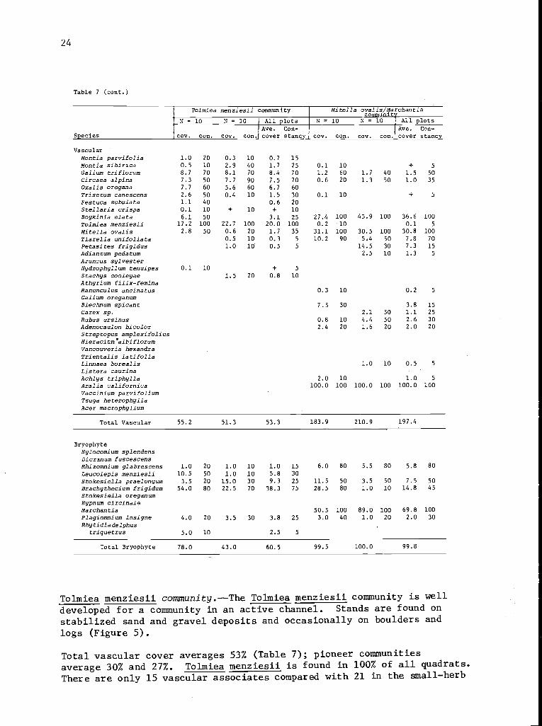
Tolmiea menziesii community.--The Tolmiea menziesii community is well
developed for a community in an active channel. Stands are found on
stabilized sand and gravel deposits and occasionally on boulders and
logs (Figure 5).
Total vascular cover averages 53% (Table 7); pioneer communities
average 30% and 27%. Tolmiea menziesii is found in 100% of all quadrats.
There are only 15 vascular associates compared with 21 in the small-herb
25
community. The smaller number is due in part smaller sample
size, but also to the exclusion of species such as Hieracium albiflorum
which cannot compete in the dense vegetation found in the Tolmiea
menziesii community.
Moss cover averages 50%, and 10% to 15% of the substrate, ordinarily
rock, is exposed. The addition of Rhizomnium glabescens, Leucolepis
menziesii, Plagiomnium insigne, and Rhytidiadelphus triquetrus common
on undisturbed sites and on soil, and the loss of Rhacomitrium aciculare
and Scleropodium obtusifolium characteristic of-exposed rock, reflect
the change in habitat from colonized rock to stabilized gravel and
soil.
Tolmiea menziesii is a community of wet areas. On WS 2 it is 3 times
more common in the active zone than in the border zone. It was found
in the active zone at Mack Creek and The Black Hole, but in the border
on Tiny Trout. The species Tolmiea menziesii is adaptable to the
deep litter of streamside forests, particularly on low terraces, and
may reach 100% cover. Because other characteristics of a Tolmiea
community are missing, it is merely a characteristic species of the
hardwood forest.
Mitella ovalis/Marchantia community.--Occasionally a semiporous
barrier will be deposited upon a slightly sloping, nonporous surface
across which water seeps all year, such as a small log impeding drainage
from an almost flat rock. If there is no disturbance, organic matter
and extremely fine inorganic particles build up and form an aqueous
muck. Sampled depths varied from 1 to 6 cm.
The bryophyte layer nears 100% and Marchantia, the dominant species,
averages 70% cover (Table 7). This is the only community where
Marchantia is not rare. Brachythecium frigidum is the most common
associate.
The vascular species closely approach those of the Boykinia elata
community but lack some of the larger herbs and disturbed-earth
invasives. Cover of Boykinia elata and Mitella ovalis averages 37%
and 31%, respectively (62% and 13% in the Boykinia community). A 100%
overstory of Aralia californica was present in all stands.
The Mitella ovalis/Marchantia community was found only on WS 2. It
occupies less than 1% of the riparian area and is found only in the
border zone. Nonetheless, it has practical importance as an indicator
beyond its area or biomass. Marchantia and Mitella give the surface
a flat firm appearance, but the smooth, almost slimy consistency of the
muck and lack of surface irregularities in the bedrock substrate make
the footing treacherously slick.
26
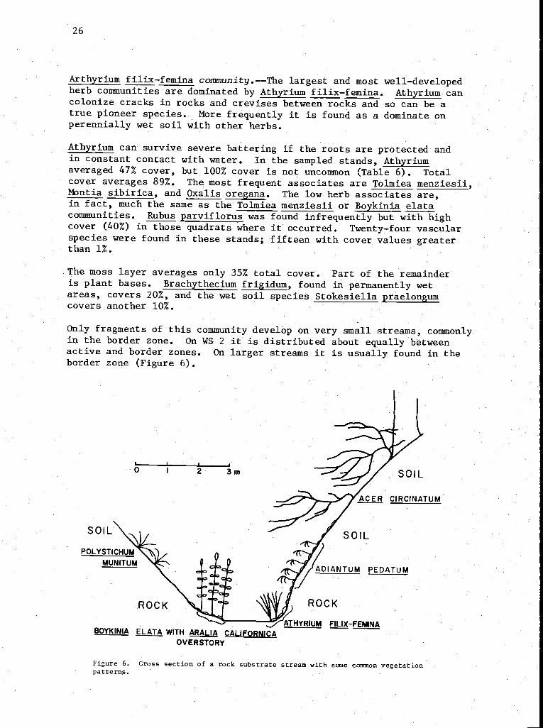
Arthyrium filix-femina community.--The largest and most well-developedherb communities are dominated by Athyrium filix-femina. Athyrium cancolonize cracks in rocks and crevises between rocks and so can be atrue pioneer species. More frequently it is found as a dominate onperennially wet soil with other herbs.
Athyrium can survive severe battering if the roots are protected andin constant contact with water. In the sampled stands, Athyriumaveraged 47% cover, but 100% cover is not uncommon (Table 6). Totalcover averages 89%. The most frequent associates are Tolmiea menziesii,Montia sibirica, and Oxalis oregana. The low herb associates are,in fact, much the same as the Tolmiea menziesii or Boykinia elatacommunities. Rubus parviflorus was found infrequently but with highcover (40%) in those quadrats where it occurred. Twenty-four vascularspecies were found in these stands; fifteen with cover values greaterthan 1%.
The moss layer averages only 35% total cover. Part of the remainderis plant bases. Brachythecium frigidum, found in permanently wetareas, covers 20%, and the wet soil species Stokesiella praelongumcovers another 10%.
Only fragments of this community develop on very small streams, commonlyin the border zone. On WS 2 it is distributed about equally betweenactive and border zones. On larger streams it is usually found in theborder zone (Figure 6).
2 3m
SOIL
ADIANTUM PEDATUM
ROCK
BOYKINIA ELATA WITH ARALIA CALIFORNICAOVERSTORY
ATHYRIUM FILIX-FEMINA
Figure 6. Cross section of a rock substrate stream with some common vegetationpatterns.
0
ROCK
27
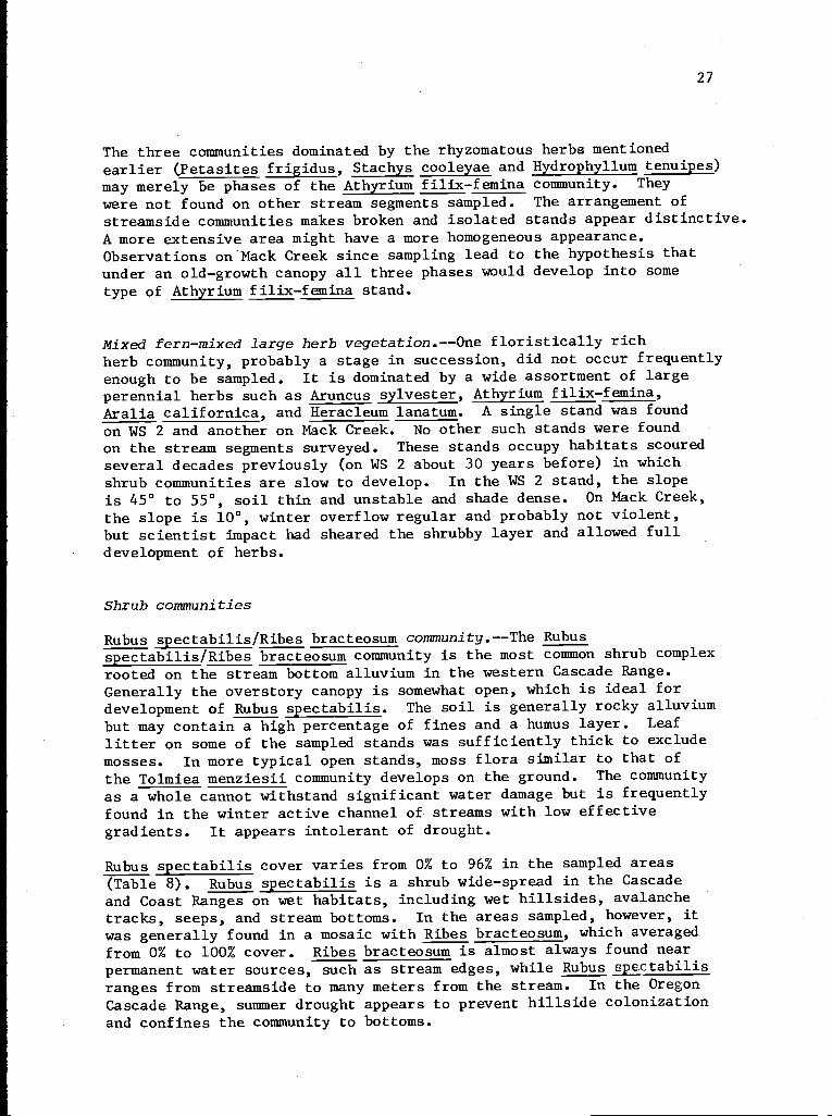
The three communities dominated by the rhyzomatous herbs mentioned
earlier (Petasites frigidus, Stachys cooleyae and Hydrophyllum tenuipes)
may merely be phases of the Athyrium filix-femina community. They
were not found on other stream segments sampled. The arrangement of
streamside communities makes broken and isolated stands appear distinctive.A more extensive area might have a more homogeneous appearance.Observations on'Mack Creek since sampling lead to the hypothesis thatunder an old-growth canopy all three phases would develop into sometype of Athyrium f ilix-f emina stand.
Mixed fern-mixed large herb vegetation.--One floristically rich
herb community, probably a stage in succession, did not occur frequentlyenough to be sampled. It is dominated by a wide assortment of largeperennial herbs such as Aruncus sylvester, Athyrium f ilix-f emina,Aralia californica, and Heracleum lanatum. A single stand was found
on WS 2 and another on Mack Creek. No other such stands were found
on the stream segments surveyed. These stands occupy habitats scouredseveral decades previously (on WS 2 about 30 years before) in whichshrub communities are slow to develop. In the WS 2 stand, the slope
is 45° to 55°, soil thin and unstable and shade dense. On Mack Creek,
the slope is 10°, winter overflow regular and probably not violent,but scientist impact had sheared the shrubby layer and allowed fulldevelopment of herbs.
Shrub communities
Rubus spectabilis/Ribes bracteosum community.--The Rubusspectabilis/Ribes bracteosum community is the most common shrub complexrooted on the stream bottom alluvium in the western Cascade Range.Generally the overstory canopy is somewhat open, which is ideal fordevelopment of Rubus spectabilis. The soil is generally rocky alluviumbut may contain a high percentage of fines and a humus layer. Leaflitter on some of the sampled stands was sufficiently thick to excludemosses. In more typical open stands, moss flora similar to that ofthe Tolmiea menziesii community develops on the ground. The communityas a whole cannot withstand significant water damage but is frequentlyfound in the winter active channel of streams with low effectivegradients. It appears intolerant of drought.
Rubus spectabilis cover varies from 0% to 96% in the sampled areas(Table 8). Rubus spectabilis is a shrub wide-spread in the Cascadeand Coast Ranges on wet habitats, including wet hillsides, avalanchetracks, seeps, and stream bottoms. In the areas sampled, however, itwas generally found in a mosaic with Ribes bracteosum, which averagedfrom 0% to 100% cover. Ribes bracteosum is almost always found nearpermanent water sources, such as stream edges, while Rubus spertabilisranges from streamside to many meters from the stream. In the OregonCascade Range, summer drought appears to prevent hillside colonizationand confines the community to bottoms.
28
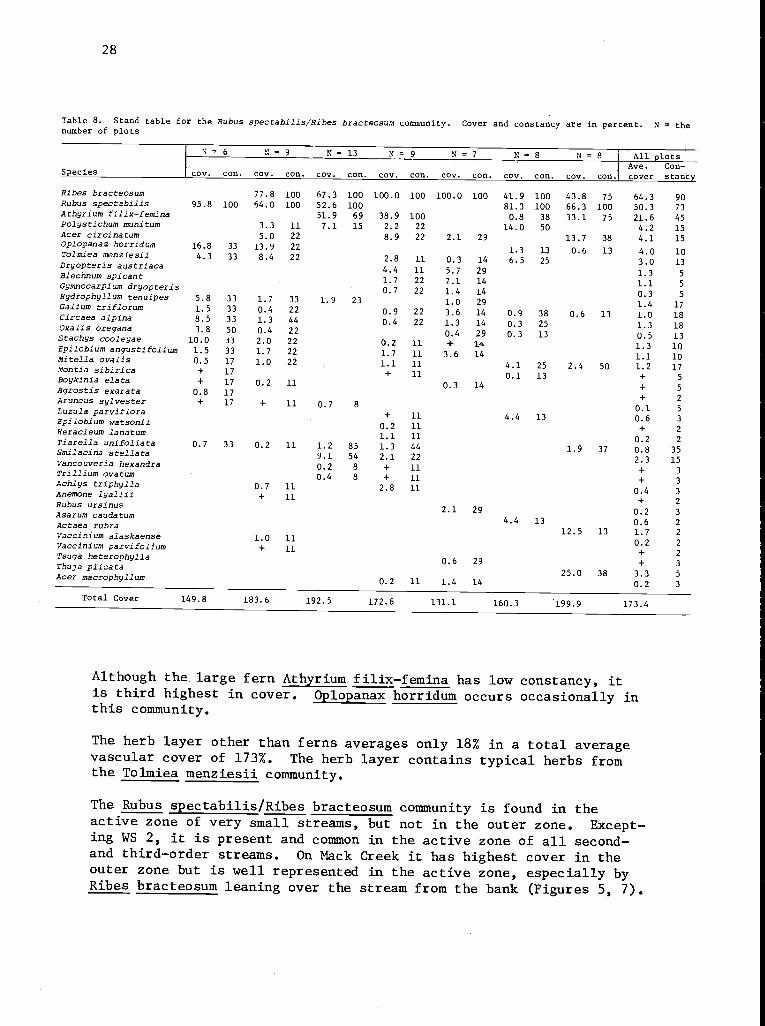
Table 8. Stand table for the Rubus spectabilis/gibes bracteosum community. Cover and constancy are in percent. N = thenumber of plots
N = 6 N= 13 N= 9 N= 7 N- 8 N= 8 All plotsAve. Con-
Species cov. con. cov. con. cov. con. cov. con. cov, con. cov. con. cov. con. cover stance
Ribes bracteosum 77.8 100 67.3 100 100.0 100 100.0 100 41.9 100 43.8 75 64.3 90Rubus spectabilis 95.8 100 64.0 100 52.6 100 81.3 100 66.3 100 50.3 73Athyrium filix-femina 51.9 69 38.9 100 0.8 38 33.1 75 21.6 45Palystichum munitum 3.3 11 7.1 15 2.2 22 14.0 50 4.2 15Acer circinatum 5.0 22 8.9 22 2.1 29 13.7 38 4.1 15Oplopanaz horridum 16.8 33 13.9 22 1.3 13 0.6 13 4 0 10Tolmiea menziesii 4.3 33 8.4 22 2.8 11 0.3 14 6.5 25
.
3.0 13Dryopteris austriaca4.4 11 5.7 29 1 3 5Blechnum spicant1.7 22 7.1 14
.
1 1 5Gymnocarpium dryopteris0.7 22 1.4 14
.
0 3 5Hydrophyllum tenuipes 5.8 33 1.7 33 1.9 23 1.0 29.
1 4 17Galium triflorum 1.5 33 0.4 22 0.9 22 3.6 14 0.9 38 0.6.
13 1 0 18Circaea alpina 8.5 33 1.3 44 0.4 22 1.3 14 0.3 25.
1 3 18Oxalis oregana 3.8 50 0.4 22 0.4 29 0.3 13.
0 5 13Stachys cooleyae 10.0 33 2.0 22 0 2 11 + 14.
Epilobium angustifolium 1.5 33 1.7 22.
1.7 11 3.6 141.31 1
1010Mitella ovalis 0.5 17 1.0 22 1.1 11 4.1 25 2.4
.
50 1 2 17Montie sibirica + 17 + 11.
Boykinia elata + 17 0.2 11 0.3 140.1 13 +
+5
5Agrostis exarata 0.8 17Aruncus sylvester + 17 + 11 0 7 8
+ 2
Luzula parviflora .
+ 11 4.4 130.10 6
5
3Epilobium watsonii0.2 11
.+ 2Heracleum lanatum
1.1 11 20 2Tiarella unifoliata 0.7 33 0.2 11 1.2 85 1.3 44 1.9.
37 0 8 35Smilacina stellata 9.1 54 2.1 22.
2 3 15Vancouveria hexandra 0.2 8 + 11.
+ 3Trillium ovatum 0.4 8 + 11 + 3Achlys triphylla 0.7 11 2.8 11 0 4 3Anemone lyallii + 11.
Rubus ursinus + 2
Asarum caudatum 2.1 29 0.2 3
Actaea rubra 4.4 13 0.6 2
Vaccinium alaskaense 1 0 1112.5 13 1.7 2
Vaccinium parvifoliumTsuga heterophylla
.
+ 110.2+
2
2
Thuja plicata 0.6 29 + 3
Acer macrophyllum0.2 11 1.4 14
25.0 38 3.30.2
5
3
Total Cover 149.8 183.6 192.5 172.6 131.1 160.3 199.9 173.4
Although the large fern Athyrium filix-femina has low constancy, itis third highest in cover. Oplopanax horridum occurs occasionally inthis community.
The herb layer other than ferns averages only 18% in a total averagevascular cover of 173%. The herb layer contains typical herbs fromthe Tolmiea menziesii community.
The Rubus spectabilis/Ribes bracteosum community is found in theactive zone of very small streams, but not in the outer zone. Except-ing WS 2, it is present and common in the active zone of all second-and third-order streams. On Mack Creek it has highest cover in theouter zone but is well represented in the active zone, especially byRibes bracteosum leaning over the stream from the bank (Figures 5, 7).
29
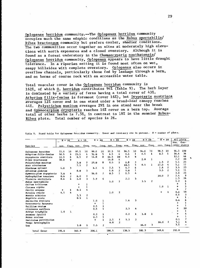
Oplopanax horridum community.--The Oplopanax horridum community
occupies much the same edaphic conditions as the Rubus spectabilis/
Ribes bracteosum community but prefers cooler, shadier conditions.The two communities occur together on sites at moderately high eleva-
tions with north exposures and a closed overstory. Although it is
found as a forest understory in the Chamaecyparis nootkatensis/
Oplopanax horridum community, Oplopanax appears to have little drought
tolerance. In a riparian setting it is found most often on wet,
seepy hillsides with complete overstory. Oplopanax also occurs in
overflow channels, particularly those fed by leakage through a berm,
and on berms of coarse rock with an accessible water table.
Total vascular cover in the Oplopanax horridum community is162%, of which 0. horridum contributes 94% (Table 9). The herb layer
is dominated by a variety of ferns having a total cover of 43%.
Athyrium filix-femina is foremost (cover 16%), but Drypoteris austriaca
averages 12% cover and in one stand under a broad-leaf canopy reaches
44%. Polystichum munitum averages 29% in one stand near the break
and Gymnocarpium dryopteris reaches 16% cover on a berm top. Average
total of other herbs is 7.5%, in contrast to 18% in the sunnier Rubus-
Ribes plots. Total number of species is 26.
Table 9. Stand table for Oplapanax horridum community. Cover and constancy are In percent. N = number of plots.
N = 10 N - 10 N = 10 N = 10 N = 10 N = 10 N - 10 All plotsAve. Con-
Species cov. freq. cov. freq cov freq. cov. freq. cov. freq. cov. freq. cov. freq. cover stancy
Oplopanax horridum 77.0 10 97.5 10 99.0 10 97.5 10 96.5 10 94.0 10 98.5 10 94.3 100
Athyrium filix-femina 50.5 9 25.5 4 31.0 5 6.5 4 0.4 1 0.5 1 0.5 1 16.4 36
Dryopteris austriaca 12.9 6 6.5 2 14.0 8 44.5 10 6.5 6 12.1 46
Rites bracteosum 38.0 9 14.0 4 2.0 1 7.7 20
Polystichum munitum 3.0 2 29.0 8 0.5 1 1.8 3 1.5 2 5.1 23
Acer circinatum 7.5 2 10.5 5 0.5 1 17.0 4 5.1 17
Blechnum spicant 4.0 3 6.5 4 7.5 3 4.7 4 1.6 2 3.5 23
Adiantum pedatum 8.0 3 1.0 2 9.0 1 3.5 2 3.1 11
Gymnocarpium dryopteris 3.0 4 16.0 7 0.5 1 1.5 4 3.0 23
Hydrophyllum tenuipes 0.6 2 6.0 2 10.0 2 2.4 9
Tiarella unifoliata 0.4 4 1.8 3 5.9 6 2.2 5 1.5 26
Rubus spectabilis 5.0 2 3.5 2 1.2 6
Galium triflorum + 1 + 1
Circaea alpina + 1 1.0 1 + 3
Oxalis oregana + 1 0.3 4 + 7
Mitella ovalis 4.1 4 1.0 2 + 1 0.1 10
Montia sibirica 5.3 2 0.1 3
Boykinia elata 0.5 1 + 1 .
Smilacina stellata 1.0 1 1.6 3 0.4 6
Vancouveria hexandra + 1 + 1
Trillium ovatum 2.5 1 + 1
Clintonia uniflora 0.5 1 2.3 6 + 10
Achlys triphylla 1.0 1 + 1
Anemone lyallii 0.3 1 0.2 1 1.0 1 + 4
Rubus ursinus 0.3 1 + 1
Vaccinium parvifolium + 1 2.5 1 1.3 3 0.1 7
Tsuga heterophylla 6.0 2 16.0 2 3.1 6
Log 1.0 1 7.5 2 16.0 3 3.5 -
Total Cover 191.6 161.9 206.1 186.5 138.5 101.5 149.6 162.6
30
The Oplopanax horridum community is most frequent in the outer zoneon Mack Creek (Figure 5) but also leans over the active channel fromthe bank. Its single other occurrence in the survey is also over theactive channel and in the outer zone (Table 3).
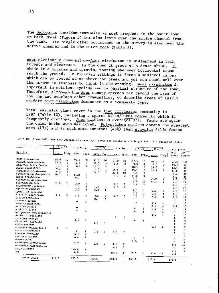
Acer circinatum community.--Acer circinatum is widespread in bothforests and clearcuts. In the open it grows as a dense shrub. Inshade it elongates and sprawls, rooting wherever horizontal stemsreach the ground. In riparian settings it forms a midlevel canopywhich can be rooted at or above the break and yet can reach well overthe stream in response to light in the opening. Acer circinatum isimportant in nutrient cycling and in physical structure of the zone.Therefore, although the Acer canopy spreads far beyond the area ofrooting and overlaps other communities, we describe areas of fairlyuniform Acer circinatum dominance as a community type.
Total vascular plant cover in the Acer circinatum community is179% (Table 10), including a sparse Ribes/Rubus community which itfrequently overtops. Acer circinatum averages 97%. Ferns are againthe chief herbs with 44% cover. Polystichum munitum covers the greatestarea (15%) and is much more constant (45%) than Athyrium filix-femina
Table 10. Stand table for Ace r circinatum community. Cover and constancy are in percent. N = number of plots.
N = 10 N = 10 N = 10 N = 10 N = 10 N = 10 AllSpecies
I cov freq cov freq. cov. fre cov. freq. cov. freq cov fAve.
plotsCon-
Acer circinatum 100.0Polystichum munitum 25 5
10 99.5 10 98.0 10 93.0 10 97.5 10
req cover
95.0 10 97.2
stancy
100.Athyrium filix-frmina 1 1
7 14.3 7 34.5 5 1.8 2 9.0 4 6.0 2 15.2 45.Rubus spectabilis 6 1
2 9.0 2 16.5 3 18.5 5 29.0 5 12.4 28.Vaccinium alaskaense 8
1 8.0 3 18.5 3 15.5 6 22.5 8 11.8 35.5Gymnocarpium dryo teri 20 2
3 22.0 3 22.6 10 1.5 1 9.1 28p s .Ribes bracteosum
9 11.0 3 10.2 3 11.0 3 8.7 30H dro h ll 0.1 1 5.5 1 24.0 5 4.9 12y p y um tenuipesBlechn i 6.0 2 12.2 5 3.0 12um sp cant 10.0Dr o t i 1 5.0 1 1.0 1 0.6 2 2.8 8y p er s austriacaAdiantum d
7.5 5 1.6 3 6.0 4 2.5 20pe atumO lo anax h id
5.5 3 5.0 1 1.0 1 2.0 1 2.3 10p p orr umTiarella if li 5.5 1 2.0 2 1.3 5un o ata 1.1Galium trifl
5 3.3 5 3.6 3 0.7 3 0.4 2 4.0 2 2.2 33orumCirc l i
0.1 2 + 3aea a p naTolmiea menziesii
+ 1 0.2 2 0.3 1 + 7
Mitella o li 5.0 1 0.8 2va sBo kinia l t + 1 + 1 0.3 1 + 5y e a aStre to
+ 1 + 1 + 1 + 5p pus amplexifoliusSmiiacin t ll 1.0 1 + 2a s e ataTrillium ov t + 1 + 2a umClintoni if 1.0 1 + 1 + 3a un loraRubus ursinus 1.6 1 + 2
Good er bl 0.5 1 + 2y a o onyifolia +Cornu d
1 + 7s cana ensisLin b
+ 1 0.7 1 0.3 2 + 7naea orealisAsaru d
0.2 2 + 3m cau atumAct
0.4 1 + 1 + 3aea rubraVa i i 1.0 1 + 2cc n um parvifoliumVaccini b
2.7 4 1.0 2 1.6 2 0.8 13um mem ranaceumThuj li 2.5 1 + 2a p cataLo
20.0 3 3.3 5g 6.0 1 21.0 6 7.5 2 8.0 2 7.1Total Cover 172.7 179.9 192.6 158.3 168.1 203.9 179.3
31
(12% cover, 28% constancy). Gymnocarpium dryopteris is third in
cover (9%) but is found as frequently as Athyrium f ilix-femina. Cover
of shrubs other than Acer circinatum is 28%. Rubus spectabilis is
most important (12% cover, 35% constancy). Vaccinium spp. covers 10%
(constancy 43%).
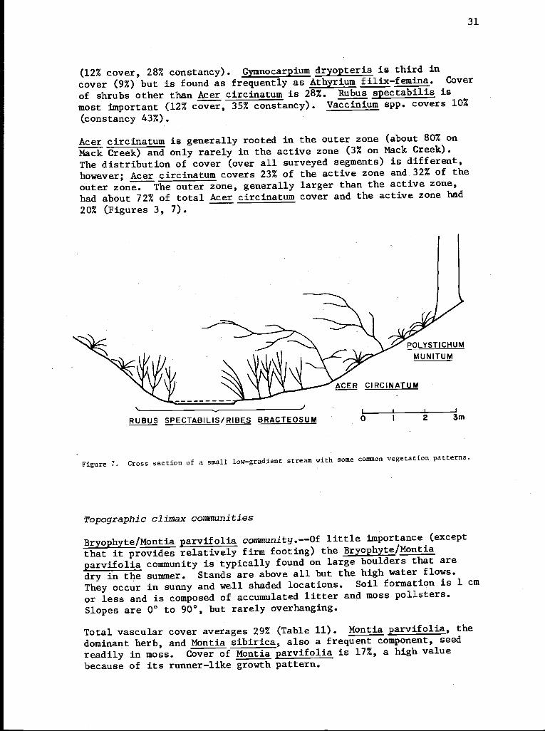
Acer circinatum is generally rooted in the outer zone (about 80% on
Mack Creek) and only rarely in the active zone (3% on Mack Creek).
The distribution of cover (over all surveyed segments) is different,
however; Acer circinatum covers 23% of the active zone and 32% of the
outer zone. The outer zone, generally larger than the active zone,
had about 72% of total Acer circinatum cover and the active zone had
20% (Figures 3, 7).
RUBUS SPECTABILIS/RIBES BRACTEOSUMJ3m
Figure 7. Cross section of a small low-gradient stream with some common vegetation patterns.
Topographic climax communities
Bryophyte/Montia parvifolia community.--Of little importance (except
that it provides relatively firm footing) the Bryophyte/Montia
parvifolia community is typically found on large boulders that are
dry in the summer. Stands are above all but the high water flows.
They occur in sunny and well shaded locations. Soil formation is 1 cm
or less and is composed of accumulated litter and moss pollsters.
Slopes are 0° to 90°, but rarely overhanging.
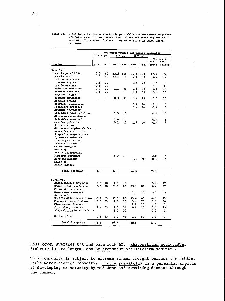
Total vascular cover averages 29% (Table 11). Montia parvifolia, the
dominant herb, and Montia sibirica, also a frequent component, seed
readily in moss. Cover of Montia parvifolia is 17%, a high value
because of its runner-like growth pattern.
0 2
32
Table 11. Stand table for Bryophyte/Montia parvifolia and Petasites frigidus/Brachythecium-frigidum communities. Cover and constancy are inpercent. N - number of plots. Degree of slope is shown wherepertinent.
Bryophyte/Montia parvifolia communityN - 10 N - 10 N - 10
All plots
Species cov. con. cov. con. cov. con.1Ave.cover
Con-stance
VascularMontia parvifolia 3.7 90 13.5 100 32.6 100 16.6 97Montia sibirica 2.5 50 12.1 40 0.8 40 5.1 43Galium triflorumCircaea alpina 0.1 10 0.6 20 0.2 10Oxalis oregana 0.1 10 + +Trisetum canescens 0.2 10 1.5 30 2.2 30 1.3 23Festuca subulata 0.1 10 3.3 30 1.1 13Boykinia elataTolmiea menziesii + 10 0.3 30 0.5 10 0.2 16Mitella ovalisTiarella unifoliata 0.3 10 0.1 3Petasites frigidus 1.5 10 0.5 3Aruncus sylvesterEpilobium angustifolium 2.5 20 0.8 10Athyrium filix-feminaEpilobium watsonii 1.0 10 0.3 3Mimulus guttatus 0.1 10 1.5 10 0.5 7
Rubus ursinusStreptopus amplexifoliusHieracium albiflorumAnaphalis margaritaceaEquesetum telmatiaLuzula parvifloraCistern caurinaCarex deweyanaviola sp.
Aralia californicaSambucus racemosa 0 0 0 7
Acer circinatum 1.5 20 0.5 7
Salix ap.
Alnus sinuata
Total Vascular 6.7 37.0 44.8 29.2
BryophyteBrachythecium frigidum 1.3 40 1.3 10 0.9 17Stokesiella praelongum 6.2 40 28.8 80 23.7 80 19.6 67Philonotis fontanaLeucolepis menziesii 1.5 10 0.5 3
MarchantiaScleropodium obtusifolium 48.0 80 55.5 80 35.0 60 46.2 73Rhacomitrium aciculare 12.5 60 8.3 50 15.8 70 12.2 60Plagiomnium insigne 2.0 10 0.7 3Ceratodon purpurens 1.4 20 1.5 10 0.8 10 1.2 13Rhacomitrium heterostichum 1.0 10 0.3 3
Unidentified 2.5 50 1.3 40 1.2 50 2.1 47,
Total Bryophyte 71.9 97.7 80.0 83.2
Moss cover averages 84% and bare rock 6%. Rhacomitrium acciculare,Stokesiella praelongum, and Scleropodium obtusifolium dominate.
This community is subject to extreme summer drought because the habitatlacks water storage capacity. Montia parvifolia is a perennial capableof developing to maturity by mid-June and remaining dormant throughthe summer.
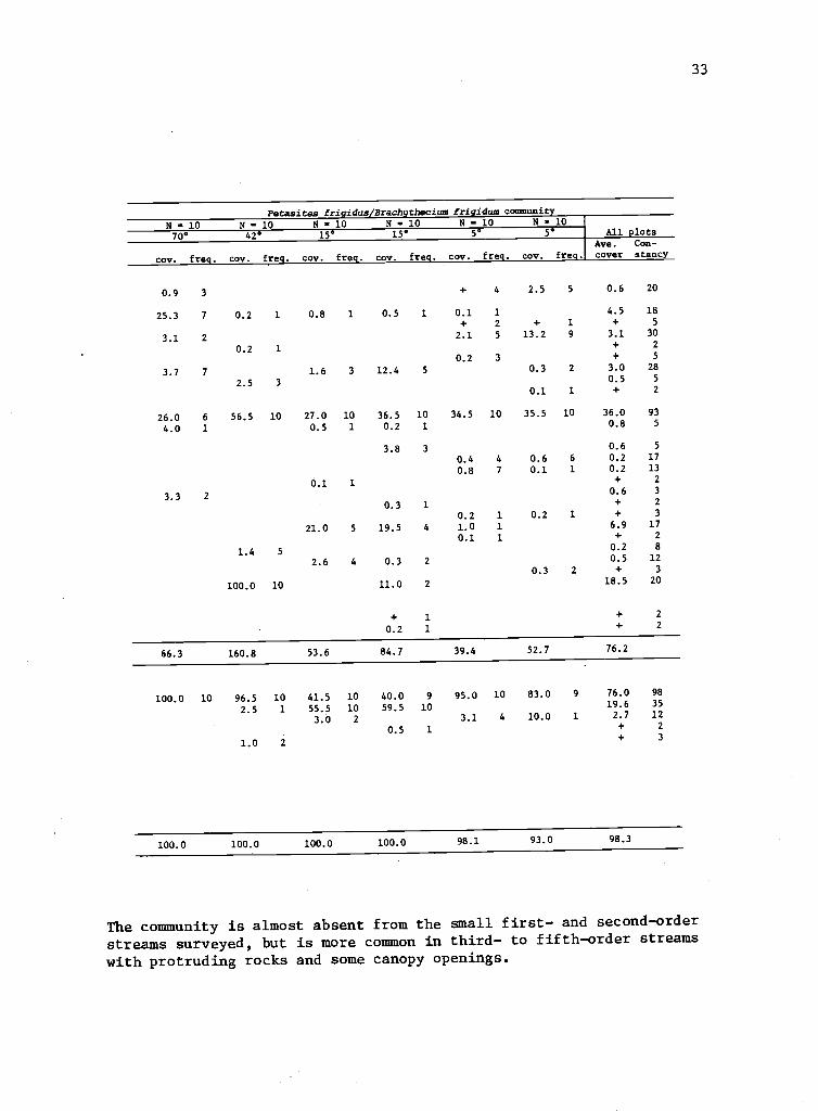
33
Petasites fri idus Brach thecium fri idum community
N - 10 N - 10 N - 10 N - 10 N - 10 N - 1070° 42° 15 15° 5 5 All plots
Ave. Con-
cov. freq. cov. freq. cov. freq. cov. freq. cov. freq. cov. freq. cover stancy
0.9 3 + 4 2.5 5 0.6 20
25.3 7 0.2 1 0.8 1 0.5 1 0.1 1 4.5 18
+ 2 + 1 + 5
3.1 2 2.1 5 13.2 9 3.1 30
0.2 1+ 2
0.2 3 + 5
3.7 7 1.6 3 12.4 5 0.3 2 3.0 28
2.5 3 0.5 5
0.1 1 + 2
26.0 6 56.5 10 27.0 10 36.5 10 34.5 10 35.5 10 36.0 93
4.0 1 0.5 1 0.2 1 0.8 5
3.8 3 0.6 5
0.4 4 0.6 6 0.2 17
0.8 7 0.1 1 0.2 13
0.1 1 + 2
60 33.3 2.
0.3 1 + 2
0.2 1 0.2 1 + 3
21.0 5 19.5 4 1.0 1 6.9 17
0.1 1 + 2
1.4 5 0.2 8
2.6 4 0.3 2 0.5 120.3 2 + 3
100.0 10 11.0 2 18.5 20
+ 1 + 2
0.2 1 + 2
66.3 160.8 53.6 84.7 39.4 52.7 76.2
100.0 10 96.5 10 41.5 10 40.0 9 95.0 10 83.0 9 76.0 98
2 5 1 55.5 10 59.5 10 19.6 35.
3.0 2 3.1 4 10.0 1 2. 7 12
0.5 1 + 2+ 3
1.0
100.0 100.0 100.0 100.0 98.1 93.0 98.3
The community is almost absent from the small first- and second-orderstreams surveyed, but is more common in third- to fifth-order streamswith protruding rocks and some canopy openings.
34
Adiantum pedatum/precipice community.--Adiantum pedatum growsluxuriantly in wet cracks in rocks, especially on slopes too steepfor Athyrium filix-femina. It prefers shaded north-facing slopeswith a permanent water supply, but does not necessarily require seeps(Figure 6).
Slopes on sample sites average 83° and range from 50° to 110°. Sub-strates range from an overhanging dry rock face with little mosscover to a somewhat broken and decayed rock slope with slight soilformation and 100% moss cover. Typically, the bottom of the slope isslightly steeper than the top. Upper edges have more species, includingsome from the forest floor, than lower slopes. Old fern fronds stillbasally attached are the source of most of the accumulated litter.
Moss cover averages 58% but ranges from 5 to 100%. Wet, north-exposedfaces have highest concentrations. Bryophytes found in the quadratsindicate the wide variation in surface condition; Ceratodon purpurens,typical of sterile rock cliffs, Hylocomium splendens, typical offorest floors, and Rhacomitrium aciculare indicating well-aeratedwater, are parts of the bryophytic flora at different locations (Table12).
Vascular cover averages 78% but ranges from 21% to 125%. Adiantumpedatum averages 53% cover. Aruncus sylvester is fairly common onsteep slopes and, being large, is second in vascular coverage (6%).Streptopus amplexifolius commonly eaten by deer, reaches large dimen-sions and full fruit in these inaccessible locations, but its coveris low. A total of 23 vascular species were recorded in the plots.
The Adiantum pedatum community covers approximately 2% of the riparianarea on Mack Creek and is found only in the border zone. On WS 2 itcovers about 3% of the riparian area, again in the border zone.
Petasites frigidus/Brachythecium frigidum community.--The well-definedPetasites frigidus/Brachythecium frigidum community occupies seepageareas, usually on rock surfaces, in the border zone. It was found insmall quantities on Mack Creek, WS 2, and several other streams inthe Andrews Reserve, but not on other streams sampled for communitycover. Brachythecium frigidum forms thick 3- to 5-cm mats of moss inwhich Petasites frigidus, an adaptable species, can grow. The standsare found on seepage areas, with firm soil to solid rock, and onboggy muck. Gradients range from 5° to perpendicular and are notsubject to scour. Most stands are in sunny locales. There is usuallylittle soil formation, and the moss layer is the rooting medium forvascular plants. The locations are not subject to summer drought; atleast a minimal amount of moisture was available all year in the drysummer of 1977.
Total cover of vascular plants is 76.2% for all stands (Table 11).One stand had 100% Aralia californica overstory cover. If this isremoved, vascular cover averages 58%: 36% Petasites frigidus, 7%Equisetum telmatia, 5% Galium trif lorum, and 3% Oxalis oregana.Twenty-six species were recorded.
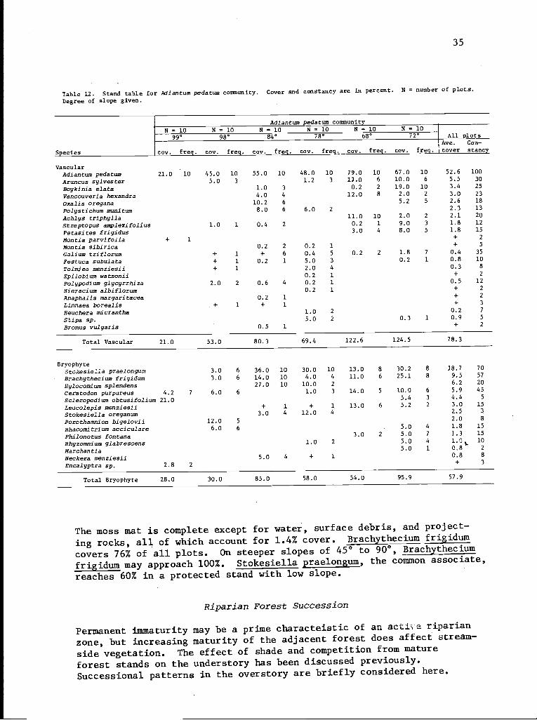
35
Table 12. Stand table for Adiantum pedatum community. Cover and constancy are in percent. N = number of plots.Degree of slope given.
Adiantum pedatum communityN = 10 N = 10 N = 10 N = 10
-
N = 10 N = 1099° 98° 84° 78° 68° 72° All plots
Species cov. freq. cov. freq. cov freq. cov. freq. cov. freq. cov. freq.
Ac
ve. Con-over stance
VascularAdiantum pedatum 21.0 10 45.0 10 55.0 10 48.0 10 79.0 10 67.0 10 52.6 100
Aruncus sylvester 5.0 3 1.2 3 17.0 6 10.0 6 5.5 30
Boykinia elata 1.0 3 0.2 2 19.0 10 3.4 25
Vancouveria hexandra 4.0 4 12.0 8 2.0 2 3.0 23
Oxalis oregana 10.2 6 5.2 5 2.6 18
Polystichum munitum 8.0 6 6.0 2 2.3 13
Achlys triphylla 11.0 10 2.0 2 2.1 20
Streptopus amplexifolius 1.0 1 0.4 2 0.2 1 9.0 3 1.8 12
Petasites frigidus 3.0 4 8.0 5 1.8 15
Montia parvifolia + 1 + 2
Montia sibirica 0.2 2 0.2 1 + 5
Galium triflorum + 1 + 6 0.4 5 0.2 2 1.8 7 0.4 35
Festuca subulata + 1 0.2 1 5.0 3 0.2 1 0.8 10
Tolmiea menziesii + 1 2.0 4 0.3 8
Epilobium watsonii 0.2 1 + 2
Polypodium glycyrrhiza 2.0 2 0.6 4 0.2 1 0.5 12
Hieracium albiflorum 0.2 1 + 2
Anaphalis margaritacea 0.2 1 + 2
Linnaea borealis + 1 + 1 + 3
Heuchera micrantha 1.0 2 0.2 7
Stipa sp. 5.0 2 0.3 1 0.9 5
Bromus vulgaris 0.5 1 + 2
Total Vascular 21.0 53.0 80.3 69.4 122.6 124.5 78.3
BryophyteStokesiella praelongum 3.0 6 36.0 10 30.0 10 13.0 8 30.2 8 18.7
9 5
7057Brachythecium frigidum 3.0 6 14.0 10 4.0 4 11.0 6 25.1 .8
Hylocomium splendens 27.0 10 10.0 2 6.2 20
Ceratodon purpureus 4.2 7 6.0 6 1.0 3 14.0 5 10.0 6 5.9 45
Scleropodium obtusifolium 21.0 5.4 3 4.4 5
Leucolepis menziesii + 1 + 1 13.0 6 5.2 2 3.0 15
Stokesiella oreganum 3.0 4 12.0 4 2.5 3
Porothamnion bigelovii 12.0 5 2.0 8
Rhacomitrium acciculare 6.0 6 5.0 4 1.8 15
Philonotus fontana 3.0 2 5.0 7 1.3 15
Rhyzomnium glabrescens 1.0 2 5.0 4 1.01. 10
Marchantia 5.0 1 0.8 2
Neckera menziesii 5.0 4 + 1 0.8 8
Encalyptra sp. 2.8 2+ 3
Total Bryophyte 28.0 30.0 85.0 58.0 54.0 95.9 57.9
The moss mat is complete except for water, surface debris, and project-
ing rocks, all of which account for 1.4% cover. Brachythecium frigidum
covers 76% of all plots. On steeper slopes of 45° to 900, Brachythecium
frigidum may approach 100%. Stokesiella praelongum, the common associate,
reaches 60% in a protected stand with low slope.
Riparian Forest Succession
Permanent immaturity may be a prime characteistic of an acti.e riparian
zone, but increasing maturity of the adjacent forest does affect stream-
side vegetation. The effect of shade and competition from mature
forest stands on the understory has been discussed previously.
Successional patterns in the overstory are briefly considered here.
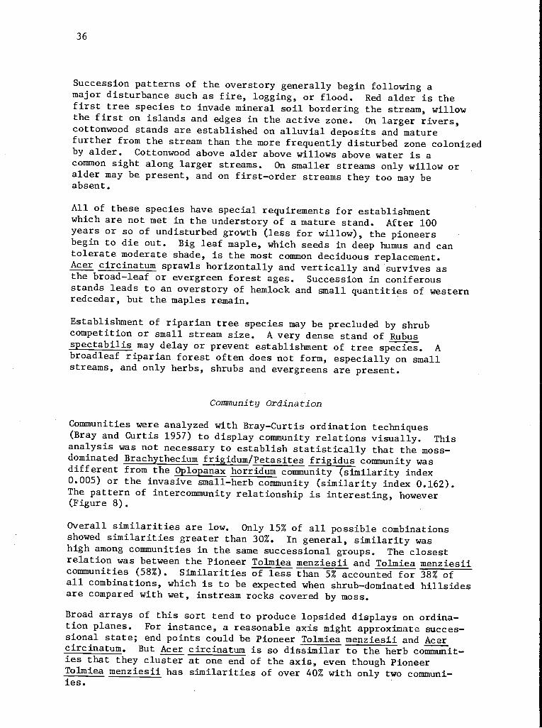
36
Succession patterns of the overstory generally begin following amajor disturbance such as fire, logging, or flood. Red alder is thefirst tree species to invade mineral soil bordering the stream, willowthe first on islands and edges in the active zone. On larger rivers,cottonwood stands are established on alluvial deposits and maturefurther from the stream than the more frequently disturbed zone colonizedby alder. Cottonwood above alder above willows above water is acommon sight along larger streams. On smaller streams only willow oralder may be present, and on first-order streams they too may beabsent.
All of these species have special requirements for establishmentwhich are not met in the understory of a mature stand. After 100years or so of undisturbed growth (less for willow), the pioneersbegin to die out. Big leaf maple, which seeds in deep humus and cantolerate moderate shade, is the most common deciduous replacement.Acer circinatum sprawls horizontally and vertically and survives asthe broad-leaf or evergreen forest ages. Succession in coniferousstands leads to an overstory of hemlock and small quantities of westernredcedar, but the maples remain.
Establishment of riparian tree species may be precluded by shrubcompetition or small stream size. A very dense stand of Rubusspectabilis may delay or prevent establishment of tree species. Abroadleaf riparian forest often does not form, especially on smallstreams, and only herbs, shrubs and evergreens are present.
Community Ordination
Communities were analyzed with Bray-Curtis ordination techniques(Bray and Curtis 1957) to display community relations visually. Thisanalysis was not necessary to establish statistically that the moss-dominated Brachythecium frigidum/Petasites frigidus community wasdifferent from the Oplopanax horridum community (similarity index0.005) or the invasive small-herb community (similarity index 0.162).The pattern of intercommunity relationship is interesting, however(Figure 8).
Overall similarities are low. Only 15% of all possible combinationsshowed similarities greater than 30%. In general, similarity washigh among communities in the same successional groups. The closestrelation was between the Pioneer Tolmiea menziesii and Tolmiea menziesiicommunities (58%). Similarities of less than 5% accounted for 38% ofall combinations, which is to be expected when shrub-dominated hillsidesare compared with wet, instream rocks covered by moss.
Broad arrays of this sort tend to produce lopsided displays on ordina-tion planes. For instance, a reasonable axis might approximate succes-sional state; end points could be Pioneer Tolmiea menziesii and Acercircinatum. But Acer circinatum is so dissimilar to the herb communit-ies that they cluster at one end of the axis, even though PioneerTolmiea menziesii has similarities of over 40% with only two communi-ies.
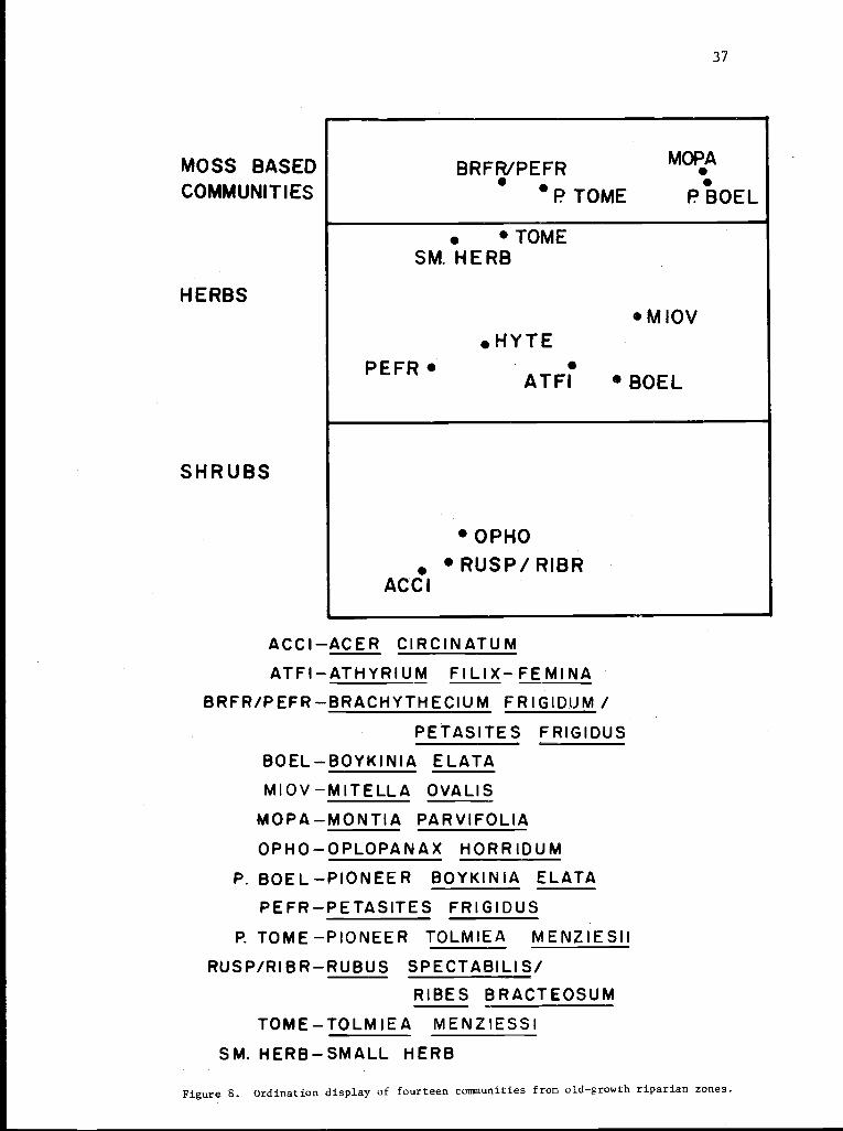
37
MOSS BASEDCOMMUNITIES
PEFR
TOMESM. HERB
HERBSMIOV
SHRUBS
BRFR/PEFR MOPA
P TOME P BOEL
HYTE
ATFI BOEL
OPHO
RUSP/RIBRACC I
ACCI-ACER CIRCINATUMATFI-ATHYRIUM FILIX-FEMINA
BRFR/PEFR-BRACHYTHECIUM FRIGIDUM /
PETASITES FRIGIDUS
BOEL-BOYKINIA ELATAMIOV-MITELLA OVALIS
MOPA-MONTIA PARVIFOLIA
OPHO-OPLOPANAX HORRIDUM
P. BOE L -PIONEER BOYKI N IA ELATA
PEFR-PETASITES FRIGIDUS
P. TOME-PIONEER TOLMIEA MENZIESII
RUSP/RIBR-RUBUS SPECTABILIS/RIBES BRACTEOSUM
TOME-TOLMIEA MENZIESSISM. HERB-SMALL HERB
Figure 8. Ordination display of fourteen communities from old-growth riparian zones.
38
The best separation is achieved by using the two communities leastrelated to all others for initial ordinates and two similar communitiesfrom two substrate types for second ordinates. The Acer circinatumand Bryophyte/ Montia parvifolia communities are end points for thefirst dimension, Petasites frigidus and Pioneer Boykinia elata endpoints for the second (Figure 8). This segregated the communitiesinto moss, herb, and shrub dominated groups which roughly parallelsuccessional stages. Herbs with affinity for a rootable substratesuch as soil or sand segregate to the left, those oriented to rocksubstrates to the top and right.
BIOMASS ESTIMATES
Small stream ecosystems depend upon terrestrial vegetation as a sourcefor most nutrient and energy sources (Cummins 1974, Sedell et al.1975). In old-growth forests, a large share of this plant materialenters streams as detritus from herbaceous or shrubby layers. In aclearcut, before young trees close in, the origin may be entirelyherbaceous. To quantify detrital contributions to the aquatic systemfrom the lower plant strata, biomass estimates were made on two segmentsof Mack Creek and one one of WS 2.
Distribution of biomass is uneven across the riparian zone. Somespecies are common, others sporadic, some are large and some small,and some are almost completely confined to a single zone. Vegetationgrowing well back from the stream, whatever its biomass, does nothave the influence of that in the active zone. Therefore, to estimateproportional impact upon the stream, data are further classified underactive zone, border zone, and outer zone.
Biomass and distribution data are presented here in three ways relatingto detritus production: (1) as overall 1976 foliar biomass productionfor stream segments; (2) as average yearly production. of differentcommunities, including the many minor species; and (3) as weight andfrequency of individual species that are a major source of detritus.
Overall biomass measurements for a stream segment are generally summa-rized per meter of stream length rather than by square meter of eitherland or water. Frequently vegetation overlaps the stream and theincreased length of stream edge--by meander or island--will increasethe material deposited in the stream. On the other hand, the streamcan be 1 m or 10 m wide without necessarily changing the vegetationmass deposited along a given length. This is particularly true inthe herb-dominated clearcut where no advantage is gained by additionallight penetration. For this reason, summary by square meter of streamis unsatisfactory as a measure of detritus source. Data for a linearmeter of stream may easily be translated to load per square meter ofstream.
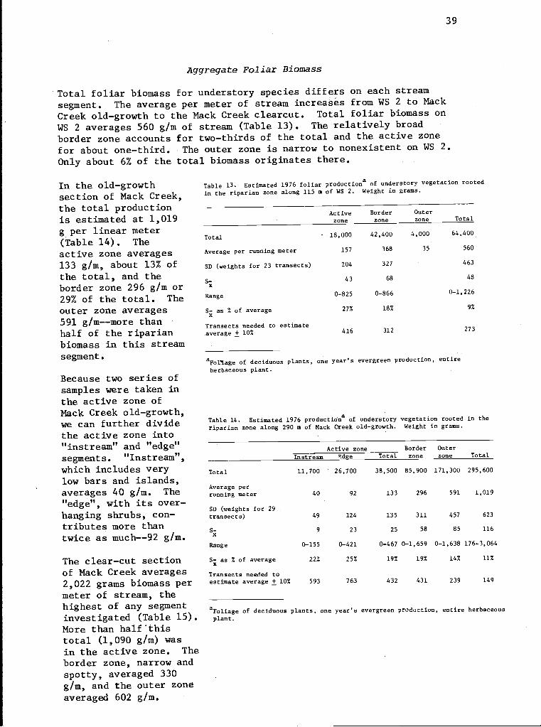
39
Aggregate Foliar Biomass
Total foliar biomass for understory species differs on each streamsegment. The average per meter of stream increases from WS 2 to MackCreek old-growth to the Mack Creek clearcut. Total foliar biomass onWS 2 averages 560 g/m of stream (Table 13). The relatively broadborder zone accounts for two-thirds of the total and the active zonefor about one-third. The outer zone is narrow to nonexistent on WS 2.Only about 6% of the total biomass originates there.
In the old-growthsection of Mack Creek,the total productionis estimated at 1,019g per linear meter(Table 14). Theactive zone averages133 g/m, about 13% ofthe total, and theborder zone 296 g/m or29% of the total. Theouter zone averages591 g/m--more thanhalf of the riparianbiomass in this streamsegment.
Because two series ofsamples were taken inthe active zone ofMack Creek old-growth,we can further dividethe active zone into"instream" and "edge"segments. "Instream",which includes verylow bars and islands,averages 40 g/m. The"edge", with its over-hanging shrubs, con-tributes more thantwice as much--92 g/m.
The clear-cut sectionof Mack Creek averages2,022 grams biomass permeter of stream, thehighest of any segmentinvestigated (Table 15).More than half'thistotal (1,090 g/m) wasin the active zone. Theborder zone, narrow andspotty, averaged 330g/m, and the outer zoneaveraged 602 g/m.
Table 13. Estimated 1976 foliar production of understory vegetation rootedin the riparian zone along 115 m of WS 2. Weight in grams.
Total
Average per running meter
SD (weights for 23 transects)
S-X
Range
S- as % of averagex
Transects needed to estimateaverage ± 10%
Activezone
Borderzone
Outerzone Total
- 18,000 42,400 4,000 64,400
157 368 35 560
204 327 463
43 68 48
0-825 0-866 0-1,226
27% 18% 9%
416 312 273
aFol7.age of deciduous plants, one year's evergreen production, entireherbaceous plant.
Table 14. Estimated 1976 productions of understory vegetation rooted in theriparian zone along 290 m of Mack Creek old-growth. Weight in grams.
Active zone Border OuterInstream Edge Total zone zone Total
Total 11,700 26,700 38,500 85,900 171,300 295,600
Average perrunning meter 40 92 133 296 591 1,019
SD (weights for 29transects) 49 124 135 311 457 623
S- 9 23 25 58 85 116x
Range 0-155 0-421 0-467 0-1,659 0-1,638 176-3,064
S- as % of average 22% 25% 19% 19% 14% 11%
Transacts needed toestimate average ± 10% 593 763 432 431 239 149
aFoliage of deciduous plants, one year's evergreen production, entire herbaceousplant.
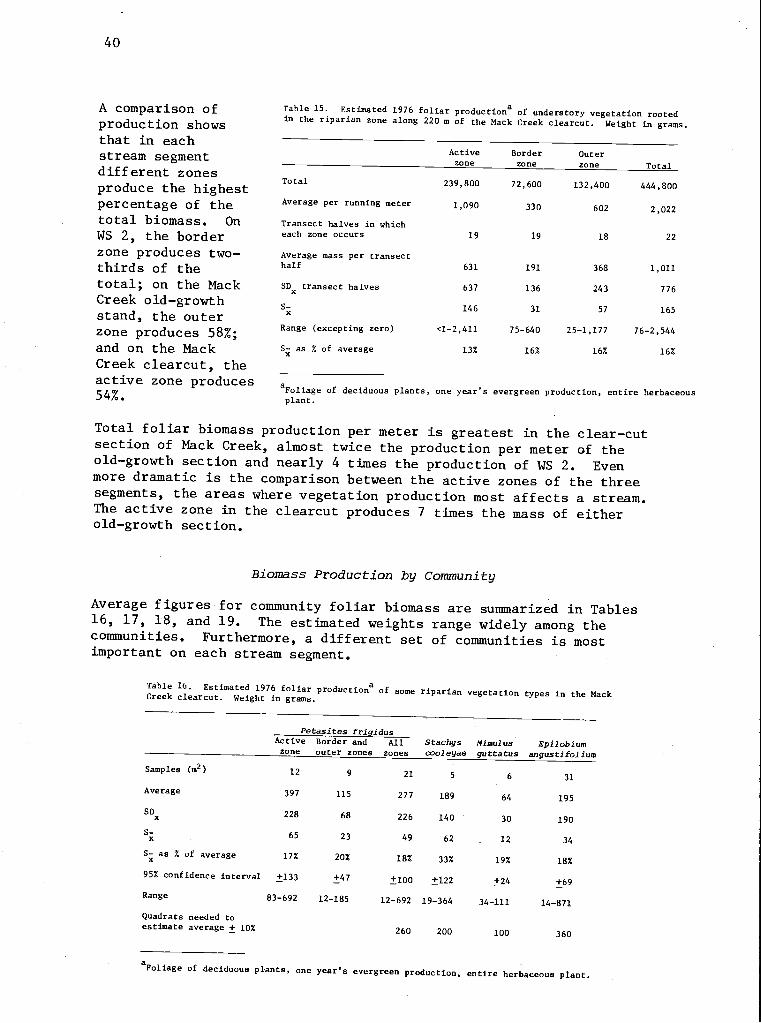
40
A comparison ofproduction showsthat in eachstream segmentdifferent zonesproduce the highestpercentage of thetotal biomass. OnWS 2, the borderzone produces two-thirds of thetotal; on the MackCreek old-growthstand, the outerzone produces 58%;and on the MackCreek clearcut, theactive zone produces54%.
Table 15. Estimated 1976 foliar production of understory vegetation rootedin the riparian zone along 220 m of the Mack Creek clearcut. Weight in grams.
Activezone
Borderzone
Outerzone Total
Tnt.1 239,800 72,600 132,400 444 ,1SUU
Average oar run ,ino ,.ores 1,090 330
Transect halves in whicheach zone occurs 19 19 18 22
Average mass per transecthalf 631 191 368 1 011
SDx transect halves 637 136 243 776
S- 146 31 57 165
Range (excepting zero) <1-2,411 75-640 25-1,177 76-2,544
S- as % of average 13% 16% 16% 16%
a Foliage of deciduous plants, one year's evergreen production, entire herbaceousplant.
Total foliar biomass production per meter is greatest in the clear-cutsection of Mack Creek, almost twice the production per meter of theold-growth section and nearly 4 times the production of WS 2. Evenmore dramatic is the comparison between the active zones of the threesegments, the areas where vegetation production most affects a stream.The active zone in the clearcut produces 7 times the mass of eitherold-growth section.
Biomass Production by Community
Average figures for community foliar biomass are summarized in Tables16, 17, 18, and 19. The estimated weights range widely among thecommunities. Furthermore, a different set of communities is mostimportant on each stream segment.
Table 16. Estimated 1976 foliar productions of some riparian vegetation types in the MackCreek clearcut. Weight in grams.
Petasites frigidusActive
zoneBorder andouter zones
Allzones
Stachyscooleyae
Mimulusguttatus
Epilobiumangustifolium
Samples (m2) 12 9 21 5 31
Average 397 115 277 189 64 195
SDx 228 68 226 140 30 190
Sx 65 23 49 62 12 34
S-xas % of average 17% 20% 18% 33% 19% 18%
95% confidence interval +133 +47 +100 +122 +24 +69
Range 83-692 12-185 12-692 19-364 34-111 14-871
Quadrats needed toestimate average ± 10% 260 200 100 360
a Foliage of deciduous plants, one year's evergreen production, entire herbaceous plant.
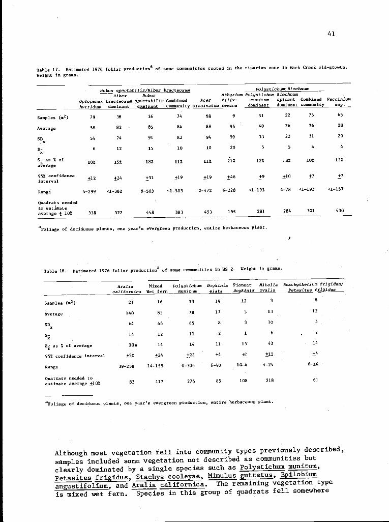
41
Table 17. Estimated 1976 foliar production of some communities rooted in the riparian zone in Mack Creek old-growth.Weight in grams.
Samples (m2)
Average
SDx
S-x
S- as % ofxaverage
95% confidenceinterval
Range
Quadrats neededto estimateaverage + 10%
Rubus spectabilislRibes bracteosum Polystichum-Blechnum
Ribes Rubus Athyrium Polystichum Blechnum
Oplopanax bracteosum spectabilis Combined Acer filix- munitum spicant Combined Vaccinium
horridum dominant dominant community circinatum femina dominant dominant community ssp.
79 38 36 74 98 9 51 22 73 65
58 82 85 84 88 96 40 26 36 28
54 74 91 82 94 59 33 22 31 29
6 12 15 10 10 20 5 5 4 4
10% 15% 18% 11% 11% 21% 12% 18% 10% 13%
+12 +24 +31 +19 +19 +46 +9 +10 +7 +7
4-299 <1-382 8-503 <1-503 2-472 6-228 <1-193 4-78 <1-193 <1-157
338 322 448 383 453 155 281 284 301 430
a Foliage of deciduous plants, one year's evergreen production, entire herbaceous plant.
Table 18. Estimated 1976 foliar productions of some communities in WS 2. Weight in grams.
Araliacalifornica
MixedWet fern
Polystichummunitum
Boykiniaelata
PioneerBoykinia
Mitellaovalis
Brachythecium frigidum/Petasites frigidus
Samples (m2) 21 16 33 19 12 3 8
Average 140 85 78 17 5 13 12
SD 64 46 65 8 3 10 5
x
S- 14 12 11 2 1 6 2
x
S- as % of average 104 14 14 11 15 43 14
x
95% confidence interval +30 +24 +22 +4 +2 +12 +4
Range 39-258 14-155 0-306 6-40 10-4 4-24 6-16
Quatrats needed toestimate average ±10% 83 117 276 85 108 218 61
aFoliage of deciduous plants, one year's evergreen production, entire herbaceous plant.
Although most vegetation fell into community types previously described,
samples included some vegetation not described as communities but
clearly dominated by a single species such as Polystichum munitum,
Petasites frigidus, Stachys cooleyae, Mimulus guttatus, Epilobium
angustifolium, and Aralia californica. The remaining vegetation type
is mixed wet fern. Species in this group of quadrats fell somewhere
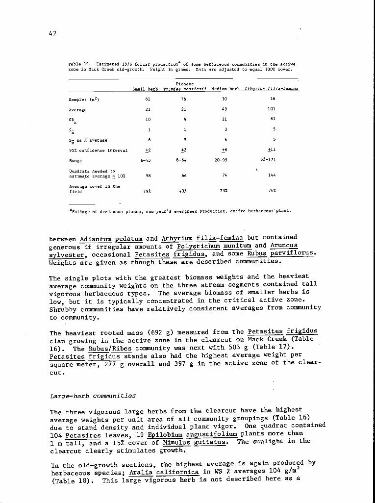
42
Table 19. Estimated 1976 foliar productiona of some herbaceous communities in the activezone in Mack Creek old-growth. Weight: in grams. Data are adjusted to equal 100% cover.
PioneerSmall herb Tolmiea menziesii Medium herb Athyrium filix-femina
Samples (m2) 61 76 30 16
Average 21 21 49 101
SDx
10 9 21 61
S- 1 1 3 5x
S- as % average 6 5 6 5X
95% confidence interval +2 +2 +6 +11
Range 6-43 8-64 20-95 32-171
Quadrats needed toestimate average + 10% 98 66 74 144
Average cover in thefield 79% 43% 73% 76%
a Foliage of deciduous plants, one year's evergreen production, entire herbaceous' plant.
between Adiantum pedatum and Athyrium filix-femina but contained
generous if irregular amounts of Polystichum munitum and Aruncus
sylvester, occasional Petasites frigidus, and some Rubus parviflorus.
Weights are given as though these are described communities.
The single plots with the greatest biomass weights and the heaviest
average community weights on the three stream segments contained tall
vigorous herbaceous types. The average biomass of smaller herbs is
low, but it is typically concentrated in the critical active zone.
Shrubby communities have relatively consistent averages from community
to community.
The heaviest rooted mass (692 g) measured from the Petasites frigidus
clan growing in the active zone in the clearcut on Mack Creek (Table
16). The Rubus/Ribes community was next with 503 g (Table 17).
Petasites frigidus stands also had the highest average weight per
square meter, 277 g overall and 397 g in the active zone of the clear-
cut.
Large-herb communities
The three vigorous large herbs from the clearcut have the highest
average weights per unit area of all community groupings (Table 16)
due to stand density and individual plant vigor. One quadrat contained
104 Petasites leaves, 19 Epilobium angustifolium plants more than
1 m tall, and a 15% cover of Mimulus guttatus. The sunlight in the
clearcut clearly stimulates growth.
In the old-growth sections, the highest average is again produced by
herbaceous species; Aralia californica in WS 2 averages 104 g/m2
(Table 18). This large vigorous herb is not described here as a
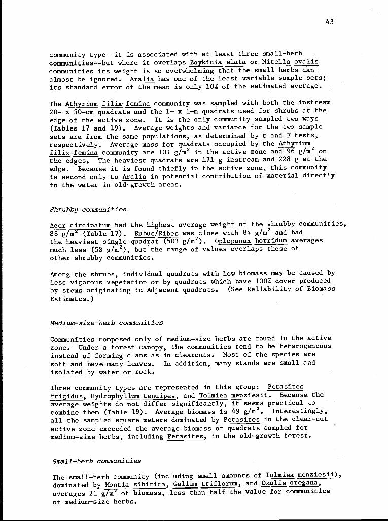
43
community type--it is associated with at least three small-herbcommunities--but where it overlaps Boykinia elata or Mitella ovaliscommunities its weight is so overwhelming that the small herbs canalmost be ignored. Aralia has one of the least variable sample sets;its standard error of the mean is only 10% of the estimated average.
The Athyrium filix-femina community was sampled with both the instream20- x 50-cm quadrats and the 1- x 1-m quadrats used for shrubs at the
edge of the active zone. It is the only community sampled two ways(Tables 17 and 19). Average weights and variance for the two samplesets are from the same populations, as determined by t and F tests,
respectively. Average mass for quadrats occupied by the Athyrium
filix-femina community are 101 g/m2 in the active zone and 96 g/m2 onthe edges. The heaviest quadrats are 171 g instream and 228 g at the
edge. Because it is found chiefly in the active zone, this community
is second only to Aralia in potential contribution of material directlyto the water in old-growth areas.
Shrubby communities
Acer circinatum had the highest average weight of the shrubby communities,88 g/m (Table 17). Rubus/Ribes was close with 84 g/m2 and hadthe heaviest single quadrat (503 g/m2). Oplopanax horridum averagesmuch less (58 g/m2), but the range of values overlaps those ofother shrubby communities.
Among the shrubs, individual quadrats with low biomass may be caused byless vigorous vegetation or by quadrats which have 100% cover producedby stems originating in Adjacent quadrats. (See Reliability of BiomassEstimates.)
Medium-size-'herb communities
Communities composed only of medium-size herbs are found in the activezone. Under a forest canopy, the communities tend to be heterogeneousinstead of forming clans as in clearcuts. Most of the species aresoft and have many leaves. In addition, many stands are small andisolated by water or rock.
Three community types are represented in this group: Petasitesfrigidus, Hydrophyllum tenuipes, and Tolmiea menziesii. Because theaverage weights do not differ significantly, it seems practical tocombine them (Table 19). Average biomass is 49 g/m2. Interestingly,all the sampled square meters dominated by Petasites in the clear-cutactive zone exceeded the average biomass of quadrats sampled formedium-size herbs, including Petasites, in the old-growth forest.
Small-herb communities
The small-herb community (including small amounts of Tolmiea menziesii),dominated by Montia sibirica, Galium triflorum, and Oxalis oregana,averages 21 g/m of biomass, less than half the value for communitiesof medium-size herbs.
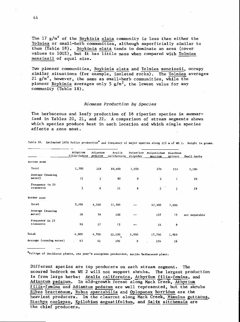
44
The 17 g/m2 of the Boykinia elata community is less than either theTolmiea or small-herb communities, although superficially similar tothem (Table 18). Boykinia elata tends to dominate an area (covervalues to 100%), but it has little mass when compared with Tolmieamenziesii of equal size.
Two pioneer communities, Boykinia elata and Tolmiea menziesii, occupysimilar situations (for example, isolated rocks). The Tolmiea averages21 g/m2, however, the same as small-herb communities, while thepioneer Boykinia averages only 5 g/m2, the lowest value for anycommunity (Table 18).
Biomass Production by Species
The herbaceous and leafy production of 16 riparian species is summar-ized in Tables 20, 21, and 22. A comparison of stream segments showswhich species produce best in each location and which single speciesaffects a zone most.
Table 20. Estimated 1976 foliar production and frequency of major species along 115 m of WS 2. Weight in grams.
Athyri umfilix-femina
Adiantumpedatum
Araliacalifornica
Petasitesfrigidus
Polystichummunitum
Blechnumspicant Small herbs
Active zone
Total 1,700 218 10,600 1,050 370 123 3,290
Average (runningmeter) 15 2 92 9 3 1 29
Frequency in 23transects 5 6 11 8 2 1 19
Border zone
Total 3,200 4,530 11,500 -- 17,300 1,690
Average (runningmeter) 28 39 100 -- 157 15 not separable
Frequency in 23transects 10 17 12 14 9
Total 4,900 4,700 22,100 1,050 17,700 1,810
Average (running meter) 43 41 192 9 154 16
aFoltage of deciduous plants, one year's evergreen production, entire herbaceous plant.
Different species are top producers on each stream segment. Thescoured bedrock on WS 2 will not support shrubs. The largest productionis from large herbs: Aralia californica, Athyrium filix-femina, andAdiantum pedatum. In old-growth forest along Mack Creek, Athyriumfilix-femina and Adiantum pedatum are well represented, but the shrubsRibes bracteosum, Rubus spectabilis and Oplopanax horridum are theheaviest producers. In the clearcut along Mack Creek, Mimulus guttatus,Stachys cooleyae, Epilobium angustifolium, and Salix sitchensis arethe chief producers.
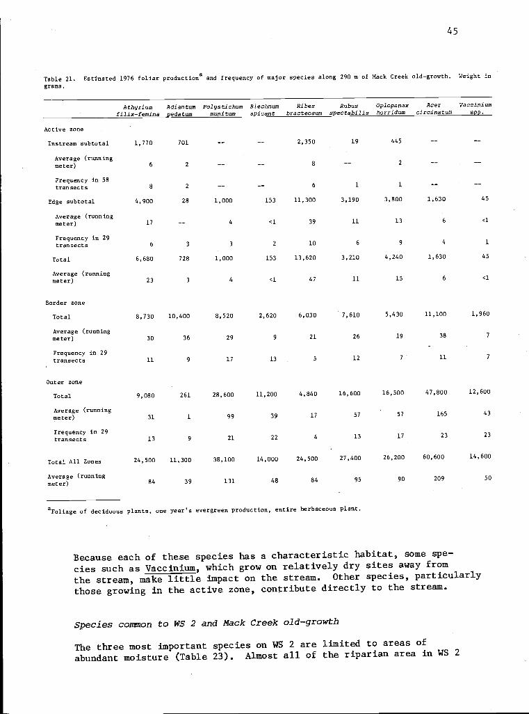
45
Table 21. Estimated 1976 foliar productiona and frequency of major species along 290 m of Mack Creek old-growth. Weight in
grams.
Active zone
Instream subtotal 1,770 701 -- -- 2,350 19 445
Average (runningmeter) 6 2 -- -- 8 -- 2
Frequency in 58transects 8 2 6 1 1
Edge subtotal 4,900 28 1,000 153 11,300 3,190 3,800 1,630 45
Average (runningmeter) 17 -- 4 <1 39 11 13 6 <1
Frequency in 29transacts 6 3 3 2 10 6 9 4 1
Total 6,680 728 1,000 153 13,620 3,210 4,240 1,630 45
Average (runningmeter) 23 3 4 <1 47 11 15 6 <1
Border zone
Total 8,730 10,400 8,520 2,620 6,030 7,610 5,430 11,100 1,960
Average (runningmeter) 30 36 29 9 21 26 19 38 7
Frequency in 29transects 11 9 17 13 5 12 7 11 7
Outer zone
Total 9,080 261 28,600 11,200 4,840 16,600 16,500 47,800 12,600
Average (runningmeter) 31 1 99 39 17 57 57 165 43
Frequency in 29transects 13 9 21 22 4 13 17 23 23
Total All Zones 24,500 11,300 38,100 14,000 24,500 27,400 26,200 60,600 14,600
Average (runningmeter) 84 39 131 48 84 95 90 209 50
aFoliage of deciduous plants, one year's evergreen production, entire herbaceous plant.
Because each of these species has a characteristic habitat, some spe-
cies such as Vaccinium, which grow on relatively dry sites away from
the stream, make little impact on the stream. Other species, particularly
those growing in the active zone, contribute directly to the stream.
Species common to WS 2 and Mack Creek old-growth
The three most important species on WS 2 are limited to areas ofabundant moisture (Table 23). Almost all of the riparian area in WS 2
Athyrium Adiantum Polystichum Blechnum Ribes Rubus Oplopanax Acer Vacciniumfilix-femina pedatum munitum spi cant bracteosum spectabilis horridum circinatum spp.
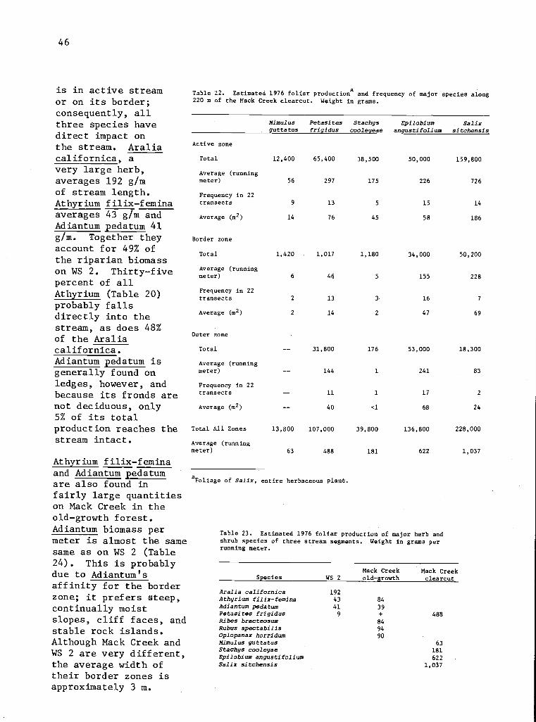
46
is in active streamor on its border;consequently, allthree species havedirect impact onthe stream. Araliacalifornica, avery large herb,averages 192 g/mof stream length.Athyrium filix-feminaaverages 43 g/m andAdiantum pedatum 41g/m. Together theyaccount for 49% ofthe riparian biomasson WS 2. Thirty-fivepercent of allAthyrium (Table 20)probably fallsdirectly into thestream, as does 48%of the Araliacalifornica.Adiantum pedatum isgenerally found onledges, however, andbecause its fronds arenot deciduous, only5% of its totalproduction reaches thestream intact.
Athyrium filix-feminaand Adiantum pedatumare also found infairly large quantitieson Mack Creek in theold-growth forest.Adiantum biomass permeter is almost the samesame as on WS 2 (Table24). This is probablydue to Adiantum'saffinity for the borderzone; it prefers steep,continually moistslopes, cliff faces, andstable rock islands.Although Mack Creek andWS 2 are very different,the average width oftheir border zones isapproximately 3 m.
Table 22. Estimated 1976 foliar production and frequency of major species along220 m of the Mack Creek clearcut. Weight in grams.
Mimulusguttatus
Petasitesfrigidus
Stachyscooleyeae
Epilobiumangustifolium
Salixsitchensis
Active zone
Total 12,400 65,400 38,500 50,000 159,800
Average (runningmeter) 56 297 175 226 726
Frequency in 22transects 9 13 5 15 14
Average (m2) 14 76 45 58 186
Border zone
Total 1,420 1,017 1,180 34,000 50,200
Average (runningmeter) 6 46 5 155 228
Frequency in 22transects 2 13 3 16 7
Average (m2) 2 14 2 47 69
Outer zone
Total 31,800 176 53,000 18,300
Average (runningmeter) 144 1 241 83
Frequency in 22transects 11 1 17 2
Average (m2) 40 <1 68 24
Total All Zones 13,800 107,000 39,800 136,800 228,000
Average (runningmeter) 63 488 181 622 1,037
a Foliage of Salix, entire herbaceous plant.
Table 23. Estimated 1976 foliar production of major herb andshrub species of three stream segments. Weight in grams perrunning meter.
Species WS 2Mack Creekold-growth
Mack Creekclearcut
Aralia californica 192Athyrium filix-femina 43 84Adiantum pedatum 41 39Petasites frigidus 9 + 488Ribes bracteosum 84Rubus spectabilis 94Oplopanax horridum 90Mimulus guttatus 63Stachys cooleyae 181Epilobium angustifolium 622Salix sitchensis 1,037
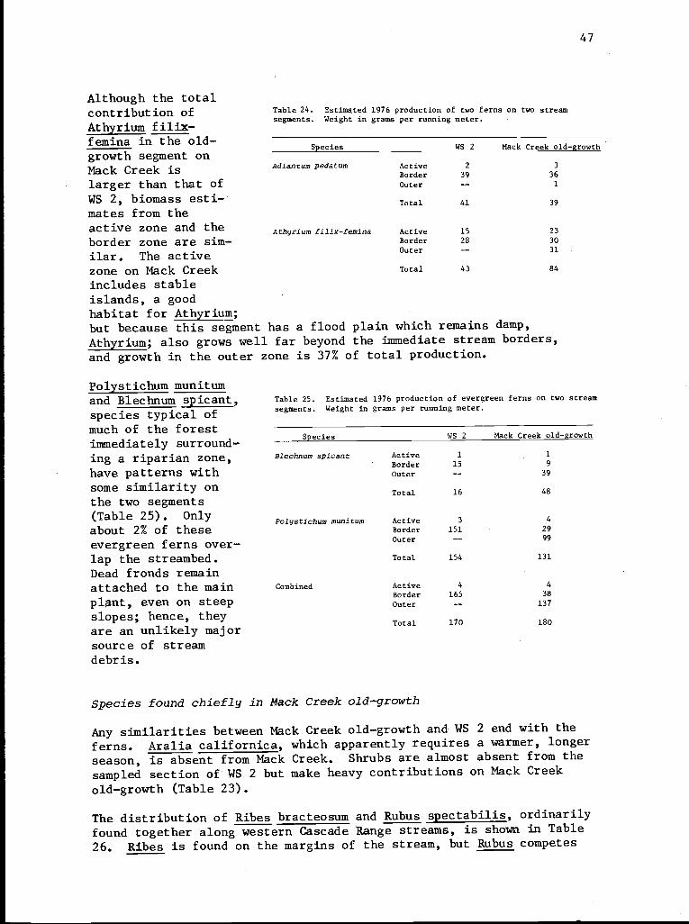
47
Although the totalcontribution ofAthyrium f ilix-f emina in the old-growth segment onMack Creek islarger than that ofWS 2, biomass esti-mates from theactive zone and theborder zone are sim-ilar. The activezone on Mack Creekincludes stableislands, a goodhabitat for Athyrium;
Table 24. Estimated 1976 production of two ferns on two streamsegments. Weight in grams per running meter.
Species WS 2 Mack Creek old-growth
Adiantum pedatum Active 2 3
Border 39 36
Outer 1
Total 41 39
Athyrium filix-femina Active 15 23
Border 28 30
Outer 31
Total 43 84
but because this segment has a flood plain which remains damp,
Athyrium; also grows well far beyond the immediate stream borders,
and growth in the outer zone is 37% of total production.
Polystichum munitumand Blechnum spicant,species typical ofmuch of the forestimmediately surround-ing a riparian zone,have patterns withsome similarity onthe two segments(Table 25). Onlyabout 2% of theseevergreen ferns over-lap the streambed.Dead fronds remainattached to the mainplant, even on steepslopes; hence, theyare an unlikely majorsource of streamdebris.
Table 25. Estimated 1976 production of evergreen ferns on two stream
segments. Weight in grams per running meter.
Species WS 2 Mack Creek old-growth
Blechnum spicant Active 1 1
Border 15 9
Outer -- 39
Total 16 48
Palystichum munitum Active 3 4
Border 151 29
Outer -- 99
Total 154 131
Combined Active 4 4
Border 165 38
Outer -- 137
Total 170 180
Species found chiefly in Mack Creek old-growth
Any similarities between Mack Creek old-growth and WS 2 end with the
ferns. Aralia californica, which apparently requires a warmer, longer
season, is absent from Mack Creek. Shrubs are almost absent from the
sampled section of WS 2 but make heavy contributions on Mack Creek
old-growth (Table 23).
The distribution of Ribes bracteosum and Rubus spectabilis, ordinarily
found together along western Cascade Range streams, is shown in Table
26. Ribes is found on the margins of the stream, but Rubus competes
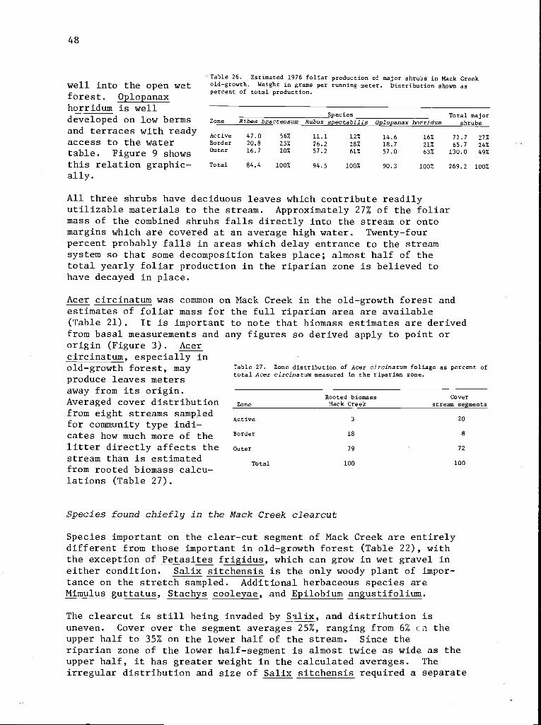
48
well into the open wetforest. Oplopanaxhorridum is well
Table 26. Estimated 1976 foliar production of major shrubs in Mack Creekold-growth. Weight in grams per running meter. Distribution shown aspercent of total production.
developed on low berms Zone
and terraces with ready Activeaccess to the water Border
Outertable. Figure 9 showsthis relation graphic-ally.
Total
Species Total majorRites bracteosum Rubus spectabilis Oplopanax horridum shrubs
47.0 56% 11.1 12% 14.6 16% 72.7 27%20.8 25% 26.2 28% 18.7 21% 65.7 24%16.7 20% 57.2 61% 57.0 63% 130.0 49%
84.4 100% 94.5 100% 90.3 100% 269.2 100%
All three shrubs have deciduous leaves which contribute readilyutilizable materials to the stream. Approximately 27% of the foliarmass of the combined shrubs falls directly into the stream or ontomargins which are covered at an average high water. Twenty-fourpercent probably falls in areas which delay entrance to the streamsystem so that some decomposition takes place; almost half of thetotal yearly foliar production in the riparian zone is believed tohave decayed in place.
Acer circinatum was common on Mack Creek in the old-growth forest andestimates of foliar mass for the full riparian area are available(Table 21). It is important to note that biomass estimates are derivedfrom basal measurements and any figures so derived apply to point ororigin (Figure 3). Acercircinatum, especially inold-growth forest, mayproduce leaves metersaway from its origin.Averaged cover distributionfrom eight streams sampledfor community type indi-cates how much more of thelitter directly affects thestream than is estimatedfrom rooted biomass calcu-lations (Table 27).
Table 27. Zone distribution of Acer circinatum foliage as percent oftotal Acer circinatum measured in the riparian zone.
Rooted biomass CoverZone Mack Creek stream se ments
Active 3 20
Border 18 8
Outer 79 72
Total 100 100
Species found chiefly in the Mack Creek clearcut
Species important on the clear-cut segment of Mack Creek are entirelydifferent from those important in old-growth forest (Table 22), withthe exception of Petasites frigidus, which can grow in wet gravel ineither condition. Salix sitchensis is the only woody plant of impor-tance on the stretch sampled. Additional herbaceous species areMimulus guttatus, Stachys cooleyae, and Epilobium angustifolium.
The clearcut is still being invaded by Salix, and distribution isuneven. Cover over the segment averages 25%, ranging from 6% cn theupper half to 35% on the lower half of the stream. Since theriparian zone of the lower half-segment is almost twice as wide as theupper half, it has greater weight in the calculated averages. Theirregular distribution and size of Salix sitchensis required a separate
49
biomass sample, a 250-m segment extending 15 m beyond each end of the
rest of the sample. A transect 5 m wide was run in the center of
each 25 m segment--a 20% sample.
Salix sitchensis averages 1,037 g foliage per meter of stream, thegreatest production for any riparian species. Approximately 70% of
all Salix foliage (726 g/m) falls in the active zone, and the per-centage is that low only because many leaves fall on top of steepbanks that tend to contain winter flow. Twenty-two percent of leaves
fall in the border zone and only 8% in the outer zone (Table 22).
Mimulus guttatus grows almost exclusively in the active zone. It is
probably more important for maturation and decay early in the seasonthan for total biomass. Ninety percent of its yearly production is in theactive zone (Table 22).
Stachys cooleyae is similarly restricted. Of an estimated averageof 181 g of stream, 175 g (97%) was rooted in the active channel(Table 22).
Petasites frigidus is a vigorous, adaptable species. In the clear-
cut, large quantities are rooted in gravel deposits in the stream.It also grows on top of the rocky side banks lining the stream, al-though not as vigorously.. The total weight distribution for this speciesis high in the active zone, drops markedly in the border zone, andrises in the outer zone (Figure 9), a pattern also apparent on aquadrat basis. Petasites frigidus produced approximately 297 g/m in
the active zone (Table 22), second only to Salix.
Epilobium angustifolium must have reached its apogee in the riparianzone in the year of sampling. It was tall and vigorous.. On 67% of
transects it was found in the active zone on islands and bars. Detritus
contribution to the active stream was 226 g/m, third after Salix andPetasites (Table 22). However, Epilobium overtops Petasites on thestream bank, particularly where water is near the surface. Epilobium
is second (622 g/m) in total biomass estimates for the full width ofthe clear-cut riparian zone.
The distribution of biomass of these species as percent of total bio-
mass is shown in Figure 9.
Reliability of Biomass Estimates
Biomass is irregularly distributed in the riparian zone and variationin total biomass from transect to transect is very high (Tables 13,14, and 15). Standard deviations approach or surpass the averageweights of the transects. Biomass prediction for the active zone ismost important because this zone is most directly related to thestream. In the clearcut, the active zone is slightly less variablethan in the other two zones. In the old-growth forest, the activezone is most variable. Figure 10 shows the distribution of sampleweights from active-zone transects on Mack Creek. Along this segment,
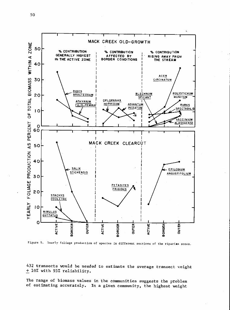
50
woz 50IV
40
Ii0I-
060
W0-
U) 50z0
40D00Cr 30WCD
0 20Iir
10
Wr
0
I
MACK CREEK OLD-GROWTH
% CONTRIBUTIONGENERALLY HIGHESTIN THE ACTIVE ZONE
I
I
W
I-
Q
RIBES I
BRACTEOSUM
ATHYRIUMFILIX-FEMINAI
I
W
0
WI-0
% CONTRIBUTION % CONTRIBUTIONAFFECTED BY I " RISING AWAY FROM
BORDER CONDITIONS THE STREAM
ACERI CIRCINATUM
BLECHNUM / POLYSTICHUMMSPICANT MUNITUM
OPLOPANAX I
W
Q
I
HORRIDUM ADIANTUM.1. A PEDATUM
I-UQ
W0Ct0CD
MW
D0
at
W
0
I
WF0
Figure 9. Yearly foliage production of species in different sections of the riparian zones.
432 transects would be needed to estimate the average transect weight+ 10% with 95% reliability.
The range of biomass values in the communities suggests the problemof estimating accurately. In a given community, the highest weight
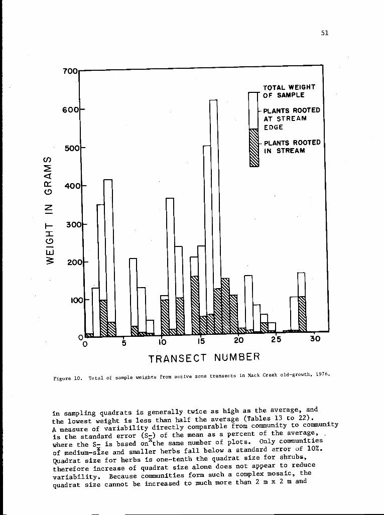
51
700
600
5001-
Z
W200 -
TOTAL WEIGHTr OF SAMPLE
PLANTS ROOTEDAT STREAMEDGE
PLANTS ROOTEDIN STREAM
I
r.,
SS 1-.105 161
20 25 30
TRANSECT NUMBER
Figure 10. Total of sample weights from active zone transects in Mack Creek old-growth, 1976.
in sampling quadrats is generally twice as high as the average, and
the lowest weight is less than half the average (Tables 13 to 22).
A measure of variability directly comparable from community to community
is the standard error (S-) of the mean as a percent of the average,
where the S- is based onxthe same number of plots. Only communities
of medium-size and smaller herbs fall below a standard error of 10%.
Quadrat size for herbs is one-tenth the quadrat size for shrubs,
therefore increase of quadrat size alone does not appear to reduce
variability. Because communities form such a complex mosaic, the
quadrat size cannot be increased to much more than 2 m x 2 m and
100
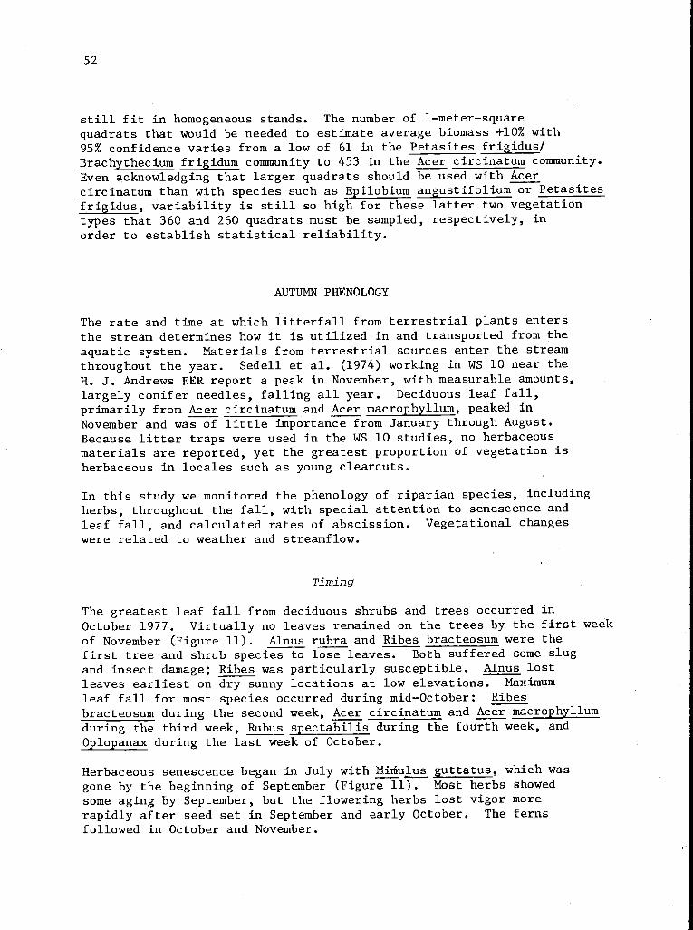
52
still fit in homogeneous stands. The number of 1-meter-squarequadrats that would be needed to estimate average biomass +10% with95% confidence varies from a low of 61 in the Petasites frigidus/Brachythecium frigidum community to 453 in the Acer circinatum community.Even acknowledging that larger quadrats should be used with Acercircinatum than with species such as Epilobium angustifolium or Petasitesfrigidus, variability is still so high for these latter two vegetationtypes that 360 and 260 quadrats must be sampled, respectively, inorder to establish statistical reliability.
AUTUMN PHENOLOGY
The rate and time at which litterfall from terrestrial plants entersthe stream determines how it is utilized in and transported from theaquatic system. Materials from terrestrial sources enter the streamthroughout the year. Sedell et al. (1974) working in WS 10 near theH. J. Andrews EER report a peak in November, with measurable amounts,largely conifer needles, falling all year. Deciduous leaf fall,primarily from Acer circinatum and Acer macrophyllum, peaked inNovember and was of little importance from January through August.Because litter traps were used in the WS 10 studies, no herbaceousmaterials are reported, yet the greatest proportion of vegetation isherbaceous in locales such as young clearcuts.
In this study we monitored the phenology of riparian species, includingherbs, throughout the fall, with special attention to senescence andleaf fall, and calculated rates of abscission. Vegetational changeswere related to weather and streamflow.
Timing
The greatest leaf fall from deciduous shrubs and trees occurred inOctober 1977. Virtually no leaves remained on the trees by the first weekof November (Figure 11). Alnus rubra and Ribes bracteosum were thefirst tree and shrub species to lose leaves. Both suffered some slugand insect damage; Ribes was particularly susceptible. Alnus lostleaves earliest on dry sunny locations at low elevations. Maximumleaf fall for most species occurred during mid-October: Ribesbracteosum during the second week, Acer circinatum and Acer macrophyllumduring the third week, Rubus spectabilis during the fourth week, andOplopanax during the last week of October.
Herbaceous senescence began in July with Mihulus guttatus, which wasgone by the beginning of September (Figure 11). Most herbs showedsome aging by September, but the flowering herbs lost vigor morerapidly after seed set in September and early October. The fernsfollowed in October and November.
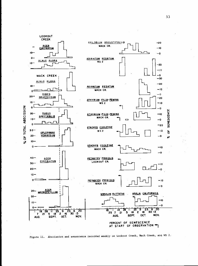
53
LOOKOUTCREEK
EPILOBIUM ANGUSTIFOLIUM
- ACER MACK CR.CIRCINATUM
10-
0- ADIANTUM PEDATUMALNUS RUBRA WS 210-
STACHYS COOLEYAEMACK CR.
-10
MACK CREEK,
ALNUS RUBRA
10-
0CRUBUS
SPECTABILIS r-j
RIBES20- BRACTEOSUM
ADIANTUM PEDATUMMACK CR.
ATHYRIUM FILIX-FEMINAWS 2
ATHYRIUM FILIX-FEMINAMACK CR.
J'--`--'' LJ
30-OPLOPANAX
20- HORRIDUM
I0-0
40- ACERCIRCINATUM30-
R30- MACRACEOPHYLLUM
20-
10-
r STACHYS COOLEYAEW S 2
0 --e2'0
1 19 28 II 25 9 23 6' 207 21 5 IB 2 16 30 13
AUG. SEPT. OCT. NOV.
PETASITES 'FRIG IOU
LOOKOUT CR.
PETASITES FRIGIDUSMACK CR.
-0-30
J1
-20
-10
-0
-20
-20
-10
-0-20
-10
-O
-10
-10
-0
MIMULUS GUTTATUS ARALIA CALIFORNICA_ sL
X10
25 1 7 1 21 2 5 11 1825 29
16 3 30 1320
AUG. SEPT. OCT. NOV.
PERCENT OF SENESCENCEAT START OF OBSERVATION
Figure 11. Abscission and senescence recorded weekly on Lookout Creek, Mack Creek, and WS 2.
20-
to-0=
54
Abscission Rates
Lookout and Mack Creek differ markedly in their leaf-fall patterns(Figure 12). Leaf-fall data from Lookout Creek plot as straightlines on probit paper, but data from Mack Creek do not. Acer circinatumon Lookout Creek began to lose leaves in early September and continuedto lose them at a fairly steady high rate for 9 weeks until the leaveswere gone by the first week in November. Leaf fall on Mack Creekbegan at the same time, first at a much slower rate and then morerapidly after October 2. Ninety-four percent of the leaves were lostin 3 weeks. Alnus rubra shows a similar pattern of leaf fall--constantat Lookout Creek, varied at Mack Creek (Figure 12).
Abscission is largely controlled by natural aging, frost, and accelera-tion due to other weather events such as rain (Carps 1966). Initiationof abscission of Acer circinatum may depend upon day length, since itbegan within a week at Mack Creek and Lookout Creek and also on twounmonitored upland sites. Once initiated, the steady rate evident onLookout Creek suggests that aging, a linear process, controls leaffall. Leaves at Lookout Creek are much older than those at MackCreek, because on low-elevation, south-facing slopes they developsooner. This development is apparently responsible for the higherinitial leaf fall rate at Lookout Creek. During the week of October 18,an increase in rate at Lookout Creek coincided with first rains afterthe onset of leaf fall. This mechanical force possibly acceleratedsusceptible leaves, and heavier rains the next week did not producesimilar increases.
Environmental factors probably accelerated leaf fall at Mack Creek,if the slow initial rate was, in fact, due to younger leaves. Thefirst reported frost coincided with the abrupt increase in-abscissionrate. The weather station temperature did not reach 0°C (Figure 13),but ice crystals were reported in the soil in the adjacent clearcutduring the preceeding week (Art McKee, personal communication).Since air temperature probes are well protected from reradiation butnot from ground radiation, vegetation quite possibly reached temperaturesof 0°C or less. Initial aging is probably a prerequisite for abscissionin Acer circinatum, as it is hardy through summer frost. No frost wasrecorded or reported at Lookout Creek during the abscission period.
All deciduous trees and shrubs from Mack Creek, with the exception ofAlnus rubra, have similar patterns (Figure 12). Ribes bracteosumbegins abscission earlier than Acer circinatum; although the rate islower on both slopes, the alteration in rate is noticeable. Ribes seemsto respond strongly to aging and is damaged by slugs. Half of theleaves had fallen by first frost, and many of those remaining hadlost much of their mass. Acer macrophyllum and Oplopanax horridumhave rates of leaf fall almost identical to those of Acer circinatum.Except for initial animal damage, the Acer macrophyllum plot wouldhave fitted over the plot for Acer circinatum.
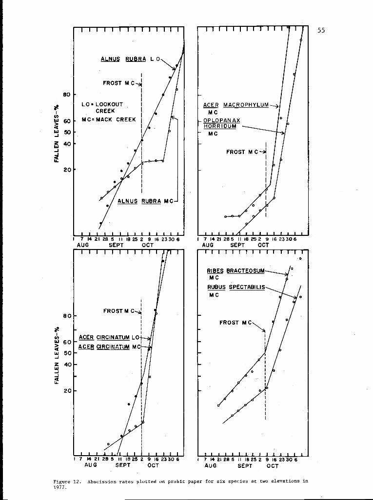
55
80
60
50
40
20
80
1 7 14 21. 28 5 11 18 25 2 9 16 23 30 6AUG SEPT OCT
60
50
40
20
1 7 14 21 28 5 II I825AUG SEPT
2 9 16 2330 6OCT
1 7 1421 285 II 18 252 9 16 23306AUG SEPT OCT
I 7 1421285 II 18252 9 1623306AUG SEPT OCT
Figure 12. Abscission rates plotted on probit paper for six species at two elevations in1977.
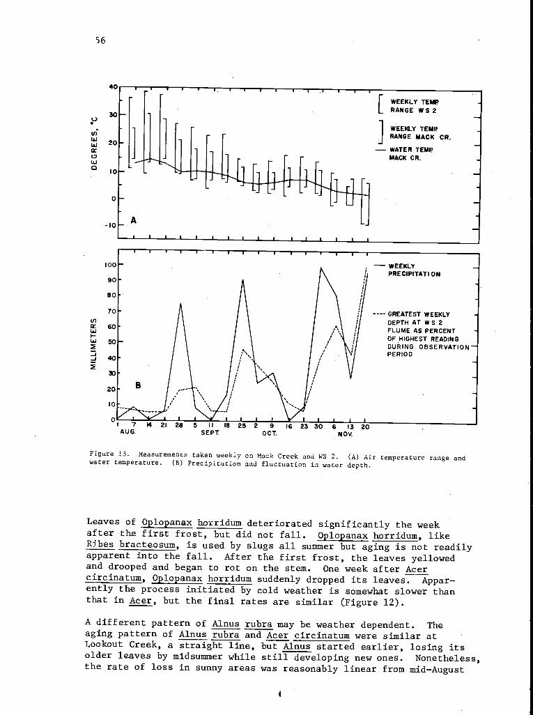
56
40
30
U)
W 20
wa I0
0
-10
T I
A
I
r WEEKLY TEMPLL RANGE W S 2
1 WEEKLY TEMPJ RANGE MACK CR.
- WATER TEMPMACK CR.
GREATEST WEEKLYDEPTH AT W S 2FLUME AS PERCENTOF HIGHEST READINGDURING OBSERVATIONPERIOD
1 7 14 21 28 5 II 18 25 2 9 16 23 30 6 13 20AUG. SEPT. OCT. NOV.
Figure 13. Measurements taken weekly on Mack Creek and WS 2. (A) Air temperature range andwater temperature. (B) Precipitation and fluctuation in water depth.
Leaves of Oplopanax horridum deteriorated significantly the weekafter the first frost, but did not fall. Oplopanax horridum, likeRibes bracteosum, is used by slugs all summer but aging is not readilyapparent into the fall. After the first frost, the leaves yellowedand drooped and began to rot on the stem. One week after Acercircinatum, Oplopanax horridum suddenly dropped its leaves. Appar-ently the process initiated by cold weather is somewhat slower thanthat in Acer, but the final rates are similar (Figure 12).
A different pattern of Alnus rubra may be weather dependent. Theaging pattern of Alnus rubra and Acer circinatum were similar atLookout Creek, a straight line, but Alnus started earlier, losing itsolder leaves by midsummer while still developing new ones. Nonetheless,the rate of loss in sunny areas was reasonably linear from mid-August
4
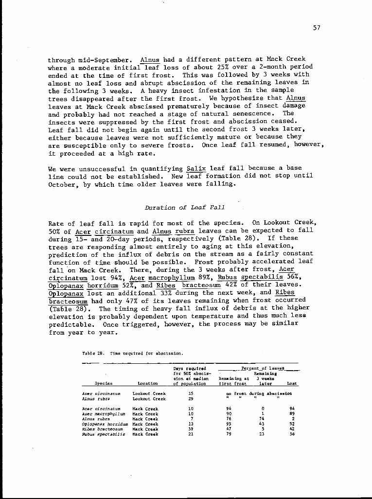
57
through mid-September. Alnus had a different pattern at Mack Creekwhere a moderate initial leaf loss of about 25% over a 2-month periodended at the time of first frost. This was followed by 3 weeks with
almost no leaf loss and abrupt abscission of the remaining leaves inthe following 3 weeks. A heavy insect infestation in the sampletrees disappeared after the first frost. We hypothesize that Alnus
leaves at Mack Creek abscissed prematurely because of insect damageand probably had not reached a stage of natural senescence. The
insects were suppressed by the first frost and abscission ceased.Leaf fall did not begin again until the second frost 3 weeks later,either because leaves were not sufficiently mature or because theyare susceptible only to severe frosts. Once leaf fall resumed, however,
it proceeded at a high rate.
We were unsuccessful in quantifying Salix leaf fall because a baseline could not be established. New leaf formation did not stop until
October, by which time older leaves were falling.
Duration of Leaf Fall
Rate of leaf fall is rapid for most of the species. On Lookout Creek,50% of Acer circinatum and Alnus rubra leaves can be expected to fallduring 15- and 20-day periods, respectively (Table 28). If thesetrees are responding almost entirely to aging at this elevation,prediction of the influx of debris on the stream as a fairly constantfunction of time should be possible. Frost probably accelerated leaffall on Mack Creek. There, during the 3 weeks after frost, Acercircinatum lost 94%, Acer macrophyllum 89%, Rubus spectabilis 56%,Oplopanax horridum 52%, and Ribes bracteosum 42% of their leaves.Oplopanax lost an additional 33% during the next week, and Ribesbracteosum had only 47% of its leaves remaining when frost occurred(Table 28). The timing of heavy fall influx of debris at the higherelevation is probably dependent upon temperature and thus much lesspredictable. Once triggered, however, the process may be similarfrom year to year.
Table 28. Time required for abscission.
Species Location
Days required Percent of leavesfor 50% abscis- Remainingsion at median Remaining at 3 weeksof population first frost later Lost
Acer circinatum Lookout Creek 15 no frost during abscissionAlnus rubra Lookout Creek 29 n n n n
Acer circinatum Mack Creek 10 94 0 94Acer macrophyllum Mack Creek 10 90 1 89Alnus rubra Mack Creek 7 76 74 2
Oplopanax horridum Mack Creek 13 95 43 52
Ribes bracteosum Mack Creek 39 47 5 42Rubus spectabilis Mack Creek 21 79 23 56
58
Rate of Senescence in Herbaceous Plants
The senescence of herbaceous plants is more complex than abscission.First, herbaceous plants generally lack sharply defined events, comparableto abscission, which lead to litterfall. They tend to wilt and decayrather slowly. Furthermore, the mechanical action of the streamcontributes to breakdown. Second, few general patterns appear inherb senescence. Species appear to respond variously to sun, drought,cold, and natural aging. Maturity, followed by natural decay as afunction of growing season, is probably the most common pattern amongflowering herbs. Ferns and vegetative herbs appear to respond toenvironment. Patterns of each herb are considered here individually.
Mimulus guttatus, a delicate, soft, showy herb and one of the firstto develop in spring, begins to drop its flowers by July, developsseeds, withers and is 90% down by mid-September (Figure 14). Mimulusaged at roughly the same time and generally at the same rate at bothLookout Creek and Mack Creek. All locations showed a jump in senescenceafter the first heavy rain in late August, probably because plantswere beaten down.
Aralia californica has a pattern similar to Mimulus guttatus, althoughmany of the stems do not flower (Figure 14). Aging first appeared asbrowning'on the lower leaves and continues steadily until leaves andmost of the stem become soft and decayed and finally collapse on thesubstrate. Senescence in Aralia californica is relatively late, thefirst noticeable withering about mid-September. Decadence continuesat a steady rate until about November 9, when a frost rapidly acceleratedfailure of the remaining 20%.
Patterns of senescence in Epilobium angustifolium, a tall vigorousfireweed, are similar to those for Mimulus guttatus. Flowering isfollowed by browning after little apparent environmental stimulus(Figure 14). At Mack Creek, visible deterioration began in earlySeptember and continued until early October. Epilobium angustifoliumis a stiff herb, however, and unlike Mimulus guttatus, remains brownand upright. Epilobium angustifolium stems occasionally tipped intothe creek, but the greatest proportion of stems were still standingon November 6. Very high water or snow is required to bring themdown; hence this species enters the stream system quite late.
Stachys cooleyae is a mint which stands 0.5 to 1.5 m tall. Anapparent change in rate in September is an artifact of the ratingsystem, which gave considerable importance to flower drop. Afterflowering, the lower leaves begin to wither, but senescence proceedsslowly and many stems were bent into the water while still green andfunctioning. Evidence of water action can be seen in late Septemberand early October where senescence is positively associated withwater level. All Stachys cooleyae were bent and killed by high waterat the end of October.
The Petasites frigidus plant is a vigorous clump of leafy stems withflowers born early in the spring on separate stalks. It was the
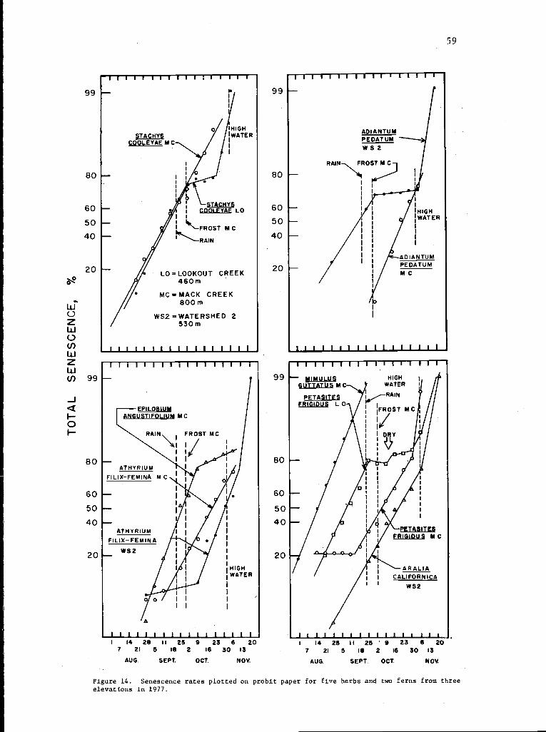
59
Oo
99
80
60
50
40
20
80
60
50
40
20
1 I I I I 1 1 1 1 I 1 1 I I I I
111 11 11111 11 IF-U-"
1 1 1 1 1 1 1 1 1 1 1 1_ 1 1 1 1- 1I 14 29 II 25 9 23 6 20
7 21 5 16 2 16 30 13
AUG. SEPT. OCT. NOV.
99
80
60
50
40
20
99
80
60
50
40
20
MIMULUS HIGHGUTTATUS MC WATER
PETASITES I (RAINR G DUS 0- IIF I L
l I 1 1 1 1 I 1 1 1 1 1 1 1 a a l l 1.
I 14 28 II 25 ' 9 23 6 207 21 5 18 2 16 30 13
AUG. SEPT. OCT. NOV.
Figure 14. Senescence rates plotted on probit paper for five herbs and two ferns from threeelevations in 1977.
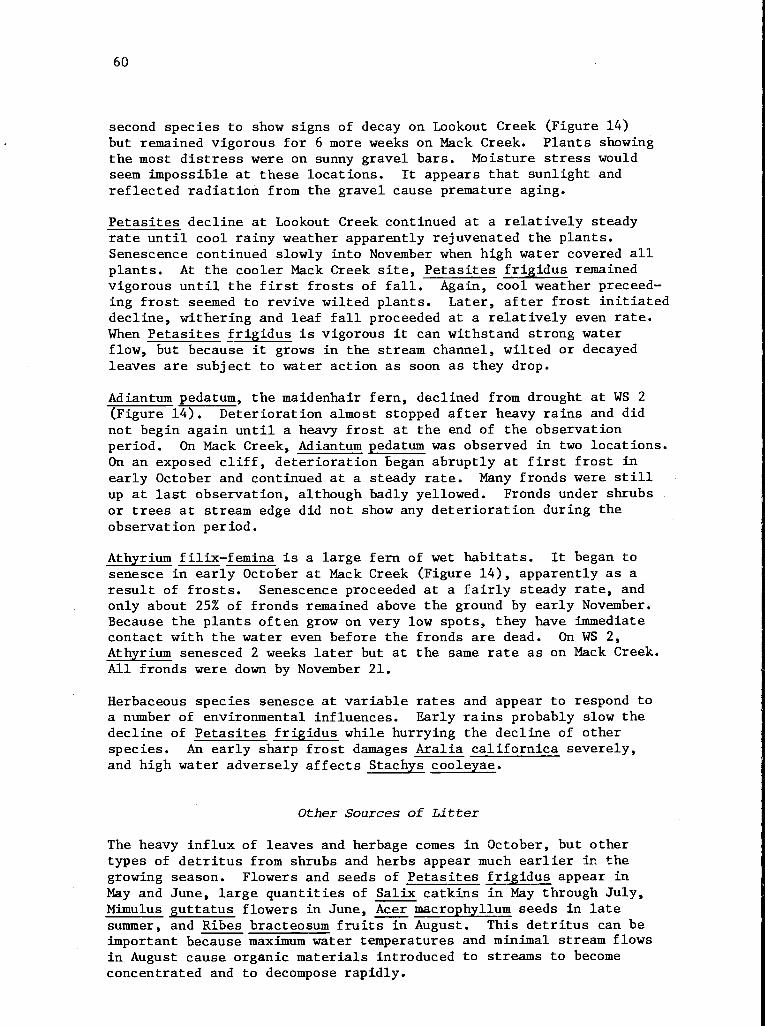
60
second species to show signs of decay on Lookout Creek (Figure 14)but remained vigorous for 6 more weeks on Mack Creek. Plants showingthe most distress were on sunny gravel bars. Moisture stress wouldseem impossible at these locations. It appears that sunlight andreflected radiation from the gravel cause premature aging.
Petasites decline at Lookout Creek continued at a relatively steadyrate until cool rainy weather apparently rejuvenated the plants.Senescence continued slowly into November when high water covered allplants. At the cooler Mack Creek site, Petasites frigidus remainedvigorous until the first frosts of fall. Again, cool weather preceed-ing frost seemed to revive wilted plants. Later, after frost initiateddecline, withering and leaf fall proceeded at a relatively even rate.When Petasites frigidus is vigorous it can withstand strong waterflow, but because it grows in the stream channel, wilted or decayedleaves are subject to water action as soon as they drop.
Adiantum pedatum, the maidenhair fern, declined from drought at WS 2(Figure 14). Deterioration almost stopped after heavy rains and didnot begin again until a heavy frost at the end of the observationperiod. On Mack Creek, Adiantum pedatum was observed in two locations.On an exposed cliff, deterioration began abruptly at first frost inearly October and continued at a steady rate. Many fronds were stillup at last observation, although badly yellowed. Fronds under shrubsor trees at stream edge did not show any deterioration during theobservation period.
Athyrium filix-femina is a large fern of wet habitats. It began tosenesce in early October at Mack Creek (Figure 14), apparently as aresult of frosts. Senescence proceeded at a fairly steady rate, andonly about 25% of fronds remained above the ground by early November.Because the plants often grow on very low spots, they have immediatecontact with the water even before the fronds are dead. On WS 2,Athyrium senesced 2 weeks later but at the same rate as on Mack Creek.All fronds were down by November 21.
Herbaceous species senesce at variable rates and appear to respond toa number of environmental influences. Early rains probably slow thedecline of Petasites frigidus while hurrying the decline of otherspecies. An early sharp frost damages Aralia californica severely,and high water adversely affects Stachys cooleyae.
Other Sources of Litter
The heavy influx of leaves and herbage comes in October, but othertypes of detritus from shrubs and herbs appear much earlier in thegrowing season. Flowers and seeds of Petasites frigidus appear inMay and June, large quantities of Salix catkins in May through July,Mimulus guttatus flowers in June, Acer macrophyllum seeds in latesummer, and Ribes bracteosum fruits in August. This detritus can beimportant because maximum water temperatures and minimal stream flowsin August cause organic materials introduced to streams to becomeconcentrated and to decompose rapidly.
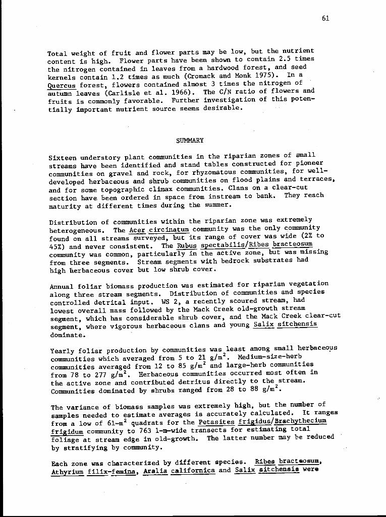
61
Total weight of fruit and flower parts may be low, but the nutrient
content is high. Flower parts have been shown to contain 2.5 times
the nitrogen contained in leaves from a hardwood forest, and seedkernels contain 1.2 times as much (Cromack and Monk 1975). In a
Quercus forest, flowers contained almost 3 times the nitrogen of
autumn leaves (Carlisle et al. 1966). The C/N ratio of flowers and
fruits is commonly favorable. Further investigation of this poten-
tially important nutrient source seems desirable.
SUMMARY
Sixteen understory plant communities in the riparian zones of small
streams have been identified and stand tables constructed for pioneer
communities on gravel and rock, for rhyzomatous communities, for well-
developed herbaceous and shrub communities on flood plains and terraces,
and for some topographic climax communities. Clans on a clear-cut
section have been ordered in space from instream to bank. They reach
maturity at different times during the summer.
Distribution of communities within the riparian zone was extremely
heterogeneous. The Acer circinatum community was the only community
found on all streams surveyed, but its range of cover was wide (2% to
45%) and never consistent. The Rubus spectabilis/Ribes bracteosumcommunity was common, particularly in the active zone, but was missing
from three segments. Stream segments with bedrock substrates had
high herbaceous cover but low shrub cover.
Annual foliar biomass production was estimated for riparian vegetation
along three stream segments. Distribution of communities and species
controlled detrital input. WS 2, a recently scoured stream, had
lowest overall mass followed by the Mack Creek old-growth stream
segment, which has considerable shrub cover, and the Mack Creek clear-cut
segment, where vigorous herbaceous clans and young Salix sitchensis
dominate.
Yearly foliar production by communities was least among small herbaceouscommunities which averaged from 5 to 21 g/m2. Medium-size-herbcommunities averaged from 12 to 85 g/m2 and large-herb communitiesfrom 78 to 277 g/m2. Herbaceous communities occurred most often inthe active zone and contributed detritus directly to the stream.Communities dominated by shrubs ranged from 28 to 88 g/m2.
The variance of biomass samples was extremely high, but the number ofsamples needed to estimate averages is accurately calculated. It rangesfrom a low of 61-m2 quadrats for the Petasites frigidus/Brachythecium
frigidum community to 763 1-m-wide transects for estimating total
foliage at stream edge in old-growth. The latter number may be reduced
by stratifying by community.
Each zone was characterized by different species. Ribes bracteosum,Athyrium filix-femina, Aralia californica and Salix sitchensis were
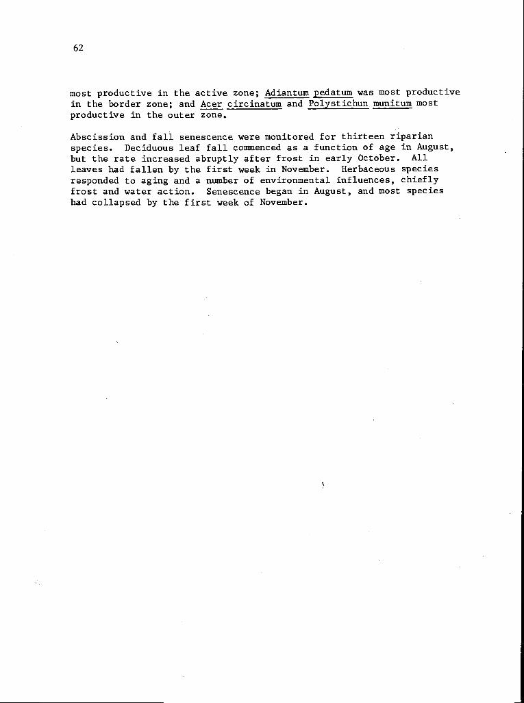
62
most productive in the active zone; Adiantum pedatum was most productivein the border zone; and Acer circinatum and Polystichun munitum mostproductive in the outer zone.
Abscission and fall senescence were monitored for thirteen riparianspecies. Deciduous leaf fall commenced as a function of age in August,but the rate increased abruptly after frost in early October. Allleaves had fallen by the first week in November. Herbaceous speciesresponded to aging and a number of environmental influences, chieflyfrost and water action. Senescence began in August, and most specieshad collapsed by the first week of November.
63
REFERENCES
BOLING, R. H., JR., E. D. GOODMAN, J. A. VAN SICKLE, J. 0. ZIMMER,K. W. CUMMINS, R. C. PETERSEN, and S. R. REICE. 1975. Toward amodel of detritus processing in a woodland stream. Ecology 56:141-151.
BRAY, J. R., and J. T. CURTIS. 1957. An ordination of the uplandforest communities of southern Wisconsin. Ecol. Monogr. 27:325-349.
CARLISLE, A., A. H. F. BROWN, and E. J. WHITE. 1966. Litterfall,leaf production and the effects of defoliation by Tortrix viridanain a sessile oak (Quercus petraea) woodland. J. Ecol. 54:65-85.
CARNS, H. R. 1966. Abscission and its control. Annu. Rev. of PlantPhysiol. 17:295-314.
CROMACK, K., JR., and C. D. MONK. 1975. Liter production, decomposi-tion, and nutrient cycling in a mixed hardwood watershed and a whitepine watershed. IN: F. G. Howell, J. B. Gentry, and M. H. Smith (eds.)Mineral Cycling in Southwestern Ecosystems, p. 609-624. ERDA SymposiumSeries. (CONF-740513).
CUMMINS, K. W. 1974. Structure and function of stream ecosystems.Bioscience 24:631-641.
GHOLZ, H. L., C. C. GRIER, A. G. CAMPBELL, and A. T. BROWN. 1979.Equations for estimating biomass and leaf area of plants in thePacific Northwest. For. Res. Lab., Oregon State Univ., Corvallis.Res. Pap. 40. In press.
GRIER, C. C., and R. H. Waring. 1974. Conifer mass related tosapwood area. Forest Sci. 20(3):205-206.
RUSSELL, D. W. 1973. The life history of vine maple on the H. J.Andrews Experimental Forest. M. S. thesis, Oregon State Univ.,Corvallis.
SARVAS, R. 1972. Investigations on the annual cycle of developmentof forest trees. Finnish For. Res. Inst., Helsinki, 110 p.
SEDELL, J., F. J. TRISKA, J. HALL, N. ANDERSON, and J. LYFORD. 1974.Sources and fates of organic inputs in coniferous forest streams.IN: R. H. Waring (ed.), Integrated research in the coniferous forestbiome, Proc. AIBS Symp. Conif. For. Ecosystems, p. 57-69. Conif.For. Biome Bull. 5.
SEDELL, J. R., F. J. TRISKA, and N. M. TRISKA. 1975. The processingof conifer and hardwood leaves into two coniferous forest streams:I. Weight loss and associated invertebrates. Ver. Int. Verin. Limnol.19.
SWANSON, F. J., and M. E. JAMES. 1975. Geomorphic history of thelower Blue River-Lookout Creek area, Western Cascades, Oregon. NorthwestSci. 49(l):1-11.
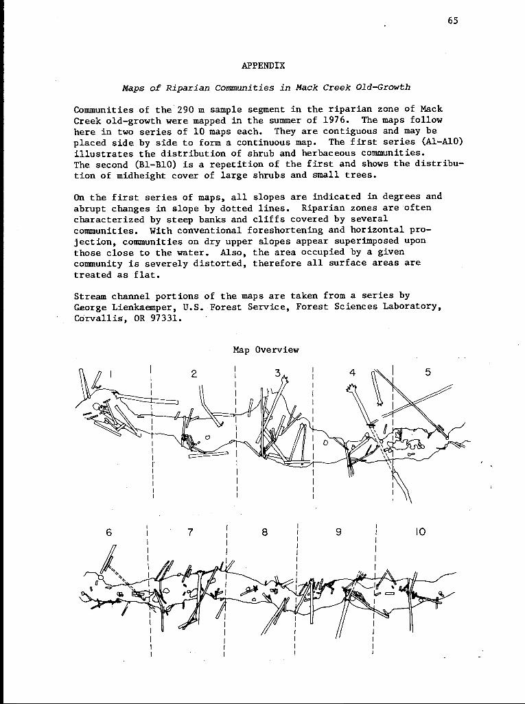
65
APPENDIX
Maps of Riparian Communities in Mack Creek Old-Growth
Communities of the 290 m sample segment in the riparian zone of MackCreek old-growth were mapped in the summer of 1976. The maps followhere in two series of 10 maps each. They are contiguous and may beplaced side by side to form a continuous map. The first series (Al-AlO)illustrates the distribution of shrub and herbaceous communities.The second (B1-B10) is a repetition of the first and shows the distribu-tion of midheight cover of large shrubs and small trees.
On the first series of maps, all slopes are indicated in degrees andabrupt changes in slope by dotted lines. Riparian zones are oftencharacterized by steep banks and cliffs covered by severalcommunities. With conventional foreshortening and horizontal pro-jection, communities on dry upper slopes appear superimposed uponthose close to the water. Also, the area occupied by a givencommunity is severely distorted, therefore all surface areas aretreated as flat.
Stream channel portions of the maps are taken from a series byGeorge Lienkaemper, U.S. Forest Service, Forest Sciences Laboratory,Corvallis, OR 97331.
Map Overview
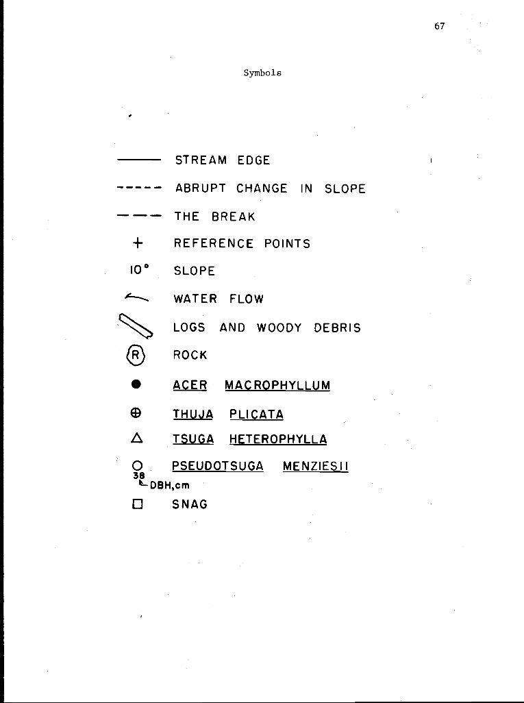
67
Symbols
STREAM EDGE
ABRUPT CHANGE IN SLOPE
--- THE BREAK+ REFERENCE POINTS
100 SLOPE
WATER FLOW
LOGS AND WOODY DEBRIS
RO ROCK
ACER MACROPHYLLUM
THUJA PLICATA
TSUGA HETE.ROPHYLLA
0. PSEUDOTSUGA MENZIESII38'1-DBH,cm
SNAG
-
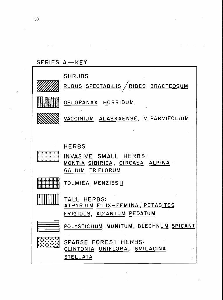
68
SERIES A -KEY
SHRUBS
RUBUS SPECTABILIS/RIBES BRACTEOSUM
OPLOPANAX HORRIDUM
VACCINIUM ALASKAENSE, V. PARVIFOLIUM
HERBS
INVASIVE SMALL HERBS:MONTIA SIBIRICA, CIRCAEA ALPINAGALIUM TRIFLORUM
TOLMIEA MENZIES I I
TALL HERBS:'ATHYRIUM FILIX-FEMINA, PETASITES
FRIGIDUS, ADIANTUM PEDATUM
POLYSTICHUM MUNITUM, BLECHNUM SPICANT
SPARSE FOREST HERBS:CLINTONIA UNIFLORA, SMILACINASTELLATA
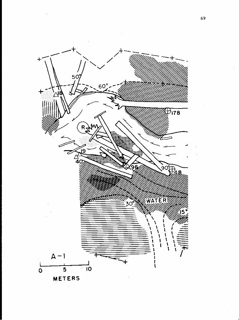
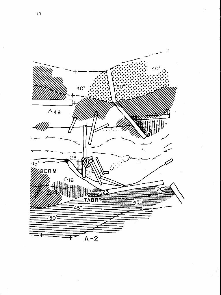
70
.__o
2
0
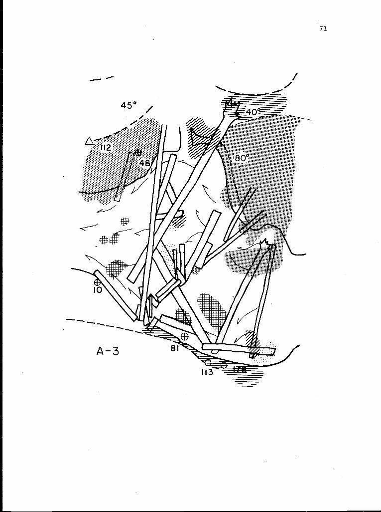
I
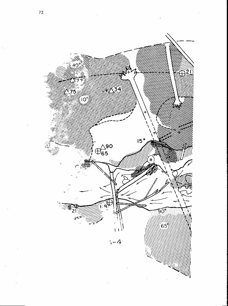
.,,
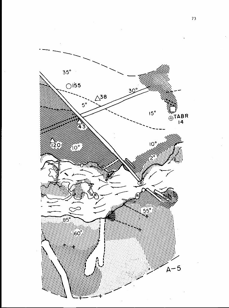
73
1
K
35°
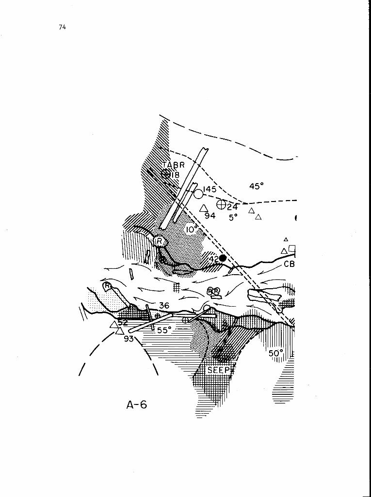
74
............
.A .iI li \ n. \ -w- ip -171
A-6
50II
45°
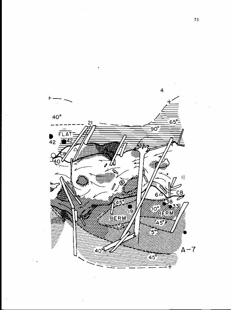
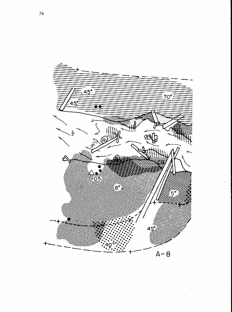
76
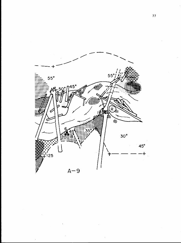
77
55 0
m-Iii --
55°i
:1 ,
30°
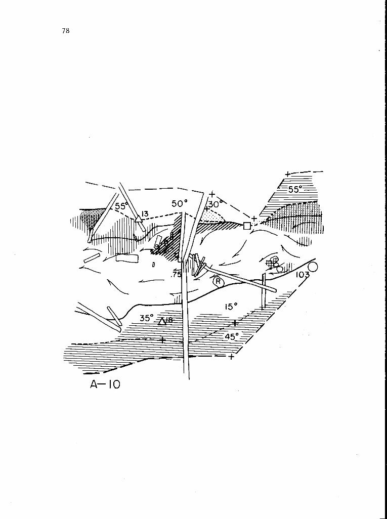
4455°
mm5 00 /.30`
galill 111 111111
11 ir111111
A- 10
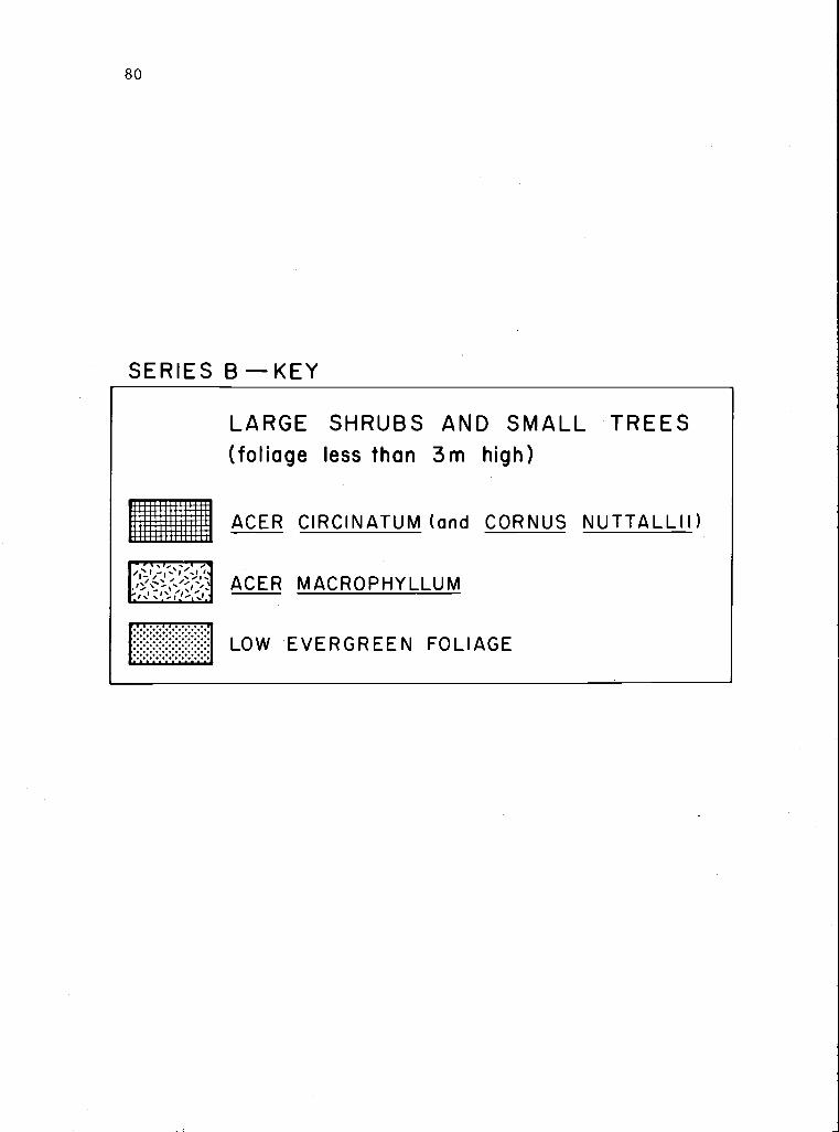
80
SERIES B-KEY
LARGE SHRUBS AND SMALL TREES(foliage less than 3m high)
ACER CIRCINATUM (and CORNUS NUTTALLII )
ACER MACROPHYLLUM
LOW EVERGREEN FOLIAGE