Embed Size (px)
Citation preview
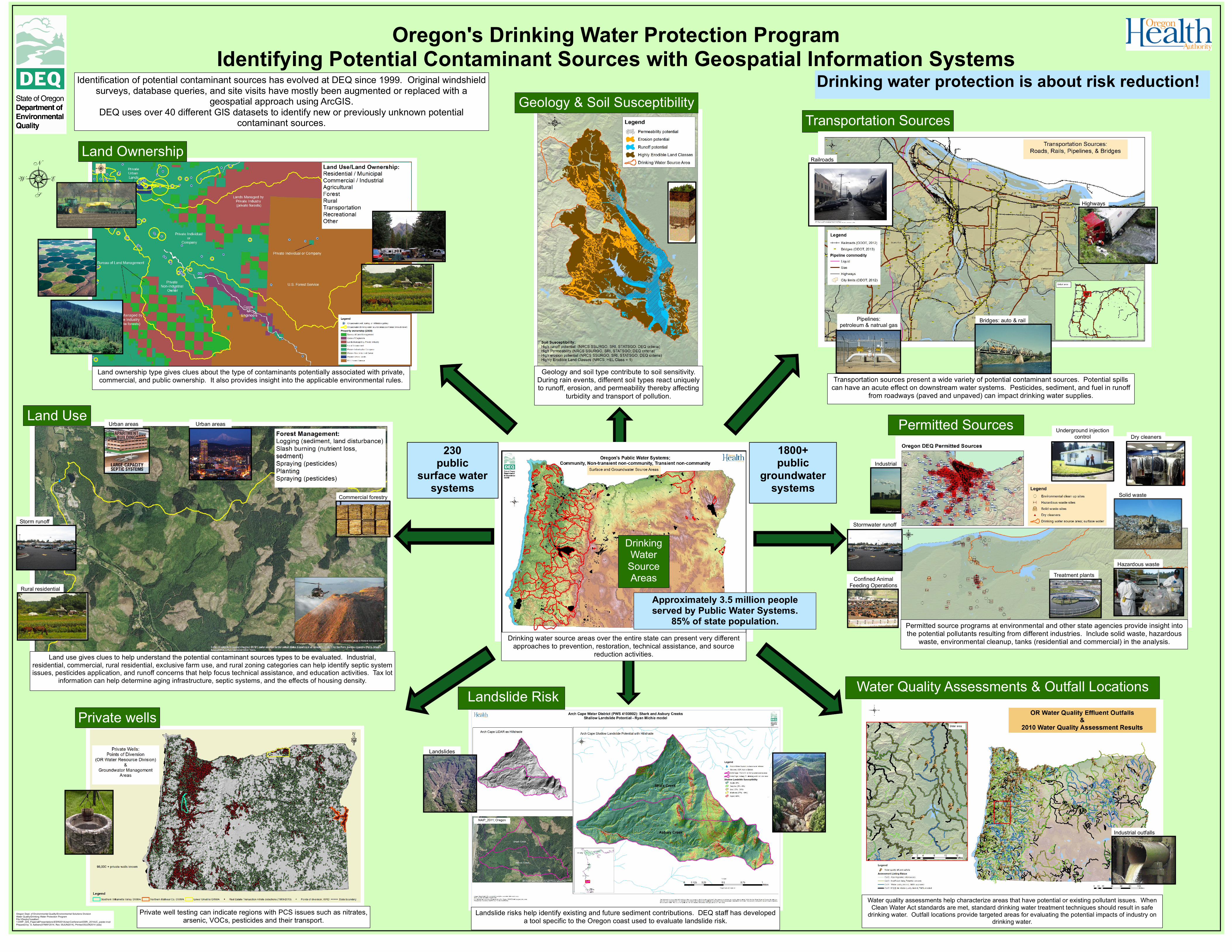
Oregon's Drinking Water Protection ProgramIdentifying Potential Contaminant Sources with Geospatial Information Systems
Oregon Dept. of Environmental Quality/Environmental Solutions DivisionWater Quality/Drinking Water Protection ProgramFile:\\Deqhq1\saalber\1-DWP_GIS_Papers&Presentations\ESRI2014UserConference\ESRI_2014UC_poster.mxdPrepared by: S. Aalbers(07MAY2014, Rev. 05JUN2014), Printed:05JUN2014 (sda)
Identification of potential contaminant sources has evolved at DEQ since 1999. Original windshieldsurveys, database queries, and site visits have mostly been augmented or replaced with a
geospatial approach using ArcGIS.DEQ uses over 40 different GIS datasets to identify new or previously unknown potential
contaminant sources.
Transportation sources present a wide variety of potential contaminant sources. Potential spillscan have an acute effect on downstream water systems. Pesticides, sediment, and fuel in runoff
from roadways (paved and unpaved) can impact drinking water supplies.
8
Drinking water source areas over the entire state can present very differentapproaches to prevention, restoration, technical assistance, and source
reduction activities.
Geology & Soil Susceptibility
Water Quality Assessments & Outfall Locations
Underground injectioncontrol
Permitted SourcesDry cleaners
Solid waste
Hazardous waste
Transportation Sources
Small farms &rural residential lands
DrinkingWaterSourceAreas
Water quality assessments help characterize areas that have potential or existing pollutant issues. WhenClean Water Act standards are met, standard drinking water treatment techniques should result in safe
drinking water. Outfall locations provide targeted areas for evaluating the potential impacts of industry ondrinking water.
Permitted source programs at environmental and other state agencies provide insight intothe potential pollutants resulting from different industries. Include solid waste, hazardous
waste, environmental cleanup, tanks (residential and commercial) in the analysis.
Drinking water protection is about risk reduction!
230public
surface watersystems
1800+public
groundwatersystems
Approximately 3.5 million peopleserved by Public Water Systems.
85% of state population.
Land use gives clues to help understand the potential contaminant sources types to be evaluated. Industrial,residential, commercial, rural residential, exclusive farm use, and rural zoning categories can help identify septic systemissues, pesticides application, and runoff concerns that help focus technical assistance, and education activities. Tax lot
information can help determine aging infrastructure, septic systems, and the effects of housing density.
Land Use
Landslide Risk
Landslide risks help identify existing and future sediment contributions. DEQ staff has developeda tool specific to the Oregon coast used to evaluate landslide risk.
Private well testing can indicate regions with PCS issues such as nitrates,arsenic, VOCs, pesticides and their transport.
Private wells
Land Ownership
Land ownership type gives clues about the type of contaminants potentially associated with private,commercial, and public ownership. It also provides insight into the applicable environmental rules.
Geology and soil type contribute to soil sensitivity.During rain events, different soil types react uniquelyto runoff, erosion, and permeability thereby affecting
turbidity and transport of pollution.
Railroads
Highways
Pipelines:petroleum & natrual gas Bridges: auto & rail
Industrial
Stormwater runoff
Confined AnimalFeeding Operations
Treatment plants
Commercial forestry
Urban areas
Storm runoff
Rural residential
Urban areas
Landslides
Industrial outfalls
![Safe Drinking Water Plan - Comment Letter ELC · More broadly, ELC supports the Draft Plan’s call for “[identifying] ... “Draft Safe Drinking Water Plan for California,” pp](https://img.dokumen.tips/doc/110x75/5b4f82757f8b9a346e8c6831/safe-drinking-water-plan-comment-letter-more-broadly-elc-supports-the-draft.jpg)