Embed Size (px)
Citation preview


RIO DEL ORO
CITY OF RANCHO CORDOVA
Submitted to:
City of Rancho Cordova &
Sacramento Metropolitan Air Quality Management District
November 2006
AIR QUALITY AND EMISSIONS REDUCTION PLAN
E l l i o t t H o m e s , I n c . • 8 0 I r o n P o i n t C i r c l e , S u i t e 11 0 • F o l s o m , C A 9 5 6 3 0
G e n C o r p R e a l E s t a t e • 6 2 0 C o o l i d g e D r i v e , S u i t e 1 0 0 • F o l s o m , C A 9 5 6 3 0

EXECUTIVE SUMMARY
This document presents the Air Quality and Emissions Reduction Plan for the proposed Rio del Oro project in the City of Rancho Cordova.
The City of Rancho Cordova General Plan Policy AQ.1.2.3 requires all new development projects that exceed the Sacramento Air Quality Management District’s (SMAQMD) operational threshold of significance to incorporate design, construction and/or operational features that will result in a reduction in emissions when compared to an “unmitigated baseline” project. Under Policy AQ.1.2.3, emissions reductions measures should consider cost-effectiveness, maximum cost and the provision of credits for emissions reductions already in place.
The measures contained in this Plan are also consistent with County of Sacramento General Plan Policy AQ-15, which requires "a 15% reduction in emissions from the level that would be produced by a base-case project assuming full trip generation per the current ITE Trip Generation Handbook."
Rio del Oro is a 3,828-acre mixed use project proposed in eastern Sacramento County, in the City of Rancho Cordova. The project site is located south of White Rock Road, north of Douglas Road, and east of Sunrise Boulevard. Rio del Oro features approximately 11,601 residential units at a range of density levels, and a mix of commercial, business park, industrial park, school, park and open space uses.
Numerous trip reduction and emission reduction measures are proposed for the project and are identified below. Collectively, these measures will reduce peak hour vehicle trips by employees and reduce emissions from both mobile and direct sources by 15.0%.
R I O D E L O R O A I R Q U A L I T Y A N D E M I S S I O N S R E D U C T I O N P L A N
1

R I O D E L O R O
S U M M A RY O F P R O P O S E D A I R Q U A L I T Y A N D E M I S S I O N S R E D U C T I O N P L A N
CATEGORY
Measure Description
BICYCLE/PEDESTRIAN/TRANSIT
1. Bicycle Lockers and Racks Non-residential projects provide bicycle lockers and/or racks
2. Additional Bicycle Parking Facilities Provide an additional 20% or required Class I and Class II bicycle
facilities within each commercial development in the project area.
3. Shower and Locker Facilities Non-residential projects provide personal showers and lockers
4. Class I Bicycle Storage - Residential Bicycle storage (Class I) at apartment complexes or condos without
garages
5. Class I and Class II Bicycle Facilities Entire project is located within 1/2 mile of an existing Class I or
Class II bike lane and provides a comparable bikeway connection
to that existing facility
6. Pedestrian Facilities The project provides for pedestrian facilities and improvements
7. Uses Proximate to Planned Transit Bus service provides headways of 15 minutes or less for stops
within 1/4 mile; project provides essential bus stop improvements
8. Transportation Information Kiosk Provide a display case or kiosk within each commercial development, displaying transportation information
PARKING
17. Carpool/Vanpool Parking Provide preferential parking for carpool//vanpools
21. Parking Lot Design Provide a parking lot design that includes clearly marked and
shaded pedestrian pathways between transit facilities and building
entrances.
MIXED USE
30. Mixed Use Have at least 3 of the following on-site and/or within 1/4 mile:
Residential Development, Retail Development, Personal Services,
Open Space, Office
31. Neighborhood as Focal Point Neighborhood serving as focal point with parks, school and civic
uses within 1/4 mile
R I O D E L O R O A I R Q U A L I T Y A N D E M I S S I O N S R E D U C T I O N P L A N
2

R I O D E L O R O
S U M M A RY O F P R O P O S E D A I R Q U A L I T Y A N D E M I S S I O N S R E D U C T I O N P L A N
32. Bicycle and Pedestrian Paths Separate, safe and convenient bicycle and pedestrian paths
connecting residential, commercial and office uses.
33. Elimination of Barriers The project provides a development pattern that eliminates
physical barriers such as walls, berms, landscaping, and slopes
between residential and non-residential land uses that impede
bicycle or pedestrian circulation.
BUILDING COMPONENTS
41. Natural Gas Fireplace Install lowest emitting commercially available fireplace in all
residences where fireplaces installed.
42. Energy Efficient Heating Install lowest emitting commercially available furnaces in all
project buildings.
43. Ozone Destruction Catalyst Install ozone destruction catalyst air conditioners in all residential
units
45. High Speed Data Connection Install a connection for high speed data transmission to each
residential unit through the installation of fiber optic cable, T-1
wiring or other comparable technology.
TRANSPORTATION DEMAND
MANAGEMENT & MISC.
51. TMA Membership Include permanent TMA membership and funding requirement.
Funding to be provided by Community Facilities District or
County Service Area or other non-revocable
funding mechanism
65. Lawnmowers Provide a complimentary cordless electric lawnmower to each
residential buyer
R I O D E L O R O A I R Q U A L I T Y A N D E M I S S I O N S R E D U C T I O N P L A N
3

1.0 INTRODUCTION
The City of Rancho Cordova General Plan Policy AQ.1.2.3 requires large development
projects to incorporate design, construction and/or operational features that will result in a
reduction in emissions when compared to an “unmitigated baseline” project. The purpose of
this document is to describe the design features and other mechanisms that will achieve the
required reduction in emissions to comply with this policy. The Rio del Oro project will reduce
impacts to traffic and air quality through the following means:
Reduce total vehicle emissions in the City of Rancho Cordova by reducing the number of
vehicle trips that might otherwise be generated by residents and visitors to the project
area and by utilizing building materials and machinery that will reduce emissions;
Reduce peak hour traffic congestion by reducing both the number of vehicle trips and
vehicular miles to travel that might otherwise be generated by residents and visitors;
and
Increase the efficiency of the existing transportation network and achieve the highest
possible level or service at existing critical intersections
The Sacramento Metropolitan Air Quality Management District (SMAQMD) Guide to Air
Quality Assessment (July 2004) and Indirect Source Review Program Implementation Guidelines
(February 1995) provide guidance to local land use agencies in implementing an indirect source
review program. The SMAQMD has prepared a list of measures and corresponding reduction
credits that can be applied to meet the targeted 15% reduction in emissions. Each emission
reduction measure is assigned a point value, which is approximately equivalent to the
percentage reduction in emissions from the level that would be produced by a base-case project
assuming full trip generation per the current ITE Trip Generation Handbook. See County of
Sacramento General Plan Policy AQ-15. The emission reduction measures are organized into the
following categories:
• Bicycle, Pedestrian and Transit
• Parking
• Mixed Use
• Building Components
• Transportation Demand Management and Miscellaneous
R I O D E L O R O A I R Q U A L I T Y A N D E M I S S I O N S R E D U C T I O N P L A N
4

Section 2 of this document describes the proposed project and the current transportation
setting. Section 3 describes each measure that will be implemented in the project to reduce both
emissions and employee-generated, single-occupant vehicle trips during peak hours. Section 4
summarizes the proposed measures and identifies credits for each measure toward the
emissions reduction requirements.
Implementation of the measures identified in this report will be required as a condition
of approval of the Rio del Oro project and enforceable by the City as lead agency under the
requirements of the California Environmental Quality Act (CEQA) and applicable provisions of
the Municipal Code.
R I O D E L O R O A I R Q U A L I T Y A N D E M I S S I O N S R E D U C T I O N P L A N
5
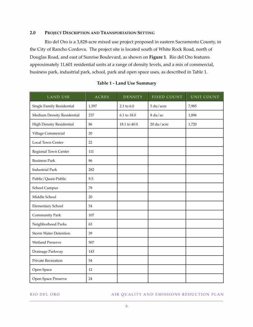
2.0 PROJECT DESCRIPTION AND TRANSPORTATION SETTING
Rio del Oro is a 3,828-acre mixed use project proposed in eastern Sacramento County, in
the City of Rancho Cordova. The project site is located south of White Rock Road, north of
Douglas Road, and east of Sunrise Boulevard, as shown on Figure 1. Rio del Oro features
approximately 11,601 residential units at a range of density levels, and a mix of commercial,
business park, industrial park, school, park and open space uses, as described in Table 1.
Table 1 - Land Use Summary
LAND USE ACRES DENSITY FIXED COUNT UNIT COUNT
Single Family Residential 1,597 2.1 to 6.0 5 du/acre 7,985
Medium Density Residential 237 6.1 to 18.0 8 du/ac 1,896
High Density Residential 86 18.1 to 40.0 20 du/acre 1,720
Village Commercial 20
Local Town Center 22
Regional Town Center 111
Business Park 86
Industrial Park 282
Public/Quasi-Public 9.5
School Campus 78
Middle School 20
Elementary School 54
Community Park 107
Neighborhood Parks 63
Storm Water Detention 39
Wetland Preserve 507
Drainage Parkway 143
Private Recreation 54
Open Space 12
Open Space Preserve 24
R I O D E L O R O A I R Q U A L I T Y A N D E M I S S I O N S R E D U C T I O N P L A N
6

LAND USE ACRES DENSITY FIXED COUNT UNIT COUNT
Landscape Corridors 44
Greenbelts 50
Major Roads 183
TOTAL 3,828 11,601
An illustrative site plan of the Rio del Oro project is shown as Figure 2.
The concept plan for Rio del Oro is intended to encourage internal pedestrian circulation
and ease of access through the following design and land use features: a network of pathways,
greenbelts and landscaped boulevards that will provide a pleasant pedestrian experience; the
location of compatible and complementary land uses is close proximity; and many linkages
between the internal pedestrian/bicycle network to new paths and trails or existing and
planned regional serving facilities on the periphery of the project site. Design standards and
guidelines will ensure that such pedestrian-friendly features such as a street tree planting
program, open space corridors, pedestrian and vehicular linkages and connections between
parking lots and development sites as well as between residential and commercial
development, will be liberally incorporated into the project.
2.1 Access Characteristics
Vehicular access to the project site will be primarily from White Rock Road, Sunrise
Boulevard, and Douglas Road. Primary access to U.S. 50 would be from the existing Zinfandel
Drive and Sunrise Boulevard interchanges, and under long-range conditions, from a new
“Sunrise Reliever” interchange located to the east of the existing Sunrise Boulevard interchange.
2.2 Bicycle Facilities
Bicycle facilities are currently limited near the project site. A Class I off-street bike path
parallels Sunrise Boulevard from White Rock Road south to Grant Line Road along the Folsom
South Canal. However, the City of Rancho Cordova’s Bikeway and Trails Plan (incorporated
into the General Plan Circulation Element) includes on-street bicycle lanes on Sunrise
Boulevard, Grant Line Road, Jackson Road (past Grant Line Road), Kiefer Road, Douglas Road,
Eagles Nest Road, and White Rock Road. See Figure 3.
R I O D E L O R O A I R Q U A L I T Y A N D E M I S S I O N S R E D U C T I O N P L A N
7
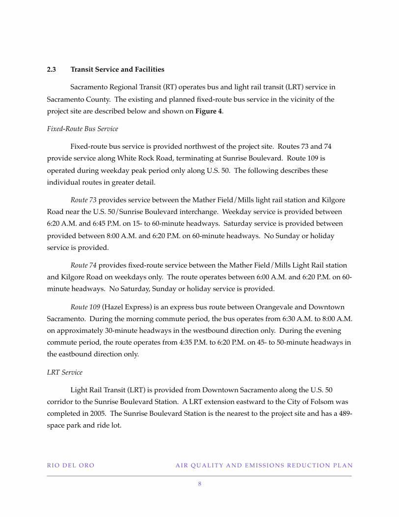
2.3 Transit Service and Facilities
Sacramento Regional Transit (RT) operates bus and light rail transit (LRT) service in
Sacramento County. The existing and planned fixed-route bus service in the vicinity of the
project site are described below and shown on Figure 4.
Fixed-Route Bus Service
Fixed-route bus service is provided northwest of the project site. Routes 73 and 74
provide service along White Rock Road, terminating at Sunrise Boulevard. Route 109 is
operated during weekday peak period only along U.S. 50. The following describes these
individual routes in greater detail.
Route 73 provides service between the Mather Field/Mills light rail station and Kilgore
Road near the U.S. 50/Sunrise Boulevard interchange. Weekday service is provided between
6:20 A.M. and 6:45 P.M. on 15- to 60-minute headways. Saturday service is provided between
provided between 8:00 A.M. and 6:20 P.M. on 60-minute headways. No Sunday or holiday
service is provided.
Route 74 provides fixed-route service between the Mather Field/Mills Light Rail station
and Kilgore Road on weekdays only. The route operates between 6:00 A.M. and 6:20 P.M. on 60-
minute headways. No Saturday, Sunday or holiday service is provided.
Route 109 (Hazel Express) is an express bus route between Orangevale and Downtown
Sacramento. During the morning commute period, the bus operates from 6:30 A.M. to 8:00 A.M.
on approximately 30-minute headways in the westbound direction only. During the evening
commute period, the route operates from 4:35 P.M. to 6:20 P.M. on 45- to 50-minute headways in
the eastbound direction only.
LRT Service
Light Rail Transit (LRT) is provided from Downtown Sacramento along the U.S. 50
corridor to the Sunrise Boulevard Station. A LRT extension eastward to the City of Folsom was
completed in 2005. The Sunrise Boulevard Station is the nearest to the project site and has a 489-
space park and ride lot.
R I O D E L O R O A I R Q U A L I T Y A N D E M I S S I O N S R E D U C T I O N P L A N
8

R I O D E L O R O A I R Q U A L I T Y A N D E M I S S I O N S R E D U C T I O N P L A N
9

FIGURE 2RIO DEL ORO
LAND USE PLAN
R I O D E L O R O A I R Q U A L I T Y A N D E M I S S I O N S R E D U C T I O N P L A N
10

Portion of Bikeway & Trails Plan (Figure C-2)
Rancho Cordova General Plan
FIGURE 3CITY OF RANCHO CORDOVA BIKEWAY AND TRAIL PLAN
R I O D E L O R O A I R Q U A L I T Y A N D E M I S S I O N S R E D U C T I O N P L A N
11

Portion of Transit System Map (Figure C-3)
Rancho Cordova General Plan
FIGURE 4CITY OF RANCHO CORDOVA TRANSIT SYSTEM PLAN
R I O D E L O R O A I R Q U A L I T Y A N D E M I S S I O N S R E D U C T I O N P L A N
12

3.0 PROPOSED MEASURES
This section presents measures to reduce emissions as required by General Plan Policy
AQ.1.2.3. Each measure is consistent (in scope and numbering) with the menu of creditable
measures for emissions reduction developed by the SMAQMD. Measures are applicable to
Residential (R), Commercial (C) and Mixed-Use (M) projects as identified by SMAQMD criteria.
3.1 Bicycle/Pedestrian/Transit Measures
Measure 1 - Bicycle Lockers and Racks (C)
Commercial uses within the project will install bicycle lockers and/or racks, which will
provide employees with safe and convenient bicycle storage. The Rio del Oro Development
Standards and Design Guidelines (Section 3.4.2) provide that “on-site amenities for bicycle
parking shall be provided in a convenient location within each center and designed as an
integral part of the site. The City Zoning Code requires one Class I or Class II bicycle storage
space for every 25 vehicle parking spaces, and one Class II bicycle storage space for every 33
patron vehicle spaces. This measure is intended to reduce vehicle trips and associated
emissions by encouraging employees to ride bicycles to work and for services. Locations of
bicycle racks and storage will be clearly identified prior to City approval of commercial,
business park and industrial park site plans. This measure applies to parcels within the plan
area designated as Village Commercial (VC), Local Town Center (LTC), Regional Town Center
(RTC), Business Park (BP) and Industrial Park (MP) on Figure 5.
R I O D E L O R O A I R Q U A L I T Y A N D E M I S S I O N S R E D U C T I O N P L A N
13

Figure 5Commercial and Employment Land Uses
Measure 2 - Additional Bicycle Parking Facilities (C)
As described above with respect to Measure 1, the City Zoning Code requires one Class I
or Class II bicycle storage space for every 25 vehicle parking spaces, and one Class II bicycle
storage space for every 33 patron vehicle spaces. The project will provide an additional 20% of
required Class I and Class II bicycle facilities within each commercial, office and industrial
development in the plan area. This measure is intended to reduce vehicle trips and associated
emissions by encouraging employees to ride bicycles to work and for services. Locations of
bicycle racks and storage will be clearly identified prior to City approval of commercial,
business park and industrial park site plans. This measure applies to areas within the project
R I O D E L O R O A I R Q U A L I T Y A N D E M I S S I O N S R E D U C T I O N P L A N
14

site designated as Village Commercial (VC), Local Town Center (LTC), Regional Town Center
(RTC), Business Park (BP) and Industrial Park (MP) on Figure 5.
Measure 3 - Shower and Locker Facilities (C)
Showers for both men and women as well as lockers will be located in accordance with
the City Zoning Code, at all commercial development sites with more than 200 employees, as
support for bicycle use and walking. See City Zoning Code Section 330-145. Under Section
330-142 of the City Zoning Code, square-footage equivalents are defined as follows:
TYPE OF USE MINIMUM DEVELOPMENT SIZE ( IN SQUARE
FEET) EQUIVALENT TO 200 EMPLOYEES
Office (excluding medical) 50,000
Industrial Office Park (MP) 60,000
Hospital and Medical Offices 80,000
Commercial 100,000
Light Industrial (M-1) 95,000
Heavy Industrial (M-2) 130,000
Mixed or Multiple Uses (a)
One (1) shower and eight (8) lockers with minimum dimensions of 12 inches X 18 inches
X 36 inches shall be provided for each two hundred (200) employees or fraction thereof, based
on the equivalent development size data in Section 330-142 shown above. The design and/or
management of the shower and locker facilities shall provide for access by both male and
female employees. The shower and locker facilities must be located convenient to one another
and located within 200 feet of the employee bicycle parking facilities. This measure applies to
areas within the plan area designated as Village Commercial (VC), Local Town Center (LTC),
Regional Town Center (RTC), Business Park (BP) and Industrial Park (MP) on Figure 5.
Measure 4 - Bicycle Storage for Residential Projects (R)
Any multi-family development within the plan area that does not provide a private
garage for each unit, Class I bicycle storage will be provided, including bicycle lockers and
racks. Bicycle storage facilities shall be provided in accordance with Zoning Code Section
330-131 standards for multi-family development as follows:
R I O D E L O R O A I R Q U A L I T Y A N D E M I S S I O N S R E D U C T I O N P L A N
15

• 1 bicycle space for every 3 units for complexes of 30 units or less
• 1 bicycle space for every 4 units for complexes of 31 to 100 units
• 1 bicycle space for every 5 units for complexes of 101 or more units
Locations of bicycle storage facilities will be clearly identified on multi-family residential
site plans prior to City approval. This measure applies to areas within the plan area designated
as Medium Density Residential (MD) and High Density Residential (HD) on Figure 6.
FIGURE 6MEDIUM AND HIGH DENSITY RESIDENTIAL LAND USES
R I O D E L O R O A I R Q U A L I T Y A N D E M I S S I O N S R E D U C T I O N P L A N
16

Measure 5 - Class I and Class II Bicycle Facilities (R,C,M)
The Rio del Oro project include Class II bicycle facilities as part of roadway
improvements on Rio del Oro Parkway, Jaeger Road, Americanos Boulevard, Villagio Parkway
and White Rock Road. These facilities will be constructed to City standards, and will include all
appropriate signage and striping. Bicycle facilities will be constructed concurrently with
parallel roadways through the plan area, connecting with adjacent facilities to become part of
the overall bicycle circulation network within the City. Bicycle facilities within the plan area are
shown in Figure 7.1. As described above, a Class I off-street bike path parallels Sunrise
Boulevard from White Rock Road south to Grant Line Road along the Folsom South Canal. In
addition, Class II bike lanes currently exist along the north side of White Rock Road
immediately to the west of the Plan Area, providing for eventual connection to the Folsom
South Canal bicycle trail. Class II bike lanes presently exist (or are under construction) along
Sunrise Boulevard between White Rock Road and Douglas Road as well as along Douglas Road
and a connection to the Folsom South Canal bike trail at Douglas Road. See Figure 7.2. The City
of Rancho Cordova’s Bikeway and Trails Plan (incorporated into the General Plan Circulation
Element) includes on-street bicycle lanes on Sunrise Boulevard, Grant Line Road, Jackson Road
(past Grant Line Road), Kiefer Road, Douglas Road, Eagles Nest Road, and White Rock Road.
See Figure 3. The Plan would provide for Class 1 off-street trails in six separate but connecting
networks through the Plan area. See Figure 7.1.
Consistent with General Plan policies C.2.5, C.2.6, C.2.7 and associated actions, the City will require that Rio del Oro Specific Plan planned Class I and II bikeway improvements and connections be provided concurrent with associated project and roadway development to the satisfaction of the City as part of conditions of approval for tentative map applications.
R I O D E L O R O A I R Q U A L I T Y A N D E M I S S I O N S R E D U C T I O N P L A N
17

FIGURE 7.1RIO DEL ORO BIKEWAYS PLAN
R I O D E L O R O A I R Q U A L I T Y A N D E M I S S I O N S R E D U C T I O N P L A N
18

FIGURE 7.2EXISTING CLASS II BIKEWAY FACILITIES
R I O D E L O R O A I R Q U A L I T Y A N D E M I S S I O N S R E D U C T I O N P L A N
19

Measure 6 - Pedestrian Facilities (R,C,M)
The design of the Rio del Oro project features pathways and connections between land
uses and buildings as well as to and from bus stops that are direct, shaded and lighted. All
pathways will meet ADA requirements for width, slope, grade and access. Per the City Design
Guidelines, sidewalks will be designed and maintained at the following minimum width:
• 5 feet where the sidewalk is separated from the roadway
• 7 feet where the sidewalk is not separated from the roadway
• 8 feet in front of schools and commercial uses
• Sidewalks internal to the site (and not part of a public right-of-way) shall be a minimum of 6 feet in width.
As described in the Rio del Oro Design Guidelines (Section 3.2.4), highly visible
crosswalks will be constructed at each intersection, incorporating changes in paving materials to
safety, visibility and aesthetics. Pedestrian pathways will be shown on improvement plans for
each use, and will connect adjacent land uses and provide connections to sidewalks and other
pedestrian features within the plan area. Consistent with General Plan Policy C.2.3 and
associated actions, the City will require that Rio del Oro Specific Plan sidewalks, high visible crosswalks, trails and other associated planned pedestrian facilities and connections be provided concurrent with associated project and roadway development to the satisfaction of the City as
part of conditions of approval for tentative map applications.
Measure 7 - Commercial Uses Proximate (1/4 Mile) to Planned Transit (7)
Sacramento Regional Transit currently provides bus service in the vicinity of the plan
area, Monday through Friday, on Routes 73, 74 and 109. Saturday service is provided by Route
73. The Rio del Oro project includes plans for bus stop improvements, bus turnouts and bus
shelters to accommodate future extension of bus service to the project site. The exact location of
these facilities will be determined in consultation with City staff and transit district staff. Bus
stops will be designed in consultation with the transit service provider and are expected to
include transit route information, benches, shelter and lighting, electrical connections,
easements and pads. Planned transit stops within the plan area would be located nearby
(within 1/4 mile) to high density residential and employment-generating land uses along
arterial roadways, and these planned uses will be able to easily access transit services when
extended to the site. This planning approach is intended to achieve a nucleus of ridership
sufficient to warrant transit service at 15-minute headways. As shown on Figure 4 above,
R I O D E L O R O A I R Q U A L I T Y A N D E M I S S I O N S R E D U C T I O N P L A N
20

transit service is proposed along White Rock Road, Douglas Road, and International Drive
through the Plan Area.
In addition, Bus Rapid Transit (BRT) service is planned along Rancho Cordova Parkway,
which is designated as an Enhanced Transit Corridor, all connecting the Plan Area to existing
and proposed transit throughout the City. This measure applies to parcels within the plan area
designated as High Density Residential (HD)Village Commercial (VC), Local Town Center
(LTC), Regional Town Center (RTC), Business Park (BP) and Industrial Park (MP) on Figure 8.
FIGURE 8COMMERCIAL, EMPLOYMENT AND HIGH DENSITY RESIDENTIAL LAND USES
R I O D E L O R O A I R Q U A L I T Y A N D E M I S S I O N S R E D U C T I O N P L A N
21

Measure 8 - Transportation Information Kiosk (R,C,M)
The project will provide a display case or kiosk within each commercial development,
displaying transportation information in a prominent area accessible to employees and
residents. The following is a brief list of the potential information that could be available at the
kiosk:
• Carpool and Vanpool Matching• Telecommuting Information• Transit Schedules• Emergency Ride Home Programs• Park and Ride Information• Air Quality Information• Bicycle Discount Program• TMA Meeting Schedule• Newsletters
Materials within each transportation information kiosk shall be replenished and/or
updated by management personnel for commercial, employment and high-density residential
uses as appropriate to maintain currency. This measure applies to parcels within the plan area
designated as High Density Residential (HD),Village Commercial (VC), Local Town Center
(LTC), Regional Town Center (RTC), Business Park (BP) and Industrial Park (MP) on Figure 8.
R I O D E L O R O A I R Q U A L I T Y A N D E M I S S I O N S R E D U C T I O N P L A N
22

3.2 Parking Measures
Measure 17 - Preferred Carpool/Vanpool Parking (C)
The City Zoning Code, Section 330-144, states that at least 10 percent of employee spaces
will be for carpool/vanpool purposes. Under this Section, requirements for employee parking
are determined as follows:
TYPE OF USE PERCENT OF TOTAL PARKING
DEVOTED TO EMPLOYEE PARKING
Office (excluding medical) 70%
Hospital and Medical Office 50%
Commercial 30%
Industrial 70%
The Rio del Oro project will comply with the City Zoning Code requirement for
employee parking spaces, as well as carpool/vanpool spaces. Designated carpool/vanpool
spaces will be located as close to employee entrances as possible. The location of carpool/
vanpool spaces shall be identified on improvement plans, to the satisfaction of City staff, and
shall be clearly marked when built. All carpool/vanpool spaces shall be covered, shaded, or in
some other obvious way be designated as preferential. This measure applies to parcels within
the plan area designated as Business Park (BP) and Industrial Park (MP) on Figure 9.
R I O D E L O R O A I R Q U A L I T Y A N D E M I S S I O N S R E D U C T I O N P L A N
23

FIGURE 9EMPLOYMENT LAND USES
Measure 21 - Parking Lot Design (C)
Surface parking lots utilized by non-residential development within the project will
include clearly marked and shaded pedestrian pathways between transit facilities and business
entrances. The Rio del Oro Design Guidelines Section 3.4.2.8 provide that surface parking lots
shall be designed with clear visible access ways to major building entries, and shall contain
landscaped areas with large shade trees to provide coverage. The Design Guidelines further
require a green landscape buffer between parking areas and pedestrian ways. Pedestrian
pathways shall be designed to minimize conflicts with vehicular traffic through the use of
measures such as changes in paving and lighting to delineate a pedestrian path. Pathways may
utilize tree cover or structures for shading purposes, as appropriate. Pedestrian pathways will
be shown on improvement plans for each commercial use prior to City approval. This measure
applies to parcels within the plan area designated as Village Commercial (VC), Local Town R I O D E L O R O A I R Q U A L I T Y A N D E M I S S I O N S R E D U C T I O N P L A N
24

Center (LTC), Regional Town Center (RTC), Business Park (BP) and Industrial Park (MP) on
Figure 5.
3.3 Mixed Use Development Measures
Measure 30 - Mixed Use within a Single Site (R,C,M)
The Rio del Oro project includes a mix of land zoned for commercial uses and multi-
family land uses within close proximity, providing at least 3 of the following on-site and/or
within 1/4 mile: Residential Development, Retail Development, Personal Services, Open Space,
Office. Approximately 76% of the plan area is within a 1/4 mile walking distance from parks,
open space, commercial and office/light industrial employment areas. See Figure 9.
R I O D E L O R O A I R Q U A L I T Y A N D E M I S S I O N S R E D U C T I O N P L A N
25

FIGURE 9PROXIMITY OF MIXED USES
R I O D E L O R O A I R Q U A L I T Y A N D E M I S S I O N S R E D U C T I O N P L A N
26

Measure 31 - Neighborhood Serving as Focal Point (R,M)
The Rio del Oro project features neighborhoods in close proximity to parks, schools and
civic uses within 1/4 mile. The relationship between residential communities and focal point
land uses (including parks, schools and civic uses) is shown on Figure 10. Approximately 77
percent of all land uses within the Plan area are within 1/4 mile of parks, schools or public/
quasi-public facilities.
Measure 32 - Bicycle and Pedestrian Paths (R,C,M).
The design of the Rio del Oro project features pathways and connections between land
uses and buildings as well as to and from bus stops that are direct, shaded and lighted as
appropriate. All pathways will meet ADA requirements for width, slope, grade and access, and
shall be designed in accordance with City Design Guidelines 2:20 to 2:21, which provide for a
linked system of bicycle paths through the plan area by:
• Direct connections to regional bicycle systems (streets with bike lanes, open spaces
with bike paths, etc.)
• Bicycle routes shall continue to the property boundary to connect to existing systems
on adjacent development or to allow future connections when adjacent properties
develop
• Provide bicycle facilities and part of roadways/driveways with painted lanes and
signage or provide a separate bicycle system
The Rio del Oro project include Class II bicycle facilities as part of roadway
improvements on Rio del Oro Parkway, Jaeger Road, Americanos Boulevard, Villagio Parkway
and White Rock Road. These facilities will be constructed to City standards, and will include all
appropriate signage and striping. Bicycle facilities will be constructed concurrently with
parallel roadways through the plan area, connecting with adjacent facilities to become part of
the overall bicycle circulation network within the City. Bicycle facilities within the Plan area are
shown on Figure 7. As described above, a Class I off-street bike path parallels Sunrise
Boulevard from White Rock Road south to Grant Line Road along the Folsom South Canal.
However, the City of Rancho Cordova’s Bikeway and Trails Plan (incorporated into the General
Plan Circulation Element) includes on-street bicycle lanes on Sunrise Boulevard, Grant Line
Road, Jackson Road (past Grant Line Road), Kiefer Road, Douglas Road, Eagles Nest Road, and
White Rock Road. See Figure 3. In addition, Class II bike lanes currently exist along the north
R I O D E L O R O A I R Q U A L I T Y A N D E M I S S I O N S R E D U C T I O N P L A N
27

side of White Rock Road immediately to the west of the Plan Area, providing for eventual
connection to the Folsom South Canal bicycle trail. Class II bike lanes presently exist (or are
under construction) along Sunrise Boulevard between White Rock Road and Douglas Road as
well as along Douglas Road and a connection to the Folsom South Canal bike trail at Douglas Road. See Figure 7.2 Pedestrian and bicycle pathways will be shown on improvement plans for
each use, and will connect adjacent land uses and provide connections to sidewalks and other
features within the plan area.
R I O D E L O R O A I R Q U A L I T Y A N D E M I S S I O N S R E D U C T I O N P L A N
28

FIGURE 10WALKING DISTANCES (1/4 MILE)
R I O D E L O R O A I R Q U A L I T Y A N D E M I S S I O N S R E D U C T I O N P L A N
29

Measure 33 - Elimination of Barriers (C,M)
The complete elimination of barriers is not practical in a large mixed use project such as
Rio Del Oro, due to the wide variety of land uses. However, in providing a mix of uses within
close proximity, greater opportunities are created to promote non- vehicular use. It is
understood that barriers such as walls, fences and berms will be necessary in some areas to
provide for security, noise attenuation, to maintain compatibility between uses and for aesthetic
enhancements.
The key is to ensure that the development pattern facilitates easy access between uses.
The following design techniques shall be incorporated into the layout of residential and non-
residential sites.
• Placement of physical barriers between compatible land uses, such as walls and fences,
shall be limited.
• Residential subdivisions or housing site layouts shall provide a pedestrian/ bicycle
access connection to any adjacent non-residential or public/quasi public use.
• The site design for all parcels shall incorporate a direct on-site connection to an adjacent
pedestrian or bicycle facility.
As identified in the Rio Del Oro Design Guidelines and as required by the Rancho
Cordova Open Space Standards, extensive pedestrian access to open space, parks and
neighboring residential and non-residential uses is required, and the use of walls or other
barriers that preclude connection between uses is limited. Project design will create meaningful
public spaces and buildings that form a dialogue between uses and promote interactions. The
intent of this design feature is to allow pedestrian and bicycle circulation to occur away from
public streets as appropriate, and to increase direct internal connectivity. This is contrast to
typical suburban site designs where each building or development is sealed off by curbs, walls,
fences or other barriers from its neighbors.
The City will condition (consistent with the policy provisions of the General Plan Urban
Design Element) subsequent non-residential development that no parcel perimeter walls
(except for noise attenuation) or building orientation shall be included in site design without the
provision of pedestrian and bicycle access for adjoining residential uses.
R I O D E L O R O A I R Q U A L I T Y A N D E M I S S I O N S R E D U C T I O N P L A N
30

3.4 Building Component Measures
Measure 41 - Low Emissions Fireplaces (R)
The project will install lowest emitting commercially available natural gas fireplaces in
all residential units where fireplaces are installed.
Measure 42 - Energy Efficient Heating (R, C, M)
The project will install lowest emitting commercially available furnaces in all project
buildings.
Measure 43 - Ozone Destruction Catalyst (R)
The project will install ozone destruction catalyst air conditioners in all residential units
Measure 45 - High Speed Data Connection (R)
The project will install a connection for high speed data transmission to each residential
unit through the installation of fiber optic cable, T-1 wiring or other comparable technology.
Connection jacks will be installed as a standard feature within each residential unit.
3.5 Transportation Demand Management and Miscellaneous Measures
Measure 51 - TMA Membership (R,C,M)
Transportation Management Associations (TMA) are private, non-profit organizations
run by a voluntary Board of Directors and a small staff. TMAs assist businesses, developers,
building owners, local government representatives and others to work together to collectively
establish policies, programs and services to address local transportation problems and issues.
The key to a successful TMA lies in the synergism of multiple businesses banding together to
address and accomplish more than any employer, building operator or developer could do
alone. TMAs typically provide a number of services, including:
• Carpool and Vanpool Matching• Advocacy• Telecommuting Information• Transit Schedules• Emergency Ride Home Program• Park and Ride Information• Air Quality Information• Transportation Roundtable
R I O D E L O R O A I R Q U A L I T Y A N D E M I S S I O N S R E D U C T I O N P L A N
31

• Bicycle Discount Program• Newsletters
The Rio del Oro project intends to join together with an existing TMA already operating
in the area, known as the Folsom/El Dorado /Cordova TMA. Project area funding
contributions for TMA activities would be from annual assessments pursuant to the
establishment of a new Benefit Zone within the existing County Service Area 10. Currently,
Benefit Zones within County Service Area 10 have been established for Villages of Zinfandel
(Benefit Zone 1), SunRidge (Benefit Zone 2) and North Vineyard Station (Benefit Zone 3).
Measure 65 - Complimentary Cordless Electric Lawnmower (R)
The project will provide a complimentary cordless electric lawnmower to purchasers of single-family residential homes.
R I O D E L O R O A I R Q U A L I T Y A N D E M I S S I O N S R E D U C T I O N P L A N
32

4.0 Credits Toward Emission Reduction Requirements
Table 2 identifies credits for each measure toward General Plan Policy AQ.1.2.3 emission
reduction requirements. For each measure, points are derived from Appendix E of SMAQMD’s
Guide to Air Quality Assessment. As shown in Table 2, the Rio del Oro project achieves a
reduction of 15.00 points based upon SMAQMD criteria.
TABLE 2 - RIO DEL ORO
CREDIT TOWARD EMISSIONS REDUCTION REQUIREMENTS
CATEGORY
Measure Description Point Value Reduction
Credit by
SMAQMD
BICYCLE/PEDESTRIAN/
TRANSIT
1. Bicycle Lockers and Racks Non-residential projects provide bicycle
lockers and/or racks0.5 0.25
2. Additional Bicycle Parking
Facilities
Provide an additional 20% or required Class
I and Class II bicycle facilities within each
commercial development in the project area. 0.5 0.25
3. Shower and Locker Facilities Non-residential projects provide personal
showers and lockers0.5 0.25
4. Class I Bicycle Storage -
Residential
Bicycle storage (Class I) at apartment
complexes or condos without garages0.5 0.25
5. Class I and Class II Bicycle
Facilities
Entire project is located within 1/2 mile of
an existing Class I or Class II bike lane and
provides a comparable bikeway connection
to that existing facility
1.0 1.0
6. Pedestrian Facilities The project provides for pedestrian facilities
and improvements1.0 1.0
7. Uses Proximate to Planned
Transit
Bus service provides headways of 15
minutes or less for stops within 1/4 mile;
project provides essential bus stop
improvements
1.0 0.5
R I O D E L O R O A I R Q U A L I T Y A N D E M I S S I O N S R E D U C T I O N P L A N
33

TABLE 2 - RIO DEL ORO
CREDIT TOWARD EMISSIONS REDUCTION REQUIREMENTS
8. Transportation Information
Kiosk
Provide a display case or kiosk within each commercial development, displaying transportation information
0.5 0.5
PARKING
17. Carpool//Vanpool Parking Provide preferential parking for carpools/
vanpools0.5 0.25
21. Parking Lot Design Provide a parking lot design that includes
clearly marked and shaded pedestrian
pathways between transit facilities and
building entrances.
0.5 0.5
MIXED USE
30. Mixed Use Have at least 3 of the following on-site and/
or within 1/4 mile: Residential
Development, Retail Development, Personal
Services, Open Space, Office
1.0 0.75
31. Neighborhood as Focal Point Neighborhood serving as focal point with
parks, school and civic uses within 1/4 mile0.5 0.25
32. Pedestrian and Bicycle Paths Separate, safe and convenient bicycle and
pedestrian paths connecting residential,
commercial and office uses
2.0 2.0
33. Elimination of Barriers The project provides a development pattern
that eliminates physical barriers such as
walls, berms, landscaping, and slopes
between residential and non-residential
land uses that impede bicycle or pedestrian
circulation.
1.0 1.0
BUILDING COMPONENTS
41. Natural Gas Fireplace Install lowest emitting commercially
available fireplace in all residences where
fireplaces installed.
1.0 1.0
R I O D E L O R O A I R Q U A L I T Y A N D E M I S S I O N S R E D U C T I O N P L A N
34

TABLE 2 - RIO DEL ORO
CREDIT TOWARD EMISSIONS REDUCTION REQUIREMENTS
42. Energy Efficient Heating Install lowest emitting commercially
available furnaces in all project buildings. 0.5 0.5
43. Ozone Destruction Catalyst Install ozone destruction catalyst air
conditioners in all residential units1.25 1.25
45. High Speed Data Connection Install a connection for high speed data
transmission to each residential unit
through the installation of fiber optic cable,
T-1 wiring or other comparable technology.
0.5 0.5
TRANSPORTATION DEMAND
MANAGEMENT & MISC.
51. TMA Membership Include permanent TMA membership andfunding requirement. Funding to be provided by Community Facilities District orCounty Service Area or other non-revocablefunding mechanism
2.5 1.0
65. Lawnmowers Provide a complimentary cordless electric lawnmower to each residential buyer
2.0 2.0
TOTAL CREDIT 18.75 15.00
Emissions Reduction Target 15
R I O D E L O R O A I R Q U A L I T Y A N D E M I S S I O N S R E D U C T I O N P L A N
35