Embed Size (px)
Citation preview

University of Massachusetts Amherst University of Massachusetts Amherst
ScholarWorks@UMass Amherst ScholarWorks@UMass Amherst
Masters Theses 1911 - February 2014
2011
Revitalizing Mumbai Textile Mill Lands for the City Revitalizing Mumbai Textile Mill Lands for the City
Vinay Surve University of Massachusetts Amherst
Follow this and additional works at: https://scholarworks.umass.edu/theses
Part of the Architectural Engineering Commons, Interior Architecture Commons, Landscape
Architecture Commons, and the Urban, Community and Regional Planning Commons
Surve, Vinay, "Revitalizing Mumbai Textile Mill Lands for the City" (2011). Masters Theses 1911 - February 2014. 722. Retrieved from https://scholarworks.umass.edu/theses/722
This thesis is brought to you for free and open access by ScholarWorks@UMass Amherst. It has been accepted for inclusion in Masters Theses 1911 - February 2014 by an authorized administrator of ScholarWorks@UMass Amherst. For more information, please contact [email protected].

Revitalizing Mumbai textile mill lands for the city
A Dissertation Presented
by
VINAY ARUN SURVE
Submitted to the Graduate School of the University of Massachusetts Amherst in partial fulfillment
of the requirements for the degree of
MASTER OF ARCHITECTURE
September 2011
Architecture + Design Program Department of Art, Architecture and Art History

Revitalizing Mumbai textile mill lands for the city
A Dissertation Presented
by
VINAY ARUN SURVE
Approved as to style and content by: _______________________________________ Kathleen Lugosch, Chair _______________________________________ Max Page, Member _______________________________________ Alexander C. Schreyer, Member
____________________________________ William T. Oedel,
Chair, Department of Art, Architecture and Art History

DEDICATION
For my beloved Aai (mother), Bhau (Father), Manish (Brother), Tejas (Brother),
Bhakti (Sister in law), and Tunnu (Nephew).
And
Professor David Dillon

iv
ACKNOWLEDGMENTS
I would like to start by thanking the institution, UMASS Amherst for providing
every support system in achieving this milestone. This thesis would not have been
possible without late Prof. David Dillon who inspired me to take a stand towards my
thesis topic. I remember his inspiring words when he saw an attitude and energy in my
initial thesis discussions and asked me to maintain that attitude till the end. I owe my
deepest gratitude to my mentor and chair Prof. Kathleen Lugosch for her limitless support
throughout my Masters curriculum. Her understanding, encouraging and constructive
guidance have provided a good basis for developing my thesis.
I would like to thank my committee members Prof. Alexander C. Schreyer and
Prof. Max Page along with Prof. Joseph Krupczynski and Prof. Skender Luarasi for
providing valuable inputs, suggestions and advice. In addition, I would like to extend my
thanks to Prof. Sigrid Miller and Prof. Caryn Brause for sharing their approach towards a
particular problem in design in their respective studios, which helped me to achieve my
goal towards thesis. Further, I would like to extend my thanks to Prof. Ray K. Mann for
giving me support and opportunity to get hands-on experience in handling a construction
site, which gave me exposure to building construction techniques in cold climates.
I am very grateful to my mom, dad, brothers and sisters for their continuous
emotional support and incomparable love and care. I owe my deepest gratitude to my
studio mates with whom I shared thoughts, discussions and ideas to shape up my ideas.
Lastly, I offer my regards and blessings to all of those who supported me in any respect
during the completion of the project.

v
ABSTRACT
REVITALIZING MUMBAI TEXTILE MILL LANDS FOR THE CITY
SEPTEMBER 2011
VINAY ARUN SURVE
B.ARCH, PILLAI’S COLLEGE OF ARCHITECTURE, MUMBAI, INDIA
M.ARCH, UNIVERSITY OF MASSACHUSETTS AMHERST
Directed by: Professor Kathleen Lugosch
Cities are always in transition and so the city’s Architecture should respond to it.
Transition brings opportunities of growth, expansion, improvement in social and urban
fabric along with new development strategies. My thesis explores the current trend of
textile mills development in the heart of the city of Mumbai, its drawbacks and proposes
a development plan for a mill premise for the benefit of the city. It is an attempt to
preserve the city’s old fabric, which at one time was a city in itself and merge its fabric
with the new development in a cohesive manner.
I was looking at the response to the historic city and how you add new work to it
by superimposing or juxtaposing. The success of the building is in its layering, its
discovery by the visitor and its ability to make a public building truly public. My ideas
come from observation: of the site, of nature, of people moving in the city.

vi
TABLE OF CONTENTS
Page ACKNOWLEDGMENTS ................................................................................................. iv
ABSTRACT .........................................................................................................................v
LIST OF TABLES ............................................................................................................. vi
LIST OF FIGURES ........................................................................................................... ix
CHAPTER
1. STATEMENT OF INTENT ....................................................................................1
2. MUMBAI - GEOGRAPHY ....................................................................................5
3. MUMBAI - COLONIAL .........................................................................................8
4. MUMBAI - TIMELINE ........................................................................................10
5. MUMBAI - THEN AND TODAY ........................................................................14
6. MUMBAI - URBAN .............................................................................................16
7. MUMBAI - URBAN AND ENVIRONMENTAL ISSUES ..................................19
8. GIRANGAON - THE MILL PRECINCT .............................................................22
9. DECLINE OF THE TEXTILE MILLS .................................................................30
10. REDEVELOPMENT OF TEXTILE MILL LANDS ............................................33
11. CHARLES CORREA STUDY GROUP REPORT ...............................................35
12. TODAY'S TREND OF DEVELOPMENT ON MILL LANDS ............................39
13. SITE ANALYSIS .................................................................................................44
14. PRECEDENTS ………………………………………………………………….51
Redevelopment of Highline Park, New York ............................................51 Massachusetts Museum of Contemporary Art ...........................................53

vii
15. DESIGN DEVELOPMENT ..................................................................................55
APPENDIX APPENDIX: DEVELOPMENT CONTROL REGULATIONS (DCR) FOR MILL LANDS..............................................................................................................................66
BIBLIOGRAPHY ..............................................................................................................74

viii
LIST OF TABLES
Table Page
1. ....................................Declining status of Manufacturing in Mumbai (1980 – 1998) 31
2. ......................................................................................
Declining status of Manufacturing compared with other employment sectors in Mumbai (1980 – 1998) 32
3. ...............................................SWOT analysis of five different Mill sites in Mumbai 47
4. .....................Distribution of land use of Mill land redevelopment as per size of plot 67
ix
LIST OF FIGURES
Figure Page
1. Aerial view of the city ....................................................................................................2
2. City view ........................................................................................................................5
3. City map ........................................................................................................................6
4. Early map of Mumbai showing seven separate islands .................................................8
5. Land reclaimation and urban development of the city by the years ..............................8
6. Bombay islands in 1500 ...............................................................................................10
7. Bombay islands in 1661 ...............................................................................................10
8. South Bombay ..............................................................................................................10
9. Bombay fire 1803 ........................................................................................................10
10. Amalgamation of seven islands ...................................................................................10
11. First Railway line 1853 ................................................................................................10
12. First textile mill owner Cowasji Jehangir ....................................................................11
13. City's Municipal Corporation ......................................................................................11
14. Bombay Port Trust .......................................................................................................11
15. City major land reclaimation ......................................................................................11
16. New Mumbai ...............................................................................................................12
17. Marine Drive ................................................................................................................12
18. India United Mill No.1 .................................................................................................12
19. Aerial view Parel, Mumbai ..........................................................................................12
20. Aerial view, Girangaon ................................................................................................12
21. Cuffe Parade .................................................................................................................14
22. Gateway of India ..........................................................................................................14

x
23. Bombay Streets ............................................................................................................14
24. Mumbai Downtown .....................................................................................................14
25.Gateway of India (Today) .............................................................................................14
26. Market Street (Today) ..................................................................................................14
27. Regal theatre (Old) .......................................................................................................14
28. Churchgate station (Old) ..............................................................................................14
29. Victoria Terminus railway station ...............................................................................14
30. Regal theatre (Today) ..................................................................................................14
31. Churchgate station (Today)..........................................................................................14
32. Victoria Terminus railway station (Today) ..................................................................14
33. Ganeh idol ....................................................................................................................16
34. Chowpaty beach ...........................................................................................................16
35.Street side food .............................................................................................................16
36. Siddhivinayak temple...................................................................................................17
37. Prince of Wales Museum .............................................................................................17
38. Shoe market .................................................................................................................17
39. Diagram Urban environmental issues ..........................................................................19
40. Girangaon map .............................................................................................................22
41. Map showing location of textile mills in the city ........................................................24
42. Road side grocery shop ................................................................................................25
43. Shops / Commercial at street level...............................................................................25
44. Road side flower shop ..................................................................................................25
45. Mill workers housing ...................................................................................................26
46. Marathi theatre .............................................................................................................28
47. High Street Phoenix mall and Residential tower .........................................................39

xi
48. Ashok towers ...............................................................................................................40
49. Godrej Heights .............................................................................................................41
50. Division of land between three stake holders ..............................................................42
51. Location of Mill lands in Mumbai ...............................................................................44
52. Site analysis .................................................................................................................48
53. Architectural / Structural analysis of site .....................................................................49
54. Site Surroundings .........................................................................................................50
55. Elevated Highline park ................................................................................................51
56. Highline rail bridge ......................................................................................................52
57. Highline Park features..................................................................................................52
58. MASS MoCA ..............................................................................................................53
59. Light well at MASS MoCA .........................................................................................54
60. Gallery space ................................................................................................................54
61. Museum Entrance ........................................................................................................54
62. Industrial building refurbished .....................................................................................54
63. Mill Chimney ...............................................................................................................55
64. Mill premise .................................................................................................................56
65. Mill premise .................................................................................................................56
66. Vibrant character of the city ........................................................................................56
67. Site response to context ...............................................................................................57
68. Existing Mill structure .................................................................................................58
69. New Fabric ...................................................................................................................58
70. Restless nature of site...................................................................................................58
71. Sketch showing city’s fabric merged with the mill fabric ...........................................58
72. Diagram showing forces within site ............................................................................59

xii
73. Fifteen feet high Mill boundary wall ...........................................................................59
74. Mill interiors spaces reacting to site forces ..................................................................59
75. Chimney as focal center ...............................................................................................60
76. Site responsive development ........................................................................................60
77. Design development.....................................................................................................60
78. Study of light within existing Mill structure ................................................................60
79. Site Model ....................................................................................................................61
80. Fragmented Mill structure............................................................................................61
81. Composition - 1............................................................................................................62
82.Composition - 2.............................................................................................................63
83.Composition - 3.............................................................................................................64
84.Composition - 4.............................................................................................................65

1
CHAPTER 1
STATEMENT OF INTENT
There is a basic difference of vision between a planner and an owner's approach to
the redevelopment of the cotton mill lands in Mumbai. A vision of a planner is to take a
holistic view on the issues related to the city. For a visionary planner, a “city” is referred
to as people, streets, transportation, vegetation, buildings and places and so its response
to the development is in reference to this landscape adding life to the city. It is my
intention to explore the transition of this development by layering the mill fabric with the
new urban development in the city. I would like to take a holistic view of the available
land and look it as an asset meant to be put to the fullest benefit for the city and further
represent the interest of the owner, state and the workers. I intend to merge small group
of mill lands together and prepare a development plan for a single group of mill lands.
The building and infrastructure of old cities have value, in that they reveal the
history through their physical forms. The existence of the old with the new, where both
hold importance in the service they provide is what generates the genius loci of these
cities. It is only the physical presence of these structures that conveys the history of the
growth of the city, and imparts the spirit of the city. To completely wipe them off the
fabric of the city would be like blanking off completely an important era of the history1.
The fabric, though functionally obsolete, represents an important era in the development
of this metropolis. Here is an opportunity to preserve old mill Architecture and create low
cost housing, playgrounds, cafeterias, green promenades along with new office spaces to
bring new business to the city that drives the economy of the country.

2
The present economic forces make it difficult for the mills to continue running
within the city. The fact that the textile mills that are located on, now is a very highly
priced inner city property makes it subject to a number of economic and political forces.
Also the changing technology, including the use of machines with high speeds is
incompatible with the existing buildings making them functionally obsolete, as they
cannot withstand the vibrations. Also the large volumes and larger windows do not allow
the humidity to be controlled to meet the requirements of the new weaving technology.
However, these buildings are strong edifices, capable of serving many more years of life
if maintained well. They leave a legacy of space and structures which still stand.
Figure: 1 Aerial view of the city2

3
The ongoing development is in favor of high rise residences, elite class clubs and
hotels without paying attention to the city’s issues. The question arises: who has the first
claim to such lands. Is it the mill owner, who have been given countless concessions by
the government to run their industries and who had surrendered their mills to government
when they were unable to run? Or the workers / public, where up to 40% of people do not
even have roof over its head? Or the public at large, who are reeling under acute shortage
of open space, one of the lowest in the world.3
Along with preserving these buildings, it is my opinion to create public open
spaces in different mill plots and merge new functions giving public access to the premise
which was restricted in the past and now even after it is abandoned. The current open
space requirement to population in the city is alarming and as low as 0.04 acre per
population of 1000 as compared to 5.3 acres in New York, 4.84 acres in London and 4.4
acres in New Delhi.4 Also taking owners interest into consideration, surrounding site
conditions and generating employment opportunities, I would like to convert some of the
existing mill structures into new workplaces for small scale business and propose new
office complex which emerged from the current landscape, creating an urban mill fabric.
Here is the challenge to have public spaces along with private work spaces having shared
common amenities. Because of the high value of real estate and as per Charles Correa's
report5, the available Floor Space Index used in public parks and public buildings should
be used in the same plot commercially. Here is another opportunity to use the excess
Floor Space Index to generate more jobs in the city.

4
Notes
1 http://www.intbau.org/archive/Mumbai.htm 2 http://img267.imageshack.us/img267/2120/45797143295037522aco6aazo0.jpg 3 http://urbanplanningblog.com/507/revitalizing-mumbai-%E2%80%93-the-mill-land-issue/
4http://docs.google.com/viewer?a=v&q=cache:VuuAjY06eGgJ:www.bcpt.org.in/webadmin/publications/pubimages/openspaces.pdf+open+space+requirement+to+population+in+the+city+of+mumbai&hl=en&gl=us&pid=bl&srcid=ADGEESiQ_4MFhmmIpsLeBrUXxD0pbSRIEguLE36YA_nE51jpDmbe78Edg2xVuGisBYX_98yMjN6MW_bsTrzrCFKQhzpWBk0OYF3HjfXHbwLiVHqf2x1SFij257n0LAgFUSb8ZhGUDe4&sig=AHIEtbQK7hQDDfjxPqEYnJ6DYqsWWCxIxA 5 Chapter – 11

5
CHAPTER 2
MUMBAI - GEOGRAPHY
Figure: 2 City View1
India’s first and world’s sixth biggest metropolitan area, capital of Maharashtra
state, commercial, financial & entertainment capital of the country, home to over 21
million people, density of 25000 people per square kilometers , Mumbai is the most
populous city in India & second most populous city in the world. It connotes more than
just the land area and material wealth. It is not just a city but it’s a concept, a dream
cherished my millions of citizens.
In the past Mumbai was considered as the most important port & a gateway to the
west because of its geographical position. Located on the western coast of Maharashtra,
6
Mumbai spans a total area of 603 sq. km (233 sq. mi) with a total coastal length of 180
km. (112 mi) Mumbai is bounded by Arabian Sea to the west. All parts of the city are
efficiently connected by Mumbai’s mass transit system consisting of trains and buses.
Predominantly organic in its urban form, the city consists of 10% vehicular road
coverage.
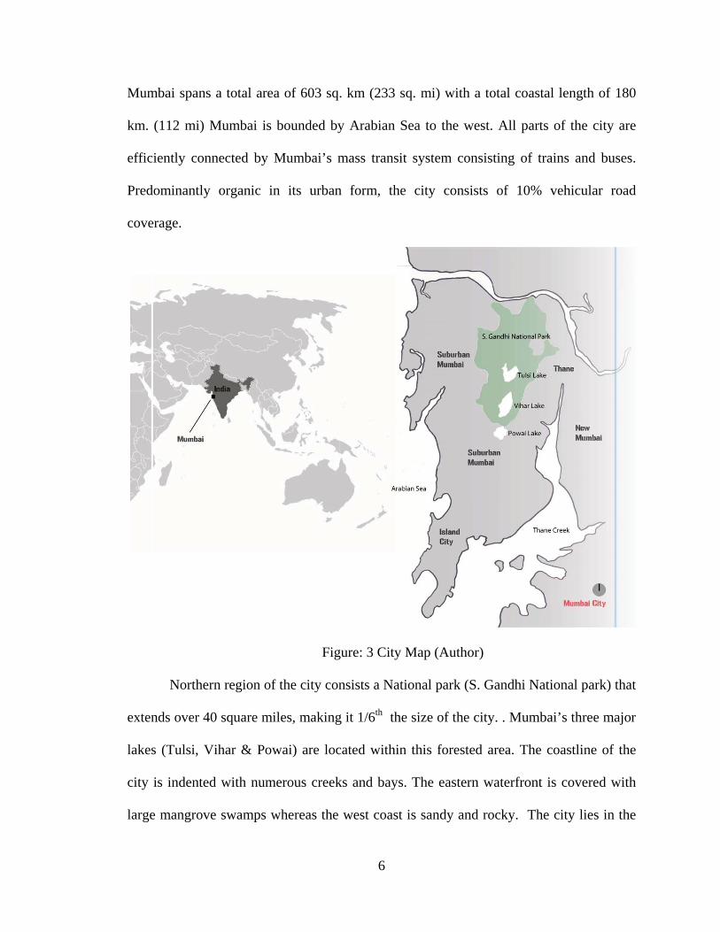
Figure: 3 City Map (Author)
Northern region of the city consists a National park (S. Gandhi National park) that
extends over 40 square miles, making it 1/6th the size of the city. . Mumbai’s three major
lakes (Tulsi, Vihar & Powai) are located within this forested area. The coastline of the
city is indented with numerous creeks and bays. The eastern waterfront is covered with
large mangrove swamps whereas the west coast is sandy and rocky. The city lies in the

7
tropical climate zone resulting in harsh monsoons & hot summers. With an average
annual temperature of about 80F, Mumbai receives a lash of rainfall equaling to an
average of 96 inches per year.
City’s downtown is located to the south & it is popularly known as South Mumbai
or the Island City. Because of its tapering peninsular form, urbanization of the city
continued towards the north. This region today is considered as Suburban Mumbai.
Whereas towns like Thane, New Mumbai & Panvel serve as Mumbai’s satellite towns.
Both the districts (south & suburban) are administered by city’s municipal council known
as BMC - Brinhanmumbai Municipal Corporation. Mumbai is divided into 17 wards for
the purpose of civic administration.
Notes 1http://www.worldnavigator.info/data/gallery/00000018/Aerial_photo_of_Mumbai_city.jpg

8
CHAPTER 3
MUMBAI - COLONIAL
Figure: 4 - Early map of Mumbai showing seven separate islands. (Author)
Mumbai initially known as ‘Bombay’ was originally an archipelago of seven islands –
Colaba, Malabar Hill, Worli, Mazgaon, Parel, Mahim & Sion. These islands were
inhabited by farmers and fisherman and the land was extensively covered with forests. By
late 15th century, after quite a few invasions and rulers, the Portuguese took over the
islands and ruled without opposition for over a century.
Figure: 5 - Land reclamation & urban development of the city over the years. (Author)

9
In 1661, the islands were handed over to England as part of a dowry arrangement.
In 1838, under the British rule, Bombay islands were amalgamated into a singular mass.
Since then the city has been constantly transformed by land reclamation projects. The city
is built on a foundation of continuously altered and reclaimed natural and urban
landscapes.
Colonial Mumbai was developed as a planned segregation promoted by English
ideology. The southern tip of the island city was fortified to create an insulated territory
for the colonial rulers. The northern part within the fortification included the elite
Indians, Parsis, Bohras and Hindu industrialists or traders. Small native traders, white-
collar workers and the working class lived outside the Fort walls in largely congested
areas further segregated on class and regional identities. At first the urbanization of the
island only occurred within the Fort area until a massive fire in 1803 provided an impetus
for urban improvements and land dispersal that led to expansion of the fortified town.
By 1850 Bombay had become the major colonial mercantile and industrial city
and cotton textile mills as foundation of its economy. Subsequently many of the great
monuments and public buildings in the island city were built with the wealth generated
by the textile industry. Land reclamation continued, closing the creeks & creating newer
destinations towards the north. With new developments in place and increased
employment opportunities, Bombay attracted millions of migrants around the state and
country. Soon Mumbai became the fastest growing metropolis with maximum capital
accumulation and the most unequal distribution of land. A trading town in its past,
Mumbai, today is an aspiring global city where space is a rare commodity created &
recreated by land reclamation & rehabilitation.
10
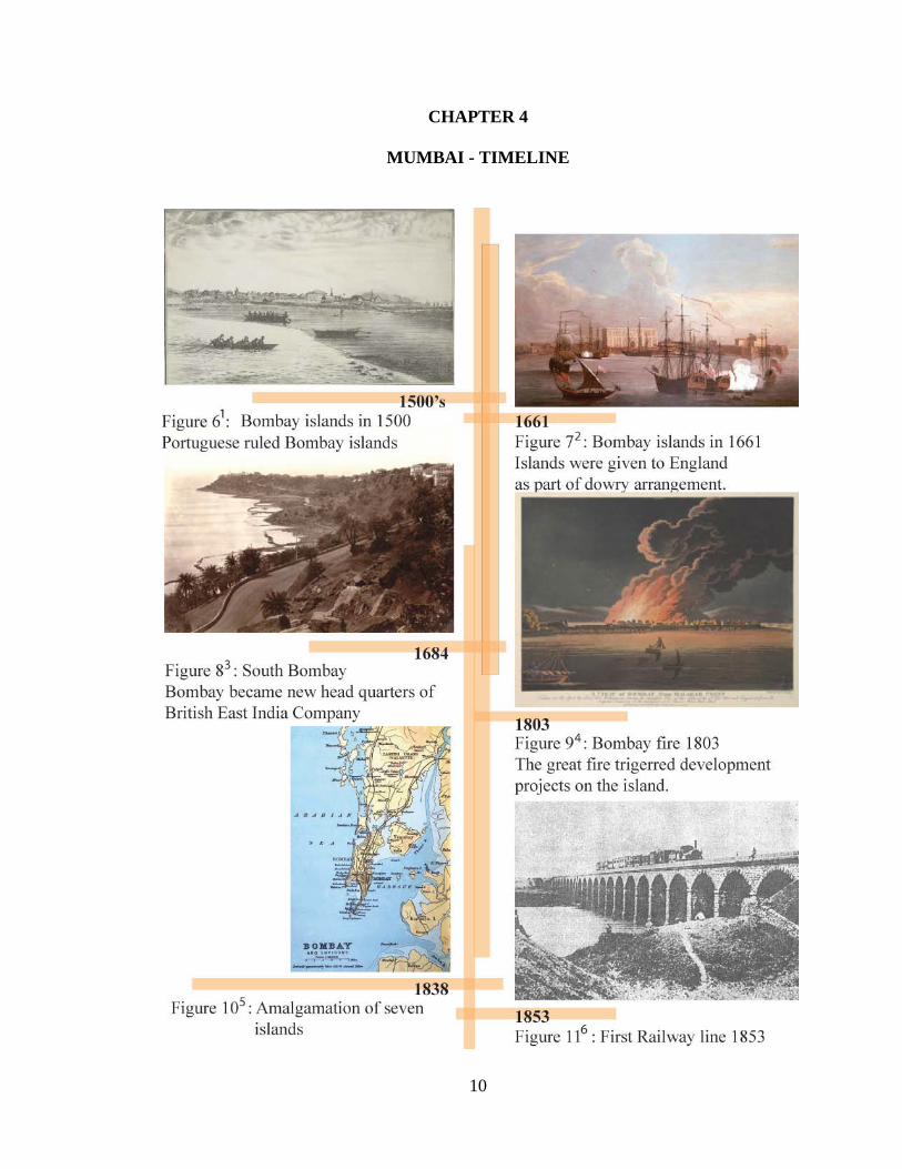
CHAPTER 4
MUMBAI - TIMELINE

11

12

13
Notes 1http://upload.wikimedia.org/wikipedia/commons/a/a6/Colaba_Causeway_construction%2C_view_from_Colaba_island%2C_1826.jpg
2http://upload.wikimedia.org/wikipedia/commons/4/43/Ships_in_Bombay_Harbour%2C_1731.jpg
3http://upload.wikimedia.org/wikipedia/commons/0/05/Malabarpoint_governmenthouse_bombay.jpg
4http://upload.wikimedia.org/wikipedia/commons/4/48/A_View_of_Bombay_from_Malabar_Point_during_the_Fire_of_1803.jpg
5http://upload.wikimedia.org/wikipedia/commons/6/69/IslandsofBombay1893.jpg
6 http://commons.wikimedia.org/wiki/File:Bombay_Thane_train_1853.jpg 7http://commons.wikimedia.org/wiki/File:Sir_Cowasji_Jehangir_Readymoney_(1812-1878).jpg
8 http://commons.wikimedia.org/wiki/File:Bombay_Municipal_Corporation.JPG 9http://upload.wikimedia.org/wikipedia/commons/f/fa/Kotia-1909.jpg
10 http://commons.wikimedia.org/wiki/File:BombayReclamation_1911.jpg
11 http://commons.wikimedia.org/wiki/File:Navi_Mumbai.jpg
12 http://commons.wikimedia.org/wiki/File:Marine_Drive.JPG
13 http://commons.wikimedia.org/wiki/File:India_United_Mill_1.jpg
14 http://commons.wikimedia.org/wiki/File:Mill_lands_parel_ground.jpg

14
CHAPTER 5
MUMBAI – THEN AND TODAY
Figure 211: Cuffe Parade, Figure 222 : Gateway of India, Figure 233: Bombay Streets
Figure: 244: Mumbai Downtown, Figure 255: Gateway of India (Today), 266 –Market Street (Today)
Figure277: Regal Theatre (Old), Figure288: Churchgate station (Old), Figure 299: Victoria Terminus Railway Station
Figure 3010: Regal Theatre (Today), Figure 3111: Churchgate station (Today), Figure 3212 : Victoria Terminus Railway Station (Today)

15
Notes
1 http://upload.wikimedia.org/wikipedia/commons/c/ce/Cuffe_Parade_old_.jpg
2http://commons.wikimedia.org/wiki/File:Gateway_of_India,_Bombay._1911.JPG
3 http://commons.wikimedia.org/wiki/File:BombayKalbadevieRoad1890.jpg
4http://commons.wikimedia.org/wiki/File:Mumbai_Downtown.jpg
5http://commons.wikimedia.org/wiki/File:Mumbai_(Bombay)_Gateway_of_India.JPG 6 http://commons.wikimedia.org/wiki/File:Mumbai-centre-street-market.jpg
7 http://upload.wikimedia.org/wikipedia/commons/a/a9/Regal-Cinema-1935.jpg
8 http://commons.wikimedia.org/wiki/File:Churchgate_station.jpg
9http://commons.wikimedia.org/wiki/File:V.M._Doroshevich-East_and_War-British_India._Railroad_Station_in_Bombay_enhaced.jpg
10 http://commons.wikimedia.org/wiki/File:Regal_Cinema,_Colaba,_Mumbai.jpg
11 http://upload.wikimedia.org/wikipedia/en/b/b1/Mumbai_Churchgate.jpg
12http://commons.wikimedia.org/wiki/File:Chhatrapati_Shivaji_Terminus_(The_Victoria_Terminus),_Mumbai_-_India.jpg
16
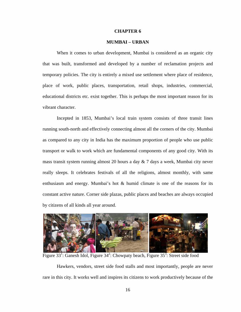
CHAPTER 6
MUMBAI – URBAN
When it comes to urban development, Mumbai is considered as an organic city
that was built, transformed and developed by a number of reclamation projects and
temporary policies. The city is entirely a mixed use settlement where place of residence,
place of work, public places, transportation, retail shops, industries, commercial,
educational districts etc. exist together. This is perhaps the most important reason for its
vibrant character.
Incepted in 1853, Mumbai’s local train system consists of three transit lines
running south-north and effectively connecting almost all the corners of the city. Mumbai
as compared to any city in India has the maximum proportion of people who use public
transport or walk to work which are fundamental components of any good city. With its
mass transit system running almost 20 hours a day & 7 days a week, Mumbai city never
really sleeps. It celebrates festivals of all the religions, almost monthly, with same
enthusiasm and energy. Mumbai’s hot & humid climate is one of the reasons for its
constant active nature. Corner side plazas, public places and beaches are always occupied
by citizens of all kinds all year around.
Figure 331: Ganesh Idol, Figure 342: Chowpaty beach, Figure 353: Street side food
Hawkers, vendors, street side food stalls and most importantly, people are never
rare in this city. It works well and inspires its citizens to work productively because of the

17
way it is built. A true metropolis and the city of the migrants, Mumbai is one of the most
livable cities in the country. The growing population of this metropolis proves the same.
Mumbai’s built environment does not lack variety either. From the southern tip of
the city to its northern border, it encompasses array of spaces, buildings and destinations
representing its growth from colonial era to present day metropolis. Most of the
monumental buildings in the city were built during the British regime. These structures
still serve as important public, infrastructure and administrative buildings of the city. The
built environment throughout Mumbai is composed of various architectural styles – from
Indo-Saracenic to Hindu, from Greek revival to modern.
The urban characteristic of Mumbai could be studied by looking at the different
spatial elements that are woven into its urban fabric. Locations ranging from important
public places to historic districts or a lively street to a popular market place, fuel the city
for its everyday hustle-bustle and its very existence. Following pages describe some of
the places that define this city.
Figure 364: Siddhivinayak temple, Figure 375: Prince of Wales Museum, Figure 386: Shoe Market
18
Notes 1http://upload.wikimedia.org/wikipedia/commons/e/e9/Ganesh_Idol_in_Mumbai.jpg 2 http://commons.wikimedia.org/wiki/File:Vendors_on_Chowpatty_Beach.jpg
3 http://commons.wikimedia.org/wiki/File:Bademiya_restaurant,_Mumbai.jpg
4 http://commons.wikimedia.org/wiki/File:Siddhivinayak_temple.jpg
5 http://commons.wikimedia.org/wiki/File:Prince_of_Wales_Museum,_Mumbai.jpg
6 http://commons.wikimedia.org/wiki/File:Bandra_Shoe_Market.jpg

19
CHAPTER 7
MUMBAI – URBAN ENVIRONMENTAL ISSUES
Mangrove Destruction: Mangroves are an integral part of the landscape of
Mumbai. The city was originally
surrounded by 5000 acres of
mangrove swamps. Among these,
the city has lost almost 40% to
reclamation of land for construction
and development projects. As a
result, Mumbai became more
vulnerable to natural disasters.
Land Use Changes: Salt
Pan Lands: Similar to its mangrove
cover, the city has a chunk of land
dedicated to salt production.
However, the lack of land for
residential accommodation has pushed the developers to convert the salt pan lands into
residential and commercial zones. Salt pan lands are an important barrier between land &
sea. And with their land use change, the danger of flooding has increased.
Land Use Changes: Mill Lands: Central district of Mumbai consists of 600
acres of defunct mill lands that represent the textile era of the city. These mill lands are a
boon for Mumbai if developed in the right way. However city developers are using these
20
lands for residential and commercial unsustainable constructions. This is further adding
to the already inflated problems of the city.
Forest Depletion: Urban development didn’t spare Mumbai’s only breathing lung
too. Illegal construction continues to develop on National Park periphery. Consequently
this rich and unique forest which acts as an essential green cover and carbon sink is
shrinking day by day.
Rapid land reclamation: Mumbai once had numerous creeks flowing into the
island. But as urbanization of the city continued, these water bodies got filled up. Such
excessive coastal land reclamation is unhealthy for an island city like Mumbai.
Pollution, population and lack of space are traditionally described as the ultimate
problems of Mumbai. These issues consequently lead to environmental degradation of
this global city. Leopard attacks in a bustling city, landslides, abnormally high
temperatures in summers, erratic rainfall have long since warned the city of the
impending doom. It is believed that the environmental problems of Mumbai have
emerged due to the creation of the city itself.
With change in climate and global temperature rise, Mumbai now receives
extravagant monsoon showers making city’s drainage system inadequate. On 26th
November 2005, Mumbai was lashed with 39 inches of rainfall within 24 hours. This day
was an eye opener when the city came to a standstill. Disasters like 26/7 not only cause a
distress among the citizens but they also drain the city economically. Mumbai’s urban
environmental issues might not have a water tight solution at the moment. But it’s
important that they are studied, analyzed & addressed in the best possible way.
21
Over the last few years Mumbai has witnessed several signs of ‘sanity’ in terms of
environmental protection. Some of the leading organizations in the city along with active
environmentalists are persistently fighting for city’s sustainability. Their efforts are
essential & could turn out to be one of the most crucial steps towards Mumbai’s
environmentally healthy future.
Mumbai is still in the need of similar efforts. Considerable damage has already
been done to the 600 acres of land belonging to the textile era of the city. Yet there exists
a small ray of hope for Mumbai since some of the major chunks of derelict mills indicate
a strong potential for a sustainable development.

22
CHAPTER 8
GIRANGAON – THE MILL PRECINCT
Location
“Girangaon” is a Marathi word for “Mill village” or the mill precinct, which is
characterized by industrial architecture of more than 50 mills. Over 600 acres of land in
this region was dedicated to textile industry in early19th century.
Girangaon was home to thousands
of mill workers and their families. The
unique housing settlements by workers,
their social networks and communities
dominated Mumbai’s mill precinct for
decades.
Diagram to the left highlights
Girangaon on the map of Mumbai. The
precinct stretches from Lalbaug to Parel
and Worli to Sewri and spreads across an
area of 25sq.km. The entire mill precinct is
efficiently integrated into Mumbai’s mass
transit system and well connected to major
Figure 40: Girangaon map (Author) streets in the city.
Origin
The inception of textile industry in Mumbai goes back to late 19th century when
the first mill was established by Cowasji Davar in the year of 1856 with the help of 50

23
leading businessmen in the city. By 1862, four mills were added and this number grew to
21 by 1885.
By early 20th century there were more than 50 textile mills in Mumbai which
transformed it from a trading town to a manufacturing center. Increased employment
opportunities in mills drew thousands of migrants from towns and villages all over the
state. By 1931 half of the city’s population was economically dependent on textile
industry.
Development
Residential, institutional and infrastructure development had already commenced
in the south region of the city and development plans were now being modified and
extended towards the north. To encourage the development of textile industry and
promote industrial production, acres of lands in Central Mumbai were given to the mill
owners at concessional rates by the colonial Bombay Government. Mumbai’s
development as an economic hub was greatly enhanced by these very mills.1
Areas where mills were located grew to become the heart of the city. Eventually
central Mumbai witnessed a distinctive skyline of tall chimneys and gigantic mill
structures.
Characteristics
Over 50 mills in less than a 3 mile radius converted this portion of the city into an
incredibly crowded, lively and dynamic hub. Almost all of the workers employed by
mills lived in close proximity of their place of work. Such an aggregation of workers
within a smaller region of the city increased the social and cultural involvement of the
24
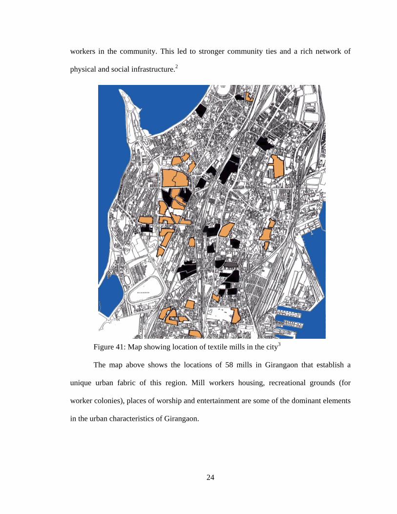
workers in the community. This led to stronger community ties and a rich network of
physical and social infrastructure.2
Figure 41: Map showing location of textile mills in the city3
The map above shows the locations of 58 mills in Girangaon that establish a
unique urban fabric of this region. Mill workers housing, recreational grounds (for
worker colonies), places of worship and entertainment are some of the dominant elements
in the urban characteristics of Girangaon.

25
Social Structure
In the period of 1891 to 1921 the population of Parel & Byculla doubled where as
the population of Worli & Sewri increased by five times. Mumbai now received migrants
from not just east and coastal Maharashtra, but it was also populated by crowds from
Uttar Pradesh and Gujarat (some of the other states of India) all employed in textile
industry. Mill workers included people from all castes and religion. Soon they established
their distinctive places of worship such as temples and mosques and started side
businesses in meat and vegetable markets.
Initially in the migrant population, the men arrived alone in order to find
employment. Later as they settled they brought their families along. In 1875 when the
textile industry was at its peak the housewives of workers too, started working in the
mills for additional income. However the male population among the workers community
always dominated the female population.
Figure 424: Roadside grocery shop, Figure 435 : Shops/Commercial at street level, Figure 446 : Road-side flower shop
Most of the single men lived in groups. As a result a number of housewives
started buffet services and canteens for lunch and dinner. In 1970’s, the mill precinct had
over 500 canteens predominantly serviced by the female group. Along with these, most
of the residential buildings incorporated side businesses of workers such as retail,

26
grocery, newspaper, flower, sweets shops, snack centers, ice-cream parlors, pharmacy,
service shops like laundry shop, domestic flour mills etc. on street level.
Housing
Due to housing demands from the mill workers, the Bombay Development
District (BDD) and Bombay Improvement Trust (BIT) built rows of low cost houses in
Girangaon. These 1-2 stories high, single to double room tenements with a common nar-
row corridor, and a block of shared toilets situated at the end of the corridor came to be
known as “Chawls”.
Figure 45: Mill workers housing (Author)

27
A group of 3 to 4 Chawls were built around a central courtyard that became the
venue for family celebrations, weddings, sports, festivals, community fairs and meetings.
This congested tenement living created a “Chawls Culture” based upon a unique, shared
lifestyle and collective identity. Since the dwelling units in Chawls were very small in
area, (Hardly 200sq.ft) most of the residents spent their days in the common corridors and
staircases. Small grounds, sidewalks, spaces between the two Chawls, benches under
trees, boundary edges, shop fronts and street corners also known as “Chowk” or “Naka”
became the social gathering spaces. Mill lands were designed in such a way that they will
have sufficient amount of open space around them, so that the nuisance to surrounding
community is limited. Hence these lands efficiently merged into the surrounding urban
fabric as opposed to standing exclusive. In addition to ‘workplace’, mills became a
second hometown for mill workers. They included a place of worship, family clinics and
canteens.
Culture
Many of the social groups in a single Chawl shared a common hometown.
Sometimes they belonged to the same extended family, had common interests and
cultural outlooks. Girangaon was dense, poor & illiterate. Yet it was filled with talent in
theatre, music and arts. The mill precinct gave many talented and versatile artists to city.
People here enthusiastically celebrated different Indian festivals throughout the year.
During the festive season the streets and Chawls of Girangaon looked no less majestic
than a wealthy south Mumbai neighborhood7. In fact the hard work, simplicity, honesty
and benevolence of people added to the attractiveness of this precinct. Even today, the

28
festivals are enjoyed with same exuberance and honor; however the workers’ society is
poorer, hurt and unhappy.
Figure 46: Marathi theatre8
The mill workers also staged brilliant theater and sustained folk arts like Lawani,
Tamasha, Bhajan, Namaan, and Shahiri Powadas. All these art forms narrated the stories
of their life style, their social and political upheavals, the freedom struggle of the country
and Samyukt Maharashtra Andolan.
Girangaon or the mill precinct of Mumbai has experienced a great amount of
upheaval over the past two decades. Textile industry in Girangaon - the backbone of
city’s economy gradually set out to disintegrate under pressures from various other
sectors. Hence the decline of Mumbai mill lands is rooted in several economic, social and
political issues9.
Even after their decline in Mumbai, the textile industry remains India’s second
largest employer after agriculture. It accounts for a fifth of industrial production and
employs 18 million directly. If one adds all those engaged in related industries, like
textile machinery, dyes and chemicals, marketing, transport - not counting the millions of
farmers growing cotton - the number dependent on it goes up substantially. Moreover, it

29
contributes over 30 per cent of all export earnings. Export of Indian textiles comprise of
2.4% of the world trade.10
Mumbai Mills contributed significantly towards the creation of country’s finest
cloth. After led by the textile mills, several other large and medium scale industries were
established in the post-independence era and the development plans made provision for
the same through earmarking industrial zones for manufacturing, trade and logistics
operations. Mumbai has shown how to build the enormous potential in industrial
production and almost became one of the country’s backbones of industries and
economy11.
Notes 1 (Nallathiga 2010) 2 (Mhatre, Downtown revitalization: Lessons for Mumbai Mill lands 2006) 3http://img464.imageshack.us/img464/800/mumbaimilllandsresized2cq.jpg 4http://commons.wikimedia.org/wiki/File:Dried_produce_shop,_Crawford_marke
t,_Mumbai.jpg 5 http://commons.wikimedia.org/wiki/File:P1010628-EEEEE.jpg 6 http://commons.wikimedia.org/wiki/File:Flowers_at_Matunga.jpg 7 (Adarkar, Mumbai's Industrial landscape 2006, 84, 85) 8 http://commons.wikimedia.org/wiki/File:Kaka_tells_story.jpg 9 (Mhatre 2005) 10 (Ripping the fabric 2002) 11 (Nallathiga 2010)

30
CHAPTER 9
DECLINE OF THE TEXTILE MILLS
In mid-nineteenth century, textile industry experienced several technological
changes all over the world. The conventional handloom technology faced a severe
competition from the advanced power loom techniques. The mill owners did not update
the machinery in the Mumbai Mills to keep up with the changing trends and the low-
skilled workers were also comfortable with this policy. During the same period the fuel
prices and costs of raw material increased. Reservation policies and adverse taxation
discouraged the mill owners from investing more in the industry. By 1980’s it became
uneconomical to maintain large scale industrial units within the city limits on account of
high power and tax costs.1 Also, the economic and technological change struck major
mill towns like Manchester in UK and Lowell in Boston and eventually there was an
overall slump in the world textile market. By 1990’s the employment rates of service
industries increased by large numbers.
Another reason for the ultimate shut down of mills is the 18 month long strike by
mill workers’ union in 1982. Nearly 250,000 workers & more than 50 textile mills went
on strike. Rashtriya Mill Majdoor Sangh (RMMS) the largest workers union in the city
led by Congress (political party) fought the government and mill owners for their rights.
The Bombay Industrial Relations Act, 1946 (BIR Act) sought to establish a single union,
the Congress-led RMMS as the only approved union. This move was taken primarily to
renounce the option of strikes and focus on other means of resolution. The strike of 1982
was called for primarily to strike down the BIR Act along with increase in wages.

31
The strike did no good for the workers instead it opened a new strategy for mill
owners. During the strike, mill owners outsourced the work to workers in Bhiwandi, a
distant suburb who were paid almost 50 percent of the wages in spite of longer working
hours and no legal compensation.2
All this led to huge losses and the running of the Cotton Textile Mills became
unviable. Several mills were declared sick and a few even shut down their operations.
Only a few managed to survive. There were 58 cotton textile mills in Mumbai. Of these,
26 were deemed ‘sick’ and, therefore, taken over by the Government of India. The
remaining 32 mills continued in the private sector.
Declining status of Manufacturing in Mumbai (1980 - 1998)
Mill locations
No of Workers 1980 1990 1998
Mazgaon 16456 6925 4968
Tarawadi 28114 18933 12800
Byculla 27257 30332 13134
Parel 34879 15073 10561
Sewri 15960 18163 8425
Naigaon 21591 12485 13595
Prabhadevi 29721 21032 20225
Worli 61691 30895 21494
Chinchpokhli 50787 22083 18220
Table 1: Declining status of Manufacturing in Mumbai (1980 – 1998)

32
Employment sectors
% of workers in major activity groups
1980 1990 1998
Variation in absolute no of workers
1980 1990 1998
Agriculture and allied 1.04 0.43 0.26 23081 1049 6077
Mining and Quarrying 0.04 0.01 0.01 920 348 182
Manufacturing 36.73 28.47 17.73 817718 633826 394772
Construction 0.63 0.83 0.61 14028 20082 18002
Trade, Restaurants & Hotel 24.51 28.03 29.07 545591 705127 747723
Transport & Communication
9.43 5.42 9.97 209883 131472 263504
Finance, Insurance, Real Estate & Business services
6.24 10.25 13.69 138849 248541 361888
Community, social and Personnel services
13.64 23.87 28.52 303557 578945 753648
Other 7.10 1.21 0.37 157996 29257 9833
Total 100.0 100.0 100.0 2226011 2425881 2642577
Table 2: Declining status of Manufacturing compared with other employment sectors in Mumbai (1980 – 1998)
Notes 1 (Nallathiga 2010) 2 (D. D. Monte 2002, 78 - 85)

33
CHAPTER 10
REDEVELOPMENT OF TEXTILE MILL LANDS
Redevelopment of mill lands in Girangaon is one of the few options left for a
sustainable revival of the city. Mumbai’s ecological, social & cultural aspects are the
fundamental drivers in this process of urban revitalization.
When textile mills were fully operational, they were excluded from reservations
for public amenities. According to an ex-government planner, there was no reason to
believe they would shut down and hence these lands were regarded as industrial zones
alone. But a few years later, with technological changes and economic restrictions many
of the mills were declared ‘sick’ and it was hard for mill owners to pay thousands of
workers unless they were allowed to sell their assets. As a result, in 1990, DCR 58
(Development Control Regulation) came into existence. DCR 58 allowed the mill owners
to sell part of their land. For the first time Mill owners were allowed “change of user”
from Industrial to Residential / commercial on the condition that they use the resultant
funds for the revival of the mills. They were allowed to sell only 15 percent of the mill
land and use the resources to modernize the mills.
In 1991, five to six mills were developed on the basis of DCR 58, but not a single
mill undertook any kind of modernization. The skyline of Girangaon began to change
steadily with the arrival of high rise luxury towers. When Phoenix converted one of its
structures into Bowling alley (the permission for this was obtained on the pretext of
building a recreation center for the workers), Girangaon was really shaken. The issue of
mill lands no longer was limited to mill workers alone: it concerned the issue of urban
development.

34
Please note that the objective of DCR 58 was not supposed to be real estate
development, it was meant to protect the jobs of the workers, by allowing only a partial
sale. If the development of mill lands was the main objective, then the government should
have worked on comprehensive development plan to include all mill lands, in fact the
entire Girangaon. It should have been addressed as an urban planning issue instead. The
actual outcome as can be seen by all is a piecemeal, ad hoc and often surreptitious
exploitation of real estate for immediate gains.
Under the banner of GKSS (Girni kamgar sangarsh samiti) Mill Workers Action
Committee, a protest march was organized by the workers along with artists, activists and
local residences against government. All of them spoke against the new real estate
developments in which, needs of the neighborhood were totally neglected.1
Notes 1 (D. D. Monte 2006, 94 - 107)

35
CHAPTER 11
CHARLES CORREA STUDY GROUP REPORT (1996)
Holistic approach1
The current piecemeal and individual development of mill lands is one of the
major problems when it comes to retaining the character of Girangaon. This approach
initiated by the intransigent mill owners denies the integrated development the city needs.
It also points out the lack of any overall planning and development strategy seeking to
create coherent urban form and address other issues like housing for low income groups,
civic amenities and new employment opportunities for ex-mill workers.
Girangaon needs a comprehensive urban renewal plan that will take care of mill
sites as well as the surrounding communities. Since these lands are in close vicinity to
each other, each could be developed differently in accordance with its location, size and
neighboring uses and yet is a part of an integrated master plan for the entire mill district.
A complete system of urban network could be established by introducing new
destinations for entertainment, public, retail & commercial activities, transit and
recreational purposes. Consequently the Government of Maharashtra set up a study group
to prepare an integrated development plan for textile mills in Girangaon.
The study group chaired by architect & urban planner Mr. Charles Correa created
a design solution for a comprehensive redevelopment of textile mills in Girangaon. It
appointed teams of architects, engineers & conservationists to visit the 58 mills and
appraise & document the various structures and other prominent features in each of them.
However the group was denied access to 32 mills in private sector. 3 of those mills were
already keen to sell some of their land right away. Hence the report deals with remaining
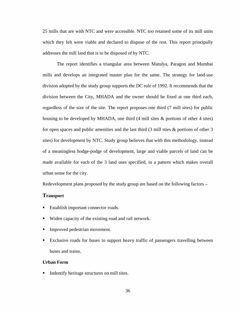
36
25 mills that are with NTC and were accessible. NTC too retained some of its mill units
which they felt were viable and declared to dispose of the rest. This report principally
addresses the mill land that is to be disposed of by NTC.
The report identifies a triangular area between Matulya, Paragon and Mumbai
mills and develops an integrated master plan for the same. The strategy for land-use
division adopted by the study group supports the DC rule of 1992. It recommends that the
division between the City, MHADA and the owner should be fixed at one third each,
regardless of the size of the site. The report proposes one third (7 mill sites) for public
housing to be developed by MHADA, one third (4 mill sites & portions of other 4 sites)
for open spaces and public amenities and the last third (3 mill sties & portions of other 3
sites) for development by NTC. Study group believes that with this methodology, instead
of a meaningless hodge-podge of development, large and viable parcels of land can be
made available for each of the 3 land uses specified, in a pattern which makes overall
urban sense for the city.
Redevelopment plans proposed by the study group are based on the following factors –
Transport
Establish important connector roads.
Widen capacity of the existing road and rail network.
Improved pedestrian movement.
Exclusive roads for buses to support heavy traffic of passengers travelling between
buses and trains.
Urban Form
Indentify heritage structures on mill sites.

37
Preserve and recycle them as studios for artists, workplaces for fashion designers,
computer software engineers etc.
Creation of a new center in the heart of the city, with its own distinctive character,
vitality and ambience.
Establish key design guidelines regarding the urban Form.
Development of larger footprints for economical & energy-efficient construction.
Use of building facades to help define streetscapes.
Open Spaces
Open spaces of different sizes to allow variety of uses.
Principal roads widened and lined with trees to create leafy boulevards.
Pedestrian plazas in front of railway stations.
Covered shopping arcades alongside major roads.
Land for public open spaces could be used for other social facilities like schools,
clinics or community centers depending upon the needs of the neighborhood.
Employment generation
Generation of semi-skilled employment similar to that provided by existing mills.
Development of new high-tech, non-polluting industries like computers and garment
industry.
Large number of household jobs would be created with the development of high-end
residential zones in place of former mills in private sector.
Housing
Land taken over by MHADA could be used to develop low income housing, recon-
struction of dilapidated buildings or redevelopment of slums.

38
MHADA could hand over some of the construction to other contractors.
Private Mill development
Prepare an Outline Development Proposal (ODP) for mill sites.
Include surrounding area with road network.
Identify and document heritage structures that need to be preserved.
Provide land allocation for three types of uses & an outline of the built form.
Pooling of land
Pooling the land for increased FSI of 2.0 (compared to FSI of1.33 in island city)
Beneficial in creating large new public spaces.
The cluster of taller buildings generated by the additional FSI would create a visible
landmark, recognizable across the city’s skyline as a symbol of the generation of
Parel and with it, the city of Mumbai.
In conclusion, the study group recommends further research and analysis of the exist-
ing conditions in Girangaon. This report is limited just to the mill plots themselves,
yet some attention has been paid to the surrounding areas.
The report also says “to bring about more comprehensive & decisive urban renewal,
detailed planning would have to be undertaken to address many problems of the area
such as chawl reconstruction, hosing for the pavement dwellers, parking for intercity
buses etc. This would also involve resolution of legal considerations related to repairs
and reconstruction of old buildings.”2
Notes 1 (Correa 2006, 16-23) 2 (D'Monte 2002, 126 - 148)
39
CHAPTER 12
TODAY’S TREND OF DEVELOPMENT OF MILL LANDS
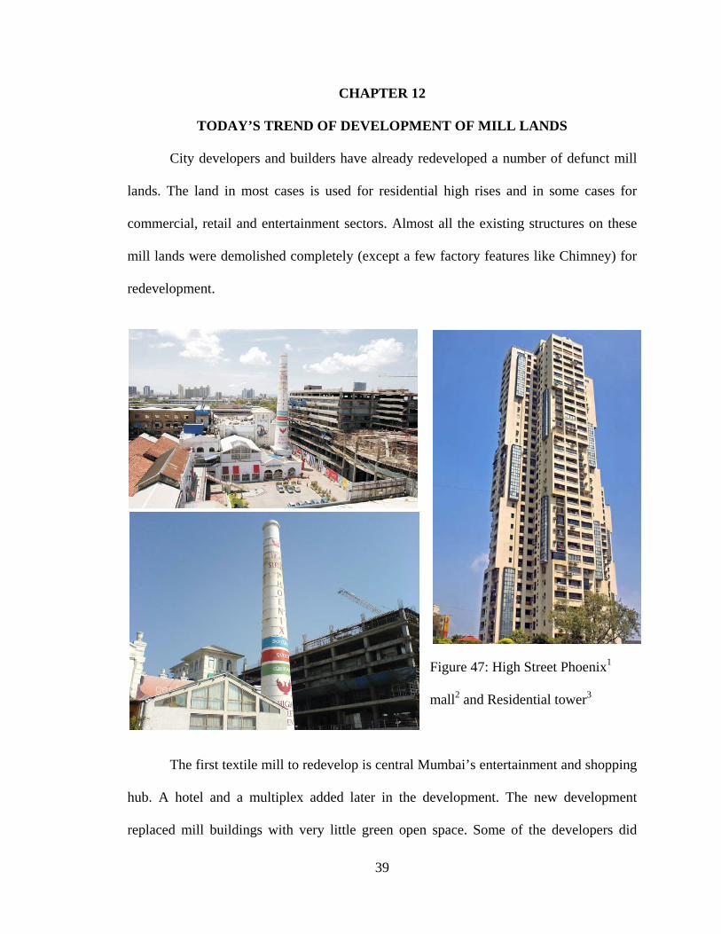
City developers and builders have already redeveloped a number of defunct mill
lands. The land in most cases is used for residential high rises and in some cases for
commercial, retail and entertainment sectors. Almost all the existing structures on these
mill lands were demolished completely (except a few factory features like Chimney) for
redevelopment.
Figure 47: High Street Phoenix1
mall2 and Residential tower3
The first textile mill to redevelop is central Mumbai’s entertainment and shopping
hub. A hotel and a multiplex added later in the development. The new development
replaced mill buildings with very little green open space. Some of the developers did

40
create some public spaces like shopping complexes, multiplexes and other retail outlets,
however the benefit of these areas and buildings for the ecological sustainability of the
city is questionable.
Figure 48: Ashok Towers4
Phoenix Mill: The first to redevelop the textile mill is today’s Central Mumbai’s
entertainment and shopping hub. A multiplex and hotel are currently being added here
though the Bombay Municipal Corporation lease deed in 2005 gives the mill over 20,000
square yards of land at the annual rent of a rupee for ‘residences of labor staff, and
welfare services like a school’.
Morarjee Mill 1: Construction of the residential complex ‘Ashok Towers’, with three
30-storeyed and a 50-storeyed tower, underway for the past six months. Part of the mill’s
land is on a 956-year lease for annual rent of Re 1.

41
Morarjee Mill 2: Peninsula Corporate Park houses new economy offices like TATA-
AIG and Orange, as well as a posh health centre, Wellsprings; part of the land is on a
999-year lease.
Simplex Mill: This mill, co-founded by
Mohammed Ali Jinnah in 1913, is bowing out
to Planet Godrej, five residential towers of 46
storeys each. Part of the land was given on a
99-year lease for an annual rent of Rs 43. The
lease expired in 1983.
Shrinivas Mill: South Mumbai’s Millionaire
Member of Legislative Assembly Mangal
Prabhat Lodha won the redevelopment rights,
plans a residential complex.
Standard Mill: A giant apartment complex Figure 49: Godrej heights5
of Beau Monde, with apartments priced at over Rs. 1 crore each. Residential towers have
also been cleared by the Bombay Municipal Corporation.
Development control regulations 1991 -war of words
1991 - DCR 58, born as a rule for redevelopment-towards-rehabilitation (of a sick mill),
two-thirds of the plot should be handed over to the Bombay Municipal Corporation
(BMC) for civic amenities and MHADA for public housing, giving the mill-owner
compensatory FSI and TDR on the remainder land to be used in suburbs.
Effect - A few mills redevelop within existing structures on DCR 58 stipulations to
develop only 15% of the land to clear workers dues and renew mill machinery. But the
42
owners violate DCR 58 by neglecting the up gradation of mill machinery. The owners act
enforces stay on further development.
1996: To solve the issue, state appoints a study group headed by planner Charles Correa
to suggest a comprehensive usage plan for defunct mill lands. Refer Chapter: l1
Effect: Denied visits by private mill-owners, group only studies NTC mills and submits a
holistic redevelopment proposal. The government puts report in cold storage.
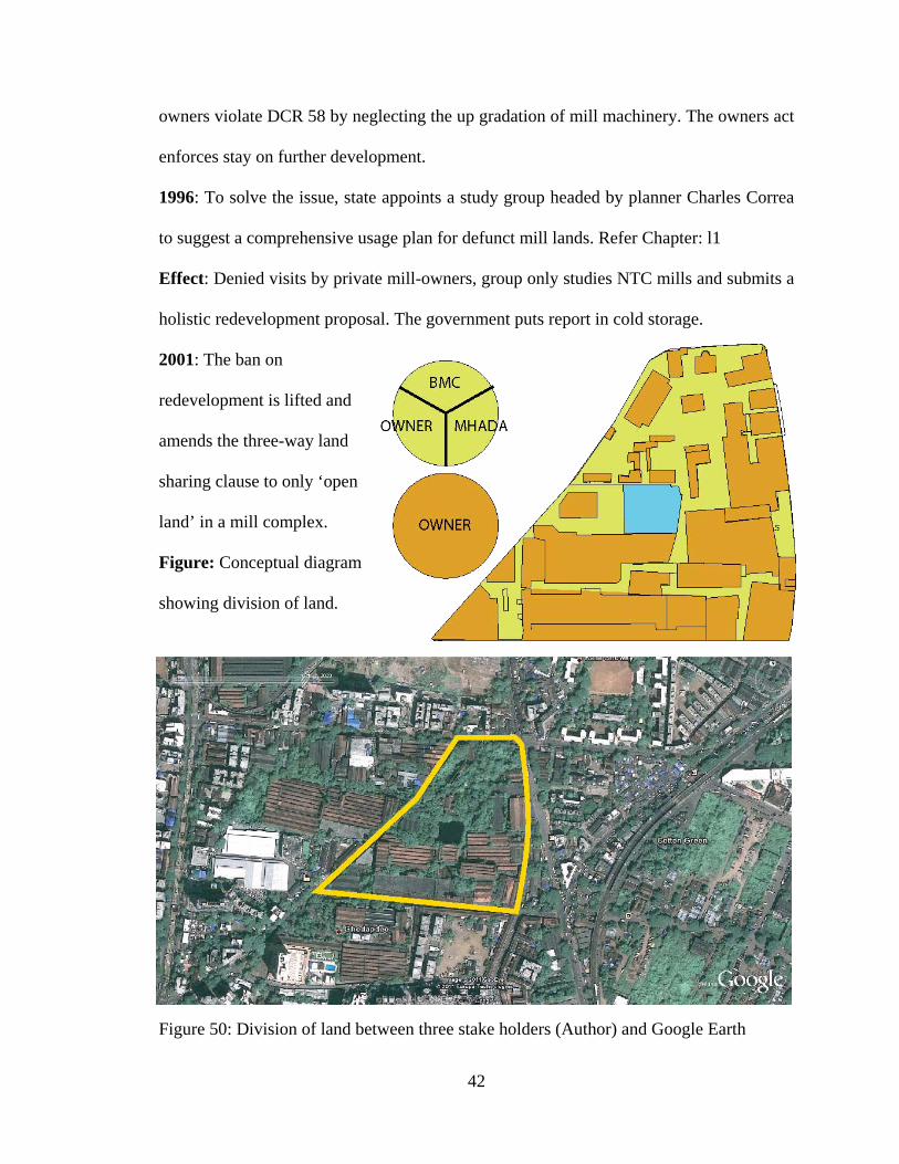
2001: The ban on
redevelopment is lifted and
amends the three-way land
sharing clause to only ‘open
land’ in a mill complex.
Figure: Conceptual diagram
showing division of land.
Figure 50: Division of land between three stake holders (Author) and Google Earth

43
Effect: Mill-owners get to keep most or even all of the land. Private mills wind down and
a flurry of redevelopment plans follow. NTC proposes a revival plan for 10 of its mills by
selling the remaining 15.
Conclusion: Privately owned properties sprouting on mill lands with private clubs, office
complex, shopping complex, hotels, and arcades with access to limited population of the
city.
Notes 1http://img526.imageshack.us/i/s1qr3.jpg/
2http://upload.wikimedia.org/wikipedia/commons/3/36/Phoenix_Mills_2.jpg 3http://img522.imageshack.us/i/phoenixtowerhumis3.jpg/
4 http://imageshack.us/photo/my-images/187/ash33da354au8tw1.jpg/ 5 http://upload.wikimedia.org/wikipedia/commons/6/68/Planet_Godrej.jpg
44
CHAPTER 13
SITE ANALYSIS
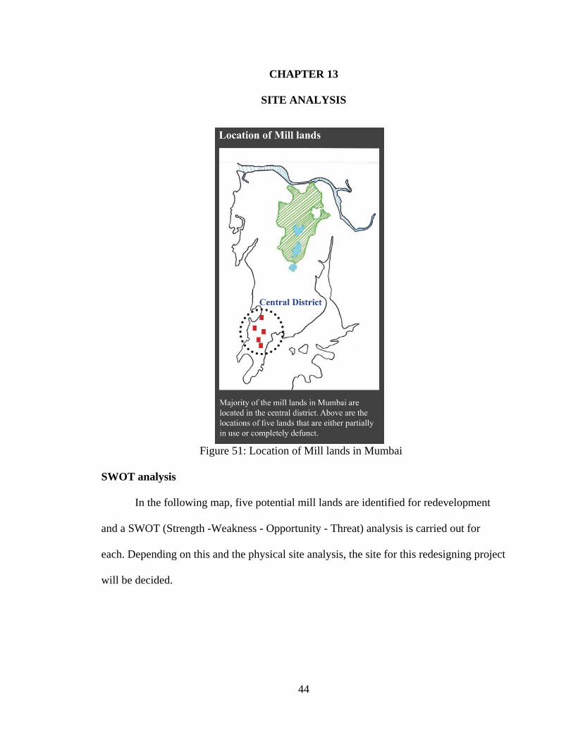
Figure 51: Location of Mill lands in Mumbai
SWOT analysis
In the following map, five potential mill lands are identified for redevelopment
and a SWOT (Strength -Weakness - Opportunity - Threat) analysis is carried out for
each. Depending on this and the physical site analysis, the site for this redesigning project
will be decided.

45
Name of
Mill land
STRENGTH
WEAKNESS
THREAT
OPPORTUNITY
India United
Mill Land
No.1
1. Located along the most
important road in central district.
2. More than75% of the mill
buildings on site are in a good
condition.
3. Close to a railway station and
several bus stops.
4. Land use around it is mostly
residential.
1. Located along a
very busy street.
2. Lesser site area
compared to other mill
lands.
1. Opportunity for a mid-
size public park or garden.
2. Existing mill buildings
can be converted into a
small public school or
community center.
3. Helpful in revitalization
of the street front.
1. Site contamination
is possible in some areas.
2. Unstable structures on
site will have to either
demolished or repaired.
3. Part of site area
might be reserved
for road widening
in the future.
Madhusudan
Mills
1. Part of a bigger mill district.
2. Considerably large site area
1. No easy access
from any of the
1. Opportunity for a mid-
size public park or garden.
1. Isolated position may
encourage crime.

46
for redevelopment.
3. Thick existing vegetation.
railway station or bus
routes.
2. Isolated position
2. Existing mill buildings
can be converted into a
museum or theater.
India United
Mill Lands
# 2 & 3
1. Large site area.
2. Strategic central position in a
dense residential zone.
3. Close to 3 railway stations and
several bus stops.
1. Away from the
main street.
2. Central yet isolated
position.
1. Good opportunity for
adaptive reuse of mill
buildings.
2. Ideal for a public park or
plaza.
3. Opportunity to revitalize
central district.
1. Number of unstable
structures on site.
2. Isolated position may
encourage crime.
Digvijay
Mills
1. Located along the most
important road in central district.
2. Close to a railway station and
several bus stops.
1. Located along a
busy street as well as
near a fly-over.
2. Limited site area
1. Opportunity to convert
the existing mill building
into a market place or
bazaar.
- Part of site area might be
reserved for road widening
in the future.

47
3. Land use around it is mostly
residential.
compared to other mill
lands.
3. Single huge mill
building might be a
challenge to reuse.
- Helpful in revitalization of
the street front.
India United
Dye Works
1. Located along a sea front to
the west and an important road
to the east.
2. Considerably large site area
for redevelopment.
3. Several bus routes and stops
along the adjacent road.
1. No easy access
from any of the
railway station.
2. Transportation to
the site or site access
will be car-driven.
1. Opportunity for a mid-
size public park or garden.
2. Existing mill buildings
can be converted into a
small public school or
community center.
3. Helpful in revitalization
of the sea front.
1. Part of site area might be
reserved for road widening
in the future.
2. Proximity to the sea
makes it prone to floods.
Table 3: SWOT analysis of five different Mill sites in Mumbai

48
Figure 52: Site Analysis (Author)
49
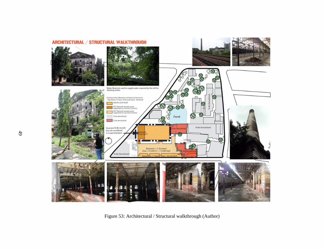
Figure 53: Architectural / Structural walkthrough (Author)

50
Figure 54: Site surroundings (Author)

51
CHAPTER 14
PRECEDENTS
REDEVELOPMENT OF HIGHLINE PARK, NEW YORK
Before it was turned into a park, the highline was in disrepair, although the riveted
steel elevated structure was basically sound. Wild grasses, plants, shrubs, and rugged
trees such as sumac grew along most of the route. It was slated for demolition under the
administration of New York Mayor.
Figure 55: Elevated Highline Park1
The park's attractions include naturalized plantings that are inspired by the self-
seeded landscape that grew on the disused tracks and new, often unexpected views of the
city and the Hudson River. Pebble-dash concrete walkways unify the trail, which swells
and constricts, swinging from side to side, and divides into concrete tines that meld the
hardscape with the planting embedded in railroad gravel mulch. Stretches of track and
ties recall the High Line's former use. Portions of track are adaptively re-used for rolling
lounges positioned for river views.
52
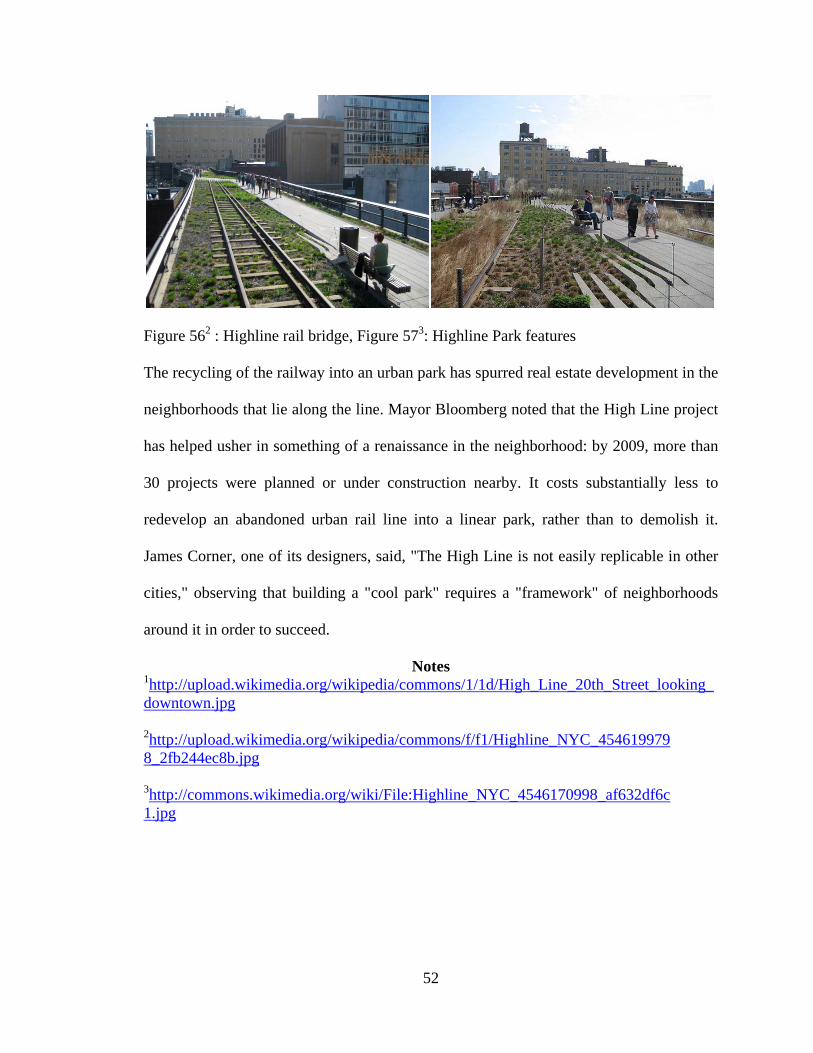
Figure 562 : Highline rail bridge, Figure 573: Highline Park features
The recycling of the railway into an urban park has spurred real estate development in the
neighborhoods that lie along the line. Mayor Bloomberg noted that the High Line project
has helped usher in something of a renaissance in the neighborhood: by 2009, more than
30 projects were planned or under construction nearby. It costs substantially less to
redevelop an abandoned urban rail line into a linear park, rather than to demolish it.
James Corner, one of its designers, said, "The High Line is not easily replicable in other
cities," observing that building a "cool park" requires a "framework" of neighborhoods
around it in order to succeed.
Notes 1http://upload.wikimedia.org/wikipedia/commons/1/1d/High_Line_20th_Street_looking_downtown.jpg
2http://upload.wikimedia.org/wikipedia/commons/f/f1/Highline_NYC_4546199798_2fb244ec8b.jpg 3http://commons.wikimedia.org/wiki/File:Highline_NYC_4546170998_af632df6c1.jpg

53
MASSACHUSETTS MUSEUM OF CONTEMPORARY ART
The Massachusetts Museum of Contemporary Art, commonly referred to as MASS
MoCA, is a museum in a converted factory building located in North Adams,
Massachusetts, USA. It is one of the largest centers for contemporary visual art and
performing arts in the country.
Figure 58: MASS MoCA1
The development of MASS MoCA began a year after Sprague vacated the
buildings. In 1986 a group of staff from the nearby Williams College Museum of Art
were looking for large factory or mill buildings where they could display and exhibit
large works of modern and contemporary art that they weren't able to display in their
more traditional museum/gallery setting. They were directed to the Marshall Street
complex by the mayor of North Adams. When they spent time with the space, they
54
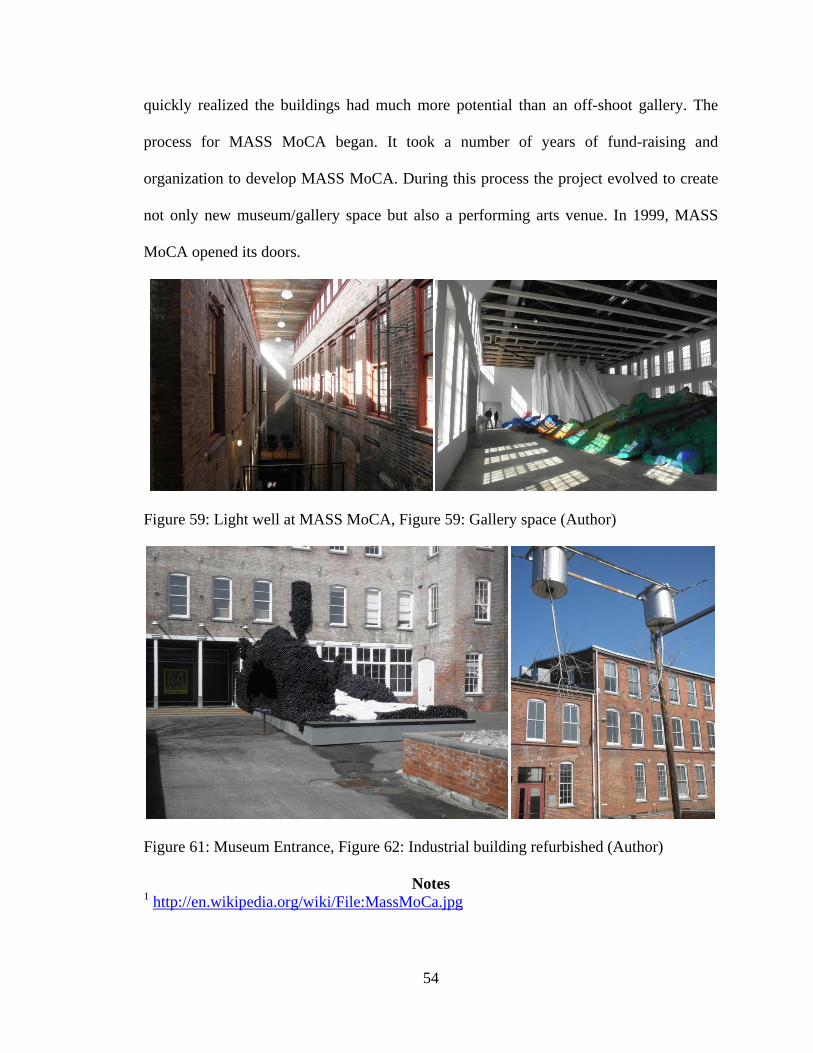
quickly realized the buildings had much more potential than an off-shoot gallery. The
process for MASS MoCA began. It took a number of years of fund-raising and
organization to develop MASS MoCA. During this process the project evolved to create
not only new museum/gallery space but also a performing arts venue. In 1999, MASS
MoCA opened its doors.
Figure 59: Light well at MASS MoCA, Figure 59: Gallery space (Author)
Figure 61: Museum Entrance, Figure 62: Industrial building refurbished (Author)
Notes 1 http://en.wikipedia.org/wiki/File:MassMoCa.jpg

55
CHAPTER 15
DESIGN DEVELOPMENT
Figure 63: Mill Chimney (Author)
Fascinated by the textile mill structures and the mill premise, felt like the stories about
the mills richness is unknown and untold. The site appeared to be deserted from rest of
the city, though physically it is located in Central core of Mumbai. Huge fifteen feet high
stone walls appeared to be like a fortress trying to embed the mills rich architecture, its
culture and the stories of its existence in shaping the city. Features like the 135 feet tall

56
chimney, North light roofs, large colonial windows, arches, light wells, and internal
alleys were very much introducing the layer within the architectural fabric of the city.
Figure 64 : Mill premise, Figure 65: Mill premise (Author)
The fifteen feet high walls were acting as a barrier for the people to experience this rich
fabric of the city. Functionally, these high walls acted as a sound barrier for the noise
created by machines and also secured the mill premise from the residential premise which
abruptly grew adjacent to the mills due to need for housing for mill workers. This aroused
a kind of mixed settlement of residential, commercial, industrial and educational around
Figure 66: Vibrant character of the city (Author)

57
the premise making it more vibrant. I experienced the characteristics like connectivity,
growth, people, street life, buildings and vegetation present within the mill premise. And
these characteristics were felt like willing to interact with today’s city to tell its untold
stories. The below figure, is my experience of restlessness among the elements that
composes the site. All these characteristics combine to form a random and radiant form
of energy that has got mobilized to merge with the current city’s fabric.
Figure 67: Site response to context (Author)
The 135 feet high chimney is a symbol of energy which travels vertically in the
form of smoke generated from the machines. The horizontal energy is the urban mill
fabric combined with the source of energy used by the machinery which has become
radiant. As of today, there is a need of this energy to be used in every possible fruitful
manner for the benefit of the city. So, this energy is deviated, diverted and merged with
the city’s current rapidly moving fabric to accelerate the mill premise, which was
deserted in the past.

58
Figure 68: Existing Mill structure (Author)
Figure 69: New fabric Figure 70: Restless nature of site (Author)
Figure 71: Sketch showing city’s fabric merged with the mill fabric (Author)
59
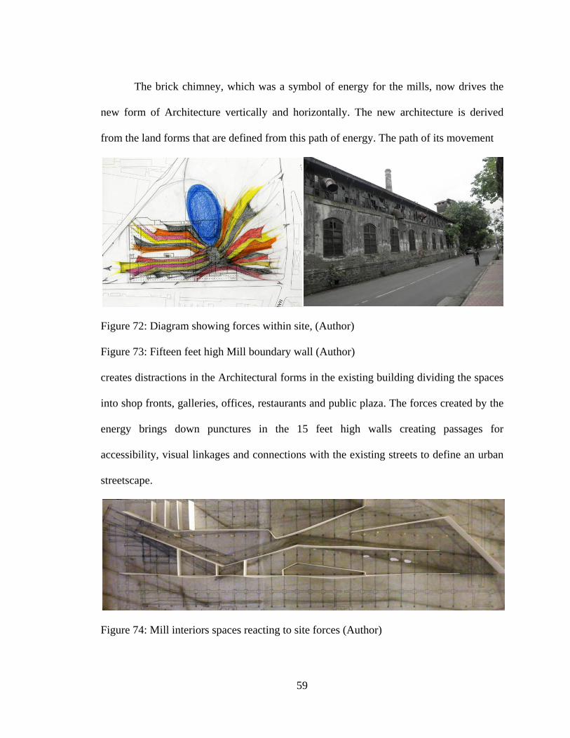
The brick chimney, which was a symbol of energy for the mills, now drives the
new form of Architecture vertically and horizontally. The new architecture is derived
from the land forms that are defined from this path of energy. The path of its movement
Figure 72: Diagram showing forces within site, (Author)
Figure 73: Fifteen feet high Mill boundary wall (Author)
creates distractions in the Architectural forms in the existing building dividing the spaces
into shop fronts, galleries, offices, restaurants and public plaza. The forces created by the
energy brings down punctures in the 15 feet high walls creating passages for
accessibility, visual linkages and connections with the existing streets to define an urban
streetscape.
Figure 74: Mill interiors spaces reacting to site forces (Author)

60
Figure 75: Chimney as focal center (Author) Figure 76: Site responsive development
Figure 77: Design development (Author)
Figure 78: Study of light within existing Mill structure (Author)

61
Figure 79: Site model (Author)
Figure 80: Fragmented Mill structure (Author)

62
Figure 81: Composition – 1 (Author)

63
Figure 82: Composition – 2 (Author)

64
Figure 83: Composition – 3

65
Figure 84: Composition – 4 (Author)

66
APPENDIX
DEVELOPMENT CONTROL REGULATIONS (DCR) FOR MILL LANDS
(I) Lands of sick and / or closed cotton textile mills.-With the previous approval
of the Commissioner to a layout prepared for development or redevelopment of the
entire open land and built-up area of a sick and/or closed cotton textile mill and on such
conditions deemed appropriate and specified by him and as a part of a package of
measures recommended by the Board of Industrial and Financial Reconstruction (BIFR)
for the revival/rehabilitation of a potentially viable sick and/or closed mill, the
Commissioner may allow:-
(a) The existing built-up areas to be utilized-
(i) For the same cotton textile or related user subject to observance of all other
Regulations;
(ii) For diversified industrial user in accordance with the industrial location policy, with
office space only ancillary to and required for such users, subject to and observance of all
other Regulations;
(iii) For commercial purposes, as permitted under these Regulations;
(b) Open lands and balance FSI shall be used as in the Table below:-

67
Table 4: Distribution of land use of Mill land redevelopment as per size of plot
No
.
(1)
Plot Area
Extent
(2)
Percentage to
be earmarked
for Recreation
Ground/Gard
en/
Playground or
any other
open user as
specified by
the
Commissioner
(3)
Percentage to be
earmarked and
handed over for
development by
MHADA for Public
Housing / for mill
workers Housing as
per guidelines
approved by
Government, to be
shared equally.
(4)
Percentage to be
earmarked and to be
developed for residential
or commercial user
(including users
permissible in residential
or commercial zone as per
these Regulations) or
diversified Industrial
users as per Industrial
Location Policy, to be
developed by the owner.
(5)
Up to and
inclusive
of 5 Ha.
33 27 40
Between
5Ha and
up to 10
Ha.
33 34 33
Over 10
Ha.
33 37 30

68
Notes-
(i) In addition to the land to be earmarked for recreation ground/garden/playground or
any other open user as in column (3) of the above Table, open spaces, public amenities
and utilities for the lands shown in columns (4) and (5) of the above Table as otherwise
required under these Regulations shall also be provided.
(ii) Segregating distance as required under these Regulations shall be provided within the
lands intended to be used for residential/commercial users.
(iii) The owner of the land will be entitled to Development Rights in accordance with the
Regulations for grant of Transferable Development Rights as in Appendix VII in respect
of lands earmarked and handed over as per column (4) of the above Table.
Notwithstanding anything contained in these Regulations, Development Rights in respect
of the lands earmarked and handed over as per column (3) shall be available to the owner
of the land for utilization in the land as per Column (5) or as Transferable Development
Rights as aforesaid.
(iv) Where FSI is in balance but open land is not available, for the purposes of column (3)
and (4) of the above Table, land will be made open by demolishing the existing structures
to the extent necessary and made available accordingly.
(v) Where the lands accruing as per Columns (3) & (4) are, in the opinion of the
Commissioner, of such small sizes that they do not admit of separate specific uses
provided for in the said columns, he may, with the prior approval of Government,
earmark the said lands for use as provided in Column (3).
(vi) It shall be permissible for the owners of the land to submit a composite scheme for
the development or redevelopment of lands of different Cotton textile mills, whether
69
under common ownership or otherwise, upon which the lands comprised in the scheme
shall be considered by the Commissioner in an integrated manner.
(II) Lands of cotton textile mills for purpose of modernization.- With previous
approval of the Commissioner to a layout prepared for development or redevelopment of
the entire open land and/or built-up area of the premises of a cotton textile mill which is
not sick or closed, but requiring modernization on the same land as approved by the
competent authorities, such development or redevelopment shall be permitted by the
commissioner, subject to the condition that it shall also be in accordance with scheme
approved by Government, provided that, with regards to the utilization of built up area,
the provisions of clause (a) of sub-Regulations (i) of this Regulation shall apply and, if
the development of open lands and balance FSI exceeds 30 per cent of the open land and
balance FSI, the provisions of clause (b) of Sub-Regulations shall apply as per
(i) The exemption of 30 per cent as specified above may be availed of in phases,
provided that, taking into account all phases, it is not exceeded in aggregate.
(ii) In the case of more than one cotton textile mill owned by the same company,
the exemption of 30% as specified above may be permitted to be consolidated and
implemented on any of the said cotton textile mill lands within Mumbai provided, and to
the extent, FSI is in balance in the receiving mill land.
(III) Lands of cotton textile mills after shifting- If a cotton textile mill is to be
shifted outside Greater Mumbai but within the state, with due permission of the
competent authorities, and in accordance with a scheme approved by Government, the
provisions of sub-clauses (a) and (b) of Sub-Regulation (1) of this Regulation shall also
apply in regard to the development or redevelopment of its land after shifting.

70
(IV) The condition of recommendation by the Board of Industrial and Financial
Reconstruction (BIFR) shall not be mandatory in the case of the type referred to in sub-
Regulations (II) and (III) above.
(V) Notwithstanding anything contained above, the Commissioner may allow
additional development to the extent of the balance FSI on open lands or otherwise by the
cotton textile mill itself for the same cotton textile or related user.
(VI) With the previous approval of the Commissioner to a layout prepared for
development or redevelopment of the entire open land and / or built up area of the
premises of a cotton textile mill which is either sick and / or closed or requiring
modernization on the same land, the Commissioner may allow:-
(a) Reconstruction after demolition of existing structures limited to the extent of
the built up area of the demolished structures, including by aggregating in one or more
structures the built up areas of the demolished structures;
(b) Multi-mills aggregation of the built up areas of existing structures where an
integrated scheme for demolition and reconstruction of the existing structures of more
than one mill, whether under common ownership or otherwise, is duly submitted,
provided that FSI is in balance in the receiving mill land.
(VII) Notwithstanding anything contained above--
(a) if and when the built up areas of a cotton textile mill occupied for residential
purposes as on the 1st of January, 2000 developed or redeveloped, it shall be obligatory
on the part of the land owner to provide to the occupants in lieu of each tenement covered
by the development or redevelopment scheme, free of cost, an alternative tenement of the
size of 225 sq. ft. carpet area; [Provided that no such occupants shall be evicted till such

71
time, he/she is provided with alternative accommodation of the size 225 sq. ft. carpet area
in such development or redevelopment scheme.](3)
(b) if and when a cotton textile mill is shifted or the mill owner establishes a
diversified industry, he shall offer on priority in the relocated mill or the diversified
industry, as the case may be, employment to the worker or at least one member of the
family of the worker in the employ of the mill on the 1st January 2000 who possesses the
requisite qualifications or skills for the job;
(c) For purposes of clause (b) above, the cotton textile mill owner shall undertake
and complete training of candidates for employment before the recruitment of personnel
and starting of the relocated mill or diversified industry takes place.
(VIII)(a) Funds accruing to a sick and/or closed cotton textile mill or a cotton
textile mill requiring modernization or a cotton textile mill to be shifted, from the
utilization of built up areas as per clause (a) of Sub-Regulations (1) and as per clauses (a)
and ( b) of Sub-Regulations (6) or from the sale of Transferable Development Rights in
respect of the land as per columns (3) & (4) of the Table contained in clause (b) of Sub-
Regulations (1) or from the development by the owner of the land as per column (5),
together with FSI on account of the land as per column(3), shall be credited to an escrow
account to be operated as hereinafter provided.
(b) The funds credited to the escrow account shall be utilized only for the revival /
rehabilitation or modernization or shifting of the cotton textile mill, as the case may be,
provided that the said funds may also be utilized for payment of workers dues, payments
under Voluntary Retirement Schemes (VRS), repayment of loans of banks and financial

72
institutions taken for the revival / rehabilitation or modernization of the cotton textile mill
or for its shifting outside Greater Mumbai but within the State.
(9)(a) In order to oversee the due implementation of the package of measures
recommended by the Board of Industrial and Financial Reconstruction (BIFR) for the
revival / rehabilitation of a potentially sick and / or closed textile mill, or schemes
approved by Government for the modernization or shifting of cotton textile mills, and the
permissions for development or redevelopment of lands of cotton textile mills granted by
the Commissioner under this Regulations, the Government shall appoint a Monitoring
Committee under the chairmanship of a retired High Court judge with one representative
each of the cotton textile mill owners, recognized trade union of cotton textile mill
workers, the Commissioner and the Government as members.
(b) The Commissioner shall provide to the Monitoring Committee the services of
a Secretary and other required staff and also the necessary facilities for its functioning.
(c) Without prejudice to the generality of the functions provided for in clause (a)
of this Sub-Regulation, the Monitoring Committee shall:-
(i) Lay down guidelines for the transparent disposal by sale or otherwise of built
up space, open lands and balance FSI by the cotton textile mills;
(ii) lay down guidelines for the opening, operation and closure of escrow
accounts;
(iii) Approve proposals for the withdrawal and application of funds from the escrow
accounts;
(iv) Monitor the implementation of the provisions of this Regulations as regards
housing, alternative employment and related training of cotton textile mill workers.

73
(d) The Monitoring Committee shall have the powers of issuing and enforcing
notices and attendance in the manner of a Civil Court.
(e) Every direction or decision of the Monitoring Committee shall be final and
conclusive and binding on all concerned.
(f) The Monitoring Committee shall determine for itself the procedures and
modalities of its functioning. (2)
(10) [Notwithstanding anything stated or omitted to be stated in these
Regulations, the development or redevelopment of all lands in Gr. Mumbai owned or
held by all cotton textile mills, irrespective of the operational or other status of the said
mills or of the land use zoning relating to the said lands or of the actual use for the time
being of the said lands or of any other factor, circumstance or consideration whatsoever
shall be regulated by the provisions of this regulation and not under any other
Regulation.](4)

74
BIBLIOGRAPHY
Adarkar, Neera. "The Mill Behind the Gloss." Unsettled city. June 19, 2011. http://unsettledcity.wordpress.com/2011/06/19/the-mill-behind-the-gloss/ (accessed August 12, 2011). Cantell, Sophie Francesca. The Adaptive Reuse of Historic Industrial Buildings: Regulation Barriers, Best Practices, and Case Studies. May 2005. http://www.historicbellingham.org/documents_reports_maps/adaptive_reuse.pdf (accessed September 2010). Day, Mid. BMC to turn India United Mill 2 and 3 into museum. 02 14, 2009. http://www.mid-day.com/news/2009/feb/140209-BMC-to-turn-India-United-Mill-2-and-3-into-museum.htm (accessed 03 2010). D'Monte, Darryl. Ripping the Fabric The decline of Mumbai and its Mills. New Delhi: Oxford university press, 2002. INTBAU. Mumbai Mills report. Analysis and conclusions of INTBAU India workshop, Mumbai: INTBAU India, 2005. KATAKAM, ANUPAMA. "A verdict for Mumbai ." Frontline, 2005: Issue 23. Krishnan, Shekhar. Phoenix Mills - A Case Study. 2000. http://mumbaimillworkers.org/page10.html (accessed August 21, 2010). Masselos, sujata Patel and Jim. Bombay and Mumbai The city in transition. New Delhi: Oxford university press, 2003. Mehta, Suketu. Maximum city Bombay lost and found. New York: Alfred A. Knopf, 2004. Mhatre, Pratik. URBAN PLANNING BLOG. Mumbai, October 17, 2005. Monte, Darryl D'. Mills for sale The way ahead. Mumbai: J.J. Bhabha for Marg Publications, 2006. "Mumbai mill lands, retrieved for the people." Good News India, 2005. Stanton, Cathy. The Lowell experiment : public history in a postindustrial city. Amherst: University of Massachusetts Press, 2006. Thompson, Jennifer Trainer, Nicholas Whitman, Joseph Thompson, and Massachusetts Museum of Contemporary Art. MASS MoCA : from mill to museum. New York: MASS MoCA Publications, 2000.

75
Wikipedia. High Line (New York City). August 24, 2011. http://en.wikipedia.org/wiki/High_Line_%28New_York_City%29 (accessed January 4, 2011). —. Massachusetts Museum of Contemporary Art. June 12 , 2011. http://en.wikipedia.org/wiki/Massachusetts_Museum_of_Contemporary_Art (accessed January 06, 2011). (Mhatre, Downtown revitalization: Lessons for Mumbai Mill lands 2006)


![Revitalizing the Brand[1]](https://img.dokumen.tips/doc/110x75/546aa096af79596c298b47b0/revitalizing-the-brand1.jpg)