Embed Size (px)
Citation preview

Otay Ranch Resort Village
Biological Resources Technical Report
San Diego County, California
Prepared for:
Baldwin & Sons LLC 610 West Ash Street, Suite 1500
San Diego, California 92101
Contact: Mr. Scott Molloy
619.515.9119
and
JPB Development LLC 1392 E. Palomar Street, Suite 202
Chula Vista, California 91913
Attention: Mr. Sean Kilkenny
619.210.0568
Prepared by:
605 Third Street
Encinitas, California 92024
Contact: Anita M. Hayworth, PhD
760.942.5147
________________________
Anita M. Hayworth, PhD, Senior Biologist
NOVEMBER 2014
REVISED JANUARY 2015
REVISED MARCH 2015

Printed on 30% post-consumer recycled material.

Biological Resources Technical Report Otay Ranch Resort Village
6524 i March 2015
TABLE OF CONTENTS
Section Page No.
ACRONYMS AND ABBREVIATIONS ..................................................................................VII
SUMMARY OF FINDINGS ...................................................................................................... XI
1 INTRODUCTION..............................................................................................................1
2 METHODS AND SURVEY LIMITATIONS .................................................................7
2.1 Literature Review.................................................................................................... 7
2.2 Field Reconnaissance .............................................................................................. 8
2.2.1 Resource Mapping .................................................................................... 10
2.2.2 Flora .......................................................................................................... 10
2.2.3 Fauna ......................................................................................................... 11
2.2.4 Jurisdictional “Waters” Delineation ......................................................... 11
2.3 Sensitive Biological Resources ............................................................................. 13
2.4 Post-Fire Assessment ............................................................................................ 16
2.5 Survey Limitations ................................................................................................ 17
3 PHYSICAL CHARACTERISTICS ...............................................................................19
3.1 Site Description ..................................................................................................... 19
3.2 Botany – Plant Communities and Floral Diversity ............................................... 21
3.2.1 Coastal Sage Scrub/Disturbed Coastal Sage Scrub (CSS/dCSS) ............. 25
3.2.2 Chamise Chaparral/Disturbed Chamise Chaparral (CC/dCC) .................. 25
3.2.3 Scrub Oak Chaparral (SOC) ..................................................................... 26
3.2.4 Southern Mixed Chaparral (SMX)............................................................ 26
3.2.5 Valley Needlegrass Grassland (VGL) ...................................................... 27
3.2.6 Non-Native Grassland (NNG) .................................................................. 28
3.2.7 Eucalyptus Woodland (EUC) ................................................................... 28
3.2.8 Cismontane Alkali Marsh (CAM/dCAM) ................................................ 28
3.2.9 Freshwater Marsh (FWM) ........................................................................ 29
3.2.10 Mulefat Scrub (MFS/dMFS) ..................................................................... 29
3.2.11 Open Water (OW) ..................................................................................... 29
3.2.12 Southern Willow Scrub (SWS) ................................................................. 30
3.2.13 Stock Pond (SP) ........................................................................................ 30
3.2.14 Disturbed Habitat/Developed Land (DH/DEV) ........................................ 30
3.2.15 Ornamental (ORN).................................................................................... 30
3.2.16 Floral Richness.......................................................................................... 31

Biological Resources Technical Report Otay Ranch Resort Village
TABLE OF CONTENTS (CONTINUED)
Section Page No.
6524 ii March 2015
3.3 Zoology – Wildlife Diversity ................................................................................ 31
3.3.1 Birds .......................................................................................................... 31
3.3.2 Reptiles and Amphibians .......................................................................... 31
3.3.3 Mammals................................................................................................... 32
3.3.4 Invertebrates .............................................................................................. 32
3.4 Jurisdictional Waters Including Wetlands ............................................................ 32
3.5 Sensitive Biological Resources ............................................................................. 36
3.5.1 Sensitive Plant Species ............................................................................. 36
3.5.2 Sensitive Wildlife Species ........................................................................ 47
3.5.3 Sensitive Upland Habitats ......................................................................... 47
3.5.4 Wildlife Corridors and Habitat Linkages .................................................. 59
3.6 Regional Resource Planning Context/Evaluation of Resources ........................... 60
3.6.1 Otay SRP and Otay Ranch RMP .............................................................. 60
3.6.2 Multiple Species Conservation Plan ......................................................... 63
3.6.3 Quino Checkerspot Butterfly Critical Habitat .......................................... 64
3.6.4 City of San Diego MSCP Cornerstone ..................................................... 64
3.6.5 County of San Diego ................................................................................. 65
3.6.6 City of Chula Vista ................................................................................... 65
4 MSCP PRESERVE BOUNDARY ADJUSTMENT AND FUNCTIONAL
EQUIVALENCY ANALYSIS ........................................................................................67
4.1 Effects on Significantly and Sufficiently Conserved Habitats ............................. 68
4.2 Effects on Covered Species .................................................................................. 80
4.3 Effects on Habitat Linkages .................................................................................. 81
4.4 Effects on Preserve Configuration and Management ........................................... 97
4.5 Effects on Ecotones or Other Conditions Affecting Species Diversity .............. 97
4.6 Effects to Species of Concern Not on the Covered Species List .......................... 98
4.7 Summary ............................................................................................................. 102
5 ANTICIPATED PROJECT IMPACTS ......................................................................107
5.1 Direct Impacts ..................................................................................................... 108
5.1.1 Vegetation Communities ........................................................................ 108
5.1.2 Jurisdictional Waters ............................................................................... 121
5.1.3 Vernal Pools ............................................................................................ 122
5.1.4 Sensitive Plant Species ........................................................................... 124

Biological Resources Technical Report Otay Ranch Resort Village
TABLE OF CONTENTS (CONTINUED)
Section Page No.
6524 iii March 2015
5.1.5 Sensitive Wildlife Species ...................................................................... 132
5.1.6 Habitat Linkages/Movement Corridors .................................................. 150
5.1.7 Regional Plan Compliance ...................................................................... 152
5.2 Indirect Impacts .................................................................................................. 154
5.2.1 Vegetation Communities ........................................................................ 154
5.2.2 Jurisdictional Waters ............................................................................... 156
5.2.3 Vernal Pools ............................................................................................ 156
5.2.4 Sensitive Plant Species ........................................................................... 156
5.2.5 Sensitive Wildlife Species ...................................................................... 157
5.2.6 Habitat Linkages/Movement Corridors .................................................. 158
5.3 Cumulative Impacts ............................................................................................ 159
6 MITIGATION ................................................................................................................165
6.1 Vegetation Communities .................................................................................... 165
6.2 Jurisdictional Waters ........................................................................................... 170
6.3 Vernal Pools ........................................................................................................ 173
6.4 Sensitive Plant Species ....................................................................................... 175
6.5 Sensitive Wildlife Species .................................................................................. 176
6.6 Habitat Linkages/Movement Corridors .............................................................. 181
6.7 Regional Resource Planning Context Impacts .................................................... 183
6.8 Indirect Impacts .................................................................................................. 183
6.9 Cumulative Impacts ............................................................................................ 186
7 ACKNOWLEDGMENTS .............................................................................................203
8 LITERATURE CITED .................................................................................................205
APPENDICES
A Vascular Plant Species Observed in the Project Area B Animal Species Observed in the Project Area C Species Sensitivity Categories D Jurisdictional Wetlands Delineation Data Sheets E Village 13 Vernal Pool Floral Inventory F Sensitive Plant and Animal Species Potentially Occurring on Site G Resource Management Plan – Biological Resource Requirements H Conceptual Upland Restoration Plan for the Otay Ranch Resort Village
Biological Resources Technical Report Otay Ranch Resort Village
TABLE OF CONTENTS (CONTINUED)
Page No.
6524 iv March 2015
I Conceptual Wetlands Mitigation and Monitoring Plan for the Otay Ranch Resort Village J Conceptual Vernal Pool Mitigation Plan for the Otay Ranch Resort Village K Quino Checkerspot Butterfly Management/Enhancement Plan
FIGURES
1 Regional Map .......................................................................................................................3
2 Vicinity Map ........................................................................................................................5
3 Vegetation Map ..................................................................................................................23
4 Jurisdictional Delineation Map ..........................................................................................37
5 Seasonal Basins Map .........................................................................................................39
6 Sensitive Plant Species Map ..............................................................................................45
7 Sensitive Wildlife Species Map .........................................................................................57
8 Existing Habitat Linkages/Movement Corridors ...............................................................61
9 Proposed Boundary Adjustment Give/Take Areas ............................................................69
10 Proposed Boundary Adjustment Give/Take Areas & Dudek Vegetation Map .................71
11 Proposed Boundary Adjustment Give/Take Areas and Sensitive Species Map ................73
12 Proposed Boundary Adjustment Give/Take Areas and Sensitive Wildlife Species Map .......75
13 Proposed Habitat Linkages/Movement Corridors .............................................................83
14 Wildlife Crossing Locations ..............................................................................................85
15 Internal Wildlife Crossing #1 along Strada Piazza ............................................................87
16 Wildlife Crossing #1 along Otay Lakes Road ...................................................................89
17 Internal Wildlife Crossing #2 along Strada Piazza ............................................................91
18 Internal Wildlife Crossing #2 along Otay Lakes Road ......................................................93
19 Relationship of Proposed Project to Surrounding Land Uses ............................................99
20 Ultimate Preserve Vegetation ..........................................................................................105
21 Vegetation Map with Proposed Development Footprint .................................................115
22 Jurisdictional Delineation Map with Proposed Development Footprint ..........................117
23 Sensitive Plant Species Map with Proposed Development Footprint ..............................129
24 Sensitive Wildlife Species Map with Proposed Development Footprint .........................143
25 QCB Proposed Critical Habitat ........................................................................................145
26 Quino Checkerspot Butterfly Oberservations and Host Plant Locations.........................147
27 Cumulative Analysis ........................................................................................................161
28 Proposed Mitigation Areas for Impacts to Quino Checkerspot Butterfly Habitat ...........179

Biological Resources Technical Report Otay Ranch Resort Village
TABLE OF CONTENTS (CONTINUED)
Page No.
6524 v March 2015
TABLES
1 Proposed Land Uses for Otay Ranch Resort Village Site....................................................1
2 Schedule of Surveys .............................................................................................................9
3 Acreages of Plant Communities.........................................................................................22
4 Jurisdictional Waters – Acreages and Linear Feet .............................................................33
5 Otay Ranch Resort Vernal Pools .......................................................................................34
6 Summary of Sensitive Plant Species Detected on or off of the Otay Ranch Resort Village Project Site .................................................................................................42
7 Summary of Sensitive Wildlife Species Detected on or off Site or with Moderate to High Potential to Occur .................................................................................48
8a Current Approved Preserve Compared to the Proposed MSCP Preserve Resulting from the Boundary Line Adjustment – Prior to Project Implementation ......................................................................................................78
8b Current Approved Preserve Compared to the Proposed MSCP Preserve Resulting from the Boundary Line Adjustment-Post Project Implementation ..................79
9 Comparison of Covered Species Impacts – Boundary Adjustment ...................................81
10 Comparison of Non-Covered Species Impacts – Boundary Adjustment .........................101
11 On-Site Impacts by Habitat Type ....................................................................................109
12 Off-Site Impacts by Habitat Type Within Various Ownerships ......................................110
13 Proposed Preserve Lands .................................................................................................112
14 Jurisdictional Waters Impacts ..........................................................................................121
15 Summary of Vernal Pools within Otay Ranch .................................................................123
16 Impacts to Special-Status Plant Species Present on Site .................................................126
17 Permanent Impacts to Special-Status Wildlife Species Present On or Off Site or with Moderate to High Potential to Occur...................................................................133
18 Impacts to Sensitive Vegetation Communities within City of Chula Vista Jurisdiction .............................................................................................................169
19 Existing Conditions for Potential Mitigation Pools .........................................................174
20 Summary of Mitigation Measures ...................................................................................187
Biological Resources Technical Report Otay Ranch Resort Village
6524 vi March 2015
INTENTIONALLY LEFT BLANK

Biological Resources Technical Report Otay Ranch Resort Village
6524 vii March 2015
ACRONYMS AND ABBREVIATIONS
ACOE United States Army Corps of Engineers AMH Anita M. Hayworth, PhD AMSL above mean sea level BAO Brock A. Ortega BCC U.S. Fish and Wildlife Service Bird of Conservation Concern BLM United States Bureau of Land Management BMO County of San Diego Biological Mitigation Ordinance BMP best management practice CAM cismontane akali marsh CC chamise chaparral CDFW California Department of Fish and Wildlife (previously California Department
of Fish and Game) CEQA California Environmental Quality Act CNDDB California Natural Diversity Database CNPS California Native Plant Society CR Christopher Rogers CRPR California Rare Plant Rank CSC California special concern species CSS coastal sage scrub dCAM disturbed cismontane alkali marsh dCC disturbed chamise chaparral dCSS disturbed coastal sage scrub DAM Danielle Mullen DEV developed land DH disturbed habitat DSS Darren S. Smith DWF David W. Flietner EAW Emily Wier EIR environmental impact report EUC eucalyptus woodland FC Federal Candidate FDL Federally Delisted FE federally listed as endangered FR Fred Roberts FT federally listed as threatened GIS Geographic Information System

Biological Resources Technical Report Otay Ranch Resort Village
6524 viii March 2015
GPS Global positioning system HAW Harold A. Wier JDP Jeffrey D. Priest JMV Julie M. Vanderwier JRP Jun Rong Powell KJM Kamarul J. Muri Leq noise level equalized MBA Michael Brandman Associates MCD Marc C. Doalson MFS mulefat scrub MH Mike Howard MHPA Multiple Habitat Planning Area MKN Myloc K. Nguyen MLB Michelle L. Balk MMRP Mitigation, Monitoring, and Reporting Program MP Marshall Paymard MSCP Multiple Species Conservation Program MSE Megan S. Enright NB Norris Bloomfield NCCP State of California Natural Communities Conservation Planning Program NNG non-native grassland NPDES National Pollution Discharge Elimination System ORN ornamental OSA open space area OW open water P California Department of Fish and Game protected and fully protected species PDA potential development area PCS Patricia C. Schuyler PML Paul M. Lemons PEW Paul E. Walsh PFE proposed for federal listing as endangered POM Preserve Owner Manager PTW pepper tree woodland QCB Quino checkerspot butterfly RH Ryan Henry RMP Otay Ranch Resource Management Plan RWQCB Regional Water Quality Control Board SANDAG San Diego Association of Governments

Biological Resources Technical Report Otay Ranch Resort Village
6524 ix March 2015
SCE state candidate for listing as endangered SDNHM San Diego Natural History Museum SG Scott Gressard SE state-listed as endangered SLM Sherri L. Miller SMX southern mixed chaparral SOC scrub oak chaparral SP stock pond SR state rare SRP Otay Ranch Subregional Plan ST state-listed as threatened Subarea plan County of San Diego Multiple Species Conservation Plan Subarea Plan SUSMP Standard Urban Stormwater Management Plan SWANCC Solid Waste Agency of Northern Cook County SWPPP Stormwater Pollution Prevention Plan SWS southern willow scrub TLW Tricia L. Wotipka TSL Thomas S. Liddicoat U.S. United States USFWS United States Fish and Wildlife Service USGS United States Geologic Survey VGL valley needlegrass grassland VRJ Vipul R. Joshi WRF willow riparian forest

Biological Resources Technical Report Otay Ranch Resort Village
6524 x March 2015
INTENTIONALLY LEFT BLANK

Biological Resources Technical Report Otay Ranch Resort Village
6524 xi March 2015
SUMMARY OF FINDINGS
The Resort Village (or “Village 13”) project area of Otay Ranch comprises approximately 1,869 acres located in the unincorporated portion of San Diego County (County) and is designated for single family and multifamily residential and resort uses (including a golf course) and for open space in the current Otay Subregional Plan, Volume 2 (”Otay SRP”; Otay Ranch 1993). The current biological resources database for the project site was accumulated through a literature search, largely consisting of regional species descriptions and specific Otay Ranch studies, and current surveys conducted by Dudek. An additional 40-acre off-site study area associated with proposed improvements to Otay Lakes Road is also included in this report.
The 1,869-acre project site is dominated by sage scrub, with substantial representation of grassland and chaparral. Various wetland plant communities also occur on the site. Portions of the site have been historically mechanically disturbed due to farming and grazing, reducing the presence of natural vegetation. In total, 16 plant communities and land cover types were mapped within the project area on and off site: coastal sage scrub, chamise chaparral, southern mixed chaparral, scrub oak chaparral, valley needlegrass grassland, eucalyptus woodland, non-native grassland, cismontane alkali marsh, freshwater marsh, mulefat scrub, open water, southern willow scrub, stock pond, disturbed habitat, ornamental, and developed land. The sage scrub and chaparral communities on site are diverse in terms of plant species and associations. Grasslands were observed to be highly degraded by recent (i.e., last 20–30 years) low rainfall and grazing activities. Wetlands on site are limited in extent and occur intermittently within drainages that traverse the project site. The site supports a relatively diverse population of wildlife species including songbirds, raptors, reptiles, invertebrates, and mammals.
In terms of sensitive species, the site supports one federally and state-listed plant species—San Diego thornmint (Acanthomintha ilicifolia)—and numerous other sensitive plant species. The site also supports three federally listed animal species: coastal California gnatcatcher (Polioptila californica californica), Quino checkerspot butterfly (Euphydryas editha quino), and San Diego fairy shrimp (Branchinecta sandiegonensis). A number of other sensitive bird and reptile species occur on the site. A regional corridor connecting habitat in the Jamul Mountains with the San Ysidro Mountains was identified on the site (Ogden 1992a). However, the entire area and vicinity currently functions as a large block of habitat and not a corridor.
The Otay Ranch is governed by several planning documents that are relevant to biological resources. They include the Otay SRP (Otay Ranch 1993), the Otay Ranch Resource Management Plan (RMP) (Otay Ranch 2011) and the County of San Diego Multiple Species Conservation Program Subarea Plan (MSCP Subarea Plan; County of San Diego 1997). The Otay SRP identifies various land use designations throughout Otay Ranch, including land use

Biological Resources Technical Report Otay Ranch Resort Village
6524 xii March 2015
designations for Village 13 (Resort Village) which consist of single family and multifamily residential, resort uses, including a golf course, and open space and Preserve uses. The Otay Ranch RMP establishes the Otay Ranch Preserve and further defines how open space is to be conserved and managed for biological resource value. Its implementation constitutes California Environmental Quality Act (CEQA) mitigation for biological impacts associated with development. The MSCP Subarea Plan outlines conservation and management for biological resources and provides regulatory take authorization for impacts to MSCP covered species under the federal and state Endangered Species Acts. Development of the site requires demonstration of conformance with or amendments to the Otay SRP, Otay Ranch RMP, and MSCP Subarea Plan.

Biological Resources Technical Report Otay Ranch Resort Village
6524 1 March 2015
1 INTRODUCTION
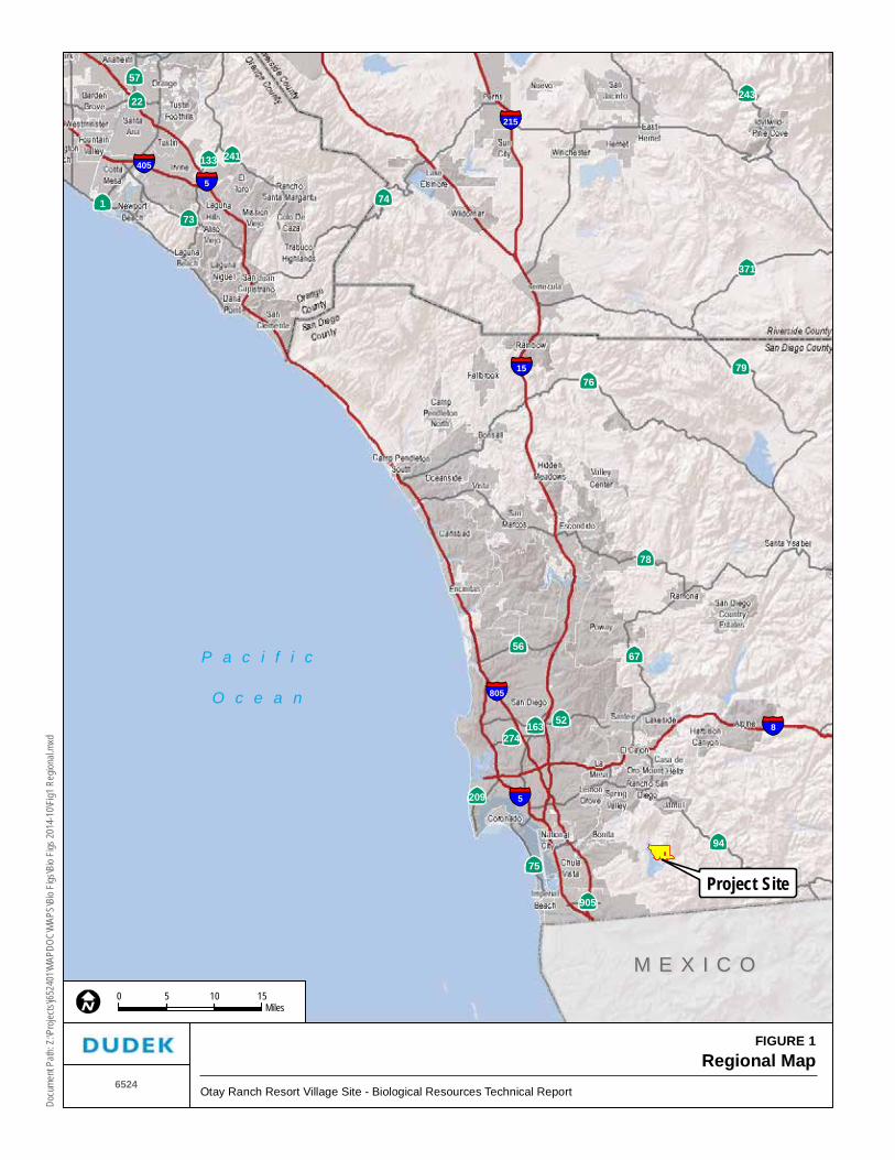
Otay Ranch is located in the southwestern portion of San Diego County (County) (Figures 1 and 2). As part of the planning for the development of Otay Ranch, several villages and planning areas were designated for various types of development while other areas were reserved for preservation of multiple species and habitats. An effort was undertaken to plan development to conserve species and habitats in the region. The project area, also referred to as “Village 13,” and the “Resort Village,” comprises approximately 1,869 acres, in the Proctor Valley Parcel of Otay Ranch, and is designated for residential and resort development and open space by the Otay SRP (Otay Ranch 1993), a component of the County General Plan. The Otay SRP governs land uses and intensities of development permitted under the County General Plan for Otay Ranch. The County General Plan identifies the project area as a “Specific Plan Area” and “Open Space” (Conservation) on the Otay Subregional Land Use Map, and as “Semi-Rural” on the Regional Categories Map. The project also includes off-site improvements to Otay Lakes Road on approximately 40-acres south and west of the project area.
The proposed Otay Ranch Resort Village Specific Plan includes amendments to the Otay SRP including an amendment to adjust the boundaries proposed for development and open space preserve uses. An amendment to the Otay SRP is a County General Plan Amendment (GPA). The project also includes a boundary adjustment to the County of San Diego MSCP Subarea Plan and the Otay Ranch Resource Management Plan (RMP) to ensure the boundaries between development and Preserve uses are consistent between those documents.
The land uses proposed by the Otay Ranch Resort Village Specific Plan are defined in Table 1. The proposed land uses consist of single-family neighborhoods, a multiple use residential and commercial neighborhood, a resort hotel with associated ancillary facilities, an elementary school site, a site for public safety facilities, open space, Otay Ranch Preserve (Preserve) land, and park and recreational uses.
Table 1 Proposed Land Uses for Otay Ranch Resort Village Site
Acres Units Density (Units/Acre)
Single Family Total 525.1 1,881 3.2–4.4
Multiple Use Total** 14.1 57 4.0
Residential Total* 539.2 1,938 3.5
Parks Total 20.7 — —
Resort Total 17.4 — —
Public Uses Total 12.1 — —
Internal Open Space 143.6 — —

Biological Resources Technical Report Otay Ranch Resort Village
6524 2 March 2015
Table 1 Proposed Land Uses for Otay Ranch Resort Village Site
Acres Units Density (Units/Acre)
Preserve Total 1,089.3 — —
Circulation Total 39.1 — —
Total 1,869.0 1,938 —
* Residential includes Residential Streets and Residential Manufactured Slopes. ** Multiple Use includes up to 20,000 square feet of commercial use; a residential only option is fully discussed in the project’s technical
reports for air quality, traffic, and greenhouse gas emissions.
The proposed Specific Plan includes approximately 525.0 acres designated for 1,881 single-family detached homes. Five single-family neighborhoods are planned with average densities ranging from 3.2 to 4.4 dwelling units per acre.
A Multiple Use neighborhood of 14.1 acres is proposed to contain 57 residential units in either an attached or detached configuration. The multiple use area may include up to 20,000 square feet of commercial uses.
Approximately 17.4 acres are identified for a resort hotel complex with a maximum of 200 guest rooms and up to 20,000 square feet of ancillary uses including meeting rooms, a conference center, offices, shops, and restaurants.
The Specific Plan proposes to reserve a 2.1-acre public safety site and a 10.0-acre elementary school site. Nine parks are planned on 28.6 acres, the largest of which is a 10.3-acre public neighborhood park site. The remaining parks range from 1.3 acres to 2.9 acres. Internal circulation comprises about 39.1 acres of the planning area.
The Otay Ranch Resort Village planning area also includes about 144 acres of open space and approximately 1,089 acres of Preserve land. Open space generally consists of large manufactured slopes outside of neighborhoods and brush management areas. Preserve land consists of undisturbed lands or restored habitats set aside for dedication to the Otay Ranch Preserve Owner Manager (POM) in satisfaction of Otay Ranch RMP conveyance requirements. No brush management or privately owned lots are located in the Preserve or on restored areas that are proposed to be included in the Preserve. Protection of Preserve lands is addressed in the Otay Ranch Resort Village Preserve Edge Plan.
The purposes of this report is to describe (1) the methods by which the entire project area has been surveyed, (2) the biological character of the site in terms of sensitive species and habitat composition, and (3) the regional resource planning efforts as they relate to potential development of the site. Furthermore, this report analyzes the direct, indirect, and cumulative impacts of the proposed project on biological resources and recommends mitigation measures to reduce these impacts to a less-than-significant level, where feasible.
P a c i f i c
O c e a n
M E X I C OM E X I C O
905
241133
57
274
209
163
56
22
75
73
52
243
371
67
1
94
74
7679
78
15
8
405
215
805
5
5
FIGURE 1Regional Map
6524Otay Ranch Resort Village Site - Biological Resources Technical Report
Docu
ment
Path:
Z:\P
rojec
ts\j65
2401
\MAP
DOC\
MAPS
\Bio
Figs\B
io Fig
s 201
4-10
\Fig1
Reg
ional.
mxd
0 155 10Miles
Project Site

Biological Resources Technical Report Otay Ranch Resort Village
6524 4 March 2015
INTENTIONALLY LEFT BLANK

FIGURE 2Vicinity Map
6524 Otay Ranch Resort Village Site - Biological Resources Technical Report
Docu
ment
Path:
Z:\P
rojec
ts\j65
2401
\MAP
DOC\
MAPS
\Bio
Figs\B
io Fig
s 201
4-10
\Fig2
_Vici
nity.m
xd
SOURCE: USGS 7.5 Minute Series, Jamul Mountains Quadrangle
0 1,200600Feet
NOTA
PART
Project Boundary
KEY MAP
Off-SiteGive
OFF-SITE GIVE
0 1,000500Feet

Biological Resources Technical Report Otay Ranch Resort Village
6524 6 March 2015
INTENTIONALLY LEFT BLANK

Biological Resources Technical Report Otay Ranch Resort Village
6524 7 March 2015
2 METHODS AND SURVEY LIMITATIONS
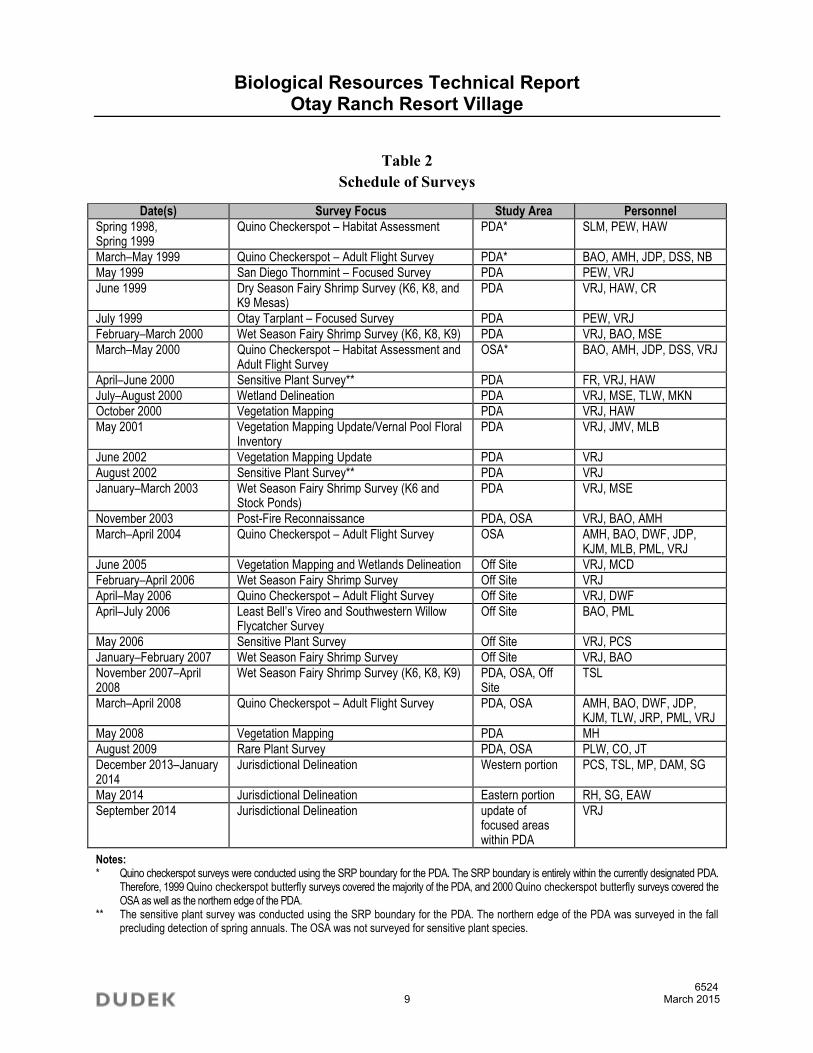
The current biological resources database for the project area was accumulated through a literature search, largely consisting of regional species descriptions and specific Otay Ranch studies, and more recent surveys conducted by Dudek biologists. Biological surveys of the project area were conducted as part of the Otay SRP planning process by various consultants between 1989 and 1991. Biologists from Dudek have recently (2005 to 2014) updated the surveys within the potential development area (PDA). The survey efforts were focused on vegetation, jurisdictional waters, and sensitive plant and invertebrate animal species. General biological surveys and some focused invertebrate studies are available for the open space area (OSA). The off-site mapping area was mapped by Dudek in 2005, with a focus on vegetation and jurisdictional waters. Focused surveys were conducted in the project area from 2006 through 2009. The jurisdictional delineation was updated in December 2013 and January, May, and September 2014.
With the exception of coastal California gnatcatcher (Polioptila californica californica) data points, all maps in this document reflect survey information gathered by Dudek between 1998 and 2014, unless noted otherwise. Previous survey reports were consulted to acquire a more complete understanding of the biological resources present; however, this information is only presented in this report in a qualitative, narrative fashion. Coastal California gnatcatcher data points were included only because of their listing status as federally threatened. Furthermore, only the methodologies of the current surveys are thoroughly explained in this report; please refer to the previous survey reports for a detailed explanation of the timing, conditions, and limitations of those surveys.
2.1 Literature Review
The project area was studied for biological resources prior to adoption of the Otay SRP. These studies included the following reports as listed in the Program Environmental Impact Report (PEIR) for the Otay SRP (Ogden 1992b), Michael Brandman Associates’ Biological Resources Survey Report (MBA 1989), Sensitive Plant Species Survey Report (MBA 1991), Report on the Hydrology and Flora of the Otay Ranch Vernal Pools (Dudek 1992), Baldwin Otay Ranch Wildlife Corridor Study: Phase I Report (Ogden 1992a), San Diego Vernal Pools (Bauder 1986), and Supplemental Survey for California Gnatcatcher (MBA no date). These reports document surveys conducted in the project area mainly in the spring seasons of 1989, 1990, and 1991. Information regarding species and habitats was taken from these reports as it was summarized in the PEIR (Ogden 1992b).

Biological Resources Technical Report Otay Ranch Resort Village
6524 8 March 2015
General information regarding wildlife species present in the region was obtained from Unitt (2004) for birds, Wilson and Reeder (2005) for mammals, Stebbins (2003) for reptiles and amphibians, and Emmel and Emmel (1973) for butterflies. In terms of regional preserve planning efforts, the project is part of Otay Ranch and is within the MSCP study area as part of the County MSCP Subarea Plan. Therefore, the following resources also were utilized: the Otay SRP (Otay Ranch 1993), MSCP (1998), County of San Diego MSCP Subarea Plan (County of San Diego 1997), MSCP habitat evaluation maps (Ogden 1999) and the Otay Ranch RMP (Otay Ranch 2011).
2.2 Field Reconnaissance
Dudek biologists conducted biological surveys of the property from spring 1998 to summer 2009. Surveys included focused surveys for Quino checkerspot butterfly (Euphydryas editha quino), San Diego and Riverside fairy shrimp (Branchinecta sandiegonensis and Streptocephalus woottoni, respectively), and sensitive plant species. The jurisdictional delineation was updated in December 2013 and January, May, and September 2014.
Biological surveys of the property were conducted by Dudek biologists Harold A. Wier (HAW), Brock A. Ortega (BAO), Anita M. Hayworth, PhD (AMH), Vipul R. Joshi (VRJ), Jeffrey D. Priest (JDP), Darren S. Smith (DSS), Paul E. Walsh (PEW), Marc C. Doalson (MCD), Megan S. Enright (MSE), Myloc K. Nguyen (MKN), Tricia L. Wotipka (TLW), Sherri L. Miller (SLM), Julie M. Vanderwier (JMV), Michelle L. Balk (MLB), David W. Flietner (DWF), Kamarul J. Muri (KJM), Paul M. Lemons (PML), Patricia C. Schuyler (PCS), Thomas S. Liddicoat (TSL), Jun Rong Powell (JRP), Mike Howard (MH), Chris Oesch (CO), Jayme Timberlake (JT), Ryan Henry (RH), Scott Gressard (SG), Danielle Mullen (DAM), Marshall Paymard (MP), Emily Wier (EAW), and Dudek subconsultants Christopher Rogers (CR), Norris Bloomfield (NB), and Fred Roberts (FR). The surveys were conducted according to the schedule shown in Table 2. Specific information regarding USFWS protocol surveys for the federally listed endangered Quino checkerspot butterfly, federally listed endangered San Diego and Riverside fairy shrimp, federally listed endangered least Bell’s vireo (Vireo bellii pusillus) and southwestern willow flycatcher (Empidonax traillii extimus) may be found in the survey reports for each of these species (Dudek 1999a, 1999b, 2000a, 2000b, 2003, 2004, 2006a, 2006b, 2006c, 2007, 2008a, 2008b). The month(s) and year(s) during which these and other surveys of the site were conducted are included in Table 2. Surveys were conducted by foot, and biotic components were inventoried during each survey.
Biological Resources Technical Report Otay Ranch Resort Village
6524 9 March 2015
Table 2 Schedule of Surveys
Date(s) Survey Focus Study Area Personnel
Spring 1998, Spring 1999
Quino Checkerspot – Habitat Assessment PDA* SLM, PEW, HAW
March–May 1999 Quino Checkerspot – Adult Flight Survey PDA* BAO, AMH, JDP, DSS, NB
May 1999 San Diego Thornmint – Focused Survey PDA PEW, VRJ
June 1999 Dry Season Fairy Shrimp Survey (K6, K8, and K9 Mesas)
PDA VRJ, HAW, CR
July 1999 Otay Tarplant – Focused Survey PDA PEW, VRJ
February–March 2000 Wet Season Fairy Shrimp Survey (K6, K8, K9) PDA VRJ, BAO, MSE
March–May 2000 Quino Checkerspot – Habitat Assessment and Adult Flight Survey
OSA* BAO, AMH, JDP, DSS, VRJ
April–June 2000 Sensitive Plant Survey** PDA FR, VRJ, HAW
July–August 2000 Wetland Delineation PDA VRJ, MSE, TLW, MKN October 2000 Vegetation Mapping PDA VRJ, HAW
May 2001 Vegetation Mapping Update/Vernal Pool Floral Inventory
PDA VRJ, JMV, MLB
June 2002 Vegetation Mapping Update PDA VRJ
August 2002 Sensitive Plant Survey** PDA VRJ
January–March 2003 Wet Season Fairy Shrimp Survey (K6 and Stock Ponds)
PDA VRJ, MSE
November 2003 Post-Fire Reconnaissance PDA, OSA VRJ, BAO, AMH
March–April 2004 Quino Checkerspot – Adult Flight Survey OSA AMH, BAO, DWF, JDP, KJM, MLB, PML, VRJ
June 2005 Vegetation Mapping and Wetlands Delineation Off Site VRJ, MCD
February–April 2006 Wet Season Fairy Shrimp Survey Off Site VRJ
April–May 2006 Quino Checkerspot – Adult Flight Survey Off Site VRJ, DWF
April–July 2006 Least Bell’s Vireo and Southwestern Willow Flycatcher Survey
Off Site BAO, PML
May 2006 Sensitive Plant Survey Off Site VRJ, PCS
January–February 2007 Wet Season Fairy Shrimp Survey Off Site VRJ, BAO
November 2007–April 2008
Wet Season Fairy Shrimp Survey (K6, K8, K9) PDA, OSA, Off Site
TSL
March–April 2008 Quino Checkerspot – Adult Flight Survey PDA, OSA AMH, BAO, DWF, JDP, KJM, TLW, JRP, PML, VRJ
May 2008 Vegetation Mapping PDA MH
August 2009 Rare Plant Survey PDA, OSA PLW, CO, JT
December 2013–January 2014
Jurisdictional Delineation Western portion PCS, TSL, MP, DAM, SG
May 2014 Jurisdictional Delineation Eastern portion RH, SG, EAW
September 2014 Jurisdictional Delineation update of focused areas within PDA
VRJ
Notes: * Quino checkerspot surveys were conducted using the SRP boundary for the PDA. The SRP boundary is entirely within the currently designated PDA.
Therefore, 1999 Quino checkerspot butterfly surveys covered the majority of the PDA, and 2000 Quino checkerspot butterfly surveys covered the OSA as well as the northern edge of the PDA.
** The sensitive plant survey was conducted using the SRP boundary for the PDA. The northern edge of the PDA was surveyed in the fall precluding detection of spring annuals. The OSA was not surveyed for sensitive plant species.

Biological Resources Technical Report Otay Ranch Resort Village
6524 10 March 2015
2.2.1 Resource Mapping
Plant communities and sensitive species locations were mapped for the PDA, OSA, and off-site areas in the field onto a 200-scale (1 inch = 200 feet) color infrared reproduction with a topographic overlay with 5-foot contours and with the aid of a 300- to 500-scale color aerial photograph. Plant community boundaries and locations of sensitive species were digitized using AutoCAD and ArcView by Dudek geographic information system (GIS) technicians Martie Clemons, Lesley Terry, and Tim Walsh. GIS coverage was created using ArcInfo and ArcCAD. The OSA resource mapping is based on information from the San Diego Association of Governments (SANDAG), as mapped in 1995 (SANDAG 1999). Vegetation mapping represents pre-fire conditions. Although a post-fire reconnaissance survey was conducted, communities were not mapped, and no changes were made.
Plant community classifications used in this report follow Holland (1986) and Oberbauer et al. (2008), in accordance with the requirements of the County (County of San Diego 2008a), with modifications or additions to accommodate the lack of conformity of the observed communities to those of Holland. It should be noted that in the mapping of vegetation communities, some consideration was given to the recent (since about 1990) level of disturbance in the project area. Because of regular grazing of the site (occurring between 1990 and 2001), typical shrub cover thresholds were lowered (e.g., the typical shrub cover level for disturbed coastal sage scrub is from 15% to 50%; anything lower than 15% is typically considered non-native grassland; for this project site, a shrub cover from approximately 5% to 50% was used to designate disturbed coastal sage scrub).
2.2.2 Flora
All plant species encountered during the field surveys were identified and recorded. The majority of species were recorded during spring sensitive plant surveys. Those species that could not be identified in the field were brought into the laboratory for further investigation. A cumulative list of plant species observed on site is presented in Appendix A. Species lists generated from earlier surveys (1989–1992) are not included in this list because these surveys covered areas that included the project site as well as other surrounding areas.
Latin and common names of plants follow the California Native Plant Society Inventory (CNPS 2014) for sensitive plants and The Jepson Manual (Hickman 1996) for non-sensitive plants. Where not listed in Hickman (1996), common names are taken from Beauchamp (1986) or Abrams (1923).

Biological Resources Technical Report Otay Ranch Resort Village
6524 11 March 2015
2.2.3 Fauna
Wildlife species detected during the field surveys by sight, calls, tracks, scat, or other signs were recorded. Binoculars (8 × 32 and 10 × 50 power) were used to help identify observed animals. Faunal species, including birds, reptiles, amphibians, invertebrates, and mammals, were observed and mostly recorded during surveys for Quino checkerspot butterfly, for which the surveys covered the entire site. A cumulative list of animal species observed or detected on site is presented in Appendix B.
Scientific and common names of animals follow Crother (2012) for reptiles and amphibians, American Ornithologists’ Union (AOU 2013) for birds, Wilson and Reeder (2005) for mammals, North American Butterfly Association (NABA 2001) or San Diego Natural History Museum (SDNHM 2002) for butterflies, and Moyle (2002) for fish. For names of sensitive wildlife, Latin and common names follow The Special Animals List (CDFW 2014a). Appendix C contains an explanation of sensitivity categories used for both plant and wildlife species within the following sections.
2.2.4 Jurisdictional “Waters” Delineation
Wetlands or other “waters” under the jurisdiction of the United States Army Corps of Engineers (ACOE) or California Department of Fish and Wildlife (CDFW) were mapped in the field onto a 200-scale (1 inch = 200 feet) topographic and color infrared map. The ACOE jurisdictional wetland delineation was conducted in accordance with the ACOE 1987 Manual for the Delineation of Wetlands (TR Y-87-1); hydrology, vegetation, and soils were examined at potential wetland sites. Munsell Soil Color Charts were used to determine soil chroma and value (Munsell 1998). The indicator status of the plant species was determined by using the USFWS National List of Plant Species that Occur in Wetlands: California (Region 1) (Reed 1988). Determination of waters of the state (i.e., areas under the jurisdiction of the CDFW in accordance with the California Fish and Game Code) was based on presence of one of the three wetland criteria of hydrology, wetland vegetation, or hydric soils in association with a stream channel. In general, some jurisdictional waters as defined by the ACOE are also under the jurisdiction of the Regional Water Quality Control Board (RWQCB); however, there are instances where the RWQCB may take jurisdiction and the ACOE does not. These instances are generally associated with isolated waters with no connection to navigable waters. Data were taken at multiple data station locations to aid in jurisdictional determinations. The data sheets attached to this report as Appendix D only include forms from the most recent jurisdictional delineation update conducted in 2014 since the previous forms were the older format. The previous forms were revised per the most current data format.

Biological Resources Technical Report Otay Ranch Resort Village
6524 12 March 2015
In addition to the routine jurisdictional waters delineation, three potential vernal pool complexes on two mesas were studied for this project. No soil pits were dug in the vernal pools to avoid impacts to the vernal pools. Potential vernal pool depressions were mapped using a global positioning system (GPS) backpack unit in the field. Each potential depression was labeled in the field with a stake and a designated number. The pools were visited during the wet season in 1999, 2000, 2003, and 2008 to determine the presence/absence of endangered fairy shrimp species. Off-site depressions were surveyed in 2006, 2007, and 2008. Information regarding inundation also was recorded as part of these studies. Due to low rainfall in 1999, dry season soil sampling was conducted. A vernal pool floral inventory of on-site depressions was compiled in spring 2001 (Appendix E). The information from the inundation records, floral inventory, and fairy shrimp surveys was used to determine whether the depression was considered a vernal pool.
Although extensive data were gathered for the vernal pools, a jurisdictional determination has not yet been made because of changes in vernal pool regulatory authority of the ACOE and RWQCB. In January 2001, the ACOE issued memoranda addressing the jurisdictional status of isolated waters under the federal Clean Water Act, in light of the U.S. Supreme Court decision in Solid Waste Agency of Northern Cook County (SWANCC) v. ACOE, 531 U.S. 159 (2001). As a result of the SWANCC decision, and the subsequent correspondence from the ACOE, vernal pools, which are isolated water features, are no longer considered to be jurisdictional waters of the U.S., with the exception being those vernal pool features that are hydrologically connected to other jurisdictional waters of the U.S.
None of the vernal pools in the project area have been confirmed to be connected to jurisdictional waters of the U.S. Based on observations of the site, it appears that water is collected on the mesa following rain events and eventually either percolates into the ground or evaporates. Because the vernal pools on the mesa may not be connected to any other waters of the U.S., they may not be under the jurisdiction of the ACOE, however, that decision has not yet been made by the ACOE. The pools are also not under the jurisdiction of CDFW because the California Fish and Game Code only regulates stream channels (i.e., areas with a defined bed and bank) and adjacent wetlands.
On February 21, 2001, the RWQCB issued a letter stating that it intends to assume jurisdiction of vernal pools under the Porter-Cologne Act. The determination on the RWQCB jurisdiction has not been clarified at this time. Since February 21, 2001, the RWQCB has not issued further guidance. Therefore, for purposes of this report, no jurisdictional determination is made with regard to vernal pools. However, the data gathered are presented in terms of the criteria previously used by the ACOE to evaluate vernal pools (ACOE 1997).
Biological Resources Technical Report Otay Ranch Resort Village
6524 13 March 2015
The ACOE issued a Special Public Notice – Regional General Conditions to the Nationwide Permits (ACOE 1997), which defined vernal pools that are under the jurisdiction of the ACOE as follows:
Vernal pools are wetlands that seasonally pond in small depressions as a result of a shallow, relatively impermeable layer (e.g., clay or other impervious soil or rock layer) that restricts downward percolation of water. The dominant source for vernal pools is precipitation with pools typically filling after fall and winter rains and evaporating during spring and summer. These seasonal ponds are fragile, easily disturbed ecosystems that provide habitat for indigenous, specialized assemblages of flora and fauna (see attached species list), including several species which are either proposed or already federally listed threatened or endangered.
Because the ACOE considers vernal pools to be “problem areas,” only one or more of the wetland parameters must be present to be considered ACOE-jurisdictional wetlands. In addition, within the Special Public Notice - Regional General Conditions to the Nationwide Permits (ACOE 1987), the ACOE lists features that are generally not considered a vernal pool, including the following features:
1. Stock ponds
2. Road ruts
3. Minor impoundments on drainages
4. Man-made ponds
5. Abandoned borrow sites
6. Seasonally flooded plains, which do not exhibit basin topography.
As mentioned, the ACOE generated a list of vernal pool indicator species (ACOE 1997), and any depression that contained at least one of these indicators was considered a vernal pool. A basin that had been mapped during previous years that did not meet these criteria was not considered a vernal pool. Thus, if the basin showed inundation, occupation by a vernal pool plant indicator species, or was determined to be occupied by a vernal pool branchiopod species (whether listed as endangered or not), it was then considered a vernal pool.
2.3 Sensitive Biological Resources
Sensitive biological resources are those defined by the County or other regulatory agencies as (1) species that have been given special recognition by federal, state, or local conservation agencies

Biological Resources Technical Report Otay Ranch Resort Village
6524 14 March 2015
and organizations due to limited, declining, or threatened population sizes; (2) species and habitat types recognized by local and regional resource agencies as sensitive; (3) habitat areas or plant communities that are unique, are of relatively limited distribution, or are of particular value to wildlife; or (4) wildlife corridors and habitat linkages.
Recent directed searches were conducted for Quino checkerspot butterfly, San Diego fairy shrimp, Riverside fairy shrimp, Otay tarplant (Deinandra conjugens), and San Diego thornmint (Acanthomintha ilicifolia). Incidental observations of other flora and fauna during these focused surveys were recorded and contributed substantially to the cumulative biological resources database for the project. Sensitive species surveys conducted for the Otay SRP included plant and bird surveys conducted in the spring seasons of 1989–1992.
Quino Checkerspot Butterfly
A Phase I habitat assessment was conducted in spring 1998 by Mr. Walsh and Ms. Miller. The assessment consisted of two visits of the proposed development area where varying densities of host plant and nectar sources were mapped. A portion of the site, which was not surveyed in spring 1998, was surveyed for habitat conditions by Mr. Wier in spring 1999. These assessments were the basis for where the Phase II adult flight surveys were conducted in spring 1999 by Mr. Ortega (USFWS permit no. TE813545-4), Dr. Hayworth (USFWS permit no. TE781084-7), Mr. Priest (USFWS permit no. TE840619-3), Mr. Smith (USFWS permit no. TE007628-0) and Mr. Bloomfield (USFWS permit no. TE838743) in the PDA (see note to Table 2). These surveys took place weekly during the ten-week flight season and covered all suitable habitat within those study areas. The surveys were conducted in accordance with the 1999 USFWS Quino checkerspot survey protocol (USFWS 1999). A survey of the adjacent OSA was conducted in spring 2000 under the revised Year 2000 USFWS protocol (USFWS 2000). During this five-week survey period, all potential habitat within the study areas, as defined by the revised survey protocol and as determined during the first week of the spring 2000 survey, was visited weekly by Mr. Ortega, Dr. Hayworth, Mr. Priest, Mr. Smith, and Mr. Joshi (USFWS permit no. TE019949-1). A protocol survey of the OSA was conducted in 2004 in accordance with the 2002 USFWS protocol (USFWS 2002). The 2004 survey covered approximately 900 acres and was defined as “treasure hunt” surveys with the goal of maximizing survey time within areas of highest potential for Quino checkerspot butterfly detection. The survey was conducted by Dr. Hayworth, Mr. Ortega, Mr. Flietner, Mr. Priest, Mr. Muri, Mr. Joshi, Michelle Balk (USFWS permit #TE051230-0), and Paul Lemons (USFWS permit #TE051248-1). The off-site area was surveyed by Mr. Flietner and Mr. Joshi according to the 2002 protocol (USFWS 2002) in 2006. The entire project area was surveyed in 2008 according to the 2002 protocol (USFWS 2002) and also included surveying a total of 30 points selected by the USFWS as part of the Quino checkerspot butterfly range-wide study.

Biological Resources Technical Report Otay Ranch Resort Village
6524 15 March 2015
The focused survey for the Quino checkerspot butterfly was conducted in the project area over a four-week period (as directed by the USFWS) by Dr. Hayworth, Mr. Ortega, Mr. Flietner, Mr. Priest, Mr. Muri, Mr. Lemons, Mr. Joshi, Jun Rong Powell (USFWS permit #TE-006559-3), and Tricia Wotipka (USFWS permit #TE-840619-2).
San Diego and Riverside Fairy Shrimp
Surveys were conducted in 1999, 2000, and 2003 to determine the presence/absence of San Diego and Riverside fairy shrimp on two mesas (K6 and K8) containing vernal pool complexes, one area mapped as the K9 mesa, and within three stock ponds on site. As determined by several visits to the site and nearby vernal pool complexes during the winter of 1999, vernal pools in the project area did not fill adequately (i.e., they did not contain at least three centimeters of pooled water for seven contiguous days during the survey period) to conduct wet season surveys for the listed shrimp species. Dry season fairy shrimp surveys were conducted by Dudek subconsultant Christopher Rogers (USFWS permit #TE795934), with the assistance of Dudek biologists Mr. Joshi and Mr. Wier, in June 1999. Mr. Rogers used a modification of the USFWS dry season sampling protocol adapted to the types of vernal pools found in Southern California. Vernal pool complexes on the mesas were re-surveyed during the winter of 2000 by Mr. Joshi and Mr. Ortega to determine adequate ponding for wet season surveys. A total of 25 pools (of 34 potential vernal pools) were observed to meet the USFWS inundation criteria within the K6 and K8 mesas and were therefore surveyed for the presence/absence of San Diego and Riverside fairy shrimp in accordance with the USFWS survey protocol for listed fairy shrimp species (USFWS 1996). No basins were detected and no ponding occurred within the K9 mesa; therefore, no dipnetting or dry season surveys were conducted in either 1999 or 2000. However the K9 mesa was visited to document the lack of ponding. In 2003, focused surveys were conducted for the first time within three stock ponds on site, as well as for a third time on the K6 mesa. All three stock ponds and six of 16 potential vernal pools on the K6 mesa ponded sufficiently to allow for wet season surveys in accordance with the USFWS survey protocol. The surveys were conducted by Mr. Joshi and Megan S. Enright (USFWS permit no. TE022524-0). A survey of the off-site survey area was performed in winter 2006 by Mr. Joshi and in 2007 by Mr. Joshi and Mr. Ortega, when five basins were identified and surveyed. A complete survey of the entire project area as well as the off-site areas was conducted in 2008 by Thomas S. Liddicoat (permit no. TE139634-0). The 2008 survey included visits to the K6, K8, and K9 mesas, the three stock ponds, and all basins observed within the off-site survey area. Similar to the previous surveys, no basins or ponding was observed on the K9 mesa so no dipnetting was conducted. Exhibits illustrating the location of the pools, basins, and stock ponds can be found in Section 3.4 of this report.

Biological Resources Technical Report Otay Ranch Resort Village
6524 16 March 2015
Sensitive Plant Species
Focused surveys for sensitive plant species were conducted within the Otay SRP development area. The Otay SRP development area is entirely within the PDA but does not include portions of the northern edge of the PDA. Focused surveys for the state-listed endangered and federally listed threatened San Diego thornmint and Otay tarplant were conducted by Dudek biologists Mr. Joshi and Mr. Walsh in May and July 1999. The survey was conducted on foot with focus given to areas that exhibited appropriate soil conditions (i.e., deep clay soils). In spring 2000, Mr. Roberts, Mr. Joshi, and Mr. Wier conducted focused surveys for all sensitive plant species. Populations of San Diego thornmint were mapped using a portable GPS unit with sub-meter accuracy. Other species were mapped by hand onto 200-scale aerial photographic or topographic maps. Population sizes were visually estimated at each location unless the species was locally common. Spring 2000 surveys were conducted during the blooming period of San Diego thornmint and Otay tarplant as well as most other potentially occurring sensitive plant species. In spring 2001, a vernal pool inventory was conducted within vernal pools on the K6 and K8 mesas. Sensitive species associated with vernal pools would have been detected during these surveys. Where sensitive species were observed, the population size was visually estimated and mapped onto 200-scale topographic maps with the vernal pool identification number. The northern edge of the PDA, which was not surveyed during the spring 2000 effort, was surveyed in August 2002 by Mr. Joshi and in 2009 by Mr. Walsh, Mr. Oesch, and Ms. Timberlake. Due to the timing of the surveys, only perennial species were detected. A survey of the off-site area was performed by Mr. Joshi and Ms. Schuyler in spring 2006.
2.4 Post-Fire Assessment
The entire project area was affected by the October 2003 Otay Fire. A post-fire reconnaissance survey was conducted to determine the general condition of the site. Details of the survey findings are provided below; however, in general it is believed that most biological components present before the fire remain or will naturally return as the site regenerates. Therefore, the pre-fire data are appropriate for analysis of potential project impacts.
A post-fire reconnaissance survey was conducted on November 7, 2003. The PDA and OSA were surveyed by vehicle and by foot to generally assess the condition of vegetation communities, general wildlife, and sensitive species. All species detected were noted, and a general rating of fire intensity (no burn, low, medium, and high) was mapped for the entire project area.

Biological Resources Technical Report Otay Ranch Resort Village
6524 17 March 2015
2.5 Survey Limitations
Surveys conducted in the early 1990s, as well as recent surveys, are limited by a diurnal bias and seasonal constraints. The surveys mostly were conducted during the daytime to maximize detection of plants and most animals. Small nocturnal mammals, reptiles and amphibians, and nocturnal birds would not be detectable. Seasonal constraints include the absence of some winter migrant birds due to the timing of the surveys in the spring through mid-summer although the fairy shrimp focused surveys contribute to winter observations. The seasonal timing of the surveys was optimal for the observation of diurnal reptiles and for the detection of many invertebrates and resident and breeding birds. No small mammal trapping was conducted, and no pitfall traps or drift-lines were used for reptile sampling.
Although the breadth of the biological studies within the PDA has some limitations, given the context of the MSCP Subarea Plan, and Otay Ranch RMP, the surveys are adequate to assess the significance of proposed development of the site in terms of impacts to biological resources and existing conservation planning efforts. With specific regard to the lack of small mammal trapping, there is no indication that such an effort is necessary given that the only listed mammal species that could conceivably be significantly impacted by the project is the federally listed endangered Pacific pocket mouse (Perognathus longimembris pacificus). The project area is outside the known range of the Pacific pocket mouse by eight miles; therefore, the species has a very low potential to occur in the project area.

Biological Resources Technical Report Otay Ranch Resort Village
6524 18 March 2015
INTENTIONALLY LEFT BLANK

Biological Resources Technical Report Otay Ranch Resort Village
6524 19 March 2015
3 PHYSICAL CHARACTERISTICS
3.1 Site Description
The Otay Ranch Resort Village Specific Plan area is located in southwestern San Diego County, approximately 13 miles east of the Pacific Ocean and six miles north of the international border with Mexico. The site is located in the Proctor Valley Parcel of the Otay SRP. Access is provided via Telegraph Canyon Road, which transitions into Otay Lakes Road, as an east–west arterial that forms the southern boundary of the project site. The property boundary includes approximately 1,869 acres, with an additional 40 acres of off-site study area. The off-site study area includes the existing Otay Lakes Road alignment plus the proposed realignment. The property is located on the United States Geological Survey (USGS) Jamul Mountains Quadrangle, Sections 4, 5, 6, 31, 32, 33; T16S and 17S, and R1E.
The Otay Ranch Resort Village consists of a broad mesa sloping to the south, broken by several steep canyons draining from north to south. Portions of the relatively flat mesa extend north into the Jamul Mountains, becoming part of steeper slopes. Site elevations range from approximately 500 feet above mean sea level (AMSL) at the southern end of the property to approximately 1,500 feet AMSL in the northeastern portions. The project area lies within the watershed of the Otay River, a westerly flowing stream that drains an area of approximately 145 square miles. The site is upstream of Savage Dam, which creates Lower Otay Lake.
The Otay Ranch Resort Village is located at the interface of urban development and scenic open space. The Otay Valley Parcel of Otay Ranch, the East Lake Vistas residential community, the East Lake Woods residential community, and the U.S. Olympic Training Center compose the edge of urban development to the west. Lower Otay Lake, a recreational reservoir and water supply owned by the City of San Diego, is located to the south. Upper Otay Lake and the Birch Family Estate are located to the northwest. A temporary ultra-light gliding and parachuting airport is located at the eastern end of the Lower Otay Lake on City of San Diego property. An inactive quarry operation is located farther to the east.
Prior to 2001, the southern half of the project area was used for ranching, specifically cattle grazing, and possibly crop cultivation purposes. In addition, crop cultivation likely occurred on the southwestern corner of the property decades ago. The site is bounded on the south by Otay Lakes Road and Jamul Creek is located just east of the eastern boundary. Lower Otay Lake (which is owned by the City of San Diego) is located south of the site; open space in the Jamul Mountains is adjacent to the site in the north and east (which is owned by the U.S. Bureau of Land Management (BLM) and private parties).

Biological Resources Technical Report Otay Ranch Resort Village
6524 20 March 2015
The southern half of the site contains three large mesas (K6, K8, and K9 from west to east), an expansive relatively flat area in the west, and increasing elevations with steep canyons to the north. Drainages bisect the mesas and generally run north to south, with the exception of one drainage running east to west from the center to the western edge of the property. Several stock ponds have been intentionally created along the drainages on the property.
According to Bowman (1973), soils within the project site are mostly Olivenhain cobbly loam, San Miguel–Exchequer rocky silt loams, Redding cobbly loam, and Friant rocky fine sandy loam. The Olivenhain soils occur in the southern, western, and central portions of the site, including the three large mesas. This soil type is known to support vernal pools and certain rare plant species. The San Miguel–Exchequer soils occur in the northwestern portion of the site. The Redding soils occur in the eastern portion of the site. The Friant soils occur in much of the northern portions and in the far eastern portion of the site. A small portion of Diablo–Olivenhain complex occurs in the southwestern portion, adjacent to Otay Lakes Road.
The Olivenhain series consists of well-drained, moderately deep to deep cobbly loams that have a very cobbly clay subsoil. These soils formed in old gravelly and cobbly alluvium. In a representative profile, the surface layer is brown and reddish-brown, medium acid cobbly loam. The subsoil is a reddish-brown, red, and pink, strongly acid, very cobbly clay and clay loam. In many places there is a microrelief of broad-base low hummocks, locally called mima mounds. This soil has an effective rooting depth of 20 to 27 inches, and the available water holding capacity is 2 to 2.5 inches. Runoff is medium to rapid, and the erosion hazard is moderate to high.
The San Miguel series consists of well-drained, shallow to moderately deep silt loams that have a clay subsoil. These soils are derived from metavolcanic rock. In a representative profile, the surface layer is light yellowish-brown and very pale brown, medium acid and strongly acid silt loam. The subsoil is brown to yellowish-brown, strongly acid, and very strongly acid clay and gravelly clay. The San Miguel-Exchequer complex occurs on mountainous uplands. The soil is slowly to moderately permeable and has 1 to 3 inches of water available in the rooting depth. Soil fertility is very low, drainage is good, runoff is medium to rapid, and the erosion hazard is moderate to very high.
Redding cobbly loam soils are well-drained, undulating to steep gravelly loams that have a gravelly clay subsoil and a hardpan. These soils formed in old mixed cobbly and gravelly alluvium. They are on dissected terraces. The surface layer is yellowish brown and light-brown, medium acid and strongly acid about 10 to 20 inches thick. The subsoil is yellowish-red and red, very strongly acid, gravelly heavy clay loam, and gravelly clay. Below this, at a depth of about 30 inches, is an iron-silica cemented hardpan that is not uniform or continuous, and in some areas the soil is cobbly throughout the profile. The landscape is characterized by many narrow divides, v-shaped valley bottoms, and steep side slopes. The surface layer is 20% to 30%

Biological Resources Technical Report Otay Ranch Resort Village
6524 21 March 2015
cobblestones, and the subsoil is 25% to 35%. The available water-holding capacity is 1.5 to 2 inches. Runoff is medium to rapid, and the erosion hazard is moderate to high.
The Friant series of soils consists of shallow and very shallow, well-drained fine sandy loams that formed in material weathered from fine-grained metasedimentary rock. In a representative profile the surface layer is dark-brown and brown, slightly acid, fine sandy loam about 12 inches thick. It is underlain by gray, hard metasedimentary rock. Rock outcrops cover 2% to 10% of the surface in some areas. The available water-holding capacity is 0.5 to 1.5 inches. Runoff is medium to rapid, and the erosion hazard is moderate to high.
The Diablo-Olivenhain complex is approximately 50% Diablo clay and 45% Olivenhain cobbly loam. The Diablo soil has a surface layer of dark-gray clay about 27 inches thick. The next layer is light-gray heavy sandy loam. At a depth of about 32 inches is soft calcareous sandstone. The Olivenhain soil has a surface layer of brown cobbly loam about 10 inches thick. The subsoil is reddish-brown cobbly clay loam about 32 inches thick. The substratum is pinkish-white cobbly loam. Diablo clay is medium to high in fertility, is slowly permeable and has 4 to 5.5 inches of water available in the 25 to 37 inches of effective rooting depth. The Olivenhain cobbly clay loam is low in fertility, is very slowly permeable in the subsoil, and has 2 to 3 inches of water available in the 20 to 40 inches of effective rooting depth. Both soils are well drained. They have medium to rapid runoff and a moderate to high erosion hazard.
3.2 Botany – Plant Communities and Floral Diversity
The project area is dominated by sage scrub, with substantial representation of grassland and chaparral. Various wetland plant communities also occur on the site. Portions of the site have been historically mechanically disturbed by farming and grazing activity, reducing the presence of natural vegetation. In total, 16 plant communities and land cover types were mapped within the project area on site and off site, consisting of coastal sage scrub, chamise chaparral, southern mixed chaparral, scrub oak chaparral, disturbed valley needlegrass grassland, non-native grassland, cismontane alkali marsh, freshwater marsh, open water, mulefat scrub, southern willow scrub, stock pond, disturbed habitat, eucalyptus woodland, ornamental, and developed land. The coastal sage scrub, chamise chaparral, cismontane alkali marsh, and mulefat scrub were subdivided as non-disturbed versus disturbed depending on the percent native shrub cover and dominance of non-native species. These habitat types are described below. Communities that are under the jurisdiction of the ACOE, CDFW, and RWQCB due to their status as wetlands are also noted. The distribution of mapped vegetation communities is presented in a 1 inch = 300 feet scale Biological Resources Map located in the map pocket of this report. This detailed mapping has been reduced to provide a general depiction of MSCP vegetation categories on Figure 3 (also see map pocket). The acreages of each community type within the project site are shown in Table 3.

Biological Resources Technical Report Otay Ranch Resort Village
6524 22 March 2015
Table 3 Acreages of Plant Communities
Plant Community Type Holland Code On Site Off Site* Total
Sensitive Upland Communities
Coastal Sage Scrub 32500 1,121.51 7.61 1129.12
Disturbed Coastal Sage Scrub 32500 348.62 4.99 353.61
Chamise Chaparral 37210 143.14 — 143.14
Disturbed Chamise Chaparral 37210 15.67 — 15.67
Scrub Oak Chaparral 37900 22.45 — 22.45
Southern Mixed Chaparral 37121 4.95 — 4.95
Disturbed Valley Needlegrass Grassland 42110 110.58 0.03 110.61
Non-Native Grassland 42200 78.96 5.44 84.40
Subtotal 1,845.88 18.07 1,863.95
Sensitive Wetland Communities (ACOE, RWQCB, CDFW unless otherwise noted)
Cismontane Alkali Marsh 52310 6.39 — 6.39
Disturbed cismontane alkali marsh 11200 0.17 — 0.17
Freshwater Marsh 52410 — 0.17 0.17
Mulefat Scrub, all jurisdictions Mulefat Scrub, CDFW only
63310 0.02
0.06
— 0.02
0.06
Disturbed Mulefat Scrub, all jurisdictions Disturbed Mulefat Scrub, CDFW only
63310 — 0.10
0.03
0.10
0.03
Open Water 64140 0.17 0.49 0.66
Southern Willow Scrub 63320 1.19 0.04 1.23
Subtotal 8.00 0.83 8.83
Non-Sensitive Communities and Land Covers
Developed Land 12000 0.88 19.23 20.10
Disturbed Habitat 11300 13.46 0.38 13.85
Eucalyptus Woodland 79100 — 0.61 0.61
Ornamental 11000 — 0.94 0.94
Stock Pond 18000 0.79 — 0.79
Subtotal 15.13 21.16 36.29
Total 1,869.01 40.06 1,909.07
* Includes proposed off-site improvement to Otay Lakes Road and any improvements that are required within City of San Diego-ownedCornerstone Lands.
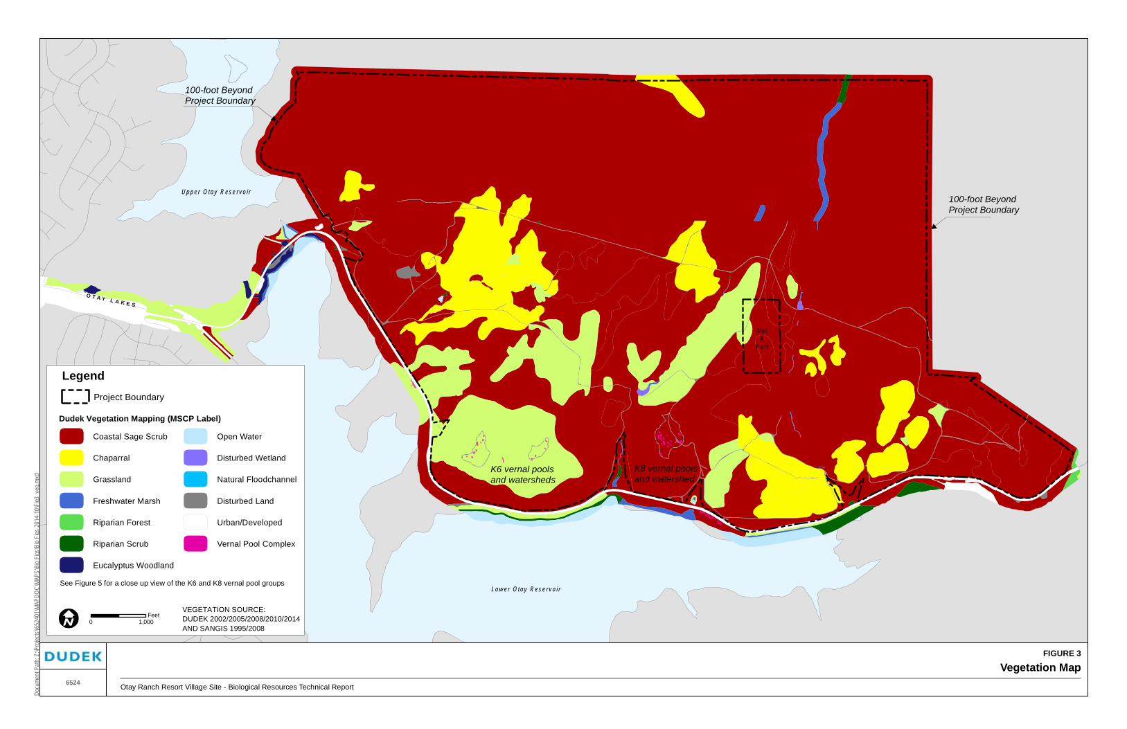
FIGURE 3
Vegetation MapOtay Ranch Resort Village Site - Biological Resources Technical Report
Docu
ment
Path:
Z:\P
rojec
ts\j65
2401
\MAP
DOC\
MAPS
\Bio
Figs\B
io Fig
s 201
4-10
\Fig3
_veg
.mxd
6524
Lo w er Ota y R ese r vo i r
No tA
Pa rt
Up p er Ota y R ese rvo i r
O T A Y L A K E S
K6 vernal poolsand watersheds
K8 vernal poolsand watershed
100-foot BeyondProject Boundary
100-foot BeyondProject Boundary
Coastal Sage Scrub
Chaparral
Grassland
Freshwater Marsh
Riparian Forest
Riparian Scrub
Eucalyptus Woodland
Open Water
Disturbed Wetland
Natural Floodchannel
Disturbed Land
Urban/Developed
Vernal Pool Complex
VEGETATION SOURCE:DUDEK 2002/2005/2008/2010/2014AND SANGIS 1995/2008
0 1,000Feet
LegendProject Boundary
Dudek Vegetation Mapping (MSCP Label)
See Figure 5 for a close up view of the K6 and K8 vernal pool groups

Biological Resources Technical Report Otay Ranch Resort Village
6524 24 March 2015
INTENTIONALLY LEFT BLANK
Biological Resources Technical Report Otay Ranch Resort Village
6524 25 March 2015
3.2.1 Coastal Sage Scrub/Disturbed Coastal Sage Scrub (CSS/dCSS)
Within the project area, coastal sage scrub occurs in relatively distinct subassociations. Shrub cover in disturbed coastal sage scrub may vary from 5% to 50% and typically consists of California sagebrush (Artemisia californica), California buckwheat (Eriogonum fasciculatum), deerweed (Lotus scoparius), rock-rose (Helianthemum scoparium), and laurel sumac (Malosma laurina). In addition to these native shrub species, a large percentage of the ground cover is taken up by broad-leaved filaree (Erodium botrys) and fascicled tarplant (Deinandra [Hemizonia] fasciculata). Other non-natives include grasses such as slender wild-oat (Avena barbata), soft chess (Bromus hordeaceus), black mustard (Brassica nigra), and star-thistle (Centaurea melitensis).
Another subassociation occurs in many of the northwestern areas, where coastal sage scrub consists of nearly monotypic stands of Munz’s sage (Salvia munzii). This subassociation contains a typical shrub cover of 80% to 90%, with Munz’s sage comprising approximately 60% to 70% of the overall cover. Other species present include San Diego County viguiera (Bahiopsis (=Viguiera) laciniata), California buckwheat, and occasionally laurel sumac and chamise (Adenostoma fasciculatum). The typical non-disturbed coastal sage scrub on site, occurring throughout the site but concentrated in the northern portions, consists of 50% to 90% shrub cover with a relative co-dominance of California sagebrush, California buckwheat, and San Diego County viguiera. The density of shrub cover within this sub-type varies with exposure, with denser cover often associated with laurel sumac and white sage (Salvia apiana) occurring in more mesic areas and sparser cover often associated with San Diego barrel cactus (Ferocactus viridescens) occurring in more xeric conditions. In the eastern portion of the project site shrub cover is relatively low, however, because the percent cover of non-native species is very low it is likely that the low shrub cover is a natural condition due to exposure, slope, and/or soil. There are also small occurrences of coastal sage scrub dominated by broom baccharis (Baccharis sarothroides). This form often is the result of historic disturbance or occurs in association with a drainage.
3.2.2 Chamise Chaparral/Disturbed Chamise Chaparral (CC/dCC)
A predominant chaparral type found in Ventura, Los Angeles, San Bernardino, Riverside and San Diego counties, chamise chaparral is a plant community overwhelmingly dominated by chamise (Holland 1986). Typically between 1 and 4 meters in height, stands of chamise are adapted to repeated fires because the species is capable of stump-sprouting following wildfire. Associated species may include manzanita (Arctostaphylos spp.), ceanothus (Ceanothus spp.), California buckwheat, deerweed, scrub oak (Quercus berberidifolia), lemonadeberry (Rhus integrifolia), sages (Salvia spp.), ashy spike-moss (Selaginella cinerascens), and yucca (Yucca spp.). However, associated species do not comprise a significant portion of the overall cover, and mature stands contain very little herbaceous understory or litter.

Biological Resources Technical Report Otay Ranch Resort Village
6524 26 March 2015
Chamise chaparral occurs in the north-central portion of the site, often on mesic exposures, and in the southeastern portion on relatively flat topography. Covering relatively large areas, these habitat patches consist of nearly monotypic stands of chamise. In habitat edges, usually adjacent to either coastal sage scrub or scrub oak chaparral, components of those habitats will also be present. For example, California buckwheat, scrub oak, and chaparral broom occur along with chamise in habitat edge areas. Very little understory is present in this community, with the exception of ashy spike-moss and fringed spineflower (Chorizanthe fimbriata) occurring in many of the chamise patches in the eastern areas, and non-native grasses that have filled gaps in a few areas where chamise chaparral occurs as a disturbed community.
3.2.3 Scrub Oak Chaparral (SOC)
Regionally, scrub oak chaparral is a dense chaparral up to 20 feet tall, dominated by scrub oak. Occurring on more mesic areas than other chaparrals, associated species may include manzanitas, ceanothus, bedstraw (Galium angustifolium), toyon (Heteromeles arbutifolia), honeysuckle (Lonicera spp.), holly-leaf cherry (Prunus ilicifolia), redberry (Rhamnus spp.), and western poison oak (Toxicodendron diversilobum) (Holland 1986).
Scrub oak chaparral occurs on north-facing slopes in the west-central and eastern portions of the project site. In the west-central areas, the main component of this vegetation community was identified as Nuttall’s scrub oak (Quercus dumosa). More recent information makes that identification less certain due to the inland location of the site and general coastal distribution of Nuttall’s scrub oak. Without more concrete documentation, the current conclusion will be assumed to be correct, however, it is understood that generally, the identification in this region would more likely be the common, inland species of scrub oak, which was also identified on site by other botanists. In more steeply sloped areas, shrub density reaches 100% with the predominant species being Nuttall’s scrub oak, mission manzanita (Xylococcus bicolor), chamise, and lemonadeberry. In more gently sloped areas, which appear to have been disturbed due to exposure to grazing activity, shrub density is approximately 60%, nearly all of which is composed of Nuttall’s scrub oak with the other shrubs occurring only occasionally. This area has an understory of mainly non-native grass species (Avena barbata, Bromus spp.). The single scrub oak chaparral patch in the eastern portion of the site is dominated by scrub oak, mission manzanita, and chamise.
3.2.4 Southern Mixed Chaparral (SMX)
Southern mixed chaparral is a drought- and fire-adapted community of woody shrubs, 1.5 to 3.0 meters (5 to 10 feet) tall, frequently forming dense, impenetrable stands. It develops primarily on mesic north-facing slopes and in canyons and is characterized by crown- or stump-sprouting

Biological Resources Technical Report Otay Ranch Resort Village
6524 27 March 2015
species that regenerate following burns or other ecological catastrophes. This association typically is a mixture of chamise, mission manzanita, ceanothus, scrub oak, laurel sumac, and black sage (Salvia mellifera).
Southern mixed chaparral occurs as three patches in a single area in the project area on a steep north-facing slope in the eastern half of the site. Vegetation components in this area include mission manzanita, chamise, laurel sumac, lemonadeberry, and white sage.
3.2.5 Valley Needlegrass Grassland (VGL)
Valley needlegrass grassland is a native grassland dominated by perennial bunchgrasses such as needlegrass (Nassella spp.). This plant community typically occurs as a mosaic with coastal sage scrub on heavy or clay soils, often on more mesic exposures and at the bases of slopes, but also may occur in large patches.
In the project area, Valley needlegrass grassland often occurs on more mesic exposures in the southwestern and central portions of the site. Native and non-native species both are present and include the following species: purple needlegrass (Nassella pulchra), foothill needlegrass (N. lepida), blue-eyed grass (Sisyrinchium bellum), shooting star (Dodecatheon clevelandii), checker mallow (Sidalcea malvaeflora), Johnny jump-up (Viola pedunculata), and California melic (Melica imperfecta), as well as non-native grasses (such as Avena barbata, Bromus madritensis, Vulpia myuros, and B. hordeaceus) and non-native annual forbs (e.g., Erodium botrys and Filago gallica). Native shrubs also are present to varying degrees, from approximately 2% to 10% cover, and mainly include California sagebrush, coastal goldenbush (Ericameria sp.), and California buckwheat.
All native grasslands on site appear disturbed, presumably due to past grazing and invasion of non-native species in recent years. Disturbance is indicated by the abundance of invasive non-native species and lower percentage of native grass cover. Grasslands in which at least 10% of the cover consisted of Nassella and other native species were considered Valley needlegrass grasslands; all others were mapped as non-native grasslands. It should be noted that native grassland species including needlegrasses and native annuals are found throughout the site within coastal sage scrub and non-native grassland communities. Densities of native grasses were generally below 10% with the exception of small patches of high density native grasses usually within disturbed coastal sage scrub. The patches were too small for mapping purposes and comprise the typical mosaic of shrub cover intermixed with grasses.

Biological Resources Technical Report Otay Ranch Resort Village
6524 28 March 2015
3.2.6 Non-Native Grassland (NNG)
Where the native habitat has been disturbed frequently or intensively by grazing, fire, agriculture, or other activities, the native community usually is incapable of recovering. These areas often are characterized by weedy, introduced annuals, primarily grasses, including especially slender wild oat, bromes, mustards, filaree, and Russian-thistle (Salsola tragus).
In the project area, non-native grassland occurs in distinct patches where extensive grazing and possibly mechanical disturbance have reduced the cover of native shrub and grass species to below 5%. These areas typically are dominated by soft chess, foxtail chess, fascicled tarplant, and broad-leaved filaree, but also contain star-thistle, black mustard, and shining peppergrass (Lepidium nitidum).
3.2.7 Eucalyptus Woodland (EUC)
Although not a Holland vegetation community, eucalyptus (Eucalyptus spp.) often forms dominant plant associations due to the alleopathic nature of its leaf litter. Eucalyptus woodlands are often found in riparian areas but may also be found in uplands due to historical plantings. The off-site mapping area contains eucalyptus woodlands associated with the Otay Lakes and adjacent tributaries.
3.2.8 Cismontane Alkali Marsh (CAM/dCAM)
Cismontane alkali marsh is a wetland community dominated by low, perennial, herbaceous plants adapted to places where standing water or saturated soils are present for a considerable portion of the year. High evaporation and low input of fresh water render these marshes somewhat salty, especially during the summer. Plant species composition tends to favor halophytes such as San Diego marsh-elder (Iva hayesiana), southwestern spiny rush (Juncus acutus ssp. leopoldii), native rye grasses (Leymus spp.), and certain sedges over the typical cattail-bulrush mix of freshwater marsh.
Cismontane alkali marsh was mapped intermittently in many of the drainages in the project area. The intermittent nature of its occurrence presumably is due to changes in topography, which cause rapid draining in some areas and seasonal inundation in others. Areas supporting cismontane alkali marsh are evidenced by the presence of annual rabbit’s-foot grass (Polypogon monspeliensis), San Diego marsh-elder, and occasionally mariposa rush (Juncus dubius) and southwestern spiny rush. These areas also exhibit hydric soils typically of a chroma two with red- and orange-colored mottles. This combination signifies reducing conditions in the soil, which indicate periodic inundation. Areas mapped as cismontane alkali marsh are under the jurisdiction of the CDFW, pursuant to Section 1600 of the California Fish and Game Code; the

Biological Resources Technical Report Otay Ranch Resort Village
6524 29 March 2015
ACOE, pursuant to Section 404 of the Clean Water Act; RWQCB, and pursuant to Section 401 of the Clean Water Act.
3.2.9 Freshwater Marsh (FWM)
Coastal and valley freshwater marsh (freshwater marsh) typically is dominated by tall, perennial, emergent monocots, such as cattails and bulrushes. Freshwater marsh receives a more constant input of fresh water than cismontane alkali marsh, such as quiet, permanently flooded sites that develop deep, peaty soils (Holland 1986). These wetlands often develop where the water table is at or just above the ground surface, such as the margins of lakes, ponds, slow-moving streams, ditches, and seepages.
The project area supports freshwater marsh off site in association with Otay Lakes Road. Freshwater marsh is either dominated by cattails (Typha latifolia) or bulrush (Schoenoplectus americanus) with few other associated species. Freshwater marsh is considered a jurisdictional wetland under ACOE, CDFW, and RWQCB regulations.
3.2.10 Mulefat Scrub (MFS/dMFS)
This relatively tall, depauperate riparian community typically is dominated by mulefat (Baccharis salicifolia) and develops along intermittent stream channels. This vegetation type can withstand frequent flooding and frequently occurs as an understory between patches of sycamore stands. Common species include arroyo willow (Salix lasiolepis), narrow-leaved willow (Salix exigua), hoary nettle (Urtica dioica ssp. holosericea), and Barbara sedge (Carex barbarae) (Holland 1986).
Mulefat scrub in the project area consists of nearly monotypic stands of mulefat. Understory species include curly dock (Rumex crispus), San Diego marsh-elder, and annual rabbit’s-foot grass. This community forms upstream of two stock ponds and downstream of several dirt road drainage crossings. These conditions evidently supply these areas with sufficient inundation to develop this community.
The community is also found off site and adjacent to Otay Lakes Road where it occupies areas above the ordinary high water mark of the associated channels.
3.2.11 Open Water (OW)
Open water refers to Lower Otay Lake and the spillway from Upper to Lower Otay Lake, where no emergent vegetation is found. During the late summer these areas may support limited

Biological Resources Technical Report Otay Ranch Resort Village
6524 30 March 2015
hydrophytic vegetation within cracked clay soils until winter rains fill these basins. Open water is considered jurisdictional wetlands under ACOE, CDFW, RWQCB regulations.
3.2.12 Southern Willow Scrub (SWS)
Holland (1986) describes southern willow scrub as a dense, broad-leafed, winter-deciduous riparian thicket dominated by several species of willow (Salix spp.), with scattered emergent Fremont’s cottonwood (Populus fremontii) and western sycamore (Platanus racemosa). The closed canopy of this riparian community typically inhibits the development of a diverse understory.
In the project area, southern willow scrub has developed in depressional areas along typically steep stream channels. These small areas contain arroyo willow, mulefat, southwestern spiny rush, San Diego marsh-elder, and annual rabbit’s-foot grass. Southern willow scrub is considered jurisdictional wetlands under ACOE, CDFW, and RWQCB regulations.
3.2.13 Stock Pond (SP)
Three stock ponds are located in the project area. Created by berms across existing drainages, these ponds historically (i.e., prior to 2001) provided drinking water for cattle during most of the year. These three ponds do not support emergent vegetation, although they do contain disturbed wetland species when dry. These species include annual rabbit’s foot grass, wild heliotrope (Heliotropium curassavicum), doveweed (Eremocarpus setigerus), and California polycarp (Polycarpon depressum). The ponds are not considered to be under the jurisdiction of ACOE, CDFW, or RWQCB as wetlands because they are man-made. The jurisdictional area is the width of the stream channel that would ordinarily flow through the stock pond (Jurisdictional Wetland Delineation Map – map pocket).
3.2.14 Disturbed Habitat/Developed Land (DH/DEV)
Disturbed habitat was mapped along major dirt roads greater than 5 feet wide where vegetation has been cleared. In addition, a single area in the western part of the site contains some old corral and tank structures that have been cleared of vegetation surrounding them. This area also was mapped as disturbed habitat. Developed land was mapped in the project area for the portions of Otay Lakes Road that intersect the project boundary.
3.2.15 Ornamental (ORN)
Ornamental was mapped on landscaped slopes in the western portion of the off-site mapping area. Ornamental also includes stands of pepper trees (Schinus spp.) within off-site mapping areas.

Biological Resources Technical Report Otay Ranch Resort Village
6524 31 March 2015
3.2.16 Floral Richness
A total of 189 species of vascular plants—147 native (78%) and 42 non-native (22%)—were recorded from the site (Appendix A). Surveys were conducted during the optimal time of year (i.e., spring and early summer), so it is assumed that this effort has recorded a majority of the plant species.
3.3 Zoology – Wildlife Diversity
Each of the following descriptions is based on incidental observations made while other focused surveys were conducted (e.g., Quino checkerspot, vegetation mapping, and sensitive plant surveys). Given the resource management context of the project area (i.e., level of study for MSCP Subarea Plan and Otay SRP), this level of wildlife survey information is adequate to evaluate significant project impacts to biological resources.
3.3.1 Birds
A total of 81 species of birds were observed on site or immediately off site during recent Dudek surveys (see Appendix B), including regionally sensitive birds such as coastal California gnatcatcher, California horned lark (Eremophila alpestris actia), Bell’s sparrow (Artemisiospiza belli), and golden eagle (Aquila chrysaetos). The following species were commonly observed in the project area: California quail (Callipepla californica), mourning dove (Zenaida macroura), greater roadrunner (Geococcyx californianus), Anna’s hummingbird (Calypte anna), common raven (Corvus corax), wrentit (Chamaea fasciata), California thrasher (Toxostoma redivivum), California towhee (Pipilo crissalis), house finch (Carpodacus mexicanus), and lesser goldfinch (Carduelis psaltria).
Other bird species less commonly seen include red-tailed hawk (Buteo jamaicensis), American kestrel (Falco sparverius), white-throated swift (Aeronautes saxatalis), Bewick’s wren (Thryomanes bewickii), Southern California rufous-crowned sparrow (Aimophila ruficeps canescens), and western meadowlark (Sturnella neglecta). Golden eagles, sharp-shinned hawks (Accipiter striatus), turkey vultures (Cathartes aura), and other raptors likely use the site for foraging. Ospreys (Pandion haliaetus) have been recorded to fly over the site on the way to their foraging areas but would not forage or nest on the site itself.
3.3.2 Reptiles and Amphibians
Fourteen species of reptile and amphibian were observed on site during the surveys including Pacific treefrog (Hyla regilla), western spadefoot toad (Spea hammondii), San Diego [coast; Blainville’s] horned lizard (Phrynosoma blainvillii), western fence lizard (Sceloporus

Biological Resources Technical Report Otay Ranch Resort Village
6524 32 March 2015
occidentalis), and red-diamond rattlesnake (Crotalus ruber). One incidental observation of African clawed frog (Xenopus laevis) was made in 1991 by Harold Wier and John Brown, Ph.D.; however, it has not been seen since then.
3.3.3 Mammals
A total of 15 mammal species were observed on site or immediately off-site during Dudek surveys. These species include San Diego black-tailed jackrabbit (Lepus californicus bennettii), brush rabbit (Sylvilagus bachmani), California ground squirrel (Spermophilus beecheyi), Botta’s pocket gopher (Thomomys bottae), woodrat (Neotoma sp.), and mule deer (Odocoileus hemionus). Other mammals likely to use the site based on observations of these species on adjacent habitat include agile (Pacific) kangaroo rat (Dipodomys agilis), coyote (Canis latrans), striped skunk (Mephitis mephitis), long-tailed weasel (Mustela frenata), and bobcat (Lynx rufus).
3.3.4 Invertebrates
Approximately 40 species of butterflies were detected during spring focused surveys for the federally listed endangered Quino checkerspot. In addition to locations of the endangered butterfly found during focused surveys, typical butterflies detected included funereal duskywing (Erynnis funeralis), Comstock’s fritillary (Speyeria callippe comstocki), western tiger swallowtail (Papilio rutulus), Behr’s metalmark (Apodemia mormo virgulti), west coast lady (Vanessa annabella), southern blue (Glaucopsyche lygdamus australis), acmon blue (Plebejus acmon acmon), and California ringlet (Coenonympha californica californica).
In addition to butterfly species, the following invertebrate subclasses were identified occupying vernal pools during focused wet season surveys for fairy shrimp: branchiopods, copepods, and ostracods. It is likely that numerous other insect species also inhabit the project site. In general, considering the high plant species richness on site, an equally high phytophagous (plant-feeding) insect richness is expected. Aside from butterflies detected on site, species from the following orders are expected to occur in relatively high numbers: Coleoptera (beetles), Hymenoptera (bees, ants, and wasps), and Diptera (flies).
3.4 Jurisdictional Waters Including Wetlands
3.4.1 Jurisdictional Waters
In addition to the wetland habitats described in Sections 3.2.8–3.2.12, there are several unvegetated waters under the jurisdiction of the ACOE, CDFW, and RWQCB. The Jurisdictional Waters Delineation Map shows the jurisdictional waters, including wetlands (Figure 4; also see map pocket). Table 4 provides a summary of the wetland habitat acreages in the project area, by jurisdiction, and the acreage of unvegetated waters.

Biological Resources Technical Report Otay Ranch Resort Village
6524 33 March 2015
Table 4 Jurisdictional Waters – Acreages and Linear Feet
On Site Off Site Total
Acres Linear Feet Acres Linear Feet Acres Linear Feet
Total ACOE/CDFW/RWQCB/ Wetlands* 7.94 — 0.80 — 8.74 —
Total CDFW Wetlands* 0.06 — 0.03 — 0.09 —
Total ACOE/CDFW/RWQCB Ephemeral Waters 2.90 61,685 0.12 2,679 3.02 64,364
Total ACOE/CDFW/RWQCB Intermittent Waters 0.04 1,711 — — 0.04 1,711
Total 10.94 63,396 0.95 2,679 11.89 66,075
* See Table 3 for the acreage of specific wetland communities
In general, stream channels in the project area drain from north to south. Drainages have been dammed artificially in three locations to create stock ponds. Dirt roads also have altered the topography of some drainages, causing aberrant inundation in some areas. In general, the drainages are relatively steep and narrow and do not hold water most of the year. A few areas exhibit less rapid flow and have thus developed more extensive hydrophytic vegetation and hydric soils. These areas occur intermittently along the stream channels and are typically represented by cismontane alkali marsh vegetation. The acreage of this community is presented in Table 3.
The drainages in the project area generally flow into 12- to 36-inch culverts that flow under Otay Lakes Road and eventually drain into Lower Otay Lake. Jamul Creek, immediately off site at the eastern boundary, flows through a large box culvert before flowing into Lower Otay Lake. Jurisdictional waters, including wetlands, within the off-site mapping areas generally are extensions of the on-site stream channels. Many of the jurisdictional areas associated with the road support modified hydrology due to the characteristics of each culvert. In the westernmost off-site areas, jurisdictional waters are tributary to Salt Creek and Lower Otay Lake.
3.4.2 Vernal Pools
Vernal pool complexes were mapped on two mesas in the southern part of the project area (K6 and K8 mesas) (Figure 5). The K9 mesa is located on the relatively flat area approximately 2,000 feet east of the K8 mesa and was investigated for potential inundation repeatedly over a number of years during survey visits conducted for fairy shrimp in other locations on site. No basins or signs of ponding were observed in the K9 mesa during surveys of the other vernal pools on the site.
A total of 34 potential vernal pools have been studied during current surveys. In general, vernal pools in the project area contain flora that include wooly marbles (Psilocarphus brevissimus), graceful hairgrass (Deschampsia danthonioides), soft chess, narrow-leaved filago (Filago gallica), broad-leaved filaree, fascicled tarplant, and doveweed. Pools that held water during

Biological Resources Technical Report Otay Ranch Resort Village
6524 34 March 2015
most of the survey period were found to contain American pillwort (Pilularia americana), long-stalk water-starwort (Callitriche longipedunculata), pale spike-sedge (Eleocharis macrostachya), wild heliotrope, and aquatic crassula (Crassula aquatica), in addition to other plant species listed above. The surrounding vegetation on the western mesa (K6) consists of disturbed Valley needlegrass grassland, and sparse coastal sage scrub is found on the eastern mesa (K8).
As described above in Section 2.2.4, a jurisdictional determination with regard to the vernal pools has not yet been made at this time, however past guidance from the ACOE has been applied. Information regarding the period of inundation within individual pools on the K6, K8, and K9 mesas is provided in the 2000 Wet Season Fairy Shrimp Survey Report (Dudek 2000b); inundation for pools in the K6 mesa and within three stock ponds is provided in the 2003 Wet Season Fairy Shrimp Survey Report (Dudek 2003); inundation for pools in the K6, K8, and K9 mesas and the three stock ponds is provided in the 2008 Wet Season Fairy Shrimp Survey Report (Dudek 2008b); plant species composition within individual pools was gathered in spring 2001 (Appendix E); additional fairy shrimp data was collected in 1999 and documented in the 1999 Dry Season Fairy Shrimp Survey Report (Dudek 1999b). The summary of the vernal pools on site is provided in Table 5.
Table 5 Otay Ranch Resort Vernal Pools
Vernal Pool Number
Size of Basin (Square Feet)
Size of Basin (Acres)
Fairy Shrimp Cysts
Present1
San Diego Fairy Shrimp
Present2
Vernal Pool Plant Indicator
Present3
Acreage of Basins Concluded to be
Vernal Pools
K6 Mesa Vernal Pools
VP1 199 0.005 x — — 0.005
VP2 215 0.005 — — — —
VP3 454 0.010 — — x 0.010
VP4 51 0.001 — — — —
VP5 705 0.016 — — x 0.016
VP6 425 0.010 — — x 0.010
VP7 972 0.022 — — x 0.022
VP8 282 0.006 — — x 0.006
VP9 753 0.017 — — x 0.017
VP10 352 0.008 — — x 0.008
VP11 439 0.010 — — —
VP12 248 0.006 — — x 0.006
VP13 533 0.012 — — x 0.012
VP14 131 0.003 — — — —
VP15 315 0.007 — — — —
VP16 67 0.002 — — — —
Total 6141 0.140 — — — 0.112

Biological Resources Technical Report Otay Ranch Resort Village
6524 35 March 2015
Table 5 Otay Ranch Resort Vernal Pools
Vernal Pool Number
Size of Basin (Square Feet)
Size of Basin (Acres)
Fairy Shrimp Cysts
Present1
San Diego Fairy Shrimp
Present2
Vernal Pool Plant Indicator
Present3
Acreage of Basins Concluded to be
Vernal Pools
K8 Mesa Vernal Pools4
A1 443 0.010 — — x 0.010
A2 230 0.005 — — — —
A3 675 0.016 — — — —
A4 997 0.023 — — x 0.023
A5 49 0.001 — — — —
VP1 1693 0.039 — x x 0.039
VP2 711 0.016 — x x 0.016
VP4 224 0.005 — — x 0.005
VP5 530 0.012 — x x 0.012
VP6 806 0.019 — — x 0.019
VP7 647 0.015 x x x 0.015
VP8 1671 0.039 x — x 0.038
VP10 408 0.009 x — 0.009
VP11 1220 0.028 x x x 0.028
VP13 322 0.008 x — — 0.008
VP14 658 0.015 x x x 0.015
VP15 533 0.012 — — x 0.012
VP16 627 0.014 — — x 0.014
Total 12,444 0.286 — — — 0.263
1 Based on dry season survey conducted in 1999. Cysts are assumed to be San Diego fairy shrimp. 2 Based on wet season surveys conducted in 2000, 2003, and 2008 3 Based on focused surveys of vernal pool plant species conducted in 2001 (Appendix E) 4 Pools in this table that do not meet criteria are not included and have been removed from the table.
A total of 25 out of 34 pools meet the criteria. Based on the inundation records, fairy shrimp surveys, and floral inventory, the following potential vernal pools meet the previously applied ACOE jurisdictional criteria:
K6 – Vernal Pools 1, 3, 5, 6, 7, 8, 9, 10, 12, 13 (0.112 acre – total basin area); and
K8 – Vernal Pools 1, 2, 4, 5, 6, 7, 8, 10, 11, 13, 14, 15, 16, A1, A4 (0.263 acre – total basin area).
It should be noted that depressions in the west-central part of the site and on the K9 mesa have been previously studied as potential vernal pools, during the 2000 and 2008 surveys, and showed no signs of inundation. No vernal pool indicator species were identified in either of these areas

Biological Resources Technical Report Otay Ranch Resort Village
6524 36 March 2015
during the surveys conducted in 1999, 2000, and 2008, nor have indicator species been identified within the three stock ponds on site during previous or recent studies (Dudek 1992).
3.5 Sensitive Biological Resources
The following resources are discussed in this section:
1. Plant and animal species present on site that are given special recognition by federal, state, or local wildlife agencies and environmental organizations owing to declining, limited, or threatened populations, that are the result, in most cases, of habitat reduction.
2. Habitat areas on site that are unique, are of relatively limited distribution, or are of particular value to wildlife.
3. Wildlife corridors and habitat linkages.
Sources used for determination of resource sensitivity are as follows:
a. General – Otay SRP (Otay Ranch 1993), MSCP (1998), County of San Diego MSCP Subarea Plan (County of San Diego 1997), County of San Diego Biological Mitigation Ordinance (BMO) (2010), and County of San Diego (2008b);
b. Wildlife – CDFW (2014a) and County of San Diego (2008b);
c. Plants – CDFW (2014b), CNPS (2014), and County of San Diego (2008b); and
d. Habitats – Holland (1986) and County of San Diego (2008b).
Target sensitive biological resources present or potentially present on site were identified by County Department of Planning and Development Services staff via a letter dated April 5, 2007. Appendix C contains an explanation of sensitivity categories used below.
3.5.1 Sensitive Plant Species
All potential sensitive plant species were searched for during focused spring season surveys conducted in 2000, by Mr. Roberts, Mr. Joshi, and Mr. Wier. The area included in this search was a subset of the entire property and focused on the proposed development area. Additional focused surveys were conducted by Mr. Walsh, Mr. Oesch, and Ms. Timberlake in 2009. These surveys were concentrated in the northwestern corner of the site. Sensitive plant species locations and abundances also were recorded during Quino checkerspot surveys, focused surveys for listed plant species, vegetation mapping, wetland delineation, and wet and dry season fairy shrimp surveys. The area included for these surveys encompassed the entire site.
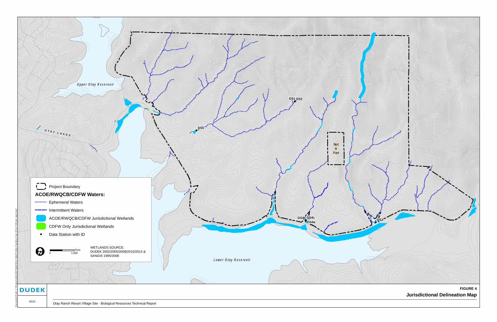
FIGURE 4
Jurisdictional Delineation MapOtay Ranch Resort Village Site - Biological Resources Technical Report
Docu
ment
Path:
Z:\P
rojec
ts\j65
2401
\MAP
DOC\
MAPS
\Bio
Figs\B
io Fig
s 201
4-10
\Fig4
_wet.
mxd
6524
Lower O t ay R ese rvo i r
NotA
Part
Upper O t ay R ese rvo i r
O T A Y L A K E S
DS5
DS2DS1
DS3DS4cDS4bDS4a
WETLANDS SOURCE:DUDEK 2002/2005/2008/2010/2014 &SANGIS 1995/2008
0 1,000Feet
Project Boundary
ACOE/RWQCB/CDFW Waters:Ephemeral Waters
Intermittent Waters
ACOE/RWQCB/CDFW Jurisdictional Wetlands
CDFW Only Jurisdictional Wetlands
Data Station with ID

Biological Resources Technical Report Otay Ranch Resort Village
6524 38 March 2015
INTENTIONALLY LEFT BLANK

FIGURE 5
Seasonal Basins MapOtay Ranch Resort Village Site - Biological Resources Technical Report
Docu
ment
Path:
Z:\P
rojec
ts\j65
2401
\MAP
DOC\
MAPS
\Bio
Figs\B
io Fig
s 201
4-10
\Fig5
_VPB
asins
.mxd
6524
SP_cent
SP_west
SP_east
VP1
VP8
A4
VP11
VP7A3
VP6
OLR25
VP9
VP2
VP5
OLR12
OLR7
OLR2
A1
VP7
OLR14
VP5
VP14
VP16
OLR8
VP3
OLR19
OLR9
VP13
VP6
OLR3
VP11
OLR18
VP10
A2
VP10
VP8
OLR6
VP13
VP15
OLR15
VP4
VP2VP1
VP12
OLR10
VP14
OLR1
OLR5
OLR22OLR21
A5
VP4
VP16
OLR13
OLR24OLR4
VP15
OLR11
OLR20
OLR23
OLR17OLR16
K6 Mesa
K8 Mesa
NOTA
PART
Key Map
TOPO SOURCE: Hunsaker & Associates, 2001
0 700Feet
Project Boundary
Offsite Survey Area
Jurisdictional Waters of the U.S.
Approximate Watershed Boundary
Fairy Shrimp Status:
SD fairy shrimp (2008)
SD fairy shrimp (2007)
SD fairy shrimp (1999 and 2000)
SD fairy shrimp cysts (1999)
No SD fairy shrimp

Biological Resources Technical Report Otay Ranch Resort Village
6524 40 March 2015
INTENTIONALLY LEFT BLANK

Biological Resources Technical Report Otay Ranch Resort Village
6524 41 March 2015
Species locations recorded during these surveys are shown in the Sensitive Plant Species Map (map pocket) and summarized in Table 6 and Figure 6 (also see map pocket). In addition to these current surveys, historical records of sensitive plant species were reviewed from the following published databases: Ogden (1992b), MSCP maps (Ogden 1999), and CDFW (2014b). Appendix F lists all potentially occurring species according to the aforementioned sources and Dudek’s knowledge of biological resources of this area as a result of the focused surveys that have been conducted on the site.
In considering rarity, the CNPS Inventory (CNPS 2014) of rare and endangered vascular plants of California was the primary reference. Use of the CNPS Inventory is helpful because it clearly defines levels of endangerment and rarity for all of the species addressed in the Inventory. The Inventory divides its subject taxa into four ranks: California Rank Plant Rank (CRPR) 1 (which is further divided into 1A and 1B), 2 (which is further divided into 2A and 2B), 3, and 4. Although the Inventory uses the terms “rare” and “endangered” in the title, it is clear in the definitions/descriptions of these categories that not all of the taxa listed in the Inventory are considered “rare.” Specifically, CRPR 3 and 4 species typically exhibit relatively widespread distribution and at the current time have not reached a level of threat, nor have numbers or populations declined to a point that would cause these taxa to be considered “rare.” CRPR 4 is defined by CNPS as “Plants of Limited Distribution – A Watch List.” CNPS further explains the CRPR 4 designation:
The plants in this category are of limited distribution or infrequent throughout a broader area in California. While we cannot call these plants “rare” from a statewide perspective, they are uncommon enough that their status should be monitored regularly. Should the degree of endangerment or rarity of a California Rare Plant Rank 4 plant change, we will transfer it to a more appropriate rank.
Therefore, for purposes of determining CEQA significance, only plants ranked as California Rare Plant Rank 1 or 2 are considered “rare” or “endangered.” Please see Appendix C for an explanation of the different CRPRs. In addition, the plant species listed on County Lists A through D (County of San Diego 2008b) also were included in the consideration of sensitive plant species for this analysis.

Biological Resources Technical Report Otay Ranch Resort Village
6524 42 March 2015
Table 6 Summary of Sensitive Plant Species Detected on or off of the
Otay Ranch Resort Village Project Site
Scientific Name
Common Name
Status Federal/State CRPR MSCP
Coverage County List
Locations and Population Size
Previous Studies
Current Surveys Comments
Acanthomintha ilicifolia
San Diego thornmint
FT/SE
1B.1
Covered Narrow Endemic
A
MBA 89/91 Observed in all recent surveys
Identified in two disturbed areas with heavy clay soils. Associated vegetation consists of non-native grasses and annuals. Populations cover approximately 0.1 and 3.3 acres each. Because the population is densely distributed in these locations, the actual number of individuals was not quantified. Analysis of this plant is based on the acreage over which it occurs.
Adolphia californica
California adolphia
None/None
2B.1
Not Covered
B
Not observed
Observed in 1999
Identified in two locations in the western portion of the site within sparse coastal sage scrub (<20 individuals).
Bloomeria [Muilla] clevelandii
San Diego goldenstar
None/None
1B.1
Covered
A
MBA 89/90 Observed in 1999 and 2000
Identified in 21 locations in western and eastern portions of the site on mesic slopes containing sparse coastal sage scrub/native grassland. Approximately 1,146 individuals in western part of site and 1,400 individuals in eastern part in 2000. 1999 observations were fewer in number of individuals than 2000 observations presumably due to rainfall differences.
Convolvulus simulans
Small-flowered morning-glory
None/None
4.2
Not Covered
D
Not observed
Observed in 2000
Three locations in western part of project site in clay soil grasslands; approximately 120 total individuals.
Dichondra occidentalis
Western dichondra
None/None
4.2
Not Covered
D
MBA 89/90 Observed in 1999 and 2000
Recorded in eight locations on the central ridges of the site. A total of 30 patches were recorded that vary from 1 to 500 square feet. This species was recorded based on patch size due to low-growing dense form of the species. The species covers approximately 0.5 acre total over the 30 patches.
Dudleya variegata
Variegated dudleya
None/None
1B.2
Covered –
Narrow Endemic
A
MBA 89/90 Observed in 1999 and 2000
Identified in 40 locations throughout the site. Estimated population size on site is approximately 5,833 individuals. Generally in clay soils and west-facing slopes, ridge lines, or margins of mesas.
Ferocactus viridescens
San Diego barrel cactus
None/None
2B.1
Covered
B
MBA 89/90 Observed in all recent surveys
Identified in approximately 50 locations throughout the project area, generally on south-facing slopes. Occurrences usually consist of <5 individuals; large stands contain 10–15 individuals. Approximately 217 individuals were recorded. Habitat association is generally open coastal sage scrub.

Biological Resources Technical Report Otay Ranch Resort Village
6524 43 March 2015
Table 6 Summary of Sensitive Plant Species Detected on or off of the
Otay Ranch Resort Village Project Site
Scientific Name
Common Name
Status Federal/State CRPR MSCP
Coverage County List
Locations and Population Size
Previous Studies
Current Surveys Comments
Harpagonella palmeri
Palmer’s grapplinghook
None/None
4.2
Not Covered
D
Not identified
Observed in 1999 and 2000
Identified in three areas in the eastern and western portions of the site within disturbed coastal sage scrub, dirt road margins, and non-native grassland with heavy clay soils. Approximately 114 individuals were recorded.
Iva hayesiana
San Diego marsh-elder
None/None
2B.2
Not Covered
B
MBA 89/90 Observed in 1999 and 2000
Abundant within narrow drainages throughout the site. Total on-site population in the thousands. Generally associated with cismontane alkali marsh or sparsely vegetated, rocky stream channels. Due to densely occurring populations within these drainages, this plant was recorded by area rather than number of individuals. A total of 5.4 acres of this species was recorded on site.
Juncus acutus ssp. leopoldii
Southwestern spiny rush
None/None
4.2
Not Covered
D
MBA 89/90 Observed 1999 and 2000
Identified in 11 locations within cismontane alkali marsh. Occurrences typically contain <10 individuals within each location. Approximately 30 individuals present on site.
Microseris douglasii ssp. platycarpha
Small-flowered microseris
None/None
4.2
Not Covered
D
Not observed
Observed in 2000
Six locations identified in the western part of the site in open non-native grassland/coastal sage scrub. Approximately 1,270 individuals recorded on the site.
Myosurus minimus ssp. apus
Little mousetail
None/None
3.1
Not Covered
C
MBA 89/90 Not observed in recent surveys
Identified within three vernal pools on K6 mesa, but number of individuals was not recorded. Was not detected in recent focused surveys and is no longer considered to be present in K6 vernal pools.
Ophioglossum californicum
California adder’s-tongue
None/None
4.2
Not Covered
D
MBA 89/90 Not observed Two locations described near Otay Lakes Road in west and south-central portions of the site. Location was not mapped by MBA. Not identified during recent surveys; may no longer be present since it was not recorded during the rare plant surveys conducted in 2000.
Pentachaeta aurea ssp. aurea
Golden-rayed pentachaeta
None/None
4.2
Not Covered
D
Not observed
Observed in 2000
Four locations identified in western portion of site; Approximately 91 individuals occur in coastal sage scrub/grassland.
Quercus dumosa
Nuttall’s scrub oak
None/None
1B.1
Not Covered
A
Not observed
Observed in all recent surveys
Occurs as a major component in areas mapped as scrub oak chaparral (approximately 200 individuals per acre). The acreage encompassed by this species is approximately 6.2 acres, including additional small patches within chaparral in the western portion of the site.

Biological Resources Technical Report Otay Ranch Resort Village
6524 44 March 2015
Table 6 Summary of Sensitive Plant Species Detected on or off of the
Otay Ranch Resort Village Project Site
Scientific Name
Common Name
Status Federal/State CRPR MSCP
Coverage County List
Locations and Population Size
Previous Studies
Current Surveys Comments
Romneya coulteri
Coulter’s matilija poppy
None/None
4.2
Not Covered
D
Not observed
Observed on site
Number and location not mapped. Single location described as being adjacent to a drainage in the eastern part of the site.
Salvia munzii
Munz’s sage
None/None
2B.2
Not Covered
B
MBA 89/90 Observed in all recent surveys
Occurs throughout the site but most densely in the northwestern quarter. Also occurs on K9 mesa. Most areas containing dense coastal sage scrub in this area contain approximately 50%–80% vegetation cover of S. munzii. Because the population is densely distributed in these locations, the actual number of individuals was not quantified. Analysis of this plant is based on the acreage over which it occurs, approximately 295 acres.
Viguiera laciniata
San Diego County viguiera
None/None
4.2
Not Covered
D
MBA 89/90 Observed in all recent surveys
Occurs throughout the site but most densely in the northern portion. Encompasses approximately 1,071 acres of the site. Comprises between 5% and 30% of vegetation cover in coastal sage scrub.
Federal Designations: FE Federally listed Endangered FT Federally listed as Threatened
State Designations: SE State-listed as Endangered ST State-listed as Threatened.
CNPS Designations: CRPR 1A: Plants Presumed Extirpated in California and Either Rare or Extinct Elsewhere CRPR 1B: Plants Rare, Threatened, or Endangered in California and Elsewhere CRPR 2A: Plants Presumed Extirpated in California, But More Common Elsewhere
CRPR 2B: Plants Rare, Threatened, or Endangered in California, But More Common Elsewhere CRPR 3: Plants About Which More Information is Needed - A Review List CRPR 4: Plants of Limited Distribution - A Watch List
.1 Seriously threatened in California (over 80% of occurrences threatened / high degree and immediacy of threat) .2 Moderately threatened in California (20-80% occurrences threatened / moderate degree and immediacy of threat) .3 Not very threatened in California (<20% of occurrences threatened / low degree and immediacy of threat or no current threats known)
MSCP Designations: Covered: Listed as Covered Species in Appendix B of Implementing Agreement between CDFW, USFWS, and County of San Diego (March 1998) Not Covered: Not Listed as Covered Species in Appendix B of Implementing Agreement between CDFW, USFWS, and County of San Diego (March 1998).
County Designations: List A Plants rare, threatened, or endangered in California and elsewhere (corresponds to CRPR 1B) List B Plants rare, threatened, or endangered in California but more common elsewhere (corresponds to CRPR 2) List C Plants which may be quite rare, but need more information to determine their rarity status (corresponds to CRPR 3) List D Plants of limited distribution and are uncommon, but not presently rare or endangered (corresponds to CRPR 4)

NotA
Par t
O T A Y L A K E S
Ac
Ac
Ai
ApVlVl
VlVlFv
FvFvFvFv Vl Ih Vl
VlAp Ap
Vl Ih Vl VlSmSmFv
IhVl Ih Ap Vl VlVlIh Ap Vl Vl VlVlFv Vl VlFvVl
VlSm Ja VlVlIhVl
FvDvIh
Ih DvVl Fv VlIh Vl Ih Fv VlVl VlDvVl Vl HpDvMc DvMcMc VlVl Vl
VlVlVl VlVl Vl VlVlVlFvIhVl VlVlVl Vl VlVlJa Ih Vl
Vl DoVlVl Vl Vl VlVl Mc Vl VlIhJaVlVlVl VlVlIh VlVl VlVlVl
Ja Vl VlVlIhMc
Vl VlMcIh IhMc
Mc VlApIh VlIh VlVl Vl
IhVlVl VlVl Ih McMcIh Vl Ih
VlVl McIh McVlVlVl Vl VlVl VlIh IhVlVl VlIh Vl Vl VlFv IhFv
VlVlVl Ih VlFv Ih Vl
VlVl
Sm VlIhFv Sm VlVlSm
Sm IhVlVl Vl VlVlSm
VlIh
SmVlSm IhSmVl
VlVlAp IhSm Sm Sm VlSm VlIhSmSm VlSm VlVl VlVl SmSm
Sm VlIhSmFvSmSmSmVl Sm Sm
SmIh
SmSmSmSmIh Sm
Sm SmVl
SmSmSm SmSm Vl VlSm SmSm Vl
SmSm SmSm SmSm SmSmQd
SmVlSmQd SmJa Sm
Sm SmSmSm
Sm VlVlVl
Sm VlSm SmVlSm Sm SmSm
Fv2Fv1
Fv2
Fv5
Fv1
Fv2 Dv14Dv100Dv60
Dv100Dv4 Dv260
Fv1
Dv46Dv800Dv260Dv6Dv21 Fv3
Fv1Pa40Fv1Fv2
Fv1
Dv2Md20Cs20
Md1000
Cs50Dv334
Dv195Dv20
Pa5Dv9
Dv140Mc269
Dv80 Dv200
Pa6Mc125Mc37
Mc37
Fv3Fv1Fv1
Mc519
Dv6
Hp15Dv300Hp42
Dv20
Md250Mc159
Fv1
Fv1Fv1Fv2
Fv1
Fv2Ja8
Fv1Dv840
Dv20
Fv1
Fv3Fv2
Fv1Fv1Fv1
Fv1Fv1Fv1
Fv1Fv1
Fv1Fv1Fv1
Fv2Fv2
Fv2Fv7Fv1
Dv86
Pa20
SmSm
SmSm
SmSm
SmSm
Sm
Fv
Fv
FvSm
SmSm
Sm
SmSm
Sm
Sm
SmSmSm
Vl
Sm
Copyright:' 2011 National Geographic Society, i-cubed
San Diego thornmint
San Diego barrel cactus
San Diego marsh-elder
Southwestern spiny rush
Western dichondra
Nuttall’s scrub oak
Munz’s sage
San Diego County viguiera
Sensitive Plant Species
Project Boundary
Ac
FIGURE 6
Sensitive Plant Species MapOtay Ranch Resort Village Site - Biological Resources Technical Report
Docu
ment
Path:
Z:\P
rojec
ts\j65
2401
\MAP
DOC\
MAPS
\Bio
Figs\B
io Fig
s 201
4-10
\Fig6
_plan
ts.mx
d
6524
0 1,000 2,000Feet
Sensitive Plant Species (Point Data):Ac = California adolphia
Ai = San Diego thornmint
Cs = Small-flowered morning-glory
Do = Western dichondra
Dv = Variegated dudleya
Fv = San Diego barrel cactus
Hp = Palmer’s grappling hook
Ih = San Diego marsh-elder
Ja = Southwestern spiny rush
Mc = San Diego goldenstar
Md = Small-flowered microseris
Pa = Golden-flowered pentachaeta
Qd = Nuttall’s scrub oak
Sm = Munz’s sage
Vl = San Diego County viguiera

Biological Resources Technical Report Otay Ranch Resort Village
6524 46 March 2015
INTENTIONALLY LEFT BLANK

Biological Resources Technical Report Otay Ranch Resort Village
6524 47 March 2015
3.5.2 Sensitive Wildlife Species
Knowledge concerning the presence/absence of sensitive wildlife species was ascertained from previous studies of Otay Ranch, as well as from more current focused surveys for fairy shrimp and Quino checkerspot butterfly. Although focused surveys for sensitive nesting bird species, amphibians, reptiles, or mammals have not been conducted, incidental observations of many sensitive wildlife species have been made. Species locations recorded during these surveys are shown on Figure 7 and summarized in Table 7. Given the context of the project within the MSCP Subarea Plan and Otay SRP, this level of sensitive wildlife survey information is adequate to assess potentially significant impacts. Evaluation of wildlife use is based on suitable habitat since the species may occur in areas other than where observed.
Appendix F lists all potentially occurring species according to a search of the California Natural Diversity Database (CNDDB), MSCP Subarea Plan documents, Otay Ranch RMP, and Dudek’s knowledge of biological resources of this area as a result of the focused surveys of the site and surrounding areas. In addition, the wildlife species listed on the County Groups 1 and 2 (County of San Diego 2008b) also were included in the consideration of sensitive wildlife species for this analysis. With each species listing is a description of their regulatory status, general habitat association, sensitivity for purposes of determining CEQA significance, and status on site based on previous surveys, incidental observations, and Dudek’s knowledge of the distribution of the species and the suitability of habitat on site.
3.5.3 Sensitive Upland Habitats
Sensitive upland habitats are those that are considered rare within the region, support sensitive plant and/or wildlife species, or function as corridors for wildlife movement. The Otay Ranch RMP defines sensitive upland habitats on site to include coastal sage scrub, mulefat scrub, southern willow scrub, cismontane alkali marsh, and Valley needlegrass grassland (Otay Ranch 1993). The BMO (County of San Diego 2004) requires mitigation for impacts to the above-listed habitats as well as chamise chaparral, southern mixed chaparral, scrub oak chaparral, and non-native grassland. As such, these are considered sensitive upland habitats according to the MSCP.
Sensitive wetland habitats are addressed in Section 3.4, Jurisdictional Waters Including Wetlands. All jurisdictional areas are considered sensitive resources.

Biological Resources Technical Report Otay Ranch Resort Village
6524 48 March 2015
Table 7 Summary of Sensitive Wildlife Species Detected on or off Site or with Moderate to High Potential to Occur
Species
(Scientific Name)
Regulatory Status:
Federal; State; MSCP; County Group General Habitat Association
Status
Previous Studies Current Surveys Comments
San Diego fairy shrimp (Branchinecta sandiegonensis)
USFWS: FE
CDFW: None
MSCP: Covered
County: 1
Small, shallow vernal pools, occasionally ditches and road ruts
Not observed Observed in 2000, 2004, and 2008
A total of nine basins on K8 and one basin on K6 are confirmed occupied by this species. Within off-site areas, a total of five road rut basins are occupied by this species.
Quino checkerspot butterfly (Euphydryas editha quino)
USFWS: FE
CDFW: None
MSCP: Not Covered
County: 1
Sparsely vegetated hilltops, ridgelines, occasionally rocky outcrops; host plant dot seed plantain (Plantago erecta) and nectar plants must be present
Not observed (known from 1970s P. Ehrlich research)
Observed in 1999, 2000, 2004, and 2008
Focused surveys of the entire site in 1999 and 2000 resulted in the observation of 48 individuals. 2004 surveys of the open space area resulted in observation of 1 individual in the northwestern corner. Focused surveys of the entire site in 2008 resulted in the observation of 71 individuals after duplicates were removed. Observations were concentrated in the northern portion and along a ridgeline within the central portion of the site and were generally in either coastal sage scrub or disturbed coastal sage scrub habitat. A number of additional observations were scattered throughout the rest of the site.
Monarch butterfly (Danaus plexippus)
USFWS: None
CDFW: None
MSCP: Not Covered.
County: 2
Overwinters in eucalyptus groves
Not observed Observed This species occurs on site on occasion as single individuals in flight over the area; however, there are not sufficient resources available to make this a significant overwintering site.
Western spadefoot toad (Spea hammondii)
USFWS: None
CDFW: CSC
MSCP: Not Covered
County: 2
Most common in grasslands, coastal sage scrub near rain pools or vernal pools; riparian habitats
Not observed Observed in 2000
Tadpoles incidentally observed in a single depression on K8 mesa. Could occur within pools that inundate.

Biological Resources Technical Report Otay Ranch Resort Village
6524 49 March 2015
Table 7 Summary of Sensitive Wildlife Species Detected on or off Site or with Moderate to High Potential to Occur
Species
(Scientific Name)
Regulatory Status:
Federal; State; MSCP; County Group General Habitat Association
Status
Previous Studies Current Surveys Comments
Rosy boa (Charina trivirgata)
USFWS: None
CDFW: None
MSCP: Not Covered
County: 2
Rocky chaparral, coastal sage scrub, oak woodlands, desert and semi-desert scrub
Not observed Observed in 2008
Observed in northeastern portion of the project site.
Western pond turtle (Emys marmorata)
USFWS: None
CDFW: CSC
MSCP: Covered
County: 1
Slow-moving permanent or intermittent streams, ponds, small lakes, reservoirs with emergent basking sites; adjacent uplands used during winter
Not observed Observed in 2000
Incidentally observed laying eggs in a dirt road in northwestern corner of site. Another observation of an individual crossing Otay Lakes Road immediately south of the site.
Orangethroat whiptail (Aspidoscelis hyperythra)
USFWS: None
CDFW: CSC
MSCP: Covered
County: 2
Coastal sage scrub, chaparral, grassland, juniper, and oak woodland
MBA 89 Observed in 2000 and 2008
Observed in coastal sage scrub. Probably occurs elsewhere within open patches of coastal sage scrub and grassland.
Coastal whiptail (Aspidoscelis tigris stejnegeri)
USFWS: None
CDFW: None
MSCP: Not Covered
County: 2
Coastal sage scrub, chaparral
Not observed Observed in 2000
Observed in sparse coastal sage scrub on site. Probably resident in open areas and sparse coastal sage scrub and chaparral throughout the site.
San Diego banded gecko (Coleonyx variegatus abbotti)
USFWS: None
CDFW: None
MSCP: Not Covered
County: 1
Cismontane chaparral, coastal sage scrub, desert scrub; granite outcrops
Not observed Not observed Moderate potential to occur on site based on the availability of rock outcrops and suitable vegetative components.
San Diego ringneck snake (Diadophis punctatus similis)
USFWS: None
CDFW: None
MSCP: Not Covered
County: 2
Open, rocky areas in moist habitats near intermittent streams: marsh, riparian woodland, sage scrub
Not observed Observed on site Observed in the main eastern drainage. Moderate potential to occur within deeper canyons on site and under debris on site.

Biological Resources Technical Report Otay Ranch Resort Village
6524 50 March 2015
Table 7 Summary of Sensitive Wildlife Species Detected on or off Site or with Moderate to High Potential to Occur
Species
(Scientific Name)
Regulatory Status:
Federal; State; MSCP; County Group General Habitat Association
Status
Previous Studies Current Surveys Comments
San Diego [coast; Blainville’s] horned lizard (Phrynosoma blainvillii)
USFWS: None
CDFW: CSC
MSCP: Covered
County: 2
Coastal sage scrub, non-native grassland, chaparral, oak and riparian woodland, coniferous forest
MBA 89 Observed in 1999, 2000, and 2008
Observed within undisturbed coastal sage scrub and chamise chaparral.
Coast patch-nosed snake (Salvadora hexalepis virgultea)
USFWS: None
CDFW: CSC
MSCP: Not Covered
County: 2
Chaparral, washes, sandy flats, rocky areas
Not observed Not observed Probably occurs on site.
Red-diamond rattlesnake (Crotalus ruber)
USFWS: None
CDFW: CSC
MSCP: Not Covered
County: 2
Variety of shrub habitats where there is heavy brush, large rocks, or boulders
Not observed Observed in 1999, 2000, and 2008
Observed throughout the site within dense and sparse coastal sage scrub and chaparral.
Two-striped garter snake (Thamnophis hammondi)
USFWS: None
CDFW: CSC
MSCP: Not Covered
County: 1
Streams, creeks, pools, streams with rocky beds, ponds, lakes, vernal pools
Not observed Not observed Probably occurs on site.
Cooper’s hawk (Accipiter cooperii)
USFWS: None
CDFW: WL
MSCP: Covered
County: 1
Riparian and oak woodlands, montane canyons
Not observed Observed in 2000
Observed flying over site; potential for nesting on site is low due to lack of developed forest or woodland habitats.
Sharp-shinned hawk (Accipiter striatus)
USFWS: None
CDFW: WL
MSCP: Not Covered
County: 1
Nests in coniferous forests, ponderosa pine, black oak, riparian deciduous, mixed conifer, Jeffrey pine; winters in lowland woodlands and other habitats
Not observed Not observed None observed on site; does not nest in coastal San Diego, but likely forages on site during winter.

Biological Resources Technical Report Otay Ranch Resort Village
6524 51 March 2015
Table 7 Summary of Sensitive Wildlife Species Detected on or off Site or with Moderate to High Potential to Occur
Species
(Scientific Name)
Regulatory Status:
Federal; State; MSCP; County Group General Habitat Association
Status
Previous Studies Current Surveys Comments
Southern California rufous-crowned sparrow (Aimophila ruficeps canescens)
USFWS: None
CDFW: WL
MSCP: Covered
County: 1
Grass-covered hillsides, coastal sage scrub, chaparral with boulders and outcrops
MBA 89 Observed in 1999, 2000, and 2008
Observed throughout the site and highly likely to nest on site.
Grasshopper sparrow (Ammodramus savannarum)
USFWS: None
CDFW: CSC
MSCP: Not Covered
County: 1
Open grassland and prairie, especially native grassland with a mix of grasses and forbs
MBA 89 Observed in 2000 and 2008
Observed mainly in southwestern and central portions of the project site.
Bell’s sage sparrow (Artemisiospiza belli belli)
(taxonomy was changed to Bell’s sparrow Artemisiospiza belli)
USFWS: None
CDFW: WL
MSCP: Not Covered
County: 1
Coastal sage scrub and dry chaparral along coastal lowlands and inland valleys
MBA 89 Observed in 1999, 2000, and 2008
Identified in eastern and western portions of site in sparse coastal sage scrub.
Golden eagle (Aquila chrysaetos)
USFWS: BCC
CDFW: P, WL, Golden Eagle Protection Act
MSCP: Covered
County: 1
Open country, especially hilly and mountainous regions; grassland, coastal sage scrub, chaparral, oak savannas, open coniferous forest
Not observed Observed in 1999, 2000, and 2008
Observed in eastern and north-central portion of the site. Site is in mapped primary foraging area for known golden eagle territory. Nearest known nest site is >3 miles from project site. No nesting observed; could forage.
Red-shouldered hawk (Buteo lineatus)
USFWS: None
CDFW: None
MSCP: Not Covered
County: 1
Riparian and woodland habitats, eucalyptus
Not observed Observed on site Observed foraging over the site near the southern portion and within adjacent riparian habitat. Moderate potential to also occur on site as a breeding bird.
Ferruginous hawk (Buteo regalis)
USFWS: BCC
CDFW: WL
MSCP: Covered
County: 1
Open, dry country, grasslands, open fields, agriculture
Not observed Not observed Moderate potential to occur on site occasionally during the winter migration. Would not breed on site.

Biological Resources Technical Report Otay Ranch Resort Village
6524 52 March 2015
Table 7 Summary of Sensitive Wildlife Species Detected on or off Site or with Moderate to High Potential to Occur
Species
(Scientific Name)
Regulatory Status:
Federal; State; MSCP; County Group General Habitat Association
Status
Previous Studies Current Surveys Comments
Turkey vulture (Cathartes aura)
USFWS: None
CDFW: None
MSCP: Not Covered
County: 1
Rangeland, agriculture, grassland; uses cliffs and large trees for roosting, nesting, and resting
Not observed Observed in flight over site
Occasionally flies over the project area as a possible foraging flight. No breeding potential.
Northern harrier (Circus cyaneus)
USFWS: None
CDFW: CSC
MSCP: Covered
County: 1
Open wetlands (nesting), pasture, old fields, dry uplands, grasslands, rangelands, coastal sage scrub
Not observed Observed in 1999, 2000, and 2008
Observed foraging over grassland areas in the K6 and K8 mesas. Could nest on site but is more likely a winter visitor.
White-tailed kite (Elanus leucurus)
USFWS: None
CDFW: P
MSCP: Not Covered
County: 1
Open grasslands, savanna-like habitats, agriculture for foraging; wetlands, oak woodlands, riparian for breeding.
Not observed Observed in 1999 and 2000
Observed foraging in grassland areas; nesting is unlikely due to lack of forest or woodlands although a small amount of riparian is located in the project area.
California horned lark (Eremophila alpestris actia)
USFWS: None
CDFW: WL
MSCP: Not Covered
County: 2
Open habitats, grassland, rangeland, shortgrass prairie, montane meadows, coastal plains, fallow grain fields
Not observed Observed in 1999, 2000, and 2008
Observed within sparse coastal sage scrub and grasslands in the project area.
Prairie falcon (Falco mexicanus)
USFWS: BCC
CDFW: WL
MSCP: Not Covered
County: 1
Grassland, savannas, rangeland, agriculture, desert scrub, alpine meadows; nest on cliffs or bluffs
Not observed Observed in 2000
Observed within coastal sage scrub and grasslands. Likely is a wintering visitor and could forage in the project area.
Loggerhead shrike (Lanius ludovicianus)
USFWS: BCC
CDFW: CSC
MSCP: Not Covered
County: 1
Open ground including grassland, coastal sage scrub, broken chaparral, agriculture, riparian, open woodland
MBA 89 Observed in 2000
Likely to nest on site, individuals observed in grassland and sparse coastal sage scrub.

Biological Resources Technical Report Otay Ranch Resort Village
6524 53 March 2015
Table 7 Summary of Sensitive Wildlife Species Detected on or off Site or with Moderate to High Potential to Occur
Species
(Scientific Name)
Regulatory Status:
Federal; State; MSCP; County Group General Habitat Association
Status
Previous Studies Current Surveys Comments
Summer tanager (nesting)
(Piranga rubra)
USFWS: None
CDFW: CSC
MSCP: Not Covered
County: 2
Nests in riparian woodland; winter habitats include parks and residential areas
Not observed
Not observed Moderate potential. Suitable habitat exists near the project site.
Coastal California gnatcatcher (Polioptila californica californica)
USFWS: FT
CDFW: CSC
MSCP: Covered
County: 1
Coastal sage scrub, coastal sage scrub–chaparral mix, coastal sage scrub–grassland ecotone, riparian in late summer
MBA 89 Observed in 1999, 2000, and 2008
Observed nesting in coastal sage scrub and chamise chaparral throughout the site. Based on previous and currently mapped locations, approximately 29 locations occur on site and 3 additional locations have been recorded within the Cornerstone Lands and could occur on site (MSCP data).
Western bluebird (Sialia mexicana)
USFWS: None
CDFW: None
MSCP: Covered
County: 2
Open forests of deciduous, coniferous or mixed trees, savanna, edges of riparian woodland saltmarsh, riparian habitats
Not observed Observed during winter
This species once did not breed on the coastal plain; however, in recent years it has begun to do so. The only breeding opportunities for this species would be within wooded habitats that are not present on site.
Burrowing owl (Athene cunicularia)
USFWS: BCC
CDFW: CSC
MSCP: Covered
County: 1
Grassland, lowland scrub, agriculture, coastal dunes and other artificial open areas
MBA 89 Observed in 2000
Previously identified on eastern slope of K6 mesa as an incidental observation of single individual in central portion of site.
Barn owl (Tyto alba)
USFWS: None
CDFW: None
MSCP: Not Covered
County: 2
Open forests of deciduous, coniferous or mixed trees, savanna, riparian habitats , abandoned structures, mines
Not observed Observed flying over site
This species has abundant foraging opportunities but limited nesting opportunities on site. It is unlikely that there is enough cover on site to support nesting by this species.

Biological Resources Technical Report Otay Ranch Resort Village
6524 54 March 2015
Table 7 Summary of Sensitive Wildlife Species Detected on or off Site or with Moderate to High Potential to Occur
Species
(Scientific Name)
Regulatory Status:
Federal; State; MSCP; County Group General Habitat Association
Status
Previous Studies Current Surveys Comments
Dulzura California pocket mouse
(Chaetodipus californicus femoralis)
USFWS: None
CDFW: CSC
MSCP: Not Covered
County: 2
Coastal sage scrub, chaparral, riparian–scrub ecotone; more mesic areas
Not observed Not observed Very likely to occur on site.
Northwestern San Diego pocket mouse
(Chaetodipus fallax fallax)
USFWS: None
CDFW: CSC
MSCP: Not Covered
County: 2
Coastal sage scrub, grassland, sage scrub–grassland ecotones, sparse chaparral; rocky substrates, loams and sandy loams
Not observed Not observed Likely to occur on site.
Townsend’s western big-eared bat
(Corynorhinus townsendii)
USFWS: None
CDFW: CSC
MSCP: Not Covered
County: 2
Mesic habitats, gleans from brush or trees or feeds along habitat
No bat surveys conducted
No bat surveys conducted
Likely to occur on site.
Spotted bat (Euderma maculatum)
USFWS: None
CDFW: CSC
MSCP: Not Covered
County: 2
Rock crevices, riparian forest, woodland, and scrub, ponds, lakes, grassland
No bat surveys conducted
No bat surveys conducted
Moderate potential to occur on site. Suitable habitat is present nearby.
Western red bat (Lasiurus blossevillii)
USFWS: None
CDFW: CSC
MSCP: Not Covered
County: 2
Prefers edges with trees for roosting and open areas for foraging. Feeds over grasslands, shrublands, woodlands, forests, and croplands.
No bat surveys conducted
No bat surveys conducted
Moderate potential to occur on site.
San Diego black-tailed jackrabbit
(Lepus californicus bennettii)
USFWS: None
CDFW: CSC
MSCP: Not Covered
County: 2
Arid habitats with open ground; grasslands, coastal sage scrub, agriculture, disturbed areas, rangelands
Not observed Incidentally observed.
Observed throughout the site.

Biological Resources Technical Report Otay Ranch Resort Village
6524 55 March 2015
Table 7 Summary of Sensitive Wildlife Species Detected on or off Site or with Moderate to High Potential to Occur
Species
(Scientific Name)
Regulatory Status:
Federal; State; MSCP; County Group General Habitat Association
Status
Previous Studies Current Surveys Comments
San Diego desert woodrat
(Neotoma lepida intermedia)
USFWS: None
CDFW: CSC
MSCP: Not Covered
County: 2
Coastal sage scrub, chaparral, pinyon–juniper woodland with rock outcrops, cactus thickets, dense undergrowth
Not observed Nests incidentally observed.
Middens were observed within chaparral areas on site.
Mountain lion
(Puma concolor)
USFWS: None
CDFW: None
MSCP: Covered
County: 2
Coastal sage scrub, chaparral, riparian, woodlands, forest; rests in rocky areas, and on cliffs and ledges that provide cover
MBA 89 Not observed Signs of movement through eastern portion of site.
Federal Designations: BCC U.S. Fish and Wildlife Service Bird of Conservation Concern FE Federally listed Endangered FT Federally listed as Threatened
State Designations: CSC California Special Concern Species P CDFW Protected and Fully Protected Species SE State-listed as Endangered ST State-listed as Threatened WL Watch List.
MSCP Designations: Covered Listed as Covered Species in Appendix B of Implementing Agreement between CDFW, USFWS, and County of San Diego (March 1998) Not Covered Not Listed as Covered Species in Appendix B of Implementing Agreement between CDFW, USFWS, and County of San Diego (March 1998).
County Designations: Group 1: High level of sensitivity, either because listed as threatened or endangered or because species has very specific natural history requirements that must be met Group 2: Species is becoming less common, but is not yet so rare that extirpation or extinction is imminent without immediate action. These species tend to be prolific within their suitable habitat types.

Biological Resources Technical Report Otay Ranch Resort Village
6524 56 March 2015
INTENTIONALLY LEFT BLANK

CORB
OTWT
WESP
HOLA
HOLA
BUOW
HOLI
POTU
GOEA
GRSP
GOEA
HOLA
HOLA
GOEAHOLI
RCSP
RCSP
HOLI
HOLINOHA
GRSP
BTJR
BTJR
HOLI
NRDR
BSGSP
Copyright:' 2011 National Geographic Society, i-cubed
Project Boundary
SOURCE: USGS 7.5 Minute Series, Jamul Mountains Quadrangle
0 1,000Feet
Quino Checkerspot Butterfly (2008)
Quino Checkerspot Butterfly (2004)
Quino Checkerspot Butterfly (2000)
Quino Checkerspot Butterfly (1999)
Dudek QCB Survey Results
California GnatcatcherMSCP Data
Other Sensitive Wildlife Species (Dudek)BSGSP= Bell’s sage sparrow
BTJR= San Diego Black-tailed jackrabbit
BUOW= Burrowing owlCORB= Coastal rosy boa
GOEA= Golden eagle
GRSP= Grasshopper sparrow
HOLA= California Horned lark
HOLI= San Diego Horned lizard
NOHA= Northern harrier
NRDR= Northern red-diamond rattlesnake
OTWT= Orange-throated whiptail
POTU= Southwestern Pond Turtle
RCSP= Southern California Rufous-crowned sparrowWESP= Western spadefoot
FIGURE 7
Sensitive Wildlife Species MapOtay Ranch Resort Village Site - Biological Resources Technical Report
Docu
ment
Path:
Z:\P
rojec
ts\j65
2401
\MAP
DOC\
MAPS
\Bio
Figs\B
io Fig
s 201
4-10
\Fig7
_wild
life.m
xd
6524

Biological Resources Technical Report Otay Ranch Resort Village
6524 58 March 2015
INTENTIONALLY LEFT BLANK

Biological Resources Technical Report Otay Ranch Resort Village
6524 59 March 2015
3.5.4 Wildlife Corridors and Habitat Linkages
Wildlife corridors are linear features that connect large patches of natural open space and provide avenues for the immigration and emigration of animals. Wildlife corridors contribute to population viability by (1) assuring the continual exchange of genes between populations, which helps maintain genetic diversity; (2) providing access to adjacent habitat areas, representing additional territory for foraging and mating; (3) allowing for a greater carrying capacity; and (4) providing routes for colonization of habitat lands following local population extinctions or habitat recovery from ecological catastrophes (e.g., fires).
Habitat linkages are patches of native habitat that function to join two larger patches of habitat. They serve as connections between habitat patches and help reduce the adverse effects of habitat fragmentation. Although individual animals may not move through a habitat linkage, the linkage does represent a potential route for gene flow and long-term dispersal. Habitat linkages may serve as both habitat and avenues of gene flow for small animals such as reptiles and amphibians. Habitat linkages may be represented by continuous patches of habitat or by nearby habitat “islands” that function as “stepping stones” for dispersal.
Ogden (1992b) conducted a comprehensive study of wildlife corridors within Otay Ranch. The study identified one regional corridor in the project area: Jamul Mountains to Dulzura Creek, Regional Corridor R2. The corridor currently allows animal movement between Dulzura Creek and the Jamul Mountains through the topographically steep drainage in the eastern portion of the project site (Figure 8). A portion of the R2 linkage for animals following Dulzura Creek and connecting to the Jamul Mountains traverses the eastern portion of the site and continues off site across Otay Lakes Road to the south and then continues east along Dulzura Creek. The discussion of this linkage focuses on movement within Dulzura Creek and the resources located within Dulzura Creek, which are off site and east of the project site. This regional corridor is connected to other off-site regional corridors that are located along the southern side of Lower Otay Lake (R5) and other corridors much farther away from the project site that connect the east-facing slope of the Jamul Mountains with Dulzura Creek and continue north towards the San Miguel Mountains and south into the San Ysidro Mountains. Currently there is no culvert or other means for terrestrial wildlife species to safely move across Otay Lakes Road between the project site and other habitat areas south of the site.
There are also local corridors for mammal movement designated in the Ogden study, including a corridor along the ridgeline north of the project site (L3) and one that connects Dulzura Creek with the San Ysidro Mountains (L8). Additional local corridors that are farther away from the project site are located in the streambed in the southern portion of Proctor Valley and within a drainage of the San Ysidro Parcel. Habitat connectivity between the project site and open space

Biological Resources Technical Report Otay Ranch Resort Village
6524 60 March 2015
immediately surrounding Otay Lakes and south to Otay River and Otay Mountain is not identified in the Ogden study.
Based on the discussion provided by Ogden (1992b), the general area may function to convey large and small mammals. Evidence of this is provided in the study due to observation of bobcat, mule deer, and mountain lion sign. These species may use the path of least resistance, which in this document is assumed to be the drainage that is located within the eastern portion of the site. However, wildlife will also likely use ridgelines and the numerous dirt roads that are on site depending on time of day. It is unlikely that this R2 linkage functions specifically for winged species, such as coastal California gnatcatcher or Quino checkerspot butterfly, since these species would be able to move freely over the entire site. In general, the entire area currently functions as a block of habitat and is not constrained to only function as a wildlife corridor between two larger blocks; therefore, the designation of a specific linkage was premature.
3.6 Regional Resource Planning Context/Evaluation of Resources
The regional resource planning of this area has mainly been conducted through the Otay SRP and MSCP processes. These plans are important to the evaluation of impacts to biological resources because the loss of resources is anticipated by these plans and compensated through the assemblage of a preserve that adequately conserves covered species. The Otay SRP and the Otay Ranch RMP establish the mechanism for mitigation of overall impacts related to Otay Ranch and provides for conservation and management of the entire 11,375-acre preserve. The planning for the Otay Ranch RMP has also been incorporated into the MSCP. The Otay Ranch Preserve represents an important part of the MSCP Subarea Plan South County Segment.
3.6.1 Otay SRP and Otay Ranch RMP
On a region-wide basis, the Otay SRP and Otay Ranch RMP are being implemented through the RMP requirements of preserve conveyance and preserve management funding. These requirements have resulted in offers for conveyance of preserve land within Otay Ranch and the establishment of the Preserve Owner Manager (POM) to monitor, manage and maintain these preserve areas. The conveyance and management of the preserve is being actively coordinated between the City of Chula Vista and the County of San Diego (as the POM) in consultation with the resource agencies.

UpperOt ay
Rese r vo i r
S A N Y S I D R O M O U N T A I N S
D U L Z U R A
C R EE
K
P R O C T O R V A L L E Y P R E S E R V E
Lower O t ay Res e rv o i r
PRESU MPT IVE CO RR ID OR
R5
L9
R10R2
L8
L3
R1
R6
R11
L4
R7
R1L3
R1
R2
L4
Copyright:' 2011 National Geographic Society, i-cubed
0 2,400 4,800 7,200 9,600Feet
Project Boundary
Otay Ranch Preserve
MSCP Preserve
Public Lands:BLM
CDFG
DOD
USFWS
Existing Wildlife Corridors (Source: OGDEN 1992)Regional Corridor for Focal Mammal & Bird Species
Major Local Corridor for Focal Mammal & Bird Species
FIGURE 8
Existing Habitat Linkages/Movement CorridorsOtay Ranch Resort Village Site - Biological Resources Technical Report
Docu
ment
Path:
Z:\P
rojec
ts\j65
2401
\MAP
DOC\
MAPS
\Bio
Figs\B
io Fig
s 201
4-10
\Fig8
_cor
ridor
s.mxd
6524

Biological Resources Technical Report Otay Ranch Resort Village
6524 62 March 2015
INTENTIONALLY LEFT BLANK

Biological Resources Technical Report Otay Ranch Resort Village
6524 63 March 2015
Based on preservation of the most sensitive resources known at the time and development feasibility, the Village 13 site plan, as adopted in the Otay SRP (Otay Ranch 1993), preserved the northern portion of the project site as Preserve open space and identified the southern portion for development. The vernal pools located within the K6 and K8 mesas were within the development area.
Specific to the project site, the Otay Ranch RMP identifies certain sensitive resources including vernal pools, San Diego thornmint, and a corridor between the Jamul Mountains and the San Ysidro Mountains. The preservation requirements of these resources are summarized in the Mitigation Monitoring and Reporting Program (MMRP) for the Otay SRP DEIR. The requirements of the MMRP and the contribution that the Otay Ranch Resort Village makes to these requirements are provided in Appendix G.
The 3.3 acre patch of San Diego thornmint located in the western portion of the site was designated as preserve area in the Otay Ranch RMP. In addition, a 100-foot buffer was required around the patch of thornmint to provide protection from indirect effects. Changes in the Otay Ranch RMP preserve boundary would be subject to analysis and findings pursuant to the boundary modification provisions of the Otay Ranch RMP.
3.6.2 Multiple Species Conservation Plan
In San Diego County, several resource conservation-planning efforts have been completed or are currently in progress with the long-term goal of establishing a regional reserve system that will protect native habitat lands and their associated biota. The ultimate goals of these plans are the establishment of biological reserve areas in conformance with the State Natural Communities Conservation Plan (NCCP) Act, and to contribute to the preserve system already established by the approved Multiple Species Conservation Program (MSCP). The Multiple Species Conservation Plan (MSCP) in southwestern San Diego County is the first of these preserve systems to be established.
Subsequent to adoption of the Otay SRP and Otay Ranch RMP, development plans for Otay Ranch, including Village 13, were incorporated into the MSCP as implemented by the MSCP Subarea Plan with some alterations. With respect to the project area, the most significant of these alterations was the re-designation of approximately 135 acres in the southeastern quarter of the site, adjacent to Otay Lakes Road, as Preserve open space rather than development. This change was made to achieve greater conservation in the eastern portions of Otay Ranch and concentrate development in the western portions. Additionally, the preservation of the eastern portion of the Resort Village site was thought to aid in the

Biological Resources Technical Report Otay Ranch Resort Village
6524 64 March 2015
establishment of a corridor between the Jamul and San Ysidro Mountains. The result was a total Preserve size of 1,114.8 acres for the Village 13 project area.
In terms of permitting development of the site under the MSCP Subarea Plan, the portion of the project site outside of the preserve boundary is identified as “Developable Area” and is an authorized take area. The portion of the project site within the preserve is where no take is authorized, and any proposed impacts in these areas would need to be permitted, consistent with the requirements of the MSCP Subarea Plan, through a boundary adjustment and equivalency analysis.
3.6.3 Quino Checkerspot Butterfly Critical Habitat
Subsequent to the adoption of the MSCP, critical habitat designations for coastal California gnatcatcher, Quino checkerspot, and San Diego fairy shrimp have been identified by the USFWS. Currently, the project site is within final designated critical habitat for Quino checkerspot butterfly only. A portion of the project site is within the Otay Unit for this species. Evaluation of the project’s effect on critical habitat is completed under Sensitive Wildlife Species sections below.
3.6.4 City of San Diego MSCP Cornerstone
The City of San Diego Water Department owns four large areas of land within the MSCP. These lands contain valuable biological resources and total 10,400 acres and are commonly referred to as the Cornerstone Lands because they are considered essential building blocks for creating the City Preserve system. Cornerstone lands, within the vicinity of the project area, include the lands surrounding portions of Upper and Lower Otay Lakes. These Cornerstone Lands are known for high quality coastal sage scrub with a riparian forest area present where Dulzura Creek empties into Lower Otay Lake.
The San Diego City Charter restricts the use and disposition of Water Utility assets and thus the Water Department must be compensated for any title restrictions placed on the Cornerstone Lands. To meet the policy objectives of the MSCP and comply with the City Charter, the City of San Diego entered into a Conservation Land Bank Agreement with the wildlife agencies for the Cornerstone Lands.
Specific to the project site, the improvements to Otay Lakes Road, as required by the County, would affect some parts of cornerstone lands. These impacts have been minimized to the maximum extent possible through iterative site designs, are quantified below and coordination is ongoing with the City on the permit and approvals that are required.

Biological Resources Technical Report Otay Ranch Resort Village
6524 65 March 2015
3.6.5 County of San Diego
A small portion of the project site, the improvements for Otay Lakes Road, is located within the jurisdiction of the County of San Diego and therefore impacts to this off-site area are required to comply with the regulations set forth by the County. In compliance with the MSCP Subregional Plan and the County of San Diego Subarea Plan (County MSCP; County of San Diego 1997), the County established the Biological Mitigation Ordinance (BMO; County of San Diego 2010) to provide the requirements and mitigation measures necessary for projects within the plan area. Certain areas within the County MSCP were designated as pre-authorized Take Areas. The Take Areas designated in the County MSCP were developed through a comprehensive planning effort with the affected jurisdictions and describe areas that are not subject to further mitigation because direct and cumulative impacts to MSCP Covered Species were considered in the overall MSCP planning effort.
3.6.6 City of Chula Vista
The MSCP Subregional Plan is implemented through individual Subarea Plans adopted by each jurisdiction receiving take authorization for covered species. The Chula Vista MSCP Subarea Plan was approved by the City in May 2003 and received Take authorization in January 2005. The Subarea Plan provides for conservation of upland habitats and species through Preserve design, regulation of impacts and uses, and management of the Preserve. The proposed project is includes a small area located within the City of Chula Vista for the improvements to Otay Lakes Road.
In compliance with the MSCP Subregional Plan and the Subarea Plan, the City established development standards, the Habitat Loss and Incidental Take (HLIT) Ordinance, as a condition of issuance of Take Authorization by the wildlife agencies. The HLIT is consistent with the conservation and mitigation goals of the MSCP Subregional Plan and the City Subarea Plan, which require impacts to sensitive vegetation communities to be avoided and minimized to the maximum extent practicable. Furthermore, the HLIT identifies specific impact and mitigation requirements for impacts to native and some non-native communities (e.g., non-native grassland). Project compliance with the HLIT is described in Section 5.1.7.3 of this report.
Biological Resources Technical Report Otay Ranch Resort Village
6524 66 March 2015
INTENTIONALLY LEFT BLANK

Biological Resources Technical Report Otay Ranch Resort Village
6524 67 March 2015
4 MSCP PRESERVE BOUNDARY ADJUSTMENT AND FUNCTIONAL EQUIVALENCY ANALYSIS
The project proposes a boundary adjustment to the MSCP Subarea Plan and the Otay Ranch RMP. The primary goal of the boundary adjustment is to respond to the agencies request to provide for greater conservation of Quino checkerspot butterfly, vernal pools and San Diego Fairy Shrimp. The project applicants redesigned the project to achieve these conservation goals, but also to reflect the changed nature of development in the eastern portions of Otay Ranch, specifically third-party acquisitions that have reduced the amount of development, including the amount of lower-density, large lot single-family homes, in Villages 14 and 15, and Planning Area 16.
The County MSCP Subarea Plan identifies a “hard line” preserve/development boundary for the Otay Ranch Resort Village. Subsequent to the approval of the Otay SRP, the wildlife agencies suggested the preserve boundaries should be modified to provide conservation of resources that were not previously identified; particularly Quino checkerspot butterfly and San Diego fairy shrimp locations and sensitive habitat resources including vernal pools. The project applicants developed a revised preserve/development boundary to reflect discussions with the Wildlife Agencies regarding these resources (Figure 9). The following analysis compares the impacts and conservation that would occur under the existing MSCP preserve boundary with the proposed project preserve boundary, e.g., a Plan to Plan comparison. Figures 9 through 12 provide a graphic comparison of the MSCP boundaries and the proposed project.
The analysis considers the relative amount of conservation and impact with respect to the “like or equivalent” exchange concept established in Section 5.4.2 of the MSCP Regional Plan (MSCP 1998). These criteria are:
Effects on significantly and sufficiently conserved habitats (i.e., whether the exchange maintains or improves the conservation, configuration, or status of significantly or sufficiently conserved habitats);
Effects on covered species (i.e., whether the exchange maintains or increases the conservation of covered species);
Effects on habitat linkages (i.e., whether the exchange maintains or improves a habitat linkage or wildlife corridor);
Effects on preserve configuration and management (i.e., whether the exchange results in similar or improved management efficiency and/or protection for biological resources);

Biological Resources Technical Report Otay Ranch Resort Village
6524 68 March 2015
Effects on ecotones or other conditions affecting species diversity (i.e., whether the exchange maintains topographic and structural diversity and habitat interfaces of the preserve); and
Effects on species of concern not on the covered species list (i.e., whether the exchange does not significantly increase the likelihood that an uncovered species will meet the criteria for listing under either the federal or state Endangered Species Acts).
4.1 Effects on Significantly and Sufficiently Conserved Habitats
The standard of review for a proposed Boundary Adjustment is one of “biological equivalency.”
Biological Functional Equivalency – A modification to a Preserve boundary that results in a Preserve configuration with a biological value that is equal to or higher than the original Preserve configuration. The comparison of biological value is based on the “like or equivalent” exchange concept for biological factors identified in Section 5.4.2 of the MSCP Subregional Plan.
Effects on significantly and sufficiently conserved habitats provides analysis of the exchange of habitats due to the proposed Boundary Adjustment and whether the exchange maintains or improves the conservation, configuration, or status of significantly or sufficiently conserved habitats as defined in Section 4.2.4.
Vernal Pool Conservation
Within the approved MSCP preserve boundary, development is shown in areas containing both the K6 and K8 vernal pool resources. While it is understood the MSCP does not provide regulatory permitting for impacts to waters and vernal pools, the existing MSCP preserve would allow development within both vernal pool mesas provided appropriate permits were obtained.

Lower O t ay Res e rv o i r
Uppe rOt ay
Rese r vo i r
O T A Y L A K E S NOTA
PART
Legend
Project Boundary
Proposed Give
Proposed Take
Existing Preserve
Impacted Lands within Give or Existing Preserve
Existing Take
GIVE/TAKE SOURCE: Hunsaker & Associates, 2014
0 1,200600Feet
City of San Diego Parcels
FIGURE 9
Proposed Boundary Adjustment Give/Take AreasOtay Ranch Resort Village Site - Biological Resources Technical Report
Docu
ment
Path:
Z:\P
rojec
ts\j65
2401
\MAP
DOC\
MAPS
\Bio
Figs\B
io Fig
s 201
4-10
\Fig9
_Give
Take
.mxd
6524
KEY MAP
Off-SiteGive
OFF-SITE GIVE
0 1,500750Feet

Biological Resources Technical Report Otay Ranch Resort Village
6524 70 March 2015
INTENTIONALLY LEFT BLANK

Lower O t ay Res e rv o i r
Uppe rOt ay
Rese r vo i r
O T A Y L A K E SNOT
APART
GIVE/TAKE SOURCE: Hunsaker & Associates, 2014
0 1,200600Feet
Dudek Vegetation Mapping
FIGURE 10
Proposed Boundary Adjustment Give/Take Areas & Dudek Vegetation MapOtay Ranch Resort Village Site - Biological Resources Technical Report
Docu
ment
Path:
Z:\P
rojec
ts\j65
2401
\MAP
DOC\
MAPS
\Bio
Figs\B
io Fig
s 201
4-10
\Fig1
0_Gi
veTa
keVe
g.mxd
6524
Coastal Sage Scrub
Chaparral
Grassland
Freshwater Marsh
Riparian Scrub
Disturbed Wetland
Disturbed Land
Urban/DevelopedKEY MAP
Off-SiteGive
OFF-SITE GIVE
Project Boundary
Proposed Give
Proposed Take
Existing Preserve
Existing Take
Impacted Lands within Proposed Give
Legend
City of San Diego Parcels
0 1,500750Feet

Biological Resources Technical Report Otay Ranch Resort Village
6524 72 March 2015
INTENTIONALLY LEFT BLANK

Lower O t ay Res e rv o i r
Uppe rOt ay R ese r vo i r
O T A Y L A K E S
O T A Y L A K E S
NOTA
PART
Fv2
Dv6
Fv1
Dv9
Fv1Dv2
Dv6
Fv1
Fv1
Dv70
Dv20Dv20
Cs50Cs20
Dv14
Dv200
Dv334
Md20
Dv260
Dv260Dv100
Md1000
Fv1 Fv2Hp15
Pa20
Dv840Dv140
Dv195
Dv800
Dv100
Vi ViViIh Vi
Ih DvViDv ViVi Vi
DvVi
Vi ViViIhVi ViViVi ViIh ViDo ViVi
Mc ViVi ViVi ViVi
ViViMc ViViMc
Vi
Fv
Vi
ViSm
SmIh SmVi Sm Sm SmSm Sm Sm Sm
Vi SmSmSm
Sensitive Plant Legend
Do= Dichondra occidentalis
Dv= Dudleya variegata
Fv= Ferocactus viridescens
Hp= Harpagonella palmeri
Ih= Iva hayesiana
Ja= Juncus acutus
Mc= Muilla clevelandii
Qd= Quercus dumosa
Sm= Salvia munzii
Vi= Viguiera laciniata
Cs= Convolvulus simulans
Md= Microseris douglasii ssp. platycarpha
Pa= Pentachaeta aurea
LegendProject Boundary
Proposed Give
Proposed Take
Existing Preserve
Impacted Lands within Give or Existing Preserve
Existing Take
0 1,500750Feet
GIVE/TAKE SOURCE: Hunsaker & Assoc., 2014
Acanthomintha ilicifolia
City of San Diego Parcels
Viguiera laciniata
Dichondra occidentalis
Iva hayesiana
Salvia munzii
Quercus dumosa
FIGURE 11
Proposed Boundary Adjustment Give/Take Areas and Sensitive Species MapOtay Ranch Resort Village Site - Biological Resources Technical Report
Docu
ment
Path:
Z:\P
rojec
ts\j65
2401
\MAP
DOC\
MAPS
\Bio
Figs\B
io Fig
s 201
4-10
\Fig1
1_Gi
veTa
kePl
ants.
mxd
6524

Biological Resources Technical Report Otay Ranch Resort Village
6524 74 March 2015
INTENTIONALLY LEFT BLANK

Lower O t ay Res e rv o i r
Uppe rOt ay R ese r vo i r
O T A Y L A K E S
O T A Y L A K E S
NOTA
PART
LegendProject Boundary
Proposed Give
Proposed Take
Existing Preserve
Impacted Lands within Give or Existing Preserve
Existing Take
GIVE/TAKE SOURCE: Hunsaker & Associates, 2014
0 1,500750Feet
Dudek QCB Survey Results
City of San Diego Parcels
Quino Checkerspot Butterfly (2008)
Quino Checkerspot Butterfly (2004)
Quino Checkerspot Butterfly (2000)
Quino Checkerspot Butterfly (1999)
California gnatcatcher (MSCP) *
Grasshopper sparrow
Horned lark
Western spadefoot
Northern red-diamond rattlesnake
Burrowing owl
Horned lizard
FIGURE 12
Proposed Boundary Adjustment Give/Take Areas and Sensitive Wildlife Species MapOtay Ranch Resort Village Site - Biological Resources Technical Report
Docu
ment
Path:
Z:\P
rojec
ts\j65
2401
\MAP
DOC\
MAPS
\Bio
Figs\B
io Fig
s 201
4-10
\Fig1
2_Gi
veTa
keW
life.m
xd
6524

Biological Resources Technical Report Otay Ranch Resort Village
6524 76 March 2015
INTENTIONALLY LEFT BLANK

Biological Resources Technical Report Otay Ranch Resort Village
6524 77 March 2015
The Otay Ranch MMRP and Otay Ranch RMP require preservation of 95% of large or high value vernal pool complexes. The proposed project incorporates the K8 vernal pool series, including nine pools occupied by San Diego fairy shrimp, into a large, intact preserve that conserves the entire watershed area and provides a 100-foot buffer. The reconfiguration preserves these resources within the K8 mesa and vernal pools as part of the Otay Ranch Preserve. Impacts to the K6 vernal pools remain the same under the existing and proposed MSCP preserve boundaries. With the proposed preserve there would be increased preservation of vernal pools occupied by San Diego fairy shrimp. The revised MSCP preserve also results in an increase in preservation of non-native grassland that is considered a sensitive upland habitat and within which the K8 pools occur. The Boundary Adjustment, as described in Section 5.1.3, contributes to Otay Ranch achieving a 97.8% conservation of vernal pools, which exceeds the Otay Ranch RMP requirement of 95%.
Habitat Conservation
The proposed project would result in greater impacts to certain sensitive vegetation types, including coastal sage scrub and chaparral, and reduced impacts to other sensitive vegetation types including disturbed coastal sage scrub, disturbed chamise chaparral, southern mixed chaparral, disturbed native grassland, and non-native grassland, when compared to the existing MSCP hard-line development footprint for the project area (Figure 10).
As part of the boundary adjustment, the project applicant is proposing that a 10.2-acre parcel north of the project site (Figures 2, 9 and 10) be added as MSCP Preserve. This 10.2-acre parcel consists of chaparral, grassland, and coastal sage and is adjacent to other Preserve lands. The APN number for the parcel is 598-010-04. The agencies have reviewed this parcel and concur that it’s acceptable for the proposed boundary adjustment. Detailed analysis of the project’s proposed preserve configuration is provided below.
Included in the impact analysis are the following: water tank and associated access road; and detention basins located in the preserve area of the site. Although these facilities are to remain in the preserve, they are not counted as preserved habitat, but rather, are considered developed lands that consist of allowable uses within the preserve upon implementation of the proposed project. The impacts resulting from the features are fully disclosed in Table 11, addressed as impacts and discussed in Section 5.
A comparison of the current MSCP preserve with the proposed preserve based on the boundary line adjustment is presented in Table 8a. Table 8b illustrates the condition of the preserve upon implementation of the project when the allowable uses have been constructed. These allowable uses include the detention basins and water tank. The decrease in preservation of coastal sage

Biological Resources Technical Report Otay Ranch Resort Village
6524 78 March 2015
scrub and chaparral is offset by both the preservation of vernal pools and the accompanying federally listed fairy shrimp, and by improvements in overall preserve design resulting from the modifications to better accommodate the Quino checkerspot butterfly. It is important to note that the proposed preserve still includes 962 acres of coastal sage scrub and other upland communities including chaparral, grassland, and vernal pools.
Table 8a Current Approved Preserve Compared to the Proposed MSCP Preserve Resulting from
the Boundary Line Adjustment – Prior to Project Implementation
On-Site Village 13
Approved MSCP
Preserve
Proposed MSCP Preserve
On site
Proposed MSCP “Give” Parcel Off Site
Total Proposed MSCP Preserve On and Off Site Change
Sensitive Upland Communities
Coastal Sage Scrub (CSS) 976.4 844.9 3.2 848.1 -128.3
Disturbed Coastal Sage Scrub (dCSS)
51.7 141.0 141.0 +89.3
Chamise Chaparral (CC) 49.8 29.9 29.9 -19.9
Disturbed Chamise Chaparral (dCC)
1.6 4.3 4.3 +2.7
Scrub Oak Chaparral (SOC) 0.4 0.3 0.3 -0.1
Southern Mixed Chaparral (SMX) 4.9 2.1 4.3 6.4 +1.5
Disturbed Valley Needlegrass Grassland (dVGL)
7.5 33.8 33.8 +26.3
Non-native Grassland (AGL) 10.0 18.9 2.7 21.6 +11.6
Sensitive Wetland Communities
Cismontane Alkali Marsh (CAM) 6.3 6.4 6.4 +0.1
Disturbed Cismontane Alkali Marsh (dCAM)
0.0 0.2 0.2 +0.2
Mulefat Scrub (MFS) 0.0 0.1 0.1 +0.1
Open Water 0.0 0.0 0.0 0.0
Southern Willow Scrub (SWS) 1.1 1.2 1.2 +0.1
Non-Sensitive Communities and Land Covers
Developed Lands (DEV) 0.1 0.1 0.1 +0.0
Disturbed Habitat (DH) 4.7 5.3 5.3 +0.6
Stock Pond (SP) 0.3 0.8 0.8 +0.5
Total (Habitat only) 1,114.8 1,089.3 10.2 1,099.5 -15.3

Biological Resources Technical Report Otay Ranch Resort Village
6524 79 March 2015
Table 8b Current Approved Preserve Compared to the Proposed MSCP Preserve Resulting from
the Boundary Line Adjustment-Post Project Implementation
On-Site Village 13
Approved MSCP
Preserve
Proposed MSCP Preserve
On site
Proposed MSCP “Give”
Parcel Off-site
Total Proposed
MSCP Preserve On- and Off-Site Change
Sensitive Upland Communities
Coastal Sage Scrub (CSS) 976.4 841.4 3.2 844.6 -131.8
Disturbed Coastal Sage Scrub (dCSS)
51.7 138.1 138.1 +86.4
Chamise Chaparral (CC) 49.8 29.9 29.9 -19.9
Disturbed Chamise Chaparral (dCC)
1.6 4.3 4.3 +2.7
Scrub Oak Chaparral (SOC) 0.4 0.3 0.3 -0.1
Southern Mixed Chaparral (SMX) 4.9 2.1 4.3 6.4 +1.5
Disturbed Valley Needlegrass Grassland (dVGL)
7.5 33.3 33.3 +25.8
Non-native Grassland (AGL) 10.0 17.9 2.7 20.6 +10.6
Sensitive Wetland Communities
Cismontane Alkali Marsh (CAM) 6.3 6.4 6.4 +0.1
Disturbed Cismontane Alkali Marsh (dCAM)
0.0 0.2 0.2 +0.2
Mulefat Scrub (MFS) 0.0 0.1 0.1 +0.1
Open Water 0.0 0.0 0.0 0.0
Southern Willow Scrub (SWS) 1.1 1.2 1.2 +0.1
Non-Sensitive Communities and Land Covers Developed Lands (DEV) Includes the acreage of allowable uses post development
0.1 8.1 6.7 +8.0
Disturbed Habitat (DH) 4.7 5.2 5.3 +0.5
Stock Pond (SP) 0.3 0.8 0.8 +0.5
Total (Habitat only) 1,114.8 1,089.3 10.2 1,099.5 -15.3
Preserve Configuration
The configuration of the conserved habitat is improved with the proposed Preserve Boundary Adjustment because the proposed Give increases the amount of dot seed plantain, a host plant for the Quino checkerspot butterfly, and creates a second north–south corridor to allow for the dispersal of Quino and other wildlife in the central portion of the project site. The reconfiguration would add a net total of thirteen locations of Quino checkerspot butterfly to the Preserve and would also include a significant ridgeline in the central portion of the project site that connects to the new wildlife corridor. This new corridor also includes the K8 vernal pool complex and establishes a

Biological Resources Technical Report Otay Ranch Resort Village
6524 80 March 2015
100-foot buffer around the vernal pools. The corridor also has been designed to direct wildlife to a new wildlife culvert under Otay Lakes Road to connect open space areas north of the project area to the City of San Diego Cornerstone Lands surrounding Otay Lakes south of the project area. Although the overall increase in Take removes coastal sage scrub and chaparral habitat from the Preserve, this decrease is offset by the overall improved preserve configuration.
In summary, the proposed Boundary Adjustment provides for increased vernal pool conservation (0.286 acre), improved conservation of native grassland, and a better preserve configuration. Thus, with respect to significant and sufficiently conserved habitat, the proposed project is functionally equivalent or superior to the existing boundary.
4.2 Effects on Covered Species
The proposed project will result in an overall increase in conservation of covered sensitive species compared with the approved MSCP preserve (Figures 11 and 12; Table 9). Of particular note are increases in populations of variegated dudleya (Dudleya variegata) by over 3,000 individuals. In addition, the proposed boundary adjustment will preserve the location where a burrowing owl (Athene cunicularia) was observed. While the burrowing owl has not been observed recently, if there is a suitable burrow present, the species may use it in the future.
Three covered species will have less preservation with the proposed boundary adjustment: San Diego barrel cactus, San Diego goldenstar (Bloomeria clevelandii), and coastal California gnatcatcher. Because gnatcatchers are very mobile, the analysis of point data is less applicable and preservation of suitable habitat is more important. With the on-site preservation of 1,089.3 acres and a total preserve of 1,099.5 acres, it is anticipated that California gnatcatcher will continue to have a substantial population within the Preserve. As described in Section 5.1.5, 18 of 32 (on and off site) historically mapped locations of California gnatcatchers will be preserved by the project, which is 56% of pairs and exceeds the Otay Ranch RMP requirement of 52%
Overall, the effects on covered species is functionally equivalent under the proposed Boundary Adjustment compared to the existing MSCP boundary especially with increased preservation of a narrow endemic species, variegated dudleya.

Biological Resources Technical Report Otay Ranch Resort Village
6524 81 March 2015
Table 9 Comparison of Covered Species Impacts – Boundary Adjustment
Species Status Given to Preserve Removed
from Preserve Net Change In Preservation*
Total Population in Proposed
Preserve
Plants
Point data
Variegated dudleya (Dudleya variegata)
None/None
1B.2
Covered –
Narrow Endemic
A
3,300 individuals 80 individuals + 3,220 individuals
4,908 individuals
San Diego barrel cactus (Ferocactus viridescens)
None/None
2.1
Covered
B
4 individuals 57 individuals - 53 individuals 102 individuals
San Diego goldenstar (Bloomeria clevelandii)
None/None
1B.1
Covered
A
— 3 individuals - 3 individuals 1,049 individuals
Wildlife
Coastal California gnatcatcher
USFWS: FT
CDFW: CSC
MSCP: Covered
County: 1
4 locations 8 locations - 4 locations 962 acres; 18 locations
Burrowing owl USFWS: BCC
CDFW: CSC
MSCP: Covered
County: 1
1 individuals 0 + 1 individual 51 acres
* Positive numbers indicate a net increase in preserve (NET GAIN). Negative numbers indicate a net decrease in preserve (NET LOSS).
4.3 Effects on Habitat Linkages
As discussed in Section 3.5.4, the project site is part of a habitat block and not a linkage. Nevertheless, once developed, the project would improve wildlife movement when compared to the approved MSCP preserve configuration (Figure 13). The originally designated R2 regional linkage (“B”) is preserved as a new configuration with the proposed MSCP preserve. In addition, a new linkage (“A”) will be provided in the central portion of the site including a culvert under Otay Lakes Road. This new central linkage was not originally analyzed or anticipated with the wildlife movement studies conducted for Otay Ranch because of the lack of data on use of the region by the Quino checkerspot butterfly. It is especially important for the Quino checkerspot butterfly since individuals of the species use this area, which includes the preservation of a ridgeline that contains populations of dot seed plantain, a host plant for the Quino checkerspot butterfly. A linkage along

Biological Resources Technical Report Otay Ranch Resort Village
6524 82 March 2015
the eastern edge of the project site (“C” on Figure 13) is also maintained by the proposed project, which connects with off-site Preserve areas to the east, including Dulzura Creek.
Requirements for culverts or wildlife undercrossings, according to the MSCP Subarea Plan includes minimizing roads that cross wildlife corridors, installation of fencing that channels wildlife to underpasses or culverts, design of the underpass such that the length-to-width ratio is less than 2, use of bridges rather than tunnels, installation of sound insulation, including a natural substrate that is vegetated, provision of line-of-sight through the tunnel, and inclusion of low-level illumination if needed.
Studies from Donaldson (2005) indicate that for deer, the critical feature for using a culvert is the height of the culvert. According to that study, culverts must be 12 feet to be used by deer. Even at very low openness deer would use the culvert if it had a height of 12 feet. Both internal crossings and Otay Lakes Road Crossings have designed heights of 12.1 feet. The Otay Lakes Road Crossings are also sized per the recommendations of the MSCP although they are not at a 2:1 ratio for length to width, they will provide sight through the culvert and daylight within the culvert. Wildlife culverts for movement are proposed under Otay Lakes Road and Strada Piazza (Figure 14).The dimensions for the proposed wildlife crossings under Otay Lakes Road and Strada Piazza are shown in Figures 15 through 18. These new culverts provide for improved movement for multiple taxonomic groups across Otay Lakes Road.
The Project applicants shall implement the following Project design features, also addressed in the Mitigation Section, Section 6.0, as conditions of the Specific Plan and Tentative Maps to avoid impacts to habitat linkages/movement corridors:
The Project includes a modification of Otay Lakes Road to accommodate wildlife under-crossings toward the eastern end of Lower Otay Lake. The under-crossings are designed to provide sufficient light to encourage use.
The analysis of the wildlife crossings is provided below and depicted in Figures 14–18. These figures illustrate the location of the crossings/culverts and the dimensions. In addition, a cross section of the opening is provided to illustrate the size and shape of the culvert. In general, the design of the wildlife culverts has been developed to be consistent with the MSCP Subarea Plan and also to be consistent with the scientific literature to the maximum extent practical. The wildlife culverts are all designed to have fencing to funnel wildlife movement, to have a natural bottom with native vegetation at either end, and to be of size and height of opening so there is direct line of site from one end to the other. Because there is natural light within the culverts, low level illumination is not included. Traffic is generally of low volume on the internal crossings hence the sound insulation is of little benefit. The details of each wildlife culvert or crossing are provided below with a brief analysis consistent with the wildlife movement literature.

UpperOt ay
Rese r vo i r
S A N Y S I D R O M O U N T A I N S
D U L Z U R A
C R EE
K
P R O C T O R V A L L E Y P R E S E R V E
Lower O t ay Res e rv o i r
PRESU MPT IVE CO RR ID OR
A B C
R5
L9
R10
L8
R1
R6
R11
R2
L3
R7
L4
R2
R1
L3
Copyright:' 2011 National Geographic Society, i-cubed
0 2,400 4,800Feet
Project Boundary
MSCP Preserve
Development Footprint
Otay Ranch Preserve
Public Lands:BLM
CDFG
DOD
USFWS
Existing Wildlife Corridors (Source: OGDEN 1992)Regional Corridor for Focal Mammal & Bird Species
Major Local Corridor for Focal Mammal & Bird Species
Proposed Wildlife CorridorsRegional Corridor for Focal Mammal & Bird Species
Major Local Corridor for Focal Mammal & Bird Species
FIGURE 13
Proposed Habitat Linkages/Movement CorridorsOtay Ranch Resort Village Site - Biological Resources Technical ReportDo
cume
nt Pa
th: Z
:\Pro
jects\
j6524
01\M
APDO
C\MA
PS\B
io Fig
s\Bio
Figs 2
014-
10\F
ig13_
corri
dors_
prop
osed
.mxd
6524

Biological Resources Technical Report Otay Ranch Resort Village
6524 84 March 2015
INTENTIONALLY LEFT BLANK

0 2,000Feet
UltimateDevelopment
Project Boundary
Internal WildlifeCrossing #1See Figure 15
Internal WildlifeCrossing #2See Figure 17Otay Lakes Rd.
Wildlife Crossing #1See Figure 16
Otay Lakes Rd.Wildlife Crossing #2See Figure 18
FIGURE 14
Wildlife Crossing LocationsOtay Ranch Resort Village Site - Biological Resources Technical Report
6524
SOURCE: USGS 7.5 Minute Series, Jamul Mountains Quadrangle
Docu
ment
Path:
Z:\P
rojec
ts\j65
2401
\MAP
DOC\
MAPS
\Bio
Figs\B
io Fig
s 201
4-10
\Figu
re14
_wlife
_xing
s.mxd

Biological Resources Technical Report Otay Ranch Resort Village
6524 86 March 2015
INTENTIONALLY LEFT BLANK

Internal Wildlife Crossing #1 along Strada PiazzaFIGURE 15
Otay Ranch Resort Village Site - Biological Resources Technical Report6524
Z:\P
rojec
ts\j65
2401
\MAP
DOC\
MAPS
\Bio
Figs\B
io Fig
s 201
4-10
SOURCE: HUNSAKER & ASSOCIATES, INC. 2014

Biological Resources Technical Report Otay Ranch Resort Village
6524 88 March 2015
INTENTIONALLY LEFT BLANK

Wildlife Crossing #1 along Otay Lakes RoadFIGURE 16
Otay Ranch Resort Village Site - Biological Resources Technical Report6524
Z:\P
rojec
ts\j65
2401
\MAP
DOC\
MAPS
\Bio
Figs\B
io Fig
s 201
4-10
SOURCE: HUNSAKER & ASSOCIATES, INC. 2014

Biological Resources Technical Report Otay Ranch Resort Village
6524 90 March 2015
INTENTIONALLY LEFT BLANK

Internal Wildlife Crossing #2 along Strada PiazzaFIGURE 17
Otay Ranch Resort Village Site - Biological Resources Technical Report6524
Z:\P
rojec
ts\j65
2401
\MAP
DOC\
MAPS
\Bio
Figs\B
io Fig
s 201
4-10
SOURCE: HUNSAKER & ASSOCIATES, INC. 2014

Biological Resources Technical Report Otay Ranch Resort Village
6524 92 March 2015
INTENTIONALLY LEFT BLANK

Internal Wildlife Crossing #2 along Otay Lakes RoadFIGURE 18
Otay Ranch Resort Village Site - Biological Resources Technical Report6524
Z:\P
rojec
ts\j65
2401
\MAP
DOC\
MAPS
\Bio
Figs\B
io Fig
s 201
4-10
SOURCE: HUNSAKER & ASSOCIATES, INC. 2014

Biological Resources Technical Report Otay Ranch Resort Village
6524 94 March 2015
INTENTIONALLY LEFT BLANK

Biological Resources Technical Report Otay Ranch Resort Village
6524 95 March 2015
Internal Wildlife Crossing no. 1 (214 feet long × 28.83 feet wide × 13.17 feet tall = openness ratio of 0.44)
This arch culvert structure is situated internal to the project site along Strada Piazza, which connects the central portion of the open space to the lake. The 150-foot length is augmented by wing walls on either side of the crossing structure. This is beneficial as it effectively visually decreases the length of the culvert.
Otay Lakes Road Wildlife Crossing no. 1 (95 feet long × 20.75 feet wide × 12.08 feet tall = openness ratio of 0.68)
This structure is located south of Internal Wildlife Crossing no. 1 along Otay Lakes Road. The culvert is sized appropriately and should function as intended. It is well below the grade of Otay Lakes Road to prevent wildlife movement up to the surface of the roadway. There is also a six foot wildlife path with a soft surface along this crossing to allow for wildlife movement.
Internal Wildlife Crossing no. 2 (248 feet long × 43.00 feet wide × 16.18 feet tall = openness ratio of 0.63)
This structure is situated along Strada Piazza, which is a single non-split roadway at this location. The culvert slopes 12% to the south. This culvert conveys wildlife to a location just east of Lower Otay Lake to quality riparian habitat and lands to the east. Wing walls occur at both ends of the culvert. There is also a six foot wildlife path with a soft surface along this crossing to allow for wildlife movement.
Otay Lakes Road Wildlife Crossing no. 2 (58 feet long × 20.75 feet wide × 12.08 feet tall = openness ratio of 1.12)
This structure is located south of Internal Wildlife Crossing no. 2 under Otay Lakes Road. This crossing is also located below the grade of Otay Lakes Road to prevent wildlife from gaining access to the surface of the roadway. There is also a six foot wildlife path with a soft surface along this crossing to allow for wildlife movement.
The proposed wildlife crossings/culverts have adequate configuration, bottom surface, size, and openness ratios to accommodate the movement of focal wildlife species. The crossings at the more eastern location no. 2 are especially important since they are located in the previously identified R2 wildlife corridor and provide a direct connection to high quality riparian habitat, Lower Otay Lake, and to large areas of preserve lands to the south. Each of these achieve the higher 0.6 openness ration suggested by Foster and Humphrey (1995).
For Quino checkerspot butterfly, large areas on site are suitable for their movement. Host plant for the larvae is abundant, and ridgelines, hilltops, and area where the butterfly has been

Biological Resources Technical Report Otay Ranch Resort Village
6524 96 March 2015
observed are all preserved. For movement of the butterfly off site, the adjacent area to the east is preserved and is contiguous with additional high quality habitat. It is unlikely that the butterfly would cross over the lake; hence, the wildlife crossing/preserve area at Wildlife Crossing no. 1 is likely to not be used for dispersal off the site but rather would be used for local, on-site movement, and “live-in” habitat. However, the habitat at Wildlife Crossing no. 2 is connected to suitable open space areas to the south, and there is viable movement potential to the east to provide connection of the on-site population with other populations within the region.
These linkages will provide adequate movement for medium and large mammals, birds, and butterflies and nearly replicate the linkages designated by Ogden. As shown on Figure 8, there is abundant wildlife movement potential east of the project area, centered on the eastern off-site movement corridor. This approximately 4-mile-wide area of protected preserve, USFWS, and BLM land, could function as a live-in habitat block for many species and would not preclude usage by larger mammals such as mountain lion or mule deer. Therefore, in conjunction with the wildlife culverts incorporated into the project design as project design features, the project is not anticipated to impact long-term wildlife movement between the Jamul Mountains and the San Ysidro Mountains.
Under the original MSCP preserve configuration, only one wildlife corridor was designated. With the proposed boundary adjustment, the original corridor is preserved and a new corridor is proposed. A connection to a potential off-site corridor is provided at the eastern boundary. The new corridors provide for movement of Quino checkerspot butterfly and other taxonomic groups. The proposed boundary adjustment would provide for two wildlife crossings, sized to meet or exceed the dimensions of the MSCP requirements. These crossings provide improved wildlife movement compared to the approved MSCP preserve.
The improvements to the wildlife movement across Otay Lakes Road were not considered under the MSCP. As described in detail above, the project proposes to improve two crossings in order to reduce roadkill and provide for a permanent movement for small to large mammal species. These culverts, located at two of the more eastern drainages, provide connections to other preserve lands and allow large mammal movement.
Thus, the boundary adjustment provides for improved wildlife movement, especially for Quino checkerspot butterfly. Both the R2 and the new linkage pass under Otay Lakes Road via appropriately sized and configured wildlife culverts and allow potential wildlife movement off site to the east and west within City of San Diego MSCP Cornerstone Lands. The Cornerstone Lands contain valuable coastal sage scrub habitat as well as vernal pools. Thus the project boundary adjustment has an improvement effect on habitat linkages and wildlife movement.

Biological Resources Technical Report Otay Ranch Resort Village
6524 97 March 2015
4.4 Effects on Preserve Configuration and Management
As part of the Otay Ranch RMP, Preserve lands are required to be dedicated to the Otay Ranch Preserve Owner/Manager. Ongoing funding for Preserve management is assured through a Community Facilities District within Otay Ranch. This Preserve management funding and maintenance program is not altered by the proposed Boundary Adjustment.
The modifications to the preserve boundaries, which have been designed in conjunction with the Wildlife Agencies, provide for an improved preserve configuration. Development is relocated from the central portion of the property (where the K-8 vernal pools and Quino checkerspot butterfly are located) to the western edge of the property where there is existing and planned urban interface and the southeastern edge where biological resources are of lower value. Figure 19 shows the interface of the proposed development in the west with the existing development in East Lake and approved development in Otay Ranch.
Additional improvements to preserve configuration result from the increased size of the preserve areas for the San Diego thornmint. The thornmint was preserved according to the Otay SRP with a 100-foot buffer. However, additional acreage is proposed to improve the management and connectivity of the preserve for the thornmint. An additional 10.19 acres of habitat are provided around the thornmint polygon buffer for a total preserve area of 17.60 acres. Configuration of the proposed preserve design is improved for the Quino checkerspot butterfly by preserving ridgelines, where the butterfly has been observed repeatedly, within the central portion of the site and preserving areas of significant dense populations of the host plant for the larvae, and by providing an additional north–south corridor in the middle of the project site as discussed above in Section 4.3.
As previously analyzed, the proposed Boundary Adjustment provides for improved protection for biological resources. As it relates to preserve management efficiency, the proposed Boundary Adjustment does not include any additional isolated areas of preserve; rather, it expands the thornmint preserve while keeping a large, intact contiguous preserve system. Overall, the Boundary Adjustment has an equivalent or improved effect on Preserve configuration and management compared to the existing MSCP.
4.5 Effects on Ecotones or Other Conditions Affecting Species Diversity
The modified preserve design results in a preserve with similar topographic and structural diversity as the existing MSCP preserve. The general consideration for this issue is that the components of the preserve reconfiguration are all within a confined geographical area, with

Biological Resources Technical Report Otay Ranch Resort Village
6524 98 March 2015
variation in ecotone elements and habitat diversity throughout. Therefore, the proposed adjustments in the preserve boundary would not result in a significant overall difference in ecotone considerations. However, it should be noted that the improvements to the Otay Lakes Road Crossings provides wildlife access to riparian habitat on the south side of the road, including Lower Otay Lake.
4.6 Effects to Species of Concern Not on the Covered Species List
The modified preserve boundary provides for significantly enhanced conservation of Quino checkerspot butterfly and dot-seed plantain, one of the host plants for the species. Seventeen additional Quino checkerspot butterfly sighting locations are proposed to be added to the preserve with only four sightings being converted to development for a net increase of 13 new locations. In addition, Quino checkerspot butterfly host plant populations are preserved on the ridgelines proposed to be incorporated into the preserve. Based on the overall surveys conducted on the site, approximately 83% of the population will be preserved in the proposed boundary adjusted Preserve. In general, the ridgelines and hilltops in the northern and eastern portion of the site where the Quino checkerspot butterfly has been observed most frequently will be preserved. The proposed Quino amendment would require 2:1 preservation of suitable habitat for impacts to Quino, for a total of 966 acres based on the calculation of proposed impacts to the species. The project site proposed boundary adjusted preserve includes roughly 962-acres of coastal sage scrub. The Quino Amendment has not been finalized by the County at this time. This project would provide management of the species in the absence of the Quino Amendment. There is also an increase in the preservation of grasslands and the non-covered species present within that habitat, including San Diego fairy shrimp, grasshopper sparrow, California horned lark and western spadefoot toad. San Diego fairy shrimp is a federally listed endangered species.

0 3,000Feet
Public Lands:BLM
CDFG
USFWS
OTHER
Otay Ranch Resort Village
Otay Ranch Village/Development
Proposed Otay Ranch Preserve
FIGURE 19
Relationship of Proposed Project to Surrounding Land UsesOtay Ranch Resort Village Site - Biological Resources Technical Report
6524
AERIAL SOURCE: BING MAPPING SERVICE
Docu
ment
Path:
Z:\P
rojec
ts\j65
2401
\MAP
DOC\
MAPS
\Bio
Figs\B
io Fig
s 201
4-10
\Fig1
9_Su
rroun
ding L
and U
ses.m
xd

Biological Resources Technical Report Otay Ranch Resort Village
6524 100 March 2015
INTENTIONALLY LEFT BLANK
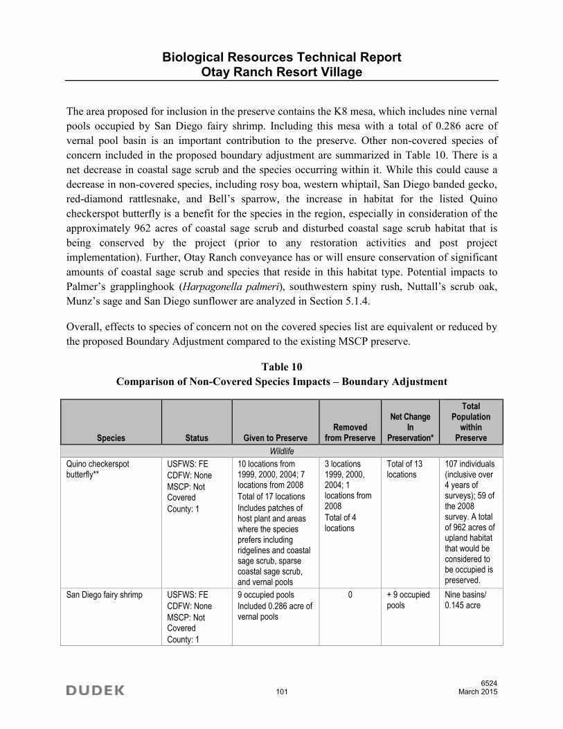
Biological Resources Technical Report Otay Ranch Resort Village
6524 101 March 2015
The area proposed for inclusion in the preserve contains the K8 mesa, which includes nine vernal pools occupied by San Diego fairy shrimp. Including this mesa with a total of 0.286 acre of vernal pool basin is an important contribution to the preserve. Other non-covered species of concern included in the proposed boundary adjustment are summarized in Table 10. There is a net decrease in coastal sage scrub and the species occurring within it. While this could cause a decrease in non-covered species, including rosy boa, western whiptail, San Diego banded gecko, red-diamond rattlesnake, and Bell’s sparrow, the increase in habitat for the listed Quino checkerspot butterfly is a benefit for the species in the region, especially in consideration of the approximately 962 acres of coastal sage scrub and disturbed coastal sage scrub habitat that is being conserved by the project (prior to any restoration activities and post project implementation). Further, Otay Ranch conveyance has or will ensure conservation of significant amounts of coastal sage scrub and species that reside in this habitat type. Potential impacts to Palmer’s grapplinghook (Harpagonella palmeri), southwestern spiny rush, Nuttall’s scrub oak, Munz’s sage and San Diego sunflower are analyzed in Section 5.1.4.
Overall, effects to species of concern not on the covered species list are equivalent or reduced by the proposed Boundary Adjustment compared to the existing MSCP preserve.
Table 10 Comparison of Non-Covered Species Impacts – Boundary Adjustment
Species Status Given to Preserve Removed
from Preserve
Net Change In
Preservation*
Total Population
within Preserve
Wildlife
Quino checkerspot butterfly**
USFWS: FE
CDFW: None
MSCP: Not Covered
County: 1
10 locations from 1999, 2000, 2004; 7 locations from 2008
Total of 17 locations
Includes patches of host plant and areas where the species prefers including ridgelines and coastal sage scrub, sparse coastal sage scrub, and vernal pools
3 locations 1999, 2000, 2004; 1 locations from 2008
Total of 4 locations
Total of 13 locations
107 individuals (inclusive over 4 years of surveys); 59 of the 2008 survey. A total of 962 acres of upland habitat that would be considered to be occupied is preserved.
San Diego fairy shrimp USFWS: FE
CDFW: None
MSCP: Not Covered
County: 1
9 occupied pools
Included 0.286 acre of vernal pools
0 + 9 occupied pools
Nine basins/ 0.145 acre

Biological Resources Technical Report Otay Ranch Resort Village
6524 102 March 2015
Table 10 Comparison of Non-Covered Species Impacts – Boundary Adjustment
Species Status Given to Preserve Removed
from Preserve
Net Change In
Preservation*
Total Population
within Preserve
Plants
Point/Patch data
Western dichondra (Dichondra occidentalis)
None/None
4.2
Not Covered
D
0.1 acre (3 patches) 0.03 acre (1 patch of plants)
+ 0.07 acre (2 patches)
0.2 acre
Palmer’s grapplinghook (Harpagonelia palmeri)
None/None
4.2
Not Covered
D
0 16 individuals -16 individuals
0
San Diego marsh-elder (Iva hayesiana)
None/None
2B.2
Not Covered
B
Polygon of plants within a drainage
Polygon of plants within a drainage
No Change 2.5 acres
Southwestern spiny rush (Juncus acutus)
None/None
4.2
Not Covered
D
0 11 individuals -11 individuals
18 individuals
Nuttall’s scrub oak (Quercus dumosa)
None/None
1B.1
Not Covered
A
0 2 patches -2 patches 0
Area of polygon data
Munz’s sage (Salvia munzii)
None/None
2B.2
Not Covered
B
7.7 acres 16.0 acres -8.3 acres 193 acres
San Diego sunflower (Viguiera laciniata)
None/None
4.2
Not Covered
D
14.5 acres 31.3 acres -16.8 acres 911 acres
* Positive numbers indicate a net increase in preserve (NET GAIN). Negative numbers indicate a net decrease in preserve (NET LOSS). ** Quino data taken from 1999, 2000, 2004, and 2008.
4.7 Summary
The proposed boundary line adjustment results in less than a 2% difference between the existing MSCP Preserve and the proposed Preserve. Habitats that are more rare (valley needlegrass

Biological Resources Technical Report Otay Ranch Resort Village
6524 103 March 2015
grassland and vernal pool) are increased in preservation, a 10 acre parcel within Proctor Valley is included as a give area to increase the preserve size, and improvements will be made to culverts under Otay Lakes Road to make them suitable for wildlife use.
The principal focus of the redesign is the Quino checkerspot butterfly. Seventeen Quino checkerspot locations will be added to the preserve (for a total net increase of thirteen locations) in the boundary adjustment along with areas that are composed of ridgelines and include expanses of host plant populations. The boundary adjustment and preserve reconfiguration are focused on preserving occupied habitat and features of the site that are important for the Quino checkerspot including ridgelines, mesas, and locations where the species has been repeatedly observed over a number of years of surveys. Populations of variegated dudleya, San Diego fairy shrimp and burrowing owl will all have increased preservation as well. The resulting preserve design is shown in Figure 20.
Other features that are included with the boundary adjustment are the inclusion of wildlife linkages that are improved over the approved MSCP and culverts under Otay Lakes Road. The Otay Lakes Road crossings are designed to achieve openness rations prescribed by Donaldson for large animals. These culverts are costly to build, do not currently exist under Otay Lakes Road, and were not originally considered by the MSCP. The culverts provide for increased wildlife movement from the Preserve lands north of the proposed project to other preserved lands to the south, including Lower Otay Lake and City of San Diego Cornerstone Lands.
The proposed project also includes all of the K8 vernal pools, which include a total of nine pools occupied by San Diego fairy shrimp. All of these pools are proposed to be included in the Preserve.
Habitat restoration for a total of approximately 19 acres will be incorporated into the long-term maintenance and management plans for the preserve and includes preparation of conceptual restoration plans with management and monitoring and success criteria. These restoration efforts will further increase the function and value of the habitat within the preserve with improved species conservation and establishment of effective habitat corridor and linkage connectivity. The proposed project will result in an overall increase in species conservation of listed species compared with the MSCP preserve design. Overall, the proposed preserve design is equivalent or improved over the approved MSCP preserve.

Biological Resources Technical Report Otay Ranch Resort Village
6524 104 March 2015
INTENTIONALLY LEFT BLANK

Lower O t ay Res e rv o i r
Uppe rOt ay
Rese r vo i r
O T A Y L A K E SNOT
APART
Legend
Project Boundary
Dudek Vegetation Mapping (MSCP LABEL)Coastal Sage Scrub
Chaparral
Grassland
Freshwater Marsh
Riparian Forest
Riparian Scrub
Eucalyptus Woodland
Open Water
Disturbed Wetland
Natural Floodchannel
Disturbed Land
Urban/Developed
Vernal Pool Complex
0 1,500750Feet
FIGURE 20
Ultimate Preserve VegetationOtay Ranch Resort Village Site - Biological Resources Technical ReportDo
cume
nt Pa
th: Z
:\Pro
jects\
j6524
01\M
APDO
C\MA
PS\B
io Fig
s\Bio
Figs 2
014-
10\F
ig20_
Ultim
atePr
eser
veVe
g.mxd
6524
KEY MAP
Off-SiteGive
OFF-SITE GIVE
0 1,500750Feet
Ultimate Development

Biological Resources Technical Report Otay Ranch Resort Village
6524 106 March 2015
INTENTIONALLY LEFT BLANK

Biological Resources Technical Report Otay Ranch Resort Village
6524 107 March 2015
5 ANTICIPATED PROJECT IMPACTS
This section addresses direct, indirect, and cumulative impacts to biological resources that would result from implementation of the proposed project. Both the proposed development and open space areas have been naturally recovering from the 2003 Otay Fire. Therefore, the evaluation of significance and adequacy of mitigation utilizes data from pre-fire conditions with the assumption that these resources will be present within both the impact and mitigation areas. A number of project design features are included in the proposed project in order to reduce or avoid impacts and are summarized below within the specific section to which they apply and as mitigation measures.
Direct impacts were quantified by overlaying the anticipated limits of grading on the Biological Resources Map and quantifying impacts. An approximately 779-acre area (as depicted in the Biological Resources Map and Impact Analysis, located in the map pocket) would be graded on site, including all on-site fuel management zones and approximately 40 acres would be graded off site associated with improvement of Otay Lakes Road. The remainder of the on-site area would consist of open space and revegetated slopes that will initially undergo grading, but will be restored to native vegetation and placed in open space.
Indirect impacts are difficult to identify and quantify but are presumed to occur. They primarily result from adverse “edge effects”: either short-term indirect impacts related to construction, or long-term, chronic indirect impacts associated with the location of urban development in proximity to biological resources within natural open space. During construction of the project, short-term indirect impacts may include dust and noise, which could disrupt habitat and species vitality temporarily, and construction-related soil erosion and runoff. However, all project grading will be subject to the typical restrictions and requirements that address erosion and runoff, including the federal Clean Water Act and the National Pollution Discharge Elimination System (NPDES), and preparation of a Stormwater Pollution Prevention Plan (SWPPP) and Standard Urban Stormwater Management Plan (SUSMP). These programs are expected to minimize project impacts with respect to erosion/runoff. Long-term indirect impacts to adjacent open space may include intrusions by humans and domestic pets, noise, lighting, invasion by exotic plant and wildlife species, effects of toxic chemicals (fertilizers, pesticides, herbicides, and other hazardous materials), urban runoff from developed areas, soil erosion, litter, fire, and hydrologic changes (e.g., groundwater level and quality).
Cumulative impacts refer to incremental individual environmental effects of two or more projects when considered together. These impacts taken individually may be minor but become collectively significant as they occur over a period of time.

Biological Resources Technical Report Otay Ranch Resort Village
6524 108 March 2015
5.1 Direct Impacts
The proposed project has been designed around an extensive open space system in close coordination with USFWS and CDFW. Development areas have been moved specifically to preserve important wildlife corridors, species, and habitat, including vernal pools, San Diego fairy shrimp and the Quino checkerspot butterfly. As a result, potential impacts to special-status biological resources have been greatly avoided and minimized.
5.1.1 Vegetation Communities
On-site Direct Impacts
Implementation of the proposed project would result in the direct and complete loss of the vegetation community acreages presented in Table 11, which presents the on-site impacts, and Table 12, which presents the off-site impacts. Losses would occur as the result of grading and fuel management. Impacts also include the installation of a water tank within the northern open space area and detention basins. A trail is proposed for the project however the location is entirely within the project impact area/project development footprint and will be separated from the preserve by protective fencing, thus no biological impacts would result from the construction or use of the trail that are not already included in the impact analysis for the project. Proposed preserve vegetation community acreages are shown in Table 13 and includes those areas not impacted by grading or fuel modification zones as well as areas proposed to be restored and areas that are considered to be allowable as a land use within the preserve. These land uses include detention basins, the water tank, and the road that provides access to the water tank. Impacts to vegetation and jurisdictional areas are shown on Figures 21 and 22 and on the Biological Resources Map and Impact Analysis (see map pocket) and Proposed Fencing, Preserve signage, and Fuel Modification Zones (see map pocket).
The Project design was prepared in close coordination with USFWS and CDFW to reduce and avoid impacts to sensitive vegetation communities and to provide wildlife movement as well as a well-designed preserve configuration, however, impacts to ten sensitive vegetation communities (Table 11) are considered significant. Specifically, impacts to Coastal Sage Scrub, Chamise Chaparral, Scrub Oak Chaparral, Southern Mixed Chaparral, Valley Needlegrass Grassland, Non-native Grassland, Cismontane Alkali Marsh, Mulefat Scrub, Southern Willow Scrub, and Open Water are considered significant impacts absent mitigation (Impact BIO-1). Impacts to sensitive upland vegetation communities that are adjacent to the preserve that consist of slopes that are appropriate to restore are considered significant absent mitigation (Impact BIO-1).

Biological Resources Technical Report Otay Ranch Resort Village
6524 109 March 2015
Table 11 On-Site Impacts by Habitat Type
Plant Community Type
Existing On Site* (Acres)
Total On-Site Impacts
Total Preserve (not impacted)**
Outside Preserve Inside Preserve
Permanent Total
Development Impacts
Permanent Impacts Temporary Impacts
Fuel Modification
Zone Development Water Tank Detention
Basins Slope Water Line
Sensitive Upland Communities
Coastal sage scrub 1,121.51 20.68 255.89 276.57 2.26 1.22 13.02 0.23 828.21
Disturbed coastal sage scrub 348.62 4.41 202.05 206.46 0.73 2.35 4.17 — 133.91
Chamise chaparral 143.14 0.87 112.34 113.21 — 0.07 0.74 — 29.12
Disturbed chamise chaparral 15.67 — 11.36 11.36 — — — — 4.31
Scrub oak chaparral 22.45 — 22.10 22.10 — — 0.01 — 0.34
Southern mixed chaparral 4.95 0.94 1.92 2.86 — — — — 2.09
Disturbed Valley needlegrass grassland
110.58 0.80 76.21 77.01 0.27 0.06 0.25 — 32.99
Non-native grassland 78.96 1.65 58.40 60.05 0.08 0.92 0.16 — 17.75
Subtotal 1,845.88 29.35 740.23 769.58 3.34 4.62 18.35 0.23 1,048.72
Sensitive Wetland Communities
Cismontane alkali marsh 6.39 — 0.01 0.01 — — — — 6.38
Disturbed cismontane alkali marsh
0.17 — 0.01 0.01 0.01 — 0.01 — 0.14
Mulefat scrub 0.08 — 0.03 0.03 — — — — 0.05
Open water 0.17 — 0.17 0.17 — — — — —
Southern willow scrub 1.19 — — -- — — — — 1.19
Subtotal 8.00 — 0.22 0.22 0.01 — 0.01 — 7.76
Non-Sensitive Communities and Land Covers
Developed Land 0.88 — 0.82 0.82 0.05 — — — 0.01
Disturbed Habitat 13.46 0.22 7.90 8.12 0.03 0.06 0.25 — 5.00
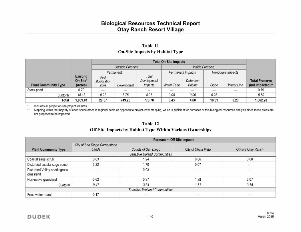
Biological Resources Technical Report Otay Ranch Resort Village
6524 110 March 2015
Table 11 On-Site Impacts by Habitat Type
Plant Community Type
Existing On Site* (Acres)
Total On-Site Impacts
Total Preserve (not impacted)**
Outside Preserve Inside Preserve
Permanent Total
Development Impacts
Permanent Impacts Temporary Impacts
Fuel Modification
Zone Development Water Tank Detention
Basins Slope Water Line
Stock pond 0.79 — — -- — — — — 0.79
Subtotal 15.13 0.22 8.75 8.97 0.08 0.06 0.25 — 5.80
Total 1,869.01 29.57 749.25 778.78 3.43 4.68 18.61 0.23 1,062.28
* Includes all project on-site project features. ** Mapping within the majority of open space areas is regional scale as opposed to project-level mapping, which is sufficient for purposes of this biological resources analysis since these areas are
not proposed to be impacted.
Table 12 Off-Site Impacts by Habitat Type Within Various Ownerships
Plant Community Type
Permanent Off-Site Impacts
City of San Diego Cornerstone Lands County of San Diego City of Chula Vista Off-site Otay Ranch
Sensitive Upland Communities
Coastal sage scrub 5.63 1.24 0.06 0.68
Disturbed coastal sage scrub 3.22 1.70 0.07 ---
Disturbed Valley needlegrass grassland
— 0.03 --- ---
Non-native grassland 0.62 0.37 1.38 3.07
Subtotal 9.47 3.34 1.51 3.75
Sensitive Wetland Communities
Freshwater marsh 0.17 — --- ---

Biological Resources Technical Report Otay Ranch Resort Village
6524 111 March 2015
Table 12 Off-Site Impacts by Habitat Type Within Various Ownerships
Plant Community Type
Permanent Off-Site Impacts
City of San Diego Cornerstone Lands County of San Diego City of Chula Vista Off-site Otay Ranch
Disturbed mulefat scrub – ACOE/CDFW/RWQCB/ County
0.09 0.01 --- ---
Disturbed mulefat scrub –CDFW/County
0.03
Open water 0.49 — --- ---
Southern willow scrub 0.04 — --- ---
Subtotal 0.82 0.01 0.00 0.00
Non-Sensitive Communities and Land Covers
Eucalyptus woodland 0.27 0.11 --- 0.23
Developed Land 0.01 17.21 1.97 0.04
Disturbed Habitat 0.27 0.11 --- ---
Ornamental 0.25 0.04 0.22 0.43
Subtotal 0.80 17.47 2.19 0.70
Total 11.09 20.82 3.70 4.45

Biological Resources Technical Report Otay Ranch Resort Village
6524 112 March 2015
Table 13 Proposed Preserve Lands
Plant community type
Preserve (not impacted)*
On Site
Preserve Purchased for
Boundary Adjustment1
Preserve (impacted)
Total On-site Preserve
Permanent Impacts Temporary Impacts
Allowable Uses (Water Tank and associated
road grading) Detention
Basins Slopes Water
Sensitive Upland Communities
Coastal sage scrub 828.21 3.18 2.26 1.22 13.02 0.23 848.12
Disturbed coastal sage scrub 133.91 — 0.73 2.35 4.17 — 141.16
Chamise chaparral 29.12 — — 0.07 0.74 — 29.93
Disturbed chamise chaparral 4.31 — — — — — 4.31
Scrub oak chaparral 0.34 — — — 0.01 — 0.35
Southern mixed chaparral 2.09 4.28 — — — — 6.37
Disturbed Valley needlegrass grassland
32.99 — 0.27 0.06 0.25
— 33.57
Non-native grassland 17.75 2.74 0.08 0.92 0.16 — 21.65
Subtotal 1,048.72 10.20 3.34 4.62 18.35 0.23 1,085.46
Sensitive Wetland Communities
Cismontane alkali marsh 6.38 — — — — — 6.38
Disturbed cismontane alkali marsh 0.14 — 0.01 — 0.01 — 0.16
Mulefat scrub 0.05 — — — — — 0.05
Open water — — — — — — —
Southern willow scrub 1.19 — — — — — 1.19
Subtotal 7.76 — 0.01 — 0.01 — 7.78
Non-Sensitive Communities and Land Covers
Developed Land 0.01 — 0.05 — — — 0.06
Disturbed Habitat 5.00 — 0.03 0.06 0.25 — 5.34

Biological Resources Technical Report Otay Ranch Resort Village
6524 113 March 2015
Table 13 Proposed Preserve Lands
Plant community type
Preserve (not impacted)*
On Site
Preserve Purchased for
Boundary Adjustment1
Preserve (impacted)
Total On-site Preserve
Permanent Impacts Temporary Impacts
Allowable Uses (Water Tank and associated
road grading) Detention
Basins Slopes Water
Stock pond 0.79 — — — — — 0.79
Subtotal 5.80 — 0.08 0.06 0.25 — 6.19
Total 1,062.28 10.20 3.43 4.68 18.61 0.23 1,089.28
* Mapping within the majority of open space areas is regional scale as opposed to project-level mapping, which is sufficient for purposes of this biological resources analysis since these areas are not proposed to be impacted.
1 The off-site area included for the Boundary Line Adjustment is not included in the overall on-site preserve acreage

Biological Resources Technical Report Otay Ranch Resort Village
6524 114 March 2015
Off-site Direct Impacts
Off-site impacts, totally approximately 40.06 acres, are anticipated to occur as a result of the widening and improvements to Otay Lakes Road. These impacts will occur to areas within the City of San Diego Cornerstone Lands, County of San Diego lands (Otay Lakes Right-of-Way), lands within the City of Chula Vista, and off-site areas within the Otay Ranch that are not a part of the proposed project and thus are considered off site. Table 12 summarizes the impacts to these off-site areas based on the vegetation community and the location of the off-site impact.
The proposed project results in a direct impact to Otay Lakes Road and requires widening from two lanes to four lanes. The County General Plan Mobility Element classifies Otay Lakes Road as a Four Lane Major Road. As part of the proposed project, a General Plan Amendment is proposed to re-classify Otay Lakes Road from a Four Lane Major Road to a Boulevard with Raised Median. The proposed re-classification is important because it reduces potential impacts resulting from the new roadway by allowing for certain design criteria to be used that maintains the current alignment. Thus, instead of both widening and realigning Otay Lakes Road through MSCP Cornerstone Lands, the proposed General Plan Amendment minimizes any realignment required for the widening of Otay Lakes Road.
City of San Diego MSCP Cornerstone Lands
Otay Lakes Road is currently adjacent to City of San Diego MSCP Cornerstone Lands around Lower Otay Lake. As shown in the Table 12, direct impacts to City of San Diego Cornerstone Lands as a result of the widening of Otay Lakes Road total 11.09 acres. Of this total, 9.47 acres are imapcts to Sensitive Upland Communities, 0.82 acres occur to wetlands and 0.80 acres are non-sensitive communities. In addition, as described in Section 5.1.2, off-site impacts to jurisdictional waters include permanent impacts to 0.02 acre of ephemeral waters.
The City of San Diego requires projects to demonstrate they avoid or reduce impacts to Cornerstone Lands to the maximum extent feasible. By proposing a General Plan Amendment to reclassify Otay Lakes Road, impacts have been reduced greatly. The prior Four Lane Major Road design impacted 21.54 acres within the Cornerstone Lanes, including 17.14 acres of impacts to Sensitive Upland Communities, 2.01 acres of impacts to Wetland Communities, and 2.39 acres of impacts to non-sensitive communities. Thus, the proposed project reduces overall impacts to Cornerstone Lands by 48.5%. Regardless, impacts to Cornerstone Lands are significant absent mitigation (Impact BIO-2).

Low er O t ay R ese rvo i r
NotA
Par t
Upp er O t ay R ese rvo i r
O T A Y L A K E S
Coastal Sage Scrub
Chaparral
Grassland
Freshwater Marsh
Riparian Forest
Riparian Scrub
Eucalyptus Woodland
Open Water
Disturbed Wetland
Natural Floodchannel
Disturbed Land
Urban/Developed
Vernal Pool Complex
VEGETATION SOURCE:DUDEK 2002/2005/2008/2010 &SANGIS 1995/2008
0 1,000Feet
Dudek Vegetation Mapping (MSCP Label)
Project Boundary
Proposed Development Footprint
Revegetated Slopes or Basins
Proposed Off-Site Impacts
K6 vernal poolsand watersheds
K8 vernal poolsand watershed
FIGURE 21
Vegetation Map with Proposed Development FootprintOtay Ranch Resort Village Site - Biological Resources Technical ReportDo
cume
nt Pa
th: Z
:\Pro
jects\
j6524
01\M
APDO
C\M
APS\
Bio
Figs
\Bio
Figs 2
014-
10\F
ig21_
veg+
impa
cts.m
xd
6524
Biological Resources Technical Report Otay Ranch Resort Village
6524 116 March 2015
INTENTIONALLY LEFT BLANK

Lower O t ay R ese rvo i r
NotA
Par t
Upper O t ay R ese rvo i r
O T A Y L A K E S
DS5
DS2DS1
DS3DS4cDS4bDS4a
WETLANDS SOURCE:DUDEK 2002/2005/2008/2010/2014 &SANGIS 1995/2008
0 1,000Feet
Project Boundary
Proposed Development Footprint
Revegetated Slopes or Basins
Proposed Off-Site Impacts
ACOE/RWQCB/CDFW Waters:Ephemeral Waters
Intermittent Waters
ACOE/RWQCB/CDFW Jurisdictional Wetlands
CDFW Only Jurisdictional Wetlands
Data Station with ID
FIGURE 22
Jurisdictional Delineation Map with Proposed Development FootprintOtay Ranch Resort Village Site - Biological Resources Technical Report
Docu
ment
Path:
Z:\P
rojec
ts\j65
2401
\MAP
DOC\
MAPS
\Bio
Figs\B
io Fig
s 201
4-10
\Fig2
2_we
t+imp
acts.
mxd
6524

Biological Resources Technical Report Otay Ranch Resort Village
6524 118 March 2015
INTENTIONALLY LEFT BLANK

Biological Resources Technical Report Otay Ranch Resort Village
6524 119 March 2015
Lands Within City of Chula Vista
In compliance with the MSCP Subregional Plan and the Subarea Plan, the City of Chula Vista established development standards, the Habitat Loss and Incidental Take (HLIT) Ordinance, as a condition of issuance of Take Authorization by the wildlife agencies. The HLIT is consistent with the conservation and mitigation goals of the MSCP Subregional Plan and the City of Chula Vista Subarea Plan, which require impacts to sensitive vegetation communities to be avoided and minimized to the maximum extent practicable. Furthermore, the HLIT identifies specific impact and mitigation requirements for impacts to native and some non-native communities (e.g., non-native grassland).
As shown in the Table 12, direct impacts to lands within the City of Chula Vista as a result of the widening of Otay Lakes Road total 3.70 acres. Of this total, 1.51 acres are to Sensitive Upland Communities and 2.19 acres are to non-sensitive communities. This off-site area is located outside of the Otay Ranch boundary and is subject to the City of Chula Vista HLIT Ordinance. The off-site impact areas within City of Chula Vista are consistent with City Planning Guidelines and do not conflict with the goals or standards of the City’s Subarea Plan since the impacts are for the road improvements; however, compliance with the City’s HLIT Ordinance will require conformance with several standard measures to address habitat loss.
Impacts to native upland vegetation communities and wetland habitats are considered significant absent mitigation under the City’s HLIT Ordinance and require mitigation (City of Chula Vista 2003, Tables 5-3 and 5-6). Vegetation communities considered sensitive under the City Subarea Plan are those listed as Tier I through Tier III (rare uplands to common uplands), as well as wetlands. Significant impacts include non-native grassland (Tier III), and the disturbed and non-disturbed coastal sage scrub (Tier II). Impacts to vegetation communities that are not considered significant include impacts to Tier IV habitats (other uplands) consisting of disturbed land and developed land on site. Impacts to areas subject to HLIT are quantified in Table 12 and mitigated as described in Chapter 6.0 (Impact BIO-3). There are no impacts to jurisdictional wetlands within the City of Chula Vista.
County of San Diego Lands
As shown in the Table 12, direct impacts to lands within the County of San Diego, Otay Lakes Road Right-of-Way, as a result of the widening of Otay Lakes Road total 20.82 acres. Of this total, 3.34 acres are to Sensitive Upland Communities and 17.47 acres are to non-sensitive communities. This off-site area is located outside of the Otay Ranch boundary and is within the jurisdiction of the County of San Diego. All of the impacts are within the right-of-way of Otay Lakes Road. Impacts are required to comply with the regulations set forth by the County. In

Biological Resources Technical Report Otay Ranch Resort Village
6524 120 March 2015
compliance with the MSCP Subregional Plan and the County of San Diego Subarea Plan (County MSCP; County of San Diego 1997), the County established the Biological Mitigation Ordinance (BMO; County of San Diego 2010) to provide the requirements and mitigation measures necessary for projects within the plan area. Certain areas within the County MSCP were designated as Take Areas within the South County Segment of the MSCP. The Take Areas designated in the County MSCP were developed through a comprehensive planning effort with the affected jurisdictions and describe areas that are not subject to further mitigation because direct and cumulative impacts to MSCP Covered Species were considered in the overall MSCP planning effort. The County specifically exempted the Take Areas from the BMO at Sec. 86.503. Exemptions, (a) (4), which states that the chapter shall not apply to “Any Take Authorization Area approved by the Board of Supervisors and the Wildlife Agencies as part of the County Subarea Plan, as shown on Attachment B of Document No. 0769999 on file with the Clerk of the Board or any approved Habitat Loss Permit issued pursuant to 16 U.S.C. Sec. 1533(d).” The right-of-way for Otay Lakes Road is located within the South County section and the proposed impact area is designated as Take Authorized. As such, and in accordance with the County MSCP and BMO, no additional biological mitigation is required for development to occur. The “take” as defined by the Endangered Species Act already has been adequately mitigated in the form of land set aside as “Hard Line” preserves during the negotiations between the landowners, wildlife agencies, and County during preparation of the Subarea Plan. The off-site impact areas are consistent with the requirements for the road improvements per the County and do not conflict with the goals or standards of the County’s Subarea Plan.
Off-site Otay Ranch Lands
As shown in the Table 12, direct impacts to off-site lands within the Otay Ranch as a result of the widening of Otay Lakes Road total 4.45 acres. Of this total, 3.75 acres are to Sensitive Upland Communities and 0.70 acres are to non-sensitive communities. This off-site area is located outside of the Otay Ranch Resort Village boundary but within the Otay Ranch. The impacts to these off-site Otay Ranch lands are subject to the requirements of the Otay Ranch RMP. Because the impacts to the off-site Otay Ranch lands are associated with road improvements as required by the County of San Diego, conveyance per the Otay Ranch RMP is not required and no mitigation is required.

Biological Resources Technical Report Otay Ranch Resort Village
6524 121 March 2015
5.1.2 Jurisdictional Waters
On-site Impacts
Permanent impacts to 0.99 acre of ephemeral and 0.04 acre of intermittent jurisdictional waters and temporary impacts to 0.07 acre of ephemeral jurisdictional waters would occur on site as a result of project implementation (Figures 21, 22, and also see map pocket; Table 14). Permanent and temporary impacts to 0.24 acre of wetlands would occur on site as a result of the project implementation (Impact BIO-4). Approximately 0.03 acre of the total 0.24 acre of impacts are under the jurisdiction of CDFW only. The vegetation communities of the wetlands are identified in Table 11.
Table 14 Jurisdictional Waters Impacts
Jurisdictional Water type
Permanent Impacts (acres) Temporary Impacts (acres)
Total Impacts (acres)
Fuel Modification Development Detention Basin Slope
Revegetation
On Site
Off Site
On Site
Off Site (Cornerstone
Lands) On Site Off Site On Site
Off Site
Total ACOE/CDFW/RWQCB Ephemeral Waters
0.02 — 0.97 0.02 <0.01 — 0.07 — 1.08
Total ACOE/CDFW/RWQCB Intermittent Waters
— — 0.04 — — — — — 0.04
Total 0.02 — 1.01 0.02 <0.01 — 0.07 — 1.12
Impacts to a total of 1.34 acres of jurisdictional waters including wetland vegetation communities on site are considered significant absent mitigation (Impact BIO-1 and BIO-4). It should be noted that unvegetated jurisdictional waters occur within other mapped upland vegetation types and thus are not included in the tables of vegetation community impacts but are included in the table presenting impacts to jurisdictional resources. Impacts to jurisdictional waters are shown in Tables 11 and 13.

Biological Resources Technical Report Otay Ranch Resort Village
6524 122 March 2015
Off-site Impacts
Off-site impacts to wetlands include 0.83 acre to vegetation communities identified in Table 12. These off-site impacts include 0.03 acre of disturbed mulefat scrub habitat that is a wetland community under the jurisdiction of CDFW only.
City of San Diego MSCP Cornerstone Lands
As noted above, Otay Lakes Road is currently adjacent to City of San Diego MSCP Cornerstone Lands around Lower Otay Lake. As shown in the Table 12, direct impacts to wetlands and waters within City of San Diego Cornerstone Lands as a result of the widening of Otay Lakes Road total 0.82 acre of wetlands (includes 0.03 acre of CDFW only jurisdictional wetlands), and 0.02 acre of ephemeral waters.
As described above, the City of San Diego requires projects to demonstrate they avoid or reduce impacts to Cornerstone Lands to the maximum extent feasible. By proposing a General Plan Amendment to reclassify Otay Lakes Road, impacts have been reduced greatly thus reducing the impacts to wetlands from 2.01 acres to 0.82 acre. Regardless, impacts to Cornerstone Lands are significant absent mitigation (Impact BIO-5).
County of San Diego Lands
As shown in the Table 12 direct impacts to wetlands within the County of San Diego, Otay Lakes Road Right-of-Way, as a result of the widening of Otay Lakes Road total 0.01 acre. This off-site area is located outside of the Otay Ranch boundary and is subject to the County of San Diego Resource Protection Ordinance (County of San Diego 2007). The off-site impact areas are consistent with the requirements for the road improvements per the County and do not conflict with the goals or standards of the County’s Subarea Plan; however, compliance with the County’s Resource Protection Ordinance will require conformance with several standard measures to address habitat loss. Impacts to wetland habitats and ephemeral waters are considered significant absent mitigation (Impact BIO-6).
5.1.3 Vernal Pools
The proposed project includes development on the K6 mesa and preservation of the vernal pools on the K8 mesa. Impacts to jurisdictional vernal pools on the K6 mesa would total 4,576 square feet (0.11 acre) in basin area and are considered significant absent mitigation (Impact BIO-7). As noted above, the K6 vernal pools have been studied as recently as 2008, and have been documented to not become inundated. Thus, these pools would be considered low to moderate quality. The project also includes a minor re-alignment of Otay Lakes Road to the east, which

Biological Resources Technical Report Otay Ranch Resort Village
6524 123 March 2015
provides for a greater buffer from existing vernal pools within City of San Diego ownership around Lower Otay Lake.
The MMRP for the Otay SRP DEIR states that “The project shall be designed to preserve 95% of large or high value VP complexes and 95% of all other VPs.” In order to document that this requirement is met, the ranch-wide mapping and quantification of vernal pool acreage was used (Table 15). The mapping was done by MBA in 1990 and Dudek in 1991 and provides a comparative basis for calculating acres of vernal pools present on Otay Ranch and the acres that are proposed to be or have been impacted. It should be noted that for calculating the actual impact and the required mitigation, the more recent mapping of vernal pools was used. Based on the 1990 mapping and quantification of vernal pool acreage ranch-wide, the total area of vernal pools is 227,285 square feet. Of this, 2,215 square feet have been impacted or are proposed to be impacted, including the K6 pools, a total of 1% of the vernal pools present. Thus the goal for the preservation of 95% of vernal pools is met assuming that the K6 pools are impacted.
Table 15 Summary of Vernal Pools within Otay Ranch
Vernal Pool Group Designation
Number of Pools recorded in 1990
Total Surface area of Basins in Group (sq ft)
Surface Area of Pools Impacted Based on 1990
mapping (sq ft)
Surface area of Pools Impacted based on
2006/2008 data (sq ft)
Otay River Valley Parcel
J29-30 170 81,771 — —
J31 South 6 3,029 — —
J31 North 2 289 — —
J23-24 531 104,995 — —
J25 151 16,656 — —
J32 3 1,029 — —
K1 7 4,377 — —
K15 4 711 — —
K16 1 187 — —
K17 2 919 919 120
M2 5 727 727 83
M5 1 157 157 157
San Ysidro Parcel
K5 7 2,546 — —
K12 4 726 — —
K14 1 346 — —
Proctor Valley Parcel
K6 3 412 412 4576
K8 11 5,581 — —
K9 1 31 — —

Biological Resources Technical Report Otay Ranch Resort Village
6524 124 March 2015
Table 15 Summary of Vernal Pools within Otay Ranch
Vernal Pool Group Designation
Number of Pools recorded in 1990
Total Surface area of Basins in Group (sq ft)
Surface Area of Pools Impacted Based on 1990
mapping (sq ft)
Surface area of Pools Impacted based on
2006/2008 data (sq ft)
R1 1 324 — —
R2 8 378 — —
R3 3 2,050 — —
R4 1 44 — —
Total — 227,285 2215 4936
If current project level information on pools is used to evaluate the percent impact and preservation, a total of 2.2% of the area of vernal pools would be impacted, including the K6 pools, preserving 97.8% on site. Regardless, impacts to vernal pools are considered a significant impact absent mitigation.
5.1.4 Sensitive Plant Species
The Project has been designed around an extensive open space system in close coordination with USFWS and CDFW in order to avoid direct impacts to sensitive plant species.
Implementation of the proposed project would result in the loss of the locations and individuals of sensitive plant species identified on Figure 23 and the Sensitive Plant Species Impact Map (see map pocket), and described in the text. A summary of impacts to sensitive plants is presented in Table 16.
Significant direct impacts to sensitive plant species include impacts to the following CRPR 2/County List B species (Impact BIO-8):
California adolphia (Adolphia californica),
In addition, direct impacts to sensitive plant species include impacts to a number of California Rare Plant Rank (CRPR) 1B/County List A species and these impacts are addressed as follows:
Impact to San Diego thornmint and variegated dudleya, MSCP narrow endemic species, is addressed through compliance with species-specific mitigation in accordance with the Otay Ranch RMP. The proposed impact to San Diego thornmint is 3% of the on-site population, resulting in 97% preservation of the species, including a 100-foot buffer around the population of the plant. The Otay Ranch RMP requires preservation of 95% of San Diego thornmint, which the project achieves. Thus, no additional mitigation is required for impacts to San Diego thornmint.

Biological Resources Technical Report Otay Ranch Resort Village
6524 125 March 2015
The proposed impact to variegated dudleya is 19%, resulting in 81% preservation of the species. The Otay Ranch RMP requires preservation of 75% of variegated dudleya, which the project achieves. Thus, no additional mitigation is required for impacts to variegated dudleya.
Mitigation for impacts to San Diego marsh-elder and Munz’s sage are addressed under the provisions of the Otay Ranch RMP. For San Diego marsh-elder, the Otay Ranch RMP indicates that 75% shall be preserved. Although 47% of the species is preserved within the project area, additional preservation within the ranch-wide preserve and third-party acquisitions achieve the Otay Ranch RMP goal.
For Munz’s sage, the Otay Ranch RMP requires that 46% shall be preserved. This is met with the on-site preservation of 64% of the species within the proposed preserve.

Biological Resources Technical Report Otay Ranch Resort Village
6524 126 March 2015
Table 16 Impacts to Special-Status Plant Species Present on Site
Species
Scientific Name
Regulatory Status Federal/State CRPR MSCP
Coverage County List Basis for Impact
Evaluation
Number/ Acre(s)
impacted % impacted
Number/ Acre(s)
preserved %
Preserved
Otay Ranch RMP % Preservation
Required
San Diego thornmint
(Acanthomintha ilicifolia) FT/SE
1B.1
Covered Narrow Endemic
A
A total of 3.4 acres of the species have been mapped on site.
0.1 acres 3 3.3 acres 97 95
California adolphia
(Adolphia californica)
None/None
2B.1
Not Covered
B
A total of <20 individuals present at two locations. For purposes of evaluation, it is assumed that a total of 20 are currently present on site.
20 individuals
100 0 0 75
Small-flowered morning-glory
(Convolvulus simulans)
None/None
4.2
Not Covered
D
A total of 120 individuals observed on site.
0 individuals 0 120 individuals
100 N/A
Western dichondra
(Dichondra occidentalis)
None/None
4.2
Not Covered
D
A total of 0.5 acre occupied by this species on site.
0.3 acre 60 0.2 acre 40 50
Variegated dudleya
(Dudleya variegata)
None/None
1B.2
Covered –
Narrow Endemic
A
A total of 5,833 individuals observed on site.
925 individuals
16 4,908 individuals
84 50
San Diego barrel cactus
(Ferocactus viridescens)
None/None
2.1
Covered
B
A total of 217 individuals observed on site.
115 individuals
53 102individuals 47 75

Biological Resources Technical Report Otay Ranch Resort Village
6524 127 March 2015
Table 16 Impacts to Special-Status Plant Species Present on Site
Species
Scientific Name
Regulatory Status Federal/State CRPR MSCP
Coverage County List Basis for Impact
Evaluation
Number/ Acre(s)
impacted % impacted
Number/ Acre(s)
preserved %
Preserved
Otay Ranch RMP % Preservation
Required
Palmer’s grapplinghook
(Harpagonella palmeri)
None/None
4.2
Not Covered
D
A total of 114 individuals observed on site.
114 individuals
100 0 individuals 0 75
San Diego marsh-elder
(Iva hayesiana)
None/None
2B.2
Not Covered
B
A total of 5.4 acres occupied by this species on site.
2.9 acres 53 2.5 acres 47 75
Southwestern spiny rush
(Juncus acutus ssp. leopoldii)
None/None
4.2
Not Covered
D
A total of 30 individuals observed on site.
12 individuals
40 18 individuals 60 50
Small-flowered microseris
(Microseris douglasii ssp. platycarpha)
None/None
4.2
Not Covered
D
A total of 1,270 individuals observed on site.
270 individuals
21 1,000 individuals
79 None
San Diego goldenstar
(Bloomeria clevelandii)
None/None
1B.1
Covered
A
A total of 2,546 individuals observed on site.
1,497 individuals
59 1,049 individuals
41 54
Little mousetail
(Myosurus minimus ssp. apus)
None/None
3.1
Not Covered
C
Although observed in 1990, this species has not been observed recently.
0 0 0 0 N/A
California adder’s-tongue
(Ophioglossum californicum)
None/None
4.2
Not Covered
D
Has not been observed in recent years and likely is not present.
0 0 0 0 N/A

Biological Resources Technical Report Otay Ranch Resort Village
6524 128 March 2015
Table 16 Impacts to Special-Status Plant Species Present on Site
Species
Scientific Name
Regulatory Status Federal/State CRPR MSCP
Coverage County List Basis for Impact
Evaluation
Number/ Acre(s)
impacted % impacted
Number/ Acre(s)
preserved %
Preserved
Otay Ranch RMP % Preservation
Required
Golden-rayed pentachaeta
(Pentachaeta aurea ssp. aurea)
None/None
4.2
Not Covered
D
A total of 91 individuals observed on site.
51 individuals
56 40 individuals 44 None
Nuttall’s scrub oak
(Quercus dumosa)
Possible mis-identification *
None/None
1B.1
Not Covered
A
A total of 6.2 acres are occupied by this species on site.
6.2 acres 100 0 acres 0 None
Coulter’s matilija poppy
(Romneya coulteri)
None/None
4.2
Not Covered
D
Single location observed. 0 0 1 individual 100 N/A
Munz’s sage
(Salvia munzii)
None/None
2B.2
Not Covered
B
A total of 295 acres are occupied by this species on site.
102 acres 35 193 acres 65 46
San Diego County viguiera
(Viguiera laciniata)
None/None
4.2
Not Covered
D
A total of 1,071 acres of coastal sage scrub dominated with San Diego County viguiera.
160 acres 15 911 acres 85 75
* In the west-central areas, the main component of this vegetation community was identified as Nuttall ’s scrub oak (Quercus dumosa). More recent information challenges that identification due to the inland location of the site and general coastal distribution of Nuttall ’s scrub oak. Without more concrete documentation, the current conclusion will be assumed to be correct, however, it is understood that generally, the identification in this region would more likely be the common, inland species o f scrub oak (Quercus berberidifolia) which was also identified on site by other botanists
.

No tA
Pa r t
O T A Y L A K E S
Sm
Vl
SmSm
Sm
Sm
SmSmSm
Sm
SmSm
FvFvFv
SmSmSm
SmSmSm
Sm
Sm
Fv1Fv7
Fv2Fv2
Fv1 Fv1Fv1
Fv1 Fv1Fv1
Fv2Fv3
Fv1
Fv1
Ja8Fv2
Fv1
Fv1Fv1
Dv7 Dv6
Fv1 Fv1Fv3
Pa6
Dv9Pa5
Dv2Fv1Fv1
Fv1Dv6
Fv1Dv4
Fv2
Fv1
Fv5
Fv2
Pa20
Dv20
Dv20
Mc37
Dv80
Dv20
Cs20
Pa40Dv21
Dv46
Dv60Dv14
Dv200Mc269
Dv334
Dv260
Dv260Dv100
Sm SmSmSm Vl SmSm VlSmVlVlSmSm SmSm SmJa SmSm Vl
SmSmSm SmSm SmSm SmSmSm
Sm VlVl SmSm Sm SmVl SmSmIh Sm Sm SmIhSm SmSmVl Sm SmFv Sm Ih VlSmSm SmVl VlVl VlSm VlSm Sm Sm Ih VlSm VlSm
SmSm Ih Vl VlVl IhVl Sm Vl VlSm Vl VlVlVl VlIhMc IhFv Sm Sm Vl VlSmFv Ih VlSm VlVl VlFv VlIhVl VlVl VlVlVlIhVlVl Vl IhIh VlVl VlVlVl IhVl Vl McIhVl Vl IhVlIhMc Mc McIhVl VlVl Vl
VlVl VlIh VlIhAp Ih VlMc IhIh Mc VlVlJaMc Ih Mc Vl VlVlJa Vl Vl VlVl VlIh VlVl Vl VlVlVlJa Ih VlVlMc VlVlVl VlDoVl VlIhVl VlVl Vl VlVl IhFv Vl Vl VlVl VlVl Vl Vl VlVl VlMc Mc DvMc Dv
VlVl Dv VlVl VlDv IhVlIh VlFv DvIhIh Vl
Fv VlVl VlJaSm VlVl VlVlFv Vl VlVlVlApIh Vl VlVlApIhVl IhSm Sm Fv VlVlVl VlIhVlFvFv FvFv
VlVl
Vl Ap
Ai
Fv2Fv1
Fv1Fv1 Fv1
Fv1
Fv2
Fv1
Fv2
Fv3
Fv2
Fv1Fv2
Dv86
Hp42Hp15Dv70Dv25
Mc37
Cs50Md20
Dv840
Mc159Md250
Dv300Mc519
Mc125
Dv140Dv195
Dv800
Dv100
Md1000
Copyright:' 2011 National Geographic Society, i-cubed
0 1,000Feet
Project Boundary
Proposed Development Footprint
Proposed Off-Site Roadway Grading
Sensitive Plant Species
San Diego thornmint
Western dichondra
San Diego barrel cactus
San Diego marsh-elder
Southwestern spiny-rush
Nuttall’s scrub oak
San Diego County viguiera
Munz’s sage
Sensitive Plant Species (Point Data):Ac = California adolphia
Ai = San Diego thornmint
Cs = Small-flowered morning-glory
Do = Western dichondra
Dv = Variegated dudleya
Fv = San Diego barrel cactus
Hp = Palmer’s grappling hook
Ih = San Diego marsh-elder
Ja = Southwestern spiny rush
Mc = San Diego goldenstar
Md = Small-flowered microseris
Pa = Golden-flowered pentachaeta
Qd = Nuttall’s scrub oak
Sm = Munz’s sage
Vl = San Diego County viguiera
Ac
Ac
Revegetated Slope or Basin
FIGURE 23Sensitive Plant Species Map with Proposed Development Footprint
Otay Ranch Resort Village Site - Biological Resources Technical Report
Docu
ment
Path:
Z:\P
rojec
ts\j65
2401
\MAP
DOC\
MAP
S\Bi
o Fi
gs\B
io Fig
s 201
4-10
\Fig2
3_pla
nts+
impa
cts.m
xd
6524

Biological Resources Technical Report Otay Ranch Resort Village
6524 130 March 2015
INTENTIONALLY LEFT BLANK

Biological Resources Technical Report Otay Ranch Resort Village
6524 131 March 2015
Direct impacts to San Diego barrel cactus and San Diego goldenstar, species adequately covered in the MSCP Subarea Plan, are mitigated by following the provisions set out in the Otay Ranch RMP (Appendix G) and MSCP Subarea Plan. As noted in the equivalency analysis in Section 4.0, the project would be consistent with the conservation objectives contained in the Otay Ranch RMP and MSCP Subarea Plan. Participation in the MSCP, following the guidelines of the Otay Ranch RMP and conveyance of preserve acreage to create an equivalent reserve, would mitigate for impacts to covered sensitive plant species to a less-than-significant level.
As shown in Table 16, the proposed project achieves the Otay Ranch RMP preservation requirement for Munz’s sage, San Diego thornmint, and variegated dudleya on-site. Thus, these impacts are considered less than significant. For San Diego marsh-elder, the Otay Ranch RMP indicates that 75% shall be preserved. Although 47% of the species is preserved within the project area, additional preservation within the ranch-wide preserve and third-party acquisitions achieve the Otay Ranch RMP goal.
Nuttall’s scrub oak is not addressed by the Otay Ranch RMP. This plant species was not anticipated to be present within the Otay Ranch and thus was not addressed by the Otay Ranch RMP because of its more coastal distribution. In fact, recent information indicates that most records of Nuttall’s scrub oak are restricted to areas of low elevation within sight of the ocean (Fryer 2012). The largest population occurs in Torrey Pines State Park and the plant extends from the U.S. border north to Santa Barbara. That being said, the identification is in question but will remain as identified during the original survey. Regardless, due to the atypical locations, the small area (6.2 acres) and isolated number of plants proposed to be impacted and the potential that the plant is the more common California scrub oak, impacts to Nuttall’s scrub oak are concluded to be less than significant.
Impacts to CRPR 4/County List D western dichondra (Dichondra occidentalis), Palmer’s grappling hook, southwestern spiny rush, small-flowered microseris (Microseris douglasii ssp. platycarpha), golden-rayed pentachaeta (Pentachaeta aurea ssp. aurea), and San Diego County viguiera are not considered significant because these species are of low sensitivity, and the on-site populations are not significant in terms of the ability for each of these species to persist (i.e., all are CRPR 4 species and are therefore not considered rare. In addition, the species either do not occur on site in a population that is considered regionally significant or are very common on site and have adequate preservation). Direct impacts to small-flowered morning glory (Convolvulus simulans), little mousetail (Myosurus minimus ssp. apus), California adder’s-tongue (Ophioglossum californicum), and Coulter’s matilija poppy (Romneya coulteri) are completely avoided or the previous locations have been determined to no longer be extant.

Biological Resources Technical Report Otay Ranch Resort Village
6524 132 March 2015
In addition to those species identified on site, several sensitive species listed in Appendix F have a moderate potential to occur on site based strictly on their distribution, habitat, and soils requirements. CRPR 1B/County List A species that were not found on site but are considered to have a moderate potential to occur include federally listed endangered San Diego ambrosia (Ambrosia pumila), federally listed threatened and state-listed endangered Otay tarplant, Dean’s milk-vetch (Astragalus deanei), coast salt-scale (Atriplex pacifica), south long-spined spineflower (Chorizanthe polygonoides var. longispina), Lakeside ceanothus (Ceanothus cyaneus), Campo clarkia (Clarkia delicata), summer holly (Comarostaphylis diversifolia ssp. diversifolia), Tecate cypress (Hesperocyparis forbesii), Tecate tarplant (Deinandra floribunda), San Diego gumplant (Grindelia hallii), felt-leaved monardella (Monardella hypoleuca ssp. lanata), snake cholla (Cylindropuntia californica var. californica), Moreno currant (Ribes canthariforme), San Miguel savory (Clinopodium chandleri), and Parry’s tetracoccus (Tetracoccus dioicus). CRPR 2/County List B species that were not found on site but are considered to have a moderate potential to occur include San Diego bur-sage (Ambrosia chenopodiifolia) and purple stemodia (Stemodia durantifolia). Impacts to these species were further evaluated but are not considered significant because the potential for impact is low due to the detailed level of focused surveys conducted in the project area, which failed to detect these species.
5.1.5 Sensitive Wildlife Species
As stated above, the Project has been designed around an extensive open space system in close coordination with USFWS and CDFW. Development areas have been moved specifically to preserve important wildlife corridors, species, and habitat, including vernal pools, San Diego fairy shrimp and the Quino checkerspot butterfly.
Implementation of the proposed project would result in the direct loss of habitat for sensitive animals described in Section 3.5.2 and provided in Appendix F. Impacts to sensitive wildlife are shown on Figure 24 and summarized in Table 17. In general, the on-site populations of most sensitive species observed or determined to have a moderate to high likelihood of occurring on site will be directly affected by this loss of habitat.
After the Otay Ranch RMP and the MSCP Subarea Plan were adopted and implemented, the Quino checkerspot butterfly was listed as a federally endangered species under the Endangered Species Act. The Quino checkerspot butterfly is not presently addressed under the Otay Ranch RMP or the MSCP Subarea Plan and no coverage for take authorization of Quino checkerspot butterflies or their habitat is provided through the MSCP. The Resort Village Project site supports Quino checkerspot butterfly and its habitat as described below.

Biological Resources Technical Report Otay Ranch Resort Village
6524 133 March 2015
Table 17 Permanent Impacts to Special-Status Wildlife Species Present On or Off Site or with Moderate to High Potential to Occur
Species
Scientific Name
Regulatory Status:
Federal; State; MSCP; County Group Basis for Impact Evaluation
Number/ Acre(s) impacted
Percent Permanently Impacted On
Site Number/ Acre(s)
preserved Percent Preserved
On Site
San Diego fairy shrimp (Branchinecta sandiegonensis)
USFWS: FE
CDFW: None
MSCP: Not Covered
County: 1
A total of nine basins on K8 mesa and one basin on K6 mesa are confirmed occupied by this species. Within off-site areas, a total of five road rut basins are occupied by this species.
1 basin/
0.005 acre
3 Nine basins/ 0.145 acre
97
Quino checkerspot (Euphydryas editha quino)
USFWS: FE
CDFW: None
MSCP: Not Covered
County: 1
Over four years of surveys, a total of 127 individuals have been observed; 71 observed in 2008. Coastal sage scrub and disturbed coastal scrub communities were considered potential habitat. Because there are quino checkerspot observations within 0.6 mile of the entire property, no areas where quino checkerspot have not been observed can be excluded. A total of 1,470 acres of potential habitat are located on site.
20 individuals (inclusive over 4 years of surveys); 12 of the 2008 survey. A total of 483 acres of potential occupied habitat.
16% of observations;
33% of potential habitat
107 individuals (inclusive over 4 years of surveys); 59 of the 2008 survey. A total of 962 acres of upland habitat that would be considered to be occupied is preserved.
84% of observations; 66% of potential habitat.
Monarch butterfly (Danaus plexippus)
USFWS: None
CDFW: None
MSCP: Not Covered.
County: 2
Incidental observation of single individuals. There are no suitable eucalyptus groves within which the species might overwinter.
0 acre 0 0 0

Biological Resources Technical Report Otay Ranch Resort Village
6524 134 March 2015
Table 17 Permanent Impacts to Special-Status Wildlife Species Present On or Off Site or with Moderate to High Potential to Occur
Species
Scientific Name
Regulatory Status:
Federal; State; MSCP; County Group Basis for Impact Evaluation
Number/ Acre(s) impacted
Percent Permanently Impacted On
Site Number/ Acre(s)
preserved Percent Preserved
On Site
Western spadefoot toad (Spea hammondii)
USFWS: None
CDFW: CSC
MSCP: Not Covered
County: 2
Based on observation and potential for inundated vernal pools on site; 0.26 acre total.
0 acre 0 0.26 acre 100
Rosy boa (Charina trivirgata)
USFWS: None
CDFW: None
MSCP: Not Covered
County: 2
Incidental observation. Impact based on 1,656 acres of suitable habitat.
633 acres 38 1,000 acres 60
Western pond turtle (Emys marmorata)
USFWS: None
CDFW: CSC
MSCP: Covered
County: 1
One observed laying eggs. No suitable open water habitat on site.
0 0 1 individual 100
Orangethroat whiptail (Aspidoscelis hyperythra)
USFWS: None
CDFW: CSC
MSCP: Covered
County: 2
Incidental observation. Impact based on 1,656 acres of suitable habitat.
633 acres 38 1,000 acres 60
Coastal whiptail (Aspidoscelis tigris stejnegeri)
USFWS: None
CDFW: None
MSCP: Not Covered
County: 2
Incidental observation. Impact based on 1,656 acres of suitable habitat.
633 acres 38 1,000 acres 60
San Diego banded gecko (Coleonyx variegatus abbotti)
USFWS: None
CDFW: None
MSCP: Not Covered
County: 1
Based on moderate potential to occur. Impact based on 1,656 acres of suitable habitat.
633 acres 38 1,000 acres 60

Biological Resources Technical Report Otay Ranch Resort Village
6524 135 March 2015
Table 17 Permanent Impacts to Special-Status Wildlife Species Present On or Off Site or with Moderate to High Potential to Occur
Species
Scientific Name
Regulatory Status:
Federal; State; MSCP; County Group Basis for Impact Evaluation
Number/ Acre(s) impacted
Percent Permanently Impacted On
Site Number/ Acre(s)
preserved Percent Preserved
On Site
San Diego ringneck snake (Diadophis punctatus similis)
USFWS: None
CDFW: None
MSCP: Not Covered
County: 2
Incidental observation. Impact based on 8.0 acres of suitable habitat.
0.3 acre 3 7.7 acres 97
San Diego [coast; Blainville’s] horned lizard (Phrynosoma blainvillii)
USFWS: None
CDFW: CSC
MSCP: Covered
County: 2
Incidental observation. Impact based on 1,656 acres of suitable habitat.
633 acres 38 1,000 acres 60
Coast patch-nosed snake (Salvadora hexalepis virgultea)
USFWS: None
CDFW: CSC
MSCP: Not Covered
County: 2
Based on moderate potential to occur. Impact based on 190 acres of suitable habitat.
137 acres 72 51 acres 27
Two-striped garter snake (Thamnophis hammondi)
USFWS: None
CDFW: CSC
MSCP: Not Covered
County: 1
Based on moderate to high potential to occur. Impact based on 8.0 acres of suitable habitat.
0.3 acre 3 7.7 acres 97
Red-diamond rattlesnake (Crotalus ruber)
USFWS: None
CDFW: CSC
MSCP: Not Covered
County: 2
Incidental observation. Impact based on 1,656 acres of suitable habitat.
633 acres 38 1,000 acres 60
Cooper’s hawk (Accipiter cooperii)
USFWS: None
CDFW: WL
MSCP: Covered
County: 1
Incidental observation. Impact based on 1.2 acres of suitable habitat. Foraging and nesting habitat are assumed to be the same for suitable habitat.
<0.1 acre <0.1 1.2 acres 100
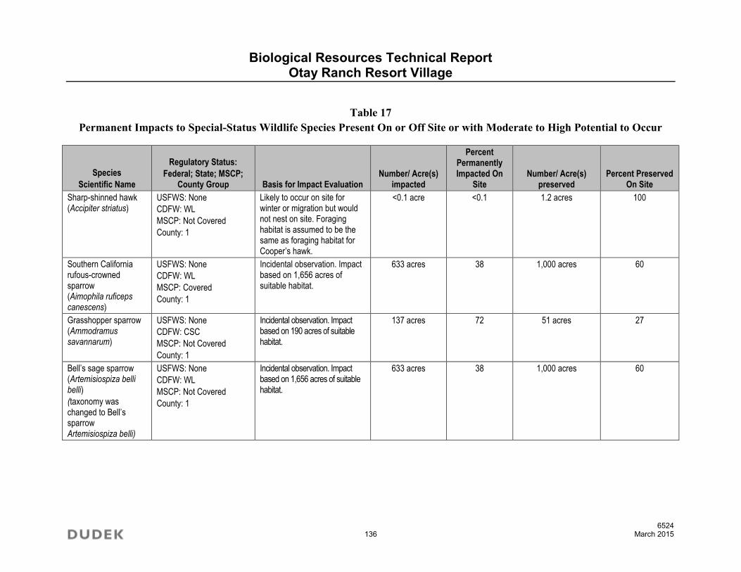
Biological Resources Technical Report Otay Ranch Resort Village
6524 136 March 2015
Table 17 Permanent Impacts to Special-Status Wildlife Species Present On or Off Site or with Moderate to High Potential to Occur
Species
Scientific Name
Regulatory Status:
Federal; State; MSCP; County Group Basis for Impact Evaluation
Number/ Acre(s) impacted
Percent Permanently Impacted On
Site Number/ Acre(s)
preserved Percent Preserved
On Site
Sharp-shinned hawk (Accipiter striatus)
USFWS: None
CDFW: WL
MSCP: Not Covered
County: 1
Likely to occur on site for winter or migration but would not nest on site. Foraging habitat is assumed to be the same as foraging habitat for Cooper’s hawk.
<0.1 acre <0.1 1.2 acres 100
Southern California rufous-crowned sparrow (Aimophila ruficeps canescens)
USFWS: None
CDFW: WL
MSCP: Covered
County: 1
Incidental observation. Impact based on 1,656 acres of suitable habitat.
633 acres 38 1,000 acres 60
Grasshopper sparrow (Ammodramus savannarum)
USFWS: None
CDFW: CSC
MSCP: Not Covered
County: 1
Incidental observation. Impact based on 190 acres of suitable habitat.
137 acres 72 51 acres 27
Bell’s sage sparrow (Artemisiospiza belli belli)
(taxonomy was changed to Bell’s sparrow Artemisiospiza belli)
USFWS: None
CDFW: WL
MSCP: Not Covered
County: 1
Incidental observation. Impact based on 1,656 acres of suitable habitat.
633 acres 38 1,000 acres 60

Biological Resources Technical Report Otay Ranch Resort Village
6524 137 March 2015
Table 17 Permanent Impacts to Special-Status Wildlife Species Present On or Off Site or with Moderate to High Potential to Occur
Species
Scientific Name
Regulatory Status:
Federal; State; MSCP; County Group Basis for Impact Evaluation
Number/ Acre(s) impacted
Percent Permanently Impacted On
Site Number/ Acre(s)
preserved Percent Preserved
On Site
Golden eagle (Aquila chrysaetos)
USFWS: BCC
CDFW: P, WL, Golden Eagle Protection Act
MSCP: Covered
County: 1
No impacts would occur to nesting habitat. Observed flying over site; likely forages on site. Impact based on 1,660 acres of suitable foraging habitat. Nests are recorded in San Diego County Bird Atlas as 3 to 6 miles away.
620 acres 37 1,015 acres 61
Red-shouldered hawk (Buteo lineatus)
USFWS: None
CDFW: None
MSCP: Not Covered
County: 1
Incidental observation. Impact based on 1.2 acres of suitable nesting and foraging habitat.
<0.1 acre <0.1 1.2 acres 100
Ferruginous hawk (Buteo regalis)
USFWS: BCC
CDFW: WL
MSCP: Covered
County: 1
Likely to occur on site for winter or migration but would not nest on site. Impact based on 79 acres of suitable foraging habitat.
60 acres 76 18 acres 23
Turkey vulture (Cathartes aura)
USFWS: None
CDFW: None
MSCP: Not Covered
County: 1
No nesting locations observed; foraging may occur but is more dependent on carrion so cannot evaluate based on acreage
Cannot be evaluated
Could forage in entire preserve
Northern harrier (Circus cyaneus)
USFWS: None
CDFW: CSC
MSCP: Covered
County: 1
Could nest on site, but is more likely to occur on site for winter or migration. Impact based on 79 acres of suitable foraging habitat.
60 acres 76 18 acres 23
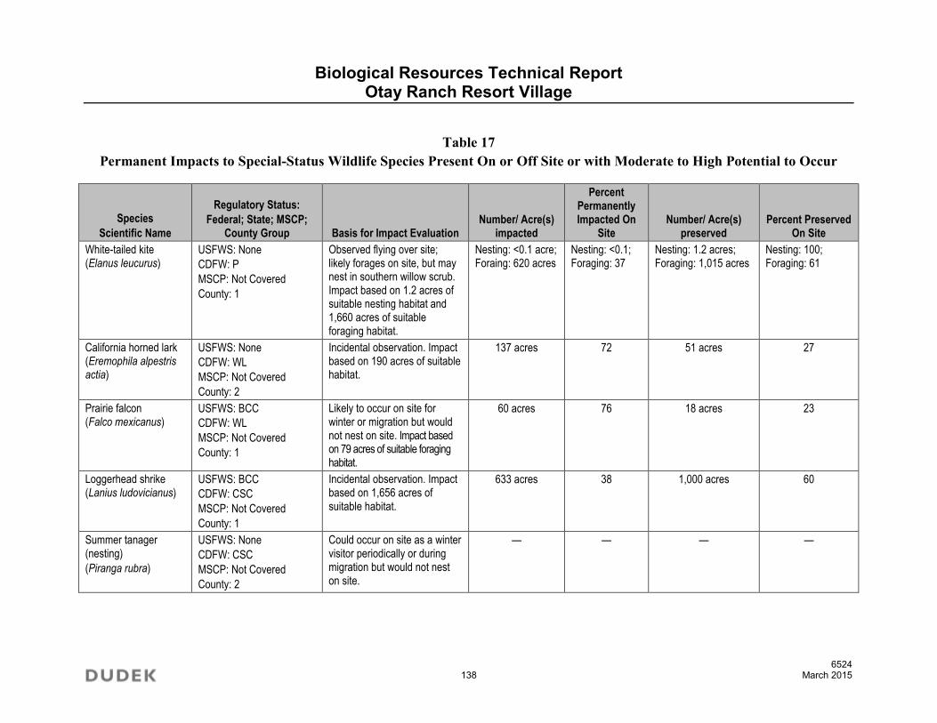
Biological Resources Technical Report Otay Ranch Resort Village
6524 138 March 2015
Table 17 Permanent Impacts to Special-Status Wildlife Species Present On or Off Site or with Moderate to High Potential to Occur
Species
Scientific Name
Regulatory Status:
Federal; State; MSCP; County Group Basis for Impact Evaluation
Number/ Acre(s) impacted
Percent Permanently Impacted On
Site Number/ Acre(s)
preserved Percent Preserved
On Site
White-tailed kite (Elanus leucurus)
USFWS: None
CDFW: P
MSCP: Not Covered
County: 1
Observed flying over site; likely forages on site, but may nest in southern willow scrub. Impact based on 1.2 acres of suitable nesting habitat and 1,660 acres of suitable foraging habitat.
Nesting: <0.1 acre; Foraing: 620 acres
Nesting: <0.1; Foraging: 37
Nesting: 1.2 acres; Foraging: 1,015 acres
Nesting: 100; Foraging: 61
California horned lark (Eremophila alpestris actia)
USFWS: None
CDFW: WL
MSCP: Not Covered
County: 2
Incidental observation. Impact based on 190 acres of suitable habitat.
137 acres 72 51 acres 27
Prairie falcon (Falco mexicanus)
USFWS: BCC
CDFW: WL
MSCP: Not Covered
County: 1
Likely to occur on site for winter or migration but would not nest on site. Impact based on 79 acres of suitable foraging habitat.
60 acres 76 18 acres 23
Loggerhead shrike (Lanius ludovicianus)
USFWS: BCC
CDFW: CSC
MSCP: Not Covered
County: 1
Incidental observation. Impact based on 1,656 acres of suitable habitat.
633 acres 38 1,000 acres 60
Summer tanager (nesting)
(Piranga rubra)
USFWS: None
CDFW: CSC
MSCP: Not Covered
County: 2
Could occur on site as a winter visitor periodically or during migration but would not nest on site.
— — — —

Biological Resources Technical Report Otay Ranch Resort Village
6524 139 March 2015
Table 17 Permanent Impacts to Special-Status Wildlife Species Present On or Off Site or with Moderate to High Potential to Occur
Species
Scientific Name
Regulatory Status:
Federal; State; MSCP; County Group Basis for Impact Evaluation
Number/ Acre(s) impacted
Percent Permanently Impacted On
Site Number/ Acre(s)
preserved Percent Preserved
On Site
Coastal California gnatcatcher
(Polioptila californica californica)
USFWS: FT
CDFW: CSC
MSCP: Covered
County: 1
Coastal sage scrub, coastal sage scrub–chaparral mix, coastal sage scrub–grassland ecotone, riparian in late summer; 29 locations are recorded on site and 3 additional locations are recorded for Cornerstone Land for a total of 32 locations recorded; 1,470 acres of suitable habitat.
483 acres; 14 locations including the locations that are impacted off-site
33% of acreage; 44% of point locations
962 acres; 18 locations
66% of acreage;
56% of point locations
Western bluebird (Sialia mexicana)
USFWS: None
CDFW: None
MSCP: Covered
County: 2
Likely to occur on site for winter or migration for foraging but would not nest on site due to lack of trees.
— — — —
Burrowing owl
(Athene cunicularia)
USFWS: BCC
CDFW: CSC
MSCP: Covered
County: 1
Incidental observation. Impact based on 190 acres of suitable habitat.
137 acres 72 51 acres 27
Barn owl (Tyto alba)
USFWS: None
CDFW: None
MSCP: Not Covered
County: 2
No impacts to nesting habitat; foraging is opportunistic and can forage throughout much of the site where habitat is relatively open.
Assuming foraging occurs in open habitat, 190 acres are present on site.
137 acres 72 51 acres 27

Biological Resources Technical Report Otay Ranch Resort Village
6524 140 March 2015
Table 17 Permanent Impacts to Special-Status Wildlife Species Present On or Off Site or with Moderate to High Potential to Occur
Species
Scientific Name
Regulatory Status:
Federal; State; MSCP; County Group Basis for Impact Evaluation
Number/ Acre(s) impacted
Percent Permanently Impacted On
Site Number/ Acre(s)
preserved Percent Preserved
On Site
Dulzura California pocket mouse
(Chaetodipus californicus femoralis)
USFWS: None
CDFW: CSC
MSCP: Not Covered
County: 2
Based on moderate potential to occur. Impact based on 1,656 acres of suitable habitat.
633 acres 38 1,000 acres 60
Northwestern San Diego pocket mouse
(Chaetodipus fallax fallax)
USFWS: None
CDFW: CSC
MSCP: Not Covered
County: 2
Based on moderate potential to occur. Impact based on 1,656 acres of suitable habitat.
633 acres 38 1,000 acres 60
Townsend’s western big-eared bat
(Corynorhinus townsendii)
USFWS: None
CDFW: CSC
MSCP: Not Covered
County: 2
Likely to occur on site to forage but no roosting/nursery habitat is present.
— — — —
Spotted bat (Euderma maculatum)
USFWS: None
CDFW: CSC
MSCP: Not Covered
County: 2
Likely to occur on site to forage but no roosting/nursery habitat is present.
— — — —
Western red bat (Lasiurus blossevillii)
USFWS: None
CDFW: CSC
MSCP: Not Covered
County: 2
Likely to occur on site to forage but no roosting/nursery habitat is present.
— — — —
San Diego black-tailed jackrabbit
(Lepus californicus bennettii)
USFWS: None
CDFW: CSC
MSCP: Not Covered
County: 2
Incidental observation. Impact based on 1,660 acres of suitable habitat.
620 acres 37 1,015 acres 61

Biological Resources Technical Report Otay Ranch Resort Village
6524 141 March 2015
Table 17 Permanent Impacts to Special-Status Wildlife Species Present On or Off Site or with Moderate to High Potential to Occur
Species
Scientific Name
Regulatory Status:
Federal; State; MSCP; County Group Basis for Impact Evaluation
Number/ Acre(s) impacted
Percent Permanently Impacted On
Site Number/ Acre(s)
preserved Percent Preserved
On Site
San Diego desert woodrat
(Neotoma lepida intermedia)
USFWS: None
CDFW: CSC
MSCP: Not Covered
County: 2
Based on moderate potential to occur. Impact based on 1,656 acres of suitable habitat.
633 acres 38 1,000 acres 60
Mountain lion
(Puma concolor)
USFWS: None
CDFW: None
MSCP: Covered
County: 2
Incidental observation of tracks. No suitable denning locations would be impacted, and movement routes and corridors would be preserved.
— — — —

Biological Resources Technical Report Otay Ranch Resort Village
6524 142 March 2015
Of 71 observations of individuals of Quino checkerspot butterfly from the 2008 surveys in the project area (obvious duplicate observations documented by photographs or notes were removed), 12 observation locations will be directly impacted (Impact BIO-9). Based on the overall surveys conducted on the site, approximately 17% of the population will be impacted. In general, the ridgelines and hilltops in the northern and eastern portion of the site where the Quino checkerspot butterfly has been observed most frequently will be preserved. The project would permanently impact 483 acres of critical habitat for this species (Figures 25 and 26). The total acreage of critical habitat within the Otay Unit is 1,782 acres of which the impact for the proposed project is 27%. The proposed Project would result in 483 acres of impacts to Quino checkerspot butterfly habitat. The proposed MSCP Subarea Plan Quino Checkerspot Butterfly Amendment (Quino Amendment), which has been used as guidance for this analysis, would require 2:1 preservation of suitable habitat for impacts to Quino checkerspot butterfly, for a total of 966 acres. The project proposes to include 962-acres of suitable or occupied coastal sage scrub and 4 additional acres of Quino checkerspot butterfly habitat restoration equaling 966 acres of total Quino habitat mitigation, meeting the proposed Quino Amendment mitigation ratio. This acreage is available on site within the proposed Preserve. In addition, as noted in Section 4, the project proposed a Boundary Line Adjustment to improve the preservation of Quino checkerspot butterflies and their habitat. However, because the Quino Amendment has not been adopted, impacts to Quino checkerspot butterfly individuals and potentially occupied habitat are considered significant absent mitigation (Impact BIO-9).
Other sensitive wildlife species significantly impacted by the project include San Diego fairy shrimp within one pool on the K6 mesa, rosy boa (Charina trivirgata), orangethroat whiptail (Aspidoscelis hyperythra), coastal whiptail (Aspidoscelis tigris stejnegeri), San Diego banded gecko (Coleonyx variegatus), San Diego [coast or Blainville’s] horned lizard, coast patch-nosed snake (Salvadora hexalepis virgultea), red-diamond rattlesnake, Southern California rufous-crowned sparrow, grasshopper sparrow (Ammodramus savannarum), Bell’s sparrow, California horned lark, loggerhead shrike (Lanius ludovicianus), coastal California gnatcatcher (14 of 32 on and off-site historically mapped locations will be impacted by the project), burrowing owl, nesting bird species that are covered under the Migratory Bird Treaty Act (generally includes all native bird species regardless of whether they are considered to be of special status), Dulzura California pocket mouse (Chaetodipus californicus femoralis), San Diego black-tailed jackrabbit, northwestern San Diego pocket mouse (Chaetodipus fallax fallax), and San Diego desert woodrat (Neotoma lepida intermedia).

NotA
Par t
CORB
OTWT
WESP
HOLA
HOLA
BUOW
HOLI
POTU
GOEA
GRSP
GOEA
HOLA
HOLA
GOEAHOLI
RCSP
RCSP
HOLI
HOLINOHA
GRSP
BTJR
BTJR
HOLI
NRDR
BSGSP
Copyright:' 2011 National Geographic Society, i-cubed
Project Boundary
Proposed Development Footprint
Revegetated Slopes or Basins
Proposed Off-Site Impacts
SOURCE: USGS 7.5 Minute Series, Jamul Mountains Quadrangle
0 1,000Feet
Quino Checkerspot Butterfly (2008)
Quino Checkerspot Butterfly (2004)
Quino Checkerspot Butterfly (2000)
Quino Checkerspot Butterfly (1999)
Dudek QCB Survey Results
California Gnatcatcher MSCP Data
Other Sensitive Wildlife Species (Dudek)BSGSP= Bell’s sage sparrow
BTJR= Black-tailed jackrabbit
BUOW= Burrowing owl
CORB= Coastal rosy boa
GOEA= Golden eagle
GRSP= Grasshopper sparrow
HOLA= Horned lark
HOLI= Horned lizard
NOHA= Northern harrier
NRDR= Northern red-diamond rattlesnake
OTWT= Orange-throated whiptail
POTU= Pond Turtle
RCSP= Rufous-crowned sparrow
WESP= Western spadefoot
FIGURE 24
Sensitive Wildlife Species Map with Proposed Development FootprintOtay Ranch Resort Village Site - Biological Resources Technical ReportDo
cume
nt Pa
th: Z
:\Pro
jects\
j6524
01\M
APDO
C\MA
PS\B
io Fig
s\Bio
Figs 2
014-
10\F
ig24_
wildl
ife+im
pacts
.mxd
6524

Biological Resources Technical Report Otay Ranch Resort Village
6524 144 March 2015
INTENTIONALLY LEFT BLANK

SOURCE: USGS 7.5 Minute Series, Jamul Mountains Quadrangle 0 2,000Feet
Project Boundary
Final Critical Habitat
Proposed Development Footprint
FIGURE 25
QCB Proposed Critical Habitat
Otay Ranch Resort Village Site - Biological Resources Technical Report6524
Docu
ment
Path:
Z:\P
rojec
ts\j65
2401
\MAP
DOC\
MAPS
\Bio
Figs\B
io Fig
s 201
4-10
\Fig2
5_QC
B_cri
t_hab
.mxd

Biological Resources Technical Report Otay Ranch Resort Village
6524 146 March 2015
INTENTIONALLY LEFT BLANK

SOURCE: USGS 7.5 Minute Series, Jamul Mountains Quadrangle0 2,000
Feet
Quino Checkerspot Butterfly Obseravations (2008)
Common Owl’s clover
Dot-seed plantain
Dot-seed plantain - polygon
Project Boundary
Proposed Development Footprint
Revegetated Slopes or Basins
Proposed Off-Site Impacts
FIGURE 26
Quino Checkerspot Butterfly Observations and Host Plant LocationsOtay Ranch Resort Village Site - Biological Resources Technical Report
6524
Docu
ment
Path:
Z:\P
rojec
ts\j65
2401
\MAP
DOC\
MAPS
\Bio
Figs\B
io Fig
s 201
4-10
\Fig2
6_QC
B_Ob
s_an
d_Ho
st_Pl
ants.
mxd

Biological Resources Technical Report Otay Ranch Resort Village
6524 148 March 2015
INTENTIONALLY LEFT BLANK

Biological Resources Technical Report Otay Ranch Resort Village Site
6524 149 March 2015
Impacts to foraging habitat will occur to the golden eagle. A total of 1,660 acres of potential foraging habitat are present on the site. Potential impacts to foraging due to the proposed project will occur to 620 acres. A total of 1,015 acres of foraging habitat will be preserved on site. This is preservation of 61% of the foraging habitat on site. With the implementation of the Otay Ranch RMP and associated conveyance of preserve land, the impacts are less than significant due to the 1,089 acres of preserve land retained on site.
While it should be noted that 97% of the San Diego fairy shrimp will be preserved, which exceeds the requirements of the Otay Ranch RMP to preserve 95%, impacts to San Diego fairy shrimp would be considered significant absent mitigation because they are a non-covered species (Impact BIO-10). Impacts to migratory birds under the Migratory Bird Treaty Act would also be considered a significant impact absent mitigation (Impact BIO-11)
Conservation provided through the Otay Ranch RMP (Appendix G) and MSCP Subarea Plan conformance/equivalency would provide mitigation for direct impacts to covered sensitive species to a less-than-significant level. These species include orange-throated whiptail, San Diego [coast; Blainville’s] horned lizard, Southern California rufous-crowned sparrow, coastal California gnatcatcher (18 of 32 (on and off site) historically mapped locations will be preserved by the project, which is 56% of pairs and exceeds the Otay Ranch RMP requirement of 52%), and burrowing owl.
Several sensitive species listed as “detected” or “likely to occur” in the project area are not classified as “covered species” by the MSCP Subarea Plan but are addressed by the Otay Ranch RMP and include ranch-wide preservation goals. These species include: rosy boa, coastal whiptail, San Diego banded gecko, coast patch-nosed snake, red-diamond rattlesnake, grasshopper sparrow, Bell’s sparrow, California horned lark, loggerhead shrike, Dulzura California pocket mouse, northwestern San Diego pocket mouse, San Diego black-tailed jackrabbit, and San Diego desert woodrat. In addition, none of these species is state- or federally listed, and all have a relatively low level of sensitivity. Therefore, the project’s contribution to the MSCP and Otay Ranch RMP preserve would mitigate impacts by providing suitable habitat in a configuration that preserves genetic exchange and species viability. Thus, direct impacts to non-covered sensitive wildlife species, with the exception of Quino checkerspot butterfly, are reduced to a less-than-significant level by virtue of the biological mitigation measures provided by the Otay Ranch RMP.
Impacts to other County-sensitive wildlife, including but not limited to western spadefoot, western pond turtle (Emys marmorata), San Diego ringneck snake (Diadophis punctatus similis), two-striped garter snake (Thamnophis hammondi), and sharp-shinned hawk, red-shouldered hawk (Buteo lineatus), ferruginous hawk (Buteo regalis), turkey vulture, prairie falcon (Falco mexicanus),
Biological Resources Technical Report Otay Ranch Resort Village Site
6524 150 March 2015
summer tanager (Piranga rubra), western bluebird (Sialia mexicana), barn owl (Tyto alba), Townsend’s western big-eared bat (Corynorhinus townsendii), spotted bat (Euderma maculatum), western red bat (Lasiurus blossevillii), and mountain lion (Puma concolor) are less than significant due to the avoidance, small amount of impacts, or the lack of use of the site for breeding.
5.1.6 Habitat Linkages/Movement Corridors
Currently the project area functions as part of a large habitat block and would not be considered a habitat linkage or wildlife corridor as discussed in Section 3.5.4. However, a portion of the project site was previously identified (Ogden 1992b) as a habitat linkage or movement corridor. This linkage is situated north–south through the eastern portion of the project site and is identified as the R2 linkage. This should be considered a general guideline within the context of the property and surrounding land uses.
As shown in Figure 13, the project site is surrounded by a variety of public lands: at least 22,000 acres of the Otay Ranch Preserve, BLM, and USFWS lands to the north; at least 9,000 acres of the Otay Ranch Preserve, USFWS, MSCP Preserve, BLM, and CDFW lands to the east; and, at least 31,000 acres of the Otay Ranch Preserve, MSCP Preserve, CDFW, and BLM lands to the south. Combined, this is a total of 62,000 acres of open space in the form of preserves and public lands.
The goal for wildlife movement on the site is to convey the focal species, including mountain lion, mule deer, bobcat, and coyote, across the internal roads and Otay Lakes Road; maintain suitable dimensions for the movement of these species; and enable movement of Quino checkerspot butterfly to resources within the project site and to off-site areas.
Proposed open space in the northern portion of the project site will preserve an east–west movement corridor and habitat linkage across the northern portion and ridgelines of the property. Two primary north/south linkages are proposed on site. The previously identified R2 corridor (Figure 13; “B”) follows the steeply sloped canyon and ridgeline west of the prominent hilltop. This corridor includes the south face of the prominent hilltop, and steep slopes along the northeast border of the Project site. Within this proposed corridor, the steep canyon west of the prominent hilltop narrows to approximately 600 feet wide and is crossed by one proposed local two-lane roadway, as well as existing Otay Lakes Road. Currently there is no culvert under Otay Lakes Road in this location to facilitate movement of large animals.
The second north/south movement corridor occurs within the middle portion of the Project site and is proposed to function as a local corridor (Figure 13; “A”). This corridor narrows to approximately 1,200 feet and is crossed by one, two-lane local roadway, as well as existing Otay
Biological Resources Technical Report Otay Ranch Resort Village Site
6524 151 March 2015
Lakes Road. As with the R2 corridor, there is no culvert under Otay Lakes Road in this location to facilitate movement of large animals.
Additionally, an approximately 300-foot-wide swath along the far eastern boundary of the Project site continues off-site in a large area of open space lands, is proposed for inclusion in the Otay Ranch Preserve and would contribute to the preservation of north/south wildlife movement across that portion of the site (Figure 13; “C”). The 300-foot-wide swath narrows at the property limits; however, it is situated directly adjacent to USFWS lands, and the rest of the length is situated adjacent to other Preserve lands.
In order to convey animals from the open space Preserve areas in the north portion of the project site to the City of San Diego Cornerstone Lands south of Otay Lakes Road, the project proposes four wildlife culverts.
Requirements for culverts or wildlife undercrossing, according to the MSCP Subarea Plan includes minimizing roads that cross wildlife corridors, installation of fencing that channels wildlife to underpasses or culverts, design of the underpass such that the length-to-width ratio is less than 2, use of bridges rather than tunnels, installation of sound insulation, including a natural substrate that is vegetated, provision of line-of-sight through the tunnel, and inclusion of low-level illumination if needed.
The Project applicants shall implement the following Project design features as conditions of the Specific Plan and Tentative Maps. Impacts to wildlife movement are considered significant and the project shall implement the features as discussed below (Impact BIO-12) to reduce these impacts to less than significant.
The Project includes a modification of Otay Lakes Road to accommodate wildlife under-crossings toward the eastern end of Lower Otay Lake. The under-crossings are designed to provide sufficient light to encourage use.
The analysis of the wildlife crossings is provided in detail in Section 4.3 and depicted in Figures 14–18. These figures illustrate the location of the crossings/culverts and the dimensions. In addition, a cross section of the opening is provided to illustrate the size and shape of the culvert. In general, the design of the wildlife culverts has been developed to be consistent with the MSCP Subarea Plan and also to be consistent with the scientific literature to the maximum extent practical.
The proposed wildlife crossings/culverts have adequate configuration, bottom surface, size, and openness ratios to accommodate the movement of focal wildlife species. The crossings at the

Biological Resources Technical Report Otay Ranch Resort Village Site
6524 152 March 2015
more eastern location no. 2 are especially important since they are located in the previously identified R2 wildlife corridor and provide a direct connection to high quality riparian habitat.
As discussed above in Section 4.2, for Quino checkerspot butterfly, large areas on site are suitable for their movement. Host plant for the larvae is abundant, and ridgelines, hilltops, and area where the butterfly has been observed are all preserved. There is viable movement potential to the east to provide connection of the on-site population with other populations within the region. These linkages will provide adequate movement for medium and large mammals, birds, and butterflies and nearly replicate the linkages designated by Ogden. Therefore, in conjunction with the wildlife culverts incorporated into the project design as project design features, the project is not anticipated to impact long-term wildlife movement between the Jamul Mountains and the San Ysidro Mountains. Thus, impacts to wildlife movement/habitat linkages are less than significant.
5.1.7 Regional Plan Compliance
County of San Diego MSCP Subarea Plan
The project site is within the MSCP Subarea Plan. The MSCP Subarea Plan originally designated approximately 1,115 acres for preserve and approximately 754 acres of development.
Subsequent to the adoption of the MSCP Subarea Plan, the Agencies requested the project applicants to consider re-designing the project to better accommodate certain non-covered species including the Quino checkerspot butterfly, vernal pools (in particular the K8 complex) and the San Diego Fairy Shrimp.
As described in Section 4, the project proposes an MSCP Boundary Adjustment to modify the development area to achieve an overall greater preserve configuration. The resulting preserve is 1,089 acres, approximately 18 acres less than the existing Preserve. However, in order to make a finding of biologically equivalency between the proposed preserve to the existing MSCP Preserve, the project includes several important components. First, the project design achieves conservation of higher value resources. The revised project footprint reduces the number of impacts Quino checkerspot butterfly by thirteen locations. In addition, the revised footprint maintains an important ridgeline in the central portion of the Project site that supports dot seed plantain, the Quino checkerspot butterfly host plant.
Redesigning the project also provided for conservation of the K8 vernal pools in the south-central portion of the project site. These pools are known to be occupied by San Diego fairy shrimp. These pools were previously shown within development under the existing MSCP.

Biological Resources Technical Report Otay Ranch Resort Village Site
6524 153 March 2015
The re-design also allows for better habitat linkages/wildlife movement by providing a second wildlife corridor through the central portion of the project site. This corridor, as well as the R2 linkage, are enhanced by the project with the inclusion of wildlife culverts under Otay Lakes Road to facilitate movement of wildlife from open space preserve areas north of the project to City of San Diego Cornerstone Lands south of the project. The culverts were not anticipated by the original MSCP. Their cost is equivalent to approximately 14.4 acres of Preserve land.
Finally, the project includes an additional 10.2 acres to be dedicated to the Preserve. This parcel has been reviewed by the Wildlife Agencies and was determined to be acceptable to add to the Preserve. Thus the project would provide not only for a biologically equivalent preserve design; it would also result in the equivalent of 1099.5 acres of Preserve and therefore is consistent with the MSCP Subarea Plan. The Boundary Adjustment achieves functional equivalency per the MSCP Regional Plan requirements as described in Section 4.0.
Otay Ranch Resource Management Plan
The Otay Ranch RMP and the Otay Ranch Preserve serve as the basis for CEQA mitigation of biological impacts identified in the Otay SRP Program EIR. The Otay Ranch RMP includes conveyance procedures for dedicating parcels of land to the Otay Ranch Preserve. The RMP establishes an obligation for each new development to convey its fair share of the Otay Ranch Preserve. Fair share contribution requirements are established in the RMP as a proportion of ranch-wide development to ranch-wide preserve land. The RMP established a fair share contribution to the creation of the Preserve as a ratio of 1.188 acres of preserve conveyance required for every one (1.000) acre of development. Accordingly, the conveyance ratio for all development is 1.188 acres for each acre of project development area, excluding development areas that include “common uses,” such as schools, parks, and arterial roadways. These “common use” areas are excluded from the required mitigation/conveyance. The Otay Ranch RMP was incorporated into the County’s MSCP Subarea Plan. A project’s compliance with the RMP constitutes its compliance with the County’s MSCP. The Resort Village project would have significant impacts related to biological resources unless the Otay Ranch Preserve is assembled proportionally and concurrently with development in accordance with provisions of the County’s MSCP Subarea Plan via compliance with the Otay Ranch RMP.
As shown in Table 11, the proposed project permanently impacts a total of approximately 779 acres (excluding temporary impacts to slopes that will be revegetated or infrastructure uses permitted within the preserve). Of this amount, common uses include 20.7 acres of public parks, the 10.0-acre elementary school, and the 2.1-acre public safety site. Thus, the overall number of Developable Acres subject to the RMP preserve conveyance ratio of 1.188 is 747.2 acres. Therefore, the 747.2 acres of developable land within the Resort Village is subject to a

Biological Resources Technical Report Otay Ranch Resort Village Site
6524 154 March 2015
conveyance obligation of 887.7 acres (747.2 acres x 1.188 = 887.7 acres). Conveyance of the required amount of RMP Preserve land will be achieved through on-site conveyance of the designated Resort Village Preserve, which was agreed to through discussions and consultations with the resource agencies. It should be noted that the Otay Ranch RMP does not require that conveyance of preserve land occur within the Specific Plan boundaries, as it is a ranch-wide obligation, and the RMP allows for conveyance of land anywhere within the Otay Ranch Preserve. Nevertheless, the Resort Village Project will meet its RMP preserve conveyance obligation on site. In fact, the Project’s MSCP hardline boundary would ultimately establish a preserve area of 1,089 acres in size.
In summary, the Otay Ranch RMP conveyance obligation is the required fair-share mitigation based on the Otay Ranch RMP and the MSCP. The total acreage of the Resort Village Preserve is a function of the boundaries of the Specific Plan Area. Upon conveyance of 887.7 acres to the Otay Ranch Preserve, the Resort Village project will be consistent with the Otay Ranch RMP conveyance requirement. The difference between the conveyance requirement (887.7 acres) and the Project’s MSCP hardline boundary (1,089 acres), approximately 201.3 acres, is available to meet conveyance or other preserve mitigation obligations for other Otay Ranch impacts.
The Otay Ranch RMP also established required preservation ratios for the entire Otay Ranch. Section 5.1.4 above and Section 6.2 below, describe how the project in combination with the greater Otay Ranch Preserve, achieve these conservation requirements. Based on the on-site and cumulative Otay Ranch conservation of selected species, the project is consistent with the requirements of the Otay Ranch RMP.
5.2 Indirect Impacts
5.2.1 Vegetation Communities
Indirect impacts to vegetation communities primarily would result from adverse “edge effects,” as cited above. During construction of the project, edge effects to vegetation communities may include dust, which could disrupt plant vitality in the short term, or construction-related soil erosion and runoff. Long-term indirect impacts on vegetation communities most likely would occur as a result of trampling of vegetation by humans and domestic pets, invasion by exotic species, alteration of the natural fire regime, and exposure to urban pollutants.
The Project applicants shall implement the following Project design features as conditions of the Specific Plan and Tentative Maps to avoid indirect impacts to natural vegetation communities (Impact BIO-13 and BIO-14):

Biological Resources Technical Report Otay Ranch Resort Village Site
6524 155 March 2015
During construction, material stockpiles shall be covered when not in use. This will prevent fly-off that could damage nearby sensitive plant communities. During grading and construction, graded areas shall be periodically watered to minimize dust affecting adjacent vegetation.
A Stormwater Pollution Prevention Plan (SWPPP) shall be developed, approved, and implemented during construction to control stormwater runoff such that erosion, sedimentation, pollution, etc., are minimized. Measures that may be incorporated into the plan include use of silt fencing, hay bales, and straw wattles. The SWPPP shall be approved by the San Diego County Department of Planning and Development Services.
During Project operation, all recreational areas that use chemicals or animal by-products, such as manure, that are potentially toxic or impactive to sensitive habitats or plants shall incorporate methods on-site to reduce impacts caused by the application and/or drainage of such materials into Preserve areas.
No invasive non-native plant species shall be introduced into areas immediately adjacent to the Preserve. All slopes immediately adjacent to the Preserve shall be planted with native species that reflect the adjacent native habitat.
During construction, material stockpiles shall be placed such that they cause minimal interference with on-site drainage patterns. This will protect sensitive vegetation from being inundated with sediment-laden runoff.
Dewatering shall be conducted in accordance with standard regulations of RWQCB. A National Pollutant Discharge Elimination System (NPDES) permit, issued by RWQCB to discharge water from dewatering activities, shall be required prior to start of construction. This will minimize erosion, siltation, and pollution within sensitive communities.
Design of drainage facilities shall incorporate long-term control of pollutants and stormwater flow to minimize pollution and hydrologic changes. An Urban Runoff Plan and operational BMPs shall be approved by the San Diego County Department of Planning and Development Services prior to construction.
Grading and/or improvement plans shall include the requirement that a fencing and signage plan be prepared and that permanent fences or walls be placed along the open space boundaries. Placement of permanent fencing or walls is required at the conclusion of the grading activity and prior to Record Plan approval.
Submit to the Director of the Department of Planning and Development Services and to the Director of Parks and Recreation evidence that permanent signs have been placed to protect all open space easements in accordance with the open space

Biological Resources Technical Report Otay Ranch Resort Village Site
6524 156 March 2015
signage exhibit that will be placed on file with the Department of Planning and Development Services as Environmental Review Number 04-19-005.
A hydroseed mix that incorporates native species, is appropriate to the area, and is without invasives shall be used for slope stabilization in transitional areas.
Peruvian pepper trees and other invasive vegetation would not be planted in streetscapes, or within 50 feet of the Preserve, where they could impact native habitat.
Implementation of these features avoids indirect impacts to natural vegetation communities.
5.2.2 Jurisdictional Waters
Indirect, adverse edge effects to jurisdictional waters include potential runoff, sedimentation, erosion, exotics introduction, and habitat-type conversion in the short and long term, particularly within waterways that drain into Otay Lakes. Indirect impacts to jurisdictional waters are considered significant absent mitigation (Impact BIO-13).
5.2.3 Vernal Pools
Indirect adverse edge effects to vernal pools located on the K8 mesa include potential runoff, sedimentation, erosion, and exotics introduction. Indirect impacts to vernal pools are considered significant absent mitigation (Impact BIO-13).
5.2.4 Sensitive Plant Species
Most of the indirect impacts to vegetation communities cited above can also affect sensitive plants. Of particular sensitivity is the preserved population of San Diego thornmint, adjacent to the Otay Lakes Road, in the west–central portion of the site. During construction of the project, indirect effects may include dust, which could disrupt plant vitality in the short term, or construction-related soil erosion and runoff. Long-term edge effects could include intrusions by humans and domestic pets and possible trampling of individual plants, invasion by exotic plant and wildlife species, exposure to urban pollutants (fertilizers, pesticides, herbicides, and other hazardous materials), soil erosion, litter, fire, and hydrologic changes (e.g., surface and groundwater level and quality).
The Project applicants shall implement the Project design features listed in Section 5.2.1 as conditions of the Specific Plan and Tentative Maps to avoid indirect impacts to sensitive plant species (Impact BIO-14).
Implementation of these features avoids indirect impacts to sensitive plant species.
Biological Resources Technical Report Otay Ranch Resort Village Site
6524 157 March 2015
5.2.5 Sensitive Wildlife Species
Short-term indirect impacts to sensitive nesting bird species include construction noise impacts. Species potentially affected by such activities include, but are not limited to, coastal California gnatcatcher and nesting raptors. Indirect impacts to sensitive bird species may occur if construction is conducted during the breeding season for coastal California gnatcatcher (February 15 to August 15) and raptors (January 15 to July 31). Long-term indirect impacts to sensitive wildlife species would also occur as a result of the project. Impacts would consist of lighting, human activity in the preserve, noise, and domestic animal predation.
The Project applicants shall implement the following Project design features as conditions of the Specific Plan and Tentative Maps to avoid indirect impacts to sensitive wildlife species (Impact BIO-15):
No clearing, grading, or grubbing activities may occur within occupied gnatcatcher habitat during the breeding season for coastal California gnatcatcher (February 15 to August 15, annually). If construction occurs during the breeding season, a nesting survey for California gnatcatcher shall be conducted prior to the onset of construction and construction may occur if active nests can be avoided and provided an adequate buffer or noise levels are documented to be below 60 dBA Leq at the nest site.
When clearing, grading, or grubbing activities occur during the breeding season for raptors (January 15 to July 31, annually), nesting bird surveys shall be conducted by a qualified biologist for the San Diego County Department of Planning and Development Services to identify active nest locations. Construction activities shall be restricted or modified such that noise levels related to those activities are below 60 dBA Leq, or other Wildlife Agency approved restrictions, in the vicinity of the active nest site.
Lighting of all developed areas adjacent to the preserve shall be directed away from the preserve, wherever feasible and consistent with public safety. Where necessary, development shall provide adequate shielding with non-invasive plant materials (preferably native), berming, and/or other methods to protect the preserve and sensitive species from night lighting. Consideration shall be given to the use of low-pressure sodium lighting.
Uses in or adjacent to the preserve shall be designed to minimize noise impacts. Berms or walls shall be constructed adjacent to commercial areas and any other use that may introduce noises that could impact or interfere with wildlife utilization of the preserve. Excessively noisy uses or activities adjacent to breeding areas must incorporate noise-reduction measures or be curtailed during the breeding season of sensitive bird species.

Biological Resources Technical Report Otay Ranch Resort Village Site
6524 158 March 2015
Grading and/or improvement plans shall include the requirement that a fencing and signage plan be prepared and that permanent fences or walls be placed along the open space boundaries. Placement of permanent fencing or walls is required at the conclusion of the grading activity and prior to Record Plan approval.
Submit to the Director of the Department of Planning and Development Services and Director of Parks and Recreation evidence that permanent signs have been placed to protect all open space easements in accordance with the open space signage exhibit that will be placed on file with the Department of Planning and Development Services as Environmental Review Number 04-19-005.
Implementation of these features avoids indirect impacts to sensitive wildlife species.
5.2.6 Habitat Linkages/Movement Corridors
As discussed in Section 5.1.6, the project site is currently part of a large habitat block, but the corridor/linkage between the Jamul Mountains and San Ysidro Mountains through the eastern portion of the project site would be limited by the proposed development (Figure 16). The proposed land uses in this area include a resort, single-family housing, and two roadways. Three north–south linkages are provided by the project and should serve to convey wildlife.
The Project applicants shall implement the following Project design features as conditions of the Specific Plan and Tentative Maps to avoid indirect impacts to wildlife movement/habitat linkages (Impact BIO-14):
During construction, material stockpiles shall be covered when not in use. This will prevent fly-off that could damage nearby sensitive plant communities. During grading and construction, graded areas shall be periodically watered to minimize dust affecting adjacent vegetation.
A Stormwater Pollution Prevention Plan (SWPPP) shall be developed, approved, and implemented during construction to control stormwater runoff such that erosion, sedimentation, pollution, etc., are minimized. Measures that may be incorporated into the plan include use of silt fencing, hay bales, and straw wattles. The SWPPP shall be approved by the San Diego County Department of Planning and Development Services.
During Project operation, all recreational areas that use chemicals or animal by-products, such as manure, that are potentially toxic or impactive to sensitive habitats or plants shall incorporate methods on-site to reduce impacts caused by the application and/or drainage of such materials into Preserve areas.

Biological Resources Technical Report Otay Ranch Resort Village Site
6524 159 March 2015
No invasive non-native plant species shall be introduced into areas immediately adjacent to the Preserve. All slopes immediately adjacent to the Preserve shall be planted with native species that reflect the adjacent native habitat.
During construction, material stockpiles shall be placed such that they cause minimal interference with on-site drainage patterns. This will protect sensitive vegetation from being inundated with sediment-laden runoff.
5.3 Cumulative Impacts
Implementation of the proposed project would contribute to the cumulative loss of biological resources within Otay Ranch and the County of San Diego MSCP Subarea Plan. Impacts to sensitive resources are all identified and addressed by the Otay Ranch RMP and MSCP Subarea Plan for covered species and species addressed in the Otay Ranch RMP. The exceptions to these are the Quino checkerspot butterfly, vernal pools, and San Diego fairy shrimp, which are not covered biological resources.
Both the Otay Ranch RMP and the MSCP Subarea Plan provide mitigation for cumulative impacts to biological resources. The Otay Ranch RMP and MSCP were specifically designed to ensure that the cumulative impacts to biological resources from development in this area, including the proposed project, are reduced to a less-than-significant level. The Otay Ranch RMP specifically provided the outline of the CEQA mitigation required by the Otay SRP Program EIR. Although portions of the project would designate open space, which is in addition to existing planned preserves, encroachment into both the Otay Ranch RMP and MSCP Subarea Plan preserves requires a demonstration that the modified preserve would provide for an equal or higher level of biological value. As analyzed in Section 4.0, the proposed reconfiguration of the preserve provides for an improved preservation of biological value and preserve design compared to the original preserve; therefore, significant cumulative impacts related to losses of habitats and species covered by the MSCP Subarea Plan and Otay Ranch RMP would be reduced to a less-than-significant level.
Cumulative impacts to non-covered species are not addressed by the MSCP or the Otay Ranch RMP. Hence the significant impacts to Quino checkerspot butterfly, vernal pools, and San Diego fairy shrimp may result in cumulatively significant impacts. A review of projects within the MSCP Subarea Plan South County Segment was conducted to evaluate the cumulative impact of the proposed project on these resources.
It was determined that there is one past, present, or foreseeable future project within the cumulative study area that includes vernal pools: Otay Ranch Villages 14, 16, and 19 (Figure 27). Village 14 is designated for 829 acres of development; Village 16 is designated for 1,117
Biological Resources Technical Report Otay Ranch Resort Village Site
6524 160 March 2015
acres of development and Village 19 is designated for 20 acres of development. These villages contain vernal pools and a population of fairy shrimp that has not been surveyed or quantified as yet. The impact and mitigation also has not been defined. The proposed project may result in impacts to vernal pools and San Diego fairy shrimp, however the cumulative impact cannot be defined at this time since there is no information available for the cumulative projects. In addition, as described in Section 5.1.3, the Otay Ranch RMP required preservation of 95% of vernal pools. As shown in Table 15, the overall Otay Ranch project area, including the proposed project, are achieving a 97.8% conservation ratio for vernal pools. The required mitigation measures listed below will address the direct impacts to these resources and will provide not only for no net loss of vernal pool habitat but will increase the total acreage of restored vernal pools and will provide for increased habitat for the San Diego fairy shrimp. Thus, potential cumulative impacts to vernal pools and the San Diego fairy shrimp are considered less than significant.
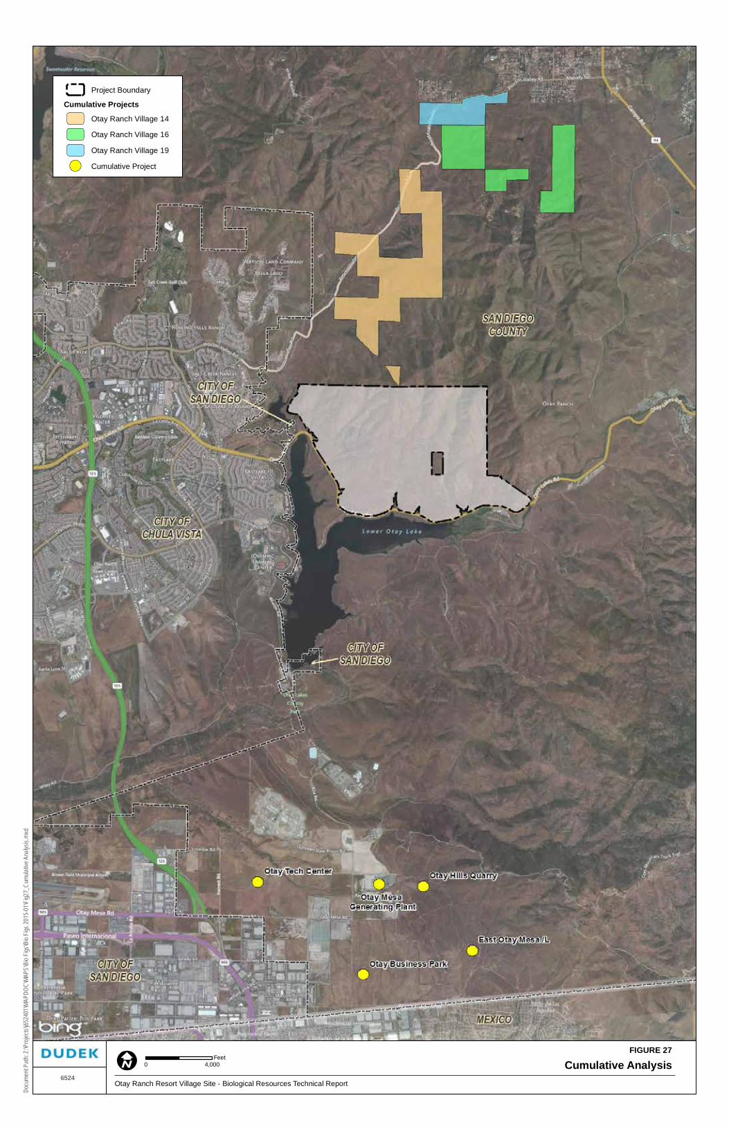
FIGURE 27
Cumulative AnalysisOtay Ranch Resort Village Site - Biological Resources Technical Report
6524
Docu
ment
Path:
Z:\P
rojec
ts\j65
2401
\MAP
DOC\
MAPS
\Bio
Figs\B
io Fig
s 201
5-01
\Fig2
7_Cu
mulat
ive A
nalys
is.mx
d
Project Boundary
Cumulative Projects
Otay Ranch Village 14
Otay Ranch Village 16
Otay Ranch Village 19
Cumulative Project
0 4,000Feet

Biological Resources Technical Report Otay Ranch Resort Village Site
6524 162 March 2015
INTENTIONALLY LEFT BLANK

Biological Resources Technical Report Otay Ranch Resort Village Site
6524 163 March 2015
Absent mitigation, the project would result in significant impacts to the Quino checkerspot butterfly and its habitat. This same impact, if not mitigated, would constitute a cumulatively considerable contribution to cumulative effects on Quino checkerspot butterfly. As shown below, however, proposed mitigation measures will preserve 966 acres of Quino checkerspot butterfly habitat, including 962 acres of preservation and 4 acres of restoration on site, and the proposed boundary line adjustment will result in a net gain of 13 Quino checkerspot butterfly sighting areas within the preserve due to the improved preserve configuration. Regardless of whether and when the County adopts a Quino Amendment to the MSCP County Subarea Plan South County Segment, these measures will reduce the project’s contribution to cumulative impacts on Quino checkerspot butterfly to less than cumulatively considerable, as that term is defined and used in CEQA Guidelines Section 15130.
Cumulative impacts for Quino checkerspot were evaluated by reviewing past, present and future projects within the MSCP Subarea Plan South County Segment that included impacts to the Quino checkerspot. Projects with proposed Quino checkerspot impact include the Otay Tech Center, Otay Mesa Generating Project, East Otay Mesa Landfill, Otay Hills Quarry, Otay Ranch Villages 14, 16, and 19, and Otay Business Park (Figure 27).
The Otay Tech Center is a 171-acre project northeast of Otay Mesa Road and State Route905. This project was required to purchase 5.4 acres of native grassland and 48.6-acre ofnon-native grassland.
The Otay Mesa Generating project is a 46-acre site on the east side of Altra Roadnorth of Otay Mesa Road. Mitigation includes purchase of 35.9 acres of Quinocheckerspot habitat.
The Otay Business Park is a 162-acre site southeast of the intersection of Alta Road andAirway Road. The mitigation required for the Quino checkerspot was not identified butwill likely be required.
East Otay Mesa Landfill is a 450 acre site in the East Otay Mesa area approximately twomiles east of the Siempre Viva Road exit from Interstate 905. Impacts are to 340 acresthat were not identified as to habitat type. Mitigation required for the Quino checkerspotwas not identified but will likely be required.
Otay Hills Quarry is a 210 acre site that includes a 112 acres impact area of which 99.2acres is composed of sensitive vegetation communities. Quino checkerspot butterfly isknown to be present on the site. The mitigation required for the impacts to Quinocheckerspot was not identified but will likely be required.
Biological Resources Technical Report Otay Ranch Resort Village Site
6524 164 March 2015
Otay Ranch Villages 14, 16, and 19 includes three development areas within the ProctorValley Parcel of the Otay Ranch. The villages are located along Proctor Valley Roadbetween Chula Vista and Jamul. Village 14 is designated for 829 acres of development;Village 16 is designated for 1,117 acres of development and Village 19 is designated for20 acres of development. Quino checkerspot butterfly has been recorded within ProctorValley however focused surveys have not been conducted and the population size andimpact to the species is unknown at this time. The mitigation required for the impacts toquino checkerspot was not identified but will likely be required.
The proposed project and the cumulative projects discussed above provide project-specific mitigation to reduce project impacts to less than significant levels on an individual basis, and where applicable, must contribute to the achievement of planning goals for the MSCP including preservation of sensitive resources. The Otay Ranch Resort Village, as it is proposed in this document, especially meets that goal since it has been designed to minimize impacts to Quino checkerspot butterfly. The County has prepared a draft amendment that addresses the conservation needs of the Quino checkerspot in the context of projected growth and future and known projects within the MSCP. The MSCP and associated environmental documentation address projected cumulative and growth-inducing impacts to Covered Species and their habitats. The County, however, has yet to adopt the Quino Amendment. Therefore, the project applicant has proposed mitigation measures that (i) would be consistent with the stated goals of the draft Quino Amendment, and (ii) would independently avoid or mitigate project-level biological impacts to Quino checkerspot butterfly and its occupied habitat. Therefore, the project’s contribution to cumulative impacts on Quino checkerspot would be mitigated to less than cumulatively considerable in one of two ways. Either (a) the County will adopt the Quino Amendment, in which case all cumulative impacts on Quino checkerspot butterfly within the MSCP area will be deemed mitigated to a less-than-significant level, or (b) the project applicant will implement the preserve design and other mitigation measures described herein and independently reduce to less than cumulatively considerable the project’s contribution to cumulative impacts on Quino checkerspot butterfly.
The applicable mitigation measures for reducing the project’s contribution to cumulative impacts on Quino checkerspot butterfly are MM-BIO-9a and MM-BIO-9b.

Biological Resources Technical Report Otay Ranch Resort Village Site
6524 165 March 2015
6 MITIGATION
The following mitigation measures would reduce identified impacts to biological resources to less than significant. Table 20, below, provides a summary of mitigation measures and the impacts to which they relate.
6.1 Vegetation Communities
As stated in Section 5.1.1, direct impacts to sensitive vegetation communities are considered significant (Impact BIO-1). The following mitigation measures are required to reduce long-term, direct impacts to less than significant.
MM-BIO-1a Conveyance. Prior to the approval of the first Final Map for the project, the Project Applicant shall coordinate with the County of San Diego to establish and annex the project area into a County-administered Community Facilities District to pay for the on-going management and maintenance of the Otay Ranch Preserve. Prior to the recordation of the first Final Map within each Tentative Map, the project applicants shall convey land within the Otay Ranch Preserve to the Otay Ranch Preserve Owner/Manager or its designee at a 1.188 acre for each “Developable Acre” impacted at Final Map as define by the Resource Management Plan (RMP). The total required conveyance for this project is 887.7 acres.
MM-BIO-1b Biological monitoring. Prior to issuance of land development permits, including clearing, grubbing, grading, and/or construction permits for any areas adjacent to the preserve and the off-site facilities located within the preserve, the Project Applicant shall provide written confirmation that a County-approved biological monitor has been retained and shall be on site during clearing, grubbing, and/or grading activities. The biological monitor shall attend all pre-construction meetings and be present during the removal of any vegetation to ensure that the approved limits of disturbance are not exceeded and provide periodic monitoring of the impact area including, but not limited to, trenches, stockpiles, storage areas and protective fencing. The biological monitor shall also be responsible for implementing the monitoring as required and specified in the restoration plans. The biological monitor shall be authorized to halt all associated project activities that may be in violation of the County’s MSCP Subarea Plan and/or permits issued by any other agencies having jurisdictional authority over the project.
Before construction activities occur in areas adjacent to preserve areas containing sensitive biological resources, all workers shall be educated by a County-approved

Biological Resources Technical Report Otay Ranch Resort Village Site
6524 166 March 2015
biologist to recognize and avoid those areas that have been marked as sensitive biological resources.
MM-BIO-1c Temporary Fencing. Prior to issuance of land development permits, including clearing, grubbing, grading and/or construction permits, the Project Applicant shall install prominently colored, fencing and signage wherever the limits of grading are adjacent to sensitive vegetation communities or other biological resources, as identified by the qualified monitoring biologist. Fencing shall remain in place during all construction activities. All temporary fencing shall be shown on grading plans for areas adjacent to the preserve and for all off-site facilities constructed within the preserve. Prior to release of grading and/or improvement bonds, a qualified biologist shall provide evidence to the satisfaction of the Director of Planning and Development Services (or their designee) and the Director of Parks and Recreation, that work was conducted as authorized under the approved land development permit and associated plans.
MM-BIO-1d Upland Restoration. Restoration areas may incorporate salvaged materials, such as seed collection and translocation of plant materials as determined to be appropriate. The project biologist shall review the plant materials prior to grading and will determine if salvage is warranted. If salvage is not appropriate due to site conditions, plant conditions, or reproductive stage of the plants, a letter indicating that will be prepared and submitted to the Director of the Department of Planning and Development Services and the Director of Parks and Recreation. Prior to grading the project, a Conceptual Upland Restoration Plan (Appendix H) will be submitted to and receive approval from the Director of the Department of Planning and Development Services (or their designee) and the Director of Parks and Recreation.
The Conceptual Upland Restoration Plan shall include, but not be limited to,the following to ensure the establishment of the restoration objectives: a 24- by 36-inch map showing the restoration areas, site preparation information, type of planting materials (species ratios, source, size of container, etc.), planting program, 80% success criteria, 5-year monitoring plan, and detailed cost estimate. The cost estimate shall include planting, plant materials, irrigation, maintenance, monitoring, and report preparation. The report shall be prepared by a County approved biologist and a state of California licensed landscape architect. The habitat created pursuant to the Conceptual Upland Restoration Plan must be placed within an open space easement dedicated to
Biological Resources Technical Report Otay Ranch Resort Village Site
6524 167 March 2015
the County prior to or immediately following the approval of the Conceptual Upland Restoration Plan.
MM-BIO-1e Limited Building Zone (LBZ) Easement. In order to protect sensitive biological resources in the adjacent preserve, a Limited Building zone (LBZ) easement will be granted to the County, as shown on the Tentative Map. The purpose of this easement is to limit the need to clear or modify vegetation for fire protection purposes within the preserve, restrict unauthorized access, prohibit landscaping with exotic pest plants that may invade the preserve, and prohibit artificial lighting and focal use areas that would alter wildlife behavior in the preserve. This easement requires the landowner to maintain permanent fencing and signage. The easement precludes 1) placement, installation, or construction of habitable structures, including garages or accessory structures designed or intended for occupancy by humans or animals, 2) landscaping with exotic pest plants, 3) artificial lighting except low-pressure sodium fixtures shielded and directed away from the preserve, 4) focal use areas including arenas, pools, and patios.
MM-BIO-1f Fencing and Signage. In order to protect the preserve from entry upon completion of construction, an open space fence or wall will be installed along all open space edges where open space is adjacent to residential uses, along internal streets, and as indicated in the Otay Ranch Resort Village Preserve Edge Plan and Proposed Fencing, Preserve signage, and Fuel Modification Zones (see map pocket). The barrier must be a minimum construction of vertical metal fencing, but may be other suitable construction material, as approved by Department of Planning and Development Services and the Director of Parks and Recreation. In order to protect the preserve from entry, informational signs will be installed, where appropriate, along all open space edges where open space is adjacent to residential uses, along internal streets, and as indicated in the Otay Ranch Resort Village Preserve Edge Plan. The signs must be corrosion resistant, a minimum of 6 inches by 9 inches in size, on posts not less than three (3) feet in height from the ground surface, and state “Sensitive Environmental Resources Protected by Easement. Entry without express written permission from the County of San Diego is prohibited.”
MM-BIO-1g Habitat manager for the off-site 10.2 acre parcel. In order to provide for the long-term management of the proposed 10.2-acre parcel that will be added to the MSCP Preserve, a habitat manager shall be designated either privately selected, a non-profit organization, or a government agency. If a private or non-profit organization is selected as the habitat manager, a Resource Management Plan (RMP)

Biological Resources Technical Report Otay Ranch Resort Village Site
6524 168 March 2015
will be prepared and implemented. The final RMP will be completed to the satisfaction of the Director of Department of Planning and Development Services, as follows: 1) The plan will be prepared and approved pursuant to the most current version of the County of San Diego Biological Report Format and Content Requirements; 2) The habitat land to be managed will be owned by a land conservancy or equivalent; 3) Open space easements will be dedicated in perpetuity; 4) A resource manager will be selected and approved, with evidence provided demonstrating acceptance of this responsibility, 5) The RMP funding mechanism will be identified and adequate to fund annual costs for implementation; and 6) A contract between the applicant and County will be executed for the implementation of the RMP, and funding will be established with the County as the third party beneficiary. In lieu of providing a private habitat manager as noted above, the applicant may contract with a federal, state, or local government agency with the primary mission of resource management to take fee title and manage the 10.2-acre parcel of land. Evidence of satisfaction must include a copy of the contract with the agency, and a written statement from the agency that (1) the land contains the specified acreage and the specified habitat, or like functioning habitat, and (2) the land will be managed by the agency for conservation of natural resources in perpetuity.
As described in Section 5.1.1, the proposed project would impact approximately 11.09 acres of City of San Diego Cornerstone Lands. Mitigation for these impacts would be provided as follows:
MM-BIO-2 Prior to widening Otay Lakes Road, the project applicants shall mitigate for the 11.09 acres of impacts to Cornerstone Lands and complete a MHPA Boundary Adjustment to the satisfaction of the City of San Diego Development Services Director (or their designee). The mitigation and MHPA Boundary Adjustment may be implemented within the Otay Ranch Preserve on property surrounding the existing Cornerstone Lands, north of Otay Lakes Road, or may be off-site at a location determined to be acceptable by the City.
As described in Section 5.1.1, the proposed project would impact approximately 3.70 acres of City of Chula Vista lands. Of the 3.70 acres of impacts, a total of 2.19 acres of impact are to Tier VI habitats that include developed land and ornamental land. No mitigation is required for these land covers. Mitigation for the impacts to 1.51 acres of sensitive habitats would be provided as follows:
MM-BIO-3 Prior to issuance of any land development permits, including clearing or grubbing and grading and/or construction permits, the project will be required to obtain a HLIT Permit pursuant to Section 17.35 of the Chula Vista Municipal

Biological Resources Technical Report Otay Ranch Resort Village Site
6524 169 March 2015
Code for impacts to Chula Vista MSCP Tier I, II, and II vegetation communities as shown below in Table 18 and in accordance with Table 5-3 of the Chula Vista MSCP Subarea Plan. Mitigation for off-site impacts outside of Otay Ranch will be in accordance with the Chula Vista MSCP Subarea Plan and the Chula Vista Habitat Loss and Incidental Take (HLIT) Ordinance.
Prior to issuance of any land development permits, the applicant shall mitigate for direct impacts pursuant to Section 5.2.2 of the City of Chula Vista MSCP Subarea Plan. In compliance with the Subarea Plan, the applicant shall secure mitigation credits within a City- and wildlife agency-approved Conservation Bank or other approved location offering mitigation credits consistent with the ratios specified in Table 18.
Table 18 Impacts to Sensitive Vegetation Communities within City of Chula Vista Jurisdiction
Vegetation Community Tier Permanent Impacts
(acres) Location of Impact
Mitigation Ratio Assuming Inside
Preserve
Mitigation Required (acres)
Coastal sage scrub II 0.06 Outside Preserve 1:1 0.06
Disturbed Coastal sage scrub
II 0.07 Outside Preserve 1:1 0.07
Non-native grassland III 1.38 Outside Preserve 0.5:1 0.69
Note: Tiers and mitigation ratios are in accordance with the Chula Vista MSCP Subarea Plan’s HLIT Upland Habitat Mitigation Ratios. No mitigation is required for Tier IV habitat types (i.e., non-sensitive vegetation communities and land covers including ornamental or developed land). It is assumed that mitigation will be located inside the Preserve. Mitigation outside of the Preserve (i.e., Chula Vista MSCP Subarea Plan or Planning Area boundary) will require increased mitigation.
The applicant shall be required to provide verification of purchase to the City prior to issuance of any land development permits.
In the event that a Project Applicant is unable to secure mitigation through an established mitigation bank approved by the City and wildlife agencies, the Project Applicant shall secure the required mitigation through the conservation of an area containing in-kind habitat within the City’s MSCP Subarea Plan or MSCP Planning Area in accordance with the mitigation ratios contained in Table 5-3 of the City of Chula Vista MSCP Subarea Plan and subject to wildlife agency concurrence.
Prior to issuance of any land development permit, and to the satisfaction and oversight of the City’s Development Services Director (or their designee), the Applicant shall secure the parcel(s) that will be permanently preserved for in-kind habitat impact mitigation, if a mitigation bank purchase is unavailable, prepare a

Biological Resources Technical Report Otay Ranch Resort Village Site
6524 170 March 2015
long-term management and monitoring plan for the mitigation area, secure an appropriate management entity to ensure that long-term biological resource management and monitoring of the mitigation area is implemented in perpetuity, and establish a long-term funding mechanism for the management and monitoring of the mitigation area in perpetuity.
The long-term management and monitoring plan shall provide management measures to be implemented to sustain the viability of the preserved habitat and identify timing for implementing the measures prescribed in the management and monitoring plan. The mitigation parcel shall be restricted from future development and permanently preserved through the recordation of a conservation easement or other mechanism approved by the wildlife agencies as being sufficient to insure that the lands are protected in perpetuity. The conservation easement or other mechanism approved by the wildlife agencies shall be recorded prior to issuance of any land development permits.
6.2 Jurisdictional Waters
As stated in Section 5.1, Tables 11, 12, and 14, a total of 1.06 acres of ephemeral waters and 0.04 acre of intermittent waters on site and off site will be permanently or temporarily impacted as a result of the project. An additional 0.24 acres of wetland vegetation communities would be permanently or temporarily impacted. This 1.34 acre total impact to wetlands and waters of the U.S. both on and off site is considered significant. In order to mitigate for this impact, the following mitigation measure is required:
MM-BIO-4 Prior to impacts occurring to waters and wetlands under the jurisdiction of ACOE, CDFW and RWQCB, the Applicant shall obtain the following permits: ACOE 404 permit, RWQCB 401 Water Quality Certification, and a CDFW Code 1600 Streambed Alteration Agreement. Impacts shall be mitigated at a 1:1 ratio by creation or purchase of credits for the creation of jurisdictional habitat of similar functions and values. A suitable mitigation site shall be selected and approved by the resource agencies during the permitting process. The ratio of wetland mitigation should be 3:1 overall. A total of 1.34 acres of wetlands will be created (1:1 creation to impact ratio). An additional 2.68 acres of wetlands will be enhanced (2:1 enhancement to impact ratio). Creation/enhancement will occur within the Dulzura Creek/Otay River watershed in accordance with a Conceptual Wetlands Mitigation and Monitoring Plan (Appendix I) approved by the County and appropriate resource agencies. The wetland creation should include at least a
Biological Resources Technical Report Otay Ranch Resort Village Site
6524 171 March 2015
1:1 ratio of each of the wetland vegetation communities impacted. The remainder of the creation/enhancement obligation may be fulfilled with any wetlands type.
Prior to issuance of land development permits, including clearing, grubbing, and grading permits that impact jurisdictional waters, the Project Applicant shall prepare a Wetlands Mitigation and Monitoring Plan to the satisfaction of the Director of Planning and Development Services (of their designee), the Director of Parks and Recreation, ACOE, RWQCB, and CDFW. The Conceptual Wetlands Mitigation and Monitoring Plan shall at a minimum prescribe site preparation, planting, irrigation, and a 5-year maintenance and monitoring program with qualitative and quantitative evaluation of the revegetation effort and specific criteria to determine successful revegetation. The temporary impacts to ephemeral and intermittent waters will be mitigated by restoring to original condition immediately upon completion of the project but will be subject to all of the success criteria and monitoring as the permanent impacted wetlands.
Implementation of this mitigation measure would ensure no net loss of jurisdictional wetlands within the watershed and would therefore reduce direct impacts to jurisdictional waters to a less-than-significant level.
MM-BIO-5 Prior to impacts occurring to waters and wetlands within the City of San Diego Cornerstone Lands, under the jurisdiction of ACOE, CDFW and RWQCB, the Applicant shall obtain the following permits: ACOE 404 permit, RWQCB 401 Water Quality Certification, and a CDFW Code 1600 Streambed Alteration Agreement. Impacts shall be mitigated at a 1:1 ratio by creation or purchase of credits for the creation of jurisdictional habitat of similar functions and values. A suitable mitigation site shall be selected and approved by the resource agencies during the permitting process. The ratio of wetland mitigation should be 3:1 overall. A total of 0.84 acres of wetlands will be composed of re-establishment habitat at a 1:1 ratio. An additional 1.68 acres of wetlands will be enhanced (2:1 enhancement to impact ratio). Creation/enhancement will occur within the Dulzura Creek/Otay River watershed in accordance with a Conceptual Wetlands Mitigation and Monitoring Plan as approved by the City of San Diego and appropriate resource agencies. The wetland creation should include at least a 1:1 ratio of each of the wetland vegetation communities impacted. The remainder of the creation/enhancement obligation may be fulfilled with any wetlands type.
Prior to issuance of land development permits, including clearing, grubbing, and grading permits that impact jurisdictional waters, the Project Applicant shall

Biological Resources Technical Report Otay Ranch Resort Village Site
6524 172 March 2015
prepare a Wetlands Mitigation and Monitoring Plan to the satisfaction of the Director of Planning and Development Services (of their designee), ACOE, and CDFW. The Conceptual Wetlands Mitigation and Monitoring Plan shall at a minimum prescribe site preparation, planting, irrigation, and a 5-year maintenance and monitoring program with qualitative and quantitative evaluation of the revegetation effort and specific criteria to determine successful revegetation. The temporary impacts to ephemeral and intermittent waters will be mitigated by restoring to original condition immediately upon completion of the project but will be subject to all of the success criteria and monitoring as the permanent impacted wetlands.
Implementation of this mitigation measure would ensure no net loss of jurisdictional wetlands within the watershed and would therefore reduce direct impacts to jurisdictional waters to a less-than-significant level.
MM-BIO-6 Prior to impacts occurring to waters within the County of San Diego under the jurisdiction of ACOE, CDFW and RWQCB, the Applicant shall obtain the following permits: ACOE 404 permit, RWQCB 401 Water Quality Certification, and a CDFW Code 1600 Streambed Alteration Agreement. Impacts shall be mitigated at a 1:1 ratio by creation or purchase of credits for the creation of jurisdictional habitat of similar functions and values. A suitable mitigation site shall be selected and approved by the resource agencies during the permitting process. The ratio of wetland mitigation should be 3:1 overall. A total of 0.01 acre of waters of the U.S. will be created (1:1 creation to impact ratio). An additional 0.02 acre of waters of the U.S. will be enhanced (2:1 enhancement to impact ratio). Creation/enhancement will occur within the Dulzura Creek/Otay River watershed in accordance with a Conceptual Wetlands Mitigation and Monitoring Plan (Appendix I) approved by the County and appropriate resource agencies. The wetland creation should include at least a 1:1 ratio of each of the wetland vegetation communities impacted. The remainder of the creation/enhancement obligation may be fulfilled with any wetlands type.
Prior to issuance of land development permits, including clearing, grubbing, and grading permits that impact jurisdictional waters, the Project Applicant shall prepare a Wetlands Mitigation and Monitoring Plan to the satisfaction of the Director of Planning and Development Services (of their designee), ACOE, and CDFW. The Conceptual Wetlands Mitigation and Monitoring Plan shall at a minimum prescribe site preparation, planting, irrigation, and a 5-year maintenance and monitoring program with qualitative and quantitative evaluation of the

Biological Resources Technical Report Otay Ranch Resort Village Site
6524 173 March 2015
revegetation effort and specific criteria to determine successful revegetation. The temporary impacts to ephemeral and intermittent waters will be mitigated by restoring to original condition immediately upon completion of the project but will be subject to all of the success criteria and monitoring as the permanent impacted wetlands.
Implementation of this mitigation measure would ensure no net loss of jurisdictional wetlands within the watershed and would therefore reduce direct impacts to jurisdictional waters to a less-than-significant level.
6.3 Vernal Pools
As stated in Section 5.1.3, significant direct impacts to 0.11 acre of vernal pool basin area would occur as a result of the project. The Otay Ranch RMP contains guidelines for preservation and, when applicable, mitigation for impacts to vernal pools. The Otay Ranch RMP was written to mitigate for biological resource impacts to satisfy CEQA and includes the requirement for providing a 100-foot buffer around the watershed but does not identify mitigation ratios. The County of San Diego provides mitigation ratios of 2:1 for Tier 1 habitat (includes vernal pools) but also indicates that 5:1 mitigation is required for areas outside of MSCP (County of San Diego 2008b). Because the K6 vernal pools impacted by the proposed project are characterized as having low to moderate value, the proposed mitigation will use a 2:1 mitigation ratio for the pools not occupied by San Diego fairy shrimp and 5:1 mitigation ratio for the occupied pool. Thus 0.025 acre will mitigate for impacts to the occupied pool, and 0.214 acre will mitigate for the impacts to the unoccupied pools for a total mitigation of 0.239 acre of vernal pool basin area. This would successfully mitigate for the project’s impacts under one of the following options:
MM-BIO-7 Option No. 1: This option consists of mitigation in the form of restoration of vernal pools within the Resort Village project site. This option would involve restoration and reconfiguration of the K8 vernal pool group. These vernal pools are proposed to be preserved, and a 100-foot minimum buffer is provided for protection of the pools and their watershed. Mitigation would involve reconfiguration and reconstruction of the mima mounds and basins, removal of weedy vegetation, revegetation of the mounds with upland sage scrub species and inoculation of the pools with vernal pool species. A Conceptual Vernal Pool Mitigation Plan shall be prepared that outlines the location and activities of the restoration (Appendix J). The plan will be submitted to and receive approval from the Director of the Department of Planning and Development Services (or their designee) and the Director of Parks and Recreation. A ratio of at least 1:1 restoration shall include the establishment of new vernal pool basins within the

Biological Resources Technical Report Otay Ranch Resort Village Site
6524 174 March 2015
K8 vernal pool group. The balance of the mitigation ratio shall include enhancement of the existing pools. There is a total of 0.26 acre available for enhancement within the existing pools. The additional restoration mitigation requirement (a total of 0.112 acre) will be directed towards establishing new basins within the K8 vernal pool group to the greatest extent feasible. An additional area of potential vernal pool restoration is located within the K9 mesa if needed. This area also is composed of suitable soils for vernal pools. These soils are present on the K6 and K8 mesas. This additional area is composed of non-native grass species, is of relatively flat topography, and exhibits some mounding characteristics similar to mima mounds.
Based on the inundation records, fairy shrimp surveys, and floral inventory, the following potential vernal pools meet the previously applied ACOE jurisdictional criteria:
K6 – Vernal Pools 1, 3, 5, 6, 7, 8, 9, 10, 12, 13 (0.11 acre – total basin area)
K8 – Vernal Pools 1, 2, 4, 5, 6, 7, 8, 10, 11, 13, 14, 15, 16, A1, A4 (0.26 acre– total basin area).
Assuming all of K6 is impacted and the mitigation requirement is a combination of 2:1 and 5:1 as outlined above, a total mitigation of 0.239 acre is required. This is typically satisfied by providing at least 1:1 as restoration and the balance as enhancement. Enhancement within the K8 pools will likely be restricted by the resource agencies to those pools not containing fairy shrimp. Table 19 summarizes the existing conditions of the pools within the K8 mesa.
Table 19 Existing Conditions for Potential Mitigation Pools
Inundation Cysts Shrimp Vernal Pool Plants
A1 443.531300 0.0102 — — — x
A2 230.750000 0.0053 — — — —
A3 675.343800 0.0155 — — — —
A4 997.875000 0.0229 x — — x
A5 49.812500 0.0011 x — — —
VP1 1693.625000 0.0389 x — X x
VP10 408.968800 0.0094 x x — —
VP11 1220.875000 0.0280 x x X x
VP13 322.437500 0.0074 x x — —
VP14 658.593800 0.0151 x x X x
VP15 533.093800 0.0122 x — — x
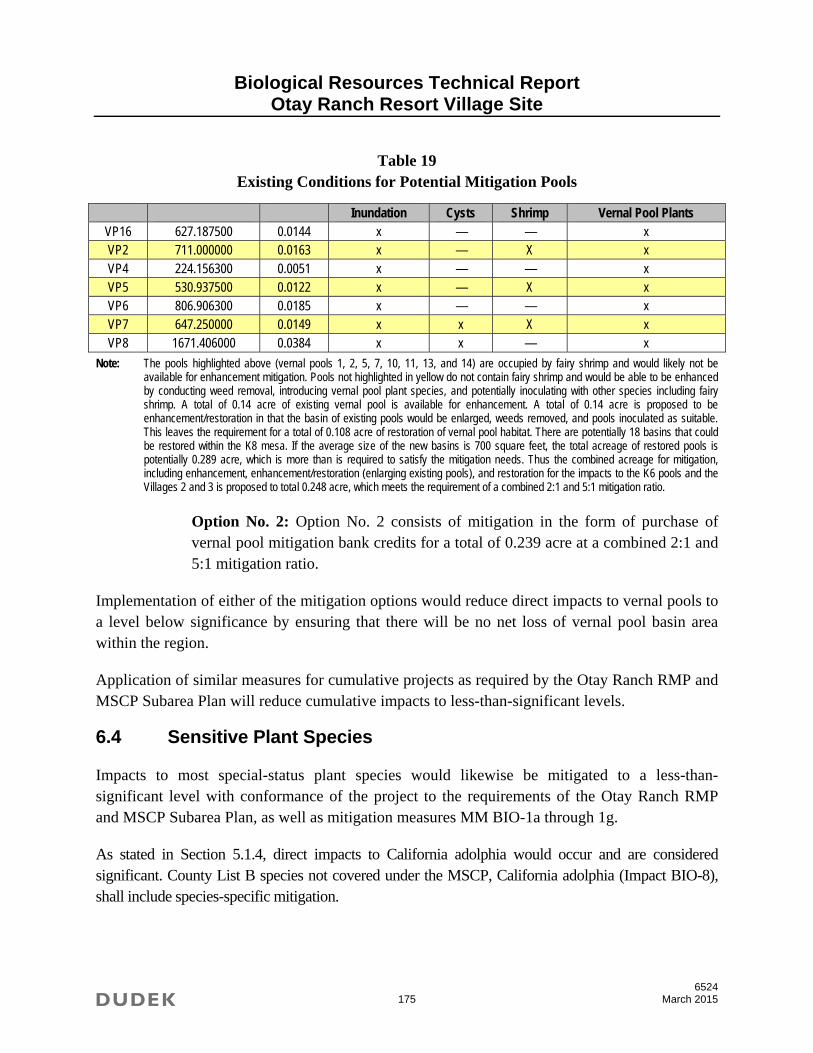
Biological Resources Technical Report Otay Ranch Resort Village Site
6524 175 March 2015
Table 19 Existing Conditions for Potential Mitigation Pools
Inundation Cysts Shrimp Vernal Pool Plants VP16 627.187500 0.0144 x — — x VP2 711.000000 0.0163 x — X x VP4 224.156300 0.0051 x — — x VP5 530.937500 0.0122 x — X x VP6 806.906300 0.0185 x — — x VP7 647.250000 0.0149 x x X x VP8 1671.406000 0.0384 x x — x
Note: The pools highlighted above (vernal pools 1, 2, 5, 7, 10, 11, 13, and 14) are occupied by fairy shrimp and would likely not be available for enhancement mitigation. Pools not highlighted in yellow do not contain fairy shrimp and would be able to be enhanced by conducting weed removal, introducing vernal pool plant species, and potentially inoculating with other species including fairy shrimp. A total of 0.14 acre of existing vernal pool is available for enhancement. A total of 0.14 acre is proposed to be enhancement/restoration in that the basin of existing pools would be enlarged, weeds removed, and pools inoculated as suitable. This leaves the requirement for a total of 0.108 acre of restoration of vernal pool habitat. There are potentially 18 basins that could be restored within the K8 mesa. If the average size of the new basins is 700 square feet, the total acreage of restored pools is potentially 0.289 acre, which is more than is required to satisfy the mitigation needs. Thus the combined acreage for mitigation, including enhancement, enhancement/restoration (enlarging existing pools), and restoration for the impacts to the K6 pools and the Villages 2 and 3 is proposed to total 0.248 acre, which meets the requirement of a combined 2:1 and 5:1 mitigation ratio.
Option No. 2: Option No. 2 consists of mitigation in the form of purchase of vernal pool mitigation bank credits for a total of 0.239 acre at a combined 2:1 and 5:1 mitigation ratio.
Implementation of either of the mitigation options would reduce direct impacts to vernal pools to a level below significance by ensuring that there will be no net loss of vernal pool basin area within the region.
Application of similar measures for cumulative projects as required by the Otay Ranch RMP and MSCP Subarea Plan will reduce cumulative impacts to less-than-significant levels.
6.4 Sensitive Plant Species
Impacts to most special-status plant species would likewise be mitigated to a less-than-significant level with conformance of the project to the requirements of the Otay Ranch RMP and MSCP Subarea Plan, as well as mitigation measures MM BIO-1a through 1g.
As stated in Section 5.1.4, direct impacts to California adolphia would occur and are considered significant. County List B species not covered under the MSCP, California adolphia (Impact BIO-8), shall include species-specific mitigation.

Biological Resources Technical Report Otay Ranch Resort Village Site
6524 176 March 2015
MM-BIO-8 Prior to the issuance of land development permits, including clearing or grubbing and grading permits, for areas with salvageable sensitive biological resources, including California adolphia, the Project Applicant may prepare a Resource Salvage Plan if seed collection is considered to be warranted. As described above in MM-BIO-1d, the project biologist shall review the California adolphia (approximately 20 plants) proposed to be impacted prior to grading and will determine if salvage is warranted. If salvage is not appropriate due to site conditions, plant conditions, or reproductive stage of the plants, a letter indicating that will be prepared and submitted to the Director of the Department of Planning and Development Services and the Director of Parks and Recreation. If determined that salvage is appropriate, a Resource Salvage Plan shall be prepared by a County-approved biologist to the satisfaction of the Director of Planning and Development Services (or their designee) and the Director of Parks and Recreation.
The Resource Salvage Plan shall, at a minimum, evaluate options for seed collection within the Preserve or from the plants proposed to be impacted. The Resource Salvage Plan shall include collection methods and timing. Relocation efforts may include seed collection and/or transplantation to a suitable receptor site within the slope restoration areas and will be based on the most reliable methods of successful restoration. The program shall also contain a recommendation for method of salvage and relocation/application based on feasibility of implementation and likelihood of success As an alternative, the California adolphia may be included within planting palettes for the slope revegetation areas that will receive monitoring and will be required to meet restoration goals and success criteria. Prior to grading the project, a Conceptual Upland Restoration Plan (Appendix H), as noted in MM-BIO-1, will be submitted to and receive approval from the Director of the Department of Planning and Development Services (or their designee) and the Director of Parks and Recreation. The program shall include, at a minimum, an implementation plan, maintenance and monitoring program, estimated completion time, and any relevant contingency measures. The program shall also be subject to the oversight of the Director of Planning and Development Services (or their designee) and the Director of Parks and Recreation. Documentation of preservation and/or planting of the species also will provide mitigation to reduce the impact to a less-than-significant level.
6.5 Sensitive Wildlife Species
As stated in Section 5.1.5, direct impacts to habitat supporting several special-status wildlife species, including 12 locations of adult Quino checkerspot butterfly, based on the 2008 survey

Biological Resources Technical Report Otay Ranch Resort Village Site
6524 177 March 2015
data, would be significant. Conservation provided through the Otay Ranch RMP (Appendix G) and MSCP Subarea Plan conformance/equivalency would provide mitigation for direct impacts to covered sensitive species to a less-than-significant level. These species include orange-throated whiptail, San Diego [coast; Blainville’s] horned lizard, Southern California rufous-crowned sparrow, coastal California gnatcatcher (18 of 32 on and off site) historically mapped locations will be preserved by the project, which is 56% of pairs and exceeds the Otay Ranch RMP requirement of 52%), and burrowing owl.
Several special-status species listed as “detected” or “likely to occur” in the project area are not classified as “covered species” by the MSCP Subarea Plan but are addressed by the Otay Ranch RMP and include ranch-wide preservation goals. These species include: rosy boa, coastal whiptail, San Diego banded gecko, coast patch-nosed snake, red-diamond rattlesnake, grasshopper sparrow, Bell’s sparrow, California horned lark, loggerhead shrike, Dulzura California pocket mouse, northwestern San Diego pocket mouse, San Diego black-tailed jackrabbit, and San Diego desert woodrat. In addition, none of these species is state- or federally listed, and all have a relatively low level of sensitivity. Therefore, the project’s contribution to the MSCP and Otay Ranch RMP preserve would mitigate potential impacts by providing suitable habitat in a configuration that preserves genetic exchange and species viability. Thus, direct impacts to non-covered sensitive wildlife species, with the exception of Quino checkerspot butterfly, are reduced to a less-than-significant level by virtue of the biological mitigation measures provided by the Otay Ranch RMP.
Impacts to Quino checkerspot butterfly and San Diego fairy shrimp, also not covered species under the MSCP Subarea Plan, are considered significant due to the very limited number of extant occurrences of these species in San Diego County. Because these species are federally listed endangered, take would be addressed either by compliance with the MSCP Subarea Plan Quino Checkerspot Butterfly Amendment being prepared by the County or a Section 7 Consultation or Section 10 incidental take permit. Mitigation for direct impacts to Quino checkerspot butterfly individuals require development and implementation of a long-term Quino checkerspot butterfly Management/Enhancement Plan until such time that the Amendment is approved or individual take is authorized through either the Section 7 Consultation process or a Section 10 Incidental Take permit is issued. Mitigation for direct impacts to San Diego fairy shrimp and the loss of habitat for the species requires development and implementation of a Conceptual Vernal Pool Mitigation Plan. It should be noted that 97% of the San Diego fairy shrimp will be preserved, which exceeds the requirements of the Otay Ranch RMP to preserve 95%.
MM-BIO-9a Take Authorization: Prior to the issuance of the first grading permit that impacts Quino checkerspot butterfly, the project shall demonstrate to the satisfaction of the Director of Planning and Development Services (or their designee) it has secured the necessary take authorization for Quino checkerspot butterfly through either the

Biological Resources Technical Report Otay Ranch Resort Village Site
6524 178 March 2015
Section 7 Consultation, Section 10 incidental take permit requirements, or the MSCP Subarea Plan Quino Checkerspot Butterfly Amendment, if/when approved. The project provides preservation of 962 acres of the required mitigation of 966 acres (2 x 483 acres). The project is required to provide an additional 4 acres of occupied habitat (Figure 28). This mitigation is proposed to be accomplished by restoration of unsuitable habitat within the preserve to suitable coastal sage scrub. Figure 28 illustrates the location of these potential restoration areas. A total of 6.3 acres is designated as potential restoration of which 4 acres will be needed.
MM-BIO-9b Quino Management/Enhancement Plan: Prior to the issuance of the first grading permit that impacts Quino checkerspot butterfly, the project shall prepare a long-term Quino checkerspot butterfly Management/Enhancement Plan that shall, at a minimum, include a survey methodology for on-site preserve areas pre- and post-construction to monitor effects on Quino checkerspot butterfly population health. The plan will be submitted to and receive approval from the Director of the Department of Planning and Development Services (or their designee) and the Director of Parks and Recreation. The Quino checkerspot butterfly Management/ Enhancement Plan will be superseded or unnecessary upon completion and adoption of the County Quino Checkerspot Butterfly MSCP Amendment. Adaptive management techniques shall be developed within the plan with contingency methods for changed circumstances. These measures will ensure that the potential loss of individuals and the loss of habitat for the species related to the proposed development are adequately offset by measures that will enhance the existing preserved population, and will provide data that will help the species recover throughout its range.
A sufficient amount of habitat is provided on site to ensure the long-term conservation of the species as outlined in the Quino checkerspot butterfly Management/Enhancement Plan. There is additional upland habitat also within the Preserve (87 acres of chaparral and grassland communities) that may be used by the butterfly as well. As shown in Figure 15, the preserve design includes significant larval host plant populations, known occurrences of the Quino checkerspot butterfly from multiple years of surveys, suitable habitat for the species, and ridgelines and hilltops where the species has been recorded. There also is connectivity to off-site occupied areas to the north, east, and south and provisions are included in the project design to provide for connectivity within the site as well as to off-site areas. Thus the project includes preservation of occupied Quino checkerspot butterfly habitat within the same region as the impact at both on-site and off-site locations. Implementation of these measures will reduce direct impacts to Quino checkerspot butterfly and its critical habitat to a less-than-significant level.

FIGURE 28
Proposed Mitigation Areas for Impacts to Quino Checkerspot Butterfly HabitatOtay Ranch Resort Village Site - Biological Resources Technical Report
6524
Docu
ment
Path:
Z:\P
rojec
ts\j65
2401
\MAP
DOC\
MAPS
\Bio
Figs\B
io Fig
s 201
5-01
\Fig2
7_QC
B Re
stora
tion T
reatm
ents.
mxd
Restore andEnhance perVernal PoolMitigation Plan
VEGETATION SOURCE:DUDEK 2002/2005/2008/2010/2014 & SANGIS 1995/2008
HABITAT, HOLLAND_LA, HOLLAND95AGL, Non-Native Grassland, 42200
CAM, Cistamonte Alkali Marsh, 52310
CC, Chamise Chaparral, 37200
CSS, Diegan Coastal Sage Scrub, 32500
DEV, Urban/Developed, 12000
DH, Disturbed Land, 11300
DW, Disturbed Wetland, 11200
EUC, Eucalyptus Woodland, 11100
FWM, Freshwater Marsh, 52400
MFS, Mule Fat Scrub, 63310
ORN, Non-Native Vegetation, 11000
OW, Open Water, 13100
PW, Non-Native Vegetation, 11000
SMX, Southern Mixed Chaparral, 37120
SOC, Scrub Oak Chaparral, 37900
SP, Disturbed Wetland, 11200
SWS, Southern Willow Scrub, 63320
VGL, Valley Needlegrass Grassland, 42110
WRF, Southern Arroyo Willow Riparian, 61320
cMFS, Mule Fat Scrub, 63310
dCC, Chamise Chaparral, 37200
dCSS, Diegan Coastal Sage Scrub, 32500
dVGL, Valley Needlegrass Grassland, 42110
Quino Checkspot Butterfly Habitat Treatments
No Active Restoration Activities
Enhancement Activity
Complete Restoration Activity
Quino Checkerspot Butterfly Obseravations (2008)
Seasonal Basin with Fairy Shrimp
Seasonal Basin without Fairy Shrimp
K8 100-Ft Buffer
K8 VP Watershed Limits
Project Boundary
Proposed Development Footprint
Vegetation Communities/Land Covers
0 1,000Feet
a aaaaa aaaaa aaaaa aaaaa aaaaa aaaa
Mitigation Areas for Impacts to Occupied Quino Checkerspot Butterfly6.3 Acres
Mitigation Areas for Impacts to Occupied Quino Checkerspot Butterfly6.3 Acres

Biological Resources Technical Report Otay Ranch Resort Village Site
6524 180 March 2015
INTENTIONALLY LEFT BLANK

Biological Resources Technical Report Otay Ranch Resort Village Site
6524 181 March 2015
MM-BIO-10 Prior to the issuance of the first grading permit that impacts the K6 vernal pool complexes, the project applicant shall demonstrate to the satisfaction of the Director of Planning and Development Services (of their designee) that the project has secured take authorization for San Diego Fairy Shrimp through the Section 7 Consultation, Section 10 incidental take permit, or as may be incorporated into the provisions of the MSCP Subarea Plan Quino Checkerspot Butterfly Amendment in order to achieve the best results towards the survival and recovery of the species.
Mitigation for impacts to San Diego fairy shrimp habitat is addressed in MM-BIO-7.
MM-BIO-11 To avoid any direct impacts to raptors and/or any migratory birds protected under the MBTA, removal of habitat that supports active nests on the proposed area of disturbance should occur outside of the breeding season for these species. If removal of habitat on the proposed area of disturbance must occur during the breeding season, the Project Applicant shall retain a County-approved biologist to conduct a pre-construction survey to determine the presence or absence of nesting birds on the proposed area of disturbance. The pre-construction survey must be conducted within 10 calendar days prior to the start of construction, and the results must be submitted to the County for review and approval prior to initiating any construction activities. If nesting birds are detected, a letter report or mitigation plan, as deemed appropriate by the County, shall be prepared and include proposed measures to be implemented to ensure that disturbance of breeding activities are avoided. The report or mitigation plan shall be submitted to the County for review and approval and implemented to the satisfaction of the Director of Planning and Development Services (or their designee). The County’s Mitigation Monitor shall verify and approve that all measures identified in the report or mitigation plan are in place prior to and/or during construction.
As stated in Section 5.2.5, incorporated project design features would reduce indirect impacts to sensitive wildlife species to a less-than-significant level.
6.6 Habitat Linkages/Movement Corridors
As stated in Section 5.1.6, direct impacts to habitat linkages and movement corridors are significant absent mitigation and are mitigated by the preserve configuration and the project design features that include the construction of wildlife crossings to provide movement within the preserve as well as off site.

Biological Resources Technical Report Otay Ranch Resort Village Site
6524 182 March 2015
MM-BIO-12 To provide and improve habitat linkages and movement corridors, the analysis of the proposed wildlife crossings is depicted in Figures 14–18. These figures illustrate the location of the crossings/culverts and the dimensions. In addition, a cross section of the opening is provided to illustrate the size and shape of the culvert. In general, the design of the wildlife culverts has been developed to be consistent with the MSCP Subarea Plan, where feasible. The wildlife culverts shall have fencing to funnel wildlife movement, shall have a natural bottom with native vegetation at either end, and shall be of size and height of opening so there is direct line of site from one end to the other. Because there is natural light within the culverts, low level illumination is not included. Traffic is generally of low volume on the internal crossings hence the sound insulation is of little benefit. The details of each wildlife culvert or crossing that shall be provided is presented below.
Internal Wildlife Crossing no. 1 (214 feet long × 28.83 feet wide × 13.17 feet tall = openness ratio of 0.44)
This arch culvert structure shall be situated internal to the project site along Strada Piazza, which connects the central portion of the open space to the lake. The 150-foot length is augmented by wing walls on either side of the crossing structure. This is beneficial as it effectively visually decreases the length of the culvert.
Otay Lakes Road Wildlife Crossing no. 1 (95 feet long × 20.75 feet wide × 12.08 feet tall = openness ratio of 0.68)
This structure shall be located south of Internal Wildlife Crossing no. 1 along Otay Lakes Road. The culvert is sized appropriately and should function as intended. It is well below the grade of Otay Lakes Road to prevent wildlife movement up to the surface of the roadway. There is also a six foot wildlife path with a soft surface along this crossing to allow for wildlife movement.
Internal Wildlife Crossing no. 2 (248 feet long × 43.00 feet wide × 16.18 feet tall = openness ratio of 0.63)
This structure shall be situated along Strada Piazza, which is a single non-split roadway at this location. The culvert slopes 12% to the south. This culvert conveys wildlife to a location just east of Lower Otay Lake to quality riparian habitat and lands to the east. Wing walls occur at both ends of the culvert. There is also a six foot wildlife path with a soft surface along this crossing to allow for wildlife movement.

Biological Resources Technical Report Otay Ranch Resort Village Site
6524 183 March 2015
Otay Lakes Road Wildlife Crossing no. 2 (58 feet long × 20.75 feet wide × 12.08 feet tall = openness ratio of 1.12)
This structure shall be located south of Internal Wildlife Crossing no. 2 under Otay Lakes Road. This crossing is also located below the grade of Otay Lakes Road to prevent wildlife from gaining access to the surface of the roadway. There is also a six foot wildlife path with a soft surface along this crossing to allow for wildlife movement.
6.7 Regional Resource Planning Context Impacts
Equivalency with the Otay Ranch RMP and MSCP Subarea Plan has been demonstrated such that impacts to these planning programs on a direct and indirect basis are less than significant. Therefore, no mitigation is required.
6.8 Indirect Impacts
As stated in Section 5.2.3, the project would potentially result in indirect adverse edge effects to vernal pools located on the K8 mesa include potential runoff, sedimentation, erosion, and exotics introduction. Likewise, indirect adverse edge effects to jurisdictional waters could include potential runoff, sedimentation, erosion, exotics introduction and habitat-type conversion in the short and long term, particularly within waterways that drain into Otay Lakes The following measure would reduce indirect impacts to vernal pools and jurisdictional waters near the impact areas to a less-than-significant level by ensuring no hydrologic change related to the proposed development:
MM-BIO-13 Prior to issuance of grading permits in portions of the development that are adjacent to the Preserve, the Project Applicant shall develop a Stormwater Pollution Prevention Plan (SWPPP). The SWPPP shall be developed, approved, and implemented during construction to control stormwater runoff such that erosion, sedimentation, pollution, and other adverse effects are minimized. The following performance measures contained in the Otay Ranch Resort Village Preserve Edge Plan shall be implemented to avoid the release of toxic substances associated with urban runoff:
Sediment shall be retained on-site by a system of sediment basins, traps, orother appropriate measures.
Where deemed necessary, storm drains shall be equipped with silt and oiltraps to remove oils, debris, and other pollutants. Storm drain inlets shall be

Biological Resources Technical Report Otay Ranch Resort Village Site
6524 184 March 2015
labeled “No Dumping–Drains to Ocean.” Storm drains shall be regularly maintained to ensure their effectiveness.
The parking lots shall be designed to allow stormwater runoff to bedirected to vegetative filter strips and/or oil-water separators to controlsediment, oil, and other contaminants.
Permanent energy dissipaters shall be included for drainage outlets.
The BMPs contained in the SWPPP shall include, but are not limited to,silt fences, fiber rolls, gravel bags, and soil stabilization measures such aserosion control mats and hydro-seeding.
The project area drainage basins will be designed to provide effective water quality control measures, as outlined in the Water Quality Technical Report. Design and operational features of the drainage basins will include design features to provide maximum infiltration, maximum detention time for settling of fine particles; maximize the distance between basin inlets and outlets to reduce velocities; and establish maintenance schedules for periodic removal of sedimentation, excessive vegetation and debris.
Indirect impacts are significant as discussed in Section 5.2.1. The following measure would reduce indirect impacts to vegetation and species near the impact areas to a less-than-significant level by ensuring no change related to the proposed development:
MM-BIO-14
During construction, material stockpiles shall be covered when not in use.This will prevent fly-off that could damage nearby sensitive plantcommunities. During grading and construction, graded areas shall beperiodically watered to minimize dust affecting adjacent vegetation.
During Project operation, all recreational areas that use chemicals or animalby-products, such as manure, that are potentially toxic or impactive tosensitive habitats or plants shall incorporate methods on-site to reduceimpacts caused by the application and/or drainage of such materials intoPreserve areas.
No invasive non-native plant species shall be introduced into areasimmediately adjacent to the Preserve. All slopes immediately adjacentto the Preserve shall be planted with native species that reflect theadjacent native habitat.

Biological Resources Technical Report Otay Ranch Resort Village Site
6524 185 March 2015
During construction, material stockpiles shall be placed such that they causeminimal interference with on-site drainage patterns. This will protectsensitive vegetation from being inundated with sediment-laden runoff.
Dewatering shall be conducted in accordance with standard regulations ofRWQCB. A National Pollutant Discharge Elimination System (NPDES)permit, issued by RWQCB to discharge water from dewatering activities,shall be required prior to start of construction. This will minimize erosion,siltation, and pollution within sensitive communities.
Design of drainage facilities shall incorporate long-term control ofpollutants and stormwater flow to minimize pollution and hydrologicchanges. An Urban Runoff Plan and operational BMPs shall be approved bythe San Diego County Department of Planning and Development Servicesprior to construction.
Grading and/or improvement plans shall include the requirement that afencing and signage plan be prepared and that permanent fences orwalls be placed along the open space boundaries. Placement ofpermanent fencing or walls is required at the conclusion of the gradingactivity and prior to Record Plan approval.
A hydroseed mix that incorporates native species, is appropriate to the area, andis without invasives shall be used for slope stabilization in transitional areas.
Peruvian pepper trees and other invasive vegetation would not be plantedin streetscapes, or within 50 feet of the Preserve, where they couldimpact native habitat.
Indirect impacts to wildlife are significant as discussed in Section 5.2.1. The following measure would reduce indirect impacts to wildlife species near the impact areas to a less-than-significant level by ensuring no change related to the proposed development:
MM-BIO-15
No clearing, grading, or grubbing activities may occur within occupiedgnatcatcher habitat during the breeding season for coastal Californiagnatcatcher (February 15 to August 15, annually). If construction occursduring the breeding season, a nesting survey for California gnatcatchershall be conducted prior to the onset of construction and construction mayoccur if active nests can be avoided and provided an adequate buffer ornoise levels are documented to be below 60 dBA Leq at the nest site.
Biological Resources Technical Report Otay Ranch Resort Village Site
6524 186 March 2015
When clearing, grading, or grubbing activities occur during the breedingseason for raptors (January 15 to July 31, annually), nesting bird surveysshall be conducted by a qualified biologist for the San Diego CountyDepartment of Planning and Development Services to identify active nestlocations. Construction activities shall be restricted or modified such thatnoise levels related to those activities are below 60 dBA Leq, or otherWildlife Agency approved restrictions, in the vicinity of the active nest site.
Lighting of all developed areas adjacent to the preserve shall be directedaway from the preserve, wherever feasible and consistent with public safety.Where necessary, development shall provide adequate shielding with non-invasive plant materials (preferably native), berming, and/or other methodsto protect the preserve and sensitive species from night lighting.Consideration shall be given to the use of low-pressure sodium lighting.
Uses in or adjacent to the preserve shall be designed to minimize noiseimpacts. Berms or walls shall be constructed adjacent to commercial areasand any other use that may introduce noises that could impact or interferewith wildlife utilization of the preserve. Excessively noisy uses or activitiesadjacent to breeding areas must incorporate noise-reduction measures or becurtailed during the breeding season of sensitive bird species.
Grading and/or improvement plans shall include the requirement that afencing and signage plan be prepared and that permanent fences or wallsbe placed along the open space boundaries. Placement of permanentfencing or walls is required at the conclusion of the grading activity andprior to Record Plan approval.
Indirect impacts to habitat linkages and wildlife corridors are significant as discussed in Section 5.2.6. The MM-BIO-14 mitigation measure would reduce indirect impacts to habitat linkages and wildlife corridors near the impact areas to a less-than-significant level by ensuring no change related to the proposed development.
6.9 Cumulative Impacts
This impact would be mitigated by the County’s anticipated adoption of the draft Quino Amendment, the goals of which guided the design of the proposed project. However, in the event that the County does not finalize and adopt the Quino Amendment, this project’s contribution to cumulative impacts on the Quino checkerspot butterfly would still be reduced to less than
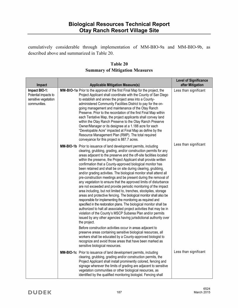
Biological Resources Technical Report Otay Ranch Resort Village Site
6524 187 March 2015
cumulatively considerable through implementation of MM-BIO-9a and MM-BIO-9b, as described above and summarized in Table 20.
Table 20 Summary of Mitigation Measures
Impact Applicable Mitigation Measure(s) Level of Significance
after Mitigation
Impact BIO-1: Potential impacts to sensitive vegetation communities.
MM-BIO-1a Prior to the approval of the first Final Map for the project, the Project Applicant shall coordinate with the County of San Diego to establish and annex the project area into a County-administered Community Facilities District to pay for the on-going management and maintenance of the Otay Ranch Preserve. Prior to the recordation of the first Final Map within each Tentative Map, the project applicants shall convey land within the Otay Ranch Preserve to the Otay Ranch Preserve Owner/Manager or its designee at a 1.188 acre for each “Developable Acre” impacted at Final Map as define by the Resource Management Plan (RMP). The total required conveyance for this project is 887.7 acres.
MM-BIO-1b Prior to issuance of land development permits, including clearing, grubbing, grading, and/or construction permits for any areas adjacent to the preserve and the off-site facilities located within the preserve, the Project Applicant shall provide written confirmation that a County-approved biological monitor has been retained and shall be on site during clearing, grubbing, and/or grading activities. The biological monitor shall attend all pre-construction meetings and be present during the removal of any vegetation to ensure that the approved limits of disturbance are not exceeded and provide periodic monitoring of the impact area including, but not limited to, trenches, stockpiles, storage areas and protective fencing. The biological monitor shall also be responsible for implementing the monitoring as required and specified in the restoration plans. The biological monitor shall be authorized to halt all associated project activities that may be in violation of the County’s MSCP Subarea Plan and/or permits issued by any other agencies having jurisdictional authority over the project.
Before construction activities occur in areas adjacent to preserve areas containing sensitive biological resources, all workers shall be educated by a County-approved biologist to recognize and avoid those areas that have been marked as sensitive biological resources.
MM-BIO-1c Prior to issuance of land development permits, including clearing, grubbing, grading and/or construction permits, the Project Applicant shall install prominently colored, fencing and signage wherever the limits of grading are adjacent to sensitive vegetation communities or other biological resources, as identified by the qualified monitoring biologist. Fencing shall
Less than significant
Less than significant
Less than significant

Biological Resources Technical Report Otay Ranch Resort Village Site
6524 188 March 2015
Table 20 Summary of Mitigation Measures
Impact Applicable Mitigation Measure(s) Level of Significance
after Mitigation
remain in place during all construction activities. All temporary fencing shall be shown on grading plans for areas adjacent to the preserve and for all off-site facilities constructed within the preserve. Prior to release of grading and/or improvement bonds, a qualified biologist shall provide evidence to the satisfaction of the Director of Planning and Development Services (or their designee) and the Director of Parks and Recreation, that work was conducted as authorized under the approved land development permit and associated plans.
MM-BIO-1d Restoration areas may incorporate salvaged materials, such as seed collection and translocation of plant materials as determined to be appropriate. The project biologist shall review the plant materials prior to grading and will determine if salvage is warranted. If salvage is not appropriate due to site conditions, plant conditions, or reproductive stage of the plants, a letter indicating that will be prepared and submitted to the Director of the Department of Planning and Development Services and the Director of Parks and Recreation. Prior to grading the project, a Conceptual Upland Restoration Plan (Appendix H) will be submitted to and receive approval from the Director of the Department of Planning and Development Services (or their designee) and the Director of Parks and Recreation.
The Conceptual Upland Restoration Plan shall include, butnot be limited to, the following to ensure the establishmentof the restoration objectives: a 24- by 36-inch map showingthe restoration areas, site preparation information, type ofplanting materials (species ratios, source, size of container,etc.), planting program, 80% success criteria, 5-yearmonitoring plan, and detailed cost estimate. The costestimate shall include planting, plant materials, irrigation,maintenance, monitoring, and report preparation. The reportshall be prepared by a County approved biologist and astate of California licensed landscape architect. The habitatcreated pursuant to the Conceptual Upland Restoration Planmust be placed within an open space easement dedicatedto the County prior to or immediately following the approvalof the Conceptual Upland Restoration Plan.
MM-BIO-1e In order to protect sensitive biological resources in the adjacent preserve, a Limited Building zone (LBZ) easement will be granted to the County, as shown on the Tentative Map. The purpose of this easement is to limit the need to clear or modify vegetation for fire protection purposes within the preserve, restrict unauthorized access, prohibit landscaping with exotic pest plants that may invade the preserve, and prohibit artificial lighting and focal use areas that would alter wildlife behavior in
Less than significant
Less than significant

Biological Resources Technical Report Otay Ranch Resort Village Site
6524 189 March 2015
Table 20 Summary of Mitigation Measures
Impact Applicable Mitigation Measure(s) Level of Significance
after Mitigation
the preserve. This easement requires the landowner to maintain permanent fencing and signage. The easement precludes 1) placement, installation, or construction of habitable structures, including garages or accessory structures designed or intended for occupancy by humans or animals, 2) landscaping with exotic pest plants, 3) artificial lighting except low-pressure sodium fixtures shielded and directed away from the preserve, 4) focal use areas including arenas, pools, and patios.
MM-BIO-1f In order to protect the preserve from entry upon completion of construction, an open space fence or wall will be installed along all open space edges where open space is adjacent to residential uses, along internal streets, and as indicated in the Otay Ranch Resort Village Preserve Edge Plan and Proposed Fencing, Preserve signage, and Fuel Modification Zones (see map pocket). The barrier must be a minimum construction of vertical metal fencing, but may be other suitable construction material, as approved by Department of Planning and Development Services and the Director of Parks and Recreation. In order to protect the preserve from entry, informational signs will be installed, where appropriate, along all open space edges where open space is adjacent to residential uses, along internal streets, and as indicated in the Otay Ranch Resort Village Preserve Edge Plan. The signs must be corrosion resistant, a minimum of 6 inches by 9 inches in size, on posts not less than three (3) feet in height from the ground surface, and state “Sensitive Environmental Resources Protected by Easement. Entry without express written permission from the County of San Diego is prohibited.”
MM-BIO-1g In order to provide for the long-term management of the proposed 10.2-acre parcel that will be added to the MSCP Preserve, a habitat manager shall be designated either privately selected, a non-profit organization, or a government agency. If a private or non-profit organization is selected as the habitat manager, a Resource Management Plan (RMP) will be prepared and implemented. The final RMP will be completed to the satisfaction of the Director of Department of Planning and Development Services, as follows: 1) The plan will be prepared and approved pursuant to the most current version of the County of San Diego Biological Report Format and Content Requirements; 2) The habitat land to be managed will be owned by a land conservancy or equivalent; 3) Open space easements will be dedicated in perpetuity; 4) A resource manager will be selected and approved, with evidence provided demonstrating acceptance of this responsibility, 5) The RMP funding mechanism will be identified and adequate to fund annual costs for implementation; and 6) A contract between the applicant and
Less than significant
Less than significant

Biological Resources Technical Report Otay Ranch Resort Village Site
6524 190 March 2015
Table 20 Summary of Mitigation Measures
Impact Applicable Mitigation Measure(s) Level of Significance
after Mitigation
County will be executed for the implementation of the RMP, and funding will be established with the County as the third party beneficiary. In lieu of providing a private habitat manager as noted above, the applicant may contract with a federal, state, or local government agency with the primary mission of resource management to take fee title and manage the 10.2-acre parcel of land. Evidence of satisfaction must include a copy of the contract with the agency, and a written statement from the agency that (1) the land contains the specified acreage and the specified habitat, or like functioning habitat, and (2) the land will be managed by the agency for conservation of natural resources in perpetuity.
Impact BIO-2 Potential impacts to vegetation within City of San Diego Cornerstone Lands
MM-BIO-2 Prior to widening Otay Lakes Road, the project applicants shall mitigate for the 11.09 acres of impacts to Cornerstone Lands and complete a MHPA Boundary Adjustment to the satisfaction of the City of San Diego Development Services Director (or their designee). The mitigation and MHPA Boundary Adjustment may be implemented within the Otay Ranch Preserve on property surrounding the existing Cornerstone Lands, north of Otay Lakes Road, or may be off-site at a location determined to be acceptable by the City.
Less than significant
Impact BIO-3 Potential impacts to vegetation within City of Chula Vista jurisdiction.
MM-BIO-3 Prior to issuance of any land development permits, including clearing or grubbing and grading and/or construction permits, the project will be required to obtain a HLIT Permit pursuant to Section 17.35 of the Chula Vista Municipal Code for impacts to Chula Vista MSCP Tier I, II, and II vegetation communities as shown below in Table 18 and in accordance with Table 5-3 of the Chula Vista MSCP Subarea Plan. Mitigation for off-site impacts outside of Otay Ranch will be in accordance with the Chula Vista MSCP Subarea Plan and the Chula Vista Habitat Loss and Incidental Take (HLIT) Ordinance.
Prior to issuance of any land development permits, the applicant shall mitigate for direct impacts pursuant to Section 5.2.2 of the City of Chula Vista MSCP Subarea Plan. In compliance with the Subarea Plan, the applicant shall secure mitigation credits within a City- and wildlife agency-approved Conservation Bank or other approved location offering mitigation credits consistent with the ratios specified in Table 18.
Less than significant

Biological Resources Technical Report Otay Ranch Resort Village Site
6524 191 March 2015
Table 20 Summary of Mitigation Measures
Impact Applicable Mitigation Measure(s) Level of Significance
after Mitigation
Table 18 Impacts to Sensitive Vegetation Communities within
City of Chula Vista Jurisdiction
Vegetation Community Tier
Permanent Impacts (acres)
Location of Impact
Mitigation Ratio Assuming
Inside Preserve
Mitigation Required (acres)
Coastal sage scrub
II 0.06 Outside Preserve
1:1 0.06
Disturbed Coastal sage scrub
II 0.07 Outside Preserve
1:1 0.07
Non-native grassland
III 1.38 Outside Preserve
0.5:1 0.69
Note: Tiers and mitigation ratios are in accordance with the Chula Vista MSCP Subarea Plan’s HLIT Upland Habitat Mitigation Ratios. No mitigation is required for Tier IV habitat types (i.e., non-sensitive vegetation communities and land covers including ornamental or developed land). It is assumed that mitigation will be located inside the Preserve. Mitigation outside of the Preserve (i.e., Chula Vista MSCP Subarea Plan or Planning Area boundary) will require increased mitigation.
The applicant shall be required to provide verification of purchase to the City prior to issuance of any land development permits.
In the event that a Project Applicant is unable to secure mitigation through an established mitigation bank approved by the City and wildlife agencies, the Project Applicant shall secure the required mitigation through the conservation of an area containing in-kind habitat within the City’s MSCP Subarea Plan or MSCP Planning Area in accordance with the mitigation ratios contained in Table 5-3 of the City of Chula Vista MSCP Subarea Plan and subject to wildlife agency concurrence.
Prior to issuance of any land development permit, and to the satisfaction and oversight of the City’s Development Services Director (or their designee), the Applicant shall secure the parcel(s) that will be permanently preserved for in-kind habitat impact mitigation, if a mitigation bank purchase is unavailable, prepare a long-term management and monitoring plan for the mitigation area, secure an appropriate management entity to ensure that long-term biological resource management and monitoring of the mitigation area is implemented in perpetuity, and establish a long-term funding mechanism for the management and monitoring of the mitigation area in perpetuity.
The long-term management and monitoring plan shall provide

Biological Resources Technical Report Otay Ranch Resort Village Site
6524 192 March 2015
Table 20 Summary of Mitigation Measures
Impact Applicable Mitigation Measure(s) Level of Significance
after Mitigation
management measures to be implemented to sustain the viability of the preserved habitat and identify timing for implementing the measures prescribed in the management and monitoring plan. The mitigation parcel shall be restricted from future development and permanently preserved through the recordation of a conservation easement or other mechanism approved by the wildlife agencies as being sufficient to insure that the lands are protected in perpetuity. The conservation easement or other mechanism approved by the wildlife agencies shall be recorded prior to issuance of any land development permits.
Impact BIO-4 Potential impacts to riparian habitat, and jurisdictional wetlands and waters.
MM-BIO-4 Prior to impacts occurring to waters and wetlands under the jurisdiction of ACOE, CDFW and RWQCB, the Applicant shall obtain the following permits: ACOE 404 permit, RWQCB 401 Water Quality Certification, and a CDFW Code 1600 Streambed Alteration Agreement. Impacts shall be mitigated at a 1:1 ratio by creation or purchase of credits for the creation of jurisdictional habitat of similar functions and values. A suitable mitigation site shall be selected and approved by the resource agencies during the permitting process. The ratio of wetland mitigation should be 3:1 overall. A total of 1.34 acres of wetlands will be created (1:1 creation to impact ratio). An additional 2.68 acres of wetlands will be enhanced (2:1 enhancement to impact ratio). Creation/enhancement will occur within the Dulzura Creek/Otay River watershed in accordance with a Conceptual Wetlands Mitigation and Monitoring Plan (Appendix I) approved by the County and appropriate resource agencies. The wetland creation should include at least a 1:1 ratio of each of the wetland vegetation communities impacted. The remainder of the creation/enhancement obligation may be fulfilled with any wetlands type.
Prior to issuance of land development permits, including clearing, grubbing, and grading permits that impact jurisdictional waters, the Project Applicant shall prepare a Wetlands Mitigation and Monitoring Plan to the satisfaction of the Director of Planning and Development Services (of their designee), the Director of Parks and Recreation, ACOE, RWQCB, and CDFW. The Conceptual Wetlands Mitigation and Monitoring Plan shall at a minimum prescribe site preparation, planting, irrigation, and a 5-year maintenance and monitoring program with qualitative and quantitative evaluation of the revegetation effort and specific criteria to determine successful revegetation. The temporary impacts to ephemeral and intermittent waters will be mitigated by restoring to original condition immediately upon completion of the project but will be subject to all of the success criteria and monitoring as the permanent impacted wetlands.
Less than significant

Biological Resources Technical Report Otay Ranch Resort Village Site
6524 193 March 2015
Table 20 Summary of Mitigation Measures
Impact Applicable Mitigation Measure(s) Level of Significance
after Mitigation
Implementation of this mitigation measure would ensure no net loss of jurisdictional wetlands within the watershed and would therefore reduce direct impacts to jurisdictional waters to a less-than-significant level.
Impact BIO-5: Potential impacts to riparian habitat, and jurisdictional wetlands and waters within City of San Diego Cornerstone Lands
MM-BIO-5 Prior to impacts occurring to waters and wetlands within the City of San Diego Cornerstone Lands, under the jurisdiction of ACOE, CDFW and RWQCB, the Applicant shall obtain the following permits: ACOE 404 permit, RWQCB 401 Water Quality Certification, and a CDFW Code 1600 Streambed Alteration Agreement. Impacts shall be mitigated at a 1:1 ratio by creation or purchase of credits for the creation of jurisdictional habitat of similar functions and values. A suitable mitigation site shall be selected and approved by the resource agencies during the permitting process. The ratio of wetland mitigation should be 3:1 overall. A total of 0.84 acres of wetlands will be created (1:1 creation to impact ratio). An additional 1.68 acres of wetlands will be enhanced (2:1 enhancement to impact ratio). Creation/enhancement will occur within the Dulzura Creek/Otay River watershed in accordance with a Conceptual Wetlands Mitigation and Monitoring Plan (Appendix I) approved by the County and appropriate resource agencies. The wetland creation should include at least a 1:1 ratio of each of the wetland vegetation communities impacted. The remainder of the creation/enhancement obligation may be fulfilled with any wetlands type.
Prior to issuance of land development permits, including clearing, grubbing, and grading permits that impact jurisdictional waters, the Project Applicant shall prepare a Wetlands Mitigation and Monitoring Plan to the satisfaction of the Director of Planning and Development Services (of their designee), ACOE, and CDFW. The Conceptual Wetlands Mitigation and Monitoring Plan shall at a minimum prescribe site preparation, planting, irrigation, and a 5-year maintenance and monitoring program with qualitative and quantitative evaluation of the revegetation effort and specific criteria to determine successful revegetation. The temporary impacts to ephemeral and intermittent waters will be mitigated by restoring to original condition immediately upon completion of the project but will be subject to all of the success criteria and monitoring as the permanent impacted wetlands.
Implementation of this mitigation measure would ensure no net loss of jurisdictional wetlands within the watershed and would therefore reduce direct impacts to jurisdictional waters to a less-than-significant level.
Less than significant
Impact BIO-6: Potential impacts
MM-BIO-6 Prior to impacts occurring to waters within the County of San Diego under the jurisdiction of ACOE, CDFW and RWQCB, the
Less than significant

Biological Resources Technical Report Otay Ranch Resort Village Site
6524 194 March 2015
Table 20 Summary of Mitigation Measures
Impact Applicable Mitigation Measure(s) Level of Significance
after Mitigation
to riparian habitat, and jurisdictional wetlands and waters within County of San Diego
Applicant shall obtain the following permits: ACOE 404 permit, RWQCB 401 Water Quality Certification, and a CDFW Code 1600 Streambed Alteration Agreement. Impacts shall be mitigated at a 1:1 ratio by creation or purchase of credits for the creation of jurisdictional habitat of similar functions and values. A suitable mitigation site shall be selected and approved by the resource agencies during the permitting process. The ratio of wetland mitigation should be 3:1 overall. A total of 0.01 acre of waters of the U.S. will be created (1:1 creation to impact ratio). An additional 0.02 acre of waters of the U.S. will be enhanced (2:1 enhancement to impact ratio). Creation/enhancement will occur within the Dulzura Creek/Otay River watershed in accordance with a Conceptual Wetlands Mitigation and Monitoring Plan (Appendix I) approved by the County and appropriate resource agencies. The wetland creation should include at least a 1:1 ratio of each of the wetland vegetation communities impacted. The remainder of the creation/enhancement obligation may be fulfilled with any wetlands type.
Prior to issuance of land development permits, including clearing, grubbing, and grading permits that impact jurisdictional waters, the Project Applicant shall prepare a Wetlands Mitigation and Monitoring Plan to the satisfaction of the Director of Planning and Development Services (of their designee), ACOE, and CDFW. The Conceptual Wetlands Mitigation and Monitoring Plan shall at a minimum prescribe site preparation, planting, irrigation, and a 5-year maintenance and monitoring program with qualitative and quantitative evaluation of the revegetation effort and specific criteria to determine successful revegetation. The temporary impacts to ephemeral and intermittent waters will be mitigated by restoring to original condition immediately upon completion of the project but will be subject to all of the success criteria and monitoring as the permanent impacted wetlands.
Implementation of this mitigation measure would ensure no net loss of jurisdictional wetlands within the watershed and would therefore reduce direct impacts to jurisdictional waters to a less-than-significant level.
Impact BIO-7: Potential impacts to Vernal Pools
MM-BIO-7
Option No. 1: This option consists of mitigation in the form of restoration of vernal pools within the Resort Village project site. This option would involve restoration and reconfiguration of the K8 vernal pool group. These vernal pools are proposed to be preserved, and a 100-foot minimum buffer is provided for protection of the pools and their watershed. Mitigation would involve reconfiguration and reconstruction of the mima
Less than significant

Biological Resources Technical Report Otay Ranch Resort Village Site
6524 195 March 2015
Table 20 Summary of Mitigation Measures
Impact Applicable Mitigation Measure(s) Level of Significance
after Mitigation
mounds and basins, removal of weedy vegetation, revegetation of the mounds with upland sage scrub species and inoculation of the pools with vernal pool species. A Conceptual Vernal Pool Mitigation Plan shall be prepared that outlines the location and activities of the restoration (Appendix J). The plan will be submitted to and receive approval from the Director of the Department of Planning and Development Services (or their designee) and the Director of Parks and Recreation. A ratio of at least 1:1 restoration shall include the establishment of new vernal pool basins within the K8 vernal pool group. The balance of the mitigation ratio shall include enhancement of the existing pools. There is a total of 0.26 acre available for enhancement within the existing pools. The additional restoration mitigation requirement (a total of 0.112 acre) will be directed towards establishing new basins within the K8 vernal pool group to the greatest extent feasible. An additional area of potential vernal pool restoration is located within the K9 mesa if needed. This area also is composed of suitable soils for vernal pools. These soils are present on the K6 and K8 mesas. This additional area is composed of non-native grass species, is of relatively flat topography, and exhibits some mounding characteristics similar to mima mounds.
Based on the inundation records, fairy shrimp surveys, and floral inventory, the following potential vernal pools meet the previously applied ACOE jurisdictional criteria:
K6 – Vernal Pools 1, 3, 5, 6, 7, 8, 9, 10, 12, 13 (0.11 acre – total basin area)
K8 – Vernal Pools 1, 2, 4, 5, 6, 7, 8, 10, 11, 13, 14, 15, 16, A1, A4 (0.26 acre – total basin area).
Assuming all of K6 is impacted and the mitigation requirement is a combination of 2:1 and 5:1 as outlined above, a total mitigation of 0.239 acre is required. Impacts to vernal pool resources at Villages 2 and 3 also were proposed to be mitigated at the K8 mesa. The mitigation requirement for these impacts was proposed to be 406 sqaure feet or approximately 0.009 acre. Thus the total mitigation requirement is 0.248 acre. This is typically satisfied by providing at least 1:1 as restoration and the balance as enhancement. Enhancement within the K8 pools will likely be restricted by the resource agencies to those pools not containing fairy shrimp. Table 18 summarizes the existing conditions of the pools within the K8 mesa.
The pools highlighted above (vernal pools 1, 2, 5, 7, 10, 11, 13, and 14) are occupied by fairy shrimp and would likely not

Biological Resources Technical Report Otay Ranch Resort Village Site
6524 196 March 2015
Table 20 Summary of Mitigation Measures
Impact Applicable Mitigation Measure(s) Level of Significance
after Mitigation
be available for enhancement mitigation. Pools not highlighted in yellow do not contain fairy shrimp and would be able to be enhanced by conducting weed removal, introducing vernal pool plant species, and potentially inoculating with other species including fairy shrimp. A total of 0.14 acre of existing vernal pool is available for enhancement. A total of 0.14 acre is proposed to be enhancement/restoration in that the basin of existing pools would be enlarged, weeds removed, and pools inoculated as suitable. This leaves the requirement for a total of 0.108 acre of restoration of vernal pool habitat. There are potentially 18 basins that could be restored within the K8 mesa. If the average size of the new basins is 700 square feet, the total acreage of restored pools is potentially 0.289 acre, which is more than is required to satisfy the mitigation needs. Thus the combined acreage for mitigation, including enhancement, enhancement/restoration (enlarging existing pools), and restoration for the impacts to the K6 pools and the Villages 2 and 3 is proposed to total 0.248 acre, which meets the requirement of a combined 2:1 and 5:1 mitigation ratio.
Option No. 2: Option No. 2 consists of mitigation in the form of purchase of vernal pool mitigation bank credits for a total of 0.239 acre at a combined 2:1 and 5:1 mitigation ratio.
Impact BIO-8: Potential impacts to Nuttall’s scrub oak and California adolphia.
MM-BIO-8 Prior to the issuance of land development permits, including clearing or grubbing and grading permits, for areas with salvageable sensitive biological resources, including California adolphia, the Project Applicant may prepare a Resource Salvage Plan if seed collection is considered to be warranted. As described above in MM-BIO-1d, the project biologist shall review the California adolphia (approximately 20 plants) proposed to be impacted prior to grading and will determine if salvage is warranted. If salvage is not appropriate due to site conditions, plant conditions, or reproductive stage of the plants, a letter indicating that will be prepared and submitted to the Director of the Department of Planning and Development Services and the Director of Parks and Recreation. If determined that salvage is appropriate, a Resource Salvage Plan shall be prepared by a County-approved biologist to the satisfaction of the Director of Planning and Development Services (or their designee) and the Director of Parks and Recreation.
The Resource Salvage Plan shall, at a minimum, evaluate options for seed collection within the Preserve or from the plants proposed to be impacted. The Resource Salvage Plan shall include collection methods and timing. Relocation
Less than significant

Biological Resources Technical Report Otay Ranch Resort Village Site
6524 197 March 2015
Table 20 Summary of Mitigation Measures
Impact Applicable Mitigation Measure(s) Level of Significance
after Mitigation
efforts may include seed collection and/or transplantation to a suitable receptor site within the slope restoration areas and will be based on the most reliable methods of successful restoration. The program shall also contain a recommendation for method of salvage and relocation/application based on feasibility of implementation and likelihood of success As an alternative, the California adolphia, may be included within planting palettes for the slope revegetation areas that will receive monitoring and will be required to meet restoration goals and success criteria. Prior to grading the project, a Conceptual Upland Restoration Plan (Appendix H), as noted in MM-BIO-1, will be submitted to and receive approval from the Director of the Department of Planning and Development Services (or their designee) and the Director of Parks and Recreation. The program shall include, at a minimum, an implementation plan, maintenance and monitoring program, estimated completion time, and any relevant contingency measures. The program shall also be subject to the oversight of the Director of Planning and Development Services (or their designee) and the Director of Parks and Recreation. Documentation of preservation and/or planting of the species also will provide mitigation to reduce the impact to a less-than-significant level.
Impact BIO-9: Potential impacts to Quino checkerspot butterfly and critical habitat for Quino.
MM-BIO-9a Take Authorization: Prior to the issuance of the first grading permit that impacts Quino checkerspot butterfly, the project shall demonstrate to the satisfaction of the Director of Planning and Development Services (or their designee) it has secured the necessary take authorization for Quino checkerspot butterfly through either the Section 7 Consultation, Section 10 incidental take permit requirements, or the MSCP Subarea Plan Quino Checkerspot Butterfly Amendment, if/when approved The project provides preservation of 962 acres of the required mitigation of 966 acres (2 x 483 acres). The project is required to provide an additional 4 acres of occupied habitat (Figure 28). This mitigation is proposed to be accomplished by restoration of unsuitable habitat within the preserve to suitable coastal sage scrub. Figure 28 illustrates the location of these potential restoration areas. A total of 6.3 acres is designated as potential restoration of which 4 acres will be needed.
MM-BIO-9b Quino Management/Enhancement Plan: Prior to the issuance of the first grading permit that impacts Quino checkerspot butterfly, the project shall prepare a long-term Quino checkerspot butterfly Management/Enhancement Plan that
Less than significant
Less than significant

Biological Resources Technical Report Otay Ranch Resort Village Site
6524 198 March 2015
Table 20 Summary of Mitigation Measures
Impact Applicable Mitigation Measure(s) Level of Significance
after Mitigation
shall, at a minimum, include a survey methodology for on-site preserve areas pre- and post-construction to monitor effects on Quino checkerspot butterfly population health. The plan will be submitted to and receive approval from the Director of the Department of Planning and Development Services (or their designee) and the Director of Parks and Recreation. The Quino checkerspot butterfly Management/ Enhancement Plan will be superseded or unnecessary upon completion and adoption of the County Quino Checkerspot Butterfly MSCP Amendment. Adaptive management techniques shall be developed within the plan with contingency methods for changed circumstances. These measures will ensure that the potential loss of individuals and the loss of habitat for the species related to the proposed development are adequately offset by measures that will enhance the existing preserved population, and will provide data that will help the species recover throughout its range.
Impact BIO-10: Potential impacts to San Diego fairy Shrimp.
MM-BIO-10 Prior to the issuance of the first grading permit that impacts the K6 vernal pool complexes, the project applicant shall demonstrate to the satisfaction of the Director of Planning and Development Services (of their designee) that Mitigation for impacts to the San Diego fairy shrimp shall be in accordance with the project has secured take authorization for San Diego Fairy Shrimp in accordance with the Section 7 Consultation, Section 10 incidental take permit, or may be incorporated into the provisions of the MSCP Subarea Plan Quino Checkerspot Butterfly Amendment in order to achieve the best results towards the survival and recovery of the species. Mitigation for impacts to San Diego fairy shrimp habitat is address in M-BIO-7.
Less than significant
Impact BIO-11: Potential impacts to birds under the MBTA
MM-BIO-11 To avoid any direct impacts to raptors and/or any migratory birds protected under the MBTA, removal of habitat that supports active nests on the proposed area of disturbance should occur outside of the breeding season for these species. If removal of habitat on the proposed area of disturbance must occur during the breeding season, the Project Applicant shall retain a County-approved biologist to conduct a pre-construction survey to determine the presence or absence of nesting birds on the proposed area of disturbance. The pre-construction survey must be conducted within 10 calendar days prior to the start of construction, and the results must be submitted to the County for review and approval prior to initiating any construction activities. If nesting birds are detected, a letter report or mitigation plan, as deemed appropriate by the County, shall be prepared and include proposed measures to be implemented to ensure that
Less than significant

Biological Resources Technical Report Otay Ranch Resort Village Site
6524 199 March 2015
Table 20 Summary of Mitigation Measures
Impact Applicable Mitigation Measure(s) Level of Significance
after Mitigation
disturbance of breeding activities are avoided. The report or mitigation plan shall be submitted to the County for review and approval and implemented to the satisfaction of the Director of Planning and Development Services (or their designee). The County’s Mitigation Monitor shall verify and approve that all measures identified in the report or mitigation plan are in place prior to and/or during construction.
Impact BIO-12. Potential direct impact to habitat linkages and wildlife movement
MM-BIO-12 To provide and improve habitat linkages and movement corridors, the analysis of the proposed wildlife crossings is depicted in Figures 14–18. These figures illustrate the location of the crossings/culverts and the dimensions. In addition, a cross section of the opening is provided to illustrate the size and shape of the culvert. In general, the design of the wildlife culverts has been developed to be consistent with the MSCP Subarea Plan, where feasible. The wildlife culverts shall have fencing to funnel wildlife movement, shall have a natural bottom with native vegetation at either end, and shall be of size and height of opening so there is direct line of site from one end to the other. Because there is natural light within the culverts, low level illumination is not included. Traffic is generally of low volume on the internal crossings hence the sound insulation is of little benefit. The details of each wildlife culvert or crossing that shall be provided is presented below.
Internal Wildlife Crossing no. 1 (214 feet long × 28.83 feet wide × 13.17 feet tall = openness ratio of 0.44)
This arch culvert structure shall be situated internal to the project site along Strada Piazza, which connects the central portion of the open space to the lake. The 150-foot length is augmented by wing walls on either side of the crossing structure. This is beneficial as it effectively visually decreases the length of the culvert.
Otay Lakes Road Wildlife Crossing no. 1 (95 feet long × 20.75 feet wide × 12.08 feet tall = openness ratio of 0.68)
This structure shall be located south of Internal Wildlife Crossing no. 1 along Otay Lakes Road. The culvert is sized appropriately and should function as intended. It is well below the grade of Otay Lakes Road to prevent wildlife movement up to the surface of the roadway. There is also a six foot wildlife path with a soft surface along this crossing to allow for wildlife movement.
Internal Wildlife Crossing no. 2 (248 feet long × 43.00 feet wide × 16.18 feet tall = openness ratio of 0.63)
This structure shall be situated along Strada Piazza, which is a single non-split roadway at this location. The culvert slopes
Less than significant

Biological Resources Technical Report Otay Ranch Resort Village Site
6524 200 March 2015
Table 20 Summary of Mitigation Measures
Impact Applicable Mitigation Measure(s) Level of Significance
after Mitigation
12% to the south. This culvert conveys wildlife to a location just east of Lower Otay Lake to quality riparian habitat and lands to the east. Wing walls occur at both ends of the culvert. There is also a six foot wildlife path with a soft surface along this crossing to allow for wildlife movement.
Otay Lakes Road Wildlife Crossing no. 2 (58 feet long × 20.75 feet wide × 12.08 feet tall = openness ratio of 1.12)
This structure shall be located south of Internal Wildlife Crossing no. 2 under Otay Lakes Road. This crossing is also located below the grade of Otay Lakes Road to prevent wildlife from gaining access to the surface of the roadway. There is also a six foot wildlife path with a soft surface along this crossing to allow for wildlife movement.
Impact BIO-13: Potential indirect impacts to vernal pools and their watershed.
MM-BIO-13 Prior to issuance of grading permits in portions of the development that are adjacent to the Preserve, the Project Applicant shall develop a Stormwater Pollution Prevention Plan (SWPPP). The SWPPP shall be developed, approved, and implemented during construction to control stormwater runoff such that erosion, sedimentation, pollution, and other adverse effects are minimized. The following performance measures contained in the Otay Ranch Resort Village Preserve Edge Plan shall be implemented to avoid the release of toxic substances associated with urban runoff:
Sediment shall be retained on-site by a system of sediment basins, traps, or other appropriate measures.
Where deemed necessary, storm drains shall be equipped with silt and oil traps to remove oils, debris, and other pollutants. Storm drain inlets shall be labeled “No Dumping–Drains to Ocean.” Storm drains shall be regularly maintained to ensure their effectiveness.
The parking lots shall be designed to allow stormwater runoff to be directed to vegetative filter strips and/or oil-water separators to control sediment, oil, and other contaminants.
Permanent energy dissipaters shall be included for drainage outlets.
The BMPs contained in the SWPPP shall include, but are not limited to, silt fences, fiber rolls, gravel bags, and soil stabilization measures such as erosion control mats and hydro-seeding.
The project area drainage basins will be designed to provide effective water quality control measures, as outlined in the Water Quality Technical Report. Design and operational features of the drainage basins will include design features to provide maximum infiltration, maximum detention time for settling of fine particles; maximize the distance between basin inlets and outlets to reduce velocities; and establish maintenance
Less than significant
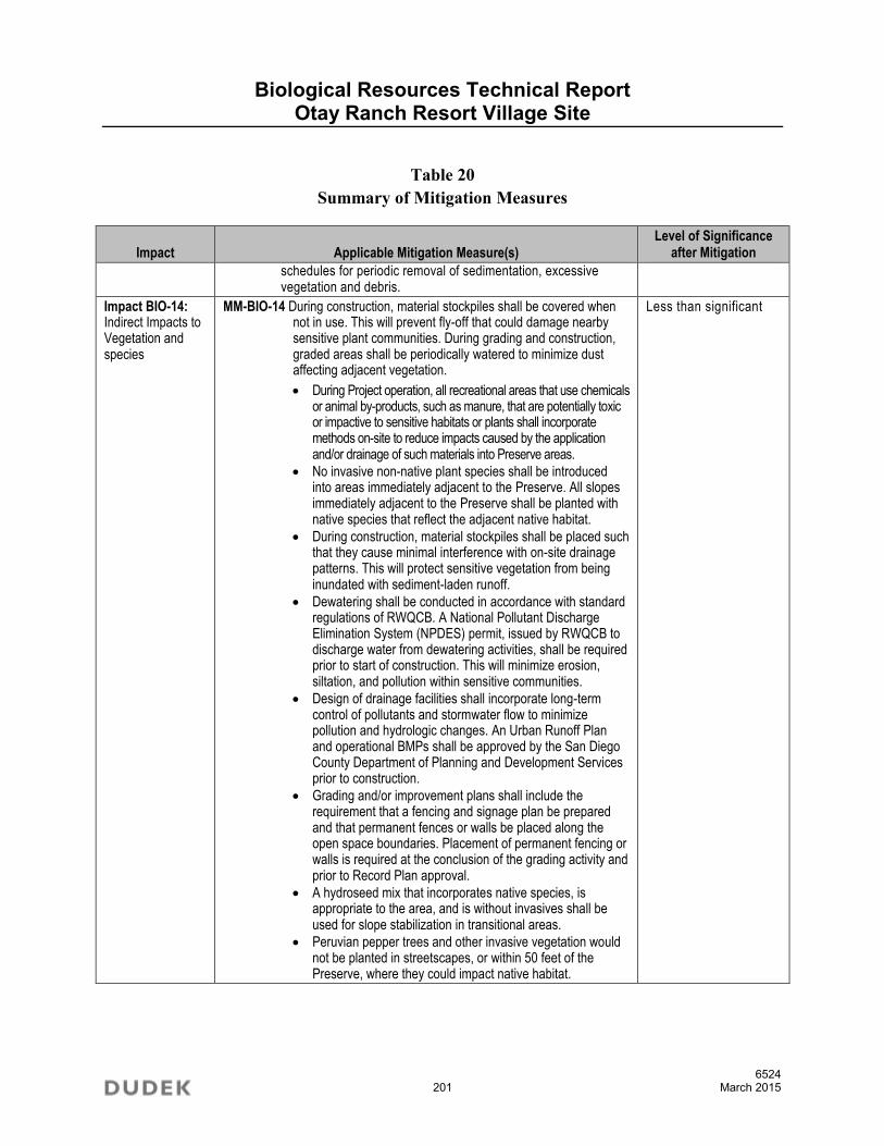
Biological Resources Technical Report Otay Ranch Resort Village Site
6524 201 March 2015
Table 20 Summary of Mitigation Measures
Impact Applicable Mitigation Measure(s) Level of Significance
after Mitigation
schedules for periodic removal of sedimentation, excessive vegetation and debris.
Impact BIO-14: Indirect Impacts to Vegetation and species
MM-BIO-14 During construction, material stockpiles shall be covered when not in use. This will prevent fly-off that could damage nearby sensitive plant communities. During grading and construction, graded areas shall be periodically watered to minimize dust affecting adjacent vegetation.
During Project operation, all recreational areas that use chemicals or animal by-products, such as manure, that are potentially toxic or impactive to sensitive habitats or plants shall incorporate methods on-site to reduce impacts caused by the application and/or drainage of such materials into Preserve areas.
No invasive non-native plant species shall be introduced into areas immediately adjacent to the Preserve. All slopes immediately adjacent to the Preserve shall be planted with native species that reflect the adjacent native habitat.
During construction, material stockpiles shall be placed such that they cause minimal interference with on-site drainage patterns. This will protect sensitive vegetation from being inundated with sediment-laden runoff.
Dewatering shall be conducted in accordance with standard regulations of RWQCB. A National Pollutant Discharge Elimination System (NPDES) permit, issued by RWQCB to discharge water from dewatering activities, shall be required prior to start of construction. This will minimize erosion, siltation, and pollution within sensitive communities.
Design of drainage facilities shall incorporate long-term control of pollutants and stormwater flow to minimize pollution and hydrologic changes. An Urban Runoff Plan and operational BMPs shall be approved by the San Diego County Department of Planning and Development Services prior to construction.
Grading and/or improvement plans shall include the requirement that a fencing and signage plan be prepared and that permanent fences or walls be placed along the open space boundaries. Placement of permanent fencing or walls is required at the conclusion of the grading activity and prior to Record Plan approval.
A hydroseed mix that incorporates native species, is appropriate to the area, and is without invasives shall be used for slope stabilization in transitional areas.
Peruvian pepper trees and other invasive vegetation would not be planted in streetscapes, or within 50 feet of the Preserve, where they could impact native habitat.
Less than significant
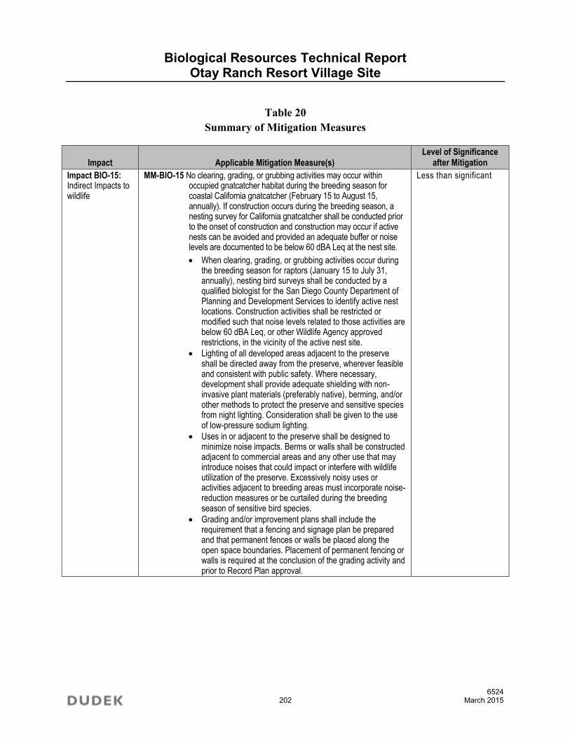
Biological Resources Technical Report Otay Ranch Resort Village Site
6524 202 March 2015
Table 20 Summary of Mitigation Measures
Impact Applicable Mitigation Measure(s) Level of Significance
after Mitigation
Impact BIO-15: Indirect Impacts to wildlife
MM-BIO-15 No clearing, grading, or grubbing activities may occur within occupied gnatcatcher habitat during the breeding season for coastal California gnatcatcher (February 15 to August 15, annually). If construction occurs during the breeding season, a nesting survey for California gnatcatcher shall be conducted prior to the onset of construction and construction may occur if active nests can be avoided and provided an adequate buffer or noise levels are documented to be below 60 dBA Leq at the nest site.
When clearing, grading, or grubbing activities occur during the breeding season for raptors (January 15 to July 31, annually), nesting bird surveys shall be conducted by a qualified biologist for the San Diego County Department of Planning and Development Services to identify active nest locations. Construction activities shall be restricted or modified such that noise levels related to those activities are below 60 dBA Leq, or other Wildlife Agency approved restrictions, in the vicinity of the active nest site.
Lighting of all developed areas adjacent to the preserve shall be directed away from the preserve, wherever feasible and consistent with public safety. Where necessary, development shall provide adequate shielding with non-invasive plant materials (preferably native), berming, and/or other methods to protect the preserve and sensitive species from night lighting. Consideration shall be given to the use of low-pressure sodium lighting.
Uses in or adjacent to the preserve shall be designed to minimize noise impacts. Berms or walls shall be constructed adjacent to commercial areas and any other use that may introduce noises that could impact or interfere with wildlife utilization of the preserve. Excessively noisy uses or activities adjacent to breeding areas must incorporate noise-reduction measures or be curtailed during the breeding season of sensitive bird species.
Grading and/or improvement plans shall include the requirement that a fencing and signage plan be prepared and that permanent fences or walls be placed along the open space boundaries. Placement of permanent fencing or walls is required at the conclusion of the grading activity and prior to Record Plan approval.
Less than significant

Biological Resources Technical Report Otay Ranch Resort Village Site
6524 203 March 2015
7 ACKNOWLEDGMENTS
This report was prepared by Dudek biologists Anita M. Hayworth, PhD, Vipul R. Joshi, and Brock Ortega. Review was provided by Philip Behrends, PhD and Joseph Monaco, AICP. Graphics and GIS analyses were provided by Lesley Terry; David Mueller, Devin Brookhart, and Ellie Choa provided publications assistance.
Biological Resources Technical Report Otay Ranch Resort Village Site
6524 204 March 2015
INTENTIONALLY LEFT BLANK

Biological Resources Technical Report Otay Ranch Resort Village Site
6524 205 March 2015
8 LITERATURE CITED
Abrams, L. 1923. Illustrated Flora of the Pacific States. Stanford University Press, Stanford, California.
ACOE (United States Army Corps of Engineers). 1987. Corps of Engineers Wetlands Delineation Manual. Wetlands Research Program Technical Report (Y-87-1) (online edition). January 1987, Vicksburg, MS.
ACOE. 1997. Corps of Engineers Los Angeles District Special Public Notice Regarding Vernal Pools. September 1997.
AOU (American Ornithologists’ Union). 2013. Check-List of North American Birds: List of the 2,090 Bird Species Known from the AOU Check-List Area. Accessed from http://checklist.aou.org/taxa/
Bauder, Ellen T. 1986. San Diego Vernal Pools: Recent and Projected Losses; Their Condition; and Threats to Their Existence 1979–1980. Prepared for Endangered Plant Project – California Department of Fish and Game. Funded by U.S. Fish and Wildlife Service – Office of Endangered Species. September.
Beauchamp, R.M. 1986. A Flora of San Diego County, California. Sweetwater Press: National City, California. 241 pp.
Bowman, R.H. 1973. Soil Survey, San Diego Area, California, Part 1. United States Department of Agriculture. 104 pp. + appendices.
CDFW (California Department of Fish and Wildlife), Natural Diversity Database. 2014a. Special Animals List. Periodic publication. September. 52 pp.
CDFW, California Natural Diversity Database. 2014b. Special Vascular Plants, Bryophytes, and Lichens List. Quarterly publication. July. 124 pp.
CNPS (California Native Plant Society). 2014. Rare and Endangered Plant Inventory. California Native Plant Society. Sacramento, California. Online edition, v8-02. Accessed October 7, 2014 at http://www.rareplants.cnps.org/
Biological Resources Technical Report Otay Ranch Resort Village Site
6524 206 March 2015
Crother, B.I. 2012. Scientific and Standard English Names of Amphibians and Reptiles of North America North of Mexico, with Comments Regarding Confidence in our Understanding, edited by J.J. Moriarty. 7th ed. Society for the Study of Amphibians and Reptiles (SSAR); Herpetological Circular, no. 39. August 2012. Accessed January 28, 2013. http://home.gwu.edu/~rpyron/publications/Crother_et_al_2012.pdf.
Dudek. 1992. Report on the Hydrology and Flora of the Otay Ranch Vernal Pools, 1990–1991 San Diego County, California. Prepared for Baldwin Vista Associates. March 12.
Dudek. 1999a. Quino Checkerspot Survey for Otay Ranch Village 13 Project Site. Report to: U.S. Fish and Wildlife Service. Prepared for Otay Ranch Company Inc. June 21.
Dudek. 1999b. Dry Season Presence/Absence Survey for Vernal Pool Branchiopods for the Otay Ranch Village 13/Resort Site. Report to: U.S. Fish and Wildlife Service. Prepared for Otay Ranch Company Inc. October 6.
Dudek. 2000a. Quino Checkerspot Butterfly Survey for Otay Ranch Village 13 Preserve Area. Prepared for Otay Ranch Company,Inc. June 16.
Dudek. 2000b. Wet Season Presence/Absence Survey for Vernal Pool Branchiopods for the Otay Ranch Village 13/Resort Site. Report to: U.S. Fish and Wildlife Service. Prepared for Otay Ranch Company Inc. June 22.
Dudek. 2003. Wet Season Presence/Absence Survey for Vernal Pool Branchiopods for the Otay Ranch Village 13/Resort Site. Report to: U.S. Fish and Wildlife Service. Prepared for Otay Ranch Company Inc. September 11.
Dudek. 2004. Protocol Presence/Absence Survey for Quino Checkerspot Butterfly for the Otay Ranch Village 13/Resort Site. Report to: U.S. Fish and Wildlife Service. Prepared for Otay Ranch Company Inc. June 14.
Dudek. 2006a. Protocol Presence/Absence Survey for Quino Checkerspot Butterfly for the Off-Site Survey Area for Otay Ranch Village 13/Resort Site. Report to: U.S. Fish and Wildlife Service. Prepared for Otay Ranch Company Inc. August 14.
Dudek. 2006b. Protocol Presence/Absence Survey for Least Bell’s Vireo and Southwestern Willow Flycatcher for the Off-Site Survey Area for Otay Ranch Village 13/Resort Site. Report to: U.S. Fish and Wildlife Service. Prepared for Otay Ranch Company Inc. August 16.

Biological Resources Technical Report Otay Ranch Resort Village Site
6524 207 March 2015
Dudek. 2006c. Wet Season Presence/Absence Survey for Vernal Pool Branchiopods for the Off-Site Survey Area for Otay Ranch Village 13/Resort Site. Report to: U.S. Fish and Wildlife Service. Prepared for Otay Ranch Company Inc. November 28.
Dudek. 2007. 2007 Wet Season Presence/Absence Survey for Vernal Pool Branchiopods for Off-Site Survey Area for Otay Ranch Village 13/Resort Site. Report to: U.S. Fish and Wildlife Service. Prepared for Otay Ranch Company Inc. November 9.
Dudek. 2008a. Quino Checkerspot Butterfly Survey for Otay Ranch Village 13/Resort Site. Report to: U.S. Fish and Wildlife Service. Prepared for Otay Ranch Company Inc. September 3.
Dudek. 2008b. 2008 Wet Season Presence/Absence Survey for Vernal Pool Branchiopods for the Otay Ranch Village 13/Resort Site. Report to: U.S. Fish and Wildlife Service. Prepared for Otay Ranch Company Inc. September 11.
Donaldson, B.M. 2005. Final Report: The Use of Highway Underpasses by Large Mammals in Virginia and Factors Influencing their Effectiveness. Virginia Transportation Research Council.
Emmel, T.C. and J.F. Emmel. 1973. The Butterflies of Southern California. Natural History Museum of Los Angeles County, Science Series 26:1–148.
Foster, M. L. and S. R. Humphrey. 1995. Use of highway underpasses by Florida panthers and other wildlife. Wildlife Society Bulletin 23:95-100.
Fryer, J.L. 2012. Quercus berberidifolia, Q. dumosa. In: Fire Effects Information System, [Online]. U.S. Department of Agriculture, Forest Service, Rocky Mountain Research Station, Fire Sciences Laboratory (Producer). Accessed January 14, 2015. http://www.fs.fed.us/database/feis/.
Hickman, J.C., ed. 1996. The Jepson Manual: Higher Plants of California. Third printing with corrections. Berkeley and Los Angeles, California: University of California Press.
Holland, R.F. 1986. Preliminary Descriptions of the Terrestrial Natural Communities of California. Nongame-Heritage Program, California Department of Fish and Game. 156 pp.
MBA (Michael Brandman Associates). 1989. Biological Resources Survey Report, Otay Ranch – Proctor Valley Area. Prepared for the Baldwin Company. September.

Biological Resources Technical Report Otay Ranch Resort Village Site
6524 208 March 2015
MBA. 1991. Sensitive Plant Species Report, Otay Ranch –Proctor Valley Area. Prepared for the Baldwin Company.
MBA. Undated. Supplemental Survey for California Gnatcatcher (Polioptila californica). Prepared for the Baldwin Company.
Moyle, P.B. 2002. Inland Fishes of California, University of California Press, Berkeley and Los Angeles, 502 pp.
MSCP (Multiple Species Conservation Program). 1998. Final MSCP Plan. Prepared by: MSCP Policy Committee and MSCP Working Group. San Diego, California.
Munsell. 1998. Munsell Soil Color Charts.
NABA (North American Butterfly Association). 2001. “Checklist of North American Butterflies Occurring North of Mexico.” Adapted from North American Butterfly Association (NABA) Checklist and English Names of North American Butterflies, eds. B. Cassie, J. Glassberg, A. Swengel, and G. Tudor. 2nd ed. Morristown, New Jersey: NABA. Accessed May 2012 at http://www.naba.org/pubs/enames2.html
Oberbauer, Thomas, Meghan Kelly, and Jeremy Buegge. 2008. Draft Vegetation Communities of San Diego County. Based on “Preliminary Descriptions of the Terrestrial Natural Communities of California,” by Robert F. Holland, PhD, October 1986. March 2008.
Ogden (Odgen Environmental and Energy Service Company ). 1992a. Baldwin Otay Ranch Wildlife Corridors Studies: Phase 1 Report. Prepared for the Otay Ranch Project Team. December.
Ogden. 1992b. Final Program Environmental Impact Report – Otay Ranch. Prepared for Otay Ranch Joint Planning Project. December.
Ogden. 1999. Multiple Species Conservation Plan, Habitat Evaluation Maps.
Otay Ranch. 1993. “Otay Subregional Plan, Volume 2.” Subregional Plan (SRP). Applicant: Otay Vista Associates. Prepared for Otay Ranch Joint Planning Project. Approved by: City of Chula Vista and County of San Diego. October 28.
Otay Ranch. 2011. Resource Management Plan (RMP). Prepared by Dudek & Associates Inc. Prepared for Otay Ranch Joint Planning Project. Anticipated to be approved in 2011 by: City of Chula Vista and County of San Diego.

Biological Resources Technical Report Otay Ranch Resort Village Site
6524 209 March 2015
Reed, P.B. 1988. National List of the Plant Species That Occur in Wetlands: California (Region 0). Biological Report 88(26.10). United States Fish and Wildlife Service, Department of the Interior.
SANDAG (San Diego Association of Governments). 1999. Regional Vegetation Mapping for Multiple Species Conservation Program Plan Area. GIS database.
San Diego, County of. 1997. MSCP Subarea Plan. Adopted October 22.
San Diego, County of. 2004. Biological Mitigation Ordinance, Ordinance No. 8845, 9246, 9632. Amendments effective 4/23/2004.
San Diego, County of. 2007. Resource Protection Ordinance. March. Accessed at: http://www.s dcounty.ca.gov/dplu/docs/res_prot_ord.pdf
San Diego, County of. 2008a. County of San Diego Report Format and Content Requirements: Biological Resources. Land Use and Environment Group, Department of Land Use and Planning, Department of Public Works. July 30, 2008.
San Diego, County of. 2008b. County of San Diego Guidelines for Determining Significance: Biological Resources. Land Use and Environment Group, Department of Land Use and Planning, Department of Public Works. July 30, 2008.
San Diego, County of. 2010. County of San Diego Biological Mitigation Ordinance.
SDNHM (San Diego Natural History Museum). 2002. “Butterflies of San Diego County. Revised September 2002.” Accessed May 2012 at http://www.sdnhm.org/archive/ research/entomology/sdbutterflies.html.
Stebbins, R.C. 2003. A Field Guide to Western Reptiles and Amphibians. Houghton Mifflin Co., Boston, Massachusetts.

Biological Resources Technical Report Otay Ranch Resort Village Site
6524 210 March 2015
Unitt, P. 2004. San Diego County Bird Atlas. Online (Google Earth) version. Proceedings of the San Diego Society of Natural History, no. 39. San Diego, California: San Diego Natural History Museum. Accessed March 30, 2013. http://www.sdnhm.org/science/birds-and-mammals/projects/san-diego-county-bird-atlas/.
USFWS (U.S. Fish and Wildlife Service). 1996. Interim Survey Guidelines to Permittees for Recovery Permits under Section 10(a)(1)(A) of the Endangered Species Act for the Listed Vernal Pool Branchiopods. April 19. Department of the Interior.
USFWS. 1999. Survey Protocol for the Endangered Quino Checkerspot Butterfly (Euphydryas editha quino) for the 1999 Field Season. January 25. Carlsbad, California.
USFWS. 2000. Survey Protocol for the Endangered Quino Checkerspot Butterfly (Euphydryas editha quino) for the 2000 Field Season. Undated. Carlsbad, California.
USFWS. 2002. Quino Checkerspot Butterfly (Euphydryas editha quino) Survey Protocol Information. Carlsbad, California. February. 8 pp.
Wilson, D.E., and D.M. Reeder, eds. 2005. Mammal Species of the World: A Taxonomic and Geographic Reference, 3rd ed. (MSW3 database). Accessed March 1, 2011. http://www.bucknell.edu/.