Embed Size (px)
Citation preview
M. Mohapatra,
Head, RSMC New Delhi
Review of Tropical Cyclone
Operational Plan for 2016

Operational plan 2016
Additional products of INSAT-3D imageries on cyclones in website of
IMD and RSMC New Delhi
GIS based RAPID system for better analysis of satellite imageries and
products available in IMD website
Derived products like vorticity, divergence, convergence, wind shear
etc from INSAT-3D

Satellite Meteorology
Establishment of a new processing system, earth station and civil work for INSAT-3D (Repeat) and INSAT-3D (Spare) expected to be launched in 2016.
Validation of different INSAT-3D products on monthly basis.
Up gradation of NSDC to a state of art New Satellite Data centre and to set up IMET cast Network for dissemination of satellite data/products.
Implementation of Advanced D ‘ Vorak’s technique tools in respect of auto tracking of cyclone.

DWR installations
DWRs Paradip, Karaikal and Mumbai: Commissioned and made functional.
DWR Srinagar: Commissioned and made functional.
DWR Gopalpur: System installed provided by ISRO. Hardware and software System tests are in progress by M/s BEL and ISRO Engineers.
DWR Bhuj: Under operational testing by M/s BEL engineers and SAT will be conducted shortly.
DWR Kochi: Installation is in progress.
DWR Goa: Installation of Base ring & Radome started. System will be commissioned shortly.
CAMC of C-Band DWR (Vaisala) for HQ and Jaipur signed for three years.
CAMC of 9 Nos. DWR (Metstar), China is under process of entering into contract agreement.
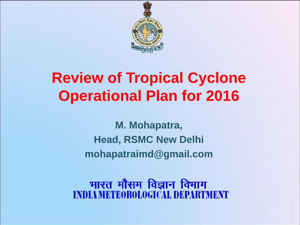
Upper Air Instruments Entire network of 39 stations of upper air (RS/RW) upgraded with GPS based system, and all the stations are working at present.
6 Nos. of GPS based systems (make M/s GRAW Germany) installed/ commissioned (one at each RMC) to up-grade these RS/RW stations as per WMO GCOS Network (GUAN) standard. Action being taken for induction of these stations into GUAN network.
13 Nos. of GPS based systems (make M/s Jinyang Korea) installed/ commissioned at RS/RW Agaratala, Siliguri, Gorakhpur, Lucknow, Ranchi, Karaikal, Machhilipatnam, Mangalore, Kochi, Jodhpur, Jammu, Sundernagar & Dehradun.
7 Nos. of GPS based systems (make M/s Changfeng China) installed/ commissioned at Patiala, Gwalior, Jagdalpur, Raipur, Jaipur, Aurangabad & Bangalore to up-grade these RS/RW stations.
Pilot Balloon (PB) observatories of Sundernagar and Dehradun up-graded to RS/RW.

Numerical Weather Prediction
Assimilation of INSAT 3D AMV/CMV in GFS and WRF, INSAT 3D Radiance in WRF, multiple DWR data in WRF
Porting of GFS and WRF model at IITM - ‘Aditya’ completed and operationalized .
GEFS and UM EPS products from NCMRWF
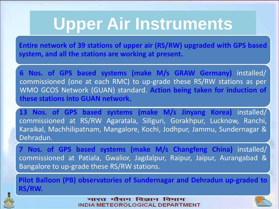
NWP Modeling
HWRF run at 27x9x3 resolution four times a day based
on 00, 06, 12 and 18 UTC analysis
Storm surge inputs: INCOIS and IIT Delhi models already
under use.
Coastal inundation forecast: INCOIS model in operation.

Plan : 2016:Experimental Seasonal Prediction
Model: Principal Component Regression Model for
storm count
The PCR model was developed using 6 parameters
for a training period of 40 years (1971 to 2010) and
tested for the years 2011-2014.
Regression model for cyclonic disturbance
(depression and above) days over NIO during OND
Experimental seasonal prediction was attempted on
real time for the post-monsoon cyclone period (OND).
2014 and 2015
The prediction may be communicated to member
countries from 2016 post-monsoon season to be
issued in September 2016

Plan: 2016
Extended Range Forecast:
Coupled Model Guidance
• We may produce the Extended Range Outlook for cyclogenesis and
heavy rainfall based on extended range numerical model forecasts.

Plan-2015: Bifurcation of VSCS category
Nomenclature MSW in kts Pressure
Drop (hPa)
Very Severe Cyclonic Storm (VSCS)
64-89 kts 20.1-40.5 hPa
Extremely Severe Cyclonic Storm (ExSCS) 90-119 kts 40.5-79.9 hPa
Nomenclature of
Low Pressure System
Pr. defect
(hPa)
T.No MSW in kts
Low pressure area (LOPAR) 1.0 T1.0 <17
Depression (D) 1.0- 3.0 T1.5 17-27
Deep Depression (DD) 3.0 - 4.5 T2.0 28-33
Cyclonic Storm (CS) 4.5- 8.5 T2.5-3.0 34-47
Severe Cyclonic Storm (SCS) 8.5-20.1 T3.5 48-63
Very Severe Cyclonic Storm (VSCS) 20.1-79.9 T4.0-6.0 64-119
Super Cyclonic Storm (SuCS) >79.9 T≥6.5 120 or more
From the year 2015 onwards, the VSCS has been bifurcated as above and all
bulletins are issued based on the new nomenclature

Plan-2016: Quadrant wind radii monitoring
• Inputs: NOAA-NESDIS multi-platform
wind products and analysis field of
the model closest to the
observational analysis
• The wind radii forecasts are issued
over the sea area only as per the
requirement of the users.
• Included the wind radii analysis
information in best track parameters
from 2015
• It has been sent to WMO and NHC,
USA
28 kt
34 kt
50 kt
64 kt
Northeast Northwest
Southwest Southeast

Plan 2016 : Rainfall estimation (Implemented)
Satellite and RADAR based QPE
IMD-NCMRWF’s GPM based satellite - gauge merged rainfall product
TC specific rainfall profiles of analogous past cyclones (TCRAIN)

Plan-2016: Heavy rainfall prediction HWRF and ensemble tropical rainfall probability (eTRaP) for every six
hrs

Rainfall Initiatives
Enhanced duration for QPF from 2 days to 3 days and outlook from 3 days to 4 days
Pictorial and tabulation of sub catchment wise QPF from NWP models- GFS for 7days in addition to WRF, MME for 3 days
QPF issued for 4 new catchments: Jhelum, Pennar, Torsa, Sankosh which involves 12 sub catchments
Real time Hourly cumulative (one day) AWS/ARG rainfall data on Pan India. Useful for real time rainfall information, Urban flooding etc.
Zoom in/out

Information Systems and Services
New in-house developed/ re-designed website (user friendly/ easy to navigate): Launched by Hon’ble Minister on 141st IMD foundation day (2016).
NKN implementation: Link established with IITM Pune for running NWP models at HPCS of IITM, Pune. The link is also utilized for data exchange with other MoES centres under CUG of NKN and web browsing.
Data sharing with NAVY, IAF including FTP service, FDP project etc.
New links: Established GTS link with Bhutan over internet and 2 links (with Exeter and offenbach) through RMDCN cloud for data exchange over GTS.
Integration of several new data sets like Satellite radiance data, Himawari satellite(JMA), Argo BUFR (INCOIS), METOP etc. for GTS exchange.
NKN implementation between NCS and INCOIS for data exchange through VSAT hub at NCMRWF Noida.
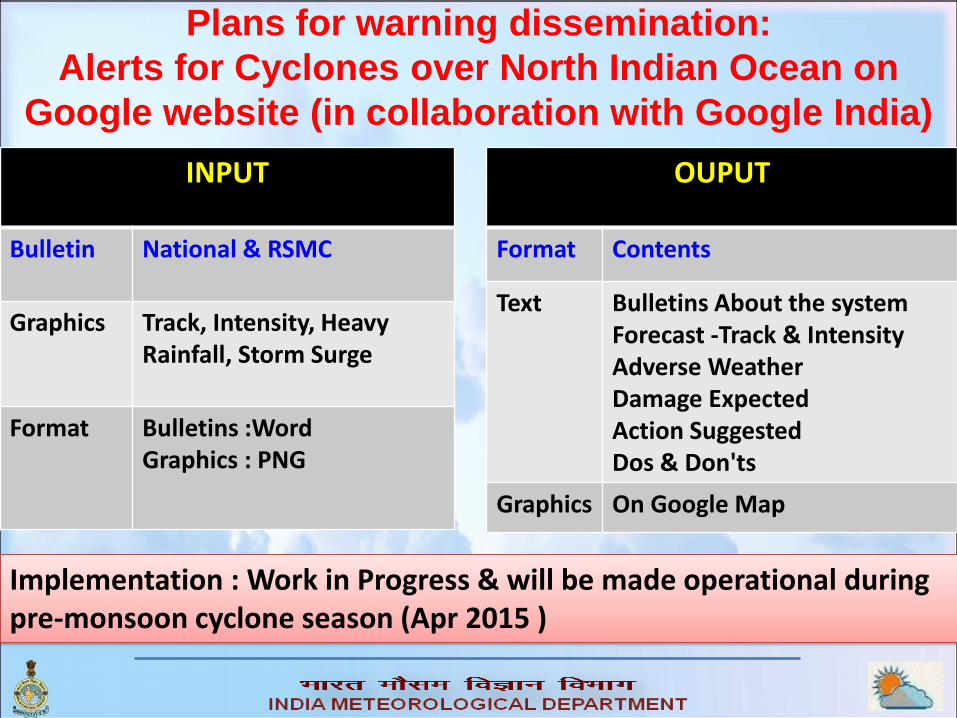
Plans for warning dissemination:
Alerts for Cyclones over North Indian Ocean on
Google website (in collaboration with Google India)
OUPUT
Format Contents
Text Bulletins About the system Forecast -Track & Intensity Adverse Weather Damage Expected Action Suggested Dos & Don'ts
Graphics On Google Map
INPUT
Bulletin National & RSMC
Graphics Track, Intensity, Heavy Rainfall, Storm Surge
Format Bulletins :Word Graphics : PNG
Implementation : Work in Progress & will be made operational during pre-monsoon cyclone season (Apr 2015 )

Sample of what an IMD alert in Google website may look like

SOPs : Chapter 9 of the manual has been
finalised for national use
SOP between IMD and INCOIS is finalised
for national use
In addition, it will be used for coastal
weather bulletin, sea area bulletin
Synergised SOP for WMO/ESCAP PTC and
Typhoon Committee countries has been
finalised
It can be used as a guideline for regional
development of SSOP
SOP

Synergized- SOP for Marine Weather & Ocean State
forecast
IMD issues marine weather forecast for NIO
INCOIS issues Ocean state forecast
Some of the forecast parameter like wind and sea
state(wave height)are common. However the forecast
differ from each other different validity period, content
and language
Hence IMD & INCOIS constituted a committee to
develop a Synergized-SOP
Final SOP has been prepared and circulated to all
Cyclones warning centres for implementation from
2016

Thank you