Embed Size (px)
Citation preview
Stephan Mueller Spec. Publ. Ser., 4, 45–64, 2009www.stephan-mueller-spec-publ-ser.net/4/45/2009/© Author(s) 2009. This work is distributed underthe Creative Commons Attribution 3.0 License.
SpecialPublication
Series
Review of geology of the New Siberian Islands between the Laptevand the East Siberian Seas, North East Russia
M. Kos’ko 1 and E. Korago2
1Geological Institute Russian Academy of Sciences, St.-Petersburg Laboratory for geology and mineralogy of polar areas, 1,Angliysky Prospekt, 190121, St.-Petersburg, Russia2VNIIOkeangeologia, 1, Angliysky Prospekt, 190121, St.-Petersburg, Russia
Abstract. The New Siberian Islands comprise De Long Is-lands, Anjou Islands, and Lyakhov Islands. Early Paleo-zoic, Mesozoic and Cenozoic sediments and igneous rocksare known on the De Long Islands. Cambrian slate, silt-stone, mudstone and silicified limestone occur on BennettIsland. Ordovician volcanogenic turbidites, lavas, and smallintrusions of andesite-basalt, basalt, dolerite, and porphyriticdiorite were mapped on Henrietta Island. The igneous rocksare of calc-alkaline island arc series. The Ordovician age ofthe sequence was defined radiometrically. Early Paleozoicstrata were faulted and folded presumably in the Caledoniantime. Early Cretaceous sandstone and mudstone are knownon Bennett Island. They are overlain by a 106–124 Ma basaltunit. Cenozoic volcanics are widespread on the De Long Is-lands. Zhokhov Island is an eroded stratovolcano. The vol-canics are mostly of picrite-olivine type and limburgite. Ra-diometric dating indicates Miocene to Recent ages for Ceno-zoic volcanism.
On the Anjou islands Lower-Middle Paleozoic strata con-sist of carbonates, siliciclastics, and clay. A Northwest-southeast syn-sedimentary facies zonation has been recon-structed. Upper Paleozoic strata are marine carbonate, clayand siliciclastic facies. Mudstone and clay predominate inthe Triassic to Upper Jurassic section. Aptian-Albian coalbearing deposits uconformably overlap lower strata indicat-ing Early Cretaceous tectonism. Upper Cretaceous units aremostly clay and siltstone with brown coal strata resting onEarly Cretaceous weathered rhyolite. Cenozoic marine andnonmarine silisiclastics and clay rest upon the older unitswith a transgressive unconformity including a weatheringprofile in the older rocks.
Manifestations of Paleozoic and Triassic mafic and Creta-ceous acidic magmatism are also found on these islands. Thepre-Cretaceous structure of the Anjou islands is of a block
Correspondence to:M. Kos’ko([email protected])
and fold type Late Cimmerian in age followed by faulting inCenozoic time.
The Lyakhov islands are located at the western end ofthe Late Cimmerian South Anyui suture. Sequences ofvariable age, composition, and structural styles are knownon the Lyakhov Islands. These include an ancient meta-morphic sequence, Late Paleozoic ophiolitic sequence, LateMesozoic turbidite sequence, Cretaceous granites, and Ceno-zoic sediments. Fold and thrust imbricate structures havebeen mapped on southern Bol’shoi Lyakhov Island. North-northwestern vergent thrusts transect the Island and projectoffshore. Open folds of Jurassic–Early Cretaceous strata arecharacteristic of Stolbovoi and Malyi Lyakhov islands.
Geology of the New Siberian Islands supports the con-cept of a circum Arctic Phanerozoic fold belt. The belt iscomprised of Caledonian, Ellesmerian, Early Cimmerian andLate Cimmerian fold systems, manifested in many placeson the mainland and on islands around the Arctic Ocean.Knowledge of the geology of the New Siberian Islands hasbeen used to interpret anomalous gravity and magnetic fieldmaps and Multi Channel Seismic (MCS) lines. Two distin-guishing structural stages are universally recognized withinthe offshore sedimentary cover which correlate with the on-shore geology of the New Siberian Islands. Dating of the up-per structural stage and constituent seismic units is based onstructural and stratigraphic relationships between Late Meso-zoic and Cenozoic units in the archipelago. The Laptev Sea–western East Siberian Sea seismostratigraphic model for theupper structural stage has much in common with the seis-mostratigraphic model in the American Chukchi Sea.
1 Introduction
The New Siberian Islands (Fig. 1) are located between theLaptev Sea to the west and the East Siberian Sea to theeast. The geological data from the islands has been projectedoffshore to help understand the poorly known sea bottom
Published by Copernicus Publications on behalf of the European Geosciences Union.

46 M. Kos’ko and E. Korago: Review of geology of the New Siberian Islands
Bolíshoi Lyakhov I.
Henrietta I.
Jeannette I.
Zhokhov I.
Vilíkitsky I.
Bennett I.
Novaya Sibirí I.
Faddeevsky I.
Zemlya Bunge
Kotelíny I.
Belíkovsky I.
Stolbovoi I.Malyi Lyakhov I.
Sviatoi Nos P.Hedens+ trom Bay
A n j o u I s l a n d s
Lyakhov Islands
Strelka Anjou
D e L o n g I s l a n d s
750
1400
1400 1500
1500 1600
1600
750
Fig. 9
Fig.10
Fig. 11
Fig. 12
Bolíshoi Lyakhov I.
Henrietta I.
Jeannette I.
Zhokhov I.
Vilíkitsky I.
Bennett I.
Novaya Sibirí I.
Faddeevsky I.
Zemlya Bunge
Kotelíny I.
Belíkovsky I.
Stolbovoi I.Malyi Lyakhov I.
Sviatoi Nos P.Hedens+ trom Bay
A n j o u I s l a n d s
Lyakhov Islands
Strelka Anjou
Fig. 1. New Siberian Islands. Location Map (note locations for Figs. 9, 10, 11, and 12).
geology. The East Siberian and Laptev seas are very large,and they have a major role to play in allowing us to un-derstand the geologic history of the whole Arctic region, ofwhich our knowledge is fragmentary. Building on the workdone on the small parts that are above sea-level is critical tointerpreting the offshore geology.
The present day knowledge of the geology of the islandsis largely based on the results of multi-disciplinary researchand exploration carried out under VNIIOkeangeologia andPolar Marine Geosurvey Expedition (PMGE) projects in thelast century, in the 1970’s and 1980’s. Geoscientists froma number of the Russian Academy of Science institutesA. B. Kuzmichev, G. V. Flerov, S. A. Silantiev, O. G. Bog-danovsky, S. S. Drachev, Yu. P. Masurenkov, L. A. Savostin,P. I. Fedorov, and others have made significant contributionsto the knowledge of the geology of the New Siberian Islandssince that time.
There are many general and detailed publications in Rus-sian and a few papers in English treating the archipelago as awhole or focused on individual islands and special problems.The review presented here is a brief up-to-date summary ofavailable geological information. Some earlier models havebeen updated, new field and laboratory studies performed butthe only dramatic revision concerns the stratified sequencesand the tectonic structure of Bol’shoi Lyakhov Island.
The purpose of this paper is to provide an outline of thegeneral geology of the archipelago and to indicate someArctic and northeast Asian geoscientific problems for whichknowledge of the geology of the New Siberian Islands canhelp provide solutions.
The New Siberian Islands comprise three constituentarchipelagos: De Long Islands, Anjou Islands, and LyakhovIslands. The archipelagos are extremely variable in mag-matic and sedimentary sequences exposed and structural pat-terns. They are described below separately starting from thenorthern De Long Islands.
2 The De Long Islands
Early Paleozoic, Mesozoic and Cenozoic sediments and ig-neous rocks are known on the De Long Islands.
2.1 Henrietta and Jeanette Islands
Ordovician volcanogenic turbidites, lavas, and small intru-sions have been mapped on Henrietta Island (Fig. 2). Thesequence comprises four units: quartzite sandstone (170 m);rhythmic volcano-clastic mudstone and sandstone (more than150 m); volcano-clastic sandstone and gritstone with inter-layers of siltstone, tuff, and basalt lava sheets (370 m). There
Stephan Mueller Spec. Publ. Ser., 4, 45–64, 2009 www.stephan-mueller-spec-publ-ser.net/4/45/2009/
M. Kos’ko and E. Korago: Review of geology of the New Siberian Islands 47
Fig. 2. Geological map of Henrietta Island. Simplified from Dorofeev et al. (1999).
is a hiatus at the base of this unit. The fourth is a basalticunit (160 m) faulted against the others and thought to be theuppermost unit in the section. Numerous andesite-basalt,basalt, dolerite, and porphyritic diorite flows, sills and dykesare known on the island (Vinogradov et al., 1975). One moreunit has been reported on the top of the stratified section onHenrietta Island by M. M. Ermolaev (Vol’nov et al., 1970)and which is not mentioned in Vinogradov’s et al. (1975).The unit is composed mostly of well rounded pebbles of theunderlying rocks and most likely has a disconformity at itsbase.
It is believed that the same sequence outcrops on Jean-nette Island. The pebble and cobble unit here disconformablyoverlies graywacke and volcano-clastics similar to those onHenrietta Island. Pebbles and cobbles up to 70 cm in di-ameter are metamorphic rocks, granites and mafic volcanics(Vol’nov et al., 1970). These volcano-sedimentary rocks onthe Jeannette Isl. dip ENE at 60◦ (Vol’nov et al., 1970).
Henrietta Island is described by Vinogradov et al. (1975)as a part of the eastern flank of a wide syncline trending closeto North. The steepest bedding is on the northeastern part ofthe island, where the beds dip to the west at an angle of 43◦–45◦. Tightly folded and faulted layers transiting into morehorizontal bedding were observed to the south. On the eastcoast and in most of the south parts of the island, the beds dipto the northwest and to the west at 8◦–10◦, leveling in someplaces up to 3◦–4◦. In some places they dip slightly steeperat 15◦–17◦. In the most southwestern part of the island a vol-canogenic basaltic unit dips to the southwest at 5◦–20◦. Thissouthwestern part of the island is also separated from the restof the island by a zone of intense deformation about 600 mwide with a sub-longtitudinal strike. Strike slip faults dippingto the east at an angle of 70◦–75◦, together with low ampli-tude NW striking steep faults are present within the deforma-tion zone. Separate box folds with steep limbs (50◦–70◦),
monoclines dipping at 70◦–80◦, vertical layers, bundles ofisoclinal folds 10–20 m wide with sub-horizontal and sub-vertical hinges have been reported (Vinogradov et al., 1975).Cleavage dipping from 80◦ up to vertical is wide-spread. Inthe north of the island the strike of cleavage is close to NS.Two cleavage systems with strikes of 310◦–320◦ and 45◦–50◦ are present on the south coast of the island.
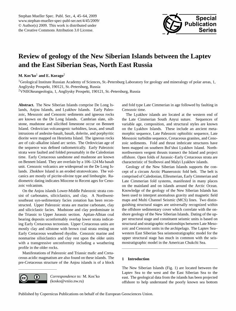
The clasts in the rocks on Henrietta Island consist of schist,microcline granite, gneiss, micropegmatite, quartzite, rhyo-lite and dacite-andesite along with rocks similar to those ofthe flows, sills and dykes. The igneous rocks are typical ofa calc-alkaline island arc (Fig. 3). The metamorphic grade isof green schist facies.
Whole rock argon-argon ages give 440 Ma for a por-phyritic diorite and 444±2 Ma for a dolerite (Kaplan et al.,2001). Previous potassium-argon whole rock determinationsindicated an Ordovician age along with younger ages: 450,310, 375, 430, 390 Ma (Gramberg et al., 2004).
2.2 Bennett, Zhokov and Vil’kitsky Islands
Cambrian strata 500 m thick occur on Bennett Island(Vol’nov and Sorokov, 1961) consisting of dark-grey slatewith thin interlayers of siltstone and silicified limestone. Thelower half of the section contains Middle Cambrian trilo-bites. The upper portion of the section is composed of alter-nating siltstone and mudstone with interbeds of essentiallyquartz sandstone with Tremadocian and Arenigian (LowerOrdovician) graptolites (Vol’nov et al., 1970; Sobolevskaya,1976). The section is capped by variegated quartz sandstone,provisionally assigned to the Ordovician. Early Cretaceoussandstone and carbonaceous mudstone 20 m thick are knownon Bennett Island. They are overlain by an alkaline basaltunit built of lava sheets with thin lenses of tuffaceous mud-stone. The mudstone contains spore and pollen characteristic
www.stephan-mueller-spec-publ-ser.net/4/45/2009/ Stephan Mueller Spec. Publ. Ser., 4, 45–64, 2009
48 M. Kos’ko and E. Korago: Review of geology of the New Siberian Islands
3
2
1
1 2 3
II
IV
I
III
TiO2%
FeOMgO
Henrietta
Bolíshoi Lyakov
4
Fig. 3. Plots of TiO2% versus FeO/MgO for early Paleozoic maficrocks from Henrietta and Bol’shoi Lyakov islands (Miyashiro et al.,1970) and trends for basalts in various geodynamic settings: I– in-traplate, II – middle oceanic, III – island arc, IV – calc-alkalinetrend.
of the second half of the Early Cretaceous. The basaltunit is 360–500 m thick. Two volcanic cones composed ofmanganese alkaline basalt flows and volcano-clastics sepa-rated from the stratified lava unit have been mapped on theeast coast of the island. The Potassium-Argon ages of thebasalts are 119–112±5 Ma (Gramberg et al., 2004; Drachev,1989) and 106±4, 109±5, 110±5, 124±6 Ma (Fedorov etal., 2005).
Cenozoic volcanics are widely spread on the De LongIslands. Zhokhov Island is an eroded stratovolcano. Seacliffs are composed of alternating flows of massive and blis-ter lava, agglomerate and tuff, variable in texture, structure,porosity, and color. Massive columnar channel fill basaltsoutcrop on the top. The slopes are covered with volcanicash containing large volcanic bombs. Basalts are mostlyof picrite-olivine type. Vilkitsky Island is built of limbur-gite. Minor amounts of limburgite were also reported fromZhokhov Island (Silantiev et al., 1991, 2004; Vol’nov etal., 1970). Fragments of mantle spinel lherzolite, quartzite,and aphyric volcanic rock are present in the volcanic brec-cia. Silicified Carboniferous limestone (Makeev et al., 1991),and perhaps dolerite, which has a different mineral compo-sition and chemistry from the volcanics exposed on eitherof the islands, could be assigned to fragments brought upfrom depth, representing units not exposed on the surface.Potassium-argon ages for the dolerite are in the range 99–152 Ma (Gramberg et al., 2004). Spinel lherzolite clasts inextrusive rocks on Zhokhov Island show ages of 545±106,605±47 and 1110±57 Ma (Silantyev et al., 2004).
Cenozoic volcanic rocks on the De Long Islands are ofintraplate continental type. The depth of the magma sourcechamber exceeds 60 km. The chemistry of the mantle inclu-sions and the lava flows indicates a depleted mantle origin(Bogdanovsky et al., 1992; Silantyev et al., 2004;.
Potassium-argon age determinations of basalts fromZhokhov Island give a range from 1.2 to 10 Ma (Gramberget al., 2004; Drachev, 1989; Bogdanovsky et al., 1992).The limburgite of Zhokhov Island gives a potassium-argon
age of 1.88–4.21 Ma, and on Vil’kitsky Island an age of 0.4–0.89 Ma. The Argon-Argon age of basalts from Zhokhov Is-land is 1.20±0.19 Ma (Layer et al., 1992). Thus, volcanismcommenced in Miocene and terminated in Recent time. Qua-ternary volcanic buildups have been described on the lavaplateau on Bennett Island (Masurenkov and Flerov, 1989).
Both middle Cretaceous basalts on Bennett Island andMiocene to Recent basalts on Zokhov and Vil’kitsky islandswere attributed to mantle plume activity (Silantyev et al.,2004).
Bennett Island is an erosional remnant of a lava plateau onthe Early Paleozoic basement. Cambrian-Ordovician unitsforms a NNW trending anticline about 20 km wide withinthe limits of the island. Dip angles on the limbs are usuallyup to 10◦, rarely up to 50◦. The Late Mesozoic- Cenozoicstrata were not folded. Inclined bedding of lavas is related tothe prevolcanic topography (Vol’nov et al., 1970).
3 The Anjou Islands
The Anjou Islands are Bel’kovsky, Kotel’ny, Faddeya, andNovaya Sibir’ Islands. They are situated on the margin of theLate Kimmerian (Late Jurassic–Early Cretaceous) fold andthrust belt of the Northeast Asia. Late Kimmerian deforma-tions here are not as pronounced as those on the mainland,on the Lyakhov Islands, and on Wrangel Island.
3.1 Stratified sequences
3.1.1 Paleozoic
Deposits from Lower Ordovician to Recent time have beenmapped on the Anjou Islands. The age of the map units andthe correlation with the general stratigraphic scale are reli-ably supported by fossil identifications.
Lower Ordovician–Middle Devonian
Lower Ordovician–Middle Devonian units are composed oflimestone, dolomite with minor siliciclastic, siliciclastic- andsiliceous-carbonate deposits. Facies zonation and deposi-tional settings for the Early–Middle Paleozoic have been re-constructed. (Kos’ko, 1977; Fig. 5). Deep water, shallowmarine, lagoonal and local stagnant basin environments wererecognized.
Deep water facies are fine grained, thin horizontallylaminated limestone, dark colored siliceous-argillaceous-carbonate sediments with abundant plankton (plus grapto-lites in the Silurian and tentaculitids in the Devonian) andpoor benthos, with pyrite dissemination and concretions. Thedepth of the basin is about 500 m for the Llandoverian. Shal-low water deposits of the same age in the northeast facieszone have a thickness of 450 m. The thickness of the syn-chronous graptolite facies in the southwest zone is 50 m.The depth of the basin (≈400 m) is approximately the dif-ference between the thicknesses of the deposits.
Stephan Mueller Spec. Publ. Ser., 4, 45–64, 2009 www.stephan-mueller-spec-publ-ser.net/4/45/2009/
M. Kos’ko and E. Korago: Review of geology of the New Siberian Islands 49
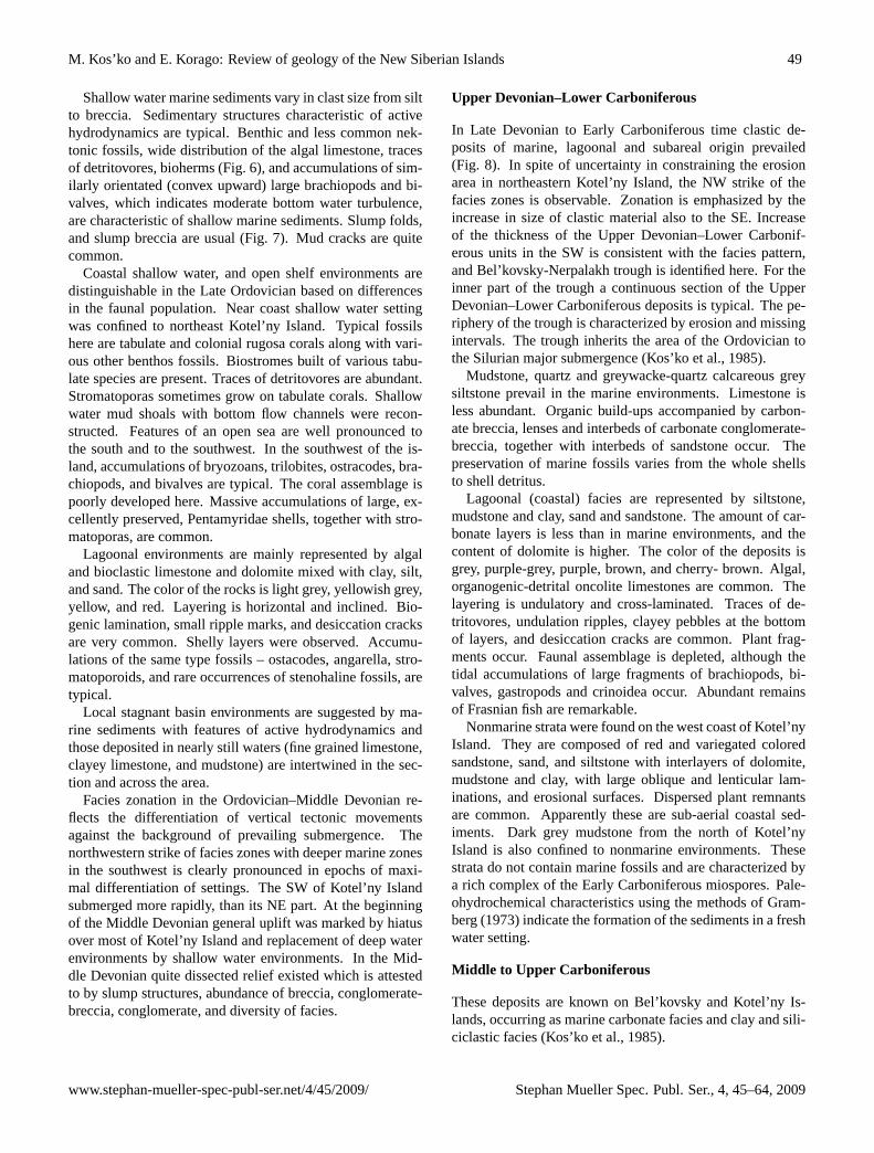
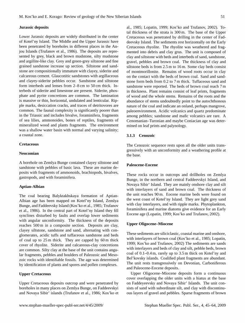
Shallow water marine sediments vary in clast size from siltto breccia. Sedimentary structures characteristic of activehydrodynamics are typical. Benthic and less common nek-tonic fossils, wide distribution of the algal limestone, tracesof detritovores, bioherms (Fig. 6), and accumulations of sim-ilarly orientated (convex upward) large brachiopods and bi-valves, which indicates moderate bottom water turbulence,are characteristic of shallow marine sediments. Slump folds,and slump breccia are usual (Fig. 7). Mud cracks are quitecommon.
Coastal shallow water, and open shelf environments aredistinguishable in the Late Ordovician based on differencesin the faunal population. Near coast shallow water settingwas confined to northeast Kotel’ny Island. Typical fossilshere are tabulate and colonial rugosa corals along with vari-ous other benthos fossils. Biostromes built of various tabu-late species are present. Traces of detritovores are abundant.Stromatoporas sometimes grow on tabulate corals. Shallowwater mud shoals with bottom flow channels were recon-structed. Features of an open sea are well pronounced tothe south and to the southwest. In the southwest of the is-land, accumulations of bryozoans, trilobites, ostracodes, bra-chiopods, and bivalves are typical. The coral assemblage ispoorly developed here. Massive accumulations of large, ex-cellently preserved, Pentamyridae shells, together with stro-matoporas, are common.
Lagoonal environments are mainly represented by algaland bioclastic limestone and dolomite mixed with clay, silt,and sand. The color of the rocks is light grey, yellowish grey,yellow, and red. Layering is horizontal and inclined. Bio-genic lamination, small ripple marks, and desiccation cracksare very common. Shelly layers were observed. Accumu-lations of the same type fossils – ostacodes, angarella, stro-matoporoids, and rare occurrences of stenohaline fossils, aretypical.
Local stagnant basin environments are suggested by ma-rine sediments with features of active hydrodynamics andthose deposited in nearly still waters (fine grained limestone,clayey limestone, and mudstone) are intertwined in the sec-tion and across the area.
Facies zonation in the Ordovician–Middle Devonian re-flects the differentiation of vertical tectonic movementsagainst the background of prevailing submergence. Thenorthwestern strike of facies zones with deeper marine zonesin the southwest is clearly pronounced in epochs of maxi-mal differentiation of settings. The SW of Kotel’ny Islandsubmerged more rapidly, than its NE part. At the beginningof the Middle Devonian general uplift was marked by hiatusover most of Kotel’ny Island and replacement of deep waterenvironments by shallow water environments. In the Mid-dle Devonian quite dissected relief existed which is attestedto by slump structures, abundance of breccia, conglomerate-breccia, conglomerate, and diversity of facies.
Upper Devonian–Lower Carboniferous
In Late Devonian to Early Carboniferous time clastic de-posits of marine, lagoonal and subareal origin prevailed(Fig. 8). In spite of uncertainty in constraining the erosionarea in northeastern Kotel’ny Island, the NW strike of thefacies zones is observable. Zonation is emphasized by theincrease in size of clastic material also to the SE. Increaseof the thickness of the Upper Devonian–Lower Carbonif-erous units in the SW is consistent with the facies pattern,and Bel’kovsky-Nerpalakh trough is identified here. For theinner part of the trough a continuous section of the UpperDevonian–Lower Carboniferous deposits is typical. The pe-riphery of the trough is characterized by erosion and missingintervals. The trough inherits the area of the Ordovician tothe Silurian major submergence (Kos’ko et al., 1985).
Mudstone, quartz and greywacke-quartz calcareous greysiltstone prevail in the marine environments. Limestone isless abundant. Organic build-ups accompanied by carbon-ate breccia, lenses and interbeds of carbonate conglomerate-breccia, together with interbeds of sandstone occur. Thepreservation of marine fossils varies from the whole shellsto shell detritus.
Lagoonal (coastal) facies are represented by siltstone,mudstone and clay, sand and sandstone. The amount of car-bonate layers is less than in marine environments, and thecontent of dolomite is higher. The color of the deposits isgrey, purple-grey, purple, brown, and cherry- brown. Algal,organogenic-detrital oncolite limestones are common. Thelayering is undulatory and cross-laminated. Traces of de-tritovores, undulation ripples, clayey pebbles at the bottomof layers, and desiccation cracks are common. Plant frag-ments occur. Faunal assemblage is depleted, although thetidal accumulations of large fragments of brachiopods, bi-valves, gastropods and crinoidea occur. Abundant remainsof Frasnian fish are remarkable.
Nonmarine strata were found on the west coast of Kotel’nyIsland. They are composed of red and variegated coloredsandstone, sand, and siltstone with interlayers of dolomite,mudstone and clay, with large oblique and lenticular lam-inations, and erosional surfaces. Dispersed plant remnantsare common. Apparently these are sub-aerial coastal sed-iments. Dark grey mudstone from the north of Kotel’nyIsland is also confined to nonmarine environments. Thesestrata do not contain marine fossils and are characterized bya rich complex of the Early Carboniferous miospores. Pale-ohydrochemical characteristics using the methods of Gram-berg (1973) indicate the formation of the sediments in a freshwater setting.
Middle to Upper Carboniferous
These deposits are known on Bel’kovsky and Kotel’ny Is-lands, occurring as marine carbonate facies and clay and sili-ciclastic facies (Kos’ko et al., 1985).
www.stephan-mueller-spec-publ-ser.net/4/45/2009/ Stephan Mueller Spec. Publ. Ser., 4, 45–64, 2009

50 M. Kos’ko and E. Korago: Review of geology of the New Siberian Islands
Marine carbonate facies are distributed in the center andin the northwest of Kotel’ny Island. These are shelly detriticlimestone, grey, light grey, pink grey, quite often silty andarenaceous. Conglomerate with pebbles of dolomite, lime-stone, chert, quartz siltstones, and quartz with calcareous ce-ment are present. The rocks are rich in foraminifera, bryozoa,brachiopods, less common nautiloids, and trilobites.
Clay and siliciclastic facies are distributed on the south-west of Kotel’ny Island. They are mudstone and sandstonewith interlayers of calcareous conglomerates, limestone, andcarbonaceous mudstone. A high content of dispersed car-bonaceous plant fragments is typical. Siliciclastic rocks formpackets 10–60 m thick. Thin interlayering of siltstone andsandstone or siltstone and mudstone are less common. Therocks are grey to black. Dolomite cherty and dolomite con-cretions are scattered across the unit. Sandstones are mainlyfine grained, compositionally immature, unlike the mostlyquartz sandstone of the underlying units. They are composedof quartz, predominantly acidic feldspar and rock clasts, in-cluding acidic and intermediate composition volcanics. Con-glomerate breccias consist of fragments of limestone, chertylimestone and chert with calcareous cement. Limestones areshelly detritic, silicified and clayey. The lamination is thinoblique, lenticular, undulated, and horizontal with erosivesurfaces. Fossils such as brachiopods, corals, foraminifera,bryozoans, crinoids, occur mainly in the lower part of thesuccession.
Permian
Permian sediments are known in the zone stretching fromthe northwest of Kotel’ny Island towards the center in asoutheastern direction. They consist of mudstone, mudstone-like clay with interlayers of siltstone, sandstone, limestone,and rare siderite. Interlayers of sideritic pyritic and calcare-ous concretions occur. The color of the rocks is grey, lightgrey, black, and brown. Siltstones are polymictic and felds-pathic quartz clayey, dolomitic, calcareous and arenaceous.Limestone are organic detrital and algal, thin laminated, andwith terrigenous admixture. The layering is thin undulatory,lenticular, with tracks of detritovores, with intralayer erosion.Dispersed plant fragments and mineralized wood were ob-served. The fossils are various brachiopods, lingulids, bi-valves, gastropods, foraminifera. In the northwest of the is-land siltstone and mudstone prevail. Towards the center theyare replaced by clayey limestone and calcareous mudstone.Permian deposits accumulated in a near-shore shallow ma-rine setting.
3.1.2 Mesozoic
Lower-Middle Triassic
These deposits are found in the northwest and in the cen-ter of Kotel’ny Island (Kos’ko et al., 1985). Mudstone andhydromuscovite clay, grey, dark grey, black and brown in
color with chlorite and other clay minerals predominate inthe section. Clay with volcanic glass and perhaps tufogenicmontmorillonite clay together with interlayers of tuffaceoussiltstone with glauconite, occur in the Induan (LowermostTriassic) strata. Isolated basalt bodies are assigned to the In-duan. Algal and detrital-algal limestone in layers up to 10 mthick within packets of alternating clay and marl are char-acteristic of the Lower Olenekian (Lower Triassic). Theyare quite rare at other stratigraphic levels, and their thicknessdoes not exceed 0.7 m. The Lower Triassic contains interlay-ers of siderite, quite often with gypsum. Carbonate packetscontain interlayers and veins of gypsum. Phosphate, pyrite,marcasite, and siderite concretions are common. Beddingis thin and horizontal. Traces of detritovores and soft sed-iment slump structures occur. Fossils are abundant and di-verse. Beds rich and barren of fossils alternate. Bivalves andammonoides dominate in the fossil collections. Brachiopod,belemnite and echinoderm fragments are subordinate. Frag-ments of fish and reptiles occur. Foraminifera are abundant.Fragments of mineralized wood are mainly confined to theupper part of the section.
Sediments were accumulated in shallow water basins withvarying salinity. Extremely high salinity is documented bygypsum containing clay with interlayers of dolomite andsiderite. The paleoenvironment in northwestern Kotel’ny Is-land was more distant from the shoreline than that in thecenter.
Upper Triassic
Upper Triassic sediments are distributed in the same areasas the Lower-Middle Triassic as well as in the far southof Kotel’ny Island. The Upper Triassic strata are mainlymudstone, mudstone-like and clay of dark grey and black,and sometimes brown color. Interlayers of siderite andlimestone occur. Limestones are detrital, algal and algal-detrital. Interlayers of crinoid limestone with well pre-served whole sea lilies are typical. Interlayers of arenaceoussiltstone occur in the upper part of the section. Sideritic,pyritic carbonate-phosphate concretions are abundant. Someinterlayers contain scattered pyrite. Soft sediment slumpstructures and traces of detritovores occur. Fauna includeforaminifera, bivalves, ammonoids, nautiloids, brachiopods,and reptilia. The sediments also contain a rich spore andpollen complex, mineralized wood, and cyanophiceae rem-nants (Kos’ko et al., 1985).
In the Carnian deposits, from the northwest coast towardsthe center of the island, the content of gypsum increases andsignificant quantities of algal limestone occur. In the southof the island clay deposits are absent, rocks are lithified andschistose. In the northwest of the island sediments accumu-lated in a marine basin with normal salinity. In the centerof the island the salinity varied. In the Late Triassic as wellas in the Early and the Middle Triassic an open sea settingoccupied the northwest.
Stephan Mueller Spec. Publ. Ser., 4, 45–64, 2009 www.stephan-mueller-spec-publ-ser.net/4/45/2009/
M. Kos’ko and E. Korago: Review of geology of the New Siberian Islands 51
Jurassic deposits
Lower Jurassic deposits are widely distributed in the centerof Kotel’ny Island. The Middle and the Upper Jurassic havebeen penetrated by boreholes in different places in the An-jou Islands (Trufanov et al., 1986). The deposits are repre-sented by grey, black and brown mudstone, silty mudstoneand argillite-like clay. Grey and green-grey siltstone and finegrained sandstone increase up section. Siltstone and sand-stone are compositionally immature with clayey, siderite andcalcareous cement. Glauconitic sandstones with argillaceousand clayey-siderite pebbles occur. Sandstone and siltstoneform interbeds and lenses from 2–8 cm to 50 cm thick. In-terbeds of siderite and limestone are present. Siderite, phos-phate and pyrite concretions are common. The laminationis massive or thin, horizontal, undulated and lenticular. Rip-ple marks, desiccation cracks, and traces of detritovores arecommon. The faunal complexity is significantly poorer thanin the Triassic and includes bivalve, foraminifera, fragmentsof sea lilies, ammonoides, bones of reptiles, fragments ofmineralized wood and plants fragments. The environmentwas a shallow water basin with normal and varying salinity;a coastal zone.
Cretaceous
Neocomian
A borehole on Zemlya Bunge contained clayey siltstone andsandstone with pebbles of basic lava. These are marine de-posits with fragments of ammonoids, brachiopods, bivalves,gastropods, and with foraminifera.
Aptian-Albian
The coal bearing Balyktakhskaya formation of Aptian-Albian age has been mapped on Kotel’ny Island, ZemlyaBunge, and Faddeevsky Island (Kos’ko et al., 1985; Trufanovet al., 1986). In the central part of Kotel’ny Island they fillsynclines disturbed by faults and overlap lower sedimentswith angular unconformity. The thickness of the depositsreaches 500 m in a composite section. Deposits are clay,clayey siltstone, sandstone and sand, alternating with con-glomerates, acidic tuffs and tuffaceous sandstone and bedsof coal up to 25 m thick. They are capped by 60 m thickcover of rhyolite. Siderite and calcareous-clay concretionsare common. Silty clay at the base of the unit contains angu-lar fragments, pebbles and boulders of Paleozoic and Meso-zoic rocks with identifiable fossils. The age was determinedby identification of plants and spores and pollen complexes.
Upper Cretaceous
Upper Cretaceous deposits outcrop and were penetrated byboreholes in many places on Zemlya Bunge, on Faddeevskyiand Novaya Sibir’ islands (Trufanov et al., 1986; Kos’ko et
al., 1985; Lopatin, 1999; Kos’ko and Trufanov, 2002). To-tal thickness of the strata is 300 m. The base of the UpperCretaceous was penetrated by drilling in the center of Fad-deevsky Island. The sediments rest horizontally on the EarlyCretaceous rhyolite. The rhyolite was weathered and frag-mented into debris and clay grus. The unit is composed ofclay and siltstone with beds and interbeds of sand, sandstone,gravel, pebbles and brown coal. The thickness of clay andsiltstone beds is from 2.5 m to 16 m. Some clay beds consistof montmorillonite. Remains of wood roots occur in clayon the contact with the beds of brown coal. Sand and sand-stone form beds from 0.2 to 7 m thick. Tuffaceous sand andsandstone were reported. The beds of brown coal reach 7 min thickness. Plant remains consist of leaf prints, fragmentsof wood and the whole stems. Remains of the roots and theabundance of stems undoubtedly point to the autochthonousnature of the coal and indicate an onland, perhaps mangrove,paleoenvironment. Acidic volcanics and quartz predominateamong pebbles; sandstone and mafic volcanics are rare. ACenomanian–Turonian and maybe Coniacian age was deter-mined on leaf prints and palynology.
3.1.3 Cenozoic
The Cenozoic sequence rests upon all the older units trans-gressively with an unconformity and a weathering profile atthe base.
Paleocene-Eocene
These rocks occur in outcrops and drillholes on ZemlyaBunge, in the northern and central Faddeevskyi Island, andNovaya Sibir’ Island. They are mainly onshore clay and siltwith interlayers of sand and brown coal. The thickness ofthe unit reaches 90 m. Eocene marine beds were found onthe west coast of Kotel’ny Island. They are light grey sandwith clay interlayers, and with ripple marks. Phytoplankton,foraminifera and marine diatoms give evidence for an EarlyEocene age (Lopatin, 1999; Kos’ko and Trufanov, 2002).
Upper Oligocene–Miocene
These sediments are siliciclastic, coastal marine and onshore,with interlayers of brown coal (Kos’ko et al., 1985; Lopatin,1999; Kos’ko and Trufanov, 2002) The sediments are sandswith interlayers and beds of clay and silt, pebble beds, browncoal of 0.1–0.4 m, rarely up to 3.5 m thick on Kotel’ny andBel’kovsky islands. Coalified plant fragments are abundant.The unit rests transgressively on Devonian, Carboniferousand Paleocene-Eocene deposits.
Upper Oligocene–Miocene deposits form a continuouscover overlapping the older units with a hiatus at the baseon Faddeyeevsky and Novaya Sibir’ Islands. The unit con-sists of sand with subordinate silt, and clay with discontinu-ous layers of gravel and pebbles. Sparse fragments of brown
www.stephan-mueller-spec-publ-ser.net/4/45/2009/ Stephan Mueller Spec. Publ. Ser., 4, 45–64, 2009

52 M. Kos’ko and E. Korago: Review of geology of the New Siberian Islands
coal, coalified wood, pebbles and boulders are typical. Peb-bles and boulders are rhyolite, basalt, dolomite, limestone,siltstone, sandstone, quartz, chert. Carbonate pebbles areabsent in the underlying Paleocene-Eocene unit, thus point-ing to a new source area with outcropping sediments similarto those composing Kotel’ny Island. Leaf prints, lagoonal,marsh and lacustrine diatoms, fresh water ostracods, sea mol-lusks, estuarial microfossils were collected and identified.The sediments were formed in the coastal fluvial-lacustrineplain and tidal shallow water paleoenvironment. Fluvial fa-cies are mainly confined to the Miocene interval. The thick-ness varies from 9 m on Kotel’ny Island to 190 m on the East-ern islands.
Upper Oligocene–Miocene deposits are more wide spreadthan the Paleocene–Eocene. They transgressively overlap allolder formations with erosion on the contact with the Eocene.Marine deposits here are more widely distributed than in theEocene, indicating the occurrence of a new terrestrial sourcearea.
Pliocene–Eopleistocene
Deposits of this age are widely distributed across the wholeof the Archipelago (Kos’ko et al., 1985; Lopatin, 1999;Kos’ko and Trufanov, 2002). They erosionally overly theLate Oligocene–Miocene strata on western Kotel’ny andBel’kovsky Islands. The sediments here are sand, silt, peb-bles, grus, and clay. Mud, silt, and sand with lenses of peatand scattered pebbles and angular fragments of local rocksdominate on Faddeevsky and Novaya Sibir’ islands. Marinebivalve and marine and fresh water diatoms were recorded.The thickness ranges from 5 m on the western islands to 75 mon Novaya Sibir’ Island. The unit was formed on a coastalfluvial-lacustrine plane and in a coastal marine shallow watersetting.
3.2 Magmatism
Manifestations of Paleozoic and Mesozoic magmatism arefound in the Anjou Islands. Small basic bodies and dikesseen mainly on southwestern Kotel’ny Island are assignedto the Middle–Late Paleozoic. According to airborne sur-veys, mafic bodies are present in the adjacent offshore.Stocks reach 0.9 km in size, dikes are traced up to 7 km withthe thickness of 1–30 m. Intrusions are composed of do-lerite, gabbro-dolerite, sometimes quartz bearing and olivinebearing, with rare gabbro-syenite schlieren. The intrusionsare hosted by units up to the Upper Devonian. They aremainly confined to the Late Devonian–Early CarboniferousBel’kovsky-Nerpalakh trough – Nerpalakh synclinorium inthe present day structure (Figs. 4 and 8). Most of the rockscorresponds to MORB tholeiite in chemistry, and are close tothe boundary with intraplate tholeiite, or (by other character-istics) to continental gabbro.
On Bel’kovsky Island magmatic rocks are subvolcanictholeiites (Kuzmichev and Goldyrev, 2007;). They form vari-
able bodies: dikes, small stocks, rare sills, and irregular bod-ies built of breccia and peperite. Volcanic bodies are lined upalong the west coast of the island. Magmatism is dated at thePermian–Triassic boundary, 252±5 Ma (biotite from olivinegabbro-diabase stock, K-Ar determination (Kuzmichev andGoldyrev, 2007). Magmatism is comparable with traps of theSiberian Platform by age, mineral composition, and chem-istry. On Bel’kovsky Island, in the upper part of the sedi-mentary host rocks magma intruded into semifluid water-richsubstrate close to the surface. Such extrusions are somewhatlater or simultaneous with sedimentation. This suggests thaton Bel’kovsky Island Permian, and perhaps Triassic depositswere not lithified at the time of the mafic lava intrusion. Astudy by Kuzmichev and Goldyrev (2007) is an importantcontribution to the magmatic geology of the Anjou Islandsand it is in agreement with the data on the Early Triassic vol-canism on Kotel’ny Island.
At the base of the Lower Triassic on Kotel’ny Island,montmorillonite clay and clayey sediments with rare frag-ments of volcanic glass and tuffaceous siltstone are present.Close to the Triassic–Paleozoic contact in the center of the is-land blocks of basalts were studied and assigned to the Trias-sic based on identification of traces of volcanism in the com-position of the sediments. Rare dolerite dikes occur amongTriassic strata. The dolerite is slightly enriched in alkaliesand it differs from the Paleozoic mafics having less alter-ation. It also has a considerably stronger magnetization thanis commonly seen in Paleozoic mafics (Gusev and Rakhin,1977).
A rhyolite sheet and acidic tuffs in the upper part ofthe Early Cretaceous Balyktakhskaya formation on Kotel’ny,Faddeevskyi, and Zemlya Bunge Islands has been reported.Volcanism continued in the Late Cretaceous, which is evi-denced by the presence of thin volcanic clastics in Cenoma-nian and Turonian strata.
3.3 Structural geology
The western Anjou Islands have the structure of a fold andthrust belt. It is characterized by a combination of folds ofdifferent orders and faults of two generations. The faults ofthe earlier generation strike northwest parallel to folds. Theyare normal and thrust faults probably with a strike-slip com-ponent. The faults of the later generation are normal faultsand strike-slip faults trending north-south. The Reshetnikovand Chokur anticlinoria and the Balyktakh and Nerpalakhsynclinoria are first order folds (Fig. 4). Anticlinoria are dis-tinguished by an area of exposed Ordovician, Silurian andLower Devonian strata. Synclinoria comprise widespreaddeposits from the Lower and Middle Devonian to the Meso-zoic. Early Cretaceous strata are developed in the hinge ofthe Balyktakh Synclinorium. Deposits with the ages down tothe Ordovician outcrop in the cores of the second order anti-clines. The width of the anticlinoria and synclinoria is up to50 km. Their length reaches 150 km.
Stephan Mueller Spec. Publ. Ser., 4, 45–64, 2009 www.stephan-mueller-spec-publ-ser.net/4/45/2009/

M. Kos’ko and E. Korago: Review of geology of the New Siberian Islands 53
Second order folds (Figs. 10 and 11) are 10–40 km longand 5–12 km wide. Crest-like and block folds were recog-nized. The dip angles on the limbs of the second order foldsvary from 10–30◦ to 20–40◦. Monoclines with dips of 3◦ to5◦ which can be traced through many kilometers in coastaloutcrops (Fig. 9) are common. Second order folds have un-dulated hinges with dip angles up to 30◦.
Folds of the higher order are developed in zones of ma-jor faults. Folds are variable in geometry; tight and gentle,symmetric and asymmetric, concentric and others, variablyoriented in some cases with steep hinges and limbs dippingup to 80◦.
Anticlinoria and synclinoria inherited the synsedimen-tary tectonic zonation. The Reshetnikov Anticlinorium onnortheast Kotel’ny Island coincides with a structural high inLlandovian–Early Ludlovian time. Its southwest flank is lo-cated on a Silurian synsedimentary flexure. The Bel’kovsky-Nerpalakh synclinorium on southwest Kotel’ny Island is apresent day structural manifestation of the Late Devonian–Early Carboniferous Bel’kovsky-Nerpalakh trough.
The age of folding is post Late Jurassic–pre Aptian. Itis evidenced by the structural unconformity at the base of theAptian-Albian Balyktakh formation. This folding masks pre-vious tectonic deformations. The Early Cretaceous structurewas affected by Cenozoic normal faults and dextral strike slipfaulting.
The Early Cretaceous structure was formed as a resultof northeast directed compression. Rigid northwest elon-gated basement blocks were separated from the underlyingsequence by deep seated faults and shifted a little towards thenorth-east. The shifting was accompanied by northeast ver-gent thrust faults along with moderate folding and tilting ofthe Phanerozoic sedimentary cover within the blocks. Defor-mation along block boundaries was much more intense, com-plex folding developed accompanied by cleavage and smallamplitude thrusting. Large thrust faults are visible on the ge-ologic map (Fig. 4). The strike-slip motion along the bound-aries of the blocks is indicated by en echelon offsets of thesecond order folds and their oblique orientation with respectto the general structural trend. It is also indicated by verti-cal dipping of minor fold hinges in a number of cases. Thestructure of Kotel’ny Island is significantly different from thefold and fold-overthrust and nappe type structure of WrangelIsland, of Bol’shoi Lyakhov Island and of the Anyui zone inChukotka. It is more similar to the structural style of a num-ber of regions of Verkhoyansk belt and Lena delta (Egorovand Surmilova, 2001; Prokopiev et al., 2001).
Eastern Faddevsky and Novaya Sibir’ islands are separatedfrom Zemlya Bunge by Hedenstrom Bay. It is believed thatthe bay coincides with a fault zone manifested in gradientsof anomalous gravity and/or magnetic fields (Trufanov etal., 1986). Faddeevsky and Novaya Sibir’ islands are nearlycompletely overlain by a loose Cenozoic cover. There areonly few outcrops of the Cretaceous deposits. Jurassic sed-iments and Cretaceous volcanics have been penetrated by
terrigenous Cenozoic
coal-bearing LowerCretaceous with felsicvolcanics
terrigeneous Jurassic
Triassic clastics withcarbonates terrigenous Middle Carboniferousto Upper Permian with carbonates
predominantly terrigenous UpperDevonian to Lower Carboniferouswith carbonatespredominantly carbonateMiddle Devonian
predominantly carbonateLower Ordovician toLower Devonian
mapped and inferred faults
76N
Chokur
m
anticlinoriuR
eshetnikov anticlinorium
Ba
um
lyktakh synclinori
Nerpalakh syclinorium
137E 139E
75N
76N
139E137E
75N
5 10 15kmkm0
Fig. 4. Geological map and tectonic zonation of Kotel’ny Island.
test boreholes. Faults dominate in the structure of the sed-imentary cover here. Most of them are not exposed due tothe wide distribution of the Quaternary sediments, and havebeen mapped by geomorphologic and magnetic and/or grav-ity potential field data. The eastwest-northwest striking faultsare the best defined. The length of these faults exceeds hun-dreds of kilometers and they project offshore. The distancebetween faults varies from 5 to 30 km. They are displaced bysubmeridional wrench faults up to 15–20 km long.
www.stephan-mueller-spec-publ-ser.net/4/45/2009/ Stephan Mueller Spec. Publ. Ser., 4, 45–64, 2009

54 M. Kos’ko and E. Korago: Review of geology of the New Siberian Islands
240
300
400450
50
50
30
30
0 25 50 75 100 ÍÏ
Kotelíny I. Kotelíny I. Kotelíny I.
Kotelíny I. Kotelíny I. Kotelíny I.
Kotelíny I.
Kotelíny I. Kotelíny I.
Belíkovsky I.
Belíkovsky I.
Belíkovsky I. Belíkovsky I.
Belíkovsky I.Belíkovsky I.
Belíkovsky I. Belíkovsky I.
Belíkovsky I.
Belíkovsky I.
Middle Ordovician Late Ordovician Llandoverian EarliestWenlockian
EarliestLudlovian
EarliestEifelian
EarliestSiegenian
Geddinian Emsian
Givetian
Deep water limestone and chert-clay-carbonate edimentsDeep water limestone
Deep water and shallow water not divided, limestoneShallow water limestone
Shallow water limestone, argillite,siltstone,
Local stagnant basin environment, limestone and limestone with argillite
Shallow water and local stagnant basin environment, limestone, argillite, clay
Shallow water and lagoonal not divided, limestone, dolomite
Lagoonal dolomite, limestone with clay and argillite
Pre Eifelian disconformity Direction of open sea
Thickness, meters, (a) complete and (b) incomplete
Bioherms
Boundaries between facies zones,
Surface exposures of strata of the age considered
Fig. 5. Ordovician–Middle Devonian facies zonation (adapted from Kos’ko, 1977).
Large scale faults are accompanied by zones of folds. Oneof these was mapped from Strelka Anjou in the west east-wards along the north coast of Novaya Sibir’ Island. Pale-ocene and Miocene strata form a row of en-echelon foldsstriking northwest. Limbs dip up to 40◦. Complex foldsand faults were mapped and observed in outcrops on CapeVysoky and Cape Goristy, on northern Novaya Sibir’ Island(Trufanov et al., 1986; Kos’ko and Trufanov, 2002).
Intense deformations were mapped in a belt apparently2 km wide along the southwest of the Novaya Sibir’ Islandat Cape Utes Derevyannykh Gor (Fig. 12). The Late Cre-taceous, Tertiary, and up to Pliocene strata form a fold andoverthrust structure striking west-northwest. Trusts dippingnorth-northeast at 40–70◦ are spaced at 50–600 m across thezone. Folds parallel the faults and are inclined southward.The north limbs of the anticlines dip north at angles 30◦–55◦,the south limbs are vertical or overturned and quite often cutoff. Recumbent folds are present. The length of larger folds
Stephan Mueller Spec. Publ. Ser., 4, 45–64, 2009 www.stephan-mueller-spec-publ-ser.net/4/45/2009/
M. Kos’ko and E. Korago: Review of geology of the New Siberian Islands 55
Fig. 6. Bioherm limestone. Givetian strata. Kotel’ny Island.
exceeds 4 km with the width from 100 to 250 m. The lengthof small folds is not greater than a few hundred m . Theirwidth ranges from a few m to a few tens of m. The ampli-tude of folds is from a few m up to 40–70 m.
4 Lyakhov islands
The Lyakhov Islands are located at the western end of theSouth Anyui suture (Sokolov et al., 2002). Sequences of vari-able age, composition, and structural styles are known on theLyakhov Islands. These include an ancient metamorphic se-quence, Late Paleozoic ophiolitic sequence, Late Mesozoicturbidite sequence, Cretaceous granites, and Cenozoic sedi-ments (Fig. 13)
4.1 Metamorphic, magmatic and stratified sequences
The metamorphic sequence
The oldest sequence on the Lyakhov Islands comprisesamphibolite and schist of the epidote-amphibolite regionalmetamorphic facies (Samusin and Belousov, 1985; Lopatin,1999; Drachev and Savostin, 1993). The rocks constitutea tectonic thrust sheet on southeastern Bol’shoi LyakhovIsland. Epidote, zoisite-epidote, pyroxene, plagioclase-amphibole, muscovite-amphibole, and garnet bearing amphi-bolite and schist were identified. Relict ophitic and vesic-ular textures were recognized in the metamorphic rocks.Pyroxene amphibolite is probably a product of metamor-phism of a pyroxenite based on the relic structure (Lopatin,1999). The initial igneous origin of the metamorphic rocksis supported by their chemistry as it is seen on the Miyasiroand Shido diagram (Fig. 3) and on more plots published re-cently (Gramberg et al., 2004). There are indications of theophiolitic affinity of the initial igneous rocks.
Fig. 7. Slump breccia, middle Devonian, Kotel’ny Island.
Whole rock K-Ar dating of the orthoamphibolites showslarge differences in the ages: 473±14 Ma, 215±8 Ma, and166±7 Ma (Drachev and Savostin, 1993). The oldest date isCaledonian, which is believed to be the age of the primaryigneous rocks, while younger dates show some later alter-ations.
Late Paleozoic ophiolites
The Late Paleozoic ophiolitic sequence comprises ultramaficrocks, gabbro-dolerite, pillow basalt, hyaloclastite (Drachevand Savostin, 1993; Lopatin, 1999; Kuzmichev et al., 2005).Dunite, peridotite, and serpentinite form tectonic sheetsalong with basalt and gabbro-dolerite hosted by Late Meso-zoic flysch on southeast Bol’shoi Lyakhov Island. Dunite is afine grained massive rock composed of forsterite, serpentine,iddingsite, and secondary talc, muscovite, flogopite, tremo-lite, and ore minerals. The peridotite is a massive and schis-tose rock with rare forsterite phenocrysts and a groundmassof olivine, diopside, relics of rhombic pyroxene, secondaryand accessory minerals. Serpentinite is widespread. Basedon their chemistry the ultramafic rocks are metamorphosedophiolite. Ultramafic and mafic bodies have high magnetiza-tion and are mappable offshore in accordance with the patternof anomalous magnetic field maps (Lopatin, 1999).
Vesicular basalt, gabbro-dolerite and orthoamphibolitewere found within the ultramafic rocks. Gabbro-dolerite bod-ies are up to 1000 m2 and veinlets up to 5 cm thick in the ul-tramafic rocks. The gabbro-dolerite is small-grained massiverock with ophitic groundmass and rare monocline pyroxenephenocrysts. The mafic rocks show the chemistry usual forthe MORB basalt (Kuzmichev et al., 2005).
www.stephan-mueller-spec-publ-ser.net/4/45/2009/ Stephan Mueller Spec. Publ. Ser., 4, 45–64, 2009

56 M. Kos’ko and E. Korago: Review of geology of the New Siberian Islands
Belíkovsky I.
Belíkovsky I.
Belíkovsky I.Kotelíny I. Kotelíny I. Kotelíny I.
Kotelíny I.
Frasnian Famennian Earliest Tournaisian Visean -Sepukhovian
ÍÏ 25 0 25 50 75 ÍÏ
Marine environment argillite and siltstone with limestone, rare conglomerate and sandstoneMarine environment limestone, siltstone argillite, rare conglomerate
Lagoonal and marine not divided, argillite, siltstone with sandstone,limestone, dolomite
Lagoonal argillite, siltstone, clay, sandstone, sand with limestone, dolomite, gritstoneLagoonal and continental not divided sandstone, sand, siltstone with argillite, clay, conglomerate, limestone and dolomiteNear shore plain sandstone, sand, siltstone with dolomite, argillite clay
Fresh water argillite Erosion The main direction of the clastic flow Subordinate direction of clastic flow
Boundaries between facies zones Surface exposures of strata of the age considered
Belíkov-Nerprlrkh trough
Fig. 8. The Late Devonian Early Carboniferous facies zonation.
Fig. 9. Flat dipping of Lower and Middle Devonian strata. Chokuranticlinorium. Northwest coast of Kotel’ny Island. See location onFig. 1.
A thrust sheet composed of pillow basalt is a part of athrust sheet package that includes ultramafic rocks on south-eastern Bol’shoi Lyakhov Island. The pillow basalt sheetis no less than 200 m thick. The basalt is hard, vitreous,aphyric, and porphyritic with olivine and plagioclase phe-nocrysts. The basalt was subjected to green schist alteration.The basalt relates to the sodium tholeiite series. All the plotson the Mullen diagram (Mullen, 1983) are inside the MORBand marginal seas area (Fig. 14). A tight cluster on the Pearcediagram (Pearce and Cann, 1973; Lopatin, 1999) lies closeto the boundary between the MORB field, ocean islands fieldand continental rift field, most plots inside the latter (Fig. 15)
Sm-Nd age of the basalts is 291±62 Ma according toDrachev and Savostin (1993). Kuzmichev et al. (2005)published 133.5±4.5 and 139±8 Ma K-Ar dating of the
hyaloclastite separating the basalt pillows and admit theirbeing skeptical whether both results are attributable to theage of the extrusions. Nevertheless both ages are compatiblewith the presence of Late Paleozoic as well as Late Mesozoicbasalts within the South Anyui Suture in Chukotka which ex-tends to Bol’shoi Lyakhov Island.
The mafic rocks were unevenly metamorphosed which re-sulted in the emplacement of various amphibolites and blueschist.
Late Jurassic to Early Cretaceous strata
A Volgian to Neocomian turbidite sequence is widespreadon Stolbovoi, Malyi Lyakhov and Bol’shoi Lyakhov islands.The Volgian to Neocomian age of the sequence was reliablydated long ago on the basis of Buchia identified on Stolbovoiand Malyi Lyakhov islands. The situation is different forBol’shoi Lyakhov Island. It was assigned to the Mesozoicby M. M. Ermolaev, and to the Late Proterozoic, to the LatePermian, to the Permian-Triassic by other authors. Samusinand Belousov (1985) provisionally dated a portion of the se-quence as Late Jurassic, considering the major portion ofthe sequence, the Burustas formation, to be Permian in age,based on pollen and spore identifications. Today the Burus-tas formation is well studied and its late Jurassic to Neoco-mian age is reliably substantiated (Vinogradov et al., 1974;Samusin and Belousov, 1985; Kuzmichev et al., 2006).
Stephan Mueller Spec. Publ. Ser., 4, 45–64, 2009 www.stephan-mueller-spec-publ-ser.net/4/45/2009/

M. Kos’ko and E. Korago: Review of geology of the New Siberian Islands 57
Fig. 10. Second order folds. Chokur anticlinorium. See location on Fig. 1.
Fig. 11. Second order folds, Chokur anticlinorium. See location on Fig. 1.
The strata on Bol’shoi Lyakhov Island are graded beddedsandstone, siltstone, and phyllite. Their thickness varies from0.5–1 m to 10–20 m (Samusin and Belousov, 1985). Individ-ual sandstone packages are 50–70 m thick. Phyllite pack-ages are built of Bouma sequences the thickness of whichvaries from centimeters up to meters. Convoluted beddingis common. There are rare, centimeters thick siltstone and
slate interbeds within the sandstone packages. Bouma se-quences built of sandstone, siltstone and phyllite are typicalof the Burustas formation. Ripple- and crossbedding werereported. These provide evidence for a tidal depositional en-vironment no deeper than storm wave base. Thick sandstonelayers are believed to be products of dense grain flows. Sedi-mentary features are indicative of a shelf basin that filled with
www.stephan-mueller-spec-publ-ser.net/4/45/2009/ Stephan Mueller Spec. Publ. Ser., 4, 45–64, 2009

58 M. Kos’ko and E. Korago: Review of geology of the New Siberian Islands
0 200 400 600 800 1000
Geological cross-section along A-BSW
0 m0 m
150 m 150 m
A B
NE
Middle to Upper Quaternaryclastic sediments
Pliocene. Loosely consolidated sediments
Upper Cretaceous, middle unit.Mud, sand, brown coal, clay, siltstone
Upper Cretaceous, upper unit, Sand,sandstone, mudstone, clay, brown coal
Upper Cretaceous, lower unit.Clay, mud, coal
Faults-known, inferred
Bedding-inclined, overturned30
m
A
B
N
S
N2
N2
N2
N2 N2
N2
N2
N2
QII-III
QII-III
K32
K32
K22
K22
K22
K22
K22
K22
K22
K22
K22
K22
K22
K32
K32
K32
K32
K12
K12K1
2
K12
K12
K12
K12
K12 K1
2
K12
K32
K32
K32
1555
25 50
55
3030
30
30
30
30
45
Fig. 12. Geological map and a cross section of the Utes Derevyannykh Gor site, Novaya Sibir’ Island (Kos’ko and Trufanov, 2002). Seelocation site 12 on Fig. 1.
ÍÏÍÏ ÍÏÍÏ1010 5 0 5 1010 1515
730730
730730
730730730730730730
740
740
0 0 0 0 0 0
0 0 0 0
0 0
0 0
0 0
0 0
0 0 0 0 0 0
0 0
20,
20,
20,
20,
40,
40,40
,40
,
00,
00,
139139 3030,
140140
140140
141141
141141
142142
142142
143143
143143
144144144144144
144144
0000
0000
0000
0000
0000
0000
0000
0000
000000000000
0000
, ,
,,
,
,
,
,
,,
,
Cenozoic sediments
Upper Mesozoic argillite
Upper Jurassic - Lower Cretaceous turbidite
Late Paleozoic schist and amphiobolite
Late Mesozoic granite
Early Cretaceous andesiteLate Paleozoic mafic and ultra mafc rocks
Deep seated thrust faults and overthrusts
Near surface thrust faults and overthrusts
Other faults
J3-K1J3-K1
KZKZ
MZMZ
PZPZ
J -K3 1J -K3 1
J -K3 1J -K3 1
J -K3 1J -K3 1
J -K3 1J -K3 1
J -K3 1J -K3 1
KZKZ
KZKZ
KZKZ
MZMZ
PZPZ
PZPZ
Khastyr
Cape Burus-TasCape Burus-Tas
Cape KigilyakhCape Kigilyakh
Cape ShalaurovaCape Shalaurova
Bol.
E teri ank
Mal
. Ete
a nri
k
Ortoy
-Yur akh
Neral
p
a kh
Volínaya
Fig. 13. Geologic map of Bol’shoi Lyakhov Island. Amended from Dorofeev et al. (1999) and Lopatin (1999).
Stephan Mueller Spec. Publ. Ser., 4, 45–64, 2009 www.stephan-mueller-spec-publ-ser.net/4/45/2009/

M. Kos’ko and E. Korago: Review of geology of the New Siberian Islands 59
50
50
I
II
IIIIV
V
P O x102 5MnOx10
TiO2
Fig. 14. Late Paleozoic pillow basalt, Mullen diagram (Mullen,1983; Lopatin, 1999). I – calc-alkaline island arc and continen-tal rift basalt, II – island arch tholeiite, III – MORB and marginalseas basalt, IV – ocean islands tholeiite, V – ocean islands alkalinebasalt.
clastic matter shed from a nearby upland area. The depth ofthe depositional basin was estimated based on the presenceof thick packages of poorly sorted silt/sandstone with stormtype bedding. The above features are characteristic of a deepshelf environment (Kuzmichev et al., 2006).
The sandstones are immature, being composed of rockclasts, feldspar, quartz and clastic muscovite. There areabundant ore minerals at the base of sandstone beds. Prod-ucts of the erosion of metamorphic rocks, granite, quartzveins and volcanic rocks are distinguishable among the clastsin the quartz sandstone. Feldspars are acidic plagioclasefrom volcanic rocks and granite. The presence of pargasiteindicates the metamorphic source rocks, and the presence ofhigh chromium chlorite is indicative of metamorphosed ul-tramafic source rocks. Rock clasts are mostly acidic, inter-mediate with rare mafic volcanics. In addition there are chert,slate, carbonates, chlorite-sericite schist, and quartzite clasts.Accessory minerals are zircon, apatite and rutile, variable inthe degree of rounding and crystal peculiarities.
The major provenance area was most likely the westernextremity of Anyui-Svyatoi Nos Arc, whose volcanic rocksoutcrop in the Svyatoi Nos Point area on the mainland closeto Bol’shoi Lyakhov Island. The late Jurassic commence-ment of the turbidites is evidenced by fission track datingof the youngest least rounded grains of the accessory zir-con population 163.7±9.3, 159.0±23.8 and 119.6±14.5 Ma.Two first numbers are Middle to Late Jurassic, the last one re-flects imposed heating caused by emplacement of Early Cre-taceous granite (Kuzmichev et al., 2006). A rigid block witha sedimentary cover related to the present day Anjou islandsis another possible provenance area. Repeatedly depositedwell rounded zircons, metamorphic and granite clasts wereshed from there. Ultramafic rocks and amphibolites similarto those exposed on Bol’shoi Lyakhov Island present a thirdsource for the clastic material of the flysch sequence.
I
IIIII
IV
V
50
FeO Total
MgO Al O2 350
Fig. 15. Late Paleozoic pillow basalt, Pearce diagram (Pearce andCann, 1973; Lopatin, 1999). I – MORB, II – ocean islands basalt,III – continental rift basalt, IV – ocean islands basalt in spreadingzones, V – island arc basalt.
So the lower age limit of the turbidite sequence is closeto the Middle–Late Jurassic boundary. The upper age limitis the emplacement in the Aptian of granite massifs hostedby the flysch. So the age of the sequence is late Jurassic–Neocomian. Late Proterozoic acritarchs as well as Late Pa-leozoic miospores were transported to the basin either alongwith clastic material or collected from not yet identified tec-tonic wedges of older rocks.
The sequence is intensely faulted and folded, and the as-sessment of the thickness is difficult. It is estimated as1300 m (Samusin and Belousov, 1985).
Late Jurassic–Early Cretaceous strata on Stolbovoi andMalyi Lyakhov islands are alternating siltstone – argillite andmostly sandstone units rhythmically bedded with fossil Ox-fordian to Valanginian Buchia. The thickness of the strata isapproximately 1100 m in a composite section. Soft sedimentslump structures on Stolbovoi Island are directed northeastdownslope. Signs of near bottom contour currents were re-ported (Vinogradov and Yavshitz, 1975; Drachev, 1989).
Early Cretaceous granites
Granite emplacement was very intense in the Lyakhov Is-lands area during the Early Cretaceous. Granite, granodi-orite, and quartz diorite massifs are exposed on Bol’shoiLyakhov Island and are supposed to be present offshore northof Bol’shoi Lyakhov Island towards the Anjou Islands basedon the interpretation of the potential field maps, and withless confidence to the northwest towards Bel’kovsky Island(Dorofeev et al., 1999; Lopatin, 1999). The massifs are up to100–140 km2. They are isometric and elongated and thoughtto be controlled by major faults. The contacts are either steepor gently dipping beneath the host rocks. The emplacementof andesite-porphyric diorite preceded granite intrusion onsoutheast Bol’shoi Lyakhov Island. These intermediate com-
www.stephan-mueller-spec-publ-ser.net/4/45/2009/ Stephan Mueller Spec. Publ. Ser., 4, 45–64, 2009
60 M. Kos’ko and E. Korago: Review of geology of the New Siberian Islands
position rocks rim the southeast extremity of the Emiytasmassif. The andesite-diorite is either the first phase of theEmiytas intrusion, or an outlier of the Anuyi-Svyatoi Nosvolcanic arc, positioned on the mainland and offshore southof the Bol’shoi Lyakhov Island.
Three groups of massifs are distinguished. The firstone is composed of hornblende-biotite granodiorite withsubordinate quartz diorite, porphyric diorite, and granite.These rocks have both transitional and eruptive contacts. Thelargest of the massifs of this group are located on southeastBol’shoi Lyakhov Island.
The second group comprises massifs in northern Bol’shoiLyakhov Island. The massifs are biotite granite, granodiorite,porphyric granite and porphyric granodiorite that suffered in-tense post-magmatic alterations and are remarkable for widepneumatolythic-hydrothermal zones in bordering host rocks.
The third group is Kigilyakh massif on the southwest endof Bol’shoi Lykhov Island and the terminal phase of theEmiytas massif on southeast Bol’shoi Lykhov Island. Theyare composed of homogeneous biotite and biotite-muscovitealkaline granite with high tin content.
The intrusions are inferred to be hypabyssal from themineral composition, structure, texture, scale and characterof late and post magmatic phenomena. They are compat-ible with the granitoid intrusions of the Verkhoyansk andPolousny regions with respect to their composition and struc-tural position.
An Aptian age has been determined radiometrically. TheU-Pb isochron age of zircons from the north Lyakhov graniteis 118.9±0.42 Ma (Dorofeev et al., 1999), from the Emiy-tas massif is 120±1.7 Ma (A. P. Chukhonin, VSEGEI, writ-ten communication, 1993); K-Ar dating of biotite from dif-ferent massifs is 118±6, 120±5, 119±5, 122±5, 120±6,122±7 Ma, from microcline – 112±5, 114±6 Ma (Dorofeevet al., 1999); 40Ar/39Ar age is 114.4±0.5 Ma (Layer et al.,2001). The Diorite-granodiorite massifs were emplaced ear-lier than the rest of the granitoid massifs as deduced from theobserved eruptive relationships.
Tertiary strata
The Tertiary sequence was divided into units similar to thoseon the Anjou Islands: Paleocene-Eocene, Upper Oligocene–Miocene, Pliocene–Eopleistocene. The sediments are mostlymud, silt and sand with minor grit and pebble. Disconfor-mities were documented at the boundaries of the units andwithin them (Kos’ko and Trufanov, 2002). Unlike the AnjouIslands there are no normal marine sediments here. Weather-ing profiles were observed at the base of the Cenozoic strata.The total thickness of the strata is approximately 200 m.
Structure and tectonics
Fold and thrust imbricate structures are mapped on southernBol’shoi Lyakhov Island. North-northwest vergent thruststransect the Island and project offshore. The thrusts are well
manifested in the magnetic field because they are accom-panied by highly magnetic rocks. The thrusts dip south-ward and south-eastward at angles 30◦–50◦ according to in-terpretation of the anomalous magnetic field performed byV. Verba, written communication, 1993.
Tectonic sheets were described (Drachev, 1989; Drachevand Savostin, 1993) along the south coast east of Burus-tas Cape. The following succession was discovered start-ing from the top: 1 – a 50 m thick sheet of black argilliteand clay presumably of Late Mesozoic age; 2 – turbidites ofthe Burustas formation; 3 – pillow basalt 200–300 m thick;4 – tectonized ultramafics, the base of the sheet is not ex-posed; 5 – orthoamphibolite in a para-autochthonous posi-tion. The thrust faults bounding the sheets are folded. Foldsare 10–15 m wide, hinges dip southeast at angles 20◦–30◦.The sheets are intensely deformed. Detachment folds, over-turned and steeply dipping layers are observed. Detachmentfolds were formed as a result of north-south directed com-pression. The age of the deformation is Early Cretaceous.Late Jurassic to Neocomian strata are folded and thrust, andEarly Cretaceous granites also cut the thrusts. A series of tec-tonic sheets composed of mafic and ultramafic rocks thrustnorthwest over Burustas sandstones and phyllites which intheir turn were thrust over ultramafics have been reported byKuzmichev et al. (2005).
Open folds of Jurassic–Early Cretaceous strata are charac-teristic of Stolbovoi and Malyi Lyakhov islands. The foldsstrike northwest on Stolbovoi Island and east-west on Ma-lyi Lyakhov Island. Limbs dip at angles of 15–20◦ in mostcases and up to 40◦ on the south limbs of anticlines on MalyiLyakhov Island.
Late Jurassic–Early Cretaceous turbidites filled a troughin the zone of late Cimmerian deformation. The Cimme-rian trough continues east-southeast to Chukotka. The defor-mation was initiated by collision along the South Anyui su-ture and prograded north. The tectonic structure on Bol’shoiLyakhov Island is that of an imbricate fold and thrust beltand Stolbovoi and Malyi Lyakhov islands show moderatelyintense folding. The sedimentary environment was relativelycalm on the north side compared to that on the south. Benthicfauna could live in the north while active hydrodynamics andabundant clastic sedimentation prohibited benthic fauna set-tling on the south. Further north on Kotel’ny Island Jurassicstrata are very poor in coarse clastic material.
The emplacement and evolution of the trough is a com-ponent of the evolution of the Late Jurassic–Early Creta-ceous Anyui-Lyakhov fold system. The trough closed aftermagmatic activity ceased within the neighboring volcanicarc. The trough is an inner structure of the Late Cimmerianorogeny separating an outer relatively stable northern blockfrom mobile regions to the south.
The southeast part of Bol’shoi Lyakhov Island was locatedwithin a major suture that extends all the way to Chukotka.Deep seated thrust faults related to the suture are mappablehere based on the character of anomalous gravity and mag-
Stephan Mueller Spec. Publ. Ser., 4, 45–64, 2009 www.stephan-mueller-spec-publ-ser.net/4/45/2009/

M. Kos’ko and E. Korago: Review of geology of the New Siberian Islands 61
netic fields. The suture displays imbricate structure com-prising wedges and sheets built of rocks variable in age andcomposition including unevenly metamorphosed ophiolitesequences and glaucophane schist (Drachev, 1989; Drachevand Savostin, 1993; Kuzmichev et al., 2005). The tectonicactivity of the suture terminated in Early Cretaceous as doc-umented by the emplacement of granites (Dorofeev et al,1999).
5 Discussion and conclusions
Knowledge of the geology of the New Siberian Islands isrequired to interpret anomalous gravity and magnetic fieldmaps and Multi-Channel Seismic lines near the islands andin the more distant offshore. Improved geologic informa-tion has allowed us to outline major tectonic blocks and ter-ranes to the east of the Laptev Sea, and for the western partof the East Siberian Sea shelf. It also allowed inferences tobe drawn about their ages, structural styles and composition(Kos’ko et al., 1998; Kos’ko, 2007).
Geology of the New Siberian Islands supports the cir-cum Arctic Phanerozoic fold belt concept (Egiazarov, 1977;Zhamoida et al., 1989). The belt comprises Caledonian,Ellesmerian, Early Cimmerian and Late Cimmerian fold sys-tems, manifested in many places on the mainland and on is-lands around the Arctic Ocean. Early Paleozoic sequenceson the De Long Islands belong to the Caledonian fold systemalong with Axel Heiberg and northern Ellesmere Island in theArctic Canada, Spitzbergen, and northern Norwegian Cale-donides. Metamorphic and granite clasts present on Henri-etta and Jeannette islands indicate a provenance area withexposed crystalline basement not far away. It could be amargin of the Hyperborean Platform, now destroyed by theevolving Arctic Basins, or ancient terranes within Caledo-nian mobile belt. The Anjou and Lyakhov Islands are un-doubtedly the westernmost extremity of the Late Cimmerianfold system traced here from the Brooks Range in Alaskathrough Chukotka. The fold system comprises South Anyuiophiolite suture and pre-collisional trough exposed on theLyakhov Islands, and moderately folded and faulted Paleo-zoic and Mesozoic sequences of its outer zone known on Ko-tel’ny Island. The South Anyui ophiolite suture terminateswithin the Bol’shoi Lyakhov area according to the anoma-lous magnetic field pattern. The presence of relict Caledo-nian units reworked in the course of the Late Cimmerian tec-tonism on Bol’shoi Lyakhov Island is very hypothetical butnot out of the question. It is questionable whether evidencefor Ellesmerian and Early Cimmerian orogeny will be foundon the New Siberian Islands, although they may project intothe East Siberian Sea shelf from the east. The thick Devo-nian turbidite unit on Wrangel Island (Kos’ko et al., 1993)and Middle to Upper Devonian marginal sea sediments andvolcanics on Chukotka (Natal’in et al., 1999) document rem-
nants of an Ellesmerian fold system within the Late Cimme-rian fold system on the east margin of the East Siberian Sea.
There is ongoing discussion of the overall East Arctic pa-leogeography, and at the present time there is little agreementas to which models are best. The New Siberian Islands areoften referred to in the discussion (Miller et al., 2006; Lawerand Scotese, 1990; Lawer et al., 2002). A detailed discussionof the various paleogeographic models is beyond the scope ofthis review.
The sedimentary cover in the East Arctic Russian shelfcomprises two structural stages (Gramberg et al., 2004). Itis recognized that the structural stages correlate with the ge-ology of the New Siberian Islands. Dating of the upper struc-tural stage and constituent offshore seismic units was basedin large part on the structural and stratigraphic relationshipsbetween Late Mesozoic and Cenozoic units in the Anjou Is-lands (Franke et al., 2001, 2004; Franke and Hinz, 1999;Hinz, 1997; Kos’ko, 2005; Kos’ko and Trufanov, 2002). TheLaptev Sea–western East Siberian Sea seismostratigraphicmodel for the upper structural stage fits in general with themajor unconformities known in the American part of theChukchi Sea (Sherwood et al., 1998, 2002; Thurston andTheiss, 1987). The lowermost regional reflector LS1/ESS1(Franke et al., 2001, 2004; Franke and Hinz, 1999; Hinz,1997) which is an acoustic basement for the Laptev and west-ern East Siberian Seas correlates with equal confidence withthe Aptian unconformity and pre-Cenomanian disconformityon the Anjou Islands, and to the ubiquitous erosional andweathered surface close to the Cretaceous–Paleocene bound-ary. On the eastern Chuckhi Sea shelf the base of the up-per structural stage can be related either to the Lower Creta-ceous Unconformity (LCU) or the Barremian Unconformity(BU). Dating of the LCU varies from one well to anotheras follows: Late Berriasian, Valaginian–Hauterivian bound-ary, Early Hauterivian, Late Barremian. The Barremian un-conformity was placed within the Barremian and Early Ap-tian stages. There is a Middle Barremian Unconformity(MBU) which is a hiatus embracing the Late Cretaceous. Sothe regional unconformity seen throughout the East ArcticEurasian shelf which is interpreted as the base of the upperstructural stage of the sedimentary cover, varies in age withinthe middle Cretaceous and Early Paleogene. The LS2/ESS2regional reflector in the Laptev Sea and western East SiberianSea correlates with the base of Upper Oligocene–Miocenestrata on the New Siberian Islands. A Lower Oligocenehiatus was reported as well from POPCORN well, EasternChukchi Sea (Sherwood et al., 1998, 2002).
Interpreting Cretaceous and Miocene-Quaternary volcan-ism on the De Long Islands as a surface manifestation of amantle plume, the latter being well substantiated by field andlaboratory research (Silantyev et al., 2004) raises problems.It is not clear, whether there were two plumes: an old one ofCretaceous age, and a younger one in Miocene-Quaternarytime, or there is one plume which started in the Middle Creta-ceous and perhaps still exists. The first option is in agreement
www.stephan-mueller-spec-publ-ser.net/4/45/2009/ Stephan Mueller Spec. Publ. Ser., 4, 45–64, 2009
62 M. Kos’ko and E. Korago: Review of geology of the New Siberian Islands
with the lack of evidence for volcanic activity between LateCretaceous and Late Miocene time, and differences in com-position of parental melts of the Cretaceous on one hand andthe Miocene-Quaternary volcanics on the other. The con-cept of one long-lived plume needs to be tested by seekingevidence of plume activity which may be obscured by sea-water and bottom sediments. Without that evidence we haveto accept that there were two magmatic events separated bya 100 Ma interlude, which is much longer than the eventsthemselves. The differences in the parental melts within onelong term plume hypothesis are understandable as a result ofprogressive differentiation stages of an original melt ascend-ing from the mantle. The De Long plumes are componentsof a hierarchy of plumes subordinate to a global scale Arcticsuperplume.
A large portion of the above conclusions and interpreta-tions are still highly hypothetical, and will remain that wayuntil more field observations supported by an advanced lab-oratory research is performed.
Acknowledgements.The authors thank David Stone for the invita-tion to write the above review for this volume. We are honoredto be in a team of geoscientists who remember and give credit toLeonid Parfenov. We thank Kazua Fujita following whose kindcritical comments we have substantially reworked the paper. Ourthanks are to be extended to A. Kuzmichev and to S. Drachev fordiscussions which were very productive. We thank Olga Vino-gradova who assisted us for many years both in the field and inthe office.
References
Bogdanovsky, O. G., Mineev, S. D., Assonov, S. S., Silantiev,S. A., Karpenko, S. F. Shukulyukov, Yu. A., and Savostin, L.A.: Magmatism of De Long Archipelago (East Arctic). Isotopegeochemistry and geochronology, Geokhimia, 1, 47–55, 1992(in Russian).
Dorofeev, V. K., Blagoveschensky, M. G., Smirnov, A. N., andUshakov, V. I.: New Siberian Islands, Geology and miner-ageny, VNIIOkeangeologia, Saint-Petersburg, 130 pp., 1999(in Russian).
Drachev, S. S.: Tectonics and Meso-Cenozoic geodynamics of theNew Siberian Islands region, Ph.D. thesis, Moscow State Uni-versity, 19 pp., 1989 (in Russian).
Drachev, S. S. and Savostin, L. A.: Ophiolites of the Bol’shoiLyakhov Island (New Siberian Islands), Geotektonika, 3, 98–107, 1993 (in Russian).
Egiazarov, B. Kh., Ermakov, B. V., Anikeeva, L. I., Romanovich, B.S., Pol’kin, Ya. I., Atltsov, I. P., Demenitskaya, R. M., Grachev,A. F., Karasik, A. M., Kiselev, Yu. G., Andreev, S. I., and Kos’ko,M. K.: Tectonica of the North Polar region of the Earth, Ex-planatory note to the Tectonic Map of the North Polar region ofthe Earth scale 1:5 000 000, NIIGA, Leningrad, 200 pp., 1977(in Russian).
Egorov, A. Yu. and Surmilova, E. P.: State Geological Map ofthe Russian Federation, Scale 1:1 000 000, Quadrangle S-50-52,
Bykovsky, Explanatory note, Kartfabrika VSEGEI press, Saint-Petersburg, 189 pp., 2001 (in Russian).
Fedorov, P. I., Flerov, G. B., and Golobin, D. I.: New data onthe age and composition of volcanic rocks on the Bennett is-land (East Arctic), Dokl. Akad. Nauk+, 400(5), 666–670, 2005(in Russian).
Franke, D. and Hinz, K. (Coordinator): Final Report, the LaptevSea BGR project. Neotectonic studies in the Laptev Sea and EastSiberian Sea, and NE Siberian borderland including seismologi-cal data, Project No 03G0529A, 122 pp., 1999.
Franke, D., Hinz, K., and Reichert, C.: Geology of East SiberianSea, Russian Arctic, from seismic images: Structures, evolution,and the implications for the evolution of the Arctic Ocean Basin,J. Geophys. Res., 109, B07106, doi:10.1029/2003JB002687,2004.
Franke, D., Hinz, K., and Oncken, O.: The Laptev Sea Rift, Mar.Petrol. Geol., 18, 1083–1127, 2001.
Gramberg, I. S.: Paleohydrochemistry of the terrigenous deposits,Nedra, 170 pp., 1973 (in Russian).
Gramberg, I. S., Ivanov, V. L., and Pogrebitsky, Yu. Ye. (Eds.): Ge-ology and mineral resources of Russia, Vol. 5, Arctic and FarEast Seas, Book 1, Arctic Seas, VSEGEI Press, Saint-Petersburg,468 pp., 2004 (in Russian).
Gusev, B. V. and Rakhin, V. A.: Geologic results of the paleo-magnetic research on the New Siberian Islands, in: Problems ofgeophysical research in the Polar Regions of the Earth, NIIGA,Leningrad, 24–34, 1977 (in Russian).
Hinz, K. (Coordinator): Cruise Report, Marine Seismic Measure-ments and Geoscientific Studies on the Shelf and Slope of theLaptev Sea and East Siberian Sea/Arctic with M. V. AcademicLazarev, I. B. Kaptain Dranitsin, 23. August – 08. October 1997,Hannover, Germany, Bundesanstalt fur Geowissenschaften undRohstoffe, Part 1, 161 pp., Part II, 52 pp., 1997.
Kaplan, A. A., Coppland, P., Bro, E. G., Korago, E. A., Proskurnin,V. F., Vinogradov, V. A., Vrolijk, P. J., and Walker, J. D: Newradoiometric ages of igneous and metamorphic rocks from theRussian Arctic, VNIGRI/AAPG regional international confer-ence, July 15–18, Saint-Petersburg, Russia, 06–2, 2001.
Kos’ko, M. K.: Stratification of the sedimentary cover of theEast Arctic shelf of Russia,in: Proceedings of the 2nd Inter-national Conference “Geodynamics of the oil and gas bearingbasins” Moscow, October 19–21, 2004, Moscow, 98–110, 2005(in Russian).
Kos’ko, M. K.: Structural and facies zonation of the Ordovician-middle Devonian carbonate sequence on the Anjou Islands, Tec-tonics of the Arctic. Fold basement of the shelf sedimentarybasins, NIIGA, Leningrad, 56–87, 1977 (in Russian).
Kos’ko, M. K.: Terranes of the East Arctic Russian shelf, Dokl.Akad. Nauk+, 213(1), 71–74, 2007 (in Russian).
Kos’ko, M. K., Bondarenko, N. S., and Nepomiluev, V. F.: StateGeological Map of the USSR, Scale 1:200 000 (New Siberian Is-lands), Quadrangles T0-54-XXXI, XXXII, XXXIII; S-53-IV, V,VI; S-54-I, II, III, S-54-VII, VIII, IX, XIII, XIV, XV, ExplanatoryNote, “Sevmorgeologia”, 162 pp., 1985 (in Russian).
Kos’ko, M. K., Cecile, M. P., Korago, E. A., Lane, L. S., Musatov,E. E., Piskarev, A. L., Suprunenko, O. I., Ustinov, N. V., andVerba, V. V.: Tectonic Basement of the Eurasian Arctic Shelf:Age and Some Aspects of Evolution, Polarforschung, 68, 275–281, 2000.
Stephan Mueller Spec. Publ. Ser., 4, 45–64, 2009 www.stephan-mueller-spec-publ-ser.net/4/45/2009/

M. Kos’ko and E. Korago: Review of geology of the New Siberian Islands 63
Kos’ko, M. K. and Trufanov, G. V.: Middle Cretaceous to Eopleis-tocene sequences on the New Siberian Islands: an approach tointerpret offshore seismic, Mar. Petrol. Geol., 19, 901–919, 2002.
Kos’ko, M. K., Cecile, M. P., Harrison, J. C., Ganelin, V. G., Khan-doshko, N. V., and Lopatin, B. G.: Geology of Wrangel Island,between Chukchi and East Siberian Seas, Northeastern Russia,Geological Survey of Canada, Ottawa, Bulletin, 461, 101 pp.,1993.
Kuzmichev, A.: Subvolcanic dikes and peperites in western Bel’kovisland – a backcountry of the Siberian Trap province on the NewSiberian Islands, Norsk Geologiisk Forening, 2004.
Kuzmichev, A. B. and Goldyrev, A. E.: Permian-Triassic trap mag-matism on Bel’kov island (New Siberian Islands), Geol. Geofiz.,48(2), 216–228, 2007 (in Russian).
Kuzmichev, A. B., Sklyarov, E. V., and Barash, I. G.: Pillowbasalts and glaucophane schists on Bol’shoi Lyakhov Island(New Siberian Islands) fragments of lithosphere of the SouthAnyui paleo ocean, Geol. Geofiz., 46(12), 1367–1381, 2005(in Russian).
Kuzmichev, A. B., Soloviev, A. V., Gonikberg, V. E., Shapiro, M.N., and Zamzhitsky, O. E.: Syncollisional Mesozoic terrige-nous deposits, Bol’shoi Lyakhov Island (New Siberian Islands,Stratigrafia, geologicheskaya korrlelatsia, 14(1), 33–53, 2006(in Russian).
Lawver, L. A., Grantz, A., and Gahagan L. M.: Plate kinematicevolution of the present Arctic region since the Ordovician, in:Tectonic Evolution of the Bering Shelf – Chukchi Sea – Arc-tic Margin and Adjacent Landmasses, edited by: Miller, E. L.,Grantz, A., and Klemperer, S. L., Geological Society of Amer-ica, Boulder, Colorado, Special Paper, 360, 333–358, 2002.
Lawver L. A. and Scotese, C. R.: A review of tectonic models for anevolution of the Canada Basin, in: The Geology of North Amer-ica, volume L., The Arctic Ocean Region, edited by: Grantz, A.,Johnson, L., and Sweeny, J. F., Geological Society of America,Boulder, Colorado, 593–618, 1990.
Layer, P. W., Newberry, R., Fujita, K., Parfenov, L., Trunilin, V., andBakharev, A.: Tectonic setting of the plutonic belts of Yakutia,northeast Russia, based on39Ar/40Fr geochronology and traceelement geochemistry, Geology, 29(2), 167–170, 2001.
Layer, P., Parfenov, L. M., Surnin, A. A., and Timofeev, V. F.: First40Ar/39Ar datings of the magmatic and metamorphic rocks of theVerkhoyano-Kolyma Mesozoids, Dokl. Akad. Nauk+, 329(5),621–624, 1993 (in Russian).
Layer, P. W., Vogel, T. A., Fujita, K., and Surnin, A. A.: Recentvolcanism in Yakutia and the East Siberian Shelf, Russia, Im-plications for the NE Asia Cenozoic stress regime, EOS T. Am.Geophys. Un., 73, Fall meeting supplement, 563, 1992.
Lopatin, B. G. (Ed.): State Geological Map of the Russian Fed-eration, Scale 1:1 000 000, Quadrangle S-53-55 – New SiberianIslands, Explanatory note, VSEGEI press, Saint-Petersburg,208 pp., 1999 (in Russian).
Makeev, V. M., Davydov, V. K., and Ustritsky, V. I.: Discovery ofmiddle Carboniferous deposits with tropic fauna on the De Longislands, in: Paleozoic stratigraphy and paleontology of the Arc-tic, Leningrad, “Sevvmorgeologia”, 167–170, 1991 (in Russian).
Masurenkov, Yu. P. and Flerov, G. V.: Basalts of the Bennett Islandin the Soviet Arctic, Vulkanologia b seismologia, 1, 36–53, 1989(in Russian).
Miller, E. L., Toro, J., Gehrels, G., Amato, J. M., Prokopiev, A.,Tuchkova, M. I., Akinin, V. V., Dumitru, T. A., Moore, A., andCecile, M. P.: New insights into Arctic paleogeography and tec-tonics from U-Pb detrital zircon geochronology, Tectonics, 25,TC3013, doi:10.1029/2005TC001830, 2006.
Miyashiro, A., Shido, F., and Ewing, M.: Crystallization and dif-ferentiation in abyssal tholeites and gabbro from mid-oceanicridges, Earth Planet. Sci. Lett., 7(4), 361–365, 1970.
Mullen, E. D.: MnO/TiO2/P2O5: A minor element discriminant forbasaltic rocks of oceanic environments and its implications forpetrogenesis, Earth Planet. Sci. Lett., 62, 53–62, 1983.
Natal’in, B. A., Amato, J. M., Toro, J., and Wright, J. E.: Paleozoicrocks of northern Chukotka Peninsula, Russian Far East: Impli-cations for the tectonics of the Arctic region, Tectonics, 18(6),977–1003, 1999.
Pearce, J. A. and Cann, J. R.: Tectonic setting of basic volcanicrocks determined using trace element analyses, Earth Planet. Sci.Lett., 19, 290–300, 1973.
Prokopiev, A. V., Toro, J., Miller, E. L, Hourigen, G. K., Tarabukin,V. P., and Dumitru, T. A.: Style of deformation of Verkhoyanskfold and thrust sequence, Otechcstvennaya Geologia, 5, 47–51,2001 (in Russian).
Samusin, A. I. and Belousov, K. N.: State Geological Map ofthe USSR, Scale 1:200 000 (New Siberian Islands), Quadran-gles S-53-XVI, XVII, XXII, XXIII; S-54-XIV, XV, XVI; S-54-XX, XXI, XXII; S-54-XXIII, XXIV; S-54-XXVII, XXVIII;S-54-XXIX, XXX, Explanatory Note, Moscow, 129 pp., 1985(in Russian).
Sherwood, K. W., Craig, J. D., Cooke, L. W., Lothamer, R. T., John-son, P. P., Zerwick, S. A., Scerr, J., Herman, B., McLean, D., Ha-ley, S., Larsen, J., Parker, J., Newman, R., Comer, C. D., Banet,S. M., Hurlburt, S. B., Sloan, P., Martin, G., and Horowitz, W. L.:Undiscovered Oil and Gas Resources, Alaska Federal Offshore,As of January 1995, edited by: Sherwood, K. W., US Depart-ment of the Interior Mineral Management Service, Alaska OCSRegion, Anchorage, Alaska, (OCS Monograph MMS 98-0054),382 pp., Appendices, 1998.
Sherwood, K. W., Johnson, P. P., Craig, J. D., Zerwick, S. A.,Lothamer, R. T., Thurston, D. K., and Hurlbert, S. B.: Struc-ture and Stratigraphy of the Hanna Trough, US Chukchi Shelf,Alaska, in: Tectonic Evolution of the Bering Shelf-Chukchi Sea-Arctic Margin and Adjacent Landmasses, edited by: Miller, E.L., Grantz, A., and Klemperer, S. L., The Geological Society ofAmerica, Boulder, CO, USA, Special Paper, 360, 39–66, 2002.
Silantiev, S. A., Bogdanovsky, O. G., Savostin, L. A., andKononkova, N. N.: Magmatism of De Long Archipelago(East Arctic): Petrography and petrochemistry of extrusiverocks and associated xenoliths (Zhokhov and Vil’kitsky islands),Geokhimiya+, 2, 267–277, 1991 (in Russian).
Silantyev, S. A., Bogdanovskii, O. G., Fedorov, P. I., Karpenko, S.F., and Kostitsyn, Yu. A.: Intraplate magmatism of the De LongIslands: A response to the propagation of the ultraslow-spreadingGakkel Ridge into passive continental margin in the Laptev Sea,Russian Journal of Earth Sciences, 6(3), June 2004.
Sobolevskaya, R. F.: Ordovician and Silurian Graptolites onthe New Siberian islands, in: Graptolites and Stratigraphy,Akademia Nauk Estonskoi SSR press, Tallinn, 202–209, 1976(in Russian).
www.stephan-mueller-spec-publ-ser.net/4/45/2009/ Stephan Mueller Spec. Publ. Ser., 4, 45–64, 2009
64 M. Kos’ko and E. Korago: Review of geology of the New Siberian Islands
Sokolov, S. D., Bondarenko, G. Ye., Morozov, O. L., Shekhovtsov,V. A., Glotov, S., Ganelin, A. V., an dKravchenko-Berezhnoy, I.R.: South Anyui suture, northeast Arctic Russia: Facts and Prob-lems, in: Tectonic Evolution of the Bering Shelf – Chukchi Sea– Arctic Margin and Adjacent Landmasses, edited by: Miller,E. L., Grantz, A., and Klemperer, S. L., Geological Society ofAmerica, Boulder, Colorado, Special Paper, 360, 209–224, 2002.
Thurston, D. K. and Theiss, L. A.: Geologic report for the Chukchiplanning area, Alaska, Regional geology, petroleum geology, andenvironmental geology, US Department of the Interior MMS,Alaska OSC Region, Anchorage, Alaska, 193 pp., 1987.
Trufanov, G. V., Belousov, K. N., and Nepomiluev, V. F.: StateGeological Map of the USSR, Scale 1:200 000 (New SiberianIslands), Quadrangles T-54-XXXIV, XXXV, XXXVI; T-56-XXXIII; S-54-IV, V, VI, X, XI, XII; S-55-I, II, II, IV, V, VI, VII,VIII, IX, X, XI, XII; S-56-III, VII, Explanatory Note, Moscow,106 pp., 1986 (in Russian).
Vinogradov, V. A., Dibner, A. F., and Samusin, A. I.: Discovery ofthe Permian strata on the Bol’shoi Lykhov Island, Dokl. Akad.Nauk+, 219(5), 1200–1202, 1974 (in Russian).
Vinogradov, V. A., Kameneva, G. I., and Yavshitz, G. P.: On theHyperborean Platform with respect to the new data on the geol-ogy of the Henrietta Island, in: Tectonics of the Arctic, NIIGA,Leningrad, 1, 21–25, 1975 (in Russian).
Vinogradov, V. A. and Yavshitz, G. P.: Stratigraphy of the upperJurassic and lower Cretaceous deposits on the north Stolbovoi Is-land, in: Geology and mineral resources of the New Siberian Is-lands and Wrangle Island, Leningrad, 38–42, 1975 (in Russian).
Vol’nov, D. A. and Sorokov, D. S.: The geology of the BennettIsland, in: Collection of papers on the geology and oil and gasresources of the Arctic, Gostoptekhizdat, Leningrad, 16, 5–18,1961 (in Russian).
Vol’nov, D. A., Voitsekhovsky, V. N., Ivanov, O. N., Sorokov, D.S., and Yashin, D. S.: New Siberian Islands, in: Geology ofthe USSR, The Islands of the Soviet Arctic, Nedra, Moscow, 26,324–374, 1970 (in Russian).
Zhamoida, A. I., Krasny, L. I., and Strel’nikov, S. I (Eds.): Geo-logical structure and economic minerals of the USSR, Vol. 10,Geological structure and mineralogeny of the USSR, Book 1,Geological structure of the USSR, Ministry of geology of theUSSR, Nedra, Leningrad, 352 pp., 1989 (in Russian).
Stephan Mueller Spec. Publ. Ser., 4, 45–64, 2009 www.stephan-mueller-spec-publ-ser.net/4/45/2009/