Embed Size (px)
Citation preview

GEOLOGY AND MORPHODYNAMICS OF CALADESI AND HONEYMOON ISLANDS, FLORIDA
Field Trip Guidebook for Coastal Sediments ‘03
Richard A. Davis, Jr. Coastal Research Laboratory
Department of Geology University of South Florida
Tampa, FL 33620
and
Nicole A. Elko
Coastal Coordinator Department of Public Works
Pinellas County Clearwater, FL 33756
May 23, 2003

TABLE OF CONTENTS
INTRODUCTION .........................................................................................................................1 General conditions ....................................................................................................................3 Weather .....................................................................................................................................3 Tides..........................................................................................................................................4 Littoral Processes......................................................................................................................4 Tropical Storms.........................................................................................................................5 Holocene Sea Level Rise ..........................................................................................................6 BARRIER-INLET SYSTEM OF NORTH PINELLAS COUNTY ..............................................7 Caladesi Island..........................................................................................................................7 Stop 1 - Dunedin Pass. ....................................................................................................7 Stop 2 – South End of Caladesi Island .........................................................................10 Stop 3 - Caladesi Island Beach .....................................................................................11 Stop 4 – North part of Caladesi Island..........................................................................12 Honeymoon Island ..................................................................................................................16 Stop 5 - Hurricane Pass.................................................................................................16 Stop 6 - Beach on Honeymoon Island ..........................................................................17 Stop 7 - North end of Honeymoon Island.....................................................................19 SUMMARY.................................................................................................................................21 REFERENCES ............................................................................................................................22
i
INTRODUCTION The northern reach of the west-central Florida barrier chain (Figure 1), covered by this excursion, represents a pristine portion of the Florida Gulf Coast. Clearwater Beach Island, the barrier just north of the conference hotel, is the northernmost developed barrier island on this coast. North of that are Caladesi Island and Honeymoon Island, both State Parks. Beyond that are Three-Rooker Bar and Anclote Key, both completely undeveloped and inaccessible except by private boat. Anclote Key is the northernmost barrier on this coast. Beyond that is the open marsh coast that extends for more than 200 km to the next barrier island on the Florida panhandle.
This short coastal reach includes a wide range in shoreline orientations that result in local reversals of net annual littoral sediment transport. Both mixed-energy and wave-dominated morphologies are present. Our trip will take us from Dunedin Pass northward along Caladesi Island and then to Hurricane Pass and northward along Honeymoon Island. We will visit a closed tidal inlet, a drumstick barrier that is beginning to develop wave-dominated characteristics, a fairly stable inlet that was formed by a hurricane, a nourished beach that has not performed well, a barrier that has been changed markedly by anthropogenic activities and a long spit with numerous washover fans. This portion of the Florida coast is adjacent to the very broad and gently sloping west Florida continental shelf. Whereas the overall gradient of the shelf is quite low, this coastal reach begins a decrease from about 1:1300 near Clearwater to less than 1:2000 north of the barrier islands. In addition to the very low gradient, the shoreface has a rather irregular bottom configuration throughout. This is due to widespread limestone bedrock exposed on the floor of the Gulf and the presence of local sand bars with varying orientations. Continuous sediment cover on the limestone ends at a depth of about 6 m. Many of the sand bars have been interpreted as being relict features. A study has recently been completed near the headland at Indian Rocks Beach to address that question (Harrison et al., in press).
The sediment supply for the barrier system must be derived primarily from the shoreface or the barriers themselves because there is no terrigenous sediment currently transported to this coast. The only new sediment is shells and shell debris. The west-central Florida coast has lacked a sediment source for at least 3,000 years, the period during which sea level has been close to its present position. The barrier island system displays a general divergence between the barrier island and the mainland from central Sand Key (the Indian Rocks area) in Pinellas County (Figure 1). At the location of Anclote Key in the north, there are a few kilometers between the barrier and the mainland (Figure 1). Bedrock controls the position of the northern barriers that mimic the orientation of the antecedent topography (Figure 2). The barriers present a great diversity of age, origins, and morphology due apparently to the combination of overall low-energy conditions and also to the relationship between wave-dominated and tide- dominated conditions. The oldest is Caladesi Island, interpreted as being at least 2,000 years old and the youngest is Three-Rooker Bar, only about 25 years old.
1

Figure 1 - General map of coastal Pinellas County, Florida showing barrier islands and tidal
inlets.
Figure 2 – Contour map of the top of the Miocene limestone showing the relationship of the
barrier shoreline to the Miocene surface.
2

General conditions The physical processes, including winds, tides, waves and sea-level rise, interact with the
geologic and geomorphic setting to produce the coastal morphology that exists at the present time. The overall reach of coast is a low and mixed-energy system that includes wave- dominated and tide-dominated sections. Mean annual wave height in the surf zone is about 30 cm (Tanner, 1960) and spring tidal range is 75-85 cm. Because the low wave energy and low tidal range place this coast near the origin of Figure 3, a small shift in values for either parameter will cause significant response in coastal morphology. In addition, these changes are surprisingly rapid, in many cases, occurring in less than a decade.
MEAN WAVE HEIGHT (CM)100 200
1
2
3
4
5
6
00
Figure 3 - Diagram showing relationship between mean tidal range and mean wave height to the
general morphological style of a coast (from Davis and Hayes, 1984). Weather
Peninsular Florida lies in a subtropical climatic belt with distinctly bimodal weather patterns due to marked seasonal changes. In the spring and summer (March-September), the area is dominated by the Bermuda high with anticyclonic circulation causing prevailing winds from the southeast. During this period local, thermal convection cells produce severe thunderstorms, which account for much of the annual rainfall but have little effect on coastal processes. Prevailing conditions in the fall and winter (October-February) are controlled by an anticyclone cell in the Gulf. The strength of winds along this coast also shows a bimodal character with strong winds in the winter and weak winds during the summer except for the passage of tropical storms.
Significant wind-generated energy is imparted on the coast under two different weather systems: passage of cold fronts during the winter and tropical storms in the summer and early fall. The cold fronts move across the Gulf from the Texas coast and approach in essentially a southeasterly path. As the front approaches, the wind is from the southwest. The passage of the weather system is accompanied by a shift to a strong northerly wind, which usually lasts 1-2 days (Figure 4).
3

Figure 4 – Diagram showing the general nature and directions of coastal processes as a cold front
approaches and passes over the west-central Florida coast. Tides
The astronomical tides along this coast are typically less than 1 m in range and are mixed with semi-diurnal cycles of unequal heights during most of the lunar month. Tidal currents show great range along this coast and are prominent transporting agents in the tidal inlets in the barrier system, but have little impact on the open coast. Inlets in this coastal reach have small tidal prisms, with most of the tidal flux moving in and out of St. Joseph Sound from and to the north (Figure 1). Tidal currents also vary with maximum values ranging up to 80 cm/sec at Hurricane Pass.
Littoral Processes The entire west peninsular coast of Florida displays a very low wave climate. The barrier
system experiences low wave energy with a mean wave height of about 30 cm near the shore and 50 cm in the open water. Wave period is typically between 3 and 4 seconds. The passage of frontal systems during winter can produce waves of 1.0-1.5 m that are steep and quite erosive with periods of 4-5 seconds. The most important reasons for this low wave climate are the limited fetch of the Gulf, the nature and distribution of wind energy and especially the very gentle gradient of the inner shelf. The combination of low wave energy and small tidal range results in small shifts in their relative influence causing significant morphologic changes of the barrier-inlet system (Figure 3).
Because of their short period and wavelength, waves commonly approach the shoreline at a large angle, which produces a moderate to strong longshore current. During the passage of frontal systems, speeds may reach a meter per second. The infrequency of the energetic events results in modest annual longshore transport rates, typically less than 50,000 m3.
4

Tropical Storms This coast is located well within the latitudes of tropical storms. These intense events have played a prominent role in the morphology and sedimentology of the west-central Florida coast even though this area is less influenced than virtually any other part of the Gulf Coast of the United States. The typical paths for tropical storms once they enter the Gulf of Mexico are in some type of northerly or northwesterly direction. Landfall commonly ranges from the Florida panhandle westward throughout the Texas coast. It is uncommon for a storm to turn easterly and move onto the west-peninsular coast of Florida (Figure 5). Storm surge along this coast can be high and devastating due to the broad and gentle gradient of the shelf. It is especially a potential danger in the estuaries and other embayments and along the irregular and low- lying marshy coast. Ho and Tracey (1975) examined 13 severe hurricanes along the Florida coast between 1837 and 1972 to calculate storm surge frequency curves for various recurrence intervals (Figure 6). Because of the gentle gradient of the shelf, the 100-year return surge is 4 m, higher than on the east coast of Florida where hurricanes are much more frequent. Historical tropical storms of significance along the subject coast include the hurricane of September 1848, which had a storm surge of near 5 m (Ludlum, 1963) and which cut John’s Pass (Figure 1). It was designated about a 200 yr storm by Ho and Tracey (1975). The next major hurricane to impact this coast was in October 1921, which had a surge of 3 m and cut Hurricane Pass between Caladesi and Honeymoon Islands.
Figure 5 – Landfalls of hurricanes over a century along the entire coast of Florida. Note that the
west-central coast has the fewest.
5

Figure 6 – Storm surge and repeat frequency of hurricanes along the west-central coast of
Florida (after Ho and Tracey, 1975). The fall of 1985 brought three tropical storms near the Florida coast: Elena, Juan and Kate. Only Elena had any significant storm surge, 1.8 m, in the Pinellas County area. Wave heights were measured at 2.8 m with periods of 10 seconds at a depth of 6 m offshore of Clearwater. The storm had a recurrence interval of only 10 years. To summarize, there has not been a major hurricane impact the west-central coast of Florida since development has been widespread. Holocene Sea Level Rise
Sea level history is uncertain since the rate of rise slowed significantly about 3,000-3,500 years before present. Three scenarios have been proposed by various researchers working on a variety of approaches in different geographic locations. Unfortunately, radiocarbon dates are not abundant from the area in question, but much information is available for the southwestern Florida coastal area (Scholl, 1964; Scholl et al., 1969; Parkinson, 1990). These ages indicate a gradual increase in sea level over the period in question. Others have proposed that sea level reached near it present position about 3,000 years ago and has risen and fallen rather rapidly since then with an amplitude of a meter or so (Fairbridge, 1961). A recently completed study at Siesta Key, Florida, about 150 km to the south has shown that sea level was at its present level at least 2500 years ago (Spurgeon and Davis, in press). Recent data from the Cedar Key area about 150 km to the north of the subject coast have shown a marked increase in this rate over the past few decades (Hicks et al., 1983). These data indicate a rate of sea level rise of about four times that which has persisted for the past few millennia. The stability of the Florida Platform suggests that this is definitely the result of eustatic rise. Increases of this magnitude can be very important to a coast of this nature, especially the extensive marsh environments. Here a rise in sea level of only a few cm can completely change the environment and its flora.
6

BARRIER-INLET SYSTEM OF NORTH PINELLAS COUNTY The barrier/inlet system of the northern part of Pinellas County is relatively pristine and
shows a quite irregular outer coastline. The orientation of barrier beaches ranges rather widely, causing some reversals of the annual net littoral transport (Davis, 1999). High-resolution shallow seismic surveys in this area (Davis et al., 1982) have shown a good rationale for this rather peculiar orientation of the barriers. Their position and orientation is controlled by the antecedent topography produced by the Miocene limestone surface beneath the Quaternary sediments (Davis and Kuhn, 1985; Evans et al., 1985). This surface has a very gently Gulfward sloping surface from the mainland to the barriers. Beneath the barriers is a relatively abrupt change in slope of this surface to one that is much steeper. This break in slope has essentially grounded the barriers in place. A structure contour map on this surface shows this situation; especially at Hurricane Pass where the shoreline orientation of Honeymoon and Caladesi Islands is the same as the configuration of the slope change on the limestone surface (Figure 2). Their origin is attributed to the upward shoaling scheme first proposed by de Beaumont (1852). The break in slope of the underlying limestone provided a perfect antecedent topography for the “grounding” of a sand body that eventually aggraded to intertidal and supratidal conditions.
Caladesi Island
Figure 7 –Map of Hog Island prior to its breaching by the hurricane of 1921 (dashed line) and the 1970’s configuration of Honeymoon and Caladesi Island.
Caladesi Island is an essentially pristine, drumstick barrier island. Prior to the hurricane of 1921 it was a part of Hog Island, which was a "double" drumstick island with prograding beach ridges at both ends (Figure 7). Caladesi Island shows the typical downdrift offset that characterizes drumstick barriers; however, the amount of offset has been diminished since the impact of Hurricane Elena (Figure 8). Stop 1 - Dunedin Pass.
This tidal inlet was known as Big Pass until the 1960s. Prior to the hurricane of 1921 it was the larger of only two inlets that served Clearwater Harbor and St. Joseph Sound, the other being Little Pass (Clearwater Pass). The earliest accurate coastal chart (1883) shows an updrift offset at Big Pass that persisted for more than 50 years (Figure 9). Then prograding beach ridges on Caladesi Island reversed the situation to a downdrift offset.
7

Until the 1940s, Big Pass maintained a width of 400-500 m with a maximum depth of 5 m. The construction of Dunedin Causeway in 1964 redirected tidal flows in St. Joseph Sound. During the past few decades, the inlet narrowed to a width of 100 m and a depth of only 1 m across the terminal lobe of the ebb delta. This period of reduction in the channel cross-section was also a time of northward migration of the inlet caused by a combination or northerly littoral drift and the ebb-dominated tidal current regime (Figure 9). The spit platform at the north end of Clearwater Beach Island was extended about a kilometer from the opening of Hurricane Pass in 1921 to the closure of Dunedin Pass in 1988. This migration was accommodated by the narrowing of the inlet itself as well as the northerly migration of the inlet and the subsequent erosion on the south end of Caladesi Island (Figure 10). This side of the channel has migrated hundreds of meters in the same time period (Lynch-Blosse, 1977).
Hurricane Elena (1985) was a modest storm but it caused much of the ebb tidal delta at
Dunedin Pass to be removed and also eroded some of the beach ridge area on the south end Caladesi Island. The removal of this tidal delta thus permitted virtually all of the littoral drift to move into the inlet rather than to bypass it as had occurred previously. The terminal lobe of an ebb delta provides a mechanism for sediment to be carried around the inlet by wave-generated currents. Only three years after Hurricane Elena, Dunedin Pass was closed with the "channel" being exposed at low tide.
Figure 8 - Aerial photo of Caladesi Island, after the closure of Dunedin Pass, showing its classic
drumstick shape.
8

Figure 9 – Migration of Dunedin Pass to the north during the century before its closing in 1988
(from Barnard, 1999).
Figure 10 – Photo of Dunedin Pass showing the truncation of the beach ridges by the northward migration of the inlet channel.
9

Presently, the stretch of beach connecting the two islands has stabilized and casual beach-goers probably don’t realize that they are walking across the site of a former inlet (Figure 8). Numerous washover fans have developed (Figure 11) and the morphology will soon mimic that near the center of the island where an older inlet has been closed. A portion of each washover fan is upper intertidal to supratidal and hosts extensive algal mats of cyanobacteria. These algal mats persist until another storm carries sediment over the inlet closure covering them. A shallow trench typically uncovers algal mats that used to be at the surface. Mangroves have colonized the sediment along the margins of the former inlet surrounding it.
Figure 11 – Oblique aerial photo of Dunedin Pass in 1990, just two years after closure. Note the
washover features into the former inlet channel. Stop 2 – South End of Caladesi Island
The south end of the island represents a classic example of the prograding end of a drumstick barrier as originally formulated by Miles Hayes (Figure 12). There are numerous beach/foredune ridges separated by low, sometimes subtidal wetlands. Some of the ridges are only about 0.5 m high but show up well on aerial photos because of the differences in vegetation. At least one is still subtidal and represents the cat’s-eye pond environment of Hayes (1976). This cat’s-eye pond was tidally influenced until the late 1990s. Tidal flux that entered the inlet from the sound side entered and exited the pond. As washover events continued to transport sand to the inlet channel they eventually closed the entrance. This is a great place for rattlesnakes; we have seen one at least 1.2 m long and as big around as your arm sunning on the sand here.
Because of the absence of an ebb-tidal delta since Dunedin Pass has been closed, there
has been little progradation and beach/dune ridge development along the south end of the island. Sediment is not being carried to the middle and northern parts of the island. Caladesi Island is being transformed from a mixed-energy, drumstick barrier, into a wave-dominated barrier. Some of the erosional features produced by Hurricane Elena remain along this part of the island. Although the beach here continues to prograde, there is a general absence of shoreward migrating swash bars and accretionary beach ridges that have characterized this part of the island for probably more than 1000 years.
10

SedimentTransportReversal
PredominantWave ApproachDominant
LongshoreSedimentTransport
Figure 12 –Model of the development of a drumstick barrier island as formulated by Hayes
(1979).
Stop 3 - Caladesi Island Beach A local reversal in the longshore sediment transport (Figure 12) caused by the ebb delta
of Dunedin Pass used to keep much sediment from reaching central and northern Caladesi Island. Since the closure of Dunedin Pass, sediment has been transported directly alongshore to this formerly sediment starved stretch of beach. Accretional berms and ridge and runnel systems highlight the abundance of sediment that has been transported this region (Figure 13). Over the last decade, beach width has increased significantly in the vicinity of the recreational facilities in the center of the island. Although sand dunes are quite modest on Caladesi Island, the increased sediment supply has also resulted in the development of small dunes in this region. The transition from transgression to accretion in this area supports the notion that Caladesi Island is changing from a mixed-energy to a wave-dominated barrier.
Despite the large volumes of sediment being transported alongshore, the sedimentary layer that overlies limestone bedrock offshore in this region is extremely thin (Figure 14). A combination of seismic data, side-scan sonar, bathymetry data, and offshore and nearshore cores was used to investigate the barrier island and offshore sedimentary sequences of Caladesi Island. Most of the sediment volume in this coastal system is found in the barrier-island section. The sedimentary layer thins offshore, with the exception of some intermittent sand waves, exposing large areas of bedrock that support benthic communities.
11

Figure 13 - Large ridge and runnel system on central Caladesi Island in 1993.
Figure 14 - Integrated stratigraphic cross-section from Caladesi Island across the shoreface showing the shallow gradient and the discontinuous nature of the sand (from Locker et al.,
2002). Stop 4 – North part of Caladesi Island
Drastic changes have taken place along northern Caladesi Island in the last 20 years including the formation of two new inlets, the closure of one of them, a change in beach performance due to increased littoral drift from the south, and the total erosion of the former north end of Caladesi Island.
The north end of Caladesi Island represents the sediment starved end of the drumstick barrier. This end is narrow and low in elevation as a result. Prior to the breaching of Hog Island by the hurricane of 1921, the open water shoreline was several tens of meters Gulfward of its present position. Washover events are common, even during the passage of winter cold fronts if they occur at spring high tide. This is a classic example of a retrograding barrier that is rapidly migrating toward the mainland shoreline. Exposed mangrove stumps and thick mangrove peat in the present surf zone testifies to the rate of migration in less than a century (Figure 15). In the past, the resistant peat created steep erosional scarps and large alongshore instabilities as the non-cohesive quartz sands eroded
12

up to 30 m on either side of the peat. Large sand bodies have recently migrated to the north over this area. Only two years ago these peat deposits were under nearly a meter of sediment. Immediately to the south, one such sand body is in the process of moving in that direction.
Figure 15 – Transgressive nature of the northern part of Caladesi Island in the 1970s and early
1980s with mangrove stumps and peat in the swash zone.
Hurricane Elena deposited a large washover fan landward of the low and narrow north end of Caladesi Island (Figure 16). Tidal currents that passed over this part of the island subsequently scoured this fan and in a two-year period a substantial inlet was developed. Vibracores taken in a transect across the sediment body indicate this fan was about 0.8 m thick with a maximum of 1.1 m (Figure 17) and contained 21,600 m3 of sediment.
13

Figure 16 - Sequence of maps showing the development of the new inlet (from Davis et al., 1989).
Figure 17 - Cross-section of the washover fan as demonstrated by vibracores taken from the Gulf
side to the landward side (from Davis et al., 1989).
The surface of the fan was exposed at low tide and was covered with ripples and megaripples. A trench through the fan revealed landward dipping avalanche bedding indicative of progradation of the washover fan in the fashion reported by Schwartz (1975).
Because there was no distinct tidal channel through the fan and because of the large ridge
and runnel feature that was generated by the storm, there was little modification to the fan for several months. A small tidal flow occurred over the fan during high tide but the presence of a thick peat layer protected the washover fan. The combination of tidal flow and passage of frontal systems with their accompanying set up and elevated wave energy breached the peat and caused the formation of a distinct tidal channel, later named Willy’s Cut.
By November 1986, a distinct channel and a broad shallow flood tidal delta characterized
the inlet area (Figure 16). The inlet throat was 25 m wide with a maximum depth of 1.5 m. A small but well-developed ebb-tidal delta was also present with an ebb channel present up to 100 m offshore. Only modest changes occurred during the following year but the inlet channel was enlarged to a depth of 2.1 m and a cross-section at the throat of 110 m2. A distinct spit platform developed on the south side of the inlet as the result of northerly longshore transport. It contained numerous small recurved spits.
At the present time the large washover fan associated with Willy’s Cut has become
stabilized with supratidal and salt marsh vegetation. The root turbation associated with these plants has destroyed nearly all of the washover signature of the sediment. It is this process that characterizes wave-dominated barriers along this coast. Eventually, mangroves might colonize the distal portion of such a sediment body to give the appearance that we see throughout this barrier island system.
A second tidal inlet, North Willy's Cut, developed just to the north of Willy's Cut adjacent to the large, vegetated washover fan. This inlet came about without benefit of a major storm and was initiated because the part of the island to the south was anchored by peat whereas the northern part was not and was experiencing both beach erosion and washover. This resulted in a dislocation of the barrier thus providing a point of weakness that eventually was scoured and
14

a channel formed. In November 1986, this channel was about 10 m wide and 0.3 m deep. One year later the channel was 75 m wide at the throat and was >2 m deep. Now it is the only channel open and is much larger.
After the closure of Dunedin Pass the combination of greatly increased sediment flux to the north end of the island and the capture of considerable tidal prism from the adjacent new inlet, the northernmost of the two new channels took over. Within a few years the southern channel at Willy's Cut was closed (1991) and the northern channel continues to expand. There are indications that this inlet is also capturing some of the tidal prism from adjacent Hurricane Pass. No detailed surveys have been conducted to support this contention but aerial photography continues to be used in a time-series for qualitative determinations of changes. The tidal currents in these inlets reached speeds of 60 cm/sec (Figure 18) while both channels were operating. The time-velocity curves for both inlets are quite similar. Distinct reversals of current flow took place during the early ebb phase at both sites during both cycles. This phenomenon has not been observed at any other sites and is at the present, unexplained. The tidal prism of these two inlets combined is about 1.5 x 10⁵ m3 which is substantial and which was probably affecting Hurricane Pass, only 1 km to the north. No measurements have been made in the past 7 years.
Figure 18 - Time-velocity curves for both of the new inlets as measured in 1987 (from Davis et
al., 1989).
15
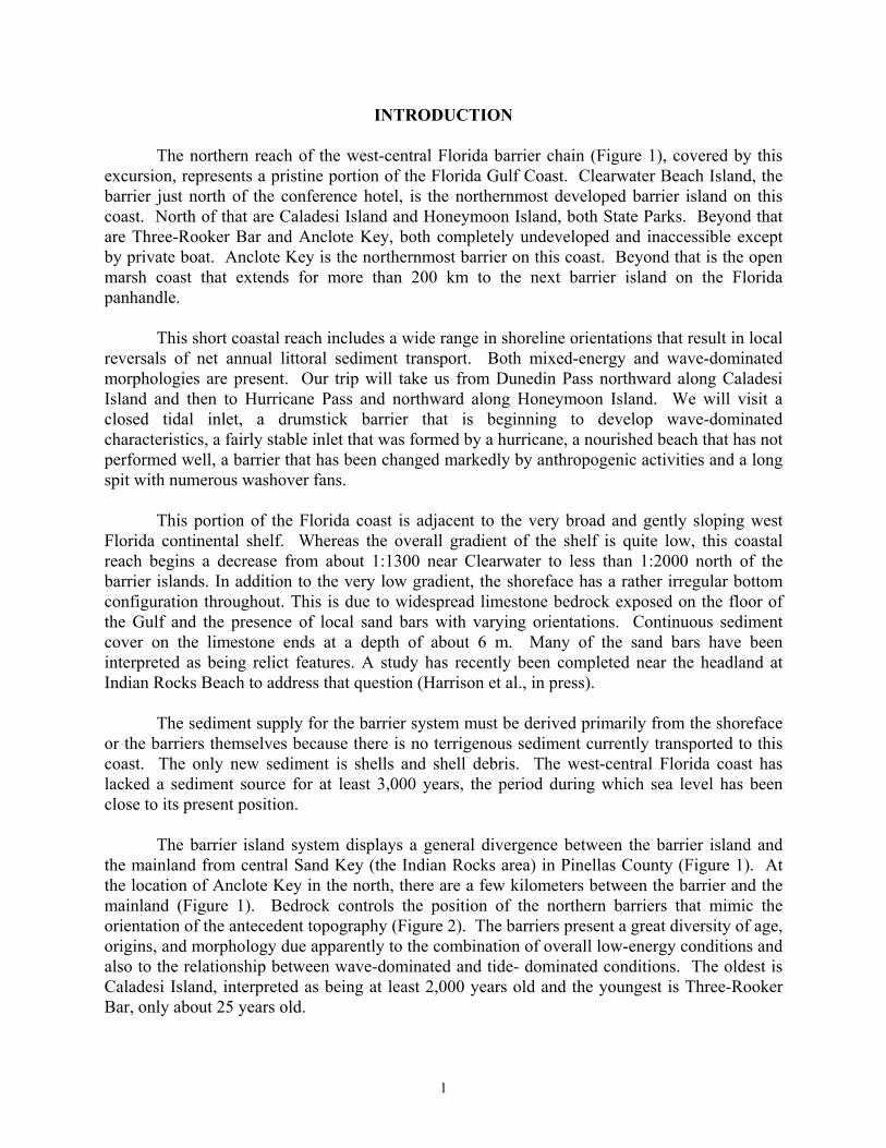
Honeymoon Island Honeymoon Island, the north portion of the former Hog Island, lived up to its name as a subtropical destination for newlyweds in the 1920s and 1930s. At that time it was necessary to take a boat to the island and put up a tent; there were no facilities of any kind. Mosquitos were the only abundant inhabitants. The island was privately held and in the early 1960s plans were made for extensive development, changing the fate of the island forever. A causeway connecting the island to the mainland was completed in 1964. Shortly thereafter a major fill project was constructed to increase the area of the island and provide many more sites for homes. Paved roads and a water system were also constructed. The southern half of the island was drastically altered along both the Gulf and backbarrier shorelines (Figure 19). Permitting the type of development that was planned was not forthcoming and funds for the project were insufficient so Honeymoon Island was sold to the State of Florida for development as a park. It has been a state park since 1974 and is the second most popular unit in the system. Unfortunately when the State purchased Honeymoon Island they did not remove the fill, causing huge problems for the aesthetics of the island and for beach users.
1963 1973 1980Figure 19 - Aerial photos showing Honeymoon Island before the large-scale fill project (1963), after completion (1973), and the approximate present shoreline orientation (1980). Note the
change in area and shoreline of the island, and the two groins on the southern beaches in 1973. Stop 5 - Hurricane Pass
The hurricane of October 1921 was one of the most severe on record for the west-central coast of Florida. It had a storm surge of 3 m and caused the formation of Redfish Pass, 150 km to the south and Hurricane Pass that breached Hog Island to form Caladesi Island and Honeymoon Island. Since that time Hurricane Pass has experienced periods of expansion and reduction in cross-section. In the late 1960s groins were placed on Honeymoon Island and rip
16

rap was placed on the north side of the inlet to keep southerly littoral drift from entering the channel. A recent project on the tidal deltas of this inlet has formulated a stratigraphic model for both ebb deltas and flood deltas (Cuffe and Davis, 1993). This project also demonstrated that the limestone surface was only about 3 m below sea level on the flood tidal delta but was at least 5 m below sea level on the Gulf side. This demonstrates the change in the gradient of this bedrock surface.
In general, Hurricane Pass has been rather stable at a depth of 7 m scouring into stiff Pleistocene sediments and resting upon Miocene limestone. The inlet is slightly flood-dominated and has shown little in the way of morphologic changes since its formation (Lynch-Blosse and Davis, 1977). The flood delta is subtidal and partly covered with seagrass attesting to its stability. The ebb delta is small and is characterized by a rather large and somewhat mobile shoal on the southern side of the channel. Since the formation and development of the inlets on Caladesi Island this shoal has tended to move northward impinging upon the inlet channel.
Tidal prism measurements for Hurricane Pass range from 7.3 to 9.8 x 10⁶ m3, all calculated prior to the formation of the new inlets on Caladesi Island. Recent measurements show maximum flood current speeds of 85 cm/sec, an increase from the 70 cm/sec values of Lynch-Blosse (1977). It is possible that this reflects a constriction of Hurricane Pass and the increase in currents speed is a response to maintenance of the tidal prism. During the past couple of years the small island that was isolated from Caladesi Island (Figure 20:1994) has been destroyed by winter storms. It now is a shallow to intertidal sand body. A significant amount of the sand body that comprises the southern portion of the ebb tidal delta here will soon be removed to nourish the beach on Honeymoon. This removal of sand is not expected to cause problems for this inlet. Stop 6 - Beach on Honeymoon Island
The developers that held Honeymoon Island before it became a state park dredged a little over one million cubic yards of sand and rock from an area just offshore in 1969. The southern half of the island was significantly altered along both the Gulf and backbarrier shorelines (Figure 19: 1973). The unconsolidated portion of the fill eroded rapidly, leaving an unpleasant limestone rubble beach (Figure 21). Along the central portion of the beach, a headland was created by the fill and subsequent erosion. This has lead to an unnatural shoreline configuration with the northern reach trending north-south and the southern reach trending northwest-southeast (Figure 19: 1980). The headland also acts as a nodal point in littoral transport along the island making it difficult to maintain a recreational beach in this region.
17

Figure 20 - Sequence of outline maps showing the origin and morphodynamics of Hurricane
Pass since its formation in 1921 (from Barnard, 1999).
Figure 21 - Limestone rubble on “beach” of Honeymoon Island just prior to the nourishment
project. This rubble is a lag deposit from the large fill project of the late 1960s.
18

In 1989, a nourishment project supplied 175,000 m3 of upland Pleistocene dune sand with a distinct reddish color due to iron oxide staining to this central region (Figure 22). A detailed tracer study of the path of the nourished material (Inglin, 1991) documented the southern movement of the bulk of the sediment with a substantial amount making its way into Hurricane Pass. This transport was the result of both southerly longshore currents and flooding tidal currents. Due to the rapid erosion of this material from the project area, two bathhouses were relocated to the southern end of the island. .
The Florida Department of Environmental Protection (DEP) and Pinellas County will be renourishing Honeymoon Island during the fall and winter of 2003. Approximately 76,000 m3 of material will be dredged from the southern shoal of the ebb delta of Hurricane Pass. The sand will be hydraulically pumped onto the southern beach in the vicinity of the bathhouses. Additionally, a rock groin will be constructed along the southern limit of the nourished area in hopes of retaining most of the nourished material. This groin will essentially be an extension of the southernmost rock groin built in the late 60’s (Figure 19: 1973).
Figure 22 - Nourishment on Honeymoon Island in 1989 with iron stained sediment from upland
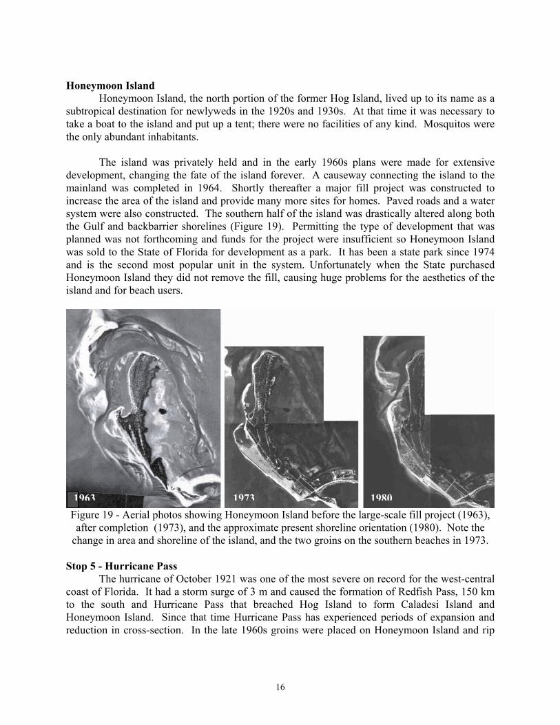
dunes that provided the borrow material. Stop 7 - North end of Honeymoon Island. A large spit has developed along the northern half of Honeymoon Island over the past two decades (Figure 23). This spit is attached to the subtle headland on the island that is the location of a longshore transport divergence. The spit receives sediment from onshore transport from the shoreface and from the subtle headland area near the middle of the island. The nourishment of 1989 provided significant sediment for northerly transport into this spit. A recent study of washover fans included the northern part of this spit (Sedgwick, 1995). This low-lying part of the island is washed over at least once a year. Detailed study of the
19

washover facies shows multiple facies depending upon location and elevation (Figure 24). Typically the horizontal laminations of sand, shell and in some places, heavy minerals, are bioturbated at intertidal and subtidal elevations.
Figure 23 – Long spit on the north portion of Honeymoon Island. This low feature is commonly
washed over, even by strong frontal passages during the winter.
20
Figure 24 - Cross-section of washover sequences at the north end of Honeymoon Island (from Sedgwick, 1995).
SUMMARY Caladesi and Honeymoon Islands and associated tidal inlets have experienced many changes over the past century. Most of these changes have come about as the result of low-energy coastal processes in combination with anthropogenic activities. The inlets have responded to changes in tidal prism produced by a combination of new inlets being cut by storms and by the construction of the fill causeways between the barrier islands and the mainland. The barrier islands have also experienced major changes. Although both are drumstick barriers, the nature and origin of the changes is different. Caladesi Island is transforming from a classic drumstick barrier to a more wave-dominated barrier. This has produced more uniform transport and accumulation of sand along the beach and nearshore than is typical for a drumstick barrier. Honeymoon Island has experienced major growth as the result of a large construction project in the late 1960s. This has resulted in a rapidly eroding beach and a long spit that is separated from the drumstick portion of the island by about 100 m of open water. These islands demonstrate the fragile nature of barrier islands. They respond rapidly and significantly to both natural and anthropogenic change.
21

REFERENCES
Barnard, P.L, 1999, Historical morphodynamics of inlet channels: west-central Florida: unpubl M.S. thesis, Univ. South Florida, 179 p.
Cuffe, C. K. and Davis, R. A., 1993, Origin, development and stratigraphy of tidal deltas at
Hurricane Pass, Pinellas County, Florida - an example of modern tidal delta architecture from a microtidal coast. Coastal Zone '93, Amer. Soc. Civil Eng., New York, p. 2570-2584.
Davis, R.A., Jr., 1999, Complicated littoral drift systems on the Gulf Coast of peninsular Florida.
Coastal Sediments ’99, Amer. Soc. Civil Eng., p. 761-769. Davis, R.A., Andronaco, M., and Gibeaut, J.C., 1989, Formation and development of a tidal inlet
from a washover fan, west-central Florida coast, U.S.A. Sedimentary Geology, v. 65, p. 87-94.
Davis, R.A., Jr. and Kuhn, B.J., 1985, Origin and development of Anclote Key, west-peninsular
Florida. Marine Geology, v. 63, p. 153-171. Davis, R.A. and Hayes, M.O., 1984, What is a wave-dominated coast? Marine Geology, v. 60,
p. 313-329. Davis, R. A., Hine, A. C. and Belknap, D. F., 1982, Coastal atlas, northern Pinellas County,
Florida. Final Rept., Florida Sea Grant, Project R/OE-17, 39 p. and 12 maps. de Beaumont, L.E., 1852, Lecons de geologie practique. Septieme lecon. P. Bertrand, Paris, p.
221-252. Evans, M.W., Hine, A.C., Belknap, D.F. and Davis, R.A., Jr., 1985, Bedrock control on barrier
island development, Pinellas County, Florida. Marine Geology, v. 63, p. 263-283. Fairbridge, R.W., 1961. Eustatic changes in sea level. In: Ahrens, L.H., et al. (eds.), Physics and
chemistry of the Earth, New York: Pergamon Press, v. 4, p. 99-185. Harrison, S.E., Locker, S.D., Hine, A.C., Edwards, J.H., Naar, D.F., Twichell, D.C. and
Mallinson, D.F., in press, Seafloor characteristics and process-response relationships of sediment starved sand ridges on a mixed carbonate/siliciclastic inner shelf off west-central Florida. Marine Geology, Special Issue.
Hayes, M.O., 1979, Barrier island morphology as a function of tidal and wave regime, In:
Leatherman, S.P. (ed), Barrier Islands from the Gulf of St. Lawrence to the Gulf of Mexico: New York, Academic Press, p. 1-27.
Hayes, M.O. and Kana, T. W., 1976. Terrigenous Clastic Depositional Environments, Technical
Report CRD-11, Dept. of Geology, Univ. of S. Carolina, Columbia, S.C., 364 p.
22

Hicks, S.D., Debaugh, H.A., Jr., and Hickman, L.E., 1983, Sea level variations for the United States 1855-1980: National Ocean Survey, Rockville, MD, 170 p.
Ho, F.P. and Tracey, R.J., 1975, Storm tide frequency analysis for the Gulf coast of Florida from
Cape San Blas to St. Petersburg Beach, National Oceanographic and Atmospheric Administration, Technical Memo NWS HYDRO-20, 34 p.
Inglin, D.C., 1991, Sediment budget of Honeymoon Island, Florida: unpubl. MS thesis, Univ.
South Florida, 132 p. Locker, S.D., Davis, R.A., Brooks, G.R., Hine, A.C., and Gelfenbaum, G., 2002, West-central
Florida coastal transect #2: Caladesi Island-Clearwater Beach Island. U.S. Geological Survey, Open File Report 99-056.
Lynch-Blosse, M.A., 1977, Inlet sedimentation at Dunedin and Hurricane passes, Pinellas
County, Florida: unpubl. M.S. thesis, Univ. South Florida, 170 p. Lynch-Blosse, M.A. and Davis, R.A., Jr., 1977, Stability of Dunedin and Hurricane passes,
Pinellas County, Florida: Coastal Sediments '77, Amer. Soc. Civil. Eng., p. 774-789. Parkinson, R.W., 1990, Decelerating Holocene sea-level rise and its influence on southwest
Florida coastal evolution: a transgressive/regressive stratigraphy. Journal of Sedimentary Petrology, v. 59, p. 960-972.
Scholl, D. W., 1964, Recent sedimentary record in mangrove swamps and rise in sea level over
the southwestern coast of Florida: Marine Geology, Part I, v. 1, p. 344-366; Part 2, v. 2, p. 343-364.
Scholl, D.W., Craighead, F.C., Sr., and Stuiver, M., 1969, Florida submergence curve revised: its
relation to coastal sedimentation rates, Science, v. 163, p. 562-564. Schwartz, R.K., 1975, Nature and genesis of some storm washover deposits, U.S. Army Corps of
Engineers, Coastal Engr. Res. Center, Technical Memo. No. 61, 69 p. Sedgwick, P. E., 1995, Stratigraphy of washover deposits in Florida: implications for recognition
in the stratigraphic record: unpubl. M.S. Thesis, Univ. South Florida, Tampa, 160 p. Sedgwick, P.E. and Davis, R.A., in press, Stratigraphy of washover deposits in Florida:
implications for recognition in the stratigraphic record. Marine Geology, Special Issue. Tanner, W.F., 1960, Florida coastal classification: Transactions of the Gulf Coast Association of
Geological Societies, v. 10, p. 259-266.
23