Embed Size (px)
Citation preview

RESOLUTION NO R-2021- 0151
RESOLUTION APPROVING ZONING APPLICATION ZVDOA-2020-00786 (CONTROL NO 1975-00156)
a Development Order Amendment APPLICATION OF West Palm Realty Associates LLC
BY Urban Design Studio AGENT (Crosstown Plaza)
WHEREAS the Board of County Commissioners as the governing body of Palm Beach County Florida pursuant to the authority vested in Chapter 163 and Chapter 125 Florida Statutes is authorized and empowered to consider applications relating to zoning
WHEREAS the notice and public hearing requirements pursuant to Article 2 (Application Processes and Procedures) of the Palm Beach County Unified Land Development Code Ordinance 2003-067 (ULDC) have been satisfied
WHEREAS Zoning Application ZVDOA-2020-00786 was presented to the Board of County Commissioners at a public hearing conducted on January 28 2021
WHEREAS the Board of County Commissioners has considered the evidence and testimony presented by the Applicant and other interested parties the recommendations of the various County Review Agencies and the recommendation of the Zoning Commission
WHEREAS the Board of County Commissioners pursuant to Article 2 (Application Processes and Procedures) of the ULDC is authorized and empowered to consider approve approve with conditions or deny the request
WHEREAS the Board of County Commissioners hereby incorporates by reference the Findings in the staff report addressing the Standards contained in Article 2B (Public Hearing Processes) for a Development Order Amendment
WHEREAS this approval is subject to Article 2E (Monitoring) of the ULDC and other provisions requiring that development commence in a timely manner
WHEREAS the issuance of th is Development Permit does not in any way create any rights on the part of the Applicant andor Property Owner to obtain a permit from a state or federal agency and does not create any liability on the part of the County for issuance of the permit if the Applicant fails to obtain requisite approvals or fulfill the obligations imposed by a state or federal agency or undertakes actions that result in a violation of state or federal law
WHEREAS the Palm Beach County Survey Section may administratively correct any scriveners errors that will not significantly impact the overall boundary of the adopted legal description and
WHEREAS Article 2B6C (Board Action) of the ULDC requires that the action of the Board of County Commissioners be adopted by resolution
NOW THEREFORE BE IT RESOLVED BY THE BOARD OF COUNTY COMMISSIONERS OF PALM BEACH COUNTY FLORIDA that Zoning Application ZVDOA-2020-00786 the Application of West Palm Realty Associates LLC by Urban Design Studio Agent for a Development Order Amendment to add square footage and reconfigure the Site Plan on a parcel of land generally described as shown on the legal description in EXHIBIT A attached hereto and made a part hereof and generally located as shown on a vicinity sketch as indicated in EXHIBIT B attached hereto and made a part hereof was approved on January 28 2021 subject to the Conditions of Approval described in EXHIBIT C attached hereto and made a part hereof
Application No ZVDOA-2020-00786 Page 1 Control No 1975-00156 Project No 00508-000
Commissioner Berna rd moved for the approval of the Resolution
The motion was seconded by Commissioner _ w_e_i_s _s ___ and upon being put to a vote the vote was as follows
Commissioner Dave Kerner Mayor Aye Commissioner Robert S Weinroth Vice Mayor Aye Commissioner Maria G Marino Aye Commissioner Gregg K Weiss Aye Commissioner Maria Sachs Aye Commissioner Melissa McKinlay Aye
Aye Commissioner Mack Bernard
The Mayor thereupon declared that the resolution was duly passed and adopted on January 28 2021
Filed with the Clerk of the Board of County Commissioners on February 17th 202 1
This resolution is effective when filed with the Clerk of the Board of County Commissioners
APPROVED AS TO FORM AND LEGAL SUFFICIENCY
PALM BEACH COUNTY FLORIDA BY ITS BOARD OF COUNTY COMMISSIONERS
JOSEPH ABRUZZO CLERK amp COMPTROLLER
BY ~ frac12 fcouNnrAnoRN EY
Application No ZVDOA-2020-00786 Page 2 Control No 1975-00156 Project No 00508-000
r
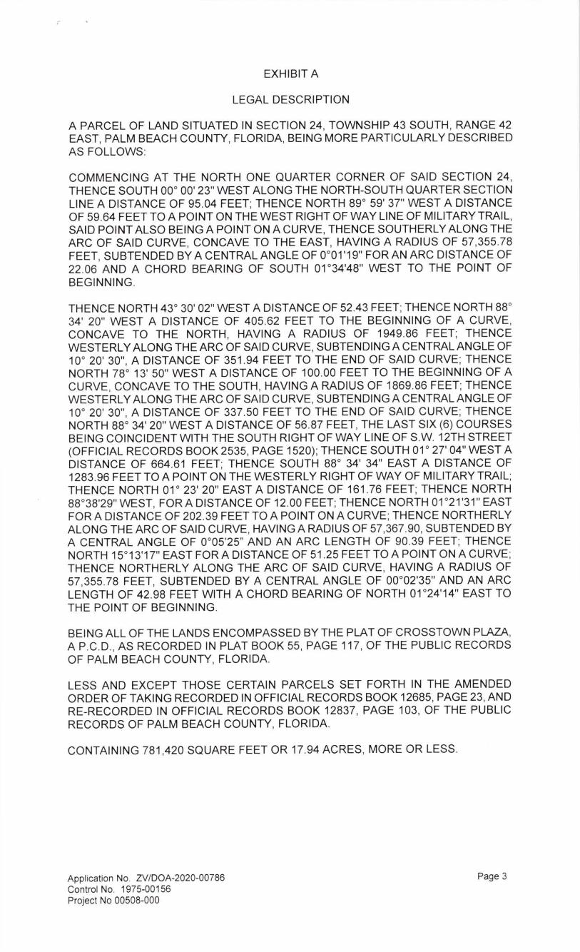
EXHIBIT A
LEGAL DESCRIPTION
A PARCEL OF LAND SITUATED IN SECTION 24 TOWNSHIP 43 SOUTH RANGE 42 EAST PALM BEACH COUNTY FLORIDA BEING MORE PARTICULARLY DESCRIBED AS FOLLOWS
COMMENCING AT THE NORTH ONE QUARTER CORNER OF SAID SECTION 24 THENCE SOUTH 00deg 00 23 WEST ALONG THE NORTH-SOUTH QUARTER SECTION LINE A DISTANCE OF 9504 FEET THENCE NORTH 89deg 59 37 WEST A DISTANCE OF 5964 FEET TOA POINTON THE WEST RIGHT OF WAY LINE OF MILITARY TRAIL SAID POINT ALSO BEING A POINT ON A CURVE THENCE SOUTHERLY ALONG THE ARC OF SAID CURVE CONCAVE TO THE EAST HAVING A RADIUS OF 5735578 FEET SUBTENDED BY A CENTRAL ANGLE OF 0deg01 19 FOR AN ARC DISTANCE OF 2206 AND A CHORD BEARING OF SOUTH 01 deg3448 WEST TO THE POINT OF BEGINNING
THENCE NORTH 43deg 30 02 WEST A DISTANCE OF 5243 FEET THENCE NORTH 88deg 34 20 WEST A DISTANCE OF 40562 FEET TO THE BEGINNING OF A CURVE CONCAVE TO THE NORTH HAVING A RADIUS OF 194986 FEET THENCE WESTERLY ALONG THE ARC OF SAID CURVE SUBTENDING A CENTRAL ANGLE OF 10deg 20 30 A DISTANCE OF 351 94 FEET TO THE END OF SAID CURVE THENCE NORTH 78deg 13 50 WEST A DISTANCE OF 10000 FEET TO THE BEGINNING OF A CURVE CONCAVE TO THE SOUTH HAVING A RADIUS OF 186986 FEET THENCE WESTERLY ALONG THE ARC OF SAID CURVE SUBTENDING A CENTRAL ANGLE OF 10deg 20 30 A DISTANCE OF 33750 FEET TO THE END OF SAID CURVE THENCE NORTH 88deg 34 20 WEST A DISTANCE OF 5687 FEET THE LAST SIX (6) COURSES BEING COINCIDENT WITH THE SOUTH RIGHT OF WAY LINE OF SW 12TH STREET (OFFICIAL RECORDS BOOK 2535 PAGE 1520) THENCE SOUTH 01 deg 27 04 WEST A DISTANCE OF 66461 FEET THENCE SOUTH 88deg 34 34 EAST A DISTANCE OF 128396 FEET TO A POINTON THE WESTERLY RIGHT OF WAY OF MILITARY TRAIL THENCE NORTH 01 deg 23 20 EAST A DISTANCE OF 161 76 FEET THENCE NORTH 88deg3829 WEST FORA DISTANCE OF 1200 FEET THENCE NORTH 01deg2131 EAST FOR A DISTANCE OF 20239 FEET TO A POINT ON A CURVE THENCE NORTHERLY ALONG THE ARC OF SAID CURVE HAVING A RADIUS OF 5736790 SUBTENDED BY A CENTRAL ANGLE OF 0deg0525 AND AN ARC LENGTH OF 9039 FEET THENCE NORTH 15deg1317 EAST FOR A DISTANCE OF 51 25 FEET TO A POINT ON A CURVE THENCE NORTHERLY ALONG THE ARC OF SAID CURVE HAVING A RADIUS OF 5735578 FEET SUBTENDED BY A CENTRAL ANGLE OF 00deg0235 AND AN ARC LENGTH OF 4298 FEET WITH A CHORD BEARING OF NORTH 01 deg2414 EAST TO THE POINT OF BEGINNING
BEING ALL OF THE LANDS ENCOMPASSED BY THE PLAT OF CROSSTOWN PLAZA A PCD AS RECORDED IN PLAT BOOK 55 PAGE 11 7 OF THE PUBLIC RECORDS OF PALM BEACH COUNTY FLORIDA
LESS AND EXCEPT THOSE CERTAIN PARCELS SET FORTH IN THE AMENDED ORDER OF TAKING RECORDED IN OFFICIAL RECORDS BOOK 12685 PAGE 23 AND RE-RECORDED IN OFFICIAL RECORDS BOOK 12837 PAGE 103 OF THE PUBLIC RECORDS OF PALM BEACH COUNTY FLORIDA
CONTAINING 781420 SQUARE FEET OR 1794 ACRES MORE OR LESS
Application No ZVDOA-2020-00786 Page 3 Control No 1975-00156 Project No 00508-000
EXHIBIT B
VICINITY SKETCH
z 0
0 ~
~ I I
r ~ w gt ~ r
I
~ - DRIVE gt-~
~ I
~
z
NORTH
~ NTS
0 ~ 0 ~
~ I
~
Application No ZVDOA-2020-00786 Page 4 Control No 1975-00156 Project No 00508-000
EXHIBIT C
CONDITIONS OF APPROVAL
Development Order Amendment (Planned Commercial Development)
ALL PETITIONS 1 The approved Preliminary Site Plan is dated November 9 2020 Modifications to the Development Order inconsistent with the Conditions of Approval or changes to the uses or site design beyond the authority of the Development Review Officer as established in the Unified Land Development Code must be approved by the Board of County Commissioners or the Zoning Commission (ONGOING ZONING - Zoning)
2 All previous Conditions of Approval applicable to the subject property as contained in Resolution R-1975-0868 (Control 1975-00156) have been consolidated as contained herein The Property Owner shall comply with all previous Conditions of Approval and deadlines previously established by Article 2E of the Unified Land Development Code and the Board of County Commissioners or Zoning Commission unless expressly modified (ONGOING MONITORING - Zoning)
ENGINEERING 1 Prior to the issuance of any building permits the Developer shall convey to Palm Beach County sixty (60) feet of right-of-way from the centerline of Military Trail and the ultimate right-of-way for 12th Street North from the subject property and Donald Walkers property as shown on the site plan (BLDGPMT ENGINEERING - Engineering) [Note COMPLETED] (Previous Condition 1 of Resolution R-1975-868 Control No1975-00156)
2 Developer shall file a plat in accordance with Ordinance No 73-4 as amended [Note COMPLETED] (Previous Condition 2 of Resolution R-1975-868 Control No1975-00156)
3 When the County has constructed 12th Street North the Developer shall provide for the construction of the 3rd lane (ONGOING ENGINEERING - Engineering) (Previous Condition 3 of Resolution R-1975-868 Control No1975-00156)
4 Developer shall construct the following at the intersection of 12th Street North and Military Trail a) Right turn lane north approach b) Left turn lane south approach c) Left and right turn lane west approach d) Signalization if and when warranted (ONGOING ENGINEERING - Engineering) (Previous Condition 4 of Resolution R-1975-868 Control No1975-00156)
5 Developer shall construct the following at the intersection of 12th Street North and the projects entrance a) Left and right turn lane south approach b) Left turn lane east approach c) Right turn lane west approach d) Signalization if and when warranted (ONGOING ENGINEERING - Engineering) (Previous Condition 5 of Resolution R-1975-868 Control No1975-00156)
6 Developer shall construct a right turn lane north approach at the intersection of Military Trail and the projects north entrance (ONGOING ENGINEERING - Engineering) [Note COMPLETED] (Previous Condition 6 of Resolution R-1975-868 Control No1975-00156)
7 Developer shall construct a left turn lane south approach and signalization if and when warranted at the intersection of Military Trail and the projects south entrance (ONGOING ENGINEERING - Engineering) (Previous Condition 7 of Resolution R-1975-868 Control No1975-00156)
8 The development is to be restricted to Phase I ie the service station power substation
Application No ZVDOA-2020-00786 Page 5 Control No 1975-00156 Project No 00508-000
and 89150 square feet of commercial area until the construction of 12th Street at which time the developer shall provide a third lane from the projects northern entrance to Military Trail (Previous Condition 8 of Resolution R-1975-868 Control No1975-00156)
9 In order to comply with the mandatory Traffic Performance Standards the Property Owner shall be restricted to the following phasing schedule
a No Building Permits for the site may be issued after December 31 2023 or as amended A time extension for this condition may be approved by the County Engineer based upon an approved Traffic Study which complies with Mandatory Traffic Performance Standards in place at the time of the request This extension request shall be made pursuant to the requirements of Art 2E of the Unified Land Development Code (DATE MONITORING - Engineering)
COMPLIANCE 1 In Granting this Approval the Board of County Commissioners rel ied upon the oral and written representations of the Property OwnerApplicant both on the record and as part of the application process Deviations from or violation of these representations shall cause the Approval to be presented to the Board of County Commissioners for review under the Compliance Condition of this Approval (ONGOING MONITORING - Zoning)
2 Failure to comply with any of the Conditions of Approval for the subject property at any time may result in a The Issuance of a Stop Work Order the Issuance of a Cease and Desist Order the Denial or Revocation of a Building Permit the Denial or Revocation of a Certificate of Occupancy the Denial of any other Permit License or Approval to any developer owner lessee or user of the subject property the Revocation of any other Permit License or Approval from any developer owner lessee or user of the subject property the Revocation of any concurrency andor b The Revocation of the Official Map Amendment Conditional Use Requested Use Development Order Amendment andor any other Zoning Approval andor c A requirement of the development to conform with the standards of the Unified Land Development Code at the time of the finding of non-compliance or the addition or modification of Conditions reasonably related to the failure to comply with existing Conditions andor d Referral to Code Enforcement andor e Imposition of entitlement density or intensity
Staff may be directed by the Executive Director of PZampB or the Code Enforcement Special Master to schedule a Status Report before the body which approved the Official Zoning Map Amendment Conditional Use Requested Use Development Order Amendment andor other zoning approval in accordance with the provisions of Section 2E of the ULDC in response to any flagrant violation andor continued violation of any condition of approval (ONGOING MONITORING - Zoning)
DISCLOSURE 1 All applicable state or federal permits shall be obtained before commencement of the development authorized by this Development Permit
Application No ZVDOA-2020-00786 Page 6 Control No 1975-00156 Project No 00508-000

Commissioner Berna rd moved for the approval of the Resolution
The motion was seconded by Commissioner _ w_e_i_s _s ___ and upon being put to a vote the vote was as follows
Commissioner Dave Kerner Mayor Aye Commissioner Robert S Weinroth Vice Mayor Aye Commissioner Maria G Marino Aye Commissioner Gregg K Weiss Aye Commissioner Maria Sachs Aye Commissioner Melissa McKinlay Aye
Aye Commissioner Mack Bernard
The Mayor thereupon declared that the resolution was duly passed and adopted on January 28 2021
Filed with the Clerk of the Board of County Commissioners on February 17th 202 1
This resolution is effective when filed with the Clerk of the Board of County Commissioners
APPROVED AS TO FORM AND LEGAL SUFFICIENCY
PALM BEACH COUNTY FLORIDA BY ITS BOARD OF COUNTY COMMISSIONERS
JOSEPH ABRUZZO CLERK amp COMPTROLLER
BY ~ frac12 fcouNnrAnoRN EY
Application No ZVDOA-2020-00786 Page 2 Control No 1975-00156 Project No 00508-000
r
EXHIBIT A
LEGAL DESCRIPTION
A PARCEL OF LAND SITUATED IN SECTION 24 TOWNSHIP 43 SOUTH RANGE 42 EAST PALM BEACH COUNTY FLORIDA BEING MORE PARTICULARLY DESCRIBED AS FOLLOWS
COMMENCING AT THE NORTH ONE QUARTER CORNER OF SAID SECTION 24 THENCE SOUTH 00deg 00 23 WEST ALONG THE NORTH-SOUTH QUARTER SECTION LINE A DISTANCE OF 9504 FEET THENCE NORTH 89deg 59 37 WEST A DISTANCE OF 5964 FEET TOA POINTON THE WEST RIGHT OF WAY LINE OF MILITARY TRAIL SAID POINT ALSO BEING A POINT ON A CURVE THENCE SOUTHERLY ALONG THE ARC OF SAID CURVE CONCAVE TO THE EAST HAVING A RADIUS OF 5735578 FEET SUBTENDED BY A CENTRAL ANGLE OF 0deg01 19 FOR AN ARC DISTANCE OF 2206 AND A CHORD BEARING OF SOUTH 01 deg3448 WEST TO THE POINT OF BEGINNING
THENCE NORTH 43deg 30 02 WEST A DISTANCE OF 5243 FEET THENCE NORTH 88deg 34 20 WEST A DISTANCE OF 40562 FEET TO THE BEGINNING OF A CURVE CONCAVE TO THE NORTH HAVING A RADIUS OF 194986 FEET THENCE WESTERLY ALONG THE ARC OF SAID CURVE SUBTENDING A CENTRAL ANGLE OF 10deg 20 30 A DISTANCE OF 351 94 FEET TO THE END OF SAID CURVE THENCE NORTH 78deg 13 50 WEST A DISTANCE OF 10000 FEET TO THE BEGINNING OF A CURVE CONCAVE TO THE SOUTH HAVING A RADIUS OF 186986 FEET THENCE WESTERLY ALONG THE ARC OF SAID CURVE SUBTENDING A CENTRAL ANGLE OF 10deg 20 30 A DISTANCE OF 33750 FEET TO THE END OF SAID CURVE THENCE NORTH 88deg 34 20 WEST A DISTANCE OF 5687 FEET THE LAST SIX (6) COURSES BEING COINCIDENT WITH THE SOUTH RIGHT OF WAY LINE OF SW 12TH STREET (OFFICIAL RECORDS BOOK 2535 PAGE 1520) THENCE SOUTH 01 deg 27 04 WEST A DISTANCE OF 66461 FEET THENCE SOUTH 88deg 34 34 EAST A DISTANCE OF 128396 FEET TO A POINTON THE WESTERLY RIGHT OF WAY OF MILITARY TRAIL THENCE NORTH 01 deg 23 20 EAST A DISTANCE OF 161 76 FEET THENCE NORTH 88deg3829 WEST FORA DISTANCE OF 1200 FEET THENCE NORTH 01deg2131 EAST FOR A DISTANCE OF 20239 FEET TO A POINT ON A CURVE THENCE NORTHERLY ALONG THE ARC OF SAID CURVE HAVING A RADIUS OF 5736790 SUBTENDED BY A CENTRAL ANGLE OF 0deg0525 AND AN ARC LENGTH OF 9039 FEET THENCE NORTH 15deg1317 EAST FOR A DISTANCE OF 51 25 FEET TO A POINT ON A CURVE THENCE NORTHERLY ALONG THE ARC OF SAID CURVE HAVING A RADIUS OF 5735578 FEET SUBTENDED BY A CENTRAL ANGLE OF 00deg0235 AND AN ARC LENGTH OF 4298 FEET WITH A CHORD BEARING OF NORTH 01 deg2414 EAST TO THE POINT OF BEGINNING
BEING ALL OF THE LANDS ENCOMPASSED BY THE PLAT OF CROSSTOWN PLAZA A PCD AS RECORDED IN PLAT BOOK 55 PAGE 11 7 OF THE PUBLIC RECORDS OF PALM BEACH COUNTY FLORIDA
LESS AND EXCEPT THOSE CERTAIN PARCELS SET FORTH IN THE AMENDED ORDER OF TAKING RECORDED IN OFFICIAL RECORDS BOOK 12685 PAGE 23 AND RE-RECORDED IN OFFICIAL RECORDS BOOK 12837 PAGE 103 OF THE PUBLIC RECORDS OF PALM BEACH COUNTY FLORIDA
CONTAINING 781420 SQUARE FEET OR 1794 ACRES MORE OR LESS
Application No ZVDOA-2020-00786 Page 3 Control No 1975-00156 Project No 00508-000
EXHIBIT B
VICINITY SKETCH
z 0
0 ~
~ I I
r ~ w gt ~ r
I
~ - DRIVE gt-~
~ I
~
z
NORTH
~ NTS
0 ~ 0 ~
~ I
~
Application No ZVDOA-2020-00786 Page 4 Control No 1975-00156 Project No 00508-000
EXHIBIT C
CONDITIONS OF APPROVAL
Development Order Amendment (Planned Commercial Development)
ALL PETITIONS 1 The approved Preliminary Site Plan is dated November 9 2020 Modifications to the Development Order inconsistent with the Conditions of Approval or changes to the uses or site design beyond the authority of the Development Review Officer as established in the Unified Land Development Code must be approved by the Board of County Commissioners or the Zoning Commission (ONGOING ZONING - Zoning)
2 All previous Conditions of Approval applicable to the subject property as contained in Resolution R-1975-0868 (Control 1975-00156) have been consolidated as contained herein The Property Owner shall comply with all previous Conditions of Approval and deadlines previously established by Article 2E of the Unified Land Development Code and the Board of County Commissioners or Zoning Commission unless expressly modified (ONGOING MONITORING - Zoning)
ENGINEERING 1 Prior to the issuance of any building permits the Developer shall convey to Palm Beach County sixty (60) feet of right-of-way from the centerline of Military Trail and the ultimate right-of-way for 12th Street North from the subject property and Donald Walkers property as shown on the site plan (BLDGPMT ENGINEERING - Engineering) [Note COMPLETED] (Previous Condition 1 of Resolution R-1975-868 Control No1975-00156)
2 Developer shall file a plat in accordance with Ordinance No 73-4 as amended [Note COMPLETED] (Previous Condition 2 of Resolution R-1975-868 Control No1975-00156)
3 When the County has constructed 12th Street North the Developer shall provide for the construction of the 3rd lane (ONGOING ENGINEERING - Engineering) (Previous Condition 3 of Resolution R-1975-868 Control No1975-00156)
4 Developer shall construct the following at the intersection of 12th Street North and Military Trail a) Right turn lane north approach b) Left turn lane south approach c) Left and right turn lane west approach d) Signalization if and when warranted (ONGOING ENGINEERING - Engineering) (Previous Condition 4 of Resolution R-1975-868 Control No1975-00156)
5 Developer shall construct the following at the intersection of 12th Street North and the projects entrance a) Left and right turn lane south approach b) Left turn lane east approach c) Right turn lane west approach d) Signalization if and when warranted (ONGOING ENGINEERING - Engineering) (Previous Condition 5 of Resolution R-1975-868 Control No1975-00156)
6 Developer shall construct a right turn lane north approach at the intersection of Military Trail and the projects north entrance (ONGOING ENGINEERING - Engineering) [Note COMPLETED] (Previous Condition 6 of Resolution R-1975-868 Control No1975-00156)
7 Developer shall construct a left turn lane south approach and signalization if and when warranted at the intersection of Military Trail and the projects south entrance (ONGOING ENGINEERING - Engineering) (Previous Condition 7 of Resolution R-1975-868 Control No1975-00156)
8 The development is to be restricted to Phase I ie the service station power substation
Application No ZVDOA-2020-00786 Page 5 Control No 1975-00156 Project No 00508-000
and 89150 square feet of commercial area until the construction of 12th Street at which time the developer shall provide a third lane from the projects northern entrance to Military Trail (Previous Condition 8 of Resolution R-1975-868 Control No1975-00156)
9 In order to comply with the mandatory Traffic Performance Standards the Property Owner shall be restricted to the following phasing schedule
a No Building Permits for the site may be issued after December 31 2023 or as amended A time extension for this condition may be approved by the County Engineer based upon an approved Traffic Study which complies with Mandatory Traffic Performance Standards in place at the time of the request This extension request shall be made pursuant to the requirements of Art 2E of the Unified Land Development Code (DATE MONITORING - Engineering)
COMPLIANCE 1 In Granting this Approval the Board of County Commissioners rel ied upon the oral and written representations of the Property OwnerApplicant both on the record and as part of the application process Deviations from or violation of these representations shall cause the Approval to be presented to the Board of County Commissioners for review under the Compliance Condition of this Approval (ONGOING MONITORING - Zoning)
2 Failure to comply with any of the Conditions of Approval for the subject property at any time may result in a The Issuance of a Stop Work Order the Issuance of a Cease and Desist Order the Denial or Revocation of a Building Permit the Denial or Revocation of a Certificate of Occupancy the Denial of any other Permit License or Approval to any developer owner lessee or user of the subject property the Revocation of any other Permit License or Approval from any developer owner lessee or user of the subject property the Revocation of any concurrency andor b The Revocation of the Official Map Amendment Conditional Use Requested Use Development Order Amendment andor any other Zoning Approval andor c A requirement of the development to conform with the standards of the Unified Land Development Code at the time of the finding of non-compliance or the addition or modification of Conditions reasonably related to the failure to comply with existing Conditions andor d Referral to Code Enforcement andor e Imposition of entitlement density or intensity
Staff may be directed by the Executive Director of PZampB or the Code Enforcement Special Master to schedule a Status Report before the body which approved the Official Zoning Map Amendment Conditional Use Requested Use Development Order Amendment andor other zoning approval in accordance with the provisions of Section 2E of the ULDC in response to any flagrant violation andor continued violation of any condition of approval (ONGOING MONITORING - Zoning)
DISCLOSURE 1 All applicable state or federal permits shall be obtained before commencement of the development authorized by this Development Permit
Application No ZVDOA-2020-00786 Page 6 Control No 1975-00156 Project No 00508-000
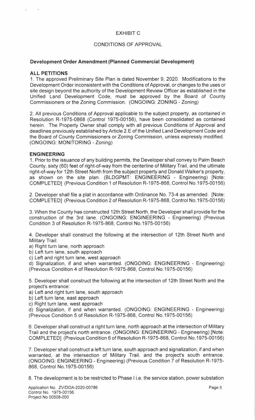