Embed Size (px)
Citation preview
REPORT OF THE VISIT BY THE TEAM OF THE SITE SELECTION COMMITTEE TO THE POTENTIAL SITES
FOR THERMAL POWER PROJECTS IN MADHYA PRADESH-(PHASE-I) 1.0 Introduction: -
Central Electricity Authority under the policy framework of Ministry of Power has proposed to develop a road map for 1,00,000 MW Thermal installation to meet the energy demands of the country in the coming years. The most important criteria for selection of sites for TPSs is availability of land with least R&R issues, fuel availability and its transportation, water availability within a reasonable distance and the acceptability from the environmental considerations. A Site Selection Committee has been set up by CEA which has members from key Ministries like Coal, Petroleum & Natural Gas, Shipping, etc., NTPC and various SEBs/Utilities. This Committee visits various potential sties and thereafter short lists the feasible sites so that these can be earmarked for thermal power projects. Madhya Pradesh State Electricity Board (MPSEB) has proposed to set up thermal power projects at the following five number sites: - 1. Malwa TPS 4x500 MW 2. Bansagar TPS 6x250 MW 3 Shahpura TPS 1000 MW 4 Rajghat TPS (Near Chanderi, District Guna) 2x500 MW 5 TPS near village Sasan in Singrauli area, District Sidhi 2000 MW The Site Selection Committee visited the proposed sites listed at Sl.No.2, 3 & 5 above in Phase-I of its site visit programme from 8th August to 11th August, 2004. The list of Committee Members and officers of CEA, MPSEB and other departments who participated in the site visit is enclosed at Annexure-I. The objective of the joint visit was to identify potential coal based sites for setting up of new thermal power projects in the state.
2.0 Present Power Scenario in Madhya Pradesh: -
As per the actual power supply position, the state of Madhya Pradesh has energy deficit of 8.7% (availability of 9142 Million Units as against requirement of 10013 Million Units) during April-July 2004. The state has peak demand deficit of 1640 MW during the same period. In order to bridge the power supply gap, the thermal capacity addition of 1710 MW is envisaged for the state in the 10th Plan Period. The state will have a peak demand deficit of 506 MW as per the anticipated power supply position at the end of 10th Plan.

3.0 Site Visit on 9th & 10th August, 2004: -
3.1 Site-I: Sasan TPP (4x500 MW)
3.1.1 Location – The site is located near Sasan village about 8 Kms south of Waidhan in Sidhi District of Madhya Pradesh. The nearest railway station is Shakti Nagar (18 Kms) and Rihand MGR passes adjacent to the site. The longitude and latitude are 82037’40” and 23059’20” respectively. An index map of the proposed TPP is enclosed at Annexure-V.
3.1.2 Land – The area of land measuring about 1000 hectares consisting
of waste land with shrubs mixed with agricultural land (single crop) is available for the power plant. The terrain is undulating and the elevation ranges from 300 metre to 310 metre above mean sea level. This land is not considered sufficient for 2000 MW capacity. At least 1300 acres of land will be required for this purpose. In addition to this, about 375 hectare of land for ash pond and about 150 hectares of land for township is also available.
3.1.3 Water – (a) Water source for the site is Gobind Vallabh Pant Sagar
(Reservoir) and the proposed off-take point for water is 1.5 Kms away. MPSEB has approached Water Resources Department, Government of Madhya Pradesh for confirming availability of about 87 million cubic metres per annum of water for the project.
(b) Concurrence of CWC shall be obtained as the water is proposed to be drawn from an inter state river basin.
3.1.4 Coal Source and Transportation – Coal source is about 22 Kms
from the site i.e. Bundela, Mahrauli, Mohar, Nigahi and Ruhalla blocks of Singrauli Coal Fields. Merry Go Round (MGR) of Rihand Super Thermal Power Station passes from near this site. MPSEB expressed the view to approach NTPC for sharing their MGR system for transportation of 10 million tonnes per annum of coal by augmenting the same or else separate MGR tracks would be required for the proposed power plant. As per MPSEB documents handed over during site visit, Gorbi ‘B’ block mine is proposed to be linked with the project. M/s NCL has indicated 5 mtpa coal from Gorbi ‘B’ for 1000 MW in the first phase which will be around 35 kms from the project site near Sasan. However, Mohar coal block is very suitable and nearer to the site. But as per NCL, 10 mtpa coal from Mohar coal block has already been allocated to M/s ISN International – an IPP company hence linkage to the proposed project may not be possible. MPSEB has requested NCL to explore the possibility of coal from Mohar Block as it is technically and economically viable due to shorter distance.

3.1.5 Ash Disposal Area – MPSEB suggested a plot of land measuring
about 375 hectares at a distance of 2.5 Kms from the power plant site. Site Selection Committee observed that the proposed ash dump area is about 20 meters to 25 meters higher than the proposed power plant site. Further, the area has undulating terrain with a large rain water drain (natural) passing through the area.
3.1.6 Resettlement & Rehabilitation – As part of the proposed land is
private land and has cultivation on it, resettlement & rehabilitation will be required for this site. However, for detailed assessment of R&R, further, study is required during feasibility studies.
3.1.7 Power Evacuation – 400 kV transmission system of Power Grid
Corporation/Madhya Pradesh Transco will need to be provided for power evacuation from the power plant.
3.1.8 Environmental Aspect – There is no eco-sensitive spot like
Natural Park, Wild Life Century, Bio-Sphere Reservation, Historical or Cultural Site in the vicinity of the proposed site. However, Madhya Pradesh Pollution Control Board official accompanying the Site Selection Committee observed/suggested that the impact of additional air pollution due to the proposed plant will have to be studied keeping in view that there are five super thermal power stations in the surrounding area. The detailed air quality modeling is required to be done to assess the carrying capacity of the region during further feasibility studies. The Pollution Control Board official also expressed his reservations about suitability of ash disposal area because of large natural drain flowing through it and its elevation being about 20 meters higher than the proposed site.
3.1.9 NOC from Airports Authority of India shall be obtained as there is a
proposed air strip site about 9.5 km away.
3.1.10 Site Features – The details of site features are enclosed at Annexure-II.
4.0 Observations & Action Plan: - The Committee Members discussed the various issues pertaining to the above site with the officials of MPSEB. It was observed that alternative site for ash disposal area has to be identified. The Madhya Pradesh Pollution Control Board’s clearance considering the quality of air in the region needs to be obtained. The Committee suggested to MPSEB that the proposed site can be considered for installation of 2x500 MW units instead of 4x500 MW units in view of the fact that suitable ash disposal land is presently not available for 2000 MW capacity and the land identified for the power plant is also not adequate for 2000 MW. However, in case additional land of about 300 acres for power plant and alternate ash disposal area is available, the site can be considered for installation of 2000 MW capacity power plant. MPSEB was requested to take action regarding the following issues: -

i. To identify and locate alternate land for ash disposal area. ii. MPSEB to take up with Madhya Pradesh Pollution Control Board for
obtaining their permission for installation of the power plant. iii. To identify the potential users of ash. iv. MPSEB to tie-up coal linkage and mode of transportation i.e. by sharing
existing MGR with NTPC or to lay separate MGR system. v. CWC clearance to be obtained as water is proposed to be drawn from
inter state river basin. vi. NOC from Airports Authority of India to be obtained.
5.0 Site-II: Bansagar TPP (3x500 MW)
5.1 Background: -
MPSEB had earlier made a proposal for setting up Bandhav TPS (4x500 MW) in District Shahdol. Since the site selected for this project was within a short distance (about 3 Kms) from the Sanjay Gandhi National Park and the proposed power plant would have involved part submergence of the National Park, the project was not found feasible. Subsequently, it was considered to explore alternative site away from the wild life sanctuary. Accordingly, a site for the power plant on the periphery of Bansagar lake having capacity of 6x250 MW near village Tikuratola was proposed.
5.1.1 Location – The proposed site is located on the periphery of Bansagar Reservoir near village Tikuratola in Shahdol district. The nearest railway station is Vijaysota on Katni-Chopan broadgauge line at a distance of about 12 Kms. Khjuraho Airport (333 Kms) is the nearest airport. An index map of the proposed site is enclosed at Annexure-VI.
5.1.2 Land – About 860 acres of land has been identified for the power
plant area including green belt area. The average ground level of the site is 350 m whereas highest water level near the site is 342.9 m. The land is with undulating terrain with level varying upto 10 m. As such a lot of cutting/filling and site leveling work is involved. In addition to above, about 1000 Ha of land has been identified for the ash disposal area. The ash disposal area is very much on the higher side keeping in view MOE&F notification regarding ash utilization.
The proposed site is about 45 Kms from Beohari and there is no proper approach road for the site.

5.1.3 Water – It is proposed to draw the consumptive water from the
Bansagar reservoir. This reservoir has a gross storage capacity of 6370 Million Cubic Meters (MM3). For the proposed project about 80 cusecs of water will be required. The distance of the water source is about 3 Kms. Water Resources Department (WRD), Government of Madhya Pradesh has accorded its consent for availability of 0.094 Million Acres Feet (MAF) of water from Bansagar reservoir with the condition to recoup the same by constructing a reservoir on the upstream of Bansagar reservoir. Accordingly, a proposal for constructing a reservoir near village Burhana has been submitted to WRD for their consent, which is awaited. Bansagar Dam is under construction and is expected by 2007.
5.1.4 Coal Source and Transportation – Singrauli Coal Fields are about 190 Kms away from the proposed site. The annual coal requirement of about 7.5 Million Tonnes can be met from the Singrauli Coal area. However, coal linkage is required to be obtained. For transportation of coal, railway siding from Vijaysota railway station on the Katni-Singrauli main line will be required to be constructed. The length of this proposed railway siding is about 12 Kms.
5.1.5 Ash Disposal Area – MPSEB intimated that about 2870 acres of land has been identified for disposal of ash from the proposed project. Considering that ash utilization programme has to be implemented as per the MOE&F Guidelines, the proposed ash disposal area is considered to be very much on the higher side. About 1000acres of land will be required for this purpose.
5.1.6 Resettlement and Rehabilitation (R&R) – No major R&R is involved for the construction of the proposed power project. However, about 579 persons will need to be rehabilitated for construction of compensatory reservoir proposed at Burhana on river Johila. MPSEB has submitted a proposal to Water Resource Department, Government of Madhya Pradesh for construction of this reservoir.
5.1.7 Power Evacuation - The evacuation of power is proposed from MPSEB Grid from Beohari Substation located at a distance of 32 Kms from the site. The detailed study in this regard will need to be carried out.
5.1.8 Environmental Aspects – The proposed site is surrounded by a number of reserved forests such as Papra, Shikarganj, Bara, Gidhaila etc. It was also noted that some portion of the land proposed for the power project is also included in the reserved forest area. As there are a number of small reserved forests in the vicinity, the suitability of the site from environmental considerations will have to be examined in detail.
5.1.9 Site Features – The details of site features are enclosed at
Annexure-III.
6.0 Observations & Action Plan: -
It is noted that the proposed site has a number of reserved forests in its vicinity . A detailed Environment Impact Assessment (EIA) study is required to be carried out to access its suitability from environmental considerations. Further, the site is about 45 Kms from Beohari town and there is no proper approach road. The following actions are required to be taken by MPSEB: -
i) MPSEB to take up with Madhya Pradesh Pollution Control Board for
obtaining NOC for the proposed site. ii) Permission of Water Resource Department for construction of
compensatory reservoir at Burhana on river Johila. iii) To identify the potential users for fly ash. iv) MPSEB to tie-up coal linkage and mode of transportation. v) EIA study to be carried out.
7.0 Site No.3: Shahpura TPP (2x500 MW)
7.1 Background
In order to meet the rising demand of power in the state, MPSEB has explored new sites for thermal power projects at load centers. The proposed site is located near Jabalpur city and is close to water source i.e. Narmada river. In the reconnaissance stage of the survey, the feasibility of the necessary requirement for the proposed power project has been assessed and is found to be favourable. 7.1.1 Location – The proposed site is located near village Magarmuha.
Shahpura town is about 4 kms from the site. Narmada river flows at a distance of about 1 km. The index map of the proposed site is enclosed at Annexure-VII. Bhitoni is situated at a distance of 5 kms and Dumna (Jabalpur) airport is about 40 kms away and Jabalpur town is 20 kms away.
7.1.2 Land – About 1000 acres of land has been identified for the power
plant. The land is mostly flat with some undulations ranging from 2 to 3 meters level variations. MPSEB intimated that average ground level of the plant area is + 379 metres and HFL is +377.50 metres. It was noted that part of the proposed land is agricultural type with one crop cultivation. The area of land is considered to be on the higher side as about 750 acres of land is required for power plant of 1000 MW capacity. In addition to the land for power plant, about 500 acres of land has been identified for ash pond in the ravines on the banks of river Narmada. This land is adjacent to the power plant area. Narmada river is having high bank near the site and as informed by the villagers, its banks have never been flooded. As per the MOE&F norms, a minimum set off distance of 500 meters has to be kept from the high flood level. Keeping this in view, the ash pond area may need to be shifted away from the river. Also, high concentration slurry disposal system may be explored to avoid
river water contamination. Apart from the above, about 200 acres of land has been identified for the proposed colony for the power plant. For a 1000 MW capacity power plant, about 100 acres of land is considered sufficient for this purpose.
7.1.3 Water – It is proposed to draw water from Narmada river at a
distance of about 1 km from the proposed site. MPSEB intimated that the consent of Narmada Valley Development Authority (NVDA) has been obtained for use of water from the river. The consumptive water requirement for the proposed plant will be around 40 Cusecs. Also a pick up weir will be required for drawl of water.
7.1.4 Coal Source & Transportation – It is proposed to transport about 5.0 Million Tones Per Annum of coal from Singraruli Coal Mines about 380 kms away (NCL) and Sohagpur Coal Mines in Shahdol District of Madhya Pradesh. These mines are connected with railway lines and railway siding of about 10 kms from Bheraghat Railway Station will be provided. Bheraghat Railway station is situated on Jabalpur-Itarsi Section of WCR.
7.1.5 Ash Disposal Area – For disposal of ash, 500 acres of land has
been identified on the bank of Narmada River. The ash disposal area is adjacent to the power plant area. As per the MOE&F norms a minimum set of distance of 500 meters has to be maintained from high flood level and as such ash disposal area may need to be shifted away from the riverbank. High concentration slurry disposal ash slurry disposal system may be explored to avoid river water contamination.
7.1.6 Resettlement & Rehabilitation (R&R) – No major R&R is involved
at the proposed site.
7.1.7 Power Evacuation – MPSEB has proposed evacuation of power through 220/130 kV Nayagaon sub-station at Jabalpur. However, a detailed study, in this regard, will need to be carried out.
7.1.8 Environmental Aspect – There is no National Park/Sanctuary
within a distance of 25 kms from the proposed site. As per the information furnished by MPSEB, about 19636 hectares of forest land lies within 25 kms radius of the proposed site. Detailed Environment Impact Assessment (EIA) study may be carried out to assess the suitability of the site from environmental angle.
7.1.9 Site Features – The details of the site features are enclosed at
Annexure-IV.

8.0 Observations & Action Plan: -
The Committee Members discussed the various issues pertaining to the proposed site and it was observed that the site is quite suitable for installation of 2x500 MW Thermal Power Plant. MPSEB was requested to take action in respect of the following issues: -
i- To take up with Madhya Pradesh Pollution Control Board for obtaining
their permission for installation of the power plant. ii- To tie-up coal linkage and mode of transportation for coal. iii- To take up study regarding power evacuation. iv- To identify the potential users of ash. v- EIA study for the proposed site may be undertaken by MPSEB.
9.0 Prioritization/Ranking of the Proposed Sites: -
Keeping in view the various site aspects as discussed in the report, it is felt that Site-III, Site-I and Site-II are suitable sites in order of prioritization/ranking for the installation of thermal power plant as shown in Table-I of the report. Shahpura Site (Site-3) is situated near the load center and is about 380 Kms away from the Singrauli Coal Mines. Coal mines at Sohagpur area in district Shahdol are situated at a distance of about 250 Kms. However, Bheraghat Railway Station is about 10 Kms from the proposed site and is situated on Jabalpur-Itarsi section of WCR. Railway siding of about 10 Kms from Bheraghat to the proposed site will need to be provided. As most of the other site features are found to be favourable, this site is ranked as Number-1 site out of the three sites visited during Phase-I of the Site Selection Committee visit. Sasan site is also considered to be good site as it is close to the pithead. As brought out in the report and pointed out by the representative of MP Pollution Control Board, the quality of air in this region will need to be examined considering that 5 Nos. Super Thermal Power Stations are located in this region. Bansagar site is surrounded by reserved forests. As mentioned in the report, the site is about 55 Kms from Beohari and there is no proper approach road for the site.

Annexure-I
List of Officials who visited the potential sites for TPPs in Madhya Pradesh on 9th & 10th August, 2004
CENTRAL ELECTRICITY AUTHORITY 1. Shri K.P. Singh, Director (TPIA) 2. Shri R.N. Mathur, Dy. Director (TPIA) 3. Shri S. Chatterji, Dy. Director (TCD) PLANNING COMMISSION 1. Shri R. K. Kaul, Dy. Advisor N.T.P.C. 1. Shri S. Basu, Dy. General Manager MADHYA PRADESH STATE ELECTRICITY BOARD 1. Shri R.B. Raghuwanshi, Additional Chief Engineer 2. Shri D.K. Bajpai, Additional Chief Engineer 3. Shri H.S. Suhane, S.E. 4. Shri O.P. Khare, S.E. 5. Shri U.N. Holker, S.E. MADHYA PRADESH POLLUTION CONTROL BOARD 1. Shri P.K. Ahirwal, S.E. (Bhopal Region) WATER RESOURCES DEPARTMENT, M.P. GOVT. 1. Shri A.K. Palandi, S.E.

Table-I
Prioritization/Ranking of the Sites Visited on 09.08.2004 & 10.08.2004
S.No. Location Coal
Source Water source
Land Capacity Possible
P/R Remarks
Site-I Sasan Village in Sidhi Distt. of Madhya Pradesh
Singrauli Coal Fields (NCL)
Govind Vallabh Pant Sagar Reservoir
400 Hectares of land for power plant, 375 Hectares for Ash Pond & 175 Hectares for colony
4x500 MW II MP Pollution Control Board’s Clearance is important considering the fact that there are a number of Super TP Stations in the vicinity.
Site-II Tikuratola in Shadol Distt. of MP
Singrauli Coal Fields (NCL)
Bansagar Reservoir
860 Acres of land identified for power plant
3x500 MW III MOE&F clearance to be obtained as it has a number of reserve forests in the vicinity.
Site-III Magarmuha Village, Near Shahpura town in MP
Singrauli Coal Fields (NCL)
Narmada River
About 1000 Acres of land, mostly barren identified for the power plant.
2x500 MW I As the site is about 1Km from Narmada river bank, MOE&F clearance is important. Railway siding of about 10 kms needs to be provided.

ANNEXURE-II
PROPOSED SASAN THERMAL POWER PROJECT (4X500 MW) IN MADHYA PRADESH
1.0
SITE FEATURES
1.1 Location of Site alongwith Longitude Latitude
: In Singrauli Area near Village Sasan 82 37’40” 23 59’20”
1.2 Site Characteristic (Pithead/Coastal/Extension/ Replacement/Other
: Pithead
1.3
Name of Village (s) : Garawara/Sasan
1.4 Name of the District : Sidhi
1.5 Nearest Town & Distance : Waidhan (9 Km approximate)
1.6 Nearest Railway Station & Distance
: Singrauli on Katni-Choapn Section 30 Km approx. Railway Station Shaktinagar in UP at a distance of 18 Km.
1.7 Nearest Airport & Distance : Khajraho Air Port (393 Km)
1.8 Ultimate Potential of the site (MW) : 2000 MW
1.9 Population to be displaced : Yet to be collected (Colony, Powe House & Ash bund)
1.10 Details of major industries, power plants, mines, quarries etc. existing within a radius of 25 KM of the site
: Industries – Nil Power Plants: - Vindhyachal STPS – 13.5 Kms Singrauli STPS – 15.0 Kms Rihand STPS – 14.0 Kms Quarries : Northern Coal Fields
1.11 Give details of the following within a radius of 25 Km from the site alongwith their distance in Km: - a) Endangered species of flora & fauna b) Wild life/Sanctuary/Fisheries c) National Park/Biosphere reserves d) Lakes/Ponds/Reservoir e) Stream/river/estuary/sea f) Hills/mountains g) Historical/Cultural/Tourism/Archeological/
seenic sites/defence installations h) Forest land
: : : : : : : :
Details yet to be collected Information awaited from Forest Deptt. Information awaited from Forest Deptt. Govind Vallabh Pant Sagar Rihand River Vindhyachal Hills Nil Some patches of Dense Mixed Forest coming under the PH and Ash bund area

2.0 LAND
2.1 Total area of land available at site for (Acres)
a) Power Plant b) Ash Pond c) Township d) Length of Ash pipe line
: : : :
400 hectares 375 hectares 150 hectares 2.2 Km approximately
2.2 Present use of land (Agriculture/Forest/Gazing/ Human settlement/Fallow)
: Agriculture / Revenue Partly Barren, Partly poorly cultivated
2.3 In case the site is in forest land, give area of forest land involved
: Approximately 50 hectares forest land coming in Ash pond area
2.4 Topographical features of the site Power House Ash bund Colony
: : : :
Generally plain area Fairly plain with hard soil surface With some hillock and valley portion with low density of forest Plain area
2.5 Av. Ground Level (RL) of the site : 279 metre
2.6 Highest flood level of the water source near the site/HTL of sea
: Govind Ballabh Pant Sagar Reservoir FRL 268.0M/HFL 272.0 M
2.7 Nature of soil : Hard murrum, Yellow and sandy soil, hard soil with Kanker
3.0 ACCESS 3.1 Details of access to site indicating constraints if
any a- Road b- Rail
: :
The distance of proposed PH from Waidhan Town is 9.0 Km approximately in south direction. Approximately 4.5 Km of road to be constructed for heavy vehicles where as upto level crossing 2 lane heavy vehicle road is available for power house traffic. Nearest Railway Station is Singrauli of West Central Railway of Katni-Chopan Section which is 30 Km from the proposed PH site. Coal field of NCL are well connected with Rly. siding from Singrauli Railway Station and NTPC Rly siding (MGR) for providing coal transportation to Singrauli TPS, Vindhyachal TPS and Rihand TPS (3000 MW).

Another Railway Station namely Shakti Nagar exclusively meant for Singrauli NTPC is provided for public use at a distance of 18 Km on Karala Shaktinagar section.
4.0 WATER
4.1 Details of source of water alongwith their capacity/flow etc. and whether it is perennial (River, pond, reservoir, canal, borewell, sea water)
a- Sweet water b- Water for condenser cooling (Sea or
others)
: :
Govind Vallabh Pant Sagar Reservoir Govind Vallabh Pant Sagar Reservoir
4.2 Distance of water source and static head for pumping
a- Sweet Water Distance/head b- Condenser Cooling
: :
1.5 Km/11.0 metre (from FRL of GVPSR) 1.5 Km/11.0 metre (from FRL of GVPSR)
4.3 Quantity of water available : WRD, Govt. of MP has been approached for confirming availability of water to the tune of 87 Mcum from GVPSR
4.4 Recommended type of condenser cooling system (Once through/Cooling Tower/Pond Cooling)
: Cooling Tower
4.5 Alternative source in case the main source is not perennial
: Need not required as the source is perennial
4.6 Time period for which the main source supply may be effected
: No effect
4.7 Confirmation of Irrigation Department/WRD for water supply
: Yet to be received from WRD,GOMP
4.8 Requirement of construction of Dam/Borewells, if any
: Not necessary
4.9 Inter-state aspects, if any : Govind Vallabh Pant Sagar Reservoir is inter state project
5.0 FUEL
5.1 Type : Low Grade Coal
5.2 Source : Singrauli Coal Fields
5.3 Distance : 20 to 35 Km
5.4 Fuel availability (as per indication by fuel Co./
LNG supplier) : Coal is available - North Moher Nigahi DIP
Extn. Coalfields. Confirmation letter from MOC, GOI to be obtained.
6.0 FUEL TRANSPORTATION
6.1 Coal/Lignite i- Mode (Rail/Road/Sea/Rail-cum-Sea/
Conveyor/Aerial Ropeway/MGR) ii- Facilities to be created
a) At mine terminal b) At power Station
c) At Port(s)/Jetty (if applicable)
: : : : :
By Rail (MGR of NTPC Rly. Siding Section) approximately 2 Km away from proposed power plant subject to NOC/Consent from concern authorities, to share their MGR Rly. track which is to be obtained OR separate rail track from coal mines to PH, has to be laid. After detailed study of techno-economy viability of above proposals, finalization of route of transport by rail track can only be done and accordingly if needed, new track will required to be laid. After coal linkage finalization it would be decided. Railway siding is to be constructed None
6.2 GAS/LNG i- Mode ii- Facilities to be created
a- At source/terminal b- At power station c- Intermediate port/jetty
: : : : :
Not applicable Not applicable Not applicable Not applicable Not applicable
7.0 ASH DISPOSAL
7.1 Distance of ash pond : 2.5 Km
7.2 Ash Utilization Potential : The use of the ash in the various works such as road construction, brick and cement manufacturing concrete blocks shall be promoted. Construction of ash pond/raising of height of ash bund and filling of low lying area.
8.0 Power Evacuation Proposal : With 400 KV transmission system of Power Grid Corporation/MP Transco to create separate power evacuation system.

9.0 Construction water & power
WATER
9.1 Source : Govind Vallabh Pant Sagar Reservoir
9.2 Distance : 1.5 Km to 2.0 Km
POWER 9.3 Source : 132 KV St/stn. Waidhan
9.4
Distance : 10 Km
10.0 Location & Vicinity Plan identifying the areas proposed for power plant, colony & ash disposal
: Enclosed

ANNEXURE-III
PROPOSED BANSAGAR THERMAL POWER PROJECT (3X500 MW) 1.0
SITE FEATURES
1.1 Location of Site alongwith Longitude Latitude
: : :
On the periphery of Bansagar Reservoir 81 03’25” 24 03’45”
1.2 Site Characteristic (Pithead/Coastal/Extension/ Replacement/Other
: Load Centre
1.3
Name of Village (s) : Tikuratola
1.4 Name of the District : Shahdol
1.5 Nearest Town & Distance : Beohari (55 Km approx)
1.6 Nearest Railway Station & Distance
: Vijaysota Rly Stn. (82 Km from Katni) on Katni-Chopan B.G. line. This railway station is 12 Kms distance from site.
1.7 Nearest Airport & Distance : Khajraho Air Port (333 Km)
1.8 Ultimate Potential of the site (MW) : 3 x 500 MW
1.9 Population to be displaced : 579 persons for construction of compensatory reservoir (Proposed at Burhana on river Johila)
1.10 Details of major industries, power plants, mines, quarries etc. existing within a radius of 25 KM of the site
: Industries – Nil Power Plant – Nil
1.11 Details of the following within a radius of 25 Km from the site alongwith their distance in Km: -
a) Endangered species of flora & fauna b) Wild life/Sanctuary/Fisheries c) National Park/Biosphere reserves d) Lakes/Ponds/Reservoir e) Stream/river/estuary/sea f) Hills/mountains g) Historical/Cultural/Tourism/Archeological
/seenic sites/defence installations h) Forest land
: : : : : : : :
Nil Nil Nil Bansagar Reservoir (Under construction stage expected to be completed in 2007) Indwar Pond (As per toposheet) River (as per toposheet) Sone Mahanadi, Bhadar, Iarwahi, Waruha, Samdhi, Madi Kaimur Hill, Patacal Pathar Nil Reserved Forests : (within 25 Km radius) papra, Gidhaila, Shikarganj, Malauti, Khumraul, Kalhari, Kuriya, Bara, Karreha, Junwahi, Sejwahi, Goraia, Ganjera, Panpatha, Bara, Amhara

2.0 LAND
2.1 Total area of land available at site for (Acres)
a) Power Plant b) Ash Pond c) Township
: : : :
144 Hact. Is available. For green belt additional 200 Hect. is identified upto Bansagar lake 1148 Hect. 100 Hect.
2.2 Present use of land (Agriculture/Forest/Grazing/ Human settlement/Fallow)
: Agriculture & Barran. Some human settlement is taken place.
2.3 In case the site is in forest land, give area of forest land involved
: 2 Hect. (Part of Rly siding 90 Hect. Involved in compensatory reservoir to be constructed at Burhana)
2.4 Topographical features of the site :
Plain area & partial hilly
2.5 Av. Ground Level (RL) of the site : 350 M approx.
2.6 Highest flood level of the water source near the site/HTL of sea
: 342.97 m (MWL of Bansagar reservoir)
2.7 Nature of soil : Ordinary soil
3.0 ACCESS
: By Rail/Road
3.1 Details of access to site indicating constraints if any
a- Road b- Rail
: :
Bansagar TPS site is at a distance of 55 Kms on West Direction from Beohari Town which is situated on road SH-9 (Rewa-Shahdol). Bansagar TPS site is situated at 12 Km on North-West from Vijaysota Railway Station on Katni-Singrauli B.G. section of W.C.R.
4.0 WATER
4.1 Details of source of water alongwith their capacity/flow etc. and whether it is perennial (River, pond, reservoir, canal, borewell, sea water)
a- Sweet water b- Water for condenser cooling (Sea or
others)
: :
Bansagar reservoir Gross Storage 6370 MM3) About 79.86 cusecs of water is required (with cooling tower arrangement) It is proposed to draw the water from Bansagar Reservoir which is to be compensated by constructing a reservoir at U/s of Bansagar reservoir near village Burhana.

4.2 Distance of water source and static head for
pumping a- Sweet Water Distance/head b- Condenser Cooling
: :
Distance 3 km (Max.) Head approx. – 30 m (Max from MDDL of Bansagar reservoir) Distance 3 km (Max.) Head approx. – 30 m (Max from MDDL of Bansagar reservoir)
4.3 Quantity of water available : WRD had accorded consent to utilize 0.094 MAF of water from Bansagar reservoir with the condition to recoupe the same by constructing reservoir on the U/s of Bansagar reservoir. Accordingly a proposal for constructing a reservoir near village Burhana has been submitted to WRD for their consent which is still awaited.
4.4 Recommended type of condenser cooling system (Once through/Cooling Tower/Pond Cooling)
: Cooling Tower
4.5 Alternative source in case the main source is not perennial
: Not required (Source is pernial)
4.6 Time period for which the main source supply may be effected
: None
4.7 Confirmation of Irrigatin Department/WRD for water supply
: Still awaited
4.8 Requirement of construction of Dam/Borewells, if any
: Yes, an additional reservoir has to be created on U/s of Bansagar reservoir
4.9 Inter-state aspects, if any : Not applicable
5.0 FUEL :
Coal
5.1 Type : Low Grade Coal
5.2 Source proposed : Singrauli Coal Fields
5.3 Distance : 191 Km
5.4 Fuel availability (as per indication by fuel Co./ LNG supplier)
: Coal shall be taken from Singrauli Coal area. However, consent from coal authority is to be obtained.

6.0 FUEL TRANSPORTATION
6.1 Coal/Lignite
i- Mode (Rail/Road/Sea/Rail-cum-Sea/ Conveyor/Aerial Ropeway/MGR)
ii- Facilities to be created
a) At mine terminal
b) At power Station
c) At Port(s)/Jetty (if applicable)
: : : : :
Mine is connected with rail line (Katni-Singrauli Section) Connected with Katni-Singrauli Rail line Railway siding is to be constructed from Vijaysota Railway Station (on Katni-Singrauli main line 179 km from Singrauli). The length of proposed siding is 12 Km. Not applicable
6.2 GAS/LNG j- Mode ii- Facilities to be created
a. At source/terminal b. At power station c. Intermediate port/jetty
: : : : :
Not applicable Not applicable Not applicable Not applicable Not applicable
7.0 ASH DISPOSAL
7.1 Distance of ash pond : 4.5 to 7 Km for ash pond I & II respectively.
7.2 Ash Utilization Potential : -
8.0 Power Evacuation Proposal : By MPSEB Grid from Beohari sub station 32 Km.
9.0 Construction water & power WATER
9.1 Source : Bansagar Reservoir
9.2 Distance : 3.0 Km
POWER 9.3 Source : MPSEB Grid
9.4
Distance : 32 Km (Behohari sub-station)
10.0 Location & Vicinity Plan identifying the areas proposed for power plant, colony & ash disposal
: Enclosed

ANNEXURE-IV
PROPOSED SHAHPURA THERMAL POWER PROJECT (2X500 MW) 1.0
SITE FEATURES
1.1 Location of Site alongwith Longitude Latitude
: : :
On the bank of Narmada river near village Shahpura 23 08’10” 79 42’50”
1.2 Site Characteristic (Pithead/Coastal/Extension/ Replacement/Other
: Other
1.3
Name of Village (s) : Bijna & Magarmuhan
1.4 Name of the District : Jabalpur
1.5 Nearest Town & Distance : Shahpura 5.0 Km
1.6 Nearest Railway Station & Distance
: Bhitoni (W.C. Railway) 5.0 Km
1.7 Nearest Airport & Distance : Dumna (Jabalpur) 40 Km
1.8 Ultimate Potential of the site (MW) : 1000 MW
1.9 Population to be displaced : No population is coming in P.H. & ash bund area, only in surrounding area of P.H. habitation is there and very few of them are required to be displaced for safety and hygienic point of view.
1.10 Details of major industries, power plants, mines, quarries etc. existing within a radius of 25 KM of the site
: i. Bharat Gas Filling Plant, Shahpura (5 Km)
ii. Narmada Gilatin Ltd. Bheraghat Road Mirganj
1.11 Details of the following within a radius of 25 Km
from the site alongwith their distance in Km: -
a) Endangered species of flora & fauna b) Wild life/Sanctuary/Fisheries] c) National Park/Biosphere reserves] d) Lakes/Ponds/Reservoir e) Stream/river/estuary/sea f) Hills/mountains
: ] ] : : :
Yet to be received Sanctuary & National park – NIL. Details received from DFO, JBP is enclosed. No Rivers (within 25 Km) Narmada river, Temar Nadi, Hiran Nadi, Sonor Nadi, Gour Nadi Streams (within 25 Km) Ghughara, Pataha, Kanchan, Ghughari, Ihmana, Bagher, Dev, Kohani, Khuja, Beha, Pariat, Mangraha, Omti, Uldana, Khandari, Shah, Narrai, Imarti, Gajna, Hinauta, Banjar, Imarau, Jogiya, Koba, Keolari, Dala Bhangre range, Rampur hills, Lapeta hills,
g) Historical/Cultural/Tourism/Archeological/
seenic sites/
Defence installations h) Forest land
: :
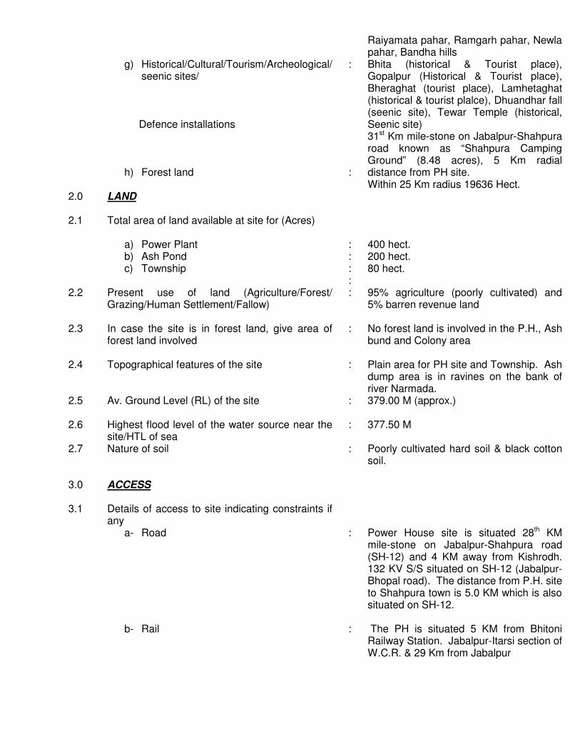
Raiyamata pahar, Ramgarh pahar, Newla pahar, Bandha hills Bhita (historical & Tourist place), Gopalpur (Historical & Tourist place), Bheraghat (tourist place), Lamhetaghat (historical & tourist plalce), Dhuandhar fall (seenic site), Tewar Temple (historical, Seenic site) 31st Km mile-stone on Jabalpur-Shahpura road known as “Shahpura Camping Ground” (8.48 acres), 5 Km radial distance from PH site. Within 25 Km radius 19636 Hect.
2.0 LAND
2.1 Total area of land available at site for (Acres)
a) Power Plant b) Ash Pond c) Township
: : : :
400 hect. 200 hect. 80 hect.
2.2 Present use of land (Agriculture/Forest/ Grazing/Human Settlement/Fallow)
: 95% agriculture (poorly cultivated) and 5% barren revenue land
2.3 In case the site is in forest land, give area of forest land involved
: No forest land is involved in the P.H., Ash bund and Colony area
2.4 Topographical features of the site :
Plain area for PH site and Township. Ash dump area is in ravines on the bank of river Narmada.
2.5 Av. Ground Level (RL) of the site : 379.00 M (approx.)
2.6 Highest flood level of the water source near the site/HTL of sea
: 377.50 M
2.7 Nature of soil : Poorly cultivated hard soil & black cotton soil.
3.0 ACCESS
3.1 Details of access to site indicating constraints if any
a- Road b- Rail
: :
Power House site is situated 28th KM mile-stone on Jabalpur-Shahpura road (SH-12) and 4 KM away from Kishrodh. 132 KV S/S situated on SH-12 (Jabalpur-Bhopal road). The distance from P.H. site to Shahpura town is 5.0 KM which is also situated on SH-12. The PH is situated 5 KM from Bhitoni Railway Station. Jabalpur-Itarsi section of W.C.R. & 29 Km from Jabalpur

4.0 WATER
4.1 Details of source of water alongwith their capacity/flow etc. and whether it is perennial (River, pond, reservoir, canal, borewell, sea water)
a- Sweet water b- Water for condenser cooling (Sear or
others)
] ]
About 160 cusec of water is available as a releases from Bargi reservoir on Narmada river.
4.2 Distance of water source and static head for pumping
: 1.0 KM distance approximately 35 M head approximately
4.3 Quantity of water available : 160 cusecs
4.4 Recommended type of condenser cooling system (Once through/Cooling Tower/Pond Cooling)
: Cooling Tower System
4.5 Alternative source in case the main source is not perennial
: Main source is perennial
4.6 Time period for which the main source supply may be effected
: Not likely to be effected.
4.7 Confirmation of Irrigatin Department/WRD for water supply
: Consent has already been obtained from NVDA for 2x500 MW
4.8 Requirement of construction of Dam/Borewells, if any
: Intake will be constructed to draw water from Narmada river
4.9 Inter-state aspects, if any : None
5.0 FUEL 5.1 Type : Low Grade Coal
5.2 Source proposed : i. Coal mine at Sohagur area
distt. Shahdol Distance is 252.0 Km and/or
ii. Coal mine at Singrauli district Sidhi Distance is 381.0 km
5.3 Distance : - 5.4 Fuel availability (as per indication by fuel Co./
LNG supplier) : To be finalized with coal field authority

6.0 FUEL TRANSPORTATION
6.1 Coal/Lignite
i- Mode (Rail/Road/Sea/Rail-cum-Sea/ Conveyor/Aerial Ropeway/MGR)
ii- Facilities to be created
a) At mine terminal
b) At power Station
c) At Port(s)/Jetty (if applicable)
: : : : :
Coal By Rail Mines are connected with Railway line. To provide Rly siding of 10.0 Km from Bheraghat Railway Station situated on Jabalpur-Itarsi section of WCR Not applicable
6.2 GAS/LNG i- Mode ii- Facilities to be created
a- At source/terminal b- At power station c- Intermediate port/jetty
: : : : :
Not applicable Not applicable Not applicable Not applicable Not applicable
7.0 ASH DISPOSAL
7.1 Distance of ash pond : 1.0 KM
7.2 Ash Utilization Potential : -
8.0 Power Evacuation Proposal : Through 220/132 KV Nayagaon S/S at MPSEB H.Q. Grid Station – 25 Km
9.0 Construction water & power WATER
9.1 Source : Narmada River
9.2 Distance : 0.5 KM
POWER 9.3 Source : Kishrodh 132 KV S/S
9.4
Distance : 4.0 KM Nearest Grid Station
10.0 Location & Vicinity Plan identifying the areas proposed for power plant, colony & ash disposal
: Enclosed

Report of the Site Visit by Member (Thermal), Central Electricity Authority to the Potential Sites for 1000 MW
Combined Cycle Power Project in the Union Territory of Dadra & Nagar Haveli

Report of the Site Visit by Member (Thermal), Central Electricity Authority to the Potential Sites for 1000 MW
Combined Cycle Power Project in the Union Territory of Dadra & Nagar Haveli
1.0 Introduction
The Union Territory of Dadra & Nagar Haveli (DNH) is situated in the Western part of the country and is surrounded by the state of Maharashtra in the South and Gujarat in the North. It is about 185 Kms from Mumbai and falls on the Eastern side of National Highway No.8. The geographical map of the territory is enclosed at Annexure-II. Vapi in Gujarat is about 16 Kms from Silvassa, which is the main Rail Head for both Daman and DNH. The total area of DNH territory is about 491 square Kms and the total population as per 2001 census is 2,21,000. The territory is having about 62% tribal population and has wide range of untapped natural resources. Daman Ganga River flows through the Union Territory and as such it has adequate river water resource for its industrial and domestic consumption. The region has a number of textile industries (small/medium) as well as various other industries. Dadra & Nagar Haveli has developed an industrial zone where most of these industries are located.
2.0 Power Scenario in the UT of Dadra and Nagar Haveli The power demand of this territory is met from the central sector generating stations of the Western Region as presently there is no power generation in the Union Territory. The present demand of this territory is about 275 MVA and due to rapid industrialization of the area, the power demand is continuously increasing. As per the UT Administration, the territory has already achieved 100% electrification by providing electricity to all the villages and there is cent-percent metering to all the categories of electricity consumers. The present allocation to this territory is 270 MW mainly from Korba Super Thermal Power Station, Vindhyachal Super Thermal Power Station (Stage-I & II) and other central sector generating stations of Western Region. The central sector power is being wheeled to this territory through Power Networks of Power Grid Corporation (India) Ltd. and Gujarat Electricity Board & is being received from Bhilad and Vapi 220/66 KV sub-stations of GEB.
The Union Territory Administration informed that 96% of the consumption is by industries and transmission & distribution losses of Dadra & Nagar Haveli are very low (about 11%) and efforts are made to maintain the same by providing electronic meters for HT & LT industrial consumers and providing 100% metering to all the categories of the consumers. The electricity department is making an yearly profit of about 98 crores by sale of power.
The general information and other details in respect of the territory as obtained from Administration, UT of Dadra & Nagar Haveli are given in the enclosed Annexure-V.

Due to increasing industrial demand for power, UT Administration had written to CEA regarding proposal for setting up a 500 MW Combined Cycle Power Plant in the territory. On the request of the UT, Member (Thermal), CEA alongwith a team of CEA engineers visited the proposed power plant sites on 4th September, 2004.
3.0 Meeting at Secretariat, Silvassa on 03.09.2004 Chaired by Administrator, UT of Dadra & Nagar Haveli
A meeting was held with Administrator, UT of Dadra & Nagar Haveli including officers from Electricity Department, Revenue Department, Forest Department, Irrigation Department, etc. The list of participants who attended the meeting is given in Annexure-I.
Hon’ble Member of Parliament, Shri Mohanbhai S. Delker of Dadra & Nagar Haveli also attended the meeting and offered his full help and support for installation of the proposed power plant. The Administrator of territory briefly mentioned about the demand/supply position of the area. It was stated by him that the present peak demand of the territory is about 270 MW. There are many textile units and other small/medium industries and the UT is drawing 212 MW share from unallocated power. As there is peak demand deficit, load shedding for industrial units has to be done and Government of India has been requested for additional power from central sector power generating stations through WREB. Further, there are applications from new industries for additional load accounting to 100 MW. It was intimated that Member Secretary, WREB has recommended additional power allocation of 100 MW for DNH. Member (Thermal), CEA assured the Administrator that this matter will be taken up with the concerned officials.
Keeping in view the power shortage and the growing power demand of the territory, Member (Thermal), CEA suggested that feasibility of installation of 1000 MW CCGT may be studied instead of 500 MW CCGT plant. The installation of 1000 MW power plant will give it a mega power project status and a number of concessions/tax rebates such as 100% custom duty exemption and waiver of all state taxes & duties, etc. can be availed. This will result in power tariff reduction of about 15 paise per unit. Also the capital cost investment of mega power plant can be restricted to Rs.2.5 Crores per MW. It was further suggested by Member (Thermal), CEA that after meeting the energy requirements of the UT, the balance power may be exported through Power Trading Corporation (PTC). Member (Thermal), CEA suggested that the installation of 1000 CCGT power plant may be entrusted to a private developer through competitive bidding. As the developer will utilize natural resources of the territory, power purchase agreement for supply of 500 MW at concessional rate of about Rs.1.90 per KWH may be obtained from them and the developer is free to export the balance power to other areas. The following methodology needs to be followed: -

1. Adequate land shall be provided by the U.T. Administration. 2. Water allocation may be obtained and the pipeline upto site may be laid. 3. Gas allocation/linkage may be finalized and gas pipeline upto proposed site may be
laid. 4. Competitive bidding based on tariff may be adopted for selection of project
developer and the project may be awarded to the party offering least tariff. 5. 10% equity participation by the UT may be considered for the project. 6. A comprehensive Power Purchase Agreement (PPA) to be finalized with the
Developer. 7. CEA shall provide all help and support in respect of the above documents and any
other matter required by the UT Administration.
UT Administration agreed to the above and will explore the feasibility of the proposal.
To meet the immediate power shortage, Member (Thermal), CEA suggested that some of the industrial units may be asked to operate during off peak hours. Further the U.T. Administration has to give incentives for operation during off-peak hours. This will make better availability of power for continuous type textile units of the region. UT Administration agreed to explore this proposal. They may also try to get additional power from PTC and other trading companies during off-peak hours.
Site visit to the proposed locations was made on 04.09.2004.
4.0 Site Visit Sites visited on 4th September, 2004: -
4.1 Site-I: Surangi Site
This site is located in the South-West of DNH Territory about 15 Kms from main stream of river Daman Ganga. The proposed gas pipeline of GAIL is also about 20 Kms away from the site. Here three different plots of land were identified as given below: -
121 acres - Government Land 102 acres - Private Land 77 acres - Private Land

As reported by UT Administration, adjacent to the 121 acres
Government land, land for private sugar factory has been allotted. The private lands indicated above are mostly under agriculture. Further, the above three sites are located within 2-3 kms of Reserved Forests/Sanctuary.
After studying the above site features, the Surangi sites were having many constraints such as long distance from water source, gas pipeline, undulating land terrain, agricultural fields and proximity to the Reserved Forests/Sanctuary. The Surangi sites hence, were not considered suitable for further study.
4.2 Site-II: Naroli Site
4.2.1 Location – This site lies in the North-West of Dadra & Nagar Haveli bordering Gujarat. The map of the site is enclosed at Annexure-III. The identified area is mostly leveled and barren except for some of it under cultivation (one crop per year). The site is bounded by river Daman Ganga on Eastern side (6 kms) and Karo river (3 kms) on Western side. The top soil cover is clay and the lower layer is rocky strata which is considered suitable for economical foundation design. The site is about 12 kms away from Reserved Forest/Sanctuary. National Highway No.8 is 6 kms from the site and Bhilad (Gujarat) Railway Station is located at a distance of about 7 kms.
4.2.2 Land – About 192 acres of land consisting of 132 acres and 60
acres on either side of the road are available for the proposed power plant. As mentioned earlier, the land is mostly leveled and barren except for sugarcane plantation in some part of the land. The Revenue Department Officials of the Union Territory confirmed that this land can be acquired for the proposed project. The estimated cost of the land is about Rs.8 Crores as intimated by the Revenue Department.
4.2.3 Water – Daman Ganga River flows at a distance of about 6 kms
from this site. Government of Gujarat has constructed Madhuban Dam located at a distance of about 14 Kms from the site. This dam is located in Valsad District (Gujarat) and has a gross storage capacity of 567 Million Cubic Metre (MM3). The salient features of the dam are given in the enclosed Annexure-IV. Dadra & Nagar Haveli has an allocation of 12.75 Million Gallons per day (2440 cubic metres/hr). As the dam reservoir has a large storage capacity, the estimated consumptive water requirement of about 20 cusecs (approximately 2000 cubic metre/hr) can be met from the existing water resources. However, Union Territory Administration may take up with Government of Gujarat for getting enhanced water allocation keeping in view the present water consumption for industrial and domestic use in the territory.

Further, CEA suggested that in order to harness the water
from Daman Ganga River, a check-dam near Athol may be constructed. The reservoir created by this check-dam shall serve as a water reservoir for about 7 days requirements of the proposed power plant and also help to create recreation spot to enhance tourism in the region. The construction of this check-dam is already under consideration of DNH Administration. Karo River on the West side of the site can be used for discharging CW blow down, etc. from the plant.
4.2.4 Availability of Natural Gas – UT Administration intimated that
GAIL is planning to lay a gas pipeline for supply of gas to Uran CCGT plant in Maharashtra. This pipeline will pass at a distance of about 3 kms from the proposed site. Natural Gas can be obtained from this pipeline and UT Administration were advised to take up this issue for supply of 4.5 million standard cubic metre per day of gas for the proposed power project with GAIL. Also Expression of Interest (EOI) offers may be obtained from Gas Suppliers like Reliance, GAIL, Petronet, etc.
4.2.5 Environmental Aspects – The environmental aspects of the
proposed site were discussed during the meeting. The conservator of forests, forest department stated that MOE&F clearance can be obtained for the Naroli site after completion of Environment Impact Assessment (EIA) studies.
4.2.6 Power Evacuation – In the UT of Dadra & Nagar Haveli there is
only one 220/66 KV sub station at Kharadpada fed through GEB network from 220 KV Bhilad GEB sub station. Another 220/66 KV sub station at Khadoli is proposed as per Master Plan prepared by Central Electricity Authority, New Delhi
The power can be evacuated at 220 KV level at any of above two sub stations. Both 220 KV sub station is proposed to be connected with 400/220 KV PGCIL sub station at Vapi. However, a specific study is to be done for absorption of power from the 1000 MW .
4.2.7 Power Takers – The present peak load of Dadra & Nagar Haveli is
245 MW and Daman-Diu is 140 MW and projected power demand upto 2012 is 450 MW and 250 MW respectively.
The major power taker from the plant will be DNH and DD and surplus power will be fed in the Western Region Grid and shared as per Central Electricity Regulatory Commission guidelines.
Keeping in view the above aspects, this site is considered
quite suitable for the proposed project.

5.0 Actions to be initiated by UT Administration: -
It is felt that two plots of land measuring 132 acres and 60 acres at Naroli site are quite suitable for installation of 1000 MW CCGT plant and colony respectively. In order to make a detailed feasibility study of the site, the following information/details may please be furnished by DNH Administration:
i. Contour map of site alongwith exact location plan. Contour plan shall also include the corridors intended for laying water intake and discharge pipelines.
ii. Soil investigation report of nearby area.
iii. Details of water consumption for industrial & domestic use out of 12.5
MGD allocated from Madhuban Dam.
iv. River Daman Ganga cross sections taken at interval of 100 m.
v. Environment Impact Assessment (EIA) study may be carried out for the proposed site.
vi. Enhanced water allocation issue may be taken up with Government of
Gujarat.
vii. Expression of Interest (EOI) offers may be obtained from the prospective gas suppliers like GAIL, Reliance, Petronet etc.
viii. Detailed Power Demand/Supply study for DNH and Daman & Diu for
the 10th & 11th plans and arrangements for export of balance power through PTC.
6.0 Action Plan 1. Inputs/clearances to be arranged by UT Administration in three months time.
2. Competitive bidding documents to be prepared after arrangement of inputs/clearances in two months time.
3. The project is expected to be commissioned in 24 months time after
finalization of the Developer and financial closure for the project, which will be zero date for the project.
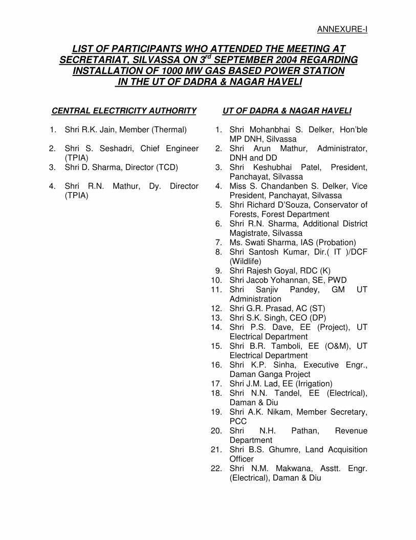
ANNEXURE-I
LIST OF PARTICIPANTS WHO ATTENDED THE MEETING AT SECRETARIAT, SILVASSA ON 3rd SEPTEMBER 2004 REGARDING
INSTALLATION OF 1000 MW GAS BASED POWER STATION IN THE UT OF DADRA & NAGAR HAVELI
CENTRAL ELECTRICITY AUTHORITY UT OF DADRA & NAGAR HAVELI
1. Shri R.K. Jain, Member (Thermal) 1. Shri Mohanbhai S. Delker, Hon’ble MP DNH, Silvassa
2. Shri S. Seshadri, Chief Engineer (TPIA)
2. Shri Arun Mathur, Administrator, DNH and DD
3. Shri D. Sharma, Director (TCD) 3. Shri Keshubhai Patel, President, Panchayat, Silvassa
4. Shri R.N. Mathur, Dy. Director (TPIA)
4. Miss S. Chandanben S. Delker, Vice President, Panchayat, Silvassa
5. Shri Richard D’Souza, Conservator of Forests, Forest Department
6. Shri R.N. Sharma, Additional District Magistrate, Silvassa
7. Ms. Swati Sharma, IAS (Probation) 8. Shri Santosh Kumar, Dir.( IT )/DCF
(Wildlife) 9. Shri Rajesh Goyal, RDC (K) 10. Shri Jacob Yohannan, SE, PWD 11. Shri Sanjiv Pandey, GM UT
Administration 12. Shri G.R. Prasad, AC (ST) 13. Shri S.K. Singh, CEO (DP) 14. Shri P.S. Dave, EE (Project), UT
Electrical Department 15. Shri B.R. Tamboli, EE (O&M), UT
Electrical Department 16. Shri K.P. Sinha, Executive Engr.,
Daman Ganga Project 17. Shri J.M. Lad, EE (Irrigation) 18. Shri N.N. Tandel, EE (Electrical),
Daman & Diu 19. Shri A.K. Nikam, Member Secretary,
PCC 20. Shri N.H. Pathan, Revenue
Department 21. Shri B.S. Ghumre, Land Acquisition
Officer 22. Shri N.M. Makwana, Asstt. Engr.
(Electrical), Daman & Diu

ANNEXURE-IV
Salient Features of Madhuban Dam in the State of Gujarat
1. Project Location :
i. Name of River ii. Dam located near village iii. District/State iv. Orientation of Dam v. Distance of Dam from Vapi. vi. Distance of Dam from Vallsad
: : : : : :
Daman Ganga Madhuban Valsad/Gujarat Lat. 200-10’N, Long. 7305’E 30 KM 60 KM
2. Project Basin and Hydrology a) Drainage area i) Total upto Sea ii) Upto Dam site in Maharashtra in Gujarat in Union Territory
Total
: : : : :
2290 Sq. Km 1318 sq. Km. 376 sq. Km 119 Sq. Km. 1813 Sq. Km.
b) Elevation at origin of the river
: 930.5 m; m.s.l.
c) AV. Elevation at dam site : 41.00 m; m.s.l.
d) Average rainfall : 2202 mm
e) Maximum rainfall : 3780 mm
f) 75% dependable runoff upto dam
i. Entire catchment ii. Gujrat & UT area only
: :
2210.3 MM3 603.1 MM3
g) Maximum observed flood peak at Vapi Weir (July-August 1976)
: 15007 Cumecs
h) 100 year flood at Vapi : 14158 Cumecs
i) Design inflow flood peak : 26856 Cumecs
j) Routed out flow : 22040 Cumecs
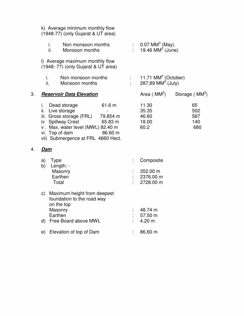
k) Average minimum monthly flow (1948-77) (only Gujarat & UT area)
i. Non monsoon months ii. Monsoon months
: :
0.07 MM3 (May). 19.46 MM3 (June)
l) Average maximum monthly flow (1948- 77) (only Gujarat & UT area)
i. Non monsoon months ii. Monsoon months
: :
11.71 MM3 (October) 287.89 MM3 (July)
3. Reservoir Data Elevation i. Dead storage 61.6 m ii. Live storage - iii. Gross storage (FRL) 79.854 m iv Spillway Crest 65.83 m v . Max. water level (MWL) 82.40 m vi. Top of dam 86.60 m vii) Submergence at FRL 4660 Hect.
Area ( MM2) Storage ( MM3) 11.30 65 35.35 502 46.60 567 18.00 140 60.2 680
4. Dam a) Type b) Length: - Masonry Earthen Total
: : : :
Composite 352.00 m 2376.00 m 2728.00 m
c) Maximum height from deepest foundation to the road way on the top Masonry Earthen
: :
48.74 m 57.50 m
d) Free Board above MWL : 4.20 m
e) Elevation of top of Dam : 86.60 m

5. Spillway: - a) Type b) Location c) Length d) Crest elevation e) Max. head over the crest f) Shape of crest g) No. of Gates h) Size and type of Gates i) Gates operation
: : : : : : : : :
Masonry with gates Main Gorge 191.11 m 65.83 m 14.0 m ogee Ten 15.55 mmX14.02 mm Radial Tainter Gates Electrically operated rope drum type hoist with manually operated system in case of power failure stand by diesel generator sets two numbers of 250 KVA capacity, each provided.
6. Canals: - a) Length Right Bank Left Bank Vapi Branch b) Type c) Capacity
: : : : :
45.54 km. 33.40 km. 19.54 km. Lined 29.35 Cumecs
7. Benefits: - a) Irrigation i) Gujarat ii) Dadra & Nagar Haveli iii) Daman
Total b) Water Supply: - i) Gujarat ii) Dadra & Nagar Haveli iii) Daman
Total
: : : : : : : :
41023 Hect. 7044 Hect. 3071 Hect 51138 Hect 40.00 M.G.D. 12.75 M.G.D. 5.25 M.G.D. 58.00 M.G.D.

REPORT OF THE VISIT BY THE TEAM OF THE SITE SELECTION COMMITTEE TO THE
POTENTIAL SITES FOR THERMAL POWER PROJECTS IN ‘VIDHARBA REGION OF MAHARASHTRA’-(PHASE-I)

REPORT OF THE VISIT BY THE TEAM OF THE SITE SELECTION COMMITTEE TO THE
POTENTIAL SITES FOR THERMAL POWER PROJECTS IN ‘VIDHARBA REGION OF MAHARASHTRA’-(PHASE-I)
Introduction: -
Central Electricity Authority under the Policy framework of Ministry of Power has proposed to develop a road map for 1,00,000 MW Thermal installation to meet the energy demands of the country in the coming years. The most important criteria for selection of sites for Thermal Power Stations is availability of land with least Rehabilitation & Resettlement issues, fuel availability and its transportation, water availability within a reasonable distance and the acceptability from the environmental considerations. A Site Selection Committee has been set up by CEA, which has members from key Ministries like Coal, Petroleum & Natural Gas, Shipping etc, NTPC and various SEBs/ Utilities. This Committee visits various potential sites and thereafter short lists the feasible sites so that these can be earmarked for thermal power projects. A team of the Site Selection Committee visited the sites for thermal power projects in Vidharba region of Maharashtra on 24th & 25th March, 2004. The list of Committee members & officers of CEA, MSEB and other Departments who participated in the visit is enclosed at Annexure-I. The objective of the joint visit was to identify potential coal based sites for setting up new Thermal Power Projects as well as to study the feasibility of capacity addition in the existing Power Plants. The findings of the team are discussed below:
Proposed Extension of existing power stations in Vidharba Region: -
Site-I – Khaperkheda TPS Extension (1x500 MW)
Proposed new sites in Vidharba Region: -
Site-II – Umred TPP (2x250 MW) Site-III – Wani TPP (2x500 MW)
Sites visited on 24.03.2004
Site-I: Khaperkheda TPS Extension ( 1x500 MW)- Khaperkheda TPS is situated at a distance of about 21 kms from Nagpur. Presently four units each of 210 MW capacity are in operation. Unit I and II were commissioned in the year 1994 and Unit III & IV in the year 2001. Three units each of 30 MW capacity commissioned in May 1960 have already been retired and are being dismantled.

Location:
The power station site falls about 2 kms away from the township of Khaperkheda, Distt. Nagpur. The site is approachable by all weather tar road and railway network. The site falls about 25 kms away from Nagpur Airport. Nagpur city is a major city in Maharashtra state and is also a major junction in Central Railway.
Land:
It is proposed to install one unit of 500 MW in the space which will become vacant after dismantling of the old 3x30 MW units. The dismantling work is in progress. Some unutilized area within the plant premises is also to be utilized for the extn. Unit by diverting the existing Nallah. About 53 hectares of land is in possession of MSEB and in case additional land is required, MSEB intimated that about 10 hectares of land can be made available by demolishing the part of the existing colony and playground , which is adjacent to the above land. The possibility of installation of 2 units each of 500 MW was also discussed with MSEB. It was felt that due to space constraint, 2 units of 500 MW are not feasible. Master Plan drawing of the power plant handed over by MSEB is enclosed at Annexure-II. MSEB was requested to prepare a detailed layout drawing after the survey of the proposed site to check the feasibility of installing all the facilities required for one unit of 500 MW.
Water:
Chief Engineer, Khaperkheda TPS informed that the State Irrigation Department had agreed to supply water quantity of 80 Million cubic meter per annum to the existing TPS at Khaperkheda. The present water requirement of existing four units is 33 million cum per annum. Hence the existing commitment of water supply will be adequate to cater to the requirement of the new 500 MW unit which will require additional 20 million cubic meter per annum. He mentioned that the present water supply is made from Pench Project through Right Bank canal and that MSEB had constructed the reservoir and pump house for supply of water to Koradi TPS and Khaperkheda TPS.
The representative of State Irrigation Department, however, stated that as per the present status of water supply, the additional 20 million cubic meter per annum water to new 500 MW unit may not be available from the existing source and the same can be made available from the Proposed Kochi Barrage on Kanhan river near the power station. Kochi barrage has been proposed by Maharashtra on River Kanhan. The project was planned for water supply to NMC. Accordingly, the DPR of the project was prepared (CSR 1992-93) and submitted to government. The cost of the barrage as per DPR is Rs.104.53 crores. As per the revised yield study, Maharashtra can utilize about 15.00 TMC (425 MM3 ) upto border.The proposed barrage has a gross storage capacity of 53.80 MM3 @ FRL 316.00 m. This FRL has been finalized by MP & MS. At this FRL total 1290 hectare of land is affected out of which 799 hectare is of M.P. The forest land in this project is about 69.57 hectare. Due to this barrage, total 206 souls from 3 villages are affected requiring rehabilitation.

Chief Engineer, Khaperkheda TPS stated that MSEB would take up the issue with GOM for supply of water to new unit from the existing source out of the commitment already made. In case of non-availability of water from existing source, Irrigation Deptt. should provide water from new source at their cost.
Coal:
The Saoner coalfield of WCL, reportedly having coal reserves of the order of 250 million MT, is catering to the part requirement of existing units. This coalfield is about 25 kms away from Khaperkheda. The coal requirement for existing four units of 210 MW each is 5.1 Million Metric Tonnes per annum (MMTPA). Presently for 4 units of 210 MW each, due to shortage in coal supply from WCL, MSEB is getting coal from SECL & MCL also.
The coal requirement for one extension unit of 500 MW will be about 2.5 MMTPA. MSEB is pursuing with Ministry of Coal for confirming the availability of 2.5 MMTPA coal.
The coal for existing four units is transported by rail on broad gauge line and this facility will be utilized for the proposed extension unit of 500 MW.
MSEB propose to construct addition 300 metre unloading track hopper and this stream is proposed to be joined to the existing coal stream to meet the requirement for the extension unit. In view of the space limitations, MSEB was requested to check the availability of adequate space for the track hopper and the associated coal handling facilities including coal storage by preparing a detailed layout drawing.
MSEB informed during discussion that WCL had categorically stated that new mines are being opened for replacement of dying mines and no new coal linkages will be possible from the WCL mines. Accordingly, the coal for the extension unit is likely to be available from MCL or SECL. MSEB was requested to work out the techno-economics of using coal from MCL/SECL vis-à-vis WCL and furnish the details. The coal requirement for one extension unit of 500 MW will be about 2.5 MMTPA.
Ash disposal facilities:
Ash of the existing four units of 210 MW each is dumped in Waregaon Ash Bund which is nearly 7 kms from the existing power station. This area can be used for the ash of the proposed one 500 MW unit. Secondly, the land measuring 264 Hectares at Nandgaon and Bakhari village is proposed for the construction of New Ash Bund which is about 10.5 km away from Khaperkheda TPS. The payment for the above said land is deposited with the revenue authorities and the possession of the said land is in process. This new ash bund can be utilized for the disposal of ash of new proposed 500 MW Unit.

Further as per Central Government Policy,100% ash is to be utilized and for maximum utilization of this ash, MSEB is trying hard and making all possible efforts to achieve the same. MSEB was requested to identify the potential users of ash from the existing plant as well as the new 500 MW plant.
Colony:
There is ample space available for the construction of residential complex of the staff of new proposed 500 MW unit in the existing colony area of unit 1 to 4.
The facilities such as hospital, school, Bank building, Post Office, Market, Police station are already available to the staff of Unit 1 to 4. These facilities can be availed by proposed 500 MW Staff.
R&R Plan:
As the proposed extension will be accommodated within the existing premises of the power plant, no R&R is involved.
Environmental aspects:
The representatives of MPCB pointed out that as per the present norms any additional unit shall have to be located at least 3 kms from the river bank. As the river bank falls within this distance, necessary permission from MPCB will have to be obtained. MSEB intimated that the matter will be taken up with MPCB/ GOM for obtaining the permission.
Power Evacuation:
MSEB was requested to firm up the power evacuation arrangement based on power absorption studies and necessary provision be made in the layout accordingly. Chief Engineer Khaperkheda mentioned that power is likely to flow to load center in western coastal area.

Conclusion:
It is felt that the land available in the existing premises of the power station as mentioned above may be sufficient for the installation of one extension unit of 500 MW. However, detailed lay out drawing needs to be developed by MSEB as mentioned above to ascertain adequacy of the available space particularly relating to 300 Metre track hopper/CHP facilities. MSEB was requested to take action relating to following issues: - i) A detailed layout drawing needs be prepared indicating all the facilities required for the 500 MW plant to check the adequacy of the available space particularly relating to track hopper/CHP facilities. ii) The matter regarding availability of water from the existing source out of
the present commitment need be taken with State Irrigation Department/GOM.
iii) In case of non-availability of water from the existing source, the additional
facilities needed to bring water from the new source and their cost need be assessed and included in the total capital cost of the project.
iv) MSEB to take up the matter with MPCB/GOM for obtaining their
permission to install extension unit within the premises of the existing power plant which is within 3 Km from the river.
v) MSEB to identify the potential users of ash from the existing units as well
as the extension unit.
vi) MSEB to firm up the power evacuation arrangement based on the power absorption studies and necessary provision be accordingly made in the layout.
vii) MSEB to furnish the techno-economics of using coal from MCL/SECL vis-à-vis WCL.

Site-II: Umred TPP ( 2x250MW)
Location: -
This site is located near villages Bhivkund and Rajola in Taluka Kuhi, Dist: Nagpur It is approachable from Nagpur by road via Nagpur-Kuchi metalled road 50 Km south east of Nagpur. The nearest Railway station Umred is about 30 kms away on Umred-Butibori WCL owned BG line and about 8-10 kms away on Nagbhid – Kuchi- Nagpur narrow gauge line. As per MSEB, Railways have a proposal to convert this narrow gauge line into broad gauge line. The B.G. line shall have to be extended from Umred. The WCL have their BG line tapped from main line at Kuhi. A copy of the vicinity map of the site is enclosed at Annexure-III.
Land:
The land proposed for the power plant is in Village Rajola / Bhivkund. MSEB informed that the land is under jurisdiction of Revenue Authority as per discussion with SDO, Umred. The land comprises of open scrubs and some patches of cultivated area. Shri Gulati of NTPC informed that this land lies in the river in a region and its topography is undulating as many local streams/Tributaries of rivers pass through this area. He further mentioned that NTPC had considered this site also before deciding Mauda site. As per him, the land was earlier under revenue authorities but later on this has been transferred to forest Deptt. As such, the topography of the area and its availability need to be ascertained from the Revenue Authorities. MSEB has proposed to acquire 200 acres of land considering a plant capacity of 2x250 MW. The extent of land available at this site also need to be ascertained to examine the feasibility of installing a larger capacity plant. Another site about 2 kms from Site-II was also visited by the Team. The frontage of this site was not considered of adequate length and major portion of the land was under cultivation. Further as land was along the foot of a large hillock major water logging problem during monsoon season was apprehended. The site was not considered suitable for the power plant and as such detailed study was not undertaken by the team.
Water:
The water requirement for a 500 MW plant will be about 25 cusecs (about 20 MCMPA) and for a 1000 MW plant it will be about 40 cusecs. The representatives of Irrigation department informed that the water can be made available from Gosikhurd Dam Project on Vain Ganga river which is only 3 Km away. They also intimated that the power plant will need to share cost of the barrage. MSEB informed that matter regarding availability of 20 MCMPA of water from Gosikhurd project had been taken up with the Irrigation department vide GOM’s letter dated 20.4.2003. The work on the Gosikhurd project is stated to be under progress and the entire project alongwith its components are

scheduled to be completed by 2009-2010. Due to this project, 85 villages are affected which require rehabilitation. At present 30% work of the dam project is completed. Shri Gulati of NTPC informed that Gosikund Project has been inordinately delayed and status of its construction/completion is uncertain due to paucity of funds. He felt that water availability from this project need to be ascertained based on the total availability of water and utilization already committed.
Coal:
The requirement of coal for 2 x 250 MW will be about 2.4 MMTPA. MSEB has taken up with M/s WCL for supply of coal. However, WCL has stated that new mines are opened for replacement of dying mines and as such coal source is yet to be identified. The coal is likely to be available from MCL or SECL.
Ash disposal facilities:
The land proposed for ash disposal area near Rajola village is having a natural hillock on its side and can be used for ash disposal by constructing a bund. The extent of land available need to be ascertained from Revenue authorities. The potential uses of ash will also need to be identified for compliance with the MOE&F guidelines on ash utilization.
R&R Plan: It was observed that no major R&R issue were required at the proposed site. Environmental aspects:
No major environmental issues are expected at the proposed site. The representative of State Pollution Board confirmed this. However, MSEB was requested to ascertain from the revenue authorities, the details of revenue forest land if any involved at the proposed site.
Conclusion:
As discussed above, the site in villages Bhivkund/Rajolo has potential for installation of a thermal power station subject to tie-up of water availability and coal availability. MSEB was requested to take action on following issues to examine the suitability of the site for a large thermal project of 1000 MW capacity & above.
i) The topography of the area at site and the extent of land availability and
its type for power plant & ash disposal need to be ascertained from the Revenue Authorities.
ii) The quantity of water likely to be available for the power plant from the Gosikhurd Barrage and its time frame and cost to be shared by the power plant if any to be ascertained from State Irrigation Deptt.
iii) The possibility of coal supply from MCL & SECL need to be ascertained from Min. of Coal.
iv) The time frame for conversion of Naghbid-Kuhi-Nagpur Narrow Gauge Line from Umred into B.G. upto the site need to be ascertained from the Railways.

Site-III: Wani TPP (2x500 MW) Location:
This site is located in Wani area.Dist: Yavatmal at a distance of about 5-6 kms on north side of Wani in between Wani-Nandepera – Mardi road and Wani-Wadgaon- Rangana road. Wani town is located on Chandrapur – Yavatmal State highway. It is also connected with Nagpur via Warora by all weather tar road and Nagpur – Adilabad NH near Pandharkawada. Wani has a railway station on Rajpur – Majari rail route New Delhi-Chennai Main trunk route of railways passes through Warora which is at 23 Km from Wani. No major forest exists in the nearby area of Wani. A copy of the vicinity map is enclosed at Annexure-IV.
Land:
Land surrounding Wani tower is mainly agricultural land without any medium /main irrigation facility. The land proposed by MSEB was found to be mostly barren with open scrubs and cultivated in patches. It was noticed that large area of land could be available at this site. MSEB proposed to acquire 345 hectare of land including ash pond & colony. The requirement for a 1000 MW plant is however about 500 to 600 hectare (1250-1500 acres). MSEB was requested to ascertain the availability of 500-600 hectare of land from Revenue Authorities with break up of ownership & type of land.
Water:
A major river Wardha which flows from north-south along the common border of Yavatmal-Chandrapur Dist. is a perennial river and main source of water. The water requirement for a 1000 MW plant is estimated to be about 40 cusecs (35 MCMPA). MSEB intimated that the matter regarding availability of 40MCMPA of water has been taken up with Irrigtion Dept, GOM. GOM has proposed to construct a barrage across the river at Dindora village in Warora Taluka. The representative of Irrigation Department intimated that to utilize the water from Dindora barrage for the proposed project, a pick up weir will be constructed on Wardha river near Rangana village. Water will be pumped to the power plant through a pipeline of about 8 kms length. He further mentioned that the cost of construction of Dindona Dam however shall have to be borne by the user. MSEB was requested to ascertain the firm schedule of construction/completion of the barrage, the quantity of water and the cost to be shared by the power plant.
Coal:
Wani area is stated to have large coal deposits. At present coal mining is being done by WCL at a number of open cast mines which are situated within 15 kms from Wani. It is understood that sufficient coal reserves to meet the requirement of the proposed plant exist at Wani coalfields. However contact could not be made with WCL officials regarding availability of coal from the nearby mines. MSEB intimated that the matter regarding linkage of 4.5 MMTPA coal has been taken up with MOP/ Min. of Coal for issue of comfort letter. The issue of coal availability from Wani was discussed with CMPDI, Ranchi after the visit. As per

them, large deposits of coal are anticipated in wani area adjoining Andhra Pradesh, but no proper investigation have been done so far. MSEB may therefore ascertain from WCL/Min. of Coal the feasibility of coal availability in wani area and its time frame. It was also decided that representative of Min. of Coal on the Standing Committee for Selection of Sites may also be requested to intimate the plan for the development of coal deposits in Wani area.
Ash disposal facilities:
The disposal of ash can be done on the west side of wani Mardi Road and about 200 hectares of land is indicated to be available for this purpose. MSEB was requested to identify the potential users of ash from the power plant.
R&R Plan:
The land was found to be mostly vacant. No major R&R is likely to be involved for the proposed site.
Environmental aspects:
As per the representative of MPCB present during the visit, no environmental issues are likely to be involved at this site for setting up a thermal plant.
Conclusion:
Considering the possibility of water & land, the site is considered suitable for installation of 2x500 MW TPP. However, MSEB was requested to take following action to ascertain the feasibility : i) MSEB to ascertain the availability of 500-600 hectare of land from
Revenue Authorities with break-up of ownership and type of land. ii) MSEB to ascertain from State Irrigation Deptt. the firm schedule of
construction/completion of the barrage on river Wardha at Divdora village, the quantity of water and the cost to be shared by the power plant.
iii) MSEB to ascertain from WCL about the feasibility of coal availability from Wani area and its time frame.
iv) MSEB to identify the potential users of ash from the proposed power plant. CEA shall separately request the representative of Min. of Coal on the Standing Committee to intimate the plan of development of coal deposits in Wani area.

Mauda TPP Site –1000 MW (NTPC)-
In addition to above mentioned three sites visited by the team, the details of the Mauda site were also discussed. Shri Gulati of NTPC intimated that the investigations for the Mauda site are underway. He further intimated that the land identified for Mauda is mostly private irrigated land and that source for the water is Gosikhurd Barrage on Vain Ganga River. The District Collector has confirmed to NTPC that the land shall be made available for the proposed power plant. The State Irrigation Deptt. has asked NTPC to pay Rs. 250 crore towards Barrage cost. NTPC has requested the State Govt. that the cost of the barrage may not be loaded to the power plant and instead annual water charges shall be paid by NTPC. The matter is under consideration of GOM. Regarding coal, he intimated that WCL is the ideal source but due to non-availability of coal from WCL, it will have to be brought from MCL or SECL. This will increase the cost of power generation. The salient features of the Mauda site as furnished by NTPC is enclosed at Annexure-V.
Wrap up Meeting with Member(Tech.), MSEB
A Wrap-up meeting was held with Member (Tech), MSEB. In this meeting held on 25.3.2004, Member (Tech), MSEB was apprised of the various observations of Site Selection Committee during visit to the potential sites. The Committee expressed the opinion that the new sites at Umred and Wani are suitable for setting up of thermal power projects. However, coal availability for these proposed projects needs to be tied-up. Member (Tech) MSEB informed that it would be preferable to use washed coal in the new thermal power projects and MSEB is exploring all avenues to get the supply of washed coal. CEA agreed with the views of MSEB as use of washed coal reduces coal transportation cost and ash generation. The Committee expressed the view that proposed Khaperkheda TPS extension ( 1x500 MW) is recommended for detailed study by MSEB. MSEB’s attention was also drawn to the observation made by the representative of MPCB that any additional unit shall have to be located at least 3 kms away from the Kanhan river bank. MSEB agreed to take up the matter with MPCB for necessary permission for installation of the proposed unit.
Prioritization/Ranking of the Proposed Sites: -
Keeping in view the various site specific aspects as discussed in the report, it is felt that site-I, Site-III and Site-II are suitable sites in order of prioritization/ranking for installation/extension of thermal power plant as shown in Table I of the Report.
Tour Report

Table-I
Prioritisation / Ranking (P/R) of the Sites Visited in Maharashtra on 24.3.2004 & 25.3.2004.
S.No. Location Coal Source Water
Source
Land Capacity Possible
P/R Remarks
Site-I
Existing Khaperkheda TPP,2 Kms from Khaperkheda township.
MCL/SECL mines, to be tied-up
Kochi Barrage on Kanhan river, to be tied-up.
53 hectares of land available after dismantling of 3x30 MW is completed.
500 MW
I As the proposed extension falls within 3 Kms of river bank, MPCB’s ‘NOC’ is required.
Site II
50 Kms South east of Nagpur near Bhivkund & Rajola villages in Kuhi Taluka.
Yet to be identified.
To be tied-up possibly from Gosikhurd Dam on Vain Ganga river.
MSEB propose to acquire 200 acres of land, open scrubs and patches of cultivated areas.
2x250 MW
III
Site III
About 5 Kms from Wani, Distt.Yavetmal.
Nearby Wani coalfields of WCL, to be tied-up.
Pick-up barrage on Wardha river
About 350 hectares of land, mostly barren with open scrubs.
2x500 MW
II MSEB to explore the possibility of acquiring 500-600 Hectares of land.

Annexure-I
List of Officials visited the potential sites for TPPs in Maharashtra
on 24.03.2004 & 25.03.2004 CENTRAL ELECTRICITY AUTHORITY
1. Shri S.Seshadri, Chief Engineer (TPI&A) 2. Shri M.S.Puri, Director (TPI&A) 3. Shri R.N.Mathur, Dy. Director (TPI&A)
PLANNING COMMISSION 1. Shri R.K.Kaul, Dy.Advisor N.T.P.C.
1. Shri O.P.Kalia, General Manager 2. Shri Kamlesh Gulati, Dy.General Manager.
MINISTRY OF SHIPPING 1. Shri A.R.Rao, Director (Development) MAHARASHTRA STATE ELECTRICITY BOARD
1. Shri M.R.Ambhore, Member(Technical) (Chaired the Wrap up meeting on 25.3.2004)
2. Shri A.D.Palemwar, Chief Engineer 3. Shri S.T. Ranjane, Chief Engineer 4. Shri Ashok R. Pampanwar, Dy. Chief Engineer 5. Shri Ingole, Ex. Engineer
IRRIGATION DEPARTMENT, GOM 1. Shri S.Doipfode, Ex. Engineer 2. Shri Chitle, Asstt. Engineer
MAHARASHTRA POLLUTION CONTROL BOARD
1. Shri B.J.Kale, Sub-Regional Officer 2. Shri V.M.Molghare

Annexure-V
“Mauda Thermal Power Project”
Project Synopsis
1. Location:- The project is located in Mauda Tehsil, Nagpur Distt. Of
Maharashtra
2. Capacity;- 1000 MW (2x500 MW)
3. Requirements/Availability of Basic Inputs
a. Land: 1700 acres of land is required for plant, ash disposal, township & various
corridors.
Land available is private agricultural / canal irrigated land yielding two crops
per year.
In-principle availability of land has been indicated by the State Government.
b. Water : 53 Cusecs of make up water is required for the proposed peroject.
Government of Maharashtra has indicated availability of required water for the
project from the storage of Gosikhurd Irrigation Project under construction.
Schedule of construction of the project is uncertain due to paucity of funds with
the Vidharba Irrigation Development Corpn. (A Government of Maharashtra
Undertaking).
c. Coal: 5.4 Million tones per annum of coal is required for the proposed project.
Ministry of Power has conveyed the decision of Ministry of Coal for granting
linkage of 5.0 mtpa from IB Valley of Mahanadi Coal Fields Ltd.
Coal transportation envisaged over Indian Railways.