Embed Size (px)
Citation preview

LandCorp
Report for Karratha TPS No 8. AmendmentPreliminary Acid Sulfate Soil Investigation
September 2011

i
Executive Summary
LandCorp commissioned GHD Pty Ltd (GHD) to undertake a Preliminary Acid Sulfate Soil (ASS)Investigation to include limited soil sampling within the following development areas in Karratha; DA10,DA13, DA14, DA15, DA26 and DA28.
Based upon the relatively low risk of ASS being present at the site (based on ASS risk mapping and siteground conditions), a limited programme of sampling and analysis was undertaken by GHD to determinethe potential for ASS occurrence. This report presents the findings of the ASS investigation and providesrecommendations to be considered prior to the commencement of any earthworks.
The scope of works completed by GHD is outlined below:
A desktop study was undertaken as a preliminary appraisal of ASS risk within the project area. Thisinvolved gathering information from published ASS risk mapping, generic soil maps, environmentalgeological maps and groundwater maps to make conclusions relating to ASS risk.;
Soil sampling was conducted at 12 locations to a maximum depth of up to 2.5 m below ground level(bgl);
Soil samples were collected at 0.5 m intervals in order to ascertain the acid generating capacityacross the soil profile;
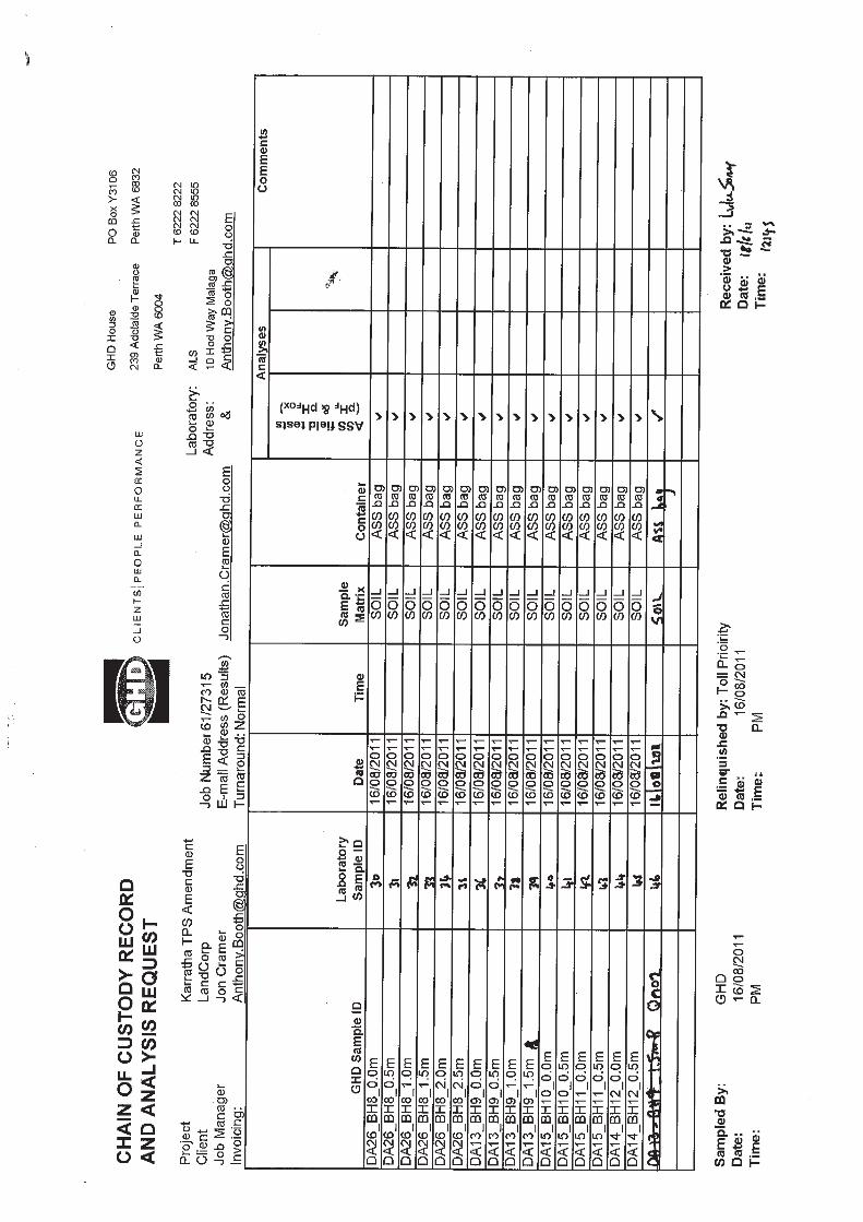
A total of 46 soil samples (including two duplicate samples) were analysed by a NATA accreditedlaboratory (ALS) for pH field screening with 11 samples selected for the Suspension Peroxide OxidationCombined Acidity and Sulfate (SPOCAS) suite.
Laboratory results were assessed against published DEC (2009) coarse texture action criteria todetermine the nature of potential and/or existing acidity at the Site and to assess the requirement forfurther soil investigations.
Based upon the findings of this investigation, the following conclusions can been drawn:
The geology and soil types on the Site are consistent with relatively low ASS risk;
The components of the acidity trail (TAA, TPA) were below the laboratory limit of reporting for all ofthe samples tested;
There were only two minor exceedances of the net acidity criteria of 18.7 mol H+/tonne with all of theother samples returning net acidities below the laboratory limit of reporting;
All samples analysed for SPOCAS contained significant amounts of buffering materials as indicatedby ANC values between 204-8160 mol H+/tonne equivalent.
The samples with the two net acidity exceedances had ANC values over 100 times greater than netacidity.
Based on the above conclusions, the potential ASS risk at the site is considered to be low to very low. Inthe event of any acid generation from possible oxidation of naturally present sulfdes (albeit at low levels)within development area DA10, the soil materials present onsite have a high potential capacity toneutralise any potential acid generation. In addition, groundwater (if encountered) at the site will notlikely require treatment during dewatering for construction.

ii
Contents
Executive Summary i
1. Introduction 1
1.1 Objectives 1
1.2 Scope of Works 1
2. Acid Sulfate Soils 2
2.1 Background on Acid Sulfate Soils 2
2.2 Potential Risks of AASS and PASS 2
2.3 Management of ASS 2
2.4 Legislative Requirements in Western Australia 3
2.5 Environmental Protection Act 1986 3
3. Site Environmental Characteristics 4
3.1 Site Description 4
3.2 Topography and Geology 4
3.3 Surface Water 5
3.4 Groundwater 5
3.5 ASS Risk Mapping 5
3.6 Historical Reports 6
4. ASS Field Investigation 7
4.1 Sampling Locations 7
4.2 Soil Sampling 7
4.3 Quality Assurance and Quality Control 7
5. Laboratory Analysis – Technical Background 8
5.1 pH Field Screening 8
5.2 Confirmatory laboratory testing: Suspension Peroxide OxidationCombined Acidity and Sulfate (SPOCAS) 8
6. Results and Discussion 10
6.1 Soil Lithology 10
6.2 Groundwater 10
6.3 pH Screening Results 10
6.4 SPOCAS 11

iii
6.5 Summary 12
7. Quality Assurance/Quality Control 13
7.1 Introduction 13
7.2 Field QA/QC 13
7.3 Laboratory QA/QC 13
7.4 Summary of QA/QC 14
8. Conclusions and Recommendations 15
8.1 Conclusions 15
8.2 Recommendations 15
9. References 16
Table IndexTable 1 Karratha Precincts, Associated Development Areas
(DA) and Borehole IDs 7Table 2 Field Testing Classifications 8Table 3 Action Criteria Based on Net Acidity for Three
Texture Categories 9Table 4 pH Criteria Outliers 11
Figure IndexFigure 1 Site Locality Plan 17Figure 2 Sampling Locations 17Figure 3 Site Geology 17Figure 4 Acid Sulfate Soil Risk Map 17
AppendicesA GlossaryB Hand Auger Bore LogsC Laboratory CertificatesD Acid Sulfate Soil Summary TableE Quality Assurance and Control Documentation
161/27315/114567 Karratha TPS No 8. AmendmentPreliminary Acid Sulfate Soil Investigation
1. Introduction
The Shire of Roebourne is currently updating the Karratha Town Planning Scheme No. 8 as a part of its‘City Growth Plan’. The City Growth Plan is to develop Karratha as the major City of the North and makeit an attractive choice for future development.
Part of the proposed Amendment 21 is to re-zone a number of sites which have been identified ashaving potential for development. The Amendment is designed to coordinate the growth of Karratha toinclude the infill of existing areas and support expansion of current residential and industrial zones.
Subsequently, LandCorp commissioned GHD to undertake a Preliminary Acid Sulfate Soil (ASS)investigation within a number of precincts and their proposed development areas (DA’s) in Karratha,Western Australia (Figure 1) to determine the potential presence of ASS.
This report presents the findings of the ASS investigation and the subsequent recommendations.
1.1 ObjectivesThe objectives of this ASS investigation were to:
Evaluate the potential presence and risk of actual acid sulfate soils (AASS) and/or potential acidsulfate soils (PASS) within each of the development areas by undertaking a desktop study, limited soilsampling and laboratory analysis; and
Draw conclusions and make recommendations that address the presence (if any) of ASS within thedevelopment areas.
1.2 Scope of WorksThe scope of this investigation is outlined below:
A total of 12 soil boreholes were hand augered to a maximum depth of 2.5 m below ground level(bgl);
A total of 46 soil samples (including two duplicate samples for QA purposes) were collected at 0.5 mintervals from the soil bores, all samples were analysed by a National Association of Testing Authoritiesaccredited (NATA) laboratory, ALS Environmental for the ASS field test suite.
A total of 11 soil samples (plus two duplicates) were analysed by ALS Environmental, for SuspensionPeroxide Oxidation Combined Acidity and Sulfate (SPOCAS);
Laboratory results were assessed against DEC (2009) action criteria to determine the likely nature ofexisting acidity and potential acidity within the development areas; and
Conclusions and recommendations were formed based upon the anticipated ASS risk.
The ASS investigation was undertaken with reference to the document, Identification and investigation ofAcid Sulfate Soils and Acidic Landscapes (DEC, 2009).

261/27315/114567 Karratha TPS No 8. AmendmentPreliminary Acid Sulfate Soil Investigation
2. Acid Sulfate Soils
2.1 Background on Acid Sulfate SoilsThe classification of ASS includes both actual acid sulfate soils (AASS) and potential acid sulfate soils(PASS). AASS are soils that are generating acidity, whereas PASS are soils that have the potential togenerate acidity.
ASS are soils containing naturally-occurring, fine-grained metal sulfides typically pyrite (FeS2), formedunder saturated, anoxic/reducing conditions. They generally occur in Quaternary (1.8 Ma – Present)marine or estuarine sediments, predominantly confined to coastal lowlands (elevations generally below 5mAHD). Within these sediments, the majority of soils that present an environmental risk are generallyconfined to Holocene aged material (<10 000 years). Where these materials have oxidised, theycommonly have a mottled appearance (orange and yellow discolouration) due to the presence ofoxidised iron minerals.
Although soils described above represent typical conditions where ASS occurs, the presence of ASSmaterials is not limited to these soil types. In Western Australia, ASS materials have been identified inother soil types such as leached sands and silts. Accordingly, for areas where no data is available, theextent of ASS materials should be established through field investigations.
2.2 Potential Risks of AASS and PASSWhen PASS are disturbed, either by excavation or lowering of the watertable below natural seasonallevels, sulfides present are exposed to air, allowing oxidisation and consequently, the formation ofsulfuric acid (H2SO4). AASS are capable of generating acidity in situ in their natural state; disturbance isnot required for acidic discharges to develop.
As a result of the presence of AASS, or the oxidation of PASS, surrounding land (soil) and nearbywaterways may become acidic (pH <6.5). Under acidic conditions, metals such as aluminium (generallyat pH <4.5) and iron, as well as trace heavy metals (including arsenic), become more mobile in theenvironment and can be taken up by infiltrating waters. As a result, surface and/or groundwaterconcentrations of these metals may reach concentrations which have the potential to cause acute orchronic toxicity to sensitive terrestrial and aquatic plants and animals.
Acidic conditions generated by ASS can also corrode concrete and steel (pipes, bridge abutments,underground services, and other infrastructure) and can result in the rapid deterioration of asphaltsurfaces where they overlie AASS or PASS.
2.3 Management of ASSAvoiding or minimising the disturbance of ASS is the primary method of management. Where avoidingdisturbance is not possible, management techniques available for ASS can include:
Chemical neutralisation (use of pure fine agricultural lime (AgLime) or a similar neutralising agent);
Anoxic storage or placement of PASS below the water table and beneath clean non-ASS fill; and
Hydraulic separation of pyrite from the soil (high maintenance process suitable for coarse grainedsediment).

361/27315/114567 Karratha TPS No 8. AmendmentPreliminary Acid Sulfate Soil Investigation
The addition of agricultural lime is the most common amelioration technique applied to acidic soils,where mechanical mixing is completed by plough or excavator to provide adequate homogeneity of thesoil/sediment-lime mix.
2.4 Legislative Requirements in Western AustraliaThe following legislative requirements often apply to works involving ASS.
2.4.1 Western Australian Planning Commission Bulletin 64
The recently amended Planning Bulletin 64/2009 (PB 64/09) aims to provide advice and guidance onmatters that should be taken into account in the rezoning, subdivision and development of landcontaining acid sulfate soils. PB 64/09 requires the identification, assessment and management of soilswhere:
The surface elevation is 5m AHD, and it is proposed to excavate 100m3 of soil;
Where the surface elevation is 5m AHD, and it is proposed to excavate 100m3, and theexcavation depth is 2m; or
Where any dewatering works are to be undertaken.
2.5 Environmental Protection Act 1986The Environmental Protection Act 1986 (EP Act 1986) provides for an Environmental ProtectionAuthority, for the prevention, control and abatement of pollution and environmental harm, for theconservation, preservation, protection, enhancement and management of the environment and formatters incidental to or connected with the foregoing.
To prevent environmental harm, the EP Act 1986 established under Section 50A, states that, A personwho –
(a) causes serious environmental harm; or
(b) allows serious environmental harm to be caused -
commits an offence.
Accordingly, all parties to a development must show that the environmental risk associated with thedevelopment has been assessed and minimised where possible.

461/27315/114567 Karratha TPS No 8. AmendmentPreliminary Acid Sulfate Soil Investigation
3. Site Environmental Characteristics
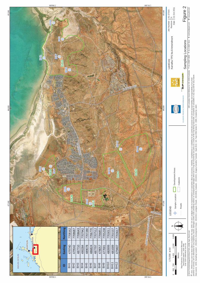
3.1 Site DescriptionThere are six development areas around the immediate vicinity of Karratha town centre that wereincluded as part of this limited ASS investigation. These development areas are shown in Figure 1 withborehole sampling locations shown in Figure 2.
Site DA10 is located approximately 3 km to the east of Karratha town centre and occupies an area ofapproximately 781.7 hectares. The Site comprises a few tracks running parallel to the ocean and twomajor tracks perpendicular to it. The Site is bound to the west by Maitland Road and a residential areawhile Mystery Road runs to the north and Millstream Road runs through the centre of the Site. Soilsampling at the Site was undertaken at five locations with DA10 (BH3, BH4, BH5, BH6 and BH7).
Site DA28 is located to the north west of Karratha and is approximately 3.6 km away from the towncentre. The Site occupies an area of about 91.0 hectares. The Site is bound to the west by Millars Roadand to the south by Balmoral Road and a residential area. Soil sampling was conducted at 2 locationswithin this development area (BH1 and BH2).
Site DA13 and DA26 are located within 5-6 km to the west of Karratha town centre. Both Sites are boundto the south and north by Dampier Road. Site DA13 is also bound to the east by Madigan Road and tothe south by the Seven Mile Waste Disposal Facility. The DA13 and DA26 sites occupy an area of 189.5and 194.5 hectares respectively. Some industrial development is present along the eastern boundary ofSite DA13. Soil sampling was undertaken at one location within each Site (BH8 in DA26 and BH9 inDA13).
Sites DA14 and DA15 are located to the south-west of the town centre at about 6 to 7 km. They occupyareas of 406.4 and 578.9 hectares respectively. One major track separates the two Sites, running to thesouth of Site DA14 and to the north of Site DA15. Three sampling locations were undertaken in thesedevelopment areas (BH12 in DA14 and BH10 & BH11 in DA15).
3.2 Topography and Geology
3.2.1 Topography
Generally, the natural ground elevation across the six development areas gently undulates between 10mand 20mAHD. Elevation in the development areas DA14 and DA15 (approximately 3 kilometres south ofKarratha town site) increases to approximately 30mAHD in certain locations.
These elevations were interpolated from 10 m contour maps provided by Landgate (2011) via theShared Land Information Portal (SLIP).
3.2.2 Geology
The geological map for the area (Dampier – Barrow Sheet, 2001) indicate that the near surfacegeological formation within Site DA10 predominantly comprises colluvium sand, silt and gravel located inbetween areas of strongly foliated basalt, wind-blown eolian sand (red/yellow), shelly sand in coastaldunes and sheetwash sand, silt and clay with gilgai surfaces. Occasional ferruginous chert and bandediron formations are present to the north east of the Site.

561/27315/114567 Karratha TPS No 8. AmendmentPreliminary Acid Sulfate Soil Investigation
The geology of Sites DA13 and DA15 mainly comprises sheetwash sand, silt and clay with gilgaisurfaces with some rare granitic intrusion The map also shows the presence of alluvial and colluviumsand, silt and clay with occasional lateritic surfaces to the southern side of Site DA15.
Sites DA28 and DA26 consist essentially of alluvial sand, silt and clay.
The geology of Site DA14 is quite complex compared to the other areas with the presence from north tosouth of wind-blown eolian sand followed by serpentinite, grey/white banded chert, intercalatedultramafic and mafic lava with thin chert units and sheetwash sand, silt and clay. A single graniticintrusion is present to the west of the Site whilst some Karratha granodiorite and strongly foliated basaltare present towards the eastern boundary of the Site.
A geotechnical site investigation was performed by GHD in August 2009 at Site DA13 (GHD, 2009)confirmed the geological conditions indicated on the regional geological map. The soil generallyconsisted of sandy clays (of alluvial origin) overlying clayey sandy gravels (of residual origin, derivedfrom weathering of granite bedrock) over weathered granite bedrock.
Site geology is presented in Figure 3.
3.3 Surface WaterThe Indian Ocean is located to the north of the study areas. The northern boundary of Site DA10 runsalong the coast and therefore is very close to the Indian Ocean. The other Sites are located between 2.8and 6 km away from the ocean. There are however no permanent natural watercourses or wetlandswithin the study areas. A few ephemeral creeks are located close to the Sites and are only flowingfollowing rainfall events.
3.4 GroundwaterGroundwater was not intersected during this ASS investigation, however a search of the Department ofWater WIN database was performed by GHD in 2010 (GHD 2010a) and indicated that two groundwaterbores were recorded within a 2 km radius of Site DA13. The groundwater depths recorded in thesebores ranged from 3.96 m to 4.72 m below ground level.
Groundwater levels (located south of Site DA13) were also recorded at the Seven Mile Waste DisposalFacility by Turton Geological Consultants and were estimated between 7.3 and 10.3 m bgl. Thisinvestigation also indicated a northwest groundwater flow direction towards Nickol Bay, consistent withthe groundwater levels of between 0.6 mAHD and 1.9 mAHD recorded in the immediate area of KarrathaAirport.
3.5 ASS Risk MappingA review of DEC ASS risk mapping available through the Landgate SLIP was undertaken for all of thedevelopments areas.
The ASS risk mapping is presented in Figure 4.
DA10
The risk mapping for this development indicates that the majority of the site overlies no known ASSdisturbance risk within 3 m of the natural soil surface with pockets of high to moderate ASS disturbance

661/27315/114567 Karratha TPS No 8. AmendmentPreliminary Acid Sulfate Soil Investigation
risk to the north (closer to the coast) and east. There are also moderate to low ASS risk areas within theproposed development area.
DA14 & DA15
The risk mapping for these developments indicates that most of the site overlies no known ASSdisturbance risk within 3 m of the natural soil surface with long, thin pockets of moderate to low ASSdisturbance risk to the east of the proposed development areas.
DA13
The risk mapping for this development indicates that most of the site overlies no known ASS disturbancerisk within 3 m of the natural soil surface with a long, thick section of moderate to low ASS disturbancerisk to the west of the proposed development area, which runs north-south along a river.
DA26
The risk mapping for this development indicates that most of the site overlies no known ASS disturbancerisk within 3 m of the natural soil surface but is bordered to the north, east and west by areas ofmoderate to low ASS disturbance risk.
DA28
The risk mapping for this development indicates that the majority of the site overlies moderate to lowASS disturbance risk areas with an area of high to moderate ASS disturbance risk to the west and north(closer to the coast) within the proposed development area.
3.6 Historical ReportsGHD previously has undertaken a Preliminary ASS investigation for the Stage 1 works of the KarrathaSupport Industrial Estate, just to the east of Regals Valley precinct. The report was entitled: GHD 2011,Cossill and Webley Consulting Engineers, Report for Gap Ridge Industrial Estate, Preliminary AcidSulfate Soil Investigation, March 2011.
The investigation included a desktop study and soil sampling at 10 locations to a maximum depth of upto 2.5 m bgl.
The results of the investigation indicated:
The underlying geology on Site is consistent with low risk of ASS being present;
The components of the acidity trail, Titratable Actual Acidity (TAA) and Titratable Peroxide Acidity(TPA), were reported below the laboratory limit of reporting for all of the samples tested;
Peroxide Oxidisable Sulfur (SPOS) was reported below the assessment criteria for all samples testedwith the exception of two samples (SB01_1.5 m and SB03_1.25 m).
Net acidity values were all below the laboratory limit of reporting for all the samples tested with theexception of SB01_1.5 m and SB03_1.25 m. Both these sample locations had pHKCl values of greaterthan 6.5 (pHKCl 8.7 and 8.8 respectively) and the net acidity was less than 10% of the Acid NeutralisingCapacity (ANC) of the sample. Although the net acidity of these two samples exceeded the actioncriteria, the DEC agreed with GHDs conclusion that soil was considered to have sufficient naturalbuffering capacity to neutralise any potential acid generation.

761/27315/114567 Karratha TPS No 8. AmendmentPreliminary Acid Sulfate Soil Investigation
4. ASS Field Investigation
4.1 Sampling LocationsA total of 12 sampling locations were hand augered in the six development areas as outlined in Table 1below.
Table 1 Karratha Precincts, Associated Development Areas (DA) and Borehole IDs
Precinct DevelopmentArea
Area
(in hectares)
Borehole IDs
Gap Ridge /Seven Mile
DA 13
DA 26
189.5
194.5
BH9
BH8
Nickol / Baynton DA 28 91.0 BH1, BH2
Regals Valley DA 14
DA 15
406.4
578.9
BH12
BH10, BH11
Mulataga DA10 781.8 BH3, BH4, BH5, BH6, BH7
Soil sampling for laboratory analysis was carried out to a maximum depth of 2.5 m bgl. The 12 locationswere sampled on the 15th and 16th August 2011. The work was carried out with reference to DEC’sguidelines, Identification and Investigation of Acid Sulfate Soils and Acidic Landscapes (DEC, 2009).
The sampling locations are provided in Figure 2.
4.2 Soil SamplingHand augered soil cores were sampled at 0.5 m intervals. Samples were placed in zip lock bags with theair excluded and placed on ice before being frozen in a freezer at the end of each working day. A total of46 samples (including 2 duplicates) were collected. The samples were stored on ice and delivered to theNATA accredited ALS Laboratory in Malaga, Perth
The soil bores were logged in accordance with standard internal GHD logging procedures.
4.3 Quality Assurance and Quality ControlQuality Assurance and Quality Control involved following the procedures outlined in the DEC’s AcidSulfate Soil and Contaminated Sites Guideline Series, Australian Standard 4482.1 and GHD’s internalsampling procedures. Quality Assurance and Quality Control results are discussed in detail in Section 7.
861/27315/114567 Karratha TPS No 8. AmendmentPreliminary Acid Sulfate Soil Investigation
5. Laboratory Analysis – Technical Background
5.1 pH Field ScreeningField pH testing1 provides a preliminary indication of existing soil pH ( pHF) and the potential pH of thesoil following oxidisation (pHFOX). Table 2 summarises the soil pH trigger values set out in theIdentification and Investigation of Acid Sulfate Soils and Acidic Landscapes (DEC, 2009) that are usedas a preliminary screening tool to identify both Actual Acid Sulfate Soils (AASS) and Potential AcidSulfate Soils (PASS).
Table 2 Field Testing Classifications
Soil pH Indication
4.0 < pHF 5.5 (1) Acidic Soil
pHF 4.0 AASS
pHFOX < 3.0 (2) PASS likely
pH > 2.0 (3) PASS likely
(1) pHFis the in situ pH of the soils(2) pHFOX is the pH measured after the sample has been fully oxidised using H2O2.(3) pH is the difference in pH before and after oxidation.
5.2 Confirmatory laboratory testing: Suspension Peroxide Oxidation CombinedAcidity and Sulfate (SPOCAS)SPOCAS analysis is an acid-base counting process which allows the determination of the net effect ofacid generation and consideration of the acid neutralising components (base) within soil samples. Giventhe leached, naturally acidic nature of soils in Western Australia, the DEC has stated that it prefers theSPOCAS method of analysis (DEC, 2009).
The net acidity, as outlined in Identification and Investigation of Acid Sulfate Soils and AcidicLandscapes (DEC, 2009), is:
Net acidity2 = Potential Acidity + Existing Acidity – Acid Neutralising Capacity3
The trigger levels for net acidity based upon soil texture are presented in Table 3. The acidity trailcomprises several components including TAA, TPA, TSA, SPOS and ANC. These are described in detailin the glossary in Appendix A.
1 Although referred to as field testing, these tests are generally conducted in a laboratory due to the health and safety issuesrelated to the handling of hydrogen peroxide.2 Equation has been extracted from the DEC guidelines, Identification and Investigation of Acid Sulfate and AcidicLandscapes(May, 2009)3 Due to the particular characteristics of the soil and groundwater regime in Western Australia, DEC does not recognise the validityof ANC values without confirmatory kinetic testing to provide a more accurate estimate of the actual amount of ANC that would beavailable under real field conditions. However, there may be instances where the net acidity exceeds the criteria however is lessthan 10% of the ANC. In some instances, this may be considered as a sufficient potential acid buffer.

961/27315/114567 Karratha TPS No 8. AmendmentPreliminary Acid Sulfate Soil Investigation
Table 3 Action Criteria Based on Net Acidity for Three Texture Categories
Soil Texture Clay Content(%)
< 1,000 Tonnes Disturbed > 1,000 Tonnes Disturbed
% S mol H+/tonne % S mol H+/tonne
Coarse (sands – gravels) < 5 0.03 18.7 0.03 18.7
Medium (sandy loam – lightclay) 5 – 40 0.06 37.4 0.03 18.7
Fine (medium to heavyclays, silty clays) > 40 0.10 64.8 0.03 18.7
Materials containing net acidity in excess of the values presented in Table 2 are deemed to be soils thatrequire treatment. Soils investigated in this study consisted of predominantly coarse grained materials;hence a conservative action criteria of 18.7 mol H+/tonne (or 0.03 %S) has been adopted.
1061/27315/114567 Karratha TPS No 8. AmendmentPreliminary Acid Sulfate Soil Investigation
6. Results and Discussion
Hand augered borehole logs are provided in Appendix B. A summary table of ASS laboratory results areprovided in Appendix D and the associated laboratory certificates are presented in Appendix C.
6.1 Soil LithologyA map showing the different geologies underlying the development areas is shown in Figure 3.
Soils encountered at each of the development areas generally agree with the lithologies outlined in thegeology mapping section of the desktop study in Sections 3.2 as well as the other Karratha ASSinvestigation conducted by GHD (GHD 2011).
The strata encountered during this investigation consisted of the following materials:
Sand, pale brown/orange, medium to coarse grained, moderately sorted with some horizonscontaining shell fragments;
Sand, pale brown/grey, medium to coarse grained, moderately sorted with some horizons containingshell fragments;
Sandy Clay, red/brown and pale brown, course grained sand, low plasticity;
Gravelly Clay, brown, coarse grain gravel, generally low to moderate plasticity; and
Clay (including gilgai clays), red/brown, variable plasticity.
6.2 GroundwaterGroundwater was encountered at the following locations and depths:
BH2 at 1.5 m bgl (refusal on gravelly brown clay at 2.0 m bgl)
BH4 at 1.5 m bgl (refusal on indurated sand/bedrock at 2.0 m bgl)
BH5 at 0.5 m bgl (refusal on clay/bedrock at 1.3 m bgl)
No groundwater samples were obtained during the limited ASS investigation.
6.3 pH Screening ResultsA total of 44 primary samples plus 2 duplicates (collected from 12 locations) were submitted to ALS forpHF and pHFOX rapid field screening.
Values for pHF ranged from 6.3 to 9.4 with values for pHFOX ranging from 6.8 to 10.1. The pH, (which isdefined as pHF minus pHFOX) ranged between -0.6 and 2.0.
The results suggest that the majority of the samples contain neutral to alkaline soils. Analysis of pHvalues does not indicate a large potential for the generation of acidity upon oxidation within the soils, inaddition even if these soils were to oxidise, it is likely that a neutral to alkaline soil would result.
A summary of the outliers of the pH screening results for the Site are presented in Table 4.

1161/27315/114567 Karratha TPS No 8. AmendmentPreliminary Acid Sulfate Soil Investigation
Table 4 pH Criteria Outliers
Parameter and trigger levels Outliers Indication
4.0 < pHF 5.5 Nil Acidic Soil
pHF 4.0 Nil AASS
pHFOX < 3.0 Nil PASS likely
pH 2.0 DA10_BH3_0.0m
DA10_BH4_1.0m
PASS likely
The field screening results are strongly indicative of the presence of minimal ASS materials at thesample locations. The pH screening criteria was marginally exceeded in 2 samples (DA10_BH3_0.0mand DA10_BH4_1.0m) however these appear to be naturally alkaline soils (pHF 8.8 and 8.9respectively). None of the samples generated a pHFOX less than 3.
To confirm the low to negligible risk of ASS across the development areas, SPOCAS analysis wasconducted on 11 of the samples (plus two duplicate samples for QA/QC purposes).
6.4 SPOCASBased on the coarse texture category adopted, two of the samples analysed (DA10_BH4_1.0m andDA10_BH4_2.0m) reported net acidity concentrations above the action criteria of 18.7 mol H+/tonne. Keyfindings of the SPOCAS testing include:
The TAA results (measure of actual acidity) reported results below the LOR for all samples. Thisindicates that actual acidity is not present in the samples collected.
The TPA (measure of potential acidity) values were below the LOR for all samples. This indicates thatthere is very low potential acidity within the samples collected.
The SPOS (estimation of soil sulfide content) ranged from <5 to 28 mol H+/tonne. Only two samplesfrom the same location (DA10_BH4_1.0m and DA10_BH4_2.0m) were identified above the adoptedassessment criteria of 18.7 mol H+/tonne. Both these samples had pHKCl values of greater than 6.5 (bothhad a pHKCl 9.8) and therefore had excess acid neutralising capacity (ANC) calculated.
The presence of acid neutralising materials was significant in all locations with values ranging from 204to 9,560 mol H+/tonne equivalent neutralising capacity. The two samples that recorded net aciditiesabove the action criteria (DA10_BH4_1.0m and DA10_BH4_2.0m) had ANC values of 5,460 and7,050 mol H+/tonne respectively . This correlates to the net acidity concentrations being less than 1% ofthe ANC in the sample. This indicates that in the event of possible acid generation from oxidation of thelow content of naturally present sulfides at DA10_BH4, the soil materials present onsite have a highcapacity to neutralise any potential acid generation.
Due to the particular characteristics of the soil and groundwater regime in Western Australia, the DECdoes not usually recognise the validity of ANC values without confirmatory kinetic testing to provide amore accurate estimate of the actual amount of ANC that would actually be “available” under real fieldconditions. However the DEC have stated that in some instances where the net acidity exceeds thecriteria but accounts for less than 10% of the ANC, that this is considered to have sufficient acidbuffering potential. As such, the soil (although containing minor amounts of sulfides) is considered to

1261/27315/114567 Karratha TPS No 8. AmendmentPreliminary Acid Sulfate Soil Investigation
have sufficient natural buffering capacity to neutralise any potential acid generation that may result fromoxidation of naturally present sulfide materials. Results indicate that all other sample locations within thedevelopment areas have limited to negligible amounts of sulfide bearing minerals.
6.5 SummaryBased on the laboratory analyses carried out on the samples taken from the site and associated netacidity values, it is GHD’s opinion that management measures pertaining to ASS would not likely berequired during construction works anticipated to take place at the sites.
With the exception of two samples from DA10_BH4, all samples analysed for SPOCAS returned resultsbelow the action criteria. Given relatively low net acidities and very high ANC values in the samples fromDA10_BH4, GHD considers that there is minimal risk of acid generation onsite due to the sufficientnatural buffering capacity in the soil.

1361/27315/114567 Karratha TPS No 8. AmendmentPreliminary Acid Sulfate Soil Investigation
7. Quality Assurance/Quality Control
7.1 IntroductionQuality Assurance and quality control requirements were undertaken in accordance with Section 8.2 ofDEC(2009). The GHD internal QA/QC results are presented in Appendix E while the laboratory QA/QCresults are presented with the Laboratory Certificates in Appendix C and are discussed in the followingsections.
ALS Laboratory is accredited by the National Association of Testing Authorities (NATA) for the analysesperformed. The internal laboratory Quality Assurance results are presented in Appendix E.
7.2 Field QA/QCGHD recorded field observations on GHD standard soil logging sheets and all samples were sent to thelaboratory with a Chain of Custody (COC) form, COCs are provided in Appendix E.
Samples were collected by hand with a dedicated pair of nitrile gloves for every sample to minimise therisk of cross contamination between samples.
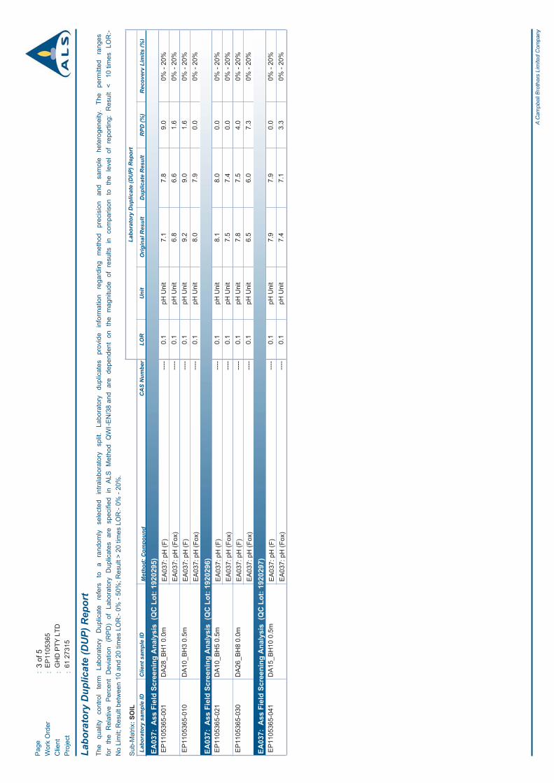
7.2.1 Field Duplicates – Relative Percentage Differences
During the soil investigation, 2 field duplicates were collected for the purposes of QA/QC.
A quantitative measure of the precision of the analytical results is made by calculating the RelativePercent Difference (RPD) between primary and duplicate results in accordance with the proceduredescribed in AS 4482.1 Guide to the sampling and investigation of potentially contaminated soil Part 1:Non-volatile and semi-volatile compounds (DEP 2001). According to AS 4482.1 typical RPD’s rangebetween 30% and 50%, however AS 4482.1 recognises that this may be higher for low concentrations ofanalytes. GHD considers the RPD acceptable, if it is less than 50 percent and where the concentrationsare more than 10 times the limit of reporting. This acceptance criterion is based on the criteria listed inAS 4482.1 (2005). RPD calculation results are provided in Appendix E.
A total of 10 RPDs were calculated for the soil investigation with no exceedances of the adopted criteria.
7.3 Laboratory QA/QCALS Laboratory is accredited by the National Association of Testing Authorities (NATA) for the analysesperformed. The internal laboratory Quality Assurance results are presented in Appendix E.
Internal laboratory QA/QC results for the soil investigation are as follows:
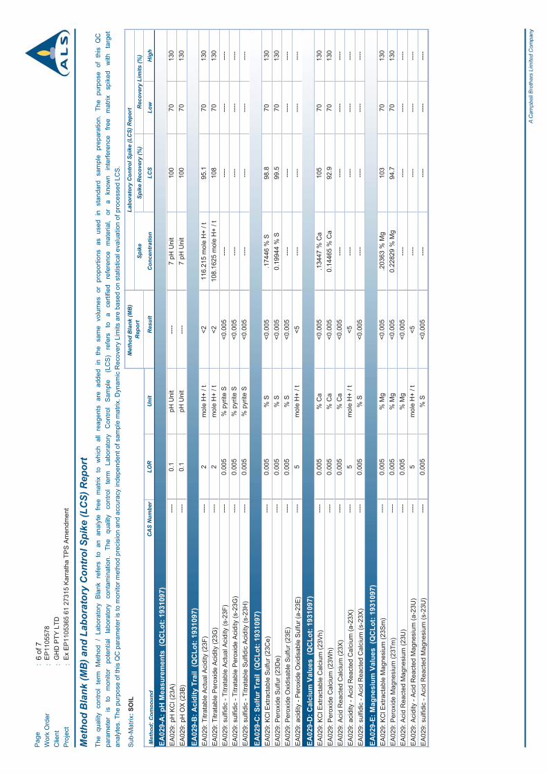
No holding time breaches were observed;
No method blank outliers occurred;
No duplicate outliers occurred; and
No matrix spike outliers occurred.

1461/27315/114567 Karratha TPS No 8. AmendmentPreliminary Acid Sulfate Soil Investigation
7.4 Summary of QA/QCThe review of the laboratory and field quality assurance and quality control data indicates that theanalytical data is considered to be of an adequate quality upon which to draw meaningful conclusionsregarding the presence of ASS across the development areas.
1561/27315/114567 Karratha TPS No 8. AmendmentPreliminary Acid Sulfate Soil Investigation
8. Conclusions and Recommendations
8.1 ConclusionsLandCorp commissioned GHD to undertake a Preliminary ASS Investigation within a number ofprecincts and their proposed development areas (DA’s) in Karratha, Western Australia to determine thepotential presence of ASS.
Based upon the findings of this investigation, the following conclusions can been drawn:
The geology and soil types on Site are consistent with relatively low ASS risk;
The components of the acidity trail (TAA, TPA) were below the laboratory limit of reporting for all ofthe samples tested;
There were only two exceedances of the net acidity criteria of 18.7 mol H+/tonne with all of the othersamples returning net acidities below the laboratory limit of reporting;
All samples analysed for SPOCAS contained significant amounts of buffering materials as indicatedby ANC;
The samples with the two exceedances had net acidity values of less than 1% of the sample’sequivalent ANC.
Based on the above conclusions, the potential ASS risk at the site is considered to be low to very low atthis time. In the event of any possible oxidation of the naturally present sulphides (albeit at low levels)within development area DA10, the soil materials present onsite likely have sufficient buffering capacityto neutralise any potential acid generation.
8.2 RecommendationsBased on the findings of this investigation, management measures pertaining to ASS would not likely berequired during any construction works. In addition no further ASS investigations or management arelikely to be required with regards to the excavation and reuse of the materials for development workswithin any of the development areas.
Groundwater encountered at the site was not tested as significant dewatering works were notanticipated. Although the site has a low ASS risk, if dewatering is required as part of construction,groundwater sampling and analysis is recommended prior to disposal into sensitive environmentalsurface or groundwater bodies.
1661/27315/114567 Karratha TPS No 8. AmendmentPreliminary Acid Sulfate Soil Investigation
9. References
Department of Environment (2009). Acid Sulfate Soils Guideline Series. Identification and Investigationof Acid Sulfate Soils and Acidic Landscapes. Perth, WA. May, 2009.
Department of Environment (2011). Acid Sulfate Soils Guideline Series. Treatment and management ofsoils and water in acid sulfate soils landscapes. Perth, WA. July, 2011.
GHD 2011, Cossill and Webley Consulting Engineers, Report for Gap Ridge Industrial Estate,Preliminary Acid Sulfate Soil Investigation, March 2011.
Hickman, A.H. (1997) Dampier, W.A. Sheet 2256: Western Australia Geological Survey, 1:100 000Geological Series
Western Australian Planning Commission (2003). Planning Bulletin Number 64. Acid Sulfate Soils.November, 2009.
61/27315/114567 Karratha TPS No 8. AmendmentPreliminary Acid Sulfate Soil Investigation
Figures
Figure 1 Site Locality Plan
Figure 2 Sampling Locations
Figure 3 Site Geology
Figure 4 Acid Sulfate Soils Risk Map

460,
000
460,
000
475,
000
475,
000
490,
000
490,
000
505,
000
505,
000
7,695,000
7,695,000
7,710,000
7,710,000
7,725,000
7,725,000
Figu
re 1
Job
Num
ber
Rev
isio
n061
-273
15
G:\6
1\27
315\
GIS
\Map
s\M
XD
\612
7315
_G00
7_fig
1_R
ev0.
mxd
Map
Pro
ject
ion:
Tra
nsve
rse
Mer
cato
rH
oriz
onta
l Dat
um:
GD
A 1
994
Grid
: GD
A 1
994
MG
A Z
one
50
02.
55
7.5
101.
25
Kilo
met
res
LEG
END
o©
201
1. W
hils
t eve
ry c
are
has
been
take
n to
pre
pare
this
map
, GH
D a
nd L
andg
ate
mak
e no
repr
esen
tatio
ns o
r war
rant
ies
abou
t its
acc
urac
y, re
liabi
lity,
com
plet
enes
s or
sui
tabi
lity
for a
ny p
artic
ular
pur
pose
and
can
not a
ccep
t lia
bilit
y an
d re
spon
sibi
lity
of a
ny k
ind
(whe
ther
in c
ontra
ct, t
ort o
r oth
erw
ise)
for a
ny e
xpen
ses,
loss
es, d
amag
es a
nd/o
r cos
ts (i
nclu
ding
indi
rect
or c
onse
quen
tial d
amag
e) w
hich
are
or m
ay b
e in
curr
ed b
y an
y pa
rty a
s a
resu
lt of
the
map
bei
ng in
accu
rate
, inc
ompl
ete
or u
nsui
tabl
e in
any
way
and
for a
ny re
ason
.
Dat
e21
Oct
201
1
Land
Cor
pKa
rrat
ha T
PS N
o.8
Amen
dmen
t
Site
Loc
ality
Pla
n
Dat
a so
urce
: G
HD
; D
evel
opm
ent A
reas
- 20
1104
12; G
A: T
opo
250k
Ser
ies
III -
2006
; Lan
dgat
e: T
rave
llers
Atla
s - 2
004
; Cre
ated
by:
vdi
nh
GH
D H
ouse
, 239
Ade
laid
e Te
rrac
e Pe
rth W
A 60
04 T
61
8 62
22 8
222
F 6
1 8
6222
855
5 E
per
mai
l@gh
d.co
m.a
u W
ww
w.g
hd.c
om.a
u
WIC
KH
AM
HEA
RS
ON
KAR
RAT
HA
IND
IAN
OC
EAN
Dev
elop
men
t Are
as
at A
41:
250,
000
! A
! A! A
! A
! A
! A
! A
! A
! A
! A ! A
! A
BH
9
BH
8
BH
7
BH
6
BH
5
BH
4
BH
3B
H2
BH
1
BH12
BH
11BH10
DA
10
DA
15
DA
14
DA
26
DA
13
DA
28
KARRATHA RD
DAM
PIER
RD
NO
RTH
WE
ST
CO
AST
AL
HW
Y
WARLU RD
477,
000
477,
000
484,
000
484,
000
491,
000
491,
000
7,701,000
7,701,000
7,708,000
7,708,000
Figu
re 2
Job
Num
ber
Rev
isio
n061
-273
15
G:\6
1\27
315\
GIS
\Map
s\M
XD
\612
7315
_G00
8_fig
2_R
ev0.
mxd
Map
Pro
ject
ion:
Tra
nsve
rse
Mer
cato
rH
oriz
onta
l Dat
um:
GD
A 1
994
Grid
: GD
A 1
994
MG
A Z
one
50
070
01,
400
2,10
02,
800
350
Met
res
LEG
END
o©
201
1. W
hils
t eve
ry c
are
has
been
take
n to
pre
pare
this
map
, GH
D, G
A a
nd L
andg
ate
mak
e no
repr
esen
tatio
ns o
r war
rant
ies
abou
t its
acc
urac
y, re
liabi
lity,
com
plet
enes
s or
sui
tabi
lity
for a
ny p
artic
ular
pur
pose
and
can
not a
ccep
t lia
bilit
y an
d re
spon
sibi
lity
of a
ny k
ind
(whe
ther
in c
ontra
ct, t
ort o
r oth
erw
ise)
for a
ny e
xpen
ses,
loss
es, d
amag
es a
nd/o
r cos
ts (
incl
udin
g in
dire
ct o
r con
sequ
entia
l dam
age)
whi
ch a
re o
r may
be
incu
rred
by
any
party
as
a re
sult
of th
e m
ap b
eing
inac
cura
te, i
ncom
plet
e or
uns
uita
ble
in a
ny w
ay a
nd fo
r any
reas
on.
Dat
e21
Oct
201
1
Land
Cor
pKa
rrat
ha T
PS N
o.8
Amen
dmen
t
Sam
plin
g Lo
catio
ns
Dat
a so
urce
: G
HD
; Sam
plin
g Lo
catio
n - 2
0110
913,
Dev
elop
men
t Are
as -
2011
0412
; Lan
dgat
e: R
oads
- 20
1108
10, C
adas
tre -
201
1042
1, Im
ager
y K
arra
tha
Tow
nsite
- S
ept 2
010;
GA
: Top
o 25
0k S
erie
s III
- 20
06; C
reat
ed b
y: v
dinh
180
Lons
dale
Stre
et M
elbo
urne
VIC
300
0 A
ustra
liaT
61
3 86
87 8
000
F 6
1 3
8687
811
1E
mel
mai
l@gh
d.co
mW
ww
w.g
hd.c
om
WIC
KH
AM
HEA
RS
ON
KAR
RAT
HA
IND
IAN
OC
EAN
! AS
ampl
e Lo
catio
n
Roa
ds
Dev
elop
men
t Are
as
Cad
astre
IDEasting
Northing
BH
1479740
7708162
BH
2479542
7708687
BH
3487710
7708643
BH
4490284
7707942
BH
5489078
7707280
BH
6486824
7706770
BH
7487797
7707512
BH
8478057
7706851
BH
9477001
7705238
BH
10480999
7703011
BH
11481009
7701537
BH
12479407
7703617
at A
41:
70,0
00

GH
D H
ouse
, 239
Ade
laid
e Te
rrac
e Pe
rth W
A 60
04 T
61
8 62
22 8
222
F 6
1 8
6222
855
5 E
per
mai
l@gh
d.co
m.a
u W
ww
w.gh
d.co
m.a
u
KARRATHA RD
DAM
PIER
RD
WARLU RD
476,
000
476,
000
480,
000
480,
000
484,
000
484,
000
488,
000
488,
000
7,704,000
7,704,000
7,708,000
7,708,000
G:\6
1\27
315\
GIS
\Map
s\M
XD
\612
7315
_G00
9_Fi
g3_R
evA
.mxd
© 2
011.
Whi
le G
HD
has
take
n ca
re to
ens
ure
the
accu
racy
of t
his
prod
uct,
GH
D a
nd L
AN
DG
ATE
, DM
P m
ake
no re
pres
enta
tions
or w
arra
ntie
s ab
out i
ts a
ccur
acy,
com
plet
enes
s or
sui
tabi
lity
for a
ny p
artic
ular
pur
pose
. G
HD
and
LAN
DG
ATE
, DM
P c
anno
t acc
ept l
iabi
lity
of a
ny k
ind
(whe
ther
in c
ontra
ct, t
ort o
r oth
erw
ise)
for a
ny e
xpen
ses,
loss
es, d
amag
es a
nd/o
r cos
ts (i
nclu
ding
indi
rect
or c
onse
quen
tial d
amag
e) w
hich
are
or m
ay b
e in
curr
ed a
s a
resu
lt of
the
prod
uct b
eing
inac
cura
te, i
ncom
plet
e or
uns
uita
ble
in a
ny w
ay a
nd fo
r any
reas
on.
LEG
EN
D
00.
40.
81.
21.
62
0.2
Kilo
met
res
Map
Pro
ject
ion:
Tra
nsve
rse
Mer
cato
rH
oriz
onta
l Dat
um: G
eoce
ntric
Dat
um o
f Aus
tralia
(GD
A)
Grid
: Map
Grid
of A
ustra
lia 1
994,
Zon
e 50
Land
Cor
pK
arra
tha
TPS
No.
8 A
men
dmen
t
Figu
re 3
Job
Num
ber
Rev
isio
nA61
-273
15
13 S
ep 2
011
Site
Geo
logy
oD
ate
Dat
a S
ourc
e: L
andg
ate:
Roa
ds -
2009
1125
; DM
P: 1
:100
000
geo
logi
cal m
ap -
DA
MP
IER
(225
6), f
irst e
ditio
n - 1
9970
523;
GH
D: S
tudy
Bou
ndar
y - 2
0110
412.
Cre
ated
by:
kdi
ralu
, sis
mai
l, vd
inh
1:40
,000
(at A
3)
1:10
0 00
0 G
eolo
gica
l Map
- D
AM
PIER
(225
6), 1
st E
d.
Ab:
Bas
altic
rock
, und
ivid
ed; g
ener
ally
m
etam
orph
osed
to g
reen
schi
st fa
cies
Aba
: Stro
ngly
folia
ted
basa
lt; m
etam
orph
osed
to
am
phib
olite
faci
es
Abg
p: F
olia
ted
and
shea
red
met
abas
alt w
ith s
hear
ed
vein
s an
d sh
eets
of m
icro
gran
ite a
nd p
egm
atite
; m
etam
orph
osed
to a
mph
ibol
ite fa
cies
Ac:
Che
rt, u
ndiv
ided
Acf
: Fer
rugi
nous
che
rt, b
ande
d iro
n-fo
rmat
ion,
and
m
etam
orph
osed
inte
rcal
ated
fine
-gra
ined
cla
stic
se
dim
enta
ry ro
cks
Acg
: Gre
en c
hert,
com
mon
ly o
ccur
s cl
ose
to
ultra
maf
ic ro
cks
Aci
: Ban
ded
iron-
form
atio
n; m
inor
ferr
ugin
ous
cher
t
Acj
: Jas
pilit
e
Acw
: Gre
y-w
hite
ban
ded
cher
t, lo
cally
as
soci
ated
with
qua
rtzite
Afs
: Rhy
olite
to a
ndes
ite s
chis
t; in
clud
es s
hear
ed
fels
ic v
olca
nic
and
clas
tic s
edim
enta
ry ro
cks
AgD
m: G
rani
te to
gra
nodi
orite
, loc
ally
ser
iate
; inc
lude
s bi
otite
-ric
h ph
ases
, leu
cocr
atic
sye
nogr
anite
, and
pe
gmat
ite v
eins
; met
amor
phos
ed
Agk
a: K
AR
RAT
HA
GR
AN
OD
IOR
ITE
: wea
kly
folia
ted
gran
odio
rite
to to
nalit
e (c
. 326
0 M
a)
Alm
: Qua
rtz-s
eric
ite s
chis
t and
che
rt; in
clud
es
met
amor
phos
ed s
iltst
one;
che
rt m
ay b
e gr
ey-w
hite
ban
ded,
gre
y, o
r gre
en; c
hief
ly
repr
esen
ts s
i
Ao:
Gab
bro
and
min
or d
oler
ite; l
ocal
uni
ts
of n
orite
and
ano
rthos
ite; m
etam
orph
osed
Aod
: Met
adol
erite
Asc
: Met
acon
glom
erat
e
Asi
: Fer
rugi
nous
cla
stic
sed
imen
tary
rock
s, d
omin
antly
pe
litic
; inc
lude
s m
inor
che
rt be
ds; m
etam
orph
osed
Asq
: Qua
rtzite
Au:
Ultr
amaf
ic ro
ck, u
ndiv
ided
; inc
lude
s sc
hist
; loc
al
silic
ifica
tion
Aub
: Int
erca
late
d ul
tram
afic
and
maf
ic la
va w
ith th
in c
hert
units
(sili
cifie
d in
terfl
ow s
edim
enta
ry ro
cks)
; met
amor
phos
ed
Auk
: Kom
atiit
e; c
hara
cter
ized
by
oliv
ine
spin
ifex
text
ures
;m
etam
opho
sed
Aus
: Ser
pent
inite
; rep
laci
ng p
erid
otite
Aut
: Tal
c-ch
lorit
e sc
hist
Ayx:
Gra
noph
yric
, xen
olith
-ric
h dy
ke; g
ener
ally
and
esiti
c
Czr
f: Fe
rric
rete
-incl
udes
ferr
ugin
ous
duric
rust
and
pis
oliti
c iro
nsto
ne o
n la
terit
ic s
urfa
ces
Czr
k: C
alcr
ete-
mas
sive
, nod
ular
and
cav
erno
us li
mes
tone
, va
riabl
y si
licifi
ed; r
esid
ual o
rigin
Mad
e gr
ound
Oce
an
Qaa
: Allu
vium
- sa
nd a
nd g
rave
l in
river
s an
d cr
eeks
; cla
y,
silt,
and
san
d in
cha
nnel
s on
floo
dpla
ins
Qab
: Allu
vial
san
d, s
ilt, a
nd c
lay
in fl
oodp
lain
s, w
ith g
ilgai
su
rface
in a
reas
of e
xpan
sive
cla
y
Qao
: Allu
vial
san
d, s
ilt, a
nd c
lay
in fl
oodp
lain
s
Qas
: Coa
stal
san
d de
posi
ts o
f mix
ed a
lluvi
al a
nd e
olia
n or
igin
Qc:
Col
luvi
um-s
and,
silt
, and
gra
vel i
n ou
twas
h fa
ns a
nd s
cree
Qhm
m: M
arin
e m
ud a
nd s
ilt; i
nter
idal
with
man
grov
es
Qhm
s: S
helly
san
d in
coa
stal
dun
es a
nd o
ld b
each
dep
osits
; c
onta
ins
Ana
dara
gra
nosa
Qhm
u: S
ilt a
nd m
ud in
sup
ratid
al to
inte
rtida
l fla
ts a
nd la
goon
s
Qs:
Eol
ian
sand
- re
d-ye
llow
win
d bl
own
sand
; loc
al s
and
ridge
s
Qw
b: S
heet
was
h sa
nd, s
ilt, a
nd c
lay
in d
ista
l out
was
h fa
ns,
with
gilg
ai s
urfa
ce in
are
as o
f exp
ansi
ve c
lay
Sal
t eva
pora
tion
pond
s
p: P
egm
atite
Dev
elop
men
t Are
as
Roa
ds
DRAF
T

! A
! A! A
! A
! A
! A
! A
! A
! A
! A ! A
! A
BH
9
BH
8
BH
7
BH
6
BH
5
BH
4
BH
3B
H2
BH
1
BH
12
BH
11
BH
10
DA
10
DA
15
DA
14
DA
26
DA
13
DA
28
KARRATHA RD
DAM
PIE
R R
D
WARLU RD
478,
000
478,
000
484,
000
484,
000
490,
000
490,
000
7,704,000
7,704,000
Figu
re 4
Job
Num
ber
Rev
isio
n061
-273
15
G:\6
1\27
315\
GIS
\Map
s\M
XD
\612
7315
_G01
1_fig
4_R
ev0.
mxd
Map
Pro
ject
ion:
Tra
nsve
rse
Mer
cato
rH
oriz
onta
l Dat
um:
GD
A 1
994
Grid
: GD
A 1
994
MG
A Z
one
50
060
01,
200
1,80
02,
400
300
Met
res
LEG
END
o©
201
1. W
hils
t eve
ry c
are
has
been
take
n to
pre
pare
this
map
, GH
D a
nd L
andg
ate
mak
e no
repr
esen
tatio
ns o
r war
rant
ies
abou
t its
acc
urac
y, re
liabi
lity,
com
plet
enes
s or
sui
tabi
lity
for a
ny p
artic
ular
pur
pose
and
can
not a
ccep
t lia
bilit
y an
d re
spon
sibi
lity
of a
ny k
ind
(whe
ther
in c
ontra
ct, t
ort o
r oth
erw
ise)
for a
ny e
xpen
ses,
loss
es, d
amag
es a
nd/o
r cos
ts (i
nclu
ding
indi
rect
or c
onse
quen
tial d
amag
e) w
hich
are
or m
ay b
e in
curr
ed b
y an
y pa
rty a
s a
resu
lt of
the
map
bei
ng in
accu
rate
, inc
ompl
ete
or u
nsui
tabl
e in
any
way
and
for a
ny re
ason
.
Dat
e21
Oct
201
1
Land
Cor
pKa
rrat
ha T
PS N
o.8
Amen
dmen
t
Acid
Sul
fate
Soi
ls R
isk
Map
Dat
a S
ourc
e: L
andg
ate:
Roa
ds -
2009
1125
, Dam
pier
And
Ext
ensi
ons
2008
- 20
1108
31; D
EC
: Aci
d S
ulfa
te S
oil R
isk
Map
- 20
0608
07; G
HD
: Sam
plin
g Lo
catio
n - 2
0110
913,
Dev
elop
men
t Are
as -
2011
0412
. Cre
ated
by:
vdi
nh
GH
D H
ouse
, 239
Ade
laid
e Te
rrac
e Pe
rth W
A 60
04 T
61
8 62
22 8
222
F 6
1 8
6222
855
5 E
per
mai
l@gh
d.co
m.a
u W
ww
w.g
hd.c
om.a
u
Size
A4
1:60
,000
! AS
ampl
ing
Loca
tion
Roa
ds
Dev
elop
men
t Are
as
Hig
h to
mod
erat
e A
SS
dis
turb
ance
risk
(<3m
from
sur
face
)
Mod
erat
e to
low
AS
S d
istu
rban
ce ri
sk (<
3m fr
om s
urfa
ce)
No
know
n A
SS
dis
turb
ance
ris
k (<
3m fr
om s
urfa
ce)
61/27315/114567 Karratha TPS No 8. AmendmentPreliminary Acid Sulfate Soil Investigation
Appendix A
Glossary
61/27315/114567 Karratha TPS No 8. AmendmentPreliminary Acid Sulfate Soil Investigation
(Acid) Fizz test: The field test used for soils to test for the presence of carbonate minerals, wherebydilute hydrochloric acid is added to the soil. An effervescent fizzing reaction indicates the presence ofcarbonate minerals.
AASS: Actual acid sulfate soils.
Acid Base Accounting (ABA): The process by which the various acid-producing components of the soilare compared with the acid neutralising components so that the soil’s net acidity can be calculated.
Action criteria: The critical net acidity values (expressed in units of equivalent % pyrite sulfur, orequivalent mol H+/t) for different soil texture groups and sizes of soil disturbance that trigger the need forASS management.
Actual Acidity: A component of existing acidity. The soluble and exchangeable acidity already presentin the soil, often as a consequence of previous oxidation of sulfides. It is this acidity that will be mobilisedand discharged following a rainfall event. It is measured in the laboratory using the TAA method. It doesnot include the less soluble acidity (i.e. retained acidity) held in hydroxy-sulfate minerals such as jarosite.
ANC: Acid neutralising capacity. A measure of a soil’s inherent ability to buffer acidity and resist thelowering of the soil pH.
ANCBT: Acid neutralising capacity by back titration. Acid neutralising capacity measured by acid digestfollowed by back titration of the acid that has not been consumed.
ANCE: Excess acid neutralising capacity. Found in soils with acid neutralising capacity in excess of thatneeded to neutralise the acidity generated by oxidation of sulfides. The soil is oxidised with peroxide,then a titration is performed with dilute hydrochloric acid to a pH of 4, followed by a second peroxidedigestion. If a soil has a positive ANCE result then the TPA result is zero and vice versa.
CaHCl: Calcium soluble in 4 M HCl, which includes soluble and exchangeable calcium as well as calciumfound in certain carbonate minerals (e.g. dolomite, calcite, aragonite).
CaKCl: Potassium chloride extractable calcium measured following the TAA analysis, which includessoluble and exchangeable calcium as well as calcium from gypsum.
CaNAS: Net acid soluble calcium. The calcium soluble in 4 M HCl that is not soluble in 1 M KCl. (CaHCl –CaKCl). It can be used (in combination with MgNAS) to provide an estimate of the soil carbonate content,but may be an overestimate if calcium is dissolved from non-carbonate or non-acid-neutralising minerals.
CaP: Peroxide calcium. Calcium measured following the TPA analysis, which includes soluble andexchangeable calcium, calcium from gypsum, as well as calcium (e.g. from carbonates) dissolved as aresult of acid produced due to oxidation of sulfides by peroxide.
Chromium Suite: The acid base accounting approach used to calculate net acidity which uses thechromium reducible sulfur method to determine potential sulfidic acidity. A decision tree approach basedon the pHKCl result is then used to determine the other components of the acid base account.
CIN: Inorganic carbon. (CT – CTO). It is used to estimate the carbonate content of the soil.
CRS: The acronym often given to the Chromium Reducible Sulfur method.
CT: Total carbon. A measure of the total carbon content of the soil, encompassing both organic andinorganic forms.

61/27315/114567 Karratha TPS No 8. AmendmentPreliminary Acid Sulfate Soil Investigation
CTO: Total organic carbon. The carbon in sample measured following a sulfurous acid digestionprocedure used to remove carbonate carbon.
Existing Acidity: The acidity already present in acid sulfate soils, usually as a result of oxidation ofsulfides, but which can also be from organic material or acidic cations. It can be further sub-divided intoactual and retained acidity, i.e. Existing Acidity = Actual Acidity + Retained Acidity.
Fineness factor: A factor applied to the acid neutralising capacity result in the acid base account toallow for the poor reactivity of coarser carbonate or other acid neutralising material. The minimum factoris 1.5 for finely divided pure agricultural lime, but may be as high as 3.0 for coarser shell material.
Jarosite: Jarosite is a characteristic pale yellow mineral deposit that can precipitate as pore fillings andcoatings on fissures. Where there is a fluctuating watertable, jarosite may be found along cracks and rootchannels in the soil. However, jarosite is not always found in AASS.
MgA: Reacted magnesium. The magnesium soluble after the peroxide digest and TPA titration that wasnot soluble following KCl-extraction and TAA titration. (MgP – MgKCl). It can be used (in combination withCaA) to provide an estimate of the soil carbonate content, but may be an underestimate if the HCltitrationto pH 4 has not been performed as part of the TPA/ANCE procedure.
MgHCl: Magnesium soluble in 4 M HCl, which includes soluble and exchangeable magnesium as well asmagnesium found in certain carbonate minerals (e.g. dolomite, magnesite).
MgKCl: Potassium chloride extractable magnesium measured following the TAA analysis, which includessoluble and exchangeable magnesium.
MgNAS: Net acid soluble magnesium. The calcium soluble in 4 M HCl that is not soluble in 1 M KCl.(MgHCl – MgKCl). It can be used (in combination with CaNAS) to provide an estimate of the soil carbonatecontent, but may be an overestimate if magnesium is dissolved from noncarbonated or non-acidneutralising minerals.
MgP: Peroxide magnesium. Magnesium measured following the TPA analysis, which includes solubleand exchangeable magnesium, as well as magnesium (e.g. from carbonates) dissolved as a result ofacid produced due to oxidation of sulfides by peroxide.
Monosulfides: The term given to the highly reactive iron sulfide minerals found in ASS that have theapproximate formula ‘FeS’ and which are soluble in hydrochloric acid (as opposed to iron disulfides suchas pyrite that are not appreciably soluble in hydrochloric acid).
Monosulfidic Black Ooze (MBO): The term used to describe black, oily in appearance, gel-likesubstances (moisture content >70%), greatly enriched in monosulfides (up to 27%), high in organicmatter (usually 10% organic carbon) and can form thick (>1.0m) accumulations in waterways, includingdrains, in acid sulfate soil landscapes.
Net Acidity: The result obtained when the values for various components of soil acidity and acidneutralising capacity are substituted into the Acid Base Accounting equation. Calculated as: Net Acidity =Potential Sulfidic Acidity + Existing Acidity – (Acid Neutralising Capacity/Fineness Factor)
PASS: Potential acid sulfate soils.
pHF: Field pH. Field determination of pH in a soil: water paste.
pHFOX: Field peroxide pH. Field determination of pH in a soil:water mixture following reaction withhydrogen peroxide.

61/27315/114567 Karratha TPS No 8. AmendmentPreliminary Acid Sulfate Soil Investigation
pHKCl: Potassium chloride pH. pH in a 1:40 (W/V) suspension of soil in a solution of 1 M potassiumchloride measured prior to TAA titration.
pHOX: Peroxide oxidised pH. pH in a suspension of soil in a solution after hydrogen peroxide digestion inthe SPOCAS method.
POCAS: An acronym standing for Peroxide Oxidation Combined Acidity and Sulfate method (MethodCode 21). This method has been superseded by the SPOCAS method.
POCASm: An acronym standing for the modified Peroxide Oxidation Combined Acidity and Sulfatemethod. This method has been superseded by the SPOCAS method.
Potential (sulfidic) acidity: The latent acidity in ASS that will be released if the sulfide minerals theycontain (e.g. pyrite) are fully oxidised. It can be estimated by titration (i.e. TSA) if no acid neutralisingmaterial is present, or calculated from SPOS or SCR results.
Retained Acidity: The ‘less available’ fraction of the existing acidity (not measured by the TAA) that maybe released slowly into the environment by hydrolysis of relatively insoluble sulfate salts (such asjarosite, natrojarosite, and other iron and aluminium hydroxy-sulfate minerals).
SCR: The symbol given to the result from the Chromium Reducible Sulfur method (Method 22B). The SCR
method provides a measure of reduced inorganic sulfide content using iodometric titration after an acidicchromous chloride reduction. This method is not subject to interferences from organic sulfur.
SHCl: Sulfur soluble in 4 M HCl which includes soluble and adsorbed sulfate, sulfate from gypsum, as wellas sulfate from hydroxy-sulfate minerals such as jarosite and natrojarosite.
SKCl: Potassium chloride extractable sulfur measured following the TAA analysis, which includes solubleand adsorbed sulfate as well as sulfate from gypsum.
SNAS: Net acid soluble sulfur (SHCl – SKCl). The sulfur soluble in 4 M HCl that is not soluble in 1 M KCl. Itprovides an estimate of the sulfate contained in jarosite and similar low solubility hydroxy-sulfateminerals (and can be used to estimate retained acidity).
SP: Peroxide sulfur. Sulfur measured following the TPA analysis, which includes soluble andexchangeable sulfate, sulfate from gypsum, as well as sulfide converted to sulfate and that released fromorganic matter as a result of peroxide oxidation.
SPOS: Peroxide oxidisable sulfur from the SPOCAS method. The sulfur soluble after the peroxide digestand TPA titration that was not soluble following KCl-extraction and TAA titration. (SP – SKCl). It providesan estimate of the soil sulfide content, but is affected by the presence of organic sulfur.
SRAS: Residual acid soluble sulfur. The sulfur measured by 4 M HCl extraction on the soil residueremaining after peroxide digestion and TPA titration of the SPOCAS method. It provides an estimate ofthe sulfate contained in jarosite and similar low solubility hydroxy-sulfate minerals (and can be used toestimate retained acidity).
ST: Total sulfur. A measure of the total sulfur content of the soil, encompassing both organic andinorganic forms.
STOS: Total oxidisable sulfur. An estimate of soil oxidisable sulfur made from determining the sulfur notsoluble in 4 M HCl. (ST – SHCl). It tends to provide an overestimate of soil sulfide content.
61/27315/114567 Karratha TPS No 8. AmendmentPreliminary Acid Sulfate Soil Investigation
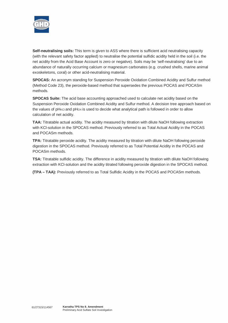
Self-neutralising soils: This term is given to ASS where there is sufficient acid neutralising capacity(with the relevant safety factor applied) to neutralise the potential sulfidic acidity held in the soil (i.e. thenet acidity from the Acid Base Account is zero or negative). Soils may be ‘self-neutralising’ due to anabundance of naturally occurring calcium or magnesium carbonates (e.g. crushed shells, marine animalexoskeletons, coral) or other acid-neutralising material.
SPOCAS: An acronym standing for Suspension Peroxide Oxidation Combined Acidity and Sulfur method(Method Code 23), the peroxide-based method that supersedes the previous POCAS and POCASmmethods.
SPOCAS Suite: The acid base accounting approached used to calculate net acidity based on theSuspension Peroxide Oxidation Combined Acidity and Sulfur method. A decision tree approach based onthe values of pHKCl and pHOX is used to decide what analytical path is followed in order to allowcalculation of net acidity.
TAA: Titratable actual acidity. The acidity measured by titration with dilute NaOH following extractionwith KCl-solution in the SPOCAS method. Previously referred to as Total Actual Acidity in the POCASand POCASm methods.
TPA: Titratable peroxide acidity. The acidity measured by titration with dilute NaOH following peroxidedigestion in the SPOCAS method. Previously referred to as Total Potential Acidity in the POCAS andPOCASm methods.
TSA: Titratable sulfidic acidity. The difference in acidity measured by titration with dilute NaOH followingextraction with KCl-solution and the acidity titrated following peroxide digestion in the SPOCAS method.
(TPA – TAA): Previously referred to as Total Sulfidic Acidity in the POCAS and POCASm methods.

61/27315/114567 Karratha TPS No 8. AmendmentPreliminary Acid Sulfate Soil Investigation
Appendix B
Hand Auger Bore Logs

BOREHOLE LOGEnvironmental - Hand Auger
Bore No.:
Page: 1 of 1
Client:Project:Job No.:Location:Date Drilled:
Total Depth (m):
Easting:Northing:Augered by:
Logged by: Checked by:
NOTES:
Dep
th (m
)
0.0
1.0
2.0
Sam
ple
Met
hod
PID
(ppm
) Sample ID
Gra
phic
Log
SOIL DESCRIPTIONSoil Type (Classification Group Symbol); Particle
Size; Colour; Secondary / Minor Components.
Moi
stur
e C
ondi
tion
CONTAMINANT INDICATORSOdours, staining, waste materials,
separate phase liquids, imported fill,ash.
Dep
th/
Elev
atio
n (m
)
GHD Soil Classifications: The GHD Soil Classification is based on Australian Standards AS 1726-1993.
BH1
LandCorpKarratha TPS Amendment ASS Investigation61/27315DA28
15/08/20111.0
4797407708162
EL
EL AB
HandAuger
DA28-BH1_0.0
Ground SurfaceCLAY (GILGAI)Red/brown
CLAYRed/brown
SANDY CLAYRed/brown
BoH at 1.0 m
Dry pH (F): 7.1 and pH (Fox): 6.8
pH (F): 7.9 and pH (Fox): 7.4
pH (F): 7.7 and pH (Fox): 7.1
0.000.00
-0.200.20
-0.700.70
-1.001.00

BOREHOLE LOGEnvironmental - Hand Auger
Bore No.:
Page: 1 of 1
Client:Project:Job No.:Location:Date Drilled:
Total Depth (m):
Easting:Northing:Augered by:
Logged by: Checked by:
NOTES:
Dep
th (m
)
0.0
1.0
2.0
3.0
Sam
ple
Met
hod
PID
(ppm
) Sample ID
Gra
phic
Log
SOIL DESCRIPTIONSoil Type (Classification Group Symbol); Particle
Size; Colour; Secondary / Minor Components.
Moi
stur
e C
ondi
tion
CONTAMINANT INDICATORSOdours, staining, waste materials,
separate phase liquids, imported fill,ash.
Dep
th/
Elev
atio
n (m
)
GHD Soil Classifications: The GHD Soil Classification is based on Australian Standards AS 1726-1993.
BH2
LandCorpKarratha TPS Amendment ASS Investigation61/27315DA28
15/08/20112.0
4795427708687
GG
EL AB
HandAuger
DA28-BH2_0.0
DA28-BH2_0.5
DA28-BH2_1.0
DA28-BH2_1.5
DA28-BH2_2.0
Ground SurfaceCLAYLight brown
CLAYBrown
GRAVELLY CLAYBrown
BoH at 2.0 m
Dry
Moist
Wet
pH (F): 8.2 and pH (FOX): 7.6
pH (F): 8.2 and pH (FOX): 8.2
pH (F): 8.2 and pH (FOX): 7.7
pH (F): 8.2 and pH (FOX): 8.5
pH (F): 8.1 and pH (FOX): 8.4
0.000.00
-0.200.20
-1.001.00
-2.002.00

BOREHOLE LOGEnvironmental - Hand Auger
Bore No.:
Page: 1 of 1
Client:Project:Job No.:Location:Date Drilled:
Total Depth (m):
Easting:Northing:Augered by:
Logged by: Checked by:
NOTES:
Dep
th (m
)
0.0
1.0
2.0
3.0
Sam
ple
Met
hod
PID
(ppm
) Sample ID
Gra
phic
Log
SOIL DESCRIPTIONSoil Type (Classification Group Symbol); Particle
Size; Colour; Secondary / Minor Components.
Moi
stur
e C
ondi
tion
CONTAMINANT INDICATORSOdours, staining, waste materials,
separate phase liquids, imported fill,ash.
Dep
th/
Elev
atio
n (m
)
GHD Soil Classifications: The GHD Soil Classification is based on Australian Standards AS 1726-1993.
BH3
LandCorpKarratha TPS Amendment ASS Investigation61/27315DA10
15/08/20112.5
4877167708643
GG
EL AB
HandAuger
DA10-BH3_0.0
DA10-BH3_0.5
DA10-BH3_1.0
DA10-BH3_1.5
DA10-BH3_2.0
DA10-BH3_2.5
Ground SurfaceSANDLight brown/orange, medium to coarse grained,moderately sorted
SANDBrown, medium to coarse grained, moderatelysorted with some shell fragments
BoH at 2.5 m
Dry
Moist
pH (F): 8.9 and pH (Fox): 6.9
pH (F): 9.2 and pH (Fox): 8
pH (F): 9.4 and pH (Fox): 8.6
pH (F): 9.4 and pH (Fox): 9.9
pH (F): 9.5 and pH (Fox): 10.1
pH (F): 9.4 and pH (Fox): 8.7
0.000.00
-0.200.20
-2.502.50

BOREHOLE LOGEnvironmental - Hand Auger
Bore No.:
Page: 1 of 1
Client:Project:Job No.:Location:Date Drilled:
Total Depth (m):
Easting:Northing:Augered by:
Logged by: Checked by:
NOTES:
Dep
th (m
)
0.0
1.0
2.0
3.0
Sam
ple
Met
hod
PID
(ppm
) Sample ID
Gra
phic
Log
SOIL DESCRIPTIONSoil Type (Classification Group Symbol); Particle
Size; Colour; Secondary / Minor Components.
Moi
stur
e C
ondi
tion
CONTAMINANT INDICATORSOdours, staining, waste materials,
separate phase liquids, imported fill,ash.
Dep
th/
Elev
atio
n (m
)
GHD Soil Classifications: The GHD Soil Classification is based on Australian Standards AS 1726-1993.
BH4
LandCorpKarratha TPS Amendment ASS Investigation61/27315DA10
15/08/20112.0
4802847707942
GG
EL AB
HandAuger
DA10-BH4_0.0
DA10-BH4_0.5
DA10-BH4_1.0
DA10-BH4_1.5
DA10-BH4_2.0
Ground SurfaceSANDLight brown/grey, medium to coarse grained,moderately sorted with some shell fragments
SANDBrown/orange, medium to coarse grained,moderately sorted with some shell fragments
BoH at 2 m
Dry
Moist
Wet
pH (F): 8.7 and pH (Fox): 6.8
pH (F): 8.5 and pH (Fox): 6.7
pH (F): 8.8 and pH (Fox): 6.8
pH (F): 8.8 and pH (Fox): 6.9
pH (F): 8.2 and pH (Fox): 6.9
0.000.00
-1.001.00
-2.002.00
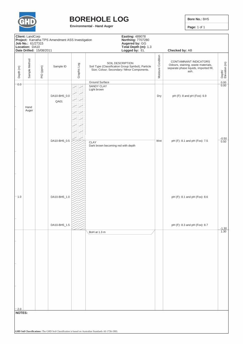
BOREHOLE LOGEnvironmental - Hand Auger
Bore No.:
Page: 1 of 1
Client:Project:Job No.:Location:Date Drilled:
Total Depth (m):
Easting:Northing:Augered by:
Logged by: Checked by:
NOTES:
Dep
th (m
)
0.0
1.0
2.0
Sam
ple
Met
hod
PID
(ppm
) Sample ID
Gra
phic
Log
SOIL DESCRIPTIONSoil Type (Classification Group Symbol); Particle
Size; Colour; Secondary / Minor Components.
Moi
stur
e C
ondi
tion
CONTAMINANT INDICATORSOdours, staining, waste materials,
separate phase liquids, imported fill,ash.
Dep
th/
Elev
atio
n (m
)
GHD Soil Classifications: The GHD Soil Classification is based on Australian Standards AS 1726-1993.
BH5
LandCorpKarratha TPS Amendment ASS Investigation61/27315DA10
15/08/20111.3
4890787707280
GG
EL AB
HandAuger
DA10-BH5_0.0
QA01
DA10-BH5_0.5
DA10-BH5_1.0
DA10-BH5_1.5
Ground SurfaceSANDY CLAYLight brown
CLAYDark brown becoming red with depth
BoH at 1.3 m
Dry
Wet
pH (F): 8 and pH (Fox): 6.9
pH (F): 8.1 and pH (Fox): 7.5
pH (F): 8.1 and pH (Fox): 8.6
pH (F): 8.3 and pH (Fox): 8.7
0.000.00
-0.500.50
-1.301.30
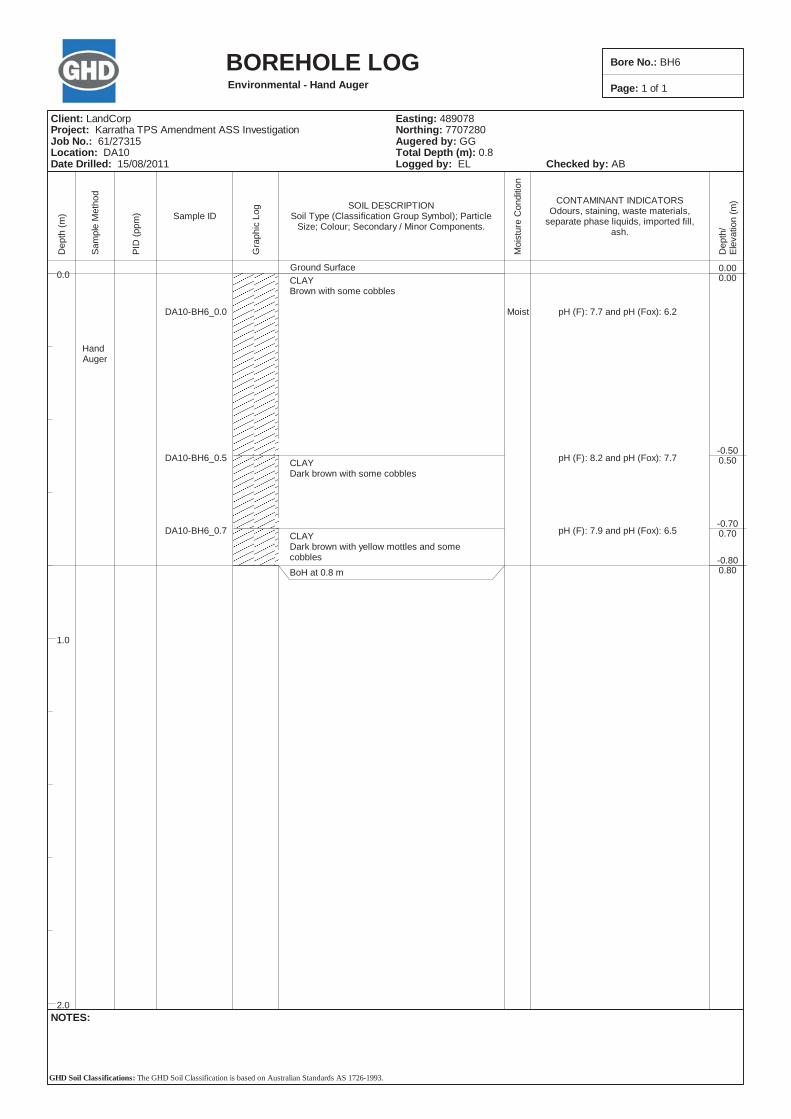
BOREHOLE LOGEnvironmental - Hand Auger
Bore No.:
Page: 1 of 1
Client:Project:Job No.:Location:Date Drilled:
Total Depth (m):
Easting:Northing:Augered by:
Logged by: Checked by:
NOTES:
Dep
th (m
)
0.0
1.0
2.0
Sam
ple
Met
hod
PID
(ppm
) Sample ID
Gra
phic
Log
SOIL DESCRIPTIONSoil Type (Classification Group Symbol); Particle
Size; Colour; Secondary / Minor Components.
Moi
stur
e C
ondi
tion
CONTAMINANT INDICATORSOdours, staining, waste materials,
separate phase liquids, imported fill,ash.
Dep
th/
Elev
atio
n (m
)
GHD Soil Classifications: The GHD Soil Classification is based on Australian Standards AS 1726-1993.
BH6
LandCorpKarratha TPS Amendment ASS Investigation61/27315DA10
15/08/20110.8
4890787707280
GG
EL AB
HandAuger
DA10-BH6_0.0
DA10-BH6_0.5
DA10-BH6_0.7
Ground SurfaceCLAYBrown with some cobbles
CLAYDark brown with some cobbles
CLAYDark brown with yellow mottles and somecobblesBoH at 0.8 m
Moist pH (F): 7.7 and pH (Fox): 6.2
pH (F): 8.2 and pH (Fox): 7.7
pH (F): 7.9 and pH (Fox): 6.5
0.000.00
-0.500.50
-0.700.70
-0.800.80

BOREHOLE LOGEnvironmental - Hand Auger
Bore No.:
Page: 1 of 1
Client:Project:Job No.:Location:Date Drilled:
Total Depth (m):
Easting:Northing:Augered by:
Logged by: Checked by:
NOTES:
Dep
th (m
)
0.0
1.0
2.0
Sam
ple
Met
hod
PID
(ppm
) Sample ID
Gra
phic
Log
SOIL DESCRIPTIONSoil Type (Classification Group Symbol); Particle
Size; Colour; Secondary / Minor Components.
Moi
stur
e C
ondi
tion
CONTAMINANT INDICATORSOdours, staining, waste materials,
separate phase liquids, imported fill,ash.
Dep
th/
Elev
atio
n (m
)
GHD Soil Classifications: The GHD Soil Classification is based on Australian Standards AS 1726-1993.
BH7
LandCorpKarratha TPS Amendment ASS Investigation61/27315DA10
15/08/20110.5
4877977707512
GG
EL AB
HandAuger
DA10-BH7_0.0
DA10-BH7_0.5
Ground SurfaceSANDBrown/orange with some cobbles
BoH at 0.5 m
Dry pH (F): 8.7 and pH (Fox): 8.3
pH (F): 8.5 and pH (Fox): 8
0.000.00
-0.500.50

BOREHOLE LOGEnvironmental - Hand Auger
Bore No.:
Page: 1 of 1
Client:Project:Job No.:Location:Date Drilled:
Total Depth (m):
Easting:Northing:Augered by:
Logged by: Checked by:
NOTES:
Dep
th (m
)
0.0
1.0
2.0
3.0
Sam
ple
Met
hod
PID
(ppm
) Sample ID
Gra
phic
Log
SOIL DESCRIPTIONSoil Type (Classification Group Symbol); Particle
Size; Colour; Secondary / Minor Components.
Moi
stur
e C
ondi
tion
CONTAMINANT INDICATORSOdours, staining, waste materials,
separate phase liquids, imported fill,ash.
Dep
th/
Elev
atio
n (m
)
GHD Soil Classifications: The GHD Soil Classification is based on Australian Standards AS 1726-1993.
BH8
LandCorpKarratha TPS Amendment ASS Investigation61/27315DA26
16/08/20112.5
4780577706851
GG
EL AB
HandAuger
DA26-BH8_0.0
DA26-BH8_0.5
DA26-BH8_1.0
DA26-BH8_1.5
DA26-BH8_2.0
DA26-BH8_2.5
Ground SurfaceCLAY (GILGAI)Brown with some cobbles
BoH at 2.5 m
Dry
Moist
pH (F):7.8 and pH (Fox): 6.5
pH (F):8.4 and pH (Fox): 8
pH (F):7.8 and pH (Fox): 8
pH (F): 7.8 and pH (Fox): 8
pH (F): 7.7 and pH (Fox): 8.2
pH (F): 7.6 and pH (Fox): 7.3
0.000.00
-2.502.50
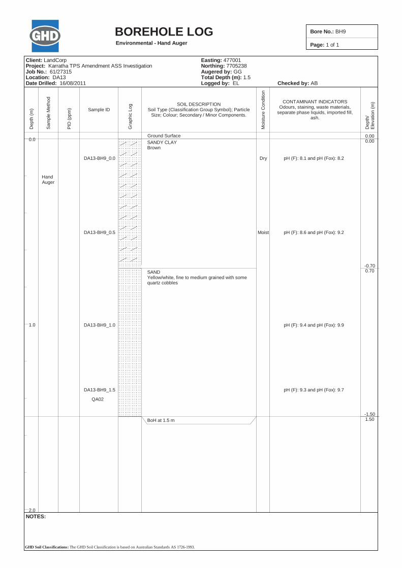
BOREHOLE LOGEnvironmental - Hand Auger
Bore No.:
Page: 1 of 1
Client:Project:Job No.:Location:Date Drilled:
Total Depth (m):
Easting:Northing:Augered by:
Logged by: Checked by:
NOTES:
Dep
th (m
)
0.0
1.0
2.0
Sam
ple
Met
hod
PID
(ppm
) Sample ID
Gra
phic
Log
SOIL DESCRIPTIONSoil Type (Classification Group Symbol); Particle
Size; Colour; Secondary / Minor Components.
Moi
stur
e C
ondi
tion
CONTAMINANT INDICATORSOdours, staining, waste materials,
separate phase liquids, imported fill,ash.
Dep
th/
Elev
atio
n (m
)
GHD Soil Classifications: The GHD Soil Classification is based on Australian Standards AS 1726-1993.
BH9
LandCorpKarratha TPS Amendment ASS Investigation61/27315DA13
16/08/20111.5
4770017705238
GG
EL AB
HandAuger
DA13-BH9_0.0
DA13-BH9_0.5
DA13-BH9_1.0
DA13-BH9_1.5
QA02
Ground SurfaceSANDY CLAYBrown
SANDYellow/white, fine to medium grained with somequartz cobbles
BoH at 1.5 m
Dry
Moist
pH (F): 8.1 and pH (Fox): 8.2
pH (F): 8.6 and pH (Fox): 9.2
pH (F): 9.4 and pH (Fox): 9.9
pH (F): 9.3 and pH (Fox): 9.7
0.000.00
-0.700.70
-1.501.50

BOREHOLE LOGEnvironmental - Hand Auger
Bore No.:
Page: 1 of 1
Client:Project:Job No.:Location:Date Drilled:
Total Depth (m):
Easting:Northing:Augered by:
Logged by: Checked by:
NOTES:
Dep
th (m
)
0.0
1.0
2.0
Sam
ple
Met
hod
PID
(ppm
) Sample ID
Gra
phic
Log
SOIL DESCRIPTIONSoil Type (Classification Group Symbol); Particle
Size; Colour; Secondary / Minor Components.
Moi
stur
e C
ondi
tion
CONTAMINANT INDICATORSOdours, staining, waste materials,
separate phase liquids, imported fill,ash.
Dep
th/
Elev
atio
n (m
)
GHD Soil Classifications: The GHD Soil Classification is based on Australian Standards AS 1726-1993.
BH10
LandCorpKarratha TPS Amendment ASS Investigation61/27315DA15
16/08/20110.5
4809997703011
GG
EL AB
HandAuger
DA15_BH10_0.0
DA15_BH10_0.5
Ground SurfaceCLAY LOAMBrown/orange
CLAY LOAMBrown
BoH at 0.5 m
Dry pH (F): 7.2 and pH (Fox): 6.9
pH (F): 7.9 and pH (Fox): 7.4
0.000.00
-0.100.10
-0.500.50

BOREHOLE LOGEnvironmental - Hand Auger
Bore No.:
Page: 1 of 1
Client:Project:Job No.:Location:Date Drilled:
Total Depth (m):
Easting:Northing:Augered by:
Logged by: Checked by:
NOTES:
Dep
th (m
)
0.0
1.0
2.0
Sam
ple
Met
hod
PID
(ppm
) Sample ID
Gra
phic
Log
SOIL DESCRIPTIONSoil Type (Classification Group Symbol); Particle
Size; Colour; Secondary / Minor Components.
Moi
stur
e C
ondi
tion
CONTAMINANT INDICATORSOdours, staining, waste materials,
separate phase liquids, imported fill,ash.
Dep
th/
Elev
atio
n (m
)
GHD Soil Classifications: The GHD Soil Classification is based on Australian Standards AS 1726-1993.
BH11
LandCorpKarratha TPS Amendment ASS Investigation61/27315DA15
16/08/20110.5
4810097701537
GG
EL AB
HandAuger
DA15-BH11_0.0
DA15-BH11_0.5
Ground SurfaceCLAY LOAMBrown/orange
CLAY LOAMBrown
BoH at 0.5 m
Dry pH (F): 6.6 and pH (Fox): 6.4
pH (F): 6.3 and pH (Fox): 5.9
0.000.00
-0.100.10
-0.500.50

BOREHOLE LOGEnvironmental - Hand Auger
Bore No.:
Page: 1 of 1
Client:Project:Job No.:Location:Date Drilled:
Total Depth (m):
Easting:Northing:Augered by:
Logged by: Checked by:
NOTES:
Dep
th (m
)
0.0
1.0
2.0
Sam
ple
Met
hod
PID
(ppm
) Sample ID
Gra
phic
Log
SOIL DESCRIPTIONSoil Type (Classification Group Symbol); Particle
Size; Colour; Secondary / Minor Components.
Moi
stur
e C
ondi
tion
CONTAMINANT INDICATORSOdours, staining, waste materials,
separate phase liquids, imported fill,ash.
Dep
th/
Elev
atio
n (m
)
GHD Soil Classifications: The GHD Soil Classification is based on Australian Standards AS 1726-1993.
BH12
LandCorpKarratha TPS Amendment ASS Investigation61/27315DA14
16/08/20110.5
4794077703617
GG
EL AB
HandAuger
DA14-BH12_0.0
DA14-BH12_0.5
Ground SurfaceLOAMBrown/orange
LOAMBrown with some cobbles
BoH at 0.5 m
Dry pH (F): 7.9 and pH (Fox): 6.9
pH (F): 8.4 and pH (Fox): 8
0.000.00
-0.100.10
-0.500.50
61/27315/114567 Karratha TPS No 8. AmendmentPreliminary Acid Sulfate Soil Investigation
Appendix C
Laboratory Certificates


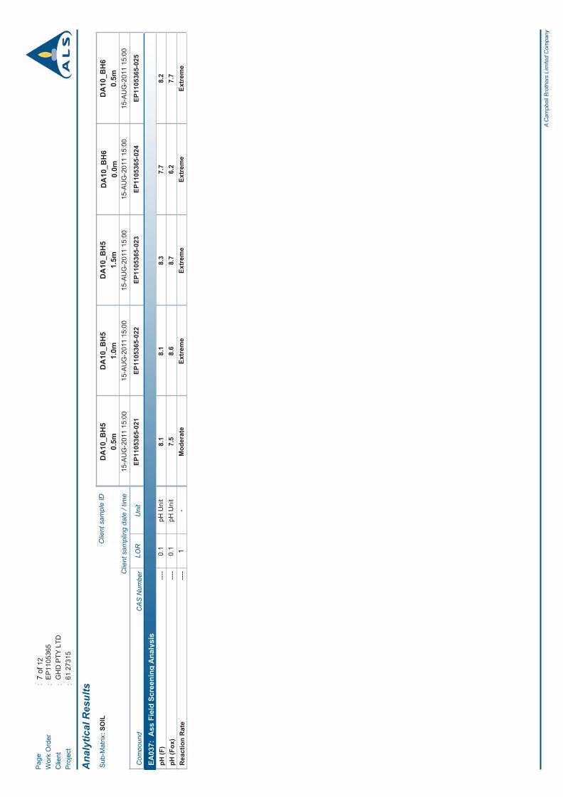
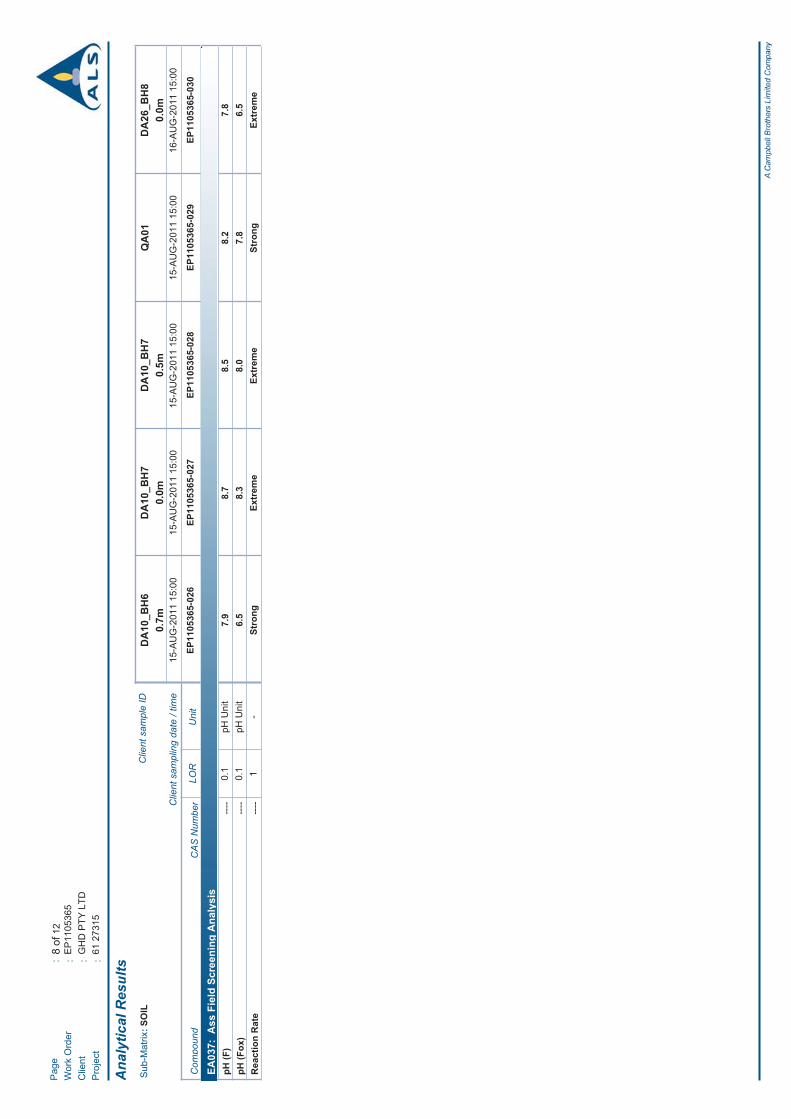

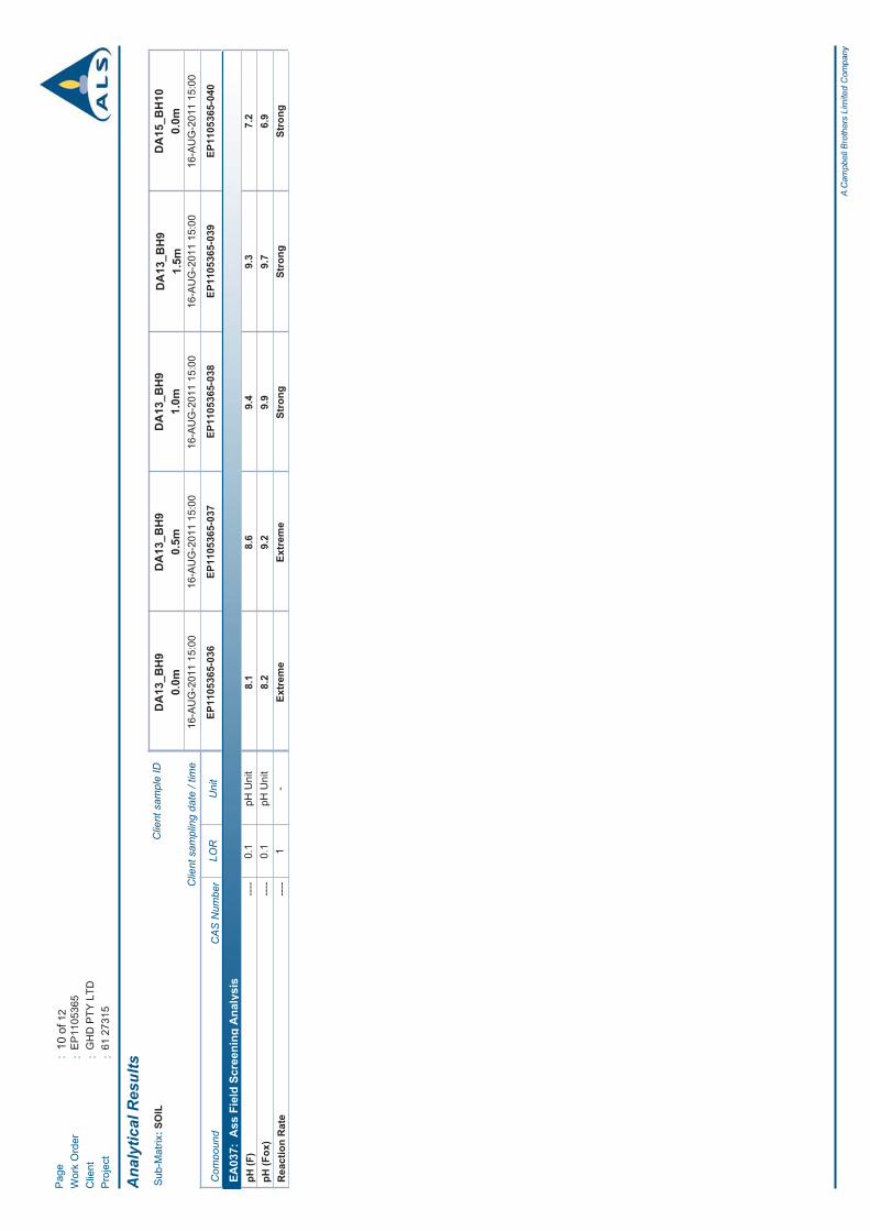


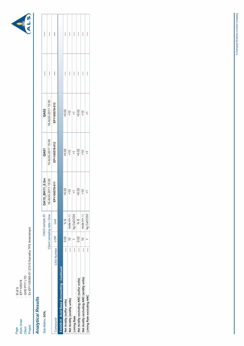

61/27315/114567 Karratha TPS No 8. AmendmentPreliminary Acid Sulfate Soil Investigation
Appendix D
Acid Sulfate Soil Summary Table

ANC
-m
ol H
+/t
% S
mol
H+
/t0.
10.
10.
1-
0.1
0.1
0.1
22
25
0.00
50.
005
0.00
50.
005
0.00
55
0.02
104
4 2
- 4
4 2
18.
7 1
8.7
18.
7 1
8.7
0.0
3 0
.03
0.0
3 0
.03
0.0
3N
A 0
.03
18.
7D
A28_
BH1
0.0
7.1
6.8
0.3
Extre
me
--
--
--
--
--
--
--
-D
A28_
BH1
0.5
7.9
7.4
0.5
Extre
me
--
--
--
--
--
--
--
-D
A28_
BH1
1.0
0.7-
1.0
Red
-bro
wn
SAN
DY
CLA
Y7.
77.
10.
6Ex
trem
e8.
59.
3-0
.8<2
<2<2
<5<0
.005
<0.0
05<0
.005
0.00
6-
629
<0.0
2<1
0D
A28_
BH2
0.0
0.0-
0.2
Ligh
t bro
wn
SILT
Y C
LAY
8.2
7.6
0.6
Stro
ng-
--
--
--
--
--
--
--
DA2
8_BH
20.
50.
2-1.
0Br
own
CLA
Y8.
28.
20.
0St
rong
--
--
--
--
--
--
--
-D
A28_
BH2
1.0
8.2
7.7
0.5
Mod
erat
e9.
310
.0-0
.7<2
<2<2
9<0
.005
<0.0
05<0
.005
0.01
-81
60<0
.02
<10
DA2
8_BH
21.
58.
28.
5-0
.3Ex
trem
e-
--
--
--
--
--
--
--
DA2
8_BH
22.
08.
18.
4-0
.3St
rong
--
--
--
--
--
--
--
-D
A10_
BH3
0.0
0.0-
0.2
Ligh
t ora
nge-
brow
nSA
ND
8.9
6.9
2.0
Mod
erat
e-
--
--
--
--
--
--
--
DA1
0_BH
30.
59.
28.
01.
2M
oder
ate
--
--
--
--
--
--
--
-D
A10_
BH3
1.0
9.4
8.6
0.8
Mod
erat
e-
--
--
--
--
--
--
--
DA1
0_BH
31.
59.
49.
9-0
.5Ex
trem
e-
--
--
--
--
--
--
--
DA1
0_BH
32.
09.
510
.1-0
.6Ex
trem
e-
--
--
--
--
--
--
--
DA1
0_BH
32.
59.
48.
70.
7M
oder
ate
9.5
10.2
-0.7
<2<2
<212
<0.0
05<0
.005
<0.0
050.
02-
7960
<0.0
212
DA1
0_BH
40.
00.
0-0.
7Li
ght g
rey-
brow
nSA
ND
, som
e sh
ells
8.7
6.8
1.9
Slig
ht-
--
--
--
--
--
--
--
DA1
0_BH
40.
58.
56.
71.
8Sl
ight
--
--
--
--
--
--
--
-D
A10_
BH4
1.0
8.8
6.8
2.0
Slig
ht9.
89.
50.
3<2
<2<2
28<0
.005
<0.0
05<0
.005
0.04
-54
600.
0428
DA1
0_BH
41.
58.
86.
91.
9Sl
ight
--
--
--
--
--
--
--
-D
A10_
BH4
2.0
8.2
6.9
1.3
Slig
ht9.
88.
90.
9<2
<2<2
24<0
.005
<0.0
05<0
.005
0.04
-70
500.
0424
DA1
0_BH
50.
00.
0-0.
2Li
ght b
row
nSA
ND
Y C
LAY
8.0
6.9
1.1
Mod
erat
e9.
18.
80.
3<2
<2<2
<5<0
.005
<0.0
05<0
.005
<0.0
05-
967
<0.0
2<1
0D
A10_
BH5
0.5
8.1
7.5
0.6
Mod
erat
e-
--
--
--
--
--
--
--
DA1
0_BH
51.
08.
18.
6-0
.5Ex
trem
e-
--
--
--
--
--
--
--
DA1
0_BH
51.
58.
38.
7-0
.4Ex
trem
e-
--
--
--
--
--
--
--
DA1
0_BH
60.
00.
0-0.
1Br
own
CLA
Y, s
ome
smal
l gra
vel
7.7
6.2
1.5
Extre
me
--
--
--
--
--
--
--
-D
A10_
BH6
0.5
8.2
7.7
0.5
Extre
me
--
--
--
--
--
--
--
-D
A10_
BH6
0.7
7.9
6.5
1.4
Stro
ng9.
39.
00.
3<2
<2<2
10<0
.005
<0.0
05<0
.005
0.02
-95
60<0
.02
10D
A10_
BH7
0.0
8.7
8.3
0.4
Extre
me
--
--
--
--
--
--
--
-D
A10_
BH7
0.5
8.5
8.0
0.5
Extre
me
--
--
--
--
--
--
--
-D
A26_
BH8
0.0
0.0-
0.2
Brow
nG
RAV
ELLY
CLA
Y, h
ard,
cra
ckin
g7.
86.
51.
3Ex
trem
e-
--
--
--
--
--
--
--
DA2
6_BH
80.
50.
2-1.
0Br
own
CLA
Y, s
ome
grav
el8.
48.
00.
4Ex
trem
e-
--
--
--
--
--
--
--
DA2
6_BH
81.
01.
0-1.
5Br
own
CLA
Y, s
ome
smal
l gra
vel
7.8
8.0
-0.2
Extre
me
--
--
--
--
--
--
--
-D
A26_
BH8
1.5
1.5-
2.0
Brow
nC
LAY
7.8
8.0
-0.2
Stro
ng-
--
--
--
--
--
--
--
DA2
6_BH
82.
07.
78.
2-0
.5St
rong
--
--
--
--
--
--
--
-D
A26_
BH8
2.5
7.6
7.3
0.3
Extre
me
9.2
8.9
0.3
<2<2
<2<5
<0.0
05<0
.005
<0.0
05<0
.005
-10
30<0
.02
<10
DA1
3_BH
90.
00.
0-0.
7Br
own
SAN
DY
CLA
Y8.
18.
2-0
.1Ex
trem
e-
--
--
--
--
--
--
--
DA1
3_BH
90.
58.
69.
2-0
.6Ex
trem
e-
--
--
--
--
--
--
--
DA1
3_BH
91.
09.
49.
9-0
.5St
rong
--
--
--
--
--
--
--
-D
A13_
BH9
1.5
9.3
9.7
-0.4
Stro
ng8.
99.
4-0
.5<2
<2<2
<5<0
.005
<0.0
05<0
.005
0.00
7-
610
<0.0
2<1
0D
A15_
BH10
0.0
0.0-
0.1
Ora
nge-
brow
nC
LAYE
Y LO
AM7.
26.
90.
3St
rong
--
--
--
--
--
--
--
-D
A15_
BH10
0.5
0.1-
0.5
Brow
nC
LAYE
Y LO
AM7.
97.
40.
5Ex
trem
e9.
510
.0-0
.5<2
<2<2
14<0
.005
<0.0
05<0
.005
0.02
-90
800.
0214
DA1
5_BH
110.
06.
66.
40.
2Ex
trem
e-
--
--
--
--
--
--
--
DA1
5_BH
110.
56.
35.
90.
4Sl
ight
8.7
8.9
-0.2
<2<2
<2<5
<0.0
05<0
.005
<0.0
05<0
.005
-20
4<0
.02
<10
DA1
4_BH
120.
07.
96.
91.
0Ex
trem
e-
--
--
--
--
--
--
--
DA1
4_BH
120.
58.
48.
00.
4Ex
trem
e-
--
--
--
--
--
--
--
Lab
pH
pH U
nit
pHKCl
Fiel
d Te
st R
esul
ts
Reaction
pHFOX
pH
pHOX
% S
mol
e H
+/ t
TSA
POS
Cal
cula
tions
TPA
s-TAA
SPOS
Sulfu
r Tra
ilAc
idity
Tra
il
TAA
NetAcidity
ANC
NetAcidity
s-TPA
s-TSA
SCr
pH
FieldTexture
Location
Sample Depth(m BGL)
SoilColour
Soil HorizonBoundary (mBGL)
pHF
GroundwaterLevel
pH U
nit
Lith
olog
y
2.0-
0.2-
2.5
Brow
nSA
ND
-
0.0-
0.7
Red
-bro
wn
CLA
Y
1.0-
2.0
Brow
nG
RAV
ELLY
CLA
Y, a
ngul
ar g
rave
l
2.0
0.7-
2.0
Ora
nge-
brow
nSA
ND
, som
e sh
ells
1.3
0.2-
1.3
Dar
k br
own-
red
CLA
Y
-
0.0-
1.0
Ora
nge-
brow
nSA
ND
, som
e sm
all g
rave
l-
0.1-
0.8
Dar
k br
own-
red
CLA
Y, s
ome
med
ium
-siz
ed g
rave
l
- -0.
7-1.
5Ye
llow
-whi
teSA
ND
, som
e sm
all q
uartz
rock
s
Kar
rath
a TP
S N
o. 8
Am
endm
ent P
roje
ct
Acid
Sul
fate
Soi
l Sum
mar
y Ta
ble
Job
num
ber:
61/
2731
5
0.0-
0.5
Brow
n-or
ange
LOAM
--
0.0-
0.5
Ora
nge-
brow
nC
LAYE
Y LO
AM-
2.0-
2.5
Brow
nC
LAY,
som
e sm
all g
rave
l
1 of
1

61/27315/114567 Karratha TPS No 8. AmendmentPreliminary Acid Sulfate Soil Investigation
Appendix E
Quality Assurance and ControlDocumentation

pHF
pHFOX
pHKCl
pHOX
Net Acidity excludingANC (acidity units)
pH U
nit
pH U
nit
pH U
nit
pH U
nit
mol
(H+/
t)
DA1
0_BH
5_0.
015
/08/
2011
86.
99.
18.
8<1
0Q
A01
15/0
8/20
118.
27.
88.
58.
9<1
02.
512
.26.
81.
1<L
OR
DA1
3_BH
9_1.
516
/08/
2011
9.3
9.7
8.9
9.4
<10
QA0
216
/08/
2011
9.2
9.6
9.4
10.5
<10
1.1
1.0
5.5
11.1
<LO
R
RPD
Val
ues
Exce
eds
50%
RPD
Exce
eds
50%
RPD
, les
s th
an 1
0x L
OR
Sam
plin
g D
etai
ls
RPD
%
RPD
%
Job
Num
ber:
61/
2731
5
Soil
Res
ults
Rel
ativ
e Pe
rcen
tage
Diff
eren
ce (R
PD) S
oil T
able
Kar
rath
a TP
S A
men
dmen
t ASS
Inve
stig
atio
n
Sample ID
Date Analysed