Embed Size (px)
Citation preview
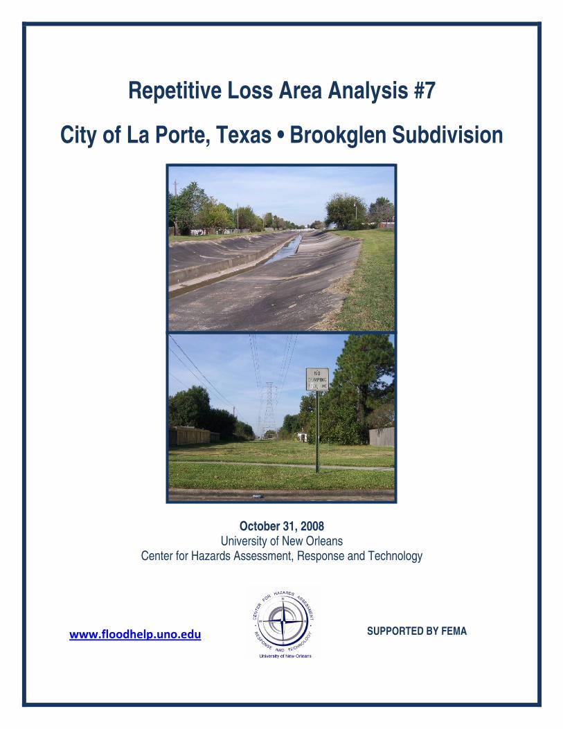
Repetitive Loss Area Analysis #7
City of La Porte, Texas • Brookglen Subdivision
October 31, 2008 University of New Orleans
Center for Hazards Assessment, Response and Technology
www.floodhelp.uno.edu
SUPPORTED BY FEMA
Terminology
Area Analysis: An approach to identify repetitive flood loss areas, evaluate mitigation approaches, and determine the most appropriate alternatives to reduce future repetitive flood losses.
BFE: Base Flood Elevation: The elevation of the crest of the base flood or 100-year flood. CHART: Center for Hazards Assessment, Response and Technology at the University
of New Orleans FEMA: Federal Emergency Management Agency
FIRM: Flood Insurance Rate Map Floodway: The channel of a stream, plus any adjacent floodplain areas, that must be
kept free of encroachment so that the 1-percent flood can be carried without substantial increases in flood heights.
Freeboard: A factor of safety usually expressed in feet above a flood level for purposes of floodplain management. GIS: Geographic Information Systems Hazard Mitigation: Any sustained action taken to reduce or eliminate long-term risk to
life and property from a hazard event. HCFCD: Harris County Flood Control District ICC: Increased Cost of Compliance NFIP: National Flood Insurance Program Repetitive Flood Loss (RL): An NFIP-insured property where two or more claim
payments of more than $1,000 have been paid within a 10-year period since 1978.
Severe Repetitive Flood Loss Properties (SRL): As defined by the Flood Insurance Reform Act of 2004, 1-4 family residences that have had four or more claims of more than $5,000 or two claims that cumulatively exceed the reported building’s value. The Act creates new funding mechanisms to help mitigate flood damage for these properties.
Substantial Improvement: The repair, reconstruction, or improvement of a structure,
the cost of which equals or exceeds 50% of the market value of the structure either, (1) before the improvement or repair is started, or (2) if the structure has been damaged and is being restored, before the damage occurred
Table of Contents
Background ............................................................................................................................1
The Process ...........................................................................................................................2
Preliminary Step: Select the Area .........................................................................................3
Step 1: Advise the Homeowners ...........................................................................................5
Step 2: Data Collection ..........................................................................................................5
I. Mitigation Plans .............................................................................................................6
II. Flood Insurance Data.....................................................................................................7
III. Drainage Information ...................................................................................................9
IV. Flooding Experiences of Homeowners.........................................................................12
V. On-Site Data Collection .................................................................................................14
Problem Statement ...........................................................................................................15
Step 3: Mitigation Measures .................................................................................................16
I. Drainage Improvements.................................................................................................16
II. Acquisition .....................................................................................................................17
III. Elevation .......................................................................................................................18
IV. Barriers to Flood Waters ..............................................................................................19
V. Dry Floodproofing .........................................................................................................21
VI. Development Regulations that Reduce Flood Risk ......................................................23
VII. Flood Insurance...........................................................................................................24
VIII. Funding for Mitigation Projects .................................................................................26
Step 4: Coordination ..............................................................................................................27
Step 5: Findings and Recommendations ...............................................................................28
I. Findings...........................................................................................................................28
II. Recommendations.........................................................................................................29
Appendix A: Letter from the City ...........................................................................................32
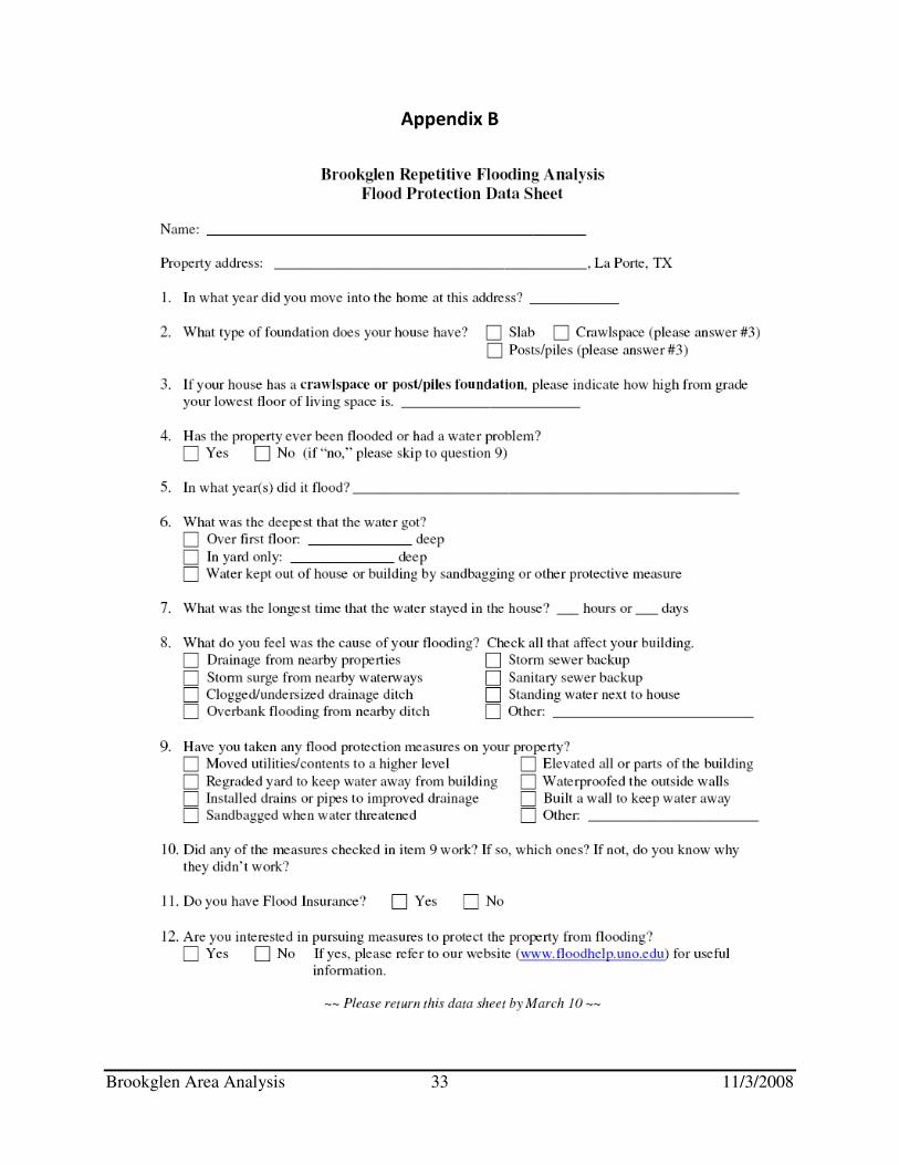
Appendix B: Residents Data Sheet.........................................................................................33
Appendix C: Mitigation Funding ............................................................................................34
List of Figures
Figure Page Figure 1-1 City of La Porte 4
Figure 1-2 Repetitive Flood Loss Analysis Area 5
Figure 1-3 A Typical Brookglen Home 3
Figure 2-1 Analysis Area Flood Zones 7
Figure 2-2 West Plantation Ditch 10
Figure 2-3 Willow Springs Bayou 10
Figure 2-4 Willow Springs Bayou 10
Figure 2-5 Willow Springs Bayou – South of Fairmont Pkwy. 10
Figure 2-6 1993 Drainage Project Area 11
Figure 2-7 Spencer Highway, 2008 14
Figure 3-1 Sheet Flow Path 17
Figure 3-2 An Elevated Slab House 18
Figure 3-3 Floodwall 19
Figure 3-4 Floodwall 19
Figure 3-5 Soils Map 20
Figure 3-6 Dry Floodproofed House 22
Figure 3-7 Dry Floodproofed House 23
Figure 3-8 Door Sealant for Dry Floodproofed House 23
Figure 3-9 Dry Floodproofed Commercial Building 23
Figure 3-10 Window Sealant for Dry Floodproofed House 23
List of Tables
Table Page Table 2-1 Claims Data for Repetitive Flood Loss Properties in Study Area 8
Table 2-2 Data Sheet Results 13
Table 2-3 Windshield Data 15
Table 3-1 Floodwall Cost Estimate 21
Table 3-2 Example NFIP Flood Insurance Premium 25
Table 3-3 Summary of Alternative Mitigation Measures 26
Acknowledgements: The compilation of this report was managed by Sarah Markway Stack, MPA, a CHART Research Associate; Maggie Olivier, a CHART Graduate Research Assistant and a Masters student in Sociology at the University of New Orleans; and Iman Adeinat a CHART Graduate Research Assistant and a Doctoral student in Engineering Management at the University of New Orleans. Contributing to this report were several City of La Porte offices including the Office of Emergency Management, especially Jeff Suggs; Drainage Department, GIS Department, La Porte City Council Flood Committee, specifically Chuck Engelken and Mike Mosteit; the Harris County Flood Control District; and the Texas State Water Development Board. For more information regarding this area analysis, contact: Sarah Markway Stack, MPA Research Associate, CHART The University of New Orleans New Orleans, LA 70148 504.280.1404 [email protected]

Brookglen Area Analysis 1 11/3/2008
Repetitive Flood Loss Area Analysis
Brookglen Neighborhood
La Porte, TX Flooding is a problem far too familiar to many neighborhoods across the United States. Enduring the consequences of flooding over and over again can be quite frustrating. When the water rises, life is disrupted, belongings are ruined, and hard-earned money is spent. This report has been created in collaboration with City of La Porte and Harris County officials, and the owners of homes in a repetitively flooded area who have continually suffered the personal losses and stresses associated with living in a flood-prone house. The goal is to help homeowners reduce their flood risk by providing a broader understanding of the flooding problems in their neighborhood, and the potential solutions to the continual suffering that results from repetitive flooding. The availability of possible funding sources for certain mitigation options is also discussed. Here, flooding issues and potential mitigation measures are discussed for homes located in the Brookglen neighborhood of La Porte, TX. Not all mitigation measures are appropriate for all homes; however, the homes in this study are quite homogeneous and are also representative of other homes throughout the region. It is understood that there are many stresses associated with repetitive flooding including worry about how high the water may rise, the loss of personal belongings, the possibility of mold, and whether or not neighbors will return after the next event. Adding to this worry is the uncertainty related to the potential solutions. Should I elevate and if so, how high? Should I pursue a buyout offer from the County? How much will a mitigation project cost? What will my neighborhood look like if I am the only one to mitigate, or the only one not to mitigate? Is there a solution that might work for the entire neighborhood? These questions are common, and this report attempts to answer them according to the specific situation faced by homeowners in the Brookglen neighborhood. Informed homeowners can become even stronger advocates for policy change at the neighborhood, city, county, state and even federal levels. Overall, it is hoped that by gaining a better understanding of the flooding issues, neighborhoods can become safer and homeowners better able to confront the hazard of flooding. Background The National Flood Insurance Program (NFIP) is continually faced with the task of paying claims while trying to keep the price of flood insurance at an affordable level. It has a particular problem with repetitive flood loss properties, which are estimated to cost $200 million per year in flood insurance claim payments. Repetitive flood loss properties represent only 1 percent of all flood insurance policies, yet historically they have accounted for nearly one-third of the claim payments (over $4.5 billion to date). Mitigation of these repetitive flood loss properties will reduce the overall costs to the NFIP as well as to the communities in which they are located and
Brookglen Area Analysis 2 11/3/2008
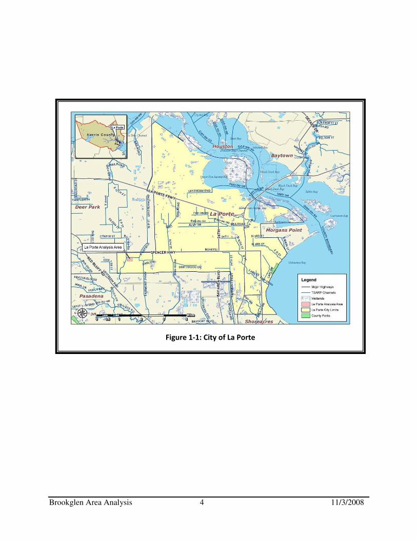
to individual homeowners. Ultimately, mitigating repetitive flood loss properties benefits all tax payers. The University of New Orleans’ Center for Hazards Assessment, Response and Technology (UNO – CHART) received a special grant from FEMA to collate data and analyze the repetitive flood loss areas in Louisiana and Texas. Using a geographic information system (GIS) and flood insurance claims data, repetitive flood loss areas and properties are being prioritized for attention and analysis. In selected locations where repetitive flooding is a problem, UNO-CHART works with local officials and residents to conduct in-depth analyses of the causes and possible solutions to the flooding problem. UNO-CHART conducted an “area analysis” case study in the Brookglen neighborhood (see Figures 1-1 and 1-2 on pages 3 and 4 for maps of the area). An area analysis follows FEMA guidelines to determine the why an area has repeated flood losses and what alternative flood protection measures would help break the cycle of repetitive flooding.
The Process
This area analysis follows a FEMA-prescribed five step process. However, the UNO-CHART Team has enhanced the five-step process by adding two important steps: a preliminary step (the area selection process) and a final step (ongoing collaboration with the neighborhood).
Preliminary Step. The area to be studied is selected through a review of the repetitive flood loss claims data as well as other relevant information about residents of the area such as their interest in flood mitigation. This is done through a collaborative effort with local officials and residents. Once a neighborhood is selected, a smaller subset of properties within the neighborhood is selected as the analysis area based on the aforementioned criteria, although the goal is to engage the entire neighborhood.
Step 1. Advise all the property owners in the repetitive flood loss area that the analysis will be conducted.
Step 2. Collect data on the analysis area and each building in the identified study area within the neighborhood to determine the cause(s) of the repetitive damage.
Step 3. Review alternative mitigation approaches and determine whether any property protection measures or drainage improvements are feasible.
Step 4. Contact agencies or organizations that may have plans that could affect the cause or impacts of the flooding.
Step 5. Document the findings, including information gathered from agencies and organizations, and relevant maps of the analysis area.
Ongoing Collaboration with the Neighborhood. UNO-CHART establishes an ongoing collaborative partnership with the study area community. The UNO-CHART role
Brookglen Area Analysis 3 11/3/2008
includes providing homeowners with information concerning mitigation measures, policy issues, or other flooding related matters as requested. UNO-CHART will also conduct a ‘follow-up’ with the community after a period of time has passed.
Preliminary Step: Select the Area In November 2007, after a careful review of the locations of repetitive flood loss properties throughout the State of Texas, a team from UNO-CHART visited the City of La Porte and met with several local officials. These local officials demonstrated their concern for the flooding problem. The City Council of La Porte has an active Flood Committee that reviews flooding related issues, and the City’s 2020 Comprehensive Plan addresses the flooding problem. It was determined at this time that because of the local commitment to floodplain management and the number of repetitive flood loss properties, the Brookglen neighborhood would be a good site for an area analysis.
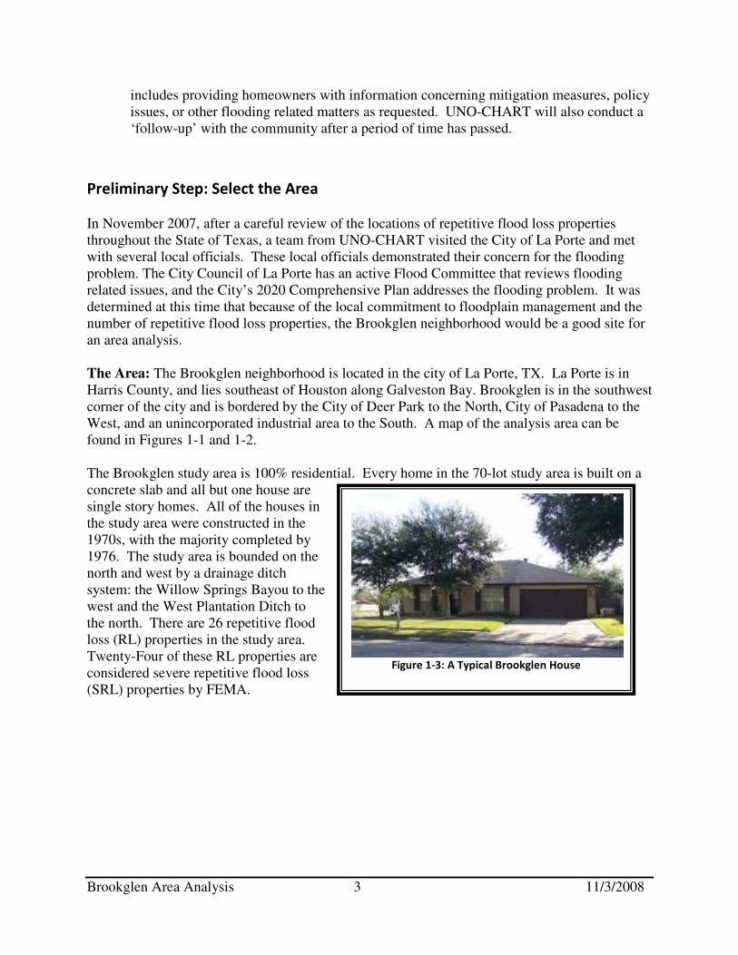
The Area: The Brookglen neighborhood is located in the city of La Porte, TX. La Porte is in Harris County, and lies southeast of Houston along Galveston Bay. Brookglen is in the southwest corner of the city and is bordered by the City of Deer Park to the North, City of Pasadena to the West, and an unincorporated industrial area to the South. A map of the analysis area can be found in Figures 1-1 and 1-2. The Brookglen study area is 100% residential. Every home in the 70-lot study area is built on a concrete slab and all but one house are single story homes. All of the houses in the study area were constructed in the 1970s, with the majority completed by 1976. The study area is bounded on the north and west by a drainage ditch system: the Willow Springs Bayou to the west and the West Plantation Ditch to the north. There are 26 repetitive flood loss (RL) properties in the study area. Twenty-Four of these RL properties are considered severe repetitive flood loss (SRL) properties by FEMA.
Figure 1-3: A Typical Brookglen House
Brookglen Area Analysis 4 11/3/2008
Figure 1-1: City of La Porte
Brookglen Area Analysis 5 11/3/2008
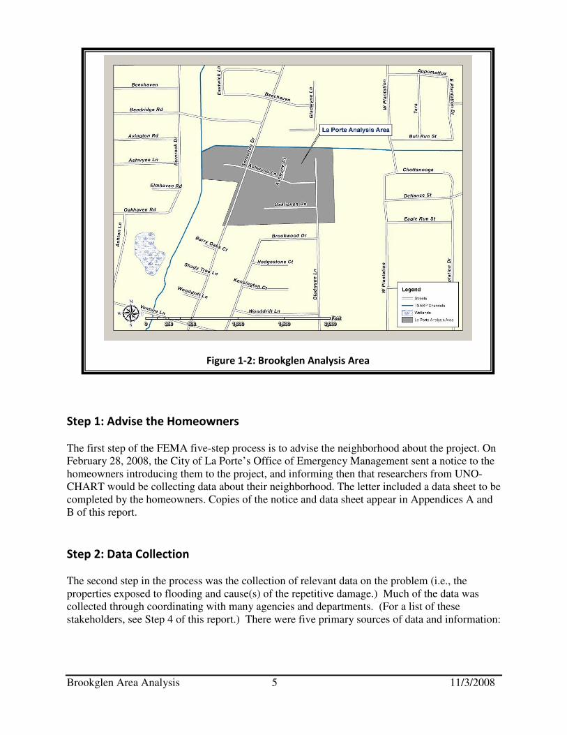
Step 1: Advise the Homeowners The first step of the FEMA five-step process is to advise the neighborhood about the project. On February 28, 2008, the City of La Porte’s Office of Emergency Management sent a notice to the homeowners introducing them to the project, and informing then that researchers from UNO-CHART would be collecting data about their neighborhood. The letter included a data sheet to be completed by the homeowners. Copies of the notice and data sheet appear in Appendices A and B of this report.
Step 2: Data Collection The second step in the process was the collection of relevant data on the problem (i.e., the properties exposed to flooding and cause(s) of the repetitive damage.) Much of the data was collected through coordinating with many agencies and departments. (For a list of these stakeholders, see Step 4 of this report.) There were five primary sources of data and information:
Figure 1-2: Brookglen Analysis Area

Brookglen Area Analysis 6 11/3/2008
I. Mitigation Plans II. Flood Insurance Data
III. Drainage Information IV. Flooding Experiences of Property Owners V. On-site Data Collection
I. Mitigation Plans
The UNO-CHART Team reviewed the following plans for information related to flooding in the study area:
A. La Porte 2020 Comprehensive Plan
B. Harris County All Hazard Mitigation Plan (Harris County, 10/02/2005)
A. La Porte 2020 Comprehensive Plan1: The City of La Porte completed a 20-year
comprehensive plan in 2005. The plan discusses the flooding hazard in Chapter 11. Chapter 11- Public Safety: Chapter 11, Public Safety, notes that the most devastating flood threat is storm surge from a hurricane or tropical storm. Heavy rains associated with tropical events, sometimes 20 to 30 inches, can overwhelm a drainage system. The storm surge from a category 5 hurricane could flood La Porte up to 10 feet deep. Although it is the greatest flood threat, this is not discussed as part of this repetitive flooding analysis since this area of La Porte has not experienced such a storm surge flood,
B. Harris County All Hazard Mitigation Plan2: The City of La Porte adopted the Harris
County All Hazard Mitigation Plan in April 2005. The flood hazard (flood, hurricanes and coastal storms, dam and levee failure) is identified, analyzed, and assessed in Sections 4.1, 4.2, and 4.3. According to the Plan, flooding is the greatest threat to Harris County due to numerous rivers and streams. In fact, flash flooding is common during a heavy rain event. One such instance of flash flooding that will live in the memory of residents of Texas’ east coast is Tropical Storm Allison. This historic storm occurred on June 5, 2001, and struck Harris County by surprise, as the storm only formed earlier that day. Allison dumped as much as 12 inches of rain in four hours on Harris County. The Port of Houston reported 37 inches of rain. Over 73,000 residences in Harris County were flooded, as were hundreds of businesses in the greater Houston area. Allison was responsible for 22 deaths in Harris County and a total of at least $5 billion in damage in the United States.
1 Copies of the La Porte 2020 Comprehensive Plan are available on the City of La Porte’s website: www.ci.la-porte.tx.us 2 Copies of the Harris County All Hazard Mitigation Plan are available from the La Porte office of Emergency Management
Brookglen Area Analysis 7 11/3/2008
II. Flood Insurance Data
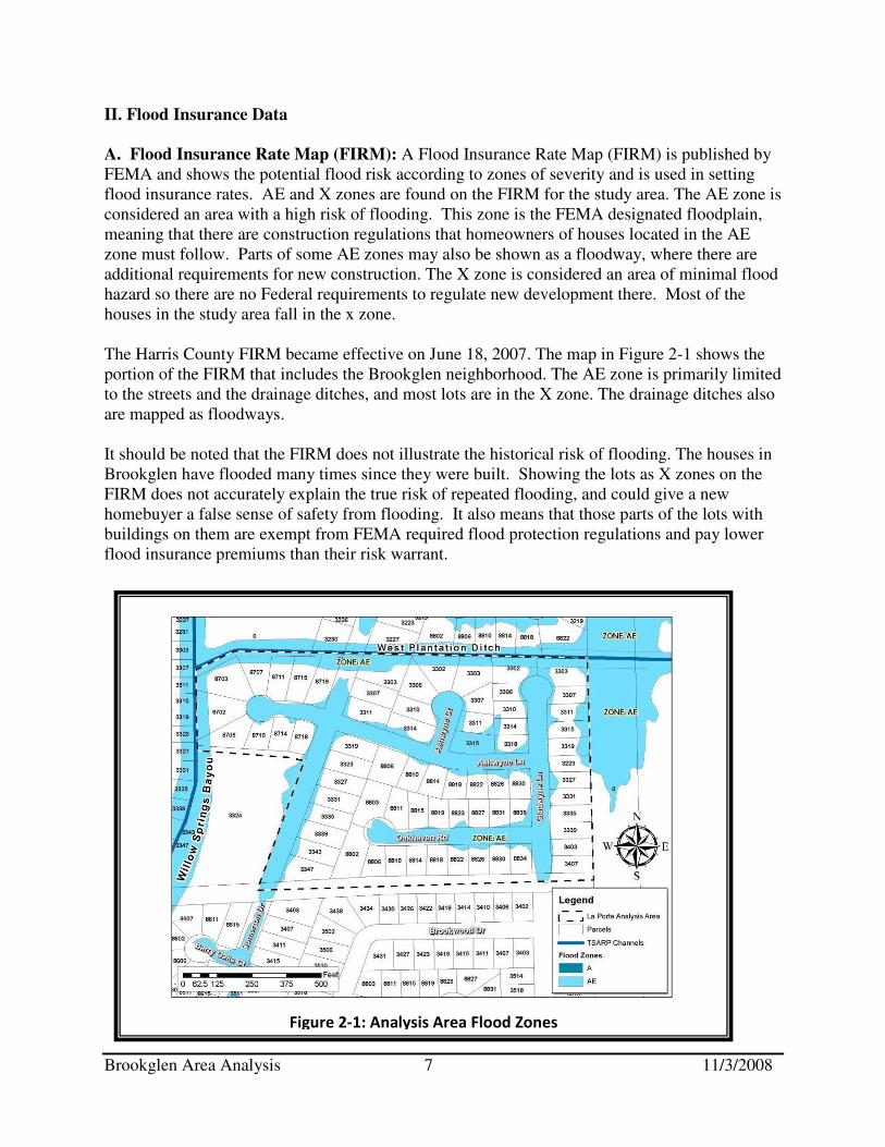
A. Flood Insurance Rate Map (FIRM): A Flood Insurance Rate Map (FIRM) is published by FEMA and shows the potential flood risk according to zones of severity and is used in setting flood insurance rates. AE and X zones are found on the FIRM for the study area. The AE zone is considered an area with a high risk of flooding. This zone is the FEMA designated floodplain, meaning that there are construction regulations that homeowners of houses located in the AE zone must follow. Parts of some AE zones may also be shown as a floodway, where there are additional requirements for new construction. The X zone is considered an area of minimal flood hazard so there are no Federal requirements to regulate new development there. Most of the houses in the study area fall in the x zone. The Harris County FIRM became effective on June 18, 2007. The map in Figure 2-1 shows the portion of the FIRM that includes the Brookglen neighborhood. The AE zone is primarily limited to the streets and the drainage ditches, and most lots are in the X zone. The drainage ditches also are mapped as floodways. It should be noted that the FIRM does not illustrate the historical risk of flooding. The houses in Brookglen have flooded many times since they were built. Showing the lots as X zones on the FIRM does not accurately explain the true risk of repeated flooding, and could give a new homebuyer a false sense of safety from flooding. It also means that those parts of the lots with buildings on them are exempt from FEMA required flood protection regulations and pay lower flood insurance premiums than their risk warrant.
Figure 2-1: Analysis Area Flood Zones
Brookglen Area Analysis 8 11/3/2008
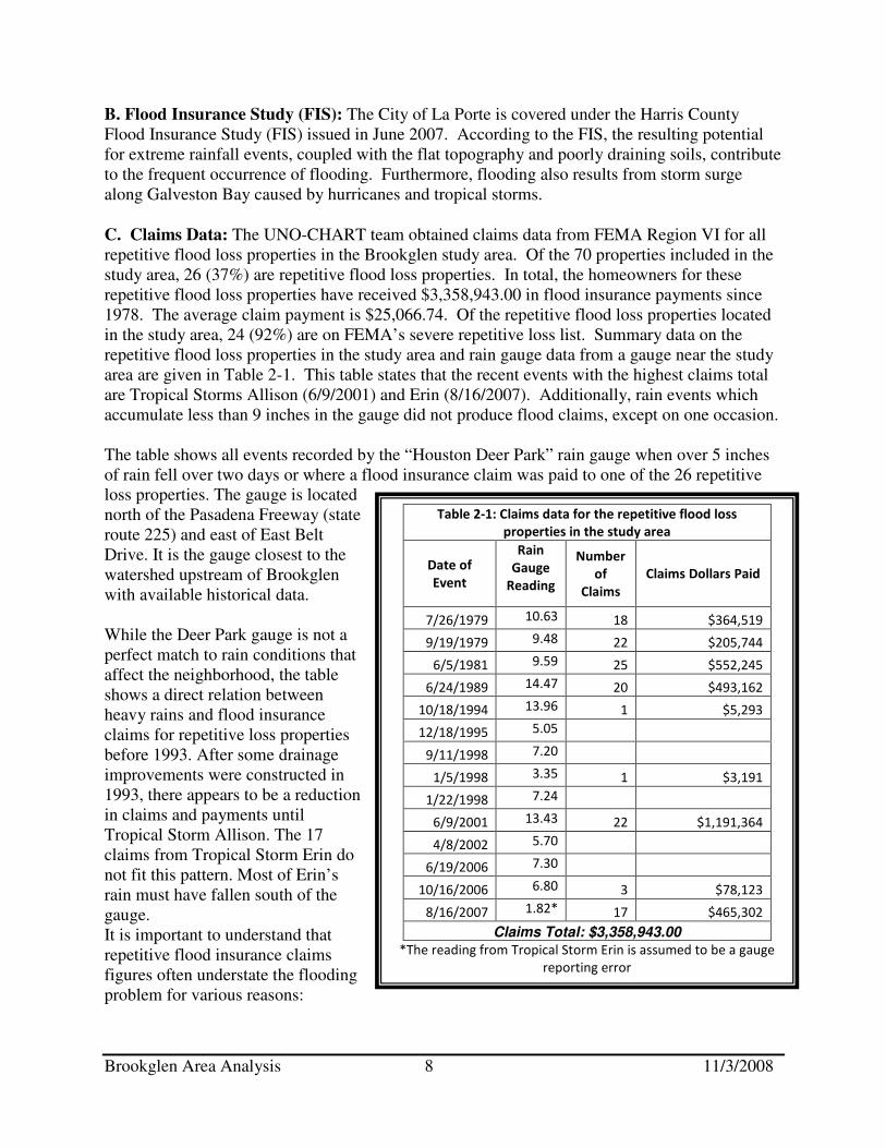
Table 2-1: Claims data for the repetitive flood loss
properties in the study area
Date of
Event
Rain
Gauge
Reading
Number
of
Claims
Claims Dollars Paid
7/26/1979 10.63 18 $364,519
9/19/1979 9.48 22 $205,744
6/5/1981 9.59 25 $552,245
6/24/1989 14.47 20 $493,162
10/18/1994 13.96 1 $5,293
12/18/1995 5.05
9/11/1998 7.20
1/5/1998 3.35 1 $3,191
1/22/1998 7.24
6/9/2001 13.43 22 $1,191,364
4/8/2002 5.70
6/19/2006 7.30
10/16/2006 6.80 3 $78,123
8/16/2007 1.82* 17 $465,302
Claims Total: $3,358,943.00
*The reading from Tropical Storm Erin is assumed to be a gauge
reporting error
B. Flood Insurance Study (FIS): The City of La Porte is covered under the Harris County Flood Insurance Study (FIS) issued in June 2007. According to the FIS, the resulting potential for extreme rainfall events, coupled with the flat topography and poorly draining soils, contribute to the frequent occurrence of flooding. Furthermore, flooding also results from storm surge along Galveston Bay caused by hurricanes and tropical storms.
C. Claims Data: The UNO-CHART team obtained claims data from FEMA Region VI for all repetitive flood loss properties in the Brookglen study area. Of the 70 properties included in the study area, 26 (37%) are repetitive flood loss properties. In total, the homeowners for these repetitive flood loss properties have received $3,358,943.00 in flood insurance payments since 1978. The average claim payment is $25,066.74. Of the repetitive flood loss properties located in the study area, 24 (92%) are on FEMA’s severe repetitive loss list. Summary data on the repetitive flood loss properties in the study area and rain gauge data from a gauge near the study area are given in Table 2-1. This table states that the recent events with the highest claims total are Tropical Storms Allison (6/9/2001) and Erin (8/16/2007). Additionally, rain events which accumulate less than 9 inches in the gauge did not produce flood claims, except on one occasion. The table shows all events recorded by the “Houston Deer Park” rain gauge when over 5 inches of rain fell over two days or where a flood insurance claim was paid to one of the 26 repetitive loss properties. The gauge is located north of the Pasadena Freeway (state route 225) and east of East Belt Drive. It is the gauge closest to the watershed upstream of Brookglen with available historical data. While the Deer Park gauge is not a perfect match to rain conditions that affect the neighborhood, the table shows a direct relation between heavy rains and flood insurance claims for repetitive loss properties before 1993. After some drainage improvements were constructed in 1993, there appears to be a reduction in claims and payments until Tropical Storm Allison. The 17 claims from Tropical Storm Erin do not fit this pattern. Most of Erin’s rain must have fallen south of the gauge. It is important to understand that repetitive flood insurance claims figures often understate the flooding problem for various reasons:

Brookglen Area Analysis 9 11/3/2008
1. Only data for the 26 repetitive flood loss properties were reviewed. There could be other properties that have been repetitively flooded, but did not submit claims. Additional, non-repetitive, flood insurance claims data were not available for the study area.
2. NFIP records do not include claims data from before 1978, so there could have been additional losses not included.
3. Policy holders may not have submitted claims for smaller floods for fear of it affecting their coverage or their premium rates.
4. The losses only account for items covered by the insurance policy. Things not covered include living expenses during evacuation, swimming pools, and automobiles.
Also noteworthy is the Privacy Act of 1974 (5 U.S.C. 522a) that restricts the release of certain types of data to the public. Flood insurance policy and claims data are included in the list of restricted information. FEMA can only release such data to state and local governments, and only if the data are used for floodplain management, mitigation, or research purposes. Therefore, this report does not identify the repetitive flood loss properties or include claims data for any individual property. Rather, it discusses them only in summary form.
III. Drainage Information
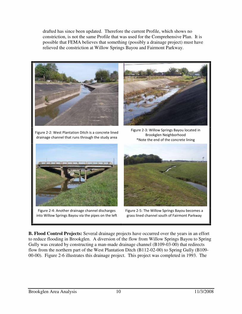
Stormwater falling on the Brookglen subdivision runs from the yards to the streets where it is collected by storm sewers. The storm sewers flow either north to West Plantation Ditch (coded B112-02-00 by the Harris County Flood Control District) or west to Willow Springs Bayou (B112-00-00.) Figure 2-1 (on page 7) illustrates the location of these two drainage channels. West Plantation Ditch (see Figure 2-2) is a concrete lined drainage channel. Willow Springs Bayou (see Figures 2-3 through 2-5) has concrete lined sections, but is grass lined in most areas. Both of these drainage channels are maintained by the Harris County Flood Control District. A. Flooding Problem: There are three potential sources of the flooding problems in the Brookglen subdivision.
1) The most severe flooding threat to the area is storm surge. The area has not seen this type of flooding event to date, therefore, the repetitive flood problem in Brookglen is not due to storm surge.
2) The storm sewers are undersized to handle a heavy rain event. As of the date of this report, the City of La Porte designs storm sewers to handle flow from a three year rain event. The rainfall from Tropical Storm Allison, for example, exceeded 500-year storm rainfall amounts. Therefore, given the flooding history in Brookglen, it can be assumed that storm sewers designed for the 3-year event are not adequate for the heavy rains that flood the neighborhood.
3) The two drainage ditches, West Plantation and Willow Springs Bayou, drain slowly and push water into the neighborhood streets, yards and houses during heavy rains. According to the Comprehensive Plan, water backs up 0.8 feet above the 100-year flood level where Willow Springs Bayou flows under Fairmont Parkway. Homeowners also report that this location is a constriction. However, a review of the current Flood Insurance Study profile for Willow Springs Bayou indicates that there is no constriction at Fairmont Parkway. The Flood Insurance Study Profile that was in effect when the Comprehensive Plan was
Brookglen Area Analysis 10 11/3/2008
drafted has since been updated. Therefore the current Profile, which shows no constriction, is not the same Profile that was used for the Comprehensive Plan. It is possible that FEMA believes that something (possibly a drainage project) must have relieved the constriction at Willow Springs Bayou and Fairmont Parkway.
Figure 2-2: West Plantation Ditch is a concrete lined
drainage channel that runs through the study area
Figure 2-3: Willow Springs Bayou located in
Brookglen Neighborhood
*Note the end of the concrete lining
Figure 2-4: Another drainage channel discharges
into Willow Springs Bayou via the pipes on the left
Figure 2-5: The Willow Springs Bayou becomes a
grass lined channel south of Fairmont Parkway
B. Flood Control Projects: Several drainage projects have occurred over the years in an effort to reduce flooding in Brookglen. A diversion of the flow from Willow Springs Bayou to Spring Gully was created by constructing a man-made drainage channel (B109-03-00) that redirects flow from the northern part of the West Plantation Ditch (B112-02-00) to Spring Gully (B109-00-00). Figure 2-6 illustrates this drainage project. This project was completed in 1993. The
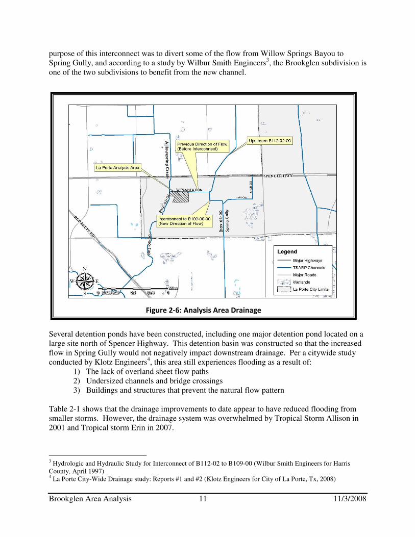
Brookglen Area Analysis 11 11/3/2008
purpose of this interconnect was to divert some of the flow from Willow Springs Bayou to Spring Gully, and according to a study by Wilbur Smith Engineers3, the Brookglen subdivision is one of the two subdivisions to benefit from the new channel.
Several detention ponds have been constructed, including one major detention pond located on a large site north of Spencer Highway. This detention basin was constructed so that the increased flow in Spring Gully would not negatively impact downstream drainage. Per a citywide study conducted by Klotz Engineers4, this area still experiences flooding as a result of:
1) The lack of overland sheet flow paths 2) Undersized channels and bridge crossings 3) Buildings and structures that prevent the natural flow pattern
Table 2-1 shows that the drainage improvements to date appear to have reduced flooding from smaller storms. However, the drainage system was overwhelmed by Tropical Storm Allison in 2001 and Tropical storm Erin in 2007.
3 Hydrologic and Hydraulic Study for Interconnect of B112-02 to B109-00 (Wilbur Smith Engineers for Harris County, April 1997) 4 La Porte City-Wide Drainage study: Reports #1 and #2 (Klotz Engineers for City of La Porte, Tx, 2008)
Figure 2-6: Analysis Area Drainage
Brookglen Area Analysis 12 11/3/2008
The Klotz report notes that the Brookglen subdivision has many homes that experienced flooding during Tropical Storms Allison and Erin. These two events were heavy rain events that overwhelmed the storm sewers. Rainwater flows into the West Plantation Ditch from the neighborhood streets through pipes that vary in size from 24 to 30 inches, and the water ponds in the cul-de-sac or streets located north or south of the channel. Recommendations for reducing this ponding made in the report are discussed in the mitigation measures section of this report. IV. Flooding Experiences of Property Owners
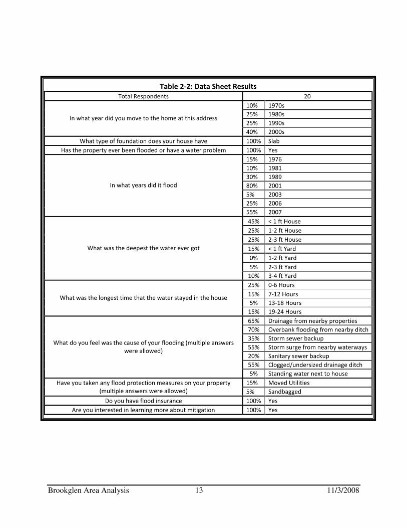
As mentioned in Step 1, the letter about the area analysis to the residents living in the Brookglen Analysis Area from the City of La Porte included a data sheet. This data sheet offered residents the opportunity to provide the UNO-CHART Team with details about their flooding experiences, and to voice their concerns regarding flooding-related issues. Of the 70 properties to which letters were sent, 20 residents responded, achieving a response rate of approximately 29%.
The homeowners who returned a data sheet to UNO-CHART have offered some insight into the flooding problem. Most of the respondents have moved to the neighborhood since 2000, and all reported having either flooded or having a water problem. The most prevalent years for flooding were 2001 and 2007, Tropical Storms Allison and Erin. Most respondents reported low depth, short duration flooding, having less than one foot of water inside their house for fewer than 12 hours. Finally, while few respondents reported using a flood protection measure to protect their property, all of the respondents were interested in learning about mitigation. The detailed results are organized in Table 2-2.
The following general conclusions can be drawn from the resident’s comments:
• During heavy rain events, the West Plantation drainage ditch overflows and floods the neighborhood.
• Floodwaters have reached halfway between the street and houses 10 – 12 times over the last several years.
• Residents are concerned that with increased development in La Porte and in neighboring cities, their risk of flooding will increase.
• According to the residents, the drainage ditches are not kept clean and clear of debris.
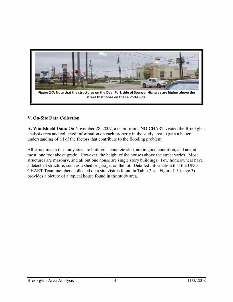
Increasing Development: Residents expressed concerns over the increasing development in La Porte and the surrounding cities. This is a topic often of concern to floodplain managers and to residents of rapidly growing areas. The City of Deer Park is located just north of the study area, across Spencer Highway. Both residential and commercial development is occurring in Deer Park, within close proximity to the Brookglen neighborhood. The recent development occurring just outside of the Brookglen neighborhood includes several detention ponds tat should mitigate the effects of the construction. However, according to residents, these detention ponds fill quickly, and then the neighborhood continues to flood. Figure 2-7 shows the recent development along Spencer Highway, the main road outside of the Brookglen subdivision.
Brookglen Area Analysis 13 11/3/2008
Table 2-2: Data Sheet Results
Total Respondents 20
10% 1970s
25% 1980s
25% 1990s In what year did you move to the home at this address
40% 2000s
What type of foundation does your house have 100% Slab
Has the property ever been flooded or have a water problem 100% Yes
15% 1976
10% 1981
30% 1989
80% 2001
5% 2003
25% 2006
In what years did it flood
55% 2007
45% < 1 ft House
25% 1-2 ft House
25% 2-3 ft House
15% < 1 ft Yard
0% 1-2 ft Yard
5% 2-3 ft Yard
What was the deepest the water ever got
10% 3-4 ft Yard
25% 0-6 Hours
15% 7-12 Hours
5% 13-18 Hours What was the longest time that the water stayed in the house
15% 19-24 Hours
65% Drainage from nearby properties
70% Overbank flooding from nearby ditch
35% Storm sewer backup
55% Storm surge from nearby waterways
20% Sanitary sewer backup
55% Clogged/undersized drainage ditch
What do you feel was the cause of your flooding (multiple answers
were allowed)
5% Standing water next to house
15% Moved Utilities Have you taken any flood protection measures on your property
(multiple answers were allowed) 5% Sandbagged
Do you have flood insurance 100% Yes
Are you interested in learning more about mitigation 100% Yes
Brookglen Area Analysis 14 11/3/2008
V. On-Site Data Collection
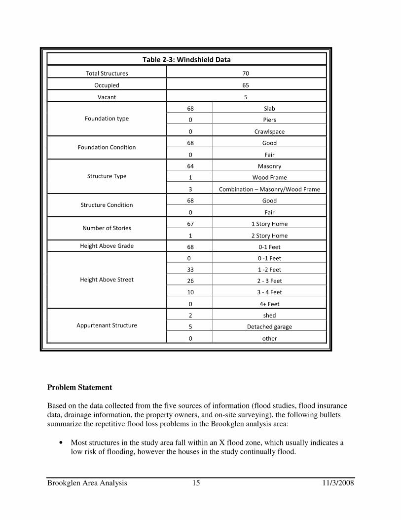
A. Windshield Data: On November 28, 2007, a team from UNO-CHART visited the Brookglen analysis area and collected information on each property in the study area to gain a better understanding of all of the factors that contribute to the flooding problem.
All structures in the study area are built on a concrete slab, are in good condition, and are, at most, one foot above grade. However, the height of the houses above the street varies. Most structures are masonry, and all but one house are single story buildings. Few homeowners have a detached structure, such as a shed or garage, on the lot. Detailed information that the UNO-CHART Team members collected on a site visit is found in Table 2-4. Figure 1-3 (page 3) provides a picture of a typical house found in the study area.
Figure 2-7: Note that the structures on the Deer Park side of Spencer Highway are higher above the
street that those on the La Porte side.
Brookglen Area Analysis 15 11/3/2008
Problem Statement
Based on the data collected from the five sources of information (flood studies, flood insurance data, drainage information, the property owners, and on-site surveying), the following bullets summarize the repetitive flood loss problems in the Brookglen analysis area:
• Most structures in the study area fall within an X flood zone, which usually indicates a low risk of flooding, however the houses in the study continually flood.
Table 2-3: Windshield Data
Total Structures 70
Occupied 65
Vacant 5
68 Slab
0 Piers Foundation type
0 Crawlspace
68 Good Foundation Condition
0 Fair
64 Masonry
1 Wood Frame Structure Type
3 Combination – Masonry/Wood Frame
68 Good Structure Condition
0 Fair
67 1 Story Home Number of Stories
1 2 Story Home
Height Above Grade 68 0-1 Feet
0 0 -1 Feet
33 1 -2 Feet
26 2 - 3 Feet
10 3 - 4 Feet
Height Above Street
0 4+ Feet
2 shed
5 Detached garage Appurtenant Structure
0 other
Brookglen Area Analysis 16 11/3/2008
• The 26 repetitive flood loss properties in the study area have made a total of 134 claims for a total of $3,358,943.00 since 1978.
• Other properties have been flooded but are not on FEMA’s RL list
• Of the 26 repetitive flood loss properties, 24 are considered severe repetitive flood loss properties.
• Average RL flood claim is $25,000.
• Residents report maximum flood depths and duration of four feet for 24 hours.
• Flooding is caused by undersized channels and bridge crossings, man-made obstructions to the predominant flow pattern, and a slow moving drainage ditch.
• Drainage improvements have been made, however the area continues to flood.
Step 3: Mitigation Measures
Reviewing the drainage system, the flooding problem, and the types and condition of the buildings in the area leads to the third step in the area analysis procedure - a review of alternative approaches to protect properties from future flood damage. Property owners should look at these alternatives but understand they are not all guaranteed to provide 100% flood protection. Seven approaches were analyzed:
1. Drainage improvements 2. Acquisition of properties in the hazardous area 3. Elevating the houses above the 100-year flood level 4. Constructing small levees or floodwalls around one or more houses 5. Dry floodproofing 6. Development regulations 7. Purchasing flood insurance coverage on the building
Each approach has its pros and cons. Drainage improvements and development regulations need to be implemented by the City or County. The other measures can be implemented by the property owners, but City or County funding can help, especially with acquisition and elevation. I. Drainage Improvements
As noted in the problem description (page 8), repetitive flooding in Brookglen is caused by two related drainage problems:
1. The storm sewers are undersized to handle a heavy rain event 2. The two drainage ditches, West Plantation Ditch and Willow Springs Bayou, drain slowly
and back up into the neighborhood streets, yards and houses during heavy rains. Larger storm sewers are suggested by the Harris County All Hazard Mitigation Plan and by the Klotz Associates Report #2. The City of La Porte now designs storm sewers to handle flow from a three-year event, however the Harris County Flood Control District Policy Criteria and Procedure Manual calls for storm sewers to be designed for 10 to 100-year storm.

Brookglen Area Analysis 17 11/3/2008
It would be very expensive to replace the existing storm sewer system with larger pipes. However, Klotz recommends constructing an overland sheet flow path, which provides a clear route located over the ground for stormwater to quickly flow into drainage canals, at the north end of Gladwyne Lane. Figure 3-1 is a photograph of a sheet flow path. When Gladwyne and the other streets fill up with stormwater, the sheet flow path would drain the water directly to West Plantation Ditch.
The effectiveness of this approach is dependent on the ditches being able to accept the stormwater and carry it downstream. This won’t happen if they are already full or backing up, which is reported to happen at the same time the streets flood. Residents report that the channels need better maintenance and there are conflicting reports as to whether the bridge at Fairmont Parkway constricts flows. Both of these concerns need further investigation by the City or the Flood Control District. II. Acquisition
This measure involves buying one or more properties and clearing the site. If there is no building subject to flooding, there is no flood damage. Acquisitions are usually recommended where the flood hazard is so great or so frequent that it is not safe to leave the structure on site.
An alternative to buying and clearing the whole subdivision is buying out individual, “worst case,” structures with FEMA funds. This approach would involve purchasing and clearing the lowest or the most severe repetitive flood loss homes. If FEMA funds are to be used, three requirements will apply:
1. The applicant for FEMA must demonstrate that the benefits exceed the costs, using FEMA’s benefit/cost software.
2. The owner must be a willing seller. 3. The parcel must be deeded to a public agency that agrees to maintain the lot and keep it
forever as open space.
Problems: 1. High cost and difficulty to obtain a favorable benefit-cost ratio, which demonstrates the
cost-effectiveness of a proposed project, in shallow flooding areas 2. Not everyone wants to sell their home, so a checkerboard pattern of vacant and occupied
lots often remains after a buyout project, leaving “holes” in the neighborhood 3. There is no reduction in expenses to maintain the neighborhood’s infrastructure, although
the tax base is reduced 4. The vacant lots must be maintained by the new owner agency, and additional expense is
added to the community.
Figure 3-1: Sample sheet flow path
(from Klotz Report)

Brookglen Area Analysis 18 11/3/2008
Despite these problems, the Harris County Flood Control District does support the use of mitigation funds for acquiring and clearing repetitive flood loss properties5. Eligibility for the program is determined by several conditions:
• The property must be a severe repetitive flood loss property
• The action of buying out the property must meet the FEMA designated benefit-cost ratio
• The property must not be located in an area where a planned capital project will reduce the flooding problem, as it would be a duplicative solution.
III. Elevation
Raising the structure above the flood level is generally viewed as the best flood protection measure, short of removing the building from the floodplain. All damageable portions of the building and its contents are high and dry during a flood, which flows under the floor instead of into the house. Houses can either be elevated on fill, posts/piles, or on a crawlspace. A house elevated on fill requires adding a specific type of dirt, called structural fill, to a lot and building the house on top of the added dirt. A house elevated on posts/ piles is either built or raised on a foundation of piers that are driven into the earth and rise high enough above the ground to elevate the house above the flood level. A house elevated on a crawlspace is built or raised on a wall-like foundation that elevates the house above the flood level. If a crawlspace is used, it is important to include vents that are appropriately sized: one square inch for each square foot of the building’s footprint. An example of an elevated house is shown in Figure 3-2.
Cost: Most of the cost to elevate a building is in the preparation and foundation construction. The cost to elevate six feet is little more than the cost to elevate two feet. Elevation is usually cost-effective for wood frame buildings on crawlspaces because it is easiest to get lifting equipment under the floor and disruption to the habitable part of the house is minimal. Elevating a slab house is much more costly, disruptive, and dangerous, but it can be done. All of the houses in the Brookglen study area are on a slab. The actual cost of elevating a particular building depends on factors such as its condition, whether it is masonry or brick faced, the soil conditions, and if additions to the house have been made over time.
While the cost of elevating a home on a slab can be high, there are funding programs that can help. The usual arrangement is for a FEMA grant to pay 75% of the cost while the remaining 25% is paid by a non-Federal source. In Harris County, the County pays the non-Federal portion.
5 For more information on the Harris County Flood Control District buyout program, please see http://www.hcfcd.org/buyout.asp?flash=yes or call 713-684-4020 or 713-684-4035.
Figure 3-2: A slab house that has been
elevated
Brookglen Area Analysis 19 11/3/2008
Feasibility: Federal funding support for an elevation project requires a study that shows that the benefits of the project exceed the cost. Elevating a masonry home or a slab can be very expensive, up to $100,000. Looking at each property individually could result in funding for the worst case properties, i.e., those that are lowest, subject to the most frequent flooding, and is structurally sound enough to elevate. IV. Barriers to Floodwaters
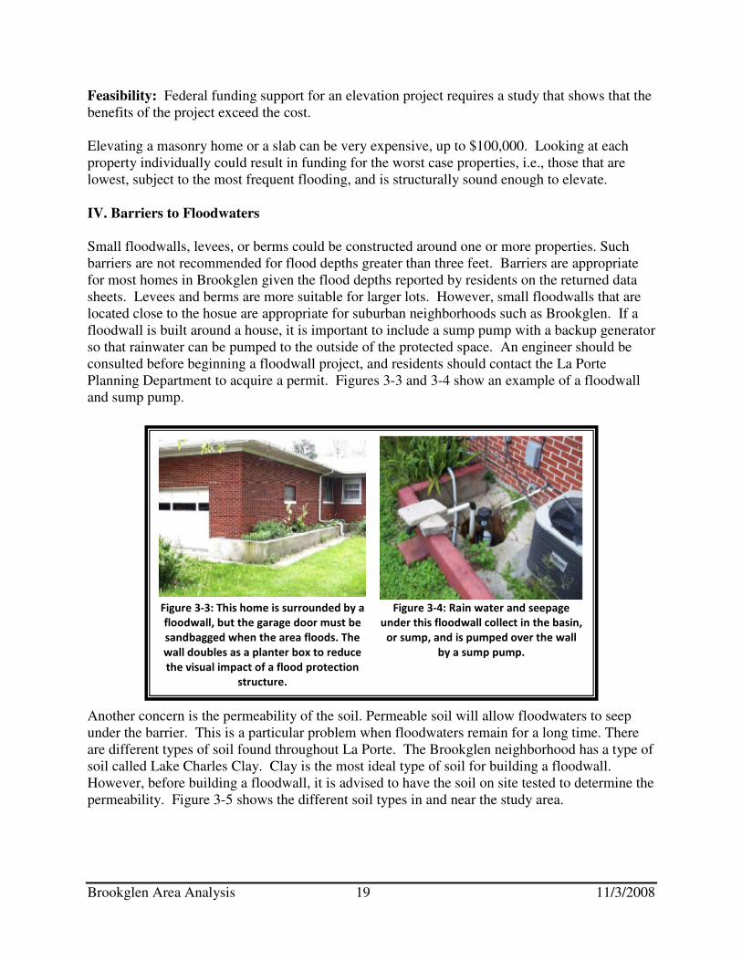
Small floodwalls, levees, or berms could be constructed around one or more properties. Such barriers are not recommended for flood depths greater than three feet. Barriers are appropriate for most homes in Brookglen given the flood depths reported by residents on the returned data sheets. Levees and berms are more suitable for larger lots. However, small floodwalls that are located close to the hosue are appropriate for suburban neighborhoods such as Brookglen. If a floodwall is built around a house, it is important to include a sump pump with a backup generator so that rainwater can be pumped to the outside of the protected space. An engineer should be consulted before beginning a floodwall project, and residents should contact the La Porte Planning Department to acquire a permit. Figures 3-3 and 3-4 show an example of a floodwall and sump pump.
Another concern is the permeability of the soil. Permeable soil will allow floodwaters to seep under the barrier. This is a particular problem when floodwaters remain for a long time. There are different types of soil found throughout La Porte. The Brookglen neighborhood has a type of soil called Lake Charles Clay. Clay is the most ideal type of soil for building a floodwall. However, before building a floodwall, it is advised to have the soil on site tested to determine the permeability. Figure 3-5 shows the different soil types in and near the study area.
Figure 3-3: This home is surrounded by a
floodwall, but the garage door must be
sandbagged when the area floods. The
wall doubles as a planter box to reduce
the visual impact of a flood protection
structure.
Figure 3-4: Rain water and seepage
under this floodwall collect in the basin,
or sump, and is pumped over the wall
by a sump pump.
Brookglen Area Analysis 20 11/3/2008
Barriers require:
• A method to close openings, such as the driveway. Generally, this requires “human intervention,” meaning someone needs to be available and have enough time to take action.
• A system to prevent sanitary sewer backup from flowing into the building, such as a back flow valve.
• A system of drain tile (perforated pipes) that collects water that falls or seeps into the protected area and sends it to a collecting basin or “sump.”
• A sump pump to send the collected water outside the barrier.
• Power to operate the sump pump around the clock during a storm.
Cost: The cost of a local barrier depends on the depth of flooding and the amount of engineering put into the design. Where flooding is only inches deep and of short duration, almost any barrier of concrete or earth will work.
Figure 3-5: Soils map for the Brookglen neighborhood and surrounding area
Brookglen Area Analysis 21 11/3/2008
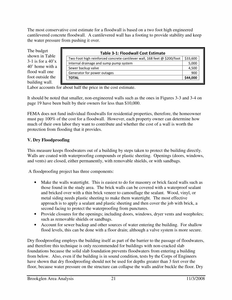
The most conservative cost estimate for a floodwall is based on a two foot high engineered cantilevered concrete floodwall. A cantilevered wall has a footing to provide stability and keep the water pressure from pushing it over. The budget shown in Table 3-1 is for a 40’x 40’ home with a flood wall one foot outside the building wall. Labor accounts for about half the price in the cost estimate.
It should be noted that smaller, non-engineered walls such as the ones in Figures 3-3 and 3-4 on page 19 have been built by their owners for less than $10,000.
FEMA does not fund individual floodwalls for residential properties, therefore, the homeowner must pay 100% of the cost for a floodwall. However, each property owner can determine how much of their own labor they want to contribute and whether the cost of a wall is worth the protection from flooding that it provides.
V. Dry Floodproofing
This measure keeps floodwaters out of a building by steps taken to protect the building directly. Walls are coated with waterproofing compounds or plastic sheeting. Openings (doors, windows, and vents) are closed, either permanently, with removable shields, or with sandbags.
A floodproofing project has three components:
• Make the walls watertight. This is easiest to do for masonry or brick faced walls such as those found in the study area. The brick walls can be covered with a waterproof sealant and bricked over with a thin brick veneer to camouflage the sealant. Wood, vinyl, or metal siding needs plastic sheeting to make them watertight. The most effective approach is to apply a sealant and plastic sheeting and then cover the job with brick, a second facing to protect the waterproofing from punctures.
• Provide closures for the openings; including doors, windows, dryer vents and weepholes; such as removable shields or sandbags.
• Account for sewer backup and other sources of water entering the building. For shallow flood levels, this can be done with a floor drain; although a valve system is more secure.
Dry floodproofing employs the building itself as part of the barrier to the passage of floodwaters, and therefore this technique is only recommended for buildings with non-cracked slab foundations because the solid slab foundation prevents floodwaters from entering a building from below. Also, even if the building is in sound condition, tests by the Corps of Engineers have shown that dry floodproofing should not be used for depths greater than 3 feet over the floor, because water pressure on the structure can collapse the walls and/or buckle the floor. Dry
Table 3-1: Floodwall Cost Estimate Two Foot high reinforced concrete cantilever wall, 168 feet @ $200/foot $33,600
Internal drainage and sump pump system 5,000
Sewer backup valve 4,500
Generator for power outages 900
TOTAL $44,000

Brookglen Area Analysis 22 11/3/2008
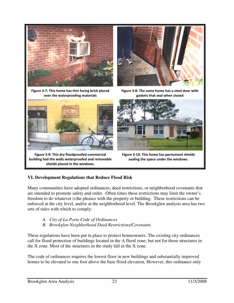
floodproofing is a mitigation technique that is appropriate for the Brookglen neighborhood; according to the returned data sheets flood depths have not exceeded 3 feet. Not all parts of the building need to be floodproofed. It is difficult to floodproof a garage door, for example, so many owners let the garage flood and floodproof the walls between the garage and the rest of the house. Appliances, electrical outlets, and other damage-prone materials located in the garage should be elevated above the expected flood levels. Examples of floodproofed houses can be seen in Figures 3-7 through 3-10. Dry floodproofing has the following shortcomings as a flood protection measure:
• It usually requires human intervention, i.e., someone must be home to close the openings.
• Its success depends on the building’s condition, which may not be readily evident. It is very difficult to tell if there are cracks in the slab under the floor covering.
• Periodic maintenance is required to check for cracks in the walls and to ensure that the waterproofing compounds do not decompose.
• There are no government financial assistance programs available for dry floodproofing, therefore the entire cost of the project must be paid by the homeowner.
• The NFIP will not offer a lower insurance rate for dry floodproofed residences.
Cost: The cost for a floodproofing project can vary according to the building’s construction and condition. It can range from $5,000 to $20,000, depending on how secure the owner wants to be. Owners can do some of the work by themselves, although an experienced contractor provides greater security. Each property owner can determine how much of their own labor they can contribute and whether the cost and appearance of a project is worth the protection from flooding that it may provide. Feasibility: As with floodwalls, floodproofing is appropriate where flood depths are shallow and are of relatively short duration. It can be an effective measure for many of the structures and flood conditions found in the Brookglen target area. It can also be more attractive than a floodwall around a house.
Figure 3-6: Dry Floodproofed House
Brookglen Area Analysis 23 11/3/2008
VI. Development Regulations that Reduce Flood Risk
Many communities have adopted ordinances, deed restrictions, or neighborhood covenants that are intended to promote safety and order. Often times these restrictions may limit the owner’s freedom to do whatever (s)he pleases with the property or building. These restrictions can be enforced at the city level, and/or at the neighborhood level. The Brookglen analysis area has two sets of rules with which to comply:
A. City of La Porte Code of Ordinances
B. Brookglen Neighborhood Deed Restrictions/Covenants
These regulations have been put in place to protect homeowners. The existing city ordinances call for flood protection of buildings located in the A flood zone, but not for those structures in the X zone. Most of the structures in the study fall in the X zone. The code of ordinances requires the lowest floor in new buildings and substantially improved homes to be elevated to one foot above the base flood elevation. However, this ordinance only
Figure 3-7: This home has thin facing brick placed
over the waterproofing materials
Figure 3-8: The same home has a steel door with
gaskets that seal when closed
Figure 3-9: This dry floodproofed commercial
building had the walls waterproofed and removable
shields placed in the windows.
Figure 3-10: This home has permanent shields
sealing the space under the windows.
Brookglen Area Analysis 24 11/3/2008
applies to structures located in the AE flood zone and there are few in the Brookglen study area. The City can amend this ordinance to include X Zone areas in its regulatory floodplain. Many communities in flat areas with drainage problems require all new buildings to have their lowest floors elevated a specified height above the street. This allows the streets to collect and store stormwater that cannot drain away fast enough, without flooding homes. Ironically, neighborhood covenants or deed restrictions regulating development within a subdivision are intended to help the neighborhood maintain a sense of solidarity, distinct character, and residential quality. In certain instances, these deed restrictions may hinder residents’ plans for a flood mitigation project.
The Brookglen Deed Restrictions state that all structures must have a slab foundation and should look similar with respect to the finished grade elevation. Also, the deed restrictions prohibit walls erected in front of the required minimum building setback. According to these guidelines, neither a slab home elevated on fill nor a floodwall would be allowed in the Brookglen neighborhood. The homeowners association can amend these covenants to allow for mitigation measures and continue to maintain a positive, unified neighborhood look by promoting crawlspace elevated foundations and allowing small floodwalls in front yards.
VII. Flood Insurance
Although not a mitigation measure that reduces property damage from a flood, an insurance policy from the National Flood Insurance Program has the following advantages for the homeowner:
• A flood insurance policy reduces a homeowner’s financial expenses when flooding occurs.
• It is an excellent “backup” for a floodwall or elevation project where the flood is higher than the protection level as it helps absorb the financial risk.
• The repetitive, shallow, flooding is unlikely to reach conditions severe enough for a disaster declaration, which allows for additional financial support. Therefore, flood insurance may be the only source of assistance to help owners of damaged property pay for cleanup and repairs.
• Once the policy goes into effect there is no need for human intervention except to pay the premium.
• Coverage is available for the contents of a home as well as for the structure.
• Renters can buy contents coverage, even if the building owner does not buy coverage for the structure itself.
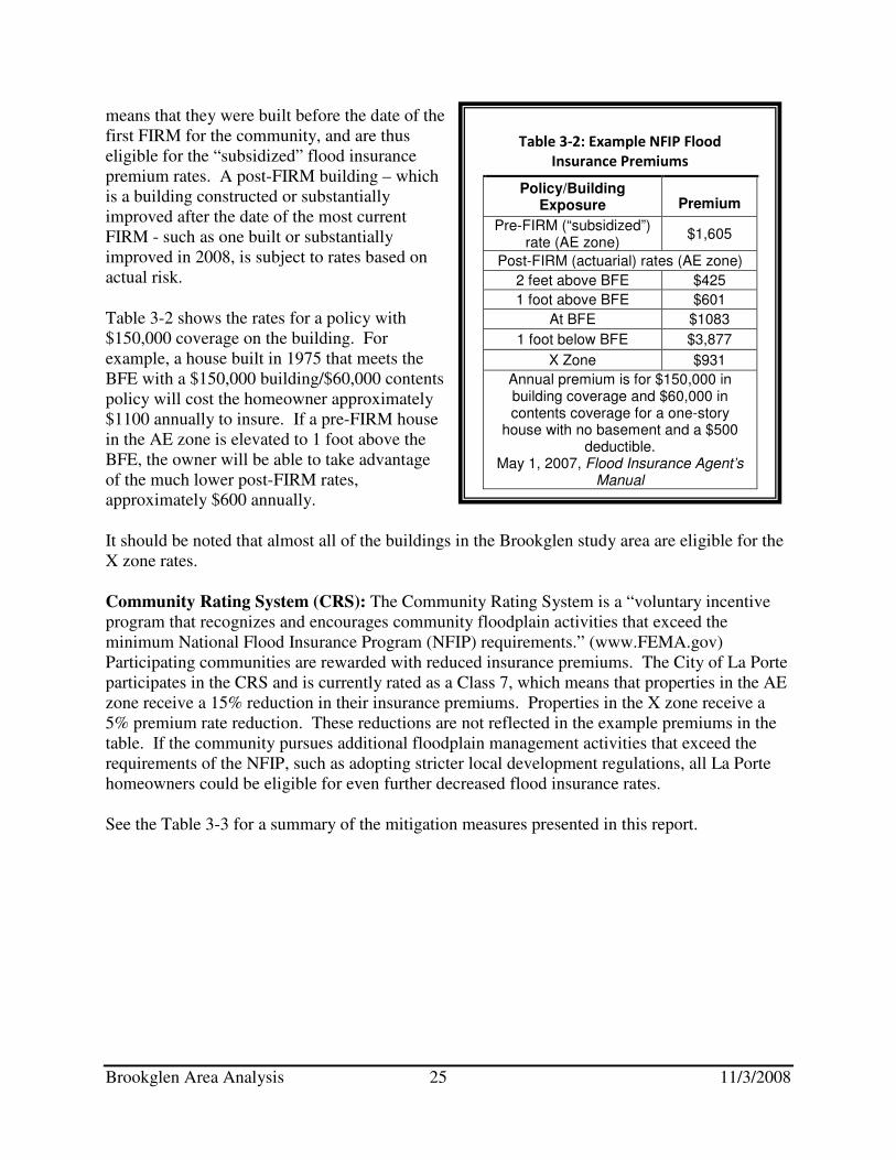
Cost: Flood insurance rates are based on several factors including whether or not the building falls in an AE or X flood zone, and if the building is considered a Pre- or Post-FIRM building. Homes in the X zone have lower flood insurance rates than those in the AE zone, because the X zone is supposed to indicate a lower risk from flooding. Many homes in the study area are in an X zone. La Porte homes constructed before February 17, 1971 are “pre-FIRM” buildings, which
Brookglen Area Analysis 25 11/3/2008
means that they were built before the date of the first FIRM for the community, and are thus eligible for the “subsidized” flood insurance premium rates. A post-FIRM building – which is a building constructed or substantially improved after the date of the most current FIRM - such as one built or substantially improved in 2008, is subject to rates based on actual risk.
Table 3-2 shows the rates for a policy with $150,000 coverage on the building. For example, a house built in 1975 that meets the BFE with a $150,000 building/$60,000 contents policy will cost the homeowner approximately $1100 annually to insure. If a pre-FIRM house in the AE zone is elevated to 1 foot above the BFE, the owner will be able to take advantage of the much lower post-FIRM rates, approximately $600 annually.
It should be noted that almost all of the buildings in the Brookglen study area are eligible for the X zone rates.
Community Rating System (CRS): The Community Rating System is a “voluntary incentive program that recognizes and encourages community floodplain activities that exceed the minimum National Flood Insurance Program (NFIP) requirements.” (www.FEMA.gov) Participating communities are rewarded with reduced insurance premiums. The City of La Porte participates in the CRS and is currently rated as a Class 7, which means that properties in the AE zone receive a 15% reduction in their insurance premiums. Properties in the X zone receive a 5% premium rate reduction. These reductions are not reflected in the example premiums in the table. If the community pursues additional floodplain management activities that exceed the requirements of the NFIP, such as adopting stricter local development regulations, all La Porte homeowners could be eligible for even further decreased flood insurance rates.
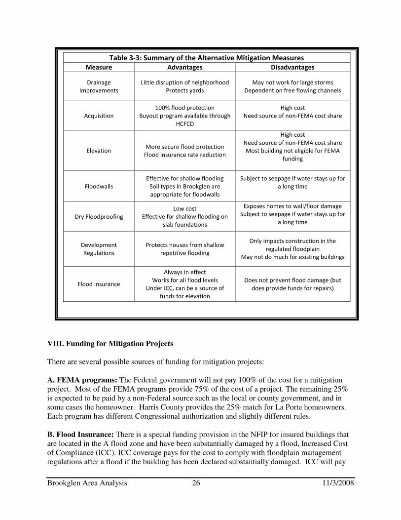
See the Table 3-3 for a summary of the mitigation measures presented in this report.
Table 3-2: Example NFIP Flood
Insurance Premiums
Policy/Building Exposure Premium
Pre-FIRM (“subsidized”) rate (AE zone)
$1,605
Post-FIRM (actuarial) rates (AE zone)
2 feet above BFE $425
1 foot above BFE $601
At BFE $1083
1 foot below BFE $3,877
X Zone $931
Annual premium is for $150,000 in building coverage and $60,000 in contents coverage for a one-story
house with no basement and a $500 deductible.
May 1, 2007, Flood Insurance Agent’s Manual
Brookglen Area Analysis 26 11/3/2008
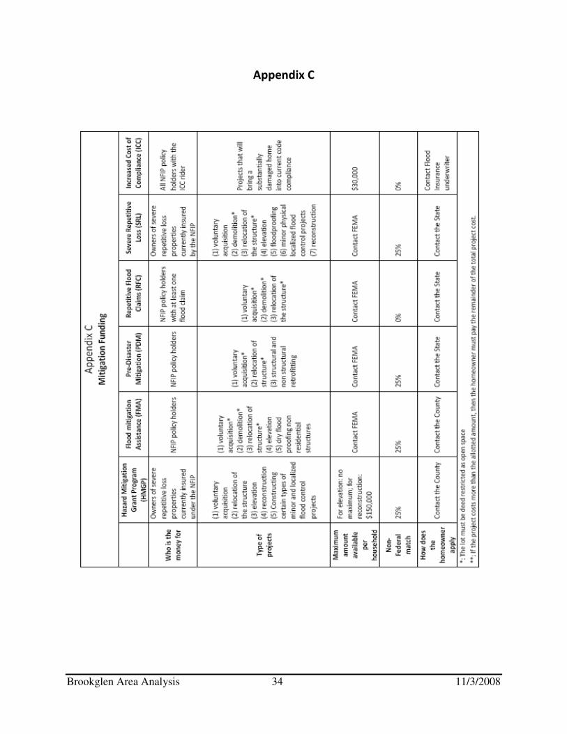
VIII. Funding for Mitigation Projects
There are several possible sources of funding for mitigation projects:
A. FEMA programs: The Federal government will not pay 100% of the cost for a mitigation project. Most of the FEMA programs provide 75% of the cost of a project. The remaining 25% is expected to be paid by a non-Federal source such as the local or county government, and in some cases the homeowner. Harris County provides the 25% match for La Porte homeowners. Each program has different Congressional authorization and slightly different rules.
B. Flood Insurance: There is a special funding provision in the NFIP for insured buildings that are located in the A flood zone and have been substantially damaged by a flood, Increased Cost of Compliance (ICC). ICC coverage pays for the cost to comply with floodplain management regulations after a flood if the building has been declared substantially damaged. ICC will pay
Table 3-3: Summary of the Alternative Mitigation Measures
Measure Advantages Disadvantages
Drainage
Improvements
Little disruption of neighborhood
Protects yards
May not work for large storms
Dependent on free flowing channels
Acquisition
100% flood protection
Buyout program available through
HCFCD
High cost
Need source of non-FEMA cost share
Elevation More secure flood protection
Flood insurance rate reduction
High cost
Need source of non-FEMA cost share
Most building not eligible for FEMA
funding
Floodwalls
Effective for shallow flooding
Soil types in Brookglen are
appropriate for floodwalls
Subject to seepage if water stays up for
a long time
Dry Floodproofing
Low cost
Effective for shallow flooding on
slab foundations
Exposes homes to wall/floor damage
Subject to seepage if water stays up for
a long time
Development
Regulations
Protects houses from shallow
repetitive flooding
Only impacts construction in the
regulated floodplain
May not do much for existing buildings
Flood Insurance
Always in effect
Works for all flood levels
Under ICC, can be a source of
funds for elevation
Does not prevent flood damage (but
does provide funds for repairs)
Brookglen Area Analysis 27 11/3/2008
up to $30,000 to help cover elevation, relocation, demolition, and (for nonresidential buildings) floodproofing. The building’s flood insurance policy must have been in effect during the flood. This payment is in addition to the damage claim payment that would be made under the regular policy coverage, as long as the total claim does not exceed $250,000. Claims must be accompanied by a substantial damage determination made by the local floodplain administrator. Coverage under the ICC does have limitations:
• It covers only damage caused by a flood;
• The building’s flood insurance policy must have been in effect during the flood;
• ICC payments are limited to $30,000 per structure;
• The structure must have a substantial damage determination – in which case flood damage equals or exceeds 50% of the home’s market value, or a repetitive damage determination – which means that the house is on FEMA’s repetitive flood loss list. The local floodplain administrator makes these determinations, and;
• The structure must be located in an A flood zone. Most, if not all homes in the Brookglen study area are located in the X zone and therefore are not eligible for the ICC funding, unless the City amends its development regulations as noted in Section V of this report. C. Rebates: A rebate is a grant in which the costs are shared by the homeowner and another source, such as the local government, usually given to a property owner after a project has been completed. Many communities favor it because the owner handles all the design details, contracting, and payment before the community makes a final commitment. The owner ensures that the project meets all of the program’s criteria, has the project constructed, and then goes to the community for the rebate after the completed project passes inspection. Rebates are more successful where the cost of the project is relatively small, e.g., under $5,000, because the owner is more likely to be able to afford to finance the bulk of the cost; the rebate acts more as an incentive, rather than as needed financial support. More information on rebates can be found in the Corps of Engineers’ report Local Flood
Proofing Programs found at www.nwo.usace.army.mil/nfpc/other.html. See Appendix C, page 34, for more information on funding sources
Step 4: Coordination
The following agencies and organizations were contacted by the UNO-CHART team:
• La Porte Office of Emergency Management
• La Porte City Council Flood Committee
Brookglen Area Analysis 28 11/3/2008
• La Porte Public Works Department
• La Porte Planning Department
• Harris County Flood Control District
• FEMA Mitigation Region VI – Mitigation
• La Porte GIS Department
• Brookglen Homeowners Association
• Texas Water Development Board – Houston Field Office
Step 5: Findings and Recommendations
I. Findings: UNO-CHART’s findings for the Brookglen Repetitive Flood Loss Area Analysis can be broken into four categories:
A. Drainage Issues: Properties in the Brookglen study area are subject to flooding due to heavy rains and drainage problems. There are two sources of flooding that are related to drainage problems. The first problem is due to heavy rains and small storm sewers. The storm sewers are designed to handle rainfall from only a 3-year event. Harris County Flood Control District recommends design standards to handle between a 10- and 100-year event. The Klotz reports recommend constructing a sheet flow path, or increasing the size of the storm sewers. The second drainage problem in Brookglen is that the West Plantation Ditch overflows its banks flooding the neighborhood streets, yards and even houses. Contributing to this problem is a reported bridge or culvert constriction at Willow Springs Bayou and Fairmont Parkway (the current Flood Insurance Study profile for Willow Springs Bayou does not show a constriction at this location), and that the West Plantation Ditch was cut off at its intersection with an interconnect to Spring Gully which was completed in 1997. Several drainage improvements made over the years were meant to alleviate flooding in the Brookglen area; however, properties have continued to flood, as is evidenced by the repetitive flood claims data.
B. Mapping Issues: In June 2007 La Porte received a new FIRM. This FIRM shows two flood zones and one floodway in the Brookglen neighborhood. Generally, the streets are mapped as an AE zone, the lots as an X zone, and the land along the drainage ditches as an AE floodway. The Base Flood Elevation for the Brookglen neighborhood is 20 feet above sea level. The ground elevation is also 20 feet above sea level. These factors would usually indicate that the risk of flooding is very low; however, the neighborhood continues to flood. Therefore, this study concludes that the flood risk in the Brookglen neighborhood is under-represented on the most recent FIRM.
C. Regulations Issues: Brookglen neighborhood residents have a set of deed restrictions/neighborhood covenants to follow regarding what they can and cannot do to their houses. The covenants mandate that all houses must have a slab foundation. Additionally, each house must have a similar elevation above grade to their neighbors. These rules inhibit residents
Brookglen Area Analysis 29 11/3/2008
from elevating their homes above the flood levels. The deed restrictions also include language that prohibits the construction of a small personal floodwall in the front yards of Brookglen houses, as no walls are allowed between the minimum building setback and the street.
The building ordinances for La Porte have elevation requirements for new, substantially damaged, and substantially improved residential buildings located in the 100-year floodplain. These regulations require an extra level of safety for frequently flooded property owners, i.e. one extra foot of protection. However, because most of the structures in the Brookglen neighborhood are located in the X zone, the regulations do not apply, and thus must be done voluntarily. More stringent building regulations can protect homeowners’ from future flooding and help them qualify for ICC funding.
D. Mitigation Measures: Several mitigation techniques would be helpful to residents. Drainage improvements would cause little disruption of the neighborhood, and would protect streets and yards as well as houses. However, the success of such improvements is determined by free flowing channels, and drainage improvements may not work for large storms. Acquisition offers 100% flood protection, and there is a buyout program available from the Harris County Flood Control District. Elevation above the flood hazard also offers secure flood protection. Harris County is not currently offering an elevation program, however the City of La Porte can apply for elevation funds separate from the County. Elevation is costly, especially for slab houses. Small personal floodwalls are effective for shallow flooding, and the soil types found in the study area are appropriate for floodwalls. If floodwaters stay up for a long period of time, the floodwall could be subject to seepage. Dry floodproofing is a lower cost option than floodwalls for owners of slab houses, but a dry floodproofed house is also susceptible to seepage during longer duration floods. Revising development regulations causes no physical impact to a house while protecting homes from shallow repetitive flooding. However, revised development regulations may not do too much for existing buildings. Flood Insurance is always in effect and works for all flood levels. It will not prevent flood damage, but it will provide funds for repairs.
II. Recommendations: These recommendations are categorized first for the City of La Porte, and second for La Porte homeowners. They are a combination of recommended improvements made by the reports which were reviewed for this report, and recommendations made by the UNO-CHART Team.
A. For the City of La Porte:
• Adopt more stringent local development regulations including o a cumulative damage/improvement ordinance6 o mandating that all first floor elevations must be a certain height above the street,
e.g. two to three feet, rather than the current one foot requirement (as similar to Action 1 in the Appendix of the Harris County All Hazard Mitigation Plan)
6Cumulative damage/improvement ordinance: Any combination of repairs, reconstruction, alteration, or improvements to a building in which the cumulative cost equals or exceeds fifty percent (50%) of the market value of the building.
Brookglen Area Analysis 30 11/3/2008
o identifying repetitively flooded neighborhoods and regulating the X zone in these neighborhoods as if it were an A flood zone
• Explore alternative financing methods to support flood mitigation projects, such as the possibility of establishing a rebate program
• Provide assistance with on-site mitigation projects through o soils testing for homeowners who want to consider building a floodwall o encourage the neighborhood to modify the deed restriction to allow for mitigation
• Consider seriously a sheet flow path as recommended by Klotz Associates for getting storm waters from heavy rain events into the drainage ditches
• Study the possible obstruction identified in the La Porte 2020 Comprehensive Plan, located at the intersection of the Willow Springs Bayou and Fairmont Parkway
• Partner with the neighborhood, perhaps using it as a test area for locally initiated mitigation options such as a rebate program and regulating a repetitively flooded X zone area as AE zone.
B. For the Brookglen Homeowners:
• Contact the office of Emergency Management7 for more information about possible funding opportunities
• Maintain an inlet maintenance program that encourages homeowners to frequently clear their drains of debris to ensure open flow for rain waters
• Amend the subdivision covenants to allow crawlspaces and floodproofing measures such as floodwalls and elevation
• Review the alternative mitigation measures discussed in this analysis and implement those that are most appropriate for their situations
• Purchase and maintain a flood insurance policy on the home
• Stay vigilant about new flood threats, such as development issues, and commit the neighborhood energy to studying and mitigating such threats.
7 La Porte office of Emergency Management: (281)471-5020

Brookglen Area Analysis 31 11/3/2008
References
FEMA Region VI Repetitive flood loss data
City of La Porte Code of Ordinances
Brookglen neighborhood covenants and deed restrictions
La Porte, Tx Comprehensive plan
Texas Multi-Jurisdictional Hazard Mitigation Plan
Flood Insurance Rate Map, 6/18/2007
Deer Park Code of Ordinances
Harris County Appraisal District
Homeowners Guide to Retrofitting: Six Ways to Protect Your House from Flooding. FEMA-312,
1998. http://www.fema.gov/mit/frit
Protecting Building Utilities from Flood Damage, FEMA-348, 2000 Reducing Damage from Localized Flooding – A Guide for Communities. FEMA-511, 2005
http://www.ci.la-porte.tx.us/ (La Porte, Tx website) November 2007 – May 2008
Klotz Associates Drainage Report #2. May 7, 2008 (http://www.ci.la-porte.tx.us/)
www.fema.gov (FEMA website), last accessed: 9/7/2008

Brookglen Area Analysis 32 11/3/2008
Appendix A
Brookglen Area Analysis 33 11/3/2008
Appendix B
Brookglen Area Analysis 34 11/3/2008
Appendix C


![Repetitive Provisions (61.120) [Enmiendas]](https://img.dokumen.tips/doc/110x75/5695cf181a28ab9b028c93a4/repetitive-provisions-61120-enmiendas.jpg)