Embed Size (px)
Citation preview

Redesign of Holland Tunnel Entrance and Exit Consolidation Study
Tier II Screening and Feasibility Assessment
FINAL REPORT December 2005
Submitted by
Maria Boile* Assistant Professor
** Alan M. Voorhees Transportation Center
Edward J. Bloustein School of Planning and Public Policy Rutgers, The State University of New Jersey
New Brunswick, NJ 08901
In cooperation with
State of New Jersey Department of Transportation
And U.S. Department of Transportation
Federal Highway Administration
* Center for Advanced Infrastructure & Transportation (CAIT) Civil & Environmental Engineering Department
Rutgers, the State University of New Jersey Piscataway, NJ 08854-8014
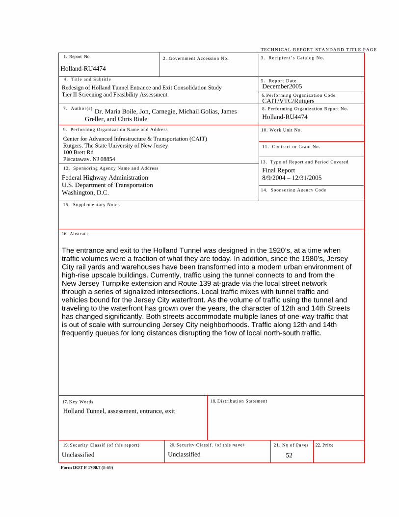
Holland-RU4474
Chris Riale** Graduate Research Assistant
James Greller** Project Manager
Michail Golias* Graduate Research Assistant
Jon A. Carnegie** AICP/PP, Assistant Director
Disclaimer Statement
"The contents of this report reflect the views of the author(s) who is (are) responsible for the facts and the accuracy of the data presented herein. The contents do
not necessarily reflect the official views or policies of the New Jersey Department of Transportation or the Federal Highway Administration. This report does not constitute
a standard, specification, or regulation."
The contents of this report reflect the views of the authors, who are responsible for the facts and the accuracy of the
information presented herein. This document is disseminated under the sponsorship of the New Jersey Department of Transportation,
in the interest of information exchange. The U.S. Government assumes no
liability for the contents or use thereof.
1. Report No. 2. Government Accession No.
TECHNICAL REPORT STANDARD TITLE PAGE
3. Rec ip ien t ’s Ca ta log No.
5 . Repor t Date
8. Performing Organization Report No.
6. Performing Organizat ion Code
4 . Ti t le and Subti t le
7 . Author(s)
9. Performing Organization Name and Address 10. Work Unit No.
11. Contract or Grant No.
13. Type of Report and Period Covered
14. Sponsoring Agency Code
12. Sponsoring Agency Name and Address
15. Supplementary Notes
16. Abstract
17. Key Words
19. Security Classif (of this report)
Form DOT F 1700.7 (8-69)
20. Security Classif. (of this page)
18. Distribution Statement
21. No of Pages 22. Price
December2005
CAIT/VTC/Rutgers
Final Report 8/9/2004 – 12/31/2005
Holland-RU4474
Center for Advanced Infrastructure & Transportation (CAIT) Rutgers, The State University of New Jersey 100 Brett Rd Piscataway, NJ 08854
Federal Highway Administration U.S. Department of Transportation Washington, D.C.
The entrance and exit to the Holland Tunnel was designed in the 1920’s, at a time when traffic volumes were a fraction of what they are today. In addition, since the 1980’s, Jersey City rail yards and warehouses have been transformed into a modern urban environment of high-rise upscale buildings. Currently, traffic using the tunnel connects to and from the New Jersey Turnpike extension and Route 139 at-grade via the local street network through a series of signalized intersections. Local traffic mixes with tunnel traffic and vehicles bound for the Jersey City waterfront. As the volume of traffic using the tunnel and traveling to the waterfront has grown over the years, the character of 12th and 14th Streets has changed significantly. Both streets accommodate multiple lanes of one-way traffic that is out of scale with surrounding Jersey City neighborhoods. Traffic along 12th and 14th frequently queues for long distances disrupting the flow of local north-south traffic.
Holland Tunnel, assessment, entrance, exit
Unclassified Unclassified
52
Holland-RU4474
Dr. Maria Boile, Jon, Carnegie, Michail Golias, James Greller, and Chris Riale
Redesign of Holland Tunnel Entrance and Exit Consolidation Study Tier II Screening and Feasibility Assessment
Holland Tunnel Entrance and Exit Consolidation Study
iii iii
TABLE OF CONTENTS Problem Statement.......................................................................................................... 2 Study Purpose................................................................................................................. 2 Location / Study Area ..................................................................................................... 2 Existing Traffic Conditions and Performance .................................................................. 3
Study Area Congestion ........................................................................................... 4 Origins and Destinations ......................................................................................... 7 Mode Split ............................................................................................................. 10
Alternatives Considered ................................................................................................ 11 Preliminary Feasibility Assessment ............................................................................... 14
Physical Feasibility ................................................................................................ 14 Post-construction Traffic and Circulation............................................................... 14 Construction Staging and Traffic Maintenance during Construction...................... 17
Right-of-way and Property Acquisition .......................................................................... 23 Redevelopment Opportunities....................................................................................... 24 Coordination and Outreach ........................................................................................... 27 Recommendation .......................................................................................................... 27
List of Preparers............................................................................................................ 28
Appendices: Appendix A – Conceptual Design Plans Appendix B – Elevation drawings –Alternative 1 Appendix C – Inventory of potential property acquisitions
Holland Tunnel Entrance and Exit Consolidation Study
iv iv
LIST OF TABLES AND FIGURES Tables: Table 1: Destinations of eastbound travel at screenline .............................................................. 6 Table 2: Origins of eastbound travel at screenline....................................................................... 6 Table 3: Origins of vehicle trips destined to downtown Jersey City at screenline........................ 8 Table 4: Origins of vehicle trips destined to the Holland Tunnel at screenline ............................ 9 Table 5: Mode split for Year 2000 (A.M. Peak Period) .............................................................. 10 Table 6: 2025 Preliminary simulation results ............................................................................. 15 Table 7: Summary of potential property to be acquired ............................................................. 23 Figures: Figure 1: Study and local impact area .........................................................................................2 Figure 2: Study area highway network......................................................................................... 3 Figure 3: Travel patterns at screenline ........................................................................................ 7 Figure 4: Origins of vehicle trips destined to downtown Jersey City from screenline .................. 8 Figure 5: Origins of vehicle trips destined to the Holland Tunnel at the screenline ..................... 9 Figure 6: Route 139 & NJ Turnpike access to/from the Holland Tunnel/Jersey City ................. 11 Figure 7: Holland Tunnel entrance and exit to Jersey City, NJ Turnpike and Rt. 139 ............... 12 Figure 8: Paramics model existing network ............................................................................... 14 Figure 9: Paramics proposed conceptual alignment model ....................................................... 15 Figure 10: 2025 congestion levels – Do-nothing alternative ...................................................... 16 Figure 11: 2025 congestion levels – Alternative 1 ..................................................................... 16 Figure 12: Section 1 – Route 139 and NJ Turnpike meeting point ............................................ 17 Figure 13: Section 2 – Holland Tunnel entrance........................................................................ 18 Figure 14: Relocated Route 139 ................................................................................................18 Figure 15: Phase 1a1................................................................................................................. 19 Figure 16: Phase 1a2 (second part) .......................................................................................... 19 Figure 17: Phase 1b1................................................................................................................. 20 Figure 18: Phase 1b2................................................................................................................. 20 Figure 19: Phase 2a................................................................................................................... 21 Figure 20: Phase 2b................................................................................................................... 21 Figure 21: Preliminary location of properties to be acquired...................................................... 22 Figure 22: Land area made available after Rt. 139 is relocated ................................................ 24 Figure 23: Potential redevelopment area with relocated Rt. 139 ............................................... 24 Figure 24: Existing development conditions .............................................................................. 25 Figure 25: Concept plan for redevelopment............................................................................... 25
Holland Tunnel Entrance and Exit Consolidation Study
1 1
PROBLEM STATEMENT The entrance and exit to the Holland Tunnel was designed in the 1920’s, at a time when traffic volumes were a fraction of what they are today. In addition, since the 1980’s, Jersey City rail yards and warehouses have been transformed into a modern urban environment of high-rise upscale buildings. Currently, traffic using the tunnel connects to and from the New Jersey Turnpike extension and Route 139 at-grade via the local street network through a series of signalized intersections. Local traffic mixes with tunnel traffic and vehicles bound for the Jersey City waterfront. As the volume of traffic using the tunnel and traveling to the waterfront has grown over the years, the character of 12th and 14th Streets has changed significantly. Both streets accommodate multiple lanes of one-way traffic that is out of scale with surrounding Jersey City neighborhoods. Traffic along 12th and 14th frequently queues for long distances disrupting the flow of local north-south traffic.
STUDY PURPOSE The purpose of the Holland Tunnel entrance and exit roadway consolidation study was to examine the preliminary feasibility of elevating the tunnel approaches to provide a safer and more efficient connection to the tunnel, eliminate conflicts between local and trans-Hudson auto traffic and improve access to the Jersey City waterfront. Secondarily, elevating the approaches would reestablish a more traditionally scaled street grid to this part of Jersey City and facilitate redevelopment.
LOCATION / STUDY AREA The project area examined for conceptual design purposes was roughly bounded by the New Jersey Turnpike Extension and Route 139 to the west, the Jersey City - Hoboken municipal boundary to the north, the Holland Tunnel portal to the east, and 11th Street to the south. The study area (fig.1) used for modeling purposes and traffic simulation was that used for the Bergen Arches study, which encompassed a significantly larger area, including parts of Hoboken, the Jersey City waterfront, the Hamilton Park neighborhood and the Jersey City Heights.
The study area is served by a rich network of multimodal facilities connecting the northwestern part of New Jersey with the fast developing Jersey City waterfront and Manhattan. The extensive network of roadways within Jersey City consists of Interstate, State, County and local facilities of all classes.
The New Jersey Turnpike Extension (Interstate Route 78) is the only interstate road to pass through Jersey City. This section of the road is designated as limited access principal arterial toll roadway with a north/south orientation. Within Jersey City, the Turnpike is designated Interstate Route 78, which terminates at its intersection with the Holland Tunnel. I-78 is four lane highway with a concrete median within Jersey City, and has a posted speed limit of 50 MPH. I-78 provides direct access from north-central New Jersey to Manhattan and is used for in-bound and out-bound commuting to employment in both Jersey City and New York City.
U.S. Route 1&9 is a principal arterial roadway, which links Jersey City to Newark International Airport and Port Newark/Elizabeth. The elevated section of Route 1&9 known
Holland Tunnel Entrance and Exit Consolidation Study
2 2
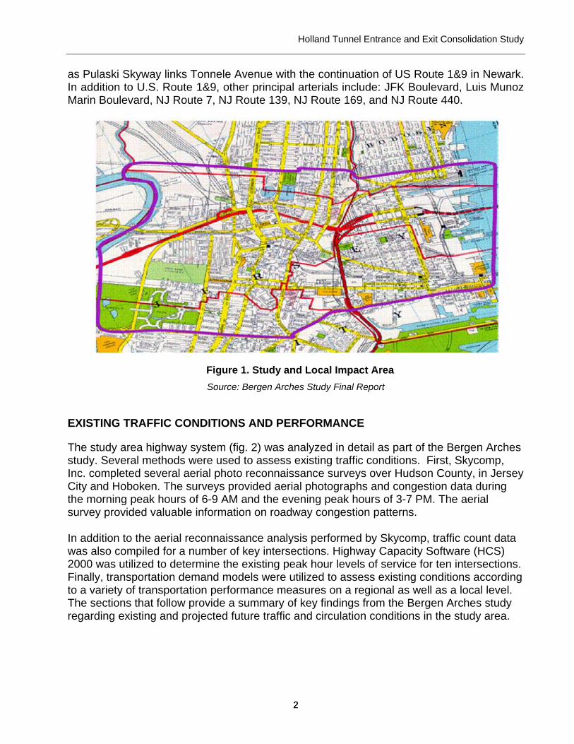
as Pulaski Skyway links Tonnele Avenue with the continuation of US Route 1&9 in Newark. In addition to U.S. Route 1&9, other principal arterials include: JFK Boulevard, Luis Munoz Marin Boulevard, NJ Route 7, NJ Route 139, NJ Route 169, and NJ Route 440.
Figure 1. Study and Local Impact Area Source: Bergen Arches Study Final Report
EXISTING TRAFFIC CONDITIONS AND PERFORMANCE
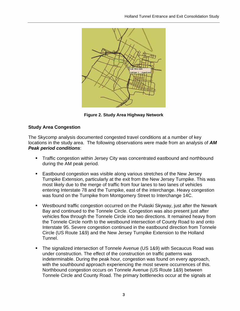
The study area highway system (fig. 2) was analyzed in detail as part of the Bergen Arches study. Several methods were used to assess existing traffic conditions. First, Skycomp, Inc. completed several aerial photo reconnaissance surveys over Hudson County, in Jersey City and Hoboken. The surveys provided aerial photographs and congestion data during the morning peak hours of 6-9 AM and the evening peak hours of 3-7 PM. The aerial survey provided valuable information on roadway congestion patterns. In addition to the aerial reconnaissance analysis performed by Skycomp, traffic count data was also compiled for a number of key intersections. Highway Capacity Software (HCS) 2000 was utilized to determine the existing peak hour levels of service for ten intersections. Finally, transportation demand models were utilized to assess existing conditions according to a variety of transportation performance measures on a regional as well as a local level. The sections that follow provide a summary of key findings from the Bergen Arches study regarding existing and projected future traffic and circulation conditions in the study area.
Holland Tunnel Entrance and Exit Consolidation Study
3 3
Figure 2. Study Area Highway Network
Study Area Congestion
The Skycomp analysis documented congested travel conditions at a number of key locations in the study area. The following observations were made from an analysis of AM Peak period conditions:
Traffic congestion within Jersey City was concentrated eastbound and northbound during the AM peak period.
Eastbound congestion was visible along various stretches of the New Jersey Turnpike Extension, particularly at the exit from the New Jersey Turnpike. This was most likely due to the merge of traffic from four lanes to two lanes of vehicles entering Interstate 78 and the Turnpike, east of the interchange. Heavy congestion was found on the Turnpike from Montgomery Street to Interchange 14C.
Westbound traffic congestion occurred on the Pulaski Skyway, just after the Newark Bay and continued to the Tonnele Circle. Congestion was also present just after vehicles flow through the Tonnele Circle into two directions. It remained heavy from the Tonnele Circle north to the westbound intersection of County Road to and onto Interstate 95. Severe congestion continued in the eastbound direction from Tonnele Circle (US Route 1&9) and the New Jersey Turnpike Extension to the Holland Tunnel.
The signalized intersection of Tonnele Avenue (US 1&9) with Secaucus Road was under construction. The effect of the construction on traffic patterns was indeterminable. During the peak hour, congestion was found on every approach, with the southbound approach experiencing the most severe occurrences of this. Northbound congestion occurs on Tonnele Avenue (US Route 1&9) between Tonnele Circle and County Road. The primary bottlenecks occur at the signals at
Holland Tunnel Entrance and Exit Consolidation Study
4 4
Manhattan Avenue and County Road. Congestion was also found on Tonnele Avenue southbound at the approach to the signal at County Road.
Late into the morning peak period, starting at 7 AM, congestion was found on eastbound US Route 1 (Lincoln Highway) at the approach to the signalized intersection with NJ Route 440. The traffic was often congested in the two right lanes, of three traffic lanes, and extended back Bergen Arches to the bridge across Newark Bay.
Congestion was present on northbound NJ Route 440. Traffic in the left-turn lane often restricted the flow of through traffic.
Congestion was found at the intersection of Jersey Avenue with 16th Street from the southbound, eastbound, and northbound approaches.
Northbound congestion was found the County Road approach to the signal at Michael Deamott Place and extended all the way back to Tonnele Avenue. Congestion at most locations dissipated by 9 AM, except for the northbound traffic on Tonnele Avenue (US Route 1&9) approaching the signal at Manhattan Avenue.
The following observations were made from an analysis of PM peak period conditions:
Traffic congestion appeared on southbound and northbound JFK Boulevard. The southbound congestion occurred at the approach to the signals at Bergen and Tonnele Avenues. Intermittent northbound congestion was found on JFK Boulevard through the series of closely spaced signals in the area of the Pulaski Skyway.
Heavy traffic in the eastbound direction was also present at the signalized intersection of US Route 1 (Lincoln Highway) with Communipaw Avenue. Heavy southbound traffic was found at the signalized intersections of US Route 1 with Culver Avenue and Kellogg Street. There was again congestion found at the Holland Tunnel. However, the evening congestion only occurred along 12th Street, at the intersection with Jersey Avenue and at the toll plaza.
Southbound / westbound congestion was also present on the New Jersey Turnpike Extension, from Interchange 14C to the Newark Bay.
Severe congestion occurred along each direction along Tonnele Avenue (US Route 1&9) between Tonnele Circle and County Road. In the southbound direction, the congestion started at Tonnele Circle and continued back through the signals at Carlton Avenue, Manhattan Avenue, and County Road. In the northbound direction, the primary bottleneck appeared to be at the signalized intersection of Tonnele Circle with Manhattan Avenue; the congestion extended back to Tonnele Circle and a short distance onto Pulaski Skyway. Bergen Arches • Draft Final Report • September, 2002
Holland Tunnel Entrance and Exit Consolidation Study
5 5
Traffic also was heavy from the Tonnele Circle north to the intersection of Tonnele Avenue (US Route 1&9) with Secaucus Road from every approach, especially eastbound and southbound. The signalized intersection of Tonnele Avenue (US 1&9) with Secaucus Road was under construction. The effect of the construction on traffic patterns was undeterminable. During the peak period, congestion was found on every approach.
Heavy congestion in the northbound direction was observed at the signalized intersections of Tonnele Avenue with Manhattan Avenue and with County Road. Congestion usually extended back to the Tonnele Circle vicinity. The southbound and eastbound approaches experienced the heaviest volumes.
Congestion was also present on the Luis Munoz Marin Boulevard, 18th Street, and Grove Street; construction on Luis Munoz Marin Boulevard appeared to aggravate the situation. Northbound traffic was diverted to Grove Street via 18th Street. In the eastbound direction, congestion was found on Hoboken Avenue at its intersection with Observer Highway. The intersection of Jersey Avenue with 18th Street also did not experience significant truck and bus traffic. The westbound approach of 18th Street endured the most truck and bus traffic with averages of 2% and 5%, respectively. The predominant truck and bus movement was the right turn onto northbound Jersey Avenue.
The intersection of Grove Street with Columbus Drive experienced significant truck and bus traffic. The westbound approach of Columbus Drive endured the most truck and bus traffic with averages of 12% each. The predominant turning movement for trucks was to remain through on westbound Columbus Boulevard, while for buses it was the left turn onto southbound Grove Street.
The intersection of Manila Avenue with 10th Street also did not experience significant truck and traffic. The westbound approach of 18th Street and the southbound approach of Manila Avenue endured the most truck traffic as each averages 6% of the total traffic, while no approach had any bus traffic.
The intersection of Tonnele Circle and Route 1&9 experienced a very significant amount of truck traffic. Large volumes of trucks were found on Route 1&9 (T) in both the northbound and eastbound directions, southbound Route 1&9, and southbound Tonnele Circle. Truck traffic averaged over 15% of the total traffic on these roads throughout the morning peak period, particularly on Route 1&9 (T), eastbound and northbound; Route 1&9, southbound, and Tonnele Circle, southbound. There was very little bus traffic on these roads during this period.
At the intersection of Marin Boulevard with 6th Street, the only approach with a significant quantity of bus traffic was westbound 6th Street. Of the total traffic at this intersection during the evening peak period, about 8% was buses and the majority of those were making the left turn movement onto southbound Marin Boulevard. There was no significant truck traffic.
Holland Tunnel Entrance and Exit Consolidation Study
6 6
The intersection of Washington Boulevard with 6th Street did not experience significant truck and bus traffic. The southbound Washington Boulevard approach was utilized by trucks and buses the most, with trucks and buses averaging 1% and 4% of the total traffic, respectively. The substantial truck and bus turning movement was the southbound right turn. The intersection of Jersey Avenue with 18th Street also did not experience significant truck and bus traffic. None of the approaches had truck or bus traffic that was over 3% of the total traffic for that intersection. The intersection of Grove Street with Columbus Drive also did not experience significant truck and bus traffic. None of the approaches had truck or bus traffic that was over 5% of the total traffic for that intersection. The intersection of Manila Avenue with 10th Street also did not experience significant truck and bus traffic. The eastbound approach of 10th Street endured the most truck traffic and only during the hour 3:30 – 4:30 PM.
Origins and Destinations
An origin and destination (O&D) analysis was performed using trip table data derived from the Bergen Arches study regional model. The analysis was based on a screenline drawn just west of the Tonnele Circle. The O&D analysis provided a picture of travel patterns in the study area and allowed comparisons showing changes in travel patterns between 2000 and 2025.
As shown in table 1, the share of vehicle trips at the screenline destined for downtown Jersey City grows from 35% in 2000 to 37% in 2025. Similarly the rest of northern New Jersey zone also gains a 3% share.
Table 1. Destinations of Eastbound Travel at the Screenline
Origins 2000 2025 Downtown Jersey City (JC) 35% 37% Holland Tunnel 16% 13% Rest of JC 37% 35% Rest of Northern New Jersey 12% 15%
Source: Bergen Arches Study Final Report
Table 2. Origins of Eastbound Travel at Screenline
Origins 2000 2025 Northern Region 31% 29% Central Region 38% 38% Jersey City 21% 22% Western Region 3% 4% Southern Region 7% 7%
Source: Bergen Arches Study Final Report

Holland Tunnel Entrance and Exit Consolidation Study
7 7
As shown in table 2, a review of trip origins at the screenline indicates that the proportion of eastbound trips with origins from the Northern Region decrease, while origins from the Central and Southern Region maintain their share, and the Western Region and Jersey City shares increase. Figure 3 illustrates the data found in table 1 and 2.
Figure 3. Travel Patterns at Screenline Source: Bergen Arches Study Final Report
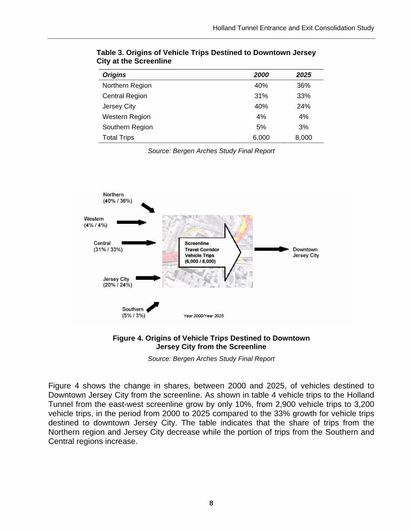
Table 3 lists the percentages of vehicle trip origins at the screenline destined to either downtown Jersey City or to the Holland Tunnel. As shown in table 3 vehicle trips to downtown Jersey City from the east-west screenline grow by 33%, from 6,000 vehicle trips to 8,000 vehicle trips, in the period from 2000 to 2025. The table indicates that the share of trips from the Northern and Southern regions decrease while the portion of trips from Jersey City and the Central region increase.
Holland Tunnel Entrance and Exit Consolidation Study
8 8
Table 3. Origins of Vehicle Trips Destined to Downtown Jersey City at the Screenline
Origins 2000 2025 Northern Region 40% 36% Central Region 31% 33% Jersey City 40% 24% Western Region 4% 4% Southern Region 5% 3% Total Trips 6,000 8,000
Source: Bergen Arches Study Final Report
Figure 4. Origins of Vehicle Trips Destined to Downtown Jersey City from the Screenline
Source: Bergen Arches Study Final Report Figure 4 shows the change in shares, between 2000 and 2025, of vehicles destined to Downtown Jersey City from the screenline. As shown in table 4 vehicle trips to the Holland Tunnel from the east-west screenline grow by only 10%, from 2,900 vehicle trips to 3,200 vehicle trips, in the period from 2000 to 2025 compared to the 33% growth for vehicle trips destined to downtown Jersey City. The table indicates that the share of trips from the Northern region and Jersey City decrease while the portion of trips from the Southern and Central regions increase.
Holland Tunnel Entrance and Exit Consolidation Study
9 9
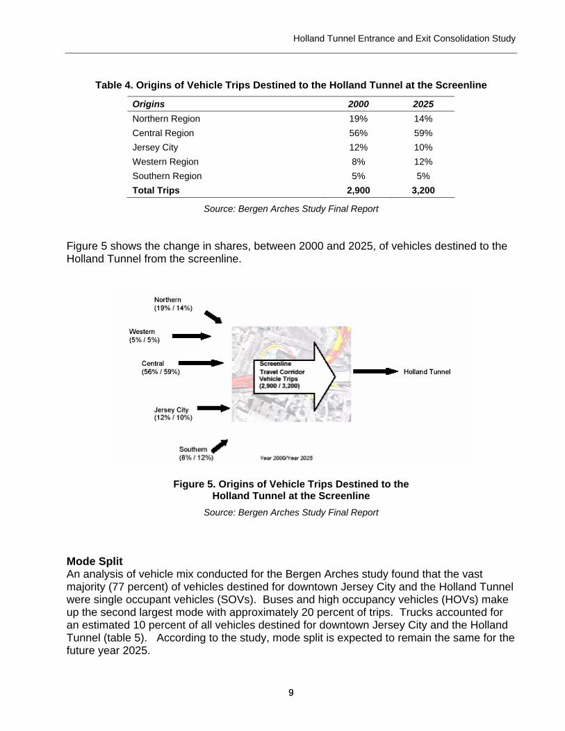
Table 4. Origins of Vehicle Trips Destined to the Holland Tunnel at the Screenline
Origins 2000 2025 Northern Region 19% 14% Central Region 56% 59% Jersey City 12% 10% Western Region 8% 12% Southern Region 5% 5% Total Trips 2,900 3,200
Source: Bergen Arches Study Final Report Figure 5 shows the change in shares, between 2000 and 2025, of vehicles destined to the Holland Tunnel from the screenline.
Figure 5. Origins of Vehicle Trips Destined to the Holland Tunnel at the Screenline
Source: Bergen Arches Study Final Report
Mode Split An analysis of vehicle mix conducted for the Bergen Arches study found that the vast majority (77 percent) of vehicles destined for downtown Jersey City and the Holland Tunnel were single occupant vehicles (SOVs). Buses and high occupancy vehicles (HOVs) make up the second largest mode with approximately 20 percent of trips. Trucks accounted for an estimated 10 percent of all vehicles destined for downtown Jersey City and the Holland Tunnel (table 5). According to the study, mode split is expected to remain the same for the future year 2025.
Holland Tunnel Entrance and Exit Consolidation Study
10 10
Table 5. Mode Split for Year 2000 (A.M. Peak Period)
Mode Percent Trucks 10% SOV 77% HOV/Buses 20%
Source: Bergen Arches Study Final Report ALTERNATIVES CONSIDERED As stated above, the purpose of this study was to examine the preliminary feasibility of elevating the Holland Tunnel approaches to provide a safer and more efficient connection to the tunnel, eliminate conflicts between local and trans-Hudson auto traffic and improve access to the Jersey City waterfront and Hoboken. The design of the conceptual alignments was guided by the following objectives:
1. Reduce congestion, increase throughput and increase travel speed to and from the Holland Tunnel via Route 139 by providing direct access to and from the Holland Tunnel.
2. Reduce conflicts between trans-Hudson tunnel traffic and local traffic on Jersey City streets.
3. Improve access to Hoboken and the Jersey City waterfront 4. Reestablish a traditional street grid in this section of Jersey City and provide
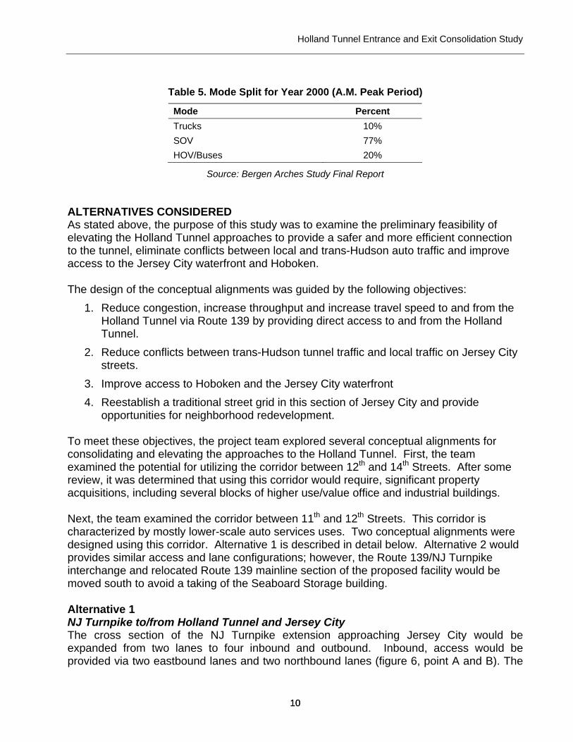
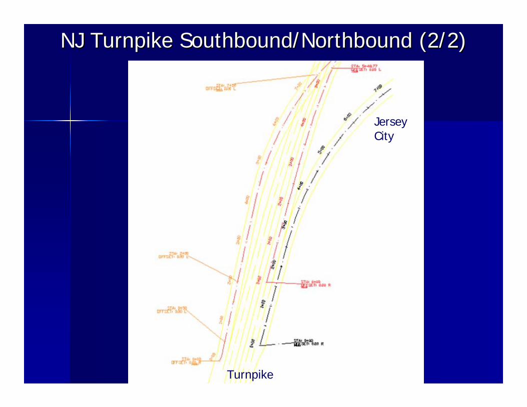
opportunities for neighborhood redevelopment. To meet these objectives, the project team explored several conceptual alignments for consolidating and elevating the approaches to the Holland Tunnel. First, the team examined the potential for utilizing the corridor between 12th and 14th Streets. After some review, it was determined that using this corridor would require, significant property acquisitions, including several blocks of higher use/value office and industrial buildings. Next, the team examined the corridor between 11th and 12th Streets. This corridor is characterized by mostly lower-scale auto services uses. Two conceptual alignments were designed using this corridor. Alternative 1 is described in detail below. Alternative 2 would provides similar access and lane configurations; however, the Route 139/NJ Turnpike interchange and relocated Route 139 mainline section of the proposed facility would be moved south to avoid a taking of the Seaboard Storage building. Alternative 1 NJ Turnpike to/from Holland Tunnel and Jersey City The cross section of the NJ Turnpike extension approaching Jersey City would be expanded from two lanes to four inbound and outbound. Inbound, access would be provided via two eastbound lanes and two northbound lanes (figure 6, point A and B). The
Holland Tunnel Entrance and Exit Consolidation Study
11 11
eastbound lanes would provide access to the Holland Tunnel and 11th Street. The northbound lanes would provide access to Jersey City via 17th street. Outbound access from the Holland Tunnel and Jersey City to the NJ Turnpike would similarly become four lanes, with two two-lane highways (figure 6, points C & D), which meet at point E (figure 6). Rt. 139 to/from Holland Tunnel and Jersey City Rt. 139 access approaching the Holland Tunnel would remain unchanged. However, access to/from Jersey City would be modified to include two one-lane roadways, one northbound and one southbound via 17th street (figure 6, points F and G).
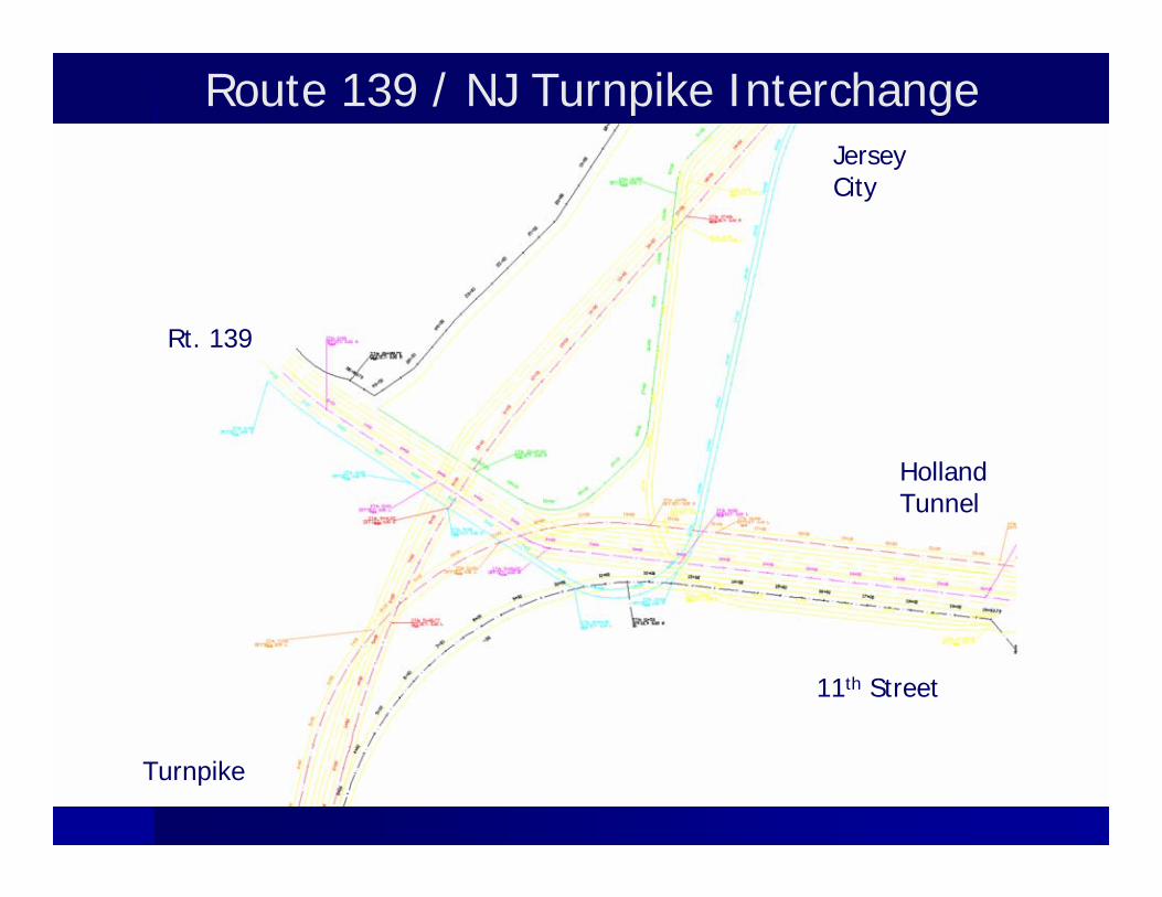
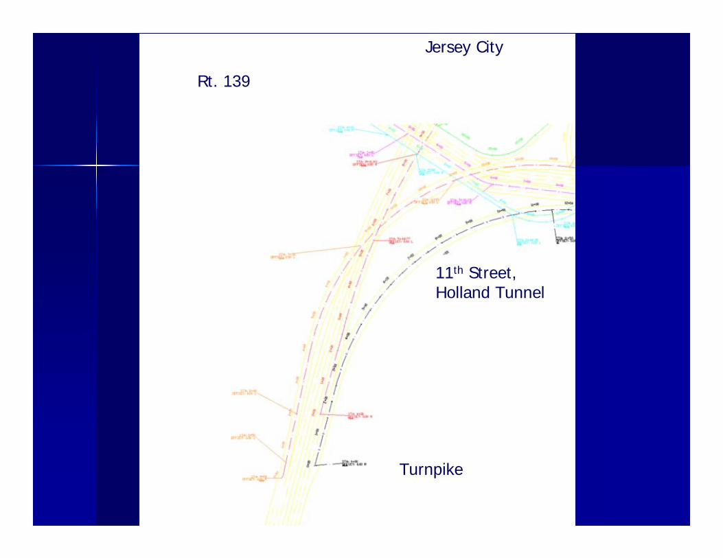
Figure 6. Rt. 139 and NJ Turnpike access to/from the Holland Tunnel/Jersey City
A. Two lane highway to Holland Tunnel/11th Street from NJ Turnpike B. Two lane highway to Jersey City from NJ Turnpike C. Two lane highway to NJ Turnpike from Holland Tunnel D. Two lane highway to NJ Turnpike from Jersey City E. Meet point of two-lane highways from Jersey City and Holland Tunnel to NJ Turnpike F. One lane highway to Rt. 139 from Jersey City G. One lane highway to Jersey City from Rt. 139 H. One lane highway to Holland Tunnel from Jersey City I. Existing roadway (Hoboken Ave.) from Jersey City to Rt. 139. J. Merging point of highways to Holland Tunnel from NJ Turnpike, Rt. 139, and Jersey
City into a 6 lane elevated highway K. 6-lane highway to NJ Turnpike, Rt. 139
B
A
C
D
E
F
G
H
I
J
K
Holland Tunnel Entrance and Exit Consolidation Study
12 12
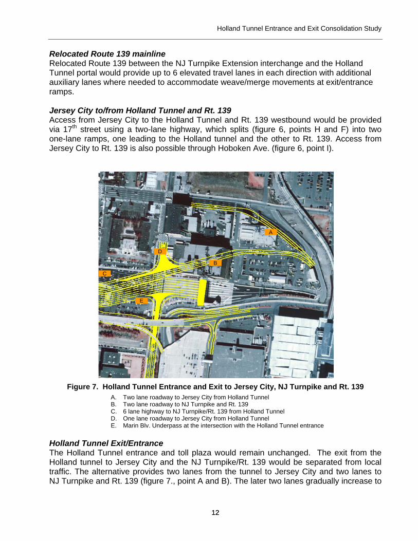
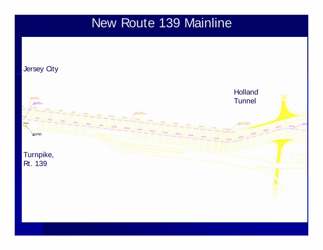
Relocated Route 139 mainline Relocated Route 139 between the NJ Turnpike Extension interchange and the Holland Tunnel portal would provide up to 6 elevated travel lanes in each direction with additional auxiliary lanes where needed to accommodate weave/merge movements at exit/entrance ramps. Jersey City to/from Holland Tunnel and Rt. 139 Access from Jersey City to the Holland Tunnel and Rt. 139 westbound would be provided via 17th street using a two-lane highway, which splits (figure 6, points H and F) into two one-lane ramps, one leading to the Holland tunnel and the other to Rt. 139. Access from Jersey City to Rt. 139 is also possible through Hoboken Ave. (figure 6, point I).
Figure 7. Holland Tunnel Entrance and Exit to Jersey City, NJ Turnpike and Rt. 139
A. Two lane roadway to Jersey City from Holland Tunnel B. Two lane roadway to NJ Turnpike and Rt. 139 C. 6 lane highway to NJ Turnpike/Rt. 139 from Holland Tunnel D. One lane roadway to Jersey City from Holland Tunnel E. Marin Blv. Underpass at the intersection with the Holland Tunnel entrance
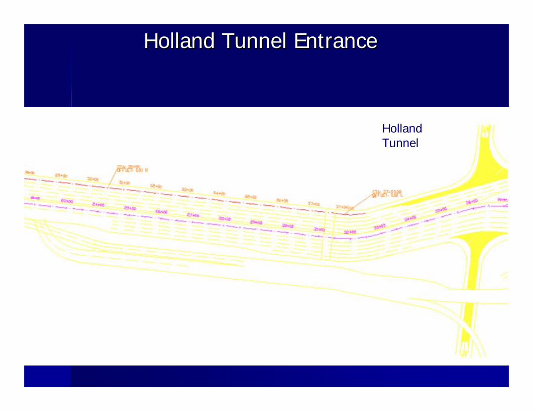
Holland Tunnel Exit/Entrance The Holland Tunnel entrance and toll plaza would remain unchanged. The exit from the Holland tunnel to Jersey City and the NJ Turnpike/Rt. 139 would be separated from local traffic. The alternative provides two lanes from the tunnel to Jersey City and two lanes to NJ Turnpike and Rt. 139 (figure 7., point A and B). The later two lanes gradually increase to
A
B
C
D
E
Holland Tunnel Entrance and Exit Consolidation Study
13 13
a six-lane highway (figure 7, point C). Motorist would also be able to access Jersey City from the Holland Tunnel via a one-lane roadway (figure 7, point D). Marin Boulevard (figure 7, point E) would become an underpass at its intersection with the Holland Tunnel entrance lanes.
PRELIMINARY FEASIBILITY ASSESSMENT
The project team used sketch level planning techniques and simulation modeling to assess the relative feasibility of Alternative 1 in terms of the following key considerations:
Physical feasibility of consolidating the entrance and exit lanes, elevating the facility and connecting it to the existing highway network;
Post-construction traffic and circulation patterns; Construction staging and traffic maintenance during construction; and Right-of-way needs and property acquisition.
Physical feasibility of consolidating the entrance and exit lanes As described above, the consolidation of the Tunnel entrance and exit lanes appears to be physically feasible. The proposed alternative would provide acceptable ramp grades on the toll plaza approach and exit/entrance ramps. It would also provide height profiles adequate to permit the movement of trucks on cross streets passing under the new elevated structure. In addition, the conceptual design study indicates that the proposed new facility could be effectively integrated with the existing roadway network while maintaining an acceptable level of service through the design year of 2025. Post-construction traffic & circulation
The engineering team conducted a sketch level analysis of post-construction traffic operations for the year 2025. The main goal was to ensure the conceptual design could appropriately accommodate existing and projected traffic. The model was built using the traffic simulation software Paramics V.3.0. The data used for this study was that collected and used for the Bergen Arches study described above. The Bergen Arches study was reviewed and data from the study was utilized to document current traffic conditions and provide input data for the simulation model, including directional volumes on the entrance and exit ramps to the Holland tunnel and surrounding local street network.
The traffic data included field data, automatic traffic recorders (ATRs), manual-turning movement counts and aerial data. As part of the traffic data collection, a data inventory was conducted which included both intersection data and roadway characteristics. Various statistics compiled from this analysis included: number of lanes, lane width, lane assignment, speed limit, parking, and roadway type for various corridors in the study area. In addition to field data collection, a total of 23 ATRs were placed in the study area.
Holland Tunnel Entrance and Exit Consolidation Study
14 14
Additionally, manual turning movement counts were performed at 14 locations during high volume times of day (AM and PM Peak Periods). The final element of the traffic data collection was a series of aerial photo surveys of highway traffic in the study area. The survey flights also occurred during high volume times of day to photograph congestion and length of queues. All the available data was provided through a Paramics microsimulation model.
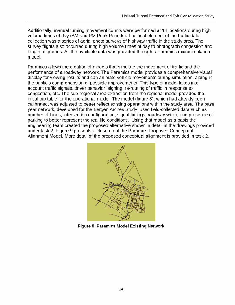
Paramics allows the creation of models that simulate the movement of traffic and the performance of a roadway network. The Paramics model provides a comprehensive visual display for viewing results and can animate vehicle movements during simulation, aiding in the public’s comprehension of possible improvements. This type of model takes into account traffic signals, driver behavior, signing, re-routing of traffic in response to congestion, etc. The sub-regional area extraction from the regional model provided the initial trip table for the operational model. The model (figure 8), which had already been calibrated, was adjusted to better reflect existing operations within the study area. The base year network, developed for the Bergen Arches Study, used field-collected data such as number of lanes, intersection configuration, signal timings, roadway width, and presence of parking to better represent the real life conditions. Using that model as a basis the engineering team created the proposed alternative shown in detail in the drawings provided under task 2. Figure 9 presents a close-up of the Paramics Proposed Conceptual Alignment Model. More detail of the proposed conceptual alignment is provided in task 2.
Figure 8. Paramics Model Existing Network
Holland Tunnel Entrance and Exit Consolidation Study
15 15
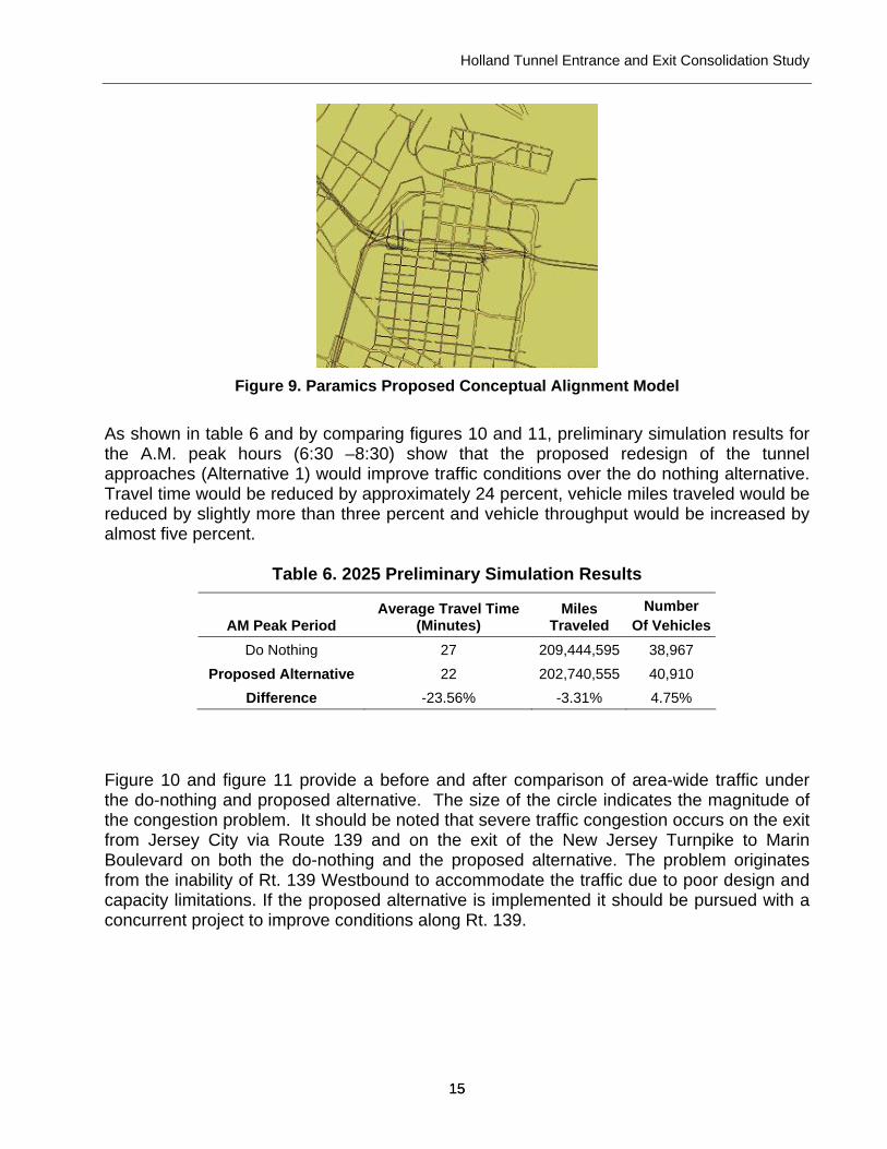
Figure 9. Paramics Proposed Conceptual Alignment Model
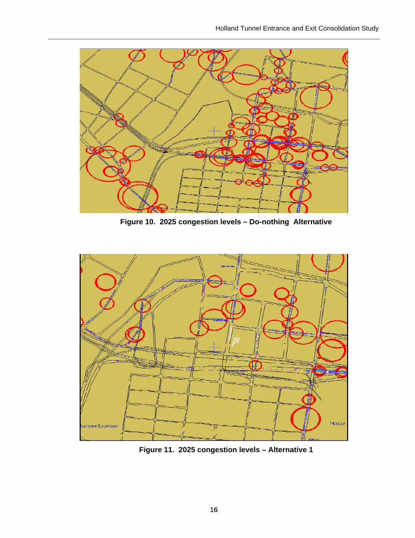
As shown in table 6 and by comparing figures 10 and 11, preliminary simulation results for the A.M. peak hours (6:30 –8:30) show that the proposed redesign of the tunnel approaches (Alternative 1) would improve traffic conditions over the do nothing alternative. Travel time would be reduced by approximately 24 percent, vehicle miles traveled would be reduced by slightly more than three percent and vehicle throughput would be increased by almost five percent.
Table 6. 2025 Preliminary Simulation Results
AM Peak Period Average Travel Time
(Minutes) Miles
Traveled Number
Of Vehicles Do Nothing 27 209,444,595 38,967
Proposed Alternative 22 202,740,555 40,910 Difference -23.56% -3.31% 4.75%
Figure 10 and figure 11 provide a before and after comparison of area-wide traffic under the do-nothing and proposed alternative. The size of the circle indicates the magnitude of the congestion problem. It should be noted that severe traffic congestion occurs on the exit from Jersey City via Route 139 and on the exit of the New Jersey Turnpike to Marin Boulevard on both the do-nothing and the proposed alternative. The problem originates from the inability of Rt. 139 Westbound to accommodate the traffic due to poor design and capacity limitations. If the proposed alternative is implemented it should be pursued with a concurrent project to improve conditions along Rt. 139.
Holland Tunnel Entrance and Exit Consolidation Study
16 16
Figure 10. 2025 congestion levels – Do-nothing Alternative
Figure 11. 2025 congestion levels – Alternative 1
Holland Tunnel Entrance and Exit Consolidation Study
17 17
Construction staging and traffic maintenance during construction
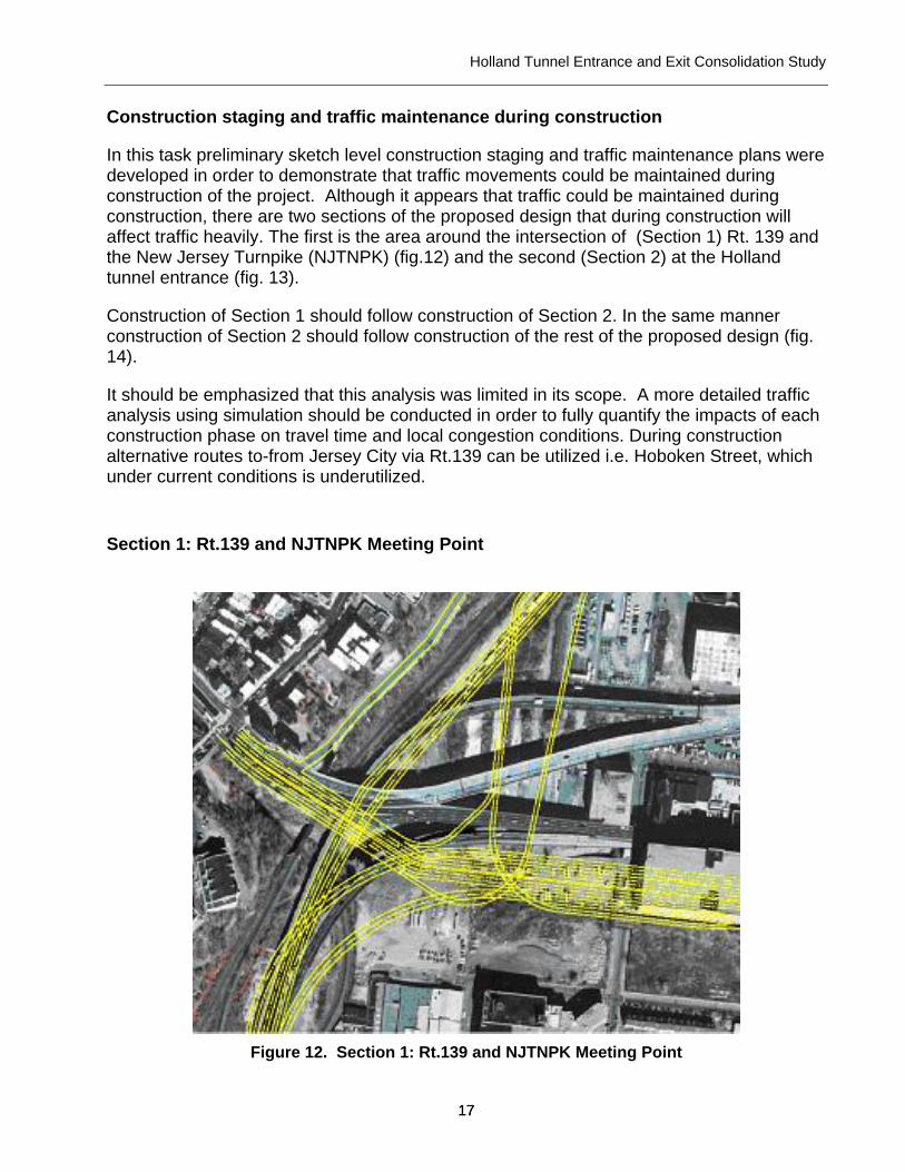
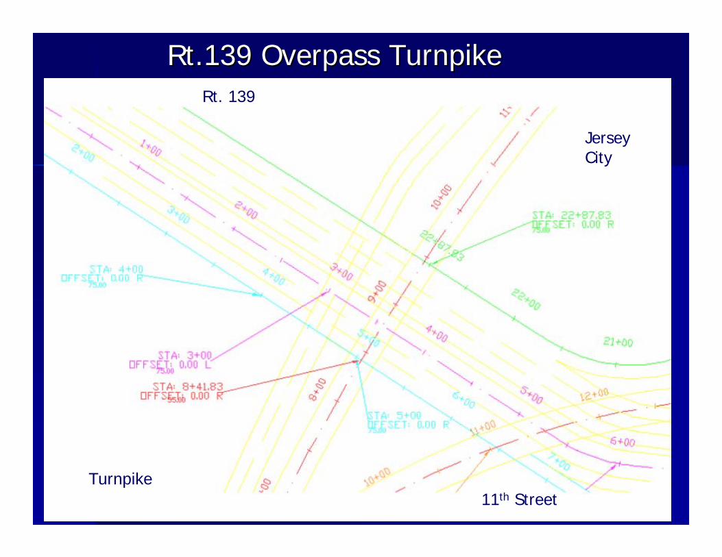
In this task preliminary sketch level construction staging and traffic maintenance plans were developed in order to demonstrate that traffic movements could be maintained during construction of the project. Although it appears that traffic could be maintained during construction, there are two sections of the proposed design that during construction will affect traffic heavily. The first is the area around the intersection of (Section 1) Rt. 139 and the New Jersey Turnpike (NJTNPK) (fig.12) and the second (Section 2) at the Holland tunnel entrance (fig. 13).
Construction of Section 1 should follow construction of Section 2. In the same manner construction of Section 2 should follow construction of the rest of the proposed design (fig. 14).
It should be emphasized that this analysis was limited in its scope. A more detailed traffic analysis using simulation should be conducted in order to fully quantify the impacts of each construction phase on travel time and local congestion conditions. During construction alternative routes to-from Jersey City via Rt.139 can be utilized i.e. Hoboken Street, which under current conditions is underutilized.
Section 1: Rt.139 and NJTNPK Meeting Point
Figure 12. Section 1: Rt.139 and NJTNPK Meeting Point

Holland Tunnel Entrance and Exit Consolidation Study
18 18
Section 2: Holland Tunnel Entrance
Figure 13. Section 2: Holland Tunnel Entrance
The main part of the new design (fig. 14) can be constructed with minimal traffic impacts.
Figure 14. New Design for Relocated Route 139

Holland Tunnel Entrance and Exit Consolidation Study
19 19
Phase 1a. Construction of Rt. 139 access to-from Jersey City and Holland Tunnel Allow usage of one lane per direction per level from Rt.139 to Jersey City and construct the other lanes (shaded part, Figure 15-16).
Figure 15. Phase 1a1.
Figure 16. Phase 1a2 (second part)
Holland Tunnel Entrance and Exit Consolidation Study
20 20
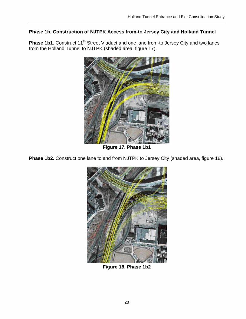
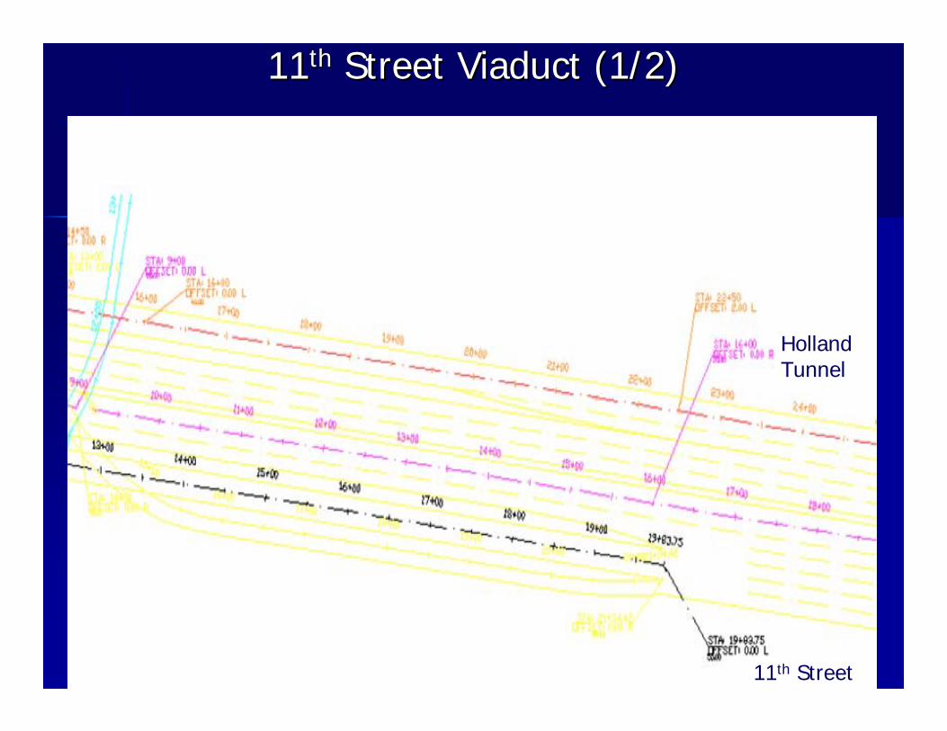
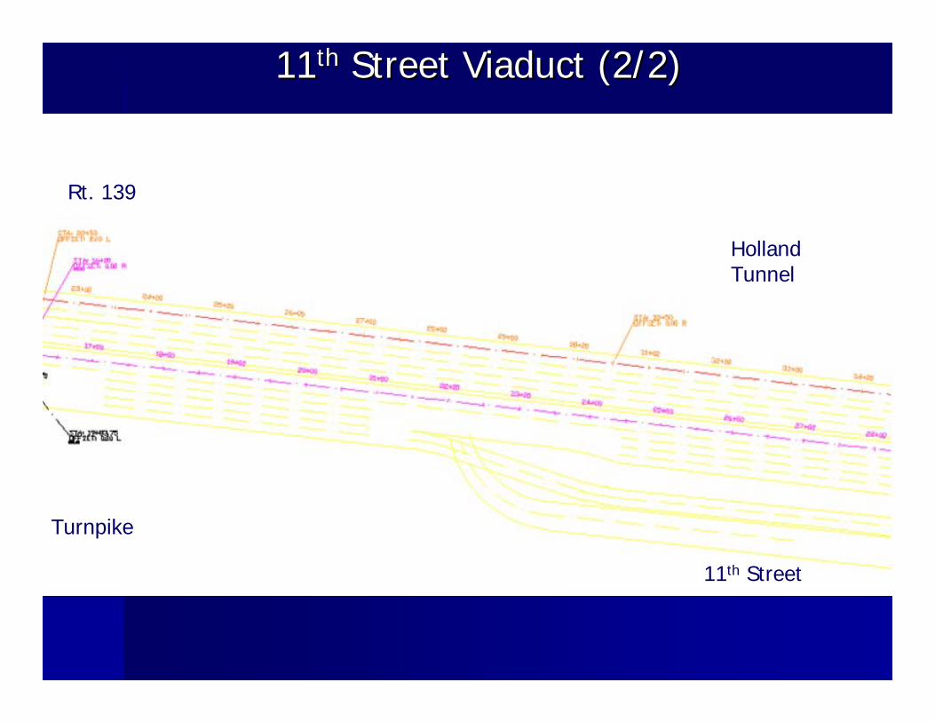
Phase 1b. Construction of NJTPK Access from-to Jersey City and Holland Tunnel Phase 1b1. Construct 11th Street Viaduct and one lane from-to Jersey City and two lanes from the Holland Tunnel to NJTPK (shaded area, figure 17).
Figure 17. Phase 1b1
Phase 1b2. Construct one lane to and from NJTPK to Jersey City (shaded area, figure 18).
Figure 18. Phase 1b2
Holland Tunnel Entrance and Exit Consolidation Study
21 21
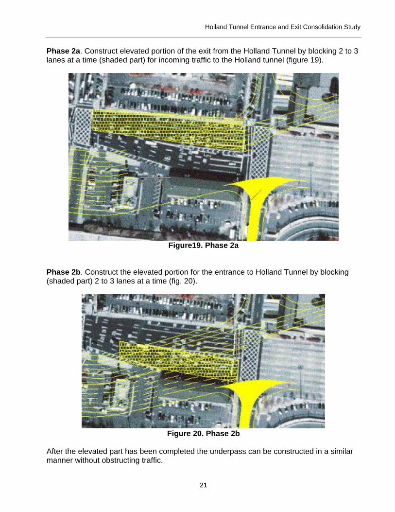
Phase 2a. Construct elevated portion of the exit from the Holland Tunnel by blocking 2 to 3 lanes at a time (shaded part) for incoming traffic to the Holland tunnel (figure 19).
Figure19. Phase 2a
Phase 2b. Construct the elevated portion for the entrance to Holland Tunnel by blocking (shaded part) 2 to 3 lanes at a time (fig. 20).
Figure 20. Phase 2b
After the elevated part has been completed the underpass can be constructed in a similar manner without obstructing traffic.
Holland Tunnel Entrance and Exit Consolidation Study
22 22
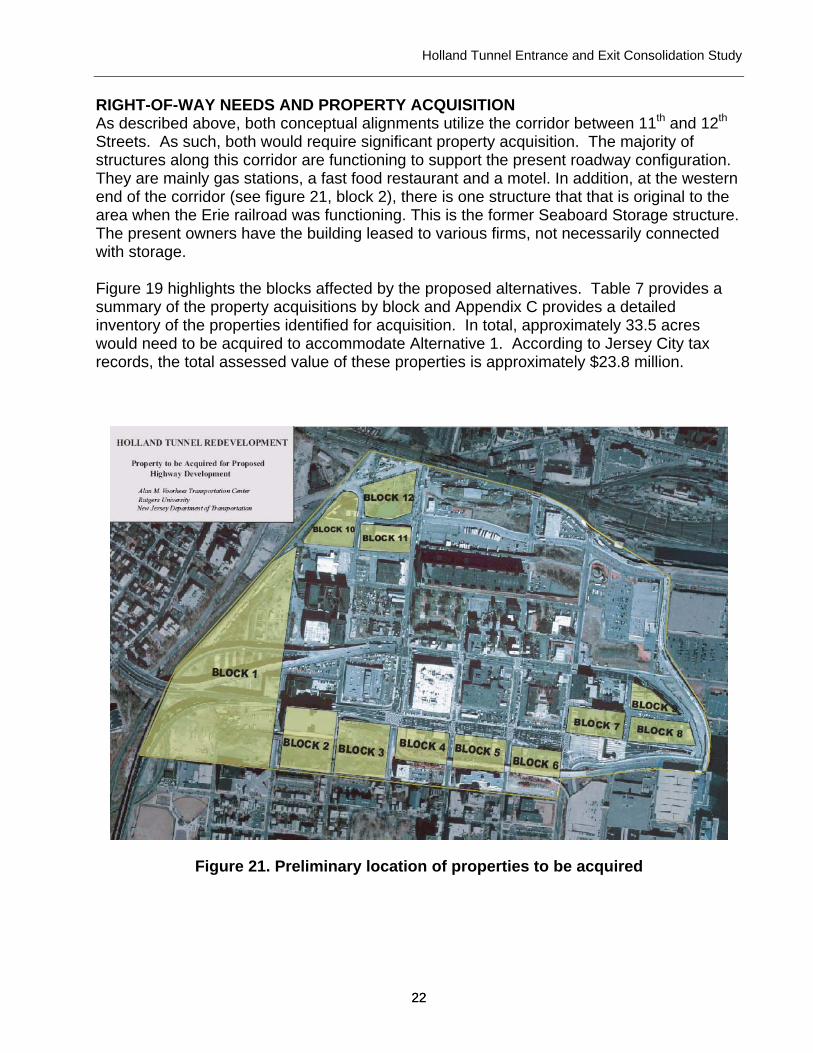
RIGHT-OF-WAY NEEDS AND PROPERTY ACQUISITION As described above, both conceptual alignments utilize the corridor between 11th and 12th Streets. As such, both would require significant property acquisition. The majority of structures along this corridor are functioning to support the present roadway configuration. They are mainly gas stations, a fast food restaurant and a motel. In addition, at the western end of the corridor (see figure 21, block 2), there is one structure that that is original to the area when the Erie railroad was functioning. This is the former Seaboard Storage structure. The present owners have the building leased to various firms, not necessarily connected with storage. Figure 19 highlights the blocks affected by the proposed alternatives. Table 7 provides a summary of the property acquisitions by block and Appendix C provides a detailed inventory of the properties identified for acquisition. In total, approximately 33.5 acres would need to be acquired to accommodate Alternative 1. According to Jersey City tax records, the total assessed value of these properties is approximately $23.8 million.
Figure 21. Preliminary location of properties to be acquired
Holland Tunnel Entrance and Exit Consolidation Study
23 23
Table 7. Summary of potential property acquisitions Acres Assessed Value Block 1 11.97 $ 3,131,250 Block 2 4.22 $ 7,247,400 Block 3 2.13 $ 275,000 Block 4 1.97 $ 1,931,800 Block 5 2.02 $ 1,540,400 Block 6 1.01 $ 3,090,000 Block 7 1.82 $ 1,750,000 Block 8 1.80 $ - Block 9 0.66 $ 1,674,800 Block 10 2.31 $ 1,211,800 Block 11 1.84 $ 1,392,300 Block 12 1.80 $ 550,000 TOTAL 33.55 $ 23,794,750
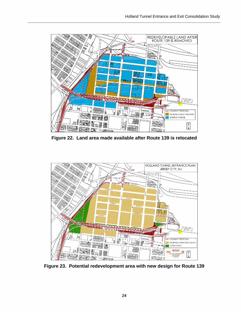
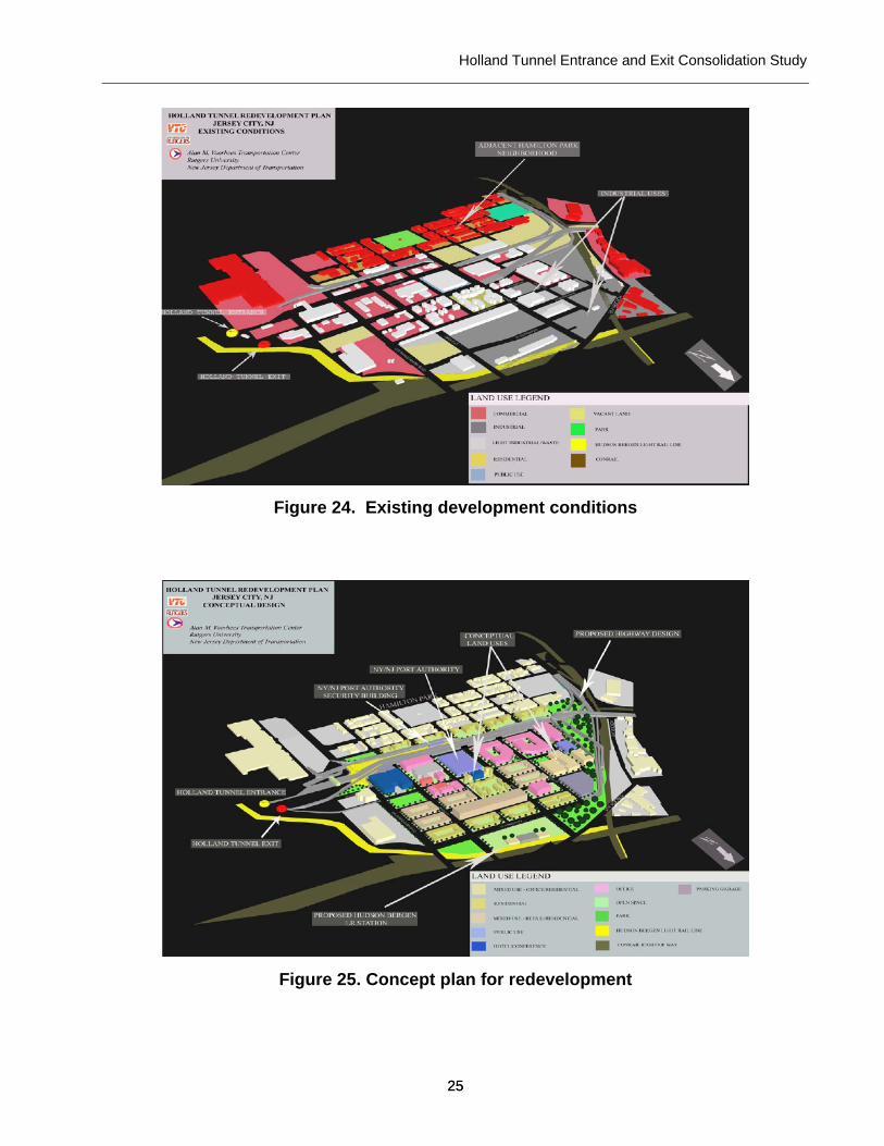
REDEVELOPMENT OPPORTUNITIES Currently, the existing block structure of this part of Jersey City is interrupted by multi-lane east-west thoroughfares and significant congestion, especially during morning and evening peak travel periods. A consolidated and elevated tunnel access road could dramatically change local traffic patterns and provide an opportunity to re-establish a functioning local street grid within the study area. In order to assess the degree to which the concept design may change and enhance access to local real estate in the study area the project team conducted a redevelopment opportunities analysis. As shown in figures 22-25, the concept design would relocate and elevate the Route 139 east and westbound lanes to the south, thereby freeing up the area for potential redevelopment. In addition, the relocation of Route 139 would permit the incorporation of former road space into adjacent blocks. The most significant change would be the creation of four “super blocks” between 12th and 14th Streets, from Marin Boulevard to Coles Street. These blocks would no longer be interrupted by heavy volumes of regional tunnel traffic and become more attractive for redevelopment. This super-block corridor could in effect extend the Newport development and connect this area to the waterfront. At the same time, elevating Route 139 from Coles Street to the tunnel portal would limit access to the Hamilton Park neighborhood from Route 139 and create street level connections for local traffic and pedestrians more in keeping with the character of the Hamilton Park neighborhood.
Holland Tunnel Entrance and Exit Consolidation Study
24 24
Figure 22. Land area made available after Route 139 is relocated
Figure 23. Potential redevelopment area with new design for Route 139
Holland Tunnel Entrance and Exit Consolidation Study
25 25
Figure 24. Existing development conditions
Figure 25. Concept plan for redevelopment
Holland Tunnel Entrance and Exit Consolidation Study
26 26
COORDINATION AND OUTREACH An initial project coordination meeting was conducted with Frank Weiss and Gary Toth of the NJDOT Project Planning and Development office. The purpose of the meeting was to discuss the entrance and exit consolidation concept and to seek data and information from various subject matter experts at NJDOT. In addition, a preliminary outreach meeting was held with Jersey City Planner Bob Cotter (1/25/05). The purpose of this meeting was to gauge initial local reaction to the consolidation concept and to seek input on areas of emphasis and caution as the study proceeded. All parties agreed that outreach during the study should be limited to elected officials and their professional staff and that no meetings with the general public should be held. Following the development of conceptual design drawings and after preliminary results from the feasibility assessment were available, the project team conducted several additional meetings with local officials. Meetings were held with Hudson County Executive Thomas DeGise and Hudson County engineer Bob Jasek (2/17/05). In addition, a meeting was held with aides to Jersey City Mayor Jerramiah Healy, including his chief of staff Carl Czaplicki and David Donnelly (3/24/05). The reactions of local officials were very positive. RECOMMENDATION Based on the findings of the preliminary feasibility assessment and the positive reception the consolidation concept received from local officials, it would be appropriate to advance the Holland Tunnel entrance and exit consolidation concept to the next phase of project development through the Department’s study and development program. Toward that end, the Department should work with Hudson County and Jersey City officials to initiate discussions with the North Jersey Transportation Planning Authority regarding the addition of this project to the study and development project pool. The following issues should be clarified as the project advances:
1. How should this project be addressed as part of the on-going Jersey City Regional Waterfront Access and Downtown Circulation study?
2. How does this project related to the proposed Hudson County West to East Access Study? For example, should continued work on the consolidation concept be included in the scope of work for the study?
3. What role can/should the Port Authority of NY&NJ and the NJ Turnpike Authority play in advancing the consolidation concept?
4. Would a NJ Turnpike exit ramp connecting to the 11th Street viaduct have independent utility of the larger consolidation concept? Is it appropriate to advance the ramp concept as a separate project/study?
Holland Tunnel Entrance and Exit Consolidation Study
27 27
LIST OF PREPARERS
Maria Boile, Ph.D., Assistant Professor, Department of Civil & Environmental Engineering, Rutgers, the State University of New Jersey
Jon A. Carnegie, AICP/PP, Assistant Director, Alan M. Voorhees Transportation Center, Rutgers, the State University of New Jersey
Michail Golias, Graduate Research Assistant, Department of Civil & Environmental Engineering, Rutgers, the State University of New Jersey
James Greller, Project Manager, Alan M. Voorhees Transportation Center, Rutgers, the State University of New Jersey
Chris Riale, Graduate Research Assistant, Alan M. Voorhees Transportation Center, Rutgers, the State University of New Jersey

Holland Tunnel Entrance and Exit Consolidation Study
28 28
Appendix A
Conceptual Design Plans
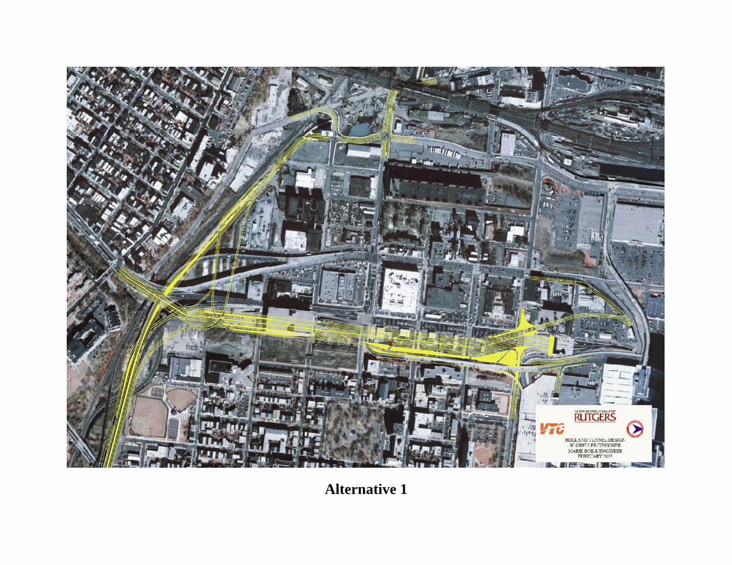
Alternative 1
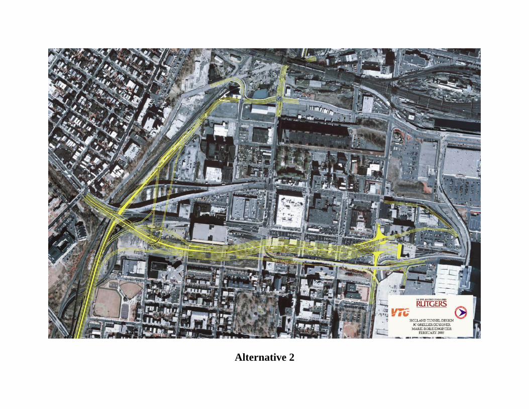
Alternative 2
Holland Tunnel Entrance and Exit Consolidation Study
29 29
Appendix B
Design Plan Elevations – Alternative 1
Route 139 / NJ Turnpike Interchange
Rt. 139
Jersey City
Turnpike
11th Street
Holland Tunnel
Rt.139 Overpass TurnpikeRt.139 Overpass TurnpikeRt. 139
Jersey City
Turnpike11th Street
Rt.139, NJ Turnpike Rt.139, NJ Turnpike (From/To Holland, From/To Jersey City)(From/To Holland, From/To Jersey City)
Rt. 139 Jersey City
Turnpike 11th Street
Turnpike
Rt. 139
Jersey City
11th Street, Holland Tunnel

NJ Turnpike Southbound/Northbound (1/2)NJ Turnpike Southbound/Northbound (1/2)
Rt. 139
Turnpike
11th Street
NJ Turnpike Southbound/Northbound (2/2)NJ Turnpike Southbound/Northbound (2/2)
Jersey City
Turnpike
New Route 139 Mainline
Holland Tunnel
Jersey City
Turnpike, Rt. 139
1111thth Street Viaduct (1/2)Street Viaduct (1/2)
Holland Tunnel
11th Street
1111thth Street Viaduct (2/2)Street Viaduct (2/2)
Holland Tunnel
11th Street
Rt. 139
Turnpike
Holland Tunnel EntranceHolland Tunnel Entrance
Holland Tunnel
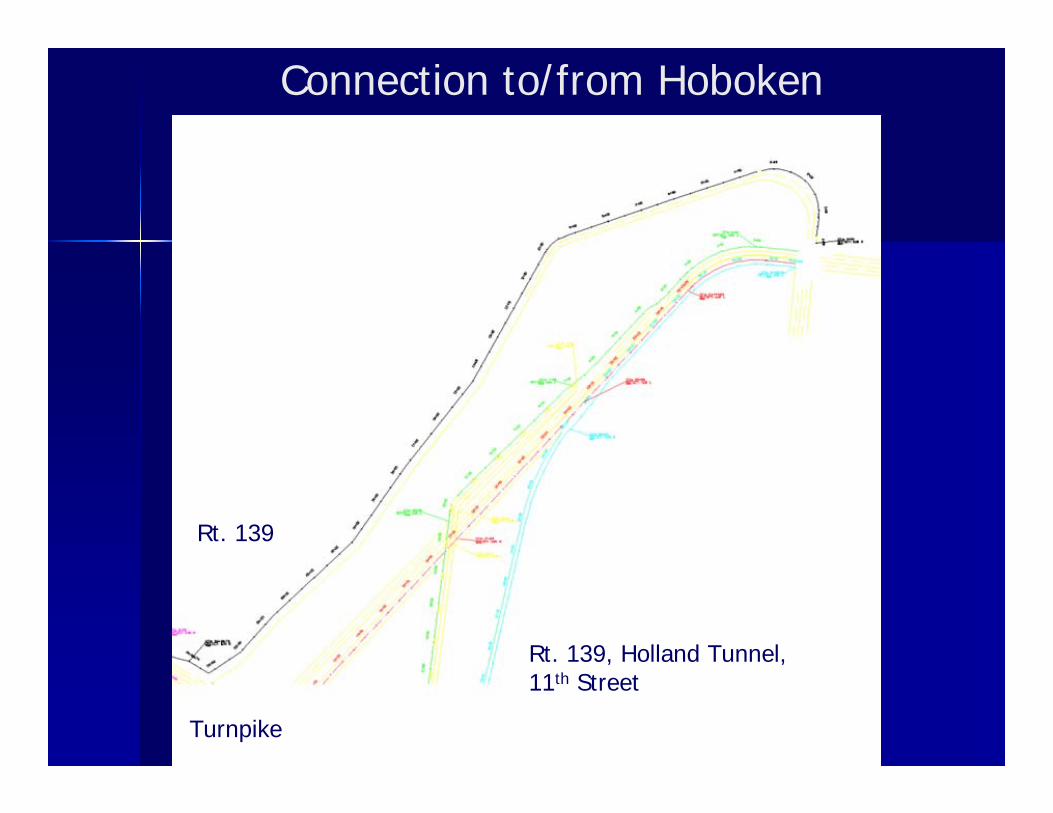
Connection to/from Hoboken
Rt. 139
Turnpike
Rt. 139, Holland Tunnel, 11th Street

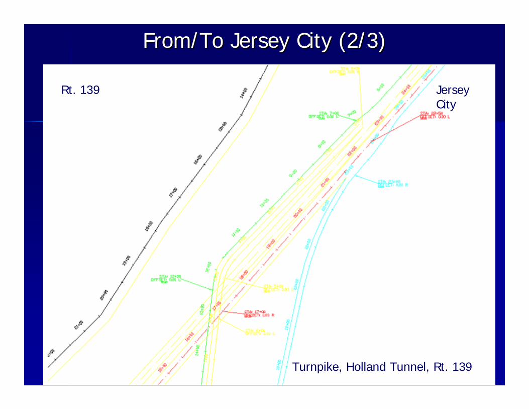
From/To Jersey City (1/3)From/To Jersey City (1/3)
Jersey City
Turnpike, Holland Tunnel, Rt. 139
From/To Jersey City (2/3)From/To Jersey City (2/3)
Jersey City
Turnpike, Holland Tunnel, Rt. 139
Rt. 139

From/To Jersey City (3/3)From/To Jersey City (3/3)
Rt. 139
Turnpike
11th Street, Holland

Holland Tunnel Entrance and Exit Consolidation Study
30 30
Appendix C
Potential Property Acquisitions
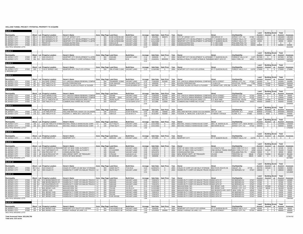
HOLLAND TUNNEL PROJECT: POTENTIAL PROPERTY TO ACQUIRE
BLOCK 1
Municipality Block Lot Property Location Owner's Name Zone Map Page Land Desc Build Desc Acreage Sale Date Sale Price Year Owner Street City/State/ZipLand
AssmntBuilding Assmnt
Exempt
Total Assmnt Assessed
06 JERSEY CITY 07302 395.1 2 605 MONMOUTH ST. CITY OF JERSEY CITY 303 8.282 ACRES8.282 VACANT LAND 8.28 9/9/2002 869879 2004 CITY OF JERSEY CITY 280 GROVE ST. JERSEY CITY, NJ 07302 1381600 0 0 1381600 138160006 JERSEY CITY 07302 395.1 3 615 MONMOUTH ST. NEWPORT CITY DEVELOPMENT % LEFRA 303 3.597 ACRES3.597 VACANT LAND 3.60 11/11/1982 0 2004 NEWPORT CITY DEVELOPMENT % LEFRAK 97-77 QUEENS BLVD. FOREST HILLS, NY 11374 1089100 0 0 1089100 108910006 JERSEY CITY 07302 395.1 4 657 MONMOUTH ST. NEWPORT CITY DEVELOPMENT % LEFRA 303 0.068 ACRES0.068 VACANT LAND 0.07 11/11/1982 0 2004 NEWPORT CITY DEVELOPMENT % LEFRAK 97-77 QUEENS BLVD. FOREST HILLS, NY 11374 20550 0 0 20550 2055006 JERSEY CITY 07302 395.1 5 TENTH ST. CONSOLIDATED RAIL 303 150X143 IR VACANT LAND 0.00 00/00/00 0 2004 CONSOLIDATED RAIL P. O. BOX 8499 PHILADELPHIA, PA. 19101 0 0 0 0 006 JERSEY CITY 07302 395.1 6 TENTH ST. CONSOLIDATED RAIL I-2 303 319.97X355I3.20 VACANT LAND 0.02 00/00/00 0 2004 CONSOLIDATED RAIL P. O. BOX 8499 PHILADELPHIA, PA. 19101 640000 0 0 640000 640000MULTIPLE MISSING LOTS 11.97 3131250
BLOCK 2
Municipality Block Lot Property Location Owner's Name Zone Map Page Land Desc Build Desc Acreage Sale Date Sale Price Year Owner Street City/State/ZipLand
AssmntBuilding Assmnt
Exempt
Total Assmnt Assessed
06 JERSEY CITY 07302 360 1 195 COLES ST. NEWPORT CITY DEVELOPMENT % LEFRA 303 233X400 VACANT LAND 2.14 00/00/00 0 2004 NEWPORT CITY DEVELOPMENT % LEFRAK 97-77 QUEENS BLVD. FORREST HILLS, NY 11374 827000 0 0 827000 82700006 JERSEY CITY 07302 361 M.2 223 COLES ST. MOSELLO REALTY CORP.%FRAN M. PARK 303 400X227 B-W 2.08 2/16/2001 8000000 2004 MOSELLO REALTY CORP.%FRAN M. PARKE450 WEST 15TH ST. NEW YORK, NY 10011 1360100 5060300 0 6420400 6420400
4.22 7247400BLOCK 3
Municipality Block Lot Property Location Owner's Name Zone Map Page Land Desc Build Desc Acreage Sale Date Sale Price Year Owner Street City/State/ZipLand
AssmntBuilding Assmnt
Exempt
Total Assmnt Assessed
06 JERSEY CITY 07302 323 1 715-37 JERSEY AVE. NEWPORT CITY DVLP.C/O LEFRAK 203 295.47X400 2.13AC VACANT LAND 2.13 11/18/1982 0 2004 NEWPORT CITY DVLP.C/O LEFRAK 97-77 QUEENS BLVD. FOREST HILLS, N.Y. 11374 275000 0 0 275000 2750001 MISSING LOT
BLOCK 4
Municipality Block Lot Property Location Owner's Name Zone Map Page Land Desc Build Desc Acreage Sale Date Sale Price Year Owner Street City/State/ZipLand
AssmntBuilding Assmnt
Exempt
Total Assmnt Assessed
06 JERSEY CITY 07302 287 1 201 ERIE STREET H.P. LINCOLN URBAN RENEWAL COMPAN 204 70X400IRR 0.59AC VACANT LAND 0.59 7/18/2000 612000 2004 H.P. LINCOLN URBAN RENEWAL COMPANY2 SIXTH STREET JERSEY CITY, NJ 07310 141800 0 0 141800 14180006 JERSEY CITY 07302 287 A.1 245 TWELFTH ST. EXXON CORPORATION 204 COR 150X210 1S-CB-SERV.STAT 0.72 00/00/00 0 2004 EXXON CORPORATION P O BOX 53 HOUSTON, TEXAS 77001 785600 214400 0 1000000 100000006 JERSEY CITY 07302 287 A.2 231 TWELFTH ST. TUCKER, ALLEN C/O PALEY & TUCKER 204 190X150 1S-M-CB-SERV.ST 0.65 8/1/1983 0 2004 TUCKER, ALLEN C/O PALEY & TUCKER 57 BRANT AVE., STE.200 CLARK, N.J. 07066 712500 77500 0 790000 790000
1.97 1931800BLOCK 5
Municipality Block Lot Property Location Owner's Name Zone Map Page Land Desc Build Desc Acreage Sale Date Sale Price Year Owner Street City/State/ZipLand
AssmntBuilding Assmnt
Exempt
Total Assmnt Assessed
06 JERSEY CITY 07302 254 1 543.5 MANILA AVE. H.P. LINCOLN URBAN RENEWAL COMPAN 203 10X400 VACANT LAND 0.09 7/18/2000 612000 2004 H.P. LINCOLN URBAN RENEWAL COMPANY2 SIXTH STREET JERSEY CITY, NJ 07310 20000 0 0 20000 2000006 JERSEY CITY 07302 254 2 545-7 MANILA AVE. H.P. LINCOLN URBAN RENEWAL COMPAN 203 60X400 .55AC VACANT LAND 0.55 7/18/2000 612000 2004 H.P. LINCOLN URBAN RENEWAL COMPANY2 SIXTH STREET JERSEY CITY, NJ 07310 120000 0 0 120000 12000006 JERSEY CITY 07302 254 E.3 221-27 TWELFTH ST. MOTIVA ENTPR.%EQUIVA SERV.LLC 203 26250 SQ.FT. 1S-M-SERV.STAT. 0.60 10/1/1998 861170 2004 MOTIVA ENTPR.%EQUIVA SERV.LLC P.O. BOX 4369 HOUSTON, TEXAS 77210 702800 147600 0 850400 85040006 JERSEY CITY 07302 254 E.4 195 TWELFTH ST. CUMBERLAND FARMS INC.#V1349 203 150X225 1S-CB-SERV.STAT 0.77 5/1/1986 110000 2004 CUMBERLAND FARMS INC.#V1349 777 DEDHAM ST. CANTON, MASS. 02021 449400 100600 0 550000 550000
2.02 1540400BLOCK 6
Municipality Block Lot Property Location Owner's Name Zone Map Page Land Desc Build Desc Acreage Sale Date Sale Price Year Owner Street City/State/ZipLand
AssmntBuilding Assmnt
Exempt
Total Assmnt Assessed
06 JERSEY CITY 07302 219 A.1 175 TWELFTH ST. HOLLAND MOTOR LODGE C/O CALANDRA 105 210X110 2S-BT-B-MOTEL 0.53 6/1/1981 100000 2004 HOLLAND MOTOR LODGE C/O CALANDRA 204 1ST. AVE. NEWARK, N.J. 07107 808500 1741500 0 2550000 255000006 JERSEY CITY 07302 219 A.2 185 TWELFTH ST. TUCKER, A., MERZ,M.E. & BUTLER, D. 105 190X110 1S-CB-M-C-H 0.48 8/13/1997 493000 2004 TUCKER, A., MERZ,M.E. & BUTLER, D. 57 BRANT AVENUE CLARK, N.J. 07066 533500 6500 0 540000 540000
1.01 3090000BLOCK 7
Municipality Block Lot Property Location Owner's Name Zone Map Page Land Desc Build Desc Acreage Sale Date Sale Price Year Owner Street City/State/ZipLand
AssmntBuilding Assmnt
Exempt
Total Assmnt Assessed
06 JERSEY CITY 07302 185 C.2 130-150 TWELFTH STREETMICHAEL ANGELO WAREHOUSE CORP. I-2 105 51777SQ.FT. VACANT LAND 1.19 12/21/2002 0 2004 MICHAEL ANGELO WAREHOUSE CORP. 580 L.M. MARIN BLVD. JERSEY CITY, NEW JERSEY 0 1250000 0 0 1250000 125000006 JERSEY CITY 07302 185 6.A 558-72 MARIN BLVD. MICHAEL ANGELO WAREHOUSE CORP. -2 105 27500 SQ FT VACANT LAND 0.63 12/21/2002 0 2004 MICHAEL ANGELO WAREHOUSE CORP. 580 MARIN BLVD. JERSEY CITY, NJ 07310 500000 0 0 500000 500000MULTIPLE MISSING LOTS? 1.82 1750000
BLOCK 8
Municipality Block Lot Property Location Owner's Name Zone Map Page Land Desc Build Desc Acreage Sale Date Sale Price Year Owner Street City/State/ZipLand
AssmntBuilding Assmnt
Exempt
Total Assmnt Assessed
06 JERSEY CITY 07302 154 A.2 THIRTEENTH ST. NEWPORT CITY 106 409X192 1.80 VACANT LAND 1.80 5/7/1985 0 2004 NEWPORT CITY 97-77 QUEENS BLVD. FOREST HILLS, NY 11374 0 0 0 0 0
BLOCK 9
Municipality Block Lot Property Location Owner's Name Zone Map Page Land Desc Build Desc Acreage Sale Date Sale Price Year Owner Street City/State/ZipLand
AssmntBuilding Assmnt
Exempt
Total Assmnt Assessed
06 JERSEY CITY 07302 155 2 FOURTEENTH & PROVOSTPORT OF NEW YORK AUTHORITY 105 8681SF VACANT LAND 0.20 00/00/00 0 2004 PORT OF NEW YORK AUTHORITY 111 EIGHTH AVE NEW YORK CITY N Y 1003 52100 0 0 52100 5210006 JERSEY CITY 07302 155 0.A 124 THIRTEENTH ST. PORT OF NEW YORK AUTHORITY 105 271X100IRR VACANT LAND 0.00 1/29/1954 0 2004 PORT OF NEW YORK AUTHORITY ONE WORLD TRADE CENTNEW YORK CITY N Y 1004 158100 543100 0 701200 70120006 JERSEY CITY 07302 155 17 236 PROVOST ST. CONSOLIDATED RAIL 105 25X100 VACANT LAND 0.06 3/31/1976 0 2004 CONSOLIDATED RAIL P. O. BOX 8499 PHILADELPHIA, PA 19101 30500 0 0 30500 3050006 JERSEY CITY 07302 155 18 238-50 PROVOST ST. NEW JERSEY DEPT. OF TREASURY 105 175X100 1&3S-B-0-G-H 0.40 3/14/2029 0 2004 NEW JERSEY DEPT. OF TREASURY CN-039 TRENTON, NJ 08646 175000 716000 0 891000 89100006 JERSEY CITY 07302 155 27.A FOURTEENTH ST STATE OF NEW JERSEY 105 84.36X60.92 VACANT LAND 0.12 00/00/00 0 2004 STATE OF NEW JERSEY CN 229 TRENTON, NJ 08625 16800 0 0 16800 16800MULTIPLE MISSING LOTS 0.66 1674800
BLOCK 10
Municipality Block Lot Property Location Owner's Name Zone Map Page Land Desc Build Desc Acreage Sale Date Sale Price Year Owner Street City/State/ZipLand
AssmntBuilding Assmnt
Exempt
Total Assmnt Assessed
06 JERSEY CITY 07302 367.5 A.2 315 COLES ST COLES ST CORP C/O AM SELF STORAGE 303 19185 SQ FT 7S-B-IN-E 0.44 12/29/1971 0 2004 COLES ST CORP C/O AM SELF STORAGE 950 STATE ROUTE 36 HAZLET, NJ 07730 383700 540100 0 923800 92380006 JERSEY CITY 07302 367 A.2 305 COLES ST. OGDEN RLTY CORP C/O WALSH TRUCK C I-2 303 81275 SQ.FT. VACANT LAND 1.87 7/29/1976 0 2004 OGDEN RLTY CORP C/O WALSH TRUCK CO2820 16TH ST NO BERGEN, NJ 07047 288000 0 0 288000 288000
2.31 1211800BLOCK 11
Municipality Block Lot Property Location Owner's Name Zone Map Page Land Desc Build Desc Acreage Sale Date Sale Price Year Owner Street City/State/ZipLand
AssmntBuilding Assmnt
Exempt
Total Assmnt Assessed
06 JERSEY CITY 07302 330 A.PL 272 SEVENTEENTH ST. OGDEN RLTY CORP C/O WALSH TRUCK C I-2 204 200X100 VACANT LAND 0.46 7/29/1976 0 2004 OGDEN RLTY CORP C/O WALSH TRUCK CO2820 16TH ST NO BERGEN NJ 07047 193900 0 0 193900 19390006 JERSEY CITY 07302 330 B.1 288 SEVENTEENTH ST. OGDEN RLTY CORP C/O WALSH TRUCK C I-2 204 100X100 VACANT LAND 0.23 7/29/1976 0 2004 OGDEN RLTY CORP C/O WALSH TRUCK CO2820 16TH ST NO BERGEN NJ 07047 97000 0 0 97000 9700006 JERSEY CITY 07302 330 B.2 287 EIGHTEENTH ST. OGDEN RLTY CORP C/O WALSH TRUCK C I-2 204 100X100 VACANT LAND 0.23 7/29/1976 0 2004 OGDEN RLTY CORP C/O WALSH TRUCK CO2820 16TH ST NO BERGEN NJ 07047 97000 0 0 97000 9700006 JERSEY CITY 07302 330 C 273 EIGHTEENTH ST. MAGASCHONI, INC. I-2 204 200X100 1S-CB-IN 0.46 11/15/1993 0 2004 MAGASCHONI, INC. 833 JERSEY AVE. JERSEY CITY, N.J. 07302 300000 375000 0 675000 67500006 JERSEY CITY 07302 330 1 833 JERSEY AVE. MAGASCHONI, INC. I-2 204 75X100 1S-CB-G-H 0.17 11/15/1993 0 2004 MAGASCHONI, INC. 833 JERSEY AVE. JERSEY CITY, N.J. 07302 112500 68500 0 181000 18100006 JERSEY CITY 07302 330 4 JERSEY AVE. MAGASCHONI, INC. I-2 204 50X100 VACANT LAND 0.11 11/15/1993 0 2004 MAGASCHONI, INC. 525 SEVENTH AVE. 21ST F NEW YORK, NY 10018 75000 0 0 75000 7500006 JERSEY CITY 07302 330 6 831 JERSEY AVE. OGDEN RLTY CORP C/O WALSH TRUCK C I-2 204 25X100 VACANT LAND 0.06 7/29/1976 0 2004 OGDEN RLTY CORP C/O WALSH TRUCK CO2820 16TH ST NO BERGEN NJ 07047 24200 0 0 24200 2420006 JERSEY CITY 07302 330 7 829 JERSEY AVE. OGDEN RLTY CORP C/O WALSH TRUCK C I-2 204 25X100 VACANT LAND 0.06 7/29/1976 0 2004 OGDEN RLTY CORP C/O WALSH TRUCK CO2820 16TH ST NO BERGEN NJ 07047 24200 0 0 24200 2420006 JERSEY CITY 07302 330 8 827 JERSEY AVE. OGDEN RLTY CORP C/O WALSH TRUCK C I-2 204 COR 25X100 VACANT LAND 0.06 7/29/1976 0 2004 OGDEN RLTY CORP C/O WALSH TRUCK CO2820 16TH ST NO BERGEN NJ 07047 25000 0 0 25000 25000MULTIPLE MISSING LOTS 1.84 1392300
BLOCK 12
Municipality Block Lot Property Location Owner's Name Zone Map Page Land Desc Build Desc Acreage Sale Date Sale Price Year Owner Street City/State/ZipLand
AssmntBuilding Assmnt
Exempt
Total Assmnt Assessed
06 JERSEY CITY 07302 331 33 843 JERSEY AVE. NEWPORT CITY DVLPT.C/O LEFRAK I-2 204 0.40 ACRES 0.40 VACANT LAND 0.40 00/00/00 0 2004 NEWPORT CITY DVLPT.C/O LEFRAK 97-77 QUEENS BLVD. FOREST HILLS, N.Y. 11374 60000 0 0 60000 6000006 JERSEY CITY 07302 331 34 853 JERSEY AVE. JERSEY AVENUE 18 LAND, LLC I-2 204 1.40 ACRES 1.40 VACANT LAND 1.40 1/21/2003 350000 2004 JERSEY AVENUE 18 LAND, LLC 2 SIXTH STREET JERSEY CITY, NJ 07310 490000 0 0 490000 490000MULTIPLE MISSING LOTS 1.80 550000
Total Assessed Value: $23,304,750 23794750Total area: 33.5 acres