Embed Size (px)
Citation preview

Red de Observacion del Nivel del Mar para America Central (RONMAC)
Nicaragua Reconnaissance Report
Tuesday, August 15, 2000Began with a meeting at Instituto Nicaragüense de Estudios Territoriales (INETER). Met with (r-l); Luis S. Palacios Ruiz, Director Recursos Hídricos; Mauricio Rosales, Director deMeteorología; Sergio Cordonero Gonzalez, Director de Hidrografía
Discussed and demonstrated the operation of the equipment. Elaborated on the plans forinstallation of two sites for this year, one on the Pacific and one on the Atlantic. We alsodiscussed the role of CRRH as the data center providing them information via the Internet. Wealso discussed the role of CRRH as the provider of maintenance and calibration of sensors andspare parts, they were pleased with this scenario. We asked their opinion of following Alejandrosrecommendation for placing sites at Corinto and Pto. Cabazas. They were in favor of using bothof these sites. They presently have a tide gaúge at Corinto and a meteorological station at Pto.Cabazas. We discussed the participation of the INETER technicians with the installations andwith the continuing maintenance needs. They were very agreeable to both. We discussed a timeframe for the installations and training. We went over plans to visit both sites in the followingtwo days of our visit.
After the meeting with the Directors, we went to a meeting with the Hydrographic Sectiontechnicians. We presented a demonstration of the equipment and answered questions about the
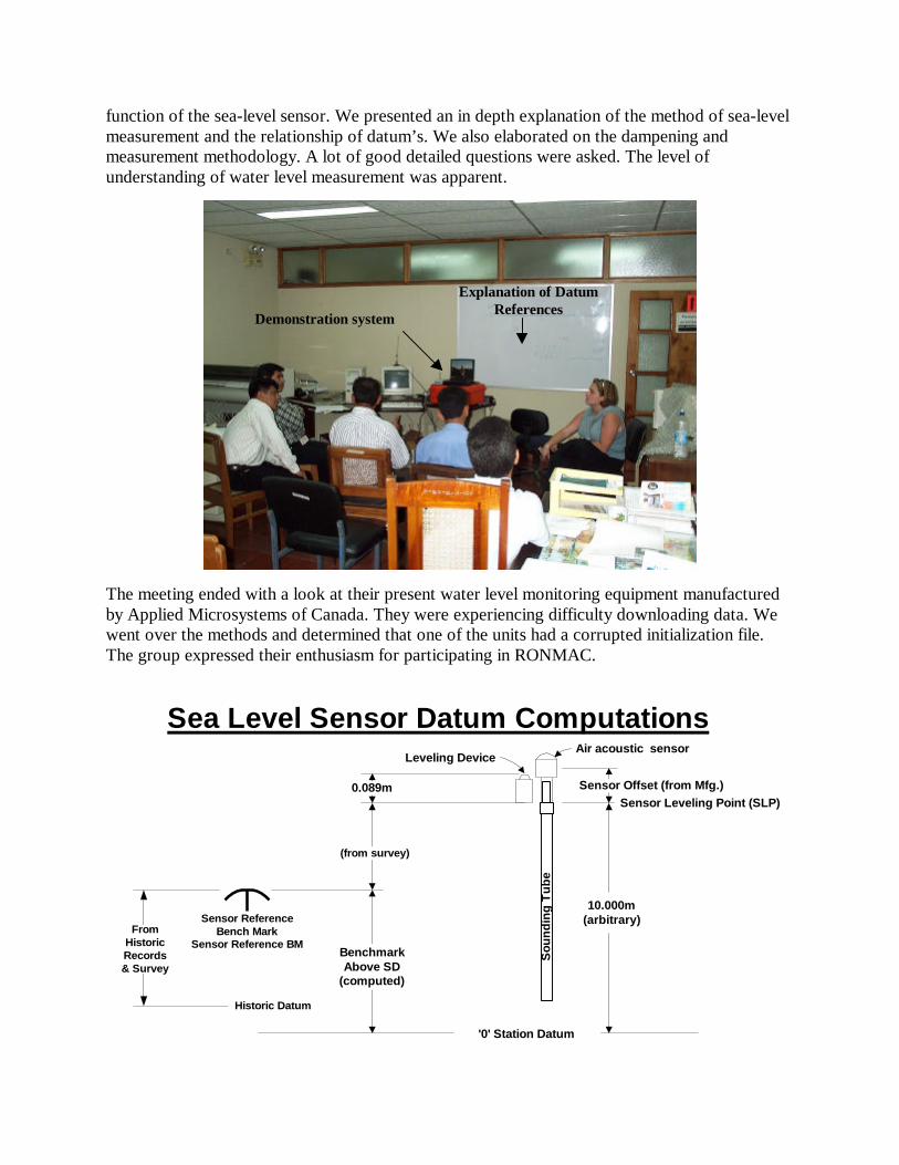
function of the sea-level sensor. We presented an in depth explanation of the method of sea-levelmeasurement and the relationship of datum’s. We also elaborated on the dampening andmeasurement methodology. A lot of good detailed questions were asked. The level ofunderstanding of water level measurement was apparent.
The meeting ended with a look at their present water level monitoring equipment manufacturedby Applied Microsystems of Canada. They were experiencing difficulty downloading data. Wewent over the methods and determined that one of the units had a corrupted initialization file.The group expressed their enthusiasm for participating in RONMAC.
Sensor ReferenceBench Mark
Sensor Reference BM
Sensor Leveling Point (SLP)
(from survey)
Sou
ndin
g T
ube
'0' Station Datum
10.000m(arbitrary)
BenchmarkAbove SD
(computed)
Sea Level Sensor Datum Computations
Sensor Offset (from Mfg.)
Air acoustic sensorLeveling Device
0.089m
Historic Datum
FromHistoricRecords& Survey
Explanation of DatumReferences
Demonstration system

Nicaragua People and Coordinates
Name Organization Coordinates
Mauricio Rosales R. Director de MeteorologíaINETERFrente a Policlínica Oriental de INSSP.O. Box 2110Managua, Nicaragua
Tel: (505) 249-2756Fax: (505) [email protected]
Luis S. Palacios Ruiz Director Recursos HídricosINETERApartado: 2110Managua, Nicaragua
Tel: (505) 249-2756Fax: (505) [email protected]
Sergio Cordonero González Director de HidrografíaINETERFrente a Policlínica Oriental de INSSApartado: 2110Managua, Nicaragua
Tel: (505) 249-2756Fax: (505) [email protected]
Leandro V. Peña Ugarte Director de OperacionesEmpresa Portuaria NacionalAdministración Portuaria de CorintoApartado postal: 11Corinto, Chinandega, Nicaragua, CA
Tel: (505) 342-2702Fax: (505) [email protected]
Sergio Caramagna DirectorOEA NicaraguaIglesia las Sierritas de Santo Domingo2c. al norteManagua, Nicaragua, CA
Tel: (505) 276-1761Fax: (505) [email protected]/ni
Gilberto Ruiz DirectorEmpresa Portuaria NacionalAdministración Portuaria de Cabezas
Jose Tomas Valle INETER - HidrografíaFrente a Policlínica Oriental de INSSApartado: 2110Managua, Nicaragua
Tel: (505) 249-2756Fax: (505) [email protected]
Chester Perez Talavera INETER - MeteorologíaFrente a Policlínica Oriental de INSSP.O. Box 2110Managua, Nicaragua
Tel: (505) 249-2756Fax: (505) [email protected]

The Reconnaissance Group

Wednesday, August 16, 2000Traveled to Puerto Cabezas on the east coast, by air on La Costeña ($100 round trip) trip took1hr. 15 minutes from Managua. We visited the INETER Meteorology Office at the Pto. Cabezasairport we looked at the equipment, some of the automatic equipment was not operatingcorrectly, the manual equipment functioned well. The Office could make good use of theRONMAC monitoring automatic line-of-site radio-modem system. They have two existingantennas with sufficient height to “see” the port pier.
The facility has a computer but the hard drive is not working. The monitor and keyboard are OK.A replacement CPU would be required to get the RONMAC monitoring system operational atthis facility. The office was very well maintained and orderly. All equipment appears to be wellcared for, however it suffers from age and lack of manufacturer support.
Next we visited the Pto. Cabezas facility pier. It is a 650m pier of wood. The main pier is inrelatively good condition, except for the eastern extremity. This portion is separate and isscheduled to be removed. There is a reasonable location on the northeast end for the monitoringequipment. The system will require “anti-climb” boards on the tower, however, only two towersections will be used since guying will not be possible. The wood on this section is relativelynew, with good hardware.
Existing Antenna TowersSensor Tower
Upper Air Bldg.
INETER Met. Office at Pto.Cabezas Airport

BM - INETERTBM 1-R 1989
Proyecto destruir
RONMACobservacion del
nivel del mar
RONMAC BM A 2000(intencion)
MAR CARIBE
Diseno de la estacion de monitoreo para el proyecto RONMAC.Puerto Cabezas, Nicaragua
140 01' 00" N - 83 0 22' 48" WN
Casa elguardia
Calle
Mue
lla d
e pu
erto
Cauce
Bodega
Playa
Playa
Bodega
xx
xx
x
x
x
x
After measuring the pier we met with Gilberto Ruiz, Director de la Empresa Nacional de Puerto(Pto. Cabezas). We demonstrated the operation of the system and explained what we would liketo do at Puerto Cabezas. He was very enthusiastic about the Marine VHF radio option that wedemonstrated using his radio. He said that this feature would help his operations because they areconstantly being asked for this type information, particularly the tide level, but he was unable to

provide the information. He was somewhat skeptical that this would actually happen. He saidthat “if we really did return to install the system” that we could count on his support. He agreedthat the anti-climb boards were necessary and will assist with security of the station.
After the meeting we recovered two local benchmarks; “INETER TBM-1-R 1989” with a valueof 4.201m (MSL) and “Geodesico Inter Americano BM-T-1-A 1965 NIC”. Both are described inthe attached INETER BM descriptions.
The installation will require “round pile” standoff brackets to compensate for the offset and the slope angle of thepile, however these are the only “good” piles on this side of the pier in an area with sufficient water depth.
poste demadera
tubo dePVC
5/8" tornillo
soporte (4")soporte (14")
ajustable
ProposedRONMACmonitoring
tower location
Proposed RONMACSea-Level, SSTSensor location
4" tubo de PVC
900 MHz antena
Antena marina debanda VHF (162 MHz)
Viento
Temperatura de lahumedad relativa
del aire
precitacion Solar Radiation
AntenaSatelitaria
Panel solar de carga
Nivel del Mar ytemperatura del Mar
DCP,BarometricPressure,Radios &Batteries
Base de la torre(con bisagras)
Disipador estatico
panel para evitar acceso
via de madera
Diseno de la estacionde monitoreo para elproyecto RONMAC Puerto Cabezas,
Nicaragua
Superficie de muelle
soporteposte de madera
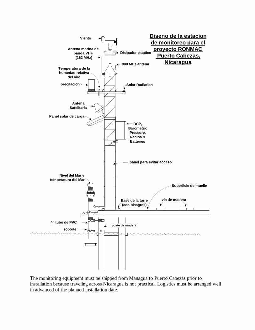
The monitoring equipment must be shipped from Managua to Puerto Cabezas prior toinstallation because traveling across Nicaragua is not practical. Logistics must be arranged wellin advanced of the planned installation date.

Puerto Cabezas Bench Mark Descriptions

Puerto Cabezas Bench Mark Descriptions (continued)
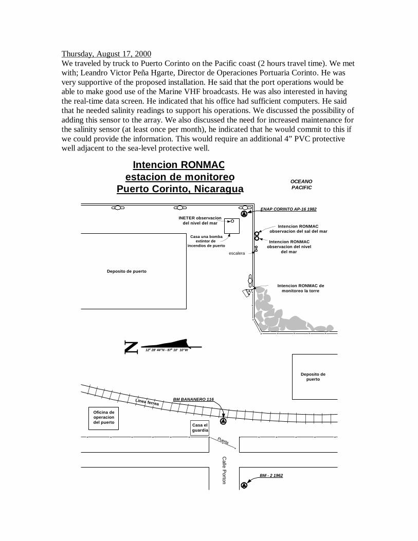
Thursday, August 17, 2000We traveled by truck to Puerto Corinto on the Pacific coast (2 hours travel time). We metwith; Leandro Victor Peña Hgarte, Director de Operaciones Portuaria Corinto. He wasvery supportive of the proposed installation. He said that the port operations would beable to make good use of the Marine VHF broadcasts. He was also interested in havingthe real-time data screen. He indicated that his office had sufficient computers. He saidthat he needed salinity readings to support his operations. We discussed the possibility ofadding this sensor to the array. We also discussed the need for increased maintenance forthe salinity sensor (at least once per month), he indicated that he would commit to this ifwe could provide the information. This would require an additional 4” PVC protectivewell adjacent to the sea-level protective well.
x
x
x
x xx x x
x x x
x
x
xxxxxxx x x x
Casa elguardia
OCEANOPACIFIC
Deposito de puerto
Casa una bombaextintor de
incendios de puerto
INETER observaciondel nivel del mar
ENAP CORINTO AP-16 1982
Intencion RONMACobservacion del nivel
del mar
Intencion RONMACobservacion del sal del mar
escalera
Intencion RONMAC demonitoreo la torre
BM BANANERO 116
N 120 28' 44"N - 870 10' 10"W
Intencion RONMACestacion de monitoreo
Puerto Corinto, Nicaragua
Oficina deoperaciondel puerto
Deposito depuerto
Calle P
orton
Puerta
Linea ferrea
BM - 2 1962

Intencion observacion del nivel del mar
Intencionmonitoreo
la torre
INETERobservaciondel nivel delmar

4" tubo de PVC
900 MHz antena
Antena marinade banda VHF
(162 MHz)
Viento
Temperatura de lahumedad relativa
del aire
Precipitacion Radiacionsolar
Antenasatelitaria
Panel solar de carga
Nivel del Mar yTemperatura del Mar
Plataforma pararecoleccion dedatos, barometro,radios y baterias
Base de la torre(con bisagras)
Disipador estatico
muelle de concreto
RONMACEstacion deMonitoreo
Pto. Corinto,Nicaragua
5'-7"
6" @15:15 on 8/17/00
8'-6"20"

The installation will require a special lower “pile” support bracket;
12"
posteconcreto(14" sq.)
5/8" tornillo
angulo de acero
soporte (4")
This arrangement will be required for both the sea-level sensor well and the salinitysensor well.
During the reconnaissance we recovered four (4) bench marks. No additional BM’s willneed to be installed. BM BANANERO 116 was occupied with GPS in the past year bythe U.S. Defense Mapping Agency, according to the INETER reconnaissance personnel.
Puerto Corinto bench mark Descriptions

Puerto Corinto Bench Mark Descriptions (continued)
Puerto Corinto Bench Mark Descriptions (continued)
Puerto Corinto Bench Mark Descriptions (continued)
The INETER keep very good surveying records, which is evident by the quality of theseBM descriptions. They also appear to have good datum information which could beresearched back to the origin for present day use.
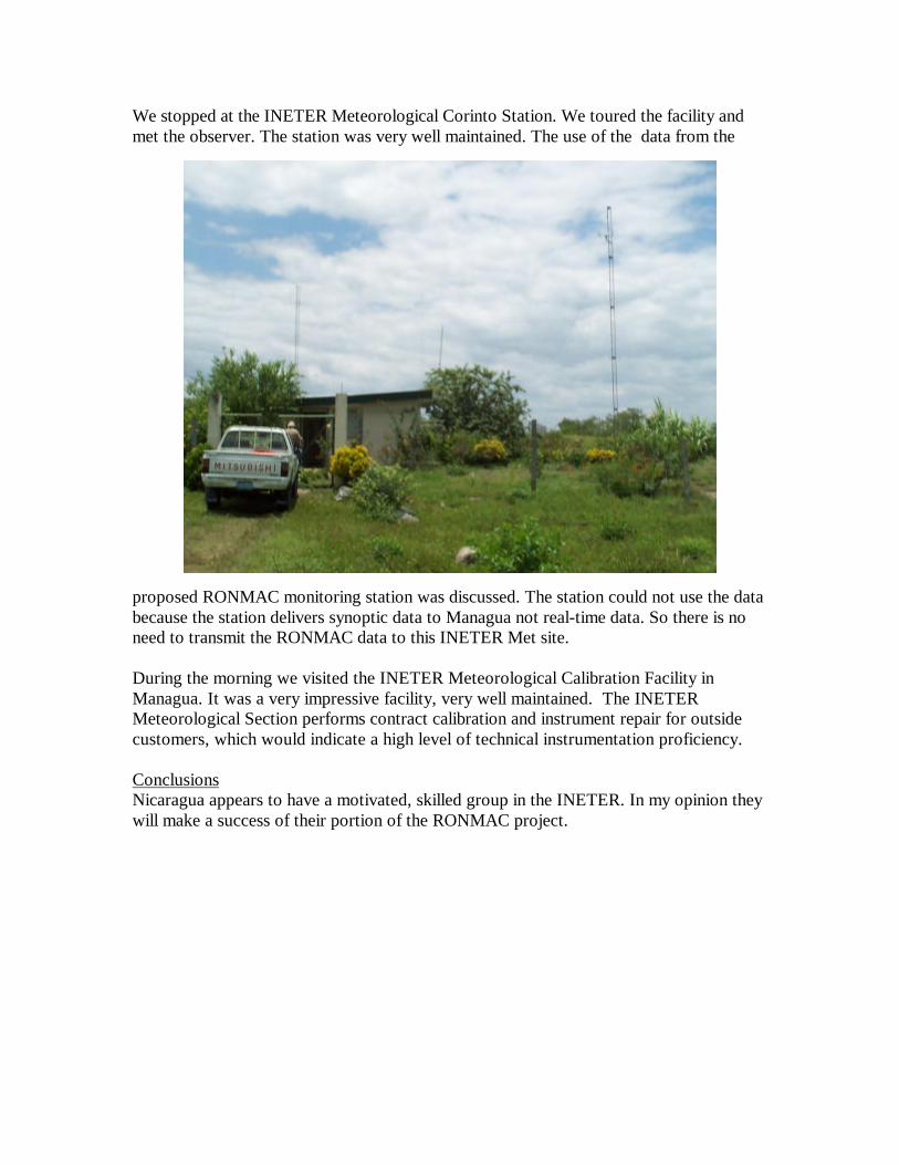
We stopped at the INETER Meteorological Corinto Station. We toured the facility andmet the observer. The station was very well maintained. The use of the data from the
proposed RONMAC monitoring station was discussed. The station could not use the databecause the station delivers synoptic data to Managua not real-time data. So there is noneed to transmit the RONMAC data to this INETER Met site.
During the morning we visited the INETER Meteorological Calibration Facility inManagua. It was a very impressive facility, very well maintained. The INETERMeteorological Section performs contract calibration and instrument repair for outsidecustomers, which would indicate a high level of technical instrumentation proficiency.
ConclusionsNicaragua appears to have a motivated, skilled group in the INETER. In my opinion theywill make a success of their portion of the RONMAC project.


![Observacion Escuela en La Isla Del Tigre-cristina[1]](https://img.dokumen.tips/doc/110x75/5571f32349795947648d8f45/observacion-escuela-en-la-isla-del-tigre-cristina1.jpg)