Embed Size (px)
Citation preview

RECREATION TRAILS 2010 - 2020

Page intentionally left blank.

- 3 -
CONTENTS
INTRODUCTION 4
BACKGROUND 6
INTEGRATION 8
OUR COMMITMENT 12
OVERALL DIRECTIONAL STATEMENT 13
TRAIL LOCATIONS 14
IMPLEMENTATION - STAGE 1 15
IMPLEMENTATION - STAGE 2 34
ACKNOWLEDGEMENTS 35

- 4 -
INTRODUCTION
Trails can provide a wide range of benefits to the community including social and physical health, economic, environmental and cultural benefits.
Definitions
For the purposes of this strategy a trail is defined as:“A corridor, route, pathway or water body used for non-motorised recreational uses such as horse riding, walking, off-road cycling or canoeing/kayaking that pass through or connect natural environments and/or human communities. It is a route formally designated by the land manager and may take a variety of forms including fully-developed tracks, road reserves (formed and unformed) or signed routes through the landscape.”1
It is important to note that this strategy does not include provisions for trail bikes.
Benefits of trails
The benefits of trails can be identified under the following categories:
Social and physical health benefits: • Improve physical and mental health.• Improve community health and reduce health
expenditure.• Facilitate participation and social interaction between a
diversity of community members, age groups, individuals and families.
• Trails can deliver a wide range of opportunities to a range of people including the elderly and people with a disability.
• Trails can introduce participants to other recreational and participation offerings in the community.
• Trails help to connect people and places.• Trails can develop community pride and promote the
heritage of the community.
Economic benefits:• Trail visitors spend money in towns and
communities along trails. • Trails generate intrastate, interstate and overseas
tourism spending.• Trails support and enhance local business
opportunities.• Trail users spend money preparing for their trail
journeys or recreation activities.• Trail construction and maintenance can generate
employment opportunities.
Environmental and cultural benefits:• Trails can provide opportunities for the community to
experience natural and cultural environments.• Trails can be a means of educating users about the
attributes of an area which can increase environmental and cultural awareness and appreciation.
• Trails lead to a decrease in the use of motorised vehicles for transportation and recreation. This helps reduce the production of emissions that cause global warming and respiratory problems.
• Trails can increase community ownership which helps to preserve natural and cultural values.
• Trails can provide opportunities for community participation in conservation and revegetation work.
Logan City Council Trail User Survey results showed that the majority of respondents (36%) walk along the existing trails. This is consistent with survey data from across Australia in terms of walking dominating activities though not as high as other surveys (walking regularly shows up around 50%). If exercising a dog (effectively walking) is added to walking, the percentage is 50%.
1. Adapted from Department of Infrastructure and Planning (2007) Active Trails - A Strategy for Regional Trails i South East Queensland.
- 5 -
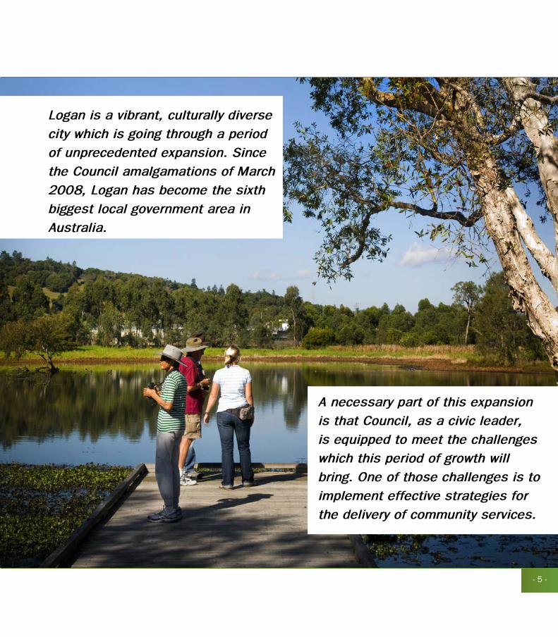
Logan is a vibrant, culturally diverse
city which is going through a period
of unprecedented expansion. Since
the Council amalgamations of March
2008, Logan has become the sixth
biggest local government area in
Australia.
A necessary part of this expansion
is that Council, as a civic leader,
is equipped to meet the challenges
which this period of growth will
bring. One of those challenges is to
implement effective strategies for
the delivery of community services.

- 6 -
BACKGROUND
“In the year 2026 Logan is a city of opportunity. Strategically positioned within a rapidly changing region and a global economy, we live in a dynamic city that sustains our quality of life. Here, neighbours, generations and cultures connect. Our lifestyles are in harmony with our environment. Logan City is a safe and healthy community, a place all generations will be proud to live and thrive in.”
“Logan 2026 City Directions”, Logan City Council
In keeping with the vision articulated in Logan 2026 City Directions, Council has worked alongside the community to develop a suite of strategies that acknowledge the benefits of economic development and links them to a commitment to social justice and equitable outcomes for all residents.
The Community Services Branch delivers outputs through four program areas:• Community Development and Safety• Leasing and Facility Management• Social Planning• Sport and Recreation (Planning & Delivery)
These programs respond to specific focus areas outlined in Council’s 2009-2013 Corporate Plan. Combined, the activities of the branch including the related strategies respond to all six priority areas, which are:
1. Infrastructure and Community facilities2. A Sustainable Economy and Employment3. Growth Management4. Council Systems and Services5. Healthy and Safe Environments6. Strong and Supportive Communities
In preparing this strategy Council consulted with a diverse range of stakeholders to find out about the issues that are important to them. In this sense, the document is the result of collaboration between Council and the community, a relationship which will continue throughout the life of the strategy.
Specifically this Recreation Trails Strategy aims to identify a number of key land and water based trail opportunities, on Council controlled and or state owned land which have the potential to deliver real benefits to the Logan community.
This Recreation Trails Strategy recommends a total of 20 projects and a 2 stage implementation process over a 10 year period. Stage one recommends 11 projects over the first 5 years. Stage two identifies another 9 projects over years 6-10.
Throughout the life of this strategy Council’s priorities may change and additional projects can be incorporated in the future. Similarly, projects within Stage 1 of this strategy may not be implemented within the order they have been numbered.

- 7 -

- 8 -
INTEGRATIONIntegration of strategic documents globally and across all levels of Government is an integral part of developing a cohesive strategy
In order to provide the best opportunities and outcomes for the Logan community the Recreation Trails Strategy needs to support and integrate with a range of initiatives and agencies including Federal and State Government and incorporate these values throughout Council’s policies and strategies.
Federal Government
The Council of Australian Governments (COAG) is the peak intergovernmental forum in Australia. The role of COAG is to initiate, develop and monitor the implementation of policy reforms that are of national significance and which require cooperative action by Australian governments at all levels, Federal, State and Local. www.coag.gov.au
Department of Environment, Water and Heritage The Australian Government Department of the Environment, Water, Heritage and the Arts develops and implements national policy, programs and legislation to protect and conserve Australia’s environment and heritage and to promote Australian arts and culture.www.environment.gov.au
Department of Innovation, Industry, Science and ResearchThe Department of Innovation, Industry, Science and Research is committed to developing policies and delivering programs, in partnership with stakeholders, to provide lasting economic benefits ensuring Australia’s competitive future.
This department delivers TQUAL (formerly the Australian Tourism Development Program) funding which can be used for trail development.www.innovation.gov.au
Department of Resources, Energy and TourismThe Department of Resources, Energy and Tourism provides advice and policy support to the Australian Government regarding Australia’s resources, energy and tourism sectors.www.ret.gov.au
Department of Health and AgeingThe Department of Health and Ageing has a diverse set of responsibilities, but throughout there is a common purpose, which is reflected in their Vision statement:
“Better health and active ageing for all Australians.”
The Australian Government is committed to supporting sport, particularly at the community level and increasing Australians’ participation in physical and recreational activities to promote physical and mental health.www.health.gov.au
- 9 -
INTEGRATIONState Government
Department of Infrastructure & Planning (DIP)
The Department of Infrastructure and Planning delivers integrated planning and infrastructure solutions for Queensland and builds the capacity of local government. The department’s six priorities are to:• Plan, coordinate and deliver key infrastructure for
economic, environmental and social development. • Plan sustainable and dynamic urban and regional
communities.• Facilitate major private sector and public projects.• Plan, secure and manage land supply for urban,
industrial and economic development.• Foster capable, sustainable and accountable local
governments.• Strengthen a professional ethical and high performance
organisation that values and nurtures its employees.
The following documents are the responsibility of this department:
1. South-East Queensland (SEQ) Regional Plan 2009-2031 The vision for SEQ is to ensure that the future is sustainable, affordable, prosperous, liveable and resilient to climate change, where the community has access to a range of quality open space and recreational opportunities.
2. Draft SEQ Outdoor Recreation StrategyThe Queensland Government, in consultation with the public, has developed a draft South East Queensland (SEQ) Outdoor Recreation Strategy. The strategy will provide a framework for coordinating the assessment, planning, delivery and management of outdoor recreation opportunities and facilities across the regions and will aim to foster partnerships between key stakeholders in SEQ.
A coordinated regional approach to the development of outdoor recreation in SEQ will enable better planning for the development of outdoor recreation infrastructure and more efficient long-term management of that infrastructure.
It will also contribute to the fulfilment of the 2006 Living the Queensland Lifestyle election commitment and is an intended outcome of the South East Queensland Regional Plan 2005-2006.
A discussion paper has been formulated for consultation purposes; a draft strategy has been developed in response to the consultation phase and is yet to be endorsed.www.dip.qld.gov.au
3. South East Queensland Regional Trails Strategy (SEQRTS)The purpose of the SEQRTS is to inform and guide future investment in recreation trail planning, development and management. The desired long-term outcome of the SEQRTS project is to facilitate the development of a network of regional and district trails providing an outstanding and appropriate diversity of opportunities for trail users.
Department of Communities (DOCS), Sport and Recreation Services
Following the 2009 state election, Sport & Recreation Services form part of the Department of Communities. Some of Sport & Recreation Services key service area initiatives for 2009-2010 are:• Deliver the next phase of the ‘Find Your 30’ campaign.• Build the capacity of the sport and recreation industry to
service a growing population and provide opportunities for volunteering.
• Target sport and recreation opportunities to support social inclusion and the well-being of children and young people.
State organisationQueensland Outdoor Recreation Federation (QORF)QORF is the peak industry body representing the interests of outdoor recreation users in Queensland. QORF affirms the value of outdoor recreation and encourages the opportunity for all people to recreate outdoors.nwww.qorf.org.au

- 10 -
INTEGRATION
Local Government
Local Government Act 2009The Local Government Act 2009 ensures local government in Queensland is accountable, effective, efficient and sustainable. Council ensures it meets its statutory requirements under the Local Government Act 2009.
Logan City Council Corporate PlanCouncil’s Corporate Plan 2009-2013 sets the priorities for Logan City for the next four years. Logan City Council is committed to the focus areas as set out in the plan.
Logan 2026 City DirectionsLogan 2026 City Directions is our city’s inspiring twenty year vision. It helps us define what we do by way of smarter planning and managing growth to create a better future. The five themes which support the vision are:• Active and healthy - creating a safe and well designed
city where residents enjoy an active and healthy lifestyle.• Creative and innovative - a hub of creativity, constantly
generating new ideas that change the way we live, work and interact.
• Green and sustainable - renowned for our stewardship of the natural environment.
• Inclusive and vibrant - a friendly and welcoming city.• Regionally and globally connected - a seamless,
connected city; regionally and globally.
Planning SchemePlanning schemes set out policies and provisions for the use, development and protection of land for an area. Each local government area in Queensland is covered by a planning scheme.
Priority Infrastructure Plan (PIP)A Priority Infrastructure Plan (PIP) is the key tool in a planning scheme for integrating land use planning and infrastructure planning. PIP’s assist in planning infrastructure in a coordinated, efficient and orderly way that encourages urban growth in areas where adequate infrastructure exists or can be provided efficiently. This ensures all new development is supplied with essential infrastructure such as water supply, sewerage, stormwater, roads, public parks and land for community facilities.
Active Logan StrategyThe Active Logan Strategy aims to provide direction for the provision of sport and recreation across the city. The Sport and Recreation team will play a key role in facilitating, supporting and advocating sport and recreation opportunities to strive for a healthy and physically active community.
Gold Coast Beaudesert Integrated Trails StrategyThe strategy, prepared in 2002, was undertaken to guide the future development and maintenance of an integrated network of recreational trails throughout (western) Gold Coast City and Beaudesert Shire. Many of the areas covered by the strategy were included in Logan City Council after the Local Government amalgamations of 2008. As part of this Trails Strategy, the recommended (relevant) trails have been reviewed to determine whether they proceed.

- 11 -
INTEGRATION
Funding Programs
A number of funding programs from both state and federal governments provide opportunities to develop and provide for recreation trails.
Federal GovernmentAusIndustry (Department of Innovation, Industry, Science and Research) TQUAL GrantsProvides funding to stimulate sustainable growth in the Australian tourism industry by supporting initiatives that: develop innovative product, services or systems within the tourism industry, contribute directly to long-term economic development in the host region or develop or support high quality visitor services and experiences.www.ausindustry.gov.au
State Government Department of Communities
Sport & Recreation Infrastructure Program Provides funding to develop and enhance sport and active recreation infrastructure to meet community participation needs; support local, regional and state levels of competition; and enable Queensland to attract and host key events.www.sportrec.qld.gov.au
What does this mean for Logan?
Staying informed of political decisions, initiatives and funding opportunities by all levels of governments and private enterprise. This will ensure that the sport and recreation team can deliver upon the recommendations detailed within this Recreation Trails Strategy and provide quality outcomes for the Logan community.
Council will work closely with
its community and all levels of
government to deliver real outcomes
for all. Council’s approach is to
continue to develop partnerships
with a range of organisation’s, to
provide the best outcomes for the
Logan community.
The Recreation Trails Strategy
has an indicative cost of over $9
million dollars in today’s figures.
Logan City Council is therefore not
in a position to provide for all of
the recommendations listed within
this strategy on its own. Council is
committed to partnering and sourcing
a range of funding opportunities from
all levels of government and private
enterprise in order to deliver upon
the recommendations detailed within
the strategy.
- 12 -
OUR COMMITMENT
Key Direction
The Community Services Branch is committed to developing a community that is well resourced, equitable, safe and active and that effectively responds to emerging needs.
Key Driver
To achieve this commitment, the Community Services Branch aims to develop policy, programs and activities that influence the development of attractive, well planned communities whose members enjoy access to a range of facilities and services which enable them to lead healthy, safe and rewarding lives.
Priorities and Strategies
The Community Services Branch delivers outputs through our four Program areas:• Community Development and Safety (Connected
Communities Strategy, Cultural Diversity Strategy and Safe City Strategy);
• Leasing and Facility Management;• Social Planning (Community Infrastructure Strategy);• Sport and Recreation (Planning and Delivery) (Active
Logan Strategy and Recreation Trails Strategy).
Corporate Plan Priorities
Priority OneInfrastructure and Community Facilities1.2 Community Facilities Planning and Maintenance
Priority TwoA Sustainable Economy and Employment2.1 Business Support2.3 City Promotion2.4 Business Relationships
Priority Three Growth Management3.1 Land Use Planning3.2 Housing and Lifestyle
Priority Four Council Systems and Services4.1 Corporate Governance4.4 Customer Service
Priority FiveHealthy and Safe Environments5.1 Community Health and Wellbeing5.2 Community Safety5.3 Heritage and Culture
Priority SixStrong and Supportive Communities6.1 Community Development6.2.1 Community Engagement
- 13 -
OVERALL DIRECTIONAL STATEMENT
Key Direction
This Recreation Trails Strategy proposes a number of specific projects that have the potential to deliver solid and real benefits to Logan City. It recognises the needs and demands of local residents (in particular) and visitors, and it takes advantage of the diverse range of attractive landscapes on offer.
The Recreation Trails Strategy proposes to deliver a number of outcomes:• delivering different aspects of the ‘Logan 2026 City
Directions’• giving Council the ability to apply for funding for trail
development• ensuring recreation trails are included in new
developments• supporting the development of nature based tourism
opportunities in Logan• enhancing community health.
Trail Planning
The Trail Planning process consists of six elements as detailed below.
Trail Planning Process
State or Regional Trail Strategies
Local Government Trails Strategy
Individual Trail Feasibility Study
Trail Development Plan
Trail Construction
Trail Maintenance
Trails were assessed against a number of criteria, these included:• Trail demand• Consultation• Value for money• Practicalities of trail development• User Experience
To ensure the effective implementation of this strategy it is important that relevant branches of Council work together through the planning and coordination stages.
Through implementation of this strategy Logan City Council will work with key stakeholders to develop a consistent and easy to understand directional and distance signage within trails across South East Queensland. Based on the trail planning criteria this strategy recommends a total of 20 projects to be implemented in a two stage process over a 10 year period.
Stage 1 - Years 1-5Stage 1 has identified 11 key projects; these trails are likely to attract not only local users but also visitors from outside of Logan City.
Stage 2 - Years 6-10Stage 2 recommends another 9 projects. These projects are trails that will attract people who live close by rather than ones who may travel some distance. With this in mind, this Recreation Trails Strategy recommends the provision of a small suite of quality trails, rather than numerous ‘average’ trails, as the primary objective.
fast factsTrail users of the Bibbulmun Track, Western Australia’s long distance walk trail, inject $39 million a year into the Western Australian economy. The initial one-off investment was only $5 million by the WA Government.
(Bibbulmun Track Foundation 2009).

- 14 -
TRAIL LOCATIONS
Spring Mountain Trails
Bethania to Beaudesert Rail Trail
Koala Bushland Coordinated Conservation Area Trails
Springwood Conservation Park Trails
Riverdale Water Trail
Berrinba Wetlands Trails Cornubia
Trails
Albert River Water Trail
Plunkett Trails
Boronia Bushland and Logan West Parklands Trails

- 15 -
IMPLEMENTATION - STAGE 1
GREAT SHORT WALKS OF LOGAN TRAILS MARKETING PROGRAM
SnapshotIn order to maximise usage of the Logan City Trails Network it is necessary to ensure that local people and tourists know of the trails existence. To facilitate this usage, a marketing and promotional campaign is proposed.
Recommendations
The purpose of the marketing and promotional campaign is to create awareness of the attractions of the City, and the means of accessing them via the trails. It will generate local support and enthusiasm for the project, as well as generating state-wide promotional coverage of the project through local and state media and the formation of partnership opportunities through networking.
Trail Brochure
A series of trail brochures, or a booklet, is recommended to support the trails and interpretive signage proposed in this strategy.
Written material, as contained within a brochure or trail guide, will provide information to local people and visitors wanting to use the trails. A high quality trail map / brochure is an essential item for a trail network such as this. It should serve a dual purpose, functioning as:
• A promotional tool, to alert local people and visitors to the presence of the trail network and the experience on offer; and
• A basic route-finding map, of sufficient clarity to guide people around the trail.
Marketing Program
Components of the marketing plan may include:
• Develop logo and design standards. • Market planning and target marketing. • Develop a 12-month promotional program to promote
trails and other facilities, including targeted advertising, listing of websites, briefing and information distribution to visitor information outlets, publicity program including mainstream print and radio media.
• Membership Fees - Establish links with visitors’ centres and Queensland tourism network through payment of appropriate memberships.
• Industry Familiarisation Program - Develop familiarisation program for tourism industry network eg. local visitor centres, Queensland tourism, RACQ, media.
• Postcard Promotion - design, print and distribute postcards promoting the trails to local residents targeting visiting friends and relatives market.
• Brochure Distribution - contract specialist brochure distribution firm/s for targeted brochure delivery to key information outlets throughout Queensland.

- 16 -
TRAIL 1 - BORONIA BUSHLANDS AND LOGAN WEST PARKLANDS TRAIL
Snapshot• Logan West Parklands is a recently purchased parcel of
land being masterplanned.• The Boronia Bushland Reserve has an existing sealed
shared use path that runs around the reserve.• This provides local residents with a quiet bushland
retreat. • The trail features a number of interpretive signs and
wildlife can be observed in the Reserve.
Recommendations
This project proposes to connect three activity areas - Logan West Parklands, Bellevue Park and Boronia Bushland Reserve through a series of existing and new shared use trails.
Boronia Bushland Reserve • Create a loop trail in existing in existing Bushland in the
centre of the Reserve.
Logan West Parklands• Create a loop trail in existing bushland on the Western
portion of the park.• Develop a sealed shared use trail to the North linking
Logan West Parklands to the existing network which connects to Boronia Bushland Reserve.
• Trail planning process should investigate providing shared use trail connections from Logan West Parklands to Princeton Drive.
Bellevue ParkA number of minor improvements to the existing trail connection to Bellevue Park to enhance the user experience including -• Installing road and distance signage at road crossings
along the existing trail.• Install a trailhead sign with map at Bellevue Park.

- 17 -
Mid
dle
Road
Lanc
ewoo
d St
reet
Crest Road
Bellevue Park
Logan West Parklands
Boronia Bushland
Mount Lindesay Highway
Fedrick Street
Future East West Bikeway alignment
P
Bikeways/paved trailsExisting unpaved trailsPlanned trailsPark

- 18 -
TRAIL 2 - CORNUBIA TRAILS
Snapshot• Cornubia Forest Park and its surrounds can be developed
into multiple trails which can provide a range of opportunities.
• An existing bikeway on the southern end of Cornubia Forest Park provides a short pleasant bike ride and walk along an attractive creek.
• The disused California Creek Road Quarry provides an open space resource that may be suitable for possible trail development.
Recommendations
The Cornubia Trails project proposes to connect all three nodes of activity through a series of existing and new trails. A new circumferential walk trail is proposed for Cornubia Nature Reserve.
Within the California Creek Road Quarry a relatively short but interesting and demanding mountain bike trail is proposed. A possible creek side walk trail could also be developed. Some improvements to the existing shared use trail along the creek could provide another trail opportunity, while development of a walk trail within the southern edge of Cornubia Forest Park would provide a further trail opportunity. A formal trailhead could be developed at the quarry allowing trail users to park and access all three trail opportunities.
Cornubia Nature Reserve• Create a loop trail in the existing bushland around the
waterhole.
California Creek Road Quarry• Determine the future use of the disused California
Creek Road Quarry with a view to providing a sustainable trail network within the quarry reserve.
• Create mountain bike trails within the reserve.• Develop a formal trailhead at the entrance to the
quarry reserve to serve trail users.• Develop a formal road crossing for California Creek
Road.
Existing creek side shared path (Parkview Crescent)• Install better directional signage on access roads.• Install a range of on-trail directional signage, especially
at trail junctions.• Install on-trail distance signage showing distance to
road entries. Such signage lets trail users know how far they have come along the trail and how far they still have to go.

- 19 -
California Creek Road Quarry (disused)
Cornubia Forest Park
Califor
nia C
reek
Rd
Bryants Rd
Parkview Cres
West Mt Cotton Rd
Bikeways/paved trailsExisting unpaved trailsPlanned trailsParkCouncil owned land

- 20 -
TRAIL 3 - PLUNKETT TRAILS
Snapshot• Plunkett Reserve is managed by the Queensland Parks
and Wildlife Service (QPWS - Department of Environment and Resource Management).
• TheReserveconsistsofthreeproperties–PlunkettConservation Park, Wickham Forest Reserve and Wickham Timber Reserve.
• Plunkett Conservation Park contains trails that are included within the SEQ Horse Trail Network.
Recommendations
This project proposes to develop a detailed development plan indicating new trail locations within Plunkett Reserve.
This project recommends that:• The existing tracks are developed to provide an internal
horse riding circuit and mountain bike loop trail aimed at the ‘family’ rider market.
• Detailed trail planning needs to occur to cater for the likely demand from residents especially in the western end of the reserve which adjoins the proposed Yarrabilba development.
• Detailed trail planning needs to occur to ensure the protection of the environmental values.
Plunkett Conservation Park
Wickham Forest Reserve
Wickham TimberReserve
To Logan Village
Plunkett Conservation Park
Steele Rd
Quinzeh Creek Rd
Plun
kett R
d

- 21 -
TRAIL 4 - SPRING MOUNTAIN FOREST PARK TRAILS
Snapshot • Spring Mountain Forest Park is an 800 hectare open
space reserve in the north-western part of Logan City. • It contains a number of vegetation communities of
significance.• It provides a unique opportunity to develop a trail system
that can draw users from the City and beyond.• Spring Mountain Forest Park provides an opportunity to
develop mountain bike and horseriding trails.
Recommendations
This project proposes to develop a detailed development plan indicating new trail locations within Spring Mountain Forest Park.
Within the development plan attention needs to be given to the following:
• Access points. • A formalised trailhead with good access.• Prevention of motorised vehicle access.• Vegetation communities of significance will need to be
located and avoided in the planning work.
Spring Mountain Forest Park
Spring Mountain Reserve
LyndaleReserve
New
Bei
th R
d
Thor
nbill
Dr
Warbler Crt
Honeyeater Dr
Woodswallow Crt

- 22 -
TRAIL 5 - KOALA BUSHLAND COORDINATED CONSERVATION AREA (DAISY HILL)
Snapshot• Koala Bushland Coordinated Conservation Area provides
an existing unique resource for all three main trail user groups (walkers, mountain bike riders and horse riders).
• It is particularly popular with mountain bike riders providing a range of rides of different trail lengths and challenges.
Recommendations
Suggested improvements to the trails include:•• Provide colour codes and/or logos on trail directional
markers to improve useability.• Distance signage on the longer trails would assist trail
users in knowing how far they have to travel.• Provide a grading system for mountain bike trails in
particular. • Improvements to the maps, like one way arrows and trail
names are needed.• All trails should be named (on mapping and on-trail).• Promote greater use of the conservation area during the
week. • There is limited interpretation in the conservation area.
Interpretation enriches trail users’ experience and a high visitation park such as Koala Bushland Coordinated Conservation Area presents a very good opportunity to provide education.
• The network of trails in Underwood Park should be rationalised and connections to Koala Bushland Coordinated Conservation Area along the unformed part of Underwood Road should be investigated in detail and constructed if feasible.

- 23 -
Koala Bushland Coordinated Conservation Area(for detailed mapcall 1300 130372)
UnderwoodPark
SpringwoodConservation
Park
Kimberley Forest
P
PUnderwood Rd
Ford Rd
Springwood Rd
Dai
sy H
ill R
d
Bikeways/paved trailsExisting unpaved trailsPlanned trailsPark

- 24 -
TRAIL 6 - ALBERT RIVER WATER TRAIL
Snapshot • The Albert River provides an opportunity for a water trail
taking users to various natural sites along the river.• This water trail connects Eagleby Wetlands reserve to the
Albert River Park at Ramu Street.• It takes advantage of two existing pontoons with
associated facilities to launch canoes. • The upstream pontoon is located at Albert River Park in
Eagleby. • The downstream pontoon is located at Eagleby Wetlands.• There is also a range of other facilities such as
barbecues, toilets and picnic shelters located at Albert River Park.
Recommendations
This project proposes a trail development plan and to construct a water trail between Albert River Park and Eagleby Wetlands. The trail would develop to extend upstream and downstream from either ramp at Albert River Park or Eagleby Wetlands.
The development plan and construction would include:• Trail ‘construction’ for the proposed water trail (notably
trailhead signage).• Installation of floating interpretive panels.

- 25 -
Oliver Sports Complex
Eagleby Wetlands
Albert River
Parklands
River Hills Rd
Logan St
Pacific MotorwayFryar R
d
P
P
P
Bikeways/paved trailsExisting unpaved trailsPlanned trailsPark

- 26 -
TRAIL 7 - BERRINBA WETLANDS TRAILS
Snapshot • Berrinba Wetlands, located in SW1 Enterprise Park,
provides an existing high quality trail experience. • There are a number of high quality trails focussing on the
wetlands. • The Greater Wetland Walk circumnavigates the wetland,
providing a 2.8 km pleasant walk and cycle experience. • Three smaller trails are located adjacent to the Billabong
Outlook Precinct. The Wetland Outlook Circuit provides a 900m circuit, the Billabong Outlook Circuit provides a 750m trail and the Bushland Experience Paths provides several small paths totalling 1900m.
• All trails are sealed providing easy access for walkers, runners, cyclists, and people in wheelchairs and pushing strollers. A number of bikeways pass through the wetland connecting to other suburbs around the Enterprise Park.
Recommendations
This project proposes a number of improvements to make the Berrinba Wetlands Trail experience even more accessible and enjoyable.
Suggested improvements include:
• Install directional signage on all major roads near the Wetlands to notify potential users of the trails’ existence.
• Install a range of on-trail directional signage. • Install on-trail distance signage. Such signage lets trail
users know how far they have come along the trail and how far they still have to go.
• Install on-trail interpretation.• Improve promotion of the network.

- 27 -
BerrinbaWetlands
Huntress RdBrowns Plains Rd
Leatrice St
Wayne G
oss Dr
Fifth AveKellar S
t
P
Bikeways/paved trailsExisting unpaved trailsPlanned trailsPark

- 28 -
TRAIL 8 - SPRINGWOOD CONSERVATION PARK TRAILS
Snapshot • Springwood Conservation Park is a 36 hectare reserve in
the middle of urban development. • The park is characterised by interesting terrain, flowering
plants, and Planchons Stringybark (one of only two places in Logan City where this eucalypt grows).
• There is an existing network of graded walk tracks in the park to allow people to explore the bush.
• A lookout above the old quarry provides good views, while wheelchair access is provided along a section of one trail.
Recommendations
This project proposes a number of improvements to make the Springwood Conservation Park Trail experience more accessible and enjoyable.
Suggested improvements include:
• A rationalisation of the on-trail signage system. There are a number of routed signs with numbers on them along the trail; it is not clear what these numbers refer to.
• Install better directional signage on access roads.• Install a range of on-trail directional signage, especially
at trail junctions.• Install on-trail distance signage showing distance to road
entries. Such signage lets trail users know how far they have come along the trail and how far they still have to go.
• Install additional on-trail interpretation. Topics could include banksias, the site’s history as a quarry, and some interpretation at the lookout.
• Interpretative signs would add to the trail experience. Council’s Parks Branch has an ongoing graffiti removal program and it is acknowledged that graffiti is a recurrent problem.
• Improve promotion of the network.

- 29 -
Springwood Rd
Plateau Dr
Deloraine Dr
Light St
John
Pau
l Dr
P
P
P
SpringwoodConservation Park
Bikeways/paved trailsExisting unpaved trailsPlanned trailsPark
- 30 -
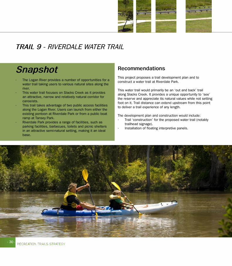
TRAIL 9 - RIVERDALE WATER TRAIL
Snapshot • The Logan River provides a number of opportunities for a
water trail taking users to various natural sites along the river.
• This water trail focuses on Slacks Creek as it provides an attractive, narrow and relatively natural corridor for canoeists.
• This trail takes advantage of two public access facilities along the Logan River. Users can launch from either the existing pontoon at Riverdale Park or from a public boat ramp at Tansey Park.
• Riverdale Park provides a range of facilities, such as parking facilities, barbecues, toilets and picnic shelters in an attractive semi-natural setting, making it an ideal base.
Recommendations
This project proposes a trail development plan and to construct a water trail at Riverdale Park.
This water trail would primarily be an ‘out and back’ trail along Slacks Creek. It provides a unique opportunity to ‘see’ the reserve and appreciate its natural values while not setting foot on it. Trail distance can extend upstream from this point to deliver a trail experience of any length.
The development plan and construction would include:• Trail ‘construction’ for the proposed water trail (notably
trailhead signage).• Installation of floating interpretive panels.

- 31 -
Riverdale Park
Logan Motorway
TanseyPark
P
P
Existing trailsPlanned trailsBikewaysPark

- 32 -
TRAIL 10 - BETHANIA TO BEAUDESERT RAIL TRAIL
The Bethania to Beaudesert Recreation Pathway was not initially identified as one of the 19 projects within this Recreation Trails Strategy. This strategy however does support the potential development of the rail trail. A detailed business case was developed to determine whether a recreation pathway could be established along the disused rail corridor between Bethania and Beaudesert. Throughout the life of this strategy Council’s priorities may change and projects such as this can be incorporated in the future.
A number of factors supporting the development of the rail trail include:
• The Corridor is situated in a relatively scenic landscape, providing views of the Scenic Rim for much of its southern sections. It passes through hills and valleys, forested areas, a variety of farmland and the attractions of the former railway.
• The railway corridor offers a pleasant trail experience being the ideal distance between towns and could become a significant recreation resource in a rapidly growing community.
• The corridor is easily accessible via the existing road and rail system and is within a half day’s drive of many of the major population centres in South East Queensland.
• The trail has the potential to inject significant money into the local economy from local, day-trip and overnight visitors.
• Cycle commuting on a sealed trail has the potential to be a significant component of the corridor, particularly in the section from Bethania to Dairy Creek Road, Waterford and linking to future development of Yarrabilba.
• Some 5,000 students have easy access to the rail corridor, and a further seven schools could use the corridor for activities.
• The corridor passes through a number of settlements, and together with possible trailheads at these towns, a variety of rides/walks of different lengths are possible.
SnapshotThe Bethania to Beaudesert rail corridor is 43km and extends from Bethania in Logan City to Beaudesert in the Scenic Rim Regional Council. The northern point of the corridor is adjacent to the Bethania railway station within Logan City Council urban area. The rail corridor traverses the urban area to the south and then into the rural residential areas between Bethania and Logan Village. The corridor runs through the townships of Logan Village, Jimboomba, and terminating in Beaudesert.
• Conversion to a rail trail provides an opportunity to address some of the negative impacts currently being experienced by adjoining landholders, notably noise from illegal trail bike riding.
• The major elements of the railway infrastructure remain (the formation, cuttings, embankments and most of the bridges and culverts).
• There is potential for interpretation along the rail trial, adding to and enriching the experience of trail users.
• The corridor provides for a variety of lengths of walks and rides and there is great flexibility of use options.
Recommendations
At its meeting of 30 March 2010, Council resolved to proceed with the Phase 2 of the Bethania to Beaudesert Rail Trail Feasibility Study. Outcome from the study will be sumitted to Council by the end of 2010.

- 33 -
Bethania
Logan Village
Jimboomba
to Beaudesert
- 34 -
IMPLEMENTATION - STAGE 2
YEARS 6-10 - LOCAL TRAIL PROJECTS
Overview
This strategy recognises that Logan City Council and its residents may want to develop local trails i.e. trails that attract people who live close by rather than ones who may travel some distance.
Details
Stage 2 of the strategy has recommended 9 projects. These are:
Crestmead Trails Design and Development ProjectProject proposes to identify the preferred location for a shared use trail to extend the existing trail running along Crestmead Park’s northern boundary.
Eagleby Wetland Path Enhancement ProjectProject proposes to rationalise the existing track along the Albert River and to seal the designated trails to create a number of loop trails within the wetland reserve.
Greenwood Lakes Trail Design and Development Project Project proposes to enhance the existing trail and to construct a new trail to create a loop around the two large water bodies along Oxley Creek.
Quinzeh Creek Trail Design and Development ProjectProject proposes to identify the preferred location for a multi-use trail traversing the open space reserve and potentially linking other formal open space reserves in the area.
Gould Adams Park Trail Enhancement ProjectThis project proposes connections to the Kingston Butter Factory and Kingston Railway Station and improved signage and promotion.
Wearing Park Trail Enhancement ProjectThis project proposes the enhancement of the existing multi-use trail traversing Wearing Park.
Henderson Water Trail Design and Development Project The Logan River provides a number of opportunities for a water trail taking users to various natural sites along the river. The water trail takes advantage of a public boat ramp along the Logan River at Henderson Park.
Jimboomba Water Trail Design and Development ProjectThis water trail takes advantage of a publicly accessible section of the Logan River at Cusack Lane, Jimboomba.
TheTinnieTrail–adrivetrailprojectThis project proposes to turn the Tinnie Trail along the Logan River into a Drive Trail which would be perfect for delivering interpretation of the many facets of life and industry along the river.

- 35 -
ACKNOWLEDGEMENTSAs a local government authority, Logan City Council acknowledges that it is well positioned to investigate, identify and determine the future direction for the benefit of all residents and visitors.
The Recreation Trails Strategy could not have been developed without the involvement of a number of key groups and individuals. • Councillors and Mayor - Logan City Council.• Deputy CEO Community & Customer Services.• Key staff from the following Branches - Parks, Major Venues & Facilities, Community Services, Strategy & Planning,
Environment & Sustainability, Road Infrastructure Planning & Community Engagement & Marketing.• Surrounding Councils including Redlands, Brisbane, Gold Coast, Ipswich and Sunshine Coast (benchmarking).• State Agencies including Dept of Infrastructure & Planning, Dept Communities - Sport & Recreation Services, Department
of Environment and Resource Managment.• Queensland Outdoor Recreation Federation
REFERENCESBibbulmun Trail Foundation (2004) “Survey Results confirm Bibbulmun Track’s increasing overseas profile” Bibbulmun News Issue 35 Autumn 2004
Department of Communities, Sport and Recreation Serviceswww.sportrec.qld.gov.au
Department of Environment and Resource Management www.environment.gov.au
Department of Infrastructure and Planningwww.dip.qld.gov.au
Department of Innovation, Industry, Science and Researchwww.ausindustry.gov.au
Gold Coast City Council and Beaudesert Shire Council (2002) Gold Coast Beaudesert Integrated Trails Strategy
Local Government Actwww.legislation.qld.gov.au/LEGISLTN/ACTS/2009/09AC017.pdf
Logan 2026 City Directionswww.logan.qld.gov.au/NR/rdonlyres/CFD913D6-48C6-4E8E-86FD-2A6E43A1E3E5/0/Logan2026CityDirections.pdf
Logan City Council Corporate Plan 2009 - 2013www.logan.qld.gov.au/NR/rdonlyres/568ABB5D-AC0A-49BC-9855-7873957C8E05/0/corporateplan20092013.pdf
Queensland Outdoor Recreation Federationwww.qorf.org.au
South East Queensland Outdoor Recreation Strategywww.dip.qld.gov.au/regional-planning/outdoor-recreation-strategy
South East Queensland Regional Planwww.dip.qld.gov.au/regional-planning/regional-plan
South East Queensland Regional Trails Strategywww.dip.qld.gov.au/resources/plan/SEQ/Active_Trails_Strategy.pdf
Towards Q2www.towardq2.qld.gov.au/library/pdf/tomorrow/Towards_Q2_Tomorrows_Queensland.pdf

RECREATION TRAILS 2010-2020
SPO
RT A
ND
RECREATIO
N