Embed Size (px)
Citation preview

Hydrol. Earth Syst. Sci., 13, 2373–2385, 2009www.hydrol-earth-syst-sci.net/13/2373/2009/© Author(s) 2009. This work is distributed underthe Creative Commons Attribution 3.0 License.
Hydrology andEarth System
Sciences
Recent trends in groundwater levels in a highly seasonalhydrological system: the Ganges-Brahmaputra-Meghna Delta
M. Shamsudduha1, R. E. Chandler2, R. G. Taylor1, and K. M. Ahmed3
1Department of Geography, University College London, London, UK2Department of Statistical Science, University College London, London, UK3Department of Geology, University of Dhaka, Dhaka, Bangladesh
Received: 20 April 2009 – Published in Hydrol. Earth Syst. Sci. Discuss.: 8 June 2009Revised: 21 October 2009 – Accepted: 23 November 2009 – Published: 10 December 2009
Abstract. Groundwater levels in shallow aquifers under-lying Asian mega-deltas are characterized by strong sea-sonal variations associated with monsoon rainfall. To re-solve trend and seasonal components in weekly ground-water levels in the Ganges-Brahmaputra-Meghna (GBM)Delta, we apply a nonparametric seasonal-trend decompo-sition procedure (STL) to observations compiled from 1985–2005 in Bangladesh. Seasonality dominates observed vari-ance in groundwater levels but declining groundwater levels(>1 m/yr) are detected in urban and peri-urban areas aroundDhaka as well as in north-central, northwestern, and south-western parts of the country (0.1–0.5 m/yr) where intensiveabstraction of groundwater is conducted for dry-season ricecultivation. Rising groundwater levels (0.5–2.5 cm/yr) areobserved in the estuarine and southern coastal regions. Thisnovel application of the STL procedure reveals, for the firsttime, the unsustainability of irrigation supplied by shallowaquifers in some areas (e.g., High Barind Tract) of the GBMDelta and the hydrological impact of potential seawater in-trusion of coastal aquifers associated with sea-level rise. Ourfindings provide important insight into the hydrological im-pacts of groundwater-fed irrigation and sea-level rise in otherAsian mega-deltas where monitoring data are limited.
Correspondence to:M. Shamsudduha([email protected])
1 Introduction
Asian mega-deltas feature regionally extensive shallowaquifers within sedimentary sequences deposited over thelast 10 ka (Benner et al., 2008). Groundwater levels inshallow aquifers (depth<80 mbgl) underlying Asian mega-deltas (Fig. 1) are highly seasonal as a result of intensive pre-cipitation during the annual monsoon (Klump et al., 2006;Mukherjee et al., 2007; Larsen et al., 2008; Norrman et al.,2008; Berg et al., 2008). Seasonal fluctuations vary consider-ably both at spatial and temporal scales and range from 2–8 min the Ganges-Brahmaputra-Meghna (GBM) Delta (BGS andDPHE, 2001), 2–5 m in the Red River Basin (Norrman et al.,2008), 2–8 m in the Mekong Basin (Benner et al., 2008; Berget al., 2008), and 1–5 m in the Chao Phraya Basin (Suwan-lert, 2004). Groundwater abstraction for dry-season irriga-tion which has taken place since 1970s in the GBM Delta(WARPO, 2000) and more recently in the Irrawaddy Basinand Mekong Delta (Dawe, 2005; FAO, 2006), serves to in-crease seasonality in shallow groundwater levels. The highlyseasonal nature of the shallow groundwater systems in Asianmega-deltas complicates resolution of trends in groundwaterlevels and, hence, groundwater storage.
Statistical methods for trend analysis vary from simple lin-ear regression to more advanced parametric and nonparamet-ric methods (Helsel and Hirsch, 2002). Classical approachessuch as the Mann-Kendall trend test (Mann, 1945; Kendall,1975) and its seasonal counterpart have been widely usedfor testing trends in hydrological time-series (Hirsch et al.,1982; Aziz and Burn, 2006; Thas et al., 2007). The Mann-Kendall and Seasonal Kendall tests are, however, unable toresolve trends adequately in a time series characterized byserial dependence (Hirsch and Slack, 1984; Hamed and Rao,1998). A further difficulty is that most standard methods
Published by Copernicus Publications on behalf of the European Geosciences Union.

2374 M. Shamsudduha et al.: Groundwater levels in the GBM Delta
1
Fig. 1. General location of the mega deltas of south and southeast Asian countries. Areas in these deltas that are equipped for irrigation(shown in color shades) are taken from the digital global map of irrigation by Siebert et al. (2006). Areas under irrigation are shown aspercentages of the surface area. In the GBM delta, groundwater-fed irrigation accounts for 30% of the country’s total land area. Irrigation is,however, mainly conducted from surface water in many of these mega deltas in Asia.
are designed to detect monotonic trend in a series (Hipeland McLeod, 1994). This restriction limits their usefulnesswhere temporary variations of a long-term trend and changein seasonality are important in assessing the impacts of short-term climate change and anthropogenic activities (Qian et al.,2000). A disadvantage, which is arguably more serious, isthat traditional trend test procedures are designed to identifytrends in the time series but not to characterize them. A sys-tematic characterization of variability permits an evaluationof hydrodynamic responses. Decomposition of a groundwa-ter level time series into trend, seasonal and irregular compo-nents enables an understanding of the processes that controlflow within groundwater systems (Taylor and Alley, 2001).In this study, we resolve trends in shallow groundwater lev-els within the GBM Delta by applying linear regression anda seasonal-trend decomposition procedure to a groundwater-level database of 1.8 million weekly records from 1267 mon-itoring wells over the period of 1985–2005 in Bangladesh.
2 The Ganges-Brahmaputra-Meghna Delta
The GBM Delta is situated in the Bengal Basin which liesin front of the Himalayan foredeep (Fig. 1; Goodbred andKuehl, 2000). River flow in this region is highly seasonal,with 80% of the annual discharge occurring during the four
months of southwestern monsoon (Coleman, 1969). Themodern Bengal Basin comprises about 100 000 km2 of low-land floodplain and delta plain and is bound by Tertiary high-lands related to the uplift of the Himalayas (Goodbred andKuehl, 2000). Global climatic changes, physical and chemi-cal weathering in the Himalayas and subsidence in the Ben-gal Basin interacted to control the Quaternary alluvial sed-imentation and thus hydrogeology of this region (BGS andDPHE, 2001; Ravenscroft et al., 2005). Highly productiveaquifers occur within these thick unconsolidated alluvial sed-iments of the Pleistocene and Holocene ages that were de-posited by the GBM river system (Shamsudduha and Ud-din, 2007). Aquifers occur at relatively shallow depths (5–20 mbgl) beneath the broad alluvial floodplain, alluvial fanand deltaic deposits, and at comparatively deeper depths (15–45 mbgl) underlying the Madhupur clay and Barind clay de-posits in Bangladesh (Ravenscroft et al., 2005). Aquifers thatare found within the geologically complex bedrock terrainsin eastern parts of the country are of variable thickness anddepth. Recent alluvium and upper part of the Dupi Tila sandof Pliocene-Pleistocene age form shallow aquifers which aregenerally located within the depth of 100 m below surface(Ahmed et al., 2004). In Bangladesh, younger or recent allu-vium and fan deposits are the focus of shallow groundwaterdevelopment (UNDP, 1982; BGS and DPHE, 2001).
Hydrol. Earth Syst. Sci., 13, 2373–2385, 2009 www.hydrol-earth-syst-sci.net/13/2373/2009/

M. Shamsudduha et al.: Groundwater levels in the GBM Delta 2375
The hydrodynamics of the GBM deltaic aquifers hasbeen substantially modified by groundwater abstraction(Agrawala et al., 2003; Harvey et al., 2006; Stute et al., 2007;Shamsudduha and Uddin, 2007). In Bangladesh, ground-water is widely used for domestic, industrial and agricul-tural purposes but dry-season irrigation for high-yieldingBoro rice cultivation withdraws the most groundwater inBangladesh (BADC, 2003). Intensive abstraction for irriga-tion (25–75 wells per km2 of irrigated land) occurs in manyareas of northwestern Bangladesh and began during the late1960s to early 1970s with the installation of deep (depth>80 mbgl) tubewells (DTW) by the Bangladesh Water De-velopment Board (BWDB) (BADC, 2003). Initially, irriga-tion from groundwater was provided by these DTW in addi-tion to surface water irrigation with low-lift pumps (LLP) andtraditional methods (BADC, 2003). During the 1980s and1990s the government, with support from international orga-nizations, installed thousands of shallow (depth<80 mbgl)irrigation tubewells (STW) following the recognition of largequantities of groundwater at relatively shallow depths (BGSand DPHE, 2001; World Bank, 2005). The regional-scaleimpact of abstraction on shallow groundwater levels has yetto be assessed. The impact of sea-level rise on groundwaterlevels in coastal regions is also unclear.
3 Data sets and statistical methods
3.1 National groundwater level database of Bangladesh
We compiled a national database of 1.8 million records ofweekly groundwater level data from a dense network (oneper 105 km2) of 1267 monitoring wells that have been man-aged by Bangladesh Water Development Board (BWDB)since the early 1970s. Depth from the well head to ground-water level at each station is referenced to a common hor-izontal datum known as the Public Works Datum (PWD),originally set approximately at the mean sea level (msl) witha vertical error of±0.45 m. During the 1960s most of thesemonitoring wells were dug wells; many of these were subse-quently replaced by piezometers. The total number of mon-itoring wells that operated from 1961–2006 is 2154; 735were dug wells and 1419 were piezometers of variable depthsranging from 3.9 to 352 mbgl (mean depth 24 mbgl). Mostdug wells have now been replaced by piezometers at thesame location; faulty piezometers have also been replacedthroughout the recording period. In some cases, newly in-stalled piezometers were drilled deeper or shallower thanthose they replaced. The total number of unique well loca-tions in the present database is 1267. In our analyses, we treateach replacement well as a separate monitoring station toavoid potential problems associated with spurious trends dueto well substitution. In the newly compiled weekly ground-water level database, there are 1189 piezometers and 78 dugwells. We used the “R” statistical language (R Development
2
Fig. 2. Distributions of groundwater level monitoring stations inBangladesh (Group A, B and C) imposed on a 90 m resolution digi-tal elevation model derived from the Shuttle Radar Topography Mis-sion (SRTM). Depth distribution of monitoring wells is shown in thehistogram (inset).
Core Team, 2007) to read and re-structure groundwater leveldata from two original data formats (i.e., flat text-file and Mi-crosoft Access database) maintained by BWDB. All water-level records were subjected to systematic quality controlprocedures. Wells with unreliable and only a few ground-water level data were flagged and discarded from subsequentanalyses. Wells with no available information on the depthto the well screen and wells with more than 50% of missingrecords were also discarded.
3.2 Data sets and exploratory analyses
Three groups of monitoring wells were defined for the sta-tistical analyses reported below. Group A comprises 1035shallow monitoring wells (66 dug wells and 969 piezome-ters) yielding 1.1 million, quality controlled, groundwater-level observations that were used for exploratory analyses(Fig. 2). The record lengths in Group A wells range from7 to 41 years, with a mean of 22. Exploratory analyseswere restricted to the period from 1985–2005 in order to
www.hydrol-earth-syst-sci.net/13/2373/2009/ Hydrol. Earth Syst. Sci., 13, 2373–2385, 2009

2376 M. Shamsudduha et al.: Groundwater levels in the GBM Delta
be consistent with the dominant observation period of themajority of monitoring wells. All wells in Group A have<20% missing data with a mean of 5.5% for the entire group.Group B is a subset of 454 wells from Group A that havebeen specially selected for trend analysis because their recordlengths extend over the entire period from 1985 to 2005;the mean proportion of missing data is 5.9%. Group C isa subset of Group B comprising 282 wells for which missingrecords (mean 5%) are of sufficiently short duration and thuscould be imputed using a simple linear interpolation method.Where data in Group C wells were found missing either inthe average driest (April) and or the wettest (September)months of a particular year, the missing value was imputedby taking the mean of groundwater levels of the relevant pe-riod from two adjacent years. Group C wells were used forSTL decomposition analysis as this method requires time se-ries without gaps.
Exploratory analyses of the Group A wells investi-gated the general distribution of groundwater levels acrossBangladesh. Groundwater levels for individual wells, se-lected to reflect variations in surface geological units, wereplotted to investigate variations in groundwater-level time se-ries in different regions. Time series plots of various sum-mary statistics at monthly, annual and decadal timescaleswere also produced to develop a preliminary assessment oftrends. For each Group A well, the median groundwaterlevel was calculated for each month to summarize the sea-sonal structure in the record.
3.3 Linear regression for trend analysis
The exploratory analyses of Group A wells provided an ini-tial impression of seasonality and trends in the groundwaterseries. It is of particular interest to test for and character-ize trends in the series, for example to examine the sustain-ability of current abstraction levels. To this end, an initialassessment of trends over the period from 1985–2005 wascarried out using linear regression applied to annual time se-ries at each Group B monitoring site for direct comparison ofresults. To investigate the possibility that trends may be sea-sonally varying, three different annual series were analyzedat each site: the mean, 5th and 95th percentiles of each year’sobservations. Trends in 5th percentiles correspond roughly tochanges during the dry period, and trends in 95th percentilesto changes in the wet season groundwater levels. The use ofpercentiles, rather than annual maxima and minima, avoidsproblems associated with outliers and data errors.
3.4 Trend and seasonality decomposition withSTL method
Despite widespread application of linear regression for trendanalysis, this procedure does not provide accurate assess-ments of nonlinear trends in borehole groundwater levels. Inthe analysis of linear trends in Group B wells, we treated
mean and seasonal extremes separately yet it is preferableto develop an integrated description of change in ground-water levels over the entire time series. We applied anonparametric time series decomposition method known as“Seasonal-Trend decomposition procedure based on Loess(STL)” (Cleveland et al., 1990) to resolve trends and sea-sonality in groundwater levels at each Group C monitoringwell. Each time series of groundwater level records was de-composed using the STL decomposition method (Eq. 1) intheR statistical language as:
Yt = Tt +St +Rt (1)
whereYt is the groundwater level at timet , Tt is the trendcomponent;St is the seasonal component; andRt is an irreg-ular (residual) component.
The STL method consists of a series of smoothing oper-ations with different moving window widths chosen to ex-tract different frequencies within a time series, and can beregarded as an extension of classical methods for decom-posing a series into its individual components (see Sect. 2.6in Chatfield, 2003). STL uses the locally weighted regres-sion (LOESS) technique that was first proposed by Cleveland(1979) and later modified by Cleveland and Devlin (1988).The nonparametric nature of the STL decomposition tech-nique enables detection of nonlinear patterns in long-termtrends that cannot be assessed through linear trend analyses(Sect. 3.3).
For STL decomposition, it is necessary to choose valuesof smoothing parameters to extract trend and seasonal com-ponents. The choice of the seasonal smoothing parameterdetermines the extent to which the extracted seasonal com-ponent varies from year to year: a large value will lead tosimilar components in all years whereas a small value will al-low the extracted component to track the observations moreclosely. Similar comments apply to the choice of smoothingparameter for the trend component. We experimented withseveral different choices of smoothing parameters at a num-ber of contrasting sites; visualization of the results suggestedthat the overall structure of time series at all sites could becaptured reasonably using window widths of 7 years for theseasonal component and 5 years for the trend. The smooth-ing parameters were therefore fixed at these values for allsubsequent STL analyses.
4 Results
4.1 Exploratory statistics and spatio-temporal distribu-tion of groundwater levels
Figure 3 shows groundwater levels for selected wells, alongwith the corresponding seasonal and annual distributions.These plots reveal both seasonality and long-term trends ingroundwater levels. The results from all wells show that
Hydrol. Earth Syst. Sci., 13, 2373–2385, 2009 www.hydrol-earth-syst-sci.net/13/2373/2009/
M. Shamsudduha et al.: Groundwater levels in the GBM Delta 2377
3
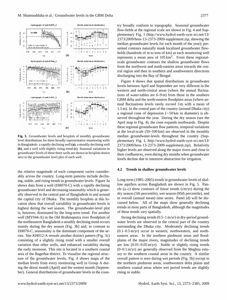
Fig. 3. Groundwater levels and boxplots of monthly groundwaterlevel distributions for three broadly representative monitoring wellsin Bangladesh: a rapidly declining well(a), a steadily declining well(b), and a well with slightly rising trend(c). Seasonal variations ingroundwater levels of these three wells are shown as boxplots drawnnext to the groundwater level plot of each well.
the relative magnitude of each component varies consider-ably across the country. Long-term patterns include declin-ing, stable, and rising trends in groundwater levels. Figure 3ashows data from a well (DH070-C) with a rapidly declininggroundwater level and decreasing seasonality which is gener-ally observed in the central part of Bangladesh in and aroundthe capital city of Dhaka. The monthly boxplots at this lo-cation show that overall variability in groundwater levels ishighest during the wet season. The groundwater-level plotis, however, dominated by the long-term trend. For anotherwell (MY044-A) in the Old Brahmaputra river floodplain ofthe northeastern Bangladesh a steadily declining trend occursmainly during the dry season (Fig. 3b) and, in contrast toDH070-C, seasonality is the dominant component of the se-ries. Site KH012-A reveals another distinct pattern (Fig. 3c)consisting of a slightly rising trend with a smaller overallvariation than other wells, and enhanced variability duringthe early monsoon. This site is located in a southern coastalarea of the Bagerhat district. To visualize the regional struc-ture of the groundwater levels, Fig. 4 shows maps of themedian levels from every monitoring well in Group A dur-ing the driest month (April) and the wettest month (Septem-ber). General distributions of groundwater levels in the coun-
try broadly conform to topography. Seasonal groundwaterflow-fields at the regional scale are shown in Fig. 4 and Sup-plementary Fig. I (http://www.hydrol-earth-syst-sci.net/13/2373/2009/hess-13-2373-2009-supplement.zip, showing themedian groundwater levels for each month of the year); pre-sented contours naturally mask localized groundwater flow-fields (hundreds of m to tens of km) as each monitoring wellrepresents a mean area of 105 km2. From these regional-scale groundwater contours the shallow groundwater flowsfrom the northwest and north-eastern areas towards the cen-tral region and then in southern and southwestern directionsdischarging into the Bay of Bengal.
Figure 4 shows that spatial distributions in groundwaterlevels between April and September are very different in thewestern and north-central areas (where the annual fluctua-tions of water-tables are 6–9 m) from those in the southernGBM delta and the north-eastern floodplain areas (where an-nual fluctuations levels rarely exceed 3 m with a mean of1.5 m). In the central part of the country (around Dhaka city)a regional cone of depression (∼50 km in diameter) is ob-served throughout the year. During the dry season (see theApril map in Fig. 4), the cone expands northwards. Despitethese regional groundwater flow patterns, temporal variationsat the local-scale (50–100 km) are observed in the monthlymedian groundwater-levels throughout the country (Sup-plementary Fig. I,http://www.hydrol-earth-syst-sci.net/13/2373/2009/hess-13-2373-2009-supplement.zip). Relativelyhigher levels are observed along the major rivers and close totheir confluences, even during dry months when groundwaterlevels decline due to intensive abstraction for irrigation.
4.2 Trends in shallow groundwater levels
Long-term (1985–2005) trends in groundwater levels of shal-low aquifers across Bangladesh are shown in Fig. 5. Pan-els (a–c) show contours of linear trends (cm/yr) during thedry season (5th percentile), wet season (95th percentile), andin overall (annual mean) time series. Panel (d) will be dis-cussed below. All of the maps show generally decliningtrends in most parts of Bangladesh, although the magnitudesof these trends vary spatially.
Strong declining trends (0.5–1 m/yr) in dry-period ground-water levels are observed in the central part of the countrysurrounding the Dhaka city. Moderately declining trends(0.1–0.5 m/yr) occur in western, northwestern, and north-eastern areas. In the northern piedmont areas and flood-plains of the major rivers, magnitudes of declining trendsare low (0.01–0.05 m/yr). Stable or slightly rising trends(0–0.1 m/yr) are generally observed from the Meghna estu-ary to the southern coastal areas in the country. A similaroverall pattern is seen during wet periods (Fig. 5b) except inthe northern piedmont areas, southwestern delta plains andsouthern coastal areas where wet period trends are slightlyrising or stable.
www.hydrol-earth-syst-sci.net/13/2373/2009/ Hydrol. Earth Syst. Sci., 13, 2373–2385, 2009

2378 M. Shamsudduha et al.: Groundwater levels in the GBM Delta
4
Fig. 4. Median groundwater levels for April (end of dry season) and September (end of monsoon season) over a period of 21 years.Groundwater levels are referenced to the mean sea level (msl).
Similar to long-term trends during dry and wet peri-ods, declining trends in annual mean groundwater levels areobserved in the central, northwestern, and northeastern parts(Fig. 5c). Relatively stable to rising mean groundwater levelsare detected in the northern piedmont, floodplains of majorrivers, and deltaic plains. Generally declining groundwaterlevels are observed in the complex geological terrain of theeastern part of Bangladesh.
4.3 Spatial variability in trend and seasonalcomponents
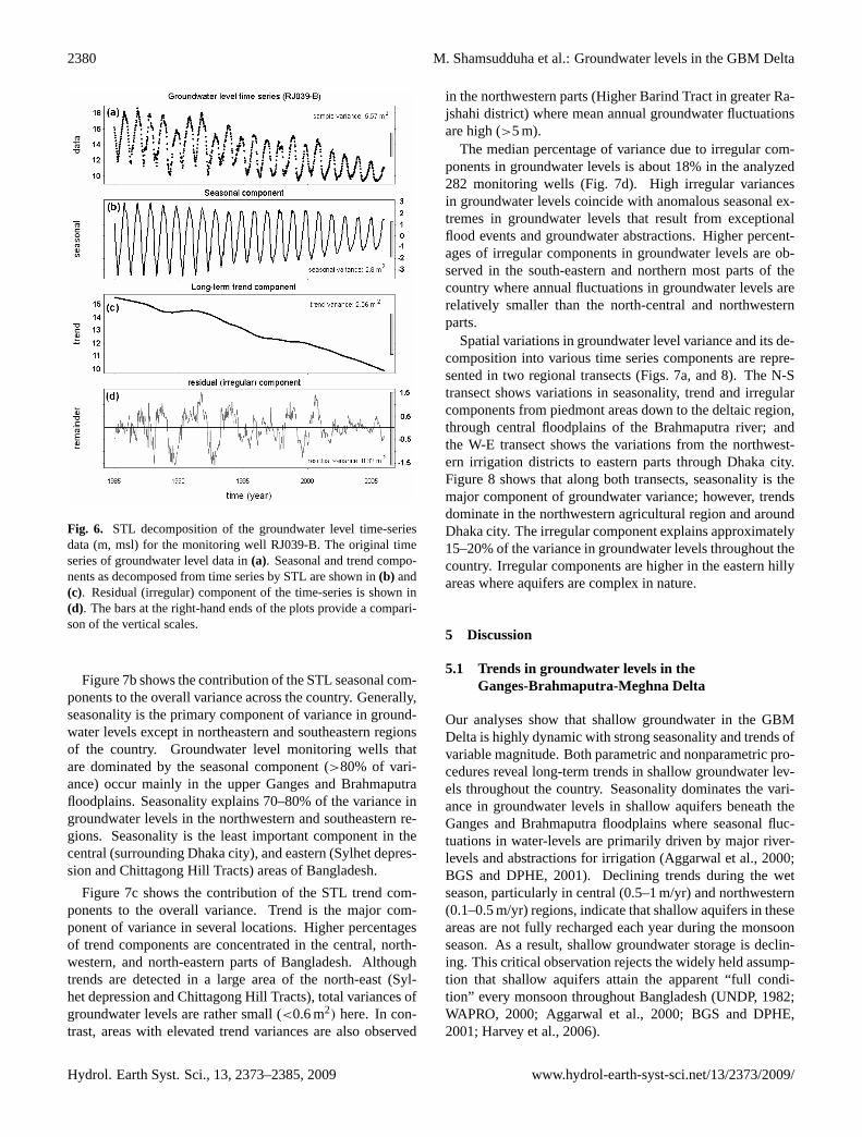
To obtain a more complete picture of the regional groundwa-ter time series structure, we focus on the results of STL anal-yses. First, a representative STL decomposition (for moni-toring well RJ039-B) is shown in Fig. 6. In this example, weobserve a decreasing seasonality over time and a decliningtrend in the time series. The STL method improves on theprevious linear regression analyses both by allowing a moreflexible representation of the underlying trend, and by con-sidering all aspects of the time series simultaneously.
For the purpose of visualizing the regional structure inSTL-derived trends, it is convenient to reduce each one toa single number. Here, for each well an index of overall
annual change has been defined as 52(Tn −T1)/n, wheren = 52× 21 is the number of weeks of record in the anal-ysis period 1985–2005 andTt is the value of the STL trendcomponent in thet-th week of the record as defined above.Panel (d) in Fig. 5 shows a map of the long-term trends cal-culated in this way. Overall, the pattern is very similar tothat derived in Fig. 5c using linear regression, although fewerwells (n=282) were used in the STL analysis due to morestringent data requirements. The STL trends are, however,more realistic than trends estimated by linear regression forthe reasons given above.
To obtain further insight into the regional groundwater dy-namics, it is of interest to compare the magnitudes of thetrend, seasonal and irregular components at each monitoringlocation. To do this we have expressed the sample variance ofeach component as a percentage of the variance of the origi-nal groundwater level time series over the 1985–2005 period.Figure 7a maps the variances in the original series. Highervariances in groundwater levels (5–30 m2) are observed inthe north-central, northwestern and southwestern parts wheremean annual fluctuations of groundwater levels are high (3–8 m). Smaller variances are observed in the north, north-eastern, southern delta plains and estuarine areas.
Hydrol. Earth Syst. Sci., 13, 2373–2385, 2009 www.hydrol-earth-syst-sci.net/13/2373/2009/

M. Shamsudduha et al.: Groundwater levels in the GBM Delta 2379
5
Fig. 5. Trends in groundwater levels between 1985 and 2005. Linear trends in the dry-period groundwater levels (5th percentiles ofobservations in each year) are shown in(a), trends in the wet-period groundwater levels (95th percentiles) are shown in(b), linear trends inannual means are shown in(c), and nonparametric trends calculated from the long-term trend component derived from an STL decompositionare shown in(d). Trends in sea-level at three locations in coastal regions of Bangladesh calculated by Singh (2002) are shown in(d).
www.hydrol-earth-syst-sci.net/13/2373/2009/ Hydrol. Earth Syst. Sci., 13, 2373–2385, 2009
2380 M. Shamsudduha et al.: Groundwater levels in the GBM Delta
6
Fig. 6. STL decomposition of the groundwater level time-seriesdata (m, msl) for the monitoring well RJ039-B. The original timeseries of groundwater level data in(a). Seasonal and trend compo-nents as decomposed from time series by STL are shown in(b) and(c). Residual (irregular) component of the time-series is shown in(d). The bars at the right-hand ends of the plots provide a compari-son of the vertical scales.
Figure 7b shows the contribution of the STL seasonal com-ponents to the overall variance across the country. Generally,seasonality is the primary component of variance in ground-water levels except in northeastern and southeastern regionsof the country. Groundwater level monitoring wells thatare dominated by the seasonal component (>80% of vari-ance) occur mainly in the upper Ganges and Brahmaputrafloodplains. Seasonality explains 70–80% of the variance ingroundwater levels in the northwestern and southeastern re-gions. Seasonality is the least important component in thecentral (surrounding Dhaka city), and eastern (Sylhet depres-sion and Chittagong Hill Tracts) areas of Bangladesh.
Figure 7c shows the contribution of the STL trend com-ponents to the overall variance. Trend is the major com-ponent of variance in several locations. Higher percentagesof trend components are concentrated in the central, north-western, and north-eastern parts of Bangladesh. Althoughtrends are detected in a large area of the north-east (Syl-het depression and Chittagong Hill Tracts), total variances ofgroundwater levels are rather small (<0.6 m2) here. In con-trast, areas with elevated trend variances are also observed
in the northwestern parts (Higher Barind Tract in greater Ra-jshahi district) where mean annual groundwater fluctuationsare high (>5 m).
The median percentage of variance due to irregular com-ponents in groundwater levels is about 18% in the analyzed282 monitoring wells (Fig. 7d). High irregular variancesin groundwater levels coincide with anomalous seasonal ex-tremes in groundwater levels that result from exceptionalflood events and groundwater abstractions. Higher percent-ages of irregular components in groundwater levels are ob-served in the south-eastern and northern most parts of thecountry where annual fluctuations in groundwater levels arerelatively smaller than the north-central and northwesternparts.
Spatial variations in groundwater level variance and its de-composition into various time series components are repre-sented in two regional transects (Figs. 7a, and 8). The N-Stransect shows variations in seasonality, trend and irregularcomponents from piedmont areas down to the deltaic region,through central floodplains of the Brahmaputra river; andthe W-E transect shows the variations from the northwest-ern irrigation districts to eastern parts through Dhaka city.Figure 8 shows that along both transects, seasonality is themajor component of groundwater variance; however, trendsdominate in the northwestern agricultural region and aroundDhaka city. The irregular component explains approximately15–20% of the variance in groundwater levels throughout thecountry. Irregular components are higher in the eastern hillyareas where aquifers are complex in nature.
5 Discussion
5.1 Trends in groundwater levels in theGanges-Brahmaputra-Meghna Delta
Our analyses show that shallow groundwater in the GBMDelta is highly dynamic with strong seasonality and trends ofvariable magnitude. Both parametric and nonparametric pro-cedures reveal long-term trends in shallow groundwater lev-els throughout the country. Seasonality dominates the vari-ance in groundwater levels in shallow aquifers beneath theGanges and Brahmaputra floodplains where seasonal fluc-tuations in water-levels are primarily driven by major river-levels and abstractions for irrigation (Aggarwal et al., 2000;BGS and DPHE, 2001). Declining trends during the wetseason, particularly in central (0.5–1 m/yr) and northwestern(0.1–0.5 m/yr) regions, indicate that shallow aquifers in theseareas are not fully recharged each year during the monsoonseason. As a result, shallow groundwater storage is declin-ing. This critical observation rejects the widely held assump-tion that shallow aquifers attain the apparent “full condi-tion” every monsoon throughout Bangladesh (UNDP, 1982;WAPRO, 2000; Aggarwal et al., 2000; BGS and DPHE,2001; Harvey et al., 2006).
Hydrol. Earth Syst. Sci., 13, 2373–2385, 2009 www.hydrol-earth-syst-sci.net/13/2373/2009/

M. Shamsudduha et al.: Groundwater levels in the GBM Delta 2381
7
Fig. 7. Variance of groundwater level time series for Group-C wells(a); relative proportions of groundwater level variance contributed byseasonal, trend and irregular components are shown in(b–d), respectively. Relative proportion of variance in groundwater levels explainedby all time series components along two profiles lines (N-S and W-E) on Fig. 7a are shown in Fig. 8.
www.hydrol-earth-syst-sci.net/13/2373/2009/ Hydrol. Earth Syst. Sci., 13, 2373–2385, 2009

2382 M. Shamsudduha et al.: Groundwater levels in the GBM Delta
8
Fig. 8. Sample variances and proportions of variances explained by
various components of the groundwater level time series data alongtwo transects as shown in Fig. 7a; N-S profile shows variance inthe groundwater level data(a); proportions of time series variancescontributed by seasonality, trend and irregular components; sea-sonality is the dominating time series component in the Piedmontand Brahmaputra floodplain areas; W-E profile(b) shows that trendcomponents in the Barind Tract and central parts of Bangladesh aredominant where seasonal components are relatively less stronger.
The spatial structure of deduced trends reflects the balancebetween abstraction and surface geology which acts as a keycontrol on the magnitude of groundwater recharge. From1979 to 2003, groundwater-fed irrigation for dry seasonrice cultivation in Bangladesh increased by approximately875 million cubic meters (MCM) each year (BADC, 2003)elevating annual rice production from 11.9 megatonnes (Mt)in 1975 to 27.3 Mt in 2006–2007 (Bangladesh Bureau ofStatistics, 2008). Although records of groundwater usagefor irrigation are not available, we provide an approxima-tion of the spatial distribution of groundwater abstractionbased on the fraction (as a percentage) of land in each ofthe country’s 64 districts that was irrigated by both shallowand deep irrigation pumps in 2003 (Fig. 9). Nationally, a to-tal of 924 023 STWs were used to irrigate about 24 094 km2
of agricultural land accounting for approximately 60% of ir-rigated land whereas irrigation using DTWs comprised 15%.
Our observations indicate that areas of intensive abstrac-tion for irrigation exhibit declining trends in long-termgroundwater levels in Bangladesh. A key exception is in thedistrict of Dhaka where the shallow aquifer is overlain by
9
Fig. 9. Percentage of land in each of the 64 districts (broken graylines) in Bangladesh irrigated with groundwater in 2003 (BADC,2003). Total numbers of shallow and deep tubewells operated ineach district in 2003 are also shown. Low-permeable regionallyextensive surface geological units are shown in the background.
the Madhupur clay formation (Ahmed et al., 1999). Here,there is little abstraction for irrigation in peri-urban areas butannual abstraction for domestic and industrial purposes is∼750 MCM (Hoque et al., 2007) and substantially exceedstotal annual recharge of 380–480 MCM in the Dhaka district(UNDP, 1982; Karim, 1984). This high groundwater deficitis responsible for the rapid decline (>1 m/yr) in groundwa-ter levels. Elsewhere in Bangladesh, the magnitude of de-clining shallow groundwater storage in northwestern (i.e.,Barind Tract) and north-central (i.e., Madhupur Tract) re-gions (Fig. 9) relates not only to the intensity of abstractionbut also low in areas of clay cover where rates of rainfall-fedrecharge are constrained by the low hydraulic conductivity(0.01 m/day) of this surface geology.
5.2 Rising groundwater levels and sea-level rise
Rising trends in groundwater levels (0.5–2.5 cm/yr) observedfrom 1985–2005 in the Meghna estuary and coastal regionsof Bangladesh, coincide with rising sea levels reported by
Hydrol. Earth Syst. Sci., 13, 2373–2385, 2009 www.hydrol-earth-syst-sci.net/13/2373/2009/

M. Shamsudduha et al.: Groundwater levels in the GBM Delta 2383
several studies (Alam, 1996; Singh et al., 2000; Singh, 2002;Mohal et al., 2007). Observed sea levels from 1977–1998 atthree locations (see Fig. 5d) reveal that mean rates of sea-level rise range from 0.4–0.8 cm/yr (Singh, 2002). Theserates are much higher than the average rate of global sealevel rise of 0.18 cm/yr for the 20th century (IPCC, 2007) andarise from regional factors such as sediment load, basin tec-tonics and differential subsidence (2–15 mm/yr) of the GBMdelta (Worm et al., 1998; Goodbred and Kuehl, 2000; Steck-ler et al., 2007). As sea levels rise, shallow groundwater incoastal areas is elevated through an overall rise in the po-sition of the freshwater-seawater interface (Barlow, 2003;McCobb and Weiskel, 2003). Barlow (2003) asserts that arise in the groundwater level caused by sea-level rise couldimpact on river deltas up to 20–50 km inland. The magni-tude of sea-level rise along the coast of the Bay of Ben-gal (0.4–0.8 cm/yr) from 1977–1998 is comparable to thetrends in rising groundwater levels (0.5–2.5 cm/yr) observedin coastal aquifers between 1985 and 2005. Rising ground-water levels may additionally result from local recharge asthe volume of rainfall-fed recharge exceeds abstraction forirrigation in southern deltaic areas (BGS and DPHE, 2001).Abstraction for irrigation has declined in coastal areas ofBangladesh where rapid growth in brackish-water shrimpfarming since the early 1990s has replaced many low-lyingrice fields (Ahmed et al., 2009). Projected rises in sea levelwill accelerate the intrusion of saline water thereby impairinggroundwater quality and threatening the world’s largest man-grove forest in the Sundarbans (Alam, 2004) where ground-water plays a vital role in maintaining an intermediate salin-ity required for mangrove growth and survival (Agrawala etal., 2003). It is important to note that coastal defenses (e.g.,embankments, dykes) will not inhibit (subsurface) seawaterintrusion.
5.3 Extrapolation of trends to other Asian mega-deltas
The large number of weekly groundwater level observationdata within a dense spatial network of monitoring stationsin Bangladesh provides valuable information on shallowgroundwater dynamics and long-term responses to rapid de-velopment and climate change in other Asian mega-deltaswhere geology, topography, and hydrogeological conditionsof shallow aquifers are similar (Benner et al., 2008). Cur-rent groundwater abstraction in other Asian mega deltas islower than in the GBM Delta but increasing demand for foodand water in urban areas are likely to intensify groundwa-ter abstraction. Extensive pumping from shallow aquifersin the Red River delta, particularly in Hanoi, as well as inand around Bangkok area within the Chao Phraya delta, isalready causing rapid declines in groundwater levels (Phien-wej et al., 2006; Berg et al., 2008). Sustainable groundwa-ter development strategies in Asian mega-deltas need also toconsider the impact of sea-level rise on costal groundwaterlevels.
6 Conclusions
We resolve recent (1985–2005) trends in groundwater levelswithin a highly seasonal hydrological system, the Ganges-Brahmaputra-Meghna (GBM) Delta, through the novel ap-plication of a robust seasonal-trend decomposition technique(STL). Seasonality dominates observed variance in ground-water levels but we show, for the first time, that groundwaterlevels are declining by 0.1–0.5 m/yr in north-central, north-western, and southwestern areas of the GBM Delta whereintensive abstraction of groundwater is conducted for dry-season rice cultivation. Unsustainable groundwater abstrac-tion is especially pronounced in areas where the low hy-draulic conductivity of surface geology inhibits rainfall-fedrecharge. In Dhaka where abstraction has increased dra-matically to meet domestic and industrial demands, ratesof groundwater-level decline exceed 1 m/yr. In the south-ern GBM Delta, we detect rising groundwater levels (0.5–4 cm/yr) that are commensurate to, and coincident with, lo-cal trends in sea levels (0.4–0.8 cm/yr). Our analysis ofthe exceptional dataset of groundwater-level observations forthe GBM Delta in Bangladesh provides insight into trendsand seasonality in shallow groundwater levels expected inother Asian mega-deltas influenced by groundwater abstrac-tion and global sea-level rise. Climate change will amplifyobserved dynamics and trends through an increase in precipi-tation involving fewer but more intense rainfall events duringthe monsoon season so future work is currently focused onthe impacts of rainfall intensity on groundwater storage.
Acknowledgements.We acknowledge the support of theBangladesh Water Development Board in providing ground-water level monitoring observation records. Support from the UK’sEngineering and Physical Sciences Research Council (EPSRC)through a Dorothy Hodgkin Postgraduate Award (Ref. GR/AKFX-DHPA 2007–2011) is kindly acknowledged. We thank twoanonymous reviewers for their valuable comments and constructivefeedback. We also thank Peter Ravenscroft, Mohammad A. Hoque,and Anwar Zahid for comments.
Edited by: A. Shamseldin
References
Aggarwal, P. K., Basu, A. R., and Poreda, R. J.: Isotope hydrol-ogy of groundwater in Bangladesh: Implications for character-isation and mitigation of arsenic in groundwater, TC ProjectBGD/8/016, Int. At. Energy Agency, Vienna, 2000.
Agrawala, S., Ota, T., Ahmed, A. U., Smith, J., and van Aalst,M.: Development and climate change in Bangladesh: Focuson coastal flooding and the Sundarbans, Final report, Organisa-tion for Economic Co-operation and Development, Paris, France,70 pp., 2003.
Ahmed, K. M., Hasan, M. K., Burgess, W. G., Dottridge, J., Raven-scroft, P., and van Wonderen, J. J.: The Dupi Tila aquifer ofDhaka, Bangladesh: hydraulic and hydrochemical response to
www.hydrol-earth-syst-sci.net/13/2373/2009/ Hydrol. Earth Syst. Sci., 13, 2373–2385, 2009

2384 M. Shamsudduha et al.: Groundwater levels in the GBM Delta
intensive exploitation, in: Groundwater in the urban environ-ment: selected city profiles, edited by: Chilton, P. J., Balkema,Rotterdam, 19–30, 1999.
Ahmed, K. M., Bhattacharya, P., Hasan, M. A., Akhter, S. H., Alam,S. M. M., Bhuyian, M. A. H., Imam, M. B., Khan, A. A., andSracek, O.: Arsenic enrichment in groundwater of the alluvialaquifers in Bangladesh: an overview, Appl. Geochem., 19, 181–200, 2004.
Ahmed, N., Allison, E. H., and Muir, J. F.: Rice fields to prawnfarms: a blue revolution in southwest Bangladesh?, Aquacult.Int., doi:10.1007/s10499-009-9276-0, 2009.
Alam, M.: Subsidence of the Ganges-Brahmaputra delta ofBangladesh and associated drainage, sedimentation, and salinityproblems, in: Sea-Level Rise and Coastal Subsidence: Causes,Consequences, and Strategies, edited by: Milliman, J. D. andHaq, B. U., Kluwer Academic Publishers, Dordrecht, 1996.
Alam, M.: Adverse impacts of climate change on development ofBangladesh: integrating adaptation into policies and activities,Working Paper No. 1 of CLACC, Bangladesh Centre for Ad-vanced Studies (BCAS), Dhaka, 2004.
Aziz, O. I. A. and Burn, D. H.: Trends and variability in the hy-drological regime of the Mackenzie River Basin, J. Hydrol., 319,282–294, 2006.
BADC: Survey report on irrigation equipment and irrigated area inBoro 2003 season, Survey and monitoring project for develop-ment of minor irrigation, Bangladesh Agricultural developmentCorporation, Sech Bhaban, Dhaka, 2003.
Bangladesh Bureau of Statistics: Annual agricultural statistics2007, Agricultural Wing, Bangladesh Bureau of Statistics,Dhaka, 2008.
Barlow, P. M.: Ground water in freshwater-saltwater environmentsof the Atlantic coast, US Geological Survey Circular 1262, USGeological Survey, Reston, Virginia, 2003.
Benner, S. G., Polizzotto, M. L., Kocar, B. D., Ganguly, S., Phan,K., Ouch, K., Sampson, M., and Fendorf, S.: Groundwater flowin an arsenic-contaminated aquifer, Mekong Delta, Cambodia,Appl. Geochem., 23, 3072–3087, 2008.
Berg, M., Trang, P. T. K., Stengel, C., Buschmann, J., Viet, P. H.,Dan, N. V., Giger, W., and Stuben, D.: Hydrological and sedi-mentary controls leading to arsenic contamination of groundwa-ter in the Hanoi area, Vietnam: The impact of iron-arsenic ratios,peat, river bank deposits, and excessive groundwater abstraction,Chem. Geol., 249, 91–112, 2008.
British Geological Survey and Department of Public Health Engi-neering (BGS and DPHE): Arsenic Contamination of Ground-water in Bangladesh, Keyworth, UK, 2001.
Chatfield, C.: The analysis of time series – an introduction,6th Edn., Chapman and Hall, CRC Press, Boca Raton, 352 pp.,2003.
Cleveland, R. B., Cleveland, W. S., McRae, J. E., and Terpenning,I.: STL: A Seasonal Trend Decomposition Procedure Based onLOESS, J. Official Statistics, 6, 3–33, 1990.
Cleveland, W. S.: Robust Locally Regression and Smoothing Scat-terplots, J. Am. Stat. Assoc., 74, 829–836, 1979.
Cleveland, W. S. and Devlin, S. J.: Locally Weighted Regression:An Approach to Regression Analysis by Local Fitting, J. Am.Stat. Assoc., 83, 596–610, 1988.
Coleman, J. M.: Brahmaputra river: channel processes and sedi-mentation, Sediment. Geol., 3, 1290–239, 1969.
Dawe, D.: Increasing water productivity in rice-based systems inAsia – past trends, current problems, and future prospects, PlatProd. Sci., 8(3), 221–230, 2005.
FAO: The State of Food and Agriculture in Asia and the Pacific,RAP Publication 2006/03, Food and Agriculture Organizationof the United Nations regional office for Asia and the Pacific,Bangkok, 2006.
Goodbred, S. L., Kuehl, S. A., Steckler, M. S., and Sarker, M. H.:Controls on facies distribution and stratigraphic preservation inthe Ganges-Brahmaputra delta sequence, Sediment. Geol., 155,301–316, 2003.
Hamed, K. H. and Rao, A. R.: A modified Mann-Kendall trend testfor autocorrelated data, J. Hydrol., 204, 182–196, 1998.
Harvey, C. F., Ashfaque, K. N., Yu, W., Badruzzaman, A. B. M.,Ali, M. A., Oates, P. M., Michael, H. A., Neumann, R. B.,Beckie, R., Islam, S., and Ahmed, M. F.: Groundwater dynam-ics and arsenic contamination in Bangladesh, Chem. Geol., 228,112–136, 2006.
Helsel D. R. and R. M.: Hirsch Statistical Methods in WaterResources, Book 4, Hydrologic Analysis and Interpretation,510 pp., US Geological Survey, Virginia, 2002.
Hipel K. W. and Mcleod, A. I.: Time Series Modelling of Water Re-sources and Environmental System, 1013 pp., Amsterdam, Else-vier, 1994.
Hirsch, R. M. and Slack, J. R.: A nonparametric trend test for sea-sonal data with serial dependence, Water Resour. Res., 20, 727–732, 1984.
Hirsch, R. M., Slack, J. R., and Smith, R. A.: Techniques of trendanalysis for monthly water quality data, Water Resour. Res., 18,107–121, 1982.
Hoque, M. A., Hoque, M. M., and Ahmed, K. M.: Declininggroundwater level and aquifer dewatering in Dhaka metropoli-tan area, Bangladesh: causes and quantification, Hydrogeol. J.,15, 1523–1534, 2007.
IPCC: Climate Change 2007: the Physical Science Basis, Contri-bution of Working Group I to the Fourth Assessment Reportof the Intergovernmental Panel on Climate Change, edited by:Solomon, S. Qin, D. Manning, M. Chen, Z. Marquis, M. Averyt,K. B. Tignor, M., and Miller, H. L., Cambridge University Press,Cambridge, UK and New York, USA, 2007.
Karim, M. A.: Upazila-wise groundwater recharge conditions ofBangladesh, Groundwater Investigation Circle, Bangladesh Wa-ter Development Board, Dhaka, 1984.
Kendall, M. G.: Rank Correlation Methods, 4th Edn., Charles Grif-fin, London, UK, 1975.
Klump, S., Kipfer, R., Cirpka, O. A., Harvey, C. F., Brennwald, M.S., Ashfaque, K. N., Badruzzaman, A. B. M., Hug, S. J., and Im-boden, D. M.: Groundwater dynamics and arsenic mobilizationin Bangladesh assessed using noble gases and tritium, Environ.Sci. Technol., 40, 243–250, 2006.
Larsen, F., Pham, N. Q., Dang, N. D., Postma, D., Jessen, S., Pham,V. H., Nguyen, T. B., Trieu, H. D., Tran, L. T., Nguyen, H.,Chambon, J., Nguyen, H. V., Ha, D. H., Hue, N. T., Duc, M. T.,and Refsgaard, J. C.: Controlling geological and hydrogeologi-cal processes in an arsenic contaminated aquifer on the Red Riverflood plain, Vietnam, Appl. Geochem., 23, 3099–3115, 2008.
Mann, H. B.: Nonparametric tests against trend, Econometrica, 13,245–259, 1945.
McCobb, T. D. and Weiskel, P. K.: Long-Term Hydrologic Monitor-
Hydrol. Earth Syst. Sci., 13, 2373–2385, 2009 www.hydrol-earth-syst-sci.net/13/2373/2009/

M. Shamsudduha et al.: Groundwater levels in the GBM Delta 2385
ing Protocol for Coastal Ecosystems, Open File Report 02-497,US Geological Survey, 94 pp., 2003.
Mohal, N., Khan, Z. H., and Rahman, N.: Impact of sea level rise oncoastal rivers of Bangladesh, in Proceedings of the 10th Interna-tional River Symposium and Environmental Flows Conference,Brisbane, Australia, 2007.
Mukherjee, A., Fryar, A. E., and Howell, P. D.: Regional hy-drostratigraphy and groundwater flow modeling in the arsenic-affected areas of the western Bengal basin, West Bengal, In-dia, Hydrogeol. J., 15(7), 1397–1418, doi:10.1007/s10040-007-0208-7, 2007.
Norrman, J., Sparrenbom, C. J., Berg, M., Nhan D. D., Nhan, P. Q.,Rosqvist H., Jacks G., Sigvardsson, E., Baric, D., Moreskog, J.,Harms-Ringdahl, P., and Hoan, V. N.: Arsenic mobilisation in anew well field for drinking water production along the Red River,Nam Du, Hanoi, Appl. Geochem., 23, 3127–3142, 2008.
Phien-wej, N., Giao, P. H., and Nutalaya, P.: Land subsidence inBangkok, Thailand, Eng. Geol., 82, 187–201, 2006.
Qian, S. S., Borsuk, M. E., and Stow, C. A.: Seasonal and long-term nutrient trend decomposition along a spatial gradient in theNeuse river watershed, Environ. Sci. Technol., 34, 4474–4482,2000.
R Development Core Team: The R manuals, edited by: R Develop-ment Core Team, Version 2.6.0, 2007.
Ravenscroft, P., Burgess, W. G., Ahmed, K. M., Burren, M.,and Perrin, J.: Arsenic in groundwater of the Bengal Basin,Bangladesh: Distribution, field relations, and hydrogeologicalsetting, Hydrogeol. J., 13, 727–751, 2005.
Shamsudduha, M. and Uddin, A.: Quaternary shoreline shifting andhydrogeologic influence on the distribution of groundwater ar-senic in aquifers of the Bengal Basin, J. Asian Earth Sci., 31,177–194, 2007.
Siebert, S., Hoogeveen, J., and Frenken, K: Irrigation in Africa, Eu-rope and Latin America – Update of the Digital Global Map ofIrrigation Areas to Version 4, Frankfurt Hydrology Paper 05, In-stitute of Physical Geography, University of Frankfurt, Frankfurtam Main, Germany and Food and Agriculture Organization ofthe United Nations, Rome, Italy, 2006.
Singh, O. P.: Spatial variation of sea level trend along theBangladesh coast, Mar. Geod., 25, 205–212, 2002.
Singh, O. P., Ali Khan, T. M., and Rahman, M. S.: The vulnera-bility assessment of the SAARC coastal region due to sea levelrise: Bangladesh case, SAARC Meteorological Research Centre,Report No. 3, Dhaka, 2000.
Steckler, M., Akhter, S. H., Seeber, L., and Armbruster, J.: GPS inBangladesh: Delta subsidence, monsoonal loading and continen-tal collision, 2008–2012 UNAVCO Proposal, Geodesy Advanc-ing Earth Science Research, 3–41, 2007.
Stute, M., Zheng, Y., Schlosser, P., Horneman, A., Dhar, R. K.,Datta, S., Hoque, M. A., Seddique, A. A., Shamsudduha, M.,Ahmed, K. M., and van Geen A.: Hydrological control of Asconcentrations in Bangladesh groundwater, Water Resour. Res.,43, W09417, doi:10.1029/2005WR004499, 2007.
Suwanlert, J.: Study of groundwater potential by groundwater simu-lation in the lower central plain of Thailand, Coordinating Com-mittee for Geoscience Programmes in East and Southeast Asia(CCOP), 41st CCOP Annual Session, Tsukuba, Japan, 15–18,November, 2004.
Taylor, C. J. and Alley, W. M.: Groundwater level monitoring andthe importance of long-term water-level data, U.S.G.S. Circular1217, US Geological Survey, Denver, Colorado, 68 pp., 2001.
Thas, O., van Vooren, L., and Ottoy, J. P.: Selection of nonpara-metric methods for monotonic trend detection in water quality, J.Amer. Water Res. Assoc., 34, 347–357, 2007.
UNDP: Groundwater Survey: the Hydrogeological Conditions ofBangladesh, United Nations Development Programme (UNDP),Technical Report DP/UN/BGD-74-009/1, New York, 113 pp.,1982.
WARPO: National Water Management Plan Project, Draft Devel-opment Strategy, Main final, Vol. 2, Water Resources PlanningOrganization (WARPO), Dhaka, 2000.
World Bank: Towards a more effective operational response: ar-senic contamination of groundwater in south and East Asiancountries, Volume I & II Technical Report, No. 31303, TheWorld Bank, Washington, 2005.
Worm, H. U., Ahmed, A. M. M., Ahmed, N. U., Islam, H. O., Huq,M. M., Hambach, U., and Lietz J.: Large sedimentation rate inthe Bengal Delta: magnetostratigraphic dating of Cenozoic sed-iments from northeastern Bangladesh, Geology, 26, 487–490,1998.
www.hydrol-earth-syst-sci.net/13/2373/2009/ Hydrol. Earth Syst. Sci., 13, 2373–2385, 2009