Embed Size (px)
Citation preview

Reappraisal Report of Shellfish Growing Area SE3
(Lakes Bay to Peck Bay)
July 2013
NJ Department of Environmental Protection
Water Monitoring and Standards
NJ Department of Environmental Protection
Bob Martin, Commissioner
State of New Jersey
Chris Christie, Governor
Kim Guadagno, Lt. Governor

Reappraisal Report of Shellfish Growing Area SE3
(Lakes Bay to Peck Bay)
New Jersey Department of Environmental Protection
Water Resources Management
Michele Siekerka, Assistant Commissioner
Water Monitoring and Standards
Jill Lipoti, Director
Bureau of Marine Water Monitoring
Bruce Friedman, Chief
July 2013
Report Prepared by:
Julie Nguyen
Acknowledgements: Special acknowledgments were given to the Captains for their perseverance in collecting shellfish water quality sampling.
This study would not have been completed without the aid of the laboratory staffs at Leeds Point.
Cover Photo –by Julie Nguyen

i
TABLE OF CONTENTS
EXECUTIVE SUMMARY 1
GROWING AREA PROFILE 2 LOCATION AND DESCRIPTION 2 GROWING AREA CLASSIFICATION SUMMARY 3 EVALUATION OF BIOLOGICAL RESOURCES 4
SHORELINE SURVEY: EVALUATION OF POTENTIAL POLLUTION SOURCES 5 LAND USE 5 SURFACE WATER DISCHARGERS 5 MARINAS 6 SPILLS, UNPERMITTED DISCHARGES, AND CLOSURE 6 STORM WATER DISCHARGES 7
WATER QUALITIES STUDIES 7 SAMPLING STRATEGY 8
BACTERIOLOGICAL QUALITY 9 COMPLIANCE WITH NSSP CRITERIA 9
Rainfall Effect 9 Location of the Stations Impacted by Rainfall at Various Time Stage 11
SEASONAL EFFECTS 11 RELATED STUDIES 13
Nutrients 13 Cooperative Coastal Monitoring Program 13 National Coastal Assessment 14 Environmental Monitoring for Public Access & Community Tracking (EMPACT) 15
CONCLUSIONS 15 RECOMMENDATIONS 15 LITERATURE CITED 16
SUPPORTING DOCUMENTATION 16

2

1
EXECUTIVE SUMMARY
Shellfish Growing Area SE3 is situated in southern New Jersey’s Atlantic Coastal Plain, between Atlantic and
Cape May County. This area also lies within the Great Egg Harbor Estuary Complex. The Great Egg Harbor
Estuary Complex includes the entire Great Egg Harbor River, Great Egg Harbor Bay, Peck Bay, and the
adjacent salt marsh habitat from the mouth of the river to the inlet. The Great Egg Harbor Bay is part of New
Jersey back-barrier lagoon system. This area is characterized by open water, salt marsh, and sandy shoreline
habitat.
The approximate size of this shellfish growing area is about 15,200 acres. The shellfish waters are classified
are Approved, Seasonally Approved, Special Restricted, and Prohibited. In 2009, 786 acres of water in Lakes
Bay were upgraded from Seasonally Approved to Approved year-round. The reclassification of shellfish waters
did not increase the overall percentage of harvestable shellfish waters for this area, but instead opened up more
waters for year-round harvesting. As the result, sixty-eight percent of shellfish waters in this area are classified
as harvestable and the remaining shellfish waters are either closed or require a special permit.
All of the adjacent city/municipalities are connected to city sewer system and are serviced by the Atlantic
County Utilities Authority (ACUA) or Ocean City Regional Wastewater Treatment Facility (OCRWTF).
These facilities discharge its treated wastewater effluent to the Atlantic Ocean. Therefore, there are no direct
discharges of treated wastewater effluent to shellfish waters. There are several facilities that possess a NJPDES
permits for stormwater and industrial discharge. One major surface water discharger is the Atlantic Electric-
BL England Generating Power Plant. This facility is permitted to discharge the plant cooling water to the
Great Egg Harbor Bay, which may contain chemicals such as heavy metals and PCBs. According to USEPA
Toxic Release Inventory (TRI), the release of heavy metals and PCBs to surface water had declined
dramatically since 2004. The only chemical that is still being released to surface water is ammonia, at minimal
quantity.
This report was based on data collected from January 2008 to December 2012. There were approximately
5,512 samples analyzed for this report, which were collected from 170 sampling sites. This shellfish growing
area is divided into two sampling strategies. Stations in the north (Lakes Bay to Great Egg Harbor Inlet) are
sampled under the Adverse Pollution Condition (APC) strategy due to predetermine point source. Stations in
the south (Great Egg Harbor Inlet to Peck Bay) are sampled under the Systematic Random Strategy (SRS) due
to impact by non-point source. Based on the NSSP APC and SRS approved and special restricted criteria, the
majority of the sampling stations do meet their respective shellfish classifications. The annual total coliform
geometric mean trend continues to decline, which means water quality is continuing to improve. Stormwater
runoff still poses problems in certain areas. Trace of metals, pesticides, and polycyclic aromatic hydrocarbons
(PAHs) were found to be presence in sediment and tissue samples. However, the contaminants levels were
below federal guidelines. The sediment qualities within this growing area were ranked as either “Good” or
“Fair”, depending on sediment location. Better sediment quality was found to coincide with area where there
is better waters quality.
Based on the data collected and analysis for this growing area, there are no upgrades or downgrades of shellfish
waters recommended at this time.

2
GROWING AREA PROFILE
Location and Description
Shellfish Growing Area SE3 is located in southern New
Jersey’s Atlantic Coastal Plain, between Atlantic and
Cape May County. The primary waterbodies in this
growing area include: Lakes Bay, Shelter Island Bay,
Scull Bay, Steelman Bay, Great Egg Harbor Bay and
River, and Peck Bay. There are several large fresh water
tributaries that flow into the Great Egg Harbor Bay; and
they are, the Great Egg Harbor River, Patcong Creek, and
Tuckahoe River.
The Great Egg Harbor Bay is part of New Jersey back-
barrier lagoon system. This area is characterized by open
water, salt marsh, and sandy shoreline habitat. Water
depth varies from less than 3 feet in shallow areas to
greater than 33 feet in the deeper channel. Tidal influence
to this growing area is through the Great Egg Harbor Inlet.
Extensive sand flats and mudflats occur in the bay due to
the movement of sand through this inlet. This bay is also
influenced by the freshwater flow that comes from the
Great Egg Harbor River. The Great Egg Harbor River is
one of the longest rivers (approximately 59 miles) in New
Jersey and drains an area of about 304 square miles. It
originates in Camden County and is joined by tributaries
in Gloucester and Atlantic County before draining into
Great Egg Harbor Bay. The river is tidal up to the dam,
which is located in Mays Landing, Atlantic County.
(National Park Service)

3
Growing Area Classification Summary
The approximate size of this shellfish growing area is about 15,200
acres. The current shellfish classifications are as follows:
Approved, Seasonally Approved, Special Restricted, and
Prohibited. The majority of shellfish waters in this area are
classified as Approved year round.
The Great Egg Harbor Bay, Scull Bay, Steelman Bay, portion of
Peck Bay, and Ship and Risley Channel are classified as Approved,
meaning harvesting of shellfish within these areas is permitted year
round. The Seasonally Approved (November to April) areas are
located in Lakes Bay, Peck Bay, and along the shoreline in Somers
Point and Ocean City. The only Seasonally Approved (January to
April) area is in the Great Egg Harbor River. This area is
approximately two miles upstream from its mouth on the Great Egg
Harbor
Bay.
Beach Thorofare, Great Thorofare, Back Thorofare,
Patcong Creek, Tuckahoe River, and section of
Great Egg Harbor River are classified as Special
Restricted. Prohibited areas can be found in the
upper portion of the Great Egg Harbor River.
The figure below illustrates the shellfish
classifications for this growing area. It is also on
the 2012 State of New Jersey Shellfish Growing
Water Classification Charts or on WM&S/BMWM
website at http://www.state.nj.us/dep/bmw/
Approved
50%
Approved (January)
3%
Special Restricted
25%
Approved (November)
14%
Prohibited
8%
Shellfish Classification Status

4
Evaluation of Biological Resources
Shellfish growing area SE3 is situated within the
Great Egg Harbor Estuary Complex. Within this
complex are several state operated wildlife
management areas, including the Lester G.
McNamara Wildlife Management Area (aka
Tuckahoe Wildlife Management Area), Pork Island
Wildlife Management Area, Malibu Beach Wildlife
Management Area, and Cape May Coastal Wetlands
Wildlife Management Area. Approximately, 99% of
the eligible waterways and adjacent lands in this
complex are part of the Pinelands National Reserve.
The Pinelands National Reserve is part of the Atlantic
Coastal Plain Biosphere Reserve designated by
UNESCO under the Man and Biosphere program. In
1992, President Bush signed a bill designating 129
miles of the Great Egg Harbor River and its
tributaries as National Wild and Scenic Rivers.
(www.nps.gov)
Due to its undisturbed and relatively pristine waterways, it provides a rich habitat for several threatened and
endangered plant and animal species, including the bald eagle, the peregrine falcon, and the Pine Barrens tree
frogs. The freshwater and tidal wetlands serve as resting, feeding, and breeding areas for waterfowl throughout
the year.

5
Shoreline Survey: Evaluation of Potential Pollution Sources
Shoreline surveys or site-specific tours of areas nearby or abutting shellfish growing waters can provide insight
as to the location and nature of land use, surface water discharges, marinas, unpermitted discharges, and
stormwater inputs. Shoreline surveys of SE3 were conducted in 2013. The following sections detail
information derived collectively from those surveys, and those that preceded them.
Land Use
Shellfish growing area SE3 is situated within the
Great Egg Harbor Watershed Management Area.
Majority of this watershed are forest and wetlands.
According to the 2007 landuse statistic, all landuse
type saw a decline in the number of designated
acreage, except for urban landuse. In 2007 survey,
urban landuse was calculated to be approximately
73,432 acres, a nine percent increase from 2002. As
more lands are being converted to urban areas, more
runoffs will likely occur as the natural landscapes are
being replaced with impervious surface.
Surface water dischargers
A surface water discharge involves the release of treated effluent from various municipal and industrial
facilities directly into a river, stream, or the ocean. The discharge of pollutant from a point source is authorized
under New Jersey Pollutant Elimination System (NJPDES), and the regulations are found at N.J.A.C. 7:14A.
The main purpose of the NJPDES program is to ensure proper treatment and discharges of wastewater. By
doing so, the permit limits the amount or concentration of pollutants that can be discharged into ground water,
streams, rivers, and the ocean.
Within this area are several major surface water dischargers that have the potential to impair water quality.
This includes the Ocean City Regional Wastewater Treatment Facility (OCRWTF), located in Ocean City. The
OCRWTF discharges their treated wastewater effluents to the Atlantic Ocean, which minimize bacteria loading
to this growing area. However, due to its location and proximity to shellfish waters, there is the risk of
accidental spill and/or unplanned discharges to shellfish waters. For this reason, the shellfish waters that are
adjacent to this facility are classified as Special Restricted or Prohibited. Another major surface water
discharger is the Atlantic Electric-BL England Power Station, located at Beesley’s Point. This plant is
permitted to discharge its cooling water to the Great Egg Harbor Bay. The health concerns are the amount of
chemicals that are being released through the plant’s cooling water, which may resulted in the contamination
of sediment and shellfish tissue. For this reason, WM&S/BMWM has been assessing tissue and sediment
samples in the Great Egg Harbor Bay area. So far, none of the data assessed shows high level of contaminants
in sediment or tissue samples.

6
Marinas
The discharge of sewage from vessels into the
waterways can contribute to the degradation of the
marine environment by introducing disease-causing
microorganisms (pathogens), such as bacteria,
protozoan, and viruses, into the marine environment.
Chemical compounds, such as oil and gasoline
resulting from spills, leaks, and pressure washing
from vessels can poison fish and other marine
organisms. Research has shown that by-products
from the biological breakdown of petroleum products
can harm fish and wildlife, and pose threats to human
health if ingested. (NOAA) For this reason, waters
within the marina basin are restricted to shellfish
harvesting. Depending on the size of the marina, the
water quality, flushing rates and water depth,
shellfish waters immediately adjacent to each marina,
known as the buffer zone, may be classified as
Prohibited, Special Restricted or Seasonally
Approved. Marina buffers are calculated using the NJ
Marina Buffer Equation. For additional information
on the marina buffer equation, see the Shellfish
Growing Area Report Guidance Document 2012.
Spills, Unpermitted Discharges, and Closure
Indirect discharges are groundwater discharge,
malfunctioning septic systems, known contaminated
sites, spills, dredging projects, and impacts from
wildlife areas. Under normal circumstances, these
indirect discharges do not routinely affect water
quality. However, on occasion they do result in the
closure of shellfish waters due to accidental discharge
that result in higher than normal bacteria counts.
In August of 2008, a closure was issued in the vicinity
of Shelter Island Bay due to a broken sewage main
located in Inside Thorofare. All of the Approved
shellfish waters north of the Margate Bridge (Rt. 662)
including Shelter Island Bay were closed for harvesting. These waters remained closed for approximately one
month until repairs were completed and bacteria levels had returned to its normal state.
In August of 2011 and October of 2012, a closure was issued for the state of New Jersey due to Hurricane
Irene and Hurricane Sandy, respectively. The entire growing area was closed for several weeks on each
incident.

7
Storm Water Discharges Non-point source pressures on shellfish beds in New Jersey originate in
materials that enter the water via stormwater. Stormwater runoff is
generated when precipitation from rain and snowmelt flows over land or
impervious surfaces and does not percolate into the ground. As the runoff
flows over the land or impervious surfaces (paved streets, parking lots, and
building rooftops), it accumulates debris, chemicals, sediment or other
pollutants that could adversely affect water quality if the runoff is discharged
untreated. The typical pollutants that are associated with stormwater run-off
are bacteria, heavy metals, pesticides, herbicides, chlorides, petroleum, and
nutrients. (NJStormwater.Org)
WM&S/BMWM have identified several potential stormwater impacted
areas. These areas included Beach Thorofare, Great Channel, and Inside
Thorofare. The bacteriological levels in these areas tend to be much
higher after a rainfall event. Areas impacted by stormwater are usually
classified as Special Restricted, Prohibited or Seasonally Approved.
Runoffs Debris Found in River and Bay

8
WATER QUALITIES STUDIES
Sampling Strategy
The State Shellfish Control Authority has the option of choosing one of two water monitoring sampling
strategies for each growing area. For additional information on the types of sampling strategies, see the
Shellfish Growing Area Report Guidance Document, 2012. This shellfish growing area is divided into two
sampling strategy. Stations in the north (Lakes Bay to Great Egg Harbor Inlet) are sampled under the Adverse
Pollution Condition (APC) strategy due to predetermine point source. Stations in the south (Great Egg Harbor
Inlet to Peck Bay) are sampled under the Systematic Random Strategy (SRS) due to impact by non-point
source.
Each shellfish producing state is directed to adopt either the total coliform or fecal coliform criterion to classify
its waters. The criteria were developed to ensure that shellfish harvested from designated waters would be free
of pathogenic (disease-producing) bacteria. Combinations of these criteria may also be used. In the past, New
Jersey shellfish growing water classifications were based on total coliform analysis. In 2012, New Jersey adopted
the fecal coliform criterion as their method of assessing shellfish waters. For additional information, see
Shellfish Growing Area Report Guidance Document, 2012.
Classification criterion is composed of a measure of the statistical ‘central tendency’ (geometric mean) and the
relative variability of the data set. For the Adverse Pollution Condition sampling strategy, variability is expressed
as the percentage that exceeds the variability criteria. An area to be approved under the Seasonal classification
must be sampled and meet the criterion during the time of year that it is approved for the harvest of shellfish. The
table on the following page shows the statistical criteria for the APC sampling strategy. For the Systematic
Random Sampling Strategy, variability is expressed as the 90th percentile.
Criteria for Adverse Pollution Condition
Sampling Strategy (APC)
Classification
Fecal Coliform Criteria
Geometric
Mean (MPN/100 mL)
No more than
10% can exceed (MPN/100 mL)
Approved 14 49
Special
Restricted 88 300
Statistical Criteria for Systematic Random
Sampling Strategy (SRS)
Classification
Fecal Coliform Criteria
Geometric
Mean (MPN/100 mL)
Maximum 90th
Percentile (MPN/100 mL)
Approved 14 49
Special
Restricted 88 300
Water sampling was performed in accordance with the Field Procedures Manual (NJDEP, 2005). From 2008 to
2012, 5,512 water samples were collected for total coliform bacteria from 170 monitoring stations. The locations
of these stations are shown in the map below. Water quality sampling, shoreline and watershed surveys were
conducted in accordance with the NSSP Guide for the Control of Molluscan Shellfish, Revision 2009. Data
management and analysis was accomplished using database applications developed for the Bureau. Mapping
of pollution data was performed with the Geographic Information System (GIS: ARCMap).

8

9
BACTERIOLOGICAL QUALITY
Compliance with NSSP Criteria Each shellfish growing area is sampled either under
the APC or SRS sampling strategy. However, there
are a few shellfish growing areas that are sampled
under both sampling strategies. This shellfish
growing area is one of those areas. Stations that
were sampled under the APC sampling strategy will
be assess using the NSSP APC criteria and SRS
stations will be evaluated under the NSSP SRS
criteria.
Based on the data analyzed for this report, none of
the SRS sampling stations exceeded the year-round
NSSP SRS approved or special restricted criteria.
All 106 SRS sampling stations meet their respective
shellfish classifications.
Several APC stations failed to meet the NSSP APC
approved criteria. Majority of these stations are
situated in Special Restricted, Prohibited, or
Seasonal waters of Lakes Bay (see map). Only one
station (2527), located in the Approved waters of
Shelter Island Bay did not meet its current shellfish
classification. This station failed to meet the ten
percent cutoff criteria. Even though this station
exceeded the approved criteria, no downgrade of waters is recommended. The coliform levels have always
been considerably low in this area. Occasionally, there will be one or two spiked samples with results above
standard level. Due to the fact that this is an APC station, it only takes two samples above standard to exceed
the ten percent cutoff criteria. Inspection of the area indicated there was no point source of pollution. The
higher than normal bacteria level was likely due to wildlife activity and runoffs.
Rainfall Effect
Precipitation inputs to this area were provided by
Middle Atlantic River Forecast Center (MARFC), an
office in the National Weather Service (NWS). The
MARFC provides 24 hour estimated precipitation based
on a Multi-Sensor Precipitation Estimation (MPE)
calculation using data collected from NWS’ NEXRAD
radar, together with rain gage observations and
recordings. Precipitation assessment for this shellfish
growing area was based on rainfall data collected at
Station RA025, RA026, RA027, and RA029. Rainfall
data collected from these stations were used in the t-test
to determine which monitoring station is impacted by rainfall.
10
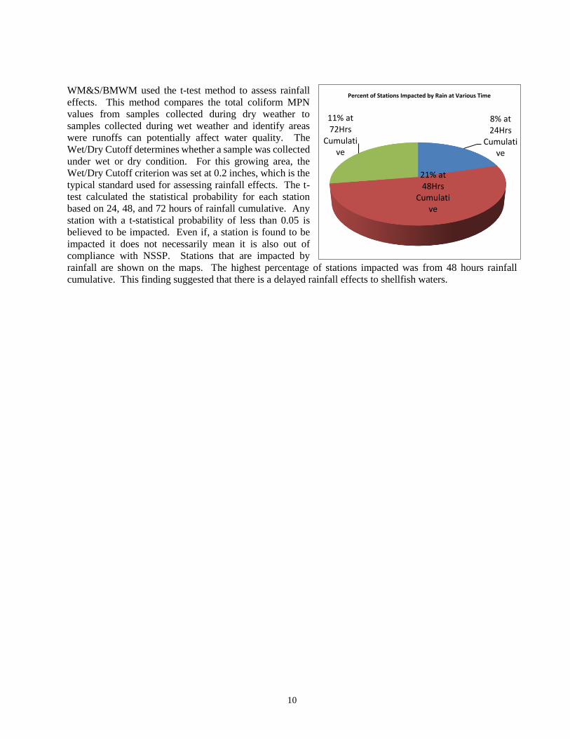
WM&S/BMWM used the t-test method to assess rainfall
effects. This method compares the total coliform MPN
values from samples collected during dry weather to
samples collected during wet weather and identify areas
were runoffs can potentially affect water quality. The
Wet/Dry Cutoff determines whether a sample was collected
under wet or dry condition. For this growing area, the
Wet/Dry Cutoff criterion was set at 0.2 inches, which is the
typical standard used for assessing rainfall effects. The t-
test calculated the statistical probability for each station
based on 24, 48, and 72 hours of rainfall cumulative. Any
station with a t-statistical probability of less than 0.05 is
believed to be impacted. Even if, a station is found to be
impacted it does not necessarily mean it is also out of
compliance with NSSP. Stations that are impacted by
rainfall are shown on the maps. The highest percentage of stations impacted was from 48 hours rainfall
cumulative. This finding suggested that there is a delayed rainfall effects to shellfish waters.
8% at 24Hrs
Cumulative
21% at 48Hrs
Cumulative
11% at 72Hrs
Cumulative
Percent of Stations Impacted by Rain at Various Time

11
Location of the Stations Impacted by Rainfall at Various Time Stage
Seasonal Effects

12
To determine seasonal effects, WM&S/BMWM uses
the t-test to compare the total coliform MPN values
from samples collected during the summer season
(May thru October) versus samples collected during
the winter months (November thru April). Any station
with a t-probability of less than 0.05 is believed to be
impacted by seasonal components.
Seasonal statistics show 54 sampling stations
impacted by seasonal components. Majority of these
stations were influenced by the summer season. Most
of these stations are located in the Great Egg Harbor
Bay area. Only one station was influenced by winter
components. This station was situated in Lakes Bay.
Summer and winter geometric means are relatively
similar throughout the bay, with the exception of Great
Egg Harbor River, Beach Thorofare, and Great
Thorofare. The geometric mean in the Great Egg
Harbor River is slightly higher during the summer than winter. Areas like Beach Thorofare and Great
Thorofare are marginally higher throughout the year (see maps below).

13
RELATED STUDIES
Nutrients
WM&S/BMWM perform additional water quality
studies related to the bacteriological monitoring
program. Nutrient monitoring and the collection of
nutrient data as part of the NJ Coastal Monitoring
Network is an example of one of those programs.
There are about thirty-seven nutrient monitoring
sites within this shellfish growing area. At these
nutrient monitoring sites, various parameters were
measured including water temperature, salinity
levels, secchi depth, total suspended solids,
dissolved oxygen levels, ammonia levels, nitrate
and nitrite levels, orthophosphate levels, total
nitrogen levels, and the inorganic nitrogen to
phosphorus ratios. The WM&S/BMWM compiles
the results of nutrient levels and then prepares a
separate report. For full nutrient assessment, see the
Estuarine Monitoring Reports, available
electronically at: http://www.state.nj.us/dep/bmw/
Cooperative Coastal Monitoring Program
NJDEP, along with the New Jersey Department of
Health and Senior Services and local health agencies,
implements the Cooperative Coastal Monitoring
Program (CCMP) which is responsible for
conducting sanitary surveys of beaches and monitors
the concentration of bacteria in coastal and estuarine
waters that are open to the public for recreational
bathing. Local health agencies and law enforcement
may close a beach at any time if the results exceeded
the State Sanitary Code of 104 Enterococci per
100mL. WM&S/BMWM utilizes these data as
adjunct information. The closure of shellfish waters
do not correspond to these results.
There are several CCMP monitoring stations located
within this shellfish growing area. For more
information regarding this program, bathing beach
data, and closures, see
http://www.nj.gov/dep/beaches/monitoring_results.htm

14
National Coastal Assessment
Since 1990, USEPA National Coastal Assessment (NCA) and its partners began sampling in the coastal and
estuarine water of the United States. Data collected include water column parameters, sediment chemistry &
toxicity, benthic communities, and tissue contaminants. Since there were no FDA criteria for assessing
sediment contaminants, trace metals and organic compounds can be evaluated using an effects-based method
developed by Long et al. (1995), which estimates the percent incidence at which adverse biological effects
occur to aquatic organisms at specific contaminant concentrations. For each chemical, Effects Range Low
(ERL) and Effects Range Medium (ERM) are used that correspond to the likelihood of adverse effects. When
concentrations are less than the ERL, adverse effects are rare, when they fall between the ERL and ERM,
adverse effects are occasional, and when they are greater than the ERM, adverse effects are frequent. The
criteria for assessing sediment contaminants by site are shown in the table below.
Criteria for Assessing Sediment Contaminants by Site
(Source: USEPA, National Coastal Condition Report)
Rating Criteria
Good No ERM concentrations are exceeded, and less than five ERL concentrations are exceeded.
Fair No ERM concentrations are exceeded, and five or more ERL concentrations are exceeded.
Poor An ERM concentration is exceeded for one or more contaminants.
The most recent NCA data for this area were collected in 2004. Based on these data, no parameters were found
to exceed the ERM value. The sediment qualities for this area were ranked as “Good” or “Fair” depending on
the location. For additional NCA data or program information, visit http://www.epa.gov/emap/nca/index.html

15
Environmental Monitoring for Public Access & Community Tracking (EMPACT)
EMPACT is a project designed to provide the public
with access to current information on the condition of
their coastal waters. It is intended to enhance the
connection between the public and their bays and
coastal waters, to ultimately provide a better
understanding of this valuable resource. One of the
three components in this project includes the
determination of toxic pollutant levels in shellfish
tissue. Tissue samples were collected throughout this
area. However, shellfish resources were only found
at Station ESF 3, ESF 18, ESF 27, and ESF 28. See
toxic monitoring sites map for the location. The
chemical data collected from these sites were
compared with available FDA criteria. None of the
parameters tested exceeded applicable FDA criteria.
For additional information regarding this project,
visit
http://www.state.nj.us/dep/wms//bmw/EMPACT.htm
CONCLUSIONS
Majority of the sampling stations within this area do meet the NSSP criteria, with the exception of one APC
station located in Shelter Island Bay area, which had failed to meet the ten percent cutoff criteria. Even though
this station exceeded the approved criteria, no downgrade of waters is recommended. The coliform levels have
always been considerably low in this area. Occasionally, there will be one or two spiked samples with results
above standard level. Due to the fact that this is an APC station, it only takes two samples above standard to
exceed the ten percent cutoff criteria. Inspection of the area indicated there was no point source of pollution.
The higher than normal bacteria level was likely due to wildlife activity and runoffs.
Seasonal and rainfall assessment shows many stations impacted by seasonal component and rainfall. Stations
with seasonal components show higher total coliform geometric mean during the summer season, which
implies that bacteria count were influenced by summer related and wildlife activities. Stormwater runoffs still
poses problems for some areas including Lakes Bay, Beach Thorofare, Risley Channel, and Scull Bay. These
areas responded immediate to rainfall, possibly due to its close proximity to city center and the numerous
stormwater outfalls that line the shore.
Chemical contaminants recovered from tissue samples were compared with applicable FDA criteria; and none
of the parameters were found to exceed their respective criteria. Sediment samples were assessed using the
sediment contaminant ranking method. Depending on the sediment location, they were ranked as either
“Good” or “Fair”. Sediment quality was found to be better in areas where shellfish waters were classified as
Approved or Seasonally Approved.
RECOMMENDATIONS
Continue sampling under the same sampling protocol. No downgrades or upgrades of shellfish waters
recommended at this time.

16
LITERATURE CITED
APHA. 1970. Recommended Procedures for the
Examination of Seawater and Shellfish, 4th ed.,
American Public Health Association, Washington, DC
APHA. 1995. Standard Methods for the Examination
of Water and Wastewater, 19th ed., American Public
Health Association, Washington, DC
Connell, Robert C. 1991. Evaluation of Adverse
Pollution Conditions in New Jersey's Coastal Waters.
New Jersey Department of Environmental Protection,
Marine Water Classification and Analysis, Leeds
Point, NJ
Ingmanson, Dale E., and William J. Wallace. 1989.
Oceanography: An Introduction. Wadsworth
Publishing Company, Belmont, California.
NJDEP. 2005. Field Sampling Procedures Manual.
New Jersey Department of Environmental Protection,
Trenton, NJ
NJDEP. 2002 & 2003. Annual Summary of
Phytoplankton Blooms and Related Conditions in New
Jersey Coastal Waters. New Jersey Department of
Environmental Protection, Freshwater and Biological
Monitoring, Trenton, NJ
NJDEP. 2008-2012. Annual Review of Shellfish
Department of Environmental Protection, Bureau of
Marine Water Monitoring, Leeds Point, NJ
NJDEP. 2012. State of New Jersey Shellfish Growing
Water Classification Charts. New Jersey Department
of Environmental Protection, Marine Water
Monitoring, Leeds Point, NJ
USPHS. 2009 Revision. National Shellfish Sanitation
Program Guide for the Control of Molluscan Shellfish.
US Public Health Service, Food and Drug
Administration, Washington, DC
NJDEP. 2008-2012. Water Sampling Assignments.
New Jersey Department of Environmental Protection,
Trenton, NJ.
USPHS. Guide for the Control of Molluscan
Shellfish, 1997.
U.S. Census Bureau. www.census.gov/
USGS. www.usgs.gov/
Landuse/Land Cover, 1995/1997/2007.
http://www.nj.gov/dep
NJDEP Record Access Program.
http://www.nj.gov/dep/opra/
National Coastal Assessment.
http://www.epa.gov/emap/nca/index.html
Interstate Environmental Commission.
http://www.iec-nynjct.org/
Interstate Shellfish Sanitation Conference.
http://www.issc.org/
US EPA Toxic Release Inventory Program.
http://www.epa.gov/tri/
New Jersey Clean Marina Program.
http://www.njcleanmarina.org/
Office of the New Jersey State Climatologist at
Rutgers University.
http://climate.rutgers.edu/stateclim/

16
Supporting Documentation
Data Sheets - Reappraisal Report for Shellfish Growing Area SE3 (Lakes Bay-Peck Bay), see the Shellfish
Growing Area Reports section at www.state.nj.us/dep/wms/bmw.
Shoreline survey field notes and pictures - Reappraisal Report for Shellfish Growing Area SE3 (Lakes Bay-
Peck Bay), see the Shellfish Growing Area Reports section at www.state.nj.us/dep/wms/bmw.