Embed Size (px)
Citation preview
Historic Plymouth Area: 2015 Emergency Public Information Calendar
An Emergency Plan For Your Protection - For Neighbors of Entergy’s Pilgrim Nuclear Power StationRead and keep this IMPORTANT Calendar

Table Of ContentsTear-out card Family Emergency Planning Guide
A Message To Neighbors Of The Pilgrim Nuclear Power Station .... 1
Emergency Classification ................................................................ 1
Are You In The Emergency Planning Zone? ................................... 2
How You Will Be Notified Of An Emergency .................................... 2
Emergency Alert System (EAS) ....................................................... 3
What To Do When Told To Shelter-In-Place ..................................... 3
Plans For Children In School Or Day Care ...................................... 4
List of Host Facilities ....................................................................... 4
What To Do When Told To Evacuate .............................................. 6
Evacuation Route And Reception Center Map ................................ 7
Reception Centers ........................................................................... 8
Emergency Bus Routes.................................................................. 11
Direction to Reception Centers ........................................................ 8
Plans for Individuals Requiring Additional Assistance .................... 15
Information About Radiation ........................................................... 16
Pilgrim Nuclear Power Station ....................................................... 16
Questions and Answers.................................................................. 17
Other Important Information ........................................................... 18
Accidental Siren Sounding ............................................................. 19
Plan in Advance to Evacuate Your Pets ........................................ 19
Personal Planning Guide................................................................ 20
Access and Functional Needs Card .................................back cover
For Help During A Pilgrim EmergencyRemember, in a public emergency, do not use your telephone except to request help if you need it. For information, listen to your local Emergency Alert System radio station. It is important to leave tele-phone lines open to allow emergency workers to assist people who need immediate help.
For information during a Pilgrim emergency call 211; For immediate help during a Pilgrim emergency:
Plymouth 911TTY 911Kingston (781) 585-7649TTY 911Duxbury (781) 934-7120TTY 911Carver (508) 866-5329TTY 911Marshfield (781) 837-7119TTY 911
Massachusetts Emergency Management AgencyRegion II Emergency Operations Center (508) 427-0400
Massachusetts Public Information 211
For emergency planning information in advance, contact:Plymouth (508) 833-5801TTY (508) 833-5846Kingston (781) 585-3135TTY (781) 585-1337Duxbury (781) 934-7159TTY (781) 934-2387Carver (508) 866-5219TTY (508) 866-4079Marshfield (781) 837-7100TTY (781) 837-0666
Cover Photo: Main Street in Plymouth, looking north from the Governor Bradford Building (1890). Street railway car “Pilgrim” in foregroundCourtesy of Plymouth Public Library Archives

2015 Calendar

One of Gurnet “Life Savers” sits on top of ice that is piled up on Duxbury Beach (1914).Courtesy of Duxbury Free Library Archives

JANUARYSUNDAY MONDAY TUESDAY WEDNESDAY THURSDAY FRIDAY SATURDAY
FEBRUARYS M T W T F S1 2 3 4 5 6 78 9 10 11 12 13 1415 16 17 18 19 20 2122 23 24 25 26 27 28
DECEMBER 2014S M T W T F S 1 2 3 4 5 67 8 9 10 11 12 1314 15 16 17 18 19 2021 22 23 24 25 26 2728 29 30 31
Emergency Alert System (EAS) Radio Stations
1030 AM 98.5 FM95.9 FM99.1 FM1390 AM2
015
Full MoonWolf Moon
Have you reviewed this year’s emergency planning information calendar?
(pages 1-20)
Did you fill out and return your Access and Functional needs card?
New Year's Day
Martin Luther King's Day
Last Quarter
First Quarter
1 2 3
4 5 6 7 8 9 10
11 12 13 14 15 16 17
18 19 20 21 22 23 24
25 26 27 28 29 30 31New Moon
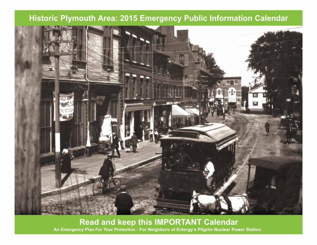
1890 Pool Room and Shooting Gallery in Marshfield.Courtesy of Harris Penniman

FEBRUARY
SUNDAY MONDAY TUESDAY WEDNESDAY THURSDAY FRIDAY SATURDAY
MARCHS M T W T F S1 2 3 4 5 6 78 9 10 11 12 13 1415 16 17 18 19 20 2122 23 24 25 26 27 2829 30 31
JANUARYS M T W T F S 1 2 34 5 6 7 8 9 1011 12 13 14 15 16 1718 19 20 21 22 23 24 25 26 27 28 29 30 312
015
Ground Hog Day
Emergency Alert System (EAS) Radio Stations
1030 AM 98.5 FM95.9 FM99.1 FM1390 AM
Full Moon Snow Moon
1 2 3 4 5 6 7
8 9 10 11 12 13 14
15 16 17 18 19 20 21
22 23 24 25 26 27 28
Do you have a family check-in plan in case of emergency? (tear out card)
Lincoln's BirthdayLast Quarter
President’s Day
First Quarter
Valentine's Day
Super Bowl
Ash WednesdayNew Moon

1904 Circus coming to Plymouth.Courtesy of Plymouth Public Library Archives

MARCHSUNDAY MONDAY TUESDAY WEDNESDAY THURSDAY FRIDAY SATURDAY
APRILS M T W T F S 1 2 3 45 6 7 8 9 10 1112 13 14 15 16 17 1819 20 21 22 23 24 2526 27 28 29 30
FEBRUARYS M T W T F S1 2 3 4 5 6 78 9 10 11 12 13 1415 16 17 18 19 20 2122 23 24 25 26 27 28
2015 Emergency Alert System
(EAS) Radio Stations1030 AM 98.5 FM95.9 FM99.1 FM1390 AM
Does your family have a meeting place in case of an emergency? (tear out card)
Evacuation Day St. Patrick’s Day
Daylight SavingTime Starts
First day of Spring
Full MoonWorm Moon
1 2 3 4 5 6 7
8 9 10 11 12 13 14
15 16 17 18 19 20 21
22 23 24 25 26 27 28
29 30 31
Last Quarter
New Moon
First Quarter
Palm Sunday

Before a 1904 game between the Carver team and a Sandwich team. Almost all members were foundry managers and workers.Courtesy of Carver Public Library

APRILSUNDAY MONDAY TUESDAY WEDNESDAY THURSDAY FRIDAY SATURDAY
MAYS M T W T F S 1 23 4 5 6 7 8 910 11 12 13 14 15 1617 18 19 20 21 22 2324/3125 26 27 28 29 302
015 Emergency Alert System
(EAS) Radio Stations1030 AM 98.5 FM95.9 FM99.1 FM1390 AM
Patriots' Day
MARCHS M T W T F S1 2 3 4 5 6 78 9 10 11 12 13 1415 16 17 18 19 20 2122 23 24 25 26 27 2829 30 31
My important papers are located at ______? (tear out card)
Arbor Day
Passover Begins
Last Quarter
New Moon
First Quarter
Full MoonPink Moon
Easter
1 2 3 4
5 6 7 8 9 10 11
12 13 14 15 16 17 18
19 20 21 22 23 24 25
26 27 28 29 30Earth Day
Tax Day
Good Friday

In Kingston, two uniformed trolley conductors or motormen sit posed inside of a trolley car, circa 1900. Advertisements for Sapolio shoe polish, Campbell's Soup, Eddy's Refrigerators, Reliant Hookon, and Mennen's Toilet Powder are visible above the windows. Courtesy of Kingston Public Library Local History Room

MAYSUNDAY MONDAY TUESDAY WEDNESDAY THURSDAY FRIDAY SATURDAY
JUNES M T W T F S 1 2 3 4 5 67 8 9 10 11 12 1314 15 16 17 18 19 2021 22 23 24 25 26 2728 29 30
APRILS M T W T F S 1 2 3 45 6 7 8 9 10 1112 13 14 15 16 17 1819 20 21 22 23 24 2526 27 28 29 30
Memorial Day
Emergency Alert System (EAS) Radio Stations
1030 AM 98.5 FM95.9 FM99.1 FM1390 AM
Do I need to prepare an emergency pet kit? (page 19)
2015
Last Quarter Mother's Day
New Moon
First Quarter
Full MoonFlower Moon
1 2
3 4 5 6 7 8 9
10 11 12 13 14 15 16
17 18 19 20 21 22 23
24/31 25 26 27 28 29 30

Lover’s Rock on Brant Rock Beach, Marshfield, circa 1900. Courtesy of Cynthia Krusell and Betty Bates

JUNESUNDAY MONDAY TUESDAY WEDNESDAY THURSDAY FRIDAY SATURDAY
JULYS M T W T F S 1 2 3 45 6 7 8 9 10 1112 13 14 15 16 17 1819 20 21 22 23 24 2526 27 28 29 30 31
MAYS M T W T F S 1 23 4 5 6 7 8 910 11 12 13 14 15 1617 18 19 20 21 22 2324/31 25 26 27 28 29 30
First day of Summer
Flag Day
Emergency Alert System (EAS) Radio Stations
1030 AM 98.5 FM95.9 FM99.1 FM1390 AM
Last Quarter
What are the Emergency Alert System radio stations? (page 3)
Bunker Hill Day
2015
1 2 3 4 5 6
7 8 9 10 11 12 13
14 15 16 17 18 19 20
21 22 23 24 25 26 27
28 29 30
New Moon
First Quarter
Full MoonStrawberry Moon
Ramadan Begins
Father's Day

Two Kingston boys fish from the rocky shore of the C. Drew & Company millpond, created by a dam across Stony Brook. The factory building and another smaller building are visible on the opposite shore, circa 1925. Courtesy of Kingston Public Library Local History Room

JULYSUNDAY MONDAY TUESDAY WEDNESDAY THURSDAY FRIDAY SATURDAY
AUGUSTS M T W T F S 12 3 4 5 6 7 89 10 11 12 13 14 1516 17 18 19 20 21 2223/3024/31 25 26 27 28 29
JUNES M T W T F S 1 2 3 4 5 67 8 9 10 11 12 1314 15 16 17 18 19 2021 22 23 24 25 26 2728 29 302
015 Emergency Alert System
(EAS) Radio Stations1030 AM 98.5 FM95.9 FM99.1 FM1390 AM
Last Quarter
Where is my Reception Center? (page 8)
1 2 3 4
5 6 7 8 9 10 11
12 13 14 15 16 17 18
19 20 21 22 23 24 25
26 27 28 29 30 31
New Moon
First Quarter
Full MoonBuck Moon
Full MoonBlue Moon
Eid-al-Fitr
Independence Day

President Harding visits Plymouth Rock for the August 1921 Plymouth Tercentenary.Courtesy of Plymouth Public Library Archives

AUGUSTSUNDAY MONDAY TUESDAY WEDNESDAY THURSDAY FRIDAY SATURDAY
SEPTEMBERS M T W T F S 1 2 3 4 56 7 8 9 10 11 1213 14 15 16 17 18 1920 21 22 23 24 25 2627 28 29 30
JULYS M T W T F S 1 2 3 45 6 7 8 9 10 1112 13 14 15 16 17 1819 20 21 22 23 24 2526 27 28 29 30 312
015 Emergency Alert System
(EAS) Radio Stations1030 AM 98.5 FM95.9 FM99.1 FM1390 AM
Last Quarter
What Sub-Area do you live or work in? (page 7)
1
2 3 4 5 6 7 8
9 10 11 12 13 14 15
16 17 18 19 20 21 22
23/30 24/31 25 26 27 28 29
New Moon
First Quarter
Full MoonSturgeon Moon

North Carver School building (date unknown).Courtesy of Carver Public Library

SEPTEMBERSUNDAY MONDAY TUESDAY WEDNESDAY THURSDAY FRIDAY SATURDAY
OCTOBERS M T W T F S 1 2 34 5 6 7 8 9 1011 12 13 14 15 16 1718 19 20 21 22 23
24
25 26 27 28 29 30 31
AUGUSTS M T W T F S 12 3 4 5 6 7 89 10 11 12 13 14 1516 17 18 19 20 21 2223/3024/31 25 26 27 28 29
Labor Day
2015 Emergency Alert System
(EAS) Radio Stations1030 AM 98.5 FM95.9 FM99.1 FM1390 AM
First day of Fall
Did you know that September is National Preparedness Month? Check out their website: www.ready.gov/
New Moon
1 2 3 4 5
6 7 8 9 10 11 12
13 14 15 16 17 18 19
20 21 22 23 24 25 26
27 28 29 30First Quarter
Full MoonHarvest Moon
Last Quarter
Rosh Hashanah begins
Yom Kippur begins Eid-al-Adha Begins
Sukkot Begins

A ceremony for the last train through Marshfield (6/24/39), with a funeral dirge being played by a bugler and a man acting as an undertaker.Courtesy of Cynthia Krusell and Betty Bates

OCTOBERSUNDAY MONDAY TUESDAY WEDNESDAY THURSDAY FRIDAY SATURDAY
NOVEMBERS M T W T F S1 2 3 4 5 6 78 9 10 11 12 13 1415 16 17 18 19 20 2122 23 24 25 26 27 2829 30
SEPTEMBERS M T W T F S 1 2 3 4 56 7 8 9 10 11 1213 14 15 16 17 18 1920 21 22 23 24 25 2627 28 29 30
Halloween
2015 Emergency Alert System
(EAS) Radio Stations1030 AM 98.5 FM95.9 FM99.1 FM1390 AM
What is my best evacuation route? (pages 8-10)
Columbus Day
New Moon
First Quarter
Full MoonHunter’s Moon
Last Quarter
1 2 3
4 5 6 7 8 9 10
11 12 13 14 15 16 17
18 19 20 21 22 23 24
25 26 27 28 29 30 31

Plymouth Water Department wagon in front of Pilgrim bookstore. Date unknown.Courtesy of Plymouth Public Library Archives

SUNDAY MONDAY WEDNESDAY THURSDAY FRIDAY SATURDAY
DECEMBER S M T W T F S 1 2 3 4 56 7 8 9 10 11 1213 14 15 16 17 18 1920 21 22 23 24 25 2627 28 29 30 31
OCTOBERS M T W T F S 1 2 34 5 6 7 8 9 1011 12 13 14 15 16 1718 19 20 21 22 23 2425 26 27 28 29 30 312
015 Emergency Alert System
(EAS) Radio Stations1030 AM 98.5 FM95.9 FM99.1 FM1390 AM
Election Day
Veterans’ Day
What should you do when the sirens sound? (page 2)
Daylight Saving Time Ends
NOVEMBERTUESDAY
1 2 3 4 5 6 7
8 9 10 11 12 13 14
15 16 17 18 19 20 21
22 23 24 25 26 27 28
29 30
New Moon
First Quarter
Full MoonBeaver Moon
Last Quarter
Thanksgiving Day

A motorman in a heavy fur coat, cap and gloves drives a Plymouth & Kingston trolley north towards the Kingston end of the line at Cobb’s Store. A passenger peers out the side window, circa 1895.Courtesy of the Jones River Village Historical Society and the Kingston Public Library Local History Room

DECEMBERSUNDAY TUESDAY WEDNESDAY THURSDAY FRIDAY SATURDAY
JANUARY 2015S M T W T F S 1 23 4 5 6 7 8 910 11 12 13 14 15 1617 18 19 20 21 22 2324/3125 26 27 28 29 30
NOVEMBERS M T W T F S1 2 3 4 5 6 78 9 10 11 12 13 1415 16 17 18 19 20 2122 23 24 25 26 27 2829 302
015 Emergency Alert System
(EAS) Radio Stations1030 AM 98.5 FM95.9 FM99.1 FM1390 AM
New Year’s Eve
First day of Winter
Look forward to receiving your 2016 Emergency Public Information
Calendar soon in the mail!
MONDAY
New Moon
First Quarter
Full MoonCold Moon
Last Quarter
Christmas
Kwanzaa
Pearl Harbor Remembrance DayChanukah begins
1 2 3 4 5
6 7 8 9 10 11 12
13 14 15 16 17 18 19
20 21 22 23 24 25 26
27 28 29 30 31

2015 Emergency Public Information

A Message to Neighbors of the Pilgrim Nuclear Power StationThe Commonwealth of Massachusetts has a policy on emergency planning:First, each and every human life is of equal and inestimable value;Second, during an emergency, the Commonwealth of Massachusetts will make every effort and exhaust every resource, public and private, to save lives, reduce injury and suffering, and protect people from exposure to harm;Third, during an emergency, protective action judgments will be made on the basis of human need. There is no such thing as an acceptable level of death, injury or suffering.
Emergency InformationThis important information is provided to you as a public service by the Massachusetts Emergency Management Agency, the Massa-chusetts Department of Public Health and the Pilgrim Nuclear Power Station.It tells you what to do in the unlikely event of an emergency at the Pil-grim Nuclear Power Station. Some of this information would also be useful in other emergencies requiring public notification and possible public response, such as train derailments, chemical spills, floods, hurricanes and tornadoes.You should read the information in this calendar carefully, well in advance of any potential emergency. Discuss it with your family, fill in your family’s information on the tear-out cards in the front and back of the calendar, and keep this calendar in a safe place for future reference.CDs containing the information in this calendar are available in local libraries for use by those with vision impairment.
As you read the public health and safety information in this calendar, record important information on the tear-out family emergency plan cards (front of calendar) and wallet cards (back of calendar) that will help keep you and your family safe in an emergency.
Emergency ClassificationIf an emergency is declared at the Pilgrim Nuclear Power Station, it would be categorized into one of four emergency levels.
Unusual Event: This means a minor problem has occurred at the plant. It may involve situations such as hazardous weather or a minor equipment problem. Public officials would be notified, but there would be no need to sound the warning signals. People in the area would not need to take any special actions.
Alert: This could affect plant safety but it is not expected to require any special actions by residents. Public officials would be noti-fied. They would watch the situation and be ready to act if it got worse. As a precaution, public officials may mobilize transportation resources. They may transfer school children to host facilities out-side the area and clear state forests and waterways. Emergency Alert System radio or news broadcasts would inform the public of these actions.
Site Area Emergency: This means a more serious problem affect-ing the plant and plant boundaries has occurred. Any release of radioactive materials would be below federal limits. State and local officials would keep persons in the area fully informed about any necessary actions through Emergency Alert System radio stations. As a precaution, state officials may move school children to host facilities outside the area if this had not already been done. Other precautions would be called for by state officials, as needed.
General Emergency: This is the most serious type of emergency. It could involve serious damage at the plant and a release of radioactive materials. State officials might direct persons in some areas to shelter-in-place or to evacuate to a safer location. Special instructions and other important information would be issued over the Emergency Alert System radio stations.
1
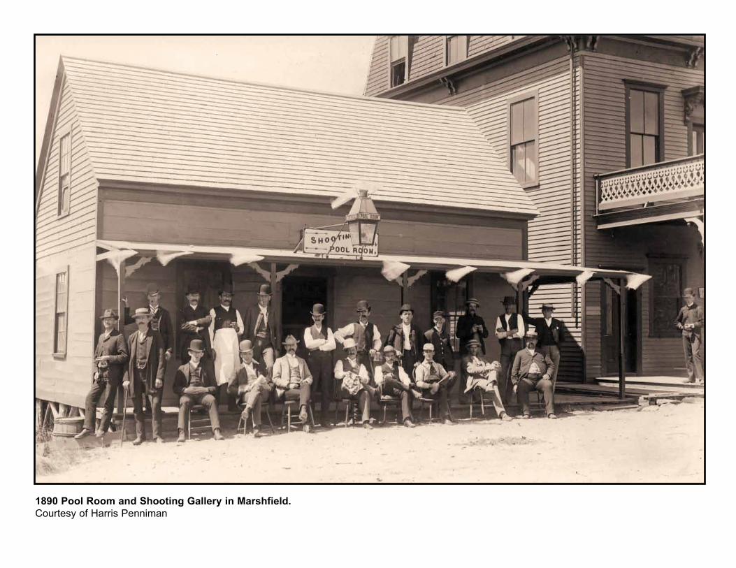
Are You In The Emergency Planning Zone?The area approximately 10 miles around the Pilgrim Nuclear Power Station is called the Emergency Planning Zone. Plans have been developed for warning and protecting people within the 10-mile area (refer to the map on page 7). Communities in the Emergency Planning Zone are: Plymouth, Kingston, Duxbury and portions of Carver and Marshfield. The Emergency Planning Zone is divided into sub-areas. Official emergency instructions will be given for specific sub-areas. It is important to know your sub-area and follow instructions for that specific area. The sub-areas are as follows:
Sub-area 1 - That portion of Plymouth within approximately 2 miles of the Pilgrim Station from Clifford Road east to White Horse Beach, and from Manomet Bluffs north to the Station
Sub-area 2 - That portion of Plymouth from Long Pond and Jordan Roads east to the coast, and from Ship Pond Road north to How-land Pond and Manomet Bluffs
Sub-area 3 - That portion of Plymouth from the eastern shores of Billington Sea, Great South Pond and Gunners Exchange Pond east to Plymouth Beach, and from the intersection of Alden and Long Pond Roads, and Jordan Road north to Samoset Street
Sub-area 4 - Duxbury Beach, Gurnet Point, Saquish Neck and Clark’s Island
Sub-area 5 - That portion of Plymouth south of Upper College Pond Road, Alden Road, Long Pond Road, and Ship Pond Road
Sub-area 6 - That portion of Plymouth from the Plymouth-Carver town line east to the eastern shores of Billington Sea. Great South Pond, and Gunners Exchange Pond, and from Upper College and Alden Roads north to Samoset Street and Carver Road
Sub-area 7 - That portion of Plymouth south of the Kingston - Plymouth Town line to Carver Road – Samoset Street
Sub-area 8 - The entire Town of Kingston
Sub-area 9 - The entire Town of Duxbury
Sub-area 10 - That portion of Marshfield south of Route 139/ Careswell Street - Dyke Road
Sub-area 11 - That portion of Carver east of Route 58
Sub-area 12 - That portion of Cape Cod Bay within 10 miles of the station
How You Will Be Notified Of An EmergencyIf there is an emergency requiring public notification, you will be alerted by one or more of the following warning signals:
• The loud, steady tone of the outdoor emergency sirens, lasting 3 to 5 minutes
• A voice message over beach loudspeakers• Broadcasts from loudspeakers on police and other official
vehicles• Announcements from town harbormasters or an Urgent Marine
Information Broadcast from the U.S. Coast Guard• Tone-alert Emergency Alert System radios• A message on Teletypewriters (TTYs) if you have registered
with a town Emergency Management Office to be notified over TTY in case of an emergency
• Word of mouth and social media• Massachusetts Alerts – a smart phone app• Wireless Emergency Alerts
If you hear any of these signals, turn to one of the Emergency Alert System radio stations immediately.
Check with your neighbors, especially the elderly or persons who have difficulty hearing or seeing, to make sure they have received the warning and know what to do.
2

Emergency Alert System (EAS)If you are alerted by the warning signal, you should tune to your local Emergency Alert System (EAS) station for emergency instruc-tions. EAS is the direct link between you and the people respon-sible for your safety. Instructions may be given to you at any hour, day or night, and will include recommendations as to what you should do for your protection. Follow instructions carefully. Do not worry if you miss the beginning of an emergency broadcast. Infor-mation will be provided regularly.
Local EAS StationsBoston 1030 AM
Boston 98.5 FM
Marshfield 95.9 FM
Plymouth 99.1 FM
Plymouth 1390 AM
In case of an emergency, always stay tuned to an Emergency Alert System station for your area.
What To Do When Told To Shelter-In-PlaceYou may be in a sub-area instructed to shelter-in-place. This means you should immediately go inside the nearest available building. If you are already inside, stay there. Sheltering-in-place may pro-vide the best protection. If a shelter-in-place message is given for your sub-area over the Emergency Alert System radio station, you should do the following:
• Go indoors and close all doors and windows.• Turn off all window fans, clothes dryers, kitchen and bath
exhaust fans, air conditioners, and other sources of outside air, unless told to do otherwise.
• Continue to monitor your EAS station for official messages and updated directions.
• Keep pets indoors.• If you have livestock, shelter them too. Give them stored feed
and water from a covered source.Below ground basements provide the best shelter. Avoid areas near windows; above ground, interior rooms on lower floors provide the best protection.
Stay inside until officials say otherwise. If you must go outside, cover your nose and mouth with a folded, damp cloth. Persons with respiratory disorders should not go out at all, until told to do so by government officials.
If you are traveling in a motor vehicle in the affected area, close the windows and air vents. Keep the radio tuned to an EAS station. If you are a local resident, go home immediately and stay inside. If you are a visitor, leave the area immediately, or go inside a nearby build-ing or a public shelter and monitor EAS for additional information.
Public shelter locations will be announced through Press briefings and Press releases.
If sheltering-in-place is recommended during school hours, children will be sheltered right in the school building and cared for by school personnel.
DO NOT use your telephone unless you need special assistance.
3
For current and accurate information, follow MEMA on social media sites. On your cell phones, Massachusetts Alerts and Wireless Emergency Alerts will provide timely and important information about emergencies and hazards in your area and how you should respond to ensure your safety. Important messages may be delivered using these methods.
For more information on these tools, visit www.Mass.Gov/MEMA.

Plans For Children In School Or Day CareSchoolsAll schools within the sub-areas shown on page 7 have emergency plans. Early in an emergency, school children will be moved to “host” facilities outside the area. Do not try to pick up children at their school or phone the school. The phone lines would be needed for emergency use. Instead, meet them at their host facilities.
Children who live inside the emergency planning zone but who go to a school outside the area will be held at their school until their parents/guardians pick them up.
If an emergency existed before the start of the school day, school would be canceled, as it is when there is danger of a winter storm.
Day Care CentersDay care centers within the emergency planning zone have emer-gency plans. Early in an emergency, day care centers will be closed. Parents/guardians will be notified of this by telephone, if possible, and asked to pick up their children. Any children not picked up will be taken to a host facility outside the emergency planning zone. Designated host facilities are listed beginning in the next column through page 5.
In a sudden, serious emergency, children may be taken directly to a reception center for monitoring and, if necessary, decontamina-tion. Then they would be taken to their assigned host facility where you should pick them up.
Parents/guardians should listen to their local Emergency Alert System radio station to confirm this information at the time of an emergency.
List of Host FacilitiesIf your children attend: Pick them up at:CARVER HOST FACILITIES
Captain Pal Preschool • Bridgewater Intermediate Cranberry Crossing Day Care (Williams) SchoolKidstop Day Care 200 South StreetLittle Crusaders Bridgewater, MA
Carver High School • Bridgewater/Raynham RegionalCarver Middle School High School 415 Center Street
Bridgewater, MA
Erwin K. Washburn Primary School • Bridgewater IntermediateGovernor John Carver Elementary (Williams) SchoolOld Colony Y 200 South Street Bridgewater, MA
DUXBURY HOST FACILITIES
Alden Elementary School* • Braintree High SchoolBay Farm Montessori Academy 128 Town StreetBerrybrook Preschool Braintree, MABlue River MontessoriChandler Elementary School* Duxbury High School Duxbury Middle School*Duxbury Bay Maritime SchoolElements Montessori Learn In Play PreschoolPied Piper PreschoolPilgrim Area CollaborativesPilgrim Day Child Care*Magic Dragon Children’s Center at Chandler Elementary School
* and all associated before and after school programs and clubs
4

List of Host Facilities (cont.)
If your children attend: Pick them up at:KINGSTON HOST FACILITIES
Kingston Elementary School • Bridgewater Middle SchoolKingston Intermediate School 166 Mt. Prospect Street Bridgewater, MASacred Heart Early Childhood Center • Bridgewater/Raynham RegionalSacred Heart Elementary School High SchoolSacred Heart High School 415 Center Street Silver Lake Regional Middle School Bridgewater, MASilver Lake Regional High School
Crayon College, Inc. • Bridgewater Middle School Growth Unlimited PreSchool 166 Mt. Prospect Street Little People’s Country Day Care Bridgewater, MA South Shore Early Education: Kingston Wooded Acres Child Care
MARSHFIELD HOST FACILITIES
Governor Edward Winslow School • Furnace Brook School Furnace Street, Marshfield, MA PLYMOUTH HOST FACILITIES
Plymouth Community • Taunton High School Intermediate School* 50 Williams StreetPlymouth South High School* Taunton, MA Plymouth South Middle School*
Indian Brook Elementary School* • Our Lady of Lourdes Elem. School 52 First Street, Taunton, MAFederal Furnace Elementary School* • James L. Mulcahey School 28 Clifford Street Taunton, MA
If your children attend: Pick them up at:PLYMOUTH HOST FACILITIES
Manomet Elementary School* • Bennett School 47 N. Walker Street Taunton, MA
Plymouth North High School* • Bristol-Plymouth RegionalPilgrim Academy* Technical SchoolRising Tide Public Charter School* 940 County Street New Testament Christian School Taunton, MA
Mt. Pleasant Elementary School* • Friedman Middle SchoolWest Elementary School* 500 Norton Avenue Taunton, MA
Nathaniel Morton School* • Martin Middle SchoolSouth Elementary School* 131 Caswell Street Taunton, MA
Cold Spring Elementary School* • Coyle and Cassidy High School Hamilton and Adams Streets Taunton, MA
Hedge Elementary School* • Elizabeth Pole School 215 Harris Street Taunton, MA
All Plymouth Daycares • Bridgewater Intermediate (Williams) School 200 South Street Bridgewater, MA
5
* and all associated before and after school programs and clubs

What To Do When Told To EvacuateIf an evacuation is necessary, public safety officials will tell you over the Emergency Alert System radio station what to do. DO NOT evac-uate unless directed to do so by public safety officials.
Take the following actions ONLY if persons in your sub-area are told to evacuate. The maps on pages 11 through 14 will help you find out which sub-area is yours.
• Take your pets with you.• Gather all persons in the house together.• DO NOT try to pick up children at their schools. They will be taken
to designated host facilities outside the area where you may pick them up later (see pages 4 and 5).
• Household members outside the area may be advised not to return during an evacuation. They will be directed to the reception center where they can join you.
• DO NOT call your local fire or police departments for information. Emergency workers will need their telephone lines for emergency use. You may call Mass 211 for more information. If you need spe-cial help, call the emergency number listed on the inside cover.
• The Commissioner of Public Health may recommend that evacu-ating individuals, who have elected to do so, ingest potassium iodide.
Stay tuned to your Emergency Alert System Radio Station.
What to Do as You Leave• Turn off lights and unnecessary appliances.• Close and lock windows and doors.• Check with neighbors to see if they need assistance. Offer to
share transportation, if you can.• If you need a ride, try to get one with neighbors.• If you cannot get a ride, find out what sub-area you are in using
the maps on pages 11 through 14. Buses will pick you up along bus routes and at pick-up points shown on those maps. If you cannot get to the bus routes or pick-up points, contact your local Emergency Management Office at the number listed on the inside cover. Emergency workers will arrange transportation for you.
• If you have livestock, shelter them. Leave them a three-day supply of stored feed and water that has been protected from possible contamination.
How to Travel• While traveling in the car, keep all windows and vents closed until
you have left the EPZ.• Keep the car radio tuned to an Emergency Alert System station.• Drive out of the area along one of the routes shown on the maps
on pages 7-10.
Here are Some Things You May Want to Take With YouJust take essential items you would need. You could be away from home for a few hours to a few days. These are suggestions that apply to any type of emergency evacuation:
• This calendar• Clothing for several days• Personal hygiene items (soap, toothbrush, toothpaste,
shampoo, etc.).• Prescription medicines, medical equipment and supplies,
important medical records, assistive aids and batteries• Special dietary foods• Baby supplies• Identification (driver’s license) and important papers• Checkbook, credit card, and cash• Blankets, pillows, and towels (if you plan to stay at a public mass
care shelter)
About Your PetsPlan how to take your pets with you. See page 19 for more informa-tion about how to evacuate your pets safely. Develop a Buddy Sys-tem with neighbors, friends and relatives to make sure someone is available to care for or evacuate your pets if you are unable to do so.
Only service animals will be allowed inside the reception centers and mass care shelters.
DO NOT LEAVE YOUR PETS BEHIND. ARRANGE FOR THEIR EVACUATION IN ADVANCE.
6

140
140
18
106106
24123
123
58
53
123
495
195
195
6
6
104
95
95
93128
106
90
9
3A
BOSTON
95
44
Scale in Miles
0 5 10 15
N
3A
6
3A
1
2
5
611
12
7
3
9
PLYMOUTH
139
3
2714
CAPE COD BAY
4
Your subarea,evacuation routeand reception center are the same color.
NOTE: Only thecolored-in portionsof the map are subarea.
KINGSTONRECEPTION
CENTERBridgewater State
University(Subareas 7, 8, 11)
RECEPTIONCENTER
Taunton High School(Subareas 1, 2, 3, 5, 6)
3
Subareas #1,2,3,5,6
Subareas #7,8,11
Reception Centers
Subareas #4,9,10
Subarea 12 Cape CodBay within 10 miles ofPilgrim Station
LEGEND
Pilgrim NuclearPower Station
PILGRIMSTATION
24
18
8
44
CARVER
25
58
495
27
14
Clark'sIsland
RECEPTION CENTERBraintree High School
(Subareas 4,9,10)
10
139
MARSHFIELD
DUXBURY
337
128
Evacuation Route And Reception Center MapTo evacuate, follow the routes shown on the map for your sub-area. The use of these suggested main roads will expedite the movement of evacuating traffic away from Pilgrim Station. They are the quickest, safest, main routes to use in an emergency. All locations outside the colored-in sub-areas shown on the map are far enough away from Pilgrim Sta-tion that evacuation is not need-ed. You should evacuate ONLY if you are in a sub-area whose resi-dents and visitors have been told to evacuate by announcements on your Emergency Alert System radio stations.
7

Reception CentersReception centers are available to assist evacuees. The reception center for your sub-area is outside the 10-mile Emergency Plan-ning Zone.
At the center, you will be registered and moni-tored for contamination. Emergency workers will decontaminate and care for anyone need-ing this type of assistance. You will be able to receive information about the location of other members of your family who have already registered at the reception center. If you need a place to stay, you will be directed to a mass care shelter that provides meals and lodging. The reception center and mass care shelters are handicap accessible. If you have addi-tional needs, officials will assist you.
If you can, you may want to stay with friends or relatives until the emergency is over.
Directions To Reception CentersTo Taunton High School Reception Center From Sub-areas 1,2,3,5,6(or if you have elementary or above school children in Plymouth)
24
24
495
6
140
TauntonHigh School
Will
iam
s St
.Owen Riverw
ay
8
49
CARVER
DUXBURY
PILGRIMSTATION
Clark'sIsland
N
495
25
3A
3
1
2
5
611
7
3
6
PLYMOUTH
KINGSTON
RECEPTION CENTERTaunton High School
6
Scale in Miles
0 5 10 15 10 MARSHFIELD
140 140
24
495
4951
2
5
611
8
4
3
9
CARVER
PLYMOUTH
DUXBURY
24
PILGRIMSTATION
N
140
TauntonHigh School
Will
iam
s St
.Owen Riverway
KINGSTON
58
RECEPTION CENTERTaunton High School
Scale in Miles
0 5 10 15
Clark'sIsland
10 MARSHFIELD
44
44
7
Sub-areas #1, 2, 3 or 5 – all in Plymouth:Take Route 3 or 3A south to Route 6 (Cran-berry Highway) west, to Route 25 west/495 North. Follow Route 25 west/495 north to Route 24 south. Follow Route 24 south to Route 140 north. Go north on Route 140 to Williams Street. Turn right on Williams Street. Follow Williams Street to the Owen Riverway. Turn left and follow the Owen Riverway to the Taunton High School Reception Center.
Sub-area #6 – Plymouth:Take Rte. 3 north to Exit 7 onto Route 44 west to Route 24 South to Route 140 north. Follow Route 140 north to Williams Street. Turn right onto Williams Street and follow to Owen Riverway. Turn left and follow Owen Riverway to the Taunton High School Reception Center.
Or, take Route 44 west to Route 58 South to Route 495 north. Follow Route 495 north to Route 24 south. Follow Route 24 south to Route 140 north. Go north on Route 140 to Williams Street. Turn right on Williams Street. Follow Williams Street to the Owen Riverway. Turn left and follow the Owen Riverway to the Taunton High School Reception Center.
8

18
18
106
5827
2
5
6
4
3
9
PLYMOUTH
DUXBURY
PILGRIMSTATION
N
27
27
106 KINGSTON
104 8
17
14
RECEPTION CENTERBridgewater State University
11
CARVER
58
10418
Whitman St.
East St.
Scale in Miles
0 5 10 15
Clark'sIsland
10 MARSHFIELD
BridgewaterStateUniversity
Great
Hill D
r.
Haywar
d St.
18
18
106
5827
495
25
2
5
611
8
4
7
3
9
CARVER
PLYMOUTH
DUXBURY
KINGSTON104
PILGRIMSTATION
N
27
1
14
27
104
Flagg St./Auburn Street
18
25
495
Scale in Miles
0 5 10 15
Lau
rel St.
Water St. Wo
od
St.
18
58
106 Clark'sIsland
10 MARSHFIELD
BridgewaterState University
Great Hill Dr.
RECEPTION CENTERBridgewater State University
Sub-area #8 – Kingston:Take Route 106 west to Route 104 west. Turn left and follow Route 104 west to Great Hill Drive. Turn left on Great Hill Drive and follow signs to the Bridgewater State University Reception Center. Or, take Brook Street to Elm Street West to Brook Street in Plympton. Follow Brook Street, bear right onto Colchester Road which becomes Mayflower Road. Follow Mayflower Road to Route 58 north to Route 106 west. Follow Route 106 west to Route 104 west to Great Hill Drive. Turn left on Great Hill Drive and follow signs to the Bridgewater State University Reception Center. Or, take Route 27 north to Route 14 west to Route 18 south. Follow Route 18 south to East Street in East Bridgewater. Turn left on East Street to Hayward Street to Whitman Street. Turn left on Whitman Street to Route 104 west. Turn right on Route 104 and follow signs to the Bridgewater State University Reception Center.
Sub-area #11 – Carver:Take Route 58 north to Route 106 west to Route 104 west. Follow Route 104 west to Great Hill Drive. Turn left on Great Hill Drive and follow signs to the Bridgewater State University Reception Center.
Or, take Route 58 south to Route 495 north to Exit 5 to Route 18 north. Continue on Route 18 north to Flagg Street. Turn right on Flagg Street and proceed across Summer Street where Flagg Street becomes Auburn Street. Proceed on Auburn Street to Laurel Street. Turn left on Laurel Street to Water Street. Turn right on Water Street to Wood Street. Turn left on Wood Street to Route 104 west. Then turn left on Wood Street to Route 104 West and follow signs to the Bridgewater State University Reception Center.
Sub-area #7 – Plymouth:Note: If you are in Sub-area 7 use the following directions. If you have daycare children in the town of Plymouth, use the following directions. However, use Sub-area 6 directions to the Taunton High School Reception Center if you have elementary or above school children.
Take Route 44 west to Route 58 north to Route 106 west. Turn left and follow Route 106 west to Route 104 west. Turn left and fol-low Route 104 west to Great Hill Drive. Turn left on Great Hill Drive and follow signs to the Bridgewater State University Reception Center.
Or, take Route 3 north to Route 53 north. Follow Route 53 north to Route 123 west to Route 18 South. Follow Route 18 south to East Street in East Bridgewater. Turn left on East Street to Hayward Street to Whitman Street. Turn left on Whitman Street to Route 104 west. Turn right on Route 104 and follow signs to the Bridgewater State University Reception Center.
To Bridgewater State University Reception Center From Sub-areas 7,8,11
18
18
18
106
123
3
123
3
106
104
1
2
5
611
4
3
9
CARVER
PLYMOUTH
PILGRIMSTATION
N
58
8
3 1
3
44
KINGSTON
58
44RECEPTION CENTER
Bridgewater State College
Scale in Miles
0 5 10 15
Clark'sIsland
3
DUXBURY
7
53
53
10 MARSHFIELD
10418
Whitman St.
East St.
BridgewaterState University
Great
Hill D
r.
Haywar
d St.
RECEPTION CENTERBridgewater State University
9

9
93
95
24
128
2
5
611
8
4
3
CARVER
PLYMOUTH
128
PILGRIMSTATION
N
KINGSTON
17
139
Scale in Miles
0 5 10 15
Clark'sIsland
MARSHFIELD
RECEPTION CENTERBraintree
318
139
58 DUXBURY
53
10
3A
BraintreeHigh School
18 3
128
93
37
37
9
9
93
95
24
128
6
87
3
PLYMOUTH
11
128
CARVER
PILGRIMSTATION
N
139
KINGSTON
1
4
2
5
58
Scale in Miles
0 5 10 15
Clark'sIsland
MARSHFIELD
18
9
3A
3
139
139 10
DUXBURY
RECEPTION CENTERBraintree
BraintreeHigh School
18 3
128
93
37
37
9
3A
123
1
2
5
611
8
4
7
3
CARVER
PLYMOUTH
PILGRIMSTATION
N
KINGSTON
Scale in Miles
0 5 10 15
Clark'sIsland
RECEPTION CENTERBraintree
139
1853
DUXBURY
3
3
9
95
128 93
3A
10 MARSHFIELD
BraintreeHigh School
18 3
128
93
37
37
123
Sub-area #9 – Duxbury:Take Route 3 north to Exit 20, Route I-93 south (128 north). Take I-93 south to Exit 6 (Route 37 Braintree), turn right on Route 37 past South Shore Plaza and proceed towards Braintree Five Corners. Bear right at Brain-tree Five Corners onto Granite Street, turn left onto Town Street at Granite Plaza to the Braintree Reception Center at Braintree High School.
To The Braintree Reception Center At The Braintree High School From Sub-areas 4,9,10
Sub-area #10 – Marshfield:Take Route 139 west to Route 3 north. Take Route 3 north to Exit 20, Route I-93 south (128 north). Take I-93 south to Exit 6 (Route 37 Braintree), turn right on Route 37 past South Shore Plaza and proceed towards Braintree Five Corners. Bear right at Brain-tree Five Corners onto Granite Street, turn left onto Town Street at Granite Plaza to the Braintree Reception Center at Braintree High School.
Sub-area #12 – Cape Cod BaySub-area 12 is that portion of Cape Cod Bay within 10 miles of the Pilgrim Nuclear Power Station (see map on page 7). Boaters in Sub-area 12 should follow instructions given by town harbormasters or the U.S. Coast Guard.
Sub-area #4 – Duxbury Beach, Saquish Neck, Gurnet Point, Clark’s Island:Take Route 3A north to Route 123 west to Route 53 south. Turn left on Route 53 south to Route 3 north. Turn right onto Route 3 north to Exit 20, Route I-93 south (128 north). Take I-93 south to Exit 6 (Route 37 Braintree), turn right on Route 37 past south Shore Plaza and proceed towards Braintree Five Corners. Bear right at Braintree Five Corners onto Granite Street. Turn left onto Town Street at Granite Plaza to the Brain-tree Reception Center at Braintree High School.
10
3
3A Cape CodBay
HowlandPond
Strand Ave.
Ship Pond Rd.
Bea
verd
am R
d.
Clark R
d.
Rock R
d.
Old
San
dw
ich R
d.
Russell Mills
Rd.
Jord
an R
d.
Lo
ng
Po
nd
Rd
.
Lo
ng
Po
nd
Rd
.
Manomet Bluffs
SUBAREA #3
SUBAREA #1
SUBAREA #5
SUBAREA #2
N
Fre
sh P
on
d
Beaverdam
Pond
LongIslandPond
GreatIslandPond Shallow
Pond
HowlandPond
3A
Man
om
et
Blu
ffs
3A
State Road
White
Hors
e Rd.
Taylor Ave.
PILGRIM STATION
White Horse Beach
Strand Ave.
SUBAREA #2
SUB-AREA #3
SUBAREA #1
N
Man
omet
Poin
t Rd.Bartlett Pond
Cliffo
rd Road
Beaverdam Rd.
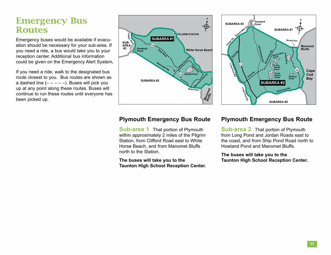
Plymouth Emergency Bus RouteSub-area 2 That portion of Plymouth from Long Pond and Jordan Roads east to the coast, and from Ship Pond Road north to Howland Pond and Manomet Bluffs.
The buses will take you to the Taunton High School Reception Center.
Plymouth Emergency Bus RouteSub-area 1 That portion of Plymouth within approximately 2 miles of the Pilgrim Station, from Clifford Road east to White Horse Beach, and from Manomet Bluffs north to the Station.
The buses will take you to the Taunton High School Reception Center.
Emergency Bus Routes Emergency buses would be available if evacu-ation should be necessary for your sub-area. If you need a ride, a bus would take you to your reception center. Additional bus information could be given on the Emergency Alert System.
If you need a ride, walk to the designated bus route closest to you. Bus routes are shown as a dashed line (– – – – –). Buses will pick you up at any point along these routes. Buses will continue to run these routes until everyone has been picked up.
11

Alden
Rd.
SUBAREA #11
SUBAREA #6
SUBAREA #3
SUBAREA #2
Upper Colle
ge Pond R
d.
Long Pond R
d.Hav
en R
d.
Independence St.
Long Pond R
d.
Herring Pond Rd.
HalfwayPond Rd.
Bo
urn
e R
d.
Plymouth - Wareham Town Line
Plymouth - Bourne Town Line
Old Sandwich
Rd.
Ship Pond Rd.Barnfield Dr.
Jess
e Br
ook
Rd.
3A
3
CapeCod Bay
SUBAREA #5
N
Plymouth - C
arver T
ow
n L
ine
3
3A
SUBAREA #3
PlymouthBay
Warren Cove
SUBAREA #7
SUBAREA #6
SUBAREA #1
SUBAREA #2
Plymouth
Beach
Route 44
Warren Ave.
Court St.Sandwich St.
Summer St.
Oat St.Alvin, Benhan
& Marjorie Rds.
Sandwich St.
Old Sandwich
Rd.
Obery St.
Long Pond R
d.
Cliffo
rd R
d.
Russell Mills
Rd.
Jord
an R
d.
Lo
ng
Po
nd
Rd
.
BillingtonSea
Great SouthPond
BootPond
HoytPond
Gunners ExchangePond
N
Little SouthPond
Gun
ners
Exch
ange
Rd.
Alden Rd.
Powder Point
BridgePick-upPoint
DuxburyBeach
Cape Cod Bay
Clark's Island
SaquishNeck
SUBAREA #9
DuxburyBay
SUBAREA #4
N
GurnetPoint
Plymouth Emergency Bus RouteSub-area 5 That portion of Plymouth south of Upper College Pond Road, Alden Road, Long Pond Road, and Ship Pond Road.
The buses will take you to the Taunton High School Reception Center.
Duxbury / Plymouth Emergency Pick-Up PointSub-area 4 Duxbury Beach, Gurnet Point, Saquish Neck and Clark's Island.
If you need a ride from Saquish Neck, Dux-bury Beach or Gurnet Point, transportation assistance will be provided at the Powder Point Bridge pick-up point. The Duxbury har-bormaster will assist those with transportation needs on Clark’s Island.
Buses will take you to the Braintree Reception Center at Braintree High School.
Plymouth Emergency Bus RouteSub-area 3 That portion of Plymouth from the eastern shores of Billington Sea, Great South Pond and Gunners Exchange Pond east to Plymouth Beach, and from the intersection of Alden and Long Pond Roads, and Jordan Road north to Samoset Street.
The buses will take you to the Taunton High School Reception Center.
12

N
SUBAREA #9
SUBAREA #7
SUBAREA #11
SUBAREA #8
Kingsto
n - Plym
outh To
wn Lin
e
Parting Ways Rd.
Wapping Rd.
West S
t.
Indi
an P
ond
Rd.
South
St.
Elm St.
Brook St.
Route 80
Route 44
Smiths Ln.
Page Ave. Leigh
Curtis
Cedar Lane
How
lands Ln.
Winthrop St.
Sum
mer
St.
Lake
St. Pembroke St.. Winter St.
Brookdale St.
Kingston - Duxbury Town Line
Kin
gst
on
- P
lym
pto
n T
ow
n L
ine
KingstonBay
3
3A
27
106
80
80
3A
106
Elm St.
Kin
gsto
n -
Carver
Tow
n L
ine
St.
Rd.
N
SUBAREA #8
SUBAREA #6
SUBAREA #11
SUBAREA #7
PlymouthBay
33A
SUBAREA #3
Pick-uppoint
RadissonPick-uppoint
Plym
outh -
Kingst
on Town L
ine
CordagePlazaPick-uppoint
Court St.
Water S
t.
Route 44 East
Route 44 West
Plympton Rd.Route 80
Charlotte D
r.
Kris
tinR
d.Princeton
Est
a R
d.Dartmouth Rd.
RobbinsRd.
Carver Rd
Samoset Street
Che
rry St.
Esta La.
SUBAREA #11
SUBAREA #6
SUBAREA #7
SUBAREA #3
SUBAREA #5
N
Micajah P
ond Rd.
Palmer Rd.
Deerh
ill Ln.
Guild Rd.
Black Cat Rd.
Billington Sea
Samoset St.
Plym
ou
th - C
arver Tow
n L
ine
BootPond
Myles StandishState Forest
SUB-AREA
#2
Fede
ral F
urna
ce R
d.South Meadow Rd. P
ond Rd.
Veronica Rd.
Stevens
Dr.
Coach Terr.
Carver Rd.
BayberryLane
Pineh
urst
Dr.
Montgomery Dr.
Jan
M
arie Dr.
Seven Hill Rd.
Carver
Rd.
Summer
GreatSouthPond
Gunners ExchangePond
HoytPond
Alden Rd.
Plymouth
Airport
Francis Rd.
LittleSouthPond
Upper Colle
ge Pond Rd.
Kingston Emergency Bus RouteSub-area 8 The entire Town of Kingston.The buses will take you to the Bridgewa-ter State University Reception Center.
Plymouth Emergency Bus Route and Pick-Up PointsSub-area 7 That portion of Plymouth south of the Kingston - Plymouth Town line to Carver Road – Samoset Street.
Three pick-up points have been established for northern Plymouth and the waterfront area in Sub-area 7 at the following locations:
• Cordage Park Plaza on Route 3A;
• Court Street at Robbins Rd.;
• Radisson Hotel Plymouth Harbor (formerly Sheraton Plymouth) parking lot on Water Street.
The buses will take you to the Bridgewater State University Reception Center.
Plymouth Emergency Bus RouteSub-area 6 That portion of Plymouth from the Plymouth-Carver Town line east to the eastern shores of Billington Sea, Great South Pond, and Gunners Exchange Pond, and from Upper College Pond and Alden Roads north to Samoset Street and Carver Road.
The buses will take you to the Taunton High School Reception Center.
13

SUBAREA #8
SUBAREA #7
SUBAREA #6
SUBAREA #5
Carver - Plympton Town Line
High St.
Gat
e St
.
Plymouth St.
Wenham
Rd.
Route 44
Plymouth St. Silva St.
Route 58 Cen
ter S
t.
War
d St.
South MeadowVillageR
oute 58
Carver - P
lymo
uth
Tow
n L
ine
Trem
ont R
d.
Mayflower Rd.
Cranberry Rd.Pipers Way
PresidentsWay
Car
ver
- M
idd
leb
oro
ug
h T
ow
n L
ine
KennedyDr.David Rd.
William Dr.
Michelle Dr.Carol St.
War
eham
St.
CranberryVillage
PinetreeVillage
SUBAREA #11
N
South Meadow Rd.
SUBAREA #9
GreenHarbor
Marshfield - Duxbury Town LinePrince Circle
Careswell St.
Canal St.
Dyk
e R
d.
Ocean St.
Central St.
Isla
nd
St.
Oce
an S
t.
SUBAREA #10
139
139
N
Jose
ph
D
rieb
eek
Way
SUBAREA #8
SUBAREA #10
DuxburyBay
Duxbury - Marshfield Tow
n Line
North St.
Keene
St.
Uni
on S
t. Fran
klin St.
Congress St.
King Phillips
Linc
oln
St.
Bir
ch S
t.
Lake
shor
e D
r.
Pine St. Winter St.
Elm St.
Union B
ridge Rd.
Chandler St.
Mayflower St.
St. George St.
Bay Ave. Tremont St.
Chestnut
Parks St.
Loring Rd.
Standish S
t.
SUBAREA #9
Was
hing
ton
St.
Depot S
t.
Powder Point Bridge Pick-up Point
Gurnet R
d.
3A
3
3
N
53 Summ
er St.
14
14
139
Duxbury
- P
embr
oke
Tow
n Li
ne
Duxbury - Kingston Tow
n L
ine
Path
Tobey Garden
Crescent St.
King Caesar Rd.
Powder Point Ave.
Carver Emergency Bus RouteSub-area 11 That portion of Carver east of Route 58.
The buses will take you to the Bridgewater State University Reception Center.
Marshfield Emergency Bus RouteSub-area 10 That portion of Marshfield south of Route 139/Careswell Street - Dyke Road.
Buses will take you to the Braintree Reception Center at Braintree High School.
Duxbury Emergency Bus Route and Pick-Up PointSub-area 9 The entire Town of Duxbury.One pick-up point also has been established in the Town of Duxbury on the west or main-land-side of the Powder Point Bridge.
Buses will take you to the Braintree Reception Center at Braintree High School.
14

Plans for Individuals Requiring Additional Assistance
Health Care FacilitiesHospital patients and residents of nursing homes who are physi-cally able to be moved will be taken to other health care facilities outside the area if evacuation is necessary.
If time allows, families of patients well enough to be discharged on a short-term basis will be contacted by health care administrators before an evacuation occurs.
If patients in health care facilities are evacuated to host facilities, information on their locations will be available through your local Emergency Management Office at the emergency telephone num-bers listed on the inside cover.
People with Access and Functional NeedsLet your local Emergency Management Director know in advance if you need any assistance during an emergency. Assistance can be made available to you.
Your Emergency Management Office is prepared to help you if you require additional assistance during a public emergency. If you or someone in your household would need notification or assistance with emergency sheltering-in-place, evacuating, or staying in a mass care shelter, please let your Emergency Management Office know immediately. Assistance is available, but is best planned before an emergency happens.
Please fill out the Access and Functional Needs Card at the back of this calendar. A new card should be sent in every year.
If you know someone who is Blind or might have difficulty reading this calendar, please read it to them. Emergency information is also available on a CD for persons who are Blind or visually impaired at your local library.
If you are Deaf or hard of hearing and would need to be notified on a TTY (teletypewriter) of a public emergency, please notify your local Emergency Management Office. You may use the Access and Functional needs card at the back of this booklet. ALL INFORMATION WILL BE KEPT STRICTLY CONFIDENTIAL.
If you have children who might be home alone, make sure they understand the information in this calendar and know what to do in an emergency. It is especially important that they know how to tune to their Emergency Alert System station.
People at the BeachesIn an emergency, beaches would be closed. People at the beaches should leave the area and go back to their lodgings or homes and listen to the Emergency Alert System stations. Public shelter loca-tions will be announced through Press briefings and Press releases.
Boaters on Cape Cod BayBoaters on Cape Cod Bay should follow instructions given by town harbormasters or the U.S. Coast Guard.
15
Information ResourcesMassachusetts Emergency Management Agencywww.mass.gov/mema
Massachusetts Department of Public Healthwww.state.ma.us/dph/rcp
Entergy Nuclearwww.entergynuclear.com
Federal Emergency Management Agencywww.FEMA.gov
Nuclear Regulatory Commissionwww.NRC.gov
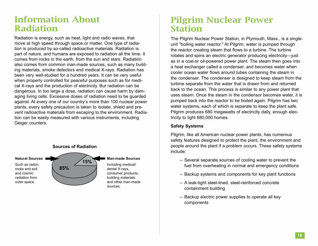
Information About RadiationRadiation is energy, such as heat, light and radio waves, that move at high speed through space or matter. One type of radia-tion is produced by so-called radioactive materials. Radiation is part of nature, and humans are exposed to radiation all the time. It comes from rocks in the earth, from the sun and stars. Radiation also comes from common man-made sources, such as many build-ing materials, smoke detectors and medical X-rays. Radiation has been very well-studied for a hundred years. It can be very useful when properly controlled for peaceful purposes such as for medi-cal X-rays and the production of electricity. But radiation can be dangerous. In too large a dose, radiation can cause harm by dam-aging living cells. Excessive doses of radiation need to be guarded against. At every one of our country’s more than 100 nuclear power plants, every safety precaution is taken to isolate, shield and pre-vent radioactive materials from escaping to the environment. Radia-tion can be easily measured with various instruments, including Geiger counters.
Pilgrim Nuclear Power StationThe Pilgrim Nuclear Power Station, in Plymouth, Mass., is a single-unit "boiling water reactor." At Pilgrim, water is pumped through the reactor creating steam that flows to a turbine. The turbine rotates and spins an electric generator producing electricity—just as in a coal-or oil-powered power plant. The steam then goes into a heat exchanger called a condenser, and becomes water when cooler ocean water flows around tubes containing the steam in the condenser. The condenser is designed to keep steam from the turbine separate from the water that is drawn from and returned back to the ocean. This process is similar to any power plant that uses steam. Once the steam in the condensor becomes water, it is pumped back into the reactor to be boiled again. Pilgrim has two water systems, each of which is separate to keep the plant safe. Pilgrim produces 680 megawatts of electricity daily, enough elec-tricity to light 680,000 homes.
Safety Systems
Pilgrim, like all American nuclear power plants, has numerous safety features designed to protect the plant, the environment and people around the plant if a problem occurs. These safety systems include:
-- Several separate sources of cooling water to prevent the fuel from overheating in normal and emergency conditions
-- Backup systems and components for key plant functions
-- A leak-tight steel-lined, steel-reinforced concrete containment building
-- Backup electric power supplies to operate all key components
16
Sources of Radiation
Natural Sources
Such as radon,rocks and soil.and cosmic radiation fromouter space.
Man-made Sources
Including medical/dental X-rays,consumer products,building materials.and other man-madesources.
85%15%

Questions and AnswersHelpful Answers to Some of Your Questions...
Q. Why is Pilgrim’s Emergency Planning Zone an area 10 miles around the plant?
A. The federal government selected 10 miles because it is the distance beyond which any radiation exposure would be so small as to not warrant any type of protective actions for the public. Most credible accidents would not require protective actions beyond five miles or less.
Q. Would radioactivity released from Pilgrim travel outward in all directions?
A. No. Radiation would move in a relatively narrow "plume" with a size and shape determined by wind and other weather conditions.
Q. Would everyone within 10 miles of Pilgrim have to evacuate if there was a serious emergency?
A. No. Only people in the direction of the narrow radiation plume – those in potentially affected sub-areas of the Emergency Planning Zone--would have to take actions as directed. In fact, to keep roads clear, only people in areas specifically mentioned in Emergency Alert System broadcasts should evacuate in an emergency.
Q. Can Pilgrim explode like a nuclear bomb?
A. No. It is a matter of scientific certainty because of the laws of physics that the plant cannot explode like a nuclear bomb. The uranium in a power plant's fuel is intentionally different from that used in nuclear weapons, making explosions impossible.
Q. How can I be sure that Pilgrim is secure and well-protected?
A. Pilgrim is defended by armed guards, sophisticated detection equipment and other advanced protection systems that meet or exceed federal, state and local requirements.
17
Q. How is Pilgrim Station prepared for an emergency?
A. Pilgrim Station’s Emergency Response Organization is made up of nuclear professionals able to respond immediately in the unlikely event of a plant emergency. Pilgrim Station conducts drills and exercises with local, state and federal agencies ensuring emergency preparedness.
Q. What type of security is Pilgrim Station required to have?
A. Federal law and regulations require strict security measures at all United States nuclear power plants. They include:
- Multiple barriers to stop entry into areas that contain essential equipment which protect areas within and around the plant
- A fixed physical protection system that permits entry of authorized personnel, vehicles and materials into these areas and ensures detection of and response to unauthorized entry
- A trained and qualified security force to protect the plant and control access to it
- Controls that ensure personnel who enter the plant unescorted meet strict background checks
- A fitness-for-duty program that requires random drug and alcohol tests for all persons allowed unescorted access into the plant
Q. What special security actions are in place now at Pilgrim Station?
A. Pilgrim Station security continues in a high state of security awareness following the terrorist attack of September 11, 2001. Additional security measures taken include:
- Pilgrim Station security officials are in contact with local, state and federal law enforcement officials
- Barriers are placed on access roads to detour incoming traffic through security checkpoints
- Background security checks have been enhanced

Other Important InformationPotassium Iodide (KI) and the PublicThe Massachusetts Department of Public Health and the Massachu-setts Emergency Management Agency want you to know about potas-sium iodide (KI). The Nuclear Regulatory Commission has made KI available to states for distribution within the 10-mile emergency plan-ning zones of commercial nuclear power stations.
What is potassium iodide (KI)?Potassium iodide is a drug that can protect the thyroid gland from radiation injury caused by radioactive iodine. The drug is approved for use by the U.S. Food and Drug Administration and is available over-the-counter.
How does it work?KI saturates the thyroid gland with stable (non-radioactive) iodine, to limit the amount of radioactive iodine that could be absorbed by the thyroid. During a radiological emergency, radioactive iodine could be released to the environment. Iodine concentrates in the thyroid gland. Breathing air or eating food contaminated with radioactive iodine can injure the thyroid and increase the risk of thyroid cancer.
Potassium iodide is only effective against exposure to radioactive iodine and only protects the thyroid gland. KI does not protect against other types of radioactivity that might be released during a nuclear emergency. Evacuation and sheltering-in-place are the primary means of protection. The use of KI is in addition to these protective measures, however, no one should delay following the EAS instructions if you can not find or do not have KI.
When should I take KI?KI should be taken shortly before or shortly after exposure to radio-active iodine to be most effective. Even if taken three to four hours after exposure, it would still reduce the amount of radioactive iodine absorbed by the thyroid and have a substantial effect. The protective effects of KI last approximately 24 hours. Emergency broadcasts over Emergency Alert System radio stations will tell people if the Massachu-setts Department of Public Health advises them to take KI.
How much KI should I take or give to my children? The presently available KI pills are 65-milligram scored tablets. In December 2001, the U.S. Food and Drug Administration published guidance on KI recommending the following dosages:
Adults 130 mg
Children aged 3 to 18 years 65 mg
Young Children (one month to 3 years) 32 mg
Infants (birth through one month) 16 mg
These are the minimum effective doses; the MDPH supports the use of one 130 mg. tablet for children above 3 years of age dur-ing an emergency. This is in agreement with US FDA guidelines. If you are considering using KI in an emergency, you should discuss whether taking KI is right for you with your health care provider.
How can I get potassium iodide?It is prudent to have potassium iodide prior to an emergency. Persons living within the 10-mile emergency planning zone may obtain potassium iodide free-of-charge from their local Board of Health or ask your local pharmacy.
For members of the EPZ population instructed to evacuate and who have not obtained KI, distribution points will be set up at pre-identified KI Dispensing Sites outside the EPZ. Here is a list of those sites:
CantonPark ‘n Ride at Rte. 138, north of Route 1
Bridgewater Rest Areas off Rt. 24 N/S at exit 15
18

Emergency Plan TestingTo make sure that the emergency plan works well, it is tested regularly. This testing is called an exercise. Emergency workers and public officials simulate a serious problem and go through the emergency actions in the plan.
Siren TestingSirens are tested periodically. The date and time of the annual 3 to 5 minute test is announced in advance in local newspapers and on the radio. Other audible siren tests may occur throughout the year, each lasting several seconds.
Accidental Siren Sounding
Occasionally, a siren or sirens may sound accidentally. If you hear a siren, tune immediately to your Emergency Alert System station for information (see page 3 for list). EAS messages would only be used in the event of an actual emergency. If the sirens were sounded unintentionally, you would be notified via a regular news broadcast.
If you do not hear a message, you can report the sounding to your local police or fire department (listed below). These are non-emergency numbers with representatives who will be able to tell you if there is an emergency associated with Pilgrim Station.
Plymouth 508-830-4212 Carver 508-866-2000 Kingston 781-585-0522 Marshfield 781-837-1315 Duxbury 781-934-1553 Please do not use 911 to report an accidental siren activation.
For information for farmers and food processors, contact:Massachusetts Department of Public HealthRadiation Control ProgramSchrafft Center, Suite 1M2A529 Main Street Charlestown. MA 02129Phone: 617-242-3035 www.mass.gov/dph/rcp
Mass care shelters do not accept animals other than service animals. Plan in advance what you will do with your pets should you have to evacuate. Make a list of places that would accept your pets outside the affected area, such as friends, relatives, pet friendly hotels/motels, boarding kennels, veterinary facilities.
• Prepare an emergency kit for your pets to include:
• Food: Keep at least three days of food in an airtight, waterproof container.
• Water: Store at least three days of water specifically for your pets.
• Medicines and medical records: Keep an extra week’s supply of medicines your pet takes in a waterproof container.
• First aid kit: Talk to your veterinarian about what is most appro-priate for your pet’s emergency medical needs. Most kits should include cotton bandage rolls, bandage tape and scissors; antibi-otic ointment; flea/tick prevention; latex gloves, saline solution.
• Collar with ID tag, harness or leash: Make sure the identification tag includes information on where you will be staying.
• Important documents: Include copies of your pet’s registration information, adoption papers, vaccination documents and medi-cal records.
• Crate or other pet carrier.• Sanitation: Include pet litter and litter box if appropriate, news-
papers, paper towels, plastic trash bags.• A picture of you and your pet together: If you become separated
from your pet during an emergency, a picture of you and your pet together will help you document ownership and allow others to assist you in identifying your pet.
• Familiar items: Put favorite toys, treats or bedding in your kit. Familiar items can help reduce stress for your pet.
For additional information, visit the Massachusetts Emergency Management Agency (MEMA) website at www.mass.gov/mema
19
PLAN IN ADVANCE TOEVACUATE YOUR PETS
Remember: WHEN YOU GO, THEY GO. If you are told to evacuate, take your pets with you. DO NOT LEAVE YOUR PETS BEHIND.

Personal Planning GuideFill in these blanks now and go over this information with your family. Decide who would pick up school-age children at the host facility and where to meet if you were apart in an emergency. Be sure children know what to do if they are alone and the sirens sound. Talk to your neighbors so you can help each other if necessary.
It is a good idea to keep some things handy in case of an emergency: portable radio, flashlight and extra batteries. Keep your car in good running order and don’t let the gas tank get too low.
This will save time and avoid confusion in an emergency.My best evacuation route is: _____________________________
____________________________________________________
____________________________________________________
____________________________________________________
My reception center is located at: _________________________
My school-age children will be taken to: ____________________
____________________________________________________
____________________________________________________
Prescription medicines I will need: ________________________
____________________________________________________
____________________________________________________
Important papers I will need: _____________________________
____________________________________________________
20
My local Emergency Management Office non-emergency number during regular business hours is: _________________________
My local Emergency Management Office emergency number is:
____________________________________________________
My local Fire/Police non-emergency number is: ______________
____________________________________________________
Pet-friendly hotels/motels:_______________________________ ____________________________________________________
Boarding facilities outside of my area: _____________________
____________________________________________________
Other things to remember: ______________________________
____________________________________________________
____________________________________________________
____________________________________________________
____________________________________________________
____________________________________________________
____________________________________________________

21
Notes: _____________________________________________________
____________________________________________________________
____________________________________________________________
____________________________________________________________
____________________________________________________________
____________________________________________________________
____________________________________________________________
____________________________________________________________
____________________________________________________________
____________________________________________________________
____________________________________________________________
____________________________________________________________
____________________________________________________________
22

Notes: _____________________________________________________
____________________________________________________________
____________________________________________________________
____________________________________________________________
____________________________________________________________
____________________________________________________________
____________________________________________________________
____________________________________________________________
____________________________________________________________
____________________________________________________________
____________________________________________________________
____________________________________________________________
____________________________________________________________
22

For People with D
isabilities or other Access and Functional N
eeds
Provisions have been m
ade to provide emergency assistance for all persons w
ith access and functional needs. It is im
portant that you make any need for assistance know
n beforehand. For exam
ple, a person who uses a w
heelchair and requires wheelchair accessible transportation,
or a person who has hearing loss and requires em
ergency notification messages to be pro-
vided on TTY (teletypewriter). C
ontact your local Em
ergency Managem
ent Director, or use the
confidential card on the back cover of this calendar. Em
ergency information is also available on
CD
at your local library for persons who are B
ind or visually impaired.
NO POSTAGENECESSARY
IF MAILEDIN THE
UNITED STATES
POSTAGE WILL BE PAID BY ADDRESSEE
BUSINESS REPLY MAILFIRST CLASS MAIL PERMIT NO 25 BRIDGEWATER MA
I live in the town of
TEAR
ALO
NG
THE LIN
E
FOLD HERE
MASSACHUSETTS EMERGENCY MANAGEMENT AGENCYREGION II HEADQUARTERS P.O. BOX 54BRIDGEWATER, MA 02324-9902

Massachusetts Em
ergency Managem
ent Agency
Region II H
eadquartersP.O
. Box 54
Bridgew
ater, MA 02324-0054
Access and Functional Needs Card
Would You Need Assistance in an Emergency?If you have any access or functional needs that may need assistance in an emergency, please fill out and return this card as soon as possible. If someone you know in the region would need assistance in an emergency, urge him or her to compete and return this card. THIS INFORMATION WILL BE KEPT CONFIDENTIAL BY STATE AND LOCAL AUTHORITIES.Please note: Even if you sent in a card in the past, new card should be sent in EACH YEAR.
Please tear along dotted line, seal closed with address facing out, and mail. No postage is necessary, Do not staple.
INSIDE: Important Information for
You and Your Family
TEAR
ALO
NG
THE LIN
E
ACCESS AND FUNCTIONAL NEEDS CARDThis Information Will Be Kept Confidential- For State and Local Official Use OnlyDo you require assistance in an emergency?It is important that you make any access and functional needs known before hand. If you have a need that may cause you to require additional assistance in an emergency, please fill out and return this card as soon as possible. Also, if you know someone in your area that may require additional assistance in an emergency, please urge them to complete and return this card. Even if you sent in an Access and Functional Needs Card in the past, a new card should be sent in each year.
Yes, I/this person will need assistance in an emergency:Name: ______________________________________________________Address/City/Zip: ______________________________________________Phone (Home): ______________________ Cell: ______________________E-Mail _______________________________________________________Relative/person we can notify to assist you in an emergency:Name: ______________________________________________________Address/City/Zip: ______________________________________________Phone (Home): _______________Cell: ___________ Work: _____________
Below, please mark an “X” in EACH box that applies to your need: Communication Medical Supervision Maintaining Independence Transportation
I use an aid or device (i.e. for mobility, communication etc.)
I receive Personal Assistance Services
Assistance Needed: Transportation Service Animal Species ___________
Wheelchair accessible transportation Weight of animal _____________
An ambulance
Bus transportation
Individualized Notification TTY or Video Phone (circle one) Number ____________________________
Evacuation assistance out of my home
Sheltering- in- place assistance
Other: __________________________________________________________
PRESORTEDFIRST-CLASS M
AILU.S. POSTAGE PA
IDJACKSON
, MS
PERMIT N
O. 134
PRESORTEDFIRST-CLASS M
AILU.S. POSTAGE PA
IDHEDERM
ANDIRECT
PRST STDAUTOCR
U.S. POSTAGE PA
IDHEDERM
ANDIRECT
PRST STDAUTOCR
U.S. POSTAGE PA
IDJACKSON
, MS
PERMIT N
O. 134
PRST STDAUTO
U.S. POSTAGE PA
IDHEDERM
ANDIRECT
PRST STDAUTO
U.S. POSTAGE PA
IDJACKSON
, MS
PERMIT N
O. 134
NON
PROFITORGAN
IZATIONU.S. POSTAGE PA
IDJACKSON
, MS
PERMIT N
O. 134
NON
PROFITORGAN
IZATIONU.S. POSTAGE PA
IDHEDERM
ANDIRECT
PRESORTEDSTAN
DARDU.S. POSTAGE PA
IDHEDERM
ANDIRECT
PRESORTEDSTAN
DARDU.S. POSTAGE PA
IDJACKSON
, MS
PERMIT N
O. 134
PRST STDECRW
SSU.S. POSTAGE PA
IDJACKSON
, MS
PERMIT N
O. 134
PRST STDECRW
SSU.S. POSTAGE PA
IDHEDERM
ANDIRECT