Embed Size (px)
Citation preview
______________________________________________________________________ Michigan Operations The Dow Chemical Company Midland, MI 48674 December 20, 2006 George W. Bruchmann, Chief Waste and Hazardous Materials Division State of Michigan Department of Environmental Quality Constitution Hall 525 West Allegan Street Lansing, MI 48909-7741 RE: Reach O Plan and Pilot Corrective Action Plan Enclosed with this letter please find enclosed the Reach O Plan and Pilot Corrective Action Plan, prepared by ATS, along with a cover letter prepared by ATS. Dow is committed to working collaboratively and cooperatively with MDEQ to further define, design and implement a detailed plan, once approved, for the removal of the Reach O in-channel high concentration material as quickly and as is safely possible, as described in the attached timeline included in plan. Dow is also committed to working cooperatively and collaboratively with MDEQ to further develop the plan to address the other high concentration locations in the other reaches of the upper Tittabawassee River as outlined in the Pilot Corrective Action Plan in an expeditious manner as outlined in the Pilot Corrective Action Plan. I will be out of the office for the remainder of the year. Please contact Ben Baker if you have any questions. Sincerely,
on behalf of Greg Cochran Greg Cochran Director Michigan Dioxin Initiative The Dow Chemical Company 1790 Building Midland, MI 48674 cc: Jim Sygo Cheryl Howe Ben Baker Phil Simon Enclosures

TM
ANN ARBOR TECHNICAL SERVICES, INC.
DE20L001.doc
Consultants in Chemistry & Environmental Science 290 South Wagner Road, Ann Arbor, Michigan 48103 Tel 734/995-0995 Fax 734/995-3731
December 20, 2006 Mr. Allan Taylor Michigan Department of Environmental Quality Waste and Hazardous Materials Division Constitution Hall 525 W. Allegan St. Lansing, MI 48933 RE: Pilot Corrective Actions - Upper Tittabawassee River, Michigan Dear Mr. Taylor: Recent findings from the on-going Upper Tittabawassee River (UTR) site characterization have revealed elevated concentrations of chlorinated furans and dioxins in eroding levees and in-channel deposits within certain reaches of the 6.5 mile UTR study area. These newly available data have been reviewed in recent days by MDEQ staff and Dow consultants, and there is consensus that these areas warrant proceeding as expeditiously as possible to develop and implement a corrective action plan to address them. Attached please find two technical memoranda, which result from our collaborative efforts with MDEQ over the past two weeks. Reach O 322+50 In-Channel Deposit Memo Recently available site characterization data have revealed elevated concentrations of chlorinated furans and dioxins (4,000 to 87,000 ppt TEQ) within a buried in-channel deposit in Reach O, from 322+50 to 327+50. The attached Reach O memo addresses the information we presently have regarding this deposit, and the plans we have made to address it on a priority basis. Pilot Corrective Actions Plan Memo This memorandum outlines the objectives, approach and schedule for developing focused Pilot Corrective Action Plans (PCAP) to address the Reach O in-channel deposit, plus additional areas of concern identified during the 2006 site characterization in Reaches D, J, K, L, M, N and O.

Mr. Allan Taylor December 20, 2006 Page 2
DE20L001.doc
TM
As with the activities we have undertaken in 2006, we look forward to working with you and the MDEQ to develop and implement these Pilot Corrective Action Plans on a priority basis, as soon as possible in 2007. Sincerely,
ANN ARBOR TECHNICAL SERVICES, INC. Peter M. Simon Project Manager Philip B. Simon President/Project Director PBS/ Attachments: (1) PCAP Memo (December 18, 2006) (2) Reach O Memo (December 19, 2006)

TM
ANN ARBOR TECHNICAL SERVICES, INC.
PCAP_Memo ©2006 Ann Arbor Technical Services, Inc.
Consultants in Chemistry & Environmental Science 290 South Wagner Road, Ann Arbor, Michigan 48103 Tel 734/995-0995 Fax 734/995-3731
MEMORANDUM To: Mr. Allan Taylor, MDEQ Waste and Hazardous Materials Division From: Philip B. Simon, ATS Peter M. Simon, ATS James F. Braithwaite, Vector Resolutions, LLC Date: December 18, 2006 RE: Background for Pilot Corrective Actions – Upper Tittabawassee River, Michigan Recent findings from the on-going Upper Tittabawassee River (UTR) site characterization have revealed elevated concentrations of chlorinated furans and dioxins in eroding levees and in-channel deposits within certain reaches of the 6.5 mile UTR study area. These newly available data have been reviewed in recent days by MDEQ staff and Dow consultants, and there is consensus that these areas warrant proceeding as expeditiously as possible to develop and implement a corrective action plan to address them. This memorandum outlines the objectives, approach and schedule for a focused Pilot Corrective Action Plan (PCAP) to address these areas, as developed in collaborative working sessions on December 14-15, 2006. PCAP Objectives
The PCAP will provide a comprehensive evaluation and presentation of each identified area of concern, including contaminant concentration in both bank and in-channel deposits, and shear stress at these locations under a variety of storm conditions. The plan will address areas in a rational, sequential approach, designed to achieve the greatest benefit with the least risk of exacerbating existing conditions. It will provide a path forward based on sound science and engineering that avoids doing additional environmental harm, minimizes net environmental resource damages, and where possible improves ecological habitat.
The PCAP will form the conceptual basis and provide the necessary supporting documentation to apply for necessary state and federal permits. The PCAP will include work to support the following objectives and deliverables for each area of concern:
• Develop detailed river bottom profile, including stability rationale, geologic and
bathymetric cross-sections, and streamline/shear stress modeling under a broad range of flow conditions;

PCAP Memorandum December 18, 2006 Page 2 of 3
TM
• Identify recent data, including erosion scar data, from eroding banks with elevated levels of furans and dioxins using sheer stress analysis and field mapping of erosion scars;
• Include mapping that identifies priority areas; • Identify pilot corrective action alternatives for removal and/or stabilization at each
location of concern; • Provide numerical modeling of the selected approaches, presenting anticipated
streamlines, velocities, shear stresses, and particle transport pathways under a variety of flow conditions;
• Identify recommended methods for removal and/or stabilization of soils and sediments, including an assessment of the strengths and weaknesses of the recommended corrective action method along with other reasonable alternative methods;
• Propose strategies that sequence tasks to achieve schedule compression and the greatest net environmental benefit during construction (e.g. initial work in Reach O to remove contaminated cut banks will prepare the area for removal of in-channel deposits, plus widen the channel cross-section and draw the Thalweg to the southwest, both of which stabilize the in-channel deposits until they can be removed.).
The PCAP will integrate elements of interim measures with components of a final
remedy master plan for each area of concern. Implementing the anticipated pilot corrective actions will:
• Address in-channel deposits with higher contaminant concentrations to prevent
re-introduction into the aquatic environment; • Address eroding levee deposits with elevated contaminant concentrations to
prevent re-introduction into the aquatic environment; • Support an on-going professional evaluation of the technologies chosen for these
pilot studies, including their efficacy in a given setting and their net environmental impact on biota;
• Provide a basis to adapt these technologies to improve their effectiveness when used in subsequent phases of remediation of the Tittabawassee River and Upper Saginaw River;
• Eliminate, to the maximum possible extent, unforeseen outcomes from the application of remediation tools that do not take river morphology into account.
Pilot corrective actions developed in the UTR PCAP may have value for reaches in the
middle and lower Tittabawassee River, which are scheduled for site characterization in 2007 and 2008.

PCAP Memorandum December 18, 2006 Page 3 of 3
TM
UTR PCAP Focus Areas Areas with the UTR identified to date for focused Pilot Corrective Actions have been
grouped into Operable Units (OU) based on river morphology, and factors relevant to remediation. They are as follows:
• OU-1: Reach D (RD-55+00, in-channel within sheet piling; owned by Dow) • OU-2: Reaches J & K (RJ-192+00 through RK-232+00, banks/over-banks;
northeast side owned by Dow, southwest side not owned by Dow) • OU-3: Reach L (RL-232+00 through RL-261+00, banks and in-channel; not
owned by Dow) • OU-4: Reaches M through O (RM-261+00 though RO-333+00, banks and in-
channel; some owned by Dow, some owned by others) The location of these OUs is shown on the UTR Reach print in Attachment 1.
Sampling of the last phase of the UTR site characterization, the Consumers Energy property, has just been completed. Analytical results are just becoming available for the more than 150 locations sampled on that property, and these results will issue throughout December 2006 and into early 2007. If additional areas of concern are identified as these results become available, the PCAP will be amended as required to address these areas. Schedule
The PCAP will be prepared and implemented as soon as possible, and as soon as the weather permits for each phase of activity. Given the “flashy” nature of the Tittabawassee River, worker safety will be paramount in scheduling work on the river itself. The plan will include a path forward to maximize those work opportunities early in the process that require the least amount of time for permit issuance (e.g., maximize work above ordinary high water mark in the initial stages).
The plan will anticipate the use of multiple construction and QA/QC crews addressing
different priority areas concurrently, in order to optimize the field/construction weather windows and similar time constraints (e.g., fish spawning, other ecological sensitivities, etc.). Attachment 2 provides a rough schedule for the UTR PCAP, including necessary steps and estimated time frame.

TM
ATTACHMENT 1 ___
UTR Reach and OU Locations

AB
E
F
G
L
M
N
C
D
H
I
J
K
O
¹0 3,0001,500 Feet
Figure 2Reach Overview
Tittabawassee River ProjectJune 1, 2006

TM
ATTACHMENT 2 ___
UTR PCAP Schedule
Reach O Memo ©2006 Ann Arbor Technical Services, Inc.
TM
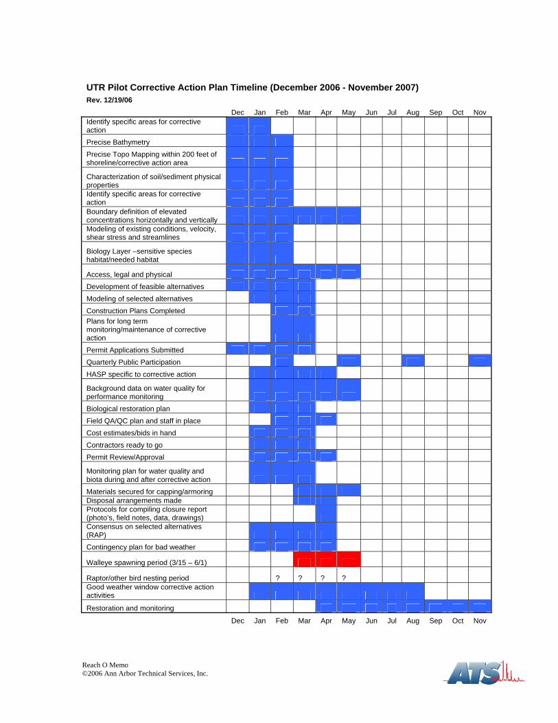
UTR Pilot Corrective Action Plan Timeline (December 2006 - November 2007) Rev. 12/19/06
Dec Jan Feb Mar Apr May Jun Jul Aug Sep Oct Nov Identify specific areas for corrective action Precise Bathymetry Precise Topo Mapping within 200 feet of shoreline/corrective action area
Characterization of soil/sediment physical properties Identify specific areas for corrective action Boundary definition of elevated concentrations horizontally and vertically Modeling of existing conditions, velocity, shear stress and streamlines
Biology Layer –sensitive species habitat/needed habitat
Access, legal and physical Development of feasible alternatives Modeling of selected alternatives Construction Plans Completed Plans for long term monitoring/maintenance of corrective action Permit Applications Submitted Quarterly Public Participation HASP specific to corrective action
Background data on water quality for performance monitoring Biological restoration plan Field QA/QC plan and staff in place Cost estimates/bids in hand Contractors ready to go Permit Review/Approval
Monitoring plan for water quality and biota during and after corrective action
Materials secured for capping/armoring Disposal arrangements made Protocols for compiling closure report (photo’s, field notes, data, drawings) Consensus on selected alternatives (RAP) Contingency plan for bad weather
Walleye spawning period (3/15 – 6/1)
Raptor/other bird nesting period ? ? ? ? Good weather window corrective action activities
Restoration and monitoring
Dec Jan Feb Mar Apr May Jun Jul Aug Sep Oct Nov

TM
ANN ARBOR TECHNICAL SERVICES, INC.
Reach O Memo ©2006 Ann Arbor Technical Services, Inc.
Consultants in Chemistry & Environmental Science 290 South Wagner Road, Ann Arbor, Michigan 48103 Tel 734/995-0995 Fax 734/995-3731
MEMORANDUM
To: Mr. Allan Taylor, MDEQ Waste and Hazardous Materials Division From: Philip B. Simon, ATS Peter M. Simon, ATS Date: December 19, 2006 RE: Reach O 322+50 In-Channel Deposit – Upper Tittabawassee River, Michigan Recent findings from the on-going Upper Tittabawassee River (UTR) site characterization have revealed elevated concentrations of chlorinated furans and dioxins (4,000 to 87,000 ppt TEQ) within a buried in-channel deposit in Reach O, from 322+50 to 327+50 (see Attachment 1). This contamination occurs in three of 21 borings completed in this reach of the UTR (see Attachment 2). The contamination is not present in borings immediately upstream at 316+00, nor in borings immediately downstream at 333+00. This contamination appears to have been co-deposited with a black, woody organic layer which is visually distinct in the core samples. At each location where the deposit occurs it is buried beneath 0.4 to 0.6 feet of well-graded, brown sand. This sand layer areally extensive throughout this section of the river, and is present in all locations where unconsolidated sediments occur. Contaminant Fingerprint
The chlorinated furans predominate the contaminant fingerprint, indicating the contamination source is likely to be graphic carbon waste from brine electrolysis. The chemical fingerprint matches contaminant deposits in adjacent levees along Reaches N and O, where broad spectrum Appendix IX analysis has been completed. In these deposits the only contaminants found are chlorinated furans and polynuclear aromatic hydrocarbons. No chlorophenols or other chlorinated benzenes occur in these deposits. Based on all available data, it appears that this material was deposited more 75 years ago. Deposit Stability
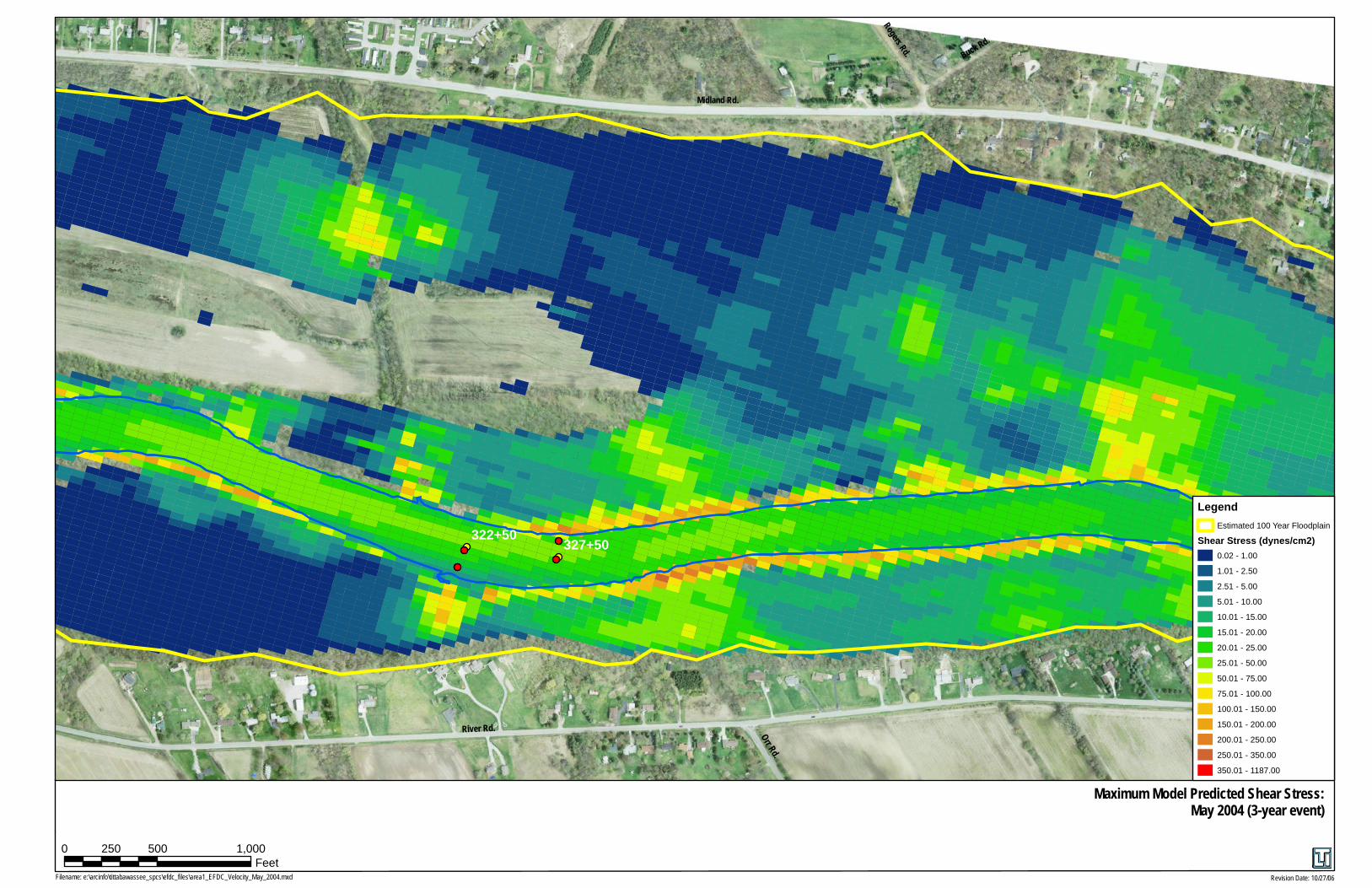
A hydrodynamic model has been built and calibrated for the UTR. Shear stresses have been calculated using calibration data sets for 3-year, 7-year and 8-year storm events. The 3-year storm event constitutes a “bank-full” condition, while the 8-year storm event constitutes a substantial flooding event (see Attachment 3). Both are considered highly erosive conditions for the Tittabawassee River. Under both conditions, the peak bottom shear stresses in the section of the river where this deposit occurs range from 10 to 50 dynes/cm2, which is insufficient to erode the medium grained sand. Unlike the shear stresses on the banks in that section of the river,

Reach O Memorandum December 19, 2006 Page 2 of 3
Reach O Memo ©2006 Ann Arbor Technical Services, Inc.
TM
shear stresses on the bottom do not change appreciably as a function of flow or storm intensity (see Attachment 4). Under these conditions the sand layer can be considered a relatively competent self-armoring capping layer for deposits buried beneath it.
Deposit Delineation Based on existing data, the contaminated deposit is estimated to consist of approximately 2,500 to 3,500 cubic yards in-place volume, including the overlying sand capping layer. However, the precise location, shape and volume of the deposit is not presently known because the poling and sampling techniques used were not intended for this purpose. Lacking better information about the location and dimensions of the deposit will require over-excavation, which increases the estimated in-place removal volume to approximately 35,000 cubic yards.
To prepare for removal, we propose the location and dimensions of the deposit be established using precision bathymetric techniques and spatially continuous geophysical survey tools. This delineation can be done during winter conditions, so long there is limited ice cover and the river is accessible by boat.
Alternatives for Remediation
The deposit may be removed using one of the following techniques: • Underwater mechanical dredging (e.g. dragline crane, or equivalent) • Underwater hydraulic dredging (with or without cutter head) • Semi-dry mechanical excavation (e.g. coffer dam isolation, mechanical excavator
removal)
Underwater mechanical dredging techniques could be implemented in winter conditions; however they are not suited for removal of contaminated material. Underwater mechanical dredging is not a precision technique, and will result in loss of dredged material. This loss of dredged material is exacerbated in a flowing water setting such as a river. If a high flow event occurs during the dredging, the loss of material may be catastrophic.
Underwater hydraulic dredging generally provides better precision in removal and control of dredged material as compared to underwater mechanical dredging. However, it is difficult to implement during winter conditions because of the large volumes of carriage water generated and the problems associated with freezing. Some loss of material from the dredging zone will occur, and this will be exacerbated by flowing water conditions. As in the case of underwater mechanical dredging, if a high flow event occurs during the dredging, the loss of material may be catastrophic. Because the dredged material must be fluidized for removal, hydraulic dredging will increase the removal volumes by a factor of approximately two, and will require some provision for discharging the substantial volume of carriage water once the solids have been removed from it (e.g. discharge to WWTP, POTW or NPDES).

Reach O Memorandum December 19, 2006 Page 3 of 3
Reach O Memo ©2006 Ann Arbor Technical Services, Inc.
TM
Mechanical excavation under semi-dry conditions is the most precise and safest means of
removal for a number of reasons, including positional control of the excavation equipment, elimination of the flowing water release pathway, and ability to complete verification sampling contemporaneously with the removal itself. The potential for catastrophic loss of material is greatly reduced over other techniques by coordinating the scope and timing of removal appropriately with weather opportunities between the inevitable storm events.
It is our considered opinion that risks associated with underwater removal of this deposit
during winter conditions, including both safety and re-mobilization of dredged material, greatly outweigh the relatively minimal risk that this deposit will be eroded under natural conditions in the next few months. We propose to remediate this deposit by performing a “surgical” excavation under semi-dry conditions using a coffer dam approach, as soon as the weather allows after the deposit has been properly located and dimensioned (see Attachment 5). Given the “flashy” nature of the Tittabawassee River, worker safety will be paramount in scheduling work of the river itself.

TM
ATTACHMENT 1 ___
UTR Reach Locations

AB
E
F
G
L
M
N
C
D
H
I
J
K
O
¹0 3,0001,500 Feet
Figure 2Reach Overview
Tittabawassee River ProjectJune 1, 2006

TM
ATTACHMENT 2 ___
Boring Logs and Geologic Cross-Section

Transect Location/Sample Identification Collection Date
Depth Interval (ft,bgs)
Geomorphic Setting Physical Description
Soil Horizon USCS
Moisture Content (%)
2,3,7,8-TCDD (ng/kg)
2,3,7,8-TCDF (ng/kg)
1,2,3,7,8-PeCDF (ng/kg)
2,3,4,7,8-PeCDF (ng/kg)
1,2,3,4,7,8 + 1,2,3,6,7,8-HxCDF
(ng/kg)
Aggregate Indicator Congener
Concentration (ng/kg)
Estimated Total TEQ
(ppt) Laboratory
RN-316+00-IC-C 10/11/06 0.0-0.3 In-Channel 10YR 5/2 grayish brown fine sand, moist, loose, single grain, non-plastic, very few angular glossy course sand subrounded grains Well sorted
1 SP 3.2 <4 19 4 4 6 34* <10* Alta
RN-316+00-IC-C 10/11/06 0.3-0.8 In-Channel 10YR 4/2 dark grayish brown fine sand, moist, loose, single grain, non-plastic, few coarse sand very few medium fine gravel, very few angular glossy coarse black sand, subrounded grains, somewhat well sorted
2 SP 8.5 <4 43 8 7 14 71 11 Alta
RN-316+00-IC-C 10/11/06 0.8-1.6 In-Channel 10YR 4/1 dark gray sand, moist, loose, single grain, non-plastic, very few medium roots, few fine gravel, few shell fragments, very few angular glossy black coarse sand, subrounded grains
3 SM 10.9 <4 28 7 7 18 59 10 Alta
RN-316+00-IC-NE 10/11/06 0.0-0.4 In-Channel 10YR 4/2 dark grayish brown fine sand, loose, single grain, non-plastic, very few medium roots, very few coarse sand, very few shell fragments, very few angular glossy black, coarse sand well sorted
1 SP 30.3 <4 88 300 73 650 1,100 120 Alta
RN-316+00-IC-NE 10/11/06 0.4-1.2 In-Channel 10YR 4/2 dark grayish brown sand, loose, single grain, non-plastic, common, fine, medium gravel, few shell fragments, few angular, glossy black coarse sand, subrounded, sub-angular grains
2 SM 11.7 <4 39 10 9 18 76 12 Alta
RN-316+00-IC-SW 10/11/06 0.0-1.1 In-Channel 10YR 5/2 grayish brown fine sand, moist, loose, single grain, non-plastic, very few fine gravel, subrounded grains, well sorted
1 SP 3.8 <4 9 <4 <4 <4 <20* <10* Alta
RN-316+00-IC-SW 10/11/06 1.1-1.4 In-Channel 10YR 4/1 dark gray loamy fine sand, moist, loose, single grain, non-plastic, very fewfine gravel, few shell fragments, subrounded grains
2 SM 14.9 <4 10 <4 <4 5 <20* <10* Alta
RN-316+00-IC-SW 10/11/06 1.4-2.0 In-Channel 10YR 4/1 dark gray sand, moist, loose, single grain, non-plastic, very few fine gravel, subrounded grains, very few shell fragments
3 SM 14.4 <4 23 11 9 14 56 <10 Alta
RO-321+50-IC-SW75 12/6/06 0.0-0.9 In-Channel 2.5Y 4/3 olive brown sand, 15<35% gravel, SW, sands, wet single grain, moist loose, non-plastic, none, coarse gravel near top of core, fine and medium below, few shell fragments
1 SW 15.4 <4 20 4 5 7 37* <10* Dow
RO-321+50-IC-SW75 12/6/06 0.0-0.9 Lab
Duplicate
In-Channel As Above 1 SW 16.0 <4 23 5 6 5 38* <10* Dow
RO-321+50-IC-SW75 12/6/06 0.9-1.5 In-Channel 10YR 2/1 black, wet, All wood 2 -- 67.6 <8LSV <14LSV <20LSV <21LSV <42LSV <100 <10 DowRO-322+00-IC-SW75 12/6/06 0.0-0.2 In-Channel 2.5Y 4/3 olive brown, coarse sand, 35<60% gravel, SW, sands, wet, single grain,
moist loose, non-plastic, many shell fragments, fine subrounded gravel, few coarse sand grains
1 SW 12.9 <4 33 8 8 7 56 <10* Dow
RO-322+00-IC-SW75 12/6/06 0.2-0.9 In-Channel 2.5Y 4/3 olive brown sand, <15% gravel, SW, sands, wet single grain, moist loose, non-plastic, some coarse sand as matrix, mostly coarse subrounded gravel
2 SW 15.8 <4 36 9 12 22 78 13 Dow
RO-322+50-IC-C 10/16/06 0.0-0.5 In-Channel 10YR 4/2 dark grayish brown sand with <15% gravel, moist, loose, single grain, non-plastic, very few angular glossy black coarse sand, few fine gravel, very few shell fragments, subrounded and subangular grains
1 SW 8.1 <4 830 380 310 260 1800 230 Alta
RO-322+50-IC-C 10/16/06 0.5-1.1 In-Channel 10YR 2/1 black , moist, non-plastic, many medium roots, wood/black material 2 -- 44.2 44 280000 160000 130000 100000 660000 87000 Alta
RO-322+50-IC-C 10/16/06 0.5-1.1 Lab
Duplicate
In-Channel As Above 2 -- 44.2 74 380000 140000 140000 83000 740000 100000 Alta
RO-322+50-IC-C 10/16/06 0.5-1.1 Lab
Duplicate
In-Channel As Above 2 -- 44.2 15 100000 33000 30000 18000 180000 24000 Alta
RO-322+50-IC-C 10/16/06 1.1-1.3 In-Channel 10YR 4/1 dark gray loamy fine sand with <15% gravel, moist, loose, single grain, non-plastic, few medium roots, few SM shell fragmernts, very few fine gravel, very few angular glossy black coarse sand, subrounded grains
3 SM 36.5 <4 570 130 130 59 890 120 Alta
RO-322+50-IC-SW 10/16/06 0.0-0.8 In-Channel 10YR 4/2 dark grayish brown loamy fine sand, moist, loose, single grain, non-plastic, common coarse sand, few fine gravel, very few shell fragments, very few angular glossy black coarse sand, subrounded grains
1 SM 10.7 <4 28 6 6 8 48* <10* Alta
RO-322+50-IC-SW 10/16/06 0.8-1.0 In-Channel 10YR 4/1 dark gray sand with <15% gravel, moist, loose, single grain, non-plastic, few fine gravel, very few shell fragments, subrounded and subangular grains
2 SW 26.6 <4 41 8 8 7 64 10 Alta
RO-322+50-IC-SW 10/16/06 1.0-1.2 In-Channel 10YR 4/1 dark gray silt loam, moist, friable, granular, slightly plastic, common medium roots
3 SM 45.0 <4 <4 <4 <4 <4 <20 <10 Alta
RO-322+50-IC-SW 10/16/06 1.2-1.5 In-Channel 10YR 4/1 dark gray sand with <15% gravel, moist, loose, single grain, non-plastic, few medium roots, few coarse sand, very few fine gravel, few shell fragments, few angular glossy black coarse sand, subrounded grains
4 SW 15.9 <4 <4 <4 <4 <4 <20 <10 Alta
GeoMorph Site Characterization Data SummaryUpper Tittabawassee River: Reach O
Midland, Michigan
TM
ANN ARBOR TECHNICAL SERVICES, INC.
290 South Wagner RoadAnn Arbor, Michigan 48103Tel. 734/995-0995 Fax. 734/995-3731Michigan Laboratory ID: 9604Wisconsin Laboratory ID: 998321720
\\project\D052-TRP.06\Draft Reach O with Soil Descriptions.xls\Reach O© 2006 Ann Arbor Technical Services, Inc.All Rights Reserved.
WORKING DRAFTRev. 121006
Page 1 of 3

Transect Location/Sample Identification Collection Date
Depth Interval (ft,bgs)
Geomorphic Setting Physical Description
Soil Horizon USCS
Moisture Content (%)
2,3,7,8-TCDD (ng/kg)
2,3,7,8-TCDF (ng/kg)
1,2,3,7,8-PeCDF (ng/kg)
2,3,4,7,8-PeCDF (ng/kg)
1,2,3,4,7,8 + 1,2,3,6,7,8-HxCDF
(ng/kg)
Aggregate Indicator Congener
Concentration (ng/kg)
Estimated Total TEQ
(ppt) Laboratory
GeoMorph Site Characterization Data SummaryUpper Tittabawassee River: Reach O
Midland, Michigan
TM
ANN ARBOR TECHNICAL SERVICES, INC.
290 South Wagner RoadAnn Arbor, Michigan 48103Tel. 734/995-0995 Fax. 734/995-3731Michigan Laboratory ID: 9604Wisconsin Laboratory ID: 998321720
RO-322+50-IC-SW25 12/6/06 0.0-0.2 In-Channel 2.5YR 3/2 very dark grayish brown and 2.5Y 3/3 dark olive brown loamy fine sand with 15<35% gravel, wet, very friable, slightly plastic, coarse gravel throughout layer, fine gravel near boundary with next layer
1 SM 21.2 <4 88 38 44 49 220 33 Dow
RO-322+50-IC-SW25 12/6/06 0.2-0.5 In-Channel 2.5Y 4/1 dark gray silty clay loam, wet, very firm, massive, very plastic 2 CL 28.5 <4 23 <8 6 4 34* <10* DowRO-322+50-IC-SW50 12/6/06 0.0-0.3 In-Channel 2.5Y 4/2 dark grayish brown fine sand, 15<35% gravel, SW, sands, wet, single
grain, moist, loose, non-plastic, lucustrine clay1 SW 7.8 <4 17 4 <5 4 25* <10* Dow
RO-322+50-IC-SW50 12/6/06 0.3-0.8 In-Channel 2.5Y 4/1 dark gray clay, CL, fine-grained/not organic, wet, massive, moist, extremely, firm very plastic, fine sand matrix with some coarse sand, fine and medium subrounded and subangular gravel
2 CL 22.7 <4 <4 <4 <5 <8 <25 <10 Dow
RO-322+50-IC-SW75 12/6/06 0.0-0.6 In-Channel 10YR 4/2 dark grayish brown sand, 15<35% gravel, SW, sands, wet, single grain, moist, loose, non-plastic, few coarse sand, subrounded, fine medium and coarse gravel
1 SW 11.6 <4 18 <4 4 6 28* <10* Dow
RO-322+50-IC-SW75 12/6/06 0.6-1.4 In-Channel 10YR 4/1 dark gray sand, 15<35% gravel, SW, sands, wet, single grain, moist, loose, non-plastic few coarse sand, very few shell fragments, fine and medium gravel
2 SW 11.9 <4 24 5 7 11 47* <10* Dow
RO-322+50-IC-SW100 12/6/06 0.0-0.3 In-Channel 2.5Y 4/2 dark grayish brown sand, 15<35% gravel, SW, sands, wet, single grain, moist, loose, non-plastic, very few shell fragments, few wood fragments at very bottom of core, common coarse sand fine and medium subrounded gravel
1 SW 14.0 <23MI 36 <26MI <37MI 16 52 <18 Dow
RO-322+50-IC-SW100 12/6/06 0.3-0.8 In-Channel 2.5Y 4/1 dark gray sand, 15<35% gravel, SW, sands, wet, single grain, moist, loose, non-plastic, common shell fragments, few coarse sand, fine and medium subrounded gravel
2 SW 10.2 <4 230 42 68 46 390 57 Dow
RO-322+50-IC-SW125 12/6/06 0.0-0.6 In-Channel 2.5Y 4/2 dark grayish brown coarse sand, 35<60% gravel, SW, sands, wet, single grain, moist loose, non-plastic, few small wood fragments throughout, few shells, subrounded, fine medium and coarse gravel
1 SW 11.0 <4 33 12 13 24 83 30 Dow
RO-322+50-IC-NE 10/11/06 0.0-0.2 In-Channel 10YR 4/3 brown loamy fine sand, SM, sands, moist single grain, moist, loose, non-plastic, very few shell fragments, very few angular, glossy black coarse sand, subrounded grains
1 SM 14.5 <4 28 11 10 14 63 10 Alta
RO-322+50-IC-NE 10/11/06 0.2-0.7 In-Channel 10YR 4/2 dark grayish brown sand, SM, sands, moist single grain, moist, loose, non-plastic, few fine gravel, few shell fragments, very few angular glossy black coarse sand, subrounded and subangular grains
2 SM 10.2 <4 73 17 17 16 120 18 Alta
RO-322+50-IC-NE 10/11/06 0.7-1.6 In-Channel 10YR 4/1 dark gray sand, SM, sands, moist single grain, moist, loose, non-plastic, fine, few common fine gravel, few angular glossy black coarse sand, few shell fragments, subrounded and subangular grains
3 SM 15.8 <4 20 5 5 7 37* <10* Alta
RO-323+00-IC-SW75 12/6/06 0.0-0.6 In-Channel 2.5Y 4/3 olive brown sand, <15% gravel, SW, sands, wet, single grain, moist, loose, non-plastic few medium and coarse rounded and subrounded gravel
1 SW 15.6 <4 47 7 10 11 75 12 Dow
RO-323+00-IC-SW75 12/6/06 0.6-0.9 In-Channel 2.5Y 2/1 black, wet, structureless, Almost entirely decompoosing wood fragments, few shell fragments, few medium and coarse sand grains
2 -- 34.5 13 11000 6900 6000 4900 29000 4000 Dow
RO-323+00-IC-SW75 12/6/06 0.9-1.0 In-Channel 2.5Y 4/2 dark grayish brown sand, <15% gravel, SW, sands, wet, single grain, moist, loose, non-plastic, Large muscle shells
3 SW 17.6 <4 500 180 190 120 990 140 Dow
RO-323+50-IC-SW75 12/6/06 0.0-0.3 In-Channel 2.5Y 4/3 olive brown sand, <15% gravel, SW, sands, wet single grain, moist, loose, non-plastic, fine subrounded gravel, few shell fragments
1 SW 12.7 <4 18 5 5 11 39* <10* Dow
RO-323+50-IC-SW75 12/6/06 0.3-0.5 In-Channel 2.5Y 4/1 dark gray sand, <15% gravel, SW, sands, wet single grain, moist, loose, non-plastic, fine subrounded gravel, few shell fragments
2 SW 14.0 <4 27 10 8 20 65 11 Dow
RO-323+50-IC-SW75 12/6/06 0.5-1.3 In-Channel 10YR 2/1 black, wet, horizon almost entirely wood, 1.1-1.2' layer of sand, (2.5Y 4/1),0.8-0.9' silty material, mixed in with wood few shell fragments
3 -- 33.8 <4 <5 <4 <6 <9 <28 <10 Dow
RO-327+50-IC-C 10/16/06 0.0-0.4 In-Channel 10YR 5/2 grayish brown sand with <15% gravel, moist, loose, single grain, non-plastic, few fine gravel, very few angular glossy black coarse sand, very few shell fragments, subrounded grains
1 SW 8.1 <4 67 16 16 22 120 18 Alta
RO-327+50-IC-C 10/16/06 0.4-1.0 In-Channel 10YR 2/1 black, moist, many medium roots, few fine gravel, very few angular glossy black coarse sand, very few shell fragments, subrounded grains
2 -- 44.0 8 30000 5400 7400 3300 46000 6300 Alta
RO-327+50-IC-C 10/16/06 1.0-1.3 In-Channel 10YR 4/1 dark gray loamy fine sand with <15% gravel, moist, loose, single grain, non-plastic, very few fine roots, few fine gravel, very few angular glossy black coarse sand, very few shell fragments, subrounded grains
3 SM 13.8 <4 180 53 44 45 320 43 Alta
\\project\D052-TRP.06\Draft Reach O with Soil Descriptions.xls\Reach O© 2006 Ann Arbor Technical Services, Inc.All Rights Reserved.
WORKING DRAFTRev. 121006
Page 2 of 3

Transect Location/Sample Identification Collection Date
Depth Interval (ft,bgs)
Geomorphic Setting Physical Description
Soil Horizon USCS
Moisture Content (%)
2,3,7,8-TCDD (ng/kg)
2,3,7,8-TCDF (ng/kg)
1,2,3,7,8-PeCDF (ng/kg)
2,3,4,7,8-PeCDF (ng/kg)
1,2,3,4,7,8 + 1,2,3,6,7,8-HxCDF
(ng/kg)
Aggregate Indicator Congener
Concentration (ng/kg)
Estimated Total TEQ
(ppt) Laboratory
GeoMorph Site Characterization Data SummaryUpper Tittabawassee River: Reach O
Midland, Michigan
TM
ANN ARBOR TECHNICAL SERVICES, INC.
290 South Wagner RoadAnn Arbor, Michigan 48103Tel. 734/995-0995 Fax. 734/995-3731Michigan Laboratory ID: 9604Wisconsin Laboratory ID: 998321720
RO-327+50-IC-NE 10/16/06 0.0-0.7 In-Channel 10YR 4/2 dark grayish brown sand with <15% gravel, moist, loose, single grain, non-plastic, very few fine roots, few fine and medium gravel, few shell fragments, few angular glossy black coarse sand, subrounded grains
1 SM 6.8 <4 30 7 9 21 67 11 Alta
RO-327+50-IC-NE 10/16/06 0.7-1.3 In-Channel 10YR 4/1 dark gray loamy fine sand, moist, loose, single grain, non-plastic, common medium roots, subrounded grains, wood layer at 0.8' and 1.2'
2 SM 32.3 <4 <4 <4 <4 <4 <20 <10 Alta
RO-327+50-IC-SW 10/16/06 0.0-0.3 In-Channel 10YR 4/2 dark grayish brown loamy fine sand, moist, loose, single grain, non-plastic, very few fine roots, very few angular glossy black coarse sand, subrounded grains, very few shell fragments
1 SM 14.3 <4 11 <4 <4 10 21* <10* Alta
RO-327+50-IC-SW 10/16/06 0.3-1.1 In-Channel 10YR 4/1 dark gray loamy fine sand with <15% gravel, moist, loose, single grain, non-plastic, few fine roots, very few angular glossy black coarse sand, subrounded grains, very few shell fragments
2 SM 15.7 <4 27 5 5 11 48* <10* Alta
RO-327+50-IC-SW 10/16/06 1.1-1.2 In-Channel 10YR 4/1 dark gray loamy very fine sand with <15% gravel, moist, friable, subangular blocky, slightly plastic, few medium roots, very few angular glossy black coarse sand, subrounded grains, very few shell fragments
3 SM 37.3 <4 <4 <4 <4 <4 <20 <10 Alta
RO-333+00-IC-C 10/16/06 0.0-0.3 In-Channel 10YR 4/2 dark grayish brown sand with 15<35% gravel, moist, loose, single grain, non-plastic, common fine gravel, very few angular glossy black coarse sand, very few shell fragments, subrounded grains
1 SM 8.8 <4 11 <4 <4 4 <20* <10* Alta
RO-333+00-IC-C 10/16/06 0.3-0.9 In-Channel 10YR 4/1 dark gray loamy fine sand, moist, loose, single grain, non-plastic, few coarse sand, very few fine gravel, few shell fragments, few angular glossy black coarse sand, subrounded grains
2 SM 14.4 <4 22 4 4 6 35* <10* Alta
RO-333+00-IC-NE 10/16/06 0.0-0.3 In-Channel 10YR 4/2 dark grayish brown loamy fine sand with <15% gravel, moist, loose, singlegrain, non-plastic, few coarse sand, few fine gravel, few angular glossy black coarse sand, very few shell fragments, subrounded grains
1 SM 12.1 <4 14 <4 <4 5 <52* <10* Alta
RO-333+00-IC-NE 10/16/06 0.3-0.9 In-Channel N 2/0 black loamy fine sand, moist, loose, single grain, non-plastic, very few fine roots, very few coarse sand, few shell fragments, few angular glossy black coarse sand, subrounded grains
2 SM 19.2 <4 71 15 13 32 130 18 Alta
RO-333+00-IC-NE 10/16/06 0.9-1.1 In-Channel 10YR 4/2 dark grayish brown sand with <15% gravel, moist, loose, single grain, non-plastic, very few fine gravel, few shell fragments, subrounded and subangular grains
3 SM 8.4 <4 54 9 22 33 120 19 Alta
RO-333+00-IC-SW 10/16/06 0.0-0.6 In-Channel 10YR 4/2 dark grayish brown coarse sand with <15% gravel, moist, loose, single grain, non-plastic, very few medium roots, very few fine gravel, few angular glossy black coarse sand, subrounded grains, somewhat well sorted
1 SP 6.7 <4 23 7 5 11 46* <10* Alta
RO-333+00-IC-SW 10/16/06 0.6-1.3 In-Channel 10YR 4/1 dark gray loamy fine sand with <15% gravel, moist, loose, single grain, non-plastic, few coarse sand, very few fine gravel, very few angular glossy black coarse sand, subrounded grains, few shell fragments
2 SM 15.2 <4 21 <4 4 10 35* <10* Alta
NOTES:All concentrations are expressed on a dry weight basis."Estimated Total TEQ" is aggregate indicator congener TEQ multiplied by correlation factor of 1.1x.DATA FLAGS:Asterisk (*) indicates estimated concentration."LSV" indicates elevated reporting limit due to limited sample volume."LISR" indicates elevated reporting limit due to low internal standard recovery.
\\project\D052-TRP.06\Draft Reach O with Soil Descriptions.xls\Reach O© 2006 Ann Arbor Technical Services, Inc.All Rights Reserved.
WORKING DRAFTRev. 121006
Page 3 of 3

RN-31
6+00
-IC-C
RO-32
2+50
-IC-C
RO-32
7+50
-IC-C
RO-33
3+00
-IC-C
585'
584'
583'
582'
581'
580'
585'
584'
583'
582'
581'
580'
WEST EAST
5 ppt TEQ
5 ppt TEQ10 ppt TEQ
11 ppt TEQ
6,300 ppt TEQ
230 ppt TEQ
5 ppt TEQ
18 ppt TEQ87,000.00 ppt TEQ
43 ppt TEQ120 ppt TEQ
!(
!(
!(
!(
D
D
D
D
D
D
D
D
D
D
D
D
295+00
300+00
305+00
310+00
315+00
320+00
325+00
330+00
335+00
340+00
345+00
350+00
LegendPhysical Description
SM: Dark gray sand / loamy sand
SP: Dark gray / brown fine sand
SW: Gray / brown sand
Wood / Black Material
River Bed Elevation
0 100 200 300
Horizontal Scale in FeetVertical Exaggeration = 50x
REACH O - LONGITUDINAL CROSS-SECTION
´Transect Location

RO-32
2+50
-IC-SW
25
RO-32
2+50
-IC-SW
50
RO-32
2+50
-IC-SW
75RO
-322+
50-IC
-SW
RO-32
2+50
-IC-SW
100
RO-32
2+50
-IC-SW
125
RO-32
2+50
-IC-C
RO-3
22+5
0-IC
-NE
590'
589'
588'
587'
586'
585'
584'
583'
582'
581'
580'
590'
589'
588'
587'
586'
585'
584'
583'
582'
581'
580'
<10* ppt TEQ
<10* ppt TEQ
<10* ppt TEQ30 ppt TEQ
<10* ppt TEQ
57 ppt TEQ
18 ppt TEQ
87,000 ppt TEQ
230 ppt TEQ
<10 ppt TEQ
<18 ppt TEQ
<10 ppt TEQ
<10* ppt TEQ
<10* ppt TEQ
10 ppt TEQ
10 ppt TEQ
33 ppt TEQ
120 ppt TEQ
!(!(
!(!(!(!(
!(!(
D
D
D
D
D
D
D
D
D
D
D
D
295+00
300+00
305+00
310+00
315+00
320+00
325+00
330+00
335+00
340+00
345+00
350+00
LegendRiver Bed Elevation
Physical DescriptionWood / Black Material
CL: Dark gray silt / clay
SM: Dark gray sand / loamy sand
SW: Gray / brown sand
0 50 100
Horizontal Scale in FeetVertical Exaggeration = 10x
TRANSECT 322+50-IC CROSS-SECTION
´Transect Location

TM
ATTACHMENT 3 ___
Model Predicted Stream Lines
3-Year and 8-Year Storm Events

EE
EE
E
E
E
EEEEE
E
E
E
E
E
E
Midland Rd.
River Rd. Orr Rd.
Smith Crossing Rd.
255+00
260+00
265+00
270+00
275+00280+00 285+00 290+00 295+00 300+00
305+00
310+00
315+00
320+00325+00
330+00335+00 340+00
0 500 1,000250Feet
Maximum Model Predicted Velocity:May 2004 (3-year event)
Filename: x:\blord\arcinfo\tittabawassee_spcs\efdc_files\Reach_MtoO_Maximum_Velocity_May_2004.mxd Revision Date: 121206
Legend
Estimated 100 Year Floodplain
Max Velocity (ft./sec.)0.02 - 0.25
0.26 - 0.50
0.51 - 1.00
1.01 - 1.50
1.51 - 2.00
2.01 - 2.50
2.51 - 3.00
3.01 - 3.50
3.51 - 4.00
4.01 - 4.50
4.51 - 5.00
5.01 - 5.50
Streamlines
´

EE
EE
E
E
E
EEEEE
E
E
E
E
E
E
Midland Rd.
River Rd. Orr Rd.
Smith Crossing Rd.
255+00
260+00
265+00
270+00
275+00280+00 285+00 290+00 295+00 300+00
305+00
310+00
315+00
320+00325+00
330+00335+00 340+00
0 500 1,000250Feet
Maximum Model Predicted Velocity:March 2004 (8-year event)
Filename: x:\blord\arcinfo\tittabawassee_spcs\efdc_files\Reach_MtoO_Maximum_Velocity_March_2004.mxd Revision Date: 121206
Legend
Estimated 100 Year Floodplain
Max Velocity (ft./sec.)0.02 - 0.25
0.26 - 0.50
0.51 - 1.00
1.01 - 1.50
1.51 - 2.00
2.01 - 2.50
2.51 - 3.00
3.01 - 3.50
3.51 - 4.00
4.01 - 4.50
4.51 - 5.00
5.01 - 5.50
Streamlines
´

TM
ATTACHMENT 4 ___
Maximum Model Predicted Shear Stress
3-Year and 8-Year Storm Events
Midland Rd.
River Rd. Orr Rd.
Buck Rd.
Rogers Rd.
322+50327+50
´
0 500 1,000250Feet
Maximum Model Predicted Shear Stress:May 2004 (3-year event)
Filename: e:\arcinfo\tittabawassee_spcs\efdc_files\area1_EFDC_Velocity_May_2004.mxd Revision Date: 10/27/06
LegendEstimated 100 Year Floodplain
Shear Stress (dynes/cm2)0.02 - 1.00
1.01 - 2.50
2.51 - 5.00
5.01 - 10.00
10.01 - 15.00
15.01 - 20.00
20.01 - 25.00
25.01 - 50.00
50.01 - 75.00
75.01 - 100.00
100.01 - 150.00
150.01 - 200.00
200.01 - 250.00
250.01 - 350.00
350.01 - 1187.00

Midland Rd.
River Rd. Orr Rd.
Buck Rd.
Rogers Rd.
322+50327+50
´
0 500 1,000250Feet
Maximum Model Predicted Shear Stress:March 2004 (8-year event)
Filename: e:\arcinfo\tittabawassee_spcs\efdc_files\area1_EFDC_Velocity_May_2004.mxd Revision Date: 10/27/06
LegendEstimated 100 Year Floodplain
Shear Stress (dynes/cm2)0.00 - 1.00
1.01 - 2.50
2.51 - 5.00
5.01 - 10.00
10.01 - 15.00
15.01 - 20.00
20.01 - 25.00
25.01 - 50.00
50.01 - 75.00
75.01 - 100.00
100.01 - 150.00
150.01 - 200.00
200.01 - 250.00
250.01 - 350.00
350.01 - 1187.00

TM
ATTACHMENT 5 ___
Project Schedule

Reach O Memo ©2006 Ann Arbor Technical Services, Inc.
TM
UTR Pilot Corrective Action Plan Timeline (December 2006 - November 2007) Rev. 12/19/06
Dec Jan Feb Mar Apr May Jun Jul Aug Sep Oct Nov Identify specific areas for corrective action Precise Bathymetry Precise Topo Mapping within 200 feet of shoreline/corrective action area
Characterization of soil/sediment physical properties Identify specific areas for corrective action Boundary definition of elevated concentrations horizontally and vertically Modeling of existing conditions, velocity, shear stress and streamlines
Biology Layer –sensitive species habitat/needed habitat
Access, legal and physical Development of feasible alternatives Modeling of selected alternatives Construction Plans Completed Plans for long term monitoring/maintenance of corrective action Permit Applications Submitted Quarterly Public Participation HASP specific to corrective action
Background data on water quality for performance monitoring Biological restoration plan Field QA/QC plan and staff in place Cost estimates/bids in hand Contractors ready to go Permit Review/Approval
Monitoring plan for water quality and biota during and after corrective action
Materials secured for capping/armoring Disposal arrangements made Protocols for compiling closure report (photo’s, field notes, data, drawings) Consensus on selected alternatives (RAP) Contingency plan for bad weather
Walleye spawning period (3/15 – 6/1)
Raptor/other bird nesting period ? ? ? ? Good weather window corrective action activities
Restoration and monitoring
Dec Jan Feb Mar Apr May Jun Jul Aug Sep Oct Nov