Embed Size (px)
Citation preview
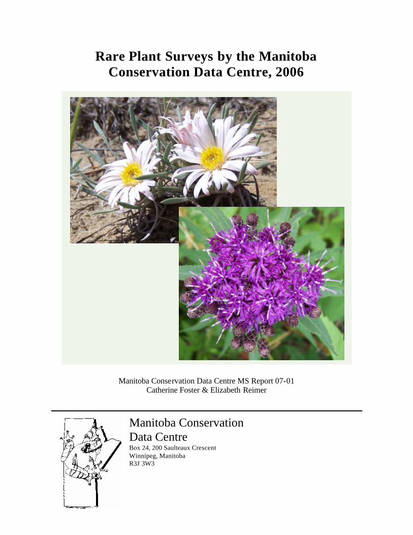
Rare Plant Surveys by the Manitoba Conservation Data Centre, 2006
Manitoba Conservation Data Centre MS Report 07-01 Catherine Foster & Elizabeth Reimer
Manitoba Conservation Data Centre Box 24, 200 Saulteaux Crescent Winnipeg, Manitoba R3J 3W3

Please cite as:
Foster, C. and Reimer, E. 2007. Rare Plant Surveys by the Manitoba Conservation Data Centre, 2006. MS Report 07-01. Manitoba Conservation Data Centre, Winnipeg, Manitoba. 53 pp. Images:
Except where noted, all images are © Manitoba Conservation Data Centre. Cover image: silky townsend daisy (Townsendia exscapa) top left; fascicled ironweed (Vernonia fasciculata ) bottom right.

Rare Plant Surveys by the Manitoba Conservation Data Centre, 2006 1
Executive Summary Information on 35 rare and uncommon plant species was gathered by the Manitoba Conservation Data Centre (CDC) in 2006 through field surveys and acquisition of data from associates. A total of 111 occurrences were newly documented or updated. Results of comprehensive field surveys of sites occupied by the following eight rare species are summarized in this report.
Buffalograss (Buchloe dactyloides)
Fascicled Ironweed (Vernonia fasciculata)
Hairy Prairie-clover (Dalea villosa)
Northern Adder’s-tongue (Ophioglossum pusillum)
Ram’s-head Lady’s-slipper (Cypripedium arietinum)
Silky Townsend Daisy (Townsendia exscapa)
Small White Lady’s-slipper (Cypripedium candidum)
Western Silvery Aster (Symphyotrichum sericeum)
Data collected includes mapping plant patches in the field using a GPS equipped hand held computer, plant abundance, habitat characteristics and threats. Notes on the other 27 species surveyed by the CDC and associates are also included.
Two information sharing and stewardship initiatives were implemented in 2006. Maps of road allowances supporting species at risk were produced for two rural municipalities to help mitigate threats associated with road maintenance activities. Interviews with private landowners were initiated to help with development of beneficial management practices. These initiatives are summarized and stewardship recommendations are discussed. Two-way information sharing among stakeholders, collaboration of conservation efforts among agencies with complimentary interests, cooperation towards the development of beneficial management practices, and prioritization of sites for inventory and monitoring are recommended.

Rare Plant Surveys by the Manitoba Conservation Data Centre, 2006 2
Acknowledgements We would like to thank Allison Poff and Carine Deland for their field assistance, and Jeff Anderson for volunteering time in the field. Several other associates joined CDC staff in the field as well as providing habitat and rare species information. Elizabeth Punter, the Manitoba Association of Plant Biologists, and Dave Roberts were involved with surveys of peatland habitats. Marilyn Latta showed CDC staff a new occurrence of western silvery aster. Laura Reeves and Christie Borkowsky of the Tall Grass Prairie Preserve provided guidance in the field during northern adder’s-tongue surveys and provided data on rare occurrences in and around the preserve. Erin Zahradka and Kyle Hildebrandt assisted with data collection at the Tall Grass Prairie Preserve in 2006.
We would also like to thank the following individuals for providing information on rare species occurrences and habitats: Marilena Kowalchuk, Ken De Smet, Kathy Murray, Tom Moran, Dan Chranowski, Gerry Pidborchynski, Glen Suggett, Peggy Westhorpe, Nicole Firlotte, Jason Greenall, Jim Duncan, Helios Hernandez, Cary Hamel, Richard Staniforth, Pat Bidlake, Peggy Bainard Acheson, Doris Ames, Ken Schykulski, John Morgan, Doug Collicutt, Jo-Anne Joyce, Marjorie Hughes, Dan Sie, Kevin Szwaluk and Tom Reaume. In addition, Linsday Donnelly was very helpful in providing GIS data layers and technical assistance.
Our appreciation extends to all landowners who granted permission to access private land for rare species surveys. All landowners contacted for additional information following rare species surveys were generous with their time and provided insightful comments.
Funding was provided by the Critical Wildlife Habitat Program of the Manitoba Habitat Heritage Corporation, the Habitat Stewardship Program of Environment Canada, the Manitoba Special Conservation Fund, and the Wildlife and Ecosystem Protection Branch of Manitoba Conservation.
Rare Plant Surveys by the Manitoba Conservation Data Centre, 2006 3
Table of Contents
Executive Summary ............................................................................................................ 1Acknowledgements............................................................................................................. 2Table of Contents ................................................................................................................ 3Introduction......................................................................................................................... 4Methods............................................................................................................................... 4Results................................................................................................................................. 5
Buffalograss (Buchloë dactyloides)................................................................................. 8Fascicled Ironweed (Vernonia fasciculata)................................................................... 12Hairy Prairie-clover (Dalea villosa) .............................................................................. 17Northern Adder’s-tongue (Ophioglossum pusillum) ..................................................... 21Ram’s-head Lady’s-slipper (Cypripedium arietinum) .................................................. 24Silky Townsend Daisy (Townsendia exscapa) .............................................................. 27Small White Lady’s-Slipper (Cypripedium candidum)................................................. 30
Western Silvery Aster (Symphyotrichum sericeum) ...................................................... 34 Other Rare and Uncommon Species Surveyed.............................................................. 37Information Sharing and Stewardship Initiatives ............................................................. 43Information Sharing and Stewardship Recommendations................................................ 45Literature Cited ................................................................................................................. 47Appendix 1: Definitions of Conservation Status Ranks ................................................... 51Appendix 2: Definitions of General Status Ranks............................................................ 53

Rare Plant Surveys by the Manitoba Conservation Data Centre, 2006 4
Introduction Effective conservation, stewardship and recovery of species at risk requires input from both scientific and local communities. The Manitoba Conservation Data Centre (CDC) gathers, manages, and provides scientific information on Manitoba’s species. Information such as distribution, abundance, preferred habitat, and threats is used to determine conservation status ranks and helps guide conservation planning and land management decisions. The CDC gives highest priority to species listed under Canada’s Species at Risk Act and Manitoba’s Endangered Species Act, species deemed to be high priorities by the Committee on the Status of Endangered Wildlife in Canada (COSEWIC), and provincially rare and uncommon species. Surveys are focussed on areas of the province lacking current information to the extent possible. Increasingly, the CDC has been providing input for the development of national recovery strategies for Endangered and Threatened species. This report summarizes information collected on 35 rare and uncommon plant species in 2006. Detailed information is given for eight rare plant species surveyed by the CDC.
Through field surveys and information gathered from other sources, the CDC has become increasingly cognizant of information sharing and stewardship opportunities. The majority of Manitoba’s species at risk occur on private land and municipally managed road allowances. In addition to Conservation Agreements with private landowners, development of beneficial management practices is needed. In 2006, interviews with private landowners were initiated to gather additional land management information following field surveys. To help mitigate threats to species at risk occurring in road allowances, maps and recommendations were produced for agencies involved with road maintenance in two rural municipalities. These initiatives, as well as other information sharing and stewardship recommendations, are discussed.
Methods Field surveys were conducted by the CDC from April 27 to September 20, 2006. Determination of areas to be visited was based on new reports and existing CDC records in conjunction with available GIS data including aerial photographs, satellite imagery and layers containing information on land use, soils, water and elevation. Landowners were contacted prior to surveys where required. Data collected at each site included mapping plant patches in the field using a GPS-equipped hand held computer, as well as information on plant abundance, habitat characteristics (substrate, aspect, slope, associated taxa, landscape context), and threats. Photographs were taken and plant specimens were collected and deposited at the University of Manitoba or Manitoba Museum herbariums when identification confirmation was required.
Data gathered in the field and from reports was entered into the CDC’s Arcview-based GIS and associated Oracle database (Biotics 4.03) according to accepted NatureServe standards (NatureServe 2007). Information on negative search results was entered into a stand alone GIS layer (Arcview 3.2a). Following field surveys and interviews, letters

Rare Plant Surveys by the Manitoba Conservation Data Centre, 2006 5
outlining the CDC’s findings were sent to private landowners. Site-specific information was also provided to relevant land managers and planners.
Results Information on 35 rare and uncommon plant species, 10 of which are legally listed, was collected by the CDC via field surveys and data acquired from associates in 2006 (Tables 1 and 2). A total of 76 known occurrences were monitored and 35 new occurrences were documented. Twenty-six sites visited by the CDC were on private land.
Detailed information on eight rare plant species surveyed by the CDC is followed by notes on other rare and uncommon species surveyed by the CDC and associates. Global, national and subnational (provincial) conservation status ranks as defined by NatureServe are given for each species (see Appendix 1 for definitions ). Canadian General Status ranks are also given, as national NatureServe ranks for Canada have not been determined for many species (see Appendix 2 for definitions). Where applicable, listing under Canada’s Species at Risk Act (SARA) and Manitoba’s Endangered Species Act (MESA) is also given. Survey results are followed by information on the CDC’s road allowance maps and private landowner interviews. Information sharing and stewardship recommendations conclude the report.

Rare Plant Surveys by the Manitoba Conservation Data Centre, 2006 6
Common Name Scientific Name Conservation StatusSites
Surveyed*Private Land
Parcels Surveyed
Known Occurrences**
MonitoredNew Occurrences
DocumentedBuffalo Grass Buchloe dactyloides Threatened (SARA) 13 13 3 0Fascicled Ironweed Vernonia fasciculata S1 12 7 1 1Hairy Prairie-clover Dalea villosa Threatened (SARA) 13 6 12 0Northern Adder’s-tongue Ophioglossum pusillum S1 9 0 1 1Ram’s-head Lady’s-slipper Cypripedium arietinum S2? 1 0 0 1Silky Townsend Daisy Townsendia exscapa S2 17 0 4 1Small White Lady’s-slipper Cypripedium candidum Endangered (SARA & MESA) 11 0 7 0Western Silvery Aster Symphyotrichum sericeum Threatened (SARA & MESA) 6 0 4 (submitted to CDC) 1 (+ 2 submitted to CDC)Totals 82 26 32 7
* Sites are defined as discrete sampling locations. A single quarter-section was considered one site, unless fragmented by multiple ownership. Each owner unit within a single quarter-section was considered a separate site. On large crown parcels covering many sections, each discrete 'stop' was considered a site. When species were not observed, site information was entered in a negative results database.
** A plant occurrence refers to a population separated by less than one kilometre from an occurrence of the same species, or less than two kilometres if intervening habitat is suitable.
Table 1. Summary of priority rare s pecies survey results, 2006.
Rare Plant Surveys by the Manitoba Conservation Data Centre, 2006 7
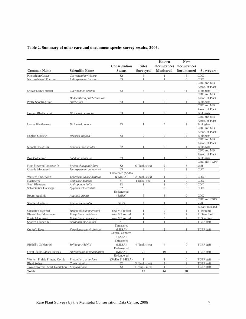
Table 2. Summary of other rare and uncommon species survey results, 2006.
Common Name Scientific NameConservation
StatusSites
Surveyed
Known Occurrences Monitored
New Occurrences Documented Surveyors
Pincushion Cactus Coryphantha vivipara S2 6 1 5 CDCNarrow-leaved Puccoon Lithospermum incisum S3 1 1 0 CDC
Showy Lady's-slipper Cypripedium reginae S3 4 0 4
CDC and MB Assoc. of Plant Biologists
Pretty Shooting StarDodecatheon pulchellum var. pulchellum S3 1 0 1
CDC and MB Assoc. of Plant Biologists
Horned Bladderwort Utricularia cornuta S3 1 0 1
CDC and MB Assoc. of Plant Biologists
Lesser Bladderwort Utricularia minor S3 1 0 1
CDC and MB Assoc. of Plant Biologists
English Sundew Drosera anglica S3 2 0 2
CDC and MB Assoc. of Plant Biologists
Smooth Twigrush Cladium mariscoides S2 1 0 1
CDC and MB Assoc. of Plant Biologists
Bog Goldenrod Solidago uliginosa S3 1 1 0
CDC and MB Assoc. of Plant Biologists
Four-flowered Loosestrife Lysimachia quadriflora S2 6 (dupl. sites) 2 3CDC and TGPP staff
Canada Moonseed Menispermum canadense S3 2 0 1 CDC
Western Spiderwort Tradescantia occidentalisThreatened (SARA
& MESA) 2 (dupl. sites) 1 0 CDCHackberry Celtis occidentalis S1 1 (dupl. site) 1 0 CDCSand Bluestem Andropogon hallii S2 1 1 0 CDCSchweinitz's Flatsedge Cyperus schweinitzii S2 3 2 0 CDC
Rough Agalinis Agalinis asperaEndangered
(SARA) 5 3 0 CDC
Slender Agalinis Agalinis tenuifolia S2S3 4 1 1CDC and TGPP staff
Clustered Burreed Sparganium glomeratum new MB record 1 0 1K. Szwaluk and T. Reaume
Blunt-lobed Mooonwort Botrychium oneidense new MB record 1 0 1 R. StaniforthPrarie Moonwort Botrychium campestre new MB record 1 0 1 R. Staniforth Spotted Crane's-bill Geranium maculatum S1 1 1 0 TGPP staff
Culver's Root Veronicastrum virginicumThreatened (MESA) 6 2 3 TGPP staff
Riddell's Goldenrod Solidago riddellii
Special Concern (SARA)
Threatened (MESA) 4 (dupl. sites) 4 0 TGPP staff
Great Plains Ladies'-tresses Spiranthes magnicamporumEndangered
(MESA) 28 19 1 TGPP staff
Western Prairie Fringed Orchid Platanthera praeclaraEndangered
(SARA & MESA) 1 1 0 TGPP staff Rigid Sedge Carex tetanica S2 3 (dupl. sites) 2 1 TGPP staff Two-flowered Dwarf Dandelion Krigia biflora S2 1 (dupl. sites) 1 0 TGPP staff Totals 72 44 28

Rare Plant Surveys by the Manitoba Conservation Data Centre, 2006 8
Buffalograss (Buchloë dactyloides) SARA: Threatened
NatureServe Status: G4G5, N1, S1 Canada General Status: 1
Buffalograss (family Poaceae) is a short perennial grass with greyish-green, slightly hairy leaves. The stems creep along the ground and root at nodes forming dense circular patches. Male and female flowers usually occur on separate plants. Female flowers are hidden by the leaf blades and enclosed in a bur- like structure held on a short stalk near the ground. Male flowers are held on stalks above the leaves in one-sided clusters. The orange pollen of the male flowers makes buffalograss fairly distinctive during its peak blooming period, typically near the end of June in Manitoba.
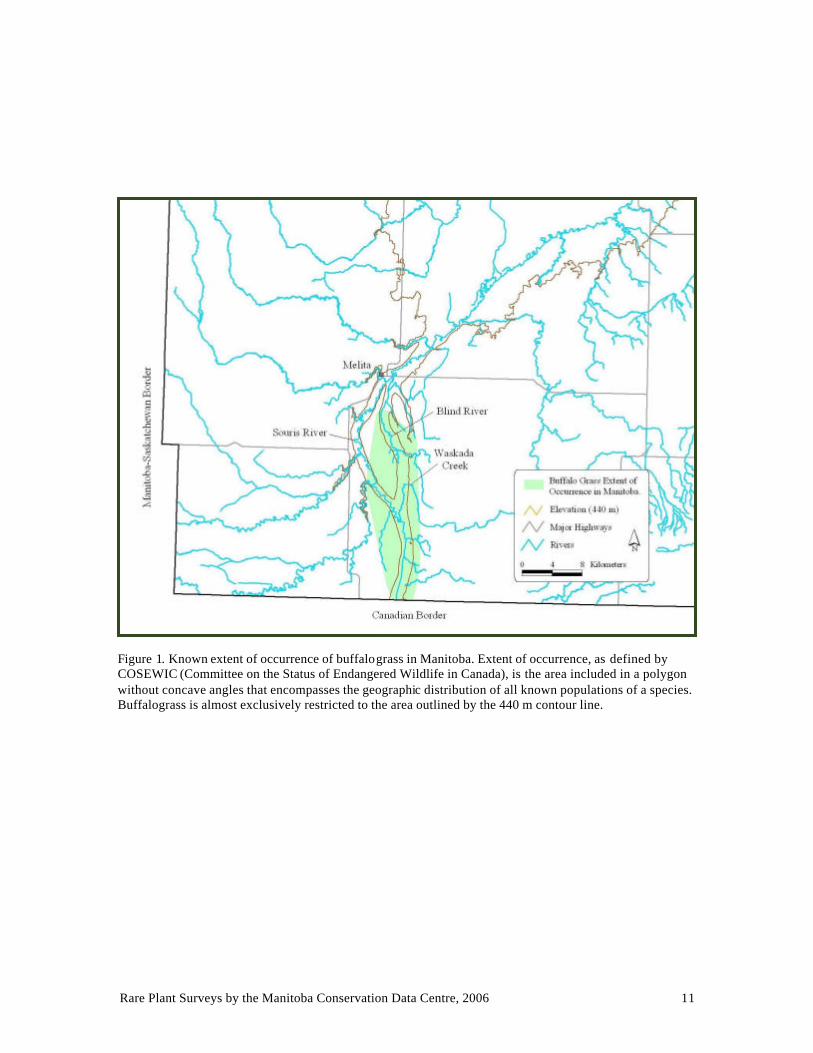
Conservation Status Buffalograss is a wide ranging, common component of shortgrass and mixed-grass prairie in the United States, presumably spreading from Mexico to Canada with large migratory herbivores (Howard 1995; Quinn et al. 1994; Hart and Ashby 1998). It becomes rare near the edges of its range and is listed as a Threatened species under Canada’s Species at Risk Act (NatureServe 2007; Environment Canada 2006). In Canada buffalograss is only found along the Souris and Blind River valleys of Saskatchewan and Manitoba. The extent of its range in Manitoba is approximately 114 km2 (Fig. 1). All but one of Manitoba’s buffalograss populations occur on privately owned pastures. Estimating the number of buffalograss plants at a particular site is not feasible due to its spreading growth habit. Mapping of the area occupied by buffalograss in the field is used as a measure of abundance. Detailed mapping of buffalograss was initiated in 2005. Surveys of buffalograss in 2006 continued to document area of occupancy in the northern portion of its Manitoba range along the Blind River valley.
Data collected in 2006 On June 27, buffalograss was mapped on two quarter sections near the junction of the Souris and Blind River valleys. The area containing buffalograss was bound by a high ridge to the west and a dry creek bed (Waskada Creek) to the east. Buffalograss patches
Male Female

Rare Plant Surveys by the Manitoba Conservation Data Centre, 2006 9
were scattered along lower slopes of low hills and ridges, and along more gradual slopes adjacent to wet alkaline areas. Associated species included cacti (Opuntia fragilis and Coryphantha vivipara), western snowberry (Symphoricarpos occidentalis) Kentucky bluegrass (Poa pratensis), foxtail barley (Hordeum jubatum) and alkali grass (Distichlis stricta).
New buffalograss growth was fairly sparse and flowering stems were not very abundant. Buffalograss has been found to respond rapidly to changes in precipitation with responses depending on grazing regime (Olsen et al. 1985; Albertson and Tomanek 1965). The spring and summer of 2005 were extremely wet and the proportion of flowering stems observed during 2005 surveys in the Souris River valley appeared to be much higher compared to 2006, which was an extremely dry year (Environment Canada 2007).
On June 28, buffalograss was mapped on three additional quarter sections in the Blind River valley. One quarter section was an open rocky pasture with heavily grazed areas and was stocked with cattle, two horses and a few llamas. Buffalograss occurred on relatively flat grazed areas mostly on the east side of the Blind River. Uncultivated portions of the adjacent quarter section to the west were searched as well but no buffalograss was encountered.
In the other two quarter sections buffalograss also occurred mainly on the east side of the river. The west side was very wet and dominated by foxtail barley. A thin strip of buffalograss was mapped along the raised edge of the eroded western fenceline. Before cultivation, buffalograss likely extended into the cultivated area between the fence and the high ridge to the west. On the east side of the river buffalograss occurred on the lower slopes of hills and ridges, becoming very abundant in one of the quarter sections. In 2002, the river was dry and buffalograss was observed in only a few patches at this site
Buffalograss among western snowberry shrubs and taller grasses in a pasture with relatively low buffalograss density.
Rare Plant Surveys by the Manitoba Conservation Data Centre, 2006 10
(Kowalchuk 2003). It is possible that buffalograss has increased at this site with increased moisture availability.
Searches for buffalograss in suitable habitat on seven other quarter sections in the Blind River valley were unsuccessful. The invasive leafy spurge (Euphorbia esula) was not a threat at the Blind River valley sites as it is at some of the Souris River valley sites.
Stewardship and Future Considerations Future buffalograss distribution and abundance in Manitoba will reflect the interacting influences of grazing, moisture availability, competing vegetation and other site characteristics. In southern mixed grass prairies of the United States, where buffalograss is a common range plant, it has been found to respond favourably to moderate or heavy grazing although responses vary depending on site characteristics and grazing regime i.e. soil, topographic position, precipitation, continuous or rotational grazing (Olson et al. 1993; Tomanek and Albertson 1953; Tomanek et al. 1958; Albertson and Tomanek 1965; Launchbaugh 1969; Olson et al. 1985; Ring et al. 1985; Olson et al. 1993; Hart and Ashby 1998; Wood and Blackburn 1984; Fisher and Marion 1951). Monitoring of buffalograss sites in Manitoba in relation to stocking rates and grazing regime will be an important step in the development of beneficial management practices for buffalograss.
All sites surveyed in 2006 employed season- long grazing with stocking densities of approximately 0.14, 0.18 and 0.26 cows per acre (buffalograss landowners, pers. comm.). The mapped area occupied by buffalograss in 2006 was 5.5, 50 and 38.4 m2 per acre respectively. The site with the lowest stocking density and the lowest buffalograss area of occupancy was located along a dry creek bed, whereas the other two were located along the Blind River. The site with the highest density of buffalograss was also stocked with horses and llamas. Future surveys aimed at determining grazing regimes beneficial to buffalograss will need to take site characteristics such as moisture availability into consideration. In 2007, buffalograss sites that are known to have begun managed grazing in recent years should be targeted for surveys.
The distribution of individual buffalograss patches can be closely linked to grazing behaviour which in turn is influenced by topographic position and vegetation composition (Ring et al. 1985; Tomanek et al. 1958). Thus the scale at which buffalograss is mapped and monitored should be considered before making inferences about population trends. Timing of surveys in relation to grazing regime is also an important consideration, as closely grazed patches are difficult to identify and map. The presence of taller grasses, a lack of flowering stems, and possibly preferential grazing of new buffalograss growth could make mapping of buffalograss at some sites a challenge depending on timing of surveys. Bright orange anthers make buffalograss readily identifiable during its peak blooming period in late June. The color and height of the leaves are also helpful at this time of year for identifying the circular patches formed by buffalograss.
Rare Plant Surveys by the Manitoba Conservation Data Centre, 2006 11
Figure 1. Known extent of occurrence of buffalograss in Manitoba. Extent of occurrence, as defined by COSEWIC (Committee on the Status of Endangered Wildlife in Canada), is the area included in a polygon without concave angles that encompasses the geographic distribution of all known populations of a species. Buffalograss is almost exclusively restricted to the area outlined by the 440 m contour line.

Rare Plant Surveys by the Manitoba Conservation Data Centre, 2006 12
Fascicled Ironweed (Vernonia fasciculata) NatureServe Status: G5, NNR, S1
Canada General Status: 2
Fascicled ironweed (family Asteraceae) is a showy herbaceous perennial that can grow over 1 m tall. It typically grows in clumps of few to many stems. The narrow leaves alternate along the stem and can grow over 20 cm long (Flora of North America Editorial Committee 2006a). The pointy, regularly spaced teeth on the leaf margins are distinctive. Showy, reddish-purple, flat-topped flower clusters bloom from July to September followed by the development of fluffy, light brown seed heads.
Although there are over 20 species of Vernonia, most of which hybridize, there is only one species of Vernonia known to occur in Canada. Two subspecies of Vernonia fasciculata have been described. However, in the recent treatment of Asteraceae by the Flora of North America Editorial Committee (2006a), Vernonia fasciculata is only recognized at the species level.
Conservation Status Fascicled ironweed ranges from southern Manitoba down to Oklahoma, typically growing in bottomlands, ditches and low prairies (Flora of North America Editorial Committee 2006a). Its Canadian General Status rank is May Be At Risk (2). In Canada historical records of occurrences are known from Manitoba and one location in Saskatchewan. It is tentatively ranked Secure in the United States (N5?) and is ranked Secure globally (G5) (NatureServe 2007). Prior to 2006, the CDC database held records for three fascicled ironweed collections from the 1950s; two from along the Rat River in the Otterburne area and one from a grassy ditch near Morris. In 2005, CDC staff attempted to relocate fascicled ironweed in two of the areas where it was collected in the 1950s. No fascicled ironweed was found. Due to prior flooding along the Rat River at one site, additional searches were recommended.

Rare Plant Surveys by the Manitoba Conservation Data Centre, 2006 13
Data Collected in 2006 Otterburne area
On July 13, fascicled ironweed was found along the Rat River in the area it had been collected from in 1958. It was not found east of this area where it had been searched for in 2005. Further surveys were carried out on July 20 after permission to access several riverbank properties was granted by landowners. When surveying along the riverbank fascicled ironweed was first observed as sparse patches but soon became much more abundant, forming a continuous band along the riverbank, eventually leading to an open field dominated by fascicled ironweed. Some native riparian woods remained but most of the area adjacent to fascicled ironweed was mowed lawn. The area occupied by fascicled ironweed was mapped for about half a mile along the riverbank, where permission to access had been granted. It was also observed on the opposite bank. Individual fascicled ironweed plants were growing in clumps of several to many stems, most of which were in flower. The area was estimated to contain 10 000 or more stems. Hundreds of butterflies, including monarchs, were feeding on fascicled ironweed on the July 20th visit. Several patches of fascicled ironweed were also observed in a nearby ditch.
Landowner permission was also granted to search another area, where fascicled ironweed had been collected in 1954, about one mile west of the above site. Fascicled ironweed was found to be very abundant at this site as well with an estimate of another 10 000 stems or more. It was growing along both sides of the river, between the riverbank and riparian woods. Most plants were within 20 m of the riverbank but were observed up to 80 m from the bank in open areas. It was mapped for about a quarter mile, where permission to access had been granted.
These two sites are considered one occurrence, as they are within 2 km of each other with riparian habitat between. Searches beyond the above sites may reveal a large continuous population along the riverbank. Both of these sites had a fairly high component of non-native species. Fascicled ironweed was typically found growing between a band of
Fascicled ironweed dominating an open field.
Fascicled ironweed under partly shaded woods.
Rare Plant Surveys by the Manitoba Conservation Data Centre, 2006 14
narrow-leaved dock (Rumex stenophyllus) bordering the riverbank and mowed lawn or riparian woods. At the latter site, it often occurred in open areas dominated by tall beggarticks (Bidens vulgata) as well as in partly shaded woods. At the former site, in the open field where fascicled ironweed was a dominant species, it occurred with narrow-leaved dock and reed canary grass (Phalaris arundinacea). Narrow-leaved dock favours slightly saline areas that are repeatedly flooded and may spread to become a field weed (Love and Bernard 1958). Further assisting its spread along riverbanks is its ability to germinate under water (Brandes 2000). Reed canary grass can become invasive, particularly in riparian habitats where erosion/sedimentation and changes in hydrologic regimes create opportunities for colonization (Barnes 1999).
Since the 1950s fascicled ironweed appears to have increased in abundance, together with non-native and weedy species, along the Rat River in the Otterburne area. The 1950s flora and some of the history of the Otterburne area is described in Love and Bernard (1959). At that time fascicled ironweed was distributed slightly beyond and between the two sites visited in 2006. However, it was observed “Only along the river, and there rather rare”. They suggest that fascicled ironweed may have colonized the area during floods caused by the Red River backing up and speculate that it was spreading along the Red River system. The Otterburne area was inundated by the Red River from the end of April to early-mid June in 1950 and periodic flooding before then was likely, particularly before the large wetland to the south was drained. In the 1950s narrow-leaved dock was very frequent to common along roads, railways and fields. Reed canary grass was occasional in the northern part of the area. Love and Bernard (1959) describe the riverbank habitat as species poor, due to unstable water levels and repeated flooding, with a large component of native species.
Flooding of the Rat River in the Otterburne area has increased in frequency and extent in recent years (Manitoba Water Stewardship; fascicled ironweed landowners, pers. comm.). Flooding has occurred at Otterburne nearly every spring since 1996 (Rural Municipality of DeSalaberry, pers. comm.). Summer and fall flooding have also been observed by landowners in recent years. Fascicled ironweed in some areas has been inundated for extended periods, sometimes approaching six weeks. In 1997 the Red River backed up into the Rat River covering much of the area occupied by fascicled ironweed. In 2006 fascicled ironweed in the Otterburne area was inundated for approximately three to four weeks.
Morris area
The area near Morris where fascicled ironweed was collected in 1953 was searched in 2006, as well as 2005, with no success. The herbarium label reads “…single large clump in grassy ditch…”. In 2006, a 1995 report of fascicled ironweed from this area was discovered, although no specimen had been collected. It was reported from a weedy, idle pasture near Morris (Mansell 1995). The pasture has since been cultivated (landowner, pers. comm.). Several miles of ditches around and between the two Morris locations were searched in 2006 but no fascicled ironweed was found. Although fascicled ironweed is likely extirpated from the two locations where it had previously been recorded, further searches in this area should be conducted, particularly along the Red River and other watercourses.

Rare Plant Surveys by the Manitoba Conservation Data Centre, 2006 15
Ste. Agathe area
Contact with a local native seed company in 2006 revealed a fascicled ironweed location along the Red River where seeds had been collected in the early 1990s. However, they indicated that since that time the area has been sprayed with herbicide and they have not observed fascicled ironweed at that site since. On Sept. 20, 2006 both sides of the Red River were searched at that location. No fascicled ironweed was found. Most of the area was mowed or choked with weeds.
The Rat River is less than 4 km east of the above site and was searched for fascicled ironweed on Sept. 20, 2006. Fascicled ironweed was found on both sides of the river. This population was estimated to contain at least 200 stems on one side of the river where fascicled ironweed was scattered in an approximate 30 x 70 m area. The surrounding area was dominated by dock (Rumex sp.). Only two plants were observed on the other side of the river in association with prairie cord grass (Spartina pectinata). This location along the Rat River also would have been inundated by the Red River backing up in 1997 and appears to flood regularly.
Stewardship and Future Considerations The persistence of fascicled ironweed in Manitoba will partly reflect its ability to compete with other species. In a study carried out between 1981 and 1996, fascicled ironweed was one of the main species displaced by reed canary grass (Barnes 1999). Conversely, fascicled ironweed has been reported as a weedy or aggressive species, able to compete with invasive species (Kansas Agr. Exp. Sta. 1989; Shaw and Schmidt 2003). It has also been reported to increase in wet pastures where cattle graze around it (Shaw and Schmidt 2003). Fascicled ironweed population trends in relation to invasive species, such as narrow-leaved dock and reed canary grass, require further study to determine its competitive ability where it grows in Manitoba.
The distribution and abundance of fascicled ironweed along the Rat River is related to hydrological processes, as well as its ability to compete with other species. Fascicled ironweed shares characteristics with other species that dominate in areas of flooding and siltation, such as prairie cord grass and reed canary grass. Their rhizomatous habit and height enable them to out grow silt deposition, while species that reproduce only by seed are crowded out (Sluis and Tandarich 2004; Barnes 1999). Monitoring of fascicled ironweed during periods of flooding is needed to determine its flood tolerance. It has been said to tolerate a water depth of 18 inches decreasing over a period of four days (Shaw and Schmidt 2003). Informa tion on flooding gathered from Manitoba Water Stewardship, the Rural Municipality of DeSalaberry and landowners indicates that fascicled ironweed is much more flood-tolerant along the Rat River.
In addition to changes in hydrologic regimes and invasive species, fascicled ironweed growing in ditches may be threatened by road maintenance activities. The Rural Municipality of DeSalaberry has been notified of the ditch where fascicled ironweed occurs, and has been advised to avoid mowing during and after its peak blooming period in order to maximize seed development and dispersal. The spread of fascicled ironweed beyond its immediate surroundings may be limited by poor germination success (USDA 1997). Fascicled ironweed in some areas, such as the field in the Otterburne area, may

Rare Plant Surveys by the Manitoba Conservation Data Centre, 2006 16
also be influenced by nearby application of fertilizers or herbicides in addition to mowing. Overshading has been noted as a hazard to fascicled ironweed as well (Burns and Cusick 1983).
The area between and beyond the two Otterburne sites visited in 2006 should be surveyed to further determine the distribution and abundance of fascicled ironweed in this area compared with its 1950s distribution. Suitable habitat along other stretches of the Rat River, Red River, and in the Morris area should be searched as well (Fig. 2).
Fascicled ironweed populations in Manitoba are of interest because they represent the northern advancement of the genus Vernonia from its centre of evolution and migration in tropical South America (Gleason 1923). Fascicled ironweed has been used as a nectar supply in plantings for creation of habitat for butterflies such as monarchs and skippers (Cavendar 2004). It has also been used for prairie and wetland restoration and is recommended for use in stormwater design (Shaw and Schmidt 2003). Native riparian vegetation can slow surface runoff, reducing erosion and increasing infiltration, filter pollutants, increase evapotranspiration and may slow the spread of invasive species. The roots of fascicled ironweed in particular act as a soil stabilizer in riparian areas.
Figure 2. Known fascicled ironweed occurrences in Manitoba.

Rare Plant Surveys by the Manitoba Conservation Data Centre, 2006 17
Hairy Prairie-clover (Dalea villosa) SARA: Threatened
NatureServe Status: G5, N2, S2 Canada General Status: 2
Hairy prairie-clover (family Fabaceae) is a perennial legume with few to many spreading, woody stems. Stems and leaves are covered with fine silvery, silky hairs. Each leaf consists of 7-21 leaflets. Pinkish-purple flowers are packed into dense spikes at the top of stems and appear from late July to mid-August.
Conservation Status Hairy prairie-clover ranges from Manitoba and Saskatchewan down to Texas (NatureServe 2007). It is listed as Threatened under Canada’s Species at Risk Act and Endangered under Saskatchewan’s Wildlife Act (Environment Canada 2006; Saskatchewan Environment 2007). Hairy prairie-clover’s conservation status has not yet been assessed for the United States but globally it is considered Secure (G5). In the sandhills of southwestern and southcentral Manitoba, hairy prairie-clover is found in pastures, along roadsides and on crown land (Fig. 3). One site is protected under ownership of the Manitoba Habitat Heritage Corporation. Hairy prairie-clover prefers open to partially vegetated sandhills but has been observed growing in areas with fairly dense vegetation. Surveys in 2006 were focussed on searching for suitable habitat between known occurrences of hairy prairie-clover with the purpose of determining the current number of extant occurrences in Manitoba.
Data collected in 2006 On July 28, searches for hairy prairie-clover plants and potential habitat were conducted in Spruce Woods Provincial Park and Portage Sandhills Wildlife Management Area (WMA). Two occurrences of hairy prairie-clover, less than 2 km apart, are known from Spruce Woods Provincial Park. According to NatureServe data standards for plant occurrences, plants located less than 1 km apart should be considered part of the same occurrence. Plants located less than 2 km apart should be considered part of the same occurrence only if intervening appropriate habitat exists. No hairy prairie-clover plants were found between the two known occurrences at Spruce Woods Provincial Park, and the potential for hairy prairie-clover to be found in the intervening habitat was low. Very little bare sand was observed and much of the area was wooded. Two occurrences of hairy prairie-clover are known from the Portage Sandhills WMA, and two others are known from surrounding private land. Based on searches and habitat observations on July

Rare Plant Surveys by the Manitoba Conservation Data Centre, 2006 18
28 it was determined that the four Portage Sandhills occurrences should continue to be considered separate at this time, but further surveys could result in the amalgamation of two or three of the occurrences that are greater than 2 km apart.
On August 1, surveys of hairy prairie-clover and potential habitat between three occurrences in the Lauder Sandhills area resulted in amalgamation of two occurrences on private land. On August 2 surveys in the Lauder Sandhills WMA and surrounding private land resulted in the amalgamation of an additional two occurrences. The two large occurrences resulting from these amalgamations represent the second and third largest hairy prairie-clover occurrences in Manitoba.
On August 2, a candidate WMA and surrounding private lands were surveyed for both western spiderwort (Tradescantia occidentalis) (provincially and nationally listed as Threatened) and hairy prairie-clover. Although the steep dunes at this location are similar to those supporting a nearby western spiderwort population none were found during visits to the area in 2001 or 2006. Much of the candidate WMA and surrounding area have been stabilized by aspen, juniper and leafy spurge with very little bare sand remaining. Hairy prairie-clover plants in the candidate WMA were associated with very little open sand. Plants on the private land were associated with areas that had been disturbed by recreational vehicles, particularly along edges of trails. The area was estimated to contain at least 2 000 plants.
Vegetation encroaching onto a sandhill that currently supports hairy prairie-clover.

Rare Plant Surveys by the Manitoba Conservation Data Centre, 2006 19
Stewardship and Future Considerations Loss of open sand habitat due to vegetation encroachment, including encroachment by the invasive species leafy spurge, threatens the survival of hairy prairie-clover in Manitoba. Detailed mapping of areas occupied by hairy prairie-clover in Manitoba has been initiated at sites visited in 2005 and 2006. Most hairy prairie-clover populations have not been mapped as mapping of large plant populations is very time consuming. Criteria need to be developed for prioritization of sites to be mapped. Hairy prairie-clover in areas that have been mapped should be monitored to determine its response to vegetation encroachment and the degree of threat posed by leafy spurge. Active management of leafy spurge is carried out in some areas that support hairy prairie-clover, including application of herbicide on roadsides (Peers 2005; Foster and Hamel 2006). The risks and benefits of spraying for leafy spurge along roadsides should be carefully assessed. Spraying heavily infested roadsides that support small hairy prairie-clover populations, that are adjacent to properties containing larger populations, may reduce the risk of leafy spurge spreading into more viable hairy prairie-clover populations. Weed control practices should be discussed with local weed control districts. The Cameron, Glenwood, Sifton Weed Control District may be a good candidate for development of maps illustrating roadsides that support hairy prairie-clover.
All properties surveyed in 2006 contained leafy spurge. Biological control of leafy spurge via the establishment of both the spurge leaf roller (Lobesia euphorbiana) and spurge beetles (Apthona spp.) has had variable success. One hairy prairie-clover property owner interviewed noted a decrease in leafy spurge, in some areas, in recent years. Spurge beetles, which may take up to a decade to have a noticeable impact, had been released on this property in 1994 and 2003 (Pachkowski 2003). The land owner also began to note the presence of the spurge leaf roller starting three or four years ago. Thus the cause of the decrease in leafy spurge on this property remains unclear. This landowner also noted recent increases in the nationally Threatened western spiderwort. Another hairy prairie-clover property owner that began to notice the presence of the spurge leaf roller about three or four years ago has noticed an increase in leafy spurge. The landowner was unaware of any spurge beetles on the property.
Many of Manitoba’s hairy prairie-clover populations are found in pastures where disturbances by cattle he lp prevent vegetation from encroaching into areas of open sand. Information on grazing regimes on lands supporting hairy prairie-clover could be helpful in determining beneficial management practices. Two hairy prairie-clover populations surveyed in 2006 were in pastures. Both are grazed continuously throughout the growing season at stocking densities of approximately 0.11 cows per acre. One landowner has observed some encroaching vegetation.
Minor disturbance by recreational vehicles may also help keep sand open for hairy prairie-clover. However, heavy continuous use may be detrimental and could possibly introduce weedy species such as leafy spurge. On one of the properties surveyed in 2006 concentrated recreational vehicle trails had been made by trespassers. The property owner has attempted to put up signs but they have been torn down.
Rare Plant Surveys by the Manitoba Conservation Data Centre, 2006 20
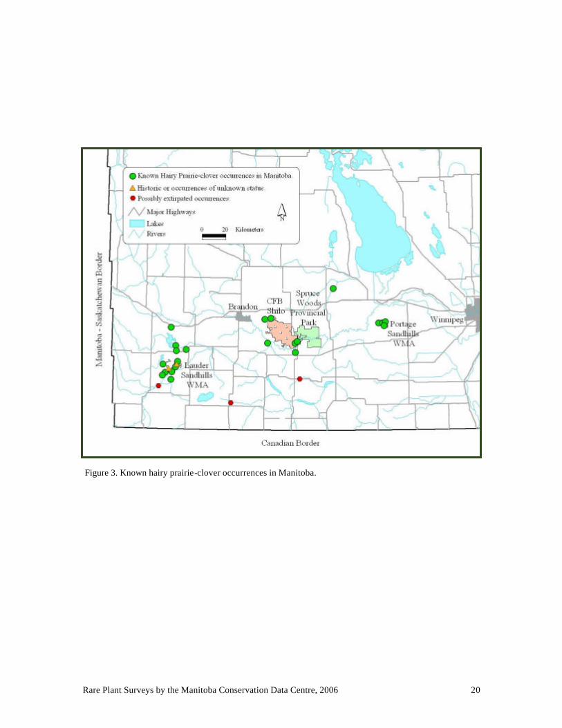
Figure 3. Known hairy prairie-clover occurrences in Manitoba.

Rare Plant Surveys by the Manitoba Conservation Data Centre, 2006 21
Northern Adder’s-tongue (Ophioglossum pusillum) NatureServe Status: G5, NNR, S1
Canada General Status: 4
Northern adder’s-tongue (family Ophioglossaceae) is a perennial fern that produces a single leaf and a single stalk that bears its reproductive spores. The indistinctive soft, green leaves can grow up to 10 cm long (Flora of North America Editorial Committee 1993). The spore-bearing stalk can grow several times the length of the leaf. The spores are held inside 10-40 pairs of spore-bearing structures on either side of the tip of the stalk. Green leaves can be found from mid-spring through to September at which time many will have turned a golden brown. This species can be very difficult to locate, but once a plant is discovered, many more may be found growing under built-up layers of graminoid vegetation.
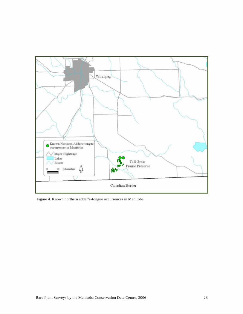
Conservation Status Northern adder’s-tongue is widespread in North America, typically occurring in open fens, marsh edges, pastures, grassy shores and roadside ditches (Flora of North America Editorial Committee 1993). Although it is ranked Secure globally (G5), 28 out of the 40 jurisdictions in which it is occurs, rank northern adder’s-tongue Historical to Uncommon (SH-S3) (NatureServe 2007). Northern adder’s-tongue is ranked Very Rare (S1) in Manitoba where only two occurrences are known (Fig. 4).
Data Collected in 2006 On July 6, a new northern adder’s-tongue occurrence was discovered approximately 3 km from the only other known occurrence in Manitoba. It was found in a pasture on provincial crown land to the northeast of the Tall Grass Prairie Preserve. Approximately 300 plants were found in three patches occupying a total area of approximately 210 m2. The patches were associated with willow clumps in an open, relatively flat area dominated by grasses and sedges. Four-flowered loosestrife (Lysimachia quadriflora), a provincially rare plant, was also observed at this site.
On September 7, the previously known occurrence on the Tall Grass Prairie Preserve was mapped in the field. The occurrence consists of two sites approximately 350 m apart that are bisected by a gravel road. One site occupies an area of approximately 340 m2 and the other occupies an area of approximately 3200 m2. The area was dry due to low rainfall in 2006 but was saturated, to inundated, when first discovered in 1997. Northern adder’s-tongue was most abundant at the edges of sedge meadow adjacent to willows. A large

Rare Plant Surveys by the Manitoba Conservation Data Centre, 2006 22
proportion of stems were found growing on small mossy hummocks hidden by graminoid vegetation. The area was estimated to contain hundreds of stems. Both new and old growth was observed. Four-flowered loosestrife and the Endangered western prairie fringed-orchid both occur at this site as well. Other similar areas in the vicinity of the two known occurrences were searched but no additional occurrences were found.
Stewardship and Future Considerations The known distribution of northern adder’s-tongue in Manitoba is restricted to a very small area of the province. The largest occurrence is on the Tall Grass Prairie Preserve and is protected. The new population discovered in 2006 is on crown land that is currently leased for grazing. The effect of grazing on northern adder’s-tongue is not known.
The Flora of North America Editorial Committee (1993) states that this small, inconspicuous fern may be much more common than collections indicate. Further searches of suitable habitat in the vicinity of the two known occurrences may result in the discovery of additional northern adder’s-tongue plants. Edges of willow clumps should be targeted during searches. Sites supporting flour- flowered loosestrife and western prairie fringed orchid could also be targeted for searches. During surveys conducted in September 2006, the golden colour of the leaves was helpful in identifying northern adder’s-tongue from a short distance. However, once leaves have begun to fall from surrounding trees and shrubs it becomes more difficult to distinguish northern adder’s-tongue at a glance.
Northern adder’s-tongue habitat (adjacent to willows) at the new occurrence discovered in 2006.
Rare Plant Surveys by the Manitoba Conservation Data Centre, 2006 23
Figure 4. Known northern adder’s-tongue occurrences in Manitoba.
Rare Plant Surveys by the Manitoba Conservation Data Centre, 2006 24
Ram’s-head Lady’s-slipper (Cypripedium arietinum) NatureServe Status: G3, N3, S2?
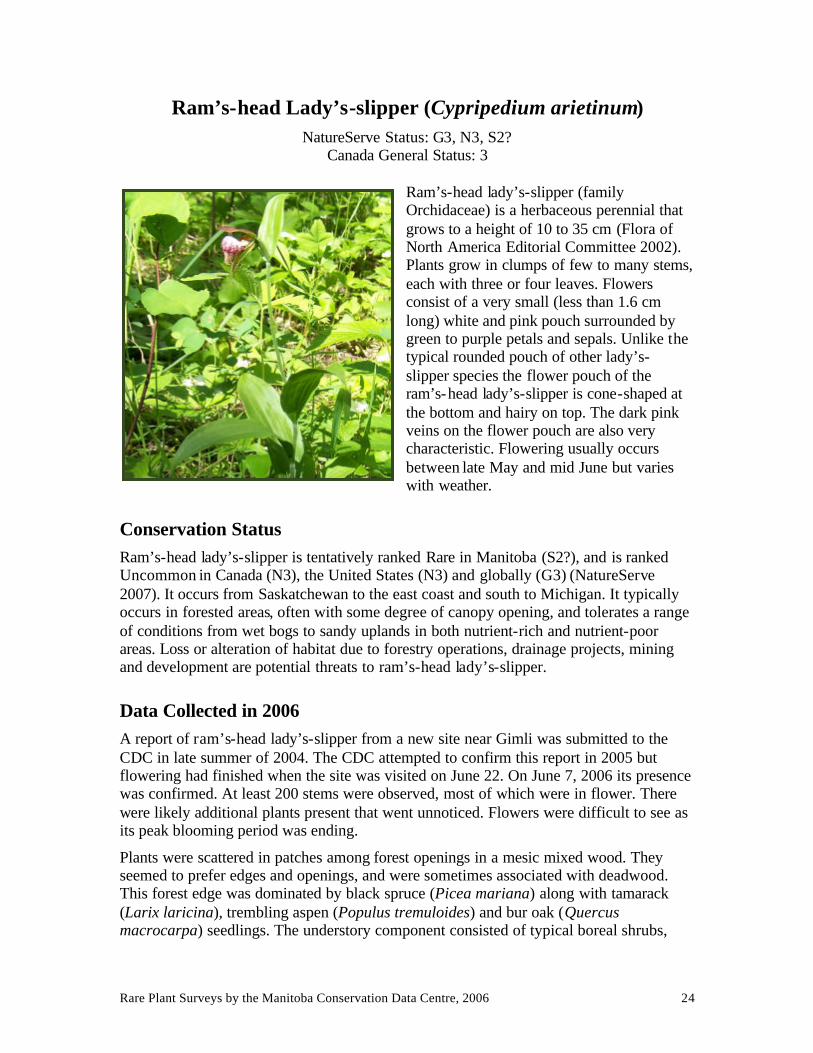
Canada General Status: 3 Ram’s-head lady’s-slipper (family Orchidaceae) is a herbaceous perennial that grows to a height of 10 to 35 cm (Flora of North America Editorial Committee 2002). Plants grow in clumps of few to many stems, each with three or four leaves. Flowers consist of a very small (less than 1.6 cm long) white and pink pouch surrounded by green to purple petals and sepals. Unlike the typical rounded pouch of other lady’s-slipper species the flower pouch of the ram’s-head lady’s-slipper is cone-shaped at the bottom and hairy on top. The dark pink veins on the flower pouch are also very characteristic. Flowering usually occurs between late May and mid June but varies with weather.
Conservation Status Ram’s-head lady’s-slipper is tentatively ranked Rare in Manitoba (S2?), and is ranked Uncommon in Canada (N3), the United States (N3) and globally (G3) (NatureServe 2007). It occurs from Saskatchewan to the east coast and south to Michigan. It typically occurs in forested areas, often with some degree of canopy opening, and tolerates a range of conditions from wet bogs to sandy uplands in both nutrient-rich and nutrient-poor areas. Loss or alteration of habitat due to forestry operations, drainage projects, mining and development are potential threats to ram’s-head lady’s-slipper.
Data Collected in 2006 A report of ram’s-head lady’s-slipper from a new site near Gimli was submitted to the CDC in late summer of 2004. The CDC attempted to confirm this report in 2005 but flowering had finished when the site was visited on June 22. On June 7, 2006 its presence was confirmed. At least 200 stems were observed, most of which were in flower. There were likely additional plants present that went unnoticed. Flowers were difficult to see as its peak blooming period was ending.
Plants were scattered in patches among forest openings in a mesic mixed wood. They seemed to prefer edges and openings, and were sometimes associated with deadwood. This forest edge was dominated by black spruce (Picea mariana) along with tamarack (Larix laricina), trembling aspen (Populus tremuloides) and bur oak (Quercus macrocarpa) seedlings. The understory component consisted of typical boreal shrubs,
Rare Plant Surveys by the Manitoba Conservation Data Centre, 2006 25
herbs and mosses with some weedy species moving in from the forest edge. The presence of shrubby cinquefoil (Dasifora fruticosa) and alder- leaved buckthorn (Rhamnus alnifolia) in the shrub layer indicated a somewhat basic or rich substrate below the forest floor.
Stewardship and Future Considerations According to the CDC the Gimli occurrence has the largest number of ram’s-head lady’s-slippers recorded at a single site in Manitoba. However, there is very little data about any of the ram’s-head lady’s-slipper sites in Manitoba, and larger populations likely exist elsewhere in the province. In addition to herbarium specimens, several reports of ram’s-head lady’s-slipper had been submitted to the CDC by NOCI (Native Orchid Conservation Inc.) in recent years. All ram’s-head lady’s-slipper records for Manitoba were reviewed and updated in the CDC’s database in 2006/2007.
There are 19 occurrences of ram’s-head lady’s-slipper known from Manitoba ranging from the southeast corner to north of Lake Winnipegosis (Fig. 5). Most occurrences are either in jack pine forest or peatlands. A few are from moist coniferous or mixed woods. Comprehensive data is lacking for most occurrences. Many are known from herbarium specimens with only location and basic habitat data. Surveys of known occurrences in Manitoba are needed, as data is lacking for this species across its range (Brzeskiewicz 2000). Collection of habitat data and monitoring of population trends is needed for the development of forestry related beneficial management practices.
Due to the wide range of habitats tolerated, its short blooming period, and very small flowers, ram’s-head lady’s-slipper may be more common than reported. Searches for unknown occurrences would be difficult as there are no unique identifying characteristics shared by habitats supporting ram’s-head lady’s-slipper (Brzeskiewicz 2000). They do tend to be found more commonly in areas with underlying basic substrates and some degree of canopy opening such as that caused by deadfall in older forests. Canopy thinning at sites being shaded out has been suggested as a management strategy and is being experimented with (NatureServe 2007). Further research is needed to determine the role of artificial canopy thinning and natural succession in the persistence of ram’s-head lady’s-slipper populations. One occurrence of ram’s-head lady’s-slipper is formally protected in Manitoba as a component of the Brokenhead Wetlands Ecological Reserve.

Rare Plant Surveys by the Manitoba Conservation Data Centre, 2006 26
Figure 5. Known ram’s-head lady’s-slipper occurrences in Manitoba.
Rare Plant Surveys by the Manitoba Conservation Data Centre, 2006 27
Silky Townsend Daisy (Townsendia exscapa) NatureServe Status: G5, NNR, S2
Canada General Status: 4
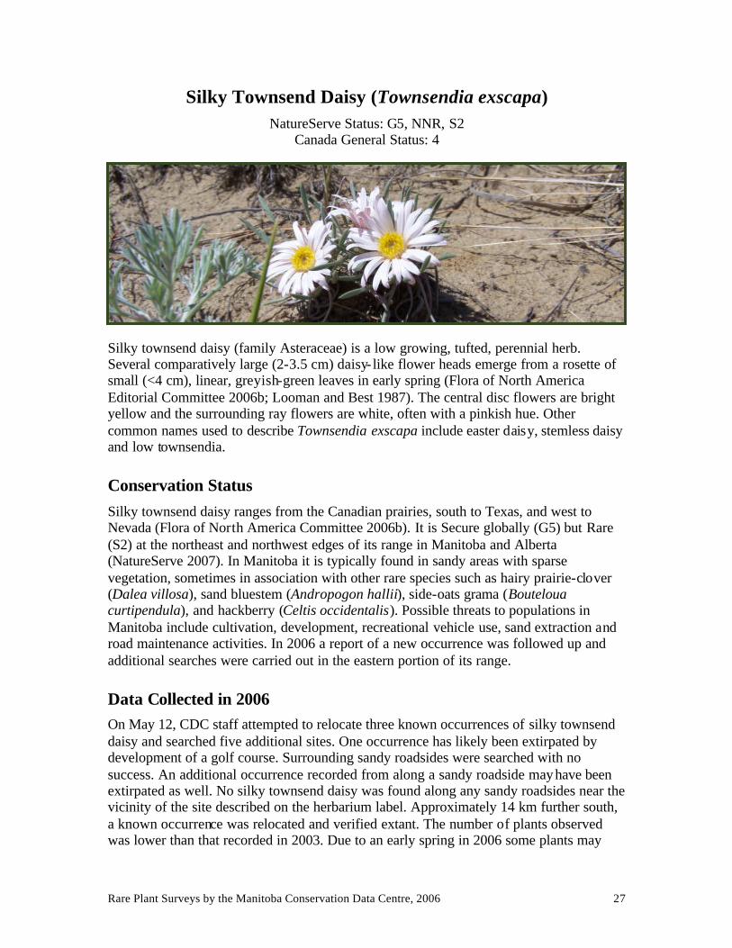
Silky townsend daisy (family Asteraceae) is a low growing, tufted, perennial herb. Several comparatively large (2-3.5 cm) daisy- like flower heads emerge from a rosette of small (<4 cm), linear, greyish-green leaves in early spring (Flora of North America Editorial Committee 2006b; Looman and Best 1987). The central disc flowers are bright yellow and the surrounding ray flowers are white, often with a pinkish hue. Other common names used to describe Townsendia exscapa include easter daisy, stemless daisy and low townsendia.
Conservation Status Silky townsend daisy ranges from the Canadian prairies, south to Texas, and west to Nevada (Flora of North America Committee 2006b). It is Secure globally (G5) but Rare (S2) at the northeast and northwest edges of its range in Manitoba and Alberta (NatureServe 2007). In Manitoba it is typically found in sandy areas with sparse vegetation, sometimes in association with other rare species such as hairy prairie-clover (Dalea villosa), sand bluestem (Andropogon hallii), side-oats grama (Bouteloua curtipendula), and hackberry (Celtis occidentalis). Possible threats to populations in Manitoba include cultivation, development, recreational vehicle use, sand extraction and road maintenance activities. In 2006 a report of a new occurrence was followed up and additional searches were carried out in the eastern portion of its range.
Data Collected in 2006 On May 12, CDC staff attempted to relocate three known occurrences of silky townsend daisy and searched five additional sites. One occurrence has likely been extirpated by development of a golf course. Surrounding sandy roadsides were searched with no success. An additional occurrence recorded from along a sandy roadside may have been extirpated as well. No silky townsend daisy was found along any sandy roadsides near the vicinity of the site described on the herbarium label. Approximately 14 km further south, a known occurrence was relocated and verified extant. The number of plants observed was lower than that recorded in 2003. Due to an early spring in 2006 some plants may

Rare Plant Surveys by the Manitoba Conservation Data Centre, 2006 28
have been missed as the peak blooming period had passed when surveyed on May 12. No silky townsend daisy was found at the additional five sites searched.
On May 17, a new occurrence reported to the CDC was surveyed and eight additional sites were searched. The new occurrence consisted of over 100 stems along a mowed sandy roadside within a town site. The area had been recently mowed but due its low growth habit, silky townsend daisy appeared to be unaffected. Herbiciding and other road maintenance activities along this roadside are a concern. No silky townsend daisy was found at any of the other eight sites searched. A conversation with one of the local landowners determined that one of the known historic occurrences has likely been extirpated by cultivation.
Stewardship and Future Considerations All silky townsend daisy records for Manitoba were reviewed and updated in the CDC’s database in 2006/2007. Thirteen occurrences are known from southwestern Manitoba, less than half of which have been verified extant within the last 40 years (Fig. 6). At least three occurrences have likely been extirpated. There is very little data associated with the older occurrences transcribed from herbarium labels. Attempts to relocate the known occurrences, in addition to searches for new occurrences, are needed to determine the current range and abundance of this species in Manitoba. It may be more common than reported as it has a very early and brief flowering period. However, it is restricted to sandhills and native sandy prairies in Manitoba, which have become increasingly uncommon due to conversion for agriculture or development. Collection of data pertaining to landscape context, degree of open sand and disturbance at silky townsend daisy sites in Manitoba would be helpful in ascertaining current threats to this species and in directing future searches. As with other remnant native prairie species, awareness of roadside occurrences is needed for the mitigation of road maintenance activities that have the potential to damage populations of silky townsend daisy.

Rare Plant Surveys by the Manitoba Conservation Data Centre, 2006 29
Figure 6. Known silky townsend daisy occurrences in Manitoba.
Rare Plant Surveys by the Manitoba Conservation Data Centre, 2006 30
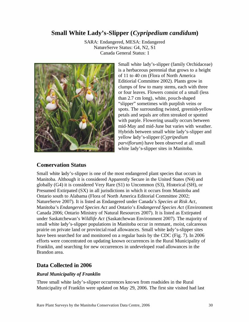
Small White Lady’s-Slipper (Cypripedium candidum) SARA: Endangered, MESA: Endangered
NatureServe Status: G4, N2, S1 Canada General Status: 1
Small white lady’s-slipper (family Orchidaceae) is a herbaceous perennial that grows to a height of 11 to 40 cm (Flora of North America Editiorial Committee 2002). Plants grow in clumps of few to many stems, each with three or four leaves. Flowers consist of a small (less than 2.7 cm long), white, pouch-shaped “slipper” sometimes with purplish veins or spots. The surrounding twisted, greenish-yellow petals and sepals are often streaked or spotted with purple. Flowering usually occurs between mid-May and mid-June but varies with weather. Hybrids between small white lady’s-slipper and yellow lady’s-slipper (Cypripedium parviflorum) have been observed at all small white lady’s-slipper sites in Manitoba.
Conservation Status Small white lady’s-slipper is one of the most endangered plant species that occurs in Manitoba. Although it is considered Apparently Secure in the United States (N4) and globally (G4) it is considered Very Rare (S1) to Uncommon (S3), Historical (SH), or Presumed Extirpated (SX) in all jurisdictions in which it occurs from Manitoba and Ontario south to Alabama (Flora of North America Editorial Committee 2002; NatureServe 2007). It is listed as Endangered under Canada’s Species at Risk Act, Manitoba’s Endangered Species Act and Ontario’s Endangered Species Act (Environment Canada 2006; Ontario Ministry of Natural Resources 2007). It is listed as Extirpated under Saskatchewan’s Wildlife Act (Saskatchewan Environment 2007). The majority of small white lady’s-slipper populations in Manitoba occur in remnant, moist, calcareous prairie on private land or provincial road allowances. Small white lady’s-slipper sites have been searched for and monitored on a regular basis by the CDC (Fig. 7). In 2006 efforts were concentrated on updating known occurrences in the Rural Municipality of Franklin, and searching for new occurrences in undeveloped road allowances in the Brandon area.
Data Collected in 2006 Rural Municipality of Franklin
Three small white lady’s-slipper occurrences known from roadsides in the Rural Municipality of Franklin were updated on May 29, 2006. The first site visited had last

Rare Plant Surveys by the Manitoba Conservation Data Centre, 2006 31
been surveyed in 2000, at which time eight flowering stems were observed and no hybridization with yellow lady’s-slippers was observed. In 2006 the number of flowering stems observed was higher but hybridization was suspected, although it was difficult to distinguish between pure white and hybrid flowers. Of the 39 stems observed in 2006, 10 were flowering and 15 flowers were aborted. The relatively high number of aborted flowers may have been a reflection of non-viable flowers produced through hybridization, or a response to lower than average precipitation in the spring of 2006.
The other two sites had last been visited in 2001. One of these had 20-30 flowering stems with no hybridization observed in 2001. In 2006 the number of flowering stems observed was higher but hybridization was observed. A total of 141 stems were counted with 67 flowering, at least 11 of which were hybrids. Twelve aborted flowers were observed.
At the third site, 74 stems with 57 flowers were observed along the road in 2000. Hybridization was noted as well. In 2001 only a few flowers were observed in an adjacent field but none were observed along the road. In 2006 no small white lady’s-slipper flowers were observed along the road or in the adjacent field. Some lady’s-slipper stems were beginning to emerge, some of which may have been small white lady’s-slippers. Emergence of lady’s-slippers at this site may have been late due to a heavy build up of thatch.
Brandon Area
In the spring of 2006, the CDC was made aware of a possible opportunity to formally close undeveloped road allowances containing small white lady’s-slippers south of Brandon. Only one undeveloped road allowance had been known to contain small white lady’s-slippers, in 1997. One additional small white lady’s-slipper occurrence, observed in 1997 and 1998, was adjacent to an undeveloped road allowance. Searches of these sites in 2004 were unsuccessful. On May 30 and June 8, 2006 seven road allowances were visited, including the above. Two road allowances had been developed and one was being developed. Of the four remaining undeveloped road allowances searched, only one was found to support one lone small white lady’s-slipper. It was the same road allowance in which three patches of small white lady’s-slippers were observed in 1997. In 2006 several suitable areas were observed along this mile long stretch that may still support dormant small white lady’s-slipper plants. Small white lady’s-slipper plants have been known to lie dormant for up to six years (Shefferson 2006). Trampling by cattle was observed in this road allowance in 2004. This site remains unprotected.
On June 8, a previously known occurrence on rural municipality land was visited and extended to include a larger area containing small white lady’s-slippers. This site contained a bewildering array of sizes and colours produced by hybridization with large and small yellow lady’s-slippers (Cypripedium parviflorum var. pubescens and var. makasin). The blooming period was coming to an end and flowers were beginning to fade and turn brown. Although it was difficult to distinguish between pure white and hybrid flowers, hybrid and yellow lady’s-slippers definitely outnumbered pure small white lady’s-slippers.

Rare Plant Surveys by the Manitoba Conservation Data Centre, 2006 32
Stewardship and Future Considerations Loss of native prairie to agriculture or development has drastically reduced the amount of suitable habitat available to support small white lady’s-slipper populations in Manitoba. Road maintenance activities, drainage projects and competition from woody and weedy species threaten the survival of our remnant populations. Furthermore the natural process of hybridization between small white lady’s-slippers and yellow lady’s-slippers is increasingly indicating potential detrimental effects upon the viability of pure small white lady’s-slipper populations in Manitoba. Hybrid lady’s-slippers are produced at a cost to pure small white lady’s-slippers by usurping flowers that may have produced pure plants in the absence of yellow lady’s-slippers. The hybrid plants then compete with pure plants for limiting resources with potentially devastating effects on the pure population. This may be particularly true for hybridization with yellow lady’s-slippers which tend to be more abundant and robust than small white lady’s-slippers.
Levin et al. (1996) proposed that rare plant conservation programs should attempt to isolate rare plant species from plant species with which they are capable of producing hybrids. Conversely, Klier et al. (1991) contend that removal of hybrids and yellow lady’s-slippers is not a viable option at sites in Iowa as pure small white- lady’s-slippers may no longer exist there and genetic analysis may be required to positively identify pure small white lady’s-slippers. Alternatively, a selection of small white lady’s-slippers could be transplanted to “safe sites” away from yellow lady’s-slippers in an attempt to maintain genetic integrity. These alternatives raise the question of when the line is crossed from assisting in the preservation of nature to fighting against natural processes. Hybridization may be a natural evolutionary adaptation to less than ideal conditions in a changing landscape. Some jurisdictions, such as Ontario, have ranked small white lady’s-slipper hybrids as Critically Imperiled rather than the traditional ranking of a Hybrid without Conservation Value (NatureServe 2007).
Prioritization of sites to be surveyed on a regular basis and standardization of monitoring techniques is needed for this species in particular. In addition to monitoring degree of hybridization, population numbers can fluctuate greatly with climate and other factors.
Many of Manitoba’s small white lady’s-slipper populations occur in remnant native prairie along roadsides in the Rural Municipalities of Franklin and Stuartburn near the Tall Grass Prairie Preserve in southern Manitoba. Maps have been provided to relevant agencies in those areas that outline periods when maintenance activities should be avoided along road allowances containing small white lady’s-slippers.
An opportunity for hybridization.

Rare Plant Surveys by the Manitoba Conservation Data Centre, 2006 33
Figure 5. Known small white lady’s-slipper occurrences in Manitoba.

Rare Plant Surveys by the Manitoba Conservation Data Centre, 2006 34
Western Silvery Aster (Symphyotrichum sericeum)
SARA: Threatened, MESA: Threatened NatureServe Status: G5, N2, S2
Canada General Status: 1
Western silvery aster (family Asteraceae) is a multi-stemmed perennial that grows to a height of 30-70 cm (Flora of North America Editorial Committee 2006b). It is distinguished from similar asters by its silvery, silky ha iry leaves. The leaves at the base of its woody stems often wither and fall before flowering giving it a wiry appearance. Flower heads are violet to purple and appear singly, or in clusters, at branch tips in late August. Western silvery aster was previous ly classified as Aster serecius.
Conservation Status Western silvery aster is widespread from Texas through the midwestern United States north to Canada (Flora of North America Editorial Committee 2006b). It is tentatively ranked Secure in the United States (N5?) and is ranked Secure globally (S5) but becomes more rare at the northern and eastern edges of its range (NatureServe 2007). Western silvery aster is listed as Threatened under Canada’s Species at Risk Act and Manitoba’s Endangered Species Act (Environment Canada 2006). It is listed as Endangered in Ontario, the only other Canadian province in which it occurs (Ontario Ministry of Natural Resources 2006). In Manitoba western silvery aster occurs in prairies and woodland openings on well drained, gravely or sandy, calcareous soils. Most of Manitoba’s known occurrences are on private land or provincial road allowances.
Data Collected in 2006 Richer area
In May of 2006, a new western silvery aster occurrence east of Richer, Manitoba was reported to the CDC (M. Latta, pers. comm.). This occurrence is approximately 40 km away from any other known occurrence of this species. On August 29, the site was re-visited to confirm the identity of western silvery aster while in bloom. The occurrence is intersected by two gravel roads and extends approximately 700 m by 300 m. Plants occurred along roadsides and in adjacent fields. The entire occurrence was not surveyed in 2006 as permission had not been sought to survey adjacent fields. The roadsides were estimated to contain well over 1 000 stems but adjacent fields also had abundant populations. Nearby areas with similar soil types were searched but no additional populations were discovered.

Rare Plant Surveys by the Manitoba Conservation Data Centre, 2006 35
Other occurrences submitted to the CDC
In 2006, Tall Grass Prairie Preserve staff reported one new roadside occurrence near the preserve consisting of seven plants (L. Reeves, pers. comm). The surrounding fields were cultivated and/or hayed. An additional new occurrence in the Rural Municipality of De Sallaberry was reported to the CDC as part of a project aimed at finding new occurrences based on geologic data (D. Collicutt and J. Joyce, pers. comm). Four known occurrences were also verified extant during the above project in the Rural Municipalities of Franklin and Stuartburn. The latter five occurrences ranged in size from approximately 30 to over 1 000 plants.
Factors Affecting Recovery and Future Considerations Western silvery aster faces similar threats as other prairie species at risk. Tree and shrub encroachment into open prairie habitat is a potential threat. Roadside occurrences are threatened by road maintenance activities. Road allowance maps highlighting sensitive areas and times have been produced for both the Rural Municipalities of Franklin and Stuartburn. An additional threat to western silvery aster is gravel extraction. A large number of Manitoba’s western silvery aster populations occur in the vicinity of gravel pits. The degree to which western silvery aster is able to re-colonize these areas has not been documented. Several occurrences also occur in pastures. Western silvery aster’s response to grazing is currently unknown. Known western silvery aster sites in Manitoba should be prioritized for regular surveys to determine responses to perceived threats and provide information for the development of beneficial management practices.
New road allowance occurrence of western silvery aster near Richer.

Rare Plant Surveys by the Manitoba Conservation Data Centre, 2006 36
Figure 5. Known western silvery aster occurrences in Manitoba.

Rare Plant Surveys by the Manitoba Conservation Data Centre, 2006 37
Other Rare and Uncommon Species Surveyed Other rare and uncommon species surveyed by the CDC and associates are given in Table 2. While conducting surveys of the eight species discussed previously, several occurrences of other rare and uncommon species were documented by the CDC as follows.
CDC Surveys of other Rare and Uncommon Species Slender agalinis (Agalinis tenuifolia)
Slender agalinis is a provincially Rare to Uncommon (S2S3) pink flowered, hemiparasitic, annual herb that reaches the northeast limit of its range in Manitoba. Four slender agalinis sites were found while searching for western silvery aster and northern adder’s-tongue. Three sites observed in the vicinity of northern adder’s-tongue resulted in the extension of a previously known slender agalinis occurrence from one site of a few square metres to four sites encompassing an area of approximately 70 ha. The abundance of slender agalinis within the area between the four sites is not currently known. The fourth slender agalinis site found in a gravel pit, while searching for western silvery aster, is a new occurrence.
Rough agalinis (Agalinis aspera)
Rough agalinis was listed as Endangered under Canada’s Species at Risk Act in April 2006. Manitoba is the only Canadian province in which it occurs. It differs from the above species in that it is very rough to the touch and has larger flowers. Limited fieldwork has been done on this species in Manitoba, where it has been observed in flower from the end of July to the beginning of September. In Manitoba it has most often been observed in moist, calcareous prairie although further south it is known from drier habitats.
In 2006, three sites previously known to contain rough agalinis were visited on August 31 in conjunction with searches for western silvery aster. Rough agalinis was found at only one site. Only a few plants were found and they had finished blooming. During a 2004 visit to this site, 25-30 plants were recorded on August 28 but plants had been mowed by September 10, destroying many seed capsules (Hughes 2006). This site had been mowed prior to the site visit on August 31, 2006.
In 2004, the other two sites revisited contained 20 plants blooming from Augus t 22 to September 10, and eight plants in bud and bloom on August 16. Failure to find plants at either of these sites in 2006 may have been due to its inconspicuous nature when not in bloom. Slender agalinis populations may have had lower abundance or flowering in 2006 due to abnormally dry weather. It is also possible that slender agalinis has been extirpated from the exact locations where previously recorded as it is an annual species and has been known to “move around”.
Rough Agalinis Photo by Marjorie Hughes

Rare Plant Surveys by the Manitoba Conservation Data Centre, 2006 38
Two sites known to support small white lady’s-slipper were also searched for slender agalinis on August 31, 2006, as the two species have been observed to co-occur at another site in Manitoba. No slender agalinis was found. One site appeared more appropriate than the other but it had been mowed prior to the site visit. Further information on the average peak blooming period, host plants, and range of habitat conditions suitable for this species in Manitoba is needed.
Narrow-leaved Puccoon (Lithospermum incisum)
Narrow-leaved puccoon is provincially Uncommon (S3). One known occurrence of this small herb with yellow fringed flowers was updated at a small white lady’s-slipper site south of Brandon.
Canada moonseed (Menispermum canadense)
Two fascicled ironweed sites along the Rat River were found to support Canada moonseed, a provincially Uncommon (S3), woody vine that reaches the northeast limit of its range in Manitoba. The two moonseed sites constitute one occurrence as they were less than 2 km apart with appropriate intervening riverbank habitat that may support additional Canada moonseed plants.
Southwestern and Sandhill Species
Several rare and uncommon species were observed while conducting surveys in the sandhills and mixed grass prairie of southwestern Manitoba.
Pincushion cactus (Coryphantha vivipara)
Six occurrences of this provincially Rare (S2) cactus, which reaches the northeast limit of its range in Manitoba, were found while searching for silky townsend daisy, buffalograss and hairy prairie-clover. One was an update of a previously known occurrence and the others were newly discovered.
Western Spiderwort (Tradescantia occidentalis)
Western spiderwort is listed as Threatened under Canada’s Species at Risk Act and Manitoba’s Endangered Species Act. It co-occurs with hairy prairie-clover at some locations and was searched for during surveys of hairy prairie-clover in 2006, although western spiderwort blooms earlier and is difficult to see without flowers. One occurrence was updated during hairy prairie-clover surveys. Only a two plants were found in bloom on August 1. Manitoba’s western spiderwort data will be reviewed and updated for drafting of a national recovery strategy in 2007.
Hackberry (Celtis occidentalis)
This provincially Rare (S2) tree reaches the northeast limit of its range in Manitoba. One occurrence was updated during hairy prairie-clover surveys at the same site where western spiderwort was observed.
Pincushion cactus

Rare Plant Surveys by the Manitoba Conservation Data Centre, 2006 39
Sand Bluestem (Andropogon hallii)
In Canada native populations of sand bluestem only occur in Manitoba, where it is ranked Rare (S2). One occurrence was updated during hairy prairie-clover surveys.
Schweinitz's Flatsedge (Cyperus shweinitzii)
This sedge is Rare (S2) in Manitoba and has been given a Canadian General Status rank of Sensitive (3). It often occurs with hairy prairie-clover and western spiderwort. Three Schweinetz’s flatsedge sites were found during hairy prairie-clover surveys. All three sites constituted updates of two previously known occurrences.
Peatland Species
Three surveys of peatlands were conducted by the CDC in cooperation with members of the Manitoba Association of Plant Biologists. They all had characteristics of calcareous fens, a rare type of peatland similar to bogs but typically richer in nutrients. Rare and/or uncommon species were observed at all three. Whitemouth Bog, near Whiteshell Provincial Park, was visited on June 16. Information collected was provided to Manitoba’s Ecological Reserves Program for a nomination proposing Ecological Reserve Status. Fish Lake and Silver Bog, in the Interlake, were visited on June 17. Efforts to give these areas some form of protection are ongoing.
Showy Lady’s-slipper (Cypripedium reginae)
This orchid is considered Uncommon (S3) in Manitoba. At highly visible sites plants are threatened by picking or digging. Showy lady’s-slipper stems can grow to a height of 90 cm and the slippers can grow larger than 5 cm (Flora of North America Editiorial Committee 2002). Vigorous plants were observed at all three peatlands visited in 2006. It was also observed while surveying ram’s-head lady’s-slipper near Gimli.
Horned Bladderwort (Utricularia cornuta) and Lesser Bladderwort (Utricularia minor)
These provincially Uncommon (S3) carnivorous plants use tiny bladders to trap tiny insects and microscopic organisms from peat, mud or shallow water. Both have yellow flowers but those of horned bladderwort are much larger (15-15 mm) than those of lesser bladderwort (<8 mm) (Looman and Best 1987). Two more common species of bladderwort occur in Manitoba. They also have yellow flowers and may be confused with the rarer species. Both horned bladderwort and lesser bladderwort were found growing at Silver Bog. The other two, more common species, were found at Fish Lake.
English Sundew (Drosera anglica)
English sundew is another provincially Uncommon (S3) carnivorous plant. It traps insects in the sticky red hairs of its leaves. Two other sundew species occur in Manitoba.
Showy lady’s-slipper at Fish Lake.

Rare Plant Surveys by the Manitoba Conservation Data Centre, 2006 40
One is common and has rounder leaves while the other is more rare and has narrower linear leaves. The leaves of English sundew are spoon shaped. English sundew was found at both Fish Lake and Silver Bog. All three sundews have been recorded at Whitemouth Bog but the rarer ones were not observed during 2006 surveys.
Smooth Twigrush (Cladium mariscoides)
Despite its common name, smooth twigrush belongs to the sedge family (Cyperaceae), not the rush family (Juncaceae). It is considered Rare (S2) in Manitoba where few occurrences are known, predominantly from calcareous fens in the southeastern portion of the province. Several plants were observed at the edge of the Fish Lake peatlands on a floating mat in an open area dominated by graminoids. When collected on June 17, 2006 the flower heads were a golden yellow.
Bog Goldenrod (Solidago uliginosa)
In Manitoba, this provincially Uncommon (S3) goldenrod is restricted to wetlands in the eastern portion of the province where it reaches the western limit of its range (Flora of North America Editorial Committee 2006b). A few plants were observed in the same location in Whitemouth Bog as previously recorded by the CDC in 2003. The plants had not yet flowered when visited on June 16, 2006.
Pretty Shooting Star (Dodecatheon pulchellum var. pulchellum)
This herb was found in an open meadow between deciduous woods and marsh on the way to the Fish Lake peatlands. Plants were scattered for approximately 1 km. There has been some taxonomic confusion regarding this genus in Manitoba. Recent revisions to the genus have determined that Dodecatheon Pulchellum var. pulchellum is the taxon that occurs in Manitoba (Reveal 2006). Pretty shooting star is a westerly species that reaches the northeast limit of its range in southeastern Manitoba. It is currently considered Uncommon (S3) in Manitoba.
New Plant Records for Manitoba Clustered Burreed (Sparganium glomeratum)
Specimens of this aquatic plant were collected for the first time in Manitoba by Tom Reaume and Kevin Szwaluk at Pine Falls in the beginning of July, 2006. About 10 plants were reported. It is a circumboreal species that appears to be rare in North America (Flora of North America Editorial Committee 2000). Its Canada General Status rank is May Be At Risk (2).
Blunt-lobed Moonwort (Botrychium oneidense) and Prairie Moonwort (Botrychium campestre)
These two species are very small, primitive ferns. Both were first identified as occurring in Manitoba by Richard Staniforth from the University of Winnipeg and were reported to the CDC in 2006. Blunt-lobed moonwort was first discovered in Whiteshell Provincial Park on June 9, 2001. It was collected from a shaded moist ditch with waterlogged organic soil in association with lady fern (Athyrium felix-femina). The site is threatened by ditch cleaning. It had been backhoed to improve drainage at the time of collection.

Rare Plant Surveys by the Manitoba Conservation Data Centre, 2006 41
Prair ie moonwort was first observed on June 3, 2005 and again on June 3, 2006 in Birds Hill Provincial Park. Above ground parts were collected in 2005 after sporulation. It reappeared in the same place in 2006. Above ground parts were dead and decomposed by June 28. The site was an open, weedy, sandy edge of a path bordering deciduous woods. Brush removal, path edge maintenance and trampling are threats at this site.
Both species have relatively small global ranges. The blunt- lobed moonwort occurrence indicates a range extension to the north-west. The Canada General Status ranks are Sensitive (3) and May Be At Risk (2) for blunt-lobed moonwort and Prairie moonwort respectively.
Data from Tall Grass Prairie Preserve Staff In 2006, Tall Grass Prairie Preserve Staff submitted data on eight rare plant species from 36 sites.
Culver’s Root (Veronicastrum virginicum)
This provincially Threatened plant was surveyed at six sites resulting in the discovery of three new occurrences and the update of two known occurrences. A total of over 400 flowering stems were estimated. Culver’s-root occurred with four-flowered loosestrife at two of the sites surveyed.
Four-flowered Loosestrife (Lysimachia quadriflora)
This provincially Rare (S2) yellow flowered herb was observed at six sites while surveying northern adder’s-tongue, western prair ie fringed orchid, Riddell’s goldenrod and Culver’s-root. Three new occurrences were documented and two known occurrences were updated.
Riddell’s Goldenrod (Solidago riddellii)
This aster, which is listed as Special Concern in Canada and Threatened in Manitoba, co-occurred with four-flowered loosestrife resulting in the update of four known Riddell’s goldenrod occurrences. Both Riddell’s goldenrod and four-flowered loosestrife were abundant in areas surveyed.
Rigid sedge (Carex tetanica)
This provincially Rare (S2) sedge has also been givern a Canada General Status rank of Sensitive (3). It was recorded at three sites while surveying Riddell’s goldenrod, four-flowered loosestrife and two-flowered dwarf dandelion, resulting in one new occurrence and two updated occurrences.
Two-flowered Dwarf Dandelion (Krigia biflora)
This herb is Rare in Manitoba (S2) and in Canada (N2). It was observed at one known occurrence in 2006 along with Culver’s-root, Riddell’s goldenrod, four- flowered loosestrife and two-flowered dwarf dandelion.
Prairie Moonwort Photo by Richard Staniforth

Rare Plant Surveys by the Manitoba Conservation Data Centre, 2006 42
Great Plains Ladies’-tresses (Spiranthes magnicamporum)
This small fragrant orchid is listed as Threatened in Manitoba. All but one of the known Great Plains ladies’-tresses sites were surveyed by Tall Grass Prairie Preserve staff. In general the number of flowering stems observed in 2006 was much lower than in previous years, possibly due to the abnormally dry summer. A total of 747 flowering stems were counted. One new occurrence was found at which 95 flowering stems were counted.
Western Prairie Fringed-orchid (Platanthera praeclara)
This large showy orchid is listed as Endangered in Manitoba and in Canada. Manitoba is the only Canadian Province in which it occurs. Tall Grass Prairie Preserve staff extended the largest of Manitoba’s two occurrences to include an additional site supporting 36 flowering stems in 2006.
Spotted Crane’s-bill (Geranium maculatum)
This geranium is Very Rare (S1) in Manitoba. Only two relatively small occurrences are known within 3 km of each other. One occurrence was updated in 2006. The area had been disturbed but the plants were surviving and will continue to be monitored. The site has been flagged to prevent further impacts.
Spotted crane’s-bill.
Rare Plant Surveys by the Manitoba Conservation Data Centre, 2006 43
Information Sharing and Stewardship Initiatives
Road Allowance Maps Many of Manitoba’s species at risk occur in agricultural landscapes and are most often found in remnant native prairie that persists along roadsides. These roadside prairies may also act as corridors between larger populations. In the absence of historical, natural disturbance regimes such as fire and grazing, encroachment by trees and shrubs may alter prairie habitats to the detriment of species at risk. Mowing at appropriate times may benefit prairie species by preventing encroachment, but mowing during reproductive periods may prevent flowering and seed dispersal. In addition to mowing during sensitive periods, road maintenance activities such as herbicide application, ditch clearing for drainage, and installation of utility lines are potential threats to roadside occurrences. In an effort to increase awareness and mitigate potentially damaging activities, the CDC has produced wall maps that indicate rare species occurrences along road allowances for two rural municipalities.
Road allowances in the Rural Municipality of Franklin support five legally listed plant species: western silvery aster, small white lady’s-slipper, Culver’s-root, Riddell’s goldenrod and Great Plains ladies’-tresses. A wall map that highlights road allowances supporting rare plants has been provided to the Rural Municipality of Franklin and was used to mitigate mowing activities in 2006 (RM of Franklin, pers. comm.). Copies of the Manitoba’s Species at Risk fact sheet series were also provided. Additional copies of the map have been produced for Manitoba Infrastructure and Transportation, and the Wildlife and Ecosystem Protection Branch Regional and District offices. Smaller laminated maps to be used by councillors or that can be taken into the field by road maintenance personnel have also been requested and provided to the Rural Municipality of Franklin.
Road allowances in the adjacent Rural Municipality of Stuartburn support the same five legally listed plant species as the Rural Municipality of Franklin, in addition to the globally Uncommon (G3), and nationally Endangered, western prairie fringed-orchid. A wall map similar to the one produced for the Rural Municipality of Franklin has been produced for the Rural Municipality of Stuartburn, Manitoba Infrastructure and Transportation, the Piney and Stuartburn Weed District, and the Wildlife and Ecosystem Protection Branch Regional and District offices. Feedback on the use of these maps and suggestions for improvements will be sought by the CDC in the fall of 2007.
Following rare plant presentations delivered to the Manitoba Weed Supervisors Association in 2006 and 2007, members indicated interest in receiving information on rare species, particularly in a form that can be used in the field. Copies of small road allowance maps that can be laminated and taken into the field should be provided to relevant weed districts and other agencies involved with weed management. According to the Manitoba Weed Supervisors Association development of more field friendly information on each rare species is also needed. Small cards that can be laminated, with a colour picture and a brief description of each plant and its habitat, would be suitable for assisting weed managers in identifying rare plants.

Rare Plant Surveys by the Manitoba Conservation Data Centre, 2006 44
Landowner Interviews As natural disturbances, such as fire and grazing by native ungulates such as bison, are replaced by agriculture and development some guidance is needed to assist stewards in the management and protection of species at risk. Development of beneficial management practices for species at risk is a priority at regional and national levels. Rare species surveys are limited in the type of information acquired and often lead to further unanswered questions about what is benefiting a particular species. Little is known about past and present management practices on private lands that support species at risk in Manitoba. For example, it is generally accepted that buffalograss is well adapted to grazing but the response of buffalograss to different grazing regimes in Manitoba is not known. Some disturbance, such as that caused by grazing, also appears to be beneficial to other species at risk such as hairy prairie-clover. Knowledge of grazing regimes and other activities on lands that support species at risk is needed to help develop beneficial management practices.
In 2006, the CDC began an interview process to gather additional information on private lands supporting species at risk. Interview questions developed by the Mixed-grass Prairie Inventory Program were helpful in developing private landowner interview questions. Landowners with property supporting buffalograss and hairy prairie-clover that were surveyed in 2006, were interviewed about grazing practices and other issues such as observations of vegetation encroachment, leafy spurge management, burn history and awareness of Conservation Agreements. Landowners and a rural municipality with property supporting fascicled ironweed were questioned about flood history.
Interviews were brief, lasting approximately five to ten minutes, and were conducted by phone following field visits. All landowners were generous with their time and provided insightful comments. Future interviews could include additional questions with further details. Following interviews, letters outlining field survey results were sent to landowners. Depending on the issues concerning each landowner, additional relevant extension materials were included with the letters. Extension materials used in 2006 include:
Leaving a legacy - Donating Land or Conservation Agreements for Wildlife (Manitoba Habitat Heritage Corporation)
A Landowner’s Guide to Conservation Agreements (Manitoba Habitat Heritage Corporation)
Species at Risk Information for Producers (Canadian Cattlemen’s Association)
Species at Risk - A guide to Canada’s species at risk in the Prairies (Environment Canada, Canadian Wildlife Service)
Leafy Spurge Prevention and Control (Leafy Spurge Stakeholders Group)
In previous years, relevant material from Manitoba’s Species at Risk fact sheet series has been provided. Fact sheets for buffalograss and hairy prairie-clover were produced in March 2007. Information on grazing agreements could also be provided in appropriate situations.

Rare Plant Surveys by the Manitoba Conservation Data Centre, 2006 45
Information Sharing and Stewardship Recommendations Information gathered by the CDC in 2006/2007 was provided to numerous agencies. Updated GIS shape files of Manitoba’s rare species, with associated data, was provided to the Manitoba Habitat Heritage Corporation to assist with signing of Conservation Agreements on private land. A data exchange with NatureServe headquarters was initiated in March 2007. Canadian Wildlife Service, Environment Canada was provided with maps, tables and feedback for the development of national recovery strategies for buffalograss and hairy prair ie-clover. Information on plant distributions and conservation status ranks was also provided to the Canadian Wildlife Service for the General Status of Species in Canada project. Results of field surveys were provided to Manitoba’s Ecological Reserves Program for the nomination of Whitemouth Bog for Ecological Reserve Status. Maps highlighting road allowances supporting rare species were provided to the Rural Municipality of Franklin for use by councillors and road maintenance personnel. Private landowners were given survey results and additional information such as known habitat preferences and threats.
Copies of this report will be provided to relevant conservation districts, conservation data centres, rural municipalities, and regional and district offices of the Wildlife and Ecosystem Protection Branch, Manitoba Conservation. Other agencies to receive copies include Environment Canada, Manitoba Habitat Heritage Corporation, Manitoba Parks and Natural Areas, Manitoba Infrastructure and Transportation, NatureServe Canada, Committee on the Status of Endangered Wildlife in Canada, The Manitoba Museum, the Universities of Manitoba and Winnipeg, Manitoba Weed Supervisors Association and the Leafy Spurge Stakeholders Group.
In addition to providing rare species information to educate and raise awareness, future stewardship activities should build on information gathered through discussions with stakeholders such as landowners and managers. In addition to providing essential information for the development of beneficial management practices, two-way information sharing with landowners can instil a sense of pride and involvement. Concerns shared by both landowners and species at risk such as drought, flooding and invasive species should be stressed and opportunities for collaboration with stakeholders should be pursued. Landowners should also be presented with options. Where Conservation Agreements may not be possible, grazing agreements may be appropriate for some species.
The issue of species at risk is just one component of the larger issue of ecosystem conservation and global sustainability. With limited resources, effective protection for species at risk could be bolstered by partnerships among agencies with complimentary goals. Coordination and collaboration of efforts can prevent duplication and promote long-term programming. Partnerships with agencies involved with invasive species management have the potential to address threats from both invasive species and herbicide application or other management activities. Feedback regarding rare species mitigation measures employed by such agencies may also assist with development of beneficial management practices.

Rare Plant Surveys by the Manitoba Conservation Data Centre, 2006 46
As in other jurisdictions, Manitoba has recognized a need for species-specific mitigation measures and management recommendations that can be used in a variety of instances, from environmental assessments to pasture management for species at risk. Beneficial management practices for several pilot prairie species at risk are currently being developed with involvement of key stakeholders including Environment Canada, Agri-Food and Agriculture Canada, and Provincial agencies. Set-back distance and timing restriction guidelines for prairie plant species at risk are also being developed by Environment Canada. Protection and management information has been prepared for some species by NatureServe and other CDCs. Manitoba should build upon existing information to the extent possible. The CDC can provide regional information to help develop products relevant to Manitoba, modify existing guidelines for use in Manitoba if necessary, and use accepted guidelines for development of management practices for species at risk not addressed by other agencies.
Accurate, current scientific data, in combination with land management information gathered from land owners, is the foundation for effective stewardship and future recovery activities. With the development of the first national recovery strategies under Canada’s Species at Risk Act, information needs have been outlined and prioritized. Development of standardized inventory and monitoring guidelines, and prioritization of sites for protection are two recommended activities. Due to limited resources available for estimating plant abundance and mapping large populations, prioritization of sites for inventory and monitoring is also necessary in Manitoba. Priority sites should be representative of each region of Manitoba in which the species of interest occurs and should include sites with different threats and management regimes for comparison purposes. Rare plant survey guidelines are currently being developed by Environment Canada with input from CDCs and other experts. Regular, standardized monitoring of priority sites would allow for comparisons between jurisdictions as well as detection of population trends. Together with management information, data on population trends will help guide development of beneficial management practices aimed at effectively protecting our species at risk.

Rare Plant Surveys by the Manitoba Conservation Data Centre, 2006 47
Literature Cited Albertson, F.W. and Tomanek, G. W. 1965. Vegetation Changes During a 30-Year
Period in Grassland Communities Near Hays, Kansas. Ecology 46(5): 714-720.
Barnes, J. 1999. The rapid growth of a population of reed canarygrass (Phalaris arundinacea L.) and its impact on some riverbottom herbs. J. Tor. Bot. Soc. 126(2): 133-138.
Brandes, D. 2000. Dynamics of riparian vegetation: The example of Rumex stenophyllus Ledeb. Braunschweig University Library. http://www.digibib.tu-bs.de/?docid=00001130. Accessed November 14, 2006.
Burns, J.F. and Cusick, A.W. 1983. Vernonia fasciculata. Ohio Department of Natural Resources. http://www.ohiodnr.com/dnap/Abstracts/U-V/vernfasc.htm. Accessed November 14, 2006.
Canadian Endangered Species Conservation Council. 2006. Wild Species 2005: The General Status of Species in Canada. Available in French under title: Espèces Sauvages 2005 : La situation générale des espèces au Canada. http://www.wildspecies.ca/wildspecies2005/index.cfm?lang=e. Accessed March 8, 2007.
Cavendar, N. 2004. Butterfly habitat creation at the Wilds Progress Report November 2003. Butterfly Conservation Initiative. http://www.butterflyrecovery.org/recovery/docs/WildsReport2004Dec.pdf. Accessed November 15, 2006.
Environment Canada. 2006. Species at Risk. http://www.speciesatrisk.gc.ca/default_e.cfm. Accessed March 9, 2007.
Environment Canada. 2007. Climate Data Online. http://www.climate.weatheroffice.ec.gc.ca/climateData/canada_e.html. Accessed March 7, 2007.
Fisher, C.E.; Marion, P.T. 1951. Continuous and Rotation Grazing on Buffalo and Tobosa Grassland. J. Range Management 4(1): 48-51.
Flora of North America Editorial Committee. 1993. Flora of North America North of Mexico. Vol. 2. Pteridophytes and Gymnosperms. Oxford Univ. Press, New York. xvi + 475 pp.
Flora of North America Editorial Committee. 2000. Flora of North America North of Mexico. Vol. 22. Magnoliophyta: Alismatidae, Arecidae, Commelinidae (in part), and Zingiberidae. Oxford Univ. Press, New York. xxiii + 352 pp.
Flora of North America Editorial Committee. 2002. Flora of North America north of Mexico. Vol. 26. Magnoliophyta: Liliidae: Liliales and Orchidales. Oxford Univ. Press, New York. xxvi + 723 pp.
Flora of North America Editorial Committee. 2006a. Flora of North America north of Mexico. Vol. 19. Magnoliophyta: Asteridae, part 6: Asteraceae, part 1. Oxford Univ. Press, New York. xxiv + 579 pp.

Rare Plant Surveys by the Manitoba Conservation Data Centre, 2006 48
Flora of North America Editorial Committee. 2006b. Flora of North America north of Mexico. Vol. 20. Magnoliophyta: Asteridae, part 7: Asteraceae, part 2. Oxford Univ. Press, New York. xxii + 666 pp.
Foster, C. and C. Hamel. 2006. Rare Species Surveys of the Manitoba Conservation Data Centre, 2005. MS Report 06-01. Manitoba Conservation Data Centre, Winnipeg, Manitoba. 43 pp.
Gleason, h.A. 1923. Evolution and geographical distribution of the genus Vernonia in North America. Am. J. Bot. 10: 187-202.
Hart, R.H. and Ashby, M.M. 1998. Grazing intensities, vegetation, and heifer gains: 55 years on shortgrass. J. Range Management 51(4): 392-398.
Hart, R.H., Samuel, M.J., Test, P.S. and Smith, M.A. 1988. Cattle, vegetation, and economic responses to grazing systems and grazing pressure. J. Range Management 41(4): 282-286.
Howard, Janet L. 1995. Buchloe dactyloides. In: Fire Effects Information System, [Online]. U.S. Department of Agriculture, Forest Service, Rocky Mountain Research Station, Fire Sciences Laboratory (Producer). http://www.fs.fed.us/database/feis/plants/graminoid/bucdac/all.html. Accessed February 20, 2007.
Hughes, M. 2006. COSEWIC Status Report on Rough Agalinis Agalinis aspera prepared for the Committee on the Status of Endangered Wildlife in Canada. Ottawa, Ontario. 20 pp.
Kansas Agr. Exp. Sta. 1989. Bull. 80. Sixth report on Kansas weeds – Distribution and other notes. Botany Dept. Exp. Sta. Kansas Ag. Coll. Manhattan. 52 pp.
Klier, K. Leoschke, M.J. and Wendel, J.F. 1991. Hybridization and Introgression in White and Yellow Ladyslipper Orchids (Cypripedium candidum and C. pubescens). J. of Heredity 82: 305-318.
Kowalchuk, M. 2003. Update of Mixed-Grass Prairie Inventory for Manitoba 2002. Critical Wildlife Habitat Program, Winnipeg, Manitoba. 111 pp.
Launchbaugh, J.L. 1969. Range Condition Classification Based on Regressions of Herbage Yields on Summer Stocking Rates. J. Range Management 22(2): 97-101.
Levin, D.A., Francisco-Ortega, J. and Jansen, R.K. 1996. Hybridization and the Extinction of Rare Plant Species. Cons. Biol. 10 (1): 10-16.
Looman, J. and K.F. Best. 1987. Budd’s Flora of the Canadian Prairie Provinces. Publication 1662, Research Branch, Agriculture Canada, Ottawa, Ontario. 863 pp.
Love, D. and Bernard, J.P. 1958. Rumex stenophyllus in North America. Rhodora 60: 54-57.
Love, D. and Bernard, J.P. 1959. Flora and vegetation of the Otterburne area, Manitoba, Canada. Svensk Botanisk Tidskrift 53: 335-461.
Manitoba Conservation Data Centre. 2007. http://web2.gov.mb.ca/conservation/cdc/. Accessed March 9, 2007.

Rare Plant Surveys by the Manitoba Conservation Data Centre, 2006 49
Mansell, T. 1995. 1995 Tall-grass prairie inventory. Critical Wildlife Habitat Program report, Winnipeg, Manitoba. 7 pp. + appendices.
Marjory Brzeskiewicz. 2000. Conservation Assessment for Ram’s Head Lady Slipper (Cypripedium arietinum). USDA Forest Service, Eastern Region, Milwaukee, Wisconsin. http://www.fs.fed.us/r9/wildlife/tes/ca-overview/docs/Ram-s-Head-Lady-Slipper-CA.pdf. Accessed February 6, 2007.
NatureServe. 2007. NatureServe Explorer: An online encyclopedia of life [web application]. Version 4.2. NatureServe, Arlington, Virginia. http://www.natureserve.org/index.jsp. Accessed winter 2007.
Olson, K.C., Brethour, J.R. and Launchbaugh, J.L. 1993. Shortgrass range vegetation and steer growth response to intensive-early stocking. J. Range Management 46(2): 127-132.
Olson, K.C., White, R.S. and Sindelar, B.W. 1985. Response of vegetation of the Northern Great Plains to precipitation amount and grazing intensity. J. Range Management 38(4): 357-361.
Ontario Ministry of Natural Resources. 2006. Species at Risk in Ontario list. http://www.mnr.gov.on.ca/mnr/speciesatrisk/status_list.html. Accessed March 9, 2007.
Pachkowski, J. 2003. Bio-control of Leafy Spurge in Support of Recovery of Species at Risk Year III. 2003 Field Research Results. Rural Development Institute, Brandon University, Manitoba. 28 pp. + appendices.
Peers, B. 2005. Leafy Spurge Control – A Best Practice: Cameron, Glenwood, Sifton Weed Control District. Leafy Spurge Stakeholders Group, Rural Development Institute, Brandon University, Manitoba. 10 pp.
Reveal, J. 2006. Revision of Dodecatheon. University of Maryland. http://www.life.umd.edu/emeritus/reveal/pbio/fna/dodecatheon.html#vpulc. Accessed February 14, 2007.
Ring, C.B. II., Nicholson, R.A. and Launchbaugh, J.L. 1985. Vegetational traits of patch-grazed rangeland in west-central Kansas. J. Range Management 38(1): 51-55.
Saskatchewan Environment. 2007. Wild Species at Risk in Saskatchewan. http://www.se.gov.sk.ca/ecosystem/speciesatrisk/. Accessed March 9, 2007.
Shaw, D. and Schmidt, R. 2003. Plants for stormwater design. Minnesota Pollution Control Agency, Saint Paul, Minnesota.
Shefferson, R.P. 2006. Survival costs of adult dormancy and the confounding influence of size in lady’s slipper orchids, genus Cypripedium. OIKOS 115 (2): 253-262.
Sluis, W. and Tandarich, J. 2004. Siltation and hydrologic regime determine species composition in herbaceous floodplain communities. Plant Ecology 173: 115-124.
Tomanek, G. W., Martin, E.P. and Albertson, F.W. 1958. Grazing Preference Comparisons of Six Native Grasses in the Mixed Prairie. J. Range Management 7(4): 191-193.

Rare Plant Surveys by the Manitoba Conservation Data Centre, 2006 50
Tomanek, G.W. and Albertson, F.W. 1953. Some Effects of Different Intensities of Grazing on Mixed Prairies near Hays, Kansas. J. Range Management 6(5): 299-306.
USDA. Natural Resources Conservation Service. 1997 (revised 2004). Native plant guide for streams and stormwater facilities in northeastern Illinois. Chicago metro urban and community assistance office. http://www.il.nrcs.usda.gov/technical/plants/npg/index.html#entire Accessed November 14, 2006.
Wood, M.K. and Blackburn, W.H. 1984. Vegetation and soil responses to cattle grazing systems in the Texas rolling plains. J. Range Management 37(4): 303-308.

Rare Plant Surveys by the Manitoba Conservation Data Centre, 2006 51
Appendix 1: Definitions of Conservation Status Ranks Adapted from Manitoba Conservation Data Centre (2007) and NatureServe (2007).
Species are evaluated and ranked at the range-wide (global - G), nation-wide (national – N), and province-wide (subnational - S) level based on a standardized procedure used by all Conservation Data Centres and Natural Heritage Programs. These ranks are used to determine protection and data collection priorities and are revised as new information becomes available. The Manitoba Conservation Data Centre is responsible for determining provincial (subnational) ranks for Manitoba.
For each level of distribution—global, national, and provincial—species are assigned a numeric rank ranging from 1 (very rare) to 5 (secure). This reflects the species’ relative endangerment and is based primarily on the number of occurrences of that species globally, nationally, or within the province. Other information such as date of observation, degree of habitat threat, geographic distribution patterns and population size and trends, is considered when assigning a rank. The numbers of occurrences listed below are suggestions, not absolute criteria.
Basic Ranks Rank Definition
1 Very rare/Critically Imperilled - Critically imperilled because of extreme rarity (often 5 or fewer occurrences) or because of some factor(s) such as very steep declines making it especially vulnerable to extirpation or extinction.
2 Rare/Imperilled - Imperilled because of rarity due to very restricted range, very few populations (often 20 or fewer), steep declines, or other factors making it very vulnerable to extirpation or extinction.
3 Uncommon/Vulnerable - Vulnerable due to a restricted range, relatively few populations (often 80 or fewer), recent and widespread declines, or other factors making it vulnerable to extirpation or extinction.
4 Apparently Secure - Uncommon but not rare; some cause for long-term concern due to declines or other factors.
5 Secure—Common, widespread, and abundant.
H Historical/Possibly Extirpated - Species occurred historically, and there is some possibility that it may be rediscovered.
X Presumed Extirpated - Species is believed to be extirpated. Not located despite intensive searches of historical sites and other appropriate habitat, and virtually no likelihood that it will be rediscovered.
U Unrankable - Currently unrankable due to lack of information or due to substantially conflicting information about status or trends.
NR Unranked - Conservation status not yet assessed.

Rare Plant Surveys by the Manitoba Conservation Data Centre, 2006 52
Other Heritage Codes Code Definition
G#G# N#N# S#S#
Range Rank - A numeric range rank (e.g., S2S3) is used to indicate any range of uncertainty about the status of the species. Ranges cannot skip more than one rank (e.g., SU is used rather than S1S4).
? Inexact or Uncertain - Denotes inexact or uncertain numeric rank. (The ? qualifies the character immediately preceding it in the S-rank.)
T# Infraspecific Taxon - The status of infraspecific taxa (subspecies or varieties) are indicated by a "T-rank" following the species' global rank (e.g. G4T3).

Rare Plant Surveys by the Manitoba Conservation Data Centre, 2006 53
Appendix 2: Definitions of General Status Ranks
Adapted from Canadian Endangered Species Conservation Council (2006).
The General Status of Wild Species in Canada is a national initiative aimed at identifying those species that may be in trouble, those for which more information is needed, or those for which a formal status assessment or additional management attention is necessary. Species receive a general status rank in each province, territory, or ocean region in which they are known to be present, as well as an overall Canada-wide general status rank. General status assessments are made by integrating information on population sizes, distributions, trends, and threats to a species across its Canadian range. The CDC’s database provides the information used to determine general status ranks for Manitoba’s plant species. General status ranks
Rank Definition 0.2 Extinct - Species that are extirpated worldwide.
0.1 Extirpated - Species that are no longer present in a given geographic area, but occur in other areas.
1 At Risk - Species for which a formal detailed risk assessment (COSEWIC assessment or provincial or territorial equivalent) has been completed and that have been determined to be at risk of extirpation or extinction (i.e. endangered or threatened).
2 May Be At Risk - Species that may be at risk of extirpation or extinction and are therefore candidates for a detailed risk assessment by COSEWIC or provincial or territorial equivalents.
3 Sensitive - Species that are not believed to be at risk of immediate extirpation or extinction but may require special attention or protection to prevent them from becoming at risk.
4 Secure - Species that are not believed to belong in the categories Extinct, Extirpated, At Risk, May Be At Risk, Sensitive, Accidental or Exotic.
5 Undetermined - Species for which insufficient data, information, or knowledge is available with which to reliably evaluate their status.
6 Not Assessed - species that are known or believed to be present regularly in the geographic area in Canada to which the rank applies but have not yet been assessed.
7 Exotic - Species that have been moved beyond their natural range as a result of human activity.
8 Accidental - Species occurring infrequently and unpredictably, outside their usual range.