Embed Size (px)
Citation preview

EXECUTIVE SUMMARY
Environmental Assessment for
RAMPUR HYDROPOWER PROJECT IN HIMACHAL PRADESH, INDIA
JANUARY 2007
IMPLEMENTING AGENCY
SATLUJ JAL VIDYUT NIGAM LIMITED
Consultants: DHI (India) Water & Environment Pvt. Ltd.

2
1 INTRODUCTION
1.1 Satluj Jal Vidyut Nigam Limited (SJVN) - a joint venture between the Government of India (GOI) and the Government of Himachal Pradesh (GoHP) - has proposed construction of the 412 MW Rampur Hydro Electric project (RHEP) on the River Satluj in Himachal Pradesh to tap the hydropower potential of the Satluj River between Jhakri and Bael village. The proposed project is conceived as a tailrace development from the 1500 MW Nathpa-Jhakri Hydro Electric Project (NJHEP); hence the operation of Rampur project would be closely interlinked with NJHEP. Thus, the Rampur project will not include the construction of a dam, nor will it involve any land inundation. The following summarises the studies and activities undertaken to assess the environmental and social impacts of the Rampur Hydropower Project. Further details on all aspects can be found in the Environmental Impact Assessment (EA) full report and its associated documents, prepared by DHI (India) Water & Environment Pvt. Ltd., Himachal Pradesh University, Consulting Engineering Services India Ltd.), FQA Management Services Pvt. Ltd., National Safety Council of India, and the Himachal State Forest Department.
1.2 The summary is set out under the following sub-headings:- Project location and context Project description Important site characteristics Environmental and social assessment process Analysis of alternatives Environmental & social impacts & mitigation measures Implementation arrangements
2 PROJECT LOCATION & CONTEXT
2.1 India, on account of the large river systems and favorable geographical features, has a vast potential for hydropower, estimated at over 148,000 MW, which has been identified as India’s solution to its low carbon energy growth strategy. The hydroelectric schemes, which have been developed to-date, utilize only about 20% of this total potential. For the purpose of hydroelectric development, the river basins can be divided into six major groups namely the Indus, the Brahmaputra, the Ganges, the Central Indian Rivers, the West Flowing Rivers and the East Flowing Rivers. There is a broad consensus in the Government of India to expand power generation by developing the country’s hydropower potential.
2.2 Himachal Pradesh has a significant hydro-potential, indeed this is one of the state’s key resources. The major river systems of the region are the Chandrabhaga or the Chenab, the Ravi, the Beas, the Satluj and the Yamuna. Through preliminary hydrological, topographical and geological investigations, it has been estimated that about 18,820 MW of hydro power can be generated in the State by constructing various major, medium, small and mini/micro hydel projects on the five river basins. Out of the total hydropower potential a little over 6,000 MW has been harnessed so far.
2.3 The River Satluj, which is one of the key river basins featuring in the hydro development plan of the state of Himachal Pradesh, rises in the Tibetan Plateau (Rakastal-Mansarovar lake; at an elevation of about 4570m above mean sea level), travels about 1450km (320km in China, 758km in India, and 370km in Pakistan) before it meets the Chenab River and subsequently the Indus. Governments of Himachal Pradesh and India are working to exploit the full hydro-potential of the Satluj river Basin though both private and public developers. The location of Satluj basin is shown in the map at Figure 1.
2.4 Some of the projects proposed for construction are Khab and the 1000 MW Karcham Wangtoo project upstream of Rampur and 425 MW Luhri and 800 MW Kol dam projects down stream. The 1500 MW Nathpa Jhakri HEP, immediate upstream is already in stage of operation. The most celebrated dam on the river is the Bhakra Dam, which was completed in 1963. Downstream of Bhakra too there are structures on the river, including the Nangal diversion dam and Ropar barrage.

3
Figure 1: Location of Satluj Basin in State of Himachal Pradesh, Northern India
2.5 RHEP is located, near the town of Rampur in Shimla and Kullu districts of Himachal Pradesh. The project area is enclosed by latitudes 77o35’N and 77o43’; and longitudes 31o23’E and 31o30’E.
Figure 2: Location & Lay-out of the Rampur Project

4
3 PROJECT DESCRIPTION
3.1 The project is designed to divert water from the tail race pool of Nathpa Jhakri hydro-electric power project (NJHEP)1 project (located near the village of Jhakri on the east bank of the Satluj) through a 15km head race tunnel to a surface power station (located near the village of Bael on the west bank of the Satluj), from where the water will be returned to the river. The project does not divert any additional water downstream of the Nathpa dam, and will not require any new dam to divert the water, any de-silting chambers to clean the sediments flowing in the river and intake arrangements, nor will it involve any additional land inundation.
3.2 The water from the Rampur Intake structure will be conveyed through a 484m long tunnel before it crosses under the river to the right bank through a 43.2m cut-and-cover conduit, from where it is conveyed via a 10.50m diameter head race tunnel (HRT) of 15.08km length will terminating at a 140m high, 38m diameter Surge Shaft. The water will then enter three surface penstocks of 5.4m diameter each, which bifurcate into six branch tunnels, of 3.8m diameter. These feed six 68.7 MW Francis turbines, housed in a surface power station.
3.3 On completion, the project would use a gross head of 138m to generate approximately 412 MW of peaking power and 1,770GWh of electricity in a 90% hydrological dependable year. The Project office and construction sites will be approached by project roads connected to National Highway-22A on the east bank of the river. This run-of river project will be located between the two other run-of-river projects: the upstream and already operating 1500MW Nathpa-Jhakri project (which has a small diurnal storage) and the proposed Luhri project downstream of Rampur.
3.4 The power generated by Rampur HEP will feed the Northern Indian Energy Grid, directly benefiting consumers in the states of north India and improving the availability of power at reasonable cost. Amongst other supplies being developed, this power can also be used to provide service for those who currently have limited or no access to electricity. Sale of power will provide the state of Himachal Pradesh with a royalty benefit of 12 per cent of the power generated – equivalent to some $10 million each year – in addition to the state’s share in the plant’s dividends.
4 IMPORTANT SITE CHARACTERISTICS
4.1 The catchment area of the Satluj at Rampur is about 50,800km2 (49,800km2 at Nathpa Dam), of which about 30% falls in India and the remainder in China. The rivers in the catchment are fed by snow melt, particularly in China. A small portion of the project catchment also receive precipitation due to the South-West monsoon (June-September).The peak flows of the river occur during June to September, while the lean period occurs between October and April. Much hydrological study of the Satluj has previously been performed in preparation for the construction of the existing Bhakra Dam, which is downstream of Rampur, and for the construction of the upstream existing Nathpa Jhakri scheme. Water availability studies were carried out from 1963 onward by using observed discharges at Rampur town. The discharge data has been related to the Nathpa dam site considering the catchment area and rainfall variability proportions.
4.2 An independent study of alternatives has also been carried out in anticipation of the proposed Rampur scheme, confirming the prudence of investing further funds to utilize the flows exiting the Nathpa Jhakri scheme.
4.3 Design flood: Both the permanent works and the temporary river diversion works will be designed to withstand a river flow corresponding to a 10,000 years return period flood, which has been assessed to be 7,151 cubic meters per second at Rampur.
1 NJHEP was built on the River Satluj and was commissioned in 2003-04. This project included construction of a 60m high dam on a deep gorge, 27km headrace tunnel, a 1km tailrace tunnel; one of the world’s deepest surge shafts; and one very large de-silting chamber. The project was financed by the World Bank.

5
4.4 Geology of the locale and lessons learnt in constructing Nathpa Jhakri: Due to RHEP’s proximity to Nathpa Jhakri, the geological experiences encountered in the construction of the Nathpa Jhakri scheme are of direct relevance for the planned construction of the Rampur project. Nathpa Jhakri and Rampur are located in the lesser Himalayas, which are characterized by very rugged topography and lofty steep-sided mountains. The lithology in the area has played a significant role in the development of its surface landforms. The granite and gneisses, with subordinate schist bands, which are exposed in the eastern parts, form high peaks, steep escarpments, and glaciated deep valleys. The terrain in the western part has subdued topography due to the presence of essentially schistose rock. The rock types in the area of the two schemes comprise of a variety of metamorphic rocks, including gneisses, schistose gneiss, schist and quartzite. Amphibolites as basic intrusive, granite, and pegmatite and quartz veins as acidic intrusive were also encountered. These unfossiliferous rocks belong to Jeori-Wangtu Gnessisic complex of the Precambrian age. The geologists and construction engineers, employed on the NJHEP, successfully met the difficult challenges, which the geology posed in the excavation and construction of the project and these lessons will inform the development of the Rampur HEP, particularly the tunneling.
4.5 Seismicity: The project area lies in the seismic zone IV as per the seismic zoning map of India as incorporated in Indian Standards, a high damage risk zone. The Project area lies in a highly seismic terrain and has been rocked by a number of major earthquakes in the recent past. As far as the project area is concerned it is observed that no epicenter of magnitude more than 5 lies within distance of 50 km. The Detailed Project Report (DPR) prepared for the project addresses seismic performance by calculating stresses induced in key components of the project under seismic loading. The considerations are also made on permanent deformations induced by seismic loading.
4.6 Sedimentation and Silt Erosion: The Satluj River normally carries a considerable volume of sediments particularly during the high-flow season. Sediment and erosion control measures upstream of Nathpa Jhakri, by soil management and afforestation, offer only very limited possibilities to reduce the sedimentation load. This is because of - (a) the natural physiography and soil morphology of the region and (b) it is not practical to introduce vegetation at the high altitudes around the higher reaches of the river, from where much of the silt is derived. Recognizing that the river silt loads will be high for the life of the project, the design of Nathpa Jhakri (a) provided for gates in the dam to facilitate the periodic flushing of the fore-bay pond in its intake area; (b) specified turbines materials to minimize equipment wear and down-time for maintenance; and (c) includes, at the head of the power tunnel, wide underground de-silting chambers, where the water flow reduces, and heavy sediments above 0.15 to 0.2mm in diameter settle into troughs. The resulting slurry is returned to the river.
4.7 Extensive research and dimensional analysis modeling supported the inclusion of these measures in the project design. However, silt erosion of the turbines runners (impellors) and the associated equipment has been proved more deleterious during the first three years of operation than was expected when the project was planned. This is mainly because the silt load content of hard quartz is higher than was expected, when the river content was analyzed and the project designed in the 1980’s. Runners have been repaired by adding replacement metal to the runner blades and other worn parts by specialized welding technique. This is an expensive and lengthy exercise and necessitates each turbine being unavailable for generation while this work is carried out. SJVN is carrying out experiments and research with modern ceramic and other coatings in an effort to reduce this wear at Nathpa Jhakri. Modifications to the station’s intake design to avoid the ingress of water with high silt contents are also being investigated.
4.8 The design of the Rampur runners and other related equipment has taken into account the considerable experience gained at Nathpa Jhakri project.

6
5 ENVIRONMENTAL AND SOCIAL ASSESSMENT PROCESS
Environmental Context & Project Location
5.1 The project area and the project’s influence area are located in the lower Himalayas, and are characterized by rugged topography with steep hills (altitude varying from 850m to 2000m). The area experiences subtropical to sub-Himalayan climate; and is sparsely vegetated. Immediate vicinity of the projects supports patches of dense forests, but has a long history of deforestation. The hill slopes are steep, and are generally covered with sparse vegetation, over burden and outwash material. Most of the human population in the project’ influence area are concentrated in the villages along the highway and the connecting district roads.
5.2 Although forestry is the major land use in the hill state of Himachal Pradesh (with 37,033km2 or about 66% of the state area under legally defined forests), there has been a long history of forest degradation. As a result, only about 8976km2 area of the state currently is classified as “dense” forest, and the remaining is a mix of “open” forests, meadows, grasslands and barren scree slopes. Most of the good quality forests remain in the relatively remote and inaccessible areas, whereas the forest cover near the traditional settlements, major towns and near major transportation routes are relatively poor. The patches of good quality forests close to the major transportation routes, such as highways are the results of government initiatives for protection of forests since 1980.
5.3 As part of the governments’ plans and programs for managing forests, biodiversity and wildlife, vast tracts of forest land is currently being protected in the state. Of these, 1896km2 (5.1% of state area) are reserved forests, and 11,378km2 (31% of state area) are demarcated protected forests. These areas support 3295 plant species (7% of the total plant wealth of India). Similarly, for conservation of biodiversity and wildlife, an area of 7000km2 (12.7% of the state area) are under the protected area network, which include 2 national parks (1440km2) and 32 wildlife sanctuaries (5562km2). This protected area network supports 5721 recorded wildlife species (7.4% of total animal wealth of India).
5.4 Historical reasons combined with the natural setting, have led to areas around the Rampur project having relatively poor forest cover or biodiversity. The project is located by the side of a major transportation route (National Highway 22A), and in the midst of a number of traditional settlements including the major town of Rampur. The steep rocky slopes by the deep gorges of the Satluj and its tributaries do not support good forests. There is no reserve forest and only 12 patches of protected forests within the project’s influence area (defined as an area 7km around the project). The protected forests (about 20km2) overall occupy about 8% of the project’s influence area. The closest of the protected forest patches, the Baruni Protected Forest is located about 750m away from the project; all others are more than 2-3km away. Of all the protected areas of the state (national parks and wildlife sanctuaries), none is located within the project’s influence area, and the closest one – the Rupi-Bhava Wildlife Sanctuary – is located 13km away from the project.
Impact Assessment process
5.5 The Rampur Hydropower project is classified as a Category A operation under the World Bank environmental screening procedures specified in operational policy 4.01. The project triggers 6 of the 10 World Bank safeguard policies2, and required comprehensive environmental assessments. The project also required a comprehensive environmental impact assessment (EIA) stipulated by the Government of India as well as the Government of Himachal Pradesh. An initial environmental impact assessment was prepared by WAPCOS Ltd. (India) in parallel with the detailed project report. The baseline surveys covered a period of June 2003 to September 2004. Subsequently, 6 supporting studies by independent consultants were
2 These 6 World Bank Safeguard Policies are those on - Environmental Assessment (OP/BP 4.01), Forests (OP/BP 4.36), Cultural Property (OPN 11.03), Involuntary Resettlement (OP/BP 4.12), Safety of Dams (OP/BP 4.37), and on Projects on International Waterways (OP/BP 7.50).

7
undertaken to enhance the analysis, which involved additional detailed field investigation and community consultations over a period of about a year (November 2005 – November 2006). Further, the Himachal State Forest Department prepared the catchment area treatment plan, and the emergency preparedness plan was prepared in-house. The initial EIA, the background studies and plans have been integrated into a consolidated environmental assessment and environmental management plan (EA/EMP) by DHI (India) Water & Environment Pvt. Ltd.
Policy & Regulatory Framework
5.6 From environmental impact assessment point of view, the project is subject to a variety of national and state laws, rules and regulations. Among these, the prominent are the following:
• The Forest Act 1927; the Forest (Conservation) Act 1980; the Wildlife (Protection) Act 1972; National Wildlife Action Plan 1983; National Conservation Strategy 1992; National Forest Policy, 1988;
• The Environment (Protection) Act 1986; the Environmental Impact Assessment Notification, 1994
• Government of Himachal Pradesh Order on Minimum Flow of Rivers, 2005.
5.7 As per the prevailing procedures, the project required (i) forestry clearances, (ii) environmental clearances. Forestry clearances were required to acquire forest land (although none of the area acquired was defined either as reserved forests or as demarcated protected forests) and clear fell about 1000 trees on such land. These were obtained through a process of joint verification of land and trees by the forest department of GoHP.
5.8 The project has obtained the 3-stage environmental clearance from the Ministry of Environment, GoI (MOEF). The final environmental clearance to the project was granted on 31 March 2006. This was preceded by the Stage I and the Stage II clearances from MOEF; the forest and environmental clearances by the GoHP; and a no-objection certificate from the Himachal Pradesh State Pollution Control Board (HP SPCB), based on a formal public hearing of the project.
5.9 The project does not require any regulatory clearance under the GoI Ancient Sites and Remains Act, as it does not impact, directly or indirectly any known or notified cultural heritage resource. The State Department of Culture had also provided no-objection to the project on the basis that no cultural property is impacted by the project.
Key Safeguard Documents
5.10 A detailed description of the project’s baseline environmental conditions; probable adverse social and environmental impacts; and detailed environmental and social management plans including institutional responsibilities, implementation schedules, budget, arrangements for monitoring and evaluation, are provided in the following documents (i) the Environmental Assessment and Management Plan (EA/EMP) consolidated/prepared by DHI-India Pvt. Ltd.; (ii) Baselin socio-economic survey of project affected people was carried out by Himachal Pradesh University, (iii) the Resettlement Action Plan (RAP) prepared by Consulting Engineering Services India Ltd.; (iii) the Social Impact Assessment (SA) prepared by FQA Management Services Pvt. Ltd.; and (iv) Sustainable community Development Program (SCDP) was prepared by SJVN in assistance with CES..
5.11 The EA/EMP is supplemented by the following supporting documents: (i) Study of the Managed River Flow in the project stretch of the river Satluj prepared by DHI-India Pvt. Ltd.; (ii) Assessment of the Terrestrial Biodiversity Impacts from the project prepared by Consulting Engineering Services India Ltd.; (iii) Analyses of Induced Impacts of the Rampur Hydropower Project & Cumulative Impacts of Hydropower Development in the Satluj Basin in India prepared by DHI-India Pvt. Ltd.; (iv) Safety Assurance Plan for the project prepared by National Safety Council of India; and (vi) a Catchment Area Treatment Plan for the project prepared by the Himachal State Forest Department. The project has also prepared an Emergency Preparedness Plan (EPP), summary recommendations from which are incorporated in the EMP.

8
Disclosure & Consultation
5.12 The project has engaged stakeholders including the project-affected people in discussing different aspects of the project over the last 3 years. SJVN has organized community meetings, meetings with village elders and elected leaders of the villages. During the preparation of EA and social assessments, a number of informal, but significant, meetings were organized. As part of the regulatory clearance process, a formal public hearing was organized. At village Bael, a public information centre (PIC) had been set up since December 2005, where the local community and any other stakeholders have full access, and this public information centre has been helpful for the local public in recording their views about the project. Additionally, SJVN has sponsored and participated in the traditional village fairs, special events such as the Republic Day celebrations, and sports events in all the villages in the project area.
5.13 As part of social assessment, 17 consultations were held with various stakeholders such as local villagers, affected people elected representatives, Government officials, women and youth organizations, media persons, etc. In all, 207 persons participated in these meetings. The key issues discussed included employment opportunities, health and education facilities, concerns about drying water sources, impact of tunnel construction, mobile health facilities, monitoring project implementation of community development activities, etc. The proposed measures for the above concerns are incorporated in the Resettlement Action Plan and the Sustainable Community Development Plan. Similarly, as part of Resettlement Action Plan, seven consultations were held which were participated by 142 persons discussing about the impact of land acquisition and proposed resettlement measures, options for resettlement, site selection, opportunities for employment, etc.
5.14 The EIA report (based on which regulatory clearance for the project was granted) was disclosed before the formal public hearing, with assistance from the state pollution control board. The revised EA/EMP, SA, RAP (including its translation of Executive Summary in the local language - Hindi) and SCDP reports have been disclosed, in October 2006 in public information centers in Bael Village and Jhakri, public libraries in Shimla and Kullu, and in SJVN corporate office in Shimla. All the documents are also available online in the Rampur Project webpage (accessible through the SJVN website – www.SJVN.nic.in). The availability of these documents was also announced in the local newspapers (both English and Hindi newspapers) in October 2006. This current (January 2007) version of the Executive Summary of the EA has also been locally disclosed.
5.15 A complete set of these safeguard documents can also be found in Bank’s Info Shop in Washington DC and New Delhi, where these have been available since October 2006. A further round of public consultation on the final versions of these safeguard documents is scheduled to be held in Bael village in February 2007.
6 ANALYSIS OF ALTERNATIVES
Identification of the Rampur Project
6.1 The key GoI policy statements that guide hydropower development are National Policy for Hydropower Development (1998) and the 50,000 MW Hydroelectric Initiative (2003). The policy statements describe the policy objectives of hydropower development as: (i) environmental benefits, in particular avoidance of pollution and emissions from thermal plant, (ii) benefits for power system operation, especially for meeting peak demand, (iii) energy security - reducing exposure to fuel price and supply risks. The policy statements also propose several actions to promote hydropower.
6.2 A key feature of these policy statements is the concept of planning for the development of a ‘shelf’ (portfolio) of hydroelectric projects. India had adopted a portfolio approach to project development given (i) the scale of projected demand increases relative to individual project size, and, (ii) the benefits of having a portfolio of projects in terms of diversifying project development and timing risks.

9
Initial Ranking
6.3 In October 2001, the Central Electricity Authority (CEA) produced a study which ranked 399 candidate hydro schemes (with an aggregate capacity of est. 106,910 MW) into three categories (A,B & C) according to the following criteria: (i) rehabilitation and resettlement impacts, (ii) whether projects are in areas subject to international water treaties, (iii) likelihood of delay due to complexities of inter-state co-ordination, (iv) project size, (v) type of scheme, preference being given to projects that do not involve large storage, (vi) height of dam, preference being given to projects with lower dams, (vii) length of tunnel / channel, preference being to projects with shorter tunnels, (vii) status of upstream and downstream hydroelectric project development, preference given to projects on rivers were there are already other projects, (ix) accessibility of site, and, (x) status of project development, preference being given to projects for which site investigations and feasibility studies are ready. This approach, therefore, screened a large universe of candidate projects using proxy indicators for (i) environmental and social impacts, (ii) political risk, (iii) construction risk, (iv) project cost, and (v) development lead time. Rampur is a CEA category A project, high in the development portfolio.
Analysis & Prioritization
6.4 A major activity under the “50,000 MW” (2003) initiative was preparation of ‘Preliminary Feasibility Reports’ (PFRs) for 162 new hydroelectric projects. CEA was entrusted with responsibility of leading this exercise, and it in turn tasked a number of agencies to prepare these reports following a standard guideline. PFRs include a conceptual project design, preliminary project and equipment layouts, environmental and geological studies, planning for power evacuation, cost estimates and financial appraisal. The 162 PFRs where then screened according to the following criteria; (i) projected levelised tariff below Rs 2.5 / kWh – 78 met this criterion, (ii) excluding projects with major environmental impacts or international issues – 5 were excluded on this basis. Therefore, 73 projects were selected for detailed feasibility analysis, i.e. preparation of “detailed project reports” - Rampur project is one of these. Each of these projects is being followed up by Government of India. Rampur falls within the top ten projects (excluding the small projects 27-85 MW) in the Indus basin and as such is a Government priority.
6.5 Detailed Project Reports also follow a methodology specified by CEA. The main components of this feasibility analysis are: (i) comparison of alternative technical options for exploitation of the hydro resource, (ii) hydrological analysis, (iii) quantification of power generation potential, (iv) site survey, (v) geological investigation, (vi) construction methodology and equipment design, (v) environmental and social assessments, and (vi) financial analysis.
The “No Project” Alternative
6.6 ‘NO PROJECT’ ALTERNATIVE: Rampur project is one of the priority elements in the hydropower development program for India. Currently, India faces severe power shortages (8% average, and 12% during peak hours), which translate into a substantial loss to the economy. India will require an additional 100,000 MW of generating capacity by 2012, even with a significant pace of loss reduction and enhanced efficiency gains, to continue with its current growth trajectory and to provide universal access to electricity. If India continues to rely heavily on indigenous coal resources; supplies and consumes energy under a “business as usual” scenario, it might produce 13% of the world’s total CO2 emissions by 2031, up from the current share of 4% of global CO2 emissions. For a “lower carbon” development path, it would be important that cleaner power generation activities, such as hydro are scaled-up; and a substantial portion of the new and additional generation capacity come from hydro.
6.7 A “no-project” scenario will ensure that the resulting increased demand-supply gap for electricity will be filled up by development of additional coal fired power stations (the fuel of choice given India’s abundant coal reserves) during off-peak time and small diesel or coal fired plants during peak time. These would result in significant net increase in GHG emissions (12,000 tonnes of SOx, 6,000 tonnes of NOx, and about 2 million tones of CO2).
6.8 Due to the finite nature and limited number of feasible of hydropower project, it is unlikely that a gap created by not developing Rampur project can be filled up by developing

10
another hydropower project which is currently low in CEA’s ranking and feasibility studies. Even if any such project replaces Rampur, the environmental and social impacts of that project will be higher than the Rampur project (as the CEA studies are good proxy for environmental and social footprints).
6.9 At the state level, hydropower is a major resource in Himachal Pradesh, important for the state’s economic progress and revenue accrual. The state is expected earn about US$200 million of revenue as royalty from hydro projects in 2013, which is more than 15% of the State’s current level of revenue receipts and more than double the State’s current level of own non-tax revenues. A “no-project” scenario would mean an annual revenue loss of US$19.3 million for the state (which is equivalent to 1.5% of the state’s current revenue receipts, or about 20% of current non-tax revenue receipt). It is unlikely that a coal fired plant (that would come up as a response to the “no project” scenario) will come up within Himachal Pradesh, being away both from the coal mines and the centers of power demand. The “no-project” scenario therefore will also mean a forgone power production worth more than Rs 800 million, which is equivalent to 0.4% of the current state net domestic product.
6.10 Overall, the “no project” alternative is not a desirable option.
Project’s Design Alternatives
6.11 Six alternative layouts were formulated and analyzed for Rampur Hydroelectric Project. As the intake structure for the Rampur project had already been built along with the outfall structure of the 1500 MW (6 x 250 MW) Nathpa Jhakri project – this is a constant in all the 6 alternative layouts.
6.12 ALTERNATIVE – I: This involved a short tunnel on the left bank followed by an inverted siphon aqueduct and further transfer tunnel on the left bank. The surface powerhouse would be located on the right bank of the river Satluj near the village of Bael to use a gross head of 138.7 m with an installed capacity of 412 MW. For this alternative no de-silting arrangement or storage reservoir was envisaged since only silt free and regulated flows from tailrace of Jhakri powerhouse are proposed to be used for power generation.
6.13 During construction, this alternative would have involved problems of handling a large diameter steel lined inverted siphon aqueduct and problem of accumulation of silt at the bend /depression points of the inverted siphon during operation. Further, the siphon will have to be long due to (i) the need to achieve workable gradients and (ii) the requirement of clearance of its ends from river banks.
6.14 ALTERNATIVE – II: This was a modification of Alternative I. The difference was that the river crossing was proposed by means of a 43.2m long cut and cover reinforced cement concrete conduit in place of the deep siphon aqueduct of Alternative-I. In addition, construction of upstream and down stream coffer dams and a concrete lined horseshoe shaped diversion tunnel are also involved.
6.15 ALTERNATIVE – III: This was similar to alternative-II except that the powerhouse would be located near village Behna at the confluence of Behna Khad with river Satluj about 20km downstream of outfall of alternative-II to gain an additional head of 80.22m. The unfavourable rock conditions for the power house were found to add complexity to this alternative which already required a very long (even longer than NJHEP) head race tunnel.
6.16 ALTERNATIVE – IV: In this alternative, the powerhouse was envisaged on the left bank of river Satluj. It envisaged a 11km long head race tunnel on left bank of river Satluj from Jhakri to Nogli. A long tailrace tunnel of around 8.2km would be required for releasing water back to Satluj River.
6.17 In this alternative, the HRT would encounter overburden or inadequate rock cover in the initial stretch. The powerhouse caverns would have to be set deep inside the hill and reinforced. The tailrace would also pass through unfavorable rock classifications; and an additional surge shaft in the downstream water conductor would be required, since it is so long. The only suitable site for an adit is too close to the populated Rampur town, which was considered unlikely to be permitted.

11
6.18 ALTERNATIVE – V: This Alternative comprised all the features of Alternative-II and also involved picking up additional water from the Satluj river at a point downstream of it’s inter section with Kajo Khad by constructing a diversion dam. It was thus proposed to utilize additional water of about 150 cumecs through a second parallel HRT. An underground de -silting chamber and additional tail race tunnel would also be required. This alternative will utilize a gross head of 138.7 m with an installed capacity of 574MW and a design discharge of 533.88 cumecs.
6.19 The geo-technical features of this proposal were similar to those for the alternative II. The difference lies in the introduction of a diversion dam across the Satluj, an additional HRT diameter coupled with a de-silting chamber for picking up the additional 150 cumecs of water during the monsoon months.
6.20 ALTERNATE VI: This alternative contemplated the construction of a pickup gravity dam with a dam toe power house near the Village of Bael so as to utilize the entire releases of Jhakri power house besides the additional waters generated from the intermediate catchment area. The height of the dam was to be around 140m so as to fully utilize the available head between Jhakri power house and Village Bael. The length of the dam at the top would have been more than 600m at this location.
I6.21 n this alternative, a large portion of Rampur Township, Brau, Nogli and other villages would have to be displaced. A wide stretch of arable land would be submerged. Three main bridges, the National Highway between Khaneri and Nirsu on the left bank and Rampur bypass road on the right bank as also the link roads on the two banks would have been affected. In addition, the 2.5MW Nogli power station and some of the transmission towers of SJVN would also be submerged.
Identification of the most favourable alternatives
6.22 Based on the preliminary studies of geological features, environmental and sociological aspects, project components and operational parameters discussed above, the No Action (or “no project”) Alternative, Alternatives I, IV and VI were not considered for further examination. Power potential studies and selection of optimum proposal in respect of the alternative II, III and V were taken up. The parameters for such investigation included water availability, water levels in intake pool, tail water level of powerhouse, water conductor losses, rated head, power generation and installed capacity, and investment cost. From all perspectives, alternative II is technically feasible, optimum from social and environmental impact points of view, and economically the most attractive.
7 ENVIRONMENTAL & SOCIAL IMPACTS & MITIGATION MEASURES
7.1 The following are reviewed in this section:- Involuntary Resettlement Impacts on Scheduled Tribes Impacts on Forests, Natural Habitats and Wildlife In stream Flow Impacts and Water Quality Issues Construction-Related Impacts including Impacts of Associated Works Safety of Workers and Communities Impacts on Physical Cultural Resources Other Induced Impacts and Cumulative Impacts Dam Safety Operations Manual and Emergency Preparedness Riparian Issues Catchment Area Treatment Plan & Other Environmental Enhancements
Involuntary Resettlement
7.2 The land acquisition and resettlement impacts of this project are small compared to similar hydropower projects. The total private land required for the project is estimated to be
12
about 29 hectares belonging to about 200 landowners. Out of these, 55 families are likely to become land less (less then 0.40 hectares of remaining land holding) and 29 families will be physically displaced. There are no impacts to non-title holders except for two tenants. A rental allowance and shifting allowances are proposed for those affected tenants. However, provisions for assistance are kept in the policy provisions in case any non-titleholders are affected during the implementation.
7.3 As part of Memorandum of Understanding (MOU) between the state Government and SJVN, a Resettlement Policy has been executed. The policy includes several improvements over the previous entitlements used for Nathpa-Jhakri project. The key improvement includes: top-up money for loss of land, options for resettlement of displaced families (cash or cash and developed plot and constructed house) and provision for award of petty contracts to Project Affected Persons (PAPs). The policy also incorporates several provisions for taking up community development works including operation of a mobile health unit. A copy of the policy provisions (in English and Hindi) has been circulated widely amongst the potential project affected people. However, there are a few gaps in comparison with the Bank’s operational policy on Involuntary Resettlement. These gaps include: non-inclusion of non-title holders as PAPs, lack of clarity of mitigation of impacts due to ancillary activities such as transmission lines, access roads, borrower areas, and dump sites, cut off date for eligibility of benefits as on the date of survey or land acquisition notification, developmental approach for income restoration or improvements, valuation of loss of structures based on scheduled rates and excluding the depreciated amounts; disclosure procedures. These gaps have been addressed through the Resettlement Action Plan (RAP).
7.4 The draft Resettlement Action Plan (RAP) has been prepared, and the report is available both in English and Hindi (Executive Summary only). This describes the policy provisions for payment of compensation and resettlement assistance and implementation arrangements consisting of institutional mechanisms, grievance procedures, monitoring and evaluation arrangements, time table and budget provisions. It also contains the outcome of baseline socio-economic survey and consultations and the baseline values for the key performance and impact indicators, which will be used for measuring the outcomes of resettlement implementation. A transit plan for resettlement of physically displaced families is in place and the livelihood support activities are also highlighted. The Resettlement Action Plan contains the provisions for assistance to non-title holders, it has also taken into account of the impacts related to land acquisition for ancillary services, dump sites, etc. The compensation rates for private lands were assessed by a special committee based on various parameters such a recent sale transactions, recent court order on enhanced compensation in the near by projects and land rates paid for some private hydro projects. A third party assessment was undertaken by approved valuers for payment of compensation to the structures which is based on recent Himachal Government scheduled rates. The RAP also outlines the assistance for income generation activities and the first notification under land acquisition act for land owners and date of baseline survey for non- title holders will constitute the cut-off date. The draft documents are disclosed in the Public information Centre and web site of SJVNL. It was disclosed in the Bank’s Info Shop. These provisions in RAP will address the gaps in relation to comparison of the resettlement provisions of the client with the Bank’s involuntary resettlement provisions.
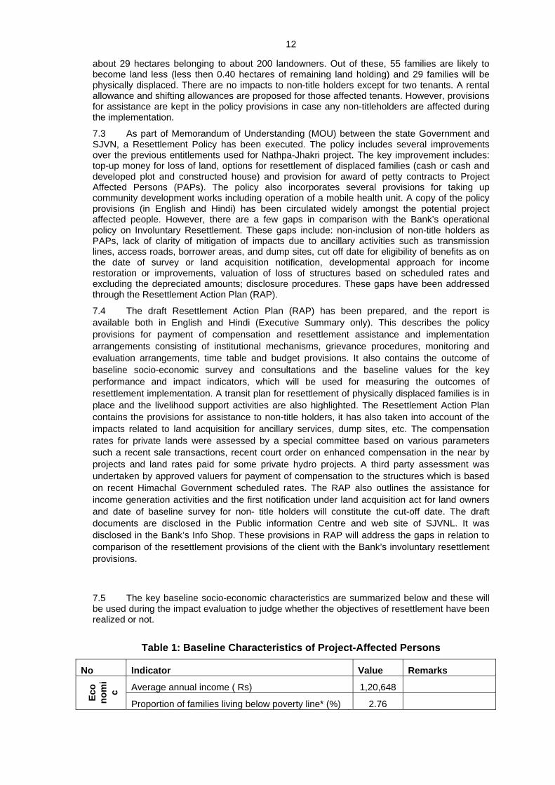
7.5 The key baseline socio-economic characteristics are summarized below and these will be used during the impact evaluation to judge whether the objectives of resettlement have been realized or not.
Table 1: Baseline Characteristics of Project-Affected Persons
No Indicator Value Remarks
Average annual income ( Rs) 1,20,648
Eco
nom
ic
Proportion of families living below poverty line* (%) 2.76

13
No Indicator Value Remarks
Proportion of families having outstanding debt (%) 29.0 Average Rs. 81,000
Proportion of workers in service or business (%) 13.0
Proportion of families living pucca houses** (%) 35.0
Average size of the house (sq.ft) 578
Proportion of families having separate kitchen (%) 79.0 Hou
sing
Proportion of families having separate toilet (%) 68
Average land holding size () 10.35
Proportion of households having Refrigerator (%) 46
Housing having LPG connection (%) 82
Ow
ners
hip
of L
and
and
asse
ts
Average livestock/household (in number) 2.12
* based on per capita monthly income of Rs. 289
** A house constructed by using cement, brick and steel.
7.6 A separate Sustainable Community Development Program (SCDP), has been prepared describing the proposed infrastructure facilities in the project area for next 5 years with an estimated cost of INR 256.8 million ($ 6 million). This program includes implementation of basic infrastructure facilities in the affected villages, operation of mobile health van, scholarships to the wards of affected and local people, sponsoring children to industrial training institutions for acquiring technical skills, support services to agricultural and horticultural activities, improving drinking water facilities in the local villages, support to educational institutions, etc.
7.7. Implementation Progress (current status): The overall land acquisition is proceeding satisfactorily. The principle approval has been obtained from MOEF for transfer of government land (49 hectares). The private land acquisition is in advance stage and so far about 14 hectares of private land (49%) has already been acquired and the compensation has been offered to the affected land owners. This land is mostly required for the civil works and the balance land acquisition is required for townships, for which construction is due to start only in the middle of 2008. Further, the options for resettlement have been explained to all those affected and 26 (to be displaced initially) out of 29 potential displaced families have expressed their preference for cash and a developed plot on which to construct a house. They will be offered developed plots shortly. The alternative sites have been identified in consultations with the displaced families and it may take some time to acquire these lands. Since the construction of houses will take about 12-18 months, the project authorities have proposed transitional arrangements with an alternative of leased accommodation or rental allowance of INR.2000 per month for a maximum of 18 months. The implementation of SCDP has also commenced. Some of the facilities already initiated include a mobile health van, contribution towards construction of a new bus station and parking space at Rampur, construction of school buildings and a bridge. In addition, 35 youths, including 5 girls, belonging to the families of the project affected area have been provided sponsorship for admission in Industrial Training Institutes (ITIs) for acquiring technical skills. The first year annual program on small infrastructure, which is based on the proposals received from each of the affected villages, is also in progress.
Impacts on Scheduled Tribes:
7.8 The impact on scheduled tribes is negligible. Only two tribal families are being affected by the project. The proportion of tribal families living in project area is about 3% compared to 4% in Himachal Pradesh and 8% in India. The socio-economic characteristics of tribal people in the project area reveal that they own agricultural land, livestock and also own material assets like television, cooking gas etc i.e. similar to the non-tribal people. A social assessment was carried out by a team of independent consultants and social scientists employed by the project developer (SJVN). It was determined that the tribal families from the Negi and Gujjar tribes migrated to the project area some 50 years ago. Based on the screening of the representative sample of tribal families against the five criteria listed in the World Bank’s OD 4.20, “Indigenous Peoples,” (which covers scheduled tribes), paragraph 5, the social assessment team concluded

14
that the families do not possess three of the five characteristics (close attachment to ancestral territories; self-identification as members of distinct cultural group and presence of customary social and political institutions). The World Bank social scientist on the Task Team, who has been visiting the project site from time to time since 1998, concurs with the determination and conclusion of the social assessment team that the families do not meet the criteria of the Indigenous Peoples as listed in OD 4.20. This issue was subject to review by the Indigenous Peoples Coordinator of the World Bank who concurred with this decision. Therefore, the project will not trigger the Indigenous Peoples Policy (OD 4.20).
Institutional arrangements for implementation of RAP and SCDP
7.9 Institutional arrangements to ensure the implementation of the RAP and SCDP are in place including suitable staff at project site and in Shimla. Regular review procedures are specified and a grievance redressal committee consisting of representatives from Government (sub-Divisional Magistrate), Bloc Development Officers, and PAP representatives has been formed. The Corporate Office at Shimla is responsible for overall policy guidance, planning and monitoring of R&R activities. Implementation of resettlement and rehabilitation component at field level is the responsibility of Environment and R&R Cell at Rampur project office. The responsibility includes implementation, monitoring, contingency planning; R&R related programme and reporting during RAP implementation. The Head of the department of Environment & R&R,Cell at Rampur project office and other field officers will coordinate with various government departments like revenue, forest, and other administrative units at various levels to facilitate smooth implementation of RAP
7.10 During implementation and subsequent operation of the 1500MW Nathpa-Jhakri Hydropower project, SJVN has already implemented a range of good social practices successfully such as: (a) uninterrupted operation of a mobile health van for more than 5 years in the affected villages; (b) offering employment to about 60 project affected persons in the project; (c) construction of a resettlement colony and market complex for project affected people; (d) support to income generation activities to about 50 families; and, (d) infrastructural developmental works worth about INR 25 million in the affected villages.
Impacts on Forests, Natural Habitats & Wildlife
7.11 Baseline studies were conducted for the project’s influence area (PIA - 7km area around the project), project’s immediate influence area (PIIA – 1.5km area around the project), and the directly affected areas (DAA – which includes all 86.5ha of land being acquired for the surface level works of the project, of which 48.9 ha is forestland).
7.12 Based on the baseline data and a comparison with the available data for the state, or the Satluj basin as a whole suggest that the project’s influence area is relatively poor in terms of forest cover, plant wealth, wildlife and biodiversity. The project’s immediate influence area and the directly affected area has the minimum possible forest types in hilly areas - sub-tropical euphorbia scrub and dodonea scrub, which are sparsely distributed along foothills and hill slopes. Only four species of wildlife are reported from the project’s influenced area of which Himalayan Black Bear is reported only during summer while Musk and Barking deer showed altitudinal migration during winter. The Common Leopard is reported to follow cattle/goat/sheep herd commonly surrounding the villages in forest areas. No endangered, rare or protected species is found from the project’s immediate influenced area or the directly affected area.
Table 2: Comparative Status of Forests and Natural Resources in the Project Area
Parameter Himachal Pradesh
Satluj Basin
Project’s Influence Area
Project’s Immediate Influence Area
Project’s Directly Affected Area
Forests Type 9 8 4 2 2

15
Parameter Himachal Pradesh
Satluj Basin
Project’s Influence Area
Project’s Immediate Influence Area
Project’s Directly Affected Area
Sub-Groups 36 9 10 2 2
Flora (total trees, shrubs, climabers, grasses, ferns, epiphytes, etc)
3256 NA 119 77 63
Flora: Diversity Index - - - 1.17 – 1.41 0.27 – 1.3
National Park 2 1 0 0 0 Protected Areas Wildlife
Sanctuary 32 8 0 0 0
Existence of Endangered/ Threatened/ Rare fauna (number of species)
11 11 1 (Common Leopard)
Altitudinal Migration – 3 more species
0 0
Other Wild Fauna 5710 NA 58 Mainly domestic animals
I7.13 Impact of the project on the existing landscape, at the basin or even at the district level is truly insignificant, owing to the environmental setting of the project. Impacts at the more immediate level will also be small, if not insignificant. The project acquires 48.9ha of degraded forest land (with very little forest or tree cover), and notionally acquires (but does not disturb – as the works are deep underground) another 20.47ha of similar degraded forest land over the tunnels. Together these represent 0.07% of the total forest area of the Rampur and Anni forest divisions (which together have 90,596ha of legally defined forests).
7.14 There are total 12 protected forests under the study area of which 6 forests fall in Rampur Division while 6 are in the outer Seraj division of the Kullu district. None of these are directly impacted by the project.
7.15 The project will clear fell 1075 trees, of which 996 are (exotic) eucalyptus trees, which were earlier planted by the forest department. The other 79 trees to be felled are commonly distributed throughout the project’s immediate influence and influence area. For each of the land parcels affected by the project, the diversity is very low. The highest value of diversity index recorded is 1.28 for the powerhouse and approach road area. For all other sites, the diversity index is even lower than that - indicating that the area is not rich in floral wealth and represents poor diversity.
7.16 No endangered, rare, threatened or endemic trees are lost due to felling in project. The dominant shrubs are of species which are widely distributed throughout the project immediate influence area as well as project influence area and are not endangered, rare, threatened, or endemic in nature. Owing to their common distribution and not having significant ecological status loss (although some of them have community use and medicinal values), losing these trees and shrubs will not significantly affect existing biodiversity status of the project influence area, the Satluj Basin in general, or Himachal Pradesh in totality. It will also not affect the structure composition, of existing forest types, forest cover or distribution characteristics of flora.
7.17 To compensate for the loss of the acquired forestland, a compensatory afforestation (CA) plan will be implemented by State Forest Department. The Compensatory Afforestation will be carried out on 139ha as per the Forests (Conservation) Act 1980 in Arsu and Nichar ranges of Ani forest division. The impacts of the project will be more than sufficiently compensated by such afforestation. In fact, development of 139ha of forested area instead of the 48.9ha of degraded forest land will be an environmental enhancement in the area. Additional measures by the project includes payment of net present value of forests of about US$ 1.1 (to generate forests of equivalent area elsewhere in the project’s influence area), and a catchment area treatment plan, costing US$ 5.4 million.

16
7.18 Indirect impacts of project activities on flora are expected to be mostly limited to project’s immediate influence area. Indirect impacts will be due to various construction activities such as generation of dust due to earthwork, excavation, transportation of construction materials (sand, aggregate, cement etc), quarry, crusher & blasting operations; air pollution due to movement of construction vehicles, equipments and machinery; influx of laborers; and pollution generated through provision of labor camps established temporarily at construction sites etc. These impacts will be short term and limited to construction period only. Long-term exposure of dust may affect some vegetation and lead to various morphological effects such as chlorosis, necrosis, discoloration and ultimately reduction in primary productivity. This is important for the vast number of orchards in the project area. The project will take sufficient measures to control dust during the construction period. Blasting will be controlled, so as not to create great noise, although noise impacts on wildlife would not be significant owing to the lack of wildlife in the area.
7.19 The EMP also includes measures related to prevention of disturbance to forests and wildlife by construction labourers, procedures for disposal and management of muck and debris, and redevelopment of muck disposal sites (see below). Dumping areas are either devoid of vegetation or show a few weedy shrubs. Very limited adverse impact on flora is expected as these shrubs are widely distributed in project immediate influence area as well as project influence area. To mitigate this loss of shrubs, an approved muck disposal plan should be strictly implemented. As such no vegetation was recorded at the proposed quarry site, however to avoid impacts due to quarry operations on surrounding quarry site, adequate dust suppression measures should be implemented. After completion the quarry operation, the area would be redeveloped.
Instream Flow Impacts & Water Quality Issues
7.20 The Rampur Hydroelectric project will in effect be operated as a cascade station to the Nathpa-Jhakri run of the river power plant. The only change in the river flow will occur between the intake works at Jhakri (where the Nathpa-Jhakri tailrace water is currently re-entering the river Satluj), and the tailrace outlet at Bael village. At Jhakri, the current flow of river is constituted by (i) the water from Nathpa-Jhakri tailrace, and (ii) the combined flow of all tributaries joining the river Satluj between the Nathpa dam and Jhakri (except a stream called Shoulding, where 6 cumec of water is diverted to augment the Nathpa-Jhakri lean season peaking power generation). The project uses all the water coming from the Nathpa-Jhakri tailrace, but does not use any of the water coming through the tributaries.
7.21 The Government is Himachal Pradesh requires all projects to provide an instream flow of a minimum of 15% of the lean season flow, immediately downstream of any dam/diversion structure. The minimum lean season flow available at Nathpa dam is 47.4 cumec. Thus a minimum lean season flow of about 7 cumec would be required to meet the spirit of the GoHP regulatory guidelines. The actual lean season flow that would be available from tributaries (at Jhakri, Rampur and upstream of the RHEP tailrace outfall at Bael village) is more than this required minimum flow.
7.22 Detailed studies carried out examining the issues of water pollution, flushing required to take care of the pollution and sewage load in the stretch between the intake and outlet works of the project, suggest that the available minimum lean season flow would be sufficient. There is no direct consumptive use of water (for drinking, irrigation and other household purposes) from the Satluj since it sits in such a deep gorge in this area. The natural springs and ‘chashme’ are the key sources of water for people living in the area for their own consumption, livestock use and irrigation purposes. In most of the villages except those, situated on high hills, the state department of water supply (department of public health) has provided piped water supply for domestic purposes. The existing plans to augment water supply also do not include use of any water from the Satluj. Irrigation in the area is rain fed or the very limited water demand for agriculture practice (only about 10% of the land area is under agriculture) is being fulfilled by khuls (canal). Therefore, the reduced flow in the river due to proposed project will not hamper the water supply schemes in the area.
7.23 Maximum discharge of river Satluj goes up to 10000-12000 cumec and minimum discharge remains in the range of 70-80 cumec. The absolute minimum 10-day flow at the Nathpa dam is 47.4 cumec (see table 3 below).

17
Table 3: Minimum Flow at various locations from Khab to Suni (cumecs)
Site Monthly min 10 Daily min Absolute Minimum
90 percentile
60 percentile
90 percentile
60 percentile Monthly 10 Daily
Khab 64 46 59 44 17 8
Nathpa 116 91 106 93 59 48
Rapmur 104 92 102 89 69 65
Luhri 108 98 104 90 70 56
Suni 110 99 106 96 72 71
7.24 Owing to geographical reasons, and very high silt load coming from snow melts in China and cold desert areas of Spiti Vally, the acquatic life in the river is poor. Great hazards are caused due to variable velocities of water, ice formation during winter, occurrence of periodic floods due to cloud burst and continuous rolling of bottom material consisting of boulders, stones, gravels etc. High flood causes dislodging of benthic animals, but still the turbulent river Satluj has provided microhabitats for a few micro-organisms to get suitably adapted to the environment.
7.25 To assess the existing scenario of fish type available in the river body, 20 days monitoring was carried out in month of March 2006. No fish were reported in the Satluj River in the project area during surveys of 1998, 2004 and 2006. However, fishes were monitored in the side streams particularly Nogli Khad, Sumej Khad and Kajo Khad, near the confluences with Satluj River. These side streams have less flow instability, favorable temperature and less turbidity than the main Satluj. The sole fish species monitored was a trout (Schizothorax spp, Schizothoraichthys spp.) and it was caught downstream of the confluence of Nogli khad with main Satluj River. This is a small sized, migratory fish variety and is locally known as “asla”. Market surveys (in 4 markets where fish is available in the project area - Tapri, Bhabanagar, Rampur and Bael) and consultation with community and experts suggest that the main Satluj river has very little fish population in the stretch between Jhakri and Bael. Only one person was found involved in fishing activity that too on one of the side streams. For commercial purposes, the fish is mainly brought from downstream areas like Bilaspur. Upstream, a few sites such as Sangla, are being developed by the state fisheries department for sport fishing. Mahseer is migratory fish, and was historically reported to be present in Satluj. However, for about 50 years now its migration is affected by construction of Bhakra dam on the Satluj. Even without the Bhakra dam, its availability in project area is a remote possibility due to the low water temperature.
7.26 Rampur, which is only town in the project area has a sewerage scheme. The sewerage treatment plants have been damaged by floods and are only partially operating and repairs are being taken up. In the mean time most of the population of the town is served by septic tanks. Other than Rampur, no other town puts effluent into the river. In Jhakri township, established under Nathpa-Jhakri project, the households are connected to sewage pipeline network, which is finally connected to eight septic tanks. Most of the villages have provision of soak pits (some up to 20-30ft deep) for collection of human excreta. Liquid effluent leaches into the ground and solid effluent is converted into manure after mixing with soil. There are no industries that could result in pollution. SJVN has proposed to fund establishing a sewerage treatment plant, as part of the EMP, to treat the sewage flowing into Satluj river from the Jagatkhan and Brow villages located opposite Rampur town, to further improve the water quality.
7.27 As per the primary water quality criteria as laid by the Central Pollution Control Board, the Himachal Pradesh State Pollution Control Board, has kept the river Satluj under ‘A’ category of water quality with respect to pH, DO and BOD in general. The critical parameters observed in past in some stretches of the river is total coliform for which category of river comes down to ‘C’ category. The level of dissolved Oxygen (DO) in the project stretch varies from 8 to 8.5 (mg/l) between Jhakri to Bael. The high DO levels in the river indicate high water quality in the study stretch. This may be because of higher water flow in the river and low environmental temperature. The pH value is 8.1 and 7.88 at Bael and Jhakri respectively indicates that the

18
river water is slightly alkaline in nature. The level of biochemical oxygen demand (BOD) in the river is around 1.0 mg/l at all places except at downstream of Rampur town, where value observed was 1.2 mg/l. The BOD and COD values are very low, which indicates the absence of organic pollution loading. This is mainly due to the low population density, low agro-chemical dosing and absence of industries in the area. Water quality in terms of pathogenic bacteria appears to be good except at immediately downstream of Rampur town, where faecal coliform was observed as 4 MPN/100ml and the value of total Coliform was observed as 14. Otherwise none of the samples (Jhakri outfall, Rampur u/s, Bael) has shown the presence of faecal contamination. Iron and Zinc were found <.05 at Jahkri outfall and at Bael but value of mercury was observed on higher side. Mercury was found 7.11 ppb at Jhakri outfall that may be due to mecahnical processing taking place in Jhakri Power house. However, all these values are much below the standard water quality norms. However, the fluorides level was of the order 1 mg/l which just meets the permissible limit for drinking purposes (note that there is no supply of drinking water from the Satluj).
7.28 In past, no major epidemic has been reported in the area. Thus, even without lots of sewage treatment facilities in the area, the pollution loading (organic and bacteriological) is well within the carrying capacity of the water available for dilution in river Satluj and its tributaries. The findings of the village level surveys, data collected from the Health Department and Government hospital, Rampur do not indicate prevalence of water borne diseases in the area. However, during summers (April-July) about 50 cases on an average have been recorded related to gastroenteritis, diarrhea and dysentery from the project area.
7.29 In light of the above, the parameters on which the medium and long term adequacy of river flow will depend include desired dilution to the sewage, limited functions as aquatic habitation, and favourable flow condition for flushing of sediments. Adequate flow in the river especially during lean season becomes essential to provide the desired dilution to the sewage, which is being disposed into the river with or without treatment. It is important to maintain the river ecology aesthetically as well as for the sustenance of its natural functions i.e. aquatic habitation etc. Several different scenarios of water demand due to increased population in the project area, and increased sewage load have been simulated for different flow releases varying from 1 cumec to 10 cumec as well as zero release. The studies suggest that the available minimum lean flow would be adequate for the needs of the water quality impacts in the Jhakri-Bael stretch. However, for maintaining water quality in the Nathpa-Jhakri stretch, a release of 5 cumec from the dam would be necessary. The project will, in fact, release more water from the dam (7 cumec), as per the regulatory requirement of the GoHP, which, according to the studies should be more than sufficient for water quality and aquatic life. All residual impacts due to managed river flow will be monitored by SJVNL as part of the project’s overall adaptive monitoring program, and all relevant actions including augmentation of lean season managed flow will be taken up if warranted by such monitoring.
Construction-Related Impacts
7.30 Management of construction-related impacts would be the responsibility of the SJVN (through its contractors, as and where relevant, and as described in the EMP). The plans for managing the construction site impacts include plans and guidelines for managing and restoring the muck disposal sites (including advance protection measures for the sites, before muck is actually disposed in these sites), management and reinstatements for the quarries, management of effluent discharge, management of safety and health issues (including a plan to manage the HIV/AIDS risks), and a chance find procedure for conservation of cultural properties. These measures are described in detail in the EMP, and in the supporting environmental documents. Supervision and monitoring will be essential to ensure full implementation of the detailed plans. These arrangements have been described as part of the EMP.
7.31 Control of Pollution from Labour Camps during Construction Phase: The aggregation of large labour population and technical staff during construction phase is likely to put significant stress as a result of discharge of sewage, solid wastes and other pollutants. The total population due to congregation of work force and their families during construction phase is expected to increase the local population significantly. This is likely to affect the existing infrastructure. Thus, the EMP has identified a number of measures to be implemented to maintain the facilities in

19
labour camps, sanitation and sewage treatment facilities, solid waste management, and provision of community kitchen.
7.32 Environmental Management in Road Construction: In hilly terrain, road construction often generates significant quantity of wastes (muck) due to the stripping of the rocks to make way for the roads. The stripped muck is generally cleared by dumping the material along the slopes. These dumped materials finally flow down to the valleys and ultimately finds its way in to the river. The EMP includes measures so that the stripped material would be collected and dumped in the designated muck disposal areas, protection against erosion, and bio-engineering measures to protect the road slopes.
7.33 Muck Disposal: For managing the 3 million m3 of muck to be generated by the project, a muck disposal plan has been prepared. The plan includes, over an above reuse of part of the muck as construction material for the project, site protection and rehabilitation measures which includes civil works, vegetative measures, fencing and planting. As three of the four dumping areas are located closed to river Satluj, there are chances of rolling down of muck/ loose material leading to blockage in river flow or contamination of water due to silting. To avoid this, retaining walls of 2–7m height are to be developed along the bank of the river at all muck disposal areas.
7.34 The EMP includes measures related to the control of air pollution and noise pollution. All crushers will have cyclone, and particulate filters. Workers would be provided with effective personal protective gears such as masks, ear muffs or ear plugs. Equipment and machinery should be maintained regularly to keep the noise generation at the design level. Silencers and mufflers of the individual machinery are to be regularly checked. The sewage generated from various labour camps shall be treated in septic tanks before disposal by discharging into the river. The septic tanks shall be located so as not to pollute the drinking water sources. During tunneling work, the ground water flows into the tunnel along with construction water, which is used for various works like drilling, shortcreting, etc. Settling tanks of adequate size to settle the suspended impurities will be constructed. The sludge from the various settling tanks can be collected once in 15 days and disposed at the site designed for disposal of municipal solid wastes from the labour camps.
7.35 Transmission, Township, and Workers’ Camps: The project does not construct any new power transmission lines. Power would be evacuated through a short loop-in loop-out arrangement by connecting to the existing high voltage transmission line at Duttanagar. The existing transmission line was built following the environmental and social standards of the Power grid Corporation, which is recognized to be among the best in India. Similarly, the project does not construct any new township, and instead uses the existing facilities at the Jhakri Township constructed by the Nathpa Jhakri project. The small project facility at Bael village and the camp sites for the contractors had been included in assessments of impacts related to land acquisition and resettlement, biodiversity and forest, etc.
Safety of Workers and Communities
7.36 Given the typical context of Himalayan geology, and the substantial underground construction works, the project involves serious potential safety risks for the workers. SJVN has adopted, as part of its overall environment policy, a Health, Safety and Environment Directive – which includes the commitment to provide a safe place to work for SJVN employees; and acknowledges that SJVN has the ultimate responsibility for compliance with all the requirements of applicable safety rules and regulations. To implement this directive for the Rampur project, a site safety assurance plan has been prepared. This plan will install systems so that safe procedures are followed in construction of the project (documented in the safety manual of the project).
7.37 The safety manual for the project describes a systems approach using an established standard similar to the well known ISO 9001 standard. Describes the applicable safety policies and rules; specifies the use of personal protective equipment for all workers. It also specifies the standards and methods to adhere to in the various stages of project construction period – such as in cutting and welding operations, excavation and trenching, tunnel excavations and drill operations; in using explosives, cranes, ladders scaffolds and stairways; in working around high voltage and in other electrical safety contexts, etc.

20
7.38 The site safety assurance plan represents a program approach to safety in which specific documentation and practices had been developed for the Rampur project. This project specific plan describes responsibilities for safety assurance, including the organizational set-up to effectively monitor and manage compliance with SJVN’s corporate safety directives. It specifies methods and schedule for hazard identification, employee orientation, subcontractor orientation and training; accident investigation and reporting, contractor/SJVN interface, safety documentation and record keeping, and a safety incentive program. The plan also includes provisions for securing occupational health by ensuring hazard communication, hearing conservation and protection, respiratory protection, and prevention of infectious diseases. The plan detailed the requirements for emergency response including worker refuge stations, evacuation of work area or jobsite, tunnel rescue team, and securing the accident scenes.
Impacts on Physical Cultural Resources
7.39 The project area does not have known archaeological or historical sites or remains. This has been confirmed by a field based archaeological examination of the project area. There is only a small possibility of impacts on cultural properties (such as community religious properties, sacred groves, and chance-finds). The EMP includes procedures to identify such properties, and mitigate and manage impacts in the case such properties are affected.
Other Induced Impacts and Cumulative Effects
7.40 The induced impacts of the project could include increasing urbanization of the area around the project, particularly at Rampur town, and the consequent demand for water, effects on water quality due to increased sewage load, increased demand for timber rights from the forests, possible drying up of small water sources, and perceived damage to built properties. The GoHP is constructing sewage treatment facilities at Rampur. The state forest department has already exhausted the stock to cater to the future demand for traditional timber rights (for which new settlers also become eligible), and will not entertain demands from new settlers in the area. The state’s Hydropower Policy commits that in the event of increased future demand for drinking water, all water allocation could be reviewed to ensure primacy of drinking water supply. The project has committed that any water source that dries up during construction or operation of the project will be compensated by the project, either by supplying water directly or by developing and protecting alternative sources. For this, the project, jointly with the villagers, has collected baseline data (on flow, location, use) including videographs of all the water sources in the villages in the vicinity. These water sources will be monitored as part of the adaptive monitoring program for the project. In addition, the project is providing for some augmentation of water supply to the villages as part of the SCDP. On the perceived damage to built properties – although it is unlikely that the underground works hundreds of meters below the surface could result into such damages – the project agreed to develop a baseline jointly with the villagers (complete with photographs and video) so as to use this baseline as a basis for compensation in the event of damages. Progress on this baseline is uneven given the varied willingness of individuals to document their properties.
7.41 Major cumulative effects of hydropower development in the Satluj basin include the creation of additional employment, including that for the local communities. In addition, parts of the revenue from the projects, and the Rampur project in particular, goes to the state which could be used to provide better access to social amenities. The possible negative cumulative affects relate to the influx of population to the project area, and include threats to biodiversity, deterioration of water quality, increased pollution levels all over the Satluj basin, and increased HIV/AIDS risks. Most of these possible effects had been described in the preceding paragraphs. For addressing the HIV/AIDS issues, the project will partner with the state level initiatives under the National HIV/AIDS program, and will have close cooperation with state AIDS control society. The project will implement through its contractors a program for awareness, diagnosis and referral as is the spirit of the National HIV/AIDS control programs. Climate change, extreme weather events and increasing flash floods could also pose a set of risks to the project. These risks had been analyzed for the project. The Rampur project uses water which is available through the Nathpa Jhakri tailrace, and is therefore protected from the impacts of flash floods or increasing/decreasing water flows unless the Nathpa Jhakri project is also impacted. Further,

21
the economic and the financial sensitivity analyses suggest that viability of the project is not affected by the worst-case scenarios for the climate change and the possible extreme events.
Dam Safety
7.42 This project does not construct any dam, but uses tailrace water diverted by the dam earlier constructed by the Nathpa-Jhakri Power project. The Nathpa-Jhakri Dam was constructed following the Bank’s policy on safety of dams (as the project was funded by the World Bank). During construction of the Nathpa-Jhakri project, a panel of experts was in place to advise SJVN on all aspects of construction of the dam and the underground works. In Rampur project, therefore, aspects related to safety of dam needed to be only re-confirmed. Accordingly, SJVN engaged the Dam Safety Organization, from Pune to examine the dam and related works with respect to stability and maintenance of the structures. The safety of the dam was confirmed and this review will now be regularly followed up.
Operations manual and emergency preparedness
7.43 Additionally, an Operations and Maintenance (O&M) Manual has been drafted, which incorporates elements pertaining to civil works and addresses the issues of instrumentation, rock anchors in the rock slope upstream on the dam, tunnel de-watering and filling procedures, and gate operation in case of floods. The O&M manual will integrate the relevant elements of the emergency preparedness plan (EPP), which covers emergency identification, evaluation, and classification, where each emergency situation is analyzed in terms of identification (observations, monitoring, instrument readings), evaluation (comparison with reference values, descriptions, etc.), classification (what measures to take). The EPP covers potential emergency situations such as excessive uplift pressures on the dam-concrete foundation contact, slope instability upstream of the dam (rock slope with anchors), emergency evacuation of the power house (flooding, fires, etc.), and underground water ways incidents (partial or total tunnel collapses).
Riparian Issues
7.44 The River Satluj (a tributary of the Indus) is an international river (flowing through China, India and Pakistan). This run-of the river project is located in between two existing dams. The upstream dam at Nathpa, about 50km upstream of the project, has a small storage (an inundation of about 22ha, all within the river gorge, mainly for producing peaking power for the 1500MW Nathpa-Jhakri project). The downstream Bhakra dam and the storage of Govindsagar were completed in 1960s, and constitute a major multi-purpose project of Northern India. The Bhakra Dam has a gross storage of 9621 million m3, and is about 200km downstream of the Rampur project. Thus, there is no significant impact of the project related to water flow and availability on either the upstream or downstream riparian countries. The water quality impacts of the project are assessed to be minor even at the immediate project area, and would be truly negligible downstream of Bhakra. In addition, the Sutlej is one of the 3 eastern rivers defined by the Indus Treaty (between India and Pakistan), and is earmarked for sole (consumptive) use by India.
7.45 According to the World Bank policy on International Waterways, both the upstream and downstream riparian countries, China and Pakistan were notified and provided with relevant project details. No objection to the project was raised by either of the riparian countries.
Catchment Area Treatment Plan & Other Environmental Enhancements
7.46 The Saltuj River flows in narrow deep channels with steep hills rising on either side in the project area. The hills are very steep with poor or no vegetation cover. Due to poor vegetation cover the rate of soil erosion is high. Different forms of erosion such as sheet erosion, gully erosion, riverbank erosion are quite prevalent throughout the project affected/immediate influence and project influence area. Common anthropogenic factors leading to erosion are over gazing, collection of trees for fuel, fodder, timber and unscientific farming practices. The project activities accelerating soil erosion will be quite significant during construction phase such excavation work, tunneling/blasting, construction of temporary and permanent road in project area to move vehicle/ machinery/equipments and workforce.

22
7.47 The induced impacts of the project are largely confined to the project’s influence area, and relate to the dependency of local people on forests. These impacts include various anthropogenic activities affecting forest such as traditional timber rights, new migrant laborers, associated development, and induced commercial developments.
7.48 To address these catchment-wise issues, the Forest Department, Government of Himachal Pradesh has formulated a catchment area treatment (CAT) plan for the Rampur hydroelectric project. The objective of this plan is to ensure that the sediment load does not increase due to construction and operation of the project. The CAT plan also addresses the need to protect the watersheds in the region and, as per the directives of the GoHP; covers area treatment measures, soil conservation measures, and includes measures for improvement of degraded forest areas within the project catchment. The plan will be implemented over a 10 year period, at a cost of Rs.233.7 million.
7.49 The CAT plan will cover the following types of degraded area - degraded forest, degraded pasture and barren land, erosion prone area, treatment of active land slides, treatment of drains. In the open forest areas, the CAT plan will support replenishment afforestation, assisted natural regeneration, development of NTFPs. As part of pasture improvement, it will provide for subsidiary silvicultural operation, treatment of erosion prone area, stabilization of active landslides, roadside erosion control, avenue plantation and landscaping. It will also support village infrastructure development, such as village ponds and tanks, soil/water conservation structures, repair of springs/baunes/water sources, strengthening of village paths/roads, treatment of private lands, distribution of seedlings, etc.
7.50 The project will support the GoHP program for development of fisheries in the state. The GoHP has proposed to implement supplementary stocking program for snow trout (Schizothorax richardsonii) – an endemic species. The stocking will be done annually by the Fisheries Department. To achieve this, facilities to produce seed of trout need to be developed at suitable sites, for which the project will contribute Rs.10 million, to be utilized for developing hatcheries. Similarly, to support the GoHP programs for conservation of wildlife, the project will contribute Rs. 6.25 million.
8 IMPLEMENTATION ARRANGEMENTS
Institutional Framework
8.1 Whereas the primary responsibility to implement the EMP is of the SJVN, a number of EMP activities, such as the compensatory afforestation, the CAT plan, the fisheries and the wildlife conservation support activities will be implemented by the state government agencies.
8.2 In view of the extensive hydropower development planned in Himachal Pradesh and the limited capacity of the Forest Department of GoHP to implement the compensatory afforestation and catchment area treatment plan in the Satluj basin, the Forest Department and the hydropower development agencies (particularly SJVN) will share the implementation responsibility. The overall principle of such division of responsibility would be to make best use of the comparative advantages for implementation (which suggests that all mechanical, i.e. non-plantation works will be implemented directly by the hydropower agencies). The cost norms will be as per the Forest Department norms, and overall monitoring will be done by the Upper Satluj Watershed Society (a part of the Forest Department). For the Nathpa-Jhakri and the Rampur projects, SJVN will discuss on the actual division of works with the Conservator of Forests (CF), Rampur Circle. The forest department will also modify the catchment area treatment plans, so as to treat the priority areas (such as current landslides) first. To this end SJVN and the CF, Rampur Circle will review and agree on the modified CAT plan. Additionally, as per the recent discussion between the SJVN and the GoHP, an integrated CAT plan will be prepared for the entire Satluj basin, based on satellite imageries and remote sensed data. SJVN will prepare this plan.
8.3 As per the hydropower policy of the state, the GoHP will constitute a multi-disciplinary committee under the chairmanship of Chief Minister. Other members shall be state Power Minister (Vice Chairman), Minister/Member of Legislative Assembly of the area where Projects are being executed, representatives of the hydropower company, representatives from various

23
concerned state government departments, Chairman/Managing Director of the concerned Power Utility and Chairman, Local Area Development Committee (LADC). The Committee will be monitoring the issues arising during the implementation of the project; employment related monitoring, relief and rehabilitation, review of progress of LADC schemes, implementation of CAT plan, compensatory afforestation, environmental management plan, and restoration of facilities which get damaged because of the implementation of the project. The committee will also review the recommendations (and implementation thereof) of the Forum of Hydroelectric Power Producers. The Committee will draw up the methodology to regulate the payments to be made by the Company to the various departments of the Government in connection with the implementation of the project.
8.4 The World Bank (financed by PPIAF) is also supporting the GoHP through a technical assistance in preparing river basin development optimization strategies, for the Satluj basin. The ongoing study would demonstrate the methodology for optimization of hydro-development in the Satluj basin with the goal of facilitating coordinated and sustainable development by private and public sector developers, with due regard for the environmental and social impact of river-basin-wide development. The optimization study will cover environmental and social implications of multi-project development, including but not limited to: (i) implications for water resource management, (ii) catchment area treatment plans, (iii) potential cumulative impact on natural forests and other protected areas; (iv) social impacts arising from multiple projects; and (v) communication/public outreach issues.
Adaptive Management of Environmental Issues
8.5 SJVN has adopted a corporate environmental mission statement and environmental policies. The SJVN mission statement (“…developing and supplying to the nation, state and local communities, and efficient, economic, environmentally sustainable, and socially responsible hydropower”) stresses the need to develop adequate long-term capacity to mange environmental issues in all its projects. The environment policy specifically requires SJVN to develop and maintain adaptive environmental management mechanisms and adequate risk management systems. To this end, SJVN has prepared an adaptive environmental management plan for its corporate operations. This would help managing environmental issues in the Rampur project.
Continuous Stakeholder Consultation
8.6 The project will continue to engage the local communities and stakeholders, through periodic public consultation meeting, special events such as cultural programs, and will take community view in consideration in all stages of the project construction and operation. A community communication plan has also been prepared, and will be implemented by SJVN. The PIC will also continue to function throughout the project construction and operation period for continued public disclosure, and for recording public comments and suggestions. A committee consisting of representatives from the state government, elected representatives, PAPs and project implementing agency was proposed to serve as grievance redress committee to deal with the grievances of the project affected people. The notification of this committee is awaited.
Institutional Capacity Building
8.7 SJVN has already taken a number of actions to augment the capacity of the environmental cell. For medium term capacity building, a capacity building plan has been prepared. It includes the development plan for staffing of the environmental cell, and procurement of monitoring equipments. Additionally, a detailed training plan has been prepared, which includes training of the staff of the environmental and social cell, training of contractors’ staff, as well as training of the corporate and project level managerial staff on environmental management.

24
List of Acronyms/Abbreviations
CA Compensatory Afforestation
CAT Catchment Area Treatment
CEA Central Electricity Authority
CPCB Central Pollution Control Board
DPR Detailed Project Report
EA/EMP Environmental Assessment and Environmental Management Plan
EPP Emergency Preparedness Plan
EIA Environmental Impact Assessment
GoHP Government of Himachal Pradesh
GOI Government of India
HP SPCB Himachal Pradesh State Pollution Control Board
HRT Head Race Tunnel
ITIs Industrial Training Institutes
LADC Local Area Development Committee
MoEF Ministry of Environment and Forests
MOU Memorandum of Understanding
NJHEP Nathpa-Jhakri Hydro Electric Power Project
O&M Operations and Maintenance
PAPs Project Affected Persons
PFRs Preliminary Feasibility Reports
PIA Project Influence Areas
PIIA Project Immediate Influence Areas
PIC Public Information Centre
RAP Resettlement Action Plan
RHEP Rampur Hydro Electric Project
SA Social Impact Assessment
SCDP Sustainable Community Development Program
SJVN Satluj Jal Vidyut Nigam Limited


![Workshop Hydropower and Fish.pptx [Schreibgeschützt] - Workshop Hydropower and Fish... · Workshop Hydropower and Fish Existing hydropower facilities: ... spawning grounds and shelter](https://img.dokumen.tips/doc/110x75/5a8733247f8b9afc5d8da3c5/workshop-hydropower-and-fishpptx-schreibgeschtzt-workshop-hydropower-and-fishworkshop.jpg)
![IWMP-IX-Rampur, Shimla, Himachal Pradesh 2011-12hprural.nic.in/IWMP_IX_Rampur_Shimla.pdfIWMP -IX (2011-12)Rampur[Page-1] DETAILED PROJECT REPORT IWMP-IX-Rampur, Shimla, Himachal Pradesh](https://img.dokumen.tips/doc/110x75/5b39fb357f8b9a5a178f0091/iwmp-ix-rampur-shimla-himachal-pradesh-2011-ix-2011-12rampurpage-1-detailed.jpg)


![IWMP-XIII-Rampur, Shimla, Himachal Pradesh 2011-12hprural.nic.in/IWMP_XIII_Rampur_Shimla.pdfIWMP -XIII (2011-12) Rampur[Page-1] DETAILED PROJECT REPORT IWMP-XIII-Rampur, Shimla, Himachal](https://img.dokumen.tips/doc/110x75/5b39fb357f8b9a5a178f0088/iwmp-xiii-rampur-shimla-himachal-pradesh-2011-xiii-2011-12-rampurpage-1.jpg)