Embed Size (px)
Citation preview

Anais da Academia Brasileira de Ciências (2003) 75(3): 357-382(Annals of the Brazilian Academy of Sciences)ISSN 0001-3765www.scielo.br/aabc
Quaternary evolution of the Caravelas strandplain– Southern Bahia State – Brazil
ANA C.S. ANDRADE1,2, JOSÉ M.L. DOMINGUEZ 2, LOUIS MARTIN 3
and ABÍLIO C.S.P. BITTENCOURT 2
1Departamento de Ciências Agrárias e AmbientaisLaboratório de Oceanografia Geológica, Universidade Estadual de Santa Cruz
45650-000 Ilhéus, BA, Brasil2Laboratório de Estudos Costeiros, Centro de Pesquisa em Geofísica e Geologia, UFBA
40210-340 Salvador, BA, Brasil3IRD/CNPq, Laboratório de Estudos Costeiros, Centro de Pesquisa em Geofísica e Geologia, UFBA
40210-340 Salvador, BA, Brasil
Manuscript received on September 12, 2002; accepted for publication on April 9, 2003;
contributed by Louis Martin*
ABSTRACT
An evolutionary model is proposed for the Caravelas strandplain. The model encompasses integration of:
(i) mapping of Quaternary deposits, (ii) cartography of beach-ridge alignments and their truncations, (iii)
relative sea-level history, (iv) development history of the Abrolhos coral reefs, (v) vibra-coring and (vi) C14
dating of Quaternary deposits. Seven major evolutionary stages were identified. These stages show that the
strandplain has had its Quaternary evolution strongly controlled by relative sea-level changes. In addition,
the development of the Abrolhos coral reefs has also played an important role in dispersion and accumulation
of sediments along the coastline, causing localized inversion in longshore sediment transport.
Key words: coastal evolution, sea-level fluctuations, sedimentary facies, coastal geomorphology.
I INTRODUCTION
The Caravelas strandplain is located in the southern
Bahia State (Fig. 1). It has an area of approximately
800 km2 and is bordered by the Tablelands of the
Barreiras Formation (Upper Tertiary).
This strandplain has had its Quaternary evo-
lution strongly controlled by relative sea-level
changes. Contrary to other strandplains present
along the east coast of Brasil such as the Jequiti-
nhonha-BA and the Doce-ES, situated respectively
north and south of Caravelas, the latter has no asso-
*Foreign member of Academia Brasileira de CiênciasCorrespondence to: Ana Cláudia da Silva AndradeE-mail: [email protected]
ciation with a major river (Dominguez 1983, 1987,
Martin et al. 1984a, b).
The Caravelas strandplain fronts a wide conti-
nental shelf, extending up to 246 km offshore. The
Abrolhos reefs present on this shelf comprise the
largest and richest reef complex of the SouthAtlantic
Ocean (Fig. 2). During the Quaternary evolution of
the Caravelas strandplain, the development of these
coral reefs in association with changes in relative
sea-level have played an important role in dispersion
and accumulation of sediments along the coastline.
In this aspect, the evolution of the Caravelas strand-
plain presents peculiarities that distinguish it from
other Brazilian strandplains.
An Acad Bras Cienc (2003)75 (3)

358 ANA C. S. ANDRADE ET AL.
BRAZIL
BAHIA
CARAVELAS
Jequitinhonhariver
Abrolhos NationalMarine Park
BR
-10
1
Pr
íe
e
eu
priv
r
PRADO
ALCOBAÇA
B
8-7
4
A
J c ç ri eu uru u v r
Al o aça ivec b r r
0BA-29
BR1-4 8
-B
A0
01
I tam
r vr
nhéi e
NOVAVIÇOSA
BA-698
Mucuririver
MUCURI
N
CARAVELAS
CaçumbaIsland
AtlanticOcean
BR- 184
10 km0
18°00’S
17°30’S
39°15’W39°30’W
Mucuririver
Fig. 1 – Location of the study area.
The aim of this paper is to present a geologic-
geomorphologic evolutionary model for this strand-
plain. This evolutionary model provides us a better
understanding of the structure and functioning of
the Caravelas coastal systems, as well as helps us in
predicting future coastal behavior.
The general approach used in this paper was to
combine data from several sources of information:
(i) mapping of Quaternary deposits; (ii) cartogra-
phy of beach-ridge alignments and truncations; (iii)
cartography ofchênier-type sand bodies; (iv) rel-
ative sea-level history (Martin et al. 1980, 1999);
(v) development history of the Abrolhos coral reefs
(Leão et al. 2000, Leão and Kikuchi 1999, 2000);
(vi) vibra-coring and (vii) C14 dating of Quaternary
deposits.
II RELATIVE SEA-LEVEL HISTORY FOR THE EASTBRAZILIAN COAST
During the Late Quaternary, the east coast of Brazil
was affected by two important relative sea-level fluc-
tuations. At least two phases of higher stand than
present sea-level have been identified for the last
123,000 years B.P. (Suguio et al. 1985, Dominguez
et al. 1987, Martin et al. 1987). The Penultimate
Transgression (Bittencourt et al. 1979) reached a
maximum around 123,000 years B.P., when sea-
level was positioned 8± 2 meters above the present
level (Martin et al. 1980). The subsequent regres-
sive event extended up to 18,000 years B.P., when
sea-level reached a minimum of 100-120 meters be-
low the present level. The most recent transgressive
episode, which initiated around 18,000 years B.P.,
is known as the Last Transgression (Bittencourt et
al. 1979) and reached a maximum approximately
5,600 cal. years B.P. (5,200 years C14 B.P.). This
last event left several records that were dated by the
C14 method, allowing the construction of relative
sea-level curves for the last 7,700 cal. years B.P.
(7,000 years C14 B.P.) (Suguio et al. 1985, Martin
et al. 1987, 1999, 2002) (Fig. 3).
The relative sea-level curve built for the Sal-
vador region (Fig. 3A) is by far the most detailed of
the entire eastern-northeastern coast of Brazil
An Acad Bras Cienc (2003)75 (3)

QUATERNARY EVOLUTION OF THE CARAVELAS STRANDPLAIN 359
o39 20'W
Parcel dos
Abrolhos coral reefs10 m
Viçosa
reefs
Coroa
Vermelha reefs
3 m
20 m
Abrolhos
islands
3 m
10 m
20 m
Timbebas reefs
Prado reefs
Guaratibas reefs
6 km0
CARAVELAS
SãoSebastião
Gomes reefs
Parcel das Paredes
coral reefs
Volcanic islands
Coral reefs
ALCOBAÇA
PRADO
NOVA
VIÇOSA
o17 30'S
o18 00'S
o17 50'S
o17 40'S
o17 20'S
o39 10'W
o39 00'W
o38 50'W
o38 40'W
Fig. 2 – Morphology of the continental shelf adjacent to the Caravelas strandplain (modified from
Dominguez et al. 1998).
(Suguio et al. 1985, Martin et al. 1987, 1988,
Suguio et al. 1988, Martin et al. 2002). Martin
et al. (2002) have recently presented a new ver-
sion of this curve incorporating corrections for the
reservoir effect and, calibrations for calendar ages
(Fig. 3B). The number of relative sea-level recon-
structions for the Caravelas region was insufficient
for the construction of a complete curve (Fig. 3C).
Nevertheless, the reconstructions obtained for the
Caravelas region are in agreement with the Salvador
curve (Suguio et al. 1985, Martin et al. 1987).
The Salvador curve exhibits an important highstand
(4, 8 ± 0, 5 meters) around 5,600 cal. years B.P.
(5,200 years C14 B.P.), followed by a drop since
that time. This drop was not continuous, but in-
terrupted by two high-frequency oscillations. Af-
ter 5,600 cal. years B.P. (5,200 years C14 B.P.),
a rapid regression occurred and the sea-level went
down reaching a level a little lower than the present
one. Between 3,800 and 3,500 years cal B.P. (3,900
and 3,600 years C14 B.P.), a rapid transgression oc-
curred. Around 3,500 cal. years B.P. (3,600 years
C14 B.P.), the relative sea-level reached a second
maximum placing it over 3, 5 ± 0, 5 meters above
the present level. Between 3,500 and 2,800 years cal
B.P. (3,600 and 2,800 years C14 B.P.) another regres-
sion occurred and the relative sea-level went down
once again slightly below the present level. Around
2,100 cal. years B.P. (2,400 years C14 B.P.) the rel-
ative sea-level reached a third maximum placing it
2, 5± 0, 5 meters above the present one. Since that
time, the relative sea-level has dropped reaching its
present position.
Angulo and Lessa (1997) questioned the exis-
An Acad Bras Cienc (2003)75 (3)

360 ANA C. S. ANDRADE ET AL.
C14 years B.P. X 1000
8 7 6 5 4 3 2 1 0
(Met
ers)
C
currentsea-level
0
5
-5
C14 years B.P. X 1000
8 7 6 5 4 3 2 1 0
(Met
ers)
A
currentsea-level
0
5
-5
cal. years B.P. X 1000
8 7 6 5 4 3 2 1 0
(Met
ers)
B
currentsea-level
0
5
-5
Fig. 3 – Relative sea-level curves: A – Salvador sea-level curve (radiocarbon years) (Martin et al. 1980), B – Salvador sea-level
curve (calendar years) (Martin et al. 2002), C – sea-level reconstructions for the Caravelas strandplain plotted on the Salvador curve
(radiocarbon years) (Martin et al. 1980).
tence of the two high-frequency sea-level oscilla-
tions. According to these authors, most of the in-
dicators used in the determination of the two high-
frequency oscillations comes from mollusks and not
from vermetid incrustations which they consider to
be the best and more precise indicators. Martin et al.
(1998, 2002) however pointed out that Angulo and
Lessa (1997) did not consider that the data from ver-
metid incrustations should be analyzed together with
other biological, sedimentological, archaeological
and morphological indicators, and not isolated as
those authors did.
III RELATIVE SEA-LEVEL HISTORY AND THEDEVELOPMENT OF THE ABROLHOS REEFS
Data obtained from a core taken in the Coroa Ver-
melha reef (Fig. 2) allowed the calculation of the
Abrolhos reefs growth rate. The island surface is
about 1,5 meters above the mean sea-level (Leão
1982). The Coroa Vermelha core reached a total
depth of 15,2 meters. The top of the pre-holocenic
sequence was found at 11,2 meters below the present
mean sea-level. Datings of corals collected in differ-
ent depths in relation to the present mean sea-level
provided ages of 7,371(7,219)7,096 cal. years B.P.
(−11 meters), 5,728(5,605)5,485 cal. years B.P.
(−8, 5 meters) and 4,527(4,415)4,287 cal. years
B.P. (−2, 4 meters). A sample dated from the reef
border provided an age over 1,683(1,538)1,504 cal.
years B.P. (Leão and Kikuchi 1999).
The comparison between the Salvador curve
and the CoroaVermelha reef growth rates evidenced
four major stages in reef development (Leão and
Kikuchi 1999, 2000, Leão et al. 2000) (Fig. 4):
An Acad Bras Cienc (2003)75 (3)

QUATERNARY EVOLUTION OF THE CARAVELAS STRANDPLAIN 361
Stage A Stage B Stage C Stage DA
met
ers
5
0 current sea-level
C14 years B.P. X 1000
8 7 6 5 4 3 2 1 0
B
met
ers
5
0current sea-level
cal. years B.P. X 1000
8 7 6 5 4 3 2 1 0
-5
-10 , m /1000 ys
1 5 mear
m/
00
er
5,5
m1
0y
as
C
2 km
STAGE D
(Meters)
0
4
8
12
Current lower mean sea-level1.683(1.538)1.504 yeras cal. B.P.
(Meters)
0
4
8
12
Sea-level in 1.800 years cal. B.P.
STAGE C
4.527(4.415)4.287 years cal. B.P.
(Meters)
0
4
8
12
Sea-level in 4.000 yeras cal. B.P.
STAGE B
5.728(5.605)5.485 years cal B.P.
7.371(7.219)7.096 years cal B.P.
(Meters)
0
4
8
12
Sea-level in 5.600 years cal. B.P.
Pleistocenic reef
Holocenic reef
Core
C14 dating
STAGE A
Fig. 4 – Coral reef evolutionary model based on radiocarbon ages and accumulation rates determined for the Coroa Vermelha reef: A
– Coral reef development stages plotted on the Salvador sea-level curve (radiocarbon years) and B – Coral reef development stages
plotted on the Salvador sea-level curve (calendar years). In the curve B are also plotted the growth rates of the Coroa Vermelha reefs
(Leão and Kikuchi 1999). C – Coral reef development stages: Stage A – initial reef establishment stage, Stage B – rapid vertical
accretion, Stage C – rapid lateral growth and Stage D – reef degradation (modified from Leão et al. 2000).
An Acad Bras Cienc (2003)75 (3)

362 ANA C. S. ANDRADE ET AL.
Stage A(initial reef establishment stage) – the old-
est age from the Coroa Vermelha core indicates that
the corals started its growth a little before 7,700 cal.
years B.P., during a sea-level rise period (Last Trans-
gression). The reef growth rate in this stage was
small, around 1,5 mm/year.
Stage B(rapid vertical accretion of the reefs) – this
stage is associated with the regression that occurred
after the maximum of the Last Transgression and it
is characterized by a rapid reef growth, with rates in
the order of 5,5 mm/year. The corals dated from the
top of the Coroa Vermelha core (4,527(4,415)4,287
cal. years B.P.) indicate that by this time these reefs
reached the present mean sea-level.
Stage C(lateral growth of the reefs) – the vertical
accretion of the reefs stopped when they reached
sea-level. Since that time, the reefs have had their
tops truncated and started growing sideways. The
age of 1,683(1,538)1,504 years cal B.P., obtained
from the border of the reef, which is younger than the
one from the top corroborates the statement above.
Stage D(reef degradation) – this stage is marked
by a decline of the reef growth which persists to the
present day.
IV CLIMATIC AND OCEANOGRAPHICPARAMETERS
Wind and Wave Patterns
The Trade Wind Belt of the South Atlantic (NE-E-
SE) and the periodic advanced of the Atlantic Po-
lar Front (SSE) are important elements of the atmo-
spheric circulation on the coastal zone of the State
of Bahia. The area is reached by winds arising from
NE and E during the spring-summer and from SE
and E during the autumn-winter. These winds and
the morphology of the inner continental shelf are
responsible for the generation of the wave-patterns
that reach the coastline: (i) wave-fronts coming from
NE and E, with height of 1,0 meter and period of 5
seconds and (ii) wave-fronts coming from SE and
SSE, with height of 1,5 meter and period of 6,5
seconds (Dominguez et al. 1992, Bittencourt et al.
2000).
Tides
Tidal regime at the Caravelas strandplain is semi-
diurnal and located at the upper microtidal range
which is close to 2 meters. Spring tidal range at
the Ilhéus port located 300 km north of the city of
Caravelas is 2,5 meters (DHN 1998).
V GEOLOGY-GEOMORPHOLOGY OF THECARAVELAS STRANDPLAIN
Five major geologic-geomorphological units were
mapped in the Caravelas strandplain (Fig. 5): pleis-
tocene beach-ridge terraces, lagoonal deposits,
holocene beach-ridge terraces, freshwater marshes
and tidal flats/mangroves.
The Caravelas strandplain is bordered land-
ward by unconsolidated Tertiary alluvial fan
deposits of the Barreiras Group. These deposits
are made up of poorly sorted sand-clay sediments,
slightly cemented by iron oxide. Altitudes vary
from 10 to 100 meters. A line of inactive sea cliffs
marks the limit between these Tablelands and the
strandplain. North and south of this strandplain the
Tablelands of the Barreiras Group reach the shore-
line forming active sea cliffs such as in Mucuri and
Prado (Fig. 1).
Pleistocene Beach-Ridge Terraces
These terraces occur in the internal portion of the
strandplain, with altitudes varying from 6 to 10 me-
ters. They present on its surface remnants of beach-
ridge. Truncation lines separate different sets of
beach-ridges. These terraces are made up of white
to brown, medium to coarse-grained, well sorted
sands. Soil processes gave origin to a horizon ce-
mented by humic acids located 3 to 4 meters below
the surface. Martin et al. (1982), based on Io/U
dating from coral fragments collected from the base
of terraces with these characteristics in the region
of Olivença, Ilhéus (BA), attributed an age of over
123,000 years B.P. to these terraces. The only avail-
able dating for this unit at the Caravelas strandplain
is from shells collected in a mud layer located at
the base of the Pleistocene Beach-Ridge Terraces,
An Acad Bras Cienc (2003)75 (3)

QUATERNARY EVOLUTION OF THE CARAVELAS STRANDPLAIN 363
o39 00'W
o17 30'S
NOVAVIÇOSA
Ponta do Catoeiro
ALCOBAÇA
Ponta da Baleia
CARAVELAS
Caçumba island
Parcel dasParedes reefs
o39 30'W
o18 00'S
Coroa Vermelhareefs
SebastiãoGomes reefs
Viçosa reefs
Timbebasreefs
03
01
04
07
08
13
CA96-00
CA96-03
CA96-30
CA92-02B
B-316/CA92-30B/CA92-30B*
B-317
B-264/B-265CA92-34A/CA92-34B
CA92-12C
B-258
B-260/B-261/B-262CA92-11C/CA92-11D
CA92-09CA92-07
B-254/B-255/CA92-14B
B-241A/B-241B/B-242/B-244/CA96-13A'
CV
0 2 4 km
N
B-246
CA96-29
LEGEND:
Pleistocenic Marine Terraces
Holocenic Marine Terraces
Freshwater Marshes
Tablelands (Barreiras Group)
Lagoonal Terraces
Tidal Flats/Mangroves
Vibracores07
Holocenic beach-ridges
Pleistocenic beach-ridges
Sandy ridge like chênier
Coral reefs
Dating samplesB-12039°14'W 39°10'W 17°52'S
17°44'S
0911
12
02
Pontal do Sul
Tomba
Barra Velha
Ponta do Catoeiro
0 1km
CaçumbaIsland
CA92-17C
CA96-22
CA96-20A
CA96-19
CA96-16ACA96-17CCA96-17B
CA96-18ACA96-18B
10
05 Caravelas Channel
Barra Nova
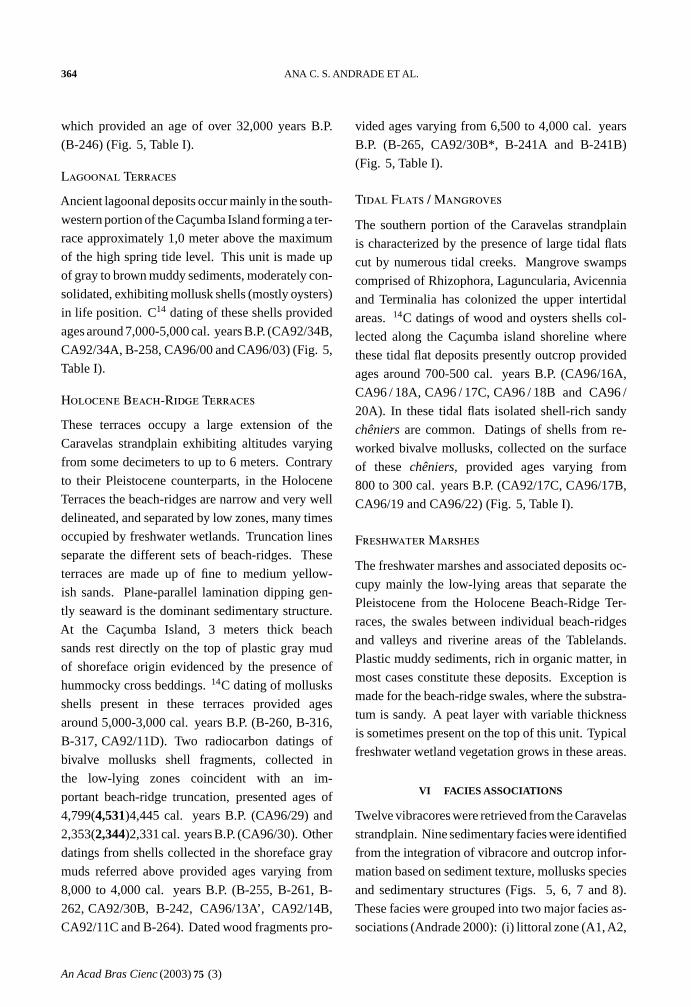
Fig. 5 – Location of vibracores and samples collected in outcrops for radiocarbon dating.
An Acad Bras Cienc (2003)75 (3)
364 ANA C. S. ANDRADE ET AL.
which provided an age of over 32,000 years B.P.
(B-246) (Fig. 5, Table I).
Lagoonal Terraces
Ancient lagoonal deposits occur mainly in the south-
western portion of the Caçumba Island forming a ter-
race approximately 1,0 meter above the maximum
of the high spring tide level. This unit is made up
of gray to brown muddy sediments, moderately con-
solidated, exhibiting mollusk shells (mostly oysters)
in life position. C14 dating of these shells provided
ages around 7,000-5,000 cal. years B.P. (CA92/34B,
CA92/34A, B-258, CA96/00 and CA96/03) (Fig. 5,
Table I).
Holocene Beach-Ridge Terraces
These terraces occupy a large extension of the
Caravelas strandplain exhibiting altitudes varying
from some decimeters to up to 6 meters. Contrary
to their Pleistocene counterparts, in the Holocene
Terraces the beach-ridges are narrow and very well
delineated, and separated by low zones, many times
occupied by freshwater wetlands. Truncation lines
separate the different sets of beach-ridges. These
terraces are made up of fine to medium yellow-
ish sands. Plane-parallel lamination dipping gen-
tly seaward is the dominant sedimentary structure.
At the Caçumba Island, 3 meters thick beach
sands rest directly on the top of plastic gray mud
of shoreface origin evidenced by the presence of
hummocky cross beddings.14C dating of mollusks
shells present in these terraces provided ages
around 5,000-3,000 cal. years B.P. (B-260, B-316,
B-317, CA92/11D). Two radiocarbon datings of
bivalve mollusks shell fragments, collected in
the low-lying zones coincident with an im-
portant beach-ridge truncation, presented ages of
4,799(4,531)4,445 cal. years B.P. (CA96/29) and
2,353(2,344)2,331 cal. years B.P. (CA96/30). Other
datings from shells collected in the shoreface gray
muds referred above provided ages varying from
8,000 to 4,000 cal. years B.P. (B-255, B-261, B-
262, CA92/30B, B-242, CA96/13A’, CA92/14B,
CA92/11C and B-264). Dated wood fragments pro-
vided ages varying from 6,500 to 4,000 cal. years
B.P. (B-265, CA92/30B*, B-241A and B-241B)
(Fig. 5, Table I).
Tidal Flats / Mangroves
The southern portion of the Caravelas strandplain
is characterized by the presence of large tidal flats
cut by numerous tidal creeks. Mangrove swamps
comprised of Rhizophora, Laguncularia, Avicennia
and Terminalia has colonized the upper intertidal
areas.14C datings of wood and oysters shells col-
lected along the Caçumba island shoreline where
these tidal flat deposits presently outcrop provided
ages around 700-500 cal. years B.P. (CA96/16A,
CA96 / 18A, CA96 / 17C, CA96 / 18B and CA96 /
20A). In these tidal flats isolated shell-rich sandy
chêniers are common. Datings of shells from re-
worked bivalve mollusks, collected on the surface
of these chêniers, provided ages varying from
800 to 300 cal. years B.P. (CA92/17C, CA96/17B,
CA96/19 and CA96/22) (Fig. 5, Table I).
Freshwater Marshes
The freshwater marshes and associated deposits oc-
cupy mainly the low-lying areas that separate the
Pleistocene from the Holocene Beach-Ridge Ter-
races, the swales between individual beach-ridges
and valleys and riverine areas of the Tablelands.
Plastic muddy sediments, rich in organic matter, in
most cases constitute these deposits. Exception is
made for the beach-ridge swales, where the substra-
tum is sandy. A peat layer with variable thickness
is sometimes present on the top of this unit. Typical
freshwater wetland vegetation grows in these areas.
VI FACIES ASSOCIATIONS
Twelve vibracores were retrieved from the Caravelas
strandplain. Nine sedimentary facies were identified
from the integration of vibracore and outcrop infor-
mation based on sediment texture, mollusks species
and sedimentary structures (Figs. 5, 6, 7 and 8).
These facies were grouped into two major facies as-
sociations (Andrade 2000): (i) littoral zone (A1,A2,
An Acad Bras Cienc (2003)75 (3)

QUATERNARY EVOLUTION OF THE CARAVELAS STRANDPLAIN 365
TABLE I
C14 datings in field samples.
Field Laboratory Material Facies Ages corrected for Ages corrected for Calendar ages
Sample Sample isotopic fractionation reservoir effect (cal years B.P.)
No. No. (C14 years B.P.) (C14 years B.P.)
B-241A Bah 760 Wood A2 5, 300± 100 5, 300± 100 6,260(6,165-6,035)5,935
B-241B Bah 761 Wood A2 5, 400± 120 5, 400± 120 6,301(6,259-6,198)5,996
B-242 Bah 762 mollusk A2 5, 710± 100 5, 360± 100 6,284(6,177)5,990
B-244 – mollusk A1 6, 050± 120 5, 700± 120 6,662(6,479)6,319
B-246 Bah 765 mollusk A3 ³32, 000
B-254 Bah 767 mollusk A1 6, 650± 120 6, 300± 120 7,282(7,205)7,027
B-255 Bah 768 mollusk A2 7, 010± 120 6, 660± 120 7,571(7,522-7,476)7,391
B-258 Bah 769 mollusk B5 5, 700± 100 5, 350± 100 6,281(6,175-6,115)5,956
B- 260 Bah 770 mollusk A1 4, 520± 110 4, 170± 110 4,840(4,814-4,649)4,527
B-261 Bah771 mollusk A2 4, 910± 110 4, 560± 110 5,446(5,292)4,997
B-262 Bah 772 mollusk A2 5, 760± 160 5, 410± 160 6,394(6,264-6,203)5,956
B-264 – mollusk A2 4, 100± 150 3, 750± 150 4,400(4,089)3,885
B-265 Bah 775 Wood A2 3, 640± 110 3, 640± 110 4,087(3,960-3,926)3,831
B-316 Bah 808 mollusk A1 3, 675± 100 3, 325± 100 3,685(3,558-3,497)3,417
B-317 Bah 809 mollusk A1 3, 310± 100 2, 960± 100 3,320(3,107-3,083)2,954
CA92/02-B Bah1809 Wood B3 410± 140 543(488)299
CA92/07 Bah1810 mollusk A1/A2 6, 920± 270 6, 570± 270 7,630(7,395)7,206
CA92/09 Bah1811 mollusk A1 or A2 6, 620± 270 6, 270± 270 7,392(7,178)6,814
CA92/11-C Bah1812 mollusk A2 4, 760± 200 4, 410± 200 5,314(4,982)4,659
CA92/11-D Bah1813 mollusk A1 4, 410± 210 4, 060± 210 4,838(4,526)4,239
CA92/12-C Ba 1814 mollusk A1/A2 6, 040± 250 5, 690± 250 6,758(6,467)6,217
CA92/14-B Ba 1815 mollusk A2 7, 130± 280 6, 780± 280 7,894(7,570)7,385
CA92/17-C OBDY - mollusk Chênier 1, 220± 40 870± 40 788(755)724
CA92/30-B Bah1817 mollusk A2 4, 420± 190 4, 070± 190 4,836(4,531)4,288
CA92/30-B* Bah1818 Wood A2 4, 100± 210 4, 100± 210 4,861(4,564)4,298
CA92/34-A Ba 1819 Oysters B5 6, 080± 260 5, 730± 260 6,852(6,494)6,287
CA92/34-B Bah1820 mollusk B5 6, 310± 270 5, 960± 270 7,166(6,840-6,786)6,468
CA96/00 Ly. 7960 Oysters B3 6, 075± 50 5, 725± 50 6,623(6,492)6,448
CA 96/03 Ly. 7961 Oysters B3 4, 855± 50 4, 505± 50 5,290(5,249-5,058)4,997
CA 96/13A’ Ly. 7897 mollusk A2 6, 480± 60 6, 130+ 60 7,152(7,004)6,896
CA 96/16A Ly. 7893 Wood B3 685± 45 685± 45 665(654)571
CA 96/17B β100121 mollusk Chênier 1, 160± 60 810± 60 759(705)668
CA 96/17C Ly. 7896 Oysters B3 885± 45 535± 45 550(537)516
CA 96/18A Ly. 8463 Wood B3 480± 45 480± 45 533(514)502
CA 96/18B Ly. 7895 Oysters B3 915± 45 565± 45 629(546)529
CA 96/19 β100119 mollusk Chênier 620± 80 270± 80 434(299)0*
CA 96/20A Ly. 7894 Oysters B3 955± 45 605± 45 645(625-556)545
CA 96/22 Ly. 7962 mollusk Chênier 1, 000± 45 650± 45 656(645-577)556
CA 96/29 Ly. 7898 mollusk T. zone 4, 420± 50 4, 070± 50 4,799(4,531)4,445
CA 96/30 T. zone 2, 690± 45 2, 340± 45 2,353(2,344)2,331
An Acad Bras Cienc (2003)75 (3)

366 ANA C. S. ANDRADE ET AL.
A3 andA4) and (ii) lagoon/freshwater wetlands zone
(B1, B2, B3, B4 and B5). The different facies and
the interpretation of their depositional environment
are described below.
VI.1 Littoral Zone Facies Association
VI.1.1 Facies A1
This facies was identified only in outcrops. It rests
on top of the facies A2 in vibracores 3 and 5 and ex-
hibit thickness varying from 2,8 to 4,0 meters. This
facies is characterized by fine to medium yellow-
ish quartz sand, including localized concentration
of heavy minerals and shells. The dominant sedi-
mentary structure is plane-parallel bedding dipping
gently towards the sea (Figs. 6 and 7).14C dat-
ings of mollusks shells collected from an outcrop
near vibracore 3 provided ages of 4,800-4,200 cal.
years B.P. (CA92/11-D and B-260) (Figs. 5 and 6,
Table I). This facies was interpreted as a result of de-
position in a beach-face environment based on the
sedimentary structures observed and on the presence
of beach-ridges capping the studied outcrops.
VI.1.2 Facies A2
This facies occurs in vibracores 1, 2, 3, 5, 8, 12 and
13. It is comprised by gray to orange medium sands,
with interbedded fine to coarse sands and mud. Lay-
ers of detritus organic matter were observed in vibra-
cores 1, 5 and 8. The dominant sedimentary struc-
tures are tabular and trough cross bedding and plane-
parallel bedding. Bioturbation is rare, except in vi-
bracores 1, 3 and 5, where vertical tubes filled with
clay and sands are present. The following bivalves
were identified:Anomalocardia brasiliana, Mulinia
cleryana, Glycimeris longior, Chione subrostrata,
Lunarca ovalis (Figs. 6, 7 and 8). According to Rios
(1985) these shells are indicative of sandy shallow
water environments. C14 datings of shells and wood
debris provided ages varying from 4,100 to 7,900
years cal B.P. (CA92/11-C, B-261, B-262, B-241A,
B-241B, B-242, CA96/13A’, B-254, CA92/14B, B-
255, CA96-13/150-152 cm) (Figs. 5, 6, 7 and 8,
Tables I and II). This facies is interpreted as a result
of deposition in a sandy shoreface environment (surf
zone and shallower portions of the shoreface), due
to the following evidences: i) sediment texture, ii)
cross bedding (the result of longshore and rip cur-
rents typical of the surf zone, and iii) stratigraphy
(position of this facies, situated immediately below
the facies A1 – beach-face).
VI.1.3 Facies A3
This facies is present in vibracores 1, 2, 3, 11 and
12 and is made up of interbedded layers of light to
dark gray muds (thickness from 5 to 8 cm) and fine
gray sands (thickness varying from a few millime-
ters to over 4 cm) forming various arrangements of
wavy and linsen bedding. The mud layers are lo-
cally enriched with mica minerals. Low-angle cross
bedding and parallel lamination are also present.
Bioturbation occurs mainly in vibracores 3, 11 and
12. Mollusk shells are rare in this facies, except
in vibracores 11 and 12, where a shell bed is ob-
served. Species of mollusks shells present include:
Mulinia cleryana, Chione subrostrata andMactra
iheringi (Figs. 6 and 8). Radiocarbon dating of
shells provided ages around 6,300-5,300 years cal
B.P. (CA96-11/469cm and CA96-12/408-413cm)
(Figs. 5, 6 and 8, Table II). This facies is the result of
deposition in a muddy shoreface environment based
on the following evidences: i) sediment texture, ii)
stratigraphic position, immediately below facies A2
(sandy shoreface) and iii) dominance of wavy and
linsen beddings.
VI.1.4 Facies A4
This facies occurs in vibracore 2 and is character-
ized by medium to coarse sands. The sedimentary
structures are represented by trough cross bedding
intercalated with plane-parallel bedding (Fig. 6).
This facies is interpreted as having been deposited
in an ebb-tidal delta environment as evidenced by: i)
sediment texture, ii) dominance of trough cross bed-
ding, iii) geographical position where the vibracore
was collected; in the present day shoreface, near to
a tidal creek mouth.
An Acad Bras Cienc (2003)75 (3)

QUATERNARY EVOLUTION OF THE CARAVELAS STRANDPLAIN 367
VI.2 Lagoon and Freshwater Wetland
Facies Association
VI.2.1 Facies B1
This facies is present in vibracores 1, 11 and 13 and
it is characterized by gray-yellowish to dark gray
muds. The top of this facies is characterized by the
presence of whitish roots in vertical position. A peat
layer, with thickness varying from a few centimeters
to half meter, caps this facies (Figs. 6 and 8). In vi-
bracore 13, radiocarbon dating from the base of the
peat layer supplied an age around 1,175(1,067)977
cal. years B.P. (CA96-13/69-72 cm) (Figs. 5 and
8, Table II). This facies is interpreted as the result
of deposition in a freshwater wetland environment
due to the similarity between the remnant vegetable
matter present in the vibracore and those found in
the present day freshwater wetlands, where the vi-
bracores were taken.
VI.2.2 Facies B2
This facies is characterized by yellowish-brownish
to dark gray muds that occur in the top of vibracores
4, 7, 9 and 10. Sedimentary structures are not visible
(Figs. 6, 7 and 8). This facies is interpreted as
having being deposited in a supratidal environment,
where these vibracores were taken.
VI.2.3 Facies B3
Plastic muds of yellowish-brown and gray color
characterize this facies, present in vibracores 1, 3,
7, 8, 9, 10, 11 and 12. The presence of intraclasts is
observed in vibracore 7. Sedimentary structures of
physical origin were not observed. Cylindrical tubes
present in this facies are filled with sand or mud.
Remnants of plant matter characterized by brownish
fibrous roots both in vertical and horizontal position
occur throughout this facies, and are very similar to
the present day mangroves rootlets. Mollusks shells
are virtually absent and restricted to:Anomalocar-
dia brasiliana, Corbula cubaniana andChione sub-
rostrata (Figs. 6, 7 and 8). According to Rios (1985)
all of these shells can inhabit muddy environments.
Radiocarbon dating of mollusks shells collected in
this facies provided ages varying from 6,400 to 7,900
years cal B.P. (CA96/00, CA96-3/676-678cm,
CA92/34-A and CA92/34-B) (Fig. 5, 6, 7 and 8,
Tables I and II). Mollusks shells from vibracore 11
however presented an age of 1,310(1,290)1,273 cal.
years B.P. (CA96-11/ 70 cm).
This facies is interpreted as having been de-
posited in an intertidal environment, colonized by
mangroves. This interpretation was based on the
presence of: (i) fibrous roots similar to the ones as-
sociated with present day mangroves; (ii) absence of
sedimentary structures of physical origin; (iii) mol-
lusks species and (iv) sediment texture.
VI.2.4 Facies B4
This facies was found in vibracores 4, 10 and 11 and
it has been subdivided into two sub-facies (Figs. 6
and 8):
Sub-Facies B4a: corresponds to the lower portion
of the facies B4. It is made up of cross bedding sands
locally exhibiting flaser bedding. Bioturbation is
present as vertical tubes filled with sand. Intraclasts
were also observed. The mollusks shells although
rare are represented by theCorbula cubaniana and
Diplodonta punctada.
Sub-Facies B4b: It corresponds to the upper por-
tion of facies B4. This sub-facies was differentiated
from the sub-facies B4a because it is predominantly
muddy, exhibiting a typical linsen bedding. The
bioturbation increases towards the top, where the
sand and clay are quite mixed, which causes diffi-
culty in the individualization of the sand and mud
lenses. The mollusks shells are also rare, and repre-
sented by:Diplodonta punctada, Mulinia cleryana
andCorbula cubaniana.
The facies B4 was interpreted as the result of
infilling of a tidal creek. This interpretation was
based on the following criteria: i) presence of flaser
and linsen bedding, ii) fining upwards of sediment
grain size, iii) dominance of cross bedding in the
lower portion of the lithofacies and iv) presence of
intraclasts.
An Acad Bras Cienc (2003)75 (3)

368 ANA C. S. ANDRADE ET AL.
TABLE II
C14 datings in vibracore samples.
Core Laboratory Material Facies Ages corrected for Ages corrected for Calendar agesSample Sample isotopic fractionation reservoir effect (cal years B.P.)Number Number (C14 years B.P.) (C14 years B.P.)
CA96-3A(676-678cm) β104777 mollusk B3 7, 420± 50 7, 070± 50 7,913(7,896-7,838)7,802
CA96-10(295-305cm) Pa. 1561 mollusk B4a 4, 965± 40 4, 615± 40 5,442(5,311)5,296
CA96-11(70cm) β104778 mollusk B3 1, 730± 50 1, 380± 50 1,310(1,290)1,273
CA96-11(469-471cm) Pa. 1563 mollusk A3 5, 805± 40 5, 455± 40 6,294(6,281)6,204
CA96-12(408-413cm) Pa. 1562 mollusk A3 5, 095± 40 4, 745± 40 5,576(5,564-5,471)5,332
CA96-13(69-72cm) Pa. 1556 peat peat 1, 180± 80 1, 180± 80 1,175(1,067)977
CA96-13(134-136cm) β104779 org. sed. B5 2, 260± 50 2, 260± 50 2,338(2,317)2,153
CA96-13(150-152cm) β104780 mollusk A2 4, 060± 50 3, 710± 50 4,129(4,077-3,994)3,933
Cvborder UM1583 coral 2, 015± 70 1, 660± 70 1,683(1,538)1,504
CV14.1(–12,5 m) UM1581 coral 6, 660± 110 6, 340± 110 7,371(7,219)7,096
CV8.1(–10 m) UM1582 coral 5, 230± 110 4, 880± 110 5,728(5,605)5,485
CV1.3(–3,9 m) UM1584 coral 4, 320± 90 3, 970± 90 4,527(4,415)4,287
VI.2.5 Facies B5
This facies occurs in vibracores 9 and 13. In vi-
bracore 9, it has more than 3 meters of thickness
and it is made up of a massive gray clay (Figs. 7
and 8). Organic sediments dated from this facies in
vibracore 13 provided an age of 2,338(2,317)2,153
years B.P. (CA96-13/134-136cm) (Figs. 5 and 8,
Table II). This facies was interpreted as a result of
clay deposition, in a subtidal environment with calm
waters, probably inside a lagoon.
VII QUATERNARY COASTAL EVOLUTION
The evolutionary model proposed for the Caravelas
strandplain (Andrade 2000) is described below:
Stage I: Construction of the Pleistocene Strand-plain – after 120,000 years B.P. (Fig. 9)
This stage corresponds to the regressive event that
followed the maximum of the Penultimate Tran-
gression (123,000 years B.P.) (Martin et al. 1980).
During this period, the sediments reworked from
the inner continental shelf, as a result of a rela-
tive sea-level drop, in association with those brought
into the area by longshore currents favored progra-
dation of the coastline through the successive ac-
cretion of beach-ridges, giving origin to the Pleis-
tocene Beach-Ridge Terraces. The paleogeographic
reconstruction depicted in Fig. 9 shows that the
coastline exhibited a great lateral continuity and was
made up of sandy beaches. The general configura-
tion of the Pleistocene coastline was very similar
to the present day coastline orientation, reflecting
the presence of offshore obstacles such as the Par-
cel das Paredes coral reefs. Analysis of beach-ridge
alignments show progradational phases intercalated
with erosional episodes as evidenced by the pres-
An Acad Bras Cienc (2003)75 (3)

QUATERNARY EVOLUTION OF THE CARAVELAS STRANDPLAIN 369
Legend:
peat
beach-faceA1
sandy shorefaceA2
muddy shorefaceA3
ebb-tidal deltaA4
freshwater wetlandB1
supratidalB2
intertidal(mangrove)B3
subtidalB5
t idal creekB4a b
cross-bedding
parallel lamination
B-120 dating sample
100(80)50 calendar ages (cal. years B.P.)
bivalve shell
organic matter
bioturbation
mangrove rootlets
top ofvibracore
de
pth
(m)
-7
-2
-3
-4
-5
-6
-1
2
1
0
3
ou
tcro
pVibracore 2
A3
A4
A2
Fmud sand
M C
Vibracore 1
A2
Peat
B1
A3
Mulinia cleryana
Glycimeris longior
6,623(6,492)6,448 (CA96/00) B3
Fmud sand
M C
Vibracore 3
7,913(7,896-7,838)7,802 (CA96-3 /676-678cm)
Fmud sand
M CB3
A3
A2
A1
4,838(4,526)4,239 (CA92/11-D)
Mulinia cleryana
Mactra iheringi
Chione subrostrata
Chione subrostrata
Lunarca ovalis
Mulinia cleryana
4,840(4,814,4,649)4,527 (B260)
5,314(4,982)4,659 (CA92/11-C)
5,446(5,292)4,997 (B261)
6,394(6,264-6,203)5,956 (B-262)
Vibracore 4
Corbula cubaniana
Diplodonta punctada
Diplodonta punctada
Corbula cubaniana
6,281(6,175-6,115)5,956 (B-258)
B4b
B4a
B2
Fmud sand
M C
Fig. 6 – Sedimentary facies of vibracores 1, 2, 3 and 4.
ence of beach-ridge truncations. Inversions in the
longshore transport direction, as indicated by sandy
spit growth, are also observed.
Stage II: Drowning of the Pleistocene Strand-plain during the Last Transgression (5,600 cal.years B.P./5,200 years C14 B.P.) (Fig. 10)
The sea-level rise that occurred after the last glacial
period reached its maximum around 5,600 cal. years
B.P. (5,200 years C14 B.P.), favoring the drowning
of the pleistocene strandplain, with partial erosion
and reworking of the Pleistocene Beach-Ridge Ter-
races. As a result a barrier island/lagoon system
was formed. The paleo-geographical reconstruc-
tion of the strandplain by that time shows the ex-
istence of two lagoonal systems: one located in
the southern sector (Lagoonal System I) and the
other in the northern sector of the Caravelas strand-
An Acad Bras Cienc (2003)75 (3)

370 ANA C. S. ANDRADE ET AL.
Legend:
peat
beach-faceA1
sandy shorefaceA2
muddy shorefaceA3
ebb-tidal deltaA4
freshwater wetlandB1
supratidalB2
intertidal(mangrove)B3
subtidalB5
t idal creekB4a b
cross-bedding
parallel lamination
B-120 dating sample
100(80)50 calendar ages (cal. years B.P.)
bivalve shell
organic matter
bioturbation
mangrove rootlets
top ofvibracore
de
pth
(m)
-7
-2
-3
-4
-5
-6
-1
2
1
0
3
ou
tcro
p
Vibracore 5
A2
A1
6,301(6,259-6,198)5,996 (B-241B)
7,52(7,004)6,896 (CA96/13A')
6,284(6,177)5,990 (B-242)
6,261(6,165, 6,035)5,935 (B-241A)
Fmud sand
M C
Vibracore 7
B2
B3
6,852(6,494)6,287 (CA92/34-A)
7,166(6,840-6,786)6,468 (CA92/34-B)
Fmud sand
M C
Vibracore 8
B3
A2
Mulinia cleryana
7,894(7,570)7,385 (CA92-14B)
7,282(7,205)7,027 (B-254)
7,571(7,522-7,476)7,391 (B-255)
Fmud sand
M C
Vibracore 9
B3
Anomalocardia brasiliana
Corbula cubanianaChione subrostrata
B2
B5
Fmud sand
M C
Fig. 7 – Sedimentary facies of vibracores 5, 7, 8 and 9.
plain (Lagoonal System II). Radiocarbon datings of
these lagoonal sediments show that the bar-
rier island/lagoon system was already present before
the maximum of the Last Transgression (5,600 cal.
years B.P. or 5,200 years C14 B.P.). Strong evidence
to the presence of a lagoon around 7,700 cal. years
B.P. (7,000 years C14 B.P.) was found in vibracore 3,
retrieved from the southern sector of the strandplain.
Shells collected in the mangroves facies (B3) near to
the contact with the superimposed foreshore facies
(A3) provided an age of 7,913(7,896,7,838)7,802
cal. years B.P. (CA96-3A/676-678 cm). The sea-
level by that time can be reconstructed, based on in-
formation from that vibracore, as being positioned
6,7 meters below the present sea-level, since the
mangrove facies (B3) which accumulated in an in-
tertidal zone is now located about 6,7 meters below
its modern equivalent.
Another important aspect to be pointed out
is the presence by that time, of a Paleo-Ponta do
Catoeiro in the barrier island chain that protected
the lagoonal system I. This cape-like form of the
coastline is probably the result of the influence of
the Coroa Vermelha, Viçosa and Sebastião Gomes
reefs on the wave refraction-diffraction patterns in
shaping the barrier island chain. At the lagoonal
system II, the southern tip of the barrier island was
anchored in the paleo-Ponta da Baleia cape and ex-
tended northwards as a result of the dominant long-
shore drift. A general north-directed longshore drift
affected almost the entire coastline of the barrier is-
land system by that time.
Finally at the northern portion of the Caravelas
strandplain a strong inflection of the paleo-coastline
towards the continent is observed on both sides of
the paleo-mouth of the Itanhém River. This probably
reflects a larger importance of the tidal currents in
modeling this coastline, due to the existence of a
An Acad Bras Cienc (2003)75 (3)

QUATERNARY EVOLUTION OF THE CARAVELAS STRANDPLAIN 371
top ofvibracore
de
pth
(m)
-7
-2
-3
-4
-5
-6
-1
2
1
0
3
ou
tcro
p
Vibracore 10
Corbula cubaniana
Diplodonta punctada
Chione subrostrata
Corbula cubaniana
5,442(5,311)5,296 (CA96-10/295-305cm)
Mulinia cleryana
Mulinia cleryana
Corbula cubaniana
B4a
B3
B2
B4b
Fmud sand
M C
Vibracore 11
B3
A3
6,294(6,281)6,204 (CA96-11/469-471cm)
1,310(1,290)1,273 (CA96-11/70cm)
B1
Peat
B4b
Fmud sand
M C
Vibracore 12
5,576(5,564-5,471)5,332(CA96-12/408-413cm)
Anomalocardia brasiliana
Mulinia cleryana
A3
B3
A2
Fmud sand
M C
Vibracore 13
A2
Peat
B1
B52,338(2,317)2,153 (CA96-13/134-136cm)
1,175(1,067)977 (CA96-13/69-72cm)
4,129(4,077-3,994)3,933 (CA96-13/150-152cm)
Fmud sand
M C
Legend:
peat
beach-faceA1
sandy shorefaceA2
muddy shorefaceA3
ebb-tidal deltaA4
freshwater wetlandB1
supratidalB2
intertidal(mangrove)B3
subtidalB5
t idal creekB4a b
cross-bedding
parallel lamination
B-120 dating sample
100(80)50 calendar ages (cal. years B.P.)
bivalve shell
organic matter
bioturbation
mangrove rootlets
Fig. 8 – Sedimentary facies of vibracores 10, 11, 12 and 13.
more important tidal prism during the maximum of
the Last Transgression.
Stage III: Coastline Progradation in the Embay-ment Situated Between the Paleo-Ponta da Baleiaand the Ponta do Catoeiro (5,600 cal. years B.P.or 5,200 years C14 B.P.) (Fig. 11)
The sea-level drop after the maximum of the Last
Transgression (5,600 cal. years B.P. or 5,200 years
C14 B.P.) favored coastline progradation. Appar-
ently, this progradation happened first in the em-
bayment situated between the Ponta da Baleia and
the Ponta do Catoeiro. This progradation took place
following two phases:
(i) infilling of the concave sector (embayment).
The orientation and parallelism of the beach-
ridges in this sector suggest that the prograda-
tion of the coastline has had essentially a tra-
verse component.
(ii) Afterwards, the progradation acquired a char-
acter essentially longitudinal, with the growth
of a sandy spit indicating a longshore sediment
transport directed towards the northeast. As
a result of the infilling of the embayment, the
coastline became more rectilinear in the south-
ern portion of the strandplain.
In other sectors of the strandplain, the coastline
did not progradated at first in a significant way. With
An Acad Bras Cienc (2003)75 (3)

372 ANA C. S. ANDRADE ET AL.
o17 30'S
o39 30'W o
39 00'W
o18 00'S
Ponta do Catoeiro
Ponta da Baleia
Paredesparcel
Coroa Vermelhareefs
Sebastião Gomes reefs
Viçosa reefs
>32,000 years B.P.
Stage I
0 2 4 km
LEGEND:
pleistocenic beach-ridgesPleistocenic Marine Terraces
present day coastlineTidal Flats/Mangroves
inferred paleolongshore driftFreshwater Marshes
coral reefsTablelands (Barreiras Group)
Fig. 9 – Quaternary evolution of the Caravelas strandplain: Stage I – Construction of the Pleistocene strandplain – after 120,000 years
B.P.
An Acad Bras Cienc (2003)75 (3)

QUATERNARY EVOLUTION OF THE CARAVELAS STRANDPLAIN 373
LEGEND:
I Lagoonal system I
II Lagoonal system II
sedimentary faciesA, B
inferred paleolongshoredrift
pleistocenic beach-ridges
coral reefs
Pleistocenic Marine Terraces
Freshwater Marshes
Tablelands (Barreiras Group) present day coastline
Vibracores07
calendar ages(cal years B.P.)
700(650)600
barrier island positionwhen sea-levelwas -6,7 meters
o17 30'S
o39 30'W
o39 00'W
o18 00'S
I
II1
8
37
.6,623(6,492)6,448 (B)
5,290(5,249-5,058)4,997(B)
7,071-7,894 (A2)
7,913(7,896-7,838)7,802 (B, -6,7 m)
46,281(6,175-6,115)5,956 (B)
6,287-7,166 (B3)
7,630(7,395)7,206 (A2)
7,392(7,178)6,814 (A2)
5,999 - 7,152 (A2)5
11 6,294(6,281)6,204 (A3, -4,7m)
5,956-6,758 (A2)
Stage II
0 2 4 km
7,370(7,220)7,100 (coral, -11m)
5,730(5,605)5,485 (coral, -8,5m)
Itanhém river mouth
Ponta da Baleia
Ponta do Catoeiro
Paredes parcelreefs
Sebastião Gomes reefs
Coroa Vermelhareefs
Viçosareefs
Fig. 10 – Quaternary evolution of the Caravelas strandplain: Stage II – Drowning of the Pleistocene strandplain during the Last
Transgression (5,600 cal. years B.P./5,200 years C14 B.P.).
An Acad Bras Cienc (2003)75 (3)

374 ANA C. S. ANDRADE ET AL.
o39 30'W o
39 00'W
o17 30'S
o18 00'S
Stage III
0 2 4 km
Parcel dasParedesreefs
Sebastião Gomes reefs
Coroa Vermelhareefs
Ponta da Baleia
Ponta do Catoeiro
Viçosa reefs
LEGEND:
inferred paleolongshore drift
present day coastline
Pleistocenic beach-ridges
Holocenic beach-ridges
coral reefs
Holocenic Marine Terraces
Freshwater Marshes
Pleistocenic Marine Terraces
Tablelands (Barreiras Group)
Fig. 11 – Quaternary evolution of the Caravelas strandplain: Stage III – Coastline progradation in the embayment situated between the
paleo-Ponta da Baleia and the paleo-Ponta do Catoeiro (5,600 cal. years B.P. or 5,200 years C14 B.P.).
An Acad Bras Cienc (2003)75 (3)

QUATERNARY EVOLUTION OF THE CARAVELAS STRANDPLAIN 375
LEGEND:
calendar ages(cal. Years B.P.)
700(650)600coral reefs
Holocene beach-ridgesPleistocene Marine Terraces
sedimentary faciesA, BHolocenic Marine Terraces
inferred paleolongshore driftFreshwater Marshes
present day coastlineLagoonal Terraces
vibracores07Tidal Flats/Mangroves
Pleistocene beach-ridgesTablelands (Barreiras Group)
o17 30'S
o39 30'W o
39 00'W
o18 00'S
4,530(4,415)(4,290) (coral, -2,4m)
5,446(5,292)4,997 (A1)
4,861-4,288 (A2)
Stage IV
11
03 5,314-4,527 (A1)
134.130(4,080-3,990)3,930 (A2,-1,5m)
4,800(4,530)4,445 (truncation zone)
5,440(5,310)5,300 (B4b,-3,0m)
5,580(5,560-5,470)5,330 (A3, -4m)12
10
0 2 4 km
frentes deon
da
11
iva itor n a
derl
â e
B
A
Ponta do Catoeiro
Parcel dasParedesreefs
Coroa Vermelhareefs
Sebastião Gomes reefs
Viçosa reefs
Ponta da Baleia
Fig. 12 – Quaternary evolution of the Caravelas strandplain: Stage IV – Beginning of the sedimentation in the northearn sector of the
Caravelas strandplain.
the progressive drop of sea-level, the lagoonal sys-
tems (I and II) have lost contact with the sea, being
replaced by fresh-water wetlands.
Stage IV: Beginning of the Sedimentation in theNorthern Sector of the Caravelas Strandplain(Fig. 12)
This stage is marked by the beginning of the sed-
imentation in the northern sector of the Caravelas
strandplain. This stage marks a major change in
the dominant longshore drift direction in the north-
ern sector of the strandplain. Firstly, this dominant
direction was northeastwards and later changed to
southwards. A possible reason for this inversion
could be the emersion of the internal arch of coral
reefs as a result of sea-level drop. This emersion
has blocked in a significant way the propagation of
the southeast waves into the northern sector. As this
An Acad Bras Cienc (2003)75 (3)

376 ANA C. S. ANDRADE ET AL.
happened the northeastern waves became more ef-
fective in determining the dominant longshore drift
direction, therefore originating an inversion in the
net longshore transport direction in this sector.
In the southern sector of the strandplain, shore-
face sediments (facies A2) with ages varying from
7,900 to 5,900 cal. years B.P. are recovered by
beach-face sediments (facies A1, 4,500-5,500 cal.
years B.P.). The littoral sands in this sector probably
comprise a composite sequence in which the basal
portion has accumulated during the Last Transgres-
sion, but before its maximum (Stage II); while the
upper portion has accumulated in the subsequent re-
gressive phase.
By that time the paleo-coastline presented a
general southwest-northeast orientation, south of the
Ponta da Baleia, and southeast-northwest, north of
that feature. Two major capes, represented by the
paleo-Ponta da Baleia and the paleo-Ponta do Cato-
eiro were present. This general shoreline orientation
is in conformity with the present coastal processes.
The coastline contour was strongly influenced
by offshore obstacles such as the Coroa Vermelha
reefs, the Sebastião Gomes reefs, the Viçosa reefs
and the Parcel das Paredes coral reefs. After a pe-
riod of slow growth during 7,700-5,600 cal years
B.P./7,000-5,200 years C14 B.P, the reef community
then presented a rapid vertical accretion, with accu-
mulation rates over 5,5 meters/1000 years (Leão et
al. 2000). The rapid vertical growth of the reefs,
concomitant to the progressive sea-level drop, al-
lowed probably, the subaerial exposition of the reefs
since around 4,000 cal. years B.P. and the trunca-
tion of their tops by wave action. As a result the
reefs started to grow sideways (Leão 1982, Leão et
al. 2000). From that time on, the reefs of the in-
ternal arch started to play a more important role in
the coastal dynamics, resulting in an inversion in the
dominant longshore drift as discussed above.
The study of beach-ridge orientation in the
northern sector of the strandplain indicates that dur-
ing the Holocene, important shifts in longshore drift
direction have occurred, generating truncations in
beach-ridge alignment (Fig. 12-A). These trunca-
tions might have resulted from changes in waves
climate.
On the other hand, the sedimentation style at
the strandplain in the neighborhood of the present
Ponta do Catoeiro cape can be described in the fol-
lowing way (Fig. 12-B): at the cape position the
paleo-coastline bent abruptly continentwards, cre-
ating an embayment. The tendency of the coast-
line is to maintain its lateral continuity (Swift 1975,
Dominguez 1987). In this way, the beach fed by the
longshore drift from southwest, trying to maintain
its lateral continuity, would extend into the embay-
ment. As a result of this process, sandy spits were
formed and they were elongated more and more
towards the northeast. While the spits extended
into the open ocean, the refraction of the southeast
waves pushed the spit towards the embayment, until
its northern extremity was welded to the mainland
coastline in the concave sector. This process cre-
ated narrow elongated lagoons, separated from the
ocean by spits. These elongated lagoons constitute
the low-lying areas occupied by wetlands that sepa-
rate the beach-ridges sets in the vicinity of the Ponta
do Catoeiro cape. The sedimentary record in vibra-
core 11 shows the progressive isolation of one of
those lagoons. In this vibracore grain size decreases
upwards in association with the following succes-
sion of sedimentary facies from base to top: muddy
shoreface facies (A3), tidal channel facies (B4a), in-
tertidal or mangrove facies (B3), freshwater marsh
facies (B1) and peat.
Stage V: The erosional episode associated withthe 2,100 cal. years B.P. (2,400 years C14 B.P.)rapid rise in relative sea-level (Fig. 13)
During the Holocene, the coastline prograda-
tion didn’t occur in a continuous manner. It was
marked by erosional episodes associated to: (i) tidal
channel dynamics, (ii) fluctuations in relative sea-
level and (iii) changes in longshore drift direction.
These episodes were recorded in the strandplain as
truncations in beach-ridge alignments. The most
dramatic erosional episode recorded in the strand-
plain is the one shown on figure 13 which resulted
An Acad Bras Cienc (2003)75 (3)

QUATERNARY EVOLUTION OF THE CARAVELAS STRANDPLAIN 377
LEGEND:
Pleistocenic beach-ridges
Holocenic beach-ridges
coral reefs
Pleistocenic Marine Terraces
Holocenic Marine Terraces
Freshwater Marshes
Tablelands (Barreiras Group)
Lagoonal Terraces
Tidal Flats/Mangroves
inferred paleolongshore drift
present day coastline
Vibracores07
calendar ages (cal years B.P.)700(650)600
sedimentary faciesA, B
o17 30'S
o39 30'W o
39 00'W
o18 00'S
13
11
2,340(2,320)2,150 (B5, -1,3m)
2,350(2,340)2,330 (truncation zone)
3,685(3,560-3,500)3,420 (A1)
3,320(3,110-3,080)2,950 (A1)
Stage V
Parcel dasParedesreefs
Sebastião Gomes reefs
Coroa Vermelhareefs
Ponta da Baleia
Ponta do Catoeiro
Viçosa reefs
Fig. 13 – Quaternary evolution of the Caravelas strandplain: Stage V – The erosional episode associated with the 2,100 cal. years B.P.
(2,400 years C14 B.P) rapid rise in relative sea-level.
An Acad Bras Cienc (2003)75 (3)

378 ANA C. S. ANDRADE ET AL.
o17 30'S
o39 30'W o
39 00'W
o18 00'S
1,175(1,070)980 ( peat, -0,7m)13
11 1,310(1,290)1,270 (B3, -0,7m)
10
Stage VI
0 2 4 km
Parcel dasParedesreefs
Sebastião Gomes reefs
Coroa Vermelhareefs
Ponta da Baleia
Ponta do Catoeiro
Viçosa reefs
LEGEND:
sedimentary faciesA, B
inferred paleolongshore drift
Vibracores07
calendar ages(cal years B.P.)
700(650)600
present day coastline
Pleistocenic beach-ridges
Holocenic beach-ridges
coral reefs
Pleistocenic Marine Terraces
Holocenic Marine Terraces
Freshwater Marshes
Tabletands (Barreiras Group)
Lagoonal Terraces
Tidal Flats/Mangroves
Fig. 14 – Quaternary evolution of the Caravelas strandplain: Stage VI – Severe coastal erosion at Caçumba island.
An Acad Bras Cienc (2003)75 (3)

QUATERNARY EVOLUTION OF THE CARAVELAS STRANDPLAIN 379
o39 00'W
o17 30'S
o39 30'W
o18 00'S
1,680(1,540)1,500 (coral edge)
Stage VII
0 2 4 km
Parcel dasParedesreefs
Sebastião Gomes reefs
Coroa Vermelhareefs
Ponta da Baleia
Ponta do Catoeiro
Viçosa reefs
LEGEND:
sedimentary faciesA, B
inferred paleolongshore drift
Vibracores07
calendar ages(cal years B.P.)
700(650)600
present day coastline
Pleistocenic beach-ridges
Holocenic beach-ridges
coral reefs
Pleistocenic Marine Terraces
Holocenic Marine Terraces
Freshwater Marshes
Tabletands (Barreiras Group)
Lagoonal Terraces
Tidal Flats/Mangroves
positioned chênier
Fig. 15 – Quaternary evolution of the Caravelas strandplain: Stage VII – Renewed coastline progradation.
An Acad Bras Cienc (2003)75 (3)

380 ANA C. S. ANDRADE ET AL.
in erosion of the paleo-Ponta da Baleia cape. This
event is probably the result of the rapid rise
in relative sea-level that occurred around 2,100 cal.
years B.P. (2,400 years C14 B.P.), as depicted in the
Salvador sea-level curve. The radicarbon ages of
2,338(2,317)2,153 cal. years B.P (CA96-13/134-
136 cm) (vibracore 13) from vegetable debris col-
lected from the lagoonal facies (B5) that infill the
low-lying area associated with the beach-ridge trun-
cation referred above and 2,353(2,344)2,331 cal.
years B.P. (CA 96/30) from shells collected from the
beach-ridge located closest to the truncation seem to
corroborate this interpretation.
Stage VI: Severe Coastal Erosion at CaçumbaIsland (Fig. 14)
The erosional episode described above was possi-
bly followed by an intensification of the southward-
directed longshore drift, which favored the displace-
ment of the Caravelas channel as depicted in figure
14. This displacement can be responsible for the
severe erosion that affected the Caçumba Island by
that time. The existence of a possible paleochannel
with a geometry like that presented in the figure 14
is suggested by the presence of a tidal channel facies
(B4a and B4b) in vibracore 10. Mollusks shells col-
lected in the mangrove facies (B3) in vibracore 11
provided an age over 1,310(1,290)1,273 cal. years
B.P. (CA96-11/70 cm). This provides a maximum
age for the paleogeography depicted on figure 14.
Stage VII: Renewed coastline progradation(Fig. 15)
This final evolutionary stage corresponds to the re-
newed coastline progradation. The growth of the
Ponta da Baleia cape in association with further
emergence of the coral reefs of Sebastião Gomes,
Coroa Vermelha and Viçosa created a low energy
zone in the neighborhood of the Caçumba Island,
favoring the deposition of fine sediments, in exten-
sive tidal flats. As a result, a change in sedimenta-
tion style occurred in this sector of the strandplain,
which began to present characteristics more typical
of a tide-dominated environment.
VIII CONCLUSIONS
This paper has presented the Quaternary evolution
of the Caravelas strandplain. This evolution was
strongly controlled by relative sea-level changes and
the concomitant development of the Abrolhos coral
reefs. Whereas sea-level behavior has controlled
progradation, erosional retreat and barrier island for-
mation at the strandplain, reef development affected
wave refraction/diffraction favoring cape develop-
ment and a significant inversion in longshore direc-
tion. The knowledge of this evolutionary history
represents an important tool for prediction of coastal
zone response to future global changes in climate
and sea-level, therefore allowing better management
of this coastal area.
ACKNOWLEGMENTS
Financial support was provided by the Brazilian Re-
search Council (CNPq) and Institut de la Recherche
pour le Développement (IRD).
RESUMO
Um modelo evolutivo foi proposto para a planície costeira
de Caravelas. Este modelo engloba a integração do: (i)
mapeamento dos depósitos Quaternários, (ii) cartografia
dos alinhamentos dos cordões litorâneos e truncamentos
destes, (iii) história do nível relativo do mar, (iv) história
do desenvolvimento dos recifes de corais de Abrolhos,
(v) testemunhos e (vi) datação C14 dos depósitos Quater-
nários. Foram identificados sete principais estágios evo-
lutivos. Estes estágios mostram que a planície costeira
teve sua evolução Quaternária fortemente controlada pelas
variações do nível relativo do mar. Além disso, o de-
senvolvimento dos recifes de corais de Abrolhos também
desempenhou um papel importante na dispersão e acumu-
lação de sedimentos ao longo da costa, causando inversão
no transporte de sedimentos.
Palavras-chave:evolução costeira, variações do nível do
mar, facies sedimentar, geomorfologia costeira.
REFERENCES
Andrade ACS. 2000. Evolução Quaternária da Planície
Costeira de Caravelas – Extremo Sul do Estado da
An Acad Bras Cienc (2003)75 (3)

QUATERNARY EVOLUTION OF THE CARAVELAS STRANDPLAIN 381
Bahia. Curso de Pós-Graduação em Geologia, Insti-
tuto de Geociências, Universidade Federal da Bahia,
Salvador, Tese de Doutorado, 162p.
Angulo R and Lessa GC. 1997. The brazilian sea-level
curves: a critical review with emphasis on the curves
from the Paranaguá and Cananéia regions. Mar Geol
140: 141-166.
Bittencourt ACSP, Martin L, Vilas Boas GS and
Flexor J-M. 1979. The marine formations of the
coast of the state of Bahia. In:International Sym-
posium on Coastal Evolution in the Quater-
nary, 1, São Paulo. Proceeding..., IGCP, Project 61,
1978. p. 232-253.
Bittencourt ACSP, Dominguez JML, Martin L
and Silva IR. 2000. Patterns of sediment disper-
sion coastwise the State of Bahia – Brazil. An Acad
Bras Cienc 72: 272-287.
DHN 1998. Tábuas das marés. Marinha do Brasil, Dire-
toria de Hidrografia e navegação.
Dominguez JML. 1983. Evolução quaternária da pla-
nície costeira associada à foz do rio Jequitinhonha
(BA): influência das variações do nível do mar e da
deriva litorânea de sedimentos. Salvador-BA, Dis-
sertação de Mestrado, IGEO-UFBA, 79p.
Dominguez JML. 1987. Quaternary sea-level changes
and the depositional architecture of beach-ridge
strandplains along the coast of Brazil. Ph.D. Disser-
tation, University of Miami – Florida/USA. 288p.
Dominguez JML, Martin L and Bittencourt ACSP.
1987. Sea-level history and quaternary evolution of
river mouth associated beach-plains along the east/
southeast brazi1lian coast – a summary. In:
Nummedal D, Pilkey DH and Howard JD (Eds.),
Sea-level Fluctuation and Coastal Evolution. Soc
Econ Paleontol Mineral Spec Publ 41: 115-127.
Dominguez JML, Bittencourt ACSP and Martin L.
1992. Controls on Quaternary coastal evolution of
the east-northeastern coast of Brazil: roles of sea-
level history, trade winds and climate. In:
Donoghue JF, Fletcher CH and Suter JR (Eds.),
Quaternary Coastal Evolution. Sediment Geol 80:
213-232.
Dominguez JML, Bittencourt ACSP, Vilas Boas
GS, Lessa GC, Martin L, Mello e Silva SCB
and Leão ZMAN. 1998. Diagnóstico ambiental da
zona costeira na Bacia de cumuruxatiba-BA. Con-
vênio Laboratório de Estudos Costeiros-UFBA/
PETROBRÁS. Salvador-Bahia (unpublished).
Leão ZMAN. 1982. Morphology, geology and develop-
ment history of the southernmost coral reefs of west-
ern Atlantic, Abrolhos Bank, Brazil. Ph.D. Disserta-
tion, Rosenstiel School of Marine and Atmospheric
Sciences, University of Miami/USA. 218p.
Leão ZMAN and Kikuchi RKP. 1999. The Bahian
coral reefs – from 7.000 to 2.000 years AD. Ciência e
Cultura, Journal of the Brazilian Association for the
Advancement of Science 51: 262-273.
Leão ZMAN and Kikuchi RKP. 2000. The Abrolhos
reefs of brazil. In:Coastal Marine Ecosystems of
Latin America, V. Seeliger et al. (Ed.). Berlin:
Springer-Verlag.
Leão ZMAN, Kikuchi RKP and Testa V. 2000. Corals
and coral reefs of Brazil. In:Latin America Coral
Reefs, Cortez (Ed.), Elsevier Science CO.,Amster-
dam.
Martin L, Bittencourt ACSP, Vilas Boas GS and
Flexor J-M. 1980. Mapa geológico do quaterná-
rio costeiro do Estado da Bahia – Esc. 1:250.000.
Salvador-BA, SME/CPM. 60p. (Texto explicativo e
mapa).
Martin L, Bittencourt ACSP and Vilas Boas GS.
1982. Primeira ocorrência de corais pleistocênicos
na costa brasileira: dotação do máximo da Penúltima
Transgressão. Rev Cienc da Terra 1: 16-17.
Martin L, Flexor J-M and Suguio K. 1984a. Enreg-
istrement des périodes de fortes et faibles énergie à
l´embouchure d´un fleuve. Le cas du Paraíba do Sul
(Brésil). Implications paléoclimatiques. C.R.Ac.Sc.
Paris, série II, T. 299: 661-667.
Martin L, Suguio K, Flexor J-M and Dominguez
JML. 1984b. Evolução da planície costeira do rio
Paraíba do Sul (RJ) durante o Quaternário: influên-
cias das flutuações do nível do mar. In:Congr Bras
Geol 33. Anais..., SBG 1: 84-97.
Martin L, Suguio K, Flexor J-M, Dominguez JML
and Bittencourt ACSP. 1987. Quaternary evolu-
tion of the central part of the Brazilian coast – the role
of relative sea-level variations and longshore drift.
Unesco Rep in Mar Sci 43: 97-115.
Martin L, Suguio K and Flexor J-M. 1988. Haut
niveaux marines pleistocenes du littoral bresilien.
An Acad Bras Cienc (2003)75 (3)

382 ANA C. S. ANDRADE ET AL.
Palaeogeography, Palaeoclimatology, Palaeoecology
68: 231-239.
Martin L, Bittencourt ACSP, Dominguez JML,
Flexor J-M and Suguio K. 1998. Oscillations
or not oscillations, that is the question: Comment on
Angulo RJ and Lessa GC. The Brazilian sea-level
curves: a critical review with emphasis on the curves
from the Paranaguá and Cananéia regions. Mar Geol
150:179-187.
Martin L, Dominguez JML and Bittencourt
ACSP. 1999. Reavaliação das variações do nível
relativo do mar ao longo do litoral leste-sudeste bra-
sileiro: idades calendárias e informações adicionais.
In: Congr. ABEQUA, VII. Porto Seguro. Anais:
viiabequazco001.pdf.
Martin L, Dominguez JML and Bittencourt ACSP.
2002. Fluctuating Holocene sea-levels in Eastern and
Southeastern Brazil: evidence from multiple fossil
and geometric indicators. West Palm Beach – USA,
J Coastal Res v. 18.
Rios EC. 1985. Seashells of Brazil. Fundação Cidade do
Rio Grande, Fundação Universidade do Rio Grande,
Museu Oceanográfico. Rio grande, RS, XII, 1985.
328p.
Suguio K, Martin L, Bittencourt ACSP, Dominguez
JML, Flexor J-M and Azevedo EGA. 1985. Flutu-
ações do nível relativo do mar durante o Quaternário
superior ao longo do litoral brasileiro e suas impli-
cações na sedimentação costeira. Rev Bras Geoc 15:
273-286.
Suguio K, Martin L and Flexor J-M. 1988. Quater-
nary sea-levels of the brazilian coast: recent progress.
Episodes 11: 203-208.
Swift DJP. 1975. Barrier-island genesis: evidence from
the Central Atlantic Shelf, Eastern U.S.A. Sediment
Geol 14: 1-43.
An Acad Bras Cienc (2003)75 (3)