Embed Size (px)
Citation preview

Seediscussions,stats,andauthorprofilesforthispublicationat:https://www.researchgate.net/publication/321230135
LateQuaternarycoastalevolutionandaeoliansedimentationinthetectonically-activesouthernAtacamaDeser....
ArticleinPalaeogeographyPalaeoclimatologyPalaeoecology·November2017
DOI:10.1016/j.palaeo.2017.11.040
CITATIONS
0
READS
54
4authors,including:
Someoftheauthorsofthispublicationarealsoworkingontheserelatedprojects:
LateQuaternaryVegetationandEcologicalChangeoftheAtacamaDesertViewproject
PEOPLE3KViewproject
DavidJNash
UniversityofBrighton
97PUBLICATIONS1,895CITATIONS
SEEPROFILE
JoannaBullard
LoughboroughUniversity
93PUBLICATIONS2,080CITATIONS
SEEPROFILE
ClaudioLatorre
PontificalCatholicUniversityofChile
104PUBLICATIONS2,223CITATIONS
SEEPROFILE
AllcontentfollowingthispagewasuploadedbyClaudioLatorreon29November2017.
Theuserhasrequestedenhancementofthedownloadedfile.

Accepted Manuscript
Late Quaternary coastal evolution and aeolian sedimentation inthe tectonically-active southern Atacama Desert, Chile
David J. Nash, Mark D. Bateman, Joanna E. Bullard, ClaudioLatorre
PII: S0031-0182(17)30713-7DOI: doi:10.1016/j.palaeo.2017.11.040Reference: PALAEO 8542
To appear in: Palaeogeography, Palaeoclimatology, Palaeoecology
Received date: 1 July 2017Revised date: 4 November 2017Accepted date: 16 November 2017
Please cite this article as: David J. Nash, Mark D. Bateman, Joanna E. Bullard, ClaudioLatorre , Late Quaternary coastal evolution and aeolian sedimentation in the tectonically-active southern Atacama Desert, Chile. The address for the corresponding author wascaptured as affiliation for all authors. Please check if appropriate. Palaeo(2017),doi:10.1016/j.palaeo.2017.11.040
This is a PDF file of an unedited manuscript that has been accepted for publication. Asa service to our customers we are providing this early version of the manuscript. Themanuscript will undergo copyediting, typesetting, and review of the resulting proof beforeit is published in its final form. Please note that during the production process errors maybe discovered which could affect the content, and all legal disclaimers that apply to thejournal pertain.

ACC
EPTE
D M
ANU
SCR
IPT
Late Quaternary coastal evolution and aeolian sedimentation in the tectonically-
active southern Atacama Desert, Chile
David J. Nash a,b,*, Mark D. Bateman c, Joanna E. Bullard d, Claudio Latorre e,f
a Centre for Aquatic Environments, School of Environment and Technology, University of Brighton,
Brighton BN2 4GJ, UK.
b School of Geography, Archaeology and Environmental Studies, University of the Witwatersrand, Private
Bag 3, Johannesburg 2050, South Africa.
c Department of Geography, University of Sheffield, Winter Street, Sheffield S10 2TN, UK.
d Department of Geography, Loughborough University, Loughborough, Leicestershire LE11 3TU, UK.
e Centro UC del Desierto de Atacama and Departamento de Ecología, Pontificia Universidad Católica de
Chile, Casilla 114-D, Santiago, Chile.
f Institute of Ecology & Biodiversity (IEB), Las Palmeras 3425, Santiago, Chile
* Corresponding author: School of Environment and Technology, University of Brighton, Brighton BN2 4GJ, UK. Tel: +44 1273 642423. Fax: +44 1273 642285. E-mail address: [email protected] (D. Nash).
Abstract:
Analyses of aeolianites and associated dune, surficial carbonate and marine terrace sediments
from north-central Chile (27° 54’ S) yield a record of environmental change for the coastal southern
Atacama Desert spanning at least the last glacial-interglacial cycle. Optically stimulated
luminescence dating indicates phases of aeolian dune construction at around 130, 111-98, 77-69
and 41-28 ka. Thin-section and stable carbon and oxygen isotope analyses suggest a
predominantly marine sediment source for the three oldest dune phases. Aeolianites appear to
have accumulated mainly from tectonically-uplifted interglacial marine sediments that were deflated
during windier and/or stormier intervals. Bedding orientations indicate that sand-transporting winds
varied in direction from S-ESE during MIS 5e and WNW-ESE during MIS 5c-5a. Winds from the
southeast quadrant are unusual today in this region of the Atacama, suggesting either major shifts
in atmospheric circulation or topographic airflow modification. Thin-section evidence indicates that
the aeolianites were cemented by two phases of vadose carbonate, tentatively linked to wetter
periods around 70 and 45 ka. Tectonic uplift in the area has proceeded at an average rate of 305-
542 mm kyr-1. The study illustrates the complexity of understanding onshore-offshore sediment
fluxes in the context of Late Quaternary sea-level fluctuations for an area undergoing rapid tectonic
uplift.
Key words:
Aeolianite; OSL dating; vadose carbonate; marine terraces; last glacial-interglacial cycle
ACCEPTED MANUSCRIPT

ACC
EPTE
D M
ANU
SCR
IPT
2
1. Introduction
Evidence for late Quaternary environmental change within the hyperarid Atacama Desert of
northern Chile is spatially and temporally limited. Most terrestrial records arise from
palaeoecological investigations in the Andean precordillera, are limited to radiocarbon timescales,
and thus date back no further than 50 ka (e.g. Betancourt et al., 2000; Latorre et al., 2002, 2003,
2006; Maldonado et al., 2005; Quade et al., 2008; Mujica et al., 2015). These studies indicate
increased winter precipitation at >52, 40-33 and 24-17 ka south of 25 °S, and increased summer
precipitation in two distinct phases from ca.18-14 ka and ca.13.8-9 ka (de Porras et al., 2017). The
latter two periods are recognised regionally as the “Central Andean (or Atacama) Pluvial Event”
(Placzek et al. 2009; Quade et al., 2008; Gayo et al., 2012; Latorre et al., 2013). Available marine
records from offshore of northern Chile span a longer time-period, but are still restricted in number.
These show that the Last Interglacial (LIG) and Last Glacial Maximum (LGM) were relatively wet
along the coast compared to a dry Holocene, with major wetter and drier periods since 120 ka
coinciding broadly with orbital precession maxima and minima, respectively (e.g. Lamy et al., 1998,
2000; Stuut and Lamy, 2004; Kaiser et al., 2008; Contreras et al., 2010).
In the near-coastal zone of north-central Chile, terrestrial palaeoenvironmental investigations
are restricted to studies of Holocene swamp forest development (Maldonado and Villagrán, 2002,
2006), late Holocene fog ecosystem evolution (Latorre et al., 2011), rodent middens (Díaz et al.,
2012) and Quaternary palaeosols (Pfeiffer et al., 2012). This is due mainly to a lack of sites with
suitable organic material for radiocarbon dating. In the absence of biological proxies, analyses of
wind-blown sediments offer the greatest potential for understanding past conditions in this zone.
Studies of near-coastal transverse dunes have been undertaken in northern Chile (e.g. Araya
Vergara, 2001; Paskoff et al., 2003; Castro Avaria et al., 2012) and southern Peru (e.g. Finkel,
1959; Gay, 1962, 1999; Hastenrath, 1967, 1987), with ages of dune initiation (Hesse, 2009a) and
periods of enhanced sediment supply (Hesse, 2009b) in southern Peru estimated from rates of
historical sand transport and tectonic contexts. Well-dated studies of near-coastal aeolian deposits
are limited to work by Londoño et al. (2012) in the Alto Ilo dunefield, southern Peru (ca.17° 30’ S),
and Veit et al. (2015) around La Serena, central Chile (30-33° S). In southern Peru, episodes of
aeolian sediment accumulation were identified by optically stimulated luminescence (OSL) at
ca.55-45, 38-27, 22-16 and 12 ka, generally coincident with periods of enhanced moisture
availability in the Peruvian Andes and Altiplano (Londoño et al., 2012). In contrast, aeolian
sediment accumulation in central Chile was punctuated by episodes of palaeosol development
(PostIR225 luminescence dated to 135-125, 59-47 and <14 ka), implying formation mainly during
drier rather than more humid periods (Veit et al., 2015).
This study presents an extensive new palaeoenvironmental dataset derived from near-coastal
carbonate aeolianite and associated sediments at Llano Agua de los Burros (27° 54’ S, 071° 04’
W), 70 km southwest of Copiapó in north-central Chile (Figs 1 and 2), an area close to the
ACCEPTED MANUSCRIPT

ACC
EPTE
D M
ANU
SCR
IPT
3
northernmost extent of mediterranean coastal climatic conditions. We combine OSL dating,
aeolianite micromorphology, particle size data and stable isotope geochemistry to address two
specific research problems: (i) identifying the factors that influenced aeolian sediment
accumulation and preservation in the study area; and (ii) determining the impact of rapid regional
tectonic uplift upon the nature of the aeolianite sequence. In other parts of the world, carbonate
aeolianite has been shown to yield information about offshore sediment production, onshore
sediment accumulation, and past climatic conditions including palaeowind direction and moisture
variability (e.g. Fairbridge, 1995; Vacher, 1997; Brooke, 2001; McLaren, 2007; Porat and Botha,
2008; Roberts et al., 2009); we explore similar themes here. The distribution and stacking of
aeolianite sequences can also provide information on tectonic regimes (Muhs et al., 2014). In
South Africa and most of Australia, coastal aeolianites are located in a tectonically-stable setting,
and deposits from numerous glacial-interglacial cycles are stacked vertically (Bateman et al., 2011;
Cawthra et al., 2014); those on the Coorong coastal plain in southern Australia, which is slowly
uplifting, form barriers across a wide coastal plain (e.g. Murray-Wallace et al., 2010). Here, we use
our OSL results to independently estimate local uplift rates and assess the influence of rapid uplift
upon aeolianite formation.
2. Regional and site context
2.1 Geological and tectonic setting
Llano Agua de los Burros (LAB) is located 2.5 km from the Pacific Ocean at the foot of the
Sierra del Carrizo coastal range (Fig. 2B), which consists of Devonian-Carboniferous meta-
sandstones, slates, phyllites, marbles and metabasites (Blanco et al., 2003). The region is situated
above a flat subduction slab (Gutscher et al., 2000) and, as a result, is highly active tectonically. In
common with other parts of the coastline of northern Chile and southern Peru, the study area
displays uplifted marine terraces formed during sea-level highstands (e.g. Saillard et al., 2009,
2011). The sites for this investigation are situated on one such terrace (maximum elevation ca.130
m asl), which is cut across Triassic-Jurassic granite and granodiorite and draped with Quaternary
sediments (Blanco et al., 2003) (Fig. 1A). In common with other parts of the coast of north-central
Chile, the continental shelf offshore of the study area is relatively narrow and drops steeply
towards the Peru-Chile Trench (cf. Rutllant and Montecino, 2002; Contreras-Reyes et al., 2014),
with water depths exceeding 100 m within 1 km of the present coastline (NOAA Bathymetric Data
Viewer; https://maps.ngdc.noaa.gov/viewers/bathymetry/).
Uplifted lithified marine terrace sediments are exposed at maximum heights of ca.130 and 85 m
asl within the Quebrada Agua de los Burros south and west of the study sites. These sediments,
and by inference the associated marine terraces, have been suggested from fossil evidence to be
Middle Miocene and Upper Miocene-Lower Pliocene in age, respectively (Marchant, 2000; Blanco
et al., 2003). Such age estimates contrast markedly with the results of more recent
ACCEPTED MANUSCRIPT

ACC
EPTE
D M
ANU
SCR
IPT
4
morphostratigraphic, cosmogenic radionuclide and U-Th dating of terraces and beach ridges at
similar elevations in the nearby Caldera/Bahía-Inglesa (27 °S) and Altos de Talinay/Tongoy bay
(31 °S) areas (Marquardt et al., 2004; Quezada et al., 2007; Saillard et al., 2009, 2012; Rodríguez
et al., 2013; Fig. 1B). The dating of these terraces suggests ages spanning Marine Isotope Stages
(MIS) 11 to 9. Like other areas of emergent continental shelf sediments along the Chilean coast
(cf. Le Roux et al., 2005), the marine terraces in the study area are fossil-rich coquinas, suggesting
high levels of biological productivity during the Quaternary.
2.2 Climate and vegetation
The LAB area is situated within the driest sector of the “Norte Chico”, an arid region with a
transitional climate between the hyperarid Atacama Desert (18-27 °S) to the north and the semi-
arid to mediterranean climate region of central Chile (30-36 °S) to the south (Latorre et al., 2007).
Climate along the western slope of the Andes and Atacama is characterised by an austral summer
rainfall regime linked to the South American Summer Monsoon (Garreaud, 2009). In the southern
Atacama, austral winter rainfall may occur during rare incursions of westerly winds (Vuille and
Ammann, 1993; Fuenzalida et al., 2005). Large areas along the coast receive virtually no moisture
other than from fog (precipitation levels of <50 mm yr-1). Hyperaridity in the region is attributed to
the blocking influence of the southeast Pacific Subtropical High (PSTH), cold water upwelling, and
the rain-shadow effect of the Andes (Cerveny, 1998). Only south of 30 °S does the amount of
winter rainfall increase significantly, with average annual rainfall varying from <200 to >700 mm yr-1
due to the weakening and northward migration of the PSTH during winter months (Garreaud and
Aceituno, 2002).
The wind regime in the southern coastal Atacama is dominated by onshore and along-shore
winds blowing from the southwest quadrant (Saavedra et al., 2010). Data from Desierto de
Atacama (Fig. 3), the closest meteorological station to the study area (Fig. 1B), indicate that the
greatest potential for aeolian sediment transport occurs during the austral spring when the PSTH
reaches its maximum strength (Flores-Aqueveque et al., 2010). Around 70 % of annual sand drift
potential is associated with this season, with sediment transport mainly towards the northeast.
Vegetation in the southern coastal Atacama Desert (24-27 °S) is characterised by fog-adapted
xeric plant communities in which Crassulacean Acid Metabolism (CAM) species such as the cacti
Eulychnia breviflora and Copiapoa spp. are common, as well as other succulents such as Nolana
crassiflora (Solanaceae) and Tetragonia maritima (Aizoaceae) (Rundel et al., 1991). Further south
(27-30 °S), dwarf C3 shrubs and grasses become more prevalent. South of 30 °S, mediterranean-
type ecosystems are present, comprising a heterogeneous mosaic of dry xerophytic thorn scrub,
mesic communities including evergreen sclerophyllous trees in the coastal and Andean foothills,
and winter-deciduous trees in the south of the mediterranean climate region (Latorre et al., 2007).
ACCEPTED MANUSCRIPT

ACC
EPTE
D M
ANU
SCR
IPT
5
Although CAM plants are common, few C4 plants exist along the Chilean coastal zone, notable
exceptions being several species of the genus Atriplex (Amaranthaceae).
3. Materials and methods
3.1 Field description and sampling
Carbonate aeolianites are exposed over an area of at least 2.5 km2 within the main outcrop at
Llano Agua de los Burros, and a further 0.1 km2 within the Quebrada Mal Paso ca.1 km to the
north (Fig. 2A). The area of subcrop may be of an equivalent size but this is difficult to establish
owing to the presence of a windblown sediment cover (Fig. 2B). Aeolianites are exposed
continuously over an altitudinal range of 95 m within the main outcrop, with the lowest exposure at
ca.190 m asl and the highest at ca.280 m asl. The maximum exposed thickness of aeolianite at the
Quebrada Mal Paso site is ca.15 m. The base of the cemented sediments is not visible at any of
the three sites.
The aeolianite sequences were examined and sampled at three localities where the best
vertical and lateral exposures were available (Figs 2 and 4A,B). Two of these (LAB Site 1 at 27°
54’ 20” S, 071° 04’ 50” W; LAB Site 2 at 27° 54’ 40” S, 071° 04’ 45” W) were located at the
northernmost end of the main outcrop, where ephemeral streams rising in the Sierra del Carrizo
dissect the aeolianite (Fig. 4C) and create exposures of 500 m (Site 1; Fig. 4A) and 200 m (Site 2;
Fig. 4B) in length. Samples were also collected from a small exposure in the Quebrada Mal Paso
(LAB Site 3; 27° 53’ 30” S, 071° 04’ 50” W). Sites were described and logged in the field, with
cross-cutting relationships and the presence of bounding surfaces used to identify the number of
distinct aeolian sedimentary units present (e.g. Fig. 4D). Once these units were defined, the
geological dip and strike of each unit was measured at five points randomly distributed across the
outcrop. Strike values for each unit were plotted on stereonets and used to estimate the
palaeowind direction at the time of sediment deposition (cf. Eastwood et al., 2012). Following
Kocurek et al. (1992), only units exhibiting mean dip angles of ≥22° (Table 1) were used for the
estimation of palaeowind direction, to exclude bedding not associated with former dune slip faces.
At all three sites, oriented aeolianite samples were collected from fresh exposures of each unit
for micromorphological and stable C and O isotope analyses. Pedogenic and other carbonates
were also collected for isotope analysis. These included pedogenic carbonate nodules sampled at
1.3 m within a 1.8 m deep pit dug in unconsolidated sand at the highest point (ca.290 m asl) of the
windblown sediment overlying the main aeolianite exposure (27° 54’ 20” S, 071° 04’ 40” W), plus
surficial nodular carbonates, rhizoliths, and secondary calcite veins from within the aeolianite
around Sites 1 and 2. Representative cubic blocks (20 x 20 x 20 cm) from each aeolianite unit at
Sites 1 and 2 were cut for OSL dating, with OSL samples of the unconsolidated sand collected in
PVC tubes taken from depths of 0.6 and 1.7 m within the pit at Site 1 noted above. OSL sampling
and laboratory protocols are described below, with supporting data and figures in the
ACCEPTED MANUSCRIPT

ACC
EPTE
D M
ANU
SCR
IPT
6
Supplementary Online Material [SOM]. Samples of cemented marine terraces exposed within the
Quebrada Agua de los Burros were also collected for C and O isotope analyses at 27° 54’ 40” S,
071° 05’ 40” W and from a road cutting at 27° 55’ 20” S, 071° 05’ 10” W (Fig. 2).
3.2 Sedimentological and micromorphological analyses
A sub-sample of each of the aeolianite blocks collected for OSL dating was subjected to
particle-size analysis. To determine the particle-size distribution of the host sediments prior to
cementation, each sub-sample was washed repeatedly in 10 % HCl (by volume) to disaggregate it
and remove any CaCO3 cement. High-resolution particle-size analyses of the acid-washed
samples were performed using a Beckman-Coulter LS280 laser-sizer in the range 0.375-2000 µm
with 93 class intervals. Summary statistics (Table 2) were calculated using the geometric method
of moments (descriptors follow Folk and Ward, 1957).
A total of 40 aeolianite samples were examined in oriented resin-impregnated thin-section using
a petrological microscope to establish the cement stratigraphy and history of diagenesis of each
sedimentary unit. Point count data (400 points per microscope slide) were collected for each
sample to quantify the proportion of mineral clasts, bioclasts, primary and secondary porosity, and
different cement types present (Table 3). Qualitative analysis of each thin-section was used to
establish the cement stratigraphy and to identify any post-cementation diagenetic changes.
3.3 Stable carbon and oxygen isotope analyses
Aeolianite, nodular carbonates, rhizolith fragments and secondary calcite samples were
analysed at Royal Holloway (University of London) using a GV Instruments Multiflow prep system
on line to an IsoPrime mass spectrometer. Data were corrected using a calibration based on the
known and raw values of two international standards (NBS-19 [δ13C +1.95 ‰VPDB; δ18O –2.20
‰VPDB] and LSVEC [δ13C –46.60 ‰ VPDB; δ18O –26.70 ‰VPDB]), plus Royal Holloway in-house calcite
standard RHBNC (δ13C +3·25 ‰VPDB; δ18O −10·40 ‰VPDB). The external precision (1 sd) on multiple
analyses of the carbonate standards during the sample analysis period was better than ±0.05 ‰
for δ13C and ±0.10 ‰ for δ18O after scale stretching correction. Samples of plant species from
around LAB were also analysed at Royal Holloway to establish their stable carbon isotopic
signatures (Table 4). International standards IAEA-CO9 (δ13C –47.32 ‰VPDB), NBS-21 (δ13C –28.10
‰VPDB) and USGS-24 (δ13C –16.05 ‰VPDB) plus in-house standards RHBNC and GF (δ13C –23.95
‰VPDB) were used for calibration.
3.4 OSL dating
To avoid sub-sampling potentially light-contaminated sediment within 2 cm of the block surface,
aeolianite block samples were spray-painted black before being cracked open under low intensity
red lighting. For the same reason, 2 cm of end material was removed from each tube sample. The
ACCEPTED MANUSCRIPT

ACC
EPTE
D M
ANU
SCR
IPT
7
remainder of each sample was sieved and chemically treated to extract 180−250 µm diameter
quartz grains (Bateman and Catt, 1996).
Dose rates were determined from analysis undertaken using inductively coupled plasma mass
spectroscopy (ICP-MS) at SGS Laboratories, Canada. Conversions to annual dose rates followed
Adamiec and Aitken (1998) for alpha and gamma, and Marsh et al. (2002) for beta, with dose rates
attenuated for sediment size and palaeomoisture contents. For the latter, given the hyperaridity of
the region with occasional wet phases (see discussion below), a value of 5 ± 2 % was assumed for
all samples. This is similar to Veit et al. (2015) (0-6 %), and palaeomoisture values used for
aeolianites in other hyperarid regions (e.g. Pruesser et al., 2002; 5 ± 1 %). Cosmic dose rates
were determined following Prescott and Hutton (1994). We have assumed that the measured
radionuclide activities are in equilibrium, given the consistency down profile of U which is
potentially mobile, and U:Th ratios (average of 1:2.1) which are not much different to those found
commonly for terrestrial sediments, and aeolianites in particular, although lower than average
crustal values (1: 3.8).
The development of carbonate cement, filling pore spaces, could partially shield quartz grains
from background radioactivity, leading to an under-estimation of the true dose-rate (Nathan and
Mauz, 2008). To establish an appropriate cementation correction factor, the present-day porosity
and carbonate content of the samples were derived from the results of micromorphological
analysis (see below). Although the latter indicated multi-phase cementation, as the timing and
duration of these phases is unknown, corrections to the external dose received by quartz during its
burial were made based on a linear growth. Such an approach has been applied successfully to
aeolianites elsewhere (e.g. Andreucci et al., 2010). The effect of this correction was small in terms
of dose rate (average change of 0.092 Gy kyr-1), but did make the resultant OSL ages older by an
average of 13 % (see Table S1 in the SOM).
For OSL measurements, samples were mounted as a monolayer of grains across a 9.6 mm
diameter disc. Measurements were undertaken with a Risø automated luminescence reader. De
values were derived using the single aliquot regeneration (SAR) protocol (Murray and Wintle,
2003). As an IRSL signal was measured in samples, aliquots were stimulated with IR at 50°C for
40s prior to all OSL measurements so that any subsequent OSL signal could be attributed as
coming only from quartz. Initial measurements showed the OSL signal to be dim, with around 50%
of signal coming from potentially unstable medium and slow components (Figs S1 and S2 in the
SOM). This is in line with results found by Veit et al (2015) in Norte Chile. As per Veit et al. (2015),
feldspar measurements could have been undertaken but this would have required fading correction
and/or quantification of hard-to-bleach residual signals. Instead, to mitigate the effects of any
unstable signal components, an early background subtraction approach was taken (e.g. Ballarini et
al., 2007; Wilson et al., 2008), and the initial 0.5 s of OSL signal avoided in case this incorporated
an unstable ultrafast component. With such an approach, dose recovery tests recovered known
ACCEPTED MANUSCRIPT

ACC
EPTE
D M
ANU
SCR
IPT
8
doses to within 1.04 ± 0.11 of unity (Fig. S3 in the SOM). No aliquots were found to be in
saturation, with SAR regeneration points well fitted with a single saturating exponential fit; the
naturally acquired dose was interpolated between these points in all cases (Fig. S4 in the SOM). A
dose recovery preheat plateau test applied to sample Shfd09043 resulted in the selection of a
preheat temperature of 160°C for 10s for all samples (Fig. S5 in the SOM). A minimum of 24 De
replicates of each sample were measured (Fig. S6 in the SOM).
For five of the eleven samples, the measured De distributions were unimodal with reasonably
low overdispersion (OD; <25 %). Whilst at the multi-grained aliquot level and with the number of
replicates measured, De heterogeneity may still be masked (Rodnight, 2008), these samples were
assumed to have been well bleached on deposition. Final De values for age calculation for such
samples were based on an average De value (Table 5). Six samples displayed multimodal/skewed
De distributions. As the samples were from well-bedded sediments it is unlikely that this is due to
post-depositional disturbance (Bateman et al., 2007). It could instead be caused by (i) micro-
dosimetry heterogeneity within the dose rate (Chauhan and Singhvi, 2011), which is relatively low
at these sites, (ii) the poor luminescence characteristics of the quartz in these samples, or (iii) poor
bleaching. Given all samples are thought to have come from the same source and had the same
potential mixing of sediments prior to deposition, it is unclear why only some samples would
appear multimodal/skewed if the poor luminescence characteristics were the dominant cause of
this. To mitigate these effects, component De values were extracted by the minimum age model,
using a sigma b value of 0.1 (MAM; see Galbraith et al., 1999; Table 5). This minimum De is
assumed to contain the most well bleached grains. As can be seen from Table 5, resultant ages
from this approach provide a stratigraphically coherent chronology.
4. Results
4.1 Description of sedimentary sequence
Figure 5 shows composite logs of sites 1 and 2, their relative elevations and stratigraphic
relationships. Outcrops at all three sites are well-consolidated, forming vertical cliffs in places and
maintaining slope angles in excess of 45°. Some beds are more friable, and have weathered to
form alveoli and tafoni. Fresh exposures of aeolianite exhibit a white to light grey (10YR 8/1 to
10YR 7/1) to very pale brown (10YR 7/3) colour. The host sediments are predominantly bioclasts
(mainly shell fragments) with minor quartz, feldspar, hornblende, pyroxene, biotite, heavy minerals
and lithic fragments. Blanco et al. (2003) also noted the presence of occasional intact gastropods
including the land snails Bostryx (Lissoacme) cf. affinis and Bostryx (Lissoacme) cf. pruinosus.
The aeolianite exposures at all three sites are dominated by cross-strata consisting of grainflow
and grainfall foresets (Fig. 4D). Large-scale (3-4 m) trough cross-bedding structures are also
present throughout the exposure. Whilst significant bounding surfaces were observed between
ACCEPTED MANUSCRIPT

ACC
EPTE
D M
ANU
SCR
IPT
9
units, recent work has shown that such surfaces within dunes may not have a temporal
significance (Leighton et al. 2013); no evidence for palaeosols indicating significant palaeosurfaces
was seen. It is not possible to determine the exact dune type within which the aeolianite host
sediments were deposited. However, on the basis of (i) the topographic position of the aeolianite
outcrop fringing the footslopes of the Sierra del Carrizo and (ii) the nature of most contemporary
dune forms in the coastal Atacama (see Araya Vergara, 2001; Paskoff et al., 2003), a transverse,
climbing or possibly echo dune form is most likely.
The aeolianite outcrop at LAB Site 3 is relatively simple, consisting of a sequence of carbonate
cemented grainfall/grainflow foresets with a mean dip of 35° towards the NNW (Table 1; Fig. 6E).
Following Eastwood et al. (2012), and noting the caveats therein concerning the relationship
between wind incidence angles and the formation of cross-strata, a SSE sand-transporting
palaeowind can be inferred. This may reflect the regional wind direction at the time of sediment
deposition; however, the impact of the local topography upon wind fields cannot be overlooked.
The exposures within the main outcrop reveal a more complex depositional history. Based on
cross-cutting relationships and variations in the dip and strike of cross-strata (Fig. 6A-C; Table 1),
eight distinct aeolian sedimentary units can be identified at LAB Site 1 (Fig. 4A). One of these (Unit
IV) was split into three sub-units to reflect a 13° shift in the mean direction of strike during the
course of deposition (Fig. 6B). Inferred palaeowind directions range from WNW (Unit II) to ESE
(Unit IVa). Five sedimentary units were identified at LAB Site 2 (Fig. 4B). Inferred palaeowind
directions were less variable, ranging from S (Unit IV) to ESE (Unit I) (Fig. 6D).
In terms of their sedimentary characteristics, most of the aeolianite host sediments comprise
unimodal, moderately to well rounded, moderately to well sorted medium sands with a symmetrical
particle-size distribution (Table 2). Overall, the sediments at LAB Site 1 are slightly finer (modal
range 223-324 m) than those at LAB Site 2 (291-379 m). The particle-size distribution of the
unconsolidated near-surface sediment sample at Site 1 is statistically different from all the other
Site 1 samples (using Kolmogarov-Smirnov Dcrit93;0.01 = 0.169) and is finer. Units I, II, III, IVb and V
from Site 1 are statistically indistinguishable in terms of their particle-size. Unit VII is unusual, being
bimodal and exhibiting a broader distribution; it is statistically different to Units III, IVb and V but
has some similarities to I and II. At Site 2, the units are all statistically different from one another,
and Units I and V are also different from all those at Site 1. Unit IV at Site 2 is indistinguishable
from all those at Site 1 with the exceptions of unit VII (oldest) and the unconsolidated sands.
4.2 Aeolianite micromorphology
Aeolianite samples from all three sites are clast-supported, comprising on average 54 %
carbonate and other mineral/rock fragments, 21 % pore space and 25 % carbonate cement (Table
3). Figure 7 illustrates the vertical variability in the relative proportion of clasts, cement and pore
space within samples from LAB Site 1, sampled along a vertical line transect from Unit I to VIII
ACCEPTED MANUSCRIPT

ACC
EPTE
D M
ANU
SCR
IPT
10
spanning ca.65 m vertically. Results suggest a slight decrease in cement content towards the base
of the outcrop. Site 1 also shows a decrease in the proportion of bioclasts towards the base of the
outcrop, and a lower overall bioclast content than Site 2.
The majority of samples exhibit a combination of simple grain-coating (rim), meniscus and pore-
lining or pore-filling cements, suggesting formation in a vadose environment (McLaren, 1993,
2007). No pendant or gravity cements were identified. Microscale stratigraphic relationships
suggest that cements in the majority of samples were generated during a single main phase of
precipitation, although, as described below, some samples with more abundant pore-filling cement
exhibit two main generations of cementation. The original aeolian bedding structures are visible in
the majority of samples with little evidence of grain displacement during cementation.
Grain-coating cements (Fig. 8A-C) are the most abundant type (on average 47 % of the cement
component), and consist typically of a thin (<50 μm) layer of micrite or rhombohedral microsparite
overlain by scalenohedral ‘dog tooth’ spar or microspar. Gently concave meniscus cements
account for on average 18 % of the cement component, are invariably found in association with
grain-coating cements (Fig. 8D,E), but are never the dominant cement type. Individual crystals
within meniscus cements have either a bladed or blunt-ended form (cf. McLaren, 1993), and are
similar in size to those found in grain-coating cements.
Pore-lining and pore-filling cements are present in more variable proportions, accounting for
ca.35 % of the cement component. Pore-filling cements range in scale from patches of individual
occluded pores, often adjacent to pores devoid of any filling cement, to areas of dense
cementation. In samples with only patches of occluded pores, pore-filling cements appear to have
developed towards the end of the precipitation of the first generation of grain-coating and meniscus
cements. In contrast, pore-filling cements in densely cemented samples clearly postdate the
precipitation of first generation cements (Fig. 8F) and indicate two distinct phases of calcite
precipitation, with little or no dissolution between cement generations. This is most evident in Units
V and VII at Site 1, Unit I at Site 3 and, most significantly, Units III and IV at Site 2 (Table 3).
The relationship between the host sediment clasts and cements provides an indication of
potential sources of calcite cement. In the majority of samples, the contact between carbonate
clasts and cements is fretted, suggesting partial dissolution (particularly of aragonite shell material)
by percolating meteoric water during subaerial diagenesis. This dissolved carbonate is the most
likely source for the development of first generation grain-coating and meniscus cements within
samples (cf. Dravis, 1996). The low levels of secondary porosity within samples, however, indicate
that dissolution was not extensive, making it unlikely that the calcite for the second generation of
pore-filling cements was supplied internally. Dissolved calcium carbonate within percolating
meteoric waters is therefore the most likely source (cf. Gardner and McLaren, 1993).
4.3 Stable carbon and oxygen isotope data
ACCEPTED MANUSCRIPT

ACC
EPTE
D M
ANU
SCR
IPT
11
Stable carbon isotope ratios (δ13C ‰VPDB) for bulk aeolianite samples from all three sites have
an average value of –0.32 ‰ (±0.29 ‰ at 1 sd) and plot within a narrow range (1.1 ‰) (Fig. 9).
Aeolianite stable oxygen isotope values (δ18O ‰VPDB) range from –0.75 ‰ to +1.02 ‰, with an
average of +0.18 ± 0.43 ‰. These are statistically identical to those obtained from the marine
terrace carbonates, suggesting that the aeolianite has a strong marine isotopic signature (as
evidenced in thin-section). A sample taken from the lower portion of the marine terrace at 27° 54’
40” S, 071° 05’ 40” W, for example, returned a δ13C value of –0.76 ‰, whilst one marine terrace
sample produced a δ18O value of +0.52 ‰.
The narrow range exhibited by the aeolianite samples contrasts with the greater spread of lower
isotopic values seen for samples collected from other sources. Pedogenic nodular carbonates,
carbonate-coated clasts and rhizoliths collected from the surface of the unconsolidated sands
overlying the main aeolianite outcrop have δ13C values between –1.17 and –2.06 ‰. Well-
developed carbonate samples collected at 1.3 m depth from within the unconsolidated sands, and
from a 1.5 m exposed road cut, reveal values between –3.29 and –4.13 ‰. Despite the
predominance of C3 biomass at LAB, which would produce values lower than -9 ‰ (e.g. Cerling
and Quade, 1993; see δ13C data in Table 4), the values for these carbonates are in fact, typical of
soil carbonates from the Atacama Desert, as these are often enriched in 13C by exchange with
atmospheric CO2 due to very low plant cover (Quade et al., 2008). This is probably also the case
for two vein calcite samples that formed within the aeolianite outcrop, which exhibit δ13C values
between –2.5 to –4.8 ‰. The δ18O values for samples of pedogenic origin exhibit a broad range
(between –1.56 and +2.05 ‰). These values are also commonly observed in carbonates of
pedogenic origin in the Atacama, where high evaporation and atmospheric exchange are
widespread processes due to the hyperaridity and very low percentage of plant cover (Quade et
al., 2008).
4.4 OSL dating
Table 5 presents the OSL data results for the samples, with ages quoted from year of sampling
(2009) with 1-sigma uncertainties. Despite the thickness of aeolianite, and multiple units with
different bedding orientations, it would appear that many of the units were deposited within a
relatively short time span, as ages are indistinguishable within errors. OSL ages fall into four
phases of activity from 28-41 ka, 69-77 ka, 98-111 ka and at around 130 ka. The most recent of
these from 28-41 ka (MIS 3) is associated with the thin unconsolidated sand blanketing the top of
the aeolianite sequence, which has ages of 28.1 ± 2.5 ka (Shfd09022) and 41.3 ± 2.5 ka
(Shfd10050). A second phase appears to have occurred between 69-77 ka (the MIS 4/5 transition).
This incorporates the uppermost aeolianite units at LAB Site 1 (Units V and VII). The phase
between 98-111 ka (MIS 5b-5d) includes the lower aeolianites at LAB Site 1 (Units IVb, III and I)
plus the youngest unit (Unit V) at LAB Site 2. The earliest phase of aeolianite host sediment
ACCEPTED MANUSCRIPT

ACC
EPTE
D M
ANU
SCR
IPT
12
deposition is dated to ca.130 ka (MIS 5/6). This is recognised from the lower units (Units I and IV)
at Site 2, from which two samples have ages of 131 ± 15 ka (Shfd09049) and 135 ± 11 ka
(Shfd09050).
5. Discussion
Isolating the factors that control the supply and preservation of aeolian sediments is critical in
determining the past environmental significance of any site where aeolianite occurs. Such factors
will now be considered for the study area, and their implications for our wider understanding of
Atacama palaeoenvironments discussed.
5.1 Sediment supply and eustatic sea-level change
Thin-section analyses, coupled with stable C and O isotopic evidence, suggest a predominantly
marine origin for the aeolianite host sediment at LAB. This contrasts with the well-dated Alto Ilo
dune field in southern Peru, where sediment supply was from upwind alluvial fans, as well as from
an extended coastal plain exposed as a result of lower eustatic sea level (Londoño et al., 2012).
Optical dating shows further that the aeolianite host sediments at LAB were deposited in
accommodation space at the front of the Sierra del Carrizo coastal range initially around 130 ka,
with two subsequent phases at 98-111 and 69-77 ka (Figs 10, 11). As Bateman et al. (2011) and
Brooke et al. (2014) have demonstrated, the onshore deflation of coastal aeolian sediment to form
dune systems (and ultimately coastal aeolianite) can be closely associated with changes in sea-
level and offshore coastal platform topography. In the case of northern Chile, the initial phase of
aeolian sediment deposition probably occurred during the marine transgression immediately
preceding the MIS 5e sea-level maxima (Fig. 11D), with further deposition during the subsequent
lower sea-level high stands following, or towards the end of, the last interglacial (i.e. MIS 5a and
MIS 5c; Fig. 11E). It is likely that marine sediment moved initially landwards during phases of
marine transgression and, given the steep offshore topography, was left as a sedimentary unit
post-regression where the coastal topography allowed (e.g. Fig. 11A,D). The low-lying embayment
formed by the mouth and trunk valleys of the Quebrada Agua de los Burros, where cemented
marine terrace sediments now occur up to 2.5 km inland from the contemporary coastline (Fig. 2A),
may have provided a suitable location. Stranded marine sediment would have then been available
for transportation by the wind to form the dunes banked up against the Sierra de Carrizo (cf.
Segerstrom, 1962).
5.2 Sediment supply and palaeowind variability
The palaeowind data presented in Table 1 add further support to the Quebrada Agua de los
Burros area being an important sediment source. The sediments within Units I, II, III, V and VI at
Site 1, Units III and IV at Site 2 and Unit I at Site 3 are likely to have been moved from littoral
ACCEPTED MANUSCRIPT

ACC
EPTE
D M
ANU
SCR
IPT
13
sources by sand-transporting winds blowing from westerly to southwesterly directions. This is in
line with the present-day low-level coastal wind regime (Fig. 3), which is dominated by the quasi-
permanent PSTH (Muñoz and Garreaud, 2005). Given the configuration of the coastline and
coastal mountain ranges, the sediments forming Units IV and VIII at Site 1 and Unit I at Site 2 can
only have been deflated off the marine terrace to the south and southeast of LAB. At the present
day, sand-transporting winds from the south occur only during austral autumn months (Fig. 3D).
Sand-transporting winds from the southeast quadrant are extremely unusual, and may indicate
either local topographic modification of airflow or larger scale atmospheric circulation changes.
However, evidence from additional sites is needed before either of these propositions can be
confirmed.
Assuming a fixed sediment source, particle size data suggest that average sand-transporting
wind strengths were slightly higher during MIS 5e, the earliest phase of aeolianite host sediment
deposition when Units I-IV at Site 2 accumulated. Sand-transporting wind directions also appear to
have been relatively consistent at this time, ranging from S to ESE (with possible allowances for
topographic modification). Average wind strengths were lower, and wind directions more variable
(WNW to ESE), during MIS 5a-5c when Units I-VII at Site 1 and Unit V at Site 2 accumulated.
Lower wind speeds only capable of mobilising the finer sands, and/or a finer source of local
sediments, are implied during MIS 3 when the unconsolidated sand blanketing the top of the
aeolianite sequence was deposited.
The occurrence of winds of sufficient strength to accumulate tens of metres of sediment against
the Sierra del Carrizo during MIS 5e, 5c and 5a may reflect an intensification of atmospheric
circulation. Contreras et al. (2010) have identified that reduced trade winds and weakened Walker
circulation, resulting from a reduced thermal gradient across the equatorial Pacific, were behind the
occurrence of a pluvial event in the northern Atacama during the LIG (MIS 5e). The remainder of
MIS 5 was characterised by a more enhanced thermal gradient and, by inference, windier and/or
stormier conditions. Aeolian sediment transport would have been optimal during this period and
diminished in MIS 4. If the MIS 5 thermal gradient is representative of interglacial conditions then
the phase of aeolianite host sediment deposition in MIS 5c may also reflect enhanced post-
interglacial windiness and/or storminess.
Particle size data (Table 2) imply a potentially different source for the accumulation of wind-
blown sediment during the latter stages of MIS 3. An increase in sediment discharge from coastal
mountain ranges has been reported at this time (cf. Lamy et al., 1998), so sediment supply to the
dune may have originated from the mountains inland of LAB (cf. Paskoff et al., 2003). This period
of sediment accumulation falls within with one of the four phases of aeolian deposition identified in
the Alto Ilo dunefield, Peru (Londoño et al., 2012).
5.3 Tectonic uplift and sediment supply
ACCEPTED MANUSCRIPT

ACC
EPTE
D M
ANU
SCR
IPT
14
The relatively simple scenario described so far, whereby the aeolianite host sediments at LAB
accumulated from interglacial marine sediments that were deflated during windier intervals of MIS
5e, 5c and 5a (Fig. 11E), would be sufficient if the area was tectonically stable. However, as
investigations of uplifted Late Pleistocene marine terraces exposed to the north and south of the
study area attest, this is not the case.
Given that the earliest identified phase of dune deposition at LAB occurred from ca.130 ka, the
marine terrace at ca.130 m asl maximum elevation underlying the study sites, and its associated
deposits, must have been formed during or prior to MIS 5e. In the absence of radiometric dating of
the terrace sediments and exposure dating of the terrace itself, it is not possible to be more precise
at this stage. However, this minimum age fits well with inception dates for uplifted terraces
elsewhere in northern Chile. Marine terraces correlated with MIS 11 are found at maximum
elevations of 162 m and 139 m asl in the Caldera and Bahía-Inglesa areas respectively (Fig. 1B),
to the north of LAB; a lower terrace at 115 m asl in the same areas is inferred to date from MIS 9
(Marquardt et al., 2004). Marine terraces (Saillard et al., 2009) and beach ridges (Saillard et al.,
2012) dated to MIS 9 also occur at maximum elevations of 102 m and ca.114 m asl respectively in
the Altos de Talinay/Tongoy Bay area to the south.
Terrace inception at LAB during MIS 9 (start date 334 ka) would indicate an average uplift rate
for the study area of 390 mm kyr-1. This is consistent with uplift rates for the Caldera/Bahía-Inglesa
area (280 ± 50 and 450 ± 60 mm kyr-1 for the period MIS 11 to 1; Marquardt et al., 2004), and
within the range identified for Altos de Talinay/Tongoy Bay (Saillard et al., 2009). Terrace formation
during MIS 7 (start date 240 kyr) would indicate a higher uplift rate of 542 mm kyr-1, closer to the
rates of between 570 ± 160 and 700 ± 40 mm kyr-1 established by Saillard et al. (2011) for marine
terraces in southern Peru.
Formation of the ca.130 m asl marine terrace during interglacials preceding MIS 5e raises a
potential question concerning the accumulation of sediments at LAB – namely, how was aeolian
sediment supply maintained on a relatively rapidly uplifting coastal platform? The best answer to
this is that sediment accumulated predominantly during sea-level highstands, with aeolian deflation
occurring from the beach, and/or from marine sediments deposited within the Quebrada Agua de
los Burros embayment, and/or from the surface of the present-day ca.130 m asl marine terrace,
once sea-levels dropped. There must have been several phases of marine sediment accumulation,
as it is unlikely that terrace sediments that had accumulated during MIS 7 (and/or 9) would have
remained uncemented until MIS 5a. This is especially the case as wetter episodes have been
identified in the intervening period (e.g. Stuut and Lamy, 2004; Jungers et al., 2013; Placzek et al.,
2013; see section 5.4), including a phase of palaeosol formation around La Serena (central Chile)
during MIS 7 (Veit et al., 2015). Marine sediments may have accumulated additionally in the
Quebrada Agua de los Burros during a sea-level incursion in the early part of MIS 7 (Fig. 11A).
Further marine sediments may have accumulated during MIS 5e (Fig. 11D), when eustatic sea-
ACCEPTED MANUSCRIPT

ACC
EPTE
D M
ANU
SCR
IPT
15
levels are thought to have been approximately 10 m higher compared to MIS 7, and 15 m higher
when compared to MIS 9 (Waelbroeck et al., 2002).
Ongoing tectonic uplift presents a further challenge for the aeolian transport of sediment from
marine sources to the sites of aeolianite accumulation. Assuming that the sediments on the marine
terrace were deposited originally in shallow (<10 m) water, the terrace (and by implication the three
study sites) would have been uplifted by the time the earliest dated aeolianite host sediments were
deposited. This would create a considerable vertical displacement between the site of aeolianite
accumulation and any beach sediment source, with this displacement increasing over time. It is,
however, possible for aeolian sediments to be transported to these sorts of elevations providing
winds are sufficiently strong and intervening slope angles are <45˚ (cf. Jennings, 1967; Cooke et
al., 1993; Saye et al. 2006; Muhs et al., 2014; Short, 2014). Indeed, the authors have observed
active transverse dunes climbing to the top of the >500 m asl high coastal cliffs near Iquique in
northern Chile. Once sediment had been transported from the beach to the marine terrace, it could
then have served as a supply for the aeolian sediments at LAB.
5.4 Aeolianite cementation during wetter climatic intervals
Thin section analyses indicate that the majority of aeolianite samples exhibit a single main
phase of carbonate cementation. Many samples from the upper units at LAB Sites 1 and 2 also
contain evidence of a second, later, phase of cementation that partially or completely infilled
remaining pore space. It is not possible to estimate the moisture input required for each
cementation phase. However, the partial dissolution of shell materials inferred as the source for the
first generation cements is likely to have required the greater volume of percolating water. That the
MIS 5e host sediments at Site 2 are no more extensively cemented than the MIS 5a-5c deposits
from Site 1 suggests that cementation began at some point after 70 ka (the age of the youngest
aeolianite host sediments). In the absence of radiometric dating of the cement phases, it is only
possible to speculate when this occurred, but cementation must have taken place prior to the
erosional event(s) that led to the fluvial dissection of the main aeolianite outcrop.
Palaeoenvironmental sequences for the Atacama extending back to the LIG are very rare. The
aridity index derived for marine core GeoB 3375-1 (Lamy et al, 1998, 2000; Stuut and Lamy, 2004)
is the closest long record to the study area. Caution is needed in interpreting this index as only the
age model for the period up to 40 ka is based upon radiometric dating (Lamy et al., 1998, 2000);
earlier parts of the record are tuned to the SPECMAP δ18O stack (Imbrie et al., 1984), and Berger
and Loutre (1991) precession index. The GeoB 3375-1 aridity index indicates five humid periods in
the near-coastal Atacama since the LIG. The first, centred around 120 ka, coincides with evidence
for increased summer rainfall over the Bolivian Altiplano (Placzek et al., 2013) and at ODP Site
1229 off Peru (Contreras et al., 2010), and palaeosol development in central Chile (Veit et al.,
2015), suggesting a widespread wetter LIG. The second, centred around 90 ka, and immediately
ACCEPTED MANUSCRIPT

ACC
EPTE
D M
ANU
SCR
IPT
16
following the second phase of aeolianite sediment deposition at LAB, coincides with a short-lived
wetter episode in the Bolivian Altiplano (Placzek et al., 2013) and a phase of palaeosol
development in central Chile (Veit et al., 2015). The third (ca.70 ka) is synchronous with high-
stands in the Salar de Atacama (Bobst et al., 2001) and Salar de Uyuni (Fritz et al., 2004);
however, this humid phase is not identified in the Bolivian Altiplano record of Placzek et al. (2013),
and was not associated with palaeosol development in central Chile (Veit et al., 2015). The fourth
(ca. 45 ka), coincides with high-stands in both the Salar de Atacama and Salar de Uyuni (Bobst et
al., 2001; Fritz et al., 2004), wetter conditions across the southern Bolivian Altiplano (Placzek et al.,
2013), palaeosol development in central Chile (Veit et al., 2015), and with palaeoecological
evidence for increased rainfall in the Andean cordillera (e.g. Latorre et al., 2002; Maldonado et al.,
2006; Quade et al., 2008; Mujica et al., 2015). The most recent humid phase, during the last
glacial-interglacial transition, includes the Central Andean (or Atacama) Pluvial Event noted in
section 1.
Given that there are two main phases of cementation within the LAB aeolianite post-MIS 5a, it is
tempting to infer that the first occurred around 70 ka and the second ca. 45 ka (Figs. 10, 11F). This
was followed by the deposition of the unconsolidated cover sands between 41 and 28 ka (Fig.
11G), with sediment potentially sourced from the mountains inland of LAB where conditions may
have been wetter. This phase of deposition is also coincident with the accumulation of aeolian
sediments in the Alto Ilo dunefield to the north (Londoño et al., 2012). Several studies point to a
phase of enhanced regional moisture during the LGM in north-central Chile, attributed to a
northward shift in the westerly wind belt (Denton et al., 1999; Heusser et al., 1999; Lamy et al.,
1999; Hebbeln et al., 2002; Shulmeister et al., 2004; Maldonado et al., 2005). This has been linked
to Antarctic sea-ice extent (Lamy et al., 2004; Stuut et al., 2004; Kaiser et al., 2005). It is feasible
that the wet conditions associated with this period led to the dissection of the main aeolianite
outcrop (Fig. 11G).
6. Conclusions
The analysis of aeolianites, unconsolidated aeolian sediments, surficial carbonates and marine
terrace remnants from the Llano Agua de los Burros area of north-central Chile has yielded a
record of environmental change for the coastal southern Atacama Desert spanning the last glacial-
interglacial cycle. In summary, our results indicate:
On the basis of OSL dating, aeolianite host sediments were deposited in three main episodes
during the last interglacial and glacial period, at ca.130 ka (MIS 6b/5e), 111-98 ka (MIS 5d-5b)
and 77-69 ka (MIS 5a-4b);
Thin-section and stable C and O isotope analyses imply a predominantly marine source for
these host sediments;
ACCEPTED MANUSCRIPT

ACC
EPTE
D M
ANU
SCR
IPT
17
Bedding orientations within the aeolianite indicate that sand-transporting winds varied, at least
at a local scale, in direction from S to ESE during MIS 5e and from WNW to ESE during MIS
5c-5a, a considerably greater range than occurs at the present day;
Thin-section evidence indicates two phases of aeolianite cement accumulation, the first
(possibly ca.70 ka) from partial dissolution of shell material by percolating meteoric water, the
second less pervasive (possibly ca.45 ka) from percolating meteoric water alone;
A later phase of aeolian activity occurred between 41 and 28 ka (MIS 3) and was possibly
sourced in part by fluvially-derived sediments during a period of increased rainfall in the
Andes;
Uplift of the coastal platform has proceeded at an average rate of 305 to 542 mm kyr-1.
This study illustrates the complexity of understanding onshore-offshore sediment transitions
for an area experiencing both large Late Quaternary sea-level fluctuations and rapid tectonic uplift.
Within this context, ‘windows of opportunity’ clearly occurred when sediment delivery, sediment
availability, land surfaces over which windblown sediment could be transported, winds sufficient to
transport this sediment, barriers against which dunes could form and, finally, conditions conducive
to cement aeolianite existed. All these factors came together at times since MIS 9 to form and
retain the carbonate aeolianite at Llano Agua de los Burros. Unlike aeolianites on the Coorong
coastal plain in southern Australia (e.g. Murray-Wallace et al., 2010), uplift through time, combined
with a narrow, steeply shelving coastal platform backed by mountains, prevented multiple barriers
of dunes forming at LAB, since accommodation space remained broadly static. Likewise, the
tectonic stability and dense coastal vegetation that promoted the stacking of aeolianites from
multiple interglacials in South Africa and most of Australia (e.g. Porat and Botha, 2008; Bateman et
al., 2011) does not apply at LAB. Instead, preservation occurred due to rapid lithification after
sediment deposition and, unlike KwaZulu Natal, limited post-depositional chemical weathering due
to regional aridity. Uplift appears to have eventually removed dunes vertically from their sediment
source(s), providing a limit to the timespan that a single deposit can encompass, even with good
preservation.
The challenge for future work in western South America is to identify and investigate other
aeolianite outcrops – if they occur at this scale – along this section of tectonically-active coastline,
to substantiate whether the conditions we identify were localised or regional. Of particular
significance would be if regional long-term palaeowind records could be established to evaluate
changes through time in the position and strength of the PSTH and/or the Walker Cell that drive
the trade winds.
Acknowledgements
ACCEPTED MANUSCRIPT

ACC
EPTE
D M
ANU
SCR
IPT
18
This research was funded by the National Geographic Society (Research Grant 8493-08); by
CONICYT (grant PFB-23) to the IEB; with additional support from the University of Brighton,
University of Sheffield, and Loughborough University. Thin section preparation was undertaken at
the Open University and Royal Holloway (University of London). Stable oxygen and carbon
analyses were also carried out at Royal Holloway. Mark Szegner is thanked for his assistance with
the drafting of Figures 1 and 3, and David McCutcheon with the drafting of Figure 6.
ACCEPTED MANUSCRIPT
ACC
EPTE
D M
ANU
SCR
IPT
19
References
Adamiec, G., Aitken, M.J., 1998. Dose-rate conversion factors update. Ancient TL 16, 37-50.
Andreucci, S., Clemmensen, L.B., Murray, A., Pascucci, V. 2010. Middle to late Pleistocene coastal deposits of Alghero, northwest Sardinia (Italy): chronology and evolution. Quaternary International 222, 3-16.
Araya Vergara, J.F., 2001. Los ergs del desierto marginal de Atacama. Investigaciones Geográficos de Chile 35, 27-66.
Ballarini, M., Wallinga, J., Wintle, A.G., Bos, A.J.J. 2007. A modified SAR protocol for optical dating of individual grains from young quartz samples. Radiation Measurements 42, 360-369.
Bateman, M.D., Catt, J.A. 1996. An absolute chronology for the raised beach deposits at Sewerby, E. Yorkshire, UK. Journal of Quaternary Science 11, 389-395.
Bateman, M.D., Boulter, C.H., Carr, A.S., Frederick, C.D., Peter, D., Wilder, M., 2007. Detecting post-depositional sediment disturbance in sandy deposits using optical luminescence. Quaternary Geochronology 2, 57-64.
Bateman, M.D., Carr, A.S., Dunajko, A., Holmes, P.J., Roberts, D.L., McLaren, S.J., Bryant, R.G., Marker, M.E., Murray-Wallace, C.V. 2011. The evolution of coastal barrier systems: A case study of the Middle-Late Pleistocene Wilderness barriers, South Africa. Quaternary Science Reviews 30, 63-81.
Berger, A., Loutre, M.F., 1991. Insolation values for the climate of the last 10 million years. Quaternary Science Reviews 10, 297-317.
Betancourt, J.L., Latorre, C., Rech, J.A., Quade, J., Rylander, K.A., 2000. A 22,000-year record of monsoonal precipitation from Northern Chile's Atacama Desert. Science 289, 1542-1546.
Blanco, N., Godoy, E., Marquardt, C., 2003. Cartas Castilla y Totoral Bajo, Región de Atacama. Carta Geológica de Chile, Serie Geological Básica number 77 and 78. Servicio Nacional de Geología y Minería (Chile), Santiago.
Bobst, A.L., Lowenstein, T.K., Jordan, T.E., Godfrey, L.V., Ku, T.-L., Luo, S., 2001. A 106 ka paleoclimate record from drill core of the Salar de Atacama, northern Chile. Palaeogeography, Palaeoclimatology, Palaeoecology 173, 21-42.
Brooke, B., 2001. The distribution of carbonate eolianite. Earth-Science Reviews 55, 135-164.
Brooke, B.P., Olley, J.M., Pietsch, T., Playford, P.E., Haines, P.W., Murray-Wallace, C.V., Woodroffe, C.D., 2014. Chronology of Quaternary coastal aeolianite deposition and the drowned shorelines of southwestern Western Australia – a reappraisal. Quaternary Science Reviews 93, 106-124.
Bullard, J.E., 1997. A note on the use of the “Fryberger method” for evaluating potential sand transport by wind. Journal of Sedimentary Research 67, 499-501.
Castro Avaria, C., Zúñiga Donoso, Á, Pattillo Barrientos, C., 2012. Geomorfología y geopatrimonio del Mar de Dunas de Atacama, Copiapó (27°S), Chile. Revista de Geografía Norte Grande 53, 123-136.
Cawthra, H.C., Bateman, M.D., Carr, A.S., Compton, J.S., Holmes, P.J., 2014. Understanding Late Quaternary change at the land-ocean interface: a synthesis of the evolution of the Wilderness Coastline, South Africa. Quaternary Science Reviews 99, 210-223.
Cerling, T.E., Quade, J., 1993. Stable carbon and oxygen isotopes in soil carbonates. In: Swart, P.K., Lohmann, K.C., Mckenzie J., Savin S. (Eds). Climate Change in Continental Isotopic Records, American Geophysical Union, Washington, D.C., pp.217-231.
Cerveny, R., 1998. Present climates of South America. In: Hobbs, J.E. (Ed.), Climates of the Southern Continents: Present, Past and Future. John Wiley and Sons, Chichester, UK, pp.107-135.
ACCEPTED MANUSCRIPT
ACC
EPTE
D M
ANU
SCR
IPT
20
Chauhan, N., Singhvi, A.K., 2011. Distribution in SAR palaeodoses due to spatial heterogeniety of natural beta dose. Geochronometrica 38, 190-198.
Contreras, S., Lange, C.B., Pantoja, S., Lavik,G., Rincón‐Martínez, D., Kuypers, M.M.M., 2010. A rainy northern Atacama Desert during the last interglacial. Geophysical Research Letters 37, Ll23612.
Contreras-Reyes, E., Becerra, J., Kopp, H., Reichert, C., Díaz-Naveas, J., 2014. Seismic structure of the north-central Chilean convergent margin: Subduction erosion of a paleomagmatic arc, Geophysical Research Letters 41, 1523–1529.
Cooke, R.U., Warren, A., Goudie, A.S., 1993. Desert Geomorphology. UCL Press, London.
Cutler, K.B., Edwards, R.L., Taylor, F.W., Cheng, H., Adkins, J., Gallup, C.D., Cutler, P.M., Burr, G.S., Bloom, A.L., 2003. Rapid sea-level fall and deep-ocean temperature change since the last interglacial period. Earth and Planetary Science Letters 206, 253-271.
De Porras, M.E., Maldonado, A., De Pol-Holz, R., Latorre, C., Betancourt, J., 2017. Late Quaternary environmental dynamics in the Atacama Desert reconstructed from rodent midden pollen records. Journal of Quaternary Science 32, 665–684.
Denton, G.H., Heusser, C.J., Lowell, T.V., Moreno, P.I., Andersen, B.G., Heusser, L.E., Schluchter, C., Marchant, D.R., 1999. Interhemispheric linkage of palaeoclimate during the last glaciation. Geografiska Annaler Series A - Physical Geography 81A, 107-153.
Díaz, F.P., Latorre, C., Maldonado, A., Quade, J., Betancourt, J.L., 2012. Rodent middens reveal episodic, long distance plant colonizations across the hyperarid Atacama Desert over the last 34,000 years. Journal of Biogeography 39, 510-525.
Dravis, J.J., 1996. Rapidity of freshwater calcite cementation - implications for carbonate diagenesis and sequence stratigraphy. Sedimentary Geology 107, 1-10.
Eastwood, E.N., Kocurek, G., Mohrig, D., Swanson, T., 2012. Methodology for reconstructing wind direction, wind speed and duration of wind events from aeolian cross-strata. Journal of Geophysical Research 117, F03035. doi:10.1029/2012JF002368.
Fairbridge, R.W., 1995. Eolianites and eustasy: early concepts on Darwin’s voyage of HMS Beagle. Carbonates and Evaporites 10, 92-101.
Finkel, H., 1959. The barchans of southern Peru. Journal of Geology 67, 614–647.
Flores-Aqueveque, V., Alfaro, S., Muñoz, R., Rutllant, J.A., Caquineau, S., Le Roux, J.P., Vargas, G., 2010. Aeolian erosion and sand transport over the Mejillones Pampa in the coastal Atacama Desert of northern Chile. Geomorphology 120, 312-325.
Folk, R.L., Ward, W.C., 1957. Brazos River bar, a study in the significance of grain-size parameters. Journal of Sedimentary Petrology 27, 3-27.
Fritz, S.C., Baker, P.A., Lowenstein, T.K., Seltzer, G.O., Rigsby, C.A., Dwyer, G.S. Tapia, P.M., Arnold, K.K., Teh-Lung Ku,T.-L., Luo, S., 2004. Hydrologic variation during the last 170,000 years in the southern hemisphere tropics of South America. Quaternary Research 61, 95-104.
Fryberger, S., 1979. Dune forms and wind regime. In: McKee, E.D. (Ed.) A Study of Global Sand Seas. US Geological Survey Professional Paper 1052, pp.137-169.
Fuenzalida, H.A., Sanchez, R., Garreaud, R.D., 2005. A climatology of cutoff lows in the Southern Hemisphere. Journal of Geophysical Research-Atmospheres 110, D18101, doi: 10.1029/2005JD005934.
Galbraith, R.F., Roberts,R.G., Laslett,G.M., Yoshida, H., Olley, J.M., 1999. Optical dating of single and multiple grains of quartz from Jinmium rock shelter, northern Australia: Part I, experimental design and statistical models. Archaeometry 41, 339-364.
Gardner, R.A.M., McLaren, S.J., 1993. Progressive vadose diagénesis in late Quaternary aeolianite deposits? In: Pye, K. (Eds.) The dynamics and environmental context of aeolian
ACCEPTED MANUSCRIPT

ACC
EPTE
D M
ANU
SCR
IPT
21
sedimentary systems. Geological Society Special Publication 72, Geological Society, London, pp.219-234.
Garreaud, R., 2009. The Andes climate and weather. Advances in Geosciences, 7, 1-9.
Garreaud, R., Aceituno, P., 2002. Atmospheric circulation over South America: mean features and variability. In: Veblen, T., Young, K., Orme, A. (Eds.) The Physical Geography of South America. Oxford University Press, Oxford, pp.45-59.
Gay, S.P., 1962. Origen, distribución y movimiento de las arenas eólicas en el área de Yauca a Palpa. Boletín de la Sociedad Geológica del Perú 37, 37-58.
Gay, S.P., 1999. Observations regarding the movement of barchan sand dunes in the Nazca to Tanaca area of southern Peru. Geomorphology 27, 279-293.
Gayo, E.M., Latorre, C., Jordan, T.E., Nester, P.L., Estay, S.A., Ojeda, K.F., Santoro, C.M., 2012. Late Quaternary hydrological and ecological changes in the hyperarid core of the northern Atacama Desert (~21°S). Earth-Science Reviews 113,120-140.
Gutscher, M.A., Spakman, W., Bijwaard, H., Engdahl, E.R., 2000. Geodynamics of flat subduction: seismicity and tomographic constraints from the Andean margin. Tectonics 19, 814-833.
Hastenrath, S.L., 1967. The barchans of the Arequipa region, southern Peru. Zeitschrift für Geomorphologie 11, 300-311.
Hastenrath, S.L., 1987. The barchans of southern Peru revisited. Zeitschrift für Geomorphologie 31, 167-178.
Hebbeln, D., Marchant, M., Wefer, G., 2002. Paleoproductivity in the southern Peru-Chile Current through the last 33,000 years. Marine Geology 186, 487-504.
Hesse, R., 2009a. Do swarms of migrating barchan dunes record paleoenvironmental changes? A case study spanning the middle to late Holocene in the Pampa de Jaguay, southern Peru. Geomorphology 104, 185-190.
Hesse, R., 2009b. Using remote sensing to quantify aeolian transport and estimate the age of the terminal dune field Dunas Pampa Blanca in southern Peru. Quaternary Research 71, 426-436.
Heusser, L., Heusser, C.J., Kleczkowski, A., Crowhurst, S., 1999. A 50,000-yr pollen record from Chile of South American millennial-scale climate instability during the last glaciation. Quaternary Research 52, 154-158.
Imbrie, J., Hays, J.D., Martinson, D.G., McIntyre, A., Mix, A.C., Morley, J.J., Pisias, N.G., Prell, W.L., Shackleton, N.J., 1984. The orbital theory of Pleistocene climate: support from a revised chronology of the marine δ18O record. In: Berger, A., Imbrie, J., Hays, H., Kukla, G., Saltzman, B. (Eds.) Milankovitch and Climate. Part 1. Reidel, Norwell, Massachusetts, pp.269-305.
Jennings, J.N. 1967. Cliff-top dunes. Australian Geographical Studies 5, 40-49.
Jungers, M.C., Heimsath, A.M., Amundson, R., Balco, G., Shuster, D., Chong, G., 2013. Active erosion–deposition cycles in the hyperarid Atacama Desert of Northern Chile. Earth and Planetary Science Letters 371-372, 125-133.
Kaiser, J., Lamy, F., Hebbeln, D., 2005. A 70-kyr sea surface temperature record off southern Chile (Ocean Drilling Program Site 1233). Paleoceanography 20, PA4009. doi:10.1029/2005PA001146.
Kaiser, J., Schefuß, E., Lamy, F., Mohtadi, M., Hebbeln, D., 2008. Glacial to Holocene changes in sea surface temperature and coastal vegetation in north central Chile: high versus low latitude forcing. Quaternary Science Reviews 27, 2064-2075.
Kocurek, G., Townsley, M., Yeh, E., Havholm, K., Sweet, M.L., 1992. Dune and dune-field development on Padre Island, Texas, with implications for interdune deposition and water-table-controlled accumulation. Journal of Sedimentary Petrology 62, 622-635.
ACCEPTED MANUSCRIPT

ACC
EPTE
D M
ANU
SCR
IPT
22
Lamy, F., Hebbeln, D., Wefer, G., 1998. Late Quaternary precessional cycles of terrigenous sediment input off the Norte Chico, Chile (27.5°S) and palaeoclimatic implications. Palaeogeography Palaeoclimatology Palaeoecology 141, 233-251.
Lamy, F., Hebbeln, D., Wefer, G., 1999. High-resolution marine record of climatic change in mid-latitude Chile during the last 28,000 years based on terrigenous sediment parameters. Quaternary Research 51, 83-93.
Lamy, F., Klump, J., Hebbeln, D., Wefer, G., 2000. Late Quaternary rapid climate change in northern Chile. Terra Nova 12, 8-13.
Lamy, F., Kaiser, J., Ninnemann, U., Hebbeln, D., Arz, H.W., Stoner, J., 2004. Antarctic timing of surface water changes off Chile and Patagonian ice sheet response. Science 304, 1959-1962.
Latorre, C., Betancourt, J.L., Rylander, K.A., Quade, J., 2002. Vegetation invasions into absolute desert: A 45 000 yr rodent midden record from the Calama-Salar de Atacama basins, northern Chile (lat 22-24°S). Geological Society of America Bulletin 114, 349-366.
Latorre, C., Betancourt, J.L., Rylander, K.A., Quade, J., Matthei, O., 2003. A vegetation history from the arid prepuna of northern Chile (22-23°S) over the last 13,500 years. Palaeogeography Palaeoclimatology Palaeoecology 194, 223-246.
Latorre, C., Betancourt, J.L., Arroyo, M.T.K., 2006. Late Quaternary vegetation and climate history of a perennial river canyon in the Rio Salado basin (22°S) of Northern Chile. Quaternary Research 65, 450-466.
Latorre, C., Moreno, P.I., Vargas, G., Maldonado, A., Villa-Martínez, R., Armesto, J.J., Villagrán, C., Pino, M., Núñez, L., Grosjean, M., 2007. Late Quaternary environments and palaeoclimate. In: Moreno, T., Gibbons, W. (Eds.) The Geology of Chile. The Geological Society, London. pp.309-328.
Latorre, C., González, A.L., Quade, J., Fariña, J.M., Pinto, R., Marquet, P.A., 2011. Establishment and formation of fog-dependent Tillandsia landbeckii dunes in the Atacama Desert: Evidence from radiocarbon and stable isotopes. Journal of Geophysical Research 116, G03033, doi:10.1029/2010JG001521.
Latorre, C., Santoro, C.M., Ugalde, P.C., Gayo, E.M., Osorio, D., Salas-Egaña, C., De Pol-Holz, R., Joly, D., Rech, J.A., 2013. Late Pleistocene human occupation of the hyperarid core in the Atacama Desert, northern Chile. Quaternary Science Reviews 77, 19-30.
Le Roux, J.P., Gómez, C., Venegas, C., Fenner, J., Middleton, H., Marchant, M., Buchbinder, B., Frassinetti, D., Marquardt, C., Gregory-Wodzicki, K.M., Lavenu, A., 2005. Neogene-Quaternary coastal and offshore sedimentation in north central Chile: Record of sea-level changes and implications for Andean tectonism. Journal of South American Earth Sciences 19, 83-98.
Leighton, C.L., Bailey, R.M., Thomas, D.S.G., 2013. The utility of desert sand dunes as Quaternary chronostratigraphic archives: evidence from the northeast Rub’ al Khali. Quaternary Science Reviews 78, 303-318.
Londoño, A.C., Forman, S.L., Eichler, T., Pierson, J., 2012. Episodic eolian deposition in the past ca. 50,000 years in the Alto Ilo dune field, southern Peru. Palaeogeography, Palaeoclimatology, Palaeoecology 346-347, 12-24.
Maldonado, A., Villagrán, C., 2002. Paleoenvironmental changes in the semiarid coast of Chile (~32°S) during the last 6200 cal years inferred from a swamp-forest record. Quaternary Research 58, 130-138.
Maldonado, A., Villagrán, C., 2006. Climate variability over the last 9900 cal yr BP from a swamp forest pollen record along the semiarid coast of Chile. Quaternary Research 66, 246-258.
Maldonado, A., Betancourt, J.L., Latorre, C., Villagrán, C., 2005. Pollen analyses from a 50000-yr rodent midden series in the southern Atacama Desert (25° 30' S). Journal of Quaternary Science 20, 493-507.
ACCEPTED MANUSCRIPT
ACC
EPTE
D M
ANU
SCR
IPT
23
Marchant, M., 2000. Micropaleontología del área entre Caleta Obispito y Quebrada Agua de los Burros, III Región. Informe (Inédito). Servicio Nacional de Geología y Minería-universidad de Concepción.
Marquardt, C., Lavenu, A., Ortlieb, L., Godoy, E., Comte, D., 2004. Coastal neotectonics in Southern Central Andes: uplift and deformation of marine terraces in Northern Chile (27°S). Tectonophysics 394, 193-219.
Marsh, R.E., Prestwich, W.V., Rink, W.J., Brennan B.J., 2002. Monte Carlo determinations of the beta dose rate to tooth enamel. Radiation Measurements 35, 609-616.
Martinson, D.G., Pisias, N.G., Hays, J.D., Imbrie, J, Moore, T.C., Shackleton, N.J., 1987. Age dating and the orbital theory of the ice ages - development of a high-resolution 0 to 300,000-year chronostratigraphy. Quaternary Research 27, 1-29.
McLaren, S.J., 1993. Use of cement types in the palaeoenvironmental interpretation of coastal aeolianite sequences. In: Pye, K. (Eds.) The Dynamics and Environmental Context of Aeolain Sedimentary Systems. Geological Society Special Publication 72, Geological Society, London, pp.235-244.
McLaren, S.J., 2007. Aeolianite. In: Nash, D.J., McLaren, S.J. (Eds.) Geochemical Sediments and Landscapes. Blackwell, Oxford. pp.144-172.
Muhs, D.R., Simmons, K.R., Schumann, R.R., Groves, L.T., DeVogel, S.B., Minor, S.A., Laurel, D., 2014. Coastal tectonics on the eastern margin of the Pacific Rim: late Quaternary sea-level history and uplift rates, Channel Islands National Park, California, USA. Quaternary Science Reviews 105, 209-238.
Mujica, M.I., Latorre, C., Maldonado, A., González-Silvestre, L., Pinto, R., de Pol-Holz, R., Santoro, C.M., 2015. Late Quaternary climate change, relict populations and present-day refugia in the northern Atacama Desert: a case study from Quebrada La Higuera (18° S). Journal of Biogeography 42, 76-88.
Muñoz, R.C., Garreaud, R.D., 2005. Dynamics of the low-level jet off the west coast of subtropical South America. Monthly Weather Review 133, 3661-3677.
Murray-Wallace, C.V., Bourman, R.P., Prescott, J.P., Williams, F., Price, D.M., Belperio, A.P., 2010. Aminostratigraphy and thermoluminescence dating of coastal aeolianites and the later Quaternary history of a failed delta: The River Murray mouth region, South Australia. Quaternary Geochronology 5, 28-49.
Nathan, R.P., Mauz, B., 2008. On the dose-rate estimate of carbonate-rich sediments for trapped charge dating. Radiation Measurements 43, 14-25.
Paskoff, R., Cuitiño, L., Manríquez, H., 2003. Origen de las arenas dunares de la región de Copiapó, Desierto de Atacama, Chile. Revista Geológica de Chile 30, 355-361.
Pfieffer, M., Aburto, F., Le Roux, J.P., Kemnitz, H., Sedov, S., Solleiro-Rebolledo, E., Seguel, O., 2012. Development of a Pleistocene calcrete over a sequence of marine terraces at Tongoy (north-central Chile) and its palaeoenvironmental implications. Catena 97, 104-118.
Placzek, C., Quade, J., Betancourt, J.L., Patchett, P.J., Rech, J.A., Latorre, C., Matmon, A., Holmgren, C., English, N.B., 2009. Climate in the dry central Andes over geologic, millennial, and interannual timescales. Annals of the Missouri Botanical Garden 96, 386–397.
Placzek, C.J., Quade, J., Platchett, P.J., 2013. A 130 ka reconstruction of rainfall on the Bolivian Altiplano. Earth and Planetary Science Letters 363, 97-108.
Porat, N., Botha, G., 2008. The luminescence chronology of dune development on the Maputaland coastal plain, southeast Africa. Quaternary Science Reviews, 27, 1024-1046.
Prescott, J.R., Hutton, J.T., 1994. Cosmic ray contributions to dose rates for luminescence and ESR dating: large depths and long-term variations. Radiation Measurements 23, 497-500.
Preusser, F., Radies, D., Matter, A. 2002. A 160,000-Year Record of Dune Development and Atmospheric Circulation in Southern Arabia. Science 296, 2018-2020.
ACCEPTED MANUSCRIPT
ACC
EPTE
D M
ANU
SCR
IPT
24
Quade, J., Rech, J.A., Betancourt, J.L., Latorre, C., Quade, B., Rylander, K.A., Fisher, T., 2008. Paleowetlands and regional climate change in the central Atacama Desert, northern Chile. Quaternary Research 69, 343-360.
Quezada, J., Gonzalez, G., Dunai, T., Jensen, A., Juez-Larre, J., 2007. Pleistocene littoral uplift of northern Chile: 21Ne age of the upper marine terrace of Caldera-Bahia Inglesa area. Revista Geológica de Chile 34, 81-96.
Roberts, D.L., Bateman, M.D., Murray-Wallace, C.V., Carr, A.S., Holmes, P.J., 2009. West coast dune plumes: Climate driven contrasts in dunefield morphogenesis along the western and southern South African coasts. Palaeogeography Palaeoclimatology Palaeoecology 271, 24-38.
Rodnight, H., 2008. How many equivalent dose values are needed to obtain a reproducible distribution? Ancient TL 26, 3-9.
Rodríguez, M.P., Carretier, S., Charrier, R., Saillard, M., Regard, V., Hérail, G., Hall, S., Farber, D., Audin, L., 2013. Geochronology of pediments and marine terraces of north-central Chile and their implications for Quaternary uplift in the Western Andes. Geomorphology 180-181, 33-46.
Rundel, P.W., Dillon, M.O., Palma, B., Mooney, H.A., Gulmon, S.L., Ehleringer, J.R., 1991. The phytogeography and ecology of the Coastal Atacama and Peruvian Deserts. Aliso 13, 1-49.
Rutllant, J., Montecino, V., 2002. Multiscale upwelling forcing cycles and biological response off north-central Chile. Revista Chilena de Historia Natural 75, 217-231.
Saavedra, N., Müller, E.P., Foppiano, A.J., 2010. On the climatology of surface wind direction frequencies for the central Chilean coast. Australian Meteorological and Oceanographic Journal 60, 103-112.
Saillard, M., Hall, S.R., Audin, L., Farber, D.L., Hérail, G., Martinod, J., Regard, V., Finkel, R.C., Bondoux, F., 2009. Non-steady long-term uplift rates and Pleistocene marine terrace development along the Andean margin of Chile (31°S) inferred from 10Be dating. Earth and Planetary Science Letters 277, 50-63.
Saillard, M., Hall, S.R. Audin, L., Farber, D.L., Regard, V., Hérail, G. 2011. Andean coastal uplift and active tectonics in southern Peru: 10Be surface exposure dating of differentially uplifted marine terrace sequences (San Juan de Marcona, ~15.4°S). Geomorphology 128, 178-190.
Saillard, M., Riotte, J., Regard, V., Violette, A., Hérail, G., Audin, L., Riquelme, R., 2012. Beach ridges U-Th dating in Tongoy bay and tectonic implications for a peninsula-bay system, Chile. Journal of South American Earth Sciences 40, 77-84.
Saye, S.E., Pye, K., Clemmensen, L.B. 2005. Development of a cliff-top dune indicated by particle size and geochemical characteristics: Rubjerg Knude, Denmark. Sedimentology 53, 1-21.
Shulmeister, J., Goodwin, I., Renwick, J., Harle, K., Armand, L., McGlone, M.S., Cook, E., Dodson, J., Hesse, P.P., Mayewski, P., Curran, M., 2004. The Southern hemisphere westerlies in the Australasian sector over the last glacial cycle: a synthesis. Quaternary International 118-119, 23-53.
Segerstrom, K., 1962. Deflated marine terrace as a source of dune chains, Atacama Province, Chile. USGS Professional Paper 450-C.
Short, A.D., 2014. Australia’s temperate carbonate coast: sources, depositional environments and implications. In: Martini, I.P., Wanless, H.R. (Eds), Sedimentary Coastal Zones from High to Low Latitudes: Similarities and Differences. Geological Society, London, Special Publications, 388, 389-405.
Stuut, J.-B.W., Lamy, F., 2004. Climate variability at the southern boundaries of the Namib (southwestern Africa) and Atacama (northern Chile) coastal deserts during the last 120,000 years. Quaternary Research 62, 301-309.
Stuut, J.B.W., Crosta, X., Van der Borg, K., Schneider, R.R., 2004. The relationship between Antarctic sea ice and South-western African climate during the late Quaternary. Geology 32, 909-912.
ACCEPTED MANUSCRIPT

ACC
EPTE
D M
ANU
SCR
IPT
25
Vacher, H.L., 1997. Introduction: varieties of carbonate islands and historical perspective. In: Vacher, H.L., Quinn, T.M. (Eds.), Geology and Hydrogeology of Carbonate Islands. Developments in Sedimentology, vol. 54. Elsevier, Amsterdam, pp.1-34.
Veit, H., Preusser, F., Trauerstein, M., 2015. The Southern Westerlies in Central Chile during the last two glacial cycles as documented by coastal aeolian sand deposits and intercalating palaeosols. Catena 134, 30-40.
Vuille, M., Ammann, C., 1993. Regional snowfall patterns in the high, arid Andes. Climatic Change 36, 413-423.
Waelbroeck C., Labeyrie, L., Michela, E., Duplessy, J.C., McManus, J.F., Lambeck, K., Balbon, E., Labracherie, M., 2002. Sea-level and deep water temperature changes derived from benthic foraminifera isotopic records. Quaternary Science Reviews 21, 295-305.
Wilson, P., Vincent, P.J., Telfer, M.W., Lord, T.C. 2008. Optically stimulated luminescence (OSL) dating of loessic sediments and cemented scree in northwest England. The Holocene 18, 1101-1112.
ACCEPTED MANUSCRIPT

ACC
EPTE
D M
ANU
SCR
IPT
26
LIST OF FIGURES Figure 1: A. Simplified geological map of the study area, indicating the distribution of igneous,
metamorphic and sedimentary units in the vicinity of Llano Agua de los Burros. The main aeolianite outcrop forms the easternmost part of the area of Qe at the centre of the map; B. Location map, including other sites mentioned in the text.
Figure 2: A. Annotated aerial photograph showing the main sampling localities (numbered 1-3) at Llano Agua de los Burros (image courtesy of Servicio Aerofotogramétrico, Chile); B. Oblique DEM of the study area looking due east towards the Sierra del Carrizo (based upon image from Google Earth, which used data from DigitalGlobe, SIO, NOAA, US Navy, HGA and GEBCO).
Figure 3: A.-D. Seasonal sand transport roses for the Desierto de Atacama meteorological station (ca.80 km north of the study site; see Fig. 1B), calculated from 2006-15 data using the Fryberger (1979) method modified after Bullard (1997). Calculations assume sand particles of 0.2 mm diameter to match the modern surface sediment size (see Table 2), and are based on three wind readings per day. The majority of sand-transporting winds occur between September and November, with ca.70 % of drift potential falling within these months. RDD – resultant drift direction; DP – drift potential; RDP – resultant drift potential.
Figure 4: A. Annotated panoramic view of Site 1 looking due east and showing the stratigraphic relationship between aeolianite sedimentary Units I to VIII. Maximum thickness of aeolianite exposure ca.95 m; B. View looking SSW across Site 2 showing the stratigraphic relationship between aeolianite sedimentary Units I to V; C. View looking down the quebrada that dissects Site 1 towards the surface of the ca.130 m asl marine terrace and the Pacific Ocean; D. Contributor MDB standing at the marked discontinuity between Units I and IVc at Site 1 – well-developed foresets are clearly visible in the foreground, with trough cross-bedding in the top right of the image.
Figure 5: Composite log of exposures investigated at Llano Agua de los Burros, showing both the site and unit relationships, with OSL ages placed in relative positions (for precise elevations of OSL sampling sites see Table 5).
Figure 6: Stereonet plots of dip and strike values from aeolianite units at Llano Agua de los Burros: A. Site 1 Units I-III; B. Site 1 Units IVa-IVc; C. Site I Units V-VIII; D. Site 2 Units I-IV; E. Site 3 Unit 1. Data are only plotted for units where the mean dip angle is ≥22°. See Table 1 and text for further information.
Figure 7: Variations in the percentage of aeolianite components and normalised cement types as identified from point-count data. Note that the y-axis on both graphs gives the relative vertical position of samples and is not to scale. Shading used to differentiate different aeolianite units.
Figure 8: Oriented photomicrographs illustrating the range of carbonate cements present within aeolianite samples from Site 1: A. and B. Typical aeolianite fabric consisting of moderate- to well-rounded carbonate shell fragments with minor quartz, feldspar, heavy mineral and lithic fragments cemented by grain-coating micrite and micro-sparite, with meniscus cements developed at some grain contacts (samples BUR 09/1/1 from Unit I and BUR 09/1/4 from Unit II respectively). Note that many carbonate clasts show evidence of surficial dissolution; C. Rare syntaxial grain-coating cements developed around carbonate fragments (sample BUR 09/1/8 from Unit III); D. and E. Grain-coating and well-developed micrite and micro-sparite meniscus cements at contacts between carbonate clasts (samples BUR 09/1/2 from Unit I and BUR 09/1/15 from Unit IVb respectively); F. Densely cemented aeolianite exhibiting two phases of cementation - an initial development of micrite and micro-sparite grain-coating cements (visible unaltered around the angular to sub-angular quartz grain at the centre of the image), followed by a later phase of cementation which has occluded the majority of porespace (sample BUR 09/1/27 from unit VII). All images are taken under cross-polarised light.
ACCEPTED MANUSCRIPT

ACC
EPTE
D M
ANU
SCR
IPT
27
Figure 9: Stable carbon and oxygen isotope data for aeolianite samples from sites 1-3, together with selected marine terrace sediments and surficial carbonate nodules, and calcite veins from joints within the aeolianite outcrop at Site 1.
Figure 10: Eustatic sea-level curve for the last 350 ka (based on scaled benthic isotopes from marine core V19-30; Cutler et al., 2003), with OSL ages and error bars from this study superimposed. OSL ages in black are derived from aeolianite and those in grey from the windblown sand cover overlying the main aeolianite outcrop. Orange vertical bars indicate dune building phases. Blue vertical bars indicate proposed periods of aeolianite cementation. Also shown for comparison (brown horizontal bars) are phases of aeolian sediment deposition in the Alto Ilo dunefield, Peru (Londoño et al., 2012), humid periods inferred in marine core GeoB 3375-1 (Stuut and Lamy, 2004), and episodes of palaeosol development in central Chile (Veit et al., 2015).
Figure 11: (A-H) Conceptual diagram showing the phases of marine terrace development, dune building, aeolianite cementation and landscape dissection at Llano Agua de los Burros from MIS 7-1. Pale grey arrows indicate onshore sediment movement by marine and aeolian processes. Dark grey arrows indicate surface erosion and sediment transport by fluvial processes. Solid black arrows indicate rising or falling sea level. Dashed black arrows indicate uplift, with arrow size reflecting the relative magnitude of uplift over time. Note that the dimensions of terraces and aeolian sediments are schematic only and not to scale.
ACCEPTED MANUSCRIPT

ACC
EPTE
D M
ANU
SCR
IPT
28
LIST OF TABLES Table 1: Mean dip, strike and palaeowind directional data by aeolianite sedimentary unit (all
dip and strike data are plotted on Figure 6). Table 2: Summary of particle size data (μm) and sedimentological characteristics by unit for
Sites 1 and 2 (samples are aeolianite unless otherwise specified). Table 3: Mean percentage clasts, porosity and cement types by aeolian sedimentary unit
(based on 400 point-counts per thin-section). Table 4: Stable carbon isotope results for selected plant species around the Llano Agua de los
Burros sample sites. Table 5: OSL-related data and ages for sampled sites (samples are aeolianite unless
otherwise specified).
ACCEPTED MANUSCRIPT

ACCEPTED MANUSCRIPT
Table 1: Mean dip, strike and palaeowind directional data by aeolianite sedimentary unit (all dip and strike data are plotted on Figure 6).
Site Unit Mean dip angle (°)
Standard deviation of dip (°)
Mean strike direction (°)
Standard deviation of strike (°)
Approximate palaeowind direction (°)
1
Approximate palaeowind bearing
1 VIII 36 4.3 032 5.1 122 SE
VII 17 8.1 354 14.0 n/a n/a
VI 34 3.6 180 6.5 270 W
V 35 3.2 188 10.8 278 W
IVc 23 3.6 034 6.2 124 SE
IVb 27 2.6 029 6.6 119 SE
IVa 22 10.9 021 10.8 111 ESE
III 40 8.4 181 10.6 271 W
II 30 1.8 197 11.4 287 WNW
I 33 11.1 145 9.4 235 SW
2 V 19 4.3 019 8.3 n/a n/a
IV 23 5.9 102 7.7 192 S
III 31 0.7 063 7.8 153 SSE
II 6 1.8 112 4.3 n/a n/a
I 25 6.0 023 4.5 113 ESE
3 I 35 4.1 066 6.0 156 SSE
1 Estimated palaeowind direction is only shown for units with mean dip angles ≥22°
ACCEPTED MANUSCRIPT

ACCEPTED MANUSCRIPT
30
Table 2: Summary of particle size data (μm) and sedimentological characteristics by unit for Sites 1 and 2 (samples are aeolianite unless otherwise specified).
Site
Unit
Mean
Median (d50)
Mode
Standard
deviation ()
Skewness (Sk)
Description
1 Unconsolidated sand (0.8 m depth)
214 226 223 1.72 -5.29 Unimodal, fine sand, well sorted, symmetrical
Unconsolidated sand (1.7 m depth)
197 224 223 2.11 -4.20 Unimodal, fine sand, moderately well-sorted, fine skewed
VII 316 320 269 1.82 -1.99 Bimodal, medium sand, moderately sorted, symmetrical
V 263 274 269 1.59 -4.73 Unimodal, medium sand, well-sorted, symmetrical
IVb 287 302 324 1.61 -4.80 Unimodal, medium sand, well-sorted, fine skewed
III (top) 280 293 296 1.62 -4.28 Unimodal, medium sand, moderately well-sorted, symmetrical
III (bottom) 286 288 296 1.36 -0.13 Unimodal, medium sand, well sorted, symmetrical
I 300 311 324 1.59 -4.640 Unimodal, medium sand, moderately well-sorted, symmetrical
2 V 328 338 356 1.66 -3.340 Unimodal, medium sand, moderately well-sorted, symmetrical
IV 291 295 296 1.34 -0.30 Unimodal, medium sand, well sorted, symmetrical
I 379 416 471 1.64 -4.20 Unimodal, medium sand, moderately well sorted, fine skewed
ACCEPTED MANUSCRIPT
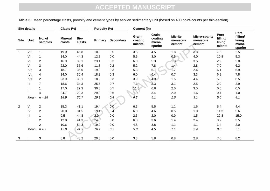
ACCEPTED MANUSCRIPT
Table 3: Mean percentage clasts, porosity and cement types by aeolian sedimentary unit (based on 400 point-counts per thin-section).
Site details Clasts (%) Porosity (%) Cement (%)
Site Unit No. of samples
Mineral clasts
Bio-clasts
Primary Secondary Grain-coating micrite
Grain-coating micro-sparite
Micrite meniscus cement
Micro-sparite meniscus cement
Pore filling/ lining micrite
Pore filling/ lining micro-sparite
1 VIII 1 19.0 46.8 10.8 0.5 3.5 4.5 1.8 3.3 7.5 2.5
VII 1 14.0 44.3 12.8 0.0 5.5 3.0 0.5 4.0 10.8 5.3
VI 2 16.9 38.1 23.1 0.3 6.0 5.3 1.3 3.5 2.9 2.8
V 3 22.0 35.6 11.8 0.2 5.2 7.8 1.4 2.8 7.0 6.2
IVc 3 18.7 35.0 19.0 0.3 5.3 5.7 1.7 2.4 6.1 5.9
IVb 4 14.0 36.4 18.3 0.3 6.0 6.4 0.7 3.3 6.9 7.8
IVa 2 23.9 30.1 18.9 0.3 3.9 4.9 1.5 4.4 5.8 6.5
III 7 18.6 34.3 25.5 0.7 7.1 3.3 3.1 2.5 2.0 2.9
II 1 17.0 27.3 30.3 0.5 11.8 6.8 2.0 3.5 0.5 0.5
I 4 24.7 29.3 29.0 0.6 7.9 3.4 2.0 1.6 0.4 1.0
Mean n = 28 18.9 35.7 19.9 0.4 6.2 5.1 1.6 3.1 5.0 4.1
2 V 2 15.3 41.1 19.4 0.0 6.3 5.5 1.1 1.6 5.4 4.4
IV 2 20.0 31.5 19.1 0.4 6.0 4.6 0.5 1.0 11.3 5.6
III 1 9.5 44.8 2.0 0.0 2.5 2.0 0.0 1.5 22.8 15.0
II 2 12.8 41.3 24.5 0.0 6.8 3.6 1.4 2.4 3.9 3.5
I 2 10.6 54.3 19.0 0.0 4.8 3.8 1.1 1.1 3.4 2.0
Mean n = 9 15.9 41.3 16.2 0.2 5.3 4.5 1.1 2.4 8.0 5.1
3 I 3 8.8 43.2 20.3 0.0 3.3 5.8 0.8 2.8 7.0 8.2
ACCEPTED MANUSCRIPT

ACCEPTED MANUSCRIPT
Table 4: Stable carbon isotope results for selected plant species around the Llano Agua de los Burros sample sites. Species δ
13C ‰VPDB
Nolana glauca –25.25
Ephedra cf. multiflora –27.40
Oxalis gigantea –24.31
Chuquiraga ulicina –26.44
Chuquiraga ulicina –26.74
Cynanchum deserticola –27.17
Cynanchum deserticola –27.45
ACCEPTED MANUSCRIPT

ACCEPTED MANUSCRIPT
Table 5: OSL-related data and ages for sampled sites (samples are aeolianite unless otherwise specified).
Site Unit Sample
code
Altitude
(m)
K
(%)
U
(ppm)
Th
(ppm)
Rb
(ppm)
Cosmic
dose rate
(μGy a-1
)
Total dose
rate (Gy
kyr-1
)
De
(Gy) N
3 Skew OD (%) Age (ka)
MIS
stage4
1 Unconsol.
sand Shfd09022 280 1.75 1.13 3.5 67.2 189 ± 9 2.33 ± 0.11 65.5 ± 4.8
2 48(44) 3.73 35(25) 28.1 ± 2.5 3a
Unconsol.
sand Shfd10050 279 2.0 0.95 2.8 69.6 163 ± 8 2.40 ± 0.13 99.1 ± 3.3 24(24) -0.12 24 (17) 41.3 ± 2.5 3a
VII Shfd09048 264 0.44 0.59 1.1 18.7 36 ± 21 0.76 ± 0.03 47.6 ± 4.7
2 24(24) 0.28 27(22) 76.9 ± 8.5 5a
V Shfd09047 241 0.55 0.51 1.0 23.0 18 ± 11 0.93 ± 0.05 48.3 ± 3.3
2 48(42) 0.05 28 (24) 69.0 ± 5.8 4b-5a
IVb Shfd09046 227 0.45 0.36 0.6 17.1 18 ± 11 0.55 ± 0.03 51.7 ± 1.7 24(21) 0.71 30(25) 97.6 ± 6.2 5b-5c
III Shfd09045 251 0.46 0.44 0.9 18.0 18 ± 11 0.53 ± 0.03 59.0 ± 3.4
2 48(48) 0.35 32(29) 107.7 ± 8.5 5c-5d
III Shfd09044 234 0.84 0.53 1.3 35.2 18 ± 11 0.70 ± 0.04 93.4 ± 2.4 24(21) -0.03 20(16) 100.6 ± 6.4 5b-5c
I Shfd09043 229 0.67 0.52 1.2 28.0 18 ± 11 0.62 ± 0.03 76.4 ± 1.7 48(42) 1.59 29(21) 101.2 ± 4.8 5b-5c
2 V Shfd09051 264 0.30 0.54 1.3 11.8 76 ± 41 0.48 ± 0.02 53.0 ± 1.9 48(41) 0.81 38(31) 111 ± 6.6 5c-5d
IV Shfd09050 259 0.45 0.39 0.7 18.1 36 ± 21 0.58 ± 0.03 78.3 ± 5.3
2 48(38) 0.52 32(26) 135 ± 11 5e-6b
I Shfd09049 243 0.29 0.40 0.4 11.6 19 ± 11 0.39 ± 0.02 50.6 ± 5.2
2 24(20) 0.36 35(35) 131 ± 15 5e-6b
1 dose rate corrected for linear uptake of cement based on total cement measured in micromorphological analyses (Table S1 in the SOM)
2 De based on minimum age model
3 N refers to the number of aliquots that met quality control criteria
4 MIS stages based on record of Martinson et al. (1987).
ACCEPTED MANUSCRIPT

ACC
EPTE
D M
ANU
SCR
IPT
Figure 1
ACCEPTED MANUSCRIPT

ACC
EPTE
D M
ANU
SCR
IPT
35
Figure 2
ACCEPTED MANUSCRIPT

ACC
EPTE
D M
ANU
SCR
IPT
36
Figure 3
ACCEPTED MANUSCRIPT

ACC
EPTE
D M
ANU
SCR
IPT
37
Figure 4
ACCEPTED MANUSCRIPT

ACC
EPTE
D M
ANU
SCR
IPT
38
Figure 5
ACCEPTED MANUSCRIPT

ACC
EPTE
D M
ANU
SCR
IPT
39
Figure 6
ACCEPTED MANUSCRIPT

ACC
EPTE
D M
ANU
SCR
IPT
40
Figure 7
ACCEPTED MANUSCRIPT

ACC
EPTE
D M
ANU
SCR
IPT
41
Figure 8
ACCEPTED MANUSCRIPT

ACC
EPTE
D M
ANU
SCR
IPT
42
Figure 9
ACCEPTED MANUSCRIPT

ACC
EPTE
D M
ANU
SCR
IPT
43
Figure 10
ACCEPTED MANUSCRIPT

ACC
EPTE
D M
ANU
SCR
IPT
44
Figure 11
ACCEPTED MANUSCRIPT

ACC
EPTE
D M
ANU
SCR
IPT
45
HIGHLIGHTS
Aeolianite host sediments deposited at 130, 111-98, 77-69 ka;
Later phase of aeolian activity from 41-28 ka;
Predominantly marine source for three oldest aeolian phases;
Sand-transporting winds varied from S-ESE (during MIS 5e) and WNW-ESE (MIS 5c-5a);
Uplift of the coastal platform proceeded at an average rate of 305 to 542 mm ka-1.
ACCEPTED MANUSCRIPT
View publication statsView publication stats