Embed Size (px)
Citation preview
7/23/2019 Pyu City States
http://slidepdf.com/reader/full/pyu-city-states 1/10
Pyu city-states
The Pyu city states (Burmese: )were a group of city-states that existed from c. 2nd cen-tury BCE to c. mid-11th century in present-day UpperBurma (Myanmar). The city-states were founded aspart of the southward migration by the Tibeto-Burman-speaking Pyu people, the earliest inhabitants of Burmaof whom records are extant.[2] The thousand-year period,oftenreferred to as the Pyu millennium, linked the BronzeAge to the beginning of the classical states period whenthe Pagan Kingdom emerged in the late 9th century.
The city-states—five major walled cities and severalsmaller towns have been excavated—were all located inthe three main irrigated regions of Upper Burma: theMu River Valley, the Kyaukse plains and Minbu region,around the confluence of the Irrawaddy and ChindwinRivers. Part of an overland trade route between Chinaand India, the Pyu realm gradually expanded south.Halin, founded in the 1st century AD at the northern edgeof Upper Burma, was the largest and most important cityuntil around the 7th or 8th century when it was super-seded by Sri Ksetra (near modern Pyay) at the southernedge. Twice as large as Halin, Sri Ksetra was the largest
and most influential Pyu center.[2]
The Pyu culture was heavily influenced by trade with In-dia, importing Buddhism as well as other cultural, archi-tectural and political concepts, which would have an en-during influence on the Culture of Burma and politicalorganization.[3] The Pyu calendar, based on the Buddhistcalendar, later became the Burmese calendar. Latestscholarship, though yet not settled, suggests that the Pyuscript, based on the Indian Brahmi script, may have beenthe source of the Mon script used to write the Burmeselanguage.
The millennium-old civilization came crashing down in
the 9th century when the city-states were destroyed byrepeated invasions from the Kingdom of Nanzhao. TheBamar people, who came from Nanzhao, set up a gar-rison town at Bagan at the confluence of the Irrawaddyand Chindwin Rivers. Pyu settlements remained in Up-per Burma for the next three centuries but the Pyu grad-ually were absorbed into the expanding Pagan Kingdom.The Pyu language still existed until the late 12th century.By the 13th century, the Pyu had assumed the Burmanethnicity. The histories and legends of the Pyu were alsoincorporated to those of the Bamar.[3]
1 Background
Based on limited archaeological evidence, it is inferredthat the earliest cultures existed in Burma as early as11,000 BCE, mainly in the central dry zone close to theIrrawaddy. The Anyathian, Burma’s Stone Age, existedaround the same time as the lower and middle Paleolithiceras in Europe. Three caves located near Taunggyi at thefoothills of the Shan Hills have yielded Neolithic artifactsdated 10-6000 BCE.[4]
About 1500 BCE, people in the region were turning cop-per into bronze, growing rice, and domesticating chickensand pigs; they were among the first people in the world todo so. By 500 BCE, iron-working settlements emergedin an area south of present-day Mandalay. Bronze-decorated coffins and burial sites filled with earthenwareremains have been excavated.[5] Archaeological evidenceat Samon River Valley south of Mandalay suggests rice-growing settlements that traded with China between 500BCE and 200 CE.[6]
Circa 2nd century BCE, the Tibeto-Burman-speakingPyu people began to enter the Irrawaddy River Valleyfrom present-day Yunnan using the Tapain and ShweliRivers. The original home of the Pyu is reconstructedto be Qinghai Lake, which is located in the present-dayprovinces of Qinghai and Gansu.[7] The Pyu, the earli-est inhabitants of Burma of whom records are extant,went on to found settlements throughout the plains re-gion centered around the confluence of the Irrawaddyand Chindwin Rivers that has been inhabited since thePaleolithic.[2][8] The Pyu realm was longer than wide,stretching from Sri Ksetra in the south to Halin in thenorth, Binnaka and Maingmaw to the east and probablyAyadawkye to the west. The Tang dynasty's records re-
port 18 Pyu states, nine of which were walled cities, cov-ering 298 districts.[9]
Archaeological surveys have actually so far unearthed 12walled cities, including five large walled cities, and sev-eral smaller non-fortified settlements, located at or nearthe three most important irrigated regions of precolonialBurma: the Mu River Valley in the north, the Kyaukseplains in center, and the Minbu region in the south andwest of the former two.[10] The city-states were contem-poraries of the Kingdom of Funan (Cambodia) and (per-haps) Champa (southern Vietnam), Dvaravati (Thailand),Tambralinga and Takuapa near the Kra Isthmus, and
Srivijaya (southeast Sumatra). All these statelets fore-shadowed the rise of the “classical kingdoms” of South-east Asia in the second millennium CE.[11]
1
7/23/2019 Pyu City States
http://slidepdf.com/reader/full/pyu-city-states 2/10
2 2 CITY-STATES
2 City-states
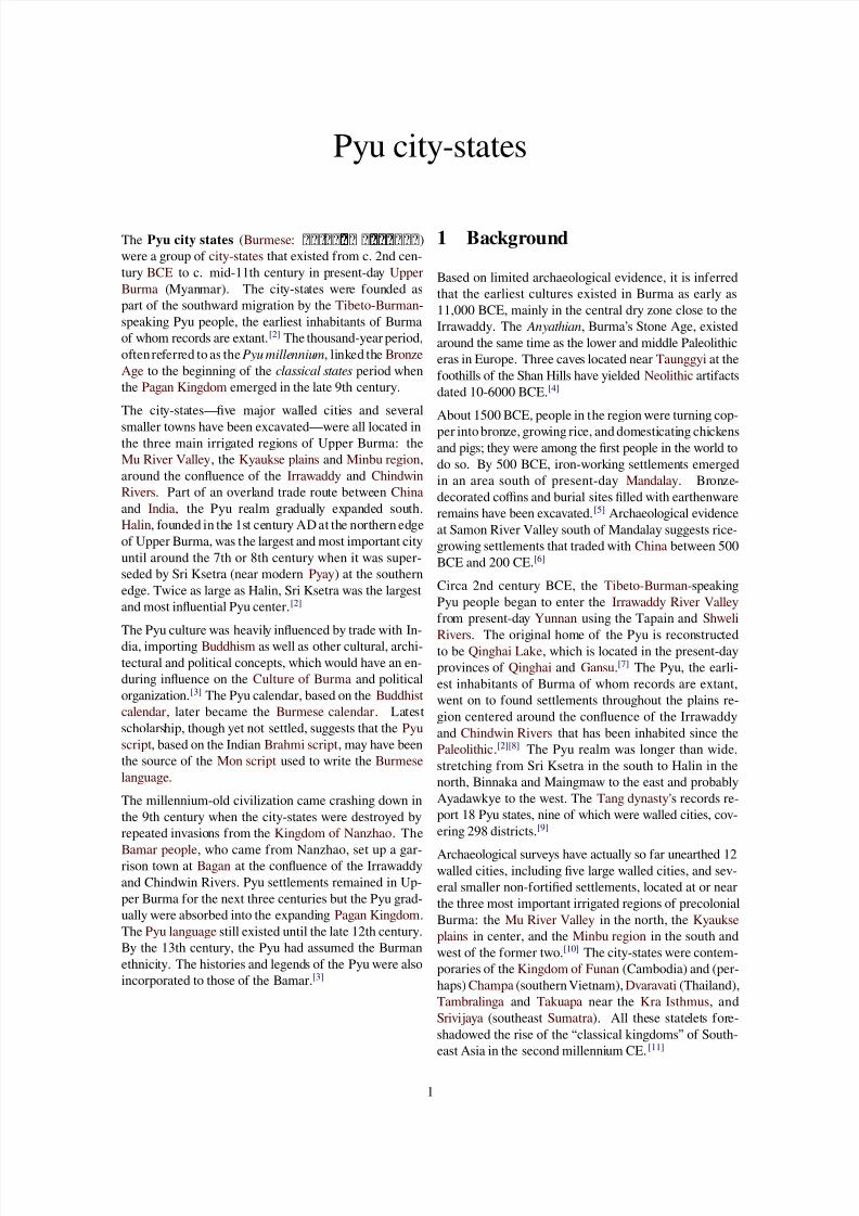
Pyu realm circa 800 CE, before the advent of the Mranma
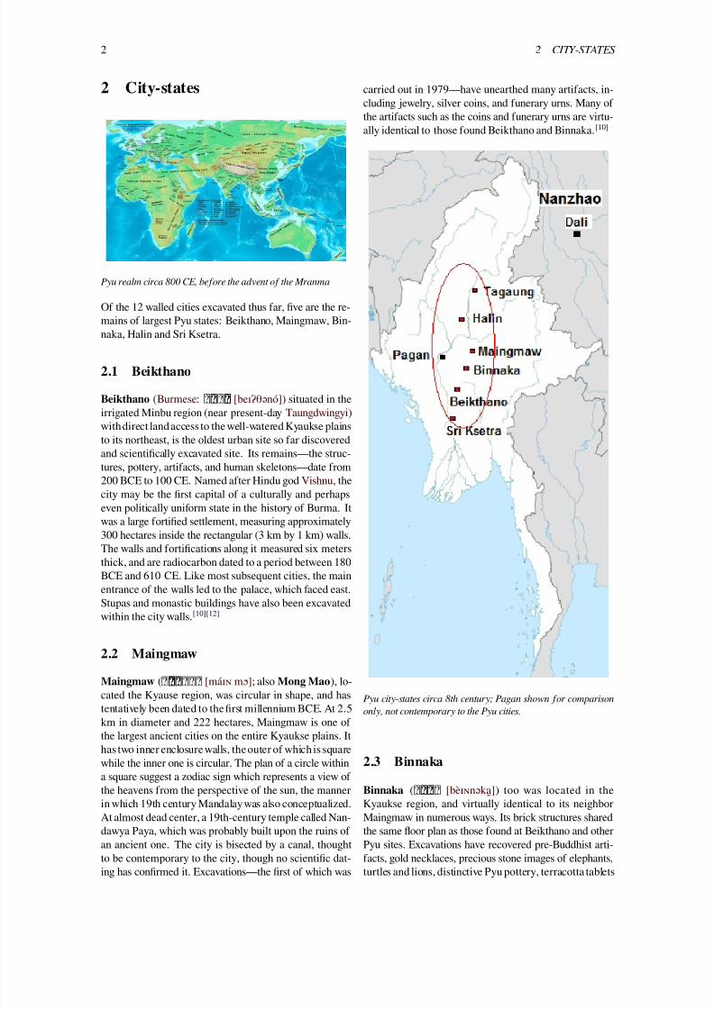
Of the 12 walled cities excavated thus far, five are the re-mains of largest Pyu states: Beikthano, Maingmaw, Bin-
naka, Halin and Sri Ksetra.
2.1 Beikthano
Beikthano (Burmese: [beɪʔθənó]) situated in theirrigated Minbu region (near present-day Taungdwingyi)withdirect land access to the well-watered Kyaukse plainsto its northeast, is the oldest urban site so far discoveredand scientifically excavated site. Its remains—the struc-tures, pottery, artifacts, and human skeletons—date from200 BCE to 100 CE. Named after Hindu god Vishnu, thecity may be the first capital of a culturally and perhaps
even politically uniform state in the history of Burma. Itwas a large fortified settlement, measuring approximately300 hectares inside the rectangular (3 km by 1 km) walls.The walls and fortifications along it measured six metersthick, and are radiocarbon dated to a period between 180BCE and 610 CE. Like most subsequent cities, the mainentrance of the walls led to the palace, which faced east.Stupas and monastic buildings have also been excavatedwithin the city walls.[10][12]
2.2 Maingmaw
Maingmaw ( [máɪɴ mɔ ́]; also Mong Mao), lo-cated the Kyause region, was circular in shape, and hastentatively been dated to the first millennium BCE. At 2.5km in diameter and 222 hectares, Maingmaw is one ofthe largest ancient cities on the entire Kyaukse plains. Ithas two inner enclosure walls, theouter of which is squarewhile the inner one is circular. The plan of a circle withina square suggest a zodiac sign which represents a view ofthe heavens from the perspective of the sun, the mannerin which 19th century Mandalay was also conceptualized.At almost dead center, a 19th-century temple called Nan-dawya Paya, which was probably built upon the ruins of
an ancient one. The city is bisected by a canal, thoughtto be contemporary to the city, though no scientific dat-ing has confirmed it. Excavations—the first of which was
carried out in 1979—have unearthed many artifacts, in-cluding jewelry, silver coins, and funerary urns. Many ofthe artifacts such as the coins and funerary urns are virtu-ally identical to those found Beikthano and Binnaka.[10]
Pyu city-states circa 8th century; Pagan shown for comparison
only, not contemporary to the Pyu cities.
2.3 Binnaka
Binnaka ( [bèɪɴnəka]̰) too was located in theKyaukse region, and virtually identical to its neighborMaingmaw in numerous ways. Its brick structures sharedthe same floor plan as those found at Beikthano and other
Pyu sites. Excavations have recovered pre-Buddhist arti-facts, gold necklaces, precious stone images of elephants,turtles and lions, distinctive Pyu pottery, terracotta tablets
7/23/2019 Pyu City States
http://slidepdf.com/reader/full/pyu-city-states 3/10
2.5 Sri Ksetra 3
with writing that strongly resembled the Pyu script, andvarious kinds of acid-etched onyx beads along with othersmade of amber and jade. Also excavated are distinctivesilver coins identical to those found at Beikthano and Bin-naka, stone molds for casting silver and gold ornamentalflowers, a gold armlet in association with a silver bowl that
has Pyu writing on it, and funerary urns virtually identicalto those found Beikthano and Binnaka.[10]
Both Maingmaw and Binnaka may have been contempo-rary of Beikthano. The chronicles, which do not mentionBeikthano at all, do mention the two, though not specif-ically as Pyu cities. The chronicles state that the rulerof Binnaka was responsible for the fall of Tagaung, thecity identified by the chronicles as the original home ofBurmese speakers.[13] Binnaka was inhabited until aboutthe 19th century, according to a Konbaung era palm-leafsittan (record) discovered there.[10]
2.4 Halin
Halin or Halingyi ( [həlɪɴ́dʑí]), located inthe Mu valley, one of the largest irrigated regions of pre-colonial Burma, is the northernmost Pyu city so far dis-covered. The earliest artifacts of Halin—city’s woodengates—are radiocarbondated to 70 CE. The city was rect-angular but with curved corners, and brick-walled. Exca-vated walls are approximately 3.2 km long on the north-south axis and 1.6 km on the east-west. At 664 hectares,the city was nearly twice the size of Beikthano. It has four
main gates at the cardinal points, and a total of 12 gates,based on the zodiac. A river or canal ran through the city.Traces of a moat exist on all sides except the south, whereit was probably not needed, as land was dammed there tocreate reservoirs.
This design of the city influenced the city planning oflater Burmese cities and the Siamese city of Sukhothai.For example, the number of gates and configuration wasalso found in subsequent major Burmese capitals such asthe 11th century Pagan and 19th century Mandalay. Thecity’s configuration was also found at other contemporarycities such as Maingmaw and Beikthano in the Pyu realm
and Danyawaddy and Wethali in Arakan as well as latercities such as Sukhothai, which emerged over a millen-nium later. Structural remains of temples at Halin showthat the design of city’s temples influenced the 11th to13th century temples at Pagan. Excavated artifacts pointto Halin’s Pyu script to be the earliest writing in the Pyurealm (and in Burma). It was based on an earlier versionof the Brahmi script (Mauryan and Guptan). Inscriptionsat Sri Ksetra show a later version of the same script.[14]
Known for the production of salt, a highly prized com-modity in the first millennium, Halin was superseded bySri Ksetra as the premier Pyu city-state circa 7th century.
By the Chinese accounts, Halin remained an importantPyu center until the 9th century when the Pyu realm cameunder repeated attacks from the Nanzhao Kingdom. The
Chinese records state that the city was destroyed by theNanzhao warriors in 832 CE, with 3000 of its inhabitantstaken away. However, radiocarbon dating reveals humanactivity to about 870 CE, nearly four decades after thereported sack of the city.[14]
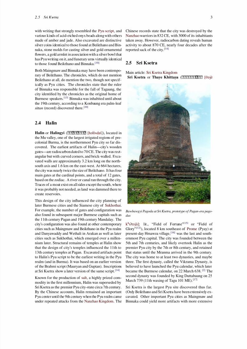
2.5 Sri Ksetra
Main article: Sri Ksetra KingdomSri Ksetra or Thaye Khittaya ( [θəjè
Bawbawgyi Pagoda at Sri Ksetra, prototype of Pagan-era pago-
das
kʰɪʔtəjà]; lit., “Field of Fortune”[15] or “Field ofGlory”[12]), located 8 km southeast of Prome (Pyay) at
present-day Hmawza village,[16] was the last and south-ernmost Pyu capital. The city was founded between the5th and 7th centuries, and likely overtook Halin as thepremier Pyu city by the 7th or 8th century, and retainedthat status until the Mranma arrived in the 9th century.The city was home to at least two dynasties, and maybethree. The first dynasty, called the Vikrama Dynasty, isbelieved to have launched the Pyu calendar, which laterbecame the Burmese calendar, on 22 March 638.[2] Thesecond dynasty was founded by King Duttabaung on 25March 739 (11th waxing of Tagu 101 ME).[17]
Sri Ksetra is the largest Pyu site discovered thus far.
(Only Beikthano and Sri Ksetra have been extensively ex-cavated. Other important Pyu cities as Maingmaw andBinnaka could yield more artifacts with more extensive
7/23/2019 Pyu City States
http://slidepdf.com/reader/full/pyu-city-states 4/10
4 3 ECONOMY
excavations.) It occupied a larger area than that of the11th century Pagan or 19th century Mandalay. Circularin design, Sri Ksetra was more than 13 km in circumfer-ence and three to four km across, or about 1400 hectaresof occupied area. The city’s brick walls were 4.5 metershigh, and had 12 gates with huge devas (deities) guarding
the entrances and a pagoda at each of the four corners.[17]
It also has curving gateways, such as those found at Halinand Beikthano. In the center of the city was what mostscholars think represented the rectangular palace site,518 meters by 343 meters, symbolizing both a mandalaand a zata (horoscope), like in Maingmaw.[17] Only thesouthern half of the city was taken up by the palace,monasteriesand houses; the entire northern halfconsistedof rice fields. Together with the moats and walls, this ar-rangement ensured that the city could withstand a longsiege by enemies.[18]
Sri Ksetra was an important entrepôt between China andIndia. It was located on the Irrawaddy, not far fromthe sea as the Irrawaddy delta had not yet been formed.Ships from the Indian ocean could come up to Prome totrade with the Pyu realm and China.[15] Trade with Indiabrought deep cultural contacts. Sri Ksetra has yielded themost extensive remains of Theravada Buddhism. Reli-gious art suggests several distinct occupations with earlierinfluences stemming from Southeast India and later influ-ences from Southwest India while 9th century influencesinclude those from the Nanzhao Kingdom.[17] Much ofthe Chinese account of the Pyu states was through SriKsetra. Chinese pilgrims Xuanzang in 648 and Yijing in
675 mentioned Sri Ksetra in their accounts of Buddhistkingdoms of Southeast Asia. The Tang histories mentionthe arrival at the court of an embassy from the Pyu capitalin 801.[19]
2.6 Smaller settlements
See also: Tagaung Kingdom
Many Pyu settlements have been found across UpperBurma. They include Wati (an urban area west of Maing-maw), Ayadawkye Ywa in the Mu valley, west of Halinand south of a recently discovered Bronze Age site calledNyaunggan, and several others in Myinmu township,which controls the mouth of the Mu river.[17] A smallbut politically significant Pyu site is Tagaung ([dəɡáʊɴ]) in northern Burma (about 200-km north ofMandalay) where Pyu artifacts including funerary urnshave been excavated. The significance is due to the factthat theBurmese chronicles identify Tagaung as the home
of the first Burmese kingdom.[20] Aside from Beikthanoand Sri Ksetra, most Pyu sites have not seen extensive orany excavation.[17]
3 Economy
3.1 Agriculture
The economy of the Pyu city states was based on agri-
culture and trade. All important Pyu settlements were lo-cated in the three main irrigated regions of Upper Burma,centered around the confluence of the Irrawaddy andChindwin rivers: Halin in the Mu valley, Maingmaw andBinnaka in the Kyaukse plains, finally Beikthano and SriKsetra at or near the Minbu district.[14] (The irrigationprojects of the Pyu were later picked up by the Burmans.King Anawrahta of Pagan would build irrigation projectsin these three regions in the 1050s to turn them into themain rice granaries of Upper Burma. They would giveUpper Burma an enduring economic base from which todominate the Irrawaddy valley anditsperiphery in the fol-lowing centuries.[21]) The Pyu grew rice, perhaps of the
Japonica variety.[22]
3.2 Trade
The Pyu realm was an important trading center betweenChina and India in the first millennium CE. Two maintrading routes passed through the Pyu states. As earlyas 128 BCE, an overland trade route between China andIndia existed across the northern Burma. An embassyfrom the Roman Empire to China passed through thisroute in 97 CE and again in 120 CE.[23] But the major-
ity of the trade was conducted by sea through the south-ern Pyu states, which at the time were located not farfrom the sea as much of the Irrawaddy delta had not yetbeen formed, and as far south as upper Tenasserim coasttowns such as Winga, Hsindat-Myindat, Sanpannagonand Mudon where Pyu artifacts have been found. (It isinsufficient to conclude however that the Pyu had admin-istrative and military control over these upper Tenasserimcoastal towns.)[24] The ports connected the overland traderoute to China via present-day Yunnan.
The trading area of the Pyu states spanned across thepresent-day Southeast Asia, South Asia and China. Arti-
facts from the 2nd century northwest India to Java and thePhilippines have been found at Beikthano.[24] Likewise,Pyu artifacts have been found along the coasts of Arakan,Lower Burma, and as far east as Óc Eo (in present-daysouthern Vietnam).[25] The Pyu also conducted trade anddiplomatic relations with China. In 800 and 801–802,Sri Ksetra sent a formal embassy, along with 35 musi-cians to the Tang court. According to the Chinese, thePyu used gold and silver coinage. But only silver coinshave survived.[26]
3.3 Currency
A notable feature of the Pyu states is the minting and useof silver coinage. Originated in the Pegu area, these coins
7/23/2019 Pyu City States
http://slidepdf.com/reader/full/pyu-city-states 5/10
4.2 Language and script 5
date from the 5th century and were the model for mostfirst millennium coinage in mainland Southeast Asia. Theearliest type of these coins is not inscribed and depicts aconch on one side and a Srivatsa on the other. Many ofthe coins had a small hole along the perimeter, and mayhave also been used as amulets. Remarkably, after the use
of coins ceased at the end of Pyu period in the late 9thcentury, coins did not reappear in the Burmese kingdomsuntil the 19th century.[27]
4 Culture
4.1 Religion
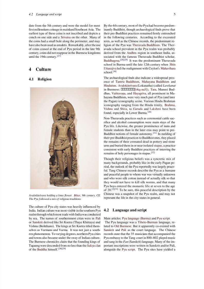
Avalokiteśvara holding a lotus flower. Bihar , 9th century, CE.
The Pyu followed a mix of religious traditions.
The culture of Pyu city states was heavily influenced byIndia. Indian culture was most visible in the southern Pyurealmthrough which most trade with Indiawas conductedby sea. The names of southernmost cities were in Palior Sanskrit derived like Sri Ksetra (Thaye Khittaya) andVishnu (Beikthano). The kings at Sri Ksetra titled them-selves as Varmans and Varma. It was not just a south-ern phenomenon. To varying degrees, northern Pyu citiesand towns also became under the sway of Indian culture.
The Burmese chronicles claim that the founding kings ofTagaung were descended from no less than the Sakya clanof the Buddha himself.[28][29]
By the 4th century, most of the Pyu had become predom-inantly Buddhist, though archaeological finds prove thattheir pre-Buddhist practices remained firmly entrenchedin the following centuries. According to the excavatedtexts, as well as the Chinese records, the predominant re-ligion of the Pyu was Theravada Buddhism. The Ther-
avada school prevalent in the Pyu realm was probablyderived from the Andhra region in southeast India, as-sociated with the famous Theravada Buddhist scholar,Buddhagosa.[28][29] It was the predominant Theravadaschool in Burma until the late 12th century when ShinUttarajiva led the realignment with Ceylon’s Mahaviharaschool.[30]
The archaeological finds also indicate a widespread pres-ence of Tantric Buddhism, Mahayana Buddhism andHinduism. Avalokiteśvara (Lokanatha) (called Lawkanat
in Burmese; [lɔ ́ka ̰naʔ]), Tara, Manusi Bud-dhas, Vaiśravaṇa, and Hayagriva, all prominent in Ma-
hayana Buddhism, were very much part of Pyu (and laterthe Pagan) iconography scene. Various Hindu Brahmaniconography ranging from the Hindu trinity, Brahma,Vishnu and Shiva, to Garuda and Lakshmi have beenfound, especially in Lower Burma.[28]
Non-Theravada practices such as ceremonial cattle sac-rifice and alcohol consumption were main stays of thePyu life. Likewise, the greater prominence of nuns andfemale students than in the later eras may point to pre-Buddhist notions of female autonomy.[31] In melding oftheir pre-Buddhistpractices to Buddhist ones, they placedthe remains of their cremated dead in pottery and stone
urns and buried them in or near isolated stupas, a practiceconsistent with early Buddhist practices of interring theremains of holy personages in stupas.[32]
Though their religious beliefs was a syncretic mix ofmany backgrounds, probably like in the early Pagan pe-riod, the outlook of the Pyu reportedly was largely peace-ful. Tang Chinese records describe the Pyu as a humaneand peaceful people to whom war was virtually unknownand who wore silk cotton instead of actually silk so thatthey would not have to kill silk worms, and that manyPyu boys entered the monastic life at seven to the ageof 20.[2][33] To be sure, this peaceful description by the
Chinese was a snapshot of the Pyu realm, and may notrepresent the life in the city-states in general.
4.2 Language and script
Main articles: Pyu language (Burma) and Pyu scriptThe Pyu language was a Tibeto-Burman language, re-
lated to Old Burmese. But it apparently co-existed withSanskrit and Pali as the court language. The Chineserecords state that the 35 musicians that accompanied thePyu embassy to the Tang court in 800–802 played music
and sang in the Fan (Sanskrit) language. Many of the im-portant inscriptions were written in Sanskrit and/or Pali,alongside the Pyu script. The Pyu sites have yielded a
7/23/2019 Pyu City States
http://slidepdf.com/reader/full/pyu-city-states 6/10
6 5 ARCHITECTURE
The Myazedi inscription c. 1112–1113 in Pyu
wide variety of Indian scripts from King Ashoka's edictswritten in north Indian Brahmi and Tamil Brahmi, bothdated to the 3rd and 2nd centuries BCE, to the Guptascript and Kannada script dated to the 4th to 6th centuries
CE.[34][35]
4.3 Calendar
In addition to religion, the Pyu also imported science andastronomical expertise from India. The Chinese recordsalso report that the Pyu knew how to make astronom-ical calculations.[2] The Pyu calendar was based on theBuddhist calendar. There were two eras in use. The firstwas the Sakra Era, which was adopted in the Pyu realmin 80 CE, just two years after the new era had come into
use in India. A second calendar was adopted at Sri Kse-tra in 638, superseding the Sakra Era. The calendar, thefirst day of which was 22 March 638, later became theBurmese calendar, and is still in use in present-day Myan-mar. (The existence of two Pyu calendars has been causefor dispute among scholars trying interpret the dates onthe finds.)[36]
5 Architecture
5.1 Irrigation structures
The Pyu-era architectural practices greatly influencedlater Pagan and Burmese architecture. The techniques of
building dams, canals and weirs found in pre-colonial Up-per Burma trace their origins to the Pyu era and the Paganera. (Burmans likely introduced new water managementmethods, especially the canal building techniques whichbecame the prevailing method of irrigation in the Paganera.)[22]
5.2 City planning
The Pyu city plans, consisted of square/rectangles andcircles, were a mix of indigenous and Indian designs. It isbelieved that circular patterns inside the cities were Pyuwhile the rectangle or square shape of the outer walls andthe use of 12 gates were Indian in origin. According tohistorian Cooler, “the adoption of Indian concepts of cityplanning incorporated a belief in the efficacy of the worldaxis that connects the centermost point in a properly con-
structed Mandala city with the city of the Gods above(Tavatimsa heaven) in order to assure prosperity through-out the kingdom below”.[27] Pyu-era city practices werethe forefathers of the latter-day Burmese city and palacedesigns down to the 19th century Mandalay.[37]
5.3 Temple design
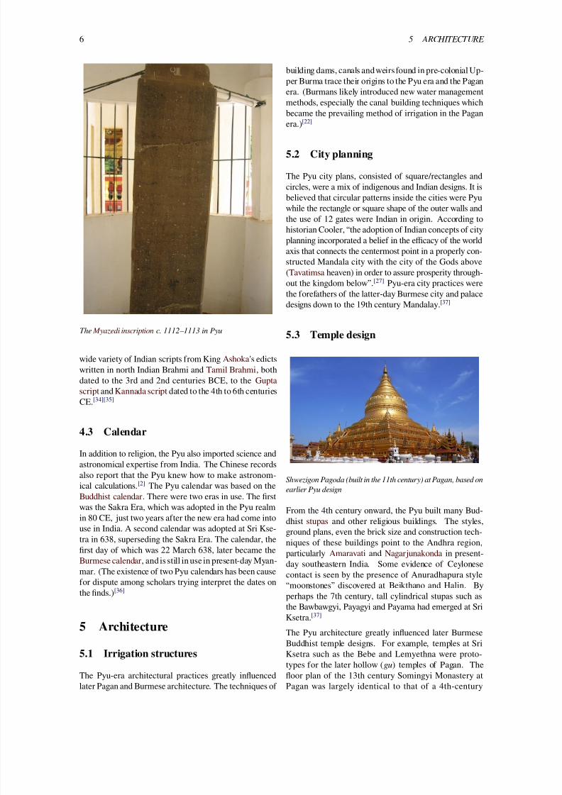
Shwezigon Pagoda (built in the 11th century) at Pagan, based on
earlier Pyu design
From the 4th century onward, the Pyu built many Bud-dhist stupas and other religious buildings. The styles,
ground plans, even the brick size and construction tech-niques of these buildings point to the Andhra region,particularly Amaravati and Nagarjunakonda in present-day southeastern India. Some evidence of Ceylonesecontact is seen by the presence of Anuradhapura style“moonstones” discovered at Beikthano and Halin. Byperhaps the 7th century, tall cylindrical stupas such asthe Bawbawgyi, Payagyi and Payama had emerged at SriKsetra.[37]
The Pyu architecture greatly influenced later BurmeseBuddhist temple designs. For example, temples at SriKsetra such as the Bebe and Lemyethna were proto-
types for the later hollow ( gu) temples of Pagan. Thefloor plan of the 13th century Somingyi Monastery atPagan was largely identical to that of a 4th-century
7/23/2019 Pyu City States
http://slidepdf.com/reader/full/pyu-city-states 7/10
7
monastery at Beikthano. The solid stupas of Sri Kse-tra were in turn prototypes for Pagan’s such as theShwezigon, Shwehsandaw, and Mingalazedi, and ulti-mately, the Shwedagon in modern Yangon.[37]
6 Demography
The city-states were mainly populated by the Tibeto-Burman-speakingPyu people, who like their cousins Bur-mans are believed to have migrated from present-daynorth central China, reconstructed as modern Qinghaiand Gansu provinces via Yunnan.[7][38][39] Extensive ex-ternal trade attracted sizable communities of Indians andthe Mon, especially in the south. In the north, trickles ofBurmans may have entered the Pyu realm from Yunnanas early as the 7th century. (Modern scholarship however
holds that Burmans did not arrive in large numbers un-til the mid-to-late 9th century, and perhaps as late as the10th century, according to radiocarbon dating of Pagan’swalls.)
The size of population of the Pyu realm was probably afew hundred thousand, given that the 17th and 18th cen-tury Burma (about thesize of present-day Myanmar) onlyhad about 2 million people.
7 Administration
The Pyu settlements were ruled by independent chiefs.The chiefs at larger city-states later styled themselves askings, and established courts largely modeled after the In-dian (Hindu) concepts of monarchy. Not all Hindu con-cepts such as divine kingship were fully adopted due tothe presence of Theravada Buddhism. It is not clear if avassalage-overlord relationship existed between the largercity-states and smaller towns. The Burmese chroniclesmention alliances between the states such as one betweenBeikthano and Sri Ksetra. By and large, each Pyu city-state appeared to have controlled just the city itself.[40]
The large size of the Pyu cities (660 to 1400 hectares)vis-a-vis Pagan (only 140 hectares) suggests that muchof the population resided within the walls, as corrobo-rated by the Chinese records.[41] Archaeology in Paganproduced Pyu artifacts across a number of the settle-ments in the enclosed complex dating to the first millen-nium, until approximately 1100 C.E. when a shift to amonument-rich state and diffusion beyond walled bound-aries is evident.[42]
8 Decline of Pyu city-states
It was a long-lasting civilization that lasted nearly a mil-lennium to the early 9th century until a new group of
“swift horsemen” from the north, the (Mranma) (Bur-mans) of the Nanzhao Kingdom entered the upper Ir-rawaddy valley through a series of raids. According to theTang Dynasty chronicles, the Nanzhao began their raidsof Upper Burma starting as early as 754[43] or 760.[2]
Nanzhao raids intensified in the 9th century, with the
Nanzhao raiding in 800-802, and again in 808-809. Fi-nally, according to the Chinese, in 832, the Nanzhao war-riors overran the Pyu country, and took away 3000 Pyuprisoners from Halin. (In 835, the Chinese records saythe Nanzhao also raided a state, generally identified bysome but not universally accepted to be a Pyu state.)
To be sure, the Pyu and their culture did not disappearjust because 3000 of them were taken away. The size ofthe Pyu realm and its many walled cities throughout theland indicates a population many times over. Indeed, nofirm indications at Sri Ksetra or at any other Pyu site existto suggest a violent overthrow. It is more likely that these
raids significantly weakened the Pyu states, enabling theBurmans to move into Pyu territories.[27] At any rate,evidence shows that the actual pace of Burman migra-tion into the Pyu realm was gradual. Radiocarbon datingshows that human activity existed until c. 870 at Halin,the subject of the 832 Nanzhao raid.[44] The Burmesechronicles claim the Burmans founded the fortified cityof Pagan (Bagan) in 849 but the oldest radiocarbon datedevidence at Pagan (old walls) points to 980 CE while themain walls point to circa 1020 CE, just 24 years earlierthan the beginning of the reign of Anawrahta, the founderof Pagan Empire.[45]
At any rate, the Burmans had overtaken the leadership ofthe Pyu realm by the late 10th century, and went on tofound the Pagan Empire in the middle of the 11th cen-tury, unifying the Irrawaddy valley and its periphery forthe first time. Nonetheless, the Pyu had left an indeliblemark on Pagan whose Burman rulers would incorporatethe histories and legends of the Pyu as their own. TheBurman kings of Pagan claimed descent from the kingsof Sri Ksetra and Tagaung as far back as 850 BCE—a claim dismissed by most modern scholars.[27][46] Pyusettlements remained in Upper Burma for the next threecenturies but the Pyu gradually were absorbed and assim-
ilated into the expanding Pagan Empire. The Pyu lan-guage still existed until the late 12th century but by the13th century, the Pyu had assumed the Burman ethnicityand disappeared into history.[3]
9 Current status of the finds
Aside from Sri Ksetra and Beikthano, the rest of the Pyusites have not been extensively excavated. The care of thesites falls under the purview of the Ministry of Culture'sDepartment of Archaeology. In November 2011, the De-
partment reportedly was planning a museum at Sri Kse-tra, and working with the UNESCO to gain recognitionfor Sri Ksetra, Beikthano and Halin as World Heritage
7/23/2019 Pyu City States
http://slidepdf.com/reader/full/pyu-city-states 8/10
8 12 REFERENCES
sites and the three old cities were recognised as WorldHeritage sites in 2014.[16]
10 See also
• Pagan Dynasty
• Mon city-states
• History of Burma
11 Notes
[1] Aung-Thwin (2005), p. 24
[2] Hall 1960: 8–10
[3] Myint-U 2006: 51–52
[4] Cooler 2002: Chapter I: Prehistoric and Animist Periods
[5] Myint-U 2006: 45
[6] Hudson 2005: 1
[7] Moore 2007: 236
[8] Aung-Thwin 2005: 16
[9] Aung-Thwin 2005: 327
[10] Aung-Thwin 2005: 18–19
[11] Aung-Thwin 2005: 25–26
[12] Aung-Thwin 1996: 77
[13] Aung-Thwin 2005: 328
[14] Aung-Thwin 2005: 21–23
[15] Htin Aung 1967: 8
[16] Thein, Myanmar Times
[17] Aung-Thwin 2005: 24–26
[18] Htin Aung 1967: 10–11
[19] Htin Aung 1967: 20–21
[20] Htin Aung 1967: 7, 16
[21] Harvey 1925: 24–25
[22] Aung-Thwin 2005: 26–27
[23] Htin Aung 1967: 7
[24] Aung-Thwin 2005: 29–30
[25] Aung-Thwin 2005: 18
[26] Htin Aung 1967: 13
[27] Cooler 2002: Chapter II The Pre-Pagan Period: The Ur-ban Age of the Mon and the Pyu
[28] Aung-Thwin 2005: 31–34
[29] Htin Aung 1967: 15–17
[30] Harvey 1925: 55–56
[31] Lieberman 2003: 116–117
[32] Stargardt 1990: 200
[33] Htin Aung 1967: 12
[34] Aung-Thwin 2005: 35–36
[35] Harvey 1925: 4
[36] Htin Aung 1967: 18–19
[37] Aung-Thwin 2005: pp. 30–31
[38] Harvey 1925: 3
[39] Hall 1960: 11
[40] Htin Aung 1967: 15–16
[41] Aung-Thwin 2005: 40
[42] Hudson, B.; Nyein, L.; Maung, W. (2001). “The originsof Bagan: new dates and old inhabitants”. Asian Perspec-
tives 40 (1): 48–74. doi:10.1353/asi.2001.0009.
[43] Harvey 1925: 13–15
[44] Aung-Thwin 2005: 36–37
[45] Aung-Thwin 2005: 38
[46] Hall 1960: 7
12 References
• Aung-Thwin, Michael (1996). “Kingdom ofBagan”. In Gillian Cribbs. Myanmar Land of the
Spirits . Guernsey: Co & Bear Productions. ISBN0-9527665-0-7.
• Aung-Thwin, Michael (2005). The mists of Rā-
mañña: The Legend that was Lower Burma (illus-
trated ed.). Honolulu: University of Hawai'i Press.ISBN 9780824828868.
• Charney, Michael W. (2006). Powerful Learning:
Buddhist Literati and the Throne in Burma’s Last
Dynasty, 1752–1885. Ann Arbor: University ofMichigan.
• Cooler, Richard M. (2002). “The Art and Cultureof Burma”. Northern Illinois University.
• Hall, D.G.E. (1960). Burma (3rd ed.). HutchinsonUniversity Library. ISBN 978-1-4067-3503-1.
• Harvey, G. E. (1925). History of Burma: From theEarliest Times to 10 March 1824. London: FrankCass & Co. Ltd.
7/23/2019 Pyu City States
http://slidepdf.com/reader/full/pyu-city-states 9/10
9
• Htin Aung, Maung (1967). A History of Burma.New York and London: Cambridge UniversityPress.
• Hudson, Bob (March 2005), “A Pyu Homeland inthe Samon Valley: a new theory of the origins of
Myanmar’s early urban system”, Myanmar Histor-ical Commission Golden Jubilee International Con-
ference
• Lieberman, Victor B. (2003). Strange Parallels:
Southeast Asia in Global Context, c. 800–1830, vol-
ume 1, Integration on the Mainland . CambridgeUniversity Press. ISBN 978-0-521-80496-7.
• Moore, Elizabeth H. (2007). Early Landscapes of
Myanmar . Bangkok: River Books. ISBN 974-9863-31-3.
• Myint-U, Thant(2006). The River of Lost Footsteps-
-Histories of Burma. Farrar, Straus and Giroux.ISBN 978-0-374-16342-6.
• Stargardt, Janice (1990). The Ancient Pyu of
Burma: Early Pyu cities in a man-made landscape
(illustrated ed.). PACSEA. ISBN 9781873178003.
• Thein, Cherry (2011-11-14). “Pyu burial site dis-covered at Sri Ksetra”. The Myanmar Times .
Coordinates: 22°28′12″N 95°49′07″E / 22.4700°N95.8186°E
7/23/2019 Pyu City States
http://slidepdf.com/reader/full/pyu-city-states 10/10
10 13 TEXT AND IMAGE SOURCES, CONTRIBUTORS, AND LICENSES
13 Text and image sources, contributors, and licenses
13.1 Text
• Pyu city-states Source: http://en.wikipedia.org/wiki/Pyu%20city-states?oldid=650315813 Contributors: Kwertii, K1Bond007, Jondel,Ambarish, GreatWhiteNortherner, Everyking, Neutrality, Fungus Guy, Dbachmann, Kwamikagami, Orlady, Yuje, Hintha, Ogress,Angr, Woohookitty, Pol098, Stevey7788, Koavf, Talessman, Splash, Ksyrie, Moe Epsilon, Nikkimaria, Udimu, SmackBot, WilliamTh-weatt, Aelfthrytha, Kintetsubuffalo, JorisvS, DabMachine, Kanatonian, Tawkerbot2, CmdrObot, Escarbot, The Anomebot2, Kevin-sam, Cgilbert76, Skier Dude, Uthantofburma, Balthazarduju, Hybernator, Darz kkg, David Condrey, Ilikedrugs12, SieBot, Jnamnath,Dthomsen8, Richardtgreer, Addbot, Luckas-bot, Yobot, AnomieBOT, AstaBOTh15, HRoestBot, Mcfl116, Javelefran, John of Read-ing, Dewritech, Battoe19, , Frietjes, Helpful Pixie Bot, PhnomPencil, Vin09, Ko Tint, Dexbot, Tircul language, Hongnyan, Monkbot,Rsuwsearch, Wemberl, Gecary and Anonymous: 19
13.2 Images
• File:BawbawgyiPaya.jpg Source: http://upload.wikimedia.org/wikipedia/commons/d/d1/BawbawgyiPaya.jpg License: CC-BY-SA-3.0Contributors: Own work Original artist: Doron
• File:Blank.png Source: http://upload.wikimedia.org/wikipedia/commons/d/d2/Blank.png License: Public domain Contributors: ? Original
artist: ?
• File:East-Hem_800ad.jpg Source: http://upload.wikimedia.org/wikipedia/commons/0/0c/East-Hem_800ad.jpg License: CC BY-SA 3.0Contributors: self-made (For reference information, see the Map Source References section below.) Original artist: Thomas Lessman(Contact!)
• File:Khasarpana_Lokesvara.jpg Source: http://upload.wikimedia.org/wikipedia/commons/e/e8/Khasarpana_Lokesvara.jpg License:
CC BY-SA 2.0 Contributors: http://www.flickr.com/photos/hyougushi/27767674/in/set-1101828/ Original artist: Hyougushi
• File:Myazedi-Inscription-Pyu.JPG Source: http://upload.wikimedia.org/wikipedia/commons/d/d2/Myazedi-Inscription-Pyu.JPG Li-
cense: Public domain Contributors: Own work Original artist: Hybernator
• File:Pyu_Realm.png Source: http://upload.wikimedia.org/wikipedia/commons/4/49/Pyu_Realm.png License: CC BY-SA 3.0 Contribu-
tors: Own work Original artist: Hybernator
• File:Shwezigon.jpg Source: http://upload.wikimedia.org/wikipedia/commons/4/4f/Shwezigon.jpg License: CC BY-SA 3.0 Contributors:
Own work Original artist: DIMMIS
• File:WikiProject_Burma_(Myanmar)_peacock.svg Source: http://upload.wikimedia.org/wikipedia/commons/2/2d/WikiProject_Burma_%28Myanmar%29_peacock.svg License: CC BY-SA 3.0 Contributors: Modified version of en::File:Burmapeacockforhistory.gifOriginal artist: Original uploader was Stepshep at en.wikipedia
13.3 Content license
• Creative Commons Attribution-Share Alike 3.0


![Pyu [Myanmar] Earthquakes of December 1930](https://img.dokumen.tips/doc/110x75/55262e59550346ad6e8b4bb3/pyu-myanmar-earthquakes-of-december-1930.jpg)