Embed Size (px)
Citation preview
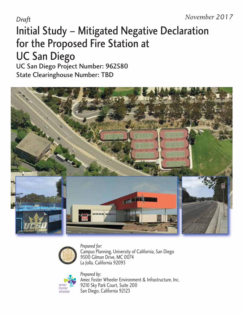
Draft
Initial Study – Mitigated Negative Declarationfor the Proposed Fire Station atUC San DiegoUC San Diego Project Number: 962580
State Clearinghouse Number: TBD
2017
Prepared for:Campus Planning, University of California, San Diego9500 Gilman Drive, MC 0074La Jolla, California 92093
Prepared by:Amec Foster Wheeler Environment & Infrastructure, Inc.9210 Sky Park Court, Suite 200San Diego, California 92123

UNIVERSITY OF CALIFORNIA DRAFT INITIAL STUDY AND MITIGATED NEGATIVE DECLARATION Project Name: Fire Station UC San Diego Project Number: 962580 University of California, San Diego SCH #: TBD November 2017
Prepared by: Amec Foster Wheeler Environment & Infrastructure, Inc. 9210 Sky Park Court, Suite 200 San Diego, California Prepared for: Campus Planning University of California, San Diego 9500 Gilman Drive, MC 0074 La Jolla, CA 92093-0074

This statement is prepared in compliance with the California Environmental Quality Act
Fire Station Draft Initial Study and Mitigated Negative Declaration November 2017
Page i
TABLE OF CONTENTS Page
ACRONYMS AND ABBREVIATIONS .......................................................................................... iii 1.0 PROJECT INFORMATION ............................................................................................... 1-1
1.1 Introduction ............................................................................................................... 1-2 2.0 PROJECT LOCATION AND DESCRIPTION .................................................................... 2-1
2.1 Project Location ........................................................................................................ 2-1 2.2 Project Site ............................................................................................................... 2-2 2.3 Environmental Setting and Surrounding Land Uses ................................................ 2-5 2.4 Project Background .................................................................................................. 2-5 2.5 Project Description ................................................................................................... 2-9 2.6 Project Objectives .................................................................................................. 2-11 2.7 Sustainability .......................................................................................................... 2-12 2.8 Project Characteristics ........................................................................................... 2-13
2.8.1 Building Program ........................................................................................ 2-13 2.8.2 Building Design ........................................................................................... 2-13 2.8.3 Fire Station Staffing and Operations .......................................................... 2-13 2.8.4 Utility Requirements ................................................................................... 2-14 2.8.5 Grading/Drainage ....................................................................................... 2-15 2.8.6 Circulation ................................................................................................... 2-17
2.8.6.1 Fire Engine Circulation................................................................. 2-17 2.8.6.2 Lane/Road Configurations ........................................................... 2-17
2.8.7 Parking ....................................................................................................... 2-20 2.8.8 Landscaping/Hardscape Improvements ..................................................... 2-20 2.8.9 Construction Staging .................................................................................. 2-20
2.9 Project Approval/Schedule ..................................................................................... 2-21 3.0 RELATIONSHIP TO AND CONSISTENCY WITH 2004 LRDP ........................................ 3-1
3.1 2004 LRDP Scope of Development and Land Use Designations ............................ 3-1 3.2 2004 LRDP Population Projections .......................................................................... 3-2 3.3 2004 LRDP Objectives ............................................................................................. 3-3 3.4 Appropriateness of a Tiered Initial Study ................................................................. 3-4
4.0 ENVIRONMENTAL FACTORS POTENTIALLY AFFECTED ............................................ 4-1 5.0 DETERMINATION ............................................................................................................ 5-1 6.0 EVALUATION OF ENVIRONMENTAL IMPACTS ............................................................ 6-1
6.1 Impact Questions and Responses ........................................................................... 6-2 Aesthetics Discussion .............................................................................................. 6-2 Air Quality Discussion .............................................................................................. 6-6 Biological Resources Discussion ........................................................................... 6-15 Cultural/Paleontological/Tribal Resources Discussion ........................................... 6-18 Geology and Soils Discussion ................................................................................ 6-21 Greenhouse Gas Emissions Discussion ................................................................ 6-24 Hazards and Hazardous Materials Discussion ....................................................... 6-39 Hydrology and Water Quality Discussion ............................................................... 6-43 Land Use and Planning Discussion ........................................................................ 6-51 Noise Discussion .................................................................................................... 6-53 Population and Housing Discussion ....................................................................... 6-61 Public Services Discussion .................................................................................... 6-62
Fire Station Draft Initial Study and Mitigated Negative Declaration November 2017 TABLE OF CONTENTS (CONTINUED)
Page ii
Recreation Discussion ............................................................................................ 6-65 Transportation/Traffic Discussion ........................................................................... 6-67 Utilities and Service Systems Discussion ............................................................... 6-73
7.0 SUPPORTING INFORMATION SOURCES ..................................................................... 7-1 8.0 INITIAL STUDY PREPARERS .......................................................................................... 8-1 LIST OF FIGURES Figure 1. Regional Location ...................................................................................................... 2-3 Figure 2. Site Vicinity ................................................................................................................ 2-4 Figure 3. Proposed Fire Station ................................................................................................ 2-9 Figure 4. Proposed Utilities ..................................................................................................... 2-16 Figure 5. Proposed Intersection Improvements ...................................................................... 2-19 Figure 6. Noise ........................................................................................................................ 6-57 Figure 7. Response Time ........................................................................................................ 6-63 LIST OF TABLES Table 1. San Diego Fire-Rescue Department Fire Response to UC San Diego Campus ......... 2-6 Table 2. Number of San Diego Fire-Rescue Department Incident Response to UC San Diego
Campus for Calendar Years 2010-2016 .................................................................. 2-14 Table 3. Existing and Projected UC San Diego Population Regular Academic Year ................ 3-2 Table 4. San Diego County Attainment Status .......................................................................... 6-8 Table 5. Air Quality Significance Thresholds ............................................................................. 6-8 Table 6. Peak Daily Mitigated Construction Emissions (lbs/day) Fire Station ........................... 6-9 Table 7. Total Mitigated Construction Emissions (tons/year) Fire Station ................................. 6-9 Table 8. Operational Emissions Fire Station ............................................................................ 6-10 Table 9. Construction GHG Emissions (Metric Tons/Year) .................................................... 6-33 Table 10. Operational GHG Emissions (Metric Tons/Year) ..................................................... 6-35 Table 11. Existing Sound Levels in Vicinity of Project Site ...................................................... 6-54 Table 12. Sound Levels of Typical Noise Sources and Noise Environments .......................... 6-58 Table 13. Existing Intersection Operations .............................................................................. 6-68 Table 14. Existing Intersection Operations .............................................................................. 6-69 LIST OF APPENDICES APPENDIX A AIR QUALITY AND GHG REPORT FIRE STATION PROJECT APPENDIX B NORTH TORREY PINES ROAD FIRE STATION ACCESS STUDY (LLG 2015) APPENDIX C PHASE I CULTURAL RESOURCES SURVEY (HELIX 2016c)
Fire Station Draft Initial Study and Mitigated Negative Declaration November 2017
Page iii
ACRONYMS AND ABBREVIATIONS
AASHTO American Association of State Highway and Transportation Officials
AB Assembly Bill
ACUPCC American College & University Presidents’ Climate Commitment
ADA Americans with Disabilities Act
ADT Average Daily Trips
AMSL above mean sea level
A-P Alquist-Priolo
APS Auxiliary Plan Services
APZ Accident Potential Zone
AQIA Air Quality Impact Assessments
BMP best management practice
CAAA Clean Air Act Amendments
CAAQS California Ambient Air Quality Standards
CAFE Corporate Average Fuel Economy
CalEEMod California Emissions Estimator Model
CAP Climate Action Plan
CAPCOA California Air Pollution Control Officers Association
CARB California Air Resources Board
CBC California Building Code
CBSC California Building Standards Commission
CCA California Coastal Act
CCC California Coastal Commission
CCR California Code of Regulations
CDP Coastal Development Permit
CEQA California Environmental Quality Act
CFC chlorofluorocarbon
CH4 methane
CIP Capital Improvement Program
City City of San Diego
Citygate Citygate Associates, LLC
CNEL Community Noise Equivalent
CO carbon monoxide
CO2 carbon dioxide
CO2e carbon dioxide equivalent
Fire Station Draft Initial Study and Mitigated Negative Declaration November 2017 ACRONYMS AND ABBREVIATIONS (CONTINUED)
Page iv
CPM Capital Program Management
cy cubic yard
dBA A-weighted decibel
DEH Department of Environmental Health
DRB Design Review Board
ECBT East Campus Bed Tower
EH&S Environmental Health & Safety
EIR Environmental Impact Report
EMS Emergency Management Services
EO Executive Order
ESL Environmentally Sensitive Lands
FEMA Federal Emergency Management Agency
FY Fiscal Year
GHG greenhouse gas
GPS Global Policy and Strategy
GSF gross square feet
GWP global warming potential
HA hydrologic area
HELIX HELIX Environmental Planning, Inc.
HFC hydrofluorocarbon
HMP Hydromodification Management Plan
HRA Health risks assessment
I-15 Interstate 15
I-5 Interstate 5
I-805 Interstate 805
I of A Institute of the Americas
IR/PS International Relations and Pacific Studies
IS Initial Study
kV kilovolt
KVP Key Vantage Point kW kilowatt
lbs pounds
LCFS Low Carbon Fuel Standard
LCP Local Coastal Plan

Fire Station Draft Initial Study and Mitigated Negative Declaration November 2017 ACRONYMS AND ABBREVIATIONS (CONTINUED)
Page v
LED Light-Emitting Diode
LEED-NC Leadership in Energy and Environmental Design-New Construction
LID Low Impact Development
LLG Linscott, Law & Greenspan
LRDP Long Range Development Plan
LUST Leaking Underground Storage Tank
MCAS Marine Corps Air Station
MHPA Multiple Habitat Preserve Area
MND Mitigated Negative Declaration
mph miles per hour
MPO Metropolitan Planning Organization
MSCP Multiple Species Conservation Plan
MT metric ton
MMT million metric tons
MT CO2e metric tons of carbon dioxide equivalent
MW megawatt
N2O nitrous oxide
NAAQS National Ambient Air Quality Standards
NCCP Natural Communities Conservation Plan
NCRA North Campus Recreation Area
NHTSA National Highway Traffic Safety Administration
NO2 nitrogen dioxide
NOAA National Oceanic and Atmospheric Organization
NOI Notice of Intent
NOx nitrogen oxides
NPDES National Pollutant Discharge Elimination System
O3 ozone
Pb lead
PFC perfluorocarbon
PLWTP Point Loma Water Treatment Plant
PM10 particulate matter with a diameter of less than 10 microns
PM2.5 particulate matter with a diameter of less than 2.5 microns
RIMAC Recreation Intermural and Activity Center
ROG reactive organic gas
Fire Station Draft Initial Study and Mitigated Negative Declaration November 2017 ACRONYMS AND ABBREVIATIONS (CONTINUED)
Page vi
RTP Regional Transportation Plan
RWQCB Regional Water Quality Control Board
SANDAG San Diego Association of Governments
SB Senate Bill
SCH State Clearinghouse
SCS Sustainable Communities Strategy
SDAB San Diego Air Basin
SDAPCD San Diego Air Pollution Control District
SDCWA San Diego County Water Authority
SDFD San Diego Fire Department
SDPD San Diego Police Department
SDSC San Diego Supercomputer Center
SDSMP San Diego Stormwater Mitigation Plan
SDSWMP San Diego Storm Water Mitigation Plan
SEP Strategic Energy Plan
SF square foot
SF6 sulfur hexafluoride
SIO Scripps Institution of Oceanography
SO2 sulfur dioxide
SOM School of Medicine
SOx sulfur oxides
SR-52 State Route 52
SSPPS Skaggs School of Pharmacy and Pharmaceutical Sciences
SWMP Storm Water Management Plan
SWPPP Storm Water Pollution Prevention Plan
SWRCB State Water Resources Control Board
SWSM Storm Water Standards Manual (City of San Diego)
TAC toxic air contaminants
UCOP University of California Office of the President
UC San Diego University of California, San Diego
USEPA U.S. Environmental Protection Agency
VA Veterans Affairs
WAP Water Action Plan
Fire Station Draft Initial Study and Mitigated Negative Declaration November 2017
Page 1-1
Environmental Checklist Form
1.0 PROJECT INFORMATION
1. Project title: Fire Station
2. Lead Agency name and address: Campus Planning University of California, San Diego
9500 Gilman Drive, MC 0074 La Jolla, California 92093-0074
(858) 534-6515
3. Contact person and phone number: Alison Buckley (858) 534-4464
4. Project location: San Diego County
5. Project sponsor’s name and address: (See #2 and #3)
6. Custodian of administrative record for this project (if different from response to #3):
7. Identification of previous Environmental Impact Reports (EIRs) relied upon for tiering purposes (including all applicable Long Range Development Plans [LRDPs] and project EIRs) and address where a copy is available for inspection (refer to #2 for availability):
University of California, San Diego 2004 Long Range Development Plan Program EIR
(State Clearinghouse No. 2003081023) Certified September 2004
University of California, San Diego
East Campus Bed Tower Project EIR (State Clearinghouse No. 2009081053)
Certified July 2010
Fire Station Draft Initial Study and Mitigated Negative Declaration November 2017
Page 1-2
1.1 Introduction
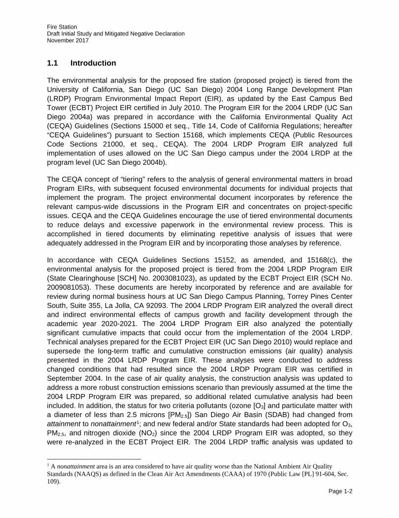
The environmental analysis for the proposed fire station (proposed project) is tiered from the University of California, San Diego (UC San Diego) 2004 Long Range Development Plan (LRDP) Program Environmental Impact Report (EIR), as updated by the East Campus Bed Tower (ECBT) Project EIR certified in July 2010. The Program EIR for the 2004 LRDP (UC San Diego 2004a) was prepared in accordance with the California Environmental Quality Act (CEQA) Guidelines (Sections 15000 et seq., Title 14, Code of California Regulations; hereafter “CEQA Guidelines”) pursuant to Section 15168, which implements CEQA (Public Resources Code Sections 21000, et seq., CEQA). The 2004 LRDP Program EIR analyzed full implementation of uses allowed on the UC San Diego campus under the 2004 LRDP at the program level (UC San Diego 2004b).
The CEQA concept of “tiering” refers to the analysis of general environmental matters in broad Program EIRs, with subsequent focused environmental documents for individual projects that implement the program. The project environmental document incorporates by reference the relevant campus-wide discussions in the Program EIR and concentrates on project-specific issues. CEQA and the CEQA Guidelines encourage the use of tiered environmental documents to reduce delays and excessive paperwork in the environmental review process. This is accomplished in tiered documents by eliminating repetitive analysis of issues that were adequately addressed in the Program EIR and by incorporating those analyses by reference.
In accordance with CEQA Guidelines Sections 15152, as amended, and 15168(c), the environmental analysis for the proposed project is tiered from the 2004 LRDP Program EIR (State Clearinghouse [SCH] No. 2003081023), as updated by the ECBT Project EIR (SCH No. 2009081053). These documents are hereby incorporated by reference and are available for review during normal business hours at UC San Diego Campus Planning, Torrey Pines Center South, Suite 355, La Jolla, CA 92093. The 2004 LRDP Program EIR analyzed the overall direct and indirect environmental effects of campus growth and facility development through the academic year 2020-2021. The 2004 LRDP Program EIR also analyzed the potentially significant cumulative impacts that could occur from the implementation of the 2004 LRDP. Technical analyses prepared for the ECBT Project EIR (UC San Diego 2010) would replace and supersede the long-term traffic and cumulative construction emissions (air quality) analysis presented in the 2004 LRDP Program EIR. These analyses were conducted to address changed conditions that had resulted since the 2004 LRDP Program EIR was certified in September 2004. In the case of air quality analysis, the construction analysis was updated to address a more robust construction emissions scenario than previously assumed at the time the 2004 LRDP Program EIR was prepared, so additional related cumulative analysis had been included. In addition, the status for two criteria pollutants (ozone [O3] and particulate matter with a diameter of less than 2.5 microns [PM2.5]) San Diego Air Basin (SDAB) had changed from attainment to nonattainment1; and new federal and/or State standards had been adopted for O3, PM2.5, and nitrogen dioxide (NO2) since the 2004 LRDP Program EIR was adopted, so they were re-analyzed in the ECBT Project EIR. The 2004 LRDP traffic analysis was updated to
1 A nonattainment area is an area considered to have air quality worse than the National Ambient Air Quality Standards (NAAQS) as defined in the Clean Air Act Amendments (CAAA) of 1970 (Public Law [PL] 91-604, Sec. 109).
Fire Station Draft Initial Study and Mitigated Negative Declaration November 2017
Page 1-3
reflect changing conditions locally and regionally, and new mitigation strategies are presented to address the effects of campus growth on the local circulation network in the near-term (2015) and the cumulative long-term (2020).
As such, the ECBT Project EIR serves as the basis for the long-term traffic and cumulative construction emissions analyses for all future campus projects proposed under the 2004 LRDP. All feasible measures to avoid or substantially reduce the significant adverse project and cumulative impacts associated with that growth are identified in the 2004 LRDP Program EIR, as updated by the ECBT Project EIR. Under Section 15152(f)(1), where the lead agency determines that a cumulative impact has been adequately addressed in the prior Program EIR, the impact is not treated as significant in a later negative declaration and need not be discussed in detail.
The tiering of the environmental analysis for the proposed project allows this Tiered Initial Study (IS) / Mitigated Negative Declaration (MND) to rely on the 2004 LRDP Program EIR, as updated by the ECBT Project EIR for the following:
a. a discussion of general background and setting information for environmental topic areas;
b. overall campus-wide growth-related issues;
c. issues that were evaluated in sufficient detail in the 2004 LRDP Program EIR, as updated by the ECBT Project EIR, for which there is no new information of substantial importance or substantial change in circumstances that would require further analysis; and
d. short- and long-term cumulative impacts.
The purpose of this IS is to evaluate the potential environmental impacts of the proposed project in light of the analysis in the 2004 LRDP Program EIR, as updated by the ECBT Project EIR to determine what level of additional environmental review, if any, is appropriate including whether additional project-level mitigation is necessary and would be included as part of the project. Based on the analysis contained in this IS, a determination has been made in Section 5.0, Determination of this IS.
Mitigation measures identified in the 2004 LRDP Program EIR, as updated by the ECBT Project EIR that apply to the proposed project or additional project-level mitigation measures must be implemented as part of the proposed project. These mitigation measures are identified and discussed in Section 6.0, Evaluation of Environmental Impacts of this IS.
Fire Station Draft Initial Study and Mitigated Negative Declaration November 2017
Page 2-1
2.0 PROJECT LOCATION AND DESCRIPTION
2.1 Project Location
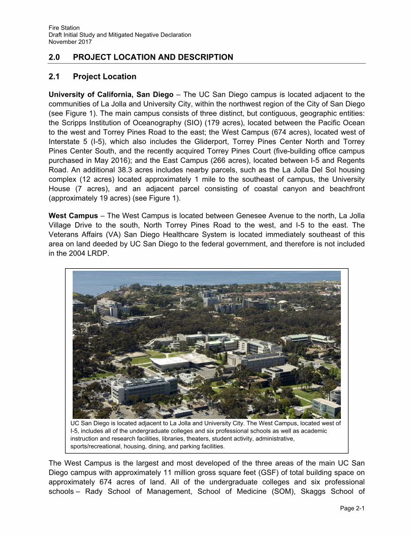
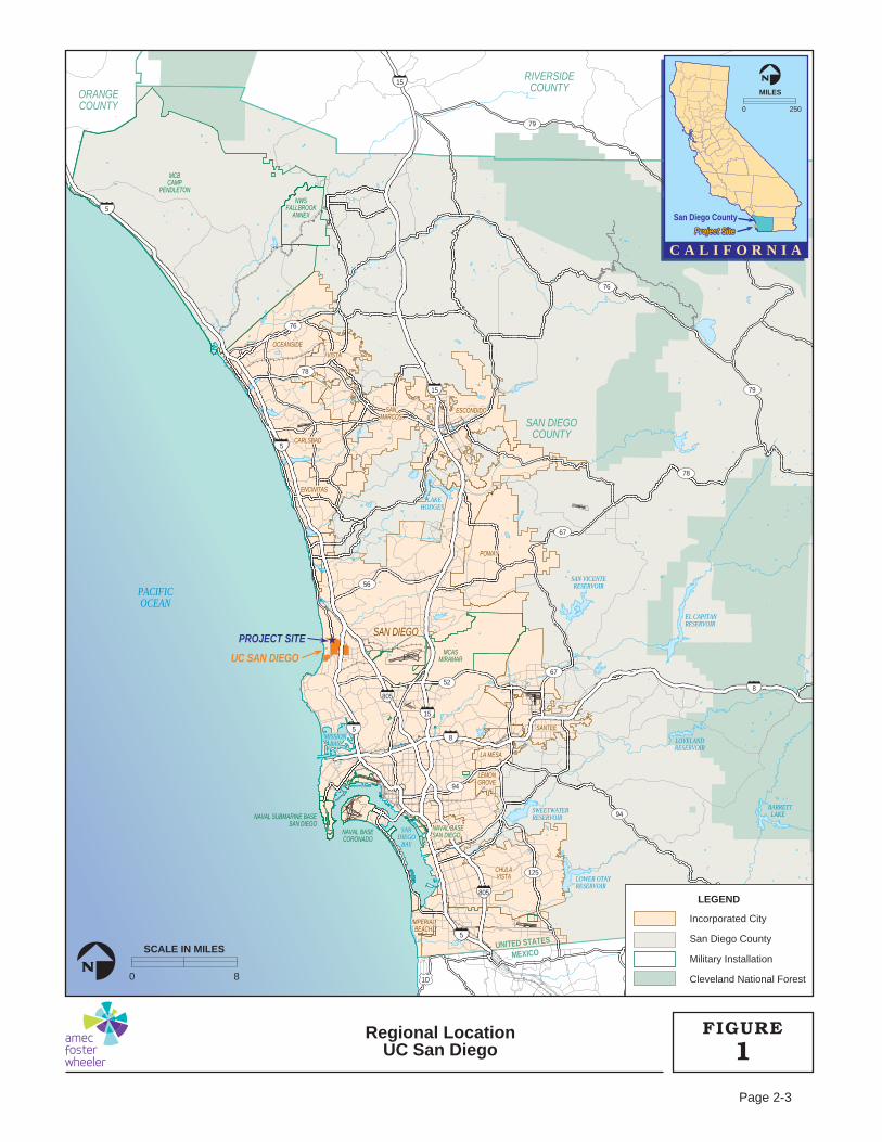
University of California, San Diego – The UC San Diego campus is located adjacent to the communities of La Jolla and University City, within the northwest region of the City of San Diego (see Figure 1). The main campus consists of three distinct, but contiguous, geographic entities: the Scripps Institution of Oceanography (SIO) (179 acres), located between the Pacific Ocean to the west and Torrey Pines Road to the east; the West Campus (674 acres), located west of Interstate 5 (I-5), which also includes the Gliderport, Torrey Pines Center North and Torrey Pines Center South, and the recently acquired Torrey Pines Court (five-building office campus purchased in May 2016); and the East Campus (266 acres), located between I-5 and Regents Road. An additional 38.3 acres includes nearby parcels, such as the La Jolla Del Sol housing complex (12 acres) located approximately 1 mile to the southeast of campus, the University House (7 acres), and an adjacent parcel consisting of coastal canyon and beachfront (approximately 19 acres) (see Figure 1).
West Campus – The West Campus is located between Genesee Avenue to the north, La Jolla Village Drive to the south, North Torrey Pines Road to the west, and I-5 to the east. The Veterans Affairs (VA) San Diego Healthcare System is located immediately southeast of this area on land deeded by UC San Diego to the federal government, and therefore is not included in the 2004 LRDP.
The West Campus is the largest and most developed of the three areas of the main UC San Diego campus with approximately 11 million gross square feet (GSF) of total building space on approximately 674 acres of land. All of the undergraduate colleges and six professional schools – Rady School of Management, School of Medicine (SOM), Skaggs School of
UC San Diego is located adjacent to La Jolla and University City. The West Campus, located west of I-5, includes all of the undergraduate colleges and six professional schools as well as academic instruction and research facilities, libraries, theaters, student activity, administrative, sports/recreational, housing, dining, and parking facilities.
Fire Station Draft Initial Study and Mitigated Negative Declaration November 2017
Page 2-2
Pharmacy and Pharmaceutical Sciences (SSPPS), and Graduate School of Global Policy and Strategy (GPS) – are also located on this portion of the campus.
The north central portion of the West Campus, north of Voigt Drive, remains in a relatively undeveloped natural state. The area contains two large canyons with an extensive eucalyptus (Eucalyptus spp.) grove on the western perimeter. Native vegetation on the slopes of these canyons has remained relatively undisturbed. The eucalyptus grove forms an almost continuous band stretching from Genesee Avenue on the campus’ northern boundary, to La Jolla Village Drive on the southern edge, and west along the northern edge of the SIO. The remainder of the West Campus is mostly developed. Topography in this area is characterized by a ridge running north-south (approximately the location of the Ridge Walk) that is immediately east of North Torrey Pines Road and is more than 400 feet above mean sea level (AMSL). The two large canyons in the northeastern corner of this portion of the campus drop down from this ridge to elevations below 200 feet AMSL.
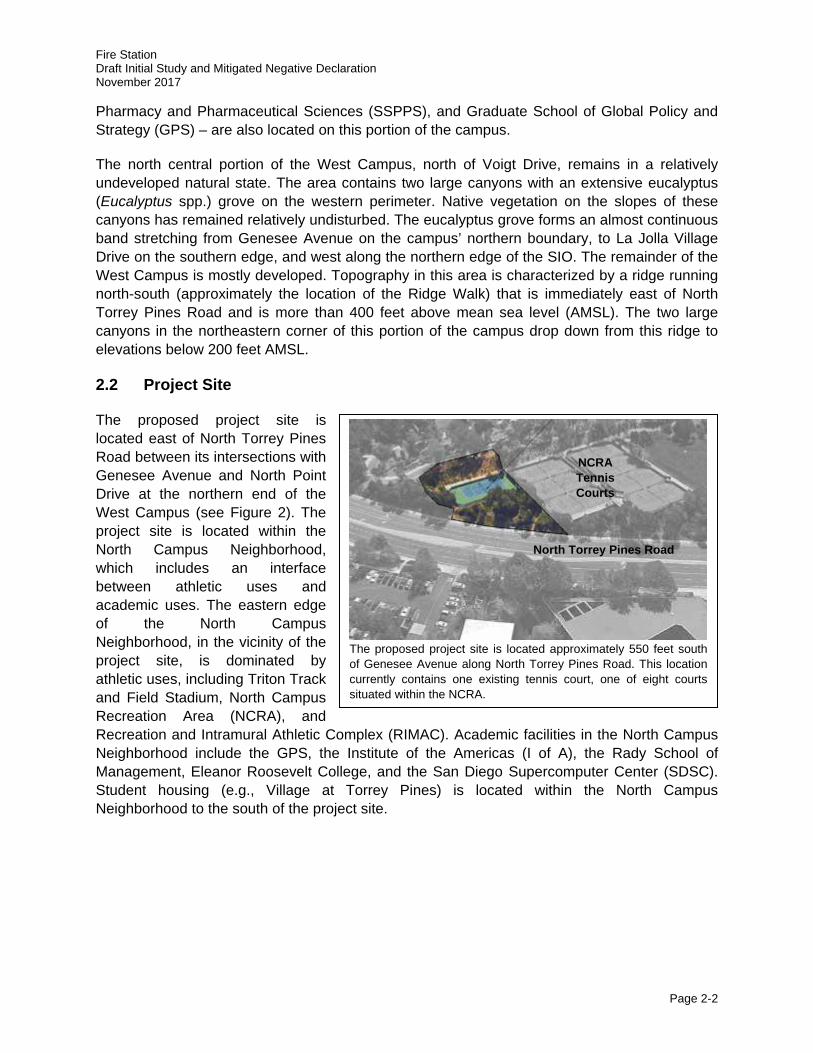
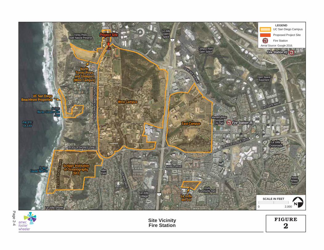
2.2 Project Site
The proposed project site is located east of North Torrey Pines Road between its intersections with Genesee Avenue and North Point Drive at the northern end of the West Campus (see Figure 2). The project site is located within the North Campus Neighborhood, which includes an interface between athletic uses and academic uses. The eastern edge of the North Campus Neighborhood, in the vicinity of the project site, is dominated by athletic uses, including Triton Track and Field Stadium, North Campus Recreation Area (NCRA), and Recreation and Intramural Athletic Complex (RIMAC). Academic facilities in the North Campus Neighborhood include the GPS, the Institute of the Americas (I of A), the Rady School of Management, Eleanor Roosevelt College, and the San Diego Supercomputer Center (SDSC). Student housing (e.g., Village at Torrey Pines) is located within the North Campus Neighborhood to the south of the project site.
The proposed project site is located approximately 550 feet south of Genesee Avenue along North Torrey Pines Road. This location currently contains one existing tennis court, one of eight courts situated within the NCRA.
NCRA Tennis Courts
North Torrey Pines Road
85
5
5
15
15
15
5
805
1D
2D
8058
94
94
201
125
94
52
56
76
76
78
78
79
79
67
67
NAVAL BASENAVAL BASESAN DIEGOSAN DIEGO
MCASMIRAMAR
MCBCAMP
PENDLETON
NWSFALLBROOK
ANNEX
NAVAL SUBMARINE BASESAN DIEGO
NAVAL BASECORONADO
NAVAL BASESAN DIEGO
MISSIONMISSIONBAYBAY
PACIFICOCEAN
SANDIEGO
BAY
MISSIONBAY
LOWER OTAYRESERVOIR
SWEETWATERRESERVOIR
BARRETT LAKE
LOVELANDRESERVOIR
EL CAPITANRESERVOIR
SAN VICENTERESERVOIR
LAKEHODGES
SAN DIEGOSAN DIEGO
VISTAVISTA
OCEANSIDEOCEANSIDE
CARLSBADCARLSBAD
ENCINITASENCINITAS
SANSANMARCOSMARCOS
ESCONDIDOESCONDIDO
POWAYPOWAY
SANTEESANTEE
LA MESALA MESA
LEMONLEMONGROVEGROVE
IMPERIALIMPERIALBEACHBEACH
CHULACHULAVISTAVISTA
SAN DIEGO
VISTA
OCEANSIDE
CARLSBAD
ENCINITAS
SANMARCOS
ESCONDIDO
POWAY
SANTEE
LA MESA
LEMONGROVE
IMPERIALBEACH
CHULAVISTA
SAN DIEGOCOUNTY
RIVERSIDECOUNTYORANGE
COUNTY
UC SAN DIEGO
UNITED STATESUNITED STATES
MEXICOMEXICOUNITED STATES
MEXICO
PROJECT SITE ★
0 250
MILES
N
Project SiteProject SiteProject Site★★
C A L I F O R N I A
San Diego County
Incorporated City
San Diego County
Military Installation
Cleveland National Forest
LEGEND
0 8
SCALE IN MILES
N
Regional LocationUC San Diego 1
FIGURE
Page 2-3
Fire Station 35Fire Station 35
Fire Station 41Fire Station 41
La JollaLa JollaVillageVillage
La JollaLa JollaCrossroadsCrossroads
La Jolla ShoresLa Jolla Shores
LA JOLLA VILLAGE DRIVE
LA JOLLA VILLAGE DRIVE
EASTGATE MALL
EASTGATE MALL
LA J
OLL
A SH
ORE
S DR
IVE
LA JOLLA SHORES LANELA JOLLA SHORES LANE
NOBEL DRIVENOBEL DRIVE
GILM
AN DRIVE
GILM
AN DRIVE
GENESEE AVENUE
NORTH TO
RREY PINES ROAD
NORTH TO
RREY PINES ROAD
5
5
805
805
LA JOLLA VILLAGE DRIVE
EASTGATE MALL
NOBEL DRIVE
LA JOLLA SHORES LANE
GILM
AN DRIVE
GENESEE AVENUE
LA J
OLL
A SH
ORE
S DR
IVE
NORTH TO
RREY PINES ROAD
West Campus
East Campus
Scripps Institutionof Oceanography
(SIO)
UC San DiegoUC San DiegoBeachfront PropertiesBeachfront Properties
NorthNorthTorrey PinesTorrey Pinesand Glideportand Glideport
(West Campus)(West Campus)
La JollaLa Jolladel Soldel Sol
West Campus
East Campus
Scripps Institutionof Oceanography
(SIO)
NorthTorrey Pinesand Glideport
(West Campus)
UC San DiegoBeachfront Properties
La Jolladel Sol
La JollaVillage
La JollaCrossroads
La Jolla Shores
DoyleDoyleCommunity ParkCommunity Park
NobelNobelAthleticAthletic
AreaArea
Torrey PinesTorrey PinesState Natural PreserveState Natural Preserve
La JollaLa JollaOpenOpenSpaceSpace
Campus PointCampus PointOpen SpaceOpen Space
Open Space/Open Space/EasementEasement
AllenAllenFieldField
Mandell-WeissEastgateEastgateCity ParkCity Park
DoyleCommunity Park
NobelAthletic
Area
Torrey PinesState Natural Preserve
La JollaOpenSpace
Campus PointOpen Space
Open Space/Easement
AllenField
Mandell-WeissEastgateCity ParkPACIFICPACIFIC
OCEANOCEAN
ScrippsScrippsMarine ConservationMarine Conservation
AreaArea
ScrippsScrippsCoastal ReserveCoastal Reserve
PACIFICOCEAN
ScrippsCoastal Reserve
ScrippsMarine Conservation
Area
Project SiteProject Site
Fire Station 35
Fire Station 41 F
F
LLLAAJJJOOO
LLLLLLAA
SSHHOOO
RREES
DDRRIIVVV
E
Scripps InstitutioScripps Institutionppof Oceanographyhof Oceanographyg
SIO(SIO)
East CampEast Campus
West CampusWest Campus
ojectoject
LEGENDUC San Diego Campus
Proposed Project Site
Fire Station
0 2,000
SCALE IN FEET
N
2FIGURESite Vicinity
Fire Station
Aerial Source: Google 2016.
Page 2-4
Fire Station Draft Initial Study and Mitigated Negative Declaration November 2017
Page 2-5
2.3 Environmental Setting and Surrounding Land Uses
The proposed project is located on an approximately 0.8-acre site that includes one existing tennis court (one of eight tennis courts comprising the NCRA Tennis Courts) and approximately 8,500 square feet (SF) of ornamental landscaping. The existing topography within the proposed project site ranges from an elevation of approximately 420 feet AMSL in the southwest corner to approximately 440 feet AMSL along its eastern edge, where the project site borders North Point Lane. The project site is located in the Scripps hydrologic area (HA), which drains to storm drains that flow to the west under off-campus residential areas and into short coastal canyons that lead to the Pacific Ocean (UC San Diego 2004a). The surrounding area is developed and contains no sensitive vegetation or wetlands according to the 2004 LRDP Program EIR (UC San Diego 2004a). This has been confirmed with recent campus-wide biological resources mapping in support of the La Jolla Campus LRDP Update (HELIX Environmental Planning, Inc. [HELIX] 2016b), which identified the project site as Urban/Developed Land. The Spanos Athletic Training Facility is located approximately 900 feet to the east across North Point Lane. The office buildings of Torrey Pines Center North and Torrey Pines Center South are located approximately 200 feet to the west across North Torrey Pines Road, and UC San Diego student housing provided at The Village at Torrey Pines is located approximately 700 feet to the south.
2.4 Project Background
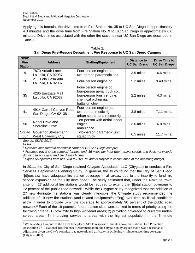
UC San Diego employs a Campus Fire Marshall and associated staff who are responsible for campus-wide fire prevention; however, UC San Diego does not have its own fire department, rather it relies on the City of San Diego Fire-Rescue Department (SDFD) to respond to emergencies as necessary. The City has 47 fire stations that serve an area of 331 square miles and more than 1.3 million residents (City of San Diego 2017a). In Fiscal Year (FY) 2016, SDFD responded to a total of 154,263 response incidents. Approximately 3.7 percent of those incidences were fire-related; however, many incidents, approximately 88.7 percent, were medical/rescue-related (City of San Diego 2017a). In the event of an incident on campus, Fire Station Nos. 35 and 9 are the most likely to respond based on proximity to the campus.
Fire Station Nos. 35 and 9 are located 2.2 miles and 3.5 miles from the most northwestern portion of the campus, respectively. As with any fire station, the emergency drive times from Fire Station Nos. 35 and 9 are difficult to calculate due to several variables that affect the overall response time, including congestion, time of day, road grade, and type of vehicle responding. Additionally, due to the size of the campus, response times also vary depending on the location of the incident. The Insurance Services Office, the leading supplier of statistical actuarial, and underwriting information for and about the property and casualty insurance industry, calculates the travel time for fire apparatus2 with the formula:
T = 0.65 + 1.7 D
Where:
T = Time in minutes D = Distance in miles
2 Vehicle or equipment for fighting and extinguishing fire (e.g., fire engines or ladder trucks).
Fire Station Draft Initial Study and Mitigated Negative Declaration November 2017
Page 2-6
Applying this formula, the drive time from Fire Station No. 35 to UC San Diego is approximately 4.3 minutes and the drive time from Fire Station No. 9 to UC San Diego is approximately 6.6 minutes. Drive times associated with the other fire stations near UC San Diego are described in Table 1.
Table 1. San Diego Fire-Rescue Department Fire Response to UC San Diego Campus
SDFD Fire
Station Address Staffing/Equipment Distance to
UC San Diego1 Drive Time to
UC San Diego2
9 7870 Ardath Lane La Jolla, CA 92037
Four-person engine co., two-person paramedic unit 3.5 miles 6.6 mins.
16 2110 Via Casa Alta La Jolla, CA 92037 Four-person engine co. 5.2 miles 9.49 mins.
35 4285 Eastgate Mall La Jolla, CA 92037
Four-person engine co., four-person aerial truck co., four-person brush engine, chemical pickup rig, battalion chief
2.2 miles 4.3 mins.
41 4914 Carroll Canyon Road San Diego, CA 92138
Four-person engine co., two-person medic rig, urban search and rescue rig
3.8 miles 7.11 mins.
50 Nobel Drive and Shoreline Drive
Ten-person with aerial ladder, engine, ambulance
3.6 miles 6.8 mins.
Squad 563
Governor/Stresemann West University City
Two-person paramedic unit, squad truck 6.5 miles 11.7 mins.
Source: SDFD 2017. Notes: 1 Distance measured to northwest corner of UC San Diego campus. 2 Assumes travel to the campus’ farthest end, 35 miles per hour (mph) travel speed, and does not include donning turnout gear and fire dispatch time. 3 Squad 56 operates from 8:00 AM to 8:00 PM and is subject to continuation of the operating budget.
In 2011, the City of San Diego retained Citygate Associates, LLC (Citygate) to conduct a Fire Services Deployment Planning Study. In general, the study found that the City of San Diego “[d]oes not have adequate fire station coverage in all areas, due to the inability to fund fire service expansion as the City developed.” The study estimated that, under the 4-minute travel criterion, 27 additional fire stations would be required to extend the “[t]otal station coverage to 72 percent of the public road network.” While the Citygate study recognized that the addition of 27 new 4-minute fire stations was clearly infeasible, the Citygate study recommended the addition of 19 new fire stations (and related equipment/staffing) over time as fiscal conditions allow in order to provide 5-minute coverage to approximately 90 percent of the public road network.3 Each of the 19 potential future station sites were ranked in terms of priority using the following criteria: 1) proximity to high workload areas; 2) providing coverage to currently under-served areas; 3) improving service to areas with the highest population in the 5-minute 3 While adding 1 minute to the travel time places SDFD response 1 minute above the National Fire Protection Association 1710 National Best Practice Recommendation, the Citygate study argued that it was a reasonable adjustment given the City’s complex road network and difficulty in achieving 4-minute travel time coverage (Citygate 2011).
Fire Station Draft Initial Study and Mitigated Negative Declaration November 2017
Page 2-7
response zone and the longest current response times; and 4) maximizing the number of additional road miles covered by individual stations.
As described in the 2011 Citygate study, much of the East Campus and some of the West Campus, adjacent to I-5, Genesee Avenue, and Gilman Drive, is located with the 4-minute (initial response) and the 8-minute (multiple response) travel time areas identified for the fire and emergency response capabilities associated with Fire Station Nos. 35 and 41. Much of the SIO campus is located within the 4-minute and 8-minute travel time areas of the engine and medic truck of Fire Station No. 9. However, the 2011 Citygate study noted that average response times, as identified above, can be misleading and “[a]re not highly regarded as a performance measurement” (Citygate 2011). Additionally, the study identified a large gap in coverage for large areas of the West Campus and North Torrey Pines and Gliderport. Of the 19 gap areas identified in the 2011 Citygate study, the UC San Diego area was ranked as the eighth most critical gap area (Citygate 2011).
Following the 2011 Citygate study, the City of San Diego made substantial investments in the SDFD, including the completion of one new fire station in East Mission Valley, one temporary fire station in Skyline Hills, and the implementation of three Fast Response Squad units in Encanto, South University City, and San Pasqual Valley. In an effort to update the findings of the 2011 study, the City retained Citygate to prepare a new study, City of San Diego – Fire-Rescue Standards of Response Cover Review, using the City’s current network of 47 active fire stations and 70 primary response apparatus (Citygate 2017). The 2017 Citygate study also used a variety of new analytical tools to improve the accuracy of response time modeling, including counting for traffic congestion peak-hour call demand. Similar to the 2011 study, the 2017 study also concluded that there are insufficient fire crews and stations to allow the City to achieve its desired emergency response time performance measures (Citygate 2017). However, the updated methodology combined with population changes and added SDFD resources produced recommendations in 2017 that differed substantially from those made in 2011. Notably, the 2017 study recommended 12 new fire stations rather than 19. However, the existing gap in coverage at UC San Diego that was identified in the 2011 study was also identified in the 2017 study. Citygate’s 2017 study indicates that Fire Station No. 35’s response is still affected by traffic congestion, which reduces its overall 5-minute response footprint, including within portions of UC San Diego. In order to reduce this gap in 5-minute coverage, the City has identified the proposed fire station in the City’s Capital Improvement Program (CIP) budget (Citygate 2017).
As described in the 2004 LRDP Program EIR, implementation of the LRDP was not anticipated to increase the demand at the multiple fire stations that serve the community and the campus to a level that would require new facilities or substantial alternatives to existing facilities. Building development at UC San Diego has remained under the LRDP projected total GSF for the 2020-2021 academic year, forecasted within the Program EIR. Development on the UC San Diego campus includes fire hardened buildings with prevention measures (e.g., sprinklers, flame retardant construction materials, etc.), and alert systems. As such, development on campus has not and is not expected to directly result in the need for additional fire services. However, unprecedented growth in the University City area in recent years along with continued campus growth to meet academic and housing mandates has put a cumulatively heavy demand on the existing local fire and emergency medical services. Recent UC San Diego CEQA-compliant environmental documents have acknowledged that projects on campus have the potential to
Fire Station Draft Initial Study and Mitigated Negative Declaration November 2017
Page 2-8
contribute to a cumulatively considerable burden related to fire protection and emergency medical services in the City of San Diego. The project-related CEQA-compliant environmental documents have each included a project-specific mitigation measure stating that UC San Diego shall work with the City to identify a suitable site to locate a new fire station in proximity to the campus. The mitigation measure also requires that UC San Diego pay its proportionate share of the cost of mitigating the environmental impacts associated with the construction and operation of a new fire station by contributing either land or money or some combination thereof. Subsequently, UC San Diego has been working with the City and SDFD and have identified an appropriate site on campus for a new fire station. The negotiation of a Development Agreement is in progress and it has been determined that UC San Diego would direct, manage, and fund the design and construction of the proposed fire station to a condition that is fully complete and operational in accordance with City of San Diego Fire Station and Facilities Design and Construction Standards. The Regents would convey fee title to the property to the City upon completion and acceptance. The City would then be responsible for equipping, staffing, operating, and maintaining the facility.
As envisioned, the proposed fire station would address the following needs:
· Provide additional fire and emergency medical services that would support existing demand in the UC San Diego West Campus and the Torrey Pines Mesa area;
· Anticipate future development, which would increase demand for emergency services on the West Campus and Torrey Pines Mesa area; and
· Improve response time for fire and medical services in the La Jolla area, as described in the 2011 and 2017 Citygate studies and allow the City to achieve its desired firefighting response time performance measures in all areas.
The City identified the northwest area of campus as the most desirable project location due to its proximity to areas in the West Campus that are underserved by SDFD (see Figure 7). The City and UC San Diego agreed that a site on North Torrey Pines Road, across from the Torrey Pines Center South and North buildings, would be the most appropriate and convenient because it would:
· Provide direct access to North Torrey Pines Road with close proximity to Genesee Avenue and I-5;
· Improve response times to underserved areas pursuant to recommendations in the Citygate reports (2011 and 2017);
· Provide sufficient distance from noise sensitive land uses (i.e. greater than 250 feet away from housing, classrooms, research facilities); and
· Limit impacts to existing and future planned University development.
Fire Station Draft Initial Study and Mitigated Negative Declaration November 2017
Page 2-9
2.5 Project Description
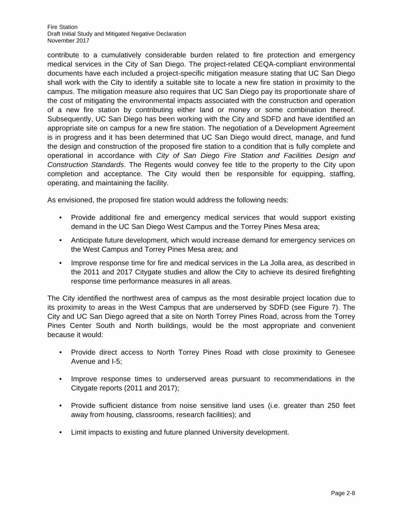
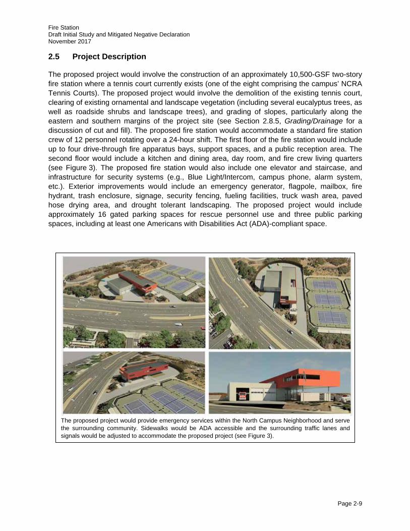
The proposed project would involve the construction of an approximately 10,500-GSF two-story fire station where a tennis court currently exists (one of the eight comprising the campus’ NCRA Tennis Courts). The proposed project would involve the demolition of the existing tennis court, clearing of existing ornamental and landscape vegetation (including several eucalyptus trees, as well as roadside shrubs and landscape trees), and grading of slopes, particularly along the eastern and southern margins of the project site (see Section 2.8.5, Grading/Drainage for a discussion of cut and fill). The proposed fire station would accommodate a standard fire station crew of 12 personnel rotating over a 24-hour shift. The first floor of the fire station would include up to four drive-through fire apparatus bays, support spaces, and a public reception area. The second floor would include a kitchen and dining area, day room, and fire crew living quarters (see Figure 3). The proposed fire station would also include one elevator and staircase, and infrastructure for security systems (e.g., Blue Light/Intercom, campus phone, alarm system, etc.). Exterior improvements would include an emergency generator, flagpole, mailbox, fire hydrant, trash enclosure, signage, security fencing, fueling facilities, truck wash area, paved hose drying area, and drought tolerant landscaping. The proposed project would include approximately 16 gated parking spaces for rescue personnel use and three public parking spaces, including at least one Americans with Disabilities Act (ADA)-compliant space.
The proposed project would provide emergency services within the North Campus Neighborhood and serve the surrounding community. Sidewalks would be ADA accessible and the surrounding traffic lanes and signals would be adjusted to accommodate the proposed project (see Figure 3).
EXISTINGEXISTINGBACKFLOWBACKFLOWPREVENTERPREVENTER EXISTING WATER LINES TO REMAINEXISTING WATER LINES TO REMAIN
NORTH TORREY PINES ROAD
NORTH TORREY PINES ROADNO
RTH POINT LANE
NORTH PO
INT LANE
NCRANCRATennis CourtsTennis Courts
SpanosAthletic
PerformanceCenter
Torrey PinesTorrey PinesCenterCenterSouthSouth
Torrey PinesTorrey PinesCenterCenterNorthNorth
NCRATennis Courts
Torrey PinesCenterSouth
Torrey PinesCenterNorth
NORTH TORREY PINES ROADNO
RTH POINT LANE
1
2 4
6
3
5
8
7
EXISTINGBACKFLOWPREVENTER EXISTING WATER LINES TO REMAINDESIGNATED FIRE TRUCKDESIGNATED FIRE TRUCK
LEFT TURN LANELEFT TURN LANEDESIGNATED FIRE TRUCK
LEFT TURN LANE
Aerial Source: Google 2017.
LEGENDProposed Project Elements
Project Site/Property Boundary
Security Fence
Gate
Retaining Wall
Apparatus Bay
Support Spaces
Public Space
Landscaped Area
Paved Area
Tiled Area
Secure Parking (16 Spaces)
Public Parking
Trash
Patio
Generator
Fuel
Fire Hydrant
Basketball Court
Fire Truck Return Route
Fire Truck Exit Route
Second Floor Living Quarters
1
2
4
6
3
5
8
7
0 60
SCALE IN FEET
N
3FIGURESite Plan
Fire Station
Page 2-10
Fire Station Draft Initial Study and Mitigated Negative Declaration November 2017
Page 2-11
As described in Section 2.8.6, Circulation, implementation of the proposed project would include several off-site transportation network improvements along North Torrey Pines Road within the public right-of-way, which would require coordination with the City. The proposed fire station would include one additional dedicated fire apparatus driveway on North Torrey Pines Road and another driveway farther south that would serve both fire apparatus and privately-owned vehicles. Additionally, median improvements including a dedicated fire apparatus left turn lane and new traffic signals would be added (see Figure 5 for a depiction of the proposed intersection improvements).
Implementation of the proposed project would require both discretionary and ministerial actions by the City of San Diego (see Section 2.9, Project Approval/Schedule). These include approving the Design and Construction Agreement for the proposed fire station and public right-of-way improvements; approval of a Purchase and Sale Agreement authorizing the City to acquire the real property and future fire station improvements from UC San Diego; approving an Option Agreement and Purchase and Sale Agreement with UC San Diego to purchase a separate parcel of City-owned real property (Torrey Pines Center South I); and issuance of ministerial permits for work within the City public right-of-way (i.e., utility and roadway improvements).
2.6 Project Objectives
The following objectives have been identified for the proposed project:
· Address fire service and emergency medical service coverage gaps as identified in the 2011 and 2017 Citygate studies prepared for the City of San Diego.
· Improve overall emergency response times on the UC San Diego Campus and within the nearby community, including La Jolla and the Torrey Pines Mesa area.
· Construct a high-quality fire station with modern equipment and facilities that is consistent with the City of San Diego Fire Station and Facilities Design and Construction Standards and is architecturally compatible with the West Campus and surrounding land uses.
· Ensure that the transportation network surrounding the fire station is appropriately configured to facilitate safe movement of fire engines into and out of designated driveways.
· Site the proposed fire station to minimize and avoid, to the maximum extent feasible, adverse environmental impacts, including noise impacts to sensitive receptors (e.g., housing, classrooms, research facilities, etc.).
· Site the storm drain, sewer lines, and utility connections in a manner that optimizes the project footprint and improvements to ensure integration/reduced conflicts with future University growth.
· Implement Low-Impact Design (LID) opportunities with respect to landscape, planting, and hardscape design.
· Incorporate sustainable design principles to the greatest extent feasible to achieve, at a minimum, Leadership in Energy and Environmental Design - New Construction (LEED-
Fire Station Draft Initial Study and Mitigated Negative Declaration November 2017
Page 2-12
NC) Silver Certification, thereby reducing energy consumption and conserving natural resources.
· Compliance with applicable portions of the UC Sustainable Practices Policy (2016 update) to the extent feasible with the required implementation of the City of San Diego Fire Station and Facilities Design and Construction Standards.
2.7 Sustainability
LEED certification is the nationally accepted benchmark for the design, construction, and operation of high-performance green buildings. The program promotes a whole-building approach to sustainability by recognizing performance in five key areas of human and environmental health: sustainable site development, water savings, energy efficiency, materials selection, and indoor environmental quality.
The proposed project would conform with many elements of the system-wide UC Sustainable Practices Policy (2016 update). However, because the project would be owned and operated in perpetuity by the City, UC San Diego is seeking a waiver from the long-term operational elements of the policy including the goal for all new building projects, other than acute-care facilities, to outperform the required provisions of the California Energy Code, Title 24 energy efficiency standards by at least 20 percent and to strive for 30 percent. The policy also sets a 2025 goal for carbon neutrality, which would not be applied to the fire station pursuant to the waiver.
As prescribed in the UC Sustainable Practices Policy: Green Building Design, the following sustainable features would be incorporated into the project siting and design:
· Achieve a minimum standard equivalent LEED-NC Silver Certification and strive to achieve LEED-NC Gold Certification or higher;
· Provision of space and maximum utility for future installation of photovoltaic solar panels on the fire station roof deck;
· Implementation of LID and storm water treatment controls;
· Use of porous concrete in hardscape features where feasible;
· Installation of drought-tolerant vegetation;
· Use of reclaimed water for landscape irrigation;
· Installation of low-flow plumbing fixtures;
· Maximization of natural ventilation where feasible to reduce energy demand; and
· Control of all Light-Emitting Diode (LED) lighting fixtures within the fire station by motion sensors to reduce energy demand.

Fire Station Draft Initial Study and Mitigated Negative Declaration November 2017
Page 2-13
2.8 Project Characteristics
2.8.1 Building Program
The proposed project includes the construction of an approximately 10,500-GSF two-story fire station that would serve UC San Diego and the surrounding community. The existing tennis court located on the 0.8-acre project site would be demolished and removed and the site would be graded (i.e., leveled) to support the proposed development. Implementation of the proposed project would also include the provision of utilities (see Section 2.8.4, Utility Requirements), transportation network improvements (see Section 2.8.6, Circulation and Section 2.8.7, Parking), and landscaping (see Section 2.8.8, Landscaping/Hardscape Improvements).
2.8.2 Building Design
Beginning in 2012, UC San Diego has worked closely with the City and the SDFD to develop a conceptual building design for the proposed fire station. As described in Section 2.4, Project Background, SDFD has confirmed that the proposed conceptual design of the fire station would meet all design criteria required by City of San Diego Fire Station and Facilities Design and Construction Standards last updated in 2011. Additionally, the proposed fire station would be architecturally consistent with surrounding UC San Diego facilities within the North Campus Neighborhood on the West Campus. The top elevation of the proposed fire station would be approximately 35 feet above the surface grade of North Torrey Pines Road consistent with development across the street. The building façade would be refined and would have an architectural character consistent with the West Campus facilities. Other project features would include an emergency generator, flagpole, mailbox, fire hydrant, trash enclosure, signage, security fencing, fueling facilities, truck wash area, hose drying area, drought tolerant landscaping, intersection improvements, and parking for employees and visitors.
2.8.3 Fire Station Staffing and Operations
As described in Section 2.4, Project Background, following construction the proposed fire station building would be equipped, staffed, operated, and maintained by SDFD. The proposed fire station would accommodate a fire station crew of 12 personnel rotating over a 24-hour shift. This staffing would accommodate up to four fire apparatus (e.g., four fire engines or one fire engine with a mix of other fire vehicles). Based on existing fire engine demands and records for SDFD services at Fire Station Nos. 9 and 35, personnel and equipment at the proposed fire station could respond to between 1,900 and 4,250 calls per year, with medical emergencies projected to constitute approximately 60 percent of these calls, and fire, rescue, and hazardous conditions emergencies involving an estimated 24 percent of these calls (City of San Diego 2017b, 2017c). The remaining calls would be for service (e.g., fire inspections), non-emergency, or “good intention” (i.e., false alarms) where service is requested but not needed.
As presented in Table 2, SDFD responded to a 7-year (2010–2016) average of 948 annual incidents at the UC San Diego campus. The 948 calls per year average equates to an averaged 2.6 calls per day. The majority of the calls were categorized as “unidentified,” but it is expected that the majority of the calls are medical-related or false alarms, consistent with the majority of calls for most fire agencies. Fire incidents on campus are very rare, with only 10 minor incidents
Fire Station Draft Initial Study and Mitigated Negative Declaration November 2017
Page 2-14
(i.e., each resulting in less than $1,000 in damage) reported at student housing facilities between 2013 and 2015 (UC San Diego 2016b).
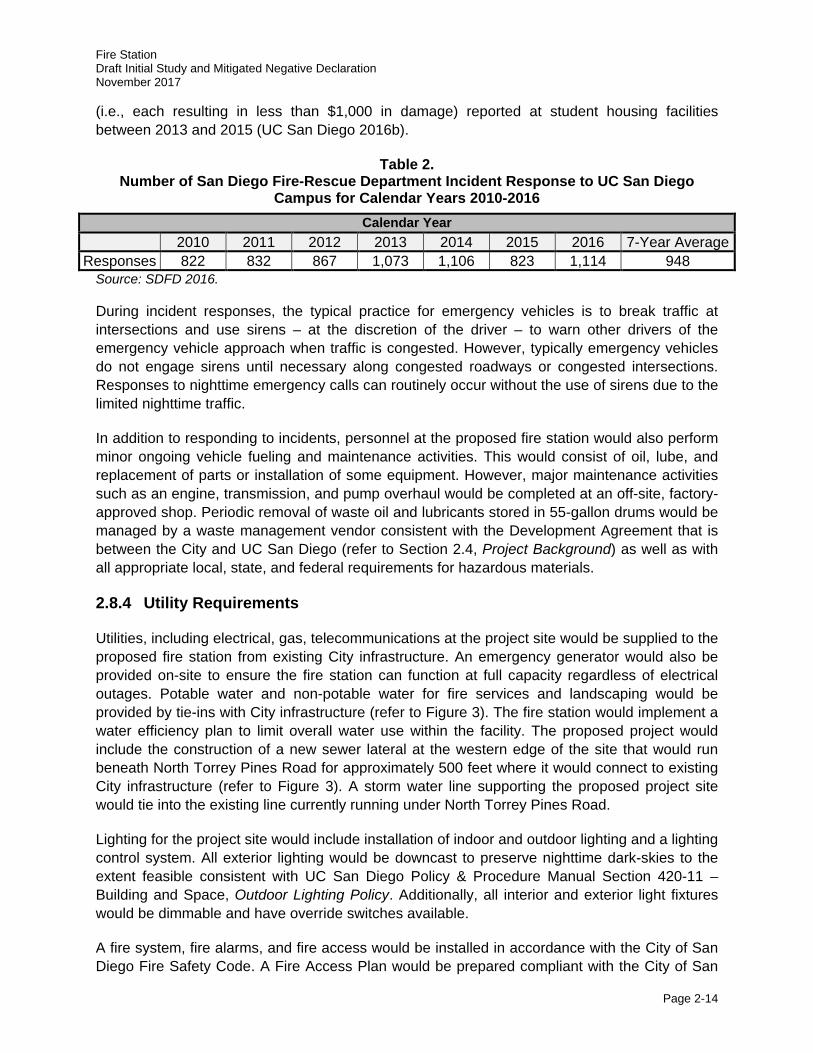
Table 2. Number of San Diego Fire-Rescue Department Incident Response to UC San Diego
Campus for Calendar Years 2010-2016 Calendar Year
2010 2011 2012 2013 2014 2015 2016 7-Year Average Responses 822 832 867 1,073 1,106 823 1,114 948
Source: SDFD 2016.
During incident responses, the typical practice for emergency vehicles is to break traffic at intersections and use sirens – at the discretion of the driver – to warn other drivers of the emergency vehicle approach when traffic is congested. However, typically emergency vehicles do not engage sirens until necessary along congested roadways or congested intersections. Responses to nighttime emergency calls can routinely occur without the use of sirens due to the limited nighttime traffic.
In addition to responding to incidents, personnel at the proposed fire station would also perform minor ongoing vehicle fueling and maintenance activities. This would consist of oil, lube, and replacement of parts or installation of some equipment. However, major maintenance activities such as an engine, transmission, and pump overhaul would be completed at an off-site, factory-approved shop. Periodic removal of waste oil and lubricants stored in 55-gallon drums would be managed by a waste management vendor consistent with the Development Agreement that is between the City and UC San Diego (refer to Section 2.4, Project Background) as well as with all appropriate local, state, and federal requirements for hazardous materials.
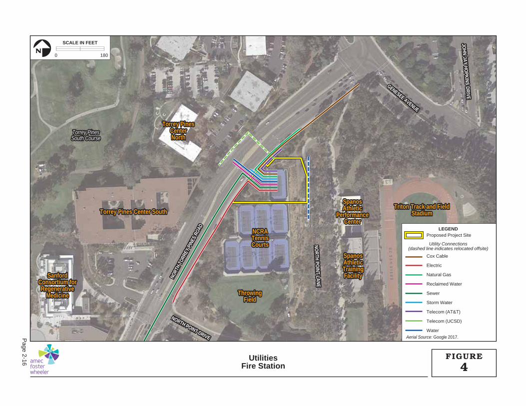
2.8.4 Utility Requirements
Utilities, including electrical, gas, telecommunications at the project site would be supplied to the proposed fire station from existing City infrastructure. An emergency generator would also be provided on-site to ensure the fire station can function at full capacity regardless of electrical outages. Potable water and non-potable water for fire services and landscaping would be provided by tie-ins with City infrastructure (refer to Figure 3). The fire station would implement a water efficiency plan to limit overall water use within the facility. The proposed project would include the construction of a new sewer lateral at the western edge of the site that would run beneath North Torrey Pines Road for approximately 500 feet where it would connect to existing City infrastructure (refer to Figure 3). A storm water line supporting the proposed project site would tie into the existing line currently running under North Torrey Pines Road.
Lighting for the project site would include installation of indoor and outdoor lighting and a lighting control system. All exterior lighting would be downcast to preserve nighttime dark-skies to the extent feasible consistent with UC San Diego Policy & Procedure Manual Section 420-11 – Building and Space, Outdoor Lighting Policy. Additionally, all interior and exterior light fixtures would be dimmable and have override switches available.
A fire system, fire alarms, and fire access would be installed in accordance with the City of San Diego Fire Safety Code. A Fire Access Plan would be prepared compliant with the City of San
Fire Station Draft Initial Study and Mitigated Negative Declaration November 2017
Page 2-15
Diego Fire Department policies. This plan, which would be reviewed by SDFD prior to construction of the proposed fire station, would ensure continued emergency access to the project site during construction and operation of the proposed fire station.
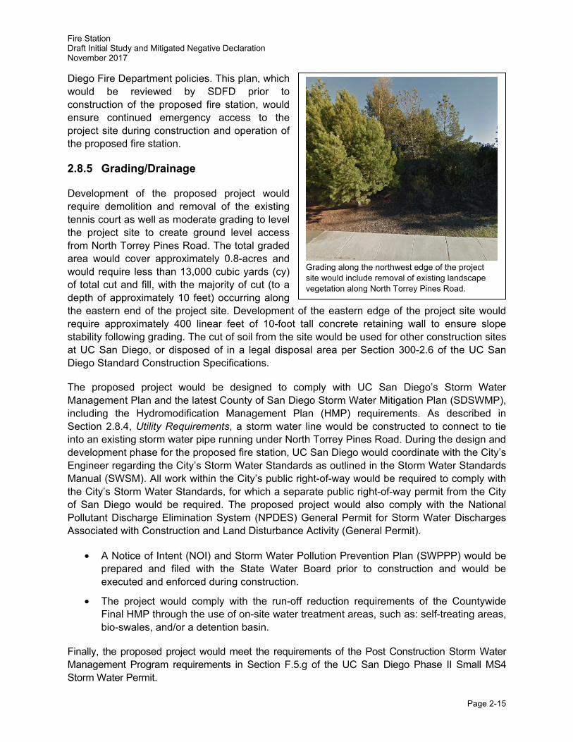
2.8.5 Grading/Drainage
Development of the proposed project would require demolition and removal of the existing tennis court as well as moderate grading to level the project site to create ground level access from North Torrey Pines Road. The total graded area would cover approximately 0.8-acres and would require less than 13,000 cubic yards (cy) of total cut and fill, with the majority of cut (to a depth of approximately 10 feet) occurring along the eastern end of the project site. Development of the eastern edge of the project site would require approximately 400 linear feet of 10-foot tall concrete retaining wall to ensure slope stability following grading. The cut of soil from the site would be used for other construction sites at UC San Diego, or disposed of in a legal disposal area per Section 300-2.6 of the UC San Diego Standard Construction Specifications.
The proposed project would be designed to comply with UC San Diego’s Storm Water Management Plan and the latest County of San Diego Storm Water Mitigation Plan (SDSWMP), including the Hydromodification Management Plan (HMP) requirements. As described in Section 2.8.4, Utility Requirements, a storm water line would be constructed to connect to tie into an existing storm water pipe running under North Torrey Pines Road. During the design and development phase for the proposed fire station, UC San Diego would coordinate with the City’s Engineer regarding the City’s Storm Water Standards as outlined in the Storm Water Standards Manual (SWSM). All work within the City’s public right-of-way would be required to comply with the City’s Storm Water Standards, for which a separate public right-of-way permit from the City of San Diego would be required. The proposed project would also comply with the National Pollutant Discharge Elimination System (NPDES) General Permit for Storm Water Discharges Associated with Construction and Land Disturbance Activity (General Permit).
• A Notice of Intent (NOI) and Storm Water Pollution Prevention Plan (SWPPP) would be prepared and filed with the State Water Board prior to construction and would be executed and enforced during construction.
• The project would comply with the run-off reduction requirements of the Countywide Final HMP through the use of on-site water treatment areas, such as: self-treating areas, bio-swales, and/or a detention basin.
Finally, the proposed project would meet the requirements of the Post Construction Storm Water Management Program requirements in Section F.5.g of the UC San Diego Phase II Small MS4 Storm Water Permit.
Grading along the northwest edge of the project site would include removal of existing landscape vegetation along North Torrey Pines Road.
SpanosSpanosAthleticAthleticTrainingTrainingFacilityFacility
Triton Track and FieldTriton Track and FieldStadiumStadium
NCRANCRATennisTennisCourtsCourts
ThrowingThrowingFieldField
SpanosSpanosAthleticAthletic
PerformancePerformanceCenterCenter
Torrey Pines Center SouthTorrey Pines Center South
Torrey PinesTorrey PinesCenterCenterNorthNorth
SanfordSanfordConsortium forConsortium forRegenerativeRegenerative
MedicineMedicine
NORTH PO
INT LANENO
RTH POINT LANE
NORTH POINT DRIVE
NORTH POINT DRIVE
GENESEE AVENUE
GENESEE AVENUE
JOHN JAY HO
PKINS DRIVEJO
HN JAY HOPKINS DRIVE
NORT
H TO
RREY
PIN
ES R
OAD
NORT
H TO
RREY
PIN
ES R
OAD
Torrey PinesTorrey PinesSouth CourseSouth Course
SpanosAthleticTrainingFacility
Triton Track and FieldStadium
NCRATennisCourts
ThrowingField
SpanosAthletic
PerformanceCenter
Torrey Pines Center South
Torrey PinesCenterNorth
SanfordConsortium forRegenerative
Medicine
NORTH POINT DRIVE
GENESEE AVENUE
JOHN JAY HO
PKINS DRIVE
NORT
H TO
RREY
PIN
ES R
OAD
NORTH PO
INT LANE
Torrey PinesSouth Course
Aerial Source: Google 2017.
LEGEND
Utility Connections(dashed line indicates relocated offsite)
Proposed Project Site
Cox Cable
Electric
Natural Gas
Reclaimed Water
Sewer
Storm Water
Telecom (AT&T)
Telecom (UCSD)
Water
0 180
SCALE IN FEET
N
4FIGUREUtilities
Fire Station
Page 2-16
Fire Station Draft Initial Study and Mitigated Negative Declaration November 2017
Page 2-17
2.8.6 Circulation
During the conceptual design and development of the proposed fire station, Linscott, Law & Greenspan (LLG) (2015) prepared a Fire Station Access Study for the proposed fire station and the surrounding area (see Appendix B). The proposed project would require two new driveways at the project site. An apparatus-dedicated (i.e., fire engine only) driveway would be constructed across from the existing Torrey Pines Center North driveway located on the west side of North Torrey Pines Road. Full access for fire apparatus would be provided at this driveway. Access would be provided for privately-owned vehicles via a right-in, right-out driveway to the south; however, this driveway would also be accessible as a right-in driveway for fire apparatus. LLG provided a number of recommendations in the Fire Station Access Study for improvements to the surrounding circulation network that would be sufficient to facilitate emergency response and to substantially reduce potential project-related delays at surrounding intersections along Genesee Avenue and North Torrey Pines Road. The roadway improvements have been designed to ensure adequate access to meet SDFD requirements. Further, during the design and development phase for the proposed fire station, UC San Diego would coordinate with City staff to ensure that roadway improvements would meet all applicable requirements prescribed by the City’s Street Design Manual.
2.8.6.1 Fire Engine Circulation
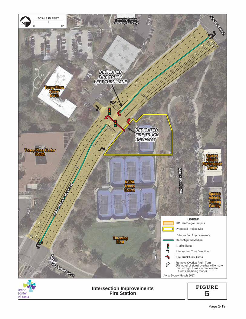
A new, dedicated left turn lane and associated median would be created for fire engines arriving to the fire station from the southbound direction on North Torrey Pines Road (see Figure 5). A traffic signal with emergency vehicle preemption would be installed at this newly created intersection.4 This would allow fire engines and/or other emergency vehicles to interrupt normal signal operation to facilitate safe and efficient entry and exit across North Torrey Pines Road during emergency response. Fire apparatus entering the fire station would make a left turn from this dedicated lane into the driveway where they would pass through a secure gate and enter the fire apparatus bay from the rear of the fire station. This circulation pattern would ensure that the vehicles are oriented toward North Torrey Pines Road when parked in the fire apparatus bay, which is important for emergency response staging and readiness. Northbound access would be provided via another driveway on the southwestern edge of the project site. After entering the parking lot, fire apparatus would pass through the secured gate and enter the fire apparatus bay from the rear of the building. Fire apparatus would exit the fire station directly from the apparatus-dedicated driveway onto North Torrey Pines Road, turning left or right as needed.
2.8.6.2 Lane/Road Configurations
As described in Section 2.8.6.1, Fire Engine Circulation the proposed project would create a new signalized intersection at the proposed fire station driveway and Torrey Pines Center North driveway with a dedicated fire engine left turn lane. The existing median at this proposed intersection would be removed and a new median would be constructed to facilitate the proposed apparatus only turn lane (see Figure 5). Lane striping and signage would be installed to clearly
4 Traffic signal preemption is a type of system that allows the normal operation of traffic lights to be “preempted” or disrupted in order to allow emergency services vehicles to proceed through the intersection more quickly and under safer conditions.
Fire Station Draft Initial Study and Mitigated Negative Declaration November 2017
Page 2-18
demark this lane as a dedicated fire truck only left turn lane. As a result of the new intersection, the proposed project would also require improvements to the traffic signals at North Torrey Pines Road with Genesee Avenue and North Point Drive to support standard daily traffic operations (see discussion below). Further, as a result of the spacing created by the new traffic signal (i.e., less than 600 feet) the City would synchronize the traffic signals at these three intersections along North Torrey Pines Road to minimize intersection delay. All traffic signals in the vicinity of the project site, including the new traffic signal supporting the proposed fire station, would continue be operated and maintained by the City.
North Torrey Pines Road & Genesee Avenue
Exits from the southern driveway under the proposed project would require that privately-owned vehicles turn right onto North Torrey Pines Road (see Figure 5). Privately-owned vehicles would not be allowed to make left turns from the proposed fire station to travel southbound on North Torrey Pines Road. As such, the signal at the intersection of North Torrey Pines Road and Genesee Avenue would be modified to permit U-turns. Because there is no signal overlap at this intersection (i.e., right turns are not permitted while left turns are occurring) no additional signal modifications would be necessary to ensure overall vehicle safety. This lane reconfiguration would accommodate privately-owned vehicles departing from the fire station that prefer to travel south along North Torrey Pines Road. It is anticipated that the majority of privately-owned vehicles entering the facility would be driven by fire station staff, and occasionally by members of the public visiting the proposed fire station, resulting in relatively infrequent trips in and out of the fire station. Additionally, pedestrian ramps at this intersection would be evaluated and modifications would be made as necessary for ADA accessibility.
North Torrey Pines Road & North Point Drive
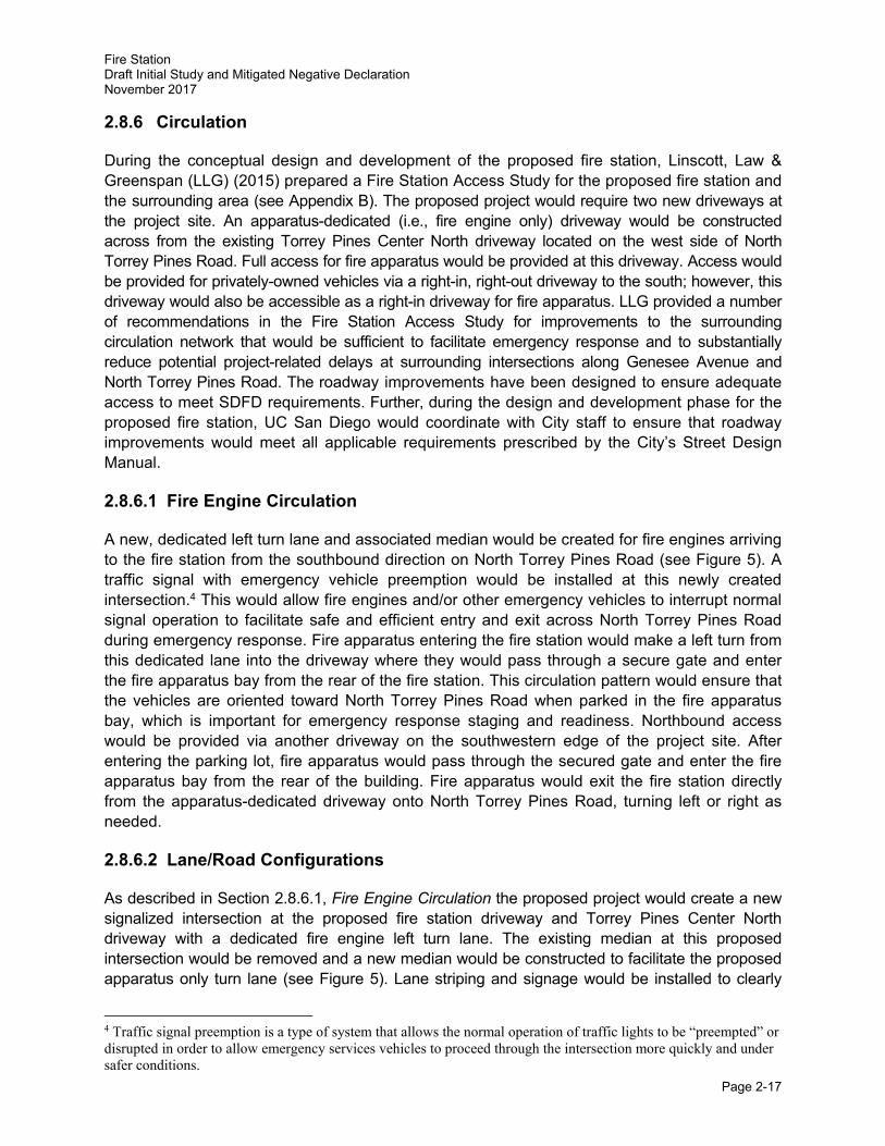
Privately-owned vehicles traveling southbound on North Torrey Pines Road would not be allowed to make left turns into the fire station from the proposed dedicated fire engine left turn lane. As such under the proposed roadway configuration these vehicles would have to first travel south to the intersection of North Torrey Pines Road and North Point Drive to make a U-turn. Under the proposed project the signal at the intersection of North Torrey Pines Road and North Point Drive would be modified to permit U-turns. Additionally, the westbound right turn signal overlap would be removed at this intersection, meaning that the signal would be adjusted such that vehicles turning right from North Point Drive onto North Torrey Pines Road would not be allowed to make turns when U-turns are occurring. This signal modification would prevent vehicle collisions at this intersection. Additionally, pedestrian ramps at this intersection would be inspected and modifications would be made as necessary for ADA accessibility.
The inside left turn lane at the intersection of North Torrey Pines Road and North Point Drive would be modified to permit U-turns.
SpanosSpanosAthleticAthleticTrainingTrainingFacilityFacility
NCRANCRATennisTennisCourtsCourts
ThrowingThrowingFieldField
SpanosSpanosAthleticAthletic
PerformancePerformanceCenterCenter
Torrey Pines CenterTorrey Pines CenterSouthSouth
Torrey PinesTorrey PinesCenterCenterNorthNorth
NORTH PO
INT LANENO
RTH POINT LANE
NORTH POINT DRIVE
NORTH POINT DRIVE
GENESEE AVENUE
GENESEE AVENUE
NORT
H TO
RREY
PIN
ES R
OAD
NORT
H TO
RREY
PIN
ES R
OAD
Center for CreativeCenter for CreativeLeadership San DiegoLeadership San Diego
SpanosAthleticTrainingFacility
NCRATennisCourts
ThrowingField
SpanosAthletic
PerformanceCenter
Torrey Pines CenterSouth
Torrey PinesCenterNorth
NORTH POINT DRIVE
GENESEE AVENUE
NORT
H TO
RREY
PIN
ES R
OAD
NORTH PO
INT LANE
Center for CreativeLeadership San Diego
DEDICATEDDEDICATEDFIRE TRUCKFIRE TRUCK
LEFT TURN LANELEFT TURN LANE
DEDICATEDDEDICATEDFIRE TRUCKFIRE TRUCKDRIVEWAYDRIVEWAY
DEDICATEDFIRE TRUCK
LEFT TURN LANE
DEDICATEDFIRE TRUCKDRIVEWAY
Aerial Source: Google 2017.
LEGEND
Intersection Improvements
UC San Diego Campus
Proposed Project Site
Reconfigured Median
Traffic Signal
Intersection Turn Direction
Fire Truck Only Turns
Remove Overlap Right Turn(Removal of signal overlap will ensure that no right turns are made while U-turns are being made)
0 120
SCALE IN FEET
N
Intersection ImprovementsFire Station 5
FIGURE
Page 2-19
Fire Station Draft Initial Study and Mitigated Negative Declaration November 2017
Page 2-20
Torrey Pines Center North Driveway
The Torrey Pines Center North driveway is a right turn in and right turn out driveway. No left turns onto North Torrey Pines Road are permitted. To prevent outbound privately-owned vehicles from turning left and crossing three lanes of traffic following the construction of the new traffic signal, additional signage and striping would be added emphasize that “right turns only” are permitted.
2.8.7 Parking
The proposed project would include approximately 16 secure parking spaces (located behind a perimeter fence) for fire rescue personnel, as well as three public parking spaces near the entrance to the proposed fire station. At least one of the public parking spaces would be ADA-compliant. Secure parking spaces would primarily be situated along the eastern edge of the project site, with public spaces positioned to the west of the proposed fires station.
2.8.8 Landscaping/Hardscape Improvements
The vegetation within and adjacent to the proposed project site, is mapped in the LRDP Program EIR as Urban/Developed Land and is characterized as ornamental landscape plantings. This has been confirmed with recent campus-wide biological resources mapping in support of the La Jolla Campus LRDP Update (HELIX 2016b). The site is dominated by the existing tennis court, but roadside shrubs and trees, including several eucalyptus and landscape pine trees, are present adjacent to North Torrey Pines Road. However, no Torrey Pines (Pinus torreyana) are located on-site. Grading associated with the construction of the proposed fire station would include the removal of existing vegetation including several trees as well as understory vegetation along the northern and western margins of the proposed project site. A fire- and drought-resistant planting palette would be developed to provide plant material consistent with the surrounding landscape.
Hardscape features such as parking, retaining walls, and walkways would be designed to complement existing building materials and surrounding landscape. LID features would be incorporated into the proposed project design to effectively address storm water run-off. Additional project features would include an emergency generator, flagpole, mailbox, fire hydrant, trash enclosure, signage, security fencing, fueling facilities, truck wash area, and hose drying area.
2.8.9 Construction Staging
Construction of the proposed project would occur over 12 to 16 months and would include demolition activities (e.g., tennis court), excavation and export of cut, fine grading, and construction of the proposed fire station and associated intersection improvements. Additionally,
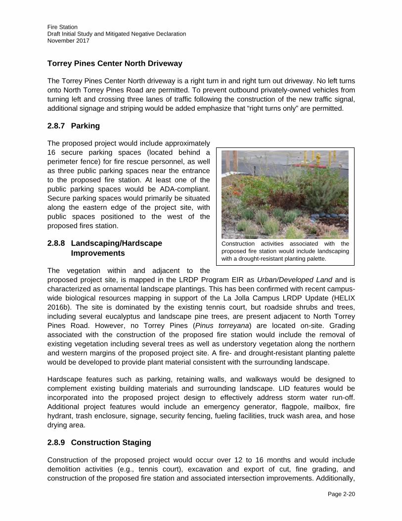
Construction activities associated with the proposed fire station would include landscaping with a drought-resistant planting palette.
Fire Station Draft Initial Study and Mitigated Negative Declaration November 2017
Page 2-21
construction would also include the installation of utilities, including sewer, storm water, telecom, reclaimed water, electric, water, and natural gas. The construction of approximately 400 linear feet of retaining walls would be required to provide geotechnical stability along the eastern edge of the project site.
Construction activities would be expected to follow University standard hours of 7:00 AM to 7:00 PM Monday through Saturday. Throughout the duration of construction activities, the project site boundary would be fenced, with a primary construction access from North Torrey Pines Road. Construction staging would be located on-site or along North Point Lane adjacent to the Spanos Athletic Performance Center (e.g., heavy haul truck staging). With the exception of construction vehicle entry and exit to the project site, vehicle, pedestrian, and bicycle access adjacent to the site along North Torrey Pines Road would be unaffected.
There would be minor utility interruptions during construction, particularly during installation and synchronization of the new traffic signal. However, the dedicated utility shutdown coordinator would proactively coordinate any utility service shutdowns, cut-overs, and connections well in advance to ensure they coincide with a time that provides the least impact to surrounding facilities and other nearby construction activities.
2.9 Project Approval/Schedule
As the public agency principally responsible for approving or carrying out the proposed project, which includes a minor LRDP amendment, the University of California is the Lead Agency under CEQA and is responsible for the review and approval of the Tiered IS/MND. The proposed Tiered IS/MND would be considered by the UC San Diego, and this Tiered IS/MND would support the environmental, option and purchase agreement, minor LRDP amendment, and design approval actions.
The proposed project will require subsequent actions (discretionary and or ministerial) from the following Responsible Agencies:
California Coastal Commission (CCC)
• Coastal Development Permit (CDP)
City of San Diego
• Approval of the Design and Construction Agreement for the fire station and public right-of-way improvements;
• Approval the Purchase and Sale Agreement and authorizing the City to acquire the real property and future fire station improvements from UC San Diego;
• Approval an Option Agreement and Purchase and Sale Agreement with UC San Diego to purchase a separate parcel of City-owned real property (Torrey Pines Center South I); and
• Issuance of ministerial permits for work within the City public right-of-way.
Fire Station Draft Initial Study and Mitigated Negative Declaration November 2017
Page 2-22
In addition, although the project site and adjacent City public right-of-way has been graded/disturbed from prior development, due to the proximity of a recorded archaeological site the City, acting in its role as a responsible agency under CEQA, has requested that work within this area of North Torrey Pines Road and Genesee Avenue include the provision for archaeological and Native American Kumeyaay monitoring. This provision is consistent with the City’s commitment to the local Native American Kumeyaay community to include monitoring in areas of high sensitivity to minimize and reduce inadvertent discoveries in the public right-of-way during construction-related activities. This requirement would be reflected on public right of way improvement plans submitted for review/approval to the City during the ministerial plan check process. Site preparation, grading, and construction are anticipated to begin in 2019; the proposed fire station is scheduled to be fully operational by 2021.

Fire Station Draft Initial Study and Mitigated Negative Declaration November 2017
Page 3-1
3.0 RELATIONSHIP TO AND CONSISTENCY WITH 2004 LRDP
This IS/MND for the proposed fire station has been tiered from the 2004 LRDP Program EIR (SCH No. 2003081023) and ECBT Project EIR (SCH No. 2009081053), which are hereby incorporated by reference. The 2004 LRDP is the adopted land use plan for the UC San Diego campus and is based upon the anticipated increase in academic and research activities, as well as the anticipated space requirements and land uses, associated with the expansion of UC San Diego’s academic, administrative, and support programs through academic year 2020-21. The 2004 LRDP Program EIR analyzed the overall direct and indirect environmental effects of campus growth and facility development including potentially significant cumulative impacts. The ECBT Project EIR analyzed the cumulative traffic/circulation and cumulative air quality impacts associated with the implementation of the 2004 LRDP Program EIR, as an update to the 2004 LRDP Program EIR.
The 2004 LRDP consists of three primary elements: 1) a description of the planning context for the campus; 2) an outline of the enrollment, faculty/staff, space, and parking needs of the campus; and 3) a land use plan to guide the siting of proposed new development and related circulation and parking facilities to meet those needs.
In order to determine the consistency of the proposed project with the 2004 LRDP, the following questions should be considered.
· Is the proposed project included within the scope of the development projected for the 2004 LRDP?
· Is the proposed project location in an area designated for this type of use in the 2004 LRDP? Is the campus population that would result from the proposed project included within the scope of the 2004 LRDP population projections?
· Are the objectives of the proposed project consistent with the objectives of the 2004 LRDP?
The following discussion describes the scope of development, land use designations, population projections, and objectives contained in the 2004 LRDP that are relevant to the proposed project, and evaluates the proposed project’s consistency with each of these items. The consistency discussion is followed by a summary of the appropriateness of using a tiered CEQA document for the proposed project.
3.1 2004 LRDP Scope of Development and Land Use Designations
The 2004 LRDP designates the existing underlying land use for the proposed project site as Sports and Recreation (refer to Figure 3.4-5 on page 3-31 of the 2004 LRDP Program EIR) which by definition includes major playing fields and other athletic facilities associated with the NCRA (refer to page 3-30 of the 2004 LRDP Program EIR). As stated in Section 2.0, Project Location and Description, the proposed project involves the development of a fire station that would support the UC San Diego campus and the greater La Jolla community. As stated in Section 2.9, Project Approval/Schedule, the proposed project includes a minor LRDP amendment. The LRDP amendment would change the land use designation on the project site from Sports and Recreation to General Services. The minor LRDP amendment would be
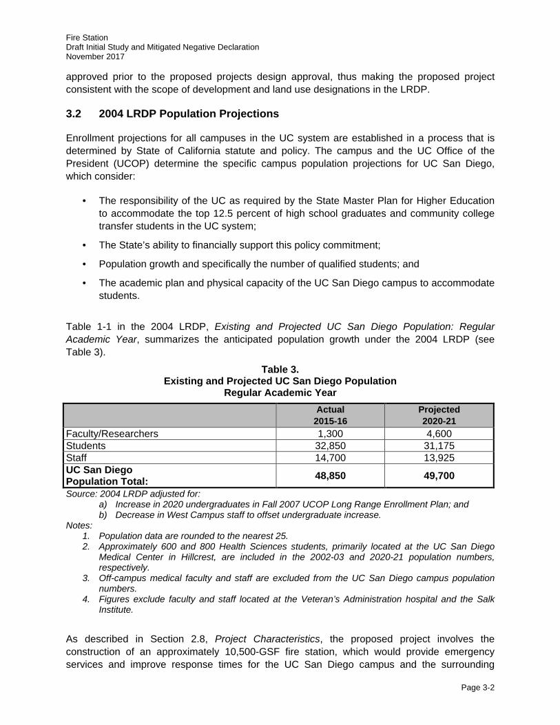
Fire Station Draft Initial Study and Mitigated Negative Declaration November 2017
Page 3-2
approved prior to the proposed projects design approval, thus making the proposed project consistent with the scope of development and land use designations in the LRDP.
3.2 2004 LRDP Population Projections
Enrollment projections for all campuses in the UC system are established in a process that is determined by State of California statute and policy. The campus and the UC Office of the President (UCOP) determine the specific campus population projections for UC San Diego, which consider:
· The responsibility of the UC as required by the State Master Plan for Higher Education to accommodate the top 12.5 percent of high school graduates and community college transfer students in the UC system;
· The State’s ability to financially support this policy commitment;
· Population growth and specifically the number of qualified students; and
· The academic plan and physical capacity of the UC San Diego campus to accommodate students.
Table 1-1 in the 2004 LRDP, Existing and Projected UC San Diego Population: Regular Academic Year, summarizes the anticipated population growth under the 2004 LRDP (see Table 3).
Table 3. Existing and Projected UC San Diego Population
Regular Academic Year
Actual 2015-16
Projected 2020-21
Faculty/Researchers 1,300 4,600 Students 32,850 31,175 Staff 14,700 13,925 UC San Diego Population Total: 48,850 49,700
Source: 2004 LRDP adjusted for: a) Increase in 2020 undergraduates in Fall 2007 UCOP Long Range Enrollment Plan; and b) Decrease in West Campus staff to offset undergraduate increase.
Notes: 1. Population data are rounded to the nearest 25. 2. Approximately 600 and 800 Health Sciences students, primarily located at the UC San Diego
Medical Center in Hillcrest, are included in the 2002-03 and 2020-21 population numbers, respectively.
3. Off-campus medical faculty and staff are excluded from the UC San Diego campus population numbers.
4. Figures exclude faculty and staff located at the Veteran’s Administration hospital and the Salk Institute.
As described in Section 2.8, Project Characteristics, the proposed project involves the construction of an approximately 10,500-GSF fire station, which would provide emergency services and improve response times for the UC San Diego campus and the surrounding
Fire Station Draft Initial Study and Mitigated Negative Declaration November 2017
Page 3-3
community. The proposed project would not add to the campus faculty and staff populations and no new students, faculty, or staff growth would be anticipated as a result of implementation of the proposed project because the fire station would be owned and operated by the City of San Diego. However, approximately 12 fire rescue personnel, employed by the City, would be at the project site on a rotational basis over a 24-hour period. All fire rescue personnel would be employed by the City, and would only negligibly contribute to the on-campus population (i.e., less than < 1 percent of the total projected 2020-21 UC San Diego population). The proposed Project would be well within the projected 2020 population and space projections for UC San Diego under the 2004 LRDP.
3.3 2004 LRDP Objectives
The 2004 LRDP Program EIR contains the following objectives which serve as a framework for the physical development of the campus as stated on pages 3-11 and 3-12 of the Final Program EIR:
a. Provide a plan that will enable UC San Diego to grow in a manner that is consistent with the University of California’s mission and commitment to excellence in teaching, research, and public service.
b. Respond to projected demand for enrollment in the UC by providing the capability to expand academic and non-academic programs to accommodate additional students, faculty, and staff at UC San Diego.
c. Continue to provide services such as student housing, parking, transportation, recreation, childcare, appropriate retail operations, and administrative support, necessary to support the auxiliary program objectives of the campus.
d. Minimize impacts to environmental resources and preserve and enhance environmental resources when practicable.
e. Maintain, expand, and support existing and future scientific and research opportunities and patient care services.
f. Maintain academic excellence and serve as a resource to the surrounding community, city, state, and nation.
As described in Section 2.4, Project Background, the construction of a fire station on or near the UC San Diego campus has been identified as a mitigation measure for UC San Diego’s contribution to cumulative impacts to public services in several CEQA-compliant environmental documents prepared by UC San Diego (refer to Section 2.4, Project Background). The construction of the proposed fire station would support the growing campus population and the surrounding community. The proposed project also would further UC San Diego’s objectives to grow in a manner that is consistent with the University of California’s mission and commitment to excellence in teaching, research, and public service. The proposed project would be compatible with the existing surrounding land uses and with the adoption of the minor LRDP amendment, the proposed project would be consistent with the overall scope and objectives of the 2004 LRDP.
Fire Station Draft Initial Study and Mitigated Negative Declaration November 2017
Page 3-4
3.4 Appropriateness of a Tiered Initial Study
The proposed project, including the minor LRDP amendment, would be consistent with the scope of development, population projections, and objectives contained in the 2004 LRDP and evaluated in the 2004 LRDP Program EIR, as updated by the ECBT Project EIR. Accordingly, pursuant to Section 15152 of the State CEQA Guidelines, it is appropriate to tier this IS from the 2004 LRDP Program EIR, as updated by the ECBT Project EIR. This IS evaluates whether the environmental effects of the proposed project were adequately addressed in the 2004 LRDP Program EIR, as updated by the ECBT Project EIR. For impacts that were adequately addressed, this IS provides a cross reference to the relevant discussion in the 2004 LRDP Program EIR and the ECBT Project EIR. Project-specific impacts that were not addressed in the 2004 LRDP Program EIR, or as updated in the ECBT Project EIR, are evaluated in detail in this document. This IS also evaluates whether there have been any changes in the project or the circumstances in which it would be undertaken since the 2004 LRDP Program EIR was certified, as updated by the ECBT Project EIR, that require additional analysis in this document. Project-level mitigation has been identified where required.
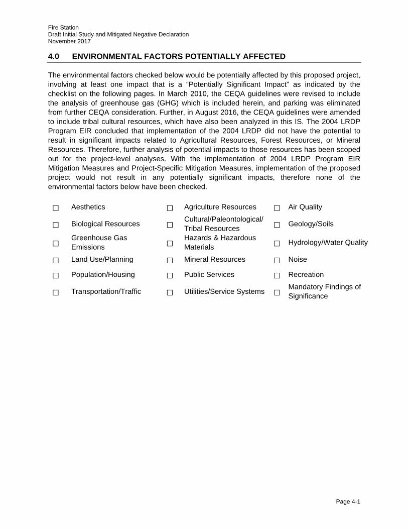
Fire Station Draft Initial Study and Mitigated Negative Declaration November 2017
Page 4-1
4.0 ENVIRONMENTAL FACTORS POTENTIALLY AFFECTED
The environmental factors checked below would be potentially affected by this proposed project, involving at least one impact that is a “Potentially Significant Impact” as indicated by the checklist on the following pages. In March 2010, the CEQA guidelines were revised to include the analysis of greenhouse gas (GHG) which is included herein, and parking was eliminated from further CEQA consideration. Further, in August 2016, the CEQA guidelines were amended to include tribal cultural resources, which have also been analyzed in this IS. The 2004 LRDP Program EIR concluded that implementation of the 2004 LRDP did not have the potential to result in significant impacts related to Agricultural Resources, Forest Resources, or Mineral Resources. Therefore, further analysis of potential impacts to those resources has been scoped out for the project-level analyses. With the implementation of 2004 LRDP Program EIR Mitigation Measures and Project-Specific Mitigation Measures, implementation of the proposed project would not result in any potentially significant impacts, therefore none of the environmental factors below have been checked.
□ Aesthetics □ Agriculture Resources □ Air Quality
□ Biological Resources □ Cultural/Paleontological/Tribal Resources □ Geology/Soils
□ Greenhouse Gas Emissions □
Hazards & Hazardous Materials □ Hydrology/Water Quality
□ Land Use/Planning □ Mineral Resources □ Noise
□ Population/Housing □ Public Services □ Recreation
□ Transportation/Traffic □ Utilities/Service Systems □ Mandatory Findings of Significance
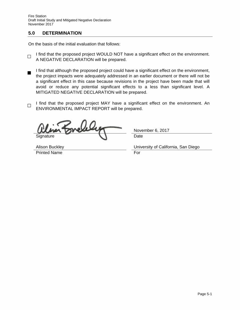
Fire Station Draft Initial Study and Mitigated Negative Declaration November 2017
Page 5-1
5.0 DETERMINATION
On the basis of the initial evaluation that follows:
□ I find that the proposed project WOULD NOT have a significant effect on the environment. A NEGATIVE DECLARATION will be prepared.
■ I find that although the proposed project could have a significant effect on the environment, the project impacts were adequately addressed in an earlier document or there will not be a significant effect in this case because revisions in the project have been made that will avoid or reduce any potential significant effects to a less than significant level. A MITIGATED NEGATIVE DECLARATION will be prepared.
□ I find that the proposed project MAY have a significant effect on the environment. An ENVIRONMENTAL IMPACT REPORT will be prepared.
November 6, 2017
Signature Date
Alison Buckley University of California, San Diego Printed Name For
Fire Station Draft Initial Study and Mitigated Negative Declaration November 2017
Page 6-1
6.0 EVALUATION OF ENVIRONMENTAL IMPACTS
The University of California has defined the column headings in the IS checklist as follows:
A) “Potentially Significant Impact” is appropriate if there is substantial evidence that the project’s effect may be significant. If there is one or more “Potentially Significant Impact” entries a Project EIR will be prepared.
B) “Project Impact Adequately Addressed in LRDP EIR” applies where the potential impacts of the proposed project were adequately addressed in the 2004 LRDP Program EIR and 2004 LRDP Program EIR mitigation measures, as updated by the ECBT Project EIR, as specified in the analysis, will mitigate any impacts of the proposed project to the extent feasible. 2004 LRDP Program EIR and the ECBT Project EIR mitigation measures may be incorporated into the project. The potential impact of the proposed project is adequately addressed in the 2004 LRDP Program EIR, as updated by the ECBT Project EIR. The impact analysis in this document summarizes and cross references (including section/page numbers) the relevant analysis in the 2004 LRDP Program EIR and the ECBT Project EIR.
C) “Less Than Significant with Project-level Mitigation Incorporated” applies where the incorporation of project-specific mitigation measures will reduce an effect from “Potentially Significant Impact” to a “Less Than Significant Impact.” All project-level mitigation measures must be described, including a brief explanation of how the measures reduce the effect to a less than significant level.
D) “Less Than Significant Impact” applies where the project will not result in any significant effects. The effects may or may not have been discussed in the 2004 LRDP Program EIR, as updated by the ECBT Project EIR. The project impact is less than significant without the incorporation of LRDP or Project-level mitigation.
E) “No Impact” applies where a project would not result in any impact in the category in question or the category simply does not apply. “No Impact” answers do not require an explanation if they are adequately supported by the information sources cited by the lead agency which show that the impact simply does not apply to projects like the one involved (e.g., the project falls outside a fault rupture zone). A “No Impact” answer should be explained where it is based on project-specific factors as well as general standards (e.g., the project will not expose sensitive receptors to pollutants, based on a project-specific screening analysis).
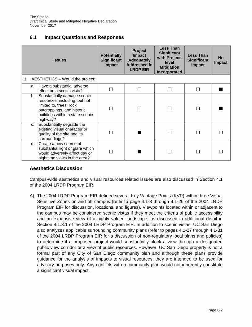
Fire Station Draft Initial Study and Mitigated Negative Declaration November 2017
Page 6-2
6.1 Impact Questions and Responses
Issues Potentially Significant
Impact
Project Impact
Adequately Addressed in
LRDP EIR
Less Than Significant
with Project-level
Mitigation Incorporated
Less Than Significant
Impact No
Impact
1. AESTHETICS – Would the project:
a. Have a substantial adverse effect on a scenic vista? □ □ □ □ ■
b. Substantially damage scenic resources, including, but not limited to, trees, rock outcroppings, and historic buildings within a state scenic highway?
□ □ □ □ ■
c. Substantially degrade the existing visual character or quality of the site and its surroundings?
□ ■ □ □ □
d. Create a new source of substantial light or glare which would adversely affect day or nighttime views in the area?
□ ■ □ □ □
Aesthetics Discussion
Campus-wide aesthetics and visual resources related issues are also discussed in Section 4.1 of the 2004 LRDP Program EIR.
A) The 2004 LRDP Program EIR defined several Key Vantage Points (KVP) within three Visual Sensitive Zones on and off campus (refer to page 4.1-8 through 4.1-26 of the 2004 LRDP Program EIR for discussion, locations, and figures). Viewpoints located within or adjacent to the campus may be considered scenic vistas if they meet the criteria of public accessibility and an expansive view of a highly valued landscape, as discussed in additional detail in Section 4.1.3.1 of the 2004 LRDP Program EIR. In addition to scenic vistas, UC San Diego also analyzes applicable surrounding community plans (refer to pages 4.1-27 through 4.1-31 of the 2004 LRDP Program EIR for a discussion of non-regulatory local plans and policies) to determine if a proposed project would substantially block a view through a designated public view corridor or a view of public resources. However, UC San Diego property is not a formal part of any City of San Diego community plan and although these plans provide guidance for the analysis of impacts to visual resources, they are intended to be used for advisory purposes only. Any conflicts with a community plan would not inherently constitute a significant visual impact.
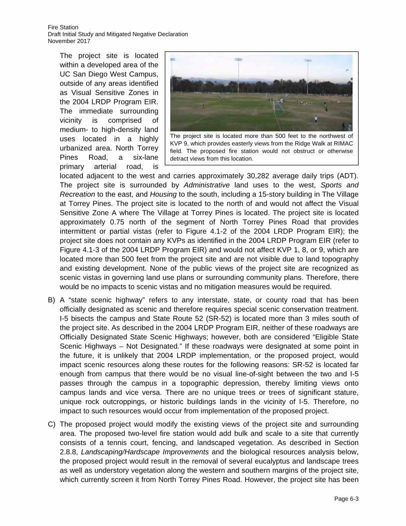
Fire Station Draft Initial Study and Mitigated Negative Declaration November 2017
Page 6-3
The project site is located within a developed area of the UC San Diego West Campus, outside of any areas identified as Visual Sensitive Zones in the 2004 LRDP Program EIR. The immediate surrounding vicinity is comprised of medium- to high-density land uses located in a highly urbanized area. North Torrey Pines Road, a six-lane primary arterial road, is located adjacent to the west and carries approximately 30,282 average daily trips (ADT). The project site is surrounded by Administrative land uses to the west, Sports and Recreation to the east, and Housing to the south, including a 15-story building in The Village at Torrey Pines. The project site is located to the north of and would not affect the Visual Sensitive Zone A where The Village at Torrey Pines is located. The project site is located approximately 0.75 north of the segment of North Torrey Pines Road that provides intermittent or partial vistas (refer to Figure 4.1-2 of the 2004 LRDP Program EIR); the project site does not contain any KVPs as identified in the 2004 LRDP Program EIR (refer to Figure 4.1-3 of the 2004 LRDP Program EIR) and would not affect KVP 1, 8, or 9, which are located more than 500 feet from the project site and are not visible due to land topography and existing development. None of the public views of the project site are recognized as scenic vistas in governing land use plans or surrounding community plans. Therefore, there would be no impacts to scenic vistas and no mitigation measures would be required.
B) A “state scenic highway” refers to any interstate, state, or county road that has been officially designated as scenic and therefore requires special scenic conservation treatment. I-5 bisects the campus and State Route 52 (SR-52) is located more than 3 miles south of the project site. As described in the 2004 LRDP Program EIR, neither of these roadways are Officially Designated State Scenic Highways; however, both are considered “Eligible State Scenic Highways – Not Designated.” If these roadways were designated at some point in the future, it is unlikely that 2004 LRDP implementation, or the proposed project, would impact scenic resources along these routes for the following reasons: SR-52 is located far enough from campus that there would be no visual line-of-sight between the two and I-5 passes through the campus in a topographic depression, thereby limiting views onto campus lands and vice versa. There are no unique trees or trees of significant stature, unique rock outcroppings, or historic buildings lands in the vicinity of I-5. Therefore, no impact to such resources would occur from implementation of the proposed project.
C) The proposed project would modify the existing views of the project site and surrounding area. The proposed two-level fire station would add bulk and scale to a site that currently consists of a tennis court, fencing, and landscaped vegetation. As described in Section 2.8.8, Landscaping/Hardscape Improvements and the biological resources analysis below, the proposed project would result in the removal of several eucalyptus and landscape trees as well as understory vegetation along the western and southern margins of the project site, which currently screen it from North Torrey Pines Road. However, the project site has been
The project site is located more than 500 feet to the northwest of KVP 9, which provides easterly views from the Ridge Walk at RIMAC field. The proposed fire station would not obstruct or otherwise detract views from this location.

Fire Station Draft Initial Study and Mitigated Negative Declaration November 2017
Page 6-4
identified as Urban/Developed Land as part of the campus-wide biological resource mapping in support of the La Jolla Campus LRDP Update (HELIX 2016a) and does not include any unique or sensitive vegetation. Vegetation to the north and south of the project site would remain and partially screen the project site from these directions. Further, there are no unique trees, rock outcroppings, or historic buildings in the vicinity of the project site. The proposed project would include infill development in the North Campus Neighborhood that would be generally consistent with surrounding administrate, academic, and housing development along North Torrey Pines Road. The two-story building would be consistent with the Torrey Pines Center North and Torrey Pines Center South across the street to the west and much smaller in scale than The Village at Torrey Pines located to the south of the project site. Further, the proposed project would undergo a design review process (as required by 2004 LRDP Program EIR Mitigation Measure Aes-1Ai) to ensure that appropriate site considerations and design aesthetics are achieved. Therefore, the proposed project was adequately addressed in the 2004 LRDP Program EIR, and no additional mitigation would be required.
2004 LRDP Program EIR Mitigation Measure:
Aes-1A i. Prior to project design approval, any proposed project that would have the potential to substantially degrade the visual character of the project site shall undergo design review by the UC San Diego Design Review Board (DRB) to ensure that the design is consistent with the visual landscape and/or the character of the surrounding development. The design review process shall evaluate and incorporate, where appropriate, factors including but not necessarily limited to: building mass and form, building proportion, roof profile, architectural detail and fenestration, texture, color, type and quality of building materials, and landscaping.
D) As described in the 2004 LRDP Program EIR implementation of the proposed 2004 LRDP would result in the development of new structures that would have the potential to increase sources of light and/or glare. New development would take place in currently developed and undeveloped areas, and potential new sources of light would include exterior building illumination, parking lots or structures, new landscaped areas, and new roadway lighting. New sources of glare could result from reflective building surfaces or the headlights of vehicular traffic, including fire apparatus. However, considering the existing architecture on campus and general practices for design of buildings, the 2004 LRDP Program EIR concludes there would be a low potential for daytime glare impacts (refer to page 4.1-39 of the 2004 LRDP Program EIR) based on the existing architecture on campus and general practices for design of buildings.
Potential nighttime light and glare impacts of most concern would be those that would create a distraction, nuisance, or hazard to people. The proposed project would include outdoor lighting as part of its lighting plan. As described in Section 2.8.4, Utility Requirements all exterior lighting would be downcast to preserve nighttime dark-skies to the extent feasible consistent with the LRDP Mitigation Measure Aes-2B and UC San Diego Policy & Procedure Manual Section 420-11 – Building and Space, Outdoor Lighting Policy. Additionally, the siren lights on fire apparatus would present new sources of periodic nighttime light. However, as described in the noise analysis below with the proposed preemptive traffic signal it is likely that fire apparatus would often be able to exit the fire station safely without being impeded by traffic. As such, many responses would not necessitate the use of siren
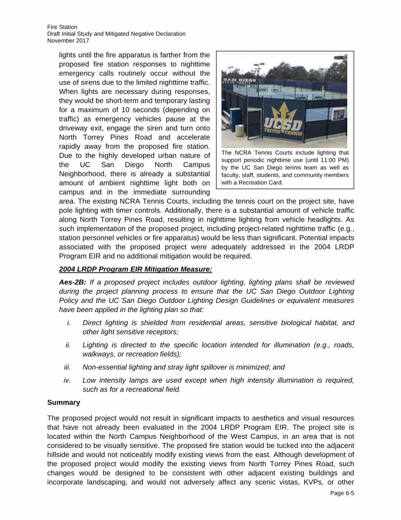
Fire Station Draft Initial Study and Mitigated Negative Declaration November 2017
Page 6-5
lights until the fire apparatus is farther from the proposed fire station responses to nighttime emergency calls routinely occur without the use of sirens due to the limited nighttime traffic. When lights are necessary during responses, they would be short-term and temporary lasting for a maximum of 10 seconds (depending on traffic) as emergency vehicles pause at the driveway exit, engage the siren and turn onto North Torrey Pines Road and accelerate rapidly away from the proposed fire station. Due to the highly developed urban nature of the UC San Diego North Campus Neighborhood, there is already a substantial amount of ambient nighttime light both on campus and in the immediate surrounding area. The existing NCRA Tennis Courts, including the tennis court on the project site, have pole lighting with timer controls. Additionally, there is a substantial amount of vehicle traffic along North Torrey Pines Road, resulting in nighttime lighting from vehicle headlights. As such implementation of the proposed project, including project-related nighttime traffic (e.g., station personnel vehicles or fire apparatus) would be less than significant. Potential impacts associated with the proposed project were adequately addressed in the 2004 LRDP Program EIR and no additional mitigation would be required.
2004 LRDP Program EIR Mitigation Measure:
Aes-2B: If a proposed project includes outdoor lighting, lighting plans shall be reviewed during the project planning process to ensure that the UC San Diego Outdoor Lighting Policy and the UC San Diego Outdoor Lighting Design Guidelines or equivalent measures have been applied in the lighting plan so that:
i. Direct lighting is shielded from residential areas, sensitive biological habitat, and other light sensitive receptors;
ii. Lighting is directed to the specific location intended for illumination (e.g., roads, walkways, or recreation fields);
iii. Non-essential lighting and stray light spillover is minimized; and
iv. Low intensity lamps are used except when high intensity illumination is required, such as for a recreational field.
Summary
The proposed project would not result in significant impacts to aesthetics and visual resources that have not already been evaluated in the 2004 LRDP Program EIR. The project site is located within the North Campus Neighborhood of the West Campus, in an area that is not considered to be visually sensitive. The proposed fire station would be tucked into the adjacent hillside and would not noticeably modify existing views from the east. Although development of the proposed project would modify the existing views from North Torrey Pines Road, such changes would be designed to be consistent with other adjacent existing buildings and incorporate landscaping, and would not adversely affect any scenic vistas, KVPs, or other
The NCRA Tennis Courts include lighting that support periodic nighttime use (until 11:00 PM) by the UC San Diego tennis team as well as faculty, staff, students, and community members with a Recreation Card.
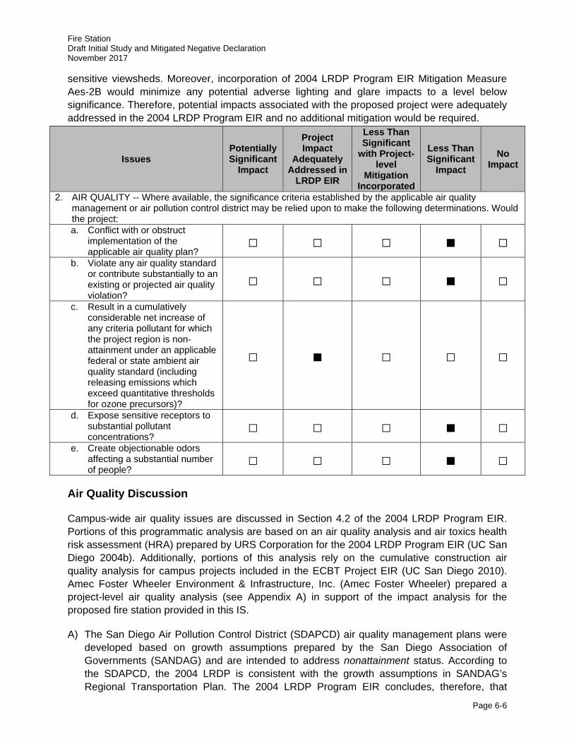
Fire Station Draft Initial Study and Mitigated Negative Declaration November 2017
Page 6-6
sensitive viewsheds. Moreover, incorporation of 2004 LRDP Program EIR Mitigation Measure Aes-2B would minimize any potential adverse lighting and glare impacts to a level below significance. Therefore, potential impacts associated with the proposed project were adequately addressed in the 2004 LRDP Program EIR and no additional mitigation would be required.
Issues Potentially Significant
Impact
Project Impact
Adequately Addressed in
LRDP EIR
Less Than Significant
with Project-level
Mitigation Incorporated
Less Than Significant
Impact No
Impact
2. AIR QUALITY -- Where available, the significance criteria established by the applicable air quality management or air pollution control district may be relied upon to make the following determinations. Would the project: a. Conflict with or obstruct
implementation of the applicable air quality plan?
□ □ □ ■ □
b. Violate any air quality standard or contribute substantially to an existing or projected air quality violation?
□ □ □ ■ □
c. Result in a cumulatively considerable net increase of any criteria pollutant for which the project region is non-attainment under an applicable federal or state ambient air quality standard (including releasing emissions which exceed quantitative thresholds for ozone precursors)?
□ ■ □ □ □
d. Expose sensitive receptors to substantial pollutant concentrations?
□ □ □ ■ □
e. Create objectionable odors affecting a substantial number of people?
□ □ □ ■ □
Air Quality Discussion
Campus-wide air quality issues are discussed in Section 4.2 of the 2004 LRDP Program EIR. Portions of this programmatic analysis are based on an air quality analysis and air toxics health risk assessment (HRA) prepared by URS Corporation for the 2004 LRDP Program EIR (UC San Diego 2004b). Additionally, portions of this analysis rely on the cumulative construction air quality analysis for campus projects included in the ECBT Project EIR (UC San Diego 2010). Amec Foster Wheeler Environment & Infrastructure, Inc. (Amec Foster Wheeler) prepared a project-level air quality analysis (see Appendix A) in support of the impact analysis for the proposed fire station provided in this IS.
A) The San Diego Air Pollution Control District (SDAPCD) air quality management plans were developed based on growth assumptions prepared by the San Diego Association of Governments (SANDAG) and are intended to address nonattainment status. According to the SDAPCD, the 2004 LRDP is consistent with the growth assumptions in SANDAG’s Regional Transportation Plan. The 2004 LRDP Program EIR concludes, therefore, that
Fire Station Draft Initial Study and Mitigated Negative Declaration November 2017
Page 6-7
campus development under the 2004 LRDP would not conflict with or obstruct implementation of the applicable air quality plan. As shown in Tables 6 through 8, implementation of the proposed project would result in construction-related and operational air quality emissions that would be well below SDAPCD thresholds and would only negligibly increase the emission of criteria pollutants as a result of development on the UC San Diego campus. As such, the implementation of the proposed project, including 2004 LRDP Program EIR Mitigation Measures Air-CA, Air-CB, and Air-CC, would result in a less than significant impact.
B) Following the adoption of the 2004 LRDP Program EIR, new standards have been adopted for three criteria pollutants: O3 (new 8-hour federal standard of 0.070 parts per million [ppm]); NO2 (new 1-hour and annual California standards of 0.18 ppm and 0.030 ppm, respectively); and PM2.5 (new 24-hour and annual federal standards of 35 micrograms per cubic meter [µg/m3] and 15 µg/m3, respectively and new annual California standard of 12 µg/m3). Three additional criteria pollutants are now at state nonattainment status; O3 (1-hour and 8-hour), PM2.5, and particulate matter with an aerodynamic diameter of less than 10 microns (PM10). O3 is still considered basic nonattainment under the federal 8-hour standard. SDAB is currently designated nonattainment for O3, both 1-hour and 8-hour, and particulate matter, PM10 and PM2.5 under the California Ambient Air Quality Standards (CAAQS). It is designated attainment for CO, NO2, sulfur dioxide (SO2), lead, and sulfates. Table 4 summarizes San Diego County’s state and federal attainment designations for each of the criteria pollutants.
As part of its air quality permitting process, SDAPCD has established thresholds in Rule 20.2 requiring the preparation of Air Quality Impact Assessments (AQIAs) for permitted sources. SDAPCD sets forth quantitative screening level thresholds below which a project would not have a significant impact on ambient air quality. For PM2.5, the U.S. Environmental Protection Agency’s (USEPA’s) Proposed Rule to implement the Fine Particle National Ambient Air Quality Standards (USEPA 2005) recommends a significance threshold of 10 tons per year, which equates to 55 pounds per day (lbs/day). Project-related air quality impacts estimated in this environmental analysis would be considered significant if any of the applicable significance thresholds presented in Table 5 are exceeded. For CEQA purposes, these screening criteria can be used as numeric methods to demonstrate that a proposed project’s total emissions would not result in a significant impact to air quality.
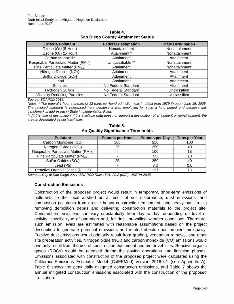
Fire Station Draft Initial Study and Mitigated Negative Declaration November 2017
Page 6-8
Table 4. San Diego County Attainment Status
Criteria Pollutant Federal Designation State Designation Ozone (O3) (8-Hour) Nonattainment Nonattainment Ozone (O3) (1-Hour) Attainment * Nonattainment
Carbon Monoxide Attainment Attainment Respirable Particulate Matter (PM10) Unclassifiable ** Nonattainment
Fine Particulate Matter (PM2.5) Attainment Nonattainment Nitrogen Dioxide (NO2) Attainment Attainment
Sulfur Dioxide (SO2) Attainment Attainment Lead Attainment Attainment
Sulfates No Federal Standard Attainment Hydrogen Sulfide No Federal Standard Unclassified
Visibility Reducing Particles No Federal Standard Unclassified Source: SDAPCD 2016. Notes: * The federal 1-hour standard of 12 parts per hundred million was in effect from 1979 through June 15, 2005. The revoked standard is referenced here because it was employed for such a long period and because this benchmark is addressed in State Implementation Plans. ** At the time of designation, if the available data does not support a designation of attainment or nonattainment, the area is designated as unclassifiable.
Table 5. Air Quality Significance Thresholds
Pollutant Pounds per Hour Pounds per Day Tons per Year Carbon Monoxide (CO) 100 550 100 Nitrogen Oxides (NOx) 25 250 40
Respirable Particulate Matter (PM10) - 100 15 Fine Particulate Matter (PM2.5) - 55 10
Sulfur Oxides (SOx) 25 250 40 Lead (Pb) - 3.2 0.6
Reactive Organic Gases (ROGs) - 137 15 Sources: City of San Diego 2011; SDAPCD Rule 1501, 20.2 (d)(2); USEPA 2005.
Construction Emissions
Construction of the proposed project would result in temporary, short-term emissions of pollutants to the local airshed as a result of soil disturbance, dust emissions, and combustion pollutants from on-site heavy construction equipment, and heavy haul trucks removing demolition debris and delivering construction materials to the project site. Construction emissions can vary substantially from day to day, depending on level of activity, specific type of operation and, for dust, prevailing weather conditions. Therefore, such emission levels are estimated with reasonable assumptions based on the project description to generate potential emissions and related effects upon ambient air quality. Fugitive dust emissions would primarily result from grading, vegetation removal, and other site preparation activities. Nitrogen oxide (NOx) and carbon monoxide (CO) emissions would primarily result from the use of construction equipment and motor vehicles. Reactive organic gases (ROGs) would be released during the paving operations and finishing phases. Emissions associated with construction of the proposed project were calculated using the California Emissions Estimator Model (CalEEMod) version 2016.3.1 (see Appendix A). Table 6 shows the peak daily mitigated construction emissions, and Table 7 shows the annual mitigated construction emissions associated with the construction of the proposed fire station.
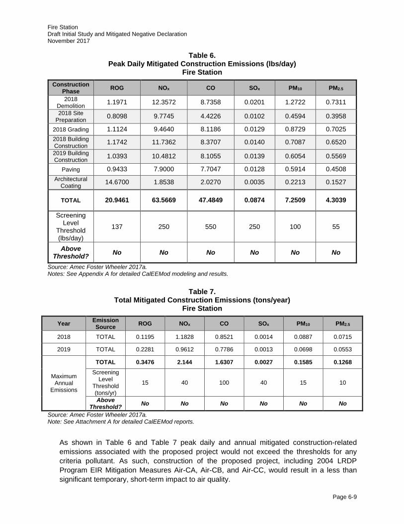
Fire Station Draft Initial Study and Mitigated Negative Declaration November 2017
Page 6-9
Table 6. Peak Daily Mitigated Construction Emissions (lbs/day)
Fire Station Construction
Phase ROG NOx CO SOx PM10 PM2.5
2018 Demolition 1.1971 12.3572 8.7358 0.0201 1.2722 0.7311 2018 Site
Preparation 0.8098 9.7745 4.4226 0.0102 0.4594 0.3958
2018 Grading 1.1124 9.4640 8.1186 0.0129 0.8729 0.7025 2018 Building Construction 1.1742 11.7362 8.3707 0.0140 0.7087 0.6520 2019 Building Construction 1.0393 10.4812 8.1055 0.0139 0.6054 0.5569
Paving 0.9433 7.9000 7.7047 0.0128 0.5914 0.4508 Architectural
Coating 14.6700 1.8538 2.0270 0.0035 0.2213 0.1527
TOTAL 20.9461 63.5669 47.4849 0.0874 7.2509 4.3039
Screening Level
Threshold (lbs/day)
137 250 550 250 100 55
Above Threshold? No No No No No No
Source: Amec Foster Wheeler 2017a. Notes: See Appendix A for detailed CalEEMod modeling and results.
Table 7. Total Mitigated Construction Emissions (tons/year)
Fire Station
Year Emission Source ROG NOx CO SOx PM10 PM2.5
2018 TOTAL 0.1195 1.1828 0.8521 0.0014 0.0887 0.0715
2019 TOTAL 0.2281 0.9612 0.7786 0.0013 0.0698 0.0553
Maximum Annual
Emissions
TOTAL 0.3476 2.144 1.6307 0.0027 0.1585 0.1268 Screening
Level Threshold (tons/yr)
15 40 100 40 15 10
Above Threshold? No No No No No No
Source: Amec Foster Wheeler 2017a. Note: See Attachment A for detailed CalEEMod reports.
As shown in Table 6 and Table 7 peak daily and annual mitigated construction-related emissions associated with the proposed project would not exceed the thresholds for any criteria pollutant. As such, construction of the proposed project, including 2004 LRDP Program EIR Mitigation Measures Air-CA, Air-CB, and Air-CC, would result in a less than significant temporary, short-term impact to air quality.
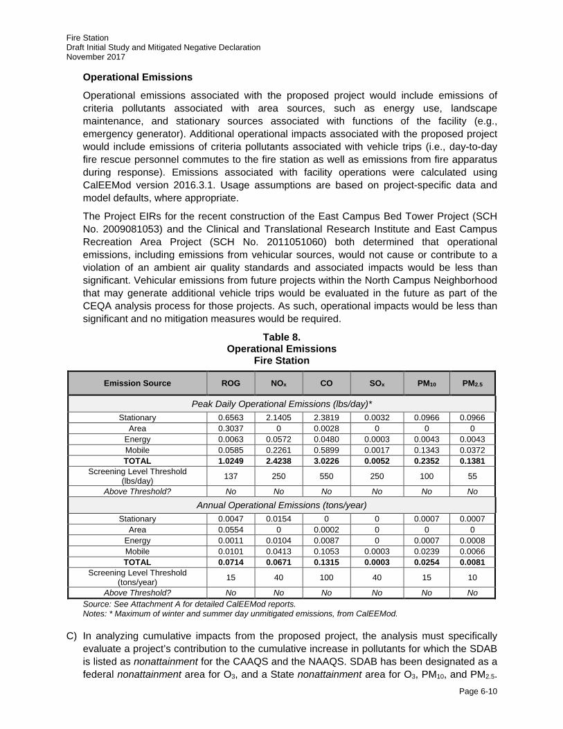
Fire Station Draft Initial Study and Mitigated Negative Declaration November 2017
Page 6-10
Operational Emissions
Operational emissions associated with the proposed project would include emissions of criteria pollutants associated with area sources, such as energy use, landscape maintenance, and stationary sources associated with functions of the facility (e.g., emergency generator). Additional operational impacts associated with the proposed project would include emissions of criteria pollutants associated with vehicle trips (i.e., day-to-day fire rescue personnel commutes to the fire station as well as emissions from fire apparatus during response). Emissions associated with facility operations were calculated using CalEEMod version 2016.3.1. Usage assumptions are based on project-specific data and model defaults, where appropriate.
The Project EIRs for the recent construction of the East Campus Bed Tower Project (SCH No. 2009081053) and the Clinical and Translational Research Institute and East Campus Recreation Area Project (SCH No. 2011051060) both determined that operational emissions, including emissions from vehicular sources, would not cause or contribute to a violation of an ambient air quality standards and associated impacts would be less than significant. Vehicular emissions from future projects within the North Campus Neighborhood that may generate additional vehicle trips would be evaluated in the future as part of the CEQA analysis process for those projects. As such, operational impacts would be less than significant and no mitigation measures would be required.
Table 8. Operational Emissions
Fire Station
Emission Source ROG NOx CO SOx PM10 PM2.5
Peak Daily Operational Emissions (lbs/day)* Stationary 0.6563 2.1405 2.3819 0.0032 0.0966 0.0966
Area 0.3037 0 0.0028 0 0 0 Energy 0.0063 0.0572 0.0480 0.0003 0.0043 0.0043 Mobile 0.0585 0.2261 0.5899 0.0017 0.1343 0.0372 TOTAL 1.0249 2.4238 3.0226 0.0052 0.2352 0.1381
Screening Level Threshold (lbs/day) 137 250 550 250 100 55
Above Threshold? No No No No No No
Annual Operational Emissions (tons/year) Stationary 0.0047 0.0154 0 0 0.0007 0.0007
Area 0.0554 0 0.0002 0 0 0 Energy 0.0011 0.0104 0.0087 0 0.0007 0.0008 Mobile 0.0101 0.0413 0.1053 0.0003 0.0239 0.0066 TOTAL 0.0714 0.0671 0.1315 0.0003 0.0254 0.0081
Screening Level Threshold (tons/year) 15 40 100 40 15 10
Above Threshold? No No No No No No Source: See Attachment A for detailed CalEEMod reports. Notes: * Maximum of winter and summer day unmitigated emissions, from CalEEMod.
C) In analyzing cumulative impacts from the proposed project, the analysis must specifically evaluate a project’s contribution to the cumulative increase in pollutants for which the SDAB is listed as nonattainment for the CAAQS and the NAAQS. SDAB has been designated as a federal nonattainment area for O3, and a State nonattainment area for O3, PM10, and PM2.5.
Fire Station Draft Initial Study and Mitigated Negative Declaration November 2017
Page 6-11
Since few sources emit O3 directly, and O3 is caused by complex chemical reactions, control of O3 is accomplished by the control of emissions of NOx and ROGs. By its very nature, air pollution is largely a cumulative impact. The nonattainment status of regional pollutants is a result of past and present development within the air basin. Therefore, this regional impact is a cumulative impact, and projects would contribute to this impact only on a cumulative basis. No single project would be sufficient in size, by itself, to result in nonattainment of the regional air quality standards. Consequently, if a proposed project’s emissions do not exceed identified significance thresholds, its emissions would not result in a cumulatively considerable contribution to the cumulatively significant impact.
Cumulative Construction Emissions
Following the adoption of the 2004 LRDP, UC San Diego determined that the amount of construction projected on campus in the near-term would be greater than was assumed in the peak construction scenario outlined in the 2004 LRDP Program EIR. As a result, technical analyses presented in the ECBT Project EIR (UC San Diego 2010) serve as an update to the cumulative construction emissions analysis presented in the 2004 LRDP Program EIR. These analyses were conducted to address changed conditions that have resulted since the 2004 LRDP Program EIR was certified in September 2004.
Section 3.2.4 of the ECBT Project EIR (refer to Table 3.2-7 of the 2004 LRDP Program EIR) includes a worst-case construction emissions scenario in order to evaluate cumulative air quality impacts. Cumulative emissions of O3 precursors, PM10, and PM2.5 resulting from LRDP implementation exceeded significance thresholds, contributing to particulate matter and O3 in the air basin, and therefore were found to be temporary cumulative and significant impacts. To reduce cumulative air quality impacts caused by campus construction, 2004 LRDP Program EIR Mitigation Measures Air-CA, Air-CB and Air-CC would be incorporated as part of the proposed project to reduce the project’s contributions to cumulative construction-related emissions.
2004 LRDP Program EIR Mitigation Measures:
Air-CA: The following measures shall be implemented campus-wide to reduce PM10 emissions from vehicles, as feasible, and on specific projects when applicable:
· Compliance with applicable portions of the UC Sustainable Practices Policy, which guides the design of green buildings and the use of clean energy (refer to Section 2.7, Sustainability).
· Reduce emissions related to motor vehicle trips through refinements to the Transportation System Management program or other methods to discourage automobile use and encourage use of alternative transportation.
· Expand pedestrian-enhancing infrastructure to encourage pedestrian activity and discourage vehicle use.
· Expand bicycle facilities to encourage bicycle use instead of driving.
· Expand transit-enhancing infrastructure to promote the use of public transportation such as buses, light rail, and other applicable methods.
· Expand facilities to accommodate alternative-fuel vehicles such as electric cars and compressed natural gas vehicles.
Fire Station Draft Initial Study and Mitigated Negative Declaration November 2017
Page 6-12
· Expand on-site housing and retail services to facilitate pedestrian activity and reduce need for off-site travel.
Air-CB: Any development on the UC San Diego campus shall include in all construction contracts the measures specified below to reduce PM10 and PM2.5 air pollutant emissions:
· All on-site unpaved roads and off-site unpaved access roads shall be effectively stabilized of dust emissions using water, chemical stabilizer/suppressant, or other stabilization techniques.
· All land clearing and grading and demolition activities shall be effectively controlled of fugitive dust emissions utilizing application of water or by presoaking.
· Street sweeping shall be performed regularly on roads surrounding the construction site that carry construction traffic or collect construction related dust or dirt.
· Revegetate exposed earth surface following construction.
· Limit traffic speeds on unpaved roads to 15 mph.
· To the extent that equipment is available and cost effective, the campus shall encourage contractors to use alternate fuels and retrofit existing engines in construction equipment.
· Minimize idling time to a maximum of 10 minutes when construction equipment is not in use.
· To the extent practicable, manage operation of heavy-duty equipment (e.g., restrict operations, operate only when necessary) to reduce emissions.
Air-CC: Campus construction contracts/specifications shall include language that requires medium and large sized construction fleets to comply with the requirements of the ARB proposed regulation for In-use Off-road Diesel Vehicles (Section 2449, Title 13, Article 4.8, California Code of Regulations, as modified).
Despite implementation of these 2004 LRDP Program EIR Mitigation Measures, impacts associated with emissions due to buildout of the UC San Diego campus would still be considered cumulatively significant. Additional construction-related emissions associated with the proposed fire station would further contribute to this cumulative impact. However, construction emissions associated with the proposed project alone would be well below the stated significance levels for all constituents. Therefore, the proposed project would not result in a cumulatively considerable contribution of cumulatively significant impacts identified in the updated campus air quality construction analysis.
Cumulative Operational Emissions
Overall project operations associated with the proposed fire station would not result in a significant direct impact on air quality since the proposed project emissions would be below the daily and operational thresholds cited in Table 8. As a means to reduce cumulative operational emissions produced by the campus, UC San Diego has implemented and would continue to implement a number of energy-saving projects and programs that partially reduce campus-generated air pollutant emissions. Those emissions reductions are achieved through its participation in the Statewide Energy Partnership Program and the UC Strategic Energy Plan for UC San Diego and the UC San Diego Medical Center. These UC energy use and air emission reduction strategies are currently being accomplished and would be accomplished for the proposed project through compliance with the Statewide Energy Partnership Program, the UC Strategic Energy Plan, and the applicable portions of the UC
Fire Station Draft Initial Study and Mitigated Negative Declaration November 2017
Page 6-13
Sustainable Practices Policy and guidelines for its implementation (refer to Section 2.7, Sustainability), including State of California GHG emission-reduction guidance documents. Among others, emission-reduction strategies instituted under these plans and policies include practices related to green building design, clean energy, climate protection, transportation, operations, recycling and waste management, and environmentally preferable procurement. Thus, operational emissions associated with energy use, landscaping emissions and vehicle traffic campus-wide from the proposed project would not be cumulatively considerable.
D) Toxic air contaminants (TACs) are a category of air pollutants with the potential to have an adverse impact on human health and are generated by a number of stationary, mobile and area sources, such as laboratories, automobiles or construction sites. A HRA was conducted in conjunction with the 2004 LRDP Program EIR to identify potential health risks associated with 2004 LRDP development, including the proposed project. In order to assess potential health risks associated with build-out of the 2004 LRDP, total health risks for the academic year 2020-2021 were evaluated for existing campus operations combined with future development. The 2004 LRDP Program EIR concluded that the estimated cancer (and non-cancer) risks from current and future campus operations for the academic year 2020-2021 would not exceed applicable significance thresholds. In addition, the 2004 LRDP Program EIR concludes that implementation of the 2004 LRDP would not violate state or federal air quality standards for CO or expose receptors to substantial CO concentrations associated with vehicular traffic on area roadways. As shown in Tables 6, 7, and 8, construction and operation of the proposed fire station would not violate federal or State air quality standards for CO or expose receptors to substantial CO concentrations. Therefore, impacts to sensitive receptors (e.g., The Village at Torrey Pines) as a result of the proposed project would be less than significant.
E) Odors would be generated from vehicles and/or equipment exhaust emissions during construction of the proposed project. Odors produced during construction would be attributable to concentrations of unburned hydrocarbons from tailpipes of construction equipment. Such odors are temporary and generally occur at magnitudes that would not affect substantial numbers of people. Operationally, the proposed kitchen and living areas may produce minimal food-related smells and/or odors related to food waste and trash. However, the kitchen would be located indoors, with appropriate venting systems and any associated food-related odors would be very localized, if at all noticeable, similar to other residences. Additionally, while petroleum, oils, and lubricants would be used on-site in support of fire truck and equipment maintenance, use of these substances would be confined to the vehicle bay and on-site fueling facility, and would not expose the surrounding area to widespread odors. Therefore, impacts associated with odors during construction and operation of the proposed project would be considered less than significant.
Summary
Construction emissions associated with the proposed project would be well below the stated significance levels for all constituents. Overall project operations associated with the proposed fire station would not result in a significant direct impact on air quality since the proposed project emissions would be below the daily and operational thresholds. To reduce cumulative air quality impacts caused by campus construction, 2004 LRDP Program EIR Mitigation Measures Air-CA, Air-CB, and Air-CC would be incorporated during construction to reduce identified project level
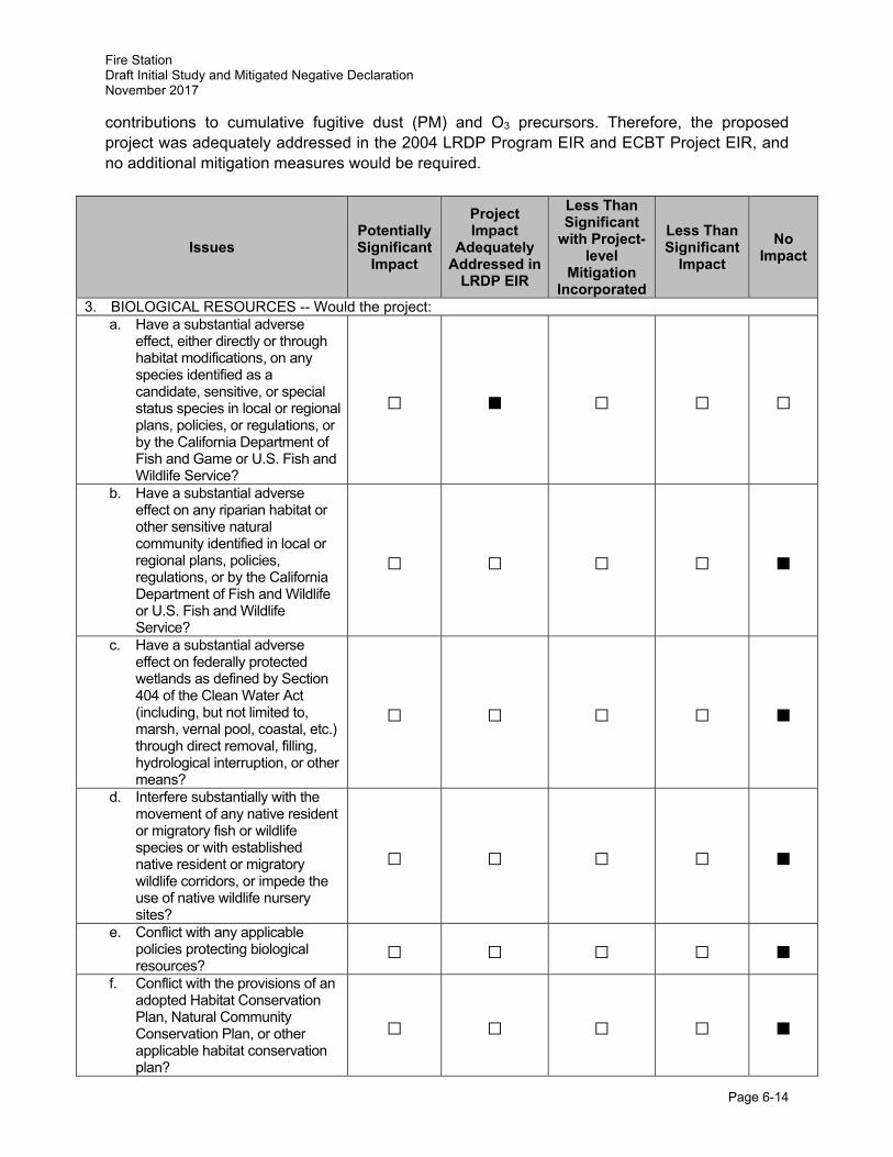
Fire Station Draft Initial Study and Mitigated Negative Declaration November 2017
Page 6-14
contributions to cumulative fugitive dust (PM) and O3 precursors. Therefore, the proposed project was adequately addressed in the 2004 LRDP Program EIR and ECBT Project EIR, and no additional mitigation measures would be required.
Issues Potentially Significant
Impact
Project Impact
Adequately Addressed in
LRDP EIR
Less Than Significant
with Project-level
Mitigation Incorporated
Less Than Significant
Impact
No Impact
3. BIOLOGICAL RESOURCES -- Would the project: a. Have a substantial adverse
effect, either directly or through habitat modifications, on any species identified as a candidate, sensitive, or special status species in local or regional plans, policies, or regulations, or by the California Department of Fish and Game or U.S. Fish and Wildlife Service?
□ ■ □ □ □
b. Have a substantial adverse effect on any riparian habitat or other sensitive natural community identified in local or regional plans, policies, regulations, or by the California Department of Fish and Wildlife or U.S. Fish and Wildlife Service?
□ □ □ □ ■
c. Have a substantial adverse effect on federally protected wetlands as defined by Section 404 of the Clean Water Act (including, but not limited to, marsh, vernal pool, coastal, etc.) through direct removal, filling, hydrological interruption, or other means?
□ □ □ □ ■
d. Interfere substantially with the movement of any native resident or migratory fish or wildlife species or with established native resident or migratory wildlife corridors, or impede the use of native wildlife nursery sites?
□ □ □ □ ■
e. Conflict with any applicable policies protecting biological resources?
□ □ □ □ ■ f. Conflict with the provisions of an
adopted Habitat Conservation Plan, Natural Community Conservation Plan, or other applicable habitat conservation plan?
□ □ □ □ ■
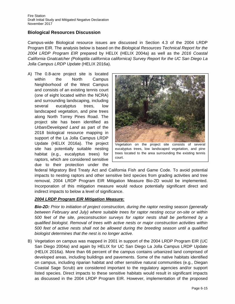
Fire Station Draft Initial Study and Mitigated Negative Declaration November 2017
Page 6-15
Biological Resources Discussion
Campus-wide Biological resource issues are discussed in Section 4.3 of the 2004 LRDP Program EIR. The analysis below is based on the Biological Resources Technical Report for the 2004 LRDP Program EIR prepared by HELIX (HELIX 2004a) as well as the 2016 Coastal California Gnatcatcher (Polioptila californica californica) Survey Report for the UC San Diego La Jolla Campus LRDP Update (HELIX 2016a).
A) The 0.8-acre project site is located within the North Campus Neighborhood of the West Campus and consists of an existing tennis court (one of eight located within the NCRA) and surrounding landscaping, including several eucalyptus trees, low landscaped vegetation, and pine trees along North Torrey Pines Road. The project site has been identified as Urban/Developed Land as part of the 2018 biological resource mapping in support of the La Jolla Campus LRDP Update (HELIX 2016a). The project site has potentially suitable nesting habitat (e.g., eucalyptus trees) for raptors, which are considered sensitive due to their protection under the federal Migratory Bird Treaty Act and California Fish and Game Code. To avoid potential impacts to nesting raptors and other sensitive bird species from grading activities and tree removal, 2004 LRDP Program EIR Mitigation Measure Bio-2D would be implemented. Incorporation of this mitigation measure would reduce potentially significant direct and indirect impacts to below a level of significance.
2004 LRDP Program EIR Mitigation Measure:
Bio-2D: Prior to initiation of project construction, during the raptor nesting season (generally between February and July) where suitable trees for raptor nesting occur on-site or within 500 feet of the site, preconstruction surveys for raptor nests shall be performed by a qualified biologist. Removal of trees with active nests or major construction activities within 500 feet of active nests shall not be allowed during the breeding season until a qualified biologist determines that the nest is no longer active.
B) Vegetation on campus was mapped in 2001 in support of the 2004 LRDP Program EIR (UC San Diego 2004a) and again by HELIX for UC San Diego La Jolla Campus LRDP Update (HELIX 2016a). More than 66 percent of the campus contains urbanized land comprised of developed areas, including buildings and pavements. Some of the native habitats identified on campus, including riparian habitat and other sensitive natural communities (e.g., Diegan Coastal Sage Scrub) are considered important to the regulatory agencies and/or support listed species. Direct impacts to these sensitive habitats would result in significant impacts as discussed in the 2004 LRDP Program EIR. However, implementation of the proposed
Vegetation on the project site consists of several eucalyptus trees, low landscaped vegetation, and pine trees located to the area surrounding the existing tennis court.
Fire Station Draft Initial Study and Mitigated Negative Declaration November 2017
Page 6-16
project would remove an existing tennis court and surrounding landscaping; no riparian habitats or other sensitive natural communities would be affected by project construction. Additionally, off-site trenching activities associated with the installation of electrical utilities along North Torrey Pines Road, if necessary, would follow existing disturbed public right-of-ways and avoid mapped Diegan Coastal Sage Scrub and other sensitive habitat types. Therefore, no impact would result due to implementation of the proposed project, and mitigation would not be required.
C) Jurisdictional wetlands do not occur within the project site boundary or within the immediate vicinity. Further, the proposed project is not located adjacent to a natural drainage course, as shown on Figure 4.3-1 of the 2004 LRDP Program EIR and Figure 4A of the 2016 Coastal California Gnatcatcher Survey Report (HELIX 2016a). Therefore, no impacts to jurisdictional wetlands would occur as a result of the construction of the proposed project, and mitigation would not be required.
D) There are four important wildlife areas located on campus consisting of: 1) the Ecological Reserve south of Genesee Avenue; 2) canyons on east campus; 3) Skeleton Canyon at SIO; and the coastal properties overlooking the Pacific Ocean. Three of these four areas are located within the UC San Diego Park, while the coastal properties are contiguous with the UC Scripps Coastal Reserve and City Multiple Habitat Preserve Area (MHPA). Although these areas provide habitat for wildlife on campus, they provide very limited connections with off-site wildlife habitat, with the exception of the coastal properties (UC San Diego 2004b). The 0.8-acre project site is developed with an existing tennis court that is surrounded by landscaped vegetation. Construction of the proposed fire station, including vegetation removal and grading would not preclude wildlife movement within these areas or to off-campus habitat as this area of the West Campus is fully developed with an arterial roadway immediately to west of the project site. No new roads or other impediments to wildlife movement are proposed as a part of the proposed fire station construction. Therefore, no impact would result due to implementation of the proposed project, and mitigation would not be required.
E, F) UC San Diego is a part of the University of California system, an entity of the State of California. Based on Article IX Section 9 of the California Constitution, the University of California is not subject to municipal plans, policies, and regulations, such as County and City General Plans or local ordinances. Nevertheless, the campus attempts to work cooperatively with the City of San Diego, and seeks consistency with local plans and policies, to the extent feasible. The 2004 LRDP is the guiding land use document and it includes development in accordance with environmental sustainability and stewardship principles. During preparation of the 2004 LRDP Program EIR, UC San Diego voluntarily reviewed the LRDP for consistency with local policies and ordinances found in the City of San Diego’s Land Development Code (2000), including the Environmentally Sensitive Lands (ESL) regulations and the City of San Diego Biology Guidelines (2002), and determined that there are no specific policies that address biological resources on the UC San Diego campus.5 No local policy conflicts would arise with implementation of the proposed project. Therefore, no impact would result due to implementation of the proposed project, and mitigation would not be required.
5 The City of San Diego Land Development Code was updated in 2016 at can be found at https://www.sandiego.gov/development-services/industry/landdevcode.
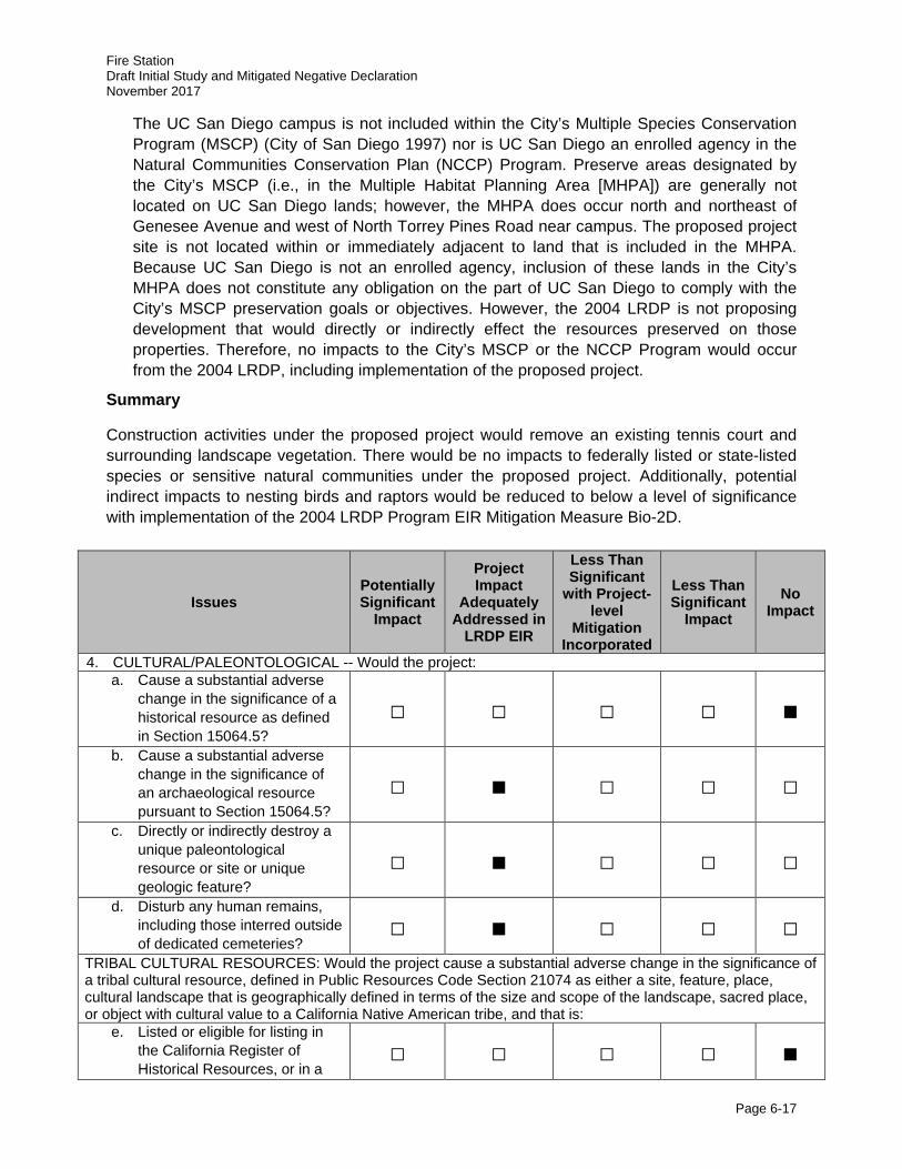
Fire Station Draft Initial Study and Mitigated Negative Declaration November 2017
Page 6-17
The UC San Diego campus is not included within the City’s Multiple Species Conservation Program (MSCP) (City of San Diego 1997) nor is UC San Diego an enrolled agency in the Natural Communities Conservation Plan (NCCP) Program. Preserve areas designated by the City’s MSCP (i.e., in the Multiple Habitat Planning Area [MHPA]) are generally not located on UC San Diego lands; however, the MHPA does occur north and northeast of Genesee Avenue and west of North Torrey Pines Road near campus. The proposed project site is not located within or immediately adjacent to land that is included in the MHPA. Because UC San Diego is not an enrolled agency, inclusion of these lands in the City’s MHPA does not constitute any obligation on the part of UC San Diego to comply with the City’s MSCP preservation goals or objectives. However, the 2004 LRDP is not proposing development that would directly or indirectly effect the resources preserved on those properties. Therefore, no impacts to the City’s MSCP or the NCCP Program would occur from the 2004 LRDP, including implementation of the proposed project.
Summary
Construction activities under the proposed project would remove an existing tennis court and surrounding landscape vegetation. There would be no impacts to federally listed or state-listed species or sensitive natural communities under the proposed project. Additionally, potential indirect impacts to nesting birds and raptors would be reduced to below a level of significance with implementation of the 2004 LRDP Program EIR Mitigation Measure Bio-2D.
Issues Potentially Significant
Impact
Project Impact
Adequately Addressed in
LRDP EIR
Less Than Significant
with Project-level
Mitigation Incorporated
Less Than Significant
Impact No
Impact
4. CULTURAL/PALEONTOLOGICAL -- Would the project: a. Cause a substantial adverse
change in the significance of a historical resource as defined in Section 15064.5?
□ □ □ □ ■
b. Cause a substantial adverse change in the significance of an archaeological resource pursuant to Section 15064.5?
□ ■ □ □ □
c. Directly or indirectly destroy a unique paleontological resource or site or unique geologic feature?
□ ■ □ □ □
d. Disturb any human remains, including those interred outside of dedicated cemeteries?
□ ■ □ □ □
TRIBAL CULTURAL RESOURCES: Would the project cause a substantial adverse change in the significance of a tribal cultural resource, defined in Public Resources Code Section 21074 as either a site, feature, place, cultural landscape that is geographically defined in terms of the size and scope of the landscape, sacred place, or object with cultural value to a California Native American tribe, and that is:
e. Listed or eligible for listing in the California Register of Historical Resources, or in a
□ □ □ □ ■
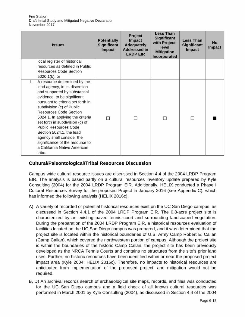
Fire Station Draft Initial Study and Mitigated Negative Declaration November 2017
Page 6-18
Issues Potentially Significant
Impact
Project Impact
Adequately Addressed in
LRDP EIR
Less Than Significant
with Project-level
Mitigation Incorporated
Less Than Significant
Impact No
Impact
local register of historical resources as defined in Public Resources Code Section 5020.1(k), or
f. A resource determined by the lead agency, in its discretion and supported by substantial evidence, to be significant pursuant to criteria set forth in subdivision (c) of Public Resources Code Section 5024.1. In applying the criteria set forth in subdivision (c) of Public Resources Code Section 5024.1, the lead agency shall consider the significance of the resource to a California Native American tribe.
□ □ □ □ ■
Cultural/Paleontological/Tribal Resources Discussion
Campus-wide cultural resource issues are discussed in Section 4.4 of the 2004 LRDP Program EIR. The analysis is based partly on a cultural resources inventory update prepared by Kyle Consulting (2004) for the 2004 LRDP Program EIR. Additionally, HELIX conducted a Phase I Cultural Resources Survey for the proposed Project in January 2016 (see Appendix C), which has informed the following analysis (HELIX 2016c).
A) A variety of recorded or potential historical resources exist on the UC San Diego campus, as discussed in Section 4.4.1 of the 2004 LRDP Program EIR. The 0.8-acre project site is characterized by an existing paved tennis court and surrounding landscaped vegetation. During the preparation of the 2004 LRDP Program EIR, a historical resources evaluation of facilities located on the UC San Diego campus was prepared, and it was determined that the project site is located within the historical boundaries of U.S. Army Camp Robert E. Callan (Camp Callan), which covered the northwestern portion of campus. Although the project site is within the boundaries of the historic Camp Callan, the project site has been previously developed as the NRCA Tennis Courts and contains no structures from the site’s prior land uses. Further, no historic resources have been identified within or near the proposed project impact area (Kyle 2004; HELIX 2016c). Therefore, no impacts to historical resources are anticipated from implementation of the proposed project, and mitigation would not be required.
B, D) An archival records search of archaeological site maps, records, and files was conducted for the UC San Diego campus and a field check of all known cultural resources was performed in March 2001 by Kyle Consulting (2004), as discussed in Section 4.4 of the 2004
Fire Station Draft Initial Study and Mitigated Negative Declaration November 2017
Page 6-19
LRDP Program EIR and summarized in Table 4.4-2 of that document. Additionally, HELIX conducted a Phase I Cultural Resources Survey which included a review of aerial photographs and topographic maps dating back to 1901 as well as a field investigation (HELIX 2016c). Review of historical imagery revealed that the project site has been previously disturbed beginning in 1940 with the construction of Camp Callan and later as a part of major construction on campus following land acquisition in 1963 by the UC. Vegetation began establishing on the project site following the closure of Camp Callan; however, the Project site was then graded in 1994 as a result of an addition to the NCRA Tennis Courts.
One archaeological site, CA-SDI-8470, is mapped as abutting the project’s southwestern corner (Kyle 2004; HELIX 2016c). However, Kyle (2004) indicated that “the entire area has either been destroyed by construction or is currently under construction.” None of CA-SDI-8470 remains and no additional work is recommended for this resource” (Kyle 2004). HELIX (2016c) confirmed that the recorded site has been previously destroyed and that the project site is not located in an area of natural deposition. Consequently, no “unexpected resources” are anticipated to occur at the project site based on the guidance of 2004 LRDP Program EIR Mitigation Measure Cul-2Dii as 2 or more feet of the top soil at the site have been previously removed. Therefore, the proposed project was adequately addressed in the 2004 LRDP Program EIR, and no additional mitigation measures or archaeological monitoring efforts are required.
C) Geologic formations in the San Diego region are rated by the San Diego Natural History Museum, Department of Paleontology according to their potential for yielding paleontological resources. The campus is located in an area where the Ardath Shale and Scripps formations are overlain by the Lindavista Formation. Geologically, the project site is underlain by early- to middle Pleistocene paralic deposits consisting of “dune and back beach ‘beach ridge’ deposits composed of cross-bedded sandstone” (Kennedy and Tan 2005; HELIX 2016c). Carlsbad gravelly loamy sand, 5 to 9 percent slopes, is the only soil type mapped for the project area (Bowman 1973; HELIX 2016c). As part of the 2004 LRDP Program EIR, UC San Diego conducted an analysis of the paleontological monitoring records and reports produced for construction projects on campus from 1998 through to 2003. From that review, it was determined that numerous excavations into formational materials on a campus-wide basis have not yielded significant paleontological resources. Therefore, the 2004 LRDP Program EIR concluded that in this geographic area, these formations have not and would not yield significant paleontological resources. Based on the 2004 LRDP Program EIR analysis, the proposed project is not anticipated to impact significant paleontological resources during construction activities.
E, F) With the adoption of Assembly Bill (AB) 52, tribal cultural resources is a new CEQA resource area added to the CEQA Guidelines in 2015. Cultural resource issues, excluding tribal cultural resources, are discussed in Section 4.4 of the 2004 LRDP Program EIR, which included a cultural resources inventory update prepared by Kyle Consulting (2004). Additionally, HELIX (2016c) conducted a Phase I Cultural Resources Survey which included a review of aerial photographs and topographic maps dating back to 1901 as well as a field investigation. As previously described, the project site has been previously disturbed beginning in 1918 with the construction of Camp Callan and also as a part of major construction on campus following land acquisition in 1963 by the UC. Vegetation began establishing on the project site following the closure of Camp Callan; however, the Project
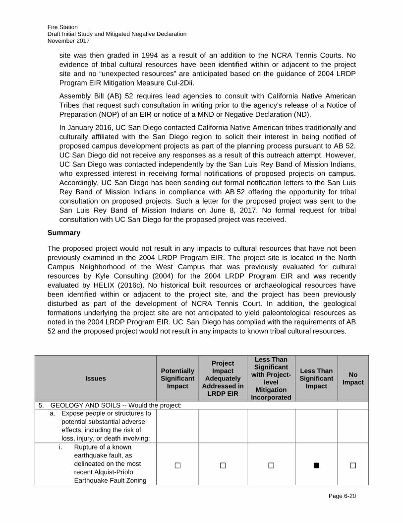
Fire Station Draft Initial Study and Mitigated Negative Declaration November 2017
Page 6-20
site was then graded in 1994 as a result of an addition to the NCRA Tennis Courts. No evidence of tribal cultural resources have been identified within or adjacent to the project site and no “unexpected resources” are anticipated based on the guidance of 2004 LRDP Program EIR Mitigation Measure Cul-2Dii.
Assembly Bill (AB) 52 requires lead agencies to consult with California Native American Tribes that request such consultation in writing prior to the agency's release of a Notice of Preparation (NOP) of an EIR or notice of a MND or Negative Declaration (ND).
In January 2016, UC San Diego contacted California Native American tribes traditionally and culturally affiliated with the San Diego region to solicit their interest in being notified of proposed campus development projects as part of the planning process pursuant to AB 52. UC San Diego did not receive any responses as a result of this outreach attempt. However, UC San Diego was contacted independently by the San Luis Rey Band of Mission Indians, who expressed interest in receiving formal notifications of proposed projects on campus. Accordingly, UC San Diego has been sending out formal notification letters to the San Luis Rey Band of Mission Indians in compliance with AB 52 offering the opportunity for tribal consultation on proposed projects. Such a letter for the proposed project was sent to the San Luis Rey Band of Mission Indians on June 8, 2017. No formal request for tribal consultation with UC San Diego for the proposed project was received.
Summary
The proposed project would not result in any impacts to cultural resources that have not been previously examined in the 2004 LRDP Program EIR. The project site is located in the North Campus Neighborhood of the West Campus that was previously evaluated for cultural resources by Kyle Consulting (2004) for the 2004 LRDP Program EIR and was recently evaluated by HELIX (2016c). No historical built resources or archaeological resources have been identified within or adjacent to the project site, and the project has been previously disturbed as part of the development of NCRA Tennis Court. In addition, the geological formations underlying the project site are not anticipated to yield paleontological resources as noted in the 2004 LRDP Program EIR. UC San Diego has complied with the requirements of AB 52 and the proposed project would not result in any impacts to known tribal cultural resources.
Issues Potentially Significant
Impact
Project Impact
Adequately Addressed in
LRDP EIR
Less Than Significant
with Project-level
Mitigation Incorporated
Less Than Significant
Impact No
Impact
5. GEOLOGY AND SOILS -- Would the project: a. Expose people or structures to
potential substantial adverse effects, including the risk of loss, injury, or death involving:
i. Rupture of a known earthquake fault, as delineated on the most recent Alquist-Priolo Earthquake Fault Zoning
□ □ □ ■ □
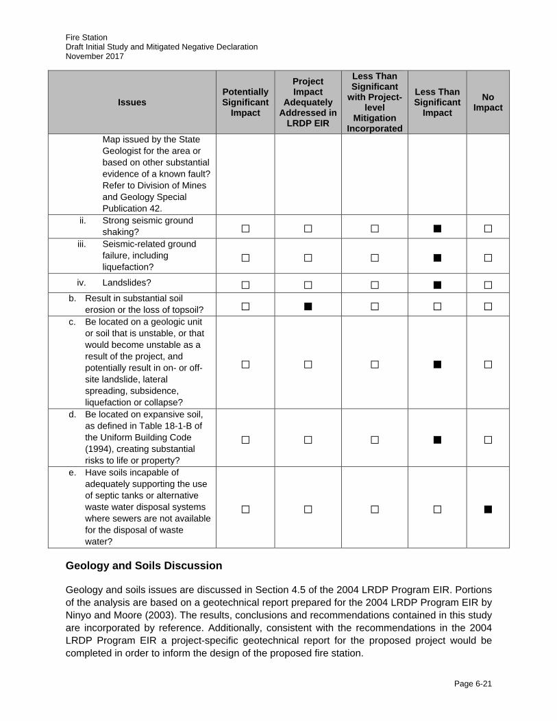
Fire Station Draft Initial Study and Mitigated Negative Declaration November 2017
Page 6-21
Issues Potentially Significant
Impact
Project Impact
Adequately Addressed in
LRDP EIR
Less Than Significant
with Project-level
Mitigation Incorporated
Less Than Significant
Impact No
Impact
Map issued by the State Geologist for the area or based on other substantial evidence of a known fault? Refer to Division of Mines and Geology Special Publication 42.
ii. Strong seismic ground shaking? □ □ □ ■ □
iii. Seismic-related ground failure, including liquefaction?
□ □ □ ■ □
iv. Landslides? □ □ □ ■ □ b. Result in substantial soil
erosion or the loss of topsoil? □ ■ □ □ □ c. Be located on a geologic unit
or soil that is unstable, or that would become unstable as a result of the project, and potentially result in on- or off-site landslide, lateral spreading, subsidence, liquefaction or collapse?
□ □ □ ■ □
d. Be located on expansive soil, as defined in Table 18-1-B of the Uniform Building Code (1994), creating substantial risks to life or property?
□ □ □ ■ □
e. Have soils incapable of adequately supporting the use of septic tanks or alternative waste water disposal systems where sewers are not available for the disposal of waste water?
□ □ □ □ ■
Geology and Soils Discussion
Geology and soils issues are discussed in Section 4.5 of the 2004 LRDP Program EIR. Portions of the analysis are based on a geotechnical report prepared for the 2004 LRDP Program EIR by Ninyo and Moore (2003). The results, conclusions and recommendations contained in this study are incorporated by reference. Additionally, consistent with the recommendations in the 2004 LRDP Program EIR a project-specific geotechnical report for the proposed project would be completed in order to inform the design of the proposed fire station.
Fire Station Draft Initial Study and Mitigated Negative Declaration November 2017
Page 6-22
A, C) The UC San Diego campus, including the project site, is located in a seismically active area as is much of Southern California. However, there are no Alquist-Priolo (A-P) Study Zones (i.e., active faults) located on the UC San Diego campus. Although several faults have been mapped at various locations on the campus as shown in Figure 4.5-1 in the 2004 LRDP Program EIR, none of these faults are considered active or significant sources of seismic activity. Consequently, ground surface rupture is not likely to occur as a result of an earthquake or seismic event.
Although no active faults are located on campus, a significant seismic event could affect the proposed project in other ways. Ground shaking during seismic events has the potential to damage and destroy buildings and other structures on the UC San Diego campus, including structures on the proposed project site. Hazards associated with damage or destruction to buildings and other structures on the UC San Diego campus are minimized through a number of methods, including: 1) reviewing and approving all building plans for compliance with the California Building Code (CBC); and 2) compliance with the UC Seismic Safety Policy, which requires anchorage for seismic resistance of nonstructural building elements such as furnishings, fixtures, material storage facilities, and utilities that could create a hazard if dislodged during an earthquake. The project site is bisected by the Saulk Fault, a concealed fault that is hidden under a younger fold of rock. As with all of the fault traces on campus, the 2004 LRDP Program EIR and supporting geotechnical report (Ninyo and More 2003) classifies the Saulk Fault as inactive. However, as described on page 4.5-10 of the 2004 LRDP Program EIR, because the development of the proposed fire station would occur within 100 feet of a fault trace, a fault study shall be conducted as a part of a site-specific geotechnical report required in order to comply with the CBC and the UC Policy on Seismic Safety. The geotechnical report shall be prepared for the proposed project by a qualified geologist. The purpose of a fault study is to determine the location and orientation of the Saulk Fault, to evaluate the potential geological anomalies adjacent to the fault trace, and to evaluate the fault plane as a potential slope stability factor. The fault study shall be used by structural engineers to determine the most appropriate design and building techniques for the proposed fire station, such as the need for additional structural support that may be required to comply with the CBC and UC Policy on Seismic Safety. However, because the fault is not active, any potential changes to the building and/or site design are expected to be structural in nature and would not change the overall footprint of the building.
Liquefaction is another seismic-related ground failure hazard that was identified as relevant to the UC San Diego campus. As shown in Figure 4.5-2 of the 2004 LRDP Program EIR, the proposed project site is located within an area with generally stable soils, and not in an area subject to liquefaction. Due to the dense nature of the underlying formational materials (i.e., Lindavista Formation) and lack of near surface groundwater over the majority of the campus, the potential for liquefaction occurring on campus, and the project site, is considered very low. The proposed project’s compliance with the most recent CBC and UC Policy on Seismic Safety would reduce any hazards associated with liquefaction.
Areas having the potential for earthquake-induced landslides generally occur within areas of previous landslide movement, or where local topographic, geological, geotechnical, and subsurface water conditions indicate a potential for permanent ground displacements (refer to Figure 4.5-1 in the 2004 LRDP Program EIR, the limits of landslide areas known on campus). While the proposed project site is bisected by the Saulk Fault, it is not located in or near any areas that have a potential for permanent ground displacements.

Fire Station Draft Initial Study and Mitigated Negative Declaration November 2017
Page 6-23
The UC San Diego campus routinely prepares all building plans for compliance with the CBC and the campus also follows the UC Policy on Seismic Safety that requires independent review of structural seismic design of both new construction and remodeling projects. Because the design of the proposed fire station would incorporate the design recommendation of a site-specific geotechnical report and would be compliant with the CBC and UC Policy on Seismic Safety, exposure to seismic risks associated with the proposed fire station would be less than significant.
B) Ground-disturbing activities associated with project construction, including minor grading and vegetation removal, would produce temporary erosion effects. Additionally, the construction of a 400-foot linear retaining wall would result in temporary erosion impacts (refer to Section 2.8.5, Grading/Drainage). However, as discussed in Section 4.5 of the 2004 LRDP Program EIR, construction activities would comply with Chapters 29 and 70 of the CBC. The proposed project would also implement an erosion control plan, as required by Hyd-2A of the 2004 LRDP Program EIR. Further, UC San Diego would continue to implement the campus-wide runoff management program to comply with the applicable provisions of NPDES Phase II, which includes erosion and sedimentation Best Management Practices (BMPs). With the continued implementation of required erosion control measures, including Hydrology and Water Quality mitigation measures outlined in Section 4.7.3.2 from the 2004 LRDP Program EIR, substantial erosion or topsoil impacts would be less than significant during and after project construction. The proposed project site is located in an area of campus that is generally stable (see Figure 4.5-2 in the 2004 LRDP Program EIR). Therefore, the potential for landslides, collapse, liquefaction, and other seismic-related soils hazards is anticipated to be low and impacts would be considered less than significant.
D) As shown in Figure 4.5-2 of the 2004 LRDP Program EIR, the proposed project is located in an area not known for expansive or unstable soils. UC San Diego is required to comply with the CBC, which includes provisions for construction on expansive soils and requires a geotechnical investigation be performed during the design phase of a project. Continued compliance with the CBC would ensure that this impact would be less than significant during implementation of the 2004 LRDP, including this project. Therefore, the proposed project would have a less than significant impact of creating substantial risks to life or property.
E) The UC San Diego campus is provided sanitary sewer service by the City of San Diego and no septic tanks or alternative wastewater systems are used or anticipated on campus or as part of the proposed project; therefore, no impacts to septic tanks or alternative waste water disposal systems would occur.
Summary
The proposed project would result in less than significant impacts to geology and soils. The potential for seismic-related soils hazards at the project site are anticipated to be low. Implementation of the project could result in minimal amount of increased erosion associated with construction activities. With implementation of recommendations in the fault study geotechnical report (including a fault study) and required erosion control measures, including Hydrology and Water Quality mitigation measures outlined in Section 4.7.3.2 from the 2004 LRDP Program EIR, substantial erosion or topsoil impacts would be less than significant during or after project construction.
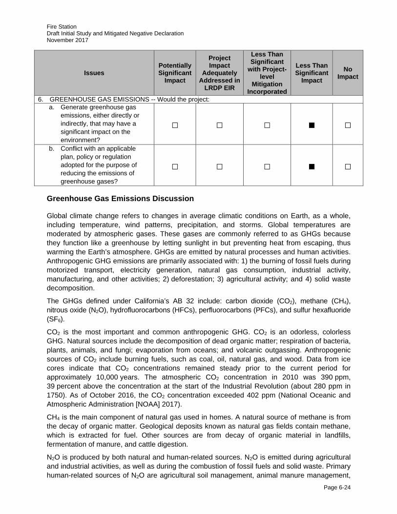
Fire Station Draft Initial Study and Mitigated Negative Declaration November 2017
Page 6-24
Issues Potentially Significant
Impact
Project Impact
Adequately Addressed in
LRDP EIR
Less Than Significant
with Project-level
Mitigation Incorporated
Less Than Significant
Impact No
Impact
6. GREENHOUSE GAS EMISSIONS -- Would the project: a. Generate greenhouse gas
emissions, either directly or indirectly, that may have a significant impact on the environment?
□ □ □ ■ □
b. Conflict with an applicable plan, policy or regulation adopted for the purpose of reducing the emissions of greenhouse gases?
□ □ □ ■ □
Greenhouse Gas Emissions Discussion
Global climate change refers to changes in average climatic conditions on Earth, as a whole, including temperature, wind patterns, precipitation, and storms. Global temperatures are moderated by atmospheric gases. These gases are commonly referred to as GHGs because they function like a greenhouse by letting sunlight in but preventing heat from escaping, thus warming the Earth’s atmosphere. GHGs are emitted by natural processes and human activities. Anthropogenic GHG emissions are primarily associated with: 1) the burning of fossil fuels during motorized transport, electricity generation, natural gas consumption, industrial activity, manufacturing, and other activities; 2) deforestation; 3) agricultural activity; and 4) solid waste decomposition.
The GHGs defined under California’s AB 32 include: carbon dioxide (CO2), methane (CH4), nitrous oxide (N2O), hydrofluorocarbons (HFCs), perfluorocarbons (PFCs), and sulfur hexafluoride (SF6).
CO2 is the most important and common anthropogenic GHG. CO2 is an odorless, colorless GHG. Natural sources include the decomposition of dead organic matter; respiration of bacteria, plants, animals, and fungi; evaporation from oceans; and volcanic outgassing. Anthropogenic sources of CO2 include burning fuels, such as coal, oil, natural gas, and wood. Data from ice cores indicate that CO2 concentrations remained steady prior to the current period for approximately 10,000 years. The atmospheric CO2 concentration in 2010 was 390 ppm, 39 percent above the concentration at the start of the Industrial Revolution (about 280 ppm in 1750). As of October 2016, the CO2 concentration exceeded 402 ppm (National Oceanic and Atmospheric Administration [NOAA] 2017).
CH4 is the main component of natural gas used in homes. A natural source of methane is from the decay of organic matter. Geological deposits known as natural gas fields contain methane, which is extracted for fuel. Other sources are from decay of organic material in landfills, fermentation of manure, and cattle digestion.
N2O is produced by both natural and human-related sources. N2O is emitted during agricultural and industrial activities, as well as during the combustion of fossil fuels and solid waste. Primary human-related sources of N2O are agricultural soil management, animal manure management,

Fire Station Draft Initial Study and Mitigated Negative Declaration November 2017
Page 6-25
sewage treatment, mobile and stationary combustion of fossil fuel, adipic (fatty) acid production, and nitric acid production.
Fluorocarbons (e.g., HFCs and PFCs) are gases formed synthetically by replacing all hydrogen atoms in methane or ethane with chlorine and/or fluorine atoms. Chlorofluorocarbons are nontoxic, nonflammable, insoluble, and chemically nonreactive in the troposphere (the level of air at Earth’s surface). Chlorofluorocarbons were first synthesized in 1928 for use as refrigerants, aerosol propellants, and cleaning solvents. They destroy stratospheric ozone; therefore, their production was stopped as required by the 1989 Montreal Protocol.
SF6 is an inorganic, odorless, colorless, nontoxic, nonflammable gas. SF6 is used for insulation in electric power transmission and distribution equipment, in the magnesium industry, in semi-conductor manufacturing, and as a tracer gas for leak detection.
GHGs have long atmospheric lifetimes that range from one year to several thousand years. Long atmospheric lifetimes allow for GHGs to disperse around the globe. Because GHGs vary widely in the power of their climatic effects, climate scientists have established a unit called global warming potential (GWP). The GWP of a gas is a measure of both potency and lifespan in the atmosphere as compared to CO2. For example, because CH4 and N2O are approximately 25 and 298 times more powerful than CO2, respectively, in their ability to trap heat in the atmosphere, they have GWPs of 25 and 298, respectively (CO2 has a GWP of 1). CO2e is a quantity that enables all GHG emissions to be considered as a group despite their varying GWP. The GWP of each GHG is multiplied by the prevalence of that gas to produce CO2e.
Federal Greenhouse Gas Regulations
Federal Clean Air Act
The U.S. Supreme Court ruled on April 2, 2007, in Massachusetts v. U.S. Environmental Protection Agency that CO2 is an air pollutant, as defined under the CAAA, and that the USEPA has the authority to regulate emissions of GHGs. The USEPA announced that GHGs (including CO2, CH4, N2O, HFC, PFC, and SF6) threaten the public health and welfare of the American people. This action was a prerequisite to finalizing the USEPA’s GHG emissions standards for light-duty vehicles, which were jointly proposed by the USEPA and the U.S. Department of Transportation’s National Highway Traffic Safety Administration (NHTSA). The standards were established on April 1, 2010 for 2012 through 2016 model year vehicles and on October 15, 2012 for 2017 through 2025 model year vehicles (USEPA 2016; USEPA and NHTSA 2012).
Light-Duty Vehicle Greenhouse Gas Emissions Standards and Corporate Average Fuel Economy Standards
The USEPA and the NHTSA have been working together on developing a national program of regulations to reduce GHG emissions and to improve fuel economy of light-duty vehicles. The USEPA is finalizing the first-ever national GHG emissions standards under the CAAA, and the NHTSA is finalizing Corporate Average Fuel Economy (CAFE) standards under the Energy Policy and Conservation Act. On April 1, 2010, the USEPA and NHTSA announced a joint Final Rulemaking that established standards for 2012 through 2016 model year vehicles. This was followed up on October 15, 2012, when the agencies issued a Final Rulemaking with standards for model years 2017 through 2025. The rules require these vehicles to meet an estimated combined average emissions level of 250 grams per mile by 2016, decreasing to an average
Fire Station Draft Initial Study and Mitigated Negative Declaration November 2017
Page 6-26
industry fleet-wide level of 163 grams per mile in model year 2025. The 2016 standard is equivalent to 35.5 miles per gallon (mpg), and the 2025 standard is equivalent to 54.5 mpg if the levels were achieved solely through improvements in fuel efficiency. The agencies expect, however, that a portion of these improvements will be made through improvements in air conditioning leakage and the use of alternative refrigerants that would not contribute to fuel economy. These standards would cut GHG emissions by an estimated 2 billion metric tons (MT) and 4 billion barrels of oil over the lifetime of the vehicles sold under the program (model years 2017–2025). The combined USEPA GHG standards and NHTSA CAFE standards resolve previously conflicting requirements under both federal programs and the standards of the State of California and other states that have adopted the California standards (USEPA 2016; USEPA and NHTSA 2012). State Greenhouse Gas Regulations
California Code of Regulations, Title 24, Part 6
California Code of Regulations Title 24 Part 6: California’s Energy Efficiency Standards for Residential and Nonresidential Buildings were first established in 1978 in response to a legislative mandate to reduce California's energy consumption. Energy-efficient buildings require less electricity, natural gas, and other fuels. Electricity production from fossil fuels and on-site fuel combustion (typically for water heating) results in GHG emissions. The Title 24 standards are updated approximately every three years to allow consideration and possible incorporation of new energy efficiency technologies and methods. The latest update to the Title 24 standards occurred in 2016 and went into effect on January 1, 2017.
California Green Building Standards Code
The California Green Building Standards Code (24 California Code of Regulations [CCR], Part 11) is a code with mandatory requirements for new residential and nonresidential buildings (including buildings for retail, office, public schools and hospitals) throughout California. The current version of the code went into effect on January 1, 2017. The code is Part 11 of the California Building Standards Code in Title 24 of the California Code of Regulations and is also known as the CALGreen Building Standards Code (California Building Standards Commission [CBSC] 2017). The development of the CALGreen Code is intended to: 1) cause a reduction in GHG emissions from buildings; 2) promote environmentally responsible, cost-effective, healthier places to live and work; 3) reduce energy and water consumption; and 4) respond to the directives by the Governor. In short, the code is established to reduce construction waste; make buildings more efficient in the use of materials and energy; and reduce environmental impact during and after construction. The CALGreen Code contains requirements for storm water control during construction; construction waste reduction; indoor water use reduction; material selection; natural resource conservation; site irrigation conservation; and more. The code provides for design options allowing the designer to determine how best to achieve compliance for a given site or building condition. The code also requires building commissioning, which is a process for the verification
Fire Station Draft Initial Study and Mitigated Negative Declaration November 2017
Page 6-27
that all building systems, like heating and cooling equipment and lighting systems, are functioning at their maximum efficiency.
Executive Order S-3-05
On June 1, 2005, Executive Order (EO) S-3-05 proclaimed that California is vulnerable to climate change impacts. It declared that increased temperatures could reduce snowpack in the Sierra Nevada, further exacerbate California’s air quality problems, and potentially cause a rise in sea levels. In an effort to avoid or reduce climate change impacts, EO S-3-05 calls for a reduction in GHG emissions to the year 2000 level by 2010, to year 1990 levels by 2020, and to 80 percent below 1990 levels by 2050.
Assembly Bill 32 – Global Warming Solution Act of 2006
The California Global Warming Solutions Act of 2006, widely known as AB 32, requires that the California Air Resources Board (CARB) develop and enforce regulations for the reporting and verification of statewide GHG emissions. CARB is directed to set a GHG emission limit, based on 1990 levels, to be achieved by 2020. The bill requires CARB to adopt rules and regulations in an open public process to achieve the maximum technologically feasible and cost-effective GHG reductions.
Executive Order B-30-15
On April 29, 2015, EO B-30-15 established a California GHG reduction target of 40 percent below 1990 levels by 2030. The EO aligns California's GHG reduction targets with those of leading international governments, including the 28 nation European Union. California is on track to meet or exceed the target of reducing greenhouse gas emissions to 1990 levels by 2020, as established in AB 32. California's new emission reduction target of 40 percent below 1990 levels by 2030 will make it possible to reach the ultimate goal established by EO S-3-05 of reducing emissions 80 percent under 1990 levels by 2050.
Senate Bill (SB) 32
As a follow-up to AB 32 and in response to EO-B-30-15, SB 32 was passed by the California legislature in August 2016 to codify the EO’s California GHG reduction target of 40 percent below 1990 levels by 2030.
Assembly Bill 1493 – Vehicular Emissions of Greenhouse Gases
AB 1493 (Pavley) requires that CARB develop and adopt regulations that achieve “the maximum feasible reduction of GHGs emitted by passenger vehicles and light-duty truck and other vehicles determined by CARB to be vehicles whose primary use is noncommercial personal transportation in the State.” On September 24, 2009, CARB adopted amendments to the Pavley regulations that intend to reduce GHG emissions in new passenger vehicles from 2009 through 2016. The amendments bind California’s enforcement of AB 1493 (starting in 2009), while providing vehicle manufacturers with new compliance flexibility. The amendments also prepare California to merge its rules with the federal CAFE rules for passenger vehicles (CARB 2013). In January 2012, CARB approved a new emissions-control program for model years 2017 through 2025. The program combines the control of smog, soot, and GHGs and

Fire Station Draft Initial Study and Mitigated Negative Declaration November 2017
Page 6-28
requirements for greater numbers of zero-emission vehicles into a single packet of standards called Advanced Clean Cars (CARB 2013).
Assembly Bill 341
In 2011, the State legislature enacted AB 341 (California Public Resource Code Section 42649.2), increasing the diversion target to 75 percent statewide. AB 341 also requires the provision of recycling service to commercial and residential facilities that generate four cubic yards or more of solid waste per week.
Executive Order S-01-07
This EO, signed by Governor Schwarzenegger on January 18, 2007, directs that a statewide goal be established to reduce the carbon intensity of California’s transportation fuels by at least 10 percent by the year 2020. It orders that a Low Carbon Fuel Standard (LCFS) for transportation fuels be established for California and directs CARB to determine whether a LCFS can be adopted as a discrete early action measure pursuant to AB 32. CARB approved the LCFS as a discrete early action item with a regulation adopted and implemented in April 2010. Although challenged in 2011, the Ninth Circuit reversed the District Court's opinion and rejected arguments that implementing LCFS violates the interstate commerce clause in September 2013. CARB is therefore continuing to implement the LCFS statewide.
Senate Bill 375
SB 375 aligns regional transportation planning efforts, regional GHG reduction targets, and affordable housing allocations. Metropolitan Planning Organizations (MPOs) are required to adopt a Sustainable Communities Strategy (SCS), which allocates land uses in the MPOs’ Regional Transportation Plan (RTP). Qualified projects consistent with an approved SCS or Alternative Planning Strategy categorized as “transit priority projects” would receive incentives to streamline CEQA processing.
Senate Bill 350
Approved by Governor Brown on October 7, 2015, SB 350 increases California’s renewable electricity procurement goal from 33 percent by 2020 to 50 percent by 2030. This will increase the use of Renewables Portfolio Standard eligible resources, including solar, wind, biomass, and geothermal. In addition, large utilities are required to develop and submit Integrated Resource Plans to detail how each entity will meet their customers resource needs, reduce greenhouse gas emissions, and increase the use of clean energy.
California Air Resources Board: Scoping Plan
On December 11, 2008, CARB adopted the Scoping Plan (CARB 2008) as directed by AB 32. The Scoping Plan proposes a set of actions designed to reduce overall GHG emissions in California to the levels required by AB 32. Measures applicable to development projects include those related to energy-efficiency building and appliance standards, the use of renewable sources for electricity generation, regional transportation targets, and green building strategy. Relative to transportation, the Scoping Plan includes nine measures or recommended actions related to reducing vehicle miles traveled and vehicle GHGs through fuel and efficiency
Fire Station Draft Initial Study and Mitigated Negative Declaration November 2017
Page 6-29
measures. These measures would be implemented statewide rather than on a project by project basis. CARB released the First Update to the Climate Change Scoping Plan in May 2014 to provide information on the development of measure-specific regulations and to adjust projections in consideration of the economic recession (CARB 2014). In the update, CARB estimated the AB 32 Baseline 2020 to be 509 million metric tons (MMT) of CO2e. The Scoping Plan’s current estimate of the necessary GHG emission reductions is 78 MMT CO2e (CARB 2014). This represents an approximately 15.32 percent reduction. CARB is forecasting that this would be achieved through the following reductions by sector: 25 MMT CO2e for energy, 23 MMT CO2e for transportation, 5 MMT CO2e for high-GWP GHGs, and 2 MMT CO2e for waste. The remaining 23 MMT CO2e would be achieved through Cap-and-Trade Program reductions. This reduction is flexible—if CARB receives new information and changes the other sectors’ reductions to be less than expected, the agency can increase the Cap-and-Trade reduction (and vice versa). In response to EO B-30-15 and SB 32, all state agencies with jurisdiction over sources of GHG emissions were directed to implement measures to achieve reductions of GHG emissions to meet the 2030 and 2050 targets. CARB was directed to update the Scoping Plan to reflect the 2030 target, and therefore, is moving forward with the update process. The mid-term target is critical to help frame the suite of policy measures, regulations, planning efforts, and investments in clean technologies and infrastructure needed to continue driving down emissions. CARB is moving forward with a second update to the Scoping Plan to reflect the 2030 target set by EO B-30-15 and codified by SB 32. The 2017 Climate Change Scoping Plan Update, Proposed Strategy for Achieving California’s 2030 Greenhouse Gas Target, was released in draft form on January 20, 2017. The Second Update to the Scoping Plan is scheduled to be finalized in June 2017.
UC Sustainable Practices Policy
The UC Sustainable Practices Policy (2016 update) provides specific scope, direction, and expectations for implementing sustainable new capital projects, facility operations, and campus transportation resources. The most recent version of the policy was issued in 2016 (refer to Section 2.7, Sustainability). The UC Sustainable Practices Policy has nine topic areas: green building, clean energy, transportation, climate protection, sustainable operations, waste reduction and recycling, environmentally preferable purchasing, sustainable foodservice and sustainable water systems. GHG reduction efforts focus on energy efficiency and conservation efforts; reducing the University’s dependence on non-renewable energy sources; incorporating alternative means of transportation; tracking, reporting and minimizing GHG emissions; minimizing University-generated waste sent to landfill; and utilizing the University of California’s purchasing power to meet its sustainability objectives. Section III.C of the UC Sustainable Practices Policy summarizes Climate Protection Practices with the following goals:
1. Climate neutrality from Scope I and II sources by 2025.
2. Climate neutrality from specific Scope III sources (as defined by the American College and University Presidents’ Climate Commitment [ACUPCC]) by 2050 or sooner.
Fire Station Draft Initial Study and Mitigated Negative Declaration November 2017
Page 6-30
And, at a minimum, meet the following intermediate goal in pursuit of climate neutrality: 3. Reduce GHG emissions to 1990 levels by 2020, pursuant to the California Global
Warming Solutions Act of 2006.
Scope I sources, also referred to as direct sources, are defined as “direct emissions from sources that are owned or controlled by the organization.” These include all area source emissions, such as landscaping equipment exhaust and consumer product use, and on-site natural gas consumption for space and water heating. Scope II sources, also referred to as electricity indirect sources, are defined as “indirect emissions from sources that are owned or controlled by the organization.” Scope II includes emissions that result from the generation of electricity, heat, or steam purchased by the agency from a utility provider. Scope III sources, also referred to as other indirect sources, are defined as “emissions from sources not owned or directly controlled by an organization, but related to the organizations activities.” Scope III emissions include employee or patron travel and commuting, organic solid waste disposal such as food waste, and wastewater treatment. The UC Sustainable Practices Policy establishes guidelines for future projects at UC campuses and provides specific scope, direction, and expectations for implementing sustainable new capital projects, facility operations, and campus transportation practices. The UC Sustainable Practices Policy includes the goal for all new building projects, other than acute-care facilities, to outperform the required provisions of the contemporary California Energy Code’s Title 24 energy efficiency standards at the time of Preliminary Plan approval by at least 20 percent and strive for 30 percent. In addition, the policy requires new construction and most major renovation projects to achieve a minimum standard equivalent to a LEED-NC Silver Certification. Because the City would own and operate the fire station in perpetuity, not all of the long-term requirements of the policy would be required, as exempted by the policy waiver approved by the University of California (refer to Section 2.7, Sustainability).
Local Greenhouse Gas Regulations
UC Strategic Energy Plan: UC San Diego and UC San Diego Medical Center
The UC Sustainable Practices Policy directed the development of a Strategic Energy Plan (SEP) for each campus. The SEP for UC San Diego and the UC San Diego Medical Center (UC San Diego 2008) describes the plan for implementing energy efficiency retrofit projects in existing campus buildings. The initial goal for the University-wide retrofit program is to reduce energy consumption to 1990 levels by 2020. Because electricity and natural gas usage is expected to represent 75 percent of a campus’ GHG emissions, the energy use reduction goals of the SEP are closely linked to the University of California’s overall GHG reduction goals in the Sustainable Practices Policy. As such, the retrofit projects that are being implemented under UC San Diego’s SEP are thought to be one of the most important tools the campus is using to work towards meeting its GHG reduction targets. Since its initial implementation, UC San Diego’s SEP has completed energy efficiency retrofit projects at all buildings over 50,000 sf at UC San Diego and UC San Diego Medical Center. The
Fire Station Draft Initial Study and Mitigated Negative Declaration November 2017
Page 6-31
retrofit projects primarily include lighting, HVAC, commissioning for efficient and proper equipment operations, and central plant efficiency measures. Current efforts are being made in the area of energy storage. Energy storage serves as a method to advance the relationship between energy consumption and production in order to increase efficiency and reduce production costs. Current solar energy storage projects include:
· FuelCell Energy, Inc. 2.8-megawatt fuel cell turning waste methane gas from the Point
Loma Wastewater Treatment Plant into electricity;
· Expansion of the 2.2-megawatt solar network including flat panels, sun-tracking PV panels, and solar energy storage;
· A 2.5-megawatt, 5 megawatt-hour energy storage system using high performance lithium-ion iron-phosphate batteries;
· Thermal Energy Storage totaling 7.6 million gallons; and
· California Energy Commission funded testing of ultracapacitors – devices that charge quickly and store energy from an electric source and discharge it on demand. Maxwell Technologies is testing ultracapacitors with concentrating photovoltaic systems from Soitec to better integrate solar panels with the campus microgrid.
UC San Diego Climate Action Plan
The UC San Diego Climate Action Plan (CAP) (UC San Diego 2008) has set a goal for the campus of being climate neutral by 2025. To reach this goal, the UC San Diego CAP programs include the following: the Clean Energy Standard, which is designed to promote the use of renewable energy on campus; the Climate Protection Practices, which involve developing a campus-wide action plan to bring the campus to carbon-neutral; Sustainable Transportation Practices, which encourage the use of clean vehicles for campus fleets and reduction in vehicle miles traveled; Sustainable Operations, designed to encourage LEED practices for existing operations; Recycling and Waste Management Programs, designed to reduce waste generation; and Environmental Preferred Purchasing Practices, which give preferences to purchasing of sustainable technologies and products. The UC San Diego CAP is currently being updated.
UC San Diego Solid Waste Diversion Plan
The UC San Diego Solid Waste Diversion Plan (UC San Diego 2012) has been developed to guide the UC San Diego campus towards reducing solid waste by implementing recycling and waste reduction programs, and evaluate progress towards achieving the target of zero-waste generation by 2020. All new campus construction must meet a minimum diversion level of 95 percent under this plan by 2020. The 2012 plan is currently being updated.
UC San Diego Water Action Plan
In response to the current state-wide drought and in compliance with the 2012 UC Sustainable Water Systems Policy, UC San Diego implemented a 2013 Water Action Plan (WAP), (UC San Diego 2013) and a strategy to meet the University of California President’s January 2014 call for
Fire Station Draft Initial Study and Mitigated Negative Declaration November 2017
Page 6-32
a 20 percent reduction in water use by 2020. The purpose of the WAP is to: 1) identify the present and future measures UC San Diego will implement to further reduce potable water use; 2) develop and implement a solid education and outreach platform that will grow with time; and 3) establish benchmark goals to go beyond the 20 percent reduction in potable water use set forth by policy. This multi-pronged plan targeted a variety of conservation measures in the following areas: new building construction, existing building operation and maintenance, irrigation and landscaping, training and outreach, and behavioral modification. Adherence to the WAP is intended to result in a 20 percent reduction strategy campus-wide by 2020 and 36-percent reduction by 2025. This would result in additional water conservation beyond what was anticipated in the 2004 LRDP EIR (as updated in 2010), further reducing demand for additional water facilities. Locations achieving this target early are encouraged to set more stringent goals to further reduce potable water consumption. The 2013 plan is currently being updated and is scheduled for release in December 2017.
A) In March 2010, the CEQA guidelines were revised to include the analysis of GHG emissions. Because GHG analysis was not required at the time the 2004 LRDP was adopted, it was not included as part of the 2004 LRDP Program EIR. Additionally, as described above, there have been numerous federal, state, and local policies and regulations related to GHG emission during this time. Therefore, Amec Foster Wheeler prepared a project-level GHG analysis (see Appendix A) to support the impact analysis for the proposed fire station provided in the IS. It should be noted that individual projects of any size are generally of insufficient magnitude by themselves to influence climate change or result in a substantial contribution to the global GHG inventory. As a result, GHG impacts are recognized as exclusively cumulative impacts; there are no non-cumulative GHG emissions impacts from a climate change perspective (California Air Pollution Control Officers Association [CAPCOA] 2008). Accordingly, discussion of the proposed project’s GHG emissions and their impact on global climate are addressed in terms of the proposed project’s contribution to a cumulative impact on global climate.
The implementation of the proposed project would emit GHG emissions during construction and operation. To model the total net operational emissions of the proposed fire station, the following inventories were calculated in CalEEMod Version 2016.3.1: project construction emissions, project operational emissions, and the existing land use operational emissions.
CAPCOA Screening Level Threshold
UC San Diego typically uses a efficiency metric, defined as metric tons of CO2e (MT CO2e) per service population per year, to quantitatively compare emissions with AB 32 and SB 32 GHG emissions targets. In order to calculate the project emissions per service population, construction emissions (amortized over 30 years) and annual operational emissions are divided by the service population for the proposed project, which is defined by CAPCOA as “the number of residents and the number of jobs supported by the project.” This calculated project emissions per service population is then compared to established UC San Diego efficiency metrics for the years 2020 and 2030. However, due to the unique nature of the proposed project – including the space requirements for large fire rescue equipment (e.g., large bays for fire apparatus), the small number of fire rescue personnel that would staff the fire station, and the City’s responsibility for long-term operation of the fire station – a service population metric is not appropriate as a quantitative threshold. Additionally, with the City’s adoption of the CAP, the City of San Diego analyzes a project’s consistency with the CAP,
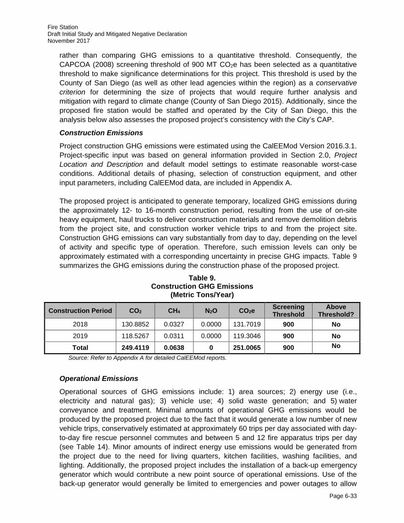
Fire Station Draft Initial Study and Mitigated Negative Declaration November 2017
Page 6-33
rather than comparing GHG emissions to a quantitative threshold. Consequently, the CAPCOA (2008) screening threshold of 900 MT CO2e has been selected as a quantitative threshold to make significance determinations for this project. This threshold is used by the County of San Diego (as well as other lead agencies within the region) as a conservative criterion for determining the size of projects that would require further analysis and mitigation with regard to climate change (County of San Diego 2015). Additionally, since the proposed fire station would be staffed and operated by the City of San Diego, this the analysis below also assesses the proposed project’s consistency with the City’s CAP.
Construction Emissions
Project construction GHG emissions were estimated using the CalEEMod Version 2016.3.1. Project-specific input was based on general information provided in Section 2.0, Project Location and Description and default model settings to estimate reasonable worst-case conditions. Additional details of phasing, selection of construction equipment, and other input parameters, including CalEEMod data, are included in Appendix A. The proposed project is anticipated to generate temporary, localized GHG emissions during the approximately 12- to 16-month construction period, resulting from the use of on-site heavy equipment, haul trucks to deliver construction materials and remove demolition debris from the project site, and construction worker vehicle trips to and from the project site. Construction GHG emissions can vary substantially from day to day, depending on the level of activity and specific type of operation. Therefore, such emission levels can only be approximately estimated with a corresponding uncertainty in precise GHG impacts. Table 9 summarizes the GHG emissions during the construction phase of the proposed project.
Table 9. Construction GHG Emissions
(Metric Tons/Year)
Construction Period CO2 CH4 N2O CO2e Screening Threshold
Above Threshold?
2018 130.8852 0.0327 0.0000 131.7019 900 No
2019 118.5267 0.0311 0.0000 119.3046 900 No
Total 249.4119 0.0638 0 251.0065 900 No
Source: Refer to Appendix A for detailed CalEEMod reports.
Operational Emissions
Operational sources of GHG emissions include: 1) area sources; 2) energy use (i.e., electricity and natural gas); 3) vehicle use; 4) solid waste generation; and 5) water conveyance and treatment. Minimal amounts of operational GHG emissions would be produced by the proposed project due to the fact that it would generate a low number of new vehicle trips, conservatively estimated at approximately 60 trips per day associated with day-to-day fire rescue personnel commutes and between 5 and 12 fire apparatus trips per day (see Table 14). Minor amounts of indirect energy use emissions would be generated from the project due to the need for living quarters, kitchen facilities, washing facilities, and lighting. Additionally, the proposed project includes the installation of a back-up emergency generator which would contribute a new point source of operational emissions. Use of the back-up generator would generally be limited to emergencies and power outages to allow
Fire Station Draft Initial Study and Mitigated Negative Declaration November 2017
Page 6-34
Fire Station operations to continue without disruption. The generator would be tested for 15 minutes per week, and once annually for 2 hours.
Area Source Emissions
Area sources include emissions from landscaping equipment and household consumer products. GHG emissions associated with area sources were estimated using the CalEEMod default values for the proposed project. The annual GHG emissions from area sources are estimated to be less than 1 MT CO2e per year in 2020 and 2030.
Energy Emissions
Buildings use electricity for lighting, heating and cooling. Electricity generation typically entails the combustion of fossil fuels, including natural gas and coal, which are then stored and transported to end users. A building’s electricity use is thus associated with the off-site or indirect emission of GHGs at the source of electricity generation (power plant). With the implementation of energy-reducing project design features described in Section 2.7, Sustainability, the annul GHG emissions from energy sources are estimated to be approximately 60 MT CO2e per year in 2020 and 2030.
Vehicular (Mobile) Sources
Operational emissions from mobile source emissions are associated with project-related vehicle trip generation and trip length. The proposed project would generate approximately 60 ADTs (see Table 14), including fire rescue personnel commutes as well as fire apparatus trips. CalEEMod default vehicle speeds were used. The project would result in vehicle-related emissions of approximately 28 MT CO2e per year in 2020 and 2030.
Solid Waste Sources
Solid waste generated by the proposed fire station would also contribute to GHG emissions. Treatment and disposal of solid waste produces emissions of methane. Using CalEEMod defaults and a 62 percent operational solid waste diversion rate in accordance with current UC San Diego solid waste diversion rates, GHG emissions from project-related solid waste would be approximately 30 MT CO2e per year in 2020 and 2030.
Water Sources
Water-related GHG emissions are from the conveyance and treatment of water. Using CalEEMod defaults and a 20 percent reduction in potable water use and wastewater generation in accordance with CALGreen, the proposed project’s estimated GHG emissions related to water treatment and conveyance would be 16 MT CO2e per year in 2020 and 2030. Other GHG Emission Sources Ozone is also a GHG; however, unlike other GHGs, O3 in the troposphere is relatively short lived and therefore is not global in nature. According to CARB, it is difficult to make an accurate determination of the contribution of ozone precursors (NOx and VOCs) to global
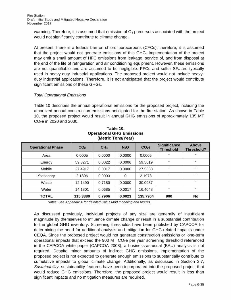
Fire Station Draft Initial Study and Mitigated Negative Declaration November 2017
Page 6-35
warming. Therefore, it is assumed that emission of O3 precursors associated with the project would not significantly contribute to climate change. At present, there is a federal ban on chlorofluorocarbons (CFCs); therefore, it is assumed that the project would not generate emissions of this GHG. Implementation of the project may emit a small amount of HFC emissions from leakage, service of, and from disposal at the end of the life of refrigeration and air conditioning equipment. However, these emissions are not quantifiable and are assumed to be negligible. PFCs and sulfur SF6 are typically used in heavy-duty industrial applications. The proposed project would not include heavy-duty industrial applications. Therefore, it is not anticipated that the project would contribute significant emissions of these GHGs. Total Operational Emissions Table 10 describes the annual operational emissions for the proposed project, including the amortized annual construction emissions anticipated for the fire station. As shown in Table 10, the proposed project would result in annual GHG emissions of approximately 135 MT CO2e in 2020 and 2030.
Table 10. Operational GHG Emissions
(Metric Tons/Year)
Operational Phase CO2 CH4 N2O CO2e Significance Threshold
Above Threshold?
Area 0.0005 0.0000 0.0000 0.0005 - -
Energy 59.3271 0.0022 0.0006 59.5619 - -
Mobile 27.4917 0.0017 0.0000 27.5333 - -
Stationary 2.1896 0.0003 0 2.1973 - -
Waste 12.1490 0.7180 0.0000 30.0987 - -
Water 14.1801 0.0685 0.0017 16.4048 - -
TOTAL 115.3380 0.7906 0.0023 135.7964 900 No Notes: See Appendix A for detailed CalEEMod modeling and results.
As discussed previously, individual projects of any size are generally of insufficient magnitude by themselves to influence climate change or result in a substantial contribution to the global GHG inventory. Screening thresholds have been published by CAPCOA for determining the need for additional analysis and mitigation for GHG-related impacts under CEQA. Since the proposed project would not generate construction emissions or long-term operational impacts that exceed the 900 MT CO2e per year screening threshold referenced in the CAPCOA white paper (CAPCOA 2008), a business-as-usual (BAU) analysis is not required. Despite minor amounts of indirect GHG emissions, implementation of the proposed project is not expected to generate enough emissions to substantially contribute to cumulative impacts to global climate change. Additionally, as discussed in Section 2.7, Sustainability, sustainability features have been incorporated into the proposed project that would reduce GHG emissions. Therefore, the proposed project would result in less than significant impacts and no mitigation measures are required.

Fire Station Draft Initial Study and Mitigated Negative Declaration November 2017
Page 6-36
Consistency with the City of San Diego Climate Action Plan (CAP)
In December 2015, the City adopted a CAP that outlines the actions that City will undertake to achieve its proportional share of statewide GHG emission reductions. The City’s CAP Consistency Checklist (Checklist) (revised June 2017), in conjunction with the City’s CAP, provides a streamlined review process for proposed new development projects that trigger environmental review pursuant to CEQA. Analysis of GHG emissions and potential climate change impacts from new development is required under CEQA. The City’s CAP is a plan for the reduction of GHG emissions in accordance with CEQA Guidelines Section 15183.5. Pursuant to CEQA Guidelines Sections 15064(h)(3), 15130(d), and 15183(b), a project’s incremental contribution to a cumulative GHG emissions effect may be determined not to be cumulatively considerable if it complies with the requirements of the City’s CAP.
The Checklist contains measures that are required to be implemented on a project-by-project basis to ensure that the specified emissions targets identified in the CAP are achieved. Implementation of these measures would ensure that new development is consistent with the CAP’s assumptions for relevant CAP strategies toward achieving the identified GHG reduction targets. Per the Checklist, the proposed project would be consistent with the City’s CAP and have a less than significant impact on the environment, as it would implement the following measures:
CAP Strategy 1, Energy and Water Efficient Buildings
The proposed fire station would provide space and maximum utility for future installation of photovoltaic solar panels on the fire station roof deck. Additionally, the fire station would include maximization of natural ventilation where feasible and control of all LED lighting fixtures by motion sensors to reduce energy demand as well as incorporate LID and water conservation measures to reduce overall water usage associated with the proposed project. Consistent with CAP Strategy 1:
1. Cool/Green Roofs
a. The roofing materials for the proposed fire station would have a minimum solar reflection index equal to or greater than the solar reflective index values specified in the voluntary measures of the California Green Building Code.
2. Plumbing Fixtures and Fittings
a. Kitchen Faucets – Maximum flow rates of faucets within the living quarters of the proposed fire station would not exceed a flow rate of 1.5 gallons per minute at 60 pounds per square inch (PSI).
b. Standard Dishwaters – The dishwasher(s) in the kitchen of the proposed fire station would not exceed 4.25 gallons per cycle.
c. Clothes Washers – The clothes washer(s) in the living quarters of the proposed fire station would not exceed a water factor of 6 gallons per cubic feet of drum capacity.
d. Plumbing fixtures and fittings would not exceed the maximum flow rate specified in the voluntary measures of the California Green Building Code.
e. Appliances and fixtures for commercial applications would be the voluntary measures of the California Green Building Code.
Fire Station Draft Initial Study and Mitigated Negative Declaration November 2017
Page 6-37
CAP Strategy 2, Clean and Renewable Energy
This CAP Strategy was removed from the Checklist in the most recent revisions in June 2017 (City of San Diego 2017d).
CAP Strategy 3, Bicycling, Walking, Transit & Land Use
The proposed project is consistent with existing alternative transportation programs on the UC San Diego campus. Consistent with CAP Strategy 3:
3. Electric Vehicle Charging
a. Of the total required listed cabinets, boxes, or enclosures supporting the proposed fire station, at least 50 percent would have the necessary electric vehicle supply equipment installed to provide active electric vehicles charging stations ready for use.
4. Bicycle Parking Spaces
a. Bicycle parking, equal to or greater than the requirement specified in the City’s Municipal Code (Chapter 14, Article, Division 5), would be provided outdoors adjacent to the public reception. These bicycle racks would support bicyclists using the existing bicycle lanes along North Torrey Pines Drive.
5. Shower Facilities
a. The proposed fire station would have full bathrooms provided as a part of the living quarters for the fire rescue personnel.
6. Designated Parking Spaces
a. The proposed fire station would provide at least two designated parking spaces for low-emitting, fuel-efficient, and carpool/vanpool vehicles.
7. Transportation Demand Management Program
a. Not applicable (not more than 50 tenant occupants).
B) UC San Diego has adopted goals, policies, and strategies for the purpose of reducing the emission of GHGs such as the UC Sustainable Practices Policy, UC San Diego CAP, UC San Diego Water Action Plan, and the UC San Diego Solid Waste Diversion Plan. These UC San Diego goals, policies, and strategies are currently being implemented, and would substantially reduce the project’s cumulative contribution to global climate change. As described in Section 2.7, Sustainability, the proposed project incorporates many features that demonstrate consistency with the intent of the goal of achieving these policy goals:
• Achieve a minimum standard equivalent LEED-NC Silver Certification and strive to achieve LEED-NC Gold Certification or higher;
• Provision of space and maximum utility for future installation of photovoltaic solar panels on the fire station roof deck;
• Implementation of LID and storm water treatment controls;
• Use of porous concrete in hardscape features where feasible;
• Installation of drought-tolerant vegetation;
• Use of reclaimed water for landscape irrigation;
• Installation of low-flow plumbing fixtures;
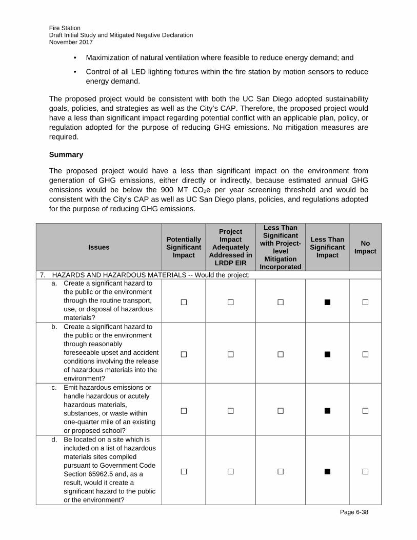
Fire Station Draft Initial Study and Mitigated Negative Declaration November 2017
Page 6-38
· Maximization of natural ventilation where feasible to reduce energy demand; and
· Control of all LED lighting fixtures within the fire station by motion sensors to reduce energy demand.
The proposed project would be consistent with both the UC San Diego adopted sustainability goals, policies, and strategies as well as the City’s CAP. Therefore, the proposed project would have a less than significant impact regarding potential conflict with an applicable plan, policy, or regulation adopted for the purpose of reducing GHG emissions. No mitigation measures are required.
Summary
The proposed project would have a less than significant impact on the environment from generation of GHG emissions, either directly or indirectly, because estimated annual GHG emissions would be below the 900 MT CO2e per year screening threshold and would be consistent with the City’s CAP as well as UC San Diego plans, policies, and regulations adopted for the purpose of reducing GHG emissions.
Issues Potentially Significant
Impact
Project Impact
Adequately Addressed in
LRDP EIR
Less Than Significant
with Project-level
Mitigation Incorporated
Less Than Significant
Impact No
Impact
7. HAZARDS AND HAZARDOUS MATERIALS -- Would the project: a. Create a significant hazard to
the public or the environment through the routine transport, use, or disposal of hazardous materials?
□ □ □ ■ □
b. Create a significant hazard to the public or the environment through reasonably foreseeable upset and accident conditions involving the release of hazardous materials into the environment?
□ □ □ ■ □
c. Emit hazardous emissions or handle hazardous or acutely hazardous materials, substances, or waste within one-quarter mile of an existing or proposed school?
□ □ □ ■ □
d. Be located on a site which is included on a list of hazardous materials sites compiled pursuant to Government Code Section 65962.5 and, as a result, would it create a significant hazard to the public or the environment?
□ □ □ ■ □
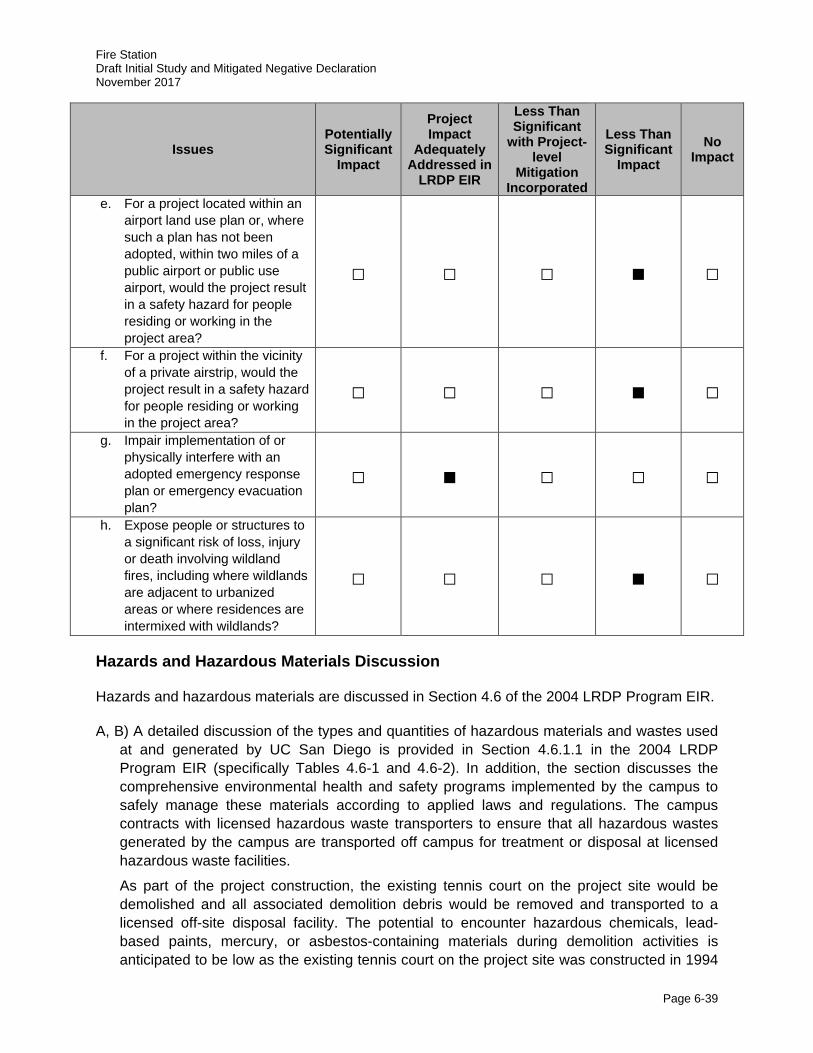
Fire Station Draft Initial Study and Mitigated Negative Declaration November 2017
Page 6-39
Issues Potentially Significant
Impact
Project Impact
Adequately Addressed in
LRDP EIR
Less Than Significant
with Project-level
Mitigation Incorporated
Less Than Significant
Impact No
Impact
e. For a project located within an airport land use plan or, where such a plan has not been adopted, within two miles of a public airport or public use airport, would the project result in a safety hazard for people residing or working in the project area?
□ □ □ ■ □
f. For a project within the vicinity of a private airstrip, would the project result in a safety hazard for people residing or working in the project area?
□ □ □ ■ □
g. Impair implementation of or physically interfere with an adopted emergency response plan or emergency evacuation plan?
□ ■ □ □ □
h. Expose people or structures to a significant risk of loss, injury or death involving wildland fires, including where wildlands are adjacent to urbanized areas or where residences are intermixed with wildlands?
□ □ □ ■ □
Hazards and Hazardous Materials Discussion
Hazards and hazardous materials are discussed in Section 4.6 of the 2004 LRDP Program EIR.
A, B) A detailed discussion of the types and quantities of hazardous materials and wastes used at and generated by UC San Diego is provided in Section 4.6.1.1 in the 2004 LRDP Program EIR (specifically Tables 4.6-1 and 4.6-2). In addition, the section discusses the comprehensive environmental health and safety programs implemented by the campus to safely manage these materials according to applied laws and regulations. The campus contracts with licensed hazardous waste transporters to ensure that all hazardous wastes generated by the campus are transported off campus for treatment or disposal at licensed hazardous waste facilities.
As part of the project construction, the existing tennis court on the project site would be demolished and all associated demolition debris would be removed and transported to a licensed off-site disposal facility. The potential to encounter hazardous chemicals, lead-based paints, mercury, or asbestos-containing materials during demolition activities is anticipated to be low as the existing tennis court on the project site was constructed in 1994
Fire Station Draft Initial Study and Mitigated Negative Declaration November 2017
Page 6-40
and no hazardous materials storage has occurred on the site since this time. However, if encountered during construction, all hazardous materials would be removed and disposed of according to all applicable federal and state regulations in coordination with the UC San Diego EH&S office.
Operation of the proposed fire station by SDFD would include activities that would involve the routine use of hazardous materials, primarily petroleum, oils, and lubricants associated with the fire apparatus and other equipment that would be located at proposed fire station. Additional hazardous materials used at the project could include cleaners, degreasers, solvents, paints, pesticides and herbicides, adhesives, and sealers. This use of hazardous materials at the proposed fire station would generate hazardous waste that would be collected and transported off campus by SDFD for disposal. All chemical waste recycling or disposal would be managed through by the City of San Diego in accordance with the Development Agreement between the UC San Diego and the City. All use of hazardous materials and disposal of hazards wastes at the project site would comply with all applicable state and federal safety regulations, guidelines, and policies. As such, the impact of the incremental increase in the use and transport of hazardous materials and wastes associated with the proposed fire station would be less than significant.
C) The project site is located within the North Campus Neighborhood of the West Campus, and as such is located in close proximity to academic, laboratory, and administrative buildings on the UC San Diego campus. However, there are no K-12 educational facilities (e.g., elementary schools, middle schools, high schools, etc.) located within 0.25 mile of the project site. Additionally, there are currently no childcare facilities within a 0.25 mile of the project site; however, development under the 2004 LRDP could include the construction of additional childcare facilities on the UC San Diego campus in the future. Hazardous materials and waste would be used and handled during construction and as a part of routine fire station operations by the SDFD during operation of the proposed fire station; however, these materials would not exist in quantities significant enough to pose a risk to occupants of the West Campus or the campus community. Compliance with all applicable state and federal regulations pertaining to hazardous wastes would ensure that risks associated with hazardous emissions or materials to existing or proposed schools located 0.25 miles from the project site would remain less than significant.
D) A records search of federal, state, and county hazardous waste lists and databases was conducted for the campus as part of the 2004 LRDP Program EIR (Ninyo and Moore 2003). At least two cases of Leaking Underground Storage Tanks (LUSTs) were identified in or adjacent to the West Campus (San Diego County Department of Environmental Health [DEH] No. H02535-012 and H12902-002) at the intersections of Gilman Drive and Myers Drive (approximately 0.15 miles southeast of the project site) and La Jolla Village Drive and Villa La Jolla Drive (approximately 0.25 miles southeast of the project site), respectively. H02535-012 is considered case closed, with low likelihood for environmental concern, and H12902-002 is a Mobil Service Station, which based on activities performed to date, more information is needed to determine whether the release presented an environmental concern. Based on the distance of these LUST sites from the project site, construction or operation of the project is not likely to create a significant hazard to the public or the environment. No new hazardous waste sites have been identified in the vicinity of the project site since the 2004 LRDP Program EIR was certified (California EnviroStor 2017).
Fire Station Draft Initial Study and Mitigated Negative Declaration November 2017
Page 6-41
Although the project site is located within an area of historic military use, the project site and surrounding areas have been developed and has undergone extensive grading in 1994 as a part of the addition to the NCRA Tennis Courts. As identified in the 2004 LRDP Program EIR, the likelihood of uncovering munitions or ordnance and creating impacts to the public or environment is extremely low. As identified in the 2004 LRDP Program EIR, the likelihood of uncovering historic hazardous materials and creating impacts to the public or environment would not likely occur and impacts would be less than significant.
E, F) The campus is not located within 2 miles of a public airport, public use airport, or private airstrip, but it is located within approximately 2.5 miles of Marine Corps Air Station (MCAS) Miramar and is adjacent to the Torrey Pines Gliderport (a local launch point for fixed wing gliders, paragliders and hang gliders). The federal Department of Defense has established Accident Potential Zones (APZs) for the air station. UC San Diego, including the project site, is not located within any APZs for MCAS Miramar. With regard to the Torrey Pines Gliderport, this fixed wing glider use is not a safety hazard to the campus and surrounding area because the paragliders and hang gliders do not take-off or land over UC San Diego structures. Aircraft operations would not pose a hazard to people visiting or working at the project site, therefore the impact would be considered less than significant.
G) Under current campus procedures, multiple emergency access or evacuation routes are provided to ensure emergency response services are not impaired or interfered with in the event of a temporary roadway closure and/or changes in campus traffic patterns. Nevertheless, 2004 LRDP Mitigation Measure Haz-6A would be implemented during project construction activities, including during the installation of the proposed traffic signal and construction/extension of the existing utilities. With the implementation of this mitigation measure, impacts from the project construction would be less than significant.
2004 LRDP Program EIR Mitigation Measure:
Haz-6A: In the event that the construction of a project requires a lane or roadway closure, prior to construction the contractor and/or Capital Program Management (CPM) shall ensure that the UC San Diego Fire Marshal is notified. If determined necessary by the UC San Diego Fire Marshal, local emergency services will be notified by the Fire Marshal of the closure.
H) The coastal influence on temperature and humidity is important in determining the frequency of critical fire weather in San Diego County. Generally speaking, structures west of I-5 (where most of the campus, including the proposed project, is located) are rated lower in terms of fire hazard severity due to favorable geographic proximity to the coast as compared to locations east of I-5 where fire hazard jumps up quickly. Nevertheless, the UC San Diego campus features open space containing vegetation that could be susceptible to wildfires. The Clinical and Translational Research Institute and East Campus Recreation Area Project EIR’s study of the campus fire risk indicated that there are very few areas on campus exposed to a high life safety or property loss risk due to wildfires. These areas include: 1) the Campus Services Complex; 2) Che Café/Revelle Provost Office; 3) Marshall College Apartments; and 4) Seaweed Canyon development. These areas are identified primarily as a result of their proximity to parklands and/or older wood framed construction of buildings.
The campus Fire Marshal is responsible for campus-wide fire prevention and provision of services such as plan review and construction inspections to ensure conformance of the proposed fire station with the CBC and California Fire Code. The campus Fire Marshal,
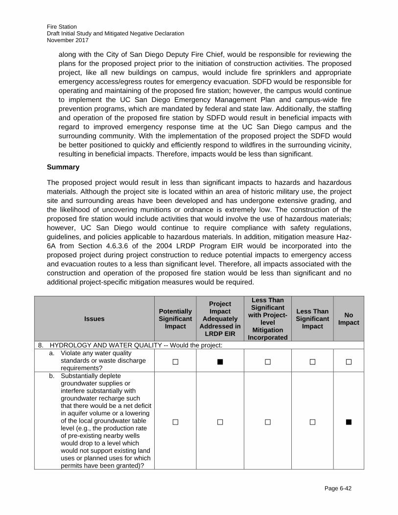
Fire Station Draft Initial Study and Mitigated Negative Declaration November 2017
Page 6-42
along with the City of San Diego Deputy Fire Chief, would be responsible for reviewing the plans for the proposed project prior to the initiation of construction activities. The proposed project, like all new buildings on campus, would include fire sprinklers and appropriate emergency access/egress routes for emergency evacuation. SDFD would be responsible for operating and maintaining of the proposed fire station; however, the campus would continue to implement the UC San Diego Emergency Management Plan and campus-wide fire prevention programs, which are mandated by federal and state law. Additionally, the staffing and operation of the proposed fire station by SDFD would result in beneficial impacts with regard to improved emergency response time at the UC San Diego campus and the surrounding community. With the implementation of the proposed project the SDFD would be better positioned to quickly and efficiently respond to wildfires in the surrounding vicinity, resulting in beneficial impacts. Therefore, impacts would be less than significant.
Summary
The proposed project would result in less than significant impacts to hazards and hazardous materials. Although the project site is located within an area of historic military use, the project site and surrounding areas have been developed and has undergone extensive grading, and the likelihood of uncovering munitions or ordnance is extremely low. The construction of the proposed fire station would include activities that would involve the use of hazardous materials; however, UC San Diego would continue to require compliance with safety regulations, guidelines, and policies applicable to hazardous materials. In addition, mitigation measure Haz-6A from Section 4.6.3.6 of the 2004 LRDP Program EIR would be incorporated into the proposed project during project construction to reduce potential impacts to emergency access and evacuation routes to a less than significant level. Therefore, all impacts associated with the construction and operation of the proposed fire station would be less than significant and no additional project-specific mitigation measures would be required.
Issues Potentially Significant
Impact
Project Impact
Adequately Addressed in
LRDP EIR
Less Than Significant
with Project-level
Mitigation Incorporated
Less Than Significant
Impact No
Impact
8. HYDROLOGY AND WATER QUALITY -- Would the project: a. Violate any water quality
standards or waste discharge requirements?
□ ■ □ □ □
b. Substantially deplete groundwater supplies or interfere substantially with groundwater recharge such that there would be a net deficit in aquifer volume or a lowering of the local groundwater table level (e.g., the production rate of pre-existing nearby wells would drop to a level which would not support existing land uses or planned uses for which permits have been granted)?
□ □ □ □ ■
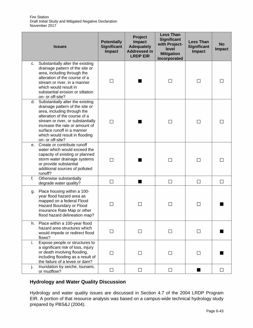
Fire Station Draft Initial Study and Mitigated Negative Declaration November 2017
Page 6-43
Issues Potentially Significant
Impact
Project Impact
Adequately Addressed in
LRDP EIR
Less Than Significant
with Project-level
Mitigation Incorporated
Less Than Significant
Impact No
Impact
c. Substantially alter the existing drainage pattern of the site or area, including through the alteration of the course of a stream or river, in a manner which would result in substantial erosion or siltation on- or off-site?
□ ■ □ □ □
d. Substantially alter the existing drainage pattern of the site or area, including through the alteration of the course of a stream or river, or substantially increase the rate or amount of surface runoff in a manner which would result in flooding on- or off-site?
□ ■ □ □ □
e. Create or contribute runoff water which would exceed the capacity of existing or planned storm water drainage systems or provide substantial additional sources of polluted runoff?
□ ■ □ □ □
f. Otherwise substantially degrade water quality? □ ■ □ □ □
g. Place housing within a 100-year flood hazard area as mapped on a federal Flood Hazard Boundary or Flood Insurance Rate Map or other flood hazard delineation map?
□ □ □ □ ■
h. Place within a 100-year flood hazard area structures which would impede or redirect flood flows?
□ □ □ □ ■ i. Expose people or structures to
a significant risk of loss, injury or death involving flooding, including flooding as a result of the failure of a levee or dam?
□ □ □ □ ■
j. Inundation by seiche, tsunami, or mudflow? □ □ □ ■ □
Hydrology and Water Quality Discussion
Hydrology and water quality issues are discussed in Section 4.7 of the 2004 LRDP Program EIR. A portion of that resource analysis was based on a campus-wide technical hydrology study prepared by PBS&J (2004).
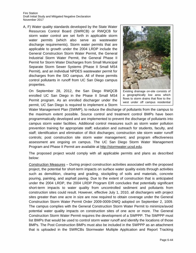
Fire Station Draft Initial Study and Mitigated Negative Declaration November 2017
Page 6-44
A, F) Water quality standards developed by the State Water Resources Control Board (SWRCB) or RWQCB for storm water control are set forth in applicable storm water permits (which also serve as wastewater discharge requirements). Storm water permits that are applicable to growth under the 2004 LRDP include the General Construction Storm Water Permit, the General Industrial Storm Water Permit, the General Phase II Permit for Storm Water Discharges from Small Municipal Separate Storm Sewer Systems (Phase II Small MS4 Permit), and an individual NPDES wastewater permit for discharges from the SIO campus. All of these permits control pollutants in runoff from UC San Diego campus properties.
On September 28, 2012, the San Diego RWQCB enrolled UC San Diego in the Phase II Small MS4 Permit program. As an enrolled discharger under the permit, UC San Diego is required to implement a Storm Water Management Plan (SWMP), to reduce the discharge of pollutants from the campus to the maximum extent possible. Source control and treatment control BMPs have been programmatically developed and are implemented to prevent the discharge of pollutants into campus storm water facilities. Additional control measures such as storm water pollution prevention training for appropriate staff; education and outreach for students, faculty, and staff; identification and elimination of illicit discharges; construction site storm water runoff controls; post construction site storm water management; and program effectiveness assessment are ongoing on campus. The UC San Diego Storm Water Management Program and Phase II Permit are available at http://stormwater.ucsd.edu.
The proposed project would comply with all applicable permits and plans as described below:
Construction Measures – During project construction activities associated with the proposed project, the potential for short-term impacts on surface water quality exists through activities such as demolition, clearing and grading, stockpiling of soils and materials, concrete pouring, painting, and asphalt paving. Due to the extent of construction that is anticipated under the 2004 LRDP, the 2004 LRDP Program EIR concludes that potentially significant short-term impacts to water quality from uncontrolled sediment and pollutants from construction sites could result. However, effective July 1, 2010, all dischargers with project sites greater than one acre in size are now required to obtain coverage under the General Construction Storm Water Permit Order 2009-0009-DWQ adopted on September 2, 1009. The campus complies with the General Construction Storm Water Permit to minimize/avoid potential water quality impacts on construction sites of one acre or more. The General Construction Storm Water Permit requires the development of a SWPPP. The SWPPP must list BMPs that would be used to control storm water runoff and identify the locations of those BMPs. The Post Construction BMPs must also be included in the SWPPP as an attachment that is uploaded in the SWRCBs Stormwater Multiple Application and Report Tracking
Existing drainage on-site consists of a geographically low area which flows to storm drains that flow to the west under off campus residential
Fire Station Draft Initial Study and Mitigated Negative Declaration November 2017
Page 6-45
System (SMARTS), an online tool to assist dischargers in submitting their notices, annual reports and to address/document long-term water quality treatment controls for the project.
The following additional measures are applicable to the proposed project, as outlined below:
· Storage of BMP materials in applicable on-site areas to provide “standby” capacity adequate to provide complete protection of exposed areas and prevent off-site sediment transport.
· Training of applicable personnel to ensure proper BMP installation and maintenance.
· Proper containment and disposal of all construction debris.
· Conformance with all local dust control requirements, including measures such as regular application of water and/or palliatives required by 2004 LRDP Program EIR Mitigation Measure Air-CB.
· Installation of permanent landscaping, with emphasis on native and/or drought-tolerant varieties, as soon as feasible during or after construction.
· Implementation of sampling/analysis, reporting and post-construction management/maintenance programs per NPDES requirements.
· Implementation of additional BMPs as necessary (and required by appropriate regulatory agencies) to ensure adequate erosion and sediment control.
The proposed project would be required to prepare a SWPPP and implement the BMPs for the entire construction site including the haul roads and staging areas needed to support the construction. Erosion control plans with specific notes and locations of construction BMPs would be included on the final construction documents. Regular inspection and maintenance of all specified BMPs would be conducted through the duration of construction. Based on implementation of appropriate erosion and sediment control BMPs as part of (and in conformance with) NPDES permit criteria and associated project SWPPP, the project would not result in significant impacts associated with construction-related water quality.
Post-Construction Measures – The Phase II Small MS4 Permit program requires construction projects that would create and/or replace 5,000 SF or more of impervious surface to incorporate post-construction storm water management controls in the project design in order to meet the new water quality regulations. The regulations require no new increase in runoff from the site as a result of project construction. Post-construction storm water management controls include permanent structural (e.g., rooftop runoff infiltration galleries) and non-structural BMPs (e.g., conservation of natural and permeable areas) that remain in place after the project is completed and prevent pollution from the new or re-developed site over time. Following construction, pavement materials, landscaping, and other LID techniques incorporated into the proposed fire station design would reduce the potential for on-site and off-site erosion as well as sediment discharges. To further address water quality and wastewater discharge requirements from building operations, UC San Diego maintains an industrial wastewater permit issued by the City of San Diego that ensures compliance with wastewater discharges into the City’s sewer system. Finally, consistent with 2004 LRDP Program EIR Mitigation Measure Hyd-2B, all development and/or redevelopment projects including the proposed project would incorporate the
Fire Station Draft Initial Study and Mitigated Negative Declaration November 2017
Page 6-46
following post-construction treatments and permanent source control measures in the project design as applicable:
i. All new storm drain inlets and catch basins within the project site shall be marked with prohibitive language and/or graphical icons to discourage illegal dumping per UC San Diego standards.
ii. Outdoor areas for storage of materials that may contribute pollutants to the storm water conveyance system shall be covered and protected by secondary containment.
iii. All trash container areas shall be enclosed to prevent off-site transport of trash and drainage shall be directed to the sanitary sewer system or the containers shall be covered to prevent exposure of trash to precipitation.
iv. Interior drains must be connected to the sanitary sewer system (may not be connected to the storm water conveyance system).
v. Use native and drought tolerant plants for decorative landscape applications to reduce water usage and fertilizer needs.
vi. Boiler drain lines, condensate drain lines, rooftop equipment, and drainage sumps must be connected to the sanitary sewer system or collected for reuse (may not be connected to the storm water conveyance system).
vii. Decorative water fountains shall not discharge to the storm water conveyance system.
viii. Building fire sprinklers may not be designed to discharge to the storm water conveyance system but should be discharged into the sewer system.
In addition to the post-construction treatments and permanent source control measures described above, Project-Specific Mitigation Measure Hyd-1 would be implemented.
2004 LRDP Program EIR Mitigation Measures:
Hyd-2A: For any project resulting in land disturbance that is less than an acre, prior to initiation of construction the APS or CPM Project Managers, in consultation with the UC San Diego Civil Engineer shall approve an erosion control plan for the project construction. This erosion control plan shall include, but not be limited to, the following applicable measures to protect downstream areas from sediment and other pollutants during site grading and construction:
· Proper storage, use, and disposal of construction materials.
· Removal of sediment from surface runoff before it leaves the site by silt fences or other similar devices around the site perimeter.
· Protection of storm drain inlets on-site or downstream of the construction site to eliminate entry of sediment.
· Stabilization of cleared or graded slopes.
· Removal of sediment tracked or otherwise transported onto adjacent roadways through periodic street sweeping.
Fire Station Draft Initial Study and Mitigated Negative Declaration November 2017
Page 6-47
· Prevention of tracking soil off-site through use of a gravel strip or wash facilities at exist areas (or equivalent measures).
· Protection or stabilization of stockpiled soils.
Hyd-2B: For each development or redevelopment project that would include 100,000 SF of development or parking lots greater than 5,00 SF potentially exposed to precipitation or runoff, the following design standards or their equivalent shall be applied in addition to those conditions in Hyd-1A. Equivalent design standards may be less restrictive if consistent with the applicable MS4 permit at that time. Design measures and other recommendations used to comply with these standards shall be incorporated into project development plans and construction documents. Design measures shall be consistent with UC San Diego’s storm water management plan, shall be operational within a reasonable time from project occupancy, and shall be maintained by UC San Diego.
i. All new storm drain inlets and catch basins within the project site shall be marked with prohibitive language and/or graphical icons to discourage illegal dumping per UC San Diego standards.
ii. Outdoor areas for storage of materials that may contribute pollutants to the storm water conveyance system shall be covered and protected by secondary containment.
iii. All trash container areas shall be enclosed to prevent off-site transport of trash and drainage shall be directed to the sanitary sewer system or the containers shall be covered to prevent exposure of trash to precipitation.
iv. Pollutants of concern shall be minimized through the incorporation of design measures best suited to maximize the reduction of pollutant loadings in that runoff. At least one treatment control is required for new parking areas or structures, or other new uses identified by CPM or Campus Planning to have potential to generate substantial pollutants. Treatment controls include detention basins, infiltration basins, wet ponds or wetlands, drainage inserts, filtration, and hydrodynamic separator systems. Treatment controls shall incorporate volumetric or flow based treatment control design standards to mitigate (infiltrate, filter, or treat) storm water runoff, as appropriate.
Project-Specific Mitigation Measure:
Hyd-1: Because the proposed project would create and/or replace 5,000 SF or greater of impervious surface, a Post-Construction Storm Water Management Checklist is required. The draft checklist, which is drafted early during the schematic design phase of the project, provides a description of the project, estimates square footages of disturbed, new impervious, and replaced impervious surfaces, identifies proposed post-construction site design measures and source control measures, and calculates area, volume, and flow that would be required to be treated for each drainage management area affected by the project. A draft of this checklist shall be provided to the project team (including the UC San Diego Project Manager, Campus Planning, and the CPM Civil Engineering Group) during schematic design, and shall inform all building design efforts going forward. The final checklist shall be incorporated into the project construction drawings and provided to the project team with the final construction drawings. The checklist can be found at: http://blink.ucsd.edu/safety/environment/outdoor/storm/post-construction.html.
Fire Station Draft Initial Study and Mitigated Negative Declaration November 2017
Page 6-48
Compliance with 2004 LRDP Program EIR Mitigation Measure Hyd-2A, Hyd-2B, Project-Specific Mitigation Measure Hyd-1, and all applicable storm water permits and plans would ensure that no violation of water quality standards or water discharge requirements would occur as a result of the proposed project, and the potential for impacts associated with water quality degradation would be less than significant.
B) No extraction of groundwater is proposed at UC San Diego. The campus uses potable water supplied by the City of San Diego Water Department via existing lines on UC San Diego’s campus. The City receives deliveries of imported water from the San Diego County Water Authority (SDCWA) to satisfy potable water demand. Consequently, no impacts to groundwater supplies would occur with implementation of the proposed project.
C, D, E) The long-term implementation of the 2004 LRDP would result in the construction of new buildings and redevelopment, landscaping, and other features on the UC San Diego campus. These improvements would result in minor alterations to existing drainage patterns of individual sites within the campus, but not substantial alterations to the drainage courses of the campus as a whole. Implementation of the 2004 LRDP would also convert some areas of the campus from softscape (e.g., lawns, landscaping, and dirt) to hardscape (e.g., pavement and buildings), which could increase runoff from certain areas due to increased impervious surfaces.
Increased peak runoff associated with development on campus may have detrimental effects on and off campus, including: exceeding the capacity of on- and off-campus storm water conveyance systems, exceeding the capacity of storm drain inlets and catch basins, causing new erosion and intensifying existing erosion problems on and off campus, particularly in coastal bluff areas. These effects could cause or contribute to impacts in such off-campus areas as Rose Canyon, Soledad Canyon, Los Peñasquitos Creek, and coastal bluffs above the ocean. According to the 2004 LRDP Program EIR, projects involving an increase in impervious surfaces would have the potential to cause significant hydrology impacts. However, changes in State storm water regulations over the past 5 years prohibit net increases in storm water runoff associated with new development or redevelopment.
The improvements associated with the proposed fire station would result in minor alterations to existing drainage patterns on the project site. The project site including the existing tennis court implements surface grading and storm drain infrastructure to convey surface water flows to a topographic low point on the west side of the project site. The project site is located in the Scripps hydrologic area (HA), which drains to storm drains that flow to the west under off-campus residential areas and into short coastal canyons that lead to the Pacific Ocean (UC San Diego 2004a).
To avoid impacts related to increases in runoff and potential erosion, the proposed project would comply with all current applicable storm water regulations. In addition, to further ensure avoidance of significant impacts, design measures for permanent storm water retention or infiltration measures and other recommendations are incorporated into project development plans and construction documents. Design measures would be consistent with the Post Construction Storm Water Management Program requirements in Section F.5.g of the Phase II Small MS4 Storm Water Permit. The following design measures would be incorporated into the project design as applicable:
· Site design that controls runoff discharge volumes and durations would be utilized where applicable and feasible.
Fire Station Draft Initial Study and Mitigated Negative Declaration November 2017
Page 6-49
• Measures that protect slopes and channels such as energy dissipaters, vegetation, and slope/channel stabilizers would be applied where appropriate.
• All developments that would increase impervious surfaces would maintain preconstruction peak flows and capture and treat storm water runoff in accordance with the Post Construction Storm Water Management Program in Section 5.F.g of the Phase II Small MS4 Storm Water Permit. The County of San Diego’s Hydrology Manual and methodology would be used for a reference in performing all hydrologic calculations. In cases where known or potential on- or off-site erosion problems have been identified, the Civil Engineer, in coordination with UC San Diego, may determine additional analysis is needed.
Storm water facilities would be applied at the location where storm runoff from the drainage basin in which the project is located flows across UC San Diego property limits, either as overland flow or contained within a storm water conveyance system. In order to achieve this standard, detention may occur at one of the following locations, with preference given to on-site detention:
• Detention or retention basins at the project site may be incorporated into the proposed project design, with features including, but not limited to: small on-site detention or retention basins; rooftop ponding; temporary flooding of parking areas, streets, and gutters; landscaping or gravel beds designed to temporarily retain water; and gravel beds designed to collect and retain runoff;
• The downstream campus boundary within the drainage basin encompassing the project site; or
• An alternative location within the drainage basin encompassing the project site, detention at which results in no net increase of runoff at the downstream property limit. This alternative would be useful in cases where detention at the project site or at the downstream property limit is precluded due to site conditions.
Compliance with all applicable storm water permits, plans, and regulations would ensure potential impacts associated with alteration of drainage patterns that could cause substantial erosion/flooding, or create/contribute runoff that would exceed the capacity of existing/planned drainage systems would not occur.
G, H) Development under the 2004 LRDP and implementation of the proposed project would not place structures within the 100-year flood hazard area, as the entire campus is located in Flood Zone X, which is outside of the 100- and 500-year floodplains (Federal Emergency Management Agency [FEMA] 2012). Therefore, the construction of the proposed fire station would not impede or redirect flood flows and no impacts associated with flooding would occur with the implementation of the proposed project.
I) UC San Diego campus development is located on the Torrey Pines Mesa, at an average elevation between 300 to 450 feet AMSL, and the proposed project site is located at an elevation of approximately 420 feet AMSL to 440 feet AMSL. A dam or levee failure occurring at remote inland San Diego County locations would have no effect on elevated campus lands located at the Pacific Coast. Flood flows emanating from inland areas would more likely travel to the coast via Los Peñasquitos Lagoon to the north or Rose Canyon to the south of campus lands. Additionally, the project site would not be affected by long-term sea level rise due to its elevation and distance from the coast. Therefore, implementation of
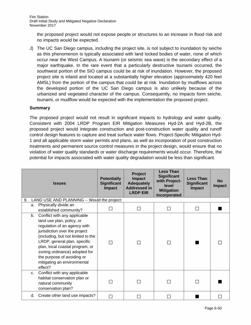
Fire Station Draft Initial Study and Mitigated Negative Declaration November 2017
Page 6-50
the proposed project would not expose people or structures to an increase in flood risk and no impacts would be expected.
J) The UC San Diego campus, including the project site, is not subject to inundation by seiche as this phenomenon is typically associated with land locked bodies of water, none of which occur near the West Campus. A tsunami (or seismic sea wave) is the secondary effect of a major earthquake. In the rare event that a particularly destructive tsunami occurred, the southwest portion of the SIO campus could be at risk of inundation. However, the proposed project site is inland and located at a substantially higher elevation (approximately 420 feet AMSL) from the portion of the campus that could be at risk. Inundation by mudflows across the developed portion of the UC San Diego campus is also unlikely because of the urbanized and vegetated character of the campus. Consequently, no impacts form seiche, tsunami, or mudflow would be expected with the implementation the proposed project.
Summary
The proposed project would not result in significant impacts to hydrology and water quality. Consistent with 2004 LRDP Program EIR Mitigation Measures Hyd-2A and Hyd-2B, the proposed project would integrate construction and post-construction water quality and runoff control design features to capture and treat surface water flows. Project-Specific Mitigation Hyd-1 and all applicable storm water permits and plans, as well as incorporation of post construction treatments and permanent source control measures in the project design, would ensure that no violation of water quality standards or water discharge requirements would occur. Therefore, the potential for impacts associated with water quality degradation would be less than significant.
Issues Potentially Significant
Impact
Project Impact
Adequately Addressed in
LRDP EIR
Less Than Significant
with Project-level
Mitigation Incorporated
Less Than Significant
Impact No
Impact
9. LAND USE AND PLANNING -- Would the project: a. Physically divide an
established community? □ □ □ □ ■ b. Conflict with any applicable
land use plan, policy, or regulation of an agency with jurisdiction over the project (including, but not limited to the LRDP, general plan, specific plan, local coastal program, or zoning ordinance) adopted for the purpose of avoiding or mitigating an environmental effect?
□ □ □ ■ □
c. Conflict with any applicable habitat conservation plan or natural community conservation plan?
□ □ □ □ ■
d. Create other land use impacts? □ □ □ ■ □
Fire Station Draft Initial Study and Mitigated Negative Declaration November 2017
Page 6-51
Land Use and Planning Discussion
Campus-wide Planning and land use issues are discussed in Section 4.8 of the 2004 LRDP Program EIR.
A) The San Diego community has developed around and in response to the campus. The proposed project site is located on an existing tennis court in the North Campus Neighborhood on the West Campus. The project site is located near the northern perimeter of campus with good access to the regional roadway network and is surrounded by generally compatible UC San Diego campus land uses. Construction of the proposed project would not divide an established community. Therefore, there would be no impacts and no mitigation measures would be required.
B) With regard to local plans and policies, UC San Diego is part of the University of California system, a constitutionally created entity of the State of California. As a constitutional entity, the University of California is not subject to municipal regulations, such as the City’s General Plan or any of the surrounding community plans. The University of California is the only agency with local land use jurisdiction over campus projects. The applicable land use plan for the project site is the campus’ 2004 LRDP.
Under the California Coastal Act (CCA), the CCC has the authority to review and approve state and local government plans located within their jurisdiction, which is defined as the coastal zone. Portions of UC San Diego’s West Campus, including the project site, are located within the coastal zone. The CCA requires cities and counties to prepare Local Coastal Plans (LCPs) to implement its conservation, development, and regulatory policies at the local level in areas of the coastal zone. The City of San Diego’s North City LCP and La Jolla Community Plan and LCP are the local planning documents for the coastal zone near the project area. However, UC San Diego is not within the jurisdiction of either of these planning documents and, thus, is governed solely by the CCA. Under Chapter 3 of the CCA, the proposed project would be submitted to the CCC for their review, and a CDP would be required (refer to Section 2.9, Project Approval/Schedule).
The 2004 LRDP designates the project site for Sports and Recreation use (refer to Figure 3.4-5 of the 2004 LRDP Program EIR). As discussed in Section 3.0, Relationship to and Consistency with 2004 LRDP, the proposed fire station is not consistent with the existing underlying land use at the project site. However, with approval of the minor LRDP amendment, which is included in the approval of this IS/MND, the proposed fire station would be consistent with the 2004 LRDP under General Services. General Services land uses primarily include facilities for personnel and equipment related to the operations, security and safety, and maintenance of UC San Diego facilities (e.g., central garage, shops supporting general maintenance activities, materials handling, police, utility plants, service yards, recycling areas, and storage) (UC San Diego 2004a). Though the proposed project’s particular land use is not expressly listed in the LRDP, the intent and intensity of the proposed fire station is generally consistent with this land use designation because it is a facility for personnel and equipment to ensure the security and safety of UC San Diego. To further ensure that project impacts to land are less than significant, the proposed conceptual design of the proposed fire station was reviewed by UC San Diego Campus Planning staff during concept development pursuant to 2004 LRDP Program EIR Mitigation Measure Lan-2A. This review evaluated factors such as edge effects and site connections to adjacent on-
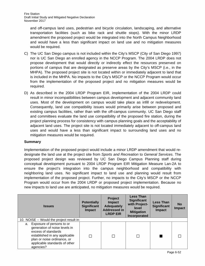
Fire Station Draft Initial Study and Mitigated Negative Declaration November 2017
Page 6-52
and off-campus land uses, pedestrian and bicycle circulation, landscaping, and alternative transportation facilities (such as bike rack and shuttle stops). With the minor LRDP amendment the proposed project would be integrated into the North Campus Neighborhood and would have a less than significant impact on land use and no mitigation measures would be required.
C) The UC San Diego campus is not included within the City’s MSCP (City of San Diego 1997) nor is UC San Diego an enrolled agency in the NCCP Program. The 2004 LRDP does not propose development that would directly or indirectly effect the resources preserved on portions of campus that are designated as preserve areas by the City’s MSCP (i.e., in the MHPA). The proposed project site is not located within or immediately adjacent to land that is included in the MHPA. No impacts to the City’s MSCP or the NCCP Program would occur from the implementation of the proposed project and no mitigation measures would be required.
D) As described in the 2004 LRDP Program EIR, implementation of the 2004 LRDP could result in minor incompatibilities between campus development and adjacent community land uses. Most of the development on campus would take place as infill or redevelopment. Consequently, land use compatibility issues would primarily arise between proposed and existing campus facilities, rather than with the off-campus community. UC San Diego staff and committees evaluate the land use compatibility of the proposed fire station, during the project planning process for consistency with campus planning goals and the acceptability of adjacent land uses. The project site is not located immediately adjacent to off-campus land uses and would have a less than significant impact to surrounding land uses and no mitigation measures would be required.
Summary
Implementation of the proposed project would include a minor LRDP amendment that would re-designate the land use at the project site from Sports and Recreation to General Services. The proposed project design was reviewed by UC San Diego Campus Planning staff during conceptual development pursuant to 2004 LRDP Program EIR Mitigation Measure Lan-2A to ensure the project’s integration into the campus neighborhood and compatibility with neighboring land uses. No significant impact to land use and planning would result from implementation of the proposed project. Further, no impacts to the City’s MSCP or the NCCP Program would occur from the 2004 LRDP or proposed project implementation. Because no new impacts to land use are anticipated, no mitigation measures would be required.
Issues Potentially Significant
Impact
Project Impact
Adequately Addressed in
LRDP EIR
Less Than Significant
with Project-level
Mitigation Incorporated
Less Than Significant
Impact No
Impact
10. NOISE -- Would the project result in: a. Exposure of persons to or
generation of noise levels in excess of standards established in any applicable plan or noise ordinance, or applicable standards of other agencies?
□ □ □ ■ □
Fire Station Draft Initial Study and Mitigated Negative Declaration November 2017
Page 6-53
Issues Potentially Significant
Impact
Project Impact
Adequately Addressed in
LRDP EIR
Less Than Significant
with Project-level
Mitigation Incorporated
Less Than Significant
Impact No
Impact
b. Exposure of persons to or generation of excessive groundborne vibration or groundborne noise levels?
□ □ □ ■ □
c. A substantial permanent increase in ambient noise levels in the project vicinity above levels existing without the project?
□ □ □ ■ □
d. A substantial temporary or periodic increase in ambient noise levels in the project vicinity above levels existing without the project (including construction)?
□ ■ □ □ □
e. For a project located within an airport land use plan or, where such a plan has not been adopted, within two miles of a public airport or public use airport, would the project expose people residing or working in the project area to excessive noise levels?
□ □ □ ■ □
f. For a project within the vicinity of a private airstrip, would the project expose people residing or working in the project area to excessive noise levels?
□ □ □ □ ■
Noise Discussion
Campus-wide Noise issues are addressed in Section 4.9 of the 2004 LRDP Program EIR. The analysis is based in part on a noise and vibration technical report prepared by URS for the 2004 LRDP Program EIR (UC San Diego 2004b). The principal contributors to the ambient noise environment at the project site are North Torrey Pines Road and Genesee Avenue. North Torrey Pines Road is a six-lane primary arterial road, which carries approximately 30,282 ADT between Genesee Avenue and North Point Drive (UC San Diego 2004b). This level of traffic generates average noise levels of approximately 72 dBA approximately 50 feet from the road centerline (refer to Table 4.9-5 of the 2004 LRDP Program EIR). Other noise sources in the area include intermittent noise form the sports facilities, including the North Campus Recreation Field (RIMAC Field), Spanos Track and Training Facility, traffic-related noise from I-5, aircraft associated with MCAS Miramar, and distant noise from passing trains. Additionally, Amec Foster Wheeler collected ambient noise measurements in several areas surrounding the project site in support of the impact analysis for the proposed fire station provided in this IS (see Table 11). Amec Foster Wheeler conducted the noise survey on May 10, 2017 and recorded average noise levels over 10-minute monitoring periods at academic, administrative, and
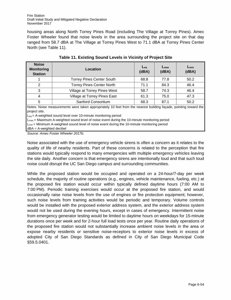
Fire Station Draft Initial Study and Mitigated Negative Declaration November 2017
Page 6-54
housing areas along North Torrey Pines Road (including The Village at Torrey Pines). Amec Foster Wheeler found that noise levels in the area surrounding the project site on that day ranged from 58.7 dBA at The Village at Torrey Pines West to 71.1 dBA at Torrey Pines Center North (see Table 11).
Table 11. Existing Sound Levels in Vicinity of Project Site Noise
Monitoring Station
Location Leq (dBA)
Lmax (dBA)
Lmin (dBA)
1 Torrey Pines Center South 68.8 77.8 50.2 2 Torrey Pines Center North 71.1 84.3 46.4 3 Village at Torrey Pines West 58.7 74.3 46.4 4 Village at Torrey Pines East 61.3 75.0 47.3 5 Sanford Consortium 68.3 87.1 50.2
Notes: Noise measurements were taken appropriately 10 feet from the nearest building façade, pointing toward the project site. Leq = A-weighted sound level over 10-minute monitoring period Lmax = Maximum A-weighted sound level of noise event during the 10-minute monitoring period Lmin = Minimum A-weighted sound level of noise event during the 10-minute monitoring period dBA = A-weighted decibel Source: Amec Foster Wheeler 2017b.
Noise associated with the use of emergency vehicle sirens is often a concern as it relates to the quality of life of nearby residents. Part of these concerns is related to the perception that fire stations would typically respond to many emergencies with multiple emergency vehicles leaving the site daily. Another concern is that emergency sirens are intentionally loud and that such loud noise could disrupt the UC San Diego campus and surrounding communities.
While the proposed station would be occupied and operated on a 24-hour/7-day per week schedule, the majority of routine operations (e.g., engines, vehicle maintenance, fueling, etc.) at the proposed fire station would occur within typically defined daytime hours (7:00 AM to 7:00 PM). Periodic training exercises would occur at the proposed fire station, and would occasionally raise noise levels from the use of engines or fire protection equipment; however, such noise levels from training activities would be periodic and temporary. Volume controls would be installed with the proposed exterior address system, and the exterior address system would not be used during the evening hours, except in cases of emergency. Intermittent noise from emergency generator testing would be limited to daytime hours on weekdays for 15-minute durations once per week and for 2-hour full load tests once per year. Routine daily operations of the proposed fire station would not substantially increase ambient noise levels in the area or expose nearby residents or sensitive noise-receptors to exterior noise levels in excess of adopted City of San Diego Standards as defined in City of San Diego Municipal Code §59.5.0401.
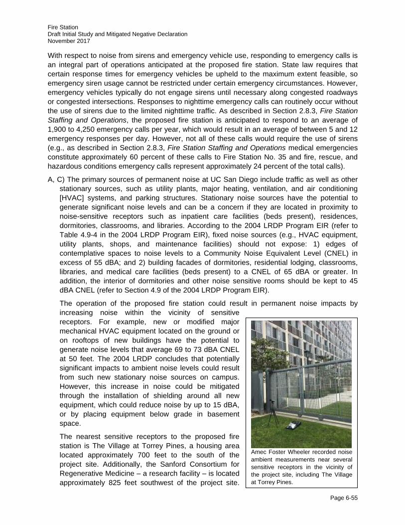
Fire Station Draft Initial Study and Mitigated Negative Declaration November 2017
Page 6-55
With respect to noise from sirens and emergency vehicle use, responding to emergency calls is an integral part of operations anticipated at the proposed fire station. State law requires that certain response times for emergency vehicles be upheld to the maximum extent feasible, so emergency siren usage cannot be restricted under certain emergency circumstances. However, emergency vehicles typically do not engage sirens until necessary along congested roadways or congested intersections. Responses to nighttime emergency calls can routinely occur without the use of sirens due to the limited nighttime traffic. As described in Section 2.8.3, Fire Station Staffing and Operations, the proposed fire station is anticipated to respond to an average of 1,900 to 4,250 emergency calls per year, which would result in an average of between 5 and 12 emergency responses per day. However, not all of these calls would require the use of sirens (e.g., as described in Section 2.8.3, Fire Station Staffing and Operations medical emergencies constitute approximately 60 percent of these calls to Fire Station No. 35 and fire, rescue, and hazardous conditions emergency calls represent approximately 24 percent of the total calls).
A, C) The primary sources of permanent noise at UC San Diego include traffic as well as other stationary sources, such as utility plants, major heating, ventilation, and air conditioning [HVAC] systems, and parking structures. Stationary noise sources have the potential to generate significant noise levels and can be a concern if they are located in proximity to noise-sensitive receptors such as inpatient care facilities (beds present), residences, dormitories, classrooms, and libraries. According to the 2004 LRDP Program EIR (refer to Table 4.9-4 in the 2004 LRDP Program EIR), fixed noise sources (e.g., HVAC equipment, utility plants, shops, and maintenance facilities) should not expose: 1) edges of contemplative spaces to noise levels to a Community Noise Equivalent Level (CNEL) in excess of 55 dBA; and 2) building facades of dormitories, residential lodging, classrooms, libraries, and medical care facilities (beds present) to a CNEL of 65 dBA or greater. In addition, the interior of dormitories and other noise sensitive rooms should be kept to 45 dBA CNEL (refer to Section 4.9 of the 2004 LRDP Program EIR).
The operation of the proposed fire station could result in permanent noise impacts by increasing noise within the vicinity of sensitive receptors. For example, new or modified major mechanical HVAC equipment located on the ground or on rooftops of new buildings have the potential to generate noise levels that average 69 to 73 dBA CNEL at 50 feet. The 2004 LRDP concludes that potentially significant impacts to ambient noise levels could result from such new stationary noise sources on campus. However, this increase in noise could be mitigated through the installation of shielding around all new equipment, which could reduce noise by up to 15 dBA, or by placing equipment below grade in basement space.
The nearest sensitive receptors to the proposed fire station is The Village at Torrey Pines, a housing area located approximately 700 feet to the south of the project site. Additionally, the Sanford Consortium for Regenerative Medicine – a research facility – is located approximately 825 feet southwest of the project site.
Amec Foster Wheeler recorded noise ambient measurements near several sensitive receptors in the vicinity of the project site, including The Village at Torrey Pines.
Fire Station Draft Initial Study and Mitigated Negative Declaration November 2017
Page 6-56
Existing average noise levels at each of these sites are provided in Table 11. Implementation of the proposed project would include HVAC equipment to support the proposed fire station as well as shops and maintenance facility space for fire apparatus that are stationed on-site. However, consistent with 2004 LRDP Mitigation Measure Noi-1A, this facility would be constructed in a manner that would avoid increasing average noise exposure to sensitive land uses by more than 3 dBA. For example, the fire station would be sited over 500 feet from the nearest academic facility and housing area. Further, to the maximum extent feasible all new HVAC equipment associated with the proposed would be shielded or located indoors. Fire truck maintenance and similar activities would be conducted within vehicles bays at the fire station and, as such, noise from these activities would be shielded from surrounding land use. Consequently, long-term impacts to the noise environment would be less than significant.
In addition to stationary noise from the fire station itself, sensitive noise receptors in the immediate vicinity of the proposed fire station would experience periodic exposure to sirens.
When sirens are necessary for an emergency response (refer to Section 2.8.3, Fire Station Staffing and Operations), they typically emit noise at a magnitude of approximately 100 dB at 100 feet (see Table 12 for comparisons of different noise levels). A decrease of about 3 dB occurs with every doubling of distance from a mobile noise source; therefore, during a response requiring sirens, The Village at Torrey Pines would experience peak short-duration exterior noise levels in the 91 to 100 dB range (see Figure 6). Similarly, administrative land uses across the street from the fire station (e.g., Torrey Pines Center North and Torrey Pines Center South) as well as the Sanford Consortium for Regenerative Medicine, would also experience peak short-duration noise levels in the 91 to 100 dB range. Because emergency vehicle response is rapid by nature, the duration of exposure to these peak noise levels in the 91 to 100 dB range is estimated to last for a maximum of 10 seconds (depending on traffic) as emergency vehicles pause at the driveway exit, engage the siren and turn onto North Torrey Pines Road and accelerate rapidly away from the proposed fire station. Based on the annual incidents by Fire Station Nos. 9 and 35, it is anticipated that such emergency responses at the proposed fire station would occur on average no more than 4 to 10 times per day. It should be noted that typical older construction practices from the 1970s would reduce typical short duration interior noise exposure to 75 to 80 dB, while more recently constructed residences such as The Village at Torrey Pines (completed in 2011), which include modern construction materials and more effective insulation, would further reduce interior noise effects. Other academic, administrative, and housing facilities farther south along North Torrey Pines Road, Genesee Avenue, and other routes used for emergency access would also be exposed to such noise levels, although the magnitude and frequency of this exposure would vary by distance from the road and proximity to the fire station. The duration of such exposure would likely be less than the projected 10 seconds than buildings in the immediate vicinity of the proposed fire station because emergency vehicles along roadways would generally be passing at full speed, with no time required for turning out of the driveway or accelerating.
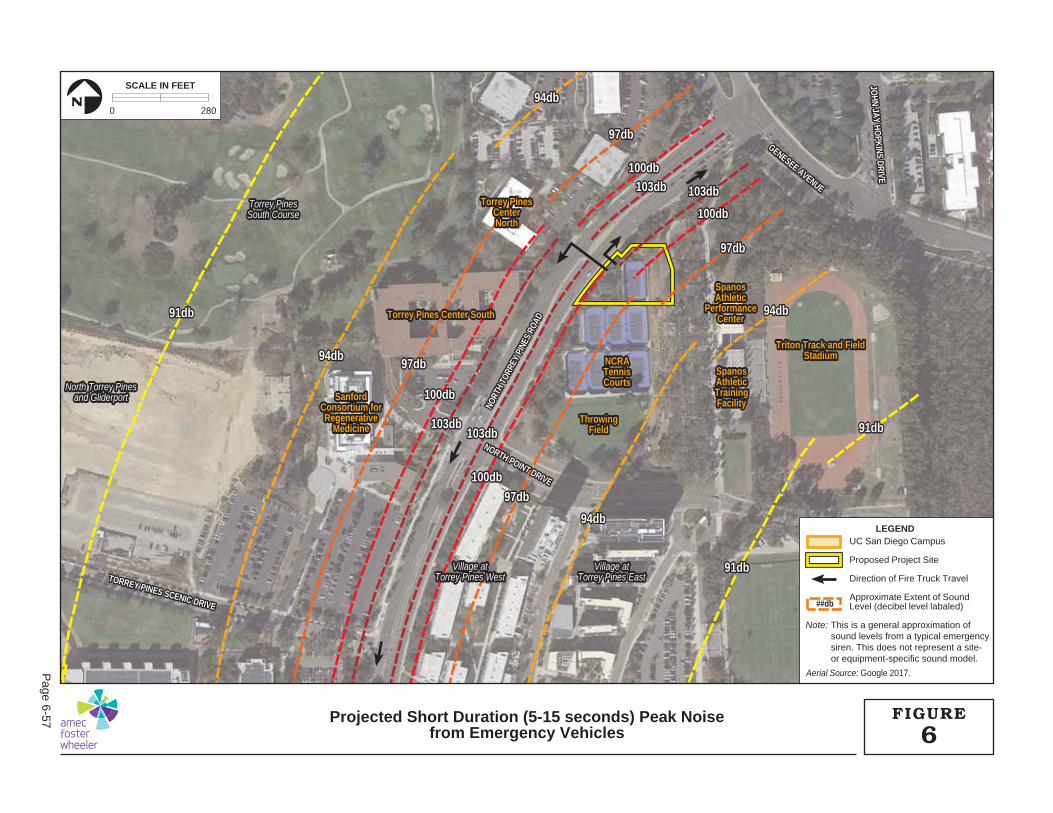
103db103db103db103db
103db103db103db103db
100db100db
100db100db
100db100db
100db100db97db97db
97db97db
97db97db
97db97db94db94db
94db94db
94db94db
94db94db91db91db
91db91db
91db91db
SpanosSpanosAthleticAthleticTrainingTrainingFacilityFacility
Triton Track and FieldTriton Track and FieldStadiumStadiumNCRANCRA
TennisTennisCourtsCourts
ThrowingThrowingFieldField
SpanosSpanosAthleticAthletic
PerformancePerformanceCenterCenterTorrey Pines Center SouthTorrey Pines Center South
Torrey PinesTorrey PinesCenterCenterNorthNorth
SanfordSanfordConsortium forConsortium forRegenerativeRegenerative
MedicineMedicine
TORREY PINES SCENIC DRIVE
TORREY PINES SCENIC DRIVE
NORTH POINT DRIVE
NORTH POINT DRIVE
GENESEE AVENUE
GENESEE AVENUEJO
HN JAY HOPKINS DRIVE
JOHN JAY HO
PKINS DRIVE
NORT
H TO
RREY
PIN
ES R
OAD
NORT
H TO
RREY
PIN
ES R
OAD
SpanosAthleticTrainingFacility
Triton Track and FieldStadiumNCRA
TennisCourts
ThrowingField
SpanosAthletic
PerformanceCenterTorrey Pines Center South
Torrey PinesCenterNorth
SanfordConsortium forRegenerative
Medicine
NORTH POINT DRIVE
TORREY PINES SCENIC DRIVE
GENESEE AVENUEJO
HN JAY HOPKINS DRIVE
NORT
H TO
RREY
PIN
ES R
OAD
Torrey PinesTorrey PinesSouth CourseSouth Course
North Torrey PinesNorth Torrey Pinesand Gliderportand Gliderport
Village atVillage atTorrey Pines WestTorrey Pines West
Village atVillage atTorrey Pines EastTorrey Pines East
Torrey PinesSouth Course
North Torrey Pinesand Gliderport
Village atTorrey Pines West
Village atTorrey Pines East
103db103db
103db103db
100db
100db
100db
100db97db
97db
97db
97db94db
94db
94db
94db91db
91db
91db
Aerial Source: Google 2017.
LEGENDUC San Diego Campus
Proposed Project Site
Direction of Fire Truck Travel
Approximate Extent of SoundLevel (decibel level labaled)
Note: This is a general approximation ofsound levels from a typical emergencysiren. This does not represent a site-or equipment-specific sound model.
##db
0 280
SCALE IN FEET
N
6FIGUREProjected Short Duration (5-15 seconds) Peak Noise
from Emergency Vehicles
Page 6-57
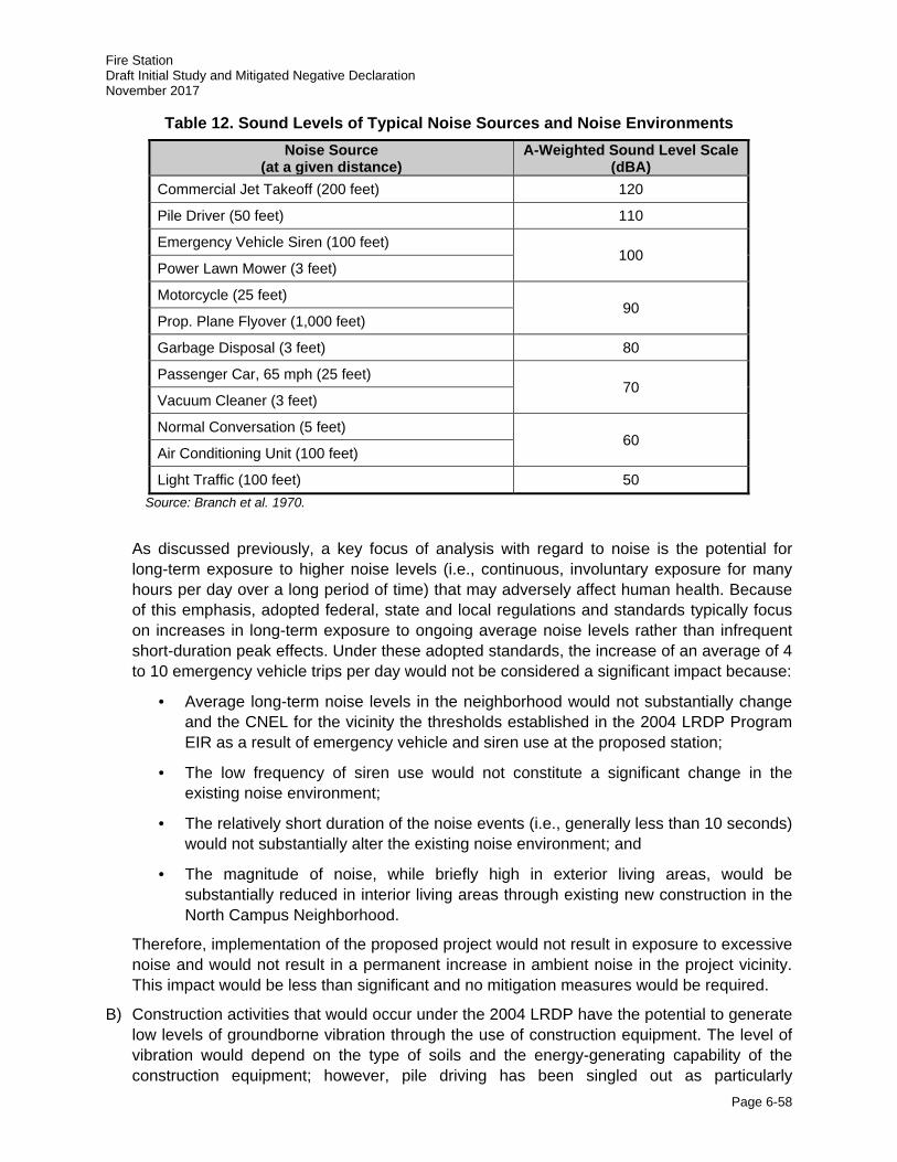
Fire Station Draft Initial Study and Mitigated Negative Declaration November 2017
Page 6-58
Table 12. Sound Levels of Typical Noise Sources and Noise Environments Noise Source
(at a given distance) A-Weighted Sound Level Scale
(dBA) Commercial Jet Takeoff (200 feet) 120
Pile Driver (50 feet) 110
Emergency Vehicle Siren (100 feet) 100
Power Lawn Mower (3 feet)
Motorcycle (25 feet) 90
Prop. Plane Flyover (1,000 feet)
Garbage Disposal (3 feet) 80
Passenger Car, 65 mph (25 feet) 70
Vacuum Cleaner (3 feet)
Normal Conversation (5 feet) 60
Air Conditioning Unit (100 feet)
Light Traffic (100 feet) 50 Source: Branch et al. 1970.
As discussed previously, a key focus of analysis with regard to noise is the potential for long-term exposure to higher noise levels (i.e., continuous, involuntary exposure for many hours per day over a long period of time) that may adversely affect human health. Because of this emphasis, adopted federal, state and local regulations and standards typically focus on increases in long-term exposure to ongoing average noise levels rather than infrequent short-duration peak effects. Under these adopted standards, the increase of an average of 4 to 10 emergency vehicle trips per day would not be considered a significant impact because:
· Average long-term noise levels in the neighborhood would not substantially change and the CNEL for the vicinity the thresholds established in the 2004 LRDP Program EIR as a result of emergency vehicle and siren use at the proposed station;
· The low frequency of siren use would not constitute a significant change in the existing noise environment;
· The relatively short duration of the noise events (i.e., generally less than 10 seconds) would not substantially alter the existing noise environment; and
· The magnitude of noise, while briefly high in exterior living areas, would be substantially reduced in interior living areas through existing new construction in the North Campus Neighborhood.
Therefore, implementation of the proposed project would not result in exposure to excessive noise and would not result in a permanent increase in ambient noise in the project vicinity. This impact would be less than significant and no mitigation measures would be required.
B) Construction activities that would occur under the 2004 LRDP have the potential to generate low levels of groundborne vibration through the use of construction equipment. The level of vibration would depend on the type of soils and the energy-generating capability of the construction equipment; however, pile driving has been singled out as particularly
Fire Station Draft Initial Study and Mitigated Negative Declaration November 2017
Page 6-59
problematic. As a guide, the 2004 LRDP Program EIR determined that any major construction activity within 200 feet of vibration-sensitive equipment and operations or pile driving within 600 feet may be potentially disruptive to sensitive operations and result in significant impacts.
However, construction of the proposed project would not involve activities that would result in major groundborne vibration (i.e., pile driving) that would adversely impact vibration-sensitive operations to adjacent land uses. In addition, adequate construction notice would be provided to all surrounding land uses to ensure that adjacent users can plan their activities accordingly. Therefore, this impact is considered to be less than significant and no mitigation measures would be required.
D) Construction of the proposed project would result in temporary noise impacts in the immediate vicinity of the project site due to operation of heavy equipment. Although, no noise-sensitive receptors would be adversely impacted during construction of the proposed project, implementation of Noi-2A from the 2004 LRDP Program EIR would ensure that construction noise impacts would remain less than significant.
2004 LRDP Program EIR Mitigation Measure:
Noi-2A: UC San Diego shall implement the following measures to minimize short-term noise levels caused by construction activities. Measures to reduce construction/demolition noise to the maximum extent feasible shall be included in contractor specifications and shall include, but not be limited to, the following:
i. The construction contractor shall be required to work in such a manner so as not to exceed a 12-hour average sound level of 75 dBA at any noise-sensitive land use (dormitories/residential/lodging, contemplative spaces, libraries, inpatient medical care facility [beds present], and classrooms) between 7:00 AM and 7:00 PM Monday through Saturday.
ii. Construction equipment shall be properly outfitted and maintained with manufacturer recommended noise-reduction devices to minimize construction-generated noise.
iii. Stationary construction noise sources such as generators or pumps shall be located at least 100 feet from noise-sensitive land uses as feasible.
iv. Laydown and construction vehicle staging areas shall be located as far from noise-sensitive land uses as feasible.
v. All neighboring land uses that would be subject to construction noise shall be informed at least two weeks prior to the start of each construction project, whenever possible.
vi. Loud construction activity such as jackhammering, concrete sawing, asphalt removal, pile driving, and large-scale grading operations occurring within 100 feet of a residential or academic building shall not be scheduled during any finals week of classes to the extent feasible or consider adjusting the hours or days of construction.
vii. Loud construction activity, such as jackhammering, concrete sawing, asphalt removal, pile driving, and large-scale grading operations, occurring within 100 feet of an academic or residential use shall be scheduled during holidays, class breaks, and/or summer session, to the extent feasible.
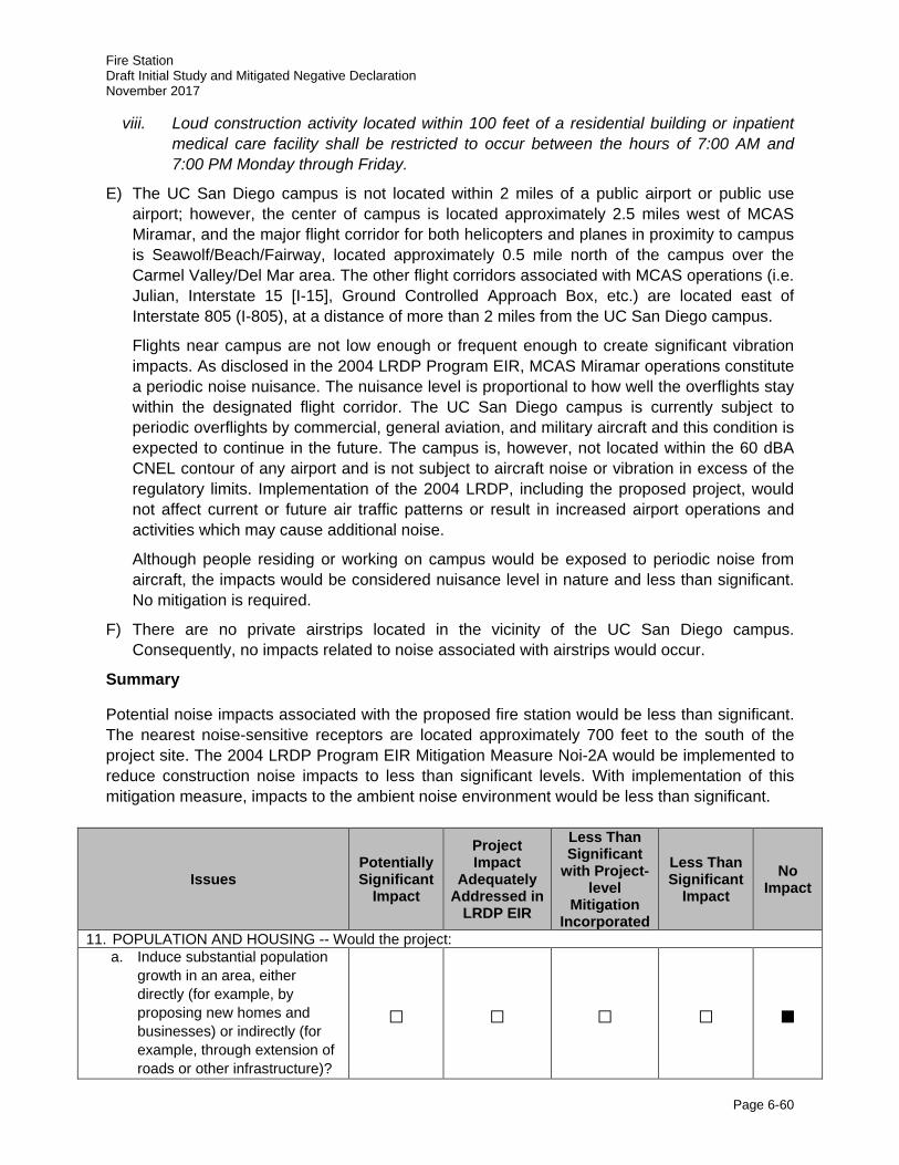
Fire Station Draft Initial Study and Mitigated Negative Declaration November 2017
Page 6-60
viii. Loud construction activity located within 100 feet of a residential building or inpatient medical care facility shall be restricted to occur between the hours of 7:00 AM and 7:00 PM Monday through Friday.
E) The UC San Diego campus is not located within 2 miles of a public airport or public use airport; however, the center of campus is located approximately 2.5 miles west of MCAS Miramar, and the major flight corridor for both helicopters and planes in proximity to campus is Seawolf/Beach/Fairway, located approximately 0.5 mile north of the campus over the Carmel Valley/Del Mar area. The other flight corridors associated with MCAS operations (i.e. Julian, Interstate 15 [I-15], Ground Controlled Approach Box, etc.) are located east of Interstate 805 (I-805), at a distance of more than 2 miles from the UC San Diego campus.
Flights near campus are not low enough or frequent enough to create significant vibration impacts. As disclosed in the 2004 LRDP Program EIR, MCAS Miramar operations constitute a periodic noise nuisance. The nuisance level is proportional to how well the overflights stay within the designated flight corridor. The UC San Diego campus is currently subject to periodic overflights by commercial, general aviation, and military aircraft and this condition is expected to continue in the future. The campus is, however, not located within the 60 dBA CNEL contour of any airport and is not subject to aircraft noise or vibration in excess of the regulatory limits. Implementation of the 2004 LRDP, including the proposed project, would not affect current or future air traffic patterns or result in increased airport operations and activities which may cause additional noise.
Although people residing or working on campus would be exposed to periodic noise from aircraft, the impacts would be considered nuisance level in nature and less than significant. No mitigation is required.
F) There are no private airstrips located in the vicinity of the UC San Diego campus. Consequently, no impacts related to noise associated with airstrips would occur.
Summary
Potential noise impacts associated with the proposed fire station would be less than significant. The nearest noise-sensitive receptors are located approximately 700 feet to the south of the project site. The 2004 LRDP Program EIR Mitigation Measure Noi-2A would be implemented to reduce construction noise impacts to less than significant levels. With implementation of this mitigation measure, impacts to the ambient noise environment would be less than significant.
Issues Potentially Significant
Impact
Project Impact
Adequately Addressed in
LRDP EIR
Less Than Significant
with Project-level
Mitigation Incorporated
Less Than Significant
Impact No
Impact
11. POPULATION AND HOUSING -- Would the project: a. Induce substantial population
growth in an area, either directly (for example, by proposing new homes and businesses) or indirectly (for example, through extension of roads or other infrastructure)?
□ □ □ □ ■
Fire Station Draft Initial Study and Mitigated Negative Declaration November 2017
Page 6-61
Issues Potentially Significant
Impact
Project Impact
Adequately Addressed in
LRDP EIR
Less Than Significant
with Project-level
Mitigation Incorporated
Less Than Significant
Impact No
Impact
b. Displace substantial numbers of existing housing, necessitating the construction of replacement housing elsewhere?
□ □ □ □ ■
c. Displace substantial numbers of people, necessitating the construction of replacement housing elsewhere?
□ □ □ □ ■
Population and Housing Discussion
Population and housing issues are discussed in Section 4.10 of the 2004 LRDP Program EIR. The analysis is based on a population and housing report on the 2004 LRDP prepared by Keyser Marston and Associates (UC San Diego 2004b).
A) Implementation of the 2004 LRDP would result in population growth on the campus because it assumes an increase in the numbers of students, faculty, researchers, and staff over time, but this growth is anticipated by the University Community Plan (City of San Diego 2014). Implementation of the proposed project would contribute to the City of San Diego’s and UC San Diego’s ability to serve the growing population in the State of California and, therefore, on a statewide scale is not considered population inducing but rather responding to the demand of an increased population.
As stated in the 2004 LRDP Program EIR, while the growth of UC San Diego is consistent with locally-adopted plans, the environmental effects associated with campus growth, such as those resulting from increased traffic and increased demands on services and utilities, are addressed in the respective sections of the 2004 LRDP Program EIR. Implementation of the proposed project is, however, not expected to directly or indirectly induce growth by expanding infrastructure or removing an obstacle to growth. As the proposed project is an infill development that would provide the necessary fire and emergency services anticipated to serve the existing and projected needs of the campus and surrounding communities, impacts related to direct and indirect inducement of population growth are not considered significant. As such, no impacts would occur, and no mitigation measures would be required.
B, C) The proposed project would not result in the displacement of substantial numbers of people or existing off-campus housing. Further, the proposed project would not require the construction of replacement housing elsewhere. The proposed project would be located within an existing developed area of campus, and no housing units would be displaced or added as a result of project implementation. The living quarters that would be included in the proposed fire station would be used by SDFD fire rescue personnel during rotating shifts and would not be a permanent place of residence. No impacts would occur and no mitigation measures would be required as a result of the implementation of the proposed project.
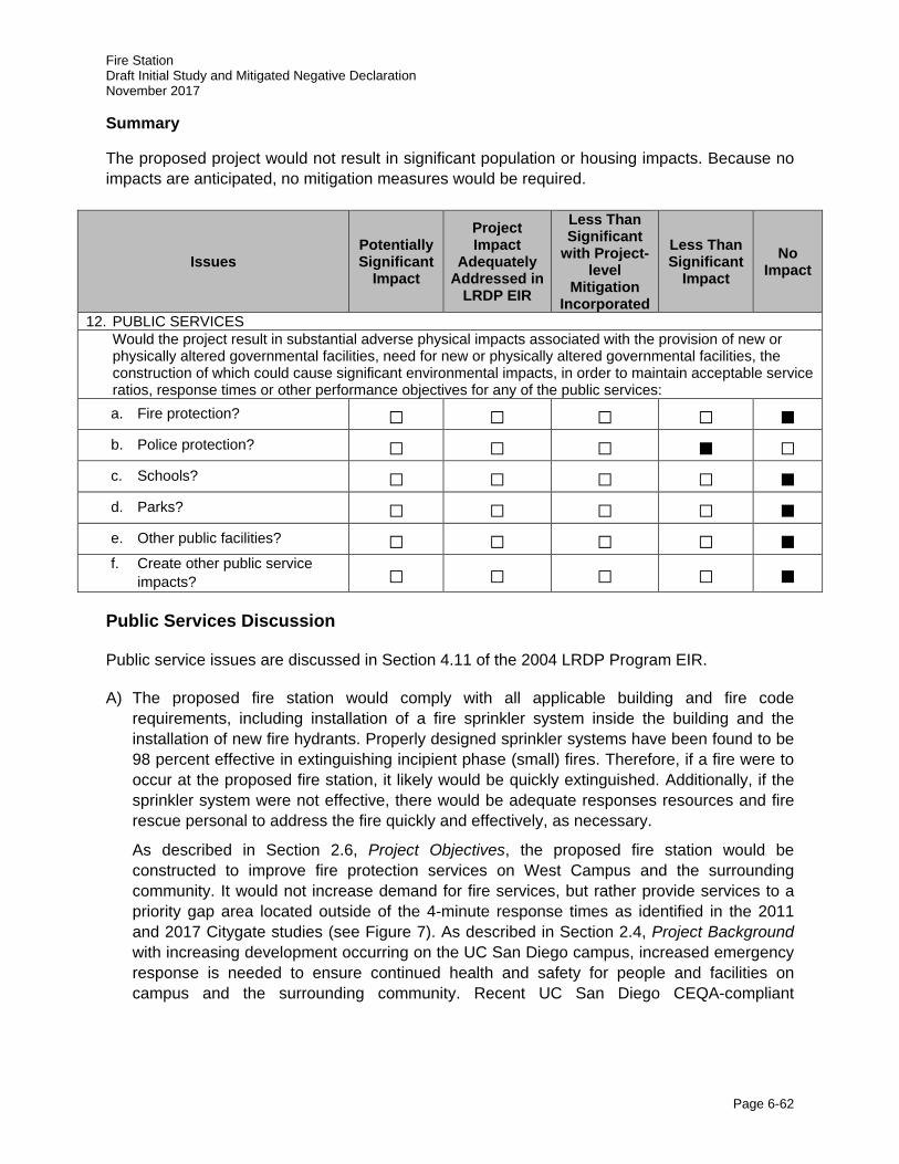
Fire Station Draft Initial Study and Mitigated Negative Declaration November 2017
Page 6-62
Summary
The proposed project would not result in significant population or housing impacts. Because no impacts are anticipated, no mitigation measures would be required.
Issues Potentially Significant
Impact
Project Impact
Adequately Addressed in
LRDP EIR
Less Than Significant
with Project-level
Mitigation Incorporated
Less Than Significant
Impact No
Impact
12. PUBLIC SERVICES Would the project result in substantial adverse physical impacts associated with the provision of new or physically altered governmental facilities, need for new or physically altered governmental facilities, the construction of which could cause significant environmental impacts, in order to maintain acceptable service ratios, response times or other performance objectives for any of the public services: a. Fire protection? □ □ □ □ ■
b. Police protection? □ □ □ ■ □
c. Schools? □ □ □ □ ■
d. Parks? □ □ □ □ ■
e. Other public facilities? □ □ □ □ ■ f. Create other public service
impacts? □ □ □ □ ■
Public Services Discussion
Public service issues are discussed in Section 4.11 of the 2004 LRDP Program EIR.
A) The proposed fire station would comply with all applicable building and fire code requirements, including installation of a fire sprinkler system inside the building and the installation of new fire hydrants. Properly designed sprinkler systems have been found to be 98 percent effective in extinguishing incipient phase (small) fires. Therefore, if a fire were to occur at the proposed fire station, it likely would be quickly extinguished. Additionally, if the sprinkler system were not effective, there would be adequate responses resources and fire rescue personal to address the fire quickly and effectively, as necessary.
As described in Section 2.6, Project Objectives, the proposed fire station would be constructed to improve fire protection services on West Campus and the surrounding community. It would not increase demand for fire services, but rather provide services to a priority gap area located outside of the 4-minute response times as identified in the 2011 and 2017 Citygate studies (see Figure 7). As described in Section 2.4, Project Background with increasing development occurring on the UC San Diego campus, increased emergency response is needed to ensure continued health and safety for people and facilities on campus and the surrounding community. Recent UC San Diego CEQA-compliant
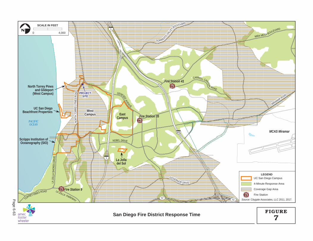
PROJECTPROJECTSITESITE
PROJECTSITE
★
805
5
5
5252
Fire Station 35
Fire Station 41Fire Station 41
Fire Station 35
Fire Station 9
Fire Station 41
MCAS Miramar
GOVERNOR DRIVE
MIRAMAR ROAD
MIRAMAR ROAD
NORT
H TO
RR
EYPI
NES
ROAD
SORRENTO V
ALLE
Y BOULEVARDTO
RREY PINES ROAD
GOVERNOR DRIVE
LA JOLLA PARKWAY
LA J
OLL
A SH
ORE
S DR
IVE
MIRAMAR ROAD
NORT
H TO
RR
EY P
INES
RO
ADCARROLL CANYO
N
ROAD
SORRENTO V
ALLE
Y BOULEVARD
NOBEL DRIVE
GENESEE AVENUE
MIRA MESA BOULEVARD
F
F
FA J
WestWestCampusCampus
WestCampus East
Campus
Scripps Institution ofOceanography (SIO)
North Torrey Pinesand Glideport
(West Campus)
UC San DiegoBeachfront Properties
La Jolladel Sol
PACIFICOCEAN
LEGENDUC San Diego Campus
4-Minute Response Area
Coverage Gap Area
Fire Station
Source: Citygate Associates, LLC 2011, 2017.
0 4,000
SCALE IN FEET
N
7FIGURE
San Diego Fire District Response Time
Page 6-63
Fire Station Draft Initial Study and Mitigated Negative Declaration November 2017
Page 6-64
environmental documents have acknowledged that projects on campus have the potential to contribute to a cumulatively considerable burden related to fire protection and emergency medical services in the City of San Diego. These CEQA-compliant environmental documents have included a project-specific mitigation measure stating that UC San Diego shall work with the City to identify a suitable site to construct a new fire station in proximity to the campus. The mitigation measure requires that UC San Diego pay its proportionate share of the cost of mitigating the impacts associated with the construction of a new fire station by contributing either land or money or some combination thereof. Implementation of the proposed project, including construction of the proposed fire station, would fulfill the mitigation measure for these previously developed projects. Through the Development Agreement with the City, UC San Diego would build the fire station, then deed the land to the City. The City would then be responsible for equipping, staffing, operating, and maintaining the facility. The implementation of the proposed project would address existing coverage gaps (refer to Section 2.4, Project Background) and would result in a beneficial impact on fire services.
B) UC San Diego provides its own police service for the UC San Diego campus as well as other UC San Diego properties. Pursuant to California Education Code Section 67381, the UC San Diego Police Department and the San Diego Police Department (SDPD) have adopted and signed a written agreement that clarifies and affixes operational responsibilities for the investigation of violent and non-violent crimes occurring on UC San Diego property. Pursuant to the agreement, UC San Diego Police Department is the primary reporting and investigating law enforcement agency for nearly all crimes occurring on campus and over all UC San Diego-administered properties located within up to 1-mile of campus. Both UC San Diego Police Department and SDPD provide mutual aid assistance as appropriate, when requested (UC San Diego 2015). As a result, the SDPD rarely responds to calls for police services. The campus’ low demand for SDPD police services reduces the need for new off-campus police facilities or expansions of existing facilities. Further, the proposed project is not expected to generate the need for new police facilities or expansions of existing facilities. Therefore, the physical impacts of providing police protection to the proposed project would be less than significant.
C) The demand for K-12 grade public education facilities generated by the UC San Diego population is associated primarily with married students, faculty, and staff households. Implementation of the proposed project would not result in a need to build new school facilities. Therefore, no physical adverse effect with respect to the provision of adequate school facilities would occur with implementation of the proposed fire station project.
D) As analyzed below under the Recreation Discussion, less than significant impacts are anticipated to on- and off-campus recreational facilities, including parks.
E, F) No other impacts to schools, libraries, parks, or other public facilities are expected.
Summary
Implementation of the proposed project would not result in significant impacts to public services. Implementation of the proposed project, including construction of the proposed fire station, would fulfill a mitigation measure for previously developed projects on campus that had the potential to contribute to cumulatively substantial impacts to the demand for fire and other emergency services. The proposed project would enhance the response time of fire and other
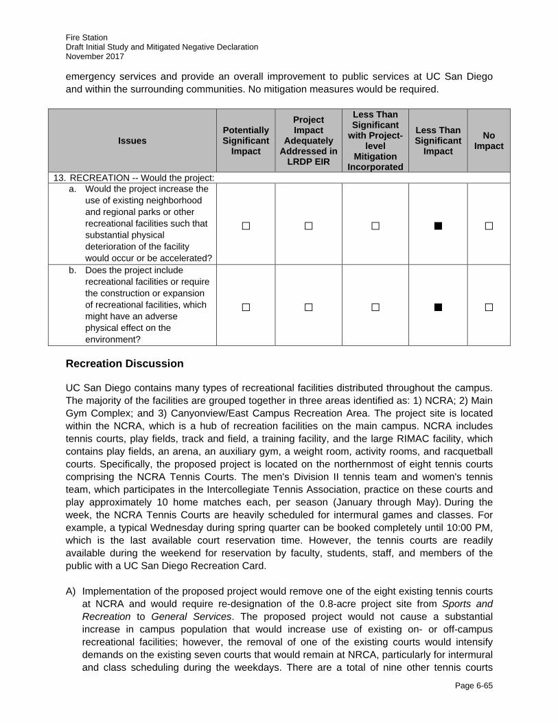
Fire Station Draft Initial Study and Mitigated Negative Declaration November 2017
Page 6-65
emergency services and provide an overall improvement to public services at UC San Diego and within the surrounding communities. No mitigation measures would be required.
Issues Potentially Significant
Impact
Project Impact
Adequately Addressed in
LRDP EIR
Less Than Significant
with Project-level
Mitigation Incorporated
Less Than Significant
Impact No
Impact
13. RECREATION -- Would the project: a. Would the project increase the
use of existing neighborhood and regional parks or other recreational facilities such that substantial physical deterioration of the facility would occur or be accelerated?
□ □ □ ■ □
b. Does the project include recreational facilities or require the construction or expansion of recreational facilities, which might have an adverse physical effect on the environment?
□ □ □ ■ □
Recreation Discussion
UC San Diego contains many types of recreational facilities distributed throughout the campus. The majority of the facilities are grouped together in three areas identified as: 1) NCRA; 2) Main Gym Complex; and 3) Canyonview/East Campus Recreation Area. The project site is located within the NCRA, which is a hub of recreation facilities on the main campus. NCRA includes tennis courts, play fields, track and field, a training facility, and the large RIMAC facility, which contains play fields, an arena, an auxiliary gym, a weight room, activity rooms, and racquetball courts. Specifically, the proposed project is located on the northernmost of eight tennis courts comprising the NCRA Tennis Courts. The men's Division II tennis team and women's tennis team, which participates in the Intercollegiate Tennis Association, practice on these courts and play approximately 10 home matches each, per season (January through May). During the week, the NCRA Tennis Courts are heavily scheduled for intermural games and classes. For example, a typical Wednesday during spring quarter can be booked completely until 10:00 PM, which is the last available court reservation time. However, the tennis courts are readily available during the weekend for reservation by faculty, students, staff, and members of the public with a UC San Diego Recreation Card. A) Implementation of the proposed project would remove one of the eight existing tennis courts
at NCRA and would require re-designation of the 0.8-acre project site from Sports and Recreation to General Services. The proposed project would not cause a substantial increase in campus population that would increase use of existing on- or off-campus recreational facilities; however, the removal of one of the existing courts would intensify demands on the existing seven courts that would remain at NRCA, particularly for intermural and class scheduling during the weekdays. There are a total of nine other tennis courts
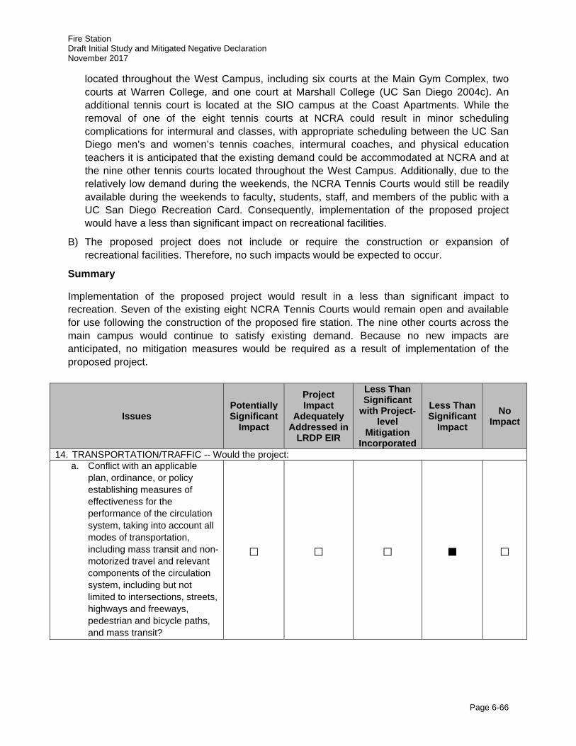
Fire Station Draft Initial Study and Mitigated Negative Declaration November 2017
Page 6-66
located throughout the West Campus, including six courts at the Main Gym Complex, two courts at Warren College, and one court at Marshall College (UC San Diego 2004c). An additional tennis court is located at the SIO campus at the Coast Apartments. While the removal of one of the eight tennis courts at NCRA could result in minor scheduling complications for intermural and classes, with appropriate scheduling between the UC San Diego men’s and women’s tennis coaches, intermural coaches, and physical education teachers it is anticipated that the existing demand could be accommodated at NCRA and at the nine other tennis courts located throughout the West Campus. Additionally, due to the relatively low demand during the weekends, the NCRA Tennis Courts would still be readily available during the weekends to faculty, students, staff, and members of the public with a UC San Diego Recreation Card. Consequently, implementation of the proposed project would have a less than significant impact on recreational facilities.
B) The proposed project does not include or require the construction or expansion of recreational facilities. Therefore, no such impacts would be expected to occur.
Summary
Implementation of the proposed project would result in a less than significant impact to recreation. Seven of the existing eight NCRA Tennis Courts would remain open and available for use following the construction of the proposed fire station. The nine other courts across the main campus would continue to satisfy existing demand. Because no new impacts are anticipated, no mitigation measures would be required as a result of implementation of the proposed project.
Issues Potentially Significant
Impact
Project Impact
Adequately Addressed in
LRDP EIR
Less Than Significant
with Project-level
Mitigation Incorporated
Less Than Significant
Impact No
Impact
14. TRANSPORTATION/TRAFFIC -- Would the project: a. Conflict with an applicable
plan, ordinance, or policy establishing measures of effectiveness for the performance of the circulation system, taking into account all modes of transportation, including mass transit and non-motorized travel and relevant components of the circulation system, including but not limited to intersections, streets, highways and freeways, pedestrian and bicycle paths, and mass transit?
□ □ □ ■ □
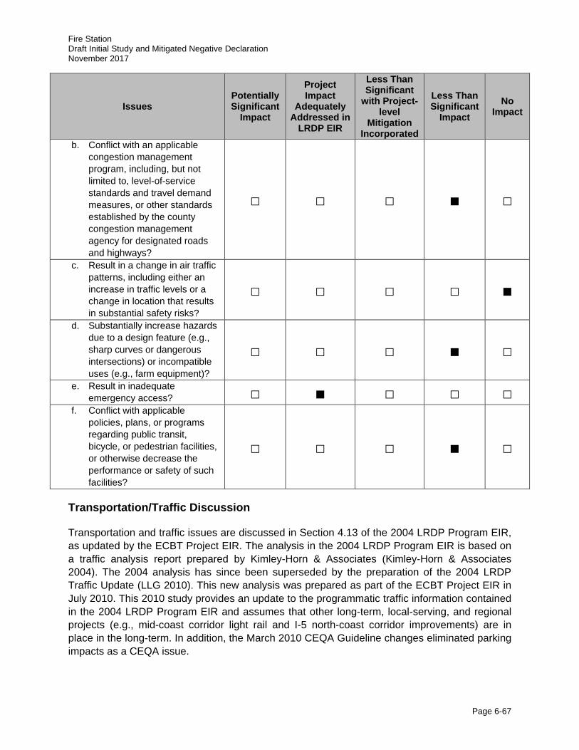
Fire Station Draft Initial Study and Mitigated Negative Declaration November 2017
Page 6-67
Issues Potentially Significant
Impact
Project Impact
Adequately Addressed in
LRDP EIR
Less Than Significant
with Project-level
Mitigation Incorporated
Less Than Significant
Impact No
Impact
b. Conflict with an applicable congestion management program, including, but not limited to, level-of-service standards and travel demand measures, or other standards established by the county congestion management agency for designated roads and highways?
□ □ □ ■ □
c. Result in a change in air traffic patterns, including either an increase in traffic levels or a change in location that results in substantial safety risks?
□ □ □ □ ■
d. Substantially increase hazards due to a design feature (e.g., sharp curves or dangerous intersections) or incompatible uses (e.g., farm equipment)?
□ □ □ ■ □
e. Result in inadequate emergency access? □ ■ □ □ □
f. Conflict with applicable policies, plans, or programs regarding public transit, bicycle, or pedestrian facilities, or otherwise decrease the performance or safety of such facilities?
□ □ □ ■ □
Transportation/Traffic Discussion
Transportation and traffic issues are discussed in Section 4.13 of the 2004 LRDP Program EIR, as updated by the ECBT Project EIR. The analysis in the 2004 LRDP Program EIR is based on a traffic analysis report prepared by Kimley-Horn & Associates (Kimley-Horn & Associates 2004). The 2004 analysis has since been superseded by the preparation of the 2004 LRDP Traffic Update (LLG 2010). This new analysis was prepared as part of the ECBT Project EIR in July 2010. This 2010 study provides an update to the programmatic traffic information contained in the 2004 LRDP Program EIR and assumes that other long-term, local-serving, and regional projects (e.g., mid-coast corridor light rail and I-5 north-coast corridor improvements) are in place in the long-term. In addition, the March 2010 CEQA Guideline changes eliminated parking impacts as a CEQA issue.
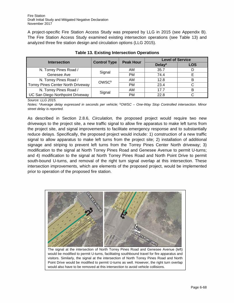
Fire Station Draft Initial Study and Mitigated Negative Declaration November 2017
Page 6-68
A project-specific Fire Station Access Study was prepared by LLG in 2015 (see Appendix B). The Fire Station Access Study examined existing intersection operations (see Table 13) and analyzed three fire station design and circulation options (LLG 2015).
Table 13. Existing Intersection Operations
Intersection Control Type Peak Hour Level of Service Delaya LOS
N. Torrey Pines Road / Genesee Ave Signal AM 35.7 D
PM 74.4 E N. Torrey Pines Road /
Torrey Pines Center North Driveway OWSCb AM 12.8 B PM 23.4 C
N. Torrey Pines Road / UC San Diego Northpoint Driveway Signal AM 17.7 B
PM 22.8 C Source: LLG 2015. Notes: aAverage delay expressed in seconds per vehicle; bOWSC – One-Way Stop Controlled intersection. Minor street delay is reported.
As described in Section 2.8.6, Circulation, the proposed project would require two new driveways to the project site, a new traffic signal to allow fire apparatus to make left turns from the project site, and signal improvements to facilitate emergency response and to substantially reduce delays. Specifically, the proposed project would include: 1) construction of a new traffic signal to allow apparatus to make left turns from the project site; 2) installation of additional signage and striping to prevent left turns from the Torrey Pines Center North driveway; 3) modification to the signal at North Torrey Pines Road and Genesee Avenue to permit U-turns; and 4) modification to the signal at North Torrey Pines Road and North Point Drive to permit south-bound U-turns, and removal of the right turn signal overlap at this intersection. These intersection improvements, which are elements of the proposed project, would be implemented prior to operation of the proposed fire station.
The signal at the intersection of North Torrey Pines Road and Genesee Avenue (left) would be modified to permit U-turns, facilitating southbound travel for fire apparatus and visitors. Similarly, the signal at the intersection of North Torrey Pines Road and North Point Drive would be modified to permit U-turns as well. However, the right turn overlap would also have to be removed at this intersection to avoid vehicle collisions.
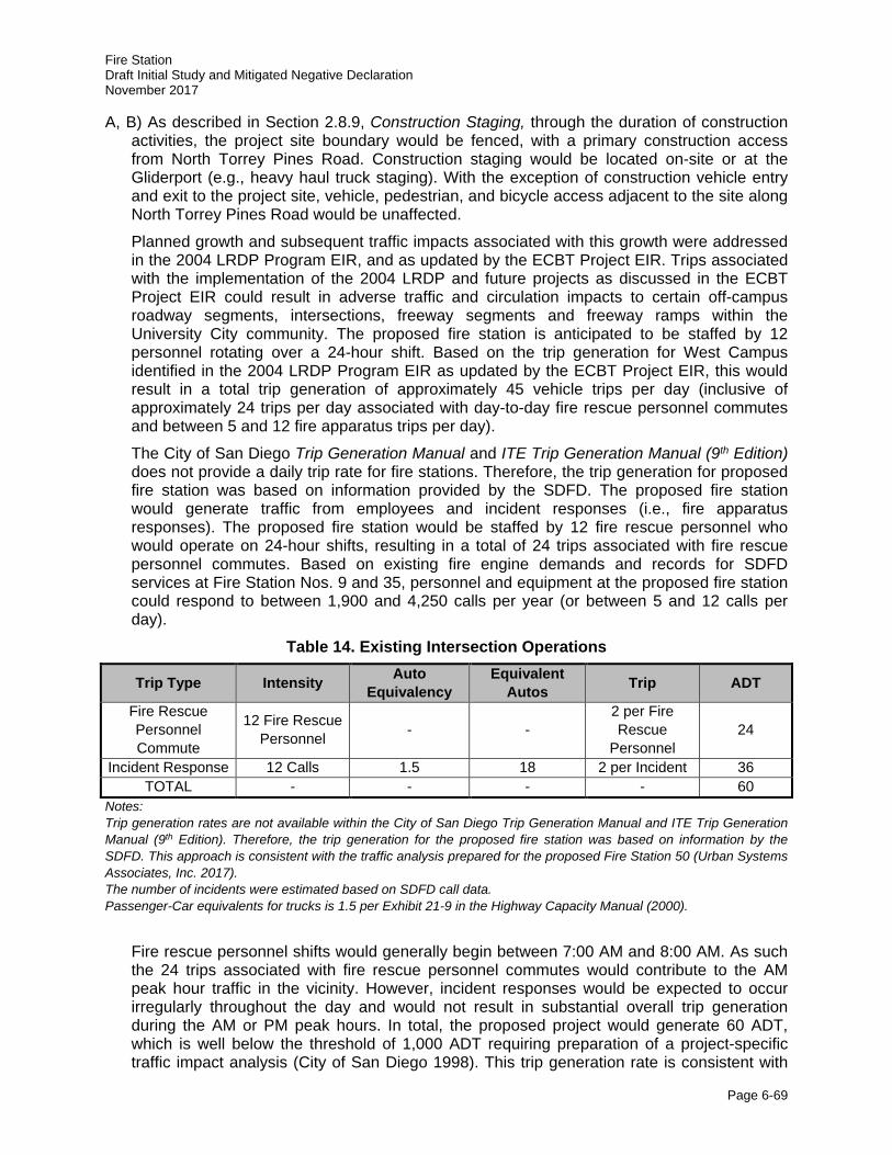
Fire Station Draft Initial Study and Mitigated Negative Declaration November 2017
Page 6-69
A, B) As described in Section 2.8.9, Construction Staging, through the duration of construction activities, the project site boundary would be fenced, with a primary construction access from North Torrey Pines Road. Construction staging would be located on-site or at the Gliderport (e.g., heavy haul truck staging). With the exception of construction vehicle entry and exit to the project site, vehicle, pedestrian, and bicycle access adjacent to the site along North Torrey Pines Road would be unaffected.
Planned growth and subsequent traffic impacts associated with this growth were addressed in the 2004 LRDP Program EIR, and as updated by the ECBT Project EIR. Trips associated with the implementation of the 2004 LRDP and future projects as discussed in the ECBT Project EIR could result in adverse traffic and circulation impacts to certain off-campus roadway segments, intersections, freeway segments and freeway ramps within the University City community. The proposed fire station is anticipated to be staffed by 12 personnel rotating over a 24-hour shift. Based on the trip generation for West Campus identified in the 2004 LRDP Program EIR as updated by the ECBT Project EIR, this would result in a total trip generation of approximately 45 vehicle trips per day (inclusive of approximately 24 trips per day associated with day-to-day fire rescue personnel commutes and between 5 and 12 fire apparatus trips per day).
The City of San Diego Trip Generation Manual and ITE Trip Generation Manual (9th Edition) does not provide a daily trip rate for fire stations. Therefore, the trip generation for proposed fire station was based on information provided by the SDFD. The proposed fire station would generate traffic from employees and incident responses (i.e., fire apparatus responses). The proposed fire station would be staffed by 12 fire rescue personnel who would operate on 24-hour shifts, resulting in a total of 24 trips associated with fire rescue personnel commutes. Based on existing fire engine demands and records for SDFD services at Fire Station Nos. 9 and 35, personnel and equipment at the proposed fire station could respond to between 1,900 and 4,250 calls per year (or between 5 and 12 calls per day).
Table 14. Existing Intersection Operations
Trip Type Intensity Auto Equivalency
Equivalent Autos Trip ADT
Fire Rescue Personnel Commute
12 Fire Rescue Personnel - -
2 per Fire Rescue
Personnel 24
Incident Response 12 Calls 1.5 18 2 per Incident 36 TOTAL - - - - 60
Notes: Trip generation rates are not available within the City of San Diego Trip Generation Manual and ITE Trip Generation Manual (9th Edition). Therefore, the trip generation for the proposed fire station was based on information by the SDFD. This approach is consistent with the traffic analysis prepared for the proposed Fire Station 50 (Urban Systems Associates, Inc. 2017). The number of incidents were estimated based on SDFD call data. Passenger-Car equivalents for trucks is 1.5 per Exhibit 21-9 in the Highway Capacity Manual (2000).
Fire rescue personnel shifts would generally begin between 7:00 AM and 8:00 AM. As such the 24 trips associated with fire rescue personnel commutes would contribute to the AM peak hour traffic in the vicinity. However, incident responses would be expected to occur irregularly throughout the day and would not result in substantial overall trip generation during the AM or PM peak hours. In total, the proposed project would generate 60 ADT, which is well below the threshold of 1,000 ADT requiring preparation of a project-specific traffic impact analysis (City of San Diego 1998). This trip generation rate is consistent with
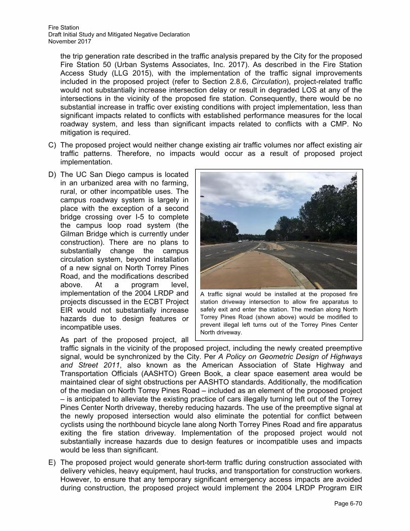
Fire Station Draft Initial Study and Mitigated Negative Declaration November 2017
Page 6-70
the trip generation rate described in the traffic analysis prepared by the City for the proposed Fire Station 50 (Urban Systems Associates, Inc. 2017). As described in the Fire Station Access Study (LLG 2015), with the implementation of the traffic signal improvements included in the proposed project (refer to Section 2.8.6, Circulation), project-related traffic would not substantially increase intersection delay or result in degraded LOS at any of the intersections in the vicinity of the proposed fire station. Consequently, there would be no substantial increase in traffic over existing conditions with project implementation, less than significant impacts related to conflicts with established performance measures for the local roadway system, and less than significant impacts related to conflicts with a CMP. No mitigation is required.
C) The proposed project would neither change existing air traffic volumes nor affect existing air traffic patterns. Therefore, no impacts would occur as a result of proposed project implementation.
D) The UC San Diego campus is located in an urbanized area with no farming, rural, or other incompatible uses. The campus roadway system is largely in place with the exception of a second bridge crossing over I-5 to complete the campus loop road system (the Gilman Bridge which is currently under construction). There are no plans to substantially change the campus circulation system, beyond installation of a new signal on North Torrey Pines Road, and the modifications described above. At a program level, implementation of the 2004 LRDP and projects discussed in the ECBT Project EIR would not substantially increase hazards due to design features or incompatible uses.
As part of the proposed project, all traffic signals in the vicinity of the proposed project, including the newly created preemptive signal, would be synchronized by the City. Per A Policy on Geometric Design of Highways and Street 2011, also known as the American Association of State Highway and Transportation Officials (AASHTO) Green Book, a clear space easement area would be maintained clear of sight obstructions per AASHTO standards. Additionally, the modification of the median on North Torrey Pines Road – included as an element of the proposed project – is anticipated to alleviate the existing practice of cars illegally turning left out of the Torrey Pines Center North driveway, thereby reducing hazards. The use of the preemptive signal at the newly proposed intersection would also eliminate the potential for conflict between cyclists using the northbound bicycle lane along North Torrey Pines Road and fire apparatus exiting the fire station driveway. Implementation of the proposed project would not substantially increase hazards due to design features or incompatible uses and impacts would be less than significant.
E) The proposed project would generate short-term traffic during construction associated with delivery vehicles, heavy equipment, haul trucks, and transportation for construction workers. However, to ensure that any temporary significant emergency access impacts are avoided during construction, the proposed project would implement the 2004 LRDP Program EIR
A traffic signal would be installed at the proposed fire station driveway intersection to allow fire apparatus to safely exit and enter the station. The median along North Torrey Pines Road (shown above) would be modified to prevent illegal left turns out of the Torrey Pines Center North driveway.
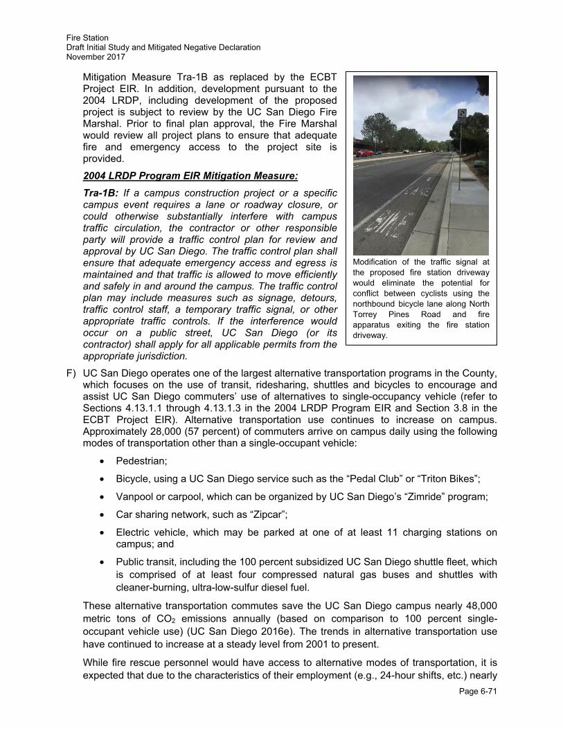
Fire Station Draft Initial Study and Mitigated Negative Declaration November 2017
Page 6-71
Mitigation Measure Tra-1B as replaced by the ECBT Project EIR. In addition, development pursuant to the 2004 LRDP, including development of the proposed project is subject to review by the UC San Diego Fire Marshal. Prior to final plan approval, the Fire Marshal would review all project plans to ensure that adequate fire and emergency access to the project site is provided. 2004 LRDP Program EIR Mitigation Measure: Tra-1B: If a campus construction project or a specific campus event requires a lane or roadway closure, or could otherwise substantially interfere with campus traffic circulation, the contractor or other responsible party will provide a traffic control plan for review and approval by UC San Diego. The traffic control plan shall ensure that adequate emergency access and egress is maintained and that traffic is allowed to move efficiently and safely in and around the campus. The traffic control plan may include measures such as signage, detours, traffic control staff, a temporary traffic signal, or other appropriate traffic controls. If the interference would occur on a public street, UC San Diego (or its contractor) shall apply for all applicable permits from the appropriate jurisdiction.
F) UC San Diego operates one of the largest alternative transportation programs in the County, which focuses on the use of transit, ridesharing, shuttles and bicycles to encourage and assist UC San Diego commuters’ use of alternatives to single-occupancy vehicle (refer to Sections 4.13.1.1 through 4.13.1.3 in the 2004 LRDP Program EIR and Section 3.8 in the ECBT Project EIR). Alternative transportation use continues to increase on campus. Approximately 28,000 (57 percent) of commuters arrive on campus daily using the following modes of transportation other than a single-occupant vehicle:
• Pedestrian;
• Bicycle, using a UC San Diego service such as the “Pedal Club” or “Triton Bikes”;
• Vanpool or carpool, which can be organized by UC San Diego’s “Zimride” program;
• Car sharing network, such as “Zipcar”;
• Electric vehicle, which may be parked at one of at least 11 charging stations on campus; and
• Public transit, including the 100 percent subsidized UC San Diego shuttle fleet, which is comprised of at least four compressed natural gas buses and shuttles with cleaner-burning, ultra-low-sulfur diesel fuel.
These alternative transportation commutes save the UC San Diego campus nearly 48,000 metric tons of CO2 emissions annually (based on comparison to 100 percent single-occupant vehicle use) (UC San Diego 2016e). The trends in alternative transportation use have continued to increase at a steady level from 2001 to present.
While fire rescue personnel would have access to alternative modes of transportation, it is expected that due to the characteristics of their employment (e.g., 24-hour shifts, etc.) nearly
Modification of the traffic signal at the proposed fire station driveway would eliminate the potential for conflict between cyclists using the northbound bicycle lane along North Torrey Pines Road and fire apparatus exiting the fire station driveway.
Fire Station Draft Initial Study and Mitigated Negative Declaration November 2017
Page 6-72
all fire rescue personnel will rely on personal vehicles to commute to and from the proposed fire station. Consequently, implementation of the proposed project would not increase the demand for alternative transportation on campus. Therefore, the proposed project would be consistent with policies, plans, or programs supporting alternative transportation and would not decrease the performance or safety of these programs. Impacts associated with the implementation of the proposed project would be less than significant and no mitigation measures would be required.
Summary
With implementation of recommendations made in the Fire Station Access Study prepared by LLG in 2015, the proposed project would not result in significant transportation or traffic impacts. The proposed project would incorporate Mitigation Measure Tra-1B to ensure that any temporary significant emergency access impacts are avoided during construction. Because no new impacts are anticipated, no additional mitigation would be required.
Issues Potentially Significant
Impact
Project Impact
Adequately Addressed in
LRDP EIR
Less Than Significant
with Project-level
Mitigation Incorporated
Less Than Significant
Impact No
Impact
15. UTILITIES AND SERVICE SYSTEMS -- Would the project: a. Exceed wastewater treatment
requirements of the applicable Regional Water Quality Control Board?
□ □ □ ■ □
b. Require or result in the construction of new water or wastewater treatment facilities or expansion of existing facilities, the construction of which could cause significant environmental effects?
□ □ □ ■ □
c. Require or result in the construction of new storm water drainage facilities or expansion of existing facilities, the construction of which could cause significant environmental effects?
□ □ □ ■ □
d. Have sufficient water supplies available to serve the project from existing entitlements and resources, or are new or expanded entitlements needed?
□ □ □ ■ □
Fire Station Draft Initial Study and Mitigated Negative Declaration November 2017
Page 6-73
Issues Potentially Significant
Impact
Project Impact
Adequately Addressed in
LRDP EIR
Less Than Significant
with Project-level
Mitigation Incorporated
Less Than Significant
Impact No
Impact
e. Result in a determination by the wastewater treatment provider, which serves or may serve the project that it has adequate capacity to serve the project’s projected demand in addition to the provider’s existing commitments?
□ □ □ ■ □
f. Be served by a landfill with sufficient permitted capacity to accommodate the project’s solid waste disposal needs?
□ □ □ ■ □ g. Comply with applicable federal,
state, and local statutes and regulations related to solid waste?
□ □ □ ■ □ h. Create other utility and service
system impacts? □ □ □ □ ■
Utilities and Service Systems Discussion
Utilities, service systems, and energy are discussed in Section 4.14 of the 2004 LRDP Program EIR. The analysis is based on a variety of information sources, including a water supply assessment report prepared for the 2004 LRDP by PBS&J (2004).
A, E) Implementation of the proposed 2004 LRDP as well as the implementation of the proposed project would increase the amount of building space and population, which would result in increased wastewater generation and discharge at the Point Loma Wastewater Treatment Plant (PLWTP) operated by the City. According to the City, it is anticipated that the PLWTP would have the capacity to receive and treat wastewater from UC San Diego, and the City is planning to meet wastewater treatment capacity in the region through the year 2050. The proposed fire station would include living quarters, kitchen, and bathroom facilities to support 12 rotating personnel over a 24-hour shift. As such, staffing of the proposed fire station would result in increased wastewater generation; however, due
Wastewater discharge from UC San Diego is treated at the Point Loma Wastewater Treatment Plant, which has the capacity to receive and treat wastewater through the year 2050.
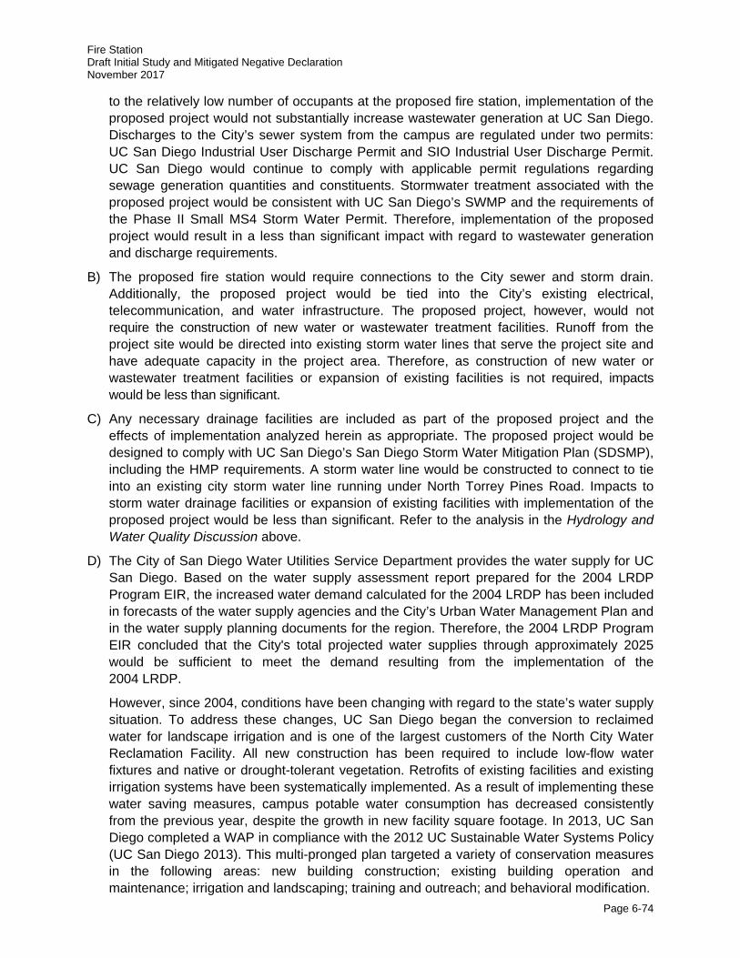
Fire Station Draft Initial Study and Mitigated Negative Declaration November 2017
Page 6-74
to the relatively low number of occupants at the proposed fire station, implementation of the proposed project would not substantially increase wastewater generation at UC San Diego. Discharges to the City’s sewer system from the campus are regulated under two permits: UC San Diego Industrial User Discharge Permit and SIO Industrial User Discharge Permit. UC San Diego would continue to comply with applicable permit regulations regarding sewage generation quantities and constituents. Stormwater treatment associated with the proposed project would be consistent with UC San Diego’s SWMP and the requirements of the Phase II Small MS4 Storm Water Permit. Therefore, implementation of the proposed project would result in a less than significant impact with regard to wastewater generation and discharge requirements.
B) The proposed fire station would require connections to the City sewer and storm drain. Additionally, the proposed project would be tied into the City’s existing electrical, telecommunication, and water infrastructure. The proposed project, however, would not require the construction of new water or wastewater treatment facilities. Runoff from the project site would be directed into existing storm water lines that serve the project site and have adequate capacity in the project area. Therefore, as construction of new water or wastewater treatment facilities or expansion of existing facilities is not required, impacts would be less than significant.
C) Any necessary drainage facilities are included as part of the proposed project and the effects of implementation analyzed herein as appropriate. The proposed project would be designed to comply with UC San Diego’s San Diego Storm Water Mitigation Plan (SDSMP), including the HMP requirements. A storm water line would be constructed to connect to tie into an existing city storm water line running under North Torrey Pines Road. Impacts to storm water drainage facilities or expansion of existing facilities with implementation of the proposed project would be less than significant. Refer to the analysis in the Hydrology and Water Quality Discussion above.
D) The City of San Diego Water Utilities Service Department provides the water supply for UC San Diego. Based on the water supply assessment report prepared for the 2004 LRDP Program EIR, the increased water demand calculated for the 2004 LRDP has been included in forecasts of the water supply agencies and the City’s Urban Water Management Plan and in the water supply planning documents for the region. Therefore, the 2004 LRDP Program EIR concluded that the City's total projected water supplies through approximately 2025 would be sufficient to meet the demand resulting from the implementation of the 2004 LRDP.
However, since 2004, conditions have been changing with regard to the state’s water supply situation. To address these changes, UC San Diego began the conversion to reclaimed water for landscape irrigation and is one of the largest customers of the North City Water Reclamation Facility. All new construction has been required to include low-flow water fixtures and native or drought-tolerant vegetation. Retrofits of existing facilities and existing irrigation systems have been systematically implemented. As a result of implementing these water saving measures, campus potable water consumption has decreased consistently from the previous year, despite the growth in new facility square footage. In 2013, UC San Diego completed a WAP in compliance with the 2012 UC Sustainable Water Systems Policy (UC San Diego 2013). This multi-pronged plan targeted a variety of conservation measures in the following areas: new building construction; existing building operation and maintenance; irrigation and landscaping; training and outreach; and behavioral modification.
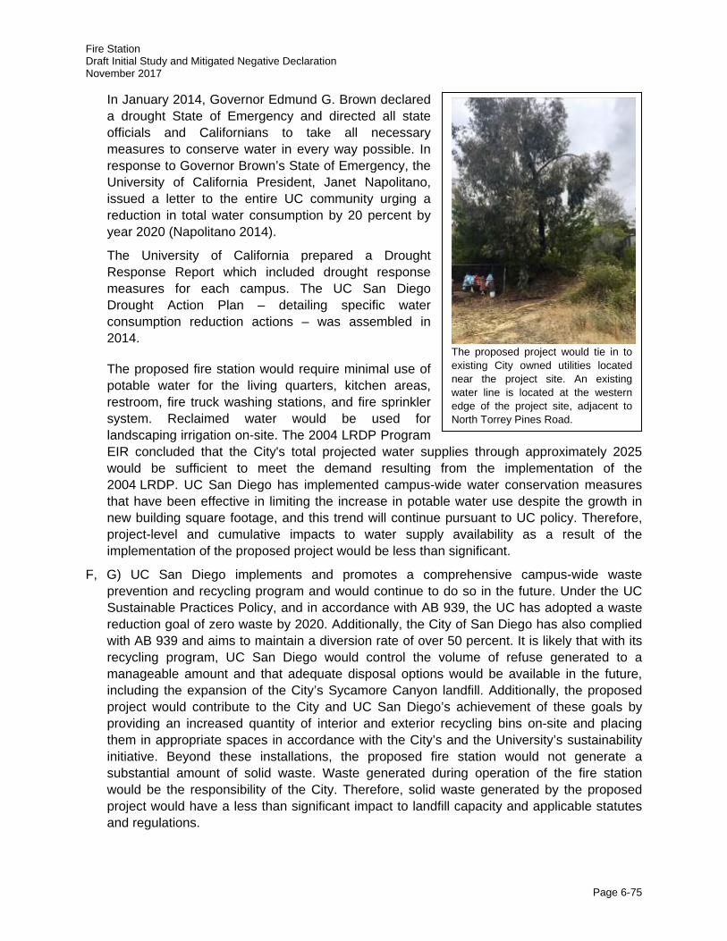
Fire Station Draft Initial Study and Mitigated Negative Declaration November 2017
Page 6-75
In January 2014, Governor Edmund G. Brown declared a drought State of Emergency and directed all state officials and Californians to take all necessary measures to conserve water in every way possible. In response to Governor Brown’s State of Emergency, the University of California President, Janet Napolitano, issued a letter to the entire UC community urging a reduction in total water consumption by 20 percent by year 2020 (Napolitano 2014).
The University of California prepared a Drought Response Report which included drought response measures for each campus. The UC San Diego Drought Action Plan – detailing specific water consumption reduction actions – was assembled in 2014.
The proposed fire station would require minimal use of potable water for the living quarters, kitchen areas, restroom, fire truck washing stations, and fire sprinkler system. Reclaimed water would be used for landscaping irrigation on-site. The 2004 LRDP Program EIR concluded that the City's total projected water supplies through approximately 2025 would be sufficient to meet the demand resulting from the implementation of the 2004 LRDP. UC San Diego has implemented campus-wide water conservation measures that have been effective in limiting the increase in potable water use despite the growth in new building square footage, and this trend will continue pursuant to UC policy. Therefore, project-level and cumulative impacts to water supply availability as a result of the implementation of the proposed project would be less than significant.
F, G) UC San Diego implements and promotes a comprehensive campus-wide waste prevention and recycling program and would continue to do so in the future. Under the UC Sustainable Practices Policy, and in accordance with AB 939, the UC has adopted a waste reduction goal of zero waste by 2020. Additionally, the City of San Diego has also complied with AB 939 and aims to maintain a diversion rate of over 50 percent. It is likely that with its recycling program, UC San Diego would control the volume of refuse generated to a manageable amount and that adequate disposal options would be available in the future, including the expansion of the City’s Sycamore Canyon landfill. Additionally, the proposed project would contribute to the City and UC San Diego’s achievement of these goals by providing an increased quantity of interior and exterior recycling bins on-site and placing them in appropriate spaces in accordance with the City’s and the University’s sustainability initiative. Beyond these installations, the proposed fire station would not generate a substantial amount of solid waste. Waste generated during operation of the fire station would be the responsibility of the City. Therefore, solid waste generated by the proposed project would have a less than significant impact to landfill capacity and applicable statutes and regulations.
The proposed project would tie in to existing City owned utilities located near the project site. An existing water line is located at the western edge of the project site, adjacent to North Torrey Pines Road.
Fire Station Draft Initial Study and Mitigated Negative Declaration November 2017
Page 6-76
H) The proposed project is not anticipated to create other utility or service system impacts beyond those that have already been described above. Less than significant impacts would occur as a result of the proposed project.
Summary
Implementation of the proposed project would not result in significant impacts to utilities and service systems serving the campus or surrounding community.
Issues Potentially Significant
Impact
Project Impact
Adequately Addressed in
LRDP EIR
Less Than Significant
with Project-level
Mitigation Incorporated
Less Than Significant
Impact No
Impact
16. MANDATORY FINDINGS OF SIGNIFICANCE – The lead agency shall find that a project may have a significant effect on the environment and thereby require an EIR to be prepared for the project where there is substantial evidence, in light of the whole record, that any of the following conditions may occur. Where prior to commencement of the environmental analysis a project proponent agrees to mitigation measures or project modifications that would avoid any significant effect on the environment or would mitigate the significant environmental effect, a lead agency need not prepare an EIR solely because without mitigation the environmental effects would have been significant (per Section 15065 of the State CEQA Guidelines): a. Does the project have the
potential to degrade the quality of the environment, substantially reduce the habitat of a fish or wildlife species, cause a fish or wildlife population to drop below self-sustaining levels, threaten to eliminate a plant or animal community, substantially reduce the number or restrict the range of a rare or endangered plant or animal or eliminate important examples of the major periods of California history or prehistory?
□ □ □ ■ □
b. Does the project have the potential to achieve short-term environmental goals to the disadvantage of long-term environmental goals?
□ □ □ □ ■
Fire Station Draft Initial Study and Mitigated Negative Declaration November 2017
Page 6-77
Issues Potentially Significant
Impact
Project Impact
Adequately Addressed in
LRDP EIR
Less Than Significant
with Project-level
Mitigation Incorporated
Less Than Significant
Impact No
Impact
c. Does the project have impacts that are individually limited, but cumulatively considerable? (“Cumulatively considerable” means that the incremental effects of a project are significant when viewed in connection with the effects of past projects, the effects of other current projects, and the effects of past, present and probable future projects)?
□ ■ □ □ □
d. Does the project have environmental effects which will cause substantial adverse effects on human beings, either directly or indirectly?
□ □ □ ■ □
Fire Station Draft Initial Study and Mitigated Negative Declaration November 2017
Page 7-1
7.0 SUPPORTING INFORMATION SOURCES
Association of Environmental Professionals (AEP). 2007. “Recommendations by the Association of Environmental Professionals (AEP) on How to Analyze Greenhouse Gas Emissions and Global Climate Change in CEQA Documents.” http://citeseerx.ist.psu.edu/viewdoc/download;jsessionid=762597C724870A2073978F37B653E423?doi=10.1.1.512.9243&rep=rep1&type=pdf.
Amec Foster Wheeler Environment & Infrastructure, Inc. (Amec Foster Wheeler). 2017a. “UC San Diego Fire Station CalEEMod Summary Report.”
California EnviroStor. 2016. “EnviroStor Database.” http://www.envirostor.dtsc.ca.gov/public/mapfull.asp?global_id=19490005.
California Air Pollution Control Officers Association (CAPCOA). 2008. “CEQA and Climate Change.” http://www.capcoa.org/wp-content/uploads/2012/03/CAPCOA-White-Paper.pdf.
California Air Resources Board (CARB). 2008. “Climate Change Scoping Plan.” http://www.arb.ca.gov/cc/scopingplan/document/adopted_scoping_plan.pdf.
———. 2013. "Board Meetings." http://www.arb.ca.gov/board/meetings.htm.
———. 2014. "First Update to the Climate Change Scoping Plan." https://www.arb.ca.gov/cc/scopingplan/document/updatedscopingplan2013.htm
California Building Standards Commission. 2017. "CALGreen (Part 11 of Title 24)." http://www.bsc.ca.gov/Home/CALGreen.aspx.
City of San Diego. 1997. “City of San Diego MSCP Subarea Plan.” https://www.sandiego.gov/sites/default/files/legacy/planning/programs/mscp/pdf/subareafullversion.pdf.
———. 2011. “CEQA Significance Determination Thresholds.” https://www.sandiego.gov/sites/default/files/legacy/development-services/pdf/news/sdtceqa.pdf.
———. 2014. “University Community Plan.” https://www.sandiego.gov/sites/default/files/legacy//planning/community/profiles/university/pdf/university_cp_110614.pdf.
———. 2017a. "About SDFD Facts and Figures." https://www.sandiego.gov/fire/about.
———. 2017b. "Fire Station 35." https://www.sandiego.gov/fire/about/firestations/sta35.
———. 2017c. "Fire Station 9." https://www.sandiego.gov/fire/about/firestations/sta9.
———. 2017d. "Climate Action Plan Consistency Checklist. Revised June 2017" https://www.sandiego.gov/sites/default/files/city_of_san_diego_cap_checklist.pdf.
Fire Station Draft Initial Study and Mitigated Negative Declaration November 2017
Page 7-2
Citygate Associates, LLC (Citygate). 2011. “Fire Service Standards of Response Coverage Deployment Study for the City of San Diego Fire Rescue Department.” http://voiceofsandiego.org/wp-content/uploads/2013/07/citygate-associates-inc-fire-service-standards.pdf.
———. 2017. “Executive Summary Standards of Response Cover Review - San Diego Fire-Rescue Department, Volume 1 of 3.”
County of San Diego. 2015. "2015 GHG Guidance. Recommended Approach to Addressing Climate Change in CEQA Documents. County of San Diego Planning & Development Services." http://www.sandiegocounty.gov/content/dam/sdc/pds/ceqa/Sweetwater-Place/PDS2014-TM-5588-Greenhouse-Gas-Guidance-2015.pdf.
Federal Emergency Management Agency (FEMA). 2012. “FEMA Flood Map Service Center | Search By Address.” https://msc.fema.gov/portal/search?AddressQuery=university%20of%20california%20san%20diego#searchresultsanchor.
HELIX Environmental Planning, Inc. (HELIX). 2004. "Biological Resources Technical Report for the 2004 UC San Diego LRDP Update." May.
———. 2016a. “Coastal California Gnatcatcher Survey Report.”
———. 2016b. "Biological Resources Existing Conditions Report for the UC San Diego La Jolla Campus LRDP Update."
———. 2016c. “UC San Diego Fire Station - Cultural Resources Survey.”
Kimley-Horn & Associates. 2004. “Traffic Impact Study for the 2004 LRDP for the University of California, San Diego." May.
Kyle Consulting. 2004. "A Cultural Resource Inventory Update and Recommendations for UC San Diego and Scripps Institution of Oceanography." April.
Linscott, Law & Greenspan (LLG). 2010. “2004 Long Range Development Plan Traffic Study Update.”
———. 2015. “North Torrey Pines Road Fire Station Access Study.”
Napolitano, J. 2014. “President Announces 20% Cut in UC Water Usage | University of California - January 16.” http://universityofcalifornia.edu/press-room/president-announces-20-cut-uc-water-usage.
Ninyo and Moore. 2003. “Geological Technical Study - University of California, San Diego 2004 Long Range Development Plan Environmental Impact Report, San Diego, California." September 12.

Fire Station Draft Initial Study and Mitigated Negative Declaration November 2017
Page 7-3
National Oceanic and Atmospheric Administration (NOAA). 2017. "Trends in Atmospheric Carbon Dioxide." http://www.esrl.noaa.gov/gmd/ccgg/trends/global.html.
PBS&J. 2004. "UC San Diego Long Range Development Plan Hydrology Study." Prepared for UC San Diego.
San Diego Air Pollution Control District (SDAPCD). 2016. “San Diego County’s Attainment Status.” http://www.sdapcd.org/content/sdc/apcd/en/air-quality-planning/attainment-status.html.
Urban Systems Associates, Inc. Fire Station 50 - Traffic Memorandum.
U.S. Environmental Protection Agency (USEPA). 2007. "Ozone Depletion Glossary." Available at: http://www.epa.gov/ozone/defns.html.
———. 2005. “Proposed Rule to Implement the Fine Particle National Ambient Air Quality Standards.” https://www.federalregister.gov/articles/2005/11/01/05-20455/proposed-rule-to-implement-the-fine-particle-national-ambient-air-quality-standards.
———. 2016. "Proposed Endangerment and Cause or Contribute Findings for Greenhouse Gases under the Clean Air Act." http://www.epa.gov/climatechange/endangerment/.
USEPA and U.S. Department of Transportation National Highway Traffic Safety Administration (NHTSA). 2012. "2017 and Later Model Year Light-Duty Vehicle Greenhouse Gas Emissions and Corporate Average Fuel Economy Standards." October 15.
University of California, San Diego (UC San Diego). 2004a. “2004 LRDP Environmental Impact Report.” http://physicalplanning.ucsd.edu/environmental/eirvol1.html.
———. 2004b. “Long Range Development Plan Final Environmental Impact Report (LRDP EIR).” http://physicalplanning.ucsd.edu/environmental/lrdpeir.html.
———. 2004c. “Long Range Development Plan (LRDP).” http://physicalplanning.ucsd.edu/plans/lrdp.html.
———. 2008. "Climate Action Plan." December.
———. 2010. “East Campus Bed Tower Project Final Tiered Environmental Impact Report (ECBT EIR).” http://physicalplanning.ucsd.edu/environmental/lrdpeir.html.
———. 2012. "Waste Diversion Plan." July.
———. 2013. “Water Action Plan.” http://aquaholics.ucsd.edu/_files/wateractionplan.pdf.
———. 2015. “UC San Diego Annual Security Report (Clery Report).” http://www.police.ucsd.edu/docs/annualclery.pdf.
———. 2016a. “Alternative Transportation.” http://sustainability.ucsd.edu/initiatives/transportation.html.
Fire Station Draft Initial Study and Mitigated Negative Declaration November 2017
Page 7-4
———. 2016b. “Annual Security and Fire Safety Report." Available at: http://www.police.ucsd.edu/Docs/Annualclery.pdf.
———. 2016c. “Clean Energy.” http://sustainability.ucsd.edu/initiatives/energy.html.
———. 2016d. “Fire Station Site Evaluation - Campus Planning.”
———. 2016e. “Sustainability Initiatives: Alternative Transportation.” http://sustain.ucsd.edu/initiatives/transportation.html.
———. 2016f. “Sustainable Built Environment.” http://rmp.ucsd.edu/fdc/sustainability/index.html.
———. 2016g. “Waste Minimization.” http://sustainability.ucsd.edu/initiatives/waste.html.
———. 2016h. “Water.” http://sustainability.ucsd.edu/initiatives/water.html.
———. 2017. “UC San Diego Sports Facilities: Outdoor Courts & Sites.” http://sportsfac.ucsd.edu/facilities/outdoor/.

Fire Station Draft Initial Study and Mitigated Negative Declaration November 2017
Page 8-1
8.0 INITIAL STUDY PREPARERS
This IS was prepared for and under the direction of UC San Diego Campus Planning Department by Amec Foster Wheeler Environment & Infrastructure, Inc. (Amec Foster Wheeler). Members of the professional staff are listed below: Project Management Rita Bright, CEQA Program Manager/Quality Assurance and Quality Control
B.A. Business Economics and Environmental Studies Nick Meisinger, Project Manager B.S. Environmental Science Aaron Goldschmidt, Senior Technical Advisor
M.A. Geography Technical Analysts Taylor Lane, Air Quality Specialist B.A. Environmental Studies Brian Cook, Senior Noise Specialist B.A. Biology Erlin Worthington, Environmental Analyst B.S. Conservation and Resource Studies Production Janice Depew Production Deirdre Stites Graphics