Embed Size (px)
Citation preview
Initial Study – Mitigated Negative Declarationfor the Voigt Parking Structureat UC San DiegoUC San Diego Project Number: State Clearinghouse Number:
Prepared for:Campus Planning, University of California, San Diego9500 Gilman Drive, MC 0074La Jolla, California 92093
Prepared by:Amec Foster Wheeler Environment & Infrastructure, Inc.9210 Sky Park Court, Suite 200San Diego, California 92123
UNIVERSITY OF CALIFORNIA FINAL INITIAL STUDY AND MITIGATED NEGATIVE DECLARATION Project Name: Voigt Parking Structure UC San Diego Project Number: 966625 University of California, San Diego SCH #: 2017101020 December 2017
Prepared by: Amec Foster Wheeler Environment & Infrastructure, Inc. 9210 Sky Park Court, Suite 200 San Diego, California Prepared for: Campus Planning University of California, San Diego 9500 Gilman Drive, MC 0074 La Jolla, CA 92093-0074

This statement is prepared in compliance with the California Environmental Quality Act

NOTE TO REVIEWERS OF THE FINAL TIERED INITIAL STUDY AND MITIGATED NEGATIVE DECLARATION
The Draft Tiered Initial Study (IS) and Mitigated Negative Declaration (MND) for the Voigt Parking Structure Project was circulated for public review from October 10, 2017, to November 9, 2017 (State Clearinghouse [SCH] No. 2017101020). Additionally, Notices of Availability (NOAs) were published in The San Diego Union-Tribune as well as the UC San Diego Guardian. During the public review period, three comment letters were received from the following recipients: 1) California Department of Toxic Substances Control (DTSC); 2) California Department of Transportation (Caltrans); and 3) Native American Heritage Commission (NAHC). These letters are located immediately following this page with responses to comments provided adjacent to the comments. MINOR REVISIONS OR CLARIFICATIONS TO THE TIERED IS/MND Responses to the three comment letters provide additional clarification and expand on previous campus-wide analyses conducted as a part of the 2004 Long Range Development Plan (LRDP) Program Environmental Impact Report (EIR). While additional language was added to the Hazards and Hazards Materials discussion regarding the UC San Diego Soils Management Policy and Ammunitions Awareness Program, no substantial revisions to Draft IS/MND were required as a result of the comments received on the Draft IS/MND. However, following the publication of the Draft IS/MND for the Voigt Parking Structure Project, Campus Planning released a Draft IS/MND for the proposed fire station at UC San Diego. As such, Campus Planning revised the Project-Specific Mitigation Measure Fire-1 to provide additional detail related to timing and UC San Diego’s role in constructing the proposed fire station. In accordance with Section 15097 of the State California Environmental Quality Act (CEQA) Guidelines, a Mitigation Monitoring and Reporting Program (MMRP) has been prepared for the proposed project. The MMRP is included as Appendix E of the Final IS/MND.
Comment Response A-1: As described in the Cultural Resources/Paleontological/Tribal Resources discussion (refer to Page 6-26 of the Draft Initial Study / Mitigated Negative Declaration [IS/MND]), as early as 1964 the project site was characterized by undeveloped land associated with Camp Callan and the early development of UC San Diego. By 1973 the Central Library (now Geisel Library) was constructed with a surface parking lot in the future location of Warren Mall. In 1989, with the construction of improvements to Geisel Library, UC San Diego constructed a 36-inch reinforced concrete pipeline and associated drainage basin, which required extensive grading along the western margin of the project site. By 1994, surface parking lot P503 was constructed on the project site. The only area of the project site that has not been previously graded or developed is the approximately 65-foot wide, steep slope between surface parking lot P503 and the buried storm drain infrastructure to the west. A geotechnical survey was conducted on the project site that involved nine borings to depths between 18 and 51 feet below the project site (Southern California Soil & Testing, Inc. [SCST] 2016). As part of this survey, a State of California-certified laboratory was engaged to perform environmental testing of the on-site soils, consistent with the requirements of the Site Development Guidelines and Procedures for UC San Diego (e.g., California Health and Safety Code, Division 20, Chapter 6.8, Section 25319.5). No hazardous materials were reported at the project site. As further described in the 2004 Long Range Development Plan (LRDP) Program Environmental Impact Report (EIR), the likelihood of uncovering hazardous wastes/substances at the project site is extremely low (refer to Section 4.1.6.3 in the 2004 LRDP Program EIR). None of the recorded tanks, leaking underground storage tanks, or burn ash sites associated with Camp Callan (or the other former military establishment at UC San Diego, Camp Matthews) are located within 1,000 feet of the project site (refer to Figure 4.6-1 in the 2004 LRDP Program EIR). If contamination is detected at any time during construction, the UC San Diego Environmental Health & Safety (EH&S) office would be notified immediately and all work would be discontinued until appropriate health and safety procedures are implemented pursuant to 2004 LRDP Program EIR Mitigation Measure Haz-4C. If necessary, remediation actions would be taken under the direction of the Department of Environmental Health (DEH) or the San Diego Regional Water Quality Control Board (RWQCB) and in accordance with all applicable federal and state regulations.
Comment Response A-2: Refer to Comment Response A-1. As described in the Hazards and Hazardous Materials discussion, there are no recognized hazardous environmental conditions in the project area. The 2004 LRDP Program EIR evaluated the campus for hazardous materials and waste – including review of DEH File Review (refer to Appendix E of the 2004 LRDP Program EIR) – and determined that the likelihood of uncovering hazardous wastes/substances at the project site is extremely low. Further, the geotechnical investigation and associated soil testing did not identify any hazardous materials on-site (SCST 2016). Comment Response A-3: The project site consists of surface parking lot P503 and adjacent undeveloped Park land characterized by eucalyptus woodland and Diegan coastal sage scrub habitats. As such, no building modifications or demolition would be required to support the proposed project. Although surface parking lot P503 would be demolished and existing storm water drain lines would be removed (refer to Figure 7 in the Draft IS/MND), the probability of encountering lead-based paints or products, mercury, or asbestos-containing materials (ACM) is expected to be very low. In the event that hazardous materials are encountered during construction, all hazardous materials would be removed and disposed of according to all applicable federal and state regulations in coordination with the UC San Diego EH&S office and/or other regulatory agencies as appropriate, consistent with 2004 LRDP Program EIR Mitigation Measures Haz-4C. Comment Response A-4: Refer to Comment Response A-1. The project site has not been used for agricultural or related activities. Further, the geotechnical investigation and associated soil testing performed specifically for this proposed project did not uncover any hazardous materials on-site, including residual pesticides (SCST 2016). Therefore, no impacts to human health and environment from residual pesticides are anticipated. However, if contamination is detected on the project site at any time during construction, the UC San Diego EH&S office would be notified immediately and all work would be discontinued until appropriate health and safety procedures are implemented pursuant to 2004 LRDP Program EIR Mitigation Measure Haz-4C. If necessary, remediation actions would be taken under the direction of the DEH or the San Diego RWQCB and in accordance with all applicable federal and state regulations.
Comment Response A-5: As described in the Hazard and Hazardous Materials discussion, the project site is located within an area of historic military use (i.e., Camp Callan). This area has been recorded in the U.S. Army Corps of Engineers Formerly Used Defense Sites (FUDS) Geographic Information System (GIS) website as the Camp Matthews FUDS. The issue of ordnance (i.e., ammunition shells) across the campus is discussed in detail on Page 4.6-11 of the 2004 LRDP Program. As described in the 2004 LRDP Program EIR, the possibility of finding buried ordnance in the former Camp Callan lands is low. The only area of the project site that has not been previously graded or developed is the approximately 65-foot wide steep slope between surface parking lot P503 and the storm drain infrastructure to the west. No ordnance has been observed in this narrow strip of land and given the adjacent development on either side, it is highly unlikely that previously undiscovered buried ordnance would occur on the slope. If ordnance (or any other contamination) is detected on the project site at any time during construction, the UC San Diego EH&S office would be notified immediately and all work would be discontinued until appropriate health and safety procedures are implemented pursuant to 2004 LRDP Program EIR Mitigation Measures Haz-4C. If necessary, remediation actions would be taken under the direction of the DEH or the San Diego RWQCB and in accordance with all applicable federal and state regulations. Comment Response A-6: Refer to Comment Response A-1. If at any time during construction contamination is detected, the UC San Diego EH&S office would be notified immediately and all work would be discontinued until appropriate health and safety procedures are implemented pursuant to 2004 LRDP Program EIR Mitigation Measure Haz-4C. If necessary, remediation actions would be taken under the direction of the DEH or the San Diego RWQCB and in accordance with all applicable federal and state regulations. Import of fill soils are not currently envisioned as a part of the proposed project; if necessary, fill soils would be sampled consistent with the requirements of 2004 LRDP Program EIR Mitigation Measure Haz-4Cii. Comment Response A-7: Refer to Comment Response A-1. As described in 2004 LRDP EIR Mitigation Measure Haz-4C, either the DEH or the San Diego RWQCB, depending on the nature of the contamination, would be notified. Each agency has its own mechanism for initiating an investigation, and the appropriate program would be selected depending on the nature of the contamination.
Comment Response B-1: Although Table 3-1 in the Traffic Impact Study shows an increase in AM and PM peak hour trips, this increase in trips at the four analyzed intersections results from the parking structure capturing existing traffic on campus. Specifically, the parking structure is intended to accommodate existing parking demand from nearby academic buildings and other facilities within the Warren College Neighborhood. As described in Transportation/Traffic discussion, the proposed parking structure would not generate or contribute to any additional traffic volumes on the UC San Diego street network or the surrounding street / arterial networks (Pers. Comm. J. Boarman, Linscott, Law & Greenspan [LLG]). The proposed parking structure would not generate employment (i.e., require additional employees), and it would not directly increase student enrollment on campus. As such, there would be no long-term increase in traffic accessing the UC San Diego campus via the Interstate 5 (I-5) interchanges at La Jolla Village Drive and Genesee Avenue, and operations at these interchanges would remain as described in the 2004 LRDP Program EIR (as updated by the 2010 East Campus Bed Tower [ECBT] Project EIR). Comment Response B-2: Comment noted. UC San Diego also supports improved transit, bicycle, and pedestrian facilities. As described in the Transportation/Traffic discussion, UC San Diego operates one of the largest alternative transportation programs in the County, which focuses on the use of transit, ridesharing, shuttles, and bicycles to encourage and assist UC San Diego commuters’ use of alternatives to single-occupancy vehicles. Approximately 28,000 (or 57 percent) of commuters arrive on campus daily using alternative modes of transportation. The trends in alternative transportation use have continued to increase at a steady level form 2011 to present and are likely to continue to increase with the new mid-coast corridor light rail scheduled to open in 2021. Project-specific alternative transportation features included in the proposed parking structure design include connection improvements to existing pedestrian pathways and campus bicycle paths, enhanced with the provision of shade trees, benches, bicycle parking areas, and on-site bicycle fix-it stations to promote walking and cycling on campus.
UC San Diego also seeks to reduce vehicle miles travelled (VMT) and utilizes Transportation Demand Management (TDM) measures to decrease trip making. Project specific features included in the proposed parking structure design include:
Location of the parking structure along major access points to the West Campus to reduce vehicle miles driven in search of parking, to provide ease of wayfinding, and to provide access to multi-modal facilities, trails, and pathways providing connections across campus; and
Orientation of parking stalls to reduce internal circling. Comment Response B-3: The Traffic Impact Study determined that there would be no significant impacts to Caltrans facilities. As such, mitigation measures are not required for the proposed project. Comment Response B-4: Comment noted. UC San Diego understands that any work performed within a Caltrans right-of-way would require an encroachment permit. None of the project elements would affect any Caltrans rights-of-way.
Comment Response C-1: Refer to Comment Response A-1. As part of the preparation of the 2004 LRDP Program EIR, UC San Diego completed a Cultural Resources Inventory Update that included an archival records search and a field check of all known cultural resources (Kyle Consulting 2004). This evaluation determined that the nearest known archaeological/tribal cultural resources site is located more than 1,500 feet from the project site. No identified sites have been located within or adjacent to the project site and no “unexpected resources” are anticipated based on previous disturbance of the site and the guidance of 2004 LRDP EIR Mitigation Measure Cul-2Dii. Therefore, the proposed project is anticipated to have no impact to archaeological/tribal cultural resources (see Page 2-25 of the Draft IS/MND). Prior to consultation with the San Luis Rey Band of Mission Indians, UC San Diego requested a Sacred Lands File search from NAHC in August 2017, which returned negative results for the Project site. Further, in accordance with Assembly Bill 52 (AB 52), UC San Diego distributed a formal notification letter to the San Luis Rey Band of Mission Indians offering consultation for the proposed project. However, no formal request for tribal consultation with UC San Diego for the proposed project was received. Therefore, based on the 2004 Cultural Resources Inventory Update, similar to archaeological resources, the proposed project is not anticipated to have any impact on tribal cultural properties. Nevertheless, as with all development projects on campus, UC San Diego is committed to regulatory compliances and the implementation of best practices with respect to inadvertent encounters of cultural, archaeological, or tribal resources. In the highly unlikely event of an inadvertent discovery, Campus Planning would be notified and all work would be diverted or temporarily discontinued until the find could be assessed for significance by a qualified archaeologist and/or Tribal Cultural monitor. If human remains and/or artifacts are discovered, work shall halt in that area and the procedures detailed in Memorandum on Procedures for the Discovery of Human Remains at UC San Diego would be followed.
Comment Response C-2: Comment noted. UC San Diego understands that a lack of contact with tribes traditionally and culturally affiliated to the project area or lack of documented resources does not mean that there are no potential impacts and does not preclude inadvertent finds. However, as described in Comment Response C-1, based on the previous disturbance associated with Camp Callan as well as development associated with surface parking lot P503 and the existing 36-inch reinforced concrete pipeline and associated drainage basin, no “unexpected resources” are anticipated within the project site. As such, no mitigations for archaeological and/or tribal cultural resources have been identified for the proposed project. Nevertheless, as with all development projects on campus, UC San Diego is committed to regulatory compliance and the implementation of best practices with respect to inadvertent encounters of cultural, archaeological, and/or tribal resources. In the highly unlikely event of an inadvertent discovery, Campus Planning would be notified and all work would be diverted or temporarily discontinued until the find could be assessed for significance by a qualified archaeologist and/or tribal cultural monitor. If human remains and/or artifacts are discovered, work shall halt in that area and the procedures detailed in Memorandum on Procedures for the Discovery of Human Remains at UC San Diego would be followed. Comment Response C-3. Comment noted. UC San Diego is currently in the process of updating the LRDP and associated EIR for the campus which will include an updated cultural resources assessment. However, the Cultural/Paleontological/Tribal Resources discussion within the IS/MND incorporates the most recently completed Cultural Resources Inventory Update associated with the 2004 LRDP EIR (Kyle Consulting 2004). As described in the inventory, the nearest known archaeological/tribal cultural resource is located more than 1,500 feet from the project site. As such, no unexpected resources are anticipated to occur within the project site. Comment Response C-4. Comment noted.


UNIVERSITY OF CALIFORNIA, SAN DIEGO
BERKELEY DAVIS IRVINE LOS ANGELES MERCED RIVERSIDE SAN DIEGO SAN FRANCISCO SANTA BARBARA SANTA CRUZ
CAMPUS PLANNING 9500 GILMAN DRIVE # 0074TEL: (858) 534 6515 LA JOLLA, CALIFORNIA 92093 0074
October 9, 2017
State of CaliforniaOffice of Planning and Research1400 Tenth Street, Room 212Sacramento, CA 95814 3044
NOTICE OF COMPLETION DRAFT MITIGATED NEGATIVE DECLARATION
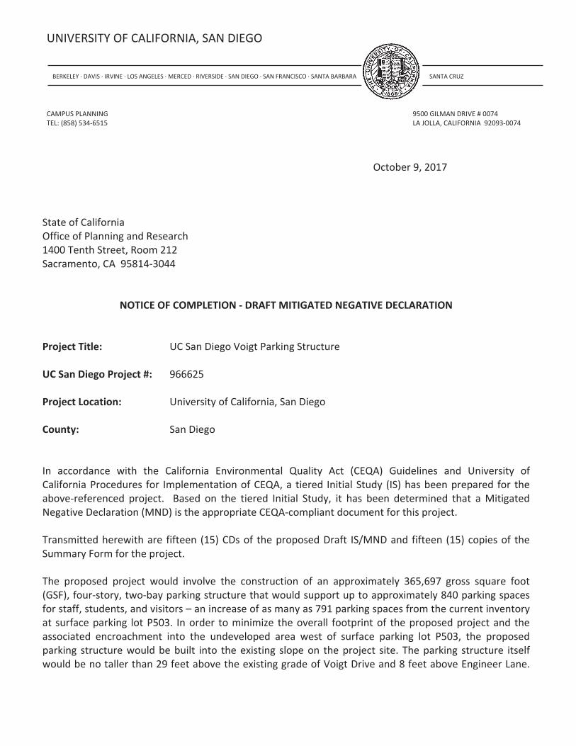
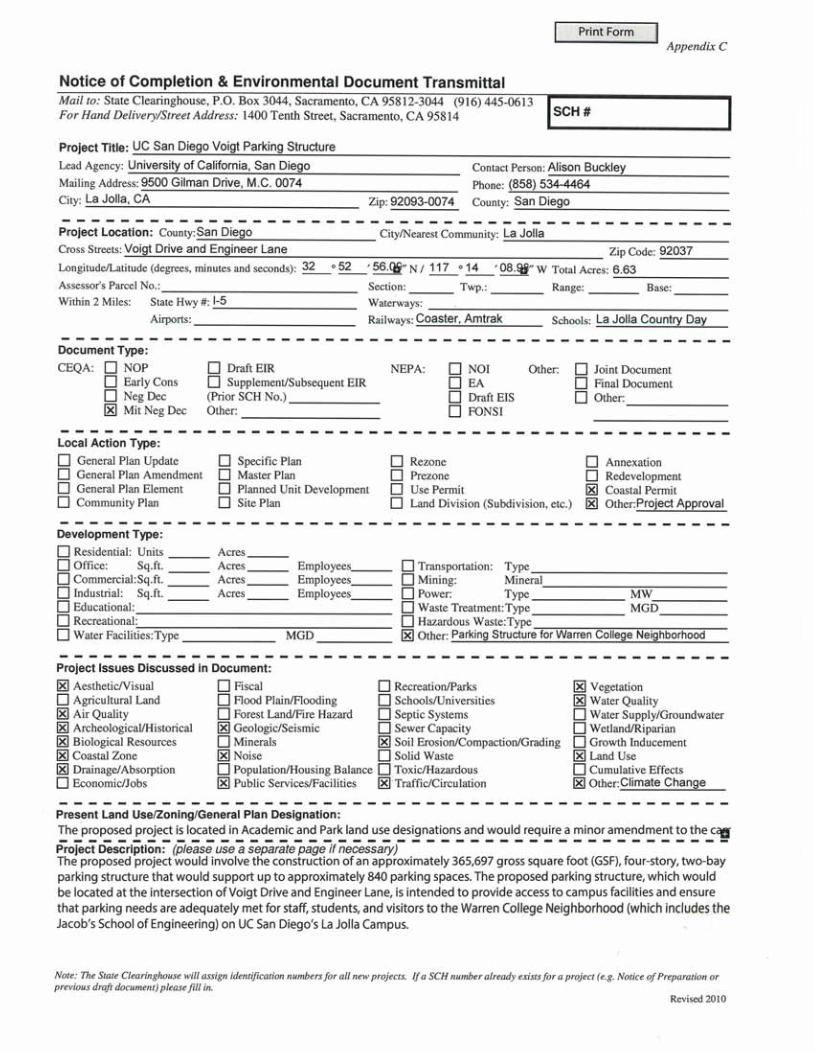
Project Title: UC San Diego Voigt Parking Structure
UC San Diego Project #: 966625
Project Location: University of California, San Diego
County: San Diego
In accordance with the California Environmental Quality Act (CEQA) Guidelines and University ofCalifornia Procedures for Implementation of CEQA, a tiered Initial Study (IS) has been prepared for theabove referenced project. Based on the tiered Initial Study, it has been determined that a MitigatedNegative Declaration (MND) is the appropriate CEQA compliant document for this project.
Transmitted herewith are fifteen (15) CDs of the proposed Draft IS/MND and fifteen (15) copies of theSummary Form for the project.
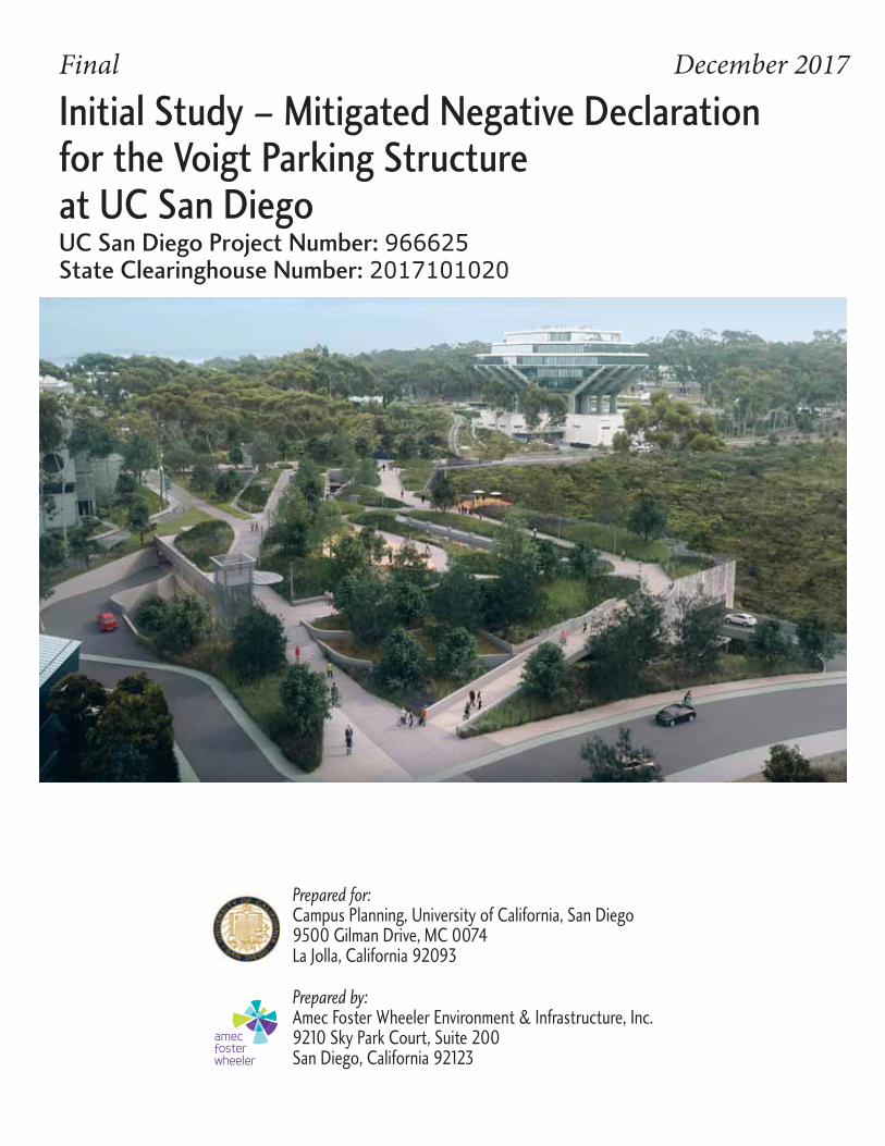
The proposed project would involve the construction of an approximately 365,697 gross square foot(GSF), four story, two bay parking structure that would support up to approximately 840 parking spacesfor staff, students, and visitors – an increase of as many as 791 parking spaces from the current inventoryat surface parking lot P503. In order to minimize the overall footprint of the proposed project and theassociated encroachment into the undeveloped area west of surface parking lot P503, the proposedparking structure would be built into the existing slope on the project site. The parking structure itselfwould be no taller than 29 feet above the existing grade of Voigt Drive and 8 feet above Engineer Lane.
SIO Marine Conservation FacilityNotice of Completion
Page 2
Railings, rooftop equipment, elevator overrides, or mechanical equipment exceeding this height would beintegrated into the overall parking structure design or screened appropriately. The proposed parkingstructure would also include a Live Roof that is partially covered with vegetation planted over awaterproofing membrane. Although the proposed project would be ineligible to attain a Leadership inEnergy and Environmental Design – New Construction (LEED NC) rating because it is a parking structure,the proposed parking structure has been designed to incorporate sustainable design features to achievecertification by Parksmart (formerly the Green Parking Council), a similar “green” rating for parkingstructures, and integrate sustainability goals to the extent possible.
The proposed project would involve the demolition of the existing surface parking lot P503 (including theremoval of 49 parking spaces), clearing of existing vegetation (including approximately 150 matureeucalyptus trees and approximately 1.43 acres of Diegan coastal sage scrub), and grading and fill of theslope to the west of the existing surface parking lot. The proposed project would observe a minimum 45foot setback from all adjacent buildings, a 25 foot setback from Voigt Drive, and a 20 foot setback fromEngineer Lane in order to accommodate adequate sidewalk and planting area. Additionally, the proposedparking structure would be setback 50 feet from wetland habitat located to the west of project site. Theproposed parking structure would include intersection improvements to provide right in/right out vehicleaccess along Voigt Drive (Third Level) and right in/left out vehicle access along Engineer Lane (FourthLevel). The proposed project would modify the four way stop controlled intersection of Voigt Drive andEngineer Lane, including widening for vehicular queuing as well as improvements to intersection crossingsand sidewalks. Additional improvements along Voigt Drive would include the removal of existing onstreet parking on the westbound side of the roadway to support striping of a new Class II bicycle lane toreplace the existing sharrows. The Live Roof (Fifth Floor) included in the proposed project incorporatesvarious multi modal circulation improvements, such as pedestrian and bicycle pathways that ramp tosurface levels and provide connections to surrounding areas within the Warren College Neighborhood.The proposed project would also widen the existing pedestrian path that runs east to west along thesouthern edge of the nearby canyon in order to provide a dedicated bicycle lane and develop a moreformalized multi modal connection between Hopkins Lane and Warren Mall, which is a priority projectidentified in the UC San Diego 2012 Bicycle and Pedestrian Master Planning Study.
This IS/MND for the proposed project has been tiered from the UC San Diego 2004 Long RangeDevelopment Plan Environmental Impact Report (EIR) (as updated), which was certified by The Regents ofthe University of California on September 23, 2004 (State Clearinghouse [SCH] No. 2014031084), asupdated by the East Campus Bed Tower Project EIR certified in July 2010 (SCH No. 2009081053). Based onthe IS prepared for the project, it has been determined that the project would not have a significanteffect on the environment that cannot be mitigated. This letter is intended to serve as the Notice ofAvailability of the Draft IS/MND. The project's anticipated environmental effects are discussed in detail inthe enclosed Draft IS/MND.
We appreciate your review of this NOA and the Draft IS/MND, which can also be viewed online athttp://plandesignbuild.ucsd.edu/planning/environmental.html. Copies of the Draft IS/MND and alldocuments referenced therein are available for review at the UC San Diego Campus Planning Office
SIO Marine Conservation FacilityNotice of Completion
Page 3
during regular business hours; please call for an appointment at (858) 534 6515. The Draft IS/MND is alsoavailable for review at the following libraries:
Central LibrarySan Diego Public Library330 Park Blvd.San Diego, CA 92101
North University Community BranchSan Diego City Library8820 Judicial DriveSan Diego, CA 92122
UC San Diego Government Document UnitGeisel LibraryUniversity of California, San Diego9500 Gilman Drive #0175 GLa Jolla, CA 92093 0175
La Jolla BranchSan Diego City Library7555 Draper AvenueLa Jolla, CA 92037
University Community BranchSan Diego City Library4155 Governor DriveSan Diego, CA 92122
We appreciate your prompt acknowledgement and processing of this Draft IS/MND. We expect the Statereview period will extend from approximately October 10, 2017 through November 9, 2017. If you haveany questions regarding the project, please contact me at (858) 534 4464.
Sincerely,
Alison BuckleySenior PlannerEnvironmental Planning
Enclosures:Draft IS/MND (15 CDs and 15 copies Summary Form)NOC and Environmental Document Transmittal Form
cc: UCOP Physical and Environmental PlanningUCOP Office of the General Counsel


UNIVERSITY OF CALIFORNIA FINAL INITIAL STUDY AND MITIGATED NEGATIVE DECLARATION Project Name: Voigt Parking Structure UC San Diego Project Number: 966625 University of California, San Diego SCH #: 2017101020 December 2017
Prepared by: Amec Foster Wheeler Environment & Infrastructure, Inc. 9210 Sky Park Court, Suite 200 San Diego, California Prepared for: Campus Planning University of California, San Diego 9500 Gilman Drive, MC 0074 La Jolla, CA 92093-0074

This statement is prepared in compliance with the California Environmental Quality Act
UC San Diego Voigt Parking Structure Final Initial Study and Mitigated Negative Declaration December 2017
Page i
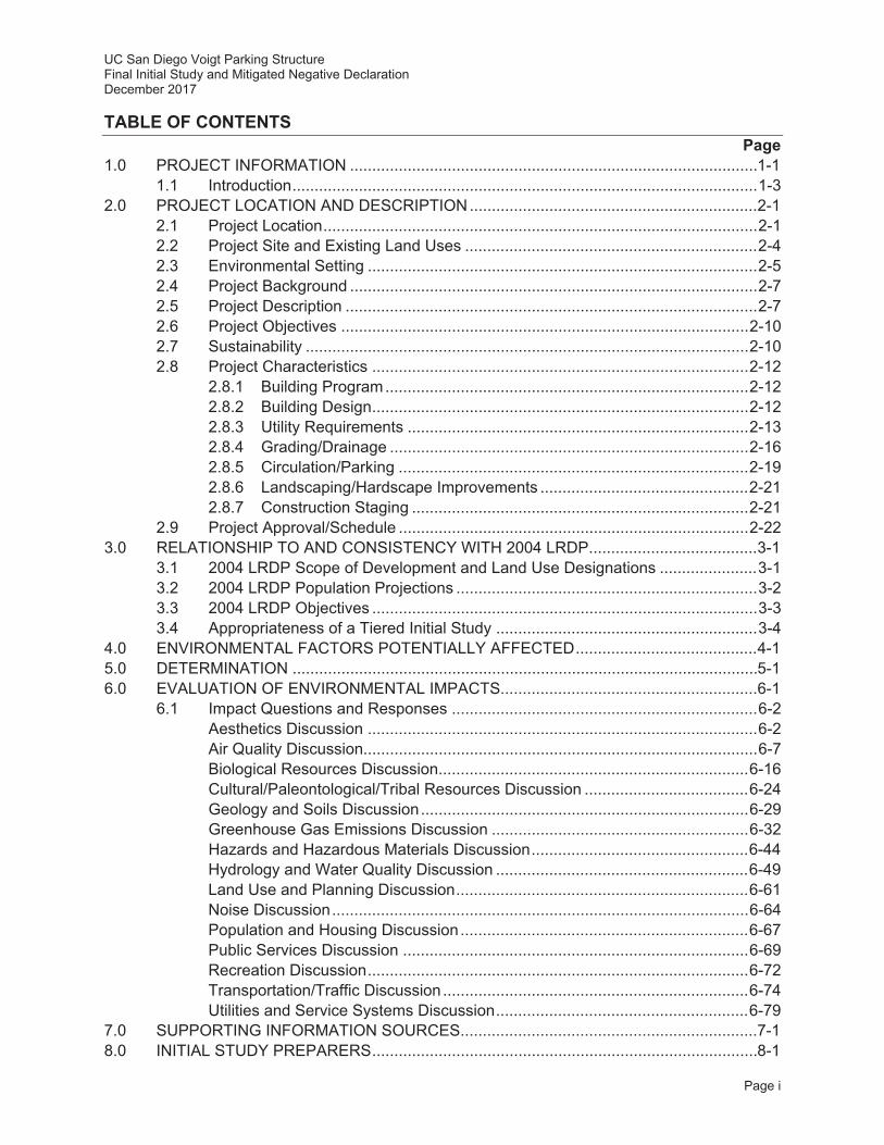
TABLE OF CONTENTS Page
1.0 PROJECT INFORMATION ............................................................................................ 1-1 1.1 Introduction ......................................................................................................... 1-3
2.0 PROJECT LOCATION AND DESCRIPTION ................................................................. 2-1 2.1 Project Location .................................................................................................. 2-1 2.2 Project Site and Existing Land Uses .................................................................. 2-4 2.3 Environmental Setting ........................................................................................ 2-5 2.4 Project Background ............................................................................................ 2-7 2.5 Project Description ............................................................................................. 2-7 2.6 Project Objectives ............................................................................................ 2-10 2.7 Sustainability .................................................................................................... 2-10 2.8 Project Characteristics ..................................................................................... 2-12
2.8.1 Building Program .................................................................................. 2-12 2.8.2 Building Design ..................................................................................... 2-12 2.8.3 Utility Requirements ............................................................................. 2-13 2.8.4 Grading/Drainage ................................................................................. 2-16 2.8.5 Circulation/Parking ............................................................................... 2-19 2.8.6 Landscaping/Hardscape Improvements ............................................... 2-21 2.8.7 Construction Staging ............................................................................ 2-21
2.9 Project Approval/Schedule ............................................................................... 2-22 3.0 RELATIONSHIP TO AND CONSISTENCY WITH 2004 LRDP ...................................... 3-1
3.1 2004 LRDP Scope of Development and Land Use Designations ...................... 3-1 3.2 2004 LRDP Population Projections .................................................................... 3-2 3.3 2004 LRDP Objectives ....................................................................................... 3-3 3.4 Appropriateness of a Tiered Initial Study ........................................................... 3-4
4.0 ENVIRONMENTAL FACTORS POTENTIALLY AFFECTED ......................................... 4-1 5.0 DETERMINATION ......................................................................................................... 5-1 6.0 EVALUATION OF ENVIRONMENTAL IMPACTS .......................................................... 6-1
6.1 Impact Questions and Responses ..................................................................... 6-2 Aesthetics Discussion ........................................................................................ 6-2 Air Quality Discussion......................................................................................... 6-7 Biological Resources Discussion...................................................................... 6-16 Cultural/Paleontological/Tribal Resources Discussion ..................................... 6-24 Geology and Soils Discussion .......................................................................... 6-29 Greenhouse Gas Emissions Discussion .......................................................... 6-32 Hazards and Hazardous Materials Discussion ................................................. 6-44 Hydrology and Water Quality Discussion ......................................................... 6-49 Land Use and Planning Discussion .................................................................. 6-61 Noise Discussion .............................................................................................. 6-64 Population and Housing Discussion ................................................................. 6-67 Public Services Discussion .............................................................................. 6-69 Recreation Discussion ...................................................................................... 6-72 Transportation/Traffic Discussion ..................................................................... 6-74 Utilities and Service Systems Discussion ......................................................... 6-79
7.0 SUPPORTING INFORMATION SOURCES ................................................................... 7-1 8.0 INITIAL STUDY PREPARERS ....................................................................................... 8-1
UC San Diego Voigt Parking Structure Final Initial Study and Mitigated Negative Declaration December 2017
Page ii
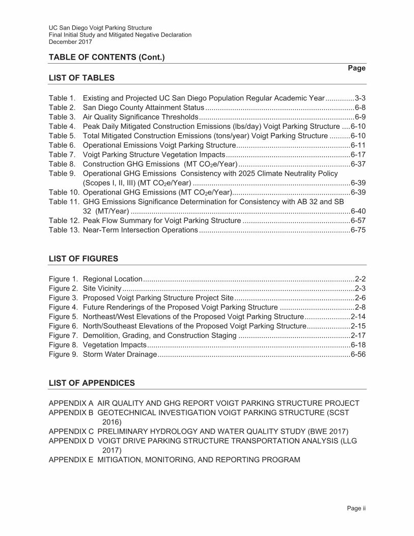
TABLE OF CONTENTS (Cont.) Page
LIST OF TABLES Table 1. Existing and Projected UC San Diego Population Regular Academic Year .............. 3-3 Table 2. San Diego County Attainment Status ........................................................................ 6-8 Table 3. Air Quality Significance Thresholds ........................................................................... 6-9 Table 4. Peak Daily Mitigated Construction Emissions (lbs/day) Voigt Parking Structure .... 6-10 Table 5. Total Mitigated Construction Emissions (tons/year) Voigt Parking Structure .......... 6-10 Table 6. Operational Emissions Voigt Parking Structure ....................................................... 6-11 Table 7. Voigt Parking Structure Vegetation Impacts ............................................................ 6-17 Table 8. Construction GHG Emissions (MT CO2e/Year) ...................................................... 6-37 Table 9. Operational GHG Emissions Consistency with 2025 Climate Neutrality Policy
(Scopes I, II, III) (MT CO2e/Year) ............................................................................ 6-39 Table 10. Operational GHG Emissions (MT CO2e/Year) ......................................................... 6-39 Table 11. GHG Emissions Significance Determination for Consistency with AB 32 and SB
32 (MT/Year) .......................................................................................................... 6-40 Table 12. Peak Flow Summary for Voigt Parking Structure .................................................... 6-57 Table 13. Near-Term Intersection Operations ......................................................................... 6-75 LIST OF FIGURES Figure 1. Regional Location ...................................................................................................... 2-2 Figure 2. Site Vicinity ................................................................................................................ 2-3 Figure 3. Proposed Voigt Parking Structure Project Site .......................................................... 2-6 Figure 4. Future Renderings of the Proposed Voigt Parking Structure .................................... 2-8 Figure 5. Northeast/West Elevations of the Proposed Voigt Parking Structure ...................... 2-14 Figure 6. North/Southeast Elevations of the Proposed Voigt Parking Structure ..................... 2-15 Figure 7. Demolition, Grading, and Construction Staging ...................................................... 2-17 Figure 8. Vegetation Impacts .................................................................................................. 6-18 Figure 9. Storm Water Drainage ............................................................................................. 6-56 LIST OF APPENDICES APPENDIX A AIR QUALITY AND GHG REPORT VOIGT PARKING STRUCTURE PROJECT APPENDIX B GEOTECHNICAL INVESTIGATION VOIGT PARKING STRUCTURE (SCST
2016) APPENDIX C PRELIMINARY HYDROLOGY AND WATER QUALITY STUDY (BWE 2017) APPENDIX D VOIGT DRIVE PARKING STRUCTURE TRANSPORTATION ANALYSIS (LLG
2017) APPENDIX E MITIGATION, MONITORING, AND REPORTING PROGRAM
UC San Diego Voigt Parking Structure Final Initial Study and Mitigated Negative Declaration December 2017
Page iii
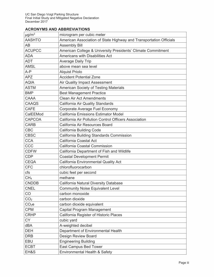
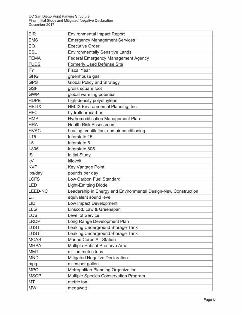
ACRONYMS AND ABBREVIATIONS μg/m3 microgram per cubic meter AASHTO American Association of State Highway and Transportation Officials AB Assembly Bill ACUPCC American College & University Presidents’ Climate Commitment ADA Americans with Disabilities Act ADT Average Daily Trip AMSL above mean sea level A-P Alquist Priolo APZ Accident Potential Zone AQIA Air Quality Impact Assessment ASTM American Society of Testing Materials BMP Best Management Practice CAAA Clean Air Act Amendments CAAQS California Air Quality Standards CAFE Corporate Average Fuel Economy CalEEMod California Emissions Estimator Model CAPCOA California Air Pollution Control Officers Association CARB California Air Resources Board CBC California Building Code CBSC California Building Standards Commission CCA California Coastal Act CCC California Coastal Commission CDFW California Department of Fish and Wildlife CDP Coastal Development Permit CEQA California Environmental Quality Act CFC chlorofluorocarbon cfs cubic feet per second CH4 methane CNDDB California Natural Diversity Database CNEL Community Noise Equivalent Level CO carbon monoxide CO2 carbon dioxide CO2e carbon dioxide equivalent CPM Capital Program Management CRHP California Register of Historic Places CY cubic yard dBA A-weighted decibel DEH Department of Environmental Health DRB Design Review Board EBU Engineering Building ECBT East Campus Bed Tower EH&S Environmental Health & Safety
UC San Diego Voigt Parking Structure Final Initial Study and Mitigated Negative Declaration December 2017
Page iv
EIR Environmental Impact Report EMS Emergency Management Services EO Executive Order ESL Environmentally Sensitive Lands FEMA Federal Emergency Management Agency FUDS Formerly Used Defense Site FY Fiscal Year GHG greenhouse gas GPS Global Policy and Strategy GSF gross square foot GWP global warming potential HDPE high-density polyethylene HELIX HELIX Environmental Planning, Inc. HFC hydrofluorocarbon HMP Hydromodification Management Plan HRA Health Risk Assessment HVAC heating, ventilation, and air conditioning I-15 Interstate 15 I-5 Interstate 5 I-805 Interstate 805 IS Initial Study kV kilovolt KVP Key Vantage Point lbs/day pounds per day LCFS Low Carbon Fuel Standard LED Light-Emitting Diode LEED-NC Leadership in Energy and Environmental Design-New Construction Leq equivalent sound level LID Low Impact Development LLG Linscott, Law & Greenspan LOS Level of Service LRDP Long Range Development Plan LUST Leaking Underground Storage Tank LUST Leaking Underground Storage Tank MCAS Marine Corps Air Station MHPA Multiple Habitat Preserve Area MMT million metric tons MND Mitigated Negative Declaration mpg miles per gallon MPO Metropolitan Planning Organization MSCP Multiple Species Conservation Program MT metric ton MW megawatt
UC San Diego Voigt Parking Structure Final Initial Study and Mitigated Negative Declaration December 2017
Page v
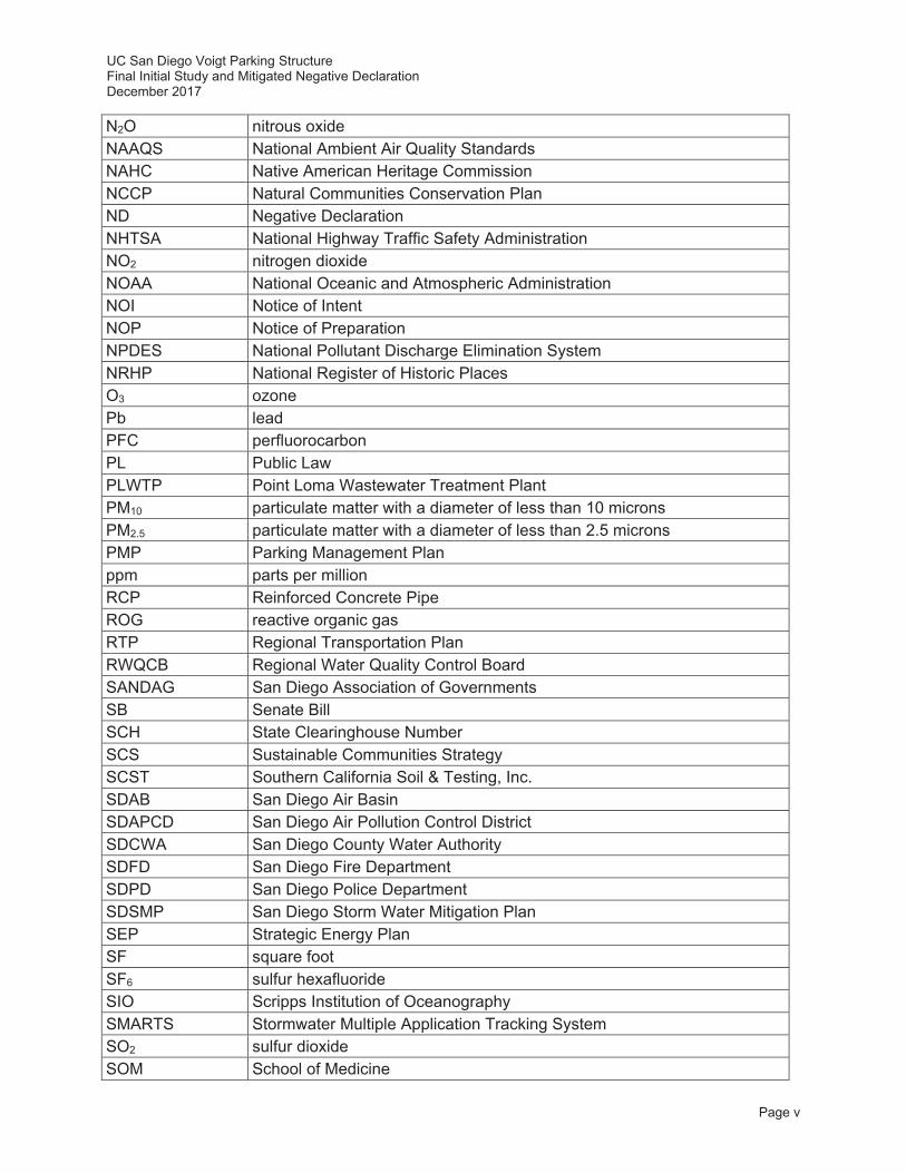
N2O nitrous oxide NAAQS National Ambient Air Quality Standards NAHC Native American Heritage Commission NCCP Natural Communities Conservation Plan ND Negative Declaration NHTSA National Highway Traffic Safety Administration NO2 nitrogen dioxide NOAA National Oceanic and Atmospheric Administration NOI Notice of Intent NOP Notice of Preparation NPDES National Pollutant Discharge Elimination System NRHP National Register of Historic Places O3 ozone Pb lead PFC perfluorocarbon PL Public Law PLWTP Point Loma Wastewater Treatment Plant PM10 particulate matter with a diameter of less than 10 microns PM2.5 particulate matter with a diameter of less than 2.5 microns PMP Parking Management Plan ppm parts per million RCP Reinforced Concrete Pipe ROG reactive organic gas RTP Regional Transportation Plan RWQCB Regional Water Quality Control Board SANDAG San Diego Association of Governments SB Senate Bill SCH State Clearinghouse Number SCS Sustainable Communities Strategy SCST Southern California Soil & Testing, Inc. SDAB San Diego Air Basin SDAPCD San Diego Air Pollution Control District SDCWA San Diego County Water Authority SDFD San Diego Fire Department SDPD San Diego Police Department SDSMP San Diego Storm Water Mitigation Plan SEP Strategic Energy Plan SF square foot SF6 sulfur hexafluoride SIO Scripps Institution of Oceanography SMARTS Stormwater Multiple Application Tracking System SO2 sulfur dioxide SOM School of Medicine

UC San Diego Voigt Parking Structure Final Initial Study and Mitigated Negative Declaration December 2017
Page vi
SOx sulfur oxides SR-52 State Route 52 SSPPS Skaggs School of Pharmacy and Pharmaceutical Sciences SWMP Storm Water Management Plan SWPPP Storm Water Pollution Prevention Plan SWRCB State Water Resources Control Board TAC toxic air contaminant TDM Transportation Demand Management UC University of California UC San Diego University of California, San Diego UCOP University of California Office of the President USEPA U.S. Environmental Protection Agency USFWS U.S. Fish and Wildlife Service UST underground storage tank VA Veterans Affairs VOC volatile organic compounds
UC San Diego Voigt Parking Structure Final Initial Study and Mitigated Negative Declaration December 2017
Page 1-1
Environmental Checklist Form
1.0 PROJECT INFORMATION
1. Project title: Voigt Parking Structure
2. Lead Agency name and address: Campus Planning University of California, San Diego
9500 Gilman Drive, MC 0074 La Jolla, California 92093-0074
(858) 534-6515
3. Contact person and phone number: Alison Buckley (858) 534-4464
4. Project location: San Diego County
5. Project sponsor’s name and address: (See #2 and #3)
6. Custodian of administrative record for this project (if different from response to #3):
7. Identification of previous Environmental Impact Reports (EIRs) relied upon for tiering purposes (including all applicable Long Range Development Plans [LRDPs] and project EIRs) and address where a copy is available for inspection (refer to #2 for availability):
University of California, San Diego 2004 Long Range Development Plan Program EIR
(State Clearinghouse No. 2003081023) Certified September, 2004
University of California, San Diego
East Campus Bed Tower Project EIR (State Clearinghouse No. 2009081053)
Certified July, 2010
UC San Diego Voigt Parking Structure Final Initial Study and Mitigated Negative Declaration December 2017
Page 1-2
This page intentionally left blank
UC San Diego Voigt Parking Structure Final Initial Study and Mitigated Negative Declaration December 2017
Page 1-3
1.1 Introduction
The environmental analysis for the proposed Voigt Parking Structure (proposed project) is tiered from the University of California, San Diego (UC San Diego) 2004 Long Range Development Plan (LRDP) Program Environmental Impact Report (EIR), as updated by the East Campus Bed Tower (ECBT) Project EIR certified in July 2010. The 2004 LRDP Program EIR (UC San Diego 2004a) was prepared in accordance with the California Environmental Quality Act (CEQA) Guidelines (Sections 15000 et seq., Title 14, Code of California Regulations; hereafter “CEQA Guidelines”) pursuant to Section 15168, which implements CEQA (Public Resources Code Sections 21000 et seq.). The 2004 LRDP Program EIR analyzed full implementation of uses allowed on the UC San Diego campus under the 2004 LRDP at the programmatic level (UC San Diego 2004a).
The CEQA concept of “tiering” refers to the analysis of general environmental matters in broad Program EIRs, with subsequent focused environmental documents for individual projects that implement the program. The project environmental document incorporates by reference relevant campus-wide discussions in the Program EIR and concentrates on project-specific issues. The CEQA Guidelines encourage the use of tiered environmental documents to reduce delays and excessive paperwork in the environmental review process. This is accomplished in tiered documents by eliminating repetitive analysis of issues that were adequately addressed in the Program EIR and by incorporating those analyses by reference.
In accordance with CEQA Guidelines Sections 15152, as amended, and 15168(c), the environmental analysis for the proposed project is tiered from the 2004 LRDP Program EIR (State Clearinghouse [SCH] No. 2003081023), as updated by the ECBT Project EIR (SCH No. 2009081053). These documents are hereby incorporated by reference and are available for review during normal business hours at UC San Diego Campus Planning, Torrey Pines Center South, Suite 355, La Jolla, CA 92093. The 2004 LRDP Program EIR analyzed the overall direct and indirect environmental effects of campus growth and facility development through the academic year 2020-2021. The 2004 LRDP Program EIR also analyzed the potentially significant cumulative impacts that could occur from the implementation of the 2004 LRDP. Technical analyses prepared for the ECBT Project EIR (UC San Diego 2010) would replace and supersede the long-term traffic and cumulative construction emissions (air quality) analyses presented in the 2004 LRDP Program EIR. These analyses were conducted to address changed conditions that had resulted since the 2004 LRDP Program EIR was certified in September 2004. In the case of the air quality analysis, the construction analysis was updated to address a more robust construction emissions scenario than previously assumed at the time that the 2004 LRDP Program EIR was prepared. In addition, the status for two criteria pollutants (ozone [O3] and particulate matter with a diameter of less than 2.5 microns [PM2.5]) in the San Diego Air Basin (SDAB) had changed from attainment to nonattainment1; and new federal and/or State standards had been adopted for O3, PM2.5, and nitrogen dioxide (NO2) since the 2004 LRDP Program EIR was adopted, so they were re-analyzed in the ECBT Project EIR. The 2004 LRDP traffic analysis was also updated to reflect changing conditions locally and
1 A nonattainment area is an area considered to have air quality worse than the National Ambient Air Quality Standards (NAAQS) as defined in the Clean Air Act Amendments (CAAA) of 1970 (Public Law [PL] 91-604, Sec. 109).

UC San Diego Voigt Parking Structure Final Initial Study and Mitigated Negative Declaration December 2017
Page 1-4
regionally, and new mitigation strategies were presented to address the effects of campus growth on the local circulation network in the near-term (2015) and the cumulative long-term (2020).
As such, the ECBT Project EIR serves as the basis for the long-term traffic and cumulative construction emissions analyses for all future campus projects proposed under the 2004 LRDP. All feasible measures to avoid or substantially reduce the significant adverse project and cumulative impacts associated with that growth are identified in the 2004 LRDP Program EIR, as updated by the ECBT Project EIR. Under Section 15152(f)(1), where the lead agency determines that a cumulative impact has been adequately addressed in the prior Program EIR, the impact is not treated as significant in a later negative declaration and need not be discussed in detail.
The tiering of the environmental analysis for the proposed project allows this Tiered Initial Study (IS) / Mitigated Negative Declaration (MND) to rely on the 2004 LRDP Program EIR, as updated by the ECBT Project EIR for the following:
a. a discussion of general background and setting information for environmental topic areas;
b. overall campus-wide growth-related issues;
c. issues that were evaluated in sufficient detail in the 2004 LRDP Program EIR, as updated by the ECBT Project EIR, for which there is no new information of substantial importance or substantial change in circumstances that would require further analysis; and
d. short- and long-term cumulative impacts.
The purpose of this Tiered IS is to evaluate the potential environmental impacts of the proposed project in light of the analysis in the 2004 LRDP Program EIR, as updated by the ECBT Project EIR to determine what level of additional environmental review, if any, is appropriate including whether additional project-specific mitigation is necessary and would be included as part of the project. Based on the analysis contained in this Tiered IS, a determination has been made in Section 5.0, Determination.
Mitigation measures identified in the 2004 LRDP Program EIR, as updated by the ECBT Project EIR that apply to the proposed project or additional project-specific mitigation measures must be implemented as part of the proposed project. These mitigation measures are identified and discussed in Section 6.0, Evaluation of Environmental Impacts.
UC San Diego Voigt Parking Structure Final Initial Study and Mitigated Negative Declaration December 2017
Page 2-1
2.0 PROJECT LOCATION AND DESCRIPTION
2.1 Project Location
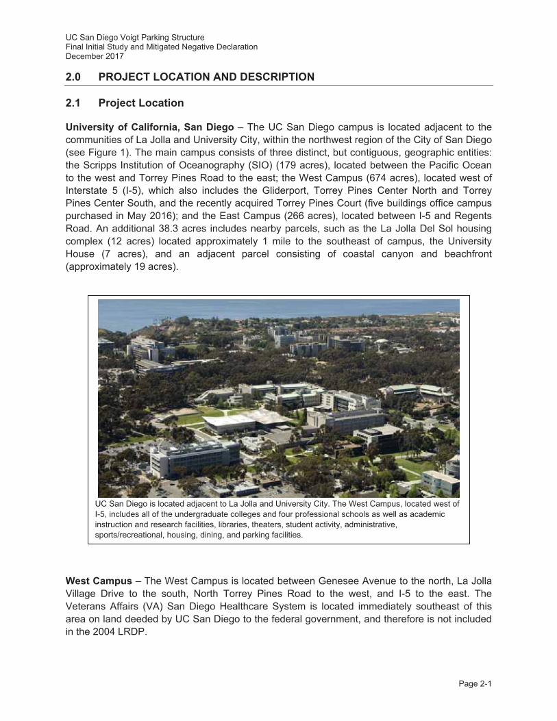
University of California, San Diego – The UC San Diego campus is located adjacent to the communities of La Jolla and University City, within the northwest region of the City of San Diego (see Figure 1). The main campus consists of three distinct, but contiguous, geographic entities: the Scripps Institution of Oceanography (SIO) (179 acres), located between the Pacific Ocean to the west and Torrey Pines Road to the east; the West Campus (674 acres), located west of Interstate 5 (I-5), which also includes the Gliderport, Torrey Pines Center North and Torrey Pines Center South, and the recently acquired Torrey Pines Court (five buildings office campus purchased in May 2016); and the East Campus (266 acres), located between I-5 and Regents Road. An additional 38.3 acres includes nearby parcels, such as the La Jolla Del Sol housing complex (12 acres) located approximately 1 mile to the southeast of campus, the University House (7 acres), and an adjacent parcel consisting of coastal canyon and beachfront (approximately 19 acres).
West Campus – The West Campus is located between Genesee Avenue to the north, La Jolla Village Drive to the south, North Torrey Pines Road to the west, and I-5 to the east. The Veterans Affairs (VA) San Diego Healthcare System is located immediately southeast of this area on land deeded by UC San Diego to the federal government, and therefore is not included in the 2004 LRDP.
UC San Diego is located adjacent to La Jolla and University City. The West Campus, located west of I-5, includes all of the undergraduate colleges and four professional schools as well as academic instruction and research facilities, libraries, theaters, student activity, administrative, sports/recreational, housing, dining, and parking facilities.
85
5
5
15
15
15
5
805
1D
2D
8058
94
94
201
125
94
52
56
76
76
78
78
79
79
67
67
NAVAL BASENAVAL BASESAN DIEGOSAN DIEGO
MCASMIRAMAR
MCBCAMP
PENDLETON
NWSFALLBROOK
ANNEX
NAVAL SUBMARINE BASESAN DIEGO
NAVAL BASECORONADO
NAVAL BASESAN DIEGO
MISSIONMISSIONBAYBAY
PACIFICOCEAN
SANDIEGO
BAY
MISSIONBAY
LOWER OTAYRESERVOIR
SWEETWATERRESERVOIR
BARRETT LAKE
LOVELANDRESERVOIR
EL CAPITANRESERVOIR
SAN VICENTERESERVOIR
LAKEHODGES
SAN DIEGOSAN DIEGO
VISTAVISTA
OCEANSIDEOCEANSIDE
CARLSBADCARLSBAD
ENCINITASENCINITAS
SANSANMARCOSMARCOS
ESCONDIDOESCONDIDO
POWAYPOWAY
SANTEESANTEE
LA MESALA MESA
LEMONLEMONGROVEGROVE
IMPERIALIMPERIALBEACHBEACH
CHULACHULAVISTAVISTA
SAN DIEGO
VISTA
OCEANSIDE
CARLSBAD
ENCINITAS
SANMARCOS
ESCONDIDO
POWAY
SANTEE
LA MESA
LEMONGROVE
IMPERIALBEACH
CHULAVISTA
SAN DIEGOCOUNTY
RIVERSIDECOUNTYORANGE
COUNTY
UC SAN DIEGO
UNITED STATESUNITED STATES
MEXICOMEXICOUNITED STATES
MEXICO
PROJECT SITE★
0 250
MILES
N
Project SiteProject SiteProject Site★★
C A L I F O R N I A
San Diego County
Incorporated City
San Diego County
Military Installation
Cleveland National Forest
LEGEND
0 8
SCALE IN MILES
N
Regional LocationUC San Diego 1
FIGURE
Page 2-2
La JollaLa JollaVillageVillage
La JollaLa JollaCrossroadsCrossroads
La Jolla ShoresLa Jolla Shores
LA JOLLA VILLAGE DRIVE
LA JOLLA VILLAGE DRIVE
EASTGATE MALL
EASTGATE MALL
LA J
OLL
A SH
ORE
S DR
IVE
LA JOLLA SHORES LANELA JOLLA SHORES LANE
NOBEL DRIVENOBEL DRIVE
GILM
AN DRIVE
GILM
AN DRIVE
GENESEE AVENUE
NORTH TO
RREY PINES ROAD
NORTH TO
RREY PINES ROAD
5
5
805
805
LA JOLLA VILLAGE DRIVE
EASTGATE MALL
NOBEL DRIVE
LA JOLLA SHORES LANE
GILM
AN DRIVE
GENESEE AVENUE
LA J
OLL
A SH
ORE
S DR
IVE
NORTH TO
RREY PINES ROAD
West Campus
East Campus
Scripps Institutionof Oceanography
(SIO)
UC San DiegoUC San DiegoBeachfront PropertiesBeachfront Properties
NorthNorthTorrey PinesTorrey Pinesand Glideportand Glideport
(West Campus)(West Campus)
La JollaLa Jolladel Soldel Sol
West Campus
East Campus
Scripps Institutionof Oceanography
(SIO)
NorthTorrey Pinesand Glideport
(West Campus)
UC San DiegoBeachfront Properties
La Jolladel Sol
La JollaVillage
La JollaCrossroads
La Jolla Shores
DoyleDoyleCommunity ParkCommunity Park
NobelNobelAthleticAthletic
AreaArea
Torrey PinesTorrey PinesState Natural PreserveState Natural Preserve
La JollaLa JollaOpenOpenSpaceSpace
Campus PointCampus PointOpen SpaceOpen Space
Open Space/Open Space/EasementEasement
AllenAllenFieldField
Mandell-WeissEastgateEastgateCity ParkCity Park
DoyleCommunity Park
NobelAthletic
Area
Torrey PinesState Natural Preserve
La JollaOpenSpace
Campus PointOpen Space
Open Space/Easement
AllenField
Mandell-WeissEastgateCity ParkPACIFICPACIFIC
OCEANOCEAN
ScrippsScrippsMarine ConservationMarine Conservation
AreaArea
ScrippsScrippsCoastal ReserveCoastal Reserve
PACIFICOCEAN
ScrippsCoastal Reserve
ScrippsMarine Conservation
Area
Project SiteProject Site
LLLAAJJJOOO
LLLLLLAA
SSHHOOO
RREES
DDRRIIVVV
E
Scripps InstitutioScripps Institutionppof Oceanographyhof Oceanographyg
SIO(SIO)
East CampEast Campus
West CampusWest Campus
Project teProject Site
LEGENDUC San Diego Campus
Proposed Project Site
0 2,000
SCALE IN FEET
N
2FIGURESite Vicinity
Voigt Parking Structure
Aerial Source: Google 2016.
Page2-3
UC San Diego Voigt Parking Structure Final Initial Study and Mitigated Negative Declaration December 2017
Page 2-4
The West Campus is the largest and most developed of the three areas of the main UC San Diego campus with approximately 11 million gross square feet (GSF) of total building space on approximately 674 acres of land. All of the undergraduate colleges and four professional schools – Rady School of Management, School of Medicine (SOM), Skaggs School of Pharmacy and Pharmaceutical Sciences (SSPPS), and Graduate School of Global Policy and Strategy (GPS) – are located on this portion of the campus.
The majority of the West Campus is densely developed, with the exception of its north central portion. Two large canyons north of Voigt Drive (i.e., north of the project site as described in Section 2.2, Project Site and Existing Land Uses) remain in a relatively undeveloped natural state. Native vegetation on the slopes of these canyons has remained relatively undisturbed. This area also contains an extensive eucalyptus (Eucalyptus spp.) grove along the western perimeter. The eucalyptus grove forms an almost continuous band stretching from Genesee Avenue on the campus’ northern boundary, to La Jolla Village Drive on the southern edge, and west along the northern edge of the SIO campus.
2.2 Project Site and Existing Land Uses
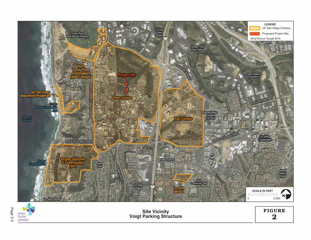
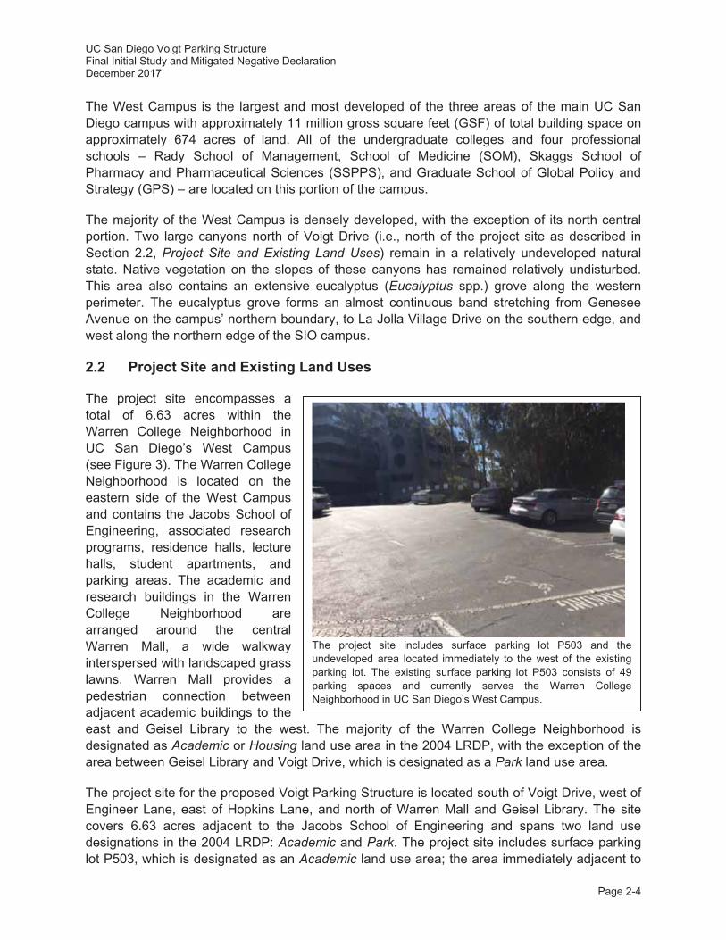
The project site encompasses a total of 6.63 acres within the Warren College Neighborhood in UC San Diego’s West Campus (see Figure 3). The Warren College Neighborhood is located on the eastern side of the West Campus and contains the Jacobs School of Engineering, associated research programs, residence halls, lecture halls, student apartments, and parking areas. The academic and research buildings in the Warren College Neighborhood are arranged around the central Warren Mall, a wide walkway interspersed with landscaped grass lawns. Warren Mall provides a pedestrian connection between adjacent academic buildings to the east and Geisel Library to the west. The majority of the Warren College Neighborhood is designated as Academic or Housing land use area in the 2004 LRDP, with the exception of the area between Geisel Library and Voigt Drive, which is designated as a Park land use area.
The project site for the proposed Voigt Parking Structure is located south of Voigt Drive, west of Engineer Lane, east of Hopkins Lane, and north of Warren Mall and Geisel Library. The site covers 6.63 acres adjacent to the Jacobs School of Engineering and spans two land use designations in the 2004 LRDP: Academic and Park. The project site includes surface parking lot P503, which is designated as an Academic land use area; the area immediately adjacent to
The project site includes surface parking lot P503 and the undeveloped area located immediately to the west of the existing parking lot. The existing surface parking lot P503 consists of 49 parking spaces and currently serves the Warren College Neighborhood in UC San Diego’s West Campus.
UC San Diego Voigt Parking Structure Final Initial Study and Mitigated Negative Declaration December 2017
Page 2-5
the west of the surface parking lot is designed as a Park land use area (see Figure 10 in the 2004 LRDP; UC San Diego 2004b). This Park land use area within the project site consists of Restoration Lands (see below); proposed bicycle and pedestrian connections to the project site (described below in Section 2.8.5, Circulation/Parking) traverse the Grove Reserve area near Hopkins Lane.
Restoration Lands. Restoration Lands include slopes on both the east and west frontages of I-5. These areas include the canyon north of Geisel Library, canyons and slopes east of I-5, the ocean bluff at the SIO campus, and slopes adjacent to the Birch Aquarium and Museum. These areas have been disturbed by erosion, invasive vegetation, and past military use. As the campus continues to develop, these areas provide an opportunity for restoration and creation of native plant habitats. Community-serving projects proposed in Restoration Lands – including the proposed parking structure – may be developed in this area provided that improvements have acceptable impacts with respect to the Park land use type.
Grove Reserve. Grove Reserve areas of the Park land use type include the major eucalyptus stands stretching south from Genesee Avenue to the northern end of the SIO campus. The eucalyptus grove, which predated UC San Diego by 60 years, is a significant part of the campus’ cultural landscape. The Grove Reserve has been affected by prior development, including several buildings within its boundaries. Nevertheless, the mature eucalyptus groves still provide a valuable aesthetic resource on campus and UC San Diego seeks to protect its existing quality. Expansion of existing facilities within the Grove Reserve are restricted; however, development of suitable bicycle and pedestrian paths in the Grove Reserve – such as those included in the proposed project – is allowed in the 2004 LRDP.
2.3 Environmental Setting
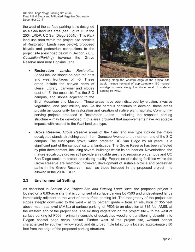
As described in Section 2.2, Project Site and Existing Land Uses, the proposed project is located on a 6.63-acre site that is comprised of surface parking lot P503 and undeveloped lands immediately adjacent to the west of the surface parking lot. The topography of the project site slopes steeply downward to the west – at 32 percent grade – from an elevation of 355 feet above mean sea level (AMSL) at surface parking lot P503 to an elevation at 315 feet AMSL at the western end of the project site. The existing vegetation on the project site – to the west of surface parking lot P503 – primarily consists of eucalyptus woodland transitioning downhill into Diegan coastal sage scrub habitat. Further west of the project site, wetland habitat characterized by southern willow scrub and disturbed mule fat scrub is located approximately 50 feet from the edge of the proposed parking structure.
Grading along the western edge of the project site would include removal of approximately 150 mature eucalyptus trees along the slope west of surface parking lot P503.

IR W
S
GEISELGEISELLIBRARYLIBRARY
CENTER FORMAGNETIC
RECORDINGRESEARCH
POWELLPOWELLSTRUCTURALSTRUCTURAL
RESEARCHRESEARCHLABORATORYLABORATORY WARRENWARREN
LECTURE HALLLECTURE HALL
JACOBSJACOBSSCHOOL OF ENGINEERINGSCHOOL OF ENGINEERING
POWELL-FOCHTPOWELL-FOCHTBIOENGINEERINGBIOENGINEERING
CAL-IT2CAL-IT2
HOPKINS LANE
HOPKINS LANE
ENGINEER LANE
ENGINEER LANE
VOIGGT DRIVE
P503P503
GEISELLIBRARY
POWELLSTRUCTURAL
RESEARCHLABORATORY WARREN
LECTURE HALL
JACOBSSCHOOL OF ENGINEERING
P503
P502
POWELL-FOCHTBIOENGINEERING
WARREN MALL
ATKINSON HALL(CAL-IT2)
HOPKINS LANE
ENGINEER LANE
VOIGT DRIVE
FS
FS
VEHICLE BRIDGEVEHICLE BRIDGE
PATIO OVERLOOKPATIO OVERLOOK
LIGHTWELLLIGHTWELL
“SNAKE PATH”“SNAKE PATH”
FIRE LANEFIRE LANE
LIGHTWELLLIGHTWELL
NEW 1” DOMESTIC WATER LINE CONNECTIONNEW 1” DOMESTIC WATER LINE CONNECTION
NEW 2” IRRIGATION LINE CONNECTIONNEW 2” IRRIGATION LINE CONNECTION CONNECTION TO EXISTINGCONNECTION TO EXISTINGSTORMWATER CLEANOUTSTORMWATER CLEANOUT
NEWNEWSTORMWATERSTORMWATERCATCH BASINSCATCH BASINS
NEW STORMWATERNEW STORMWATERCLEANOUTCLEANOUT
CONNECTION TO EXISTINGCONNECTION TO EXISTINGSTORMWATER CATCH BASINSTORMWATER CATCH BASIN
NEW STORMWATER CLEANOUTNEW STORMWATER CLEANOUT
NEW STORMWATER CLEANOUTSNEW STORMWATER CLEANOUTS
NEW 4” SEWER LINE CONNECTIONNEW 4” SEWER LINE CONNECTION
VEHICLE BRIDGE
PATIO OVERLOOK
LIGHTWELL
“SNAKE PATH”
FIRE LANE
LIGHTWELL
NEW 1” DOMESTIC WATER LINE CONNECTION
NEW 2” IRRIGATION LINE CONNECTION CONNECTION TO EXISTINGSTORMWATER CLEANOUT
NEWSTORMWATERCATCH BASINS
NEW STORMWATERCLEANOUT
CONNECTION TO EXISTINGSTORMWATER CATCH BASIN
NEW STORMWATER CLEANOUT
NEW STORMWATER CLEANOUTS
NEW 4” SEWER LINE CONNECTION
LEGENDProposed Project Elements
Voigt Parking Structure
Plaza
Trail/Walkway/Bike Path
Pedestrian Bridge
Parking StructureEntry/Exit
Retaining Wall
Areaway
Fire Service Line
Water Service Line –Domestic WaterIrrigation
Stormwater Drain Line
Sewer Line
Road Widening/Fire LaneCrosswalk Improvements
FS
W
IR
S
0 140
SCALE IN FEET
N
3FIGUREProposed Voigt Parking Structure
Project Site
Page2-6
UC San Diego Voigt Parking Structure Final Initial Study and Mitigated Negative Declaration December 2017
Page 2-7
2.4 Project Background
The Warren College Neighborhood (which includes the Jacobs School of Engineering) is served by existing surface parking lots P502 (355 spaces) and P503 (49 spaces), which provide a total of 404 spaces. Surface parking lot P502 is located north of the project site; given its location, this lot has been identified as a potential future development site for academic facilities. Future conversion of surface parking lot P502 could remove some or all of its component parking spaces and result in a parking deficit relative to existing conditions. Existing peak parking occupancy on the UC San Diego campus is approximately 89 percent (UC San Diego 2015b). The existing parking occupancy in the Warren College Neighborhood – including surface parking lots P502 and P503 – during peak hours is currently at 95 percent (UC San Diego 2015b). The proposed Voigt Parking Structure is necessary in order to ensure that continued parking demand and facility access needs are adequately met in the Warren College Neighborhood.
The proposed 6.63-acre site is located in the immediate vicinity and would provide important connections throughout the Warren College Neighborhood and adjacent areas of West Campus. The proposed Voigt Parking Structure would be consistent with the need for additional parking structures, and would address the following needs:
Provide additional proximate staff, student, and visitor parking that would help achieve the goals of the 2004 LRDP and support existing parking demand in the Warren College Neighborhood;
Anticipate future development, which would increase parking demand on the West Campus within a 0.5-mile radius of in the Warren College Neighborhood;
Reduce unnecessary vehicular traffic on internal campus roads due to decentralized staff parking in that area of campus; and
Enhance the public realm beyond the immediate project site, including pedestrian access and pathways.
2.5 Project Description
The proposed project would involve the construction of an approximately 365,697 GSF, four-story, two-bay parking structure that would support up to approximately 840 parking spaces for staff, students, and visitors – an increase of as many as 791 parking spaces from the current inventory at surface parking lot P503. In order to minimize the overall footprint of the proposed project and the associated encroachment into the Park land use area west of surface parking lot P503, the proposed parking structure would be built into the existing slope on the project site (see Figure 4). The parking structure itself would be no taller than 29 feet above the existing grade of Voigt Drive and 8 feet above Engineer Lane. Railings, rooftop equipment, elevator overrides, or mechanical equipment exceeding this height would be integrated into the overall parking structure design or screened appropriately. The proposed parking structure would also
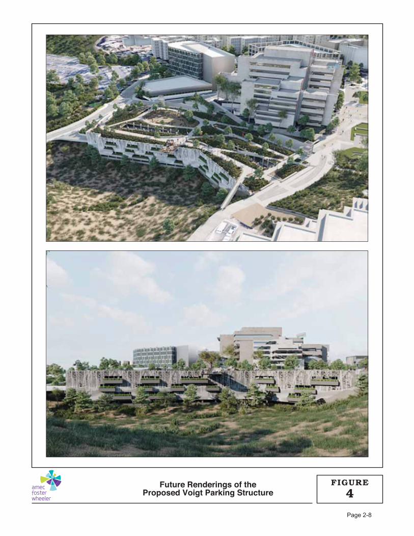
Future Renderings of theProposed Voigt Parking Structure 4
FIGURE
Page 2-8
UC San Diego Voigt Parking Structure Final Initial Study and Mitigated Negative Declaration December 2017
Page 2-9
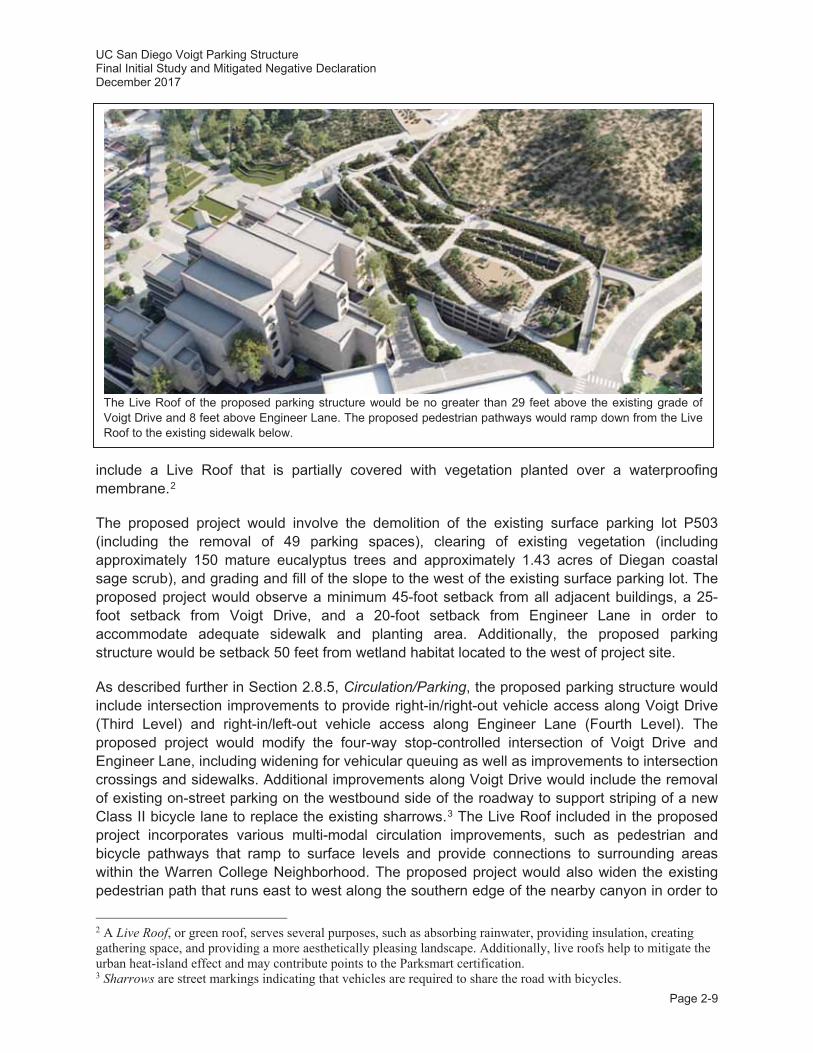
include a Live Roof that is partially covered with vegetation planted over a waterproofing membrane.2
The proposed project would involve the demolition of the existing surface parking lot P503 (including the removal of 49 parking spaces), clearing of existing vegetation (including approximately 150 mature eucalyptus trees and approximately 1.43 acres of Diegan coastal sage scrub), and grading and fill of the slope to the west of the existing surface parking lot. The proposed project would observe a minimum 45-foot setback from all adjacent buildings, a 25-foot setback from Voigt Drive, and a 20-foot setback from Engineer Lane in order to accommodate adequate sidewalk and planting area. Additionally, the proposed parking structure would be setback 50 feet from wetland habitat located to the west of project site.
As described further in Section 2.8.5, Circulation/Parking, the proposed parking structure would include intersection improvements to provide right-in/right-out vehicle access along Voigt Drive (Third Level) and right-in/left-out vehicle access along Engineer Lane (Fourth Level). The proposed project would modify the four-way stop-controlled intersection of Voigt Drive and Engineer Lane, including widening for vehicular queuing as well as improvements to intersection crossings and sidewalks. Additional improvements along Voigt Drive would include the removal of existing on-street parking on the westbound side of the roadway to support striping of a new Class II bicycle lane to replace the existing sharrows.3 The Live Roof included in the proposed project incorporates various multi-modal circulation improvements, such as pedestrian and bicycle pathways that ramp to surface levels and provide connections to surrounding areas within the Warren College Neighborhood. The proposed project would also widen the existing pedestrian path that runs east to west along the southern edge of the nearby canyon in order to
2 A Live Roof, or green roof, serves several purposes, such as absorbing rainwater, providing insulation, creating gathering space, and providing a more aesthetically pleasing landscape. Additionally, live roofs help to mitigate the urban heat-island effect and may contribute points to the Parksmart certification. 3 Sharrows are street markings indicating that vehicles are required to share the road with bicycles.
The Live Roof of the proposed parking structure would be no greater than 29 feet above the existing grade of Voigt Drive and 8 feet above Engineer Lane. The proposed pedestrian pathways would ramp down from the Live Roof to the existing sidewalk below.
UC San Diego Voigt Parking Structure Final Initial Study and Mitigated Negative Declaration December 2017
Page 2-10
provide a dedicated bicycle lane and develop a more formalized multi-modal connection between Hopkins Lane and Warren Mall, which is a priority project identified in the UC San Diego 2012 Bicycle and Pedestrian Master Planning Study (UC San Diego 2012a).
The proposed parking structure would include Americans with Disabilities Act (ADA)-accessible parking spaces near elevators on the Fourth Level closest to the main egress locations to the exterior of the structure, two elevators and staircases, an ADA-accessible bathroom, custodial closets, a maintenance/storage room and utility room, infrastructure for security systems (e.g., Blue Light/Intercom, campus phone, robbery alarm, and other measures), and a network hub room. The proposed project, like all new buildings on campus, would include sprinklers and appropriate access/egress routes for firefighting and evacuation. The campus Fire Marshal is responsible for campus-wide fire prevention and provision of services such as plan review and construction inspections to ensure conformance with California building and fire codes, and would be responsible for reviewing and approving plans for the proposed project.
2.6 Project Objectives
The following objectives have been identified for the proposed project:
Ensure access to campus facilities and parking needs are adequately met, in accordance with the 2004 LRDP;
Provide a well-designed multi-level parking structure that best serves the Warren College Neighborhood and Jacobs School of Engineering in the most practicable location while also minimizing encroachment into native habitat areas;
Provide approximately 840 new parking spaces to meet localized and anticipated parking demands in the Warren College Neighborhood;
Incorporate sustainable design principles to the greatest extent feasible to achieve certification by Parksmart (formerly the Green Parking Council), thereby reducing energy consumption and conserving natural resources;
Enhance the public realm connections with expanded multi-modal access including construction of new bicycle lanes and pedestrian pathways;
Provide (a minimum of) 50 new bicycle parking spaces on the Live Roof of the parking structure, as well as bicycle racks dispersed throughout the adjacent public realm to accommodate (a minimum of) 44 bicycles;
Extend and relocate campus utilities (e.g., storm drain) in a way that manages storm water and minimizes temporary biological impacts from trenching; and
Implement Low Impact Development (LID) opportunities with respect to landscape, planting, and hardscape design.
These objectives are consistent with the objectives of the 2004 LRDP, as updated by the ECBT Project EIR.
2.7 Sustainability
The proposed project would be in general conformance with the system-wide UC Sustainable Practices Policy (2016 update), which establishes numerous guidelines for future projects at UC campuses including the goal for all new building projects, other than acute-care facilities, to outperform the required provisions of the California Energy Code, Title 24 energy efficiency

UC San Diego Voigt Parking Structure Final Initial Study and Mitigated Negative Declaration December 2017
Page 2-11
standards by at least 20 percent and strive for 30 percent. In addition, the policy requires new construction projects to achieve a minimum standard equivalent to a LEED-New Construction (LEED-NC) Silver Certification.
LEED certification is the nationally accepted benchmark for the design, construction, and operation of high-performance green buildings. The program promotes a whole-building approach to sustainability by recognizing performance in five key areas of human and environmental health: sustainable site development, water savings, energy efficiency, materials selection, and indoor environmental quality.
Although the proposed project would be ineligible to attain a LEED-NC rating because it is a parking structure, the proposed parking structure has been designed to incorporate sustainable design features to achieve certification by Parksmart (formerly the Green Parking Council), a similar “green” rating for parking structures, and integrate sustainability goals to the extent possible.
As prescribed in the UC Sustainable Practices Policy D: Sustainable Transportation, UC San Diego has developed a business-case analysis for the proposed parking structure to document alignment with the UC San Diego Climate Action Plan (UC San Diego 2008) and sustainable transportation policies. The proposed parking structure would neither require additional employees nor directly increase student enrollment on campus. As such, no long-term increase in traffic across the UC San Diego campus would occur. Completion of the proposed project, which would result in an increase of as many as 791 parking spaces, even when considered with future proposed parking structures on the UC San Diego campus, would result in a total campus-wide parking space count less than the LRDP parking space cap as analyzed in the 2004 LRDP Program EIR. UC San Diego applies transportation demand management (TDM) strategies to reduce single-occupant vehicle travel demand. The project would include a Parking Management Plan (PMP) for the parking structure, focused on implementing sound and cost-effective parking demand management strategies as well as other TDM strategies (e.g., parking regulation strategies, employee permit parking programs, etc.) for the proposed parking structure, which could increase the efficiency of the parking structure between 20 and 40 percent (LLG 2017). Currently, approximately 57 percent of commuters to campus arrive on foot, by bicycle, vanpool, carpool, bus, or something other than a single-occupant vehicle. The proposed parking structure would include provision of 30 electric vehicle charging stations and may provide other parking preferences for carpool vehicles (e.g., parking spaces closest to stairs, elevators, etc.). Further, the proposed project would improve bicycle and pedestrian connectivity in the Warren College Neighborhood by extending pathways both across / from the Live Roof and in the vicinity of the project site. The proposed parking structure would provide short- and long-term bicycle parking further encouraging the use of multi-modal transportation. As such, the proposed parking structure would not adversely impact the ability to comply with UC San Diego’s goal of achieving carbon neutrality by 2025 (see the Greenhouse Gas Emissions discussion below).
In conformance with the Parksmart principles, the following sustainable features have been incorporated into the project siting and design:
Location of the parking structure along major access points to the West Campus to reduce vehicle miles driven in search of parking, provide ease of wayfinding, and provide
UC San Diego Voigt Parking Structure Final Initial Study and Mitigated Negative Declaration December 2017
Page 2-12
access to multi-modal facilities, trails, and pathways providing connections across campus;
Orientation of parking stalls to reduce internal circling; Provision of 30 electric vehicle charging stations; Connection and improvements to existing pedestrian pathways and campus bicycle
paths, enhanced with the provision of shade trees, benches, bicycle parking areas, and on-site bicycle fix-it stations to promote walking and cycling on campus;
Implementation of LID techniques and storm water treatment controls, including use of porous concrete in hardscape features where feasible as well as flow through planters;
Installation of a Live Roof with coastal grassland species and tree canopy to minimize heat-island effect;
Landscaping with drought-tolerant plantings, including native and adaptive species; Connection to campus recycled water for irrigation use; Re-use of eucalyptus trees for site furnishings and erosion control; Maximization of natural ventilation where feasible to reduce energy demand; Control of all Light-Emitting Diode (LED) lighting fixtures within the parking structure by
motion sensors to reduce energy demand; and Installation of low-flow plumbing fixtures.
2.8 Project Characteristics
2.8.1 Building Program
As described in Section 2.5, Project Description, the proposed project includes the construction of a four-story, two-bay parking structure on a 6.63-acre project site at the intersection of Voigt Drive and Engineer Lane within the West Campus of UC San Diego (refer to Figure 2). The project site includes surface parking lot P503 – currently comprising 49 parking spaces – and undeveloped areas immediately to the west designated for Park land uses in the 2004 LRDP. The implementation of the proposed project would provide up to approximately 840 parking spaces for the Warren College Neighborhood and would include transportation network improvements (see Section 2.8.5, Circulation/Parking), provision of utilities (see Section 2.8.3, Utility Requirements), and on-site storm water capture (see Section 2.8.4, Grading/Drainage).
2.8.2 Building Design
In order to minimize potential effects on adjacent land uses, the proposed parking structure would be architecturally consistent with the surrounding UC San Diego facilities within the Warren College Neighborhood and would be integrated into the existing slope on the project site. To ensure that appropriate site-specific considerations and design aesthetics are achieved, the parking
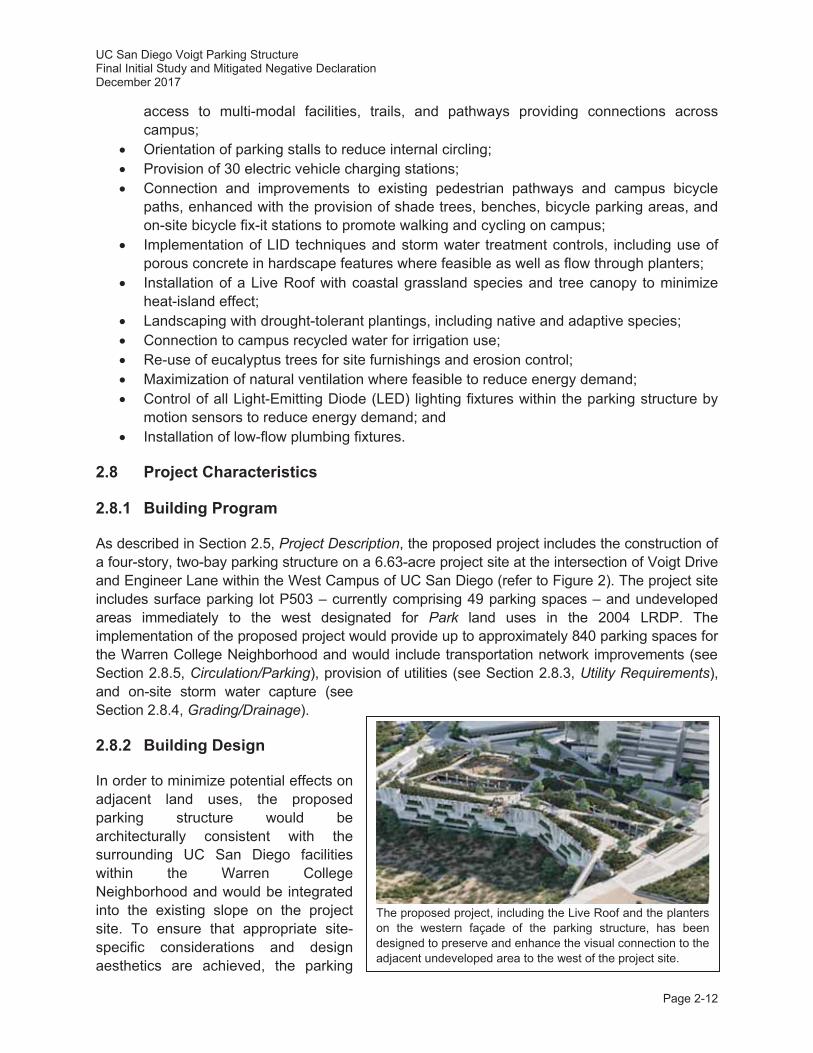
The proposed project, including the Live Roof and the planters on the western façade of the parking structure, has been designed to preserve and enhance the visual connection to the adjacent undeveloped area to the west of the project site.
UC San Diego Voigt Parking Structure Final Initial Study and Mitigated Negative Declaration December 2017
Page 2-13
structure would not exceed a height of 29 feet above Voigt Drive (i.e., 375 feet AMSL). At this height, three levels of proposed parking structure would be located below the surface grade of Voigt Drive and the Live Roof on the fifth level of the parking structure would be located approximately 0 to 8 feet above grade of Engineer Lane (see Figures 5 and 6). The proposed parking structure would include a multilayered façade system that would be designed to transition from the eucalyptus grove to the west and south to a more urban streetscape along Engineer Lane. The northern façade of the parking structure would be partially screened from Voigt Drive by landscaped coast live oak (Quercus agrifolia) trees. The western façade would consist of a modulated, concrete mass with flow through planters (i.e., storm water retention basins). The bulk and scale of the parking structure would provide a transition between the existing undeveloped land to the west to the more urban Jacobs School of Engineering. Additionally, with native landscaping and installation of a Live Roof, the proposed parking structure would preserve and enhance the existing views to and from the Geisel Library, Jacobs School of Engineering, and Warren Mall.
2.8.3 Utility Requirements
Electrical Power
Power would be supplied to the proposed parking structure from the existing 12 kilovolt (kV) primary selective underground distribution system on campus. The project’s power would connect at existing Electrical Manhole E7-15 or E7-16, with 15 kV feeders in an underground duct running from the existing manhole to an outdoor transformer. Emergency power for egress lighting and fire alarm would be provided by batteries as required by code. The hydraulic elevators would lower to the next available level, as required by code.
Lighting
Lighting for the proposed parking structure would comply with California Energy Code, Title 24 requirements, and would be designed to enhance visibility and security in the proposed parking structure. Minimum light levels would be maintained at the entrance, inside the structure, on the roof, and on the outside pedestrian paths leading to the structure. All light fixtures would be controlled by motion sensors with adjustable time delay. The proposed parking structure includes two light wells and two areaways4 that extend from the ground level to the fifth / Live Roof level intended to minimize or eliminate the need for daytime lighting. The western façade of the proposed parking structure would also have openings to allow for natural light.
Ventilation
Natural ventilation would be provided to the maximum extent feasible through the opening in the facades of the proposed parking structure (e.g., light wells, areaways, western façade, etc.). Mechanical ventilation would also be provided throughout the parking structure, utilizing carbon monoxide (CO) sensors and variable speed drives for the fans to prevent the need for continuous ventilation. All mechanical equipment would be controlled and monitoring by the Campus Energy Management System and would only be used when necessary.
4 An areaway is an open area located below grade and adjacent to a building to provide light and air. The proposed parking structure would have two areaways located along Engineer Lane.
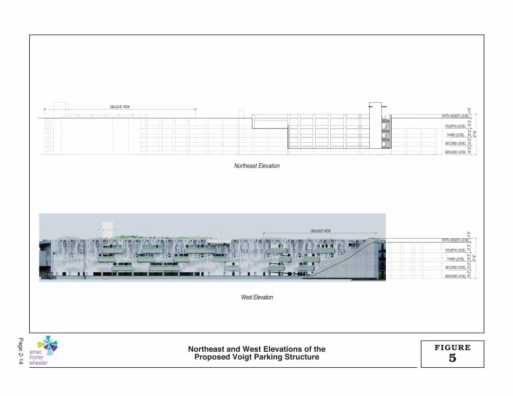
OBLIQUE VIEW
FIFTH (ROOF) LEVEL
4’-9”
12’-3
”10
’-2”
10’-2
”10
’-2”
47’-6
”
FOURTH LEVEL
THIRD LEVEL
SECOND LEVEL
GROUND LEVEL
OBLIQUE VIEW
FIFTH (ROOF) LEVEL
4’-9”
12’-3
”10
’-2”
10’-2
”10
’-2”
47’-6
”
FOURTH LEVEL
THIRD LEVEL
SECOND LEVEL
GROUND LEVEL
5FIGURENortheast and West Elevations of the
Proposed Voigt Parking Structure
West Elevation
Northeast Elevation
Page 2-14
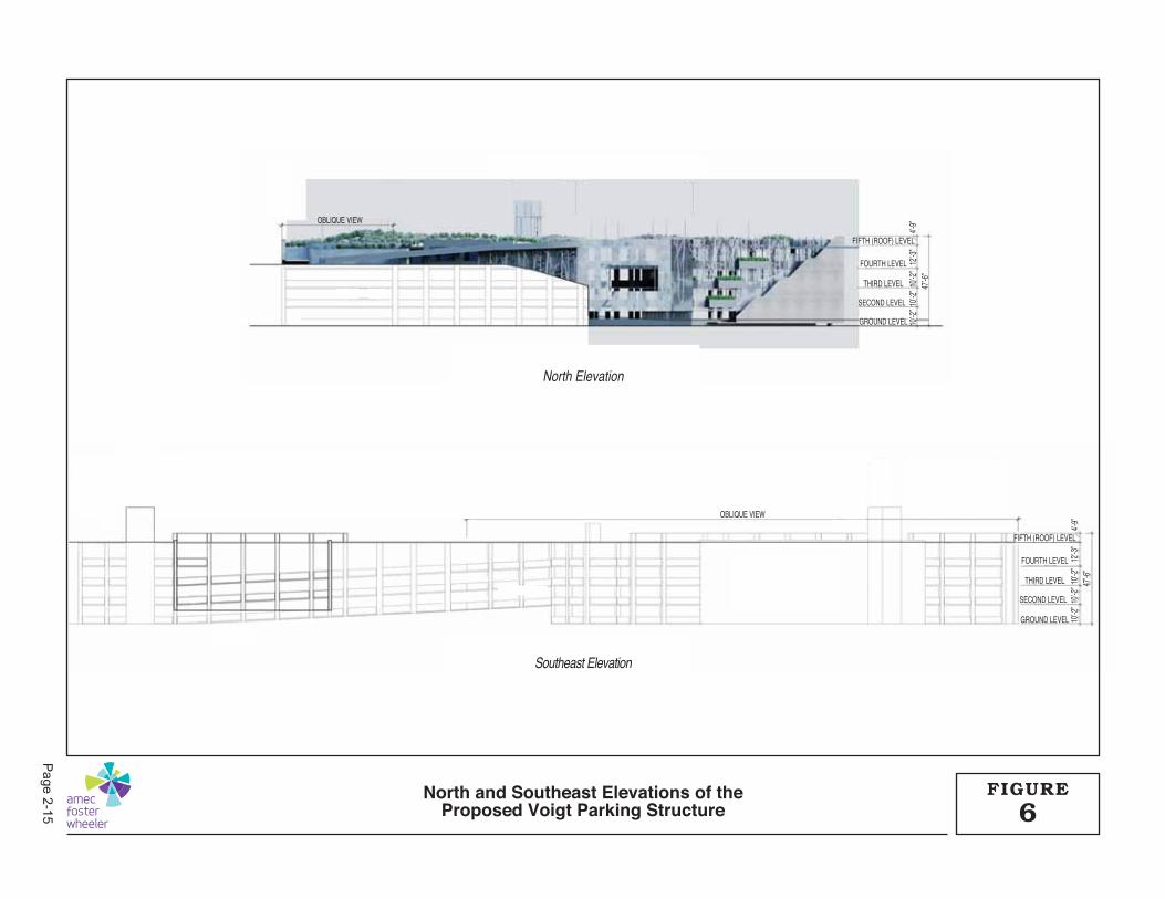
OBLIQUE VIEW
FIFTH (ROOF) LEVEL
4’-9”
12’-3
”10
’-2”
10’-2
”10
’-2”
47’-6
”
FOURTH LEVEL
THIRD LEVEL
SECOND LEVEL
GROUND LEVEL
OBLIQUE VIEW
FIFTH (ROOF) LEVEL
4’-9”
12’-3
”10
’-2”
10’-2
”10
’-2”
47’-6
”
FOURTH LEVEL
THIRD LEVEL
SECOND LEVEL
GROUND LEVEL
6FIGURENorth and Southeast Elevations of the
Proposed Voigt Parking Structure
Southeast Elevation
North Elevation
Page2-15
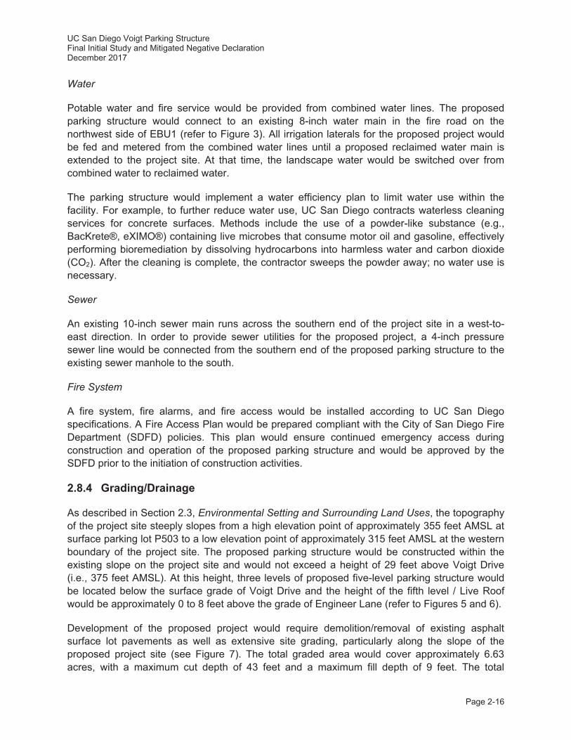
UC San Diego Voigt Parking Structure Final Initial Study and Mitigated Negative Declaration December 2017
Page 2-16
Water
Potable water and fire service would be provided from combined water lines. The proposed parking structure would connect to an existing 8-inch water main in the fire road on the northwest side of EBU1 (refer to Figure 3). All irrigation laterals for the proposed project would be fed and metered from the combined water lines until a proposed reclaimed water main is extended to the project site. At that time, the landscape water would be switched over from combined water to reclaimed water.
The parking structure would implement a water efficiency plan to limit water use within the facility. For example, to further reduce water use, UC San Diego contracts waterless cleaning services for concrete surfaces. Methods include the use of a powder-like substance (e.g., BacKrete®, eXIMO®) containing live microbes that consume motor oil and gasoline, effectively performing bioremediation by dissolving hydrocarbons into harmless water and carbon dioxide (CO2). After the cleaning is complete, the contractor sweeps the powder away; no water use is necessary.
Sewer
An existing 10-inch sewer main runs across the southern end of the project site in a west-to-east direction. In order to provide sewer utilities for the proposed project, a 4-inch pressure sewer line would be connected from the southern end of the proposed parking structure to the existing sewer manhole to the south.
Fire System
A fire system, fire alarms, and fire access would be installed according to UC San Diego specifications. A Fire Access Plan would be prepared compliant with the City of San Diego Fire Department (SDFD) policies. This plan would ensure continued emergency access during construction and operation of the proposed parking structure and would be approved by the SDFD prior to the initiation of construction activities.
2.8.4 Grading/Drainage
As described in Section 2.3, Environmental Setting and Surrounding Land Uses, the topography of the project site steeply slopes from a high elevation point of approximately 355 feet AMSL at surface parking lot P503 to a low elevation point of approximately 315 feet AMSL at the western boundary of the project site. The proposed parking structure would be constructed within the existing slope on the project site and would not exceed a height of 29 feet above Voigt Drive (i.e., 375 feet AMSL). At this height, three levels of proposed five-level parking structure would be located below the surface grade of Voigt Drive and the height of the fifth level / Live Roof would be approximately 0 to 8 feet above the grade of Engineer Lane (refer to Figures 5 and 6).
Development of the proposed project would require demolition/removal of existing asphalt surface lot pavements as well as extensive site grading, particularly along the slope of the proposed project site (see Figure 7). The total graded area would cover approximately 6.63 acres, with a maximum cut depth of 43 feet and a maximum fill depth of 9 feet. The total
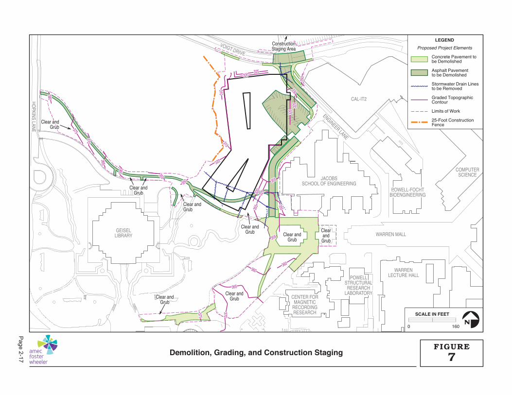
GEISELGEISELLIBRARYLIBRARY
CENTER FORCENTER FORMAGNETICMAGNETIC
RECORDINGRECORDINGRESEARCHRESEARCH
POWELLPOWELLSTRUCTURALSTRUCTURAL
RESEARCHRESEARCHLABORATORYLABORATORY
WARRENWARRENLECTURE HALLLECTURE HALL
JACOBSJACOBSSCHOOL OF ENGINEERINGSCHOOL OF ENGINEERING
POWELL-FOCHTPOWELL-FOCHTBIOENGINEERINGBIOENGINEERING
COMPUTERCOMPUTERSCIENCESCIENCE
CAL-IT2CAL-IT2HOPKINS LANE
HOPKINS LANE
ENGINEER LANE
ENGINEER LANE
VOIGT DRIVE
GEISELLIBRARY
CENTER FORMAGNETIC
RECORDINGRESEARCH
POWELLSTRUCTURAL
RESEARCHLABORATORY
WARRENLECTURE HALL
JACOBSSCHOOL OF ENGINEERING
POWELL-FOCHTBIOENGINEERING
WARREN MALL
COMPUTERSCIENCE
CAL-IT2HOPKINS LANE
ENGINEER LANE
VOIGT DRIVE
360360360360
355355
355355
355
355
355355
380380
375375
370370
365365
360360
355355
350350
320320
315315
310310
320320
320
320
325325
325
325
330330
350
350
320
320
325
325
365365370370375375
360360
355
355
355
355
380
375
370
365
360
355
350
320
315310
320
320
325
325
330
350
320
325
365370375
Clear andClear andGrubGrub
Clear andClear andGrubGrub
ConstructionConstructionStaging AreaStaging Area
Clear andClear andGrubGrub
Clear andClear andGrubGrub Clear andClear and
GrubGrub
Clear andClear andGrubGrub
ClearClearandandGrubGrub
Clear andClear andGrubGrub
Clear andGrub
Clear andGrub
Clear andGrub
ConstructionStaging Area
Clear andGrub Clear and
Grub
Clear andGrub
ClearandGrub
Clear andGrub
LEGEND
Proposed Project Elements
Concrete Pavement to be Demolished
Asphalt Pavementto be Demolished
Stormwater Drain Linesto be Removed
Graded TopographicContour
Limits of Work
25-Foot ConstructionFence
0 160
SCALE IN FEET
N
7FIGURE
Demolition, Grading, and Construction Staging
Page2-17
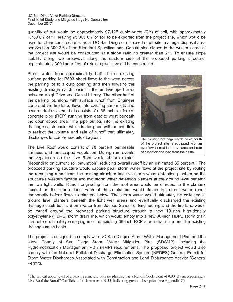
UC San Diego Voigt Parking Structure Final Initial Study and Mitigated Negative Declaration December 2017
Page 2-18
quantity of cut would be approximately 97,125 cubic yards (CY) of soil, with approximately 1,760 CY of fill, leaving 95,365 CY of soil to be exported from the project site, which would be used for other construction sites at UC San Diego or disposed of off-site in a legal disposal area per Section 300-2.6 of the Standard Specifications. Constructed slopes in the western area of the project site would be constructed at a slope ratio no greater than 2:1. To ensure slope stability along two areaways along the eastern side of the proposed parking structure, approximately 300 linear feet of retaining walls would be constructed.
Storm water from approximately half of the existing surface parking lot P503 sheet flows to the west across the parking lot to a curb opening and then flows to the existing drainage catch basin in the undeveloped area between Voigt Drive and Geisel Library. The other half of the parking lot, along with surface runoff from Engineer Lane and the fire lane, flows into existing curb inlets and a storm drain system that consists of a 36-inch reinforced concrete pipe (RCP) running from east to west beneath the open space area. The pipe outlets into the existing drainage catch basin, which is designed with an overflow to restrict the volume and rate of runoff that ultimately discharges to Los Penasquitos Lagoon.
The Live Roof would consist of 70 percent permeable surfaces and landscaped vegetation. During rain events the vegetation on the Live Roof would absorb rainfall (depending on current soil saturation), reducing overall runoff by an estimated 35 percent.5 The proposed parking structure would capture peak storm water flows at the project site by routing the remaining runoff from the parking structure into five storm water detention planters on the structure’s western façade and two storm water detention planters at the ground level beneath the two light wells. Runoff originating from the roof area would be directed to the planters located on the fourth floor. Each of these planters would detain the storm water runoff temporarily before flows to planters below. The storm water would ultimately be collected at ground level planters beneath the light well areas and eventually discharged the existing drainage catch basin. Storm water from Jacobs School of Engineering and the fire lane would be routed around the proposed parking structure through a new 18-inch high-density polyethylene (HDPE) storm drain line, which would empty into a new 30-inch HDPE storm drain line before ultimately emptying into the existing 36-inch RCP storm drain line and the existing drainage catch basin.
The project is designed to comply with UC San Diego’s Storm Water Management Plan and the latest County of San Diego Storm Water Mitigation Plan (SDSMP), including the Hydromodification Management Plan (HMP) requirements. The proposed project would also comply with the National Pollutant Discharge Elimination System (NPDES) General Permit for Storm Water Discharges Associated with Construction and Land Disturbance Activity (General Permit).
5 The typical upper level of a parking structure with no planting has a Runoff Coefficient of 0.90. By incorporating a Live Roof the Runoff Coefficient for decreases to 0.55, indicating greater absorption (see Appendix C).
The existing drainage catch basin south of the project site is equipped with an overflow to restrict the volume and rate of runoff discharged from the basin.
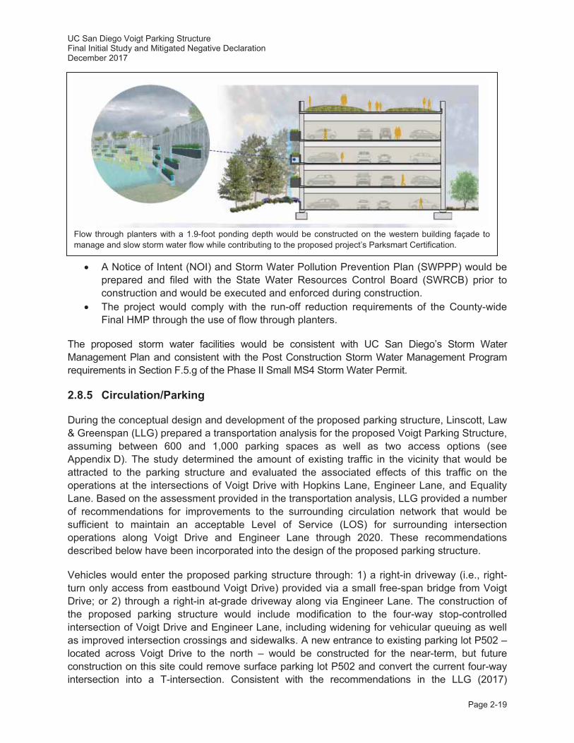
UC San Diego Voigt Parking Structure Final Initial Study and Mitigated Negative Declaration December 2017
Page 2-19
A Notice of Intent (NOI) and Storm Water Pollution Prevention Plan (SWPPP) would be prepared and filed with the State Water Resources Control Board (SWRCB) prior to construction and would be executed and enforced during construction.
The project would comply with the run-off reduction requirements of the County-wide Final HMP through the use of flow through planters.
The proposed storm water facilities would be consistent with UC San Diego’s Storm Water Management Plan and consistent with the Post Construction Storm Water Management Program requirements in Section F.5.g of the Phase II Small MS4 Storm Water Permit.
2.8.5 Circulation/Parking
During the conceptual design and development of the proposed parking structure, Linscott, Law & Greenspan (LLG) prepared a transportation analysis for the proposed Voigt Parking Structure, assuming between 600 and 1,000 parking spaces as well as two access options (see Appendix D). The study determined the amount of existing traffic in the vicinity that would be attracted to the parking structure and evaluated the associated effects of this traffic on the operations at the intersections of Voigt Drive with Hopkins Lane, Engineer Lane, and Equality Lane. Based on the assessment provided in the transportation analysis, LLG provided a number of recommendations for improvements to the surrounding circulation network that would be sufficient to maintain an acceptable Level of Service (LOS) for surrounding intersection operations along Voigt Drive and Engineer Lane through 2020. These recommendations described below have been incorporated into the design of the proposed parking structure.
Vehicles would enter the proposed parking structure through: 1) a right-in driveway (i.e., right-turn only access from eastbound Voigt Drive) provided via a small free-span bridge from Voigt Drive; or 2) through a right-in at-grade driveway along via Engineer Lane. The construction of the proposed parking structure would include modification to the four-way stop-controlled intersection of Voigt Drive and Engineer Lane, including widening for vehicular queuing as well as improved intersection crossings and sidewalks. A new entrance to existing parking lot P502 – located across Voigt Drive to the north – would be constructed for the near-term, but future construction on this site could remove surface parking lot P502 and convert the current four-way intersection into a T-intersection. Consistent with the recommendations in the LLG (2017)
Flow through planters with a 1.9-foot ponding depth would be constructed on the western building façade to manage and slow storm water flow while contributing to the proposed project’s Parksmart Certification.
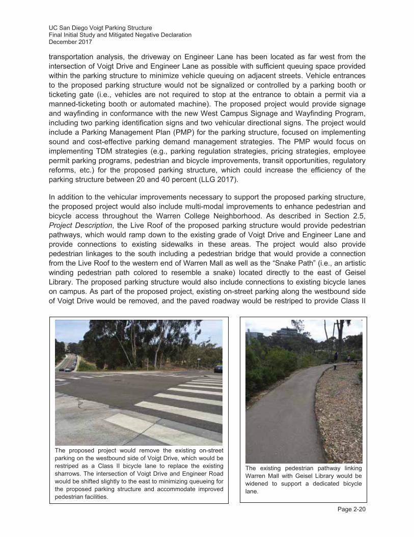
UC San Diego Voigt Parking Structure Final Initial Study and Mitigated Negative Declaration December 2017
Page 2-20
transportation analysis, the driveway on Engineer Lane has been located as far west from the intersection of Voigt Drive and Engineer Lane as possible with sufficient queuing space provided within the parking structure to minimize vehicle queuing on adjacent streets. Vehicle entrances to the proposed parking structure would not be signalized or controlled by a parking booth or ticketing gate (i.e., vehicles are not required to stop at the entrance to obtain a permit via a manned-ticketing booth or automated machine). The proposed project would provide signage and wayfinding in conformance with the new West Campus Signage and Wayfinding Program, including two parking identification signs and two vehicular directional signs. The project would include a Parking Management Plan (PMP) for the parking structure, focused on implementing sound and cost-effective parking demand management strategies. The PMP would focus on implementing TDM strategies (e.g., parking regulation strategies, pricing strategies, employee permit parking programs, pedestrian and bicycle improvements, transit opportunities, regulatory reforms, etc.) for the proposed parking structure, which could increase the efficiency of the parking structure between 20 and 40 percent (LLG 2017).
In addition to the vehicular improvements necessary to support the proposed parking structure, the proposed project would also include multi-modal improvements to enhance pedestrian and bicycle access throughout the Warren College Neighborhood. As described in Section 2.5, Project Description, the Live Roof of the proposed parking structure would provide pedestrian pathways, which would ramp down to the existing grade of Voigt Drive and Engineer Lane and provide connections to existing sidewalks in these areas. The project would also provide pedestrian linkages to the south including a pedestrian bridge that would provide a connection from the Live Roof to the western end of Warren Mall as well as the “Snake Path” (i.e., an artistic winding pedestrian path colored to resemble a snake) located directly to the east of Geisel Library. The proposed parking structure would also include connections to existing bicycle lanes on campus. As part of the proposed project, existing on-street parking along the westbound side of Voigt Drive would be removed, and the paved roadway would be restriped to provide Class II
The existing pedestrian pathway linking Warren Mall with Geisel Library would be widened to support a dedicated bicycle lane.
The proposed project would remove the existing on-street parking on the westbound side of Voigt Drive, which would be restriped as a Class II bicycle lane to replace the existing sharrows. The intersection of Voigt Drive and Engineer Road would be shifted slightly to the east to minimizing queueing for the proposed parking structure and accommodate improved pedestrian facilities.
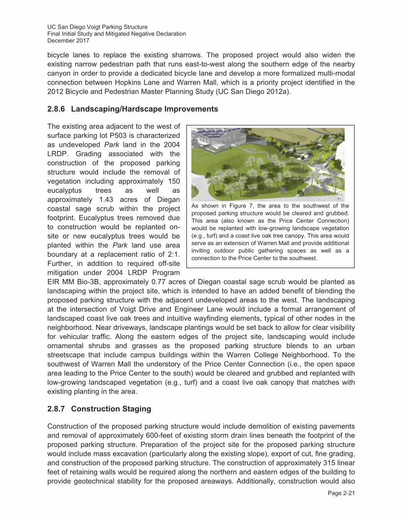
UC San Diego Voigt Parking Structure Final Initial Study and Mitigated Negative Declaration December 2017
Page 2-21
bicycle lanes to replace the existing sharrows. The proposed project would also widen the existing narrow pedestrian path that runs east-to-west along the southern edge of the nearby canyon in order to provide a dedicated bicycle lane and develop a more formalized multi-modal connection between Hopkins Lane and Warren Mall, which is a priority project identified in the 2012 Bicycle and Pedestrian Master Planning Study (UC San Diego 2012a).
2.8.6 Landscaping/Hardscape Improvements
The existing area adjacent to the west of surface parking lot P503 is characterized as undeveloped Park land in the 2004 LRDP. Grading associated with the construction of the proposed parking structure would include the removal of vegetation including approximately 150 eucalyptus trees as well as approximately 1.43 acres of Diegan coastal sage scrub within the project footprint. Eucalyptus trees removed due to construction would be replanted on-site or new eucalyptus trees would be planted within the Park land use area boundary at a replacement ratio of 2:1. Further, in addition to required off-site mitigation under 2004 LRDP Program EIR MM Bio-3B, approximately 0.77 acres of Diegan coastal sage scrub would be planted as landscaping within the project site, which is intended to have an added benefit of blending the proposed parking structure with the adjacent undeveloped areas to the west. The landscaping at the intersection of Voigt Drive and Engineer Lane would include a formal arrangement of landscaped coast live oak trees and intuitive wayfinding elements, typical of other nodes in the neighborhood. Near driveways, landscape plantings would be set back to allow for clear visibility for vehicular traffic. Along the eastern edges of the project site, landscaping would include ornamental shrubs and grasses as the proposed parking structure blends to an urban streetscape that include campus buildings within the Warren College Neighborhood. To the southwest of Warren Mall the understory of the Price Center Connection (i.e., the open space area leading to the Price Center to the south) would be cleared and grubbed and replanted with low-growing landscaped vegetation (e.g., turf) and a coast live oak canopy that matches with existing planting in the area.
2.8.7 Construction Staging
Construction of the proposed parking structure would include demolition of existing pavements and removal of approximately 600-feet of existing storm drain lines beneath the footprint of the proposed parking structure. Preparation of the project site for the proposed parking structure would include mass excavation (particularly along the existing slope), export of cut, fine grading, and construction of the proposed parking structure. The construction of approximately 315 linear feet of retaining walls would be required along the northern and eastern edges of the building to provide geotechnical stability for the proposed areaways. Additionally, construction would also
As shown in Figure 7, the area to the southwest of the proposed parking structure would be cleared and grubbed. This area (also known as the Price Center Connection) would be replanted with low-growing landscape vegetation (e.g., turf) and a coast live oak tree canopy. This area would serve as an extension of Warren Mall and provide additional inviting outdoor public gathering spaces as well as a connection to the Price Center to the southwest.
UC San Diego Voigt Parking Structure Final Initial Study and Mitigated Negative Declaration December 2017
Page 2-22
include the trenching of approximately 570-feet of new storm drain lines to the southeast of the proposed parking structure. The construction contractor would use an on-site staging area and soil stockpile area located on surface parking lot P502, which would temporarily remove approximately 85 parking spaces in the southeast corner of the parking lot throughout the duration of construction activities. It is assumed that construction vehicles would enter the parking lot driveway and turn right into an established construction staging area. Other vehicles would turn left into a preserved parking area that would continue to provide over 300 parking spaces. Throughout the proposed construction activities, the entire project boundary would be fenced. Prior to any grading activities, a minimum 25-foot setback from the wetland boundary to the west would be demarcated by a chain-link fence which would remain in place throughout the duration of all construction activities with a primary construction entrance off of Engineer Lane. Access through the site would be maintained for emergency vehicles along Voigt Drive.
Construction is anticipated to take approximately 12 to 16 months. There would be no major utility interruptions during construction activities. The dedicated utility shutdown coordinator would proactively coordinate any utility service shutdowns and connections well in advance to ensure they coincide with a time that provides the least impact to surrounding facilities and other nearby construction activities.
2.9 Project Approval/Schedule
As the public agency principally responsible for approving or carrying out the proposed project, which includes a minor LRDP amendment, the University of California is the Lead Agency under CEQA and is responsible for the review and approval of the Tiered IS/MND. The proposed Tiered IS/MND would be considered by The Regents of the University of California (or their delegate), and this Tiered IS/MND would support the environmental, minor LRDP amendment, and design approval actions.
The proposed project site is located within the California Coastal Zone; therefore, a Coastal Development Permit (CDP) from the California Coastal Commission (CCC) would be required.
The project construction schedule would allow for tree removal during the non-breeding season, which is between September through January. Site preparation, grading, and construction are anticipated to begin in spring 2018 and be completed by early 2019.
UC San Diego Voigt Parking Structure Final Initial Study and Mitigated Negative Declaration December 2017
Page 3-1
3.0 RELATIONSHIP TO AND CONSISTENCY WITH 2004 LRDP
This IS/MND for the proposed Voigt Parking Structure has been tiered from the 2004 LRDP Program EIR (SCH No. 2003081023) and ECBT Project EIR (SCH No. 2009081053), which are hereby incorporated by reference. The 2004 LRDP is the adopted land use plan for the UC San Diego campus and is based upon the anticipated increase in academic and research activities, as well as the anticipated space requirements and land uses, associated with the expansion of UC San Diego’s academic, administrative, and support programs through academic year 2020-2021. The 2004 LRDP Program EIR analyzed the overall direct and indirect environmental effects of campus growth and facility development including potentially significant cumulative impacts. The ECBT Project EIR analyzed the cumulative traffic/circulation and cumulative air quality impacts associated with the implementation of the 2004 LRDP Program EIR, as an updated to the 2004 LRDP Program EIR.
The 2004 LRDP consists of three primary elements: 1) a description of the planning context for the campus; 2) an outline of the enrollment, faculty/staff, space, and parking needs of the campus; and 3) a land use plan to guide the siting of proposed new development and related circulation and parking facilities to meet those needs.
In order to determine the consistency of the proposed project with the 2004 LRDP, the following questions should be considered.
Is the proposed project included within the scope of the development projected for the 2004 LRDP?
Is the proposed project location in an area designated for this type of use in the 2004 LRDP?
Is the campus population that would result from the proposed project included within the scope of the 2004 LRDP population projections?
Are the objectives of the proposed project consistent with the objectives of the 2004 LRDP?
The following discussion describes the scope of development, land use designations, population projections, and objectives contained in the 2004 LRDP that are relevant to the proposed project, and evaluates the proposed project’s consistency with each of these items. The consistency discussion is followed by a summary of the appropriateness of using a tiered CEQA document for the proposed project.
3.1 2004 LRDP Scope of Development and Land Use Designations
The 2004 LRDP designates the proposed project site as Academic and Park land use areas (refer to Figure 3.4-5 on page 3-31 of the 2004 LRDP Program EIR). Academic land uses primarily include classrooms; class and research laboratories; ancillary support facilities (e.g., administrative facilities, housing and dining facilities, open space, parking, recreation, and shops supporting academic activities); undergraduate colleges, graduate programs, and professional schools (refer to page 3-30 of the 2004 LRDP Program EIR). Park land use areas are defined in the UC San Diego Open Space Management Program (see Figure 10 in the 2004 LRDP; UC San Diego 2004b, 2016c) and include Ecological Reserve, Grove Reserve, and Restoration Lands. The Ecological Reserve areas within the Park land use type contain flora and fauna that
UC San Diego Voigt Parking Structure Final Initial Study and Mitigated Negative Declaration December 2017
Page 3-2
are native to the region and contribute to UC San Diego’s unique setting. The Grove Reserve areas of the Park land use type include the major eucalyptus stands stretching south from Genesee Avenue to the northern end of the SIO campus. Restoration Lands are undeveloped areas of the campus that have been disturbed by erosion, invasive vegetation, and past military use (e.g., U.S. Army Camp Callan). The proposed project site includes Restoration Lands to the west of surface parking lot P503 and limited areas of Grove Reserve further to the west. However, the project site does not include any Ecological Reserve lands, which are subject to special constraints on development. As described in Section 2.0, Project Location and Description, the proposed project would include the development of a parking structure that would support existing adjacent Academic uses in the Warren College Neighborhood. As described in Section 2.8, Project Approval/Schedule, the proposed project includes a minor LRDP amendment that would change the land use designation on the western area of the project site from Park to Academic. The minor LRDP amendment would be approved concurrent with the proposed project approval, thus making the proposed project consistent with the scope of development and land use designations in the LRDP.
3.2 2004 LRDP Population Projections
Enrollment projections for all campuses in the University of California system are established in a process that is determined by State of California statute and policy. The campus and the University of California Office of the President (UCOP) determine the specific campus population projections for UC San Diego, which consider:
The responsibility of the University of California as required by the State Master Plan for Higher Education to accommodate the top 12.5 percent of high school graduates and community college transfer students in the University of California system;
The State’s ability to support financially this policy commitment; Population growth and specifically the number of qualified students; and The academic plan and physical capacity of the UC San Diego campus to accommodate
students.
Table 1-1 in the 2004 LRDP, Existing and Projected UC San Diego Population: Regular Academic Year, summarizes the anticipated population growth under the 2004 LRDP (see Table 1).
As described in Section 2.8, Project Characteristics, the proposed project involves the construction of a new parking structure that would provide parking for existing staff, students, and visitors in the Warren College Neighborhood. The proposed project would not add to the campus staff, student, and visitor populations and no new growth would be anticipated as a result of implementation of the proposed project. Completion of the proposed project, even when considered with future proposed parking structures on the UC San Diego campus, would be under the LRDP parking space cap as analyzed in the 2004 LRDP Program EIR.
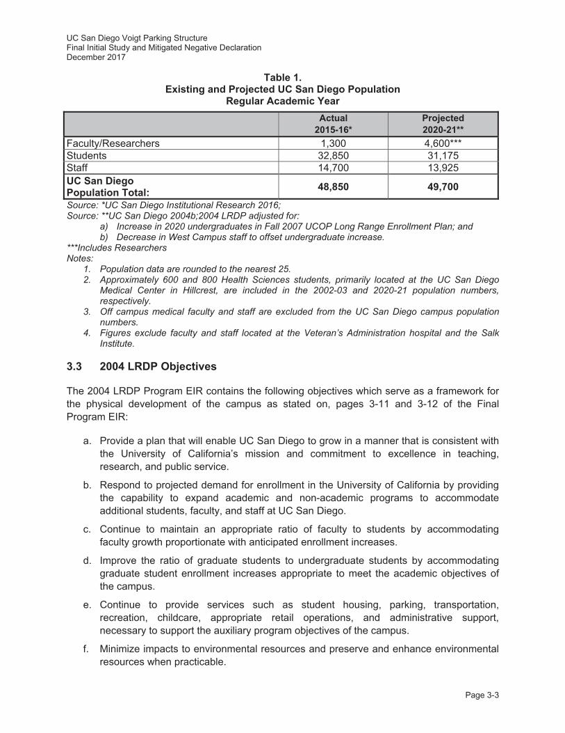
UC San Diego Voigt Parking Structure Final Initial Study and Mitigated Negative Declaration December 2017
Page 3-3
Table 1. Existing and Projected UC San Diego Population
Regular Academic Year
Actual 2015-16*
Projected 2020-21**
Faculty/Researchers 1,300 4,600*** Students 32,850 31,175 Staff 14,700 13,925 UC San Diego Population Total: 48,850 49,700
Source: *UC San Diego Institutional Research 2016; Source: **UC San Diego 2004b;2004 LRDP adjusted for:
a) Increase in 2020 undergraduates in Fall 2007 UCOP Long Range Enrollment Plan; and b) Decrease in West Campus staff to offset undergraduate increase.
***Includes Researchers Notes:
1. Population data are rounded to the nearest 25. 2. Approximately 600 and 800 Health Sciences students, primarily located at the UC San Diego
Medical Center in Hillcrest, are included in the 2002-03 and 2020-21 population numbers, respectively.
3. Off campus medical faculty and staff are excluded from the UC San Diego campus population numbers.
4. Figures exclude faculty and staff located at the Veteran’s Administration hospital and the Salk Institute.
3.3 2004 LRDP Objectives
The 2004 LRDP Program EIR contains the following objectives which serve as a framework for the physical development of the campus as stated on, pages 3-11 and 3-12 of the Final Program EIR:
a. Provide a plan that will enable UC San Diego to grow in a manner that is consistent with the University of California’s mission and commitment to excellence in teaching, research, and public service.
b. Respond to projected demand for enrollment in the University of California by providing the capability to expand academic and non-academic programs to accommodate additional students, faculty, and staff at UC San Diego.
c. Continue to maintain an appropriate ratio of faculty to students by accommodating faculty growth proportionate with anticipated enrollment increases.
d. Improve the ratio of graduate students to undergraduate students by accommodating graduate student enrollment increases appropriate to meet the academic objectives of the campus.
e. Continue to provide services such as student housing, parking, transportation, recreation, childcare, appropriate retail operations, and administrative support, necessary to support the auxiliary program objectives of the campus.
f. Minimize impacts to environmental resources and preserve and enhance environmental resources when practicable.
UC San Diego Voigt Parking Structure Final Initial Study and Mitigated Negative Declaration December 2017
Page 3-4
g. Maintain, expand, and support existing and future scientific and research opportunities and patient care services.
h. Maintain academic excellence and serve as a resource to the surrounding community, city, state, and nation.
As described in Section 2.4, Project Background, the construction of the proposed project would provide additional staff, student, and visitor parking to support the existing campus population and serve as a buffer for potential conversion and associated loss of existing surface parking that could be removed under future development at surface parking lot P502. The proposed project would be consistent with the objectives of the 2004 LRDP. Specifically, the proposed project would support and improve the auxiliary program objectives of the campus (e). The proposed parking structure is required to be located in close proximity to the Jacobs School of Engineering to support existing Academic uses; the parking structure has been located within the existing slope adjacent to surface parking lot P503 in order to reduce its overall footprint and minimize associated encroachment on adjacent undeveloped Park lands. The project footprint has also been designed to be set back by a minimum distance of 50 feet from sensitive wetland vegetation to the west. In addition to sustainability elements described further in Section 2.7, Sustainability, a Live Roof has also been incorporated into the project design to improve storm water quality over existing conditions. Together these elements of the proposed project would minimize impacts to the environment during construction and enhance environmental resources (f). The proposed project would be compatible with the existing surrounding land uses and – with the adoption of the minor LRDP amendment – the proposed project would be consistent with the overall scope and objectives of the 2004 LRDP.
3.4 Appropriateness of a Tiered Initial Study
The proposed project, including the minor LRDP amendment, would be consistent with the scope of development, population projections, and objectives contained in the 2004 LRDP and evaluated in the 2004 LRDP Program EIR, as updated by the ECBT Project EIR. Accordingly, pursuant to Section 15152 of the State CEQA Guidelines, it is appropriate to tier this IS from the 2004 LRDP Program EIR, as updated by the ECBT Project EIR. This IS evaluates whether the environmental effects of the proposed project were adequately addressed in the 2004 LRDP Program EIR, as updated by the ECBT Project EIR. For impacts that were adequately addressed, the IS provides a cross reference to the relevant discussion in the 2004 LRDP Program EIR and the ECBT Project EIR. Project-specific impacts that were not addressed in the 2004 LRDP Program EIR, or as updated in the ECBT Project EIR, are evaluated in detail in this document. This IS also evaluates whether there have been any changes in the project or the circumstances in which it would be undertaken since the 2004 LRDP Program EIR was certified, as updated by the ECBT Project EIR, that require additional analysis in this document. Project-specific mitigation has been identified where required.
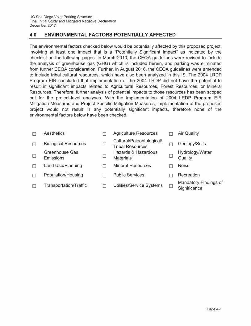
UC San Diego Voigt Parking Structure Final Initial Study and Mitigated Negative Declaration December 2017
Page 4-1
4.0 ENVIRONMENTAL FACTORS POTENTIALLY AFFECTED
The environmental factors checked below would be potentially affected by this proposed project, involving at least one impact that is a “Potentially Significant Impact” as indicated by the checklist on the following pages. In March 2010, the CEQA guidelines were revised to include the analysis of greenhouse gas (GHG) which is included herein, and parking was eliminated from further CEQA consideration. Further, in August 2016, the CEQA guidelines were amended to include tribal cultural resources, which have also been analyzed in this IS. The 2004 LRDP Program EIR concluded that implementation of the 2004 LRDP did not have the potential to result in significant impacts related to Agricultural Resources, Forest Resources, or Mineral Resources. Therefore, further analysis of potential impacts to those resources has been scoped out for the project-level analyses. With the implementation of 2004 LRDP Program EIR Mitigation Measures and Project-Specific Mitigation Measures, implementation of the proposed project would not result in any potentially significant impacts, therefore none of the environmental factors below have been checked.
Aesthetics Agriculture Resources Air Quality
Biological Resources Cultural/Paleontological/ Tribal Resources Geology/Soils
Greenhouse Gas Emissions
Hazards & Hazardous Materials
Hydrology/Water Quality
Land Use/Planning Mineral Resources Noise
Population/Housing Public Services Recreation
Transportation/Traffic Utilities/Service Systems Mandatory Findings of Significance
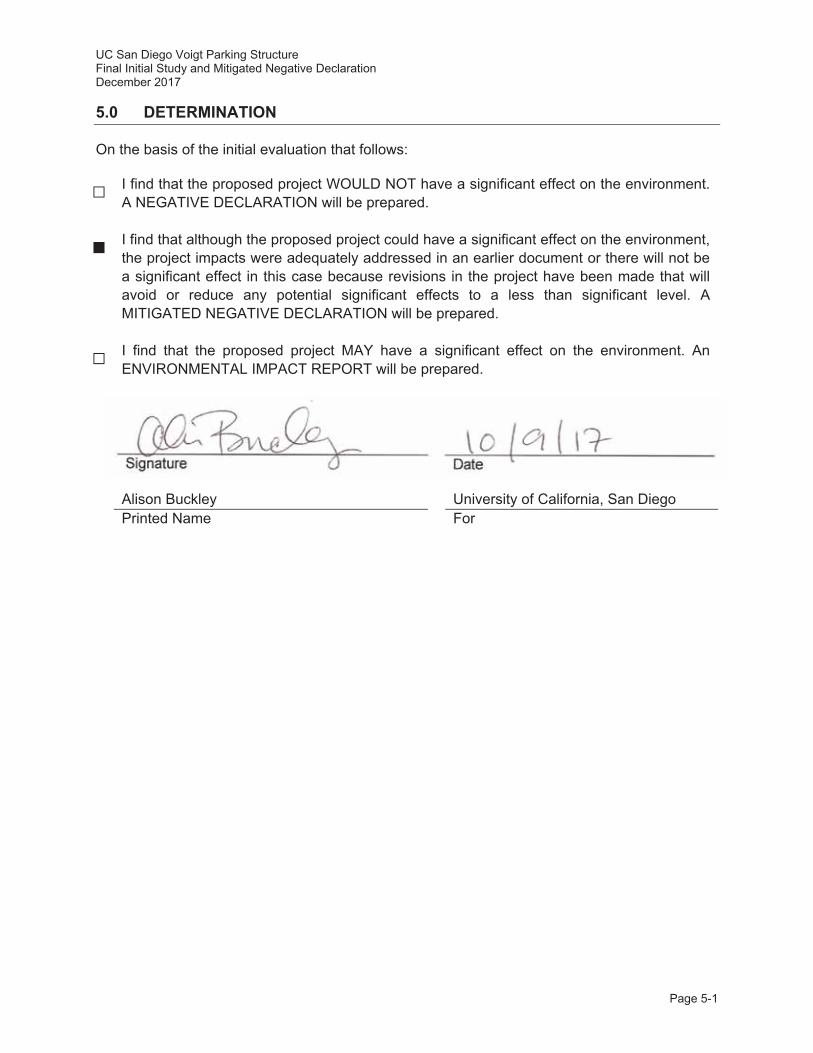
UC San Diego Voigt Parking Structure Final Initial Study and Mitigated Negative Declaration December 2017
Page 5-1
5.0 DETERMINATION
On the basis of the initial evaluation that follows:
I find that the proposed project WOULD NOT have a significant effect on the environment. A NEGATIVE DECLARATION will be prepared.
I find that although the proposed project could have a significant effect on the environment, the project impacts were adequately addressed in an earlier document or there will not be a significant effect in this case because revisions in the project have been made that will avoid or reduce any potential significant effects to a less than significant level. A MITIGATED NEGATIVE DECLARATION will be prepared.
I find that the proposed project MAY have a significant effect on the environment. An ENVIRONMENTAL IMPACT REPORT will be prepared.
Signature Date
Alison Buckley University of California, San Diego Printed Name For

UC San Diego Voigt Parking Structure Final Initial Study and Mitigated Negative Declaration December 2017
Page 6-1
6.0 EVALUATION OF ENVIRONMENTAL IMPACTS
The University of California has defined the column headings in the IS checklist as follows:
A) “Potentially Significant Impact” is appropriate if there is substantial evidence that the project’s effect may be significant. If there is one or more “Potentially Significant Impact” entries a Project EIR will be prepared.
B) “Project Impact Adequately Addressed in LRDP Program EIR” applies where the potential impacts of the proposed project were adequately addressed in the 2004 LRDP Program EIR and 2004 LRDP Program EIR Mitigation Measures, as updated by the ECBT Project EIR, as specified in the analysis, will mitigate any impacts of the proposed project to the extent feasible. 2004 LRDP Program EIR and the ECBT Project EIR mitigation measures may be incorporated into the project. The potential impact of the proposed project is adequately addressed in the 2004 LRDP Program EIR, as updated by the ECBT Project EIR. The impact analysis in this document summarizes and cross references (including section/page numbers) the relevant analysis in the 2004 LRDP Program EIR and the ECBT Project EIR.
C) “Less Than Significant with Project-level Mitigation Incorporated” applies where the incorporation of project-specific mitigation measures will reduce an effect from “Potentially Significant Impact” to a “Less Than Significant Impact.” All project-specific mitigation measures must be described, including a brief explanation of how the measures reduce the effect to a less than significant level.
D) “Less Than Significant Impact” applies where the project will not result in any significant effects. The effects may or may not have been discussed in the 2004 LRDP Program EIR, as updated by the ECBT Project EIR. The project impact is less than significant without the incorporation of LRDP Project EIR mitigation measures or project-specific mitigation.
E) “No Impact” applies where a project would not result in any impact in the category in question or the category simply does not apply. “No Impact” answers do not require an explanation if they are adequately supported by the information sources cited by the lead agency which show that the impact simply does not apply to projects like the one involved (e.g., the project falls outside a fault rupture zone). A “No Impact” answer should be explained where it is based on project-specific factors as well as general standards (e.g., the project will not expose sensitive receptors to pollutants, based on a project-specific screening analysis).
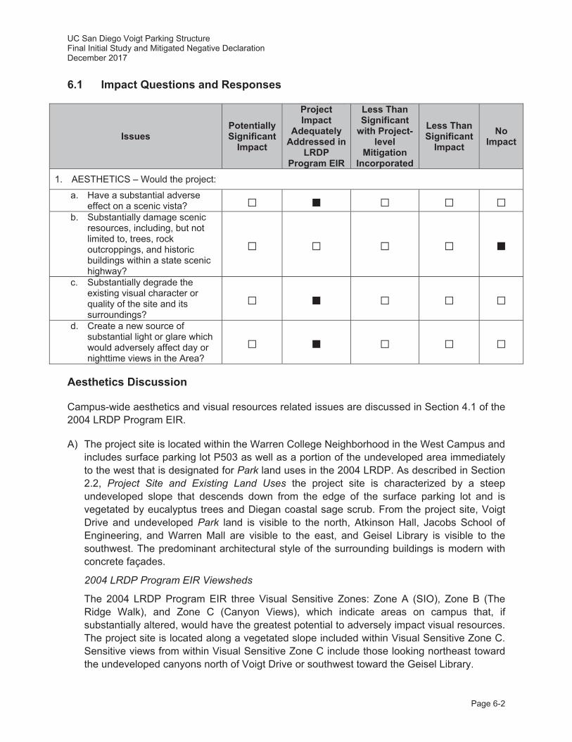
UC San Diego Voigt Parking Structure Final Initial Study and Mitigated Negative Declaration December 2017
Page 6-2
6.1 Impact Questions and Responses
Issues Potentially Significant
Impact
Project Impact
Adequately Addressed in
LRDP Program EIR
Less Than Significant
with Project-level
Mitigation Incorporated
Less Than Significant
Impact No
Impact
1. AESTHETICS – Would the project:
a. Have a substantial adverse effect on a scenic vista?
b. Substantially damage scenic resources, including, but not limited to, trees, rock outcroppings, and historic buildings within a state scenic highway?
c. Substantially degrade the existing visual character or quality of the site and its surroundings?
d. Create a new source of substantial light or glare which would adversely affect day or nighttime views in the Area?
Aesthetics Discussion
Campus-wide aesthetics and visual resources related issues are discussed in Section 4.1 of the 2004 LRDP Program EIR.
A) The project site is located within the Warren College Neighborhood in the West Campus and includes surface parking lot P503 as well as a portion of the undeveloped area immediately to the west that is designated for Park land uses in the 2004 LRDP. As described in Section 2.2, Project Site and Existing Land Uses the project site is characterized by a steep undeveloped slope that descends down from the edge of the surface parking lot and is vegetated by eucalyptus trees and Diegan coastal sage scrub. From the project site, Voigt Drive and undeveloped Park land is visible to the north, Atkinson Hall, Jacobs School of Engineering, and Warren Mall are visible to the east, and Geisel Library is visible to the southwest. The predominant architectural style of the surrounding buildings is modern with concrete façades.
2004 LRDP Program EIR Viewsheds
The 2004 LRDP Program EIR three Visual Sensitive Zones: Zone A (SIO), Zone B (The Ridge Walk), and Zone C (Canyon Views), which indicate areas on campus that, if substantially altered, would have the greatest potential to adversely impact visual resources. The project site is located along a vegetated slope included within Visual Sensitive Zone C. Sensitive views from within Visual Sensitive Zone C include those looking northeast toward the undeveloped canyons north of Voigt Drive or southwest toward the Geisel Library.
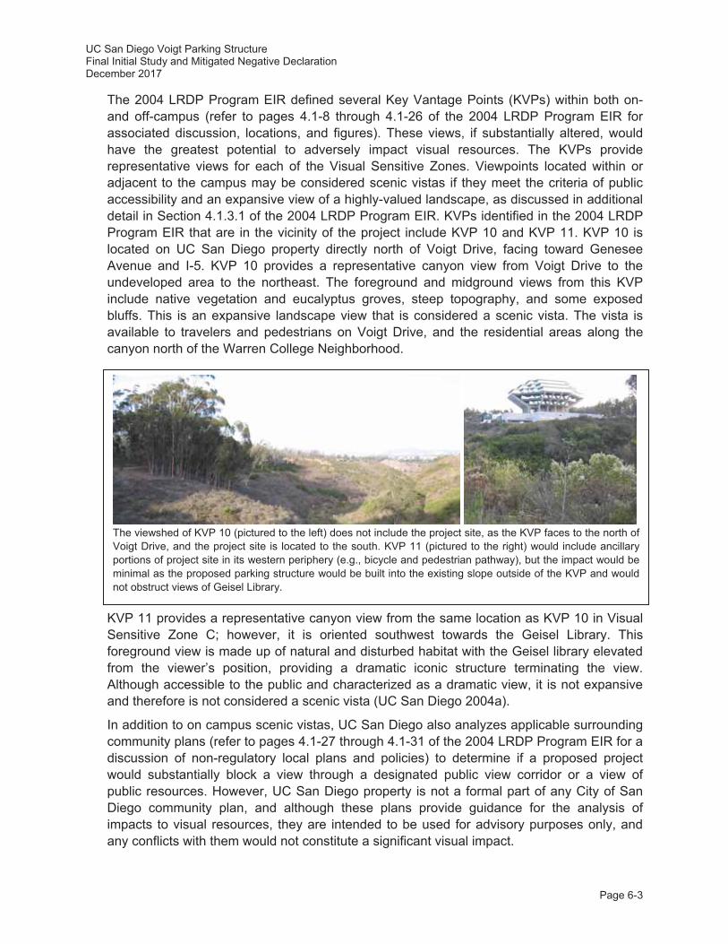
UC San Diego Voigt Parking Structure Final Initial Study and Mitigated Negative Declaration December 2017
Page 6-3
The 2004 LRDP Program EIR defined several Key Vantage Points (KVPs) within both on- and off-campus (refer to pages 4.1-8 through 4.1-26 of the 2004 LRDP Program EIR for associated discussion, locations, and figures). These views, if substantially altered, would have the greatest potential to adversely impact visual resources. The KVPs provide representative views for each of the Visual Sensitive Zones. Viewpoints located within or adjacent to the campus may be considered scenic vistas if they meet the criteria of public accessibility and an expansive view of a highly-valued landscape, as discussed in additional detail in Section 4.1.3.1 of the 2004 LRDP Program EIR. KVPs identified in the 2004 LRDP Program EIR that are in the vicinity of the project include KVP 10 and KVP 11. KVP 10 is located on UC San Diego property directly north of Voigt Drive, facing toward Genesee Avenue and I-5. KVP 10 provides a representative canyon view from Voigt Drive to the undeveloped area to the northeast. The foreground and midground views from this KVP include native vegetation and eucalyptus groves, steep topography, and some exposed bluffs. This is an expansive landscape view that is considered a scenic vista. The vista is available to travelers and pedestrians on Voigt Drive, and the residential areas along the canyon north of the Warren College Neighborhood.
KVP 11 provides a representative canyon view from the same location as KVP 10 in Visual Sensitive Zone C; however, it is oriented southwest towards the Geisel Library. This foreground view is made up of natural and disturbed habitat with the Geisel library elevated from the viewer’s position, providing a dramatic iconic structure terminating the view. Although accessible to the public and characterized as a dramatic view, it is not expansive and therefore is not considered a scenic vista (UC San Diego 2004a).
In addition to on campus scenic vistas, UC San Diego also analyzes applicable surrounding community plans (refer to pages 4.1-27 through 4.1-31 of the 2004 LRDP Program EIR for a discussion of non-regulatory local plans and policies) to determine if a proposed project would substantially block a view through a designated public view corridor or a view of public resources. However, UC San Diego property is not a formal part of any City of San Diego community plan, and although these plans provide guidance for the analysis of impacts to visual resources, they are intended to be used for advisory purposes only, and any conflicts with them would not constitute a significant visual impact.
The viewshed of KVP 10 (pictured to the left) does not include the project site, as the KVP faces to the north of Voigt Drive, and the project site is located to the south. KVP 11 (pictured to the right) would include ancillary portions of project site in its western periphery (e.g., bicycle and pedestrian pathway), but the impact would be minimal as the proposed parking structure would be built into the existing slope outside of the KVP and would not obstruct views of Geisel Library.
UC San Diego Voigt Parking Structure Final Initial Study and Mitigated Negative Declaration December 2017
Page 6-4
Visual Sensitive Zone C
The proposed parking structure has been designed to blend into the existing landscape while preserving and enhancing the visual connection to the adjacent undeveloped open space to the west, which is visible from Geisel Library, Jacobs School of Engineering, Atkinson Hall, and Warren Mall. The project site is located approximately 300 feet southeast of KVPs 10 and 11. As previously described, KVP 10 provides a representative canyon view from Voigt Drive to the northeast and KVP 11 provides a representative canyon view from this same location to the southeast that includes the Geisel Library (see Figure 4.1-9 of the 2004 LRDP Program EIR). Due to its location on the south side of Voigt Drive, the proposed project would not affect the views from KVP 10. Ancillary portions of the proposed project would be visible in the western periphery of KVP 11, including the proposed pedestrian and bicycle improvements. As such, the implementation of the proposed Project would remove a small area of existing vegetation toward the background of KVP 11. However, the proposed parking structure itself would be constructed to blend into the existing slope, avoiding any encroachment of the proposed parking structure on KVP 11 and minimizing its effect on the overall views in the vicinity. Because the parking structure would be constructed within the existing slope on the project site, it would not obstruct the view of Geisel Library from Voigt Drive and would have little to no effect on the overall character of the KVP. Therefore, any impacts to scenic vistas would be less than significant, and no mitigation would be required.
No adverse impacts to the KVP views resulting from implementation of the proposed project have been identified. However, the proposed project is located within Visual Sensitive Zone C and ancillary portions of the proposed project would have minor effects on background views in KVP 11. Therefore, UC San Diego has incorporated the 2004 LRDP Program EIR Mitigation Measures Aes-1A and Aes-1B into the project design as summarized below.
The proposed Voigt Parking Structure has been reviewed and approved by the UC San Diego Design Review Board (DRB) consistent with 2004 LRDP Program EIR Mitigation Measure Aes-1A. Additionally, consistent with 2004 LRDP Program EIR Mitigation Measure Aes-1B the following design features have been incorporated into the design of the proposed project (refer to page 4.1-37 of the 2004 LRDP Program EIR):
The building height and mass of the proposed parking structure has been designed in conformance with the natural topography of the site;
Building mechanical equipment would be located within the parking structure rather than on the roof;
External building materials and color palettes include materials intended to ensure visual consistency with surrounding development; and,
A Live Roof would be included on the top level of the structure to expand the access to views of the adjacent canyon and Geisel Library.
B) A “state scenic highway” refers to any interstate, state, or county road that has been officially designated as scenic and thereby requires special scenic conservation treatment. I-5 bisects the campus and State Route 52 (SR-52) is located approximately 1 mile south of the center of campus. Neither of these roadways are Officially Designated State Scenic Highways; however, both are considered “Eligible State Scenic Highways – Not Designated”. If these roadways were designated at some point in the future, it is unlikely that 2004 LRDP implementation, including the proposed project, would impact scenic resources
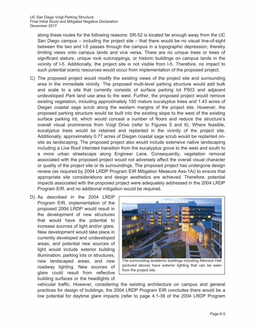
UC San Diego Voigt Parking Structure Final Initial Study and Mitigated Negative Declaration December 2017
Page 6-5
along these routes for the following reasons: SR-52 is located far enough away from the UC San Diego campus – including the project site – that there would be no visual line-of-sight between the two and I-5 passes through the campus in a topographic depression, thereby limiting views onto campus lands and vice versa. There are no unique trees or trees of significant stature, unique rock outcroppings, or historic buildings on campus lands in the vicinity of I-5. Additionally, the project site is not visible from I-5. Therefore, no impact to such potential scenic resources would occur from implementation of the proposed project.
C) The proposed project would modify the existing views of the project site and surrounding area in the immediate vicinity. The proposed multi-level parking structure would add bulk and scale to a site that currently consists of surface parking lot P503 and adjacent undeveloped Park land use area to the west. Further, the proposed project would remove existing vegetation, including approximately 150 mature eucalyptus trees and 1.43 acres of Diegan coastal sage scrub along the western margins of the project site. However, the proposed parking structure would be built into the existing slope to the west of the existing surface parking lot, which would conceal a number of floors and reduce the structure’s overall visual prominence from Voigt Drive (refer to Figures 5 and 6). Where feasible, eucalyptus trees would be retained and replanted in the vicinity of the project site. Additionally, approximately 0.77 acres of Diegan coastal sage scrub would be replanted on-site as landscaping. The proposed project also would include extensive native landscaping including a Live Roof intended transition from the eucalyptus grove to the west and south to a more urban streetscape along Engineer Lane. Consequently, vegetation removal associated with the proposed project would not adversely affect the overall visual character or quality of the project site or its surroundings. The proposed project has undergone design review (as required by 2004 LRDP Program EIR Mitigation Measure Aes-1Ai) to ensure that appropriate site considerations and design aesthetics are achieved. Therefore, potential impacts associated with the proposed project were adequately addressed in the 2004 LRDP Program EIR, and no additional mitigation would be required.
D) As described in the 2004 LRDP Program EIR, implementation of the proposed 2004 LRDP would result in the development of new structures that would have the potential to increase sources of light and/or glare. New development would take place in currently developed and undeveloped areas, and potential new sources of light would include exterior building illumination, parking lots or structures, new landscaped areas, and new roadway lighting. New sources of glare could result from reflective building surfaces or the headlights of vehicular traffic. However, considering the existing architecture on campus and general practices for design of buildings, the 2004 LRDP Program EIR concludes there would be a low potential for daytime glare impacts (refer to page 4.1-39 of the 2004 LRDP Program
The surrounding academic buildings including Atkinson Hall (pictured above) have exterior lighting that can be seen from the project site.

UC San Diego Voigt Parking Structure Final Initial Study and Mitigated Negative Declaration December 2017
Page 6-6
EIR) based on the existing architecture on campus and general practices for design of buildings.
Potential nighttime light and glare impacts of most concern would be those that would create a distraction, nuisance, or hazard to people. As the proposed parking structure would include a modulated concrete exterior on all levels of the parking structure, which would block or obscure headlights from surrounding areas. The exterior would also partially shield the view of cars and internal lighting from passersby, further reducing light spill and glare. The surrounding eucalyptus trees retained in place as well as the landscaped trees along the northern and western façades of the parking structure would also block potential light and glare from automobile headlights within the structure. Due to the highly developed urban nature of the UC San Diego and La Jolla communities, there is already a substantial amount of ambient light both on campus and in the immediate surrounding area along Voigt Drive and Engineer Lane associated with the Jacobs School of Engineering and Atkinson Hall. The 2004 LRDP Program EIR concludes that the potential for new light and glare is limited (refer to page 4.1-39 of the 2004 LRDP Program EIR). However, as part of the campus design review process, all lighting for new campus development projects, including the proposed project, has been designed in such a way as to comply with the UC San Diego Outdoor Lighting Policy (2003a) and the UC San Diego Outdoor Lighting Design Guidelines (2003b) in accordance with 2004 LRDP Program EIR Mitigation Measure Aes-2B (refer to page 4.1-40 of the 2004 LRDP Program EIR). Therefore, potential impacts associated with the proposed project were adequately addressed in the 2004 LRDP Program EIR and no additional mitigation would be required.
Summary
The proposed parking structure would not result in significant impacts to aesthetics and visual resources that have not already been evaluated in the 2004 LRDP Program EIR. The project site is located within the West Campus, in a Visually Sensitive Zone (Zone C). However, while development of the proposed project would modify the existing views of the surrounding area, such changes would be designed to be consistent with other adjacent existing development, and would not substantially affect any scenic vistas, KVPs, or other sensitive viewsheds. The proposed Voigt Parking Structure has been reviewed and approved by the UC San Diego DRB consistent with 2004 LRDP Program EIR Mitigation Measure Aes-1A and includes design features to minimize its visual impact consistent with EIR Mitigation Measure Aes-1B. Further, incorporation of 2004 LRDP Program EIR Mitigation Measure Aes-2B would minimize any potential adverse lighting and glare impacts to a level below significance. Therefore, potential impacts associated with the proposed project are adequately addressed in the 2004 LRDP Program EIR and no additional mitigation would be required.
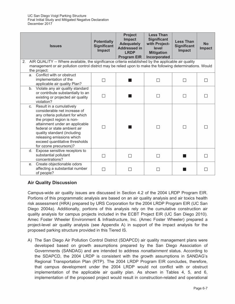
UC San Diego Voigt Parking Structure Final Initial Study and Mitigated Negative Declaration December 2017
Page 6-7
Issues Potentially Significant
Impact
Project Impact
Adequately Addressed in
LRDP Program EIR
Less Than Significant
with Project-level
Mitigation Incorporated
Less Than Significant
Impact No
Impact
2. AIR QUALITY -- Where available, the significance criteria established by the applicable air quality management or air pollution control district may be relied upon to make the following determinations. Would the project: a. Conflict with or obstruct
implementation of the applicable air quality Plan?
b. Violate any air quality standard or contribute substantially to an existing or projected air quality violation?
c. Result in a cumulatively considerable net increase of any criteria pollutant for which the project region is non-attainment under an applicable federal or state ambient air quality standard (including releasing emissions which exceed quantitative thresholds for ozone precursors)?
d. Expose sensitive receptors to substantial pollutant concentrations?
e. Create objectionable odors affecting a substantial number of people?
Air Quality Discussion
Campus-wide air quality issues are discussed in Section 4.2 of the 2004 LRDP Program EIR. Portions of this programmatic analysis are based on an air quality analysis and air toxics health risk assessment (HRA) prepared by URS Corporation for the 2004 LRDP Program EIR (UC San Diego 2004a). Additionally, portions of this analysis rely on the cumulative construction air quality analysis for campus projects included in the ECBT Project EIR (UC San Diego 2010). Amec Foster Wheeler Environment & Infrastructure, Inc. (Amec Foster Wheeler) prepared a project-level air quality analysis (see Appendix A) in support of the impact analysis for the proposed parking structure provided in this Tiered IS.
A) The San Diego Air Pollution Control District (SDAPCD) air quality management plans were developed based on growth assumptions prepared by the San Diego Association of Governments (SANDAG) and are intended to address nonattainment status. According to the SDAPCD, the 2004 LRDP is consistent with the growth assumptions in SANDAG’s Regional Transportation Plan (RTP). The 2004 LRDP Program EIR concludes, therefore, that campus development under the 2004 LRDP would not conflict with or obstruct implementation of the applicable air quality plan. As shown in Tables 4, 5, and 6, implementation of the proposed project would result in construction-related and operational
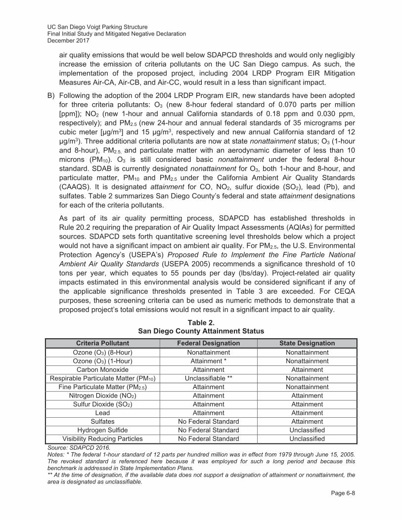
UC San Diego Voigt Parking Structure Final Initial Study and Mitigated Negative Declaration December 2017
Page 6-8
air quality emissions that would be well below SDAPCD thresholds and would only negligibly increase the emission of criteria pollutants on the UC San Diego campus. As such, the implementation of the proposed project, including 2004 LRDP Program EIR Mitigation Measures Air-CA, Air-CB, and Air-CC, would result in a less than significant impact.
B) Following the adoption of the 2004 LRDP Program EIR, new standards have been adopted for three criteria pollutants: O3 (new 8-hour federal standard of 0.070 parts per million [ppm]); NO2 (new 1-hour and annual California standards of 0.18 ppm and 0.030 ppm, respectively); and PM2.5 (new 24-hour and annual federal standards of 35 micrograms per cubic meter [μg/m3] and 15 μg/m3, respectively and new annual California standard of 12 μg/m3). Three additional criteria pollutants are now at state nonattainment status; O3 (1-hour and 8-hour), PM2.5, and particulate matter with an aerodynamic diameter of less than 10 microns (PM10). O3 is still considered basic nonattainment under the federal 8-hour standard. SDAB is currently designated nonattainment for O3, both 1-hour and 8-hour, and particulate matter, PM10 and PM2.5 under the California Ambient Air Quality Standards (CAAQS). It is designated attainment for CO, NO2, sulfur dioxide (SO2), lead (Pb), and sulfates. Table 2 summarizes San Diego County’s federal and state attainment designations for each of the criteria pollutants.
As part of its air quality permitting process, SDAPCD has established thresholds in Rule 20.2 requiring the preparation of Air Quality Impact Assessments (AQIAs) for permitted sources. SDAPCD sets forth quantitative screening level thresholds below which a project would not have a significant impact on ambient air quality. For PM2.5, the U.S. Environmental Protection Agency’s (USEPA’s) Proposed Rule to Implement the Fine Particle National Ambient Air Quality Standards (USEPA 2005) recommends a significance threshold of 10 tons per year, which equates to 55 pounds per day (lbs/day). Project-related air quality impacts estimated in this environmental analysis would be considered significant if any of the applicable significance thresholds presented in Table 3 are exceeded. For CEQA purposes, these screening criteria can be used as numeric methods to demonstrate that a proposed project’s total emissions would not result in a significant impact to air quality.
Table 2. San Diego County Attainment Status
Criteria Pollutant Federal Designation State Designation Ozone (O3) (8-Hour) Nonattainment Nonattainment Ozone (O3) (1-Hour) Attainment * Nonattainment
Carbon Monoxide Attainment Attainment Respirable Particulate Matter (PM10) Unclassifiable ** Nonattainment
Fine Particulate Matter (PM2.5) Attainment Nonattainment Nitrogen Dioxide (NO2) Attainment Attainment
Sulfur Dioxide (SO2) Attainment Attainment Lead Attainment Attainment
Sulfates No Federal Standard Attainment Hydrogen Sulfide No Federal Standard Unclassified
Visibility Reducing Particles No Federal Standard Unclassified Source: SDAPCD 2016. Notes: * The federal 1-hour standard of 12 parts per hundred million was in effect from 1979 through June 15, 2005. The revoked standard is referenced here because it was employed for such a long period and because this benchmark is addressed in State Implementation Plans. ** At the time of designation, if the available data does not support a designation of attainment or nonattainment, the area is designated as unclassifiable.
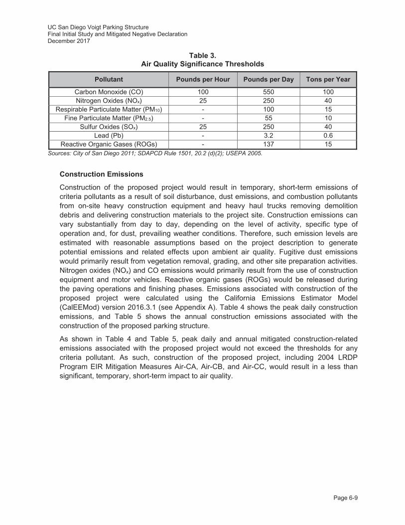
UC San Diego Voigt Parking Structure Final Initial Study and Mitigated Negative Declaration December 2017
Page 6-9
Table 3. Air Quality Significance Thresholds
Pollutant Pounds per Hour Pounds per Day Tons per Year
Carbon Monoxide (CO) 100 550 100 Nitrogen Oxides (NOx) 25 250 40
Respirable Particulate Matter (PM10) - 100 15 Fine Particulate Matter (PM2.5) - 55 10
Sulfur Oxides (SOx) 25 250 40 Lead (Pb) - 3.2 0.6
Reactive Organic Gases (ROGs) - 137 15 Sources: City of San Diego 2011; SDAPCD Rule 1501, 20.2 (d)(2); USEPA 2005.
Construction Emissions
Construction of the proposed project would result in temporary, short-term emissions of criteria pollutants as a result of soil disturbance, dust emissions, and combustion pollutants from on-site heavy construction equipment and heavy haul trucks removing demolition debris and delivering construction materials to the project site. Construction emissions can vary substantially from day to day, depending on the level of activity, specific type of operation and, for dust, prevailing weather conditions. Therefore, such emission levels are estimated with reasonable assumptions based on the project description to generate potential emissions and related effects upon ambient air quality. Fugitive dust emissions would primarily result from vegetation removal, grading, and other site preparation activities. Nitrogen oxides (NOx) and CO emissions would primarily result from the use of construction equipment and motor vehicles. Reactive organic gases (ROGs) would be released during the paving operations and finishing phases. Emissions associated with construction of the proposed project were calculated using the California Emissions Estimator Model (CalEEMod) version 2016.3.1 (see Appendix A). Table 4 shows the peak daily construction emissions, and Table 5 shows the annual construction emissions associated with the construction of the proposed parking structure.
As shown in Table 4 and Table 5, peak daily and annual mitigated construction-related emissions associated with the proposed project would not exceed the thresholds for any criteria pollutant. As such, construction of the proposed project, including 2004 LRDP Program EIR Mitigation Measures Air-CA, Air-CB, and Air-CC, would result in a less than significant, temporary, short-term impact to air quality.
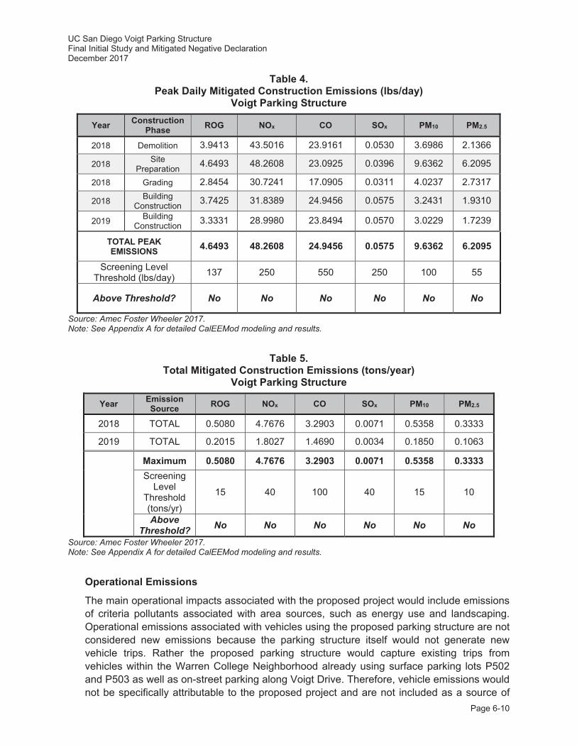
UC San Diego Voigt Parking Structure Final Initial Study and Mitigated Negative Declaration December 2017
Page 6-10
Table 4. Peak Daily Mitigated Construction Emissions (lbs/day)
Voigt Parking Structure
Year Construction Phase ROG NOx CO SOx PM10 PM2.5
2018 Demolition 3.9413 43.5016 23.9161 0.0530 3.6986 2.1366
2018 Site Preparation 4.6493 48.2608 23.0925 0.0396 9.6362 6.2095
2018 Grading 2.8454 30.7241 17.0905 0.0311 4.0237 2.7317
2018 Building Construction 3.7425 31.8389 24.9456 0.0575 3.2431 1.9310
2019 Building Construction 3.3331 28.9980 23.8494 0.0570 3.0229 1.7239
TOTAL PEAK EMISSIONS 4.6493 48.2608 24.9456 0.0575 9.6362 6.2095
Screening Level Threshold (lbs/day) 137 250 550 250 100 55
Above Threshold? No No No No No No
Source: Amec Foster Wheeler 2017. Note: See Appendix A for detailed CalEEMod modeling and results.
Table 5. Total Mitigated Construction Emissions (tons/year)
Voigt Parking Structure
Year Emission Source ROG NOx CO SOx PM10 PM2.5
2018 TOTAL 0.5080 4.7676 3.2903 0.0071 0.5358 0.3333
2019 TOTAL 0.2015 1.8027 1.4690 0.0034 0.1850 0.1063
Maximum 0.5080 4.7676 3.2903 0.0071 0.5358 0.3333 Screening
Level Threshold (tons/yr)
15 40 100 40 15 10
Above Threshold? No No No No No No
Source: Amec Foster Wheeler 2017. Note: See Appendix A for detailed CalEEMod modeling and results.
Operational Emissions
The main operational impacts associated with the proposed project would include emissions of criteria pollutants associated with area sources, such as energy use and landscaping. Operational emissions associated with vehicles using the proposed parking structure are not considered new emissions because the parking structure itself would not generate new vehicle trips. Rather the proposed parking structure would capture existing trips from vehicles within the Warren College Neighborhood already using surface parking lots P502 and P503 as well as on-street parking along Voigt Drive. Therefore, vehicle emissions would not be specifically attributable to the proposed project and are not included as a source of

UC San Diego Voigt Parking Structure Final Initial Study and Mitigated Negative Declaration December 2017
Page 6-11
emissions in this operational analysis. Further, the EIRs for the recent construction of the ECBT Project (SCH No. 2009081053) and the Clinical and Translational Research Institute and East Campus Recreation Area Project (SCH No. 2011051060) both determined that operational emissions, including emissions from vehicular sources, would not cause or contribute to a violation of ambient air quality standards and associated impacts would be less than significant. Vehicular emissions from future projects within the Warren College Neighborhood that may generate additional vehicle trips will be evaluated in the future as part of the CEQA analysis process for those projects.
Operational emissions associated with energy use, landscape maintenance, and stationary sources associated with functions of the facility (e.g., emergency generator) were calculated using CalEEMod version 2016.3.1. Usage assumptions are based on project-specific data and model defaults, where appropriate.
Table 6. Operational Emissions Voigt Parking Structure
Emission Source ROG NOx CO SOx PM10 PM2.5
Peak Daily Operational Emissions (lbs/day)* Area 0.2074 0.0008 0.0866 0 0.0003 0.0003
Energy 0 0 0 0 0 0 Mobile 0 0 0 0 0 0 TOTAL 0.2074 0.0008 0.0866 0 0.0003 0.0003
Screening Level Threshold (lbs/day) 137 250 550 250 100 55
Above Threshold? No No No No No No Annual Operational Emissions (tons/year)
Area 0.0371 0 0.0077 0 0 0 Energy 0 0 0 0 0 0 Mobile 0 0 0 0 0 0 TOTAL 0.0371 0 0.0077 0 0 0
Screening Level Threshold (lbs/day) 15 40 100 40 15 10
Above Threshold? No No No No No No Source: Amec Foster Wheeler 2017. Notes: See Appendix A for detailed CalEEMod reports. * Maximum of winter and summer day mitigated emissions, from CalEEMod.
C) In analyzing cumulative impacts from the proposed project, the analysis must specifically evaluate a project’s contribution to the cumulative increase in pollutants for which the SDAB is listed as nonattainment for the CAAQS and the NAAQS. SDAB has been designated as a federal nonattainment area for O3, and a State nonattainment area for O3, PM10, and PM2.5. Since few sources emit O3 directly, and O3 is caused by complex chemical reactions, control of O3 is accomplished by the control of emissions of NOx and ROGs. By its very nature, air pollution is largely a cumulative impact. The nonattainment status of regional pollutants is a result of past and present development within the air basin. Therefore, this regional impact is a cumulative impact, and projects would contribute to this impact only on a cumulative basis. No single project would be sufficient in size, by itself, to result in nonattainment of the regional air quality standards. Consequently, if a proposed project’s emissions do not
UC San Diego Voigt Parking Structure Final Initial Study and Mitigated Negative Declaration December 2017
Page 6-12
exceed identified significance thresholds, its emissions would not result in a cumulatively considerable contribution to the cumulatively significant impact.
Cumulative Construction Emissions
Following the adoption of the 2004 LRDP, UC San Diego determined that the amount of construction projected on campus in the near-term would be greater than was assumed in the peak construction scenario outlined in the 2004 LRDP Program EIR. As a result, technical analyses presented in the ECBT Project EIR (UC San Diego 2010) serve as an update to the cumulative construction emissions analysis presented in the 2004 LRDP Program EIR. These analyses were conducted to address changed conditions that have resulted since the 2004 LRDP Program EIR was certified in September 2004.
Section 3.2.4 of the ECBT Project EIR (refer to Table 3.2-7 of the ECBT Project EIR) includes a worst-case construction emissions scenario in order to evaluate cumulative air quality impacts. Cumulative emissions of O3 precursors, PM10, and PM2.5 resulting from LRDP implementation exceeded significance thresholds, contributing to particulate matter and O3 in the air basin, and therefore were found to be temporary cumulative and significant impacts. To reduce cumulative air quality impacts caused by campus construction, 2004 LRDP Program EIR Mitigation Measures Air-CA, Air-CB and Air-CC would be incorporated as part of the proposed project to reduce the project’s contributions to cumulative construction-related emissions.
2004 LRDP Program EIR Mitigation Measures:
Air-CA: The following measures shall be implemented campus-wide to reduce PM10 emissions from vehicles, as feasible, and on specific projects when applicable:
Compliance with the UC Sustainable Practices Policy (2016 update), which guides the design of green buildings and the use of clean energy.
Reduce emissions related to motor vehicle trips through refinements to the Transportation System Management program or other methods to discourage automobile use and encourage use of alternative transportation.
Expand pedestrian-enhancing infrastructure to encourage pedestrian activity and discourage vehicle use.
Expand bicycle facilities to encourage bicycle use instead of driving. Expand transit-enhancing infrastructure to promote the use of public
transportation such as buses, light rail, and other applicable methods. Expand facilities to accommodate alternative-fuel vehicles such as electric cars
and compressed natural gas vehicles. Expand on-site housing and retail services to facilitate pedestrian activity and
reduce need for off-site travel.
Air-CB: Any development on the UC San Diego campus shall include in all construction contracts the measures specified below to reduce PM10 and PM2.5 air pollutant emissions:
All on-site unpaved roads and off-site unpaved access roads shall be effectively stabilized of dust emissions using water, chemical stabilizer/suppressant, or other stabilization techniques.

UC San Diego Voigt Parking Structure Final Initial Study and Mitigated Negative Declaration December 2017
Page 6-13
All land clearing and grading and demolition activities shall be effectively controlled of fugitive dust emissions utilizing application of water or by presoaking.
Street sweeping shall be performed regularly on roads surrounding the construction site that carry construction traffic or collect construction related dust or dirt.
Revegetate exposed earth surface following construction. Limit traffic speeds on unpaved roads to 15 mph. To the extent that equipment is available and cost effective, the campus shall
encourage contractors to use alternate fuels and retrofit existing engines in construction equipment.
Minimize idling time to a maximum of 10 minutes when construction equipment is not in use.
To the extent practicable, manage operation of heavy-duty equipment (e.g., restrict operations, operate only when necessary) to reduce emissions.
Air-CC: Campus construction contracts/specifications shall include language that requires medium and large sized construction fleets to comply with the requirements of the ARB proposed regulation for In-use Off-road Diesel Vehicles (Section 2449, Title 13, Article 4.8, California Code of Regulations, as modified).
Despite implementation of these 2004 LRDP Program EIR Mitigation Measures, impacts associated with emissions due to buildout of the UC San Diego campus would still be considered cumulatively significant. Additional construction-related emissions associated with the proposed parking structure would further contribute to this cumulative impact. However, construction emissions associated with the proposed project alone would be well below the stated significance levels for all constituents. Therefore, the proposed project would not result in a considerable contribution of cumulatively significant impacts identified in the updated campus air quality construction analysis.
Cumulative Operational Emissions
Overall operation of the proposed parking structure would not result in a significant direct impact on air quality since the proposed project emissions would be below the daily and operational thresholds cited in Table 6. To further reduce operational emissions associated with the proposed project, the parking structure would be naturally ventilated and would utilize light wells and areaways to reduce the need for internal lighting (refer to Section 2.8.3, Utility Requirements). Further, the proposed project would include the expansion of multi-modal paths, including bicycle paths, sidewalks, and trails that would increase connectivity in the area and promote alternative modes of transportation (refer to Section 2.8.5, Circulation/Parking). As a means to reduce cumulative operational emissions campus wide, UC San Diego has implemented and would continue to implement a number of energy-saving projects and programs that partially reduce campus-generated air pollutant emissions. These UC energy use and air emission reduction strategies are currently being achieved and would be accomplished for the proposed project through compliance with the Statewide Energy Partnership Program, the UC Strategic Energy Plan, and the UC Sustainable Practices Policy (2016 update) and guidelines for its implementation, including State of California GHG emission-reduction guidance documents. Among others, emission-
UC San Diego Voigt Parking Structure Final Initial Study and Mitigated Negative Declaration December 2017
Page 6-14
reduction strategies instituted under these plans and policies include practices related to green building design, clean energy, climate protection, transportation, operations, recycling and waste management, and environmentally preferable procurement. Thus, operational emissions associated with energy use, landscaping emissions and vehicle traffic campus-wide from the proposed project would not be cumulatively considerable.
D) Toxic air contaminants (TACs) are a category of air pollutants with the potential to have an adverse impact on human health and are generated by a number of stationary, mobile and area sources, such as laboratories, automobiles or construction sites. A HRA was conducted in conjunction with the 2004 LRDP Program EIR to identify potential health risks associated with 2004 LRDP development, including the proposed project. In order to assess potential health risks associated with build-out of the 2004 LRDP, total health risks for the academic year 2020-2021 were evaluated for existing campus operations combined with future development. The 2004 LRDP Program EIR concluded that the estimated cancer (and non-cancer) risks from current and future campus operations for the academic year 2020-2021 would not exceed applicable significance thresholds. In addition, the 2004 LRDP Program EIR concludes that implementation of the 2004 LRDP would not violate state or federal air quality standards for CO or expose receptors to substantial CO concentrations associated with vehicular traffic on area roadways. As shown in Tables 4, 5, and 6, construction and operation of the proposed parking structure would not violate federal or State air quality standards for CO or expose receptors to substantial CO concentrations. Therefore, impacts to sensitive receptors (e.g., Jacobs School of Engineering) as a result of the proposed project would be less than significant.
E) Odors would be generated from vehicles and/or equipment exhaust emissions during construction of the proposed project. Odors produced during construction would be attributable to concentrations of unburned hydrocarbons from tailpipes of construction equipment. Such odors are temporary and generally occur at magnitudes that would not affect substantial numbers of people. Therefore, impacts associated with odors during construction would be considered less than significant.
Summary
Construction emissions associated with the proposed project would be well below the stated significance levels for all constituents. Overall project operations associated with the proposed parking structure would not result in a significant direct impact on air quality since the proposed project emissions would be below the daily and operational thresholds. To reduce cumulative air quality impacts caused by campus construction, 2004 LRDP Program EIR Mitigation Measures Air-CA, Air-CB and Air-CC would be incorporated as part of the proposed project to reduce the project’s contributions to cumulative construction-related PM emissions. Therefore, the proposed project was adequately addressed in the 2004 LRDP Program EIR and ECBT Project EIR, and no additional mitigation would be required.
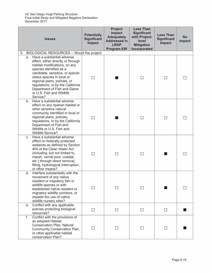
UC San Diego Voigt Parking Structure Final Initial Study and Mitigated Negative Declaration December 2017
Page 6-15
Issues Potentially Significant
Impact
Project Impact
Adequately Addressed in
LRDP Program EIR
Less Than Significant
with Project-level
Mitigation Incorporated
Less Than Significant
Impact No
Impact
3. BIOLOGICAL RESOURCES -- Would the project: a. Have a substantial adverse
effect, either directly or through habitat modifications, on any species identified as a candidate, sensitive, or special status species in local or regional plans, policies, or regulations, or by the California Department of Fish and Game or U.S. Fish and Wildlife Service?
b. Have a substantial adverse effect on any riparian habitat or other sensitive natural community identified in local or regional plans, policies, regulations, or by the California Department of Fish and Wildlife or U.S. Fish and Wildlife Service?
c. Have a substantial adverse effect on federally protected wetlands as defined by Section 404 of the Clean Water Act (including, but not limited to, marsh, vernal pool, coastal, etc.) through direct removal, filling, hydrological interruption, or other means?
d. Interfere substantially with the movement of any native resident or migratory fish or wildlife species or with established native resident or migratory wildlife corridors, or impede the use of native wildlife nursery sites?
e. Conflict with any applicable policies protecting biological resources?
f. Conflict with the provisions of
an adopted Habitat Conservation Plan, Natural Community Conservation Plan, or other applicable habitat conservation Plan?

UC San Diego Voigt Parking Structure Final Initial Study and Mitigated Negative Declaration December 2017
Page 6-16
Biological Resources Discussion
Campus-wide Biological resource issues are discussed in Section 4.3 of the 2004 LRDP Program EIR. The analysis below is based on the Biological Resources Technical Report for the 2004 LRDP Program EIR prepared by HELIX Environmental Planning, Inc. (HELIX) (UC San Diego 2004a; HELIX 2004), the 2016 Coastal California Gnatcatcher (Polioptila californica californica) Survey Report for the UC San Diego La Jolla Campus LRDP Update (HELIX 2016a), and the Biological Resources Existing Conditions Report for the UC San Diego La Jolla Campus LRDP Update (HELIX 2016b). Additionally, Amec Foster Wheeler (2016b) conducted a field reconnaissance survey of the project site and surrounding area on November 10, 2016 to verify recent vegetation mapping for the campus. Amec Foster Wheeler identified the location of potentially jurisdictional waters and other regulated waters of the U.S. or State based on the occurrence of wetland indicator species at the site.
A) The project site is located within the Warren College Neighborhood in the West Campus of UC San Diego. As described in Section 2.2, Project Site and Existing Land Uses the 6.63-acre project site consists of existing surface parking lot P503 and an adjacent undeveloped area designated as Park land use in the 2004 LRDP. Vegetation surrounding surface parking lot P503 consists of disturbed habitat, eucalyptus woodland, and Diegan coastal sage scrub. As shown in Table 7, construction activities associated with the proposed project would result in the removal of approximately 0.73 acres of eucalyptus woodland, including approximately 150 existing mature eucalyptus trees, 1.43 acres of Diegan coastal sage scrub, and 0.02 acres of disturbed habitat.
Eucalyptus woodland is not considered a sensitive community by the California Department of Fish and Wildlife (CDFW) unless it supports a federally or state-listed species. The eucalyptus trees on the project site may provide habitat for raptors and migratory birds which are protected under the federal Migratory Bird Treaty Act and California Fish and Game Code; however, no federally or state-listed species are known to occur on the project site. A USFWS protocol presence/absence survey for the federally listed threatened coastal California gnatcatcher was conducted by HELIX for UC San Diego La Jolla Campus LRDP Update between April and June 2016. Surveys were conducted by walking within and along the perimeter of suitable habitat throughout the campus; no coastal California gnatcatchers were observed south of Voigt Drive within the project site or its immediate vicinity (HELIX 2016a). No coastal California gnatcatchers have ever been observed in the project area south of Voigt Drive. Protocol surveys for the least Bell’s vireo (Vireo bellii pusillus) were similarly performed by HELIX in 2017; no observances of least Bell’s vireo were recorded during that survey and none have ever been recorded within the project site or its immediate vicinity (HELIX 2017).
Diegan coastal sage scrub is often considered sensitive by the U.S. Fish and Wildlife Service (USFWS), and is given the highest inventory priority by the CDFW’s California Natural Diversity Database (CNDDB). Further, Section 30240 of the California Coastal Act (CCA) includes policy for the protection of Environmentally Sensitive Habitat Areas (ESHAs). Because the project site is located within the Coastal Zone, Diegan coastal sage scrub may constitute ESHA as defined by Section 30107.5 of the CCA. The federally listed threatened coastal California gnatcatcher is dependent upon high quality Diegan coastal sage scrub habitat for foraging, nesting, rearing of young, roosting, and shelter. However, as previously described no coastal California gnatcatchers were have
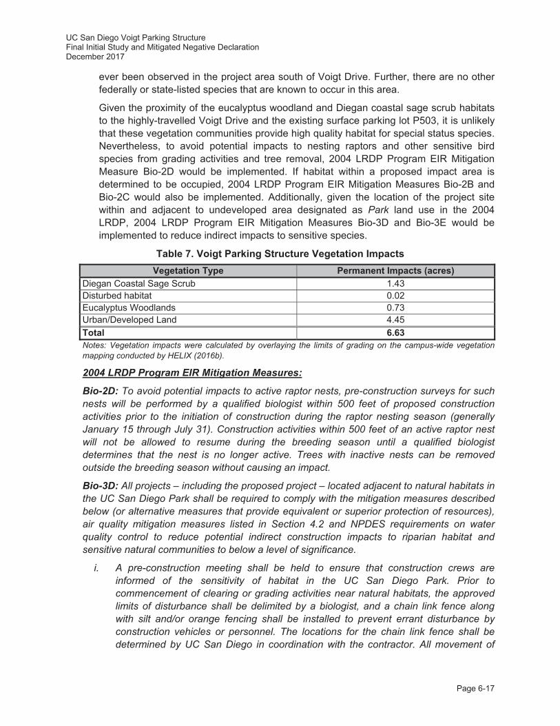
UC San Diego Voigt Parking Structure Final Initial Study and Mitigated Negative Declaration December 2017
Page 6-17
ever been observed in the project area south of Voigt Drive. Further, there are no other federally or state-listed species that are known to occur in this area.
Given the proximity of the eucalyptus woodland and Diegan coastal sage scrub habitats to the highly-travelled Voigt Drive and the existing surface parking lot P503, it is unlikely that these vegetation communities provide high quality habitat for special status species. Nevertheless, to avoid potential impacts to nesting raptors and other sensitive bird species from grading activities and tree removal, 2004 LRDP Program EIR Mitigation Measure Bio-2D would be implemented. If habitat within a proposed impact area is determined to be occupied, 2004 LRDP Program EIR Mitigation Measures Bio-2B and Bio-2C would also be implemented. Additionally, given the location of the project site within and adjacent to undeveloped area designated as Park land use in the 2004 LRDP, 2004 LRDP Program EIR Mitigation Measures Bio-3D and Bio-3E would be implemented to reduce indirect impacts to sensitive species.
Table 7. Voigt Parking Structure Vegetation Impacts Vegetation Type Permanent Impacts (acres)
Diegan Coastal Sage Scrub 1.43 Disturbed habitat 0.02 Eucalyptus Woodlands 0.73 Urban/Developed Land 4.45 Total 6.63 Notes: Vegetation impacts were calculated by overlaying the limits of grading on the campus-wide vegetation mapping conducted by HELIX (2016b).
2004 LRDP Program EIR Mitigation Measures:
Bio-2D: To avoid potential impacts to active raptor nests, pre-construction surveys for such nests will be performed by a qualified biologist within 500 feet of proposed construction activities prior to the initiation of construction during the raptor nesting season (generally January 15 through July 31). Construction activities within 500 feet of an active raptor nest will not be allowed to resume during the breeding season until a qualified biologist determines that the nest is no longer active. Trees with inactive nests can be removed outside the breeding season without causing an impact.
Bio-3D: All projects – including the proposed project – located adjacent to natural habitats in the UC San Diego Park shall be required to comply with the mitigation measures described below (or alternative measures that provide equivalent or superior protection of resources), air quality mitigation measures listed in Section 4.2 and NPDES requirements on water quality control to reduce potential indirect construction impacts to riparian habitat and sensitive natural communities to below a level of significance.
i. A pre-construction meeting shall be held to ensure that construction crews are informed of the sensitivity of habitat in the UC San Diego Park. Prior to commencement of clearing or grading activities near natural habitats, the approved limits of disturbance shall be delimited by a biologist, and a chain link fence along with silt and/or orange fencing shall be installed to prevent errant disturbance by construction vehicles or personnel. The locations for the chain link fence shall be determined by UC San Diego in coordination with the contractor. All movement of
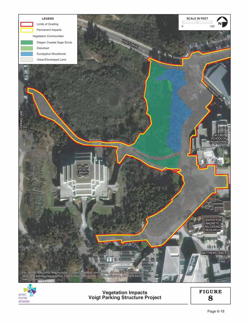
VOIGT DRIVE
VOIGT DRIVE
ENGINEER LANE
ENGINEER LANE
HOPK
INS
LANE
HOPK
INS
LANE
MATTHEWS LANEMATTHEWS LANE
VOIGT DRIVE
ENGINEER LANE
HOPK
INS
LANE
MATTHEWS LANE
GEISELGEISELLIBRARYLIBRARY
CENTER FORCENTER FORMAGNETICMAGNETIC
RECORDINGRECORDINGRESEARCHRESEARCH
JACOBSJACOBSSCHOOL OFSCHOOL OF
ENGINEERINGENGINEERING
GEISELLIBRARY
CENTER FORMAGNETIC
RECORDINGRESEARCH
JACOBSSCHOOL OF
ENGINEERING
Limits of Grading
Permanent Impacts
Diegan Coastal Sage Scrub
Disturbed
Eucalyptus Woodlands
Urban/Developed Land
LEGEND
Vegetation Communities
0 150
SCALE IN FEET
N
Vegetation ImpactsVoigt Parking Structure Project 8
FIGURE
UC San Diego Voigt Parking Structure Final Initial Study and Mitigated Negative Declaration December 2017
Page 6-19
construction contractors, including ingress and egress of equipment and personnel, shall be limited to designated construction zones. This fencing shall be removed upon completion of all construction activities.
ii. No temporary storage or stockpiling of construction materials for the proposed project shall be allowed within the Ecological Reserve or Restoration Lands, and all staging areas for equipment and materials shall be located at least 50 feet from the edge of natural habitats in the Park. This prohibition shall not be applied to facilities that are planned to traverse Ecological Reserve or Restoration Lands (e.g., trails). Staging areas and construction sites in proximity to the Ecological Reserve or Restoration Lands shall be kept free of trash, refuse, and other waste; no waste dirt, rubble, or trash shall be deposited in these portions of the Park. During and after construction, the proper use and disposal of oil, gasoline, diesel fuel, antifreeze, and other toxic substances shall be enforced.
iii. Equipment to extinguish small brush fires (such as from trucks or other vehicles) shall be present on site during all phases of project construction activities, along with personnel trained in the use of such equipment. Smoking shall be prohibited in construction areas adjacent to flammable vegetation.
iv. Natural habitats are considered light sensitive during the night. Night lighting shall not be used during the course of construction unless determined to be absolutely necessary. If necessary, the lights shall be shielded to minimize temporary lighting of the surrounding habitat.
v. A biological monitor shall be present on site on at least a weekly basis during rough grading to ensure that the limits of construction have been properly staked and are readily identifiable, and that the approved limits are not exceeded. The monitor also shall be responsible for ensuring that the contractor adheres to the other provisions described above. The monitor, in cooperation with the on-site construction manager, shall have the authority to halt construction activities in the event that these provisions are not met. Monitors shall submit a report to UC San Diego Campus Planning at the end of March, June, September and December of each year during construction documenting the implementation of all grading and construction minimization measures.
Bio-3E: All projects proposed adjacent to natural habitats in the UC San Diego Park – including the proposed project – shall be required to comply with the mitigation measures described below (or alternative measures that provide equivalent or superior protection of resources) to reduce potential indirect post-construction impacts to riparian habitat and sensitive natural communities to below a level of significance.
i. Irrigation for project landscaping shall be minimized and controlled in areas in and adjacent to the Park through efforts such as designing irrigation systems to match landscaping water needs, using sensor devices to prevent irrigation during and after precipitation, and using automatic flow reducers/shut-off valves that are triggered by a drop in water pressure from broken sprinkler heads or pipes. To the extent practicable, drainage from development areas shall not be directed to the Park if detrimental to the Park vegetation. If runoff directed to the Park would result in a
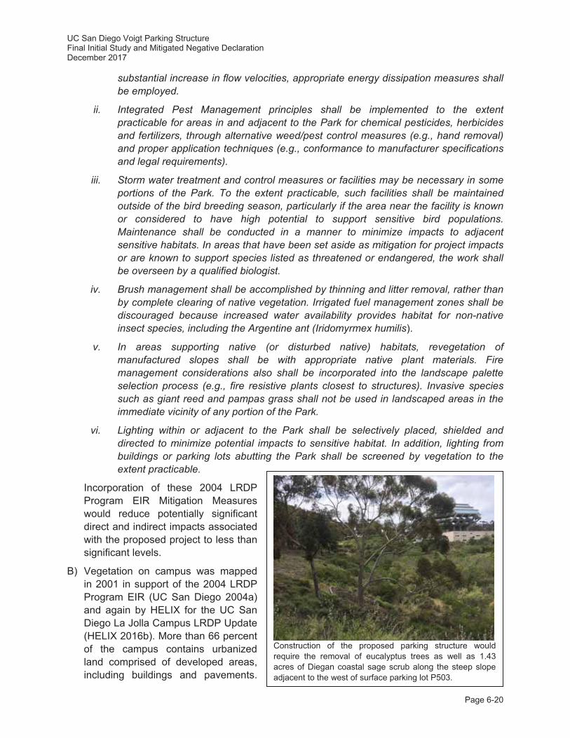
UC San Diego Voigt Parking Structure Final Initial Study and Mitigated Negative Declaration December 2017
Page 6-20
substantial increase in flow velocities, appropriate energy dissipation measures shall be employed.
ii. Integrated Pest Management principles shall be implemented to the extent practicable for areas in and adjacent to the Park for chemical pesticides, herbicides and fertilizers, through alternative weed/pest control measures (e.g., hand removal) and proper application techniques (e.g., conformance to manufacturer specifications and legal requirements).
iii. Storm water treatment and control measures or facilities may be necessary in some portions of the Park. To the extent practicable, such facilities shall be maintained outside of the bird breeding season, particularly if the area near the facility is known or considered to have high potential to support sensitive bird populations. Maintenance shall be conducted in a manner to minimize impacts to adjacent sensitive habitats. In areas that have been set aside as mitigation for project impacts or are known to support species listed as threatened or endangered, the work shall be overseen by a qualified biologist.
iv. Brush management shall be accomplished by thinning and litter removal, rather than by complete clearing of native vegetation. Irrigated fuel management zones shall be discouraged because increased water availability provides habitat for non-native insect species, including the Argentine ant (Iridomyrmex humilis).
v. In areas supporting native (or disturbed native) habitats, revegetation of manufactured slopes shall be with appropriate native plant materials. Fire management considerations also shall be incorporated into the landscape palette selection process (e.g., fire resistive plants closest to structures). Invasive species such as giant reed and pampas grass shall not be used in landscaped areas in the immediate vicinity of any portion of the Park.
vi. Lighting within or adjacent to the Park shall be selectively placed, shielded and directed to minimize potential impacts to sensitive habitat. In addition, lighting from buildings or parking lots abutting the Park shall be screened by vegetation to the extent practicable.
Incorporation of these 2004 LRDP Program EIR Mitigation Measures would reduce potentially significant direct and indirect impacts associated with the proposed project to less than significant levels.
B) Vegetation on campus was mapped in 2001 in support of the 2004 LRDP Program EIR (UC San Diego 2004a) and again by HELIX for the UC San Diego La Jolla Campus LRDP Update (HELIX 2016b). More than 66 percent of the campus contains urbanized land comprised of developed areas, including buildings and pavements.
Construction of the proposed parking structure would require the removal of eucalyptus trees as well as 1.43 acres of Diegan coastal sage scrub along the steep slope adjacent to the west of surface parking lot P503.

UC San Diego Voigt Parking Structure Final Initial Study and Mitigated Negative Declaration December 2017
Page 6-21
Some of the native habitats identified on campus, including riparian habitat and other sensitive natural communities (e.g., Diegan coastal sage scrub) are considered important to the regulatory agencies and/or support listed species. Direct impacts to these sensitive habitats would result in significant impacts as discussed in the 2004 LRDP Program EIR.
The project site partially overlies surface parking lot P503 adjacent to Engineer Lane; however, as described previously, construction of the proposed parking structure would also affect the undeveloped areas to the west, including eucalyptus woodland and Diegan coastal sage scrub (refer to Table 7). Therefore, there would be a potential for adverse impacts to habitat or other sensitive natural communities identified in local or regional plans, policies, regulations, or by the CDFW. The proposed parking structure has been designed in a way to minimize impacts to the eucalyptus trees in the undeveloped area to the west of surface parking lot P503; however, it is anticipated that approximately 150 trees may be removed during project construction. Grading associated with the construction of the project would also remove Diegan coastal sage scrub along the western margins of the project site. Impacts to Diegan coastal sage scrub would be reduced to a less than significant level with the implementation of 2004 LRDP Program EIR Mitigation Measure Bio-2B. In addition to off-site mitigation for all impacts to existing Diegan coastal sage scrub on the project site, the proposed landscaping plan would also include in planting of approximately 0.77 acres of Diegan coastal sage scrub on, which would replace existing habitat on-site.
2004 LRDP Program EIR Mitigation Measure:
Bio-3B: On a project specific basis, impacts to less than 0.1 acre for all upland habitats and 0.01 acre for all wetland habitats would not require mitigation. Prior to individual project construction, all direct impacts to riparian habitat and sensitive natural communities greater than 0.01 acre and 0.1 acre, respectively, shall be mitigated in accordance with the mitigation ratios listed in Table 4.3-5 of the 2004 LRDP Program EIR. This mitigation shall also be implemented in accordance with the following conditions.
i. Mitigation for upland community impacts shall consist of preservation of habitat on campus combined with habitat creation and/or enhancement of on-campus lands. All on-campus mitigation shall occur in the Park, particularly in the Ecological Reserve. This may require reclassifying at least some Restoration Lands and/or Grove Reserve as Ecological Reserve if they contain appropriate habitat to satisfy the mitigation requirement(s). Restoration activities could occur within portions of the Park that are currently disturbed, or in areas disturbed by project impacts, if they occur adjacent to other habitat in the Park. Mitigation credit should be given only where the habitat would be considered to be viable in the long-term, given the other surrounding uses planned by the 2004 LRDP.
C) Pursuant to 2004 LRDP Program EIR Mitigation Measure Bio-4A, Amec Foster Wheeler conducted a reconnaissance survey on November 18, 2016 to confirm the recent vegetation mapping for the UC San Diego La Jolla Campus LRDP Update. Amec Foster Wheeler identified wetland indicator plants in the area to the west of the project site and conservatively demarcated the edge of the potential wetland habitat. The results of this reconnaissance survey were used by UC San Diego Campus Planning as well as Capital Program Management (CPM) in the various design stages of the proposed project to avoid and minimize impacts to potentially jurisdictional wetland habitat.

UC San Diego Voigt Parking Structure Final Initial Study and Mitigated Negative Declaration December 2017
Page 6-22
As described in Section 2.8.7, Construction Staging, prior to construction activities associated with the proposed parking structure, a chain link with silt and/or orange fencing shall be installed 25 feet from the edge of the wetland vegetation demarcated by Amec Foster Wheeler to ensure that grading activities do not encroach on potential jurisdictional wetlands. Standard best management practices (BMPs), including the construction of a silt fence, would be implemented to ensure that there would be no indirect-construction related water quality impacts to potential wetlands adjacent to the project site (see the Hydrology and Water Quality discussion below). Further, the footprint of the proposed parking structure would be setback an additional 25 feet to ensure a post-construction buffer of 50 feet. A 50-foot buffer is consistent with 2004 LRDP Program EIR Mitigation Measure Bio-3D. This buffer is intended to provide a level of protection for wetland vegetation/riparian habitat from human activity and decreased water quality. At this distance, it is highly unlikely that sediments or incidental spills would migrate off-site into potential jurisdictional wetland areas. With the implementation of construction buffers and standard construction BMPs, indirect impacts to potential jurisdictional wetlands would be less than significant.
D) There are four important wildlife areas located on campus consisting of: 1) the Ecological Reserve south of Genesee Avenue; 2) the canyons on east campus; 3) Skeleton Canyon at SIO; and 4) the coastal properties overlooking the Pacific Ocean. Three of these four areas are located within areas designated for Park land uses within the 2004 LRDP, while the coastal properties are contiguous with the UC Scripps Coastal Reserve and City Multiple Habitat Preserve Area (MHPA). Although these areas provide habitat for wildlife on campus, they provide very limited connections with off-site wildlife habitat, with the exception of the coastal properties (UC San Diego 2004a). The west portion of the proposed project site is located within a Park land use; however, the project site is not located in either of the four important wildlife areas. Construction of the proposed project would not directly or indirectly affect any of these areas on campus. Further, the proposed project would not preclude wildlife movement within these areas or to off campus habitat since no new roads or other impediments to wildlife movement are proposed. While the proposed project would encroach on an area of undeveloped land to the west of surface parking lot P503, no wildlife thruway exists due to the interrupting presence of Voigt Drive to the north, Hopkins Drive to the east, Jacobs School of Engineering to the east, and Geisler Library to the south. Consequently, this project site is fragmented from surrounding habitats and is not currently used as a wildlife corridor. Therefore, impacts to wildlife movement would be less than significant, and mitigation would not be required.
E, F) UC San Diego is a part of the University of California, an entity of the State of California. Based on Article IX Section 9 of the California Constitution, the University of California is not subject to municipal plans, policies, and regulations, such as County and City General Plans or local ordinances. Nevertheless, the campus attempts to work cooperatively with the City of San Diego, and seeks consistency with local plans and policies, to the extent feasible. The 2004 LRDP is the guiding land use document and it includes development in accordance with environmental sustainability and stewardship principles. During preparation of the 2004 LRDP Program EIR, UC San Diego voluntarily reviewed the LRDP for consistency with local policies and ordinances found in the City of San Diego’s Land Development Code (2000), including the Environmentally Sensitive Lands (ESL) regulations and the City of San Diego Biology Guidelines (2002), and determined that there are no
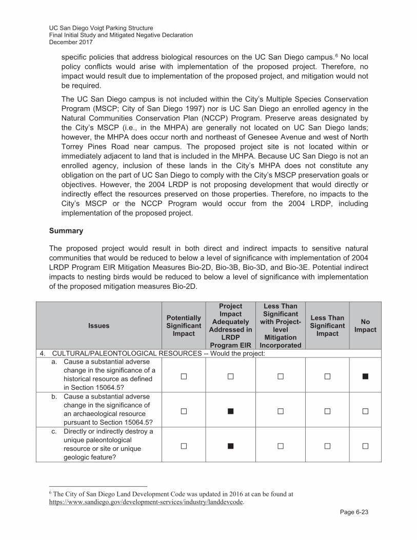
UC San Diego Voigt Parking Structure Final Initial Study and Mitigated Negative Declaration December 2017
Page 6-23
specific policies that address biological resources on the UC San Diego campus.6 No local policy conflicts would arise with implementation of the proposed project. Therefore, no impact would result due to implementation of the proposed project, and mitigation would not be required.
The UC San Diego campus is not included within the City’s Multiple Species Conservation Program (MSCP; City of San Diego 1997) nor is UC San Diego an enrolled agency in the Natural Communities Conservation Plan (NCCP) Program. Preserve areas designated by the City’s MSCP (i.e., in the MHPA) are generally not located on UC San Diego lands; however, the MHPA does occur north and northeast of Genesee Avenue and west of North Torrey Pines Road near campus. The proposed project site is not located within or immediately adjacent to land that is included in the MHPA. Because UC San Diego is not an enrolled agency, inclusion of these lands in the City’s MHPA does not constitute any obligation on the part of UC San Diego to comply with the City’s MSCP preservation goals or objectives. However, the 2004 LRDP is not proposing development that would directly or indirectly effect the resources preserved on those properties. Therefore, no impacts to the City’s MSCP or the NCCP Program would occur from the 2004 LRDP, including implementation of the proposed project.
Summary
The proposed project would result in both direct and indirect impacts to sensitive natural communities that would be reduced to below a level of significance with implementation of 2004 LRDP Program EIR Mitigation Measures Bio-2D, Bio-3B, Bio-3D, and Bio-3E. Potential indirect impacts to nesting birds would be reduced to below a level of significance with implementation of the proposed mitigation measures Bio-2D.
Issues Potentially Significant
Impact
Project Impact
Adequately Addressed in
LRDP Program EIR
Less Than Significant
with Project-level
Mitigation Incorporated
Less Than Significant
Impact No
Impact
4. CULTURAL/PALEONTOLOGICAL RESOURCES -- Would the project: a. Cause a substantial adverse
change in the significance of a historical resource as defined in Section 15064.5?
b. Cause a substantial adverse change in the significance of an archaeological resource pursuant to Section 15064.5?
c. Directly or indirectly destroy a unique paleontological resource or site or unique geologic feature?
6 The City of San Diego Land Development Code was updated in 2016 at can be found at https://www.sandiego.gov/development-services/industry/landdevcode.

UC San Diego Voigt Parking Structure Final Initial Study and Mitigated Negative Declaration December 2017
Page 6-24
Issues Potentially Significant
Impact
Project Impact
Adequately Addressed in
LRDP Program EIR
Less Than Significant
with Project-level
Mitigation Incorporated
Less Than Significant
Impact No
Impact
d. Disturb any human remains, including those interred outside of dedicated cemeteries?
TRIBAL CULTURAL RESOURCES -- Would the project cause a substantial adverse change in the significance of a tribal cultural resource, defined in Public Resources Code section 21074 as either a site, feature, place, cultural landscape that is geographically defined in terms of the size and scope of the landscape, sacred place, or object with cultural value to a California Native American tribe, and that is:
e. Listed or eligible for listing in the California Register of Historical Resources, or in a local register of historical resources as defined in Public Resources Code section 5020.1(k), or
f. A resource determined by the lead agency, in its discretion and supported by substantial evidence, to be significant pursuant to criteria set forth in subdivision (c) of Public Resources Code Section 5024.1. In applying the criteria set forth in subdivision (c) of Public Resources Code Section 5024.1, the lead agency shall consider the significance of the resource to a California Native American tribe.
Cultural/Paleontological/Tribal Resources Discussion
Campus-wide cultural resource issues are discussed in Section 4.4 of the 2004 LRDP Program EIR. The analysis is based partly on a cultural resources inventory update prepared by Kyle Consulting (2004) for the 2004 LRDP Program EIR. Additionally, Amec Foster Wheeler reviewed aerial photographs and topographic maps dating back to 1964 (UC San Diego 2017a). Review of these resources revealed that the project site has been previously disturbed beginning in 1940 with the construction of Camp Callan. Following the acquisition of the site by the University of California, the project site was further disturbed as a part of major construction associated with the Central Library (i.e., Geisel Library), Voigt Drive, surface parking lot P503, and the utility infrastructure associated with additions to the Geisel Library in September 1989.
A) A variety of recorded or potential historical resources exist on the UC San Diego campus, as discussed in Section 4.4.1 of the 2004 LRDP Program EIR. As described in Section 2.2, Project Site and Existing Land Uses, the 6.63-acre project site is predominately characterized by a paved surface parking lot as well as an undeveloped area adjacent to the

UC San Diego Voigt Parking Structure Final Initial Study and Mitigated Negative Declaration December 2017
Page 6-25
west designated as Park land use. During the preparation of the 2004 LRDP Program EIR, a historical resources evaluation of facilities located on the UC San Diego campus was prepared, and it was determined that the project site is located within the historical boundaries of Camp Callan, which covered the northwestern portion of campus. Although the project site is within the boundaries of the historic Camp Callan, no historic structures have been identified within the proposed project impact areas (Kyle Consulting 2004). The project site has been partially developed with surface parking lot P503 and the undeveloped area immediately adjacent to the west of surface parking lot P503 has been disturbed with installation of utility infrastructure associated with the additions to the Central Library in September 1989. As described above in the Aesthetics discussion, the proposed parking structure has been designed in such a way to minimize visual and aesthetic impacts and would be built into the existing slope of the canyon. As such, views from the Geisel Library (which is potentially eligible for listing as a historic structure in the California Register of Historic Places [CRHP] and/or the National Register of Historic Places [NRHP]) would not be impacted by construction of the proposed project. Therefore, no impacts to historical resources related to Camp Callan are anticipated from implementation of the proposed project, and mitigation would not be required.
B, D) An archival records search of archaeological site maps, records, and files was conducted for the UC San Diego campus and a field check of all known cultural resources was performed in March 2001 by Kyle Consulting (2004), as discussed in Section 4.4 of the 2004 LRDP Program EIR and summarized in Table 4.4-2 of that document. No identified archaeological sites have been located within or adjacent to the project site. Site CA-SDI-8472, Locus B/SDM-W-2340 – a light shell scatter recovered by Seneca (1979) – is located across Voigt Drive approximately 0.25 miles to the northeast of the project site, beneath the northeastern corner of surface parking lot P502. However, Gallegos et al. (1989) noted that an IS prepared by the UC San Diego Campus Planning Office the site as not significant and impacted by the expansion of surface parking lot P502. The site area was examined during cultural surveys prepared for the 2004 LRDP Program EIR and during parking lot construction (Kyle Consulting 2004).
The majority of the project site that would experience ground-disturbing activities as part of the construction of the proposed parking structure (e.g., excavation, trenching, etc.) has been disturbed by previous construction activities. The only area of the project site that has not been previously disturbed is the steep slope between surface parking lot P503 and the storm drain infrastructure to the west. Based on the guidance provided in 2004 LRDP Program EIR Mitigation Measure Cul-2Dii, due to the topography of this area and because no previously recorded sites are located adjacent to the project site, no “unexpected resources” are anticipated to occur. Additionally, the Native American Heritage Commission (NAHC) completed a Sacred Lands File search for the project site, which returned negative results (NAHC 2017). Therefore, the proposed project is not anticipated to impact significant archaeological resources during construction activities.
C) Geologic formations in the San Diego region are rated by the San Diego Natural History Museum, Department of Paleontology according to their potential for yielding paleontological resources. The campus is located in an area where the Ardath Shale and Scripps formations are overlain by the Lindavista Formation. Each of these geologic units is generally known to have moderate to high paleontological sensitivity. As part of the 2004 LRDP Program EIR, UC San Diego conducted an analysis of the paleontological monitoring

UC San Diego Voigt Parking Structure Final Initial Study and Mitigated Negative Declaration December 2017
Page 6-26
records and reports produced for construction projects on campus from 1998 through to 2003. From that review, it was determined that numerous excavations into formational materials on a campus-wide basis have not yielded significant paleontological resources. Therefore, the 2004 LRDP Program EIR concluded that in this geographic area, these formations have not and would not yield significant paleontological resources. Based on the 2004 LRDP Program EIR analysis, the proposed project is not anticipated to impact significant paleontological resources during construction activities.
In 1964 (pictured top left) the project site was characterized by undeveloped land located to the east of two paved roadways associated with Camp Callan and the early development of UC San Diego. By 1973 (pictured top right) the Central Library (i.e., Geisel Library) was constructed with a surface parking lot in the future location of the Warren Mall.
In 1983 (pictured bottom left) Voigt Drive was constructed providing a new east west access across this area of the West Campus. In 1989, with the construction of the improvements to Geisel Library, UC San Diego removed the original north south roadway segment between the library and Voigt Drive and constructed a 36-inch reinforced concrete pipeline and associated drainage basin, which is still in place today. By 1994 (pictured bottom right), this area was still disturbed and denuded of vegetation.
UC San Diego Voigt Parking Structure Final Initial Study and Mitigated Negative Declaration December 2017
Page 6-27
E, F) With the adoption of Assembly Bill (AB) 52, tribal cultural resources is a new CEQA resource area added to the CEQA Guidelines in 2015. Cultural resource issues, excluding tribal cultural resources, are discussed in Section 4.4 of the 2004 LRDP Program EIR, which included a cultural resources inventory update prepared by Kyle Consulting (2004). As previously described, the portions of the project site have been previously disturbed beginning in 1940 with the construction of Camp Callan. Following the acquisition of the site by UC San Diego, the project site was further disturbed as a part of major construction associated with the Geisel Library, Voigt Drive, surface parking lot P503, and the utility infrastructure associated with additions to the Central Library in September 1989. No evidence of tribal cultural resources has been identified within or adjacent to the project site (Kyle Consulting 2004; NAHC 2017) and no “unexpected resources” are anticipated based on the guidance of 2004 LRDP Program EIR Mitigation Measure Cul-2Dii.
AB 52 requires lead agencies to consult with California Native American Tribes that request such consultation in writing prior to the agency's release of a Notice of Preparation (NOP) of an EIR or notice of a MND or Negative Declaration (ND).
In January 2016, UC San Diego contacted California Native American tribes traditionally and culturally affiliated with the San Diego region to solicit their interest in being notified of proposed campus development projects as part of the planning process pursuant to AB 52. UC San Diego did not receive any responses as a result of this outreach attempt. However, UC San Diego was contacted independently by the San Luis Rey Band of Mission Indians, who expressed interest in receiving formal notifications of proposed projects on campus. Accordingly, UC San Diego has been sending out formal notification letters to the San Luis Rey Band of Mission Indians in compliance with AB 52 offering the opportunity for tribal consultation on proposed projects. Such a letter for the proposed project was sent to the San Luis Rey Band of Mission Indians on September 1, 2017. No formal request for tribal consultation with UC San Diego for the proposed project was received.
Summary
The proposed project would not result in any impacts to historical, archaeological, cultural or paleontological resources that have not been previously examined in the 2004 LRDP Program EIR. The project site is located in the Warren College Neighborhood of the West Campus that was previously evaluated for cultural resources by Kyle Consulting (2004) for the 2004 LRDP Program EIR. No historical built resources or archaeological resources have been identified within the project site (Kyle Consulting 2004; NAHC 2017), and the project has been previously disturbed as part of the development of Camp Callan as well as construction associated with Geisel Library, Voigt Drive, surface parking lot P503, and the utility infrastructure associated with additions to Geisel Library in September 1989. Further, the NAHC completed a Sacred Lands File search for the project site, which returned negative results (NAHC 2017). In addition, the geological formations underlying the project site are not anticipated to yield paleontological resources as noted in the 2004 LRDP Program EIR. UC San Diego has complied with the requirements of AB 52 and the proposed project would not result in any impacts to known tribal cultural resources.
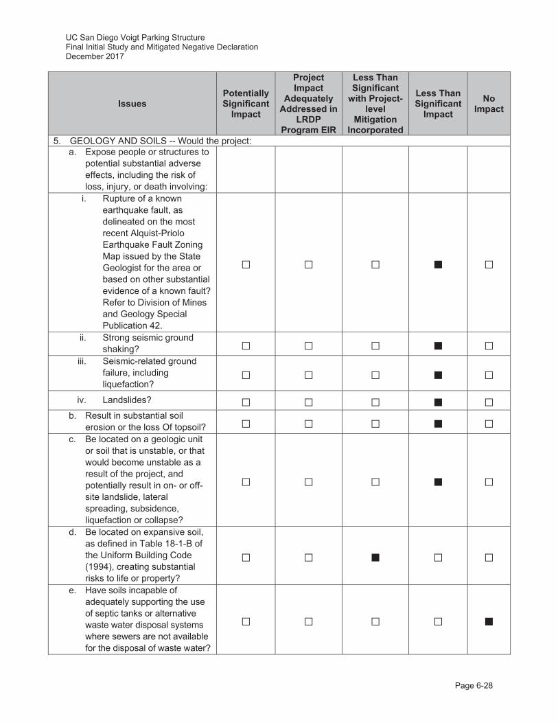
UC San Diego Voigt Parking Structure Final Initial Study and Mitigated Negative Declaration December 2017
Page 6-28
Issues Potentially Significant
Impact
Project Impact
Adequately Addressed in
LRDP Program EIR
Less Than Significant
with Project-level
Mitigation Incorporated
Less Than Significant
Impact No
Impact
5. GEOLOGY AND SOILS -- Would the project: a. Expose people or structures to
potential substantial adverse effects, including the risk of loss, injury, or death involving:
i. Rupture of a known earthquake fault, as delineated on the most recent Alquist-Priolo Earthquake Fault Zoning Map issued by the State Geologist for the area or based on other substantial evidence of a known fault? Refer to Division of Mines and Geology Special Publication 42.
ii. Strong seismic ground shaking?
iii. Seismic-related ground failure, including liquefaction?
iv. Landslides? b. Result in substantial soil
erosion or the loss Of topsoil? c. Be located on a geologic unit
or soil that is unstable, or that would become unstable as a result of the project, and potentially result in on- or off-site landslide, lateral spreading, subsidence, liquefaction or collapse?
d. Be located on expansive soil, as defined in Table 18-1-B of the Uniform Building Code (1994), creating substantial risks to life or property?
e. Have soils incapable of adequately supporting the use of septic tanks or alternative waste water disposal systems where sewers are not available for the disposal of waste water?
UC San Diego Voigt Parking Structure Final Initial Study and Mitigated Negative Declaration December 2017
Page 6-29
Geology and Soils Discussion
Geology and soils issues are discussed in Section 4.5 of the 2004 LRDP Program EIR. Portions of the analysis are based on a geotechnical report prepared for the 2004 LRDP Program EIR by Ninyo and Moore (2003). The results, conclusions and recommendations contained in this study are incorporated by reference. Additionally, consistent with the recommendations in 2004 LRDP Program EIR Geology and Soils analysis (refer to page 4.5-10 of the 2004 LRDP Program EIR), a geotechnical investigation was completed for the proposed project by Southern California Soils & Testing, Inc. (SCST) in November 2016 to determine the existing geotechnical conditions on the project site and to provide recommendations for the stability of the proposed parking structure.
A i,ii,iii) The UC San Diego campus, including the project site, is located in a seismically active area as is much of Southern California. However, there are no Alquist-Priolo (A-P) Study Zones (i.e., active faults) located on the UC San Diego campus. Although several faults have been mapped at various locations on the campus as shown in Figure 4.5-1 in the 2004 LRDP Program EIR, none of these faults are considered active or significant sources of seismic activity. Consequently, ground surface rupture is not likely to occur as a result of an earthquake or seismic event.
Although no active faults are located on campus, a significant seismic event could affect the proposed parking structure in other ways. Ground shaking during seismic events has the potential to damage and destroy buildings and other structures on the UC San Diego campus, including structures on the proposed project site. Hazards associated with damage or destruction to buildings and other structures on the UC San Diego campus are minimized through a number of methods, including: 1) reviewing and approving all building plans for compliance with the California Building Code (CBC); and 2) compliance with the UC Seismic Safety Policy, which requires anchorage for seismic resistance of nonstructural building elements such as furnishings, fixtures, material storage facilities, and utilities that could create a hazard if dislodged during an earthquake.
As described in the 2004 LRDP Program EIR, the closest known active fault is the Rose Canyon fault zone (Del Mar section), which is located approximately 2.23 miles west-southwest of the site. However, the closest mapped fault is an unnamed fault located approximately 100 feet south to the south project site. As with all of the fault traces on campus, the 2004 LRDP Program EIR and supporting geotechnical report (Ninyo and Moore 2003) classifies the unnamed fault as inactive. However, in compliance with the CBC and UC Seismic Safety Policy, a site-specific geotechnical investigation was conducted to investigate the unnamed fault. SCST (2016) determined that this fault is not known to have offset Holocene sediments indicating that it is not an active fault (SCST 2016).7 Therefore, the unnamed fault is not a potential source of seismic shaking and the probability of fault rupture is low.
Liquefaction is another seismic-related ground failure hazard that was identified as relevant to the UC San Diego campus. As shown in Figure 4.5-2 of the 2004 LRDP Program EIR, the project site is not in an area subject to liquefaction. Due to the dense nature of the
7 Holocene soils were deposited approximately 11,700 years before present. These soils are not offset across the unnamed fault (i.e., the soil layers still align within one another across the fault line), indicating that there has not been any seismic activity or movement along the fault for over 10,000 years
UC San Diego Voigt Parking Structure Final Initial Study and Mitigated Negative Declaration December 2017
Page 6-30
underlying formational materials (i.e., Scripps Formation) and lack of near surface groundwater over the majority of the campus, the potential for liquefaction occurring on campus, and the project site, is considered very low (UC San Diego 2004a; SCST 2016). The proposed project’s compliance with the CBC and UC Seismic Safety Policy would reduce any hazards associated with liquefaction.
A iv; C) Areas having the potential for earthquake-induced landslides generally occur within areas of previous landslide movement, or where local topographic, geological, geotechnical, and subsurface water conditions indicate a potential for permanent ground displacements (see Figure 4.5-1 in the 2004 LRDP Program EIR, the limits of landslide areas known on campus). Figure 4.5-2 in the 2004 LRDP Program EIR also maps the project site as an area of “Landslide; Confirmed, Known, or Suspected” and “Steeply Sloping/Canyon Areas with Potential Slope Instability”.
The project site has been mapped as a potential landslide area, including on the published City of San Diego Seismic Safety Maps. The site is located in Geologic Hazard Category 53, which is defined as an area with level to sloping terrain with unfavorable geologic structure and low to moderate risk of landslides. However, following the geological investigation at the project site – which including nine borings drilled to depths between 18 and 51 feet below the existing ground surface – SCST (2016) determined the geologic risk to be low. Claystones within the Scripps Formation may contribute to slope instability where the structure is unfavorable (i.e., dipping out of slope allowing overlying soil material to sluff off the slope); however, analysis for the borings from the project site indicates that the Scripps Formation in this location generally dips into slope, which contributes to the slope’s overall stability. SCTC (2016) found no evidence of landslides or slope instabilities at the project site.
The UC San Diego campus routinely prepares all building plans for compliance with the CBC and the campus also follows the UC Seismic Safety Policy that requires independent review of structural seismic design of both new construction and remodeling projects. Based on the findings of the geotechnical investigation (SCST 2016), impacts related to landsides, lateral spreading, subsidence, liquefaction, or collapse would be less than significant.
B) Ground-disturbing activities associated with project construction, including vegetation removal and grading, would result in temporary erosion impacts. As discussed in Section 4.5 of the 2004 LRDP Program EIR, construction activities would comply with Chapters 29 and 70 of the CBC. The proposed project would also comply with the NPDES general permit for construction activities, which requires implementation of an erosion control plan. Due to the proximity of the project site to a potential jurisdictional wetland to the east, this erosion control plan would include specific measures (e.g., siltation fences) to reduce the potential for off-site construction-related impacts during grading of the project site (see the Hydrology and Water Quality discussion below). Further, UC San Diego would continue to implement the campus wide runoff management program to comply with the applicable provisions of NPDES Phase II, which includes erosion and sedimentation BMPs. Erosion can also occur from increased surface runoff associated with the increase of impermeable surfaces following construction of the proposed project. Implementation of the proposed project would not impact the overall drainage pattern at the project site; however, as described in Section 2.8.5, Grading/Drainage, the proposed project would include the construction of seven flow through planters to capture and detain storm water flows to reduce the volume and rate of
UC San Diego Voigt Parking Structure Final Initial Study and Mitigated Negative Declaration December 2017
Page 6-31
storm water entering the existing catch basin to the west. Consequently, implementation of the proposed project would result in a long-term beneficial impact with regard to soil erosion.
D) As shown in Figure 4.5-1 of the 2004 LRDP Program EIR, the proposed project site overlies artificial fill beneath surface parking lot P503 as well as Quaternary alluvium and undifferentiated tertiary sedimentary deposits. The SCST, Inc. (2016) geotechnical investigation – which included nine borings drilled to depths between 18 and 51 feet below the existing ground surface – detected fill and Scripps Formation beneath the project site with alluvium likely to occur to the west at the canyon bottom. The fill at the project consists of medium dense to very dense silty to clayey sand with varying amounts of gravel. The Scripps Formation consists of dense to very dense, weakly to strongly cemented sandstone and siltstone and hard, strongly cemented claystone. Based on the analysis for the nine borings SCST (2016) made the following recommendations with regard to expansive soils, compressible soils, and differential sediment:
Expansive Soils. In order to reduce the potential for expansive heave (i.e., lifting of a building or other structure during periods of high moisture), SCST (2016) recommended that soils within the project footprint with an expansion index greater than 20 should be excavated 2 feet below the planned parking structure or exterior slab subgrade elevations. Horizontally, excavations should extend at least 2 feet outside the perimeter of the slab or up to temporary shoring or existing improvements. Granular material with an expansion index of 20 or less in accordance with American Society of Testing Materials (ASTM) D4829 should be used as replacement fill.
Compressible Soils. In order to address compressible soils on the project site – including fill and potentially alluvium – and to reduce the potential for settlement, SCST (2016) recommended that existing fill and alluvium, if encountered, should be excavated in their entirety beneath the parking structure and settlement sensitive improvements. Horizontally, excavations should extend at least 5 feet outside the planned perimeter foundations, at least 2 feet outside the planned hardscape or pavements, or up to existing improvements or the limits of grading.
Differential Settlement. During construction, excavation activities would remove existing fill such that the proposed parking structure would largely extend into Scripps Formation (i.e., bedrock); however, due to the topography of the project site the western side of the parking structure may be underlain by fill in some locations. To reduce the potential for differential settlement across the transition from Scripps Formation to fill, SCST (2016) recommended that the proposed parking structure should be supported entirely on formational materials (i.e., bedrock). In the fill area, to accommodate bearing on Scripps Formation, the structure should be supported on deepened, spread footings, soil-cement structural fill, or sand/cement slurry placed between the formation and design bottom of footing, aggregate piers, or deep foundations.
With incorporation of Project-Specific Mitigation Measure Geo-1 and continued compliance with the CBC and UC Seismic Safety Policy during site preparation and construction, the proposed project would have less than significant impacts related to expansive soils.
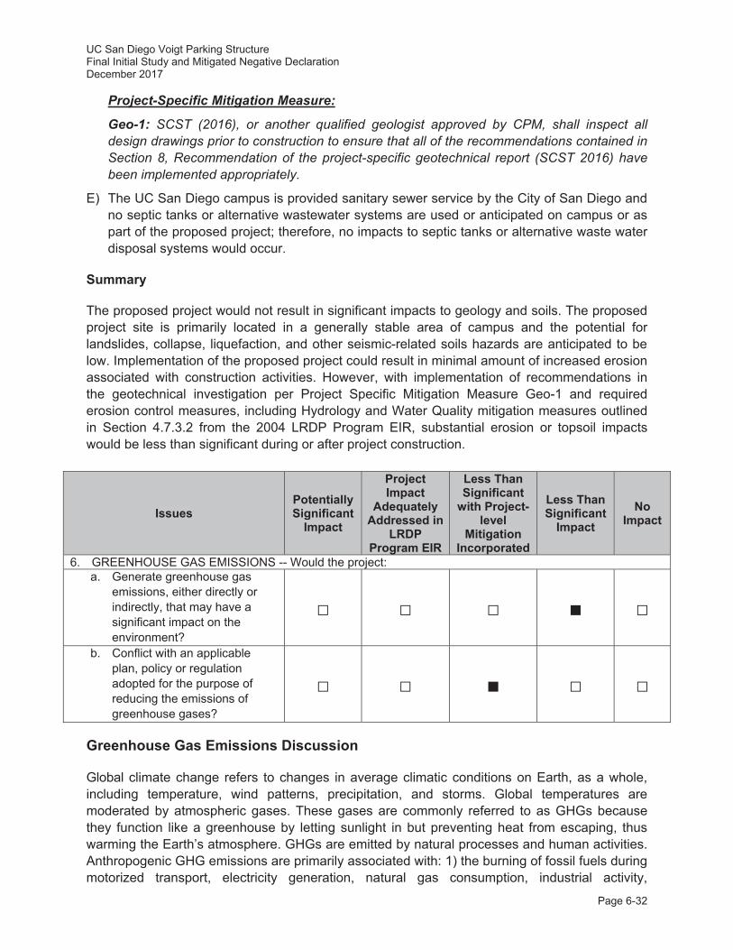
UC San Diego Voigt Parking Structure Final Initial Study and Mitigated Negative Declaration December 2017
Page 6-32
Project-Specific Mitigation Measure:
Geo-1: SCST (2016), or another qualified geologist approved by CPM, shall inspect all design drawings prior to construction to ensure that all of the recommendations contained in Section 8, Recommendation of the project-specific geotechnical report (SCST 2016) have been implemented appropriately.
E) The UC San Diego campus is provided sanitary sewer service by the City of San Diego and no septic tanks or alternative wastewater systems are used or anticipated on campus or as part of the proposed project; therefore, no impacts to septic tanks or alternative waste water disposal systems would occur.
Summary
The proposed project would not result in significant impacts to geology and soils. The proposed project site is primarily located in a generally stable area of campus and the potential for landslides, collapse, liquefaction, and other seismic-related soils hazards are anticipated to be low. Implementation of the proposed project could result in minimal amount of increased erosion associated with construction activities. However, with implementation of recommendations in the geotechnical investigation per Project Specific Mitigation Measure Geo-1 and required erosion control measures, including Hydrology and Water Quality mitigation measures outlined in Section 4.7.3.2 from the 2004 LRDP Program EIR, substantial erosion or topsoil impacts would be less than significant during or after project construction.
Issues Potentially Significant
Impact
Project Impact
Adequately Addressed in
LRDP Program EIR
Less Than Significant
with Project-level
Mitigation Incorporated
Less Than Significant
Impact No
Impact
6. GREENHOUSE GAS EMISSIONS -- Would the project: a. Generate greenhouse gas
emissions, either directly or indirectly, that may have a significant impact on the environment?
b. Conflict with an applicable plan, policy or regulation adopted for the purpose of reducing the emissions of greenhouse gases?
Greenhouse Gas Emissions Discussion
Global climate change refers to changes in average climatic conditions on Earth, as a whole, including temperature, wind patterns, precipitation, and storms. Global temperatures are moderated by atmospheric gases. These gases are commonly referred to as GHGs because they function like a greenhouse by letting sunlight in but preventing heat from escaping, thus warming the Earth’s atmosphere. GHGs are emitted by natural processes and human activities. Anthropogenic GHG emissions are primarily associated with: 1) the burning of fossil fuels during motorized transport, electricity generation, natural gas consumption, industrial activity,

UC San Diego Voigt Parking Structure Final Initial Study and Mitigated Negative Declaration December 2017
Page 6-33
manufacturing, and other activities; 2) deforestation; 3) agricultural activity; and 4) solid waste decomposition.
The GHGs defined under California’s AB 32 include: CO2, methane (CH4), nitrous oxide (N2O), hydrofluorocarbons (HFCs), perfluorocarbons (PFCs), and sulfur hexafluoride (SF6).
GHGs have long atmospheric lifetimes that range from one year to several thousand years. Long atmospheric lifetimes allow for GHGs to disperse around the globe. Because GHGs vary widely in the power of their climatic effects, climate scientists have established a unit called global warming potential (GWP). The GWP of a gas is a measure of both potency and lifespan in the atmosphere as compared to CO2. For example, because CH4 and N2O are approximately 25 and 298 times more powerful than CO2, respectively, in their ability to trap heat in the atmosphere, they have GWPs of 25 and 298, respectively (CO2 has a GWP of 1). Carbon dioxide equivalent (CO2e) is a quantity that enables all GHG emissions to be considered as a group despite their varying GWP. The GWP of each GHG is multiplied by the prevalence of that gas to produce CO2e.
State Greenhouse Gas Regulations
Executive Order S-3-05
On June 1, 2005, Executive Order (EO) S-3-05 proclaimed that California is vulnerable to climate change impacts. It declared that increased temperatures could reduce snowpack in the Sierra Nevada, further exacerbate California’s air quality problems, and potentially cause a rise in sea levels. In an effort to avoid or reduce climate change impacts, EO S-3-05 calls for a reduction in GHG emissions to the year 2000 level by 2010, to year 1990 levels by 2020, and to 80 percent below 1990 levels by 2050.
Assembly Bill 32 – Global Warming Solution Act of 2006
The California Global Warming Solutions Act of 2006, widely known as AB 32, requires that the California Air Resources Board (CARB) develop and enforce regulations for the reporting and verification of statewide GHG emissions. CARB is directed to set a GHG emission limit, based on 1990 levels, to be achieved by 2020. The bill requires CARB to adopt rules and regulations in an open public process to achieve the maximum technologically feasible and cost-effective GHG reductions.
Executive Order B-30-15
On April 29, 2015, EO B-30-15 established a California GHG reduction target of 40 percent below 1990 levels by 2030. The EO aligns California's GHG reduction targets with those of leading international governments, including the 28 nation European Union. California is on track to meet or exceed the target of reducing greenhouse gas emissions to 1990 levels by 2020, as established in AB 32. California's new emission reduction target of 40 percent below 1990 levels by 2030 will make it possible to reach the ultimate goal established by EO S-3-05 of reducing emissions 80 percent under 1990 levels by 2050.
UC San Diego Voigt Parking Structure Final Initial Study and Mitigated Negative Declaration December 2017
Page 6-34
Senate Bill (SB) 32
As a follow-up to AB 32 and in response to EO-B-30-15, SB 32 was passed by the California legislature in August 2016 to codify the EO’s California GHG reduction target of 40 percent below 1990 levels by 2030.
UC Sustainable Practices Policy
The UC Sustainable Practices Policy (2016 update) provides specific scope, direction, and expectations for implementing sustainable new capital projects, facility operations, and campus transportation resources. The UC Sustainable Practices Policy has nine topic areas: green building, clean energy, transportation, climate protection, sustainable operations, waste reduction and recycling, environmentally preferable purchasing, sustainable foodservice and sustainable water systems. GHG reduction efforts focus on energy efficiency and conservation efforts; reducing the University of California’s dependence on non-renewable energy sources; incorporating alternative means of transportation; tracking, reporting and minimizing GHG emissions; minimizing University-generated waste sent to landfill; and utilizing the UC’s purchasing power to meet its sustainability objectives. Section III.C of the UC Sustainable Practices Policy summarizes Climate Protection Practices with the following goals:
1. Climate neutrality from Scope I and II sources by 2025.
2. Climate neutrality from specific Scope III sources (as defined by the American College and University Presidents’ Climate Commitment [ACUPCC] by 2050 or sooner.
And, at a minimum, meet the following intermediate goal in pursuit of climate neutrality:
3. Reduce GHG emissions to 1990 levels by 2020, pursuant to the California Global Warming Solutions Act of 2006.
Scope I sources, also referred to as direct sources, are defined as “direct emissions from sources that are owned or controlled by the organization.” These include all area source emissions, such as landscaping equipment exhaust and consumer product use, and on-site natural gas consumption for space and water heating. Scope II sources, also referred to as electricity indirect sources, are defined as “indirect emissions from sources that are owned or controlled by the organization.” Scope II includes emissions that result from the generation of electricity, heat, or steam purchased by the Agency from a utility provider. Scope III sources, also referred to as other indirect sources, are defined as “emissions from sources not owned or directly controlled by an organization, but related to the organizations activities.” Scope III emissions include employee or patron travel and commuting, organic solid waste disposal such as food waste, and wastewater treatment. The system-wide UC Sustainable Practices Policy establishes guidelines for future projects at UC campuses and provides specific scope, direction, and expectations for implementing sustainable new capital projects, facility operations, and campus transportation practices. The UC Sustainable Practices Policy includes the goal for all new building projects, other than acute-care facilities, to outperform the required provisions of the contemporary California Energy Code’s Title 24 energy efficiency standards at the time of Preliminary Plan approval by at least 20 percent and strive for 30 percent. In addition, the policy requires new construction and most
UC San Diego Voigt Parking Structure Final Initial Study and Mitigated Negative Declaration December 2017
Page 6-35
major renovation projects to achieve a minimum standard equivalent to a LEED-NC Silver Certification.
As discussed in Section 2.7, Sustainability, the proposed parking structure would be in general conformance with the UC Sustainable Practices Policy (2016 update). Although the proposed project would be ineligible to attain a LEED-NC rating because it is a parking structure, the proposed parking structure has been designed to incorporate sustainable design features to achieve certification by Parksmart (formerly the Green Parking Council), a similar “green” rating for parking structures, and integrate sustainability goals to the extent possible.
UC San Diego Climate Action Plan
The UC San Diego Climate Action Plan (UC San Diego 2008) has set a goal for the campus of being climate neutral by 2025. To reach this goal, the Climate Action Plan programs include the following: the Clean Energy Standard, which is designed to promote the use of renewable energy on campus; the Climate Protection Practices, which involve developing a campus-wide action plan to bring the campus to carbon neutral; Sustainable Transportation Practices, which encourage the use of clean vehicles for campus fleets and reduction in vehicle miles traveled; Sustainable Operations, designed to encourage LEED practices for existing operations; Recycling and Waste Management Programs, designed to reduce waste generation; and
Environmental Preferred Purchasing Practices, which give preferences to purchasing of sustainable technologies and products. The Sustainable Transportation Practices related to the proposed project include the following:
1. At a minimum, reduce the GHG emissions from commuting by 2% per year, based on the previous year’s emissions, from 2009 to 2015.
2. At a minimum, reduce the percentage of commuters using single occupancy vehicles from 49% to 39% by 2018 (this goal includes commuters at the Main Campus and the Hillcrest campus).
The UC San Diego Climate Action Plan is currently being updated.
UC San Diego Water Action Plan
In response to the current state-wide drought and in compliance with the 2012 UC Sustainable Water Systems Policy, UC San Diego implemented a Water Action Plan (UC San Diego 2013) and a strategy to meet the University of California President’s January 2014 call for a 20 percent reduction in water use by 2020. The purpose of the UC San Diego Water Action Plan is to: 1) identify the present and future measures UC San Diego will implement to further reduce potable water use; 2) develop and implement a solid education and outreach platform that will grow with time; and 3) establish benchmark goals to go beyond the 20 percent reduction in potable water use set forth by policy. This multi-pronged plan targeted a variety of conservation measures in the following areas: new building construction, existing building operation and maintenance, irrigation and landscaping, training and outreach, and behavioral modification. Adherence to the UC San Diego Water Action Plan is intended to result in a 20 percent reduction strategy campus-wide by 2020 and 36-percent reduction by 2025. This would result in additional water conservation beyond what was anticipated in the 2004 LRDP Program EIR (as updated in
UC San Diego Voigt Parking Structure Final Initial Study and Mitigated Negative Declaration December 2017
Page 6-36
2010), further reducing demand for additional water facilities. Locations achieving this target early are encouraged to set more stringent goals to further reduce potable water consumption. The 2013 plan is currently being updated and is scheduled for release in December 2017.
A) In March 2010, the CEQA guidelines were revised to include the analysis of GHG emissions. Because GHG analysis was not required at the time the 2004 LRDP was adopted, it was not included as part of the 2004 LRDP Program EIR. Additionally, as described above, there have been numerous federal, state, and local policies and regulations related to GHG emission during this time. Therefore, Amec Foster Wheeler prepared a project-level GHG analysis (see Appendix A) to support the impact analysis for the proposed parking structure provided in the IS. It should be noted that individual projects of any size are generally of insufficient magnitude by themselves to influence climate change or result in a substantial contribution to the global GHG inventory. As a result, GHG impacts are recognized as exclusively cumulative impacts; there are no non-cumulative GHG emissions impacts from a climate change perspective (California Air Pollution Control Officers Association [CAPCOA] 2008). Accordingly, discussion of the proposed project’s GHG emissions and their impact on global climate are addressed in terms of the proposed project’s contribution to a cumulative impact on global climate.
The implementation of the proposed project would emit GHG emissions during construction and operation. To model the total net operational emissions of the proposed parking structure, the following inventories were calculated in CalEEMod version 2016.3.1: project construction emissions, project operational emissions, and the existing land use operational emissions.
Construction Emissions
Project construction GHG emissions were estimated using CalEEMod. Project-specific input was based on general information provided in Section 2.0, Project Location and Description and default model settings to estimate reasonable worst-case conditions. Additional details of phasing, selection of construction equipment, and other input parameters, including CalEEMod data, are included in Appendix A.
The proposed project is anticipated to generate temporary, localized GHG emissions during the approximately 12- to 16-month construction period, resulting from the use of on-site heavy equipment, haul trucks to deliver construction materials and remove demolition debris from the project site, and construction worker vehicle trips to and from the project site. Mitigated construction emissions only negligibly reduce GHG emissions (<0.001 MT CO2e); therefore, unmitigated emissions are discussed. As shown in Table 8, total GHG unmitigated construction emissions associated with construction of the project are estimated at 970.7602 MT CO2e. Implementation of 2004 LRDP Program EIR Mitigation Measures Air-CA, -CB, and -CC would reduce CO2e emissions, but only incrementally. For construction emissions, unmitigated emissions are amortized (i.e., averaged) over the life of the proposed project (conservatively estimated to be 30 years). Averaged over 30 years, the proposed construction activities would contribute approximately 32.4939 MT CO2e emissions per year (see Table 8). Construction GHG emissions can vary substantially from day to day, depending on the level of activity and specific type of operation. Therefore, such emission levels can only be approximately estimated with a corresponding uncertainty in precise GHG impacts.
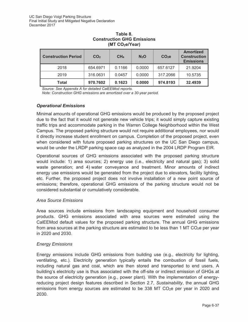
UC San Diego Voigt Parking Structure Final Initial Study and Mitigated Negative Declaration December 2017
Page 6-37
Table 8. Construction GHG Emissions
(MT CO2e/Year)
Construction Period CO2 CH4 N2O CO2e Amortized
Construction Emissions
2018 654.6971 0.1166 0.0000 657.6127 21.9204
2019 316.0631 0.0457 0.0000 317.2066 10.5735
Total 970.7602 0.1623 0.0000 974.8193 32.4939 Source: See Appendix A for detailed CalEEMod reports. Note: Construction GHG emissions are amortized over a 30-year period.
Operational Emissions
Minimal amounts of operational GHG emissions would be produced by the proposed project due to the fact that it would not generate new vehicle trips; it would simply capture existing traffic trips and accommodate parking in the Warren College Neighborhood within the West Campus. The proposed parking structure would not require additional employees, nor would it directly increase student enrollment on campus. Completion of the proposed project, even when considered with future proposed parking structures on the UC San Diego campus, would be under the LRDP parking space cap as analyzed in the 2004 LRDP Program EIR.
Operational sources of GHG emissions associated with the proposed parking structure would include: 1) area sources; 2) energy use (i.e., electricity and natural gas); 3) solid waste generation; and 4) water conveyance and treatment. Minor amounts of indirect energy use emissions would be generated from the project due to elevators, facility lighting, etc. Further, the proposed project does not involve installation of a new point source of emissions; therefore, operational GHG emissions of the parking structure would not be considered substantial or cumulatively considerable.
Area Source Emissions
Area sources include emissions from landscaping equipment and household consumer products. GHG emissions associated with area sources were estimated using the CalEEMod default values for the proposed parking structure. The annual GHG emissions from area sources at the parking structure are estimated to be less than 1 MT CO2e per year in 2020 and 2030.
Energy Emissions
Energy emissions include GHG emissions from building use (e.g., electricity for lighting, ventilating, etc.). Electricity generation typically entails the combustion of fossil fuels, including natural gas and coal, which are then stored and transported to end users. A building’s electricity use is thus associated with the off-site or indirect emission of GHGs at the source of electricity generation (e.g., power plant). With the implementation of energy-reducing project design features described in Section 2.7, Sustainability, the annual GHG emissions from energy sources are estimated to be 338 MT CO2e per year in 2020 and 2030.
UC San Diego Voigt Parking Structure Final Initial Study and Mitigated Negative Declaration December 2017
Page 6-38
Solid Waste Sources
Solid waste generated by the proposed parking structure would also contribute to GHG emissions. Treatment and disposal of solid waste produces emissions of methane. Using CalEEMod defaults and a 62-percent operational solid waste diversion rate in accordance with current UC San Diego solid waste diversion rates (UC San Diego 2012b), GHG emissions from project-related solid waste would be less than 1 MT CO2e per year in 2020 and 2030.
Water Sources
Water-related GHG emissions are from the conveyance and treatment of water. Using CalEEMod defaults a reduction in potable water use associated with the use of reclaimed water for irrigation, the proposed project’s estimated GHG emissions related to water treatment and conveyance would be less than 1 MT CO2e per year in 2020 and 2030.
Total Emissions
Table 9 describes the annual emissions for the proposed project, including the amortized annual construction emissions anticipated for the parking structure. As shown in Table 9, the proposed project would result in annual GHG emissions of approximately 371 MT CO2e in 2020 and 2030.
Greenhouse Gas Emissions Significance Determination
Significance thresholds from Appendix G of the CEQA Guidelines have been adopted by UC San Diego to indicate what level of GHG emissions would be considered substantial enough to result in a significant adverse impact on global climate. For purposes of this analysis, a significant adverse impact is identified if the proposed project would result in the following:
1. UC San Diego-specific efficiency target for 2020 of 3.34 MT CO2e/SP/year based on compliance with the California’s AB 32 target of reducing 2020 GHG emissions to 1990 levels; and
2. UC San Diego-specific efficiency target for 2030 of 1.65 MT CO2e/SP/year based on compliance with the California’s SB 32 target of reducing 2030 GHG emissions to 40 percent below 1990 levels.
Consistency with AB 32 and SB 32
Consistent with AB 32 and SB 32, the efficiency target for the year 2020 is 3.34 MT CO2e/SP/year and the efficiency target for the year 2030 is 1.65 MT CO2e/SP/year (refer to Table 10).
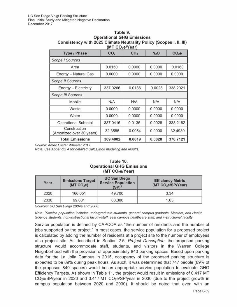
UC San Diego Voigt Parking Structure Final Initial Study and Mitigated Negative Declaration December 2017
Page 6-39
Table 9. Operational GHG Emissions
Consistency with 2025 Climate Neutrality Policy (Scopes I, II, III) (MT CO2e/Year)
Type / Phase CO2 CH4 N2O CO2e
Scope I Sources
Area 0.0150 0.0000 0.0000 0.0160
Energy – Natural Gas 0.0000 0.0000 0.0000 0.0000
Scope II Sources
Energy – Electricity 337.0266 0.0136 0.0028 338.2021
Scope III Sources
Mobile N/A N/A N/A N/A
Waste 0.0000 0.0000 0.0000 0.0000
Water 0.0000 0.0000 0.0000 0.0000
Operational Subtotal 337.0416 0.0136 0.0028 338.2182 Construction
(Amortized over 30 years) 32.3586 0.0054 0.0000 32.4939
Total Emissions 369.4002 0.0019 0.0028 370.7121 Source: Amec Foster Wheeler 2017. Note: See Appendix A for detailed CalEEMod modeling and results.
Table 10. Operational GHG Emissions
(MT CO2e/Year)
Year Emissions Target (MT CO2e)
UC San Diego Service Population
(SP)1 Efficiency Metric
(MT CO2e/SP/Year)
2020 166,051 49,700 3.34
2030 99,631 60,300 1.65 Sources: UC San Diego 2004a and 2008.
Note: 1Service population includes undergraduate students, general campus graduate, Masters, and Health Science students, non-instructional faculty/staff, east campus healthcare staff, and instructional faculty.
Service population is defined by CAPCOA as “the number of residents and the number of jobs supported by the project.” In most cases, the service population for a proposed project is calculated by adding the number of residents at a project site to the number of employees at a project site. As described in Section 2.5, Project Description, the proposed parking structure would accommodate staff, students, and visitors in the Warren College Neighborhood with the provision of approximately 840 parking spaces. Based upon parking data for the La Jolla Campus in 2015, occupancy of the proposed parking structure is expected to be 89% during peak hours. As such, it was determined that 747 people (89% of the proposed 840 spaces) would be an appropriate service population to evaluate GHG Efficiency Targets. As shown in Table 11, the project would result in emissions of 0.417 MT CO2e/SP/year in 2020 and 0.417 MT CO2e/SP/year in 2030 (due to the project growth in campus population between 2020 and 2030). It should be noted that even with an
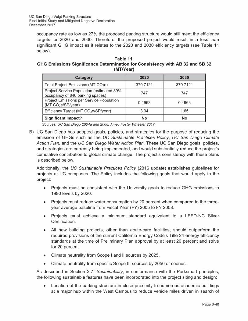
UC San Diego Voigt Parking Structure Final Initial Study and Mitigated Negative Declaration December 2017
Page 6-40
occupancy rate as low as 27% the proposed parking structure would still meet the efficiency targets for 2020 and 2030. Therefore, the proposed project would result in a less than significant GHG impact as it relates to the 2020 and 2030 efficiency targets (see Table 11 below).
Table 11. GHG Emissions Significance Determination for Consistency with AB 32 and SB 32
(MT/Year)
Category 2020 2030
Total Project Emissions (MT CO2e) 370.7121 370.7121 Project Service Population (estimated 89% occupancy of 840 parking spaces) 747 747
Project Emissions per Service Population (MT CO2e/SP/year) 0.4963 0.4963
Efficiency Target (MT CO2e/SP/year) 3.34 1.65
Significant Impact? No No Sources: UC San Diego 2004a and 2008; Amec Foster Wheeler 2017.
B) UC San Diego has adopted goals, policies, and strategies for the purpose of reducing the emission of GHGs such as the UC Sustainable Practices Policy, UC San Diego Climate Action Plan, and the UC San Diego Water Action Plan. These UC San Diego goals, policies, and strategies are currently being implemented, and would substantially reduce the project’s cumulative contribution to global climate change. The project’s consistency with these plans is described below.
Additionally, the UC Sustainable Practices Policy (2016 update) establishes guidelines for projects at UC campuses. The Policy includes the following goals that would apply to the project:
Projects must be consistent with the University goals to reduce GHG emissions to 1990 levels by 2020.
Projects must reduce water consumption by 20 percent when compared to the three-year average baseline from Fiscal Year (FY) 2005 to FY 2008.
Projects must achieve a minimum standard equivalent to a LEED-NC Silver Certification.
All new building projects, other than acute-care facilities, should outperform the required provisions of the current California Energy Code’s Title 24 energy efficiency standards at the time of Preliminary Plan approval by at least 20 percent and strive for 20 percent.
Climate neutrality from Scope I and II sources by 2025.
Climate neutrality from specific Scope III sources by 2050 or sooner.
As described in Section 2.7, Sustainability, in conformance with the Parksmart principles, the following sustainable features have been incorporated into the project siting and design:
Location of the parking structure in close proximity to numerous academic buildings at a major hub within the West Campus to reduce vehicle miles driven in search of

UC San Diego Voigt Parking Structure Final Initial Study and Mitigated Negative Declaration December 2017
Page 6-41
parking, provide ease of way finding, and provide access to multi-modal facilities, trails, and pathways providing connections across campus.
Orientation of parking stalls to reduce internal circling.
Provision of 30 electric vehicle charging stations.
Connection and improvements to existing pedestrian pathways and campus bicycle paths, enhanced with the provision of shade trees, benches, bicycle parking areas, and on-site bicycle fix-it stations to promote walking and cycling on campus.
Implementation of LID techniques and storm water treatment controls, including the use of porous concrete in hardscape features where feasible as well as flow through planters.
Installation of a Live Roof with coastal grassland species and tree canopy to minimize heat-island effect.
Landscaping with drought-tolerant plantings, including native and adaptive species.
Connection to campus recycled water for irrigation use.
Re-use of eucalyptus trees for site furnishings and erosion control.
Maximization of natural ventilation where feasible to reduce energy demand.
Control of all LED lighting fixtures within the parking structure by motion sensors to reduce energy demand.
Installation of low-flow plumbing fixtures.
With respect to the University of California 2025 climate neutrality target for Scope I and II GHG emission sources, and the subsequent University of California 2050 climate neutrality target for Scope III GHG emission sources, as shown in Table 9, Operational GHG Emissions Significance Determination for Consistency with 2025 Climate Neutrality Policy (Scopes I, II, III), the project would result in a total of 370.7121 MT CO2e per year. The emissions include all Scope I, II, and III emissions anticipated for the project. Because emissions of Scope I and II sources exceed zero, the project would result in a potentially significant impact as it relates to the UC 2025 climate neutrality target for 2025.
UC San Diego Climate Action Plan
The UC San Diego Climate Action Plan has set a goal for the campus of being net neutral for Scope I and II sources by 2025. As shown in Table 9, the project would not achieve net neutrality for these sources; therefore, impacts would be potentially significant with respect to consistency with the UC San Diego Climate Action Plan.
UC San Diego Water Action Plan
The objective of the UC San Diego Water Action Plan is to reduce potable water usage on campus by expanding the use of reclaimed water to offset potable water use, and
UC San Diego Voigt Parking Structure Final Initial Study and Mitigated Negative Declaration December 2017
Page 6-42
implementing building standards for new construction to improve water efficiency. The project would use reclaimed water lines for its irrigation. In addition, the project would install native or drought-tolerant vegetation to lower its irrigation water demand. In accordance with UC San Diego requirements for interior water use, the proposed building would include low-flow plumbing fixtures (e.g., toilets and sinks), which also would decrease project demand for potable water supplies. These reductions in water usage would also correspondingly reduce indirect emissions of GHG associated with the transport and treatment of potable water, consistent with the goals of this plan.
Conclusion
While the proposed project would implement Parksmart principles, as shown in Table 9, the project would still result in a total of 370.7121 MT CO2e per year from Scope I and II emission sources. (Scope III emissions sources would not be created because the proposed project would not generate new trips and would instead capture existing traffic on campus). Because emissions of Scope I and II emissions sources exceed zero, the proposed project would result in a potentially significant impact as it relates to the University of California 2025 climate neutrality target. The following mitigation measure is required to reduce operational GHG emissions and associated potential conflicts with an applicable plan, policy, or regulation adopted for the purpose of reducing GHG emissions. have a less than significant impacts related to GHG emissions. With incorporation of Project-Specific Mitigation Measure GHG-1, impacts would be less than significant.
Project-Specific Mitigation Measure:
GHG-1: Reduction of Scope I and II Emissions to Zero by 2025. UC San Diego shall reduce emissions generated by Scope I and II (direct emissions from area sources and electricity usage) to zero by the year 2025. The reduction of Scope I sources may be accomplished by one or a combination of measures, including sustainable alternatives for electricity production or the purchase of secure GHG offsets or credits equivalent to the project’s annual Scope I and II emissions. Because a campus-wide program will be in place by year 2025 to achieve carbon neutrality for all campus Scope I and II sources, measures implemented to reach net zero for the project may be included as part of this program.
Summary
The proposed project is anticipated to generate temporary, localized GHG emissions during the approximately 12- to 16-month construction period, resulting from the use of on-site heavy equipment, haul trucks to deliver construction materials and remove demolition debris from the project site, and construction worker vehicle trips to and from the project site. The operation of the proposed parking structure (e.g., elevators, facility lighting, etc.) would result in minor operational GHG emissions. However, the proposed project would not generate new vehicle trips as the parking structure would simply capture existing traffic trips and accommodate parking in the Warren College Neighborhood within the West Campus. The proposed parking structure would meet the efficiency targets for 2020 and 2030 consistent with the requirements of AB 32 and SB 32. Because emissions of Scope I and II emissions sources exceed zero, the proposed project would result in a potentially significant impact as it relates to the University of California 2025 climate neutrality target. However, implementation of Project-Specific Mitigation Measure GHG-1 would reduce emissions of Scope I and II sources to zero, thereby achieving the University of California 2025 climate neutrality target for those sources.

UC San Diego Voigt Parking Structure Final Initial Study and Mitigated Negative Declaration December 2017
Page 6-43
Issues Potentially Significant
Impact
Project Impact
Adequately Addressed in
LRDP Program EIR
Less Than Significant
with Project-level
Mitigation Incorporated
Less Than Significant
Impact No
Impact
7. HAZARDS AND HAZARDOUS MATERIALS -- Would the project: a. Create a significant hazard to
the public or the environment through the routine transport, use, or disposal of hazardous materials?
b. Create a significant hazard to the public or the environment through reasonably foreseeable upset and accident conditions involving the release of hazardous materials into the environment?
c. Emit hazardous emissions or handle hazardous or acutely hazardous materials, substances, or waste within one-quarter mile of an existing or proposed school?
d. Be located on a site which is included on a list of hazardous materials sites compiled pursuant to Government Code Section 65962.5 and, as a result, would it create a significant hazard to the public or the environment?
e. For a project located within an airport land use plan or, where such a plan has not been adopted, within two miles of a public airport or public use airport, would the project result in a safety hazard for people residing or working in the project area?
f. For a project within the vicinity of a private airstrip, would the project result in a safety hazard for people residing or working in the project area?
g. Impair implementation of or physically interfere with an adopted emergency response plan or emergency evacuation plan?

UC San Diego Voigt Parking Structure Final Initial Study and Mitigated Negative Declaration December 2017
Page 6-44
Issues Potentially Significant
Impact
Project Impact
Adequately Addressed in
LRDP Program EIR
Less Than Significant
with Project-level
Mitigation Incorporated
Less Than Significant
Impact No
Impact
h. Expose people or structures to a significant risk of loss, injury or death involving wildland fires, including where wildlands are adjacent to urbanized areas or where residences are intermixed with wildlands?
Hazards and Hazardous Materials Discussion
Hazards and hazardous materials are discussed in Section 4.6 of the 2004 LRDP Program EIR.
A, B) A detailed discussion of the types and quantities of hazardous materials and wastes used at and generated by UC San Diego is provided in Section 4.6.1.1 in the 2004 LRDP Program EIR (specifically Tables 4.6-1 and 4.6-2). In addition, the section discusses the comprehensive environmental health and safety programs implemented by the campus to safely manage these materials according to applied laws and regulations. The campus contracts with licensed hazardous waste transporters to ensure that all hazardous wastes generated by the campus are transported off campus for treatment or disposal at licensed hazardous waste facilities.
As early as 1964 the project site was characterized by undeveloped land associated with Camp Callan and the early development of UC San Diego. By 1973 the Central Library (now Geisel Library) was constructed with a surface parking lot in the future location of Warren Mall. In 1989, with the construction of improvements to Geisel Library, UC San Diego constructed a 36-inch reinforced concrete pipeline and associated drainage basin, which required extensive grading along the western margin of the project site. By 1994, surface parking lot P503 was constructed on the project site. The only area of the project site that has not been previously graded or developed is the approximately 65-foot wide, steep slope between surface parking lot P503 and the buried storm drain infrastructure to the west. As described in the Geology and Soils discussion, a geotechnical survey was conducted on the project site that involved nine boring to depths between 18 and 51 feet below the project site (SCST 2016). As a part of this survey, a State of California-certified laboratory was engaged to perform environmental testing of the on-site soils, consistent with the requirements of the Site Development Guidelines and Procedures for UC San Diego (e.g., California Health and Safety Code, Division 20, Chapter 6.8, Section 25319.5).
As part of the project construction, the existing surface parking lot on the project site would be demolished and all associated demolition debris would be removed and transported to a licensed off-site disposal facility. The potential to encounter hazardous chemicals, lead-based paints, mercury, or asbestos-containing hazardous materials during demolition activities is anticipated to be low. However, in the unlikely event hazardous materials are encountered during construction, the 2004 LRDP Program EIR has guidance on procedures on how to handle such an event with 2004 LRDP Program EIR Mitigation Measures Haz-4B and Haz-4C.
UC San Diego Voigt Parking Structure Final Initial Study and Mitigated Negative Declaration December 2017
Page 6-45
All chemical waste recycling or disposal would be managed through the UC San Diego EH&S office. Because UC San Diego would continue to require compliance with State and federal safety regulations, guidelines, and policies applicable to hazardous materials the impact of the increased transport of hazardous materials to and from campus as a result of this project would be less than significant.
2004 LRDP Program EIR Mitigation Measures:
Haz-4B: If contamination is detected on the project site and if it poses a risk to human health or the environment, actions shall be taken prior to any construction, pursuant to applicable regulations, to remove or otherwise remediate the contamination through appropriate measures such as natural attenuation, active remediation, and engineering controls. Assessment and remediation activities shall incorporate the following conditions:
i. All assessment and remediation activities shall be conducted in accordance with a work plan which is approved by the regulatory agency having oversight of the activities.
ii. It may be necessary to excavate existing soil within the project site, or to bring fill soils into the site from off-site locations. At sites that have been identified as being contaminated or where soil contamination is suspected, appropriate sampling is required prior to disposal of excavated soil. Contaminated soil shall be properly disposed at an approved off-site facility. Fill soils also shall be sampled to ensure that imported soil parameters are within acceptable levels.
iii. Caution shall be taken during excavation activities near existing groundwater monitoring wells, so that they are not damaged. Existing groundwater monitoring wells may have to be abandoned and reinstalled if they are located in an area that is undergoing redevelopment.
Haz-4C: In the event that underground storage tanks (USTs), not identified in consultation with EH&S Environmental Affairs or undocumented areas of contamination are encountered during construction or redevelopment activities, work shall be discontinued until appropriate health and safety procedures are implemented. Either the Department of Environmental Health (DEH) or the San Diego RWQCB, depending on the nature of the contamination, must be notified regarding the contamination. Each agency and program within the respective agency has its own mechanism for initiating an investigation. The appropriate program (e.g., the DEH Local Oversight Program for tank release cases, the DEH Voluntary Assistance Program for non-tank release cases, the RWQCB for non-tank cases involving groundwater contamination) will be selected based on the nature of the contamination identified.
C) The project site is located within the Warren College Neighborhood in the UC San Diego West Campus, and as such is surrounded by academic buildings associated with the Jacobs School of Engineering. There are no educational facilities between elementary and high school within 0.25 miles of the project site. Additionally, there are currently no childcare facilities within 0.25 miles of the project site; however, development under the 2004 LRDP could include the construction of additional childcare facilities. While minimal amounts hazardous materials (e.g., cleaning solvents, pesticides, etc.) waste could be used in associated with the proposed parking structure, these materials would not exist in quantities significant enough to pose a risk to occupants of the West Campus or the campus community. Compliance with federal and State regulations pertaining to hazardous wastes,
UC San Diego Voigt Parking Structure Final Initial Study and Mitigated Negative Declaration December 2017
Page 6-46
including the CEQA Guidelines Section 15186, along with the existing campus programs, practices, and procedures would ensure that all risks associated with hazardous materials or wastes would remain less than significant.
D) A records search of federal, State, and county hazardous waste lists and databases was conducted for the campus as part of the 2004 LRDP Program EIR (Ninyo and Moore 2003). At least two cases of Leaking Underground Storage Tanks (LUSTs) were identified in or adjacent to the West Campus (San Diego County Department of Environmental Health [DEH] No. H02535-012 and H12902-002) at the intersections of Gilman Drive and Myers Drive and La Jolla Village Drive and Villa La Jolla Drive. However, these LUSTs are located approximately 0.25 miles and 0.75 miles from the project site, respectively. Additionally, H02535-012 is considered case closed, with low likelihood for environmental concern, and H12902-002 is a Mobile Service Station, which based on activities performed to date, more information is needed to determine whether the release presented an environmental concern. No new hazardous waste sites have been identified in the vicinity of the project site since the 2004 LRDP Program EIR was certified (California EnviroStor 2017).
Although the project site is located within an area of historic military use (i.e., Camp Callan), portions of the project site and surrounding areas have been developed and have undergone extensive grading in the eastern portion of the project site as part of the development of surface parking lot P503, and construction and placement of utilities to the west of P503 as part of the upgrades to the Geisel Library. As identified in the 2004 LRDP Program EIR, the likelihood of uncovering munitions or ordnance and creating impacts to the public or environment is extremely low. UC San Diego developed a Soils Management Policy and Ammunitions Awareness Program to further ensure safety on campus, particularly for Camp Matthews south of the project site. While the project site is not located within the old Camp Matthews property, if ordnance was discovered during construction all relevant procedures described in the UC San Diego Formerly Used Defense Site (FUDS) program would be implemented, as appropriate. These procedures can be accessed and viewed at: http://blink.ucsd.edu/safety/environment/outdoor/FUDS/index.html. If encountered during construction, all hazardous materials, including ordnance, would be removed and disposed of according to all applicable federal and state regulations in coordination with the UC San Diego EH&S office consistent with 2004 LRDP Program EIR Mitigation Measure Haz-4C. Therefore, as identified in the 2004 LRDP Program EIR, the likelihood of uncovering hazardous materials and creating potential harm to the public or environment would likely not occur and impacts would be less than significant.
E, F) The campus is not located within 2 miles of a public airport, public use airport, or private airstrip, but it is located within approximately 2.5 miles of Marine Corps Air Station (MCAS) Miramar and is adjacent to the Torrey Pines Gliderport (a local launch point for fixed wing gliders, paragliders and hang gliders). The federal Department of Defense has established Accident Potential Zones (APZs) for the air station. UC San Diego, including the project site, is not located within any APZs for MCAS Miramar. With regard to the Torrey Pines Gliderport, this fixed wing glider use is not a safety hazard to the campus and surrounding area because the paragliders and hang gliders do not take-off or land over UC San Diego structures. Aircraft operations would not pose a hazard to people visiting or working at the project site, therefore the impact would be considered less than significant.
G) Under current campus procedures, multiple emergency access or evacuation routes are provided to ensure emergency response services are not impaired or interfered with in the
UC San Diego Voigt Parking Structure Final Initial Study and Mitigated Negative Declaration December 2017
Page 6-47
event of a temporary roadway closure and/or changes in campus traffic patterns. Nevertheless, 2004 LRDP Program EIR Mitigation Measure Haz-6A would be implemented during project construction activities, including the shifting of the stop-controlled intersection at Voigt Drive and Engineer Lane, and construction/extension of the existing utilities. With the implementation of this mitigation measure, impacts from the project construction would be less than significant.
2004 LRDP Program EIR Mitigation Measure:
Haz-6A: In the event that the construction of a project requires a lane or roadway closure, prior to construction the contractor and/or CPM shall ensure that the UC San Diego Fire Marshal is notified. If determined necessary by the UC San Diego Fire Marshal, local emergency services will be notified by the Fire Marshal of the closure.
H) The coastal influence on temperature and humidity is important in determining the frequency of critical fire weather in San Diego County. In general, structures west of I-5 (where most of the campus, including the proposed project, is located) are rated lower in terms of fire hazard severity due to favorable geographic proximity to the coast as compared to locations east of I-5 where fire hazard jumps up quickly. Nevertheless, the UC San Diego campus features open space containing vegetation that could be susceptible to wildfires. The Clinical and Translational Research Institute and East Campus Recreation Area Project EIR studied the campus’ fire risk which indicated that there are very few areas on campus exposed to a high life safety or property loss risk due to wildfires. These areas include: 1) the Campus Services Complex; 2) Che Café/Revelle Provost Office; 3) Marshall College Apartments; and 4) Seaweed Canyon development. These areas are identified primarily as a result of their proximity to parklands and/or older wood framed construction of buildings. The Campus Services Complex is located approximately 0.30 miles to the east of the project site and the Marshall College Apartments are located approximately 0.30 miles to the west. The proposed parking structure project would be primarily composed of cement and concrete which has a low likelihood of catching fire. In addition, parking structures are primarily vacant throughout the day and night. The structure would include sprinklers and appropriate access/egress routes for firefighting and evacuation. The campus Fire Marshal is responsible for campus-wide fire prevention and provision of services such as plan review and construction inspections to ensure conformance with California building and fire codes, and would be responsible for reviewing and approving plans for this project. The campus would also continue to implement the UC San Diego Emergency Operations Plan (UC San Diego 2014) and campus-wide fire prevention programs, which are mandated by federal and State law. Therefore, no mitigation measures would be required.
Summary
Although the project site is located within an area of historic military use, the project site and surrounding areas have been partially developed and have undergone extensive grading, and the likelihood of uncovering hazardous materials, including munitions or ordnance, is extremely low. In the unlikely event hazardous materials are encountered during construction, 2004 LRDP Program EIR Mitigation Measures Haz-4B and Haz-4C. The construction of the proposed parking structure would include activities that would involve the use of hazardous materials; however, UC San Diego would continue to require compliance with safety regulations, guidelines, and policies applicable to hazardous materials. In addition, 2004 LRDP Program EIR Mitigation Measure Haz-6A would be implemented into the project to reduce potential impacts to
UC San Diego Voigt Parking Structure Final Initial Study and Mitigated Negative Declaration December 2017
Page 6-48
emergency access and evacuation routes to less than significant. Therefore, impacts associated with the construction and operation of the proposed parking structure would be less than significant and no additional project-specific mitigation measures would be required.
Issues Potentially Significant
Impact
Project Impact
Adequately Addressed in
LRDP Program EIR
Less Than Significant
with Project-level
Mitigation Incorporated
Less Than Significant
Impact No
Impact
8. HYDROLOGY AND WATER QUALITY -- Would the project: a. Violate any water quality
standards or waste discharge requirements?
b. Substantially deplete groundwater supplies or interfere substantially with groundwater recharge such that there would be a net deficit in aquifer volume or a lowering of the local groundwater table level (e.g., the production rate of pre-existing nearby wells would drop to a level which would not support existing land uses or planned uses for which permits have been granted)?
c. Substantially alter the existing drainage pattern of the site or area, including through the alteration of the course of a stream or river, in a manner which would result in substantial erosion or siltation on- or off-site?
d. Substantially alter the existing drainage pattern of the site or area, including through the alteration of the course of a stream or river, or substantially increase the rate or amount of surface runoff in a manner which would result in flooding on- or off-site?
e. Create or contribute runoff water which would exceed the capacity of existing or planned stormwater drainage systems or provide substantial additional sources of polluted runoff?
f. Otherwise substantially degrade water quality?
UC San Diego Voigt Parking Structure Final Initial Study and Mitigated Negative Declaration December 2017
Page 6-49
Issues Potentially Significant
Impact
Project Impact
Adequately Addressed in
LRDP Program EIR
Less Than Significant
with Project-level
Mitigation Incorporated
Less Than Significant
Impact No
Impact
g. Place housing within a 100-year flood hazard area as mapped on a federal Flood Hazard Boundary or Flood Insurance Rate Map or other flood hazard delineation map?
h. Place within a 100-year flood hazard area structures which would impede or redirect flood flows?
i. Expose people or structures to
a significant risk of loss, injury or death involving flooding, including flooding as a result of the failure of a levee or dam?
j. Inundation by seiche, tsunami, Or mudflow?
Hydrology and Water Quality Discussion
Hydrology and water quality issues are discussed in Section 4.7 of the 2004 LRDP Program EIR. A portion of that resource analysis was based on a campus-wide technical hydrology study prepared by PBS&J (2004). Additionally, BWE prepared a project-specific Hydrology and Water Quality Study (2017) and a Post-Construction Stormwater Management Checklist, which have been included as Appendix C to this IS.
A, F) Water quality standards developed by the SWRCB or San Diego Regional Water Quality Control Board (RWQCB) for storm water are set forth in applicable storm water permits (which also serve as wastewater discharge requirements). Storm water permits that are applicable to growth under the 2004 LRDP include the General Construction Storm Water Permit, the General Industrial Storm Water Permit, the General Phase II Permit for Storm Water Discharges from Small Municipal Separate Storm Sewer Systems (Phase II Small MS4 Permit), and an individual NPDES wastewater permit for discharges from SIO. All of these permits control pollutants in runoff from UC San Diego campus properties.
On September 28, 2012, the San Diego RWQCB enrolled UC San Diego in the Phase II Small MS4 Permit program. As an enrolled discharger under the permit, UC San Diego is required to implement a Storm Water Management Plan (SWMP), to reduce the discharge of pollutants from the campus to the maximum extent possible. Source control and treatment control BMPs have been programmatically developed and are implemented to prevent the discharge of pollutants into campus storm water facilities. Additional control measures such as storm water pollution prevention training for appropriate staff; education and outreach for students, faculty, and staff; identification and elimination of illicit discharges; construction site storm water runoff controls; post construction site storm water management; and program effectiveness assessment are ongoing on campus. The UC San
UC San Diego Voigt Parking Structure Final Initial Study and Mitigated Negative Declaration December 2017
Page 6-50
Diego Storm Water Management Program and Phase II Permit are available at: http://stormwater.ucsd.edu.
The proposed project would comply with all applicable permits and plans as described below:
Construction Measures
During project construction the potential for short-term impacts on surface water quality exists through activities such as demolition, clearing and grading, stockpiling of soils and materials, concrete pouring, painting, and asphalt paving. Due to the extent of construction that is anticipated under the 2004 LRDP, the 2004 LRDP Program EIR concludes that potentially significant short-term impacts to water quality from uncontrolled sediment and pollutants from construction sites could result (refer to page 4.7-25 of the 2004 LRDP Program EIR).
All dischargers with project sites greater than one acre in size are required to obtain coverage under the NPDES General Construction Storm Water Permit Order 2009-0009-DWQ adopted on September 2, 2009, and extended effective July 17, 2012. The campus complies with the General Construction Storm Water Permit to minimize/avoid potential water quality impacts on construction sites of one acre and more. The General Construction Storm Water Permit requires the development and implementation of a SWPPP. The SWPPP must list BMPs that would be used to control storm water runoff and identify the locations of those BMPs. The Post-Construction BMPs must also be included in the SWPPP as an attachment that is uploaded into the SWRCB’s Stormwater Multiple Application Tracking System (SMARTS), an online tool to assist dischargers in submitting their notices, annual reports and to address/document long-term water quality treatment controls for the project.
The proposed project, which would disturb a total of 6.63 acres, would comply with the requirements of the General Construction Storm Water Permit, as described above for the campus as a whole. While specific BMPs would be determined during the NPDES permit process based on site-specific characteristics, the following typical measures also may be applicable to the proposed project:
Erosion and Sedimentation
Proposed construction-related activities could potentially result in erosion and off-site sediment transport (sedimentation). Specifically, project construction activities would involve: 1) demolition of existing structures, clearing, and grubbing; 2) utilities connections; 3) shoring and grading; 4) structure foundations; and 5) construction of structures. Construction-related erosion could result in the influx of sediment into downstream receiving waters, with associated water quality effects such as turbidity and transport of other contaminants that tend to adhere onto sediment particles (such as hydrocarbons).
While areas exposed during construction activities would be stabilized through efforts such as installation of hardscape (e.g., paving, structures, etc.) and landscaping, erosion potential would be higher in the short-term than for existing conditions. Developed areas would be especially susceptible to erosion between the beginning of construction and the installation of hardscape or establishment of permanent cover in landscaped areas. Erosion and sedimentation are not considered to be significant long-term concerns once the project is developed. The project also would incorporate long-term water quality controls pursuant to
UC San Diego Voigt Parking Structure Final Initial Study and Mitigated Negative Declaration December 2017
Page 6-51
NPDES guidelines, including (among other efforts) measures that would avoid or reduce off-site sediment transport. Specifically, this would include efforts such as the use of irrigation controls, vegetation installation, bioretention facilities, and retention and/or detention structures. Additional discussion of long-term water quality measures is provided below under Long-term (i.e., Post-construction) Operation and Maintenance. The short-term water quality effects from construction-related erosion and sedimentation described above could potentially affect downstream waters and associated wildlife habitats, with such impacts considered potentially significant. Short-term erosion and sedimentation impacts would be addressed through project-specific mitigation outlined below, in addition to required conformance with the NPDES Construction General Permit, including SWPPP preparation and implementation (as well as applicable construction activity requirements under the current Phase II Small MS4 Permit).
A SWPPP containing appropriate construction site erosion and sedimentation control BMPs would be prepared and implemented at the beginning of the project construction phase. The current permit conformance requirements would include a complete program of specific construction-related BMPs to minimize erosion and prevent sedimentation generated during construction. While specific BMPs would be determined during the NPDES permit process based on site specific characteristics (soils, etc.), typical measures to address potential construction-related erosion and sedimentation impacts could include use of the following:
Silt fences Gravel bags Fiber rolls Stabilized construction entrance(s) and exit(s) Dust control and good housekeeping practices
Several additional measures from the Construction General Permit and other sources, including the 2004 LRDP Program EIR, may also be applicable to the proposed project, as outlined below:
Storage of BMP materials in applicable on-site areas to provide “standby” capacity adequate to provide complete protection of exposed areas and prevent off-site sediment transport.
Training of applicable personnel to ensure proper BMP installation and maintenance. Proper containment and disposal of all construction debris. Conformance with all local dust control requirements, including measures such as
regular application of water and/or palliatives required by 2004 LRDP Program EIR Mitigation Measure LRDP Air-CB.
Installation of permanent landscaping, with emphasis on native and/or drought-tolerant varieties, as soon as feasible during or after construction.
Implementation of sampling/analysis, reporting and post-construction management/ maintenance programs per NPDES requirements.
Implementation of additional BMPs as necessary (and required by appropriate regulatory agencies) to ensure adequate erosion and sediment control.
The described permanent storm water flow control and water quality BMPs would be incorporated into the project site per the UC San Diego Phase II Small MS4 Permit requirements. With storm water infrastructure in the surrounding areas at capacity, the BMPs and LID techniques would be incorporated to avoid impacts to existing infrastructure,
UC San Diego Voigt Parking Structure Final Initial Study and Mitigated Negative Declaration December 2017
Page 6-52
and to prevent water from entering downstream receiving waters during construction or post-construction.
Continual inspection and maintenance of all specified BMPs would be conducted through the duration of construction, and erosion control plans with specific notes and locations of construction BMPs would be included on the final construction documents. Based on implementation of appropriate erosion and sediment control BMPs as part of (and in conformance with) NPDES permit criteria and associated project SWPPP, in addition to implementation of project-specific water quality mitigation outline below, the project would not result in significant impacts associated with construction-related erosion and sedimentation.
Construction-related Hazardous Materials
Project construction would involve the on-site use and/or storage of hazardous materials such as fuels, lubricants, solvents, concrete, paint, and portable septic system wastes. In addition, project grading and construction could potentially involve disturbance of soils contaminated with hydrocarbons (i.e., diesel fuel), or metals. The accidental discharge of such materials during project construction could potentially result in significant impacts if these pollutants reach downstream receiving waters, particularly materials such as petroleum compounds that in low concentrations are potentially toxic to aquatic species. Potential impacts from construction-related hazardous materials impacts would be addressed through required conformance with the NPDES Construction General Storm Water Permit (as well as applicable construction activity requirements under the Phase II Small MS4 Permit). These requirements would include implementing a SWPPP and related efforts that identify detailed measures to avoid or mitigate potential impacts related to the use and possible discharge of construction-related hazardous materials. In addition, the project would also be subject to applicable requirements of the UC San Diego Site Development Guidelines and Procedures developed to address soil contamination originating from historic uses and activities on UC San Diego property (UC San Diego 2009). While specific BMPs would be determined during the NPDES permit process, proper storage, use, and disposal of construction materials would partially address potential construction-related hazardous materials impacts.
Additional measures from the Construction General Permit and other sources including the 2004 LRDP Program EIR would also be applicable to the proposed project, as outlined below:
Restrict paving operations during wet weather and employ sediment control devices downstream of paving activities.
Properly contain and dispose of paving wastes and slurry from sources including concrete, drywall, and paint, by using properly designed and contained washout areas.
Minimize the amount of hazardous materials stored on-site and restrict storage/use locations to areas at least 50 feet from storm drains and surface waters.
Use raised (e.g., on pallets), covered, and/or enclosed storage facilities for all hazardous materials.
Properly maintain all construction equipment and vehicles. Maintain accurate and up-to-date written inventories and labels for all stored
hazardous materials.
UC San Diego Voigt Parking Structure Final Initial Study and Mitigated Negative Declaration December 2017
Page 6-53
Use berms, ditches, and/or impervious liners (or other applicable methods) in material storage and vehicle/equipment maintenance and fueling areas to provide a containment volume of 1.5 times the volume of stored/used materials and prevent discharge in the event of a spill.
Place warning signs in areas of hazardous material use or storage and along drainages and storm drains (or other appropriate locations) to avoid inadvertent hazardous material disposal.
Provide training for applicable employees in the proper use, handling, and disposal of hazardous materials, as well as appropriate action to take in the event of a spill.
Store absorbent and clean-up materials in readily accessible on-site locations. Properly locate and maintain construction-related trash and wastewater facilities. Use recycled or less hazardous materials whenever feasible. Post regulatory agency telephone numbers and a summary guide of clean-up
procedures in a conspicuous location at or near the job site trailer. Regularly (at least weekly) monitor and maintain hazardous material use/storage
facilities and operations to ensure proper working order.
Any contaminated soils encountered during construction would be handled in accordance with the regulations described under Section 4.6, Hazards and Hazardous Materials of the 2004 LRDP Program EIR. All required remediation for contaminated soil would be conducted in accordance with state and federal regulatory requirements, taking into consideration potential impacts to downstream water quality.
Based on implementation of appropriate BMPs as part of (and in conformance with) NPDES permit criteria, the associated project SWPPP and related measures, and UC San Diego policies and procedures, the proposed project would be consistent with all applicable conclusions and requirements identified in the 2004 LRDP Program EIR, and potential short-term water quality impacts associated with construction-related hazardous materials would be less than significant.
Post Construction Measures
As noted above, potential long-term site operation and maintenance impacts would be associated with the discharge of contaminants from urban sources. Anticipated and potential pollutants associated with project operations and maintenance include nutrients, oxygen-demanding substances, heavy metals, sediment discharge, organic compounds, trash and debris, oil and grease, bacteria and viruses, and pesticides. Such potential long-term impacts would be addressed for the proposed project as described below.
The Phase II Small MS4 Permit program requires construction projects that would create and/or replace 5,000 SF or more of impervious surface to incorporate post-construction storm water management controls in the project design in order to meet the new water quality regulations. The regulations require no new increase in runoff from the site as a result of project construction. Post-construction storm water management controls also include permanent structural and non-structural BMPs (e.g., Live Roof, planters, conservation of natural and permeable areas) that remain in place after the project is completed and prevent pollution from the new or re-developed site over time. Following construction, pavement materials, landscaping, and other LID techniques incorporated into the proposed parking structure would reduce the potential for on-site and off-site erosion as well as sediment discharges. To further address water quality and wastewater discharge
UC San Diego Voigt Parking Structure Final Initial Study and Mitigated Negative Declaration December 2017
Page 6-54
requirements from building operations, UC San Diego maintains an industrial wastewater permit issued by the City of San Diego that ensures compliance with wastewater discharges into the City’s sewer system. Finally, consistent with the 2004 LRDP Program EIR Mitigation Measure Hyd-2B, all development and/or redevelopment projects including the proposed project would incorporate the following post-construction treatments and permanent source control measures in the project design as applicable:
Source Control BMPs
Source control BMPs are intended to avoid or minimize the introduction of contaminants and urban pollutants into storm drains and natural drainages by reducing on-site contaminant generation and off-site contaminant transport to the maximum extent practicable. Source control BMPs applicable to the proposed project are identified in the project-specific drainage studies; typical measures in addition to those listed above are outlined below:
All new storm drain inlets and catch basins within the project site must be marked with prohibitive language and/or graphical icons to discourage illegal dumping per UC San Diego standards.
Outdoor areas for storage of materials that may contribute pollutants to the storm water conveyance system must be covered and protected by secondary containment.
All trash container areas must be enclosed to prevent off-site transport of trash and drainage shall be directed to the sanitary sewer system or the containers shall be covered to prevent exposure of trash to precipitation. UC San Diego must be actively engaged in regular trash pick-up and sweeping of the property.
Native and drought-tolerant plants must be used for decorative landscape applications to reduce water usage and fertilizer needs.
Provide self-containment (e.g., drainage collection sumps), pre-treatment (e.g., clarifiers), and/or sanitary sewer connections for loading docks.
Implement a landscape maintenance plan that includes regular sweeping of impervious surfaces (i.e., sidewalks, driveways, and gutters), litter pick-up, and the provision of convenient trash receptacles for public use.
Interior drains, fire sprinkler systems, wash water, boiler drain lines, condensate drain lines, rooftop equipment, and drainage sumps must be connected to the sanitary sewer system or collected for reuse (may not be connected to the storm water conveyance system).
Discourage the washing of equipment on site; minimize/restrict the use of water, soaps, and chemicals; and use a commercial wash-rack facility whenever feasible.
Properly maintain landscape equipment by fixing all leaks promptly (preferably off site or in designated equipment maintenance areas away from storm water inlets, using drip pans/drip cloths when draining and replacing fluids), and dispose of fluids properly.
Facilities maintenance staff must be trained in appropriate pest management and fertilizer use on an annual basis. BMPs such as pest control information packets must be distributed to future residents and facilities staff at new occupancy, new hire, or on an as-needed basis.
Manage the handling, delivery, application, and disposal of materials with the potential to pollute runoff (i.e., soils, pesticides, herbicides, fertilizers, detergents,

UC San Diego Voigt Parking Structure Final Initial Study and Mitigated Negative Declaration December 2017
Page 6-55
petroleum products, etc.) according to manufacturer’s labeled directions and in accordance with all federal, state, and local regulations.
The above described source control BMPs would help improve long-term water quality within and downstream from the project site by avoiding or minimizing contaminant generation and exposure to storm flows at the source.
Treatment Control
Construction of the proposed project would result in an overall 39,204-SF increase in impermeable surface. However, the proposed project has been designed to maintain the existing rate of runoff from the project site (BWE 2017) (see Table 12). As described in Section 2.8.4, Grading/Drainage, post-construction storm water management at the project site would be accomplished through the use of a Live Roof and seven flow through planters (i.e., storm water detention basins). The Live Roof would consist of 70 percent permeable surfaces including decomposed granite and landscaped vegetation. During rain events the vegetation on the Live Roof would absorb rainfall (depending on current soil saturation), reducing overall runoff by approximately 35 percent. The proposed parking structure would capture peak storm water flows at the project site by routing the remaining runoff from the parking structure into five storm water detention planters on the structure’s western façade and two storm water detention planters at the ground level beneath the two light wells. Sizing for the detention basins was performed using the requirements outlined in the Numeric Sizing Criteria for Storm Water Retention and Treatment Manual (see Section F.5.g.2.b of the Phase II Small MS4 Storm Water Permit). Each of the seven basins would be planted to absorb dissolved nutrients in the runoff. The proposed parking structure would capture peak storm water runoff at the project site by routing runoff from the parking structure into five storm water detention planters on the structure’s western façade and two storm water detention planters at the ground level beneath the two light wells. Runoff originating from the roof area would be directed to the planters located on the fourth floor. Storm water would be temporarily detained in these planters before flowing to planters below. The storm water would ultimately be collected at ground level planters and the light well areas and eventually discharged to an existing catch basin to the west of the project site (see Figure 9, Drainage Exit Point #1). Landscaping and rip rap and/or turf reinforcement mats would be installed adjacent to the planters to prevent erosion at each discharge location. Storm water from the vicinity surrounding the Jacobs School of Engineering would be routed around the proposed parking structure through a new 18-inch storm drain line, which would empty into a new 30-inch storm drain (see Figure 9) line before ultimately emptying into an existing 36-inch storm drain line at an existing catch basin to the west of the project site.
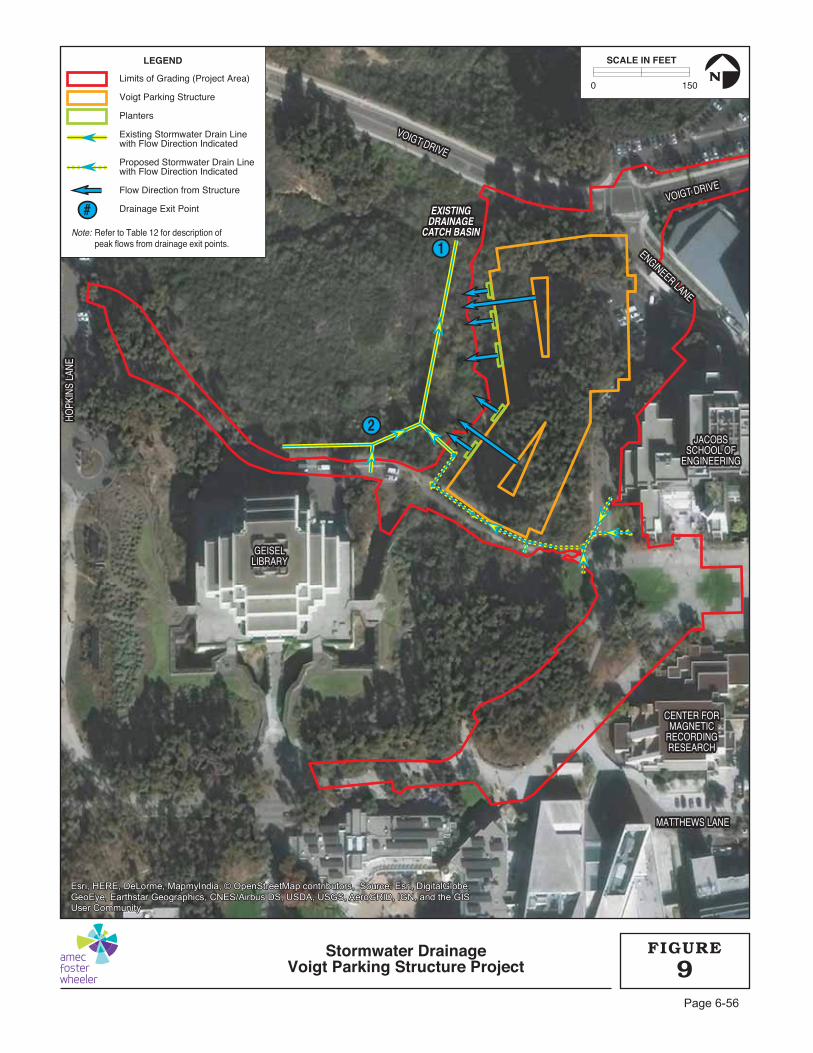
1
2
EXISTINGEXISTINGDRAINAGEDRAINAGE
CATCH BASINCATCH BASIN
VOIGT DRIVE
VOIGT DRIVE
VOIGT DRIVEVOIGT DRIVE
ENGINEER LANE
ENGINEER LANE
HOPK
INS
LANE
HOPK
INS
LANE
MATTHEWS LANEMATTHEWS LANE
VOIGT DRIVE
VOIGT DRIVE
ENGINEER LANE
HOPK
INS
LANE
MATTHEWS LANE
GEISELGEISELLIBRARYLIBRARY
CENTER FORCENTER FORMAGNETICMAGNETIC
RECORDINGRECORDINGRESEARCHRESEARCH
JACOBSJACOBSSCHOOL OFSCHOOL OF
ENGINEERINGENGINEERING
GEISELLIBRARY
CENTER FORMAGNETIC
RECORDINGRESEARCH
JACOBSSCHOOL OF
ENGINEERING
EXISTINGDRAINAGE
CATCH BASIN
#
Limits of Grading (Project Area)
Voigt Parking Structure
Planters
Existing Stormwater Drain Linewith Flow Direction Indicated
Proposed Stormwater Drain Linewith Flow Direction Indicated
Flow Direction from Structure
Drainage Exit Point
Note: Refer to Table 12 for description ofpeak flows from drainage exit points.
LEGEND
0 150
SCALE IN FEET
N
Stormwater DrainageVoigt Parking Structure Project 9
FIGURE
Esri, HERE, DeLorme, MapmyIndia, © OpenStreetMap contributors, Source: Esri, DigitalGlobe,GeoEye, Earthstar Geographics, CNES/Airbus DS, USDA, USGS, AeroGRID, IGN, and the GISUser Community
Esri, HERE, DeLorme, MapmyIndia, © OpenStreetMap contributors, Source: Esri, DigitalGlobe,GeoEye, Earthstar Geographics, CNES/Airbus DS, USDA, USGS, AeroGRID, IGN, and the GISUser Community
Page 6-56

UC San Diego Voigt Parking Structure Final Initial Study and Mitigated Negative Declaration December 2017
Page 6-57
Table 12. Peak Flow Summary for Voigt Parking Structure
Storm Water Runoff Exit Points
Storm Water Runoff Rate 10-yr, 6-hr Flow Rate (cfs)
Existing Condition
Proposed Condition
Runoff Exit Point #1 (Runoff from the Parking
Structure) 7.05 6.58*
Runoff Exit Point #2 (Runoff from Ancillary
Improvements and Pavements) 0.72 0.99
Total 7.77 7.57 Source: BWE 2017; see Appendix C. Notes: *Peak flow at Runoff Exit Point #1 is reduced through the use of the flow through planters incorporated in the project design.
The proposed flow through planter would slow the rate of runoff from the project site as a result of storm water filtering through the mixed-media and gravel layers within the plants. This process would ensure that the long-term storm water runoff flow velocity at the storm drain outlet to the south of the project site would be attenuated (i.e., reduced) relative to the existing flow velocity, resulting in an overall decrease in the existing rate of erosion at the existing drainage catch basin. Under existing conditions the 10-year 6-hour storm would produce runoff at a rate of 7.77 cubic feet per second (cfs). With the implementation of the proposed project, including the flow through planters, the same storm would produce runoff at a rate of 7.57 cfs, a reduction of approximately 2.5 percent. The Hydrology and Water Quality Report prepared by BWE demonstrates that the proposed project would be in compliance with the storm water regulations of UC San Diego and would be effective in treating pollutants of concern and meeting hydromodification requirements (BWE 2017; see Appendix C).
In addition to the post-construction treatments and permanent source control measures described above, Project-Specific Mitigation Hyd-1 and 2004 LRDP EIR Mitigation Measure Hyd-2B would be implemented.
Project-Specific Mitigation Measure:
Hyd-1: To comply with the Post-Construction Storm Water Management Checklist, the project shall implement site design measures in accordance with UC San Diego’s Phase II Small MS4 General Permit 2013-0001-DWQ to reduce project runoff. The project shall verify that post-construction water balance be achieved through site design measures. If post-project flows continue to exceed existing conditions, additional storm water treatment BMPs, source control measures, and/or storm water treatment/baseline hydromodification measures shall be designed to achieve water balance, as described in the checklist. The SWRCB’s SMARTS Post-Construction Calculator or equivalent shall be used to quantify runoff reduction resulting from implementing any site design measures in the checklist.
UC San Diego Voigt Parking Structure Final Initial Study and Mitigated Negative Declaration December 2017
Page 6-58
2004 LRDP Program EIR Mitigation Measures:
Hyd-2B: For each development or redevelopment project that would include 100,000-SF of development or parking lots greater than 5,000-SF potentially exposed to precipitation or runoff, the following design standards or their equivalent shall be applied in addition to those conditions in Hyd-1A. Equivalent design standards may be less restrictive if consistent with the applicable MS4 permit at that time. Design measures and other recommendations used to comply with these standards shall be incorporated into project development plans and construction documents. Design measures shall be consistent with UC San Diego’s storm water management plan, shall be operational within a reasonable time from project occupancy, and shall be maintained by UC San Diego.
i. All new storm drain inlets and catch basins within the project site shall be marked with prohibitive language and/or graphical icons to discourage illegal dumping per UC San Diego standards.
ii. Outdoor areas for storage of materials that may contribute pollutants to the storm water conveyance system shall be covered and protected by secondary containment.
iii. All trash container areas shall be enclosed to prevent off-site transport of trash and drainage shall be directed to the sanitary sewer system or the containers shall be covered to prevent exposure of trash to precipitation.
iv. Pollutants of concern shall be minimized through the incorporation of design measures best suited to maximize the reduction of pollutant loadings in that runoff. At least one treatment control is required for new parking areas or structures, or other new uses identified by CPM or UC San Diego Campus Planning to have potential to generate substantial pollutants. Treatment controls include detention basins, infiltration basins, wet ponds or wetlands, drainage inserts, filtration, and hydrodynamic separator systems. Treatment controls shall incorporate volumetric or flow based treatment control design standards to mitigate (infiltrate, filter, or treat) storm water runoff, as appropriate.
Compliance with Project-Specific Mitigation Measure Hyd-1, 2004 LRDP Program EIR Mitigation Measure Hyd-2B, and all applicable storm water permits and plans, no violation of water quality standards or water discharge requirements would occur as a result of the proposed project, and the potential for impacts associated with water quality degradation would be less than significant.
B) No extraction of groundwater is proposed at UC San Diego. The campus uses potable water supplied by the City of San Diego Water Department via existing lines on UC San Diego’s campus. The City receives deliveries of imported water from the San Diego County Water Authority (SDCWA) to satisfy potable water demand. Consequently, no impacts to groundwater supplies would occur with implementation of the proposed project.
C, D, E) The proposed project would result in an increase of more than 5,000 SF of impervious surfaces. The proposed development generally maintains existing flow patterns and peak flow rates of the existing conditions. Because the peak flow rate from the overall site is mitigated, the project will not create adverse impacts to the existing receiving storm drain system and downstream properties. To avoid impacts related to increases in runoff and potential erosion, the proposed project would comply with all current applicable storm water

UC San Diego Voigt Parking Structure Final Initial Study and Mitigated Negative Declaration December 2017
Page 6-59
regulations. In addition, to further ensure avoidance of significant impacts, design measures for permanent storm water retention of infiltration measures and other recommendations have been incorporated into project development plans and construction documents. Design measures would be consistent with the Post Construction Storm Water Management Program requirements in Section F.5.g of the Phase II Small MS4 Storm Water Permit. The following design measures would be incorporated into the proposed project design as applicable:
Site design that controls runoff discharge volumes and durations would be utilized where applicable and feasible.
Measures that protect slopes and channels such as energy dissipaters, vegetation, and slope/channel stabilizers would be applied where appropriate.
The 5th (roof) level of the parking structure would be a green roof with landscaping, trees, and pervious and impervious walkways. Approximately 70% of the roof would be pervious and 30% would be impervious.
Storm water runoff from the 5th (roof) level of the parking structure would be mitigated through five planters located on the west face of the parking structure and one planter in each of the light wells. The planters are designed to detain storm water per site design water balance calculations.
Two additional landscaped areas southeast of the parking structure would be constructed with soil amendments to achieve site design water balance requirements.
All developments that would increase impervious surfaces would maintain pre-construction peak flows and capture and treat storm water runoff in accordance with the Post Construction Storm Water Management Program in Section 5.F.g of the Phase II Small MS4 Storm Water Permit. The County of San Diego’s Hydrology Manual and methodology would be used for a reference in performing all hydrologic calculations. In cases where known or potential on- or off-site erosion problems have been identified, the Civil Engineer, in coordination with UC San Diego, may determine additional analysis is needed.
As discussed in the project-specific Drainage Study (see Appendix C), the proposed flow through planters would capture surface was runoff and allow for ponding and percolating through 18-inch thick mixed-media and 6-inch gravel layers. Further, the proposed lined biofiltration basins also would ensure that long-term storm water runoff flow velocity at the storm drain outlet to the south of the project site would be reduced to a level approximately 2.5 percent less than the baseline flow velocity prior to proposed project construction, resulting in an overall decrease in the existing rate of erosion at the existing drainage catch basin.
Landscaping, rip rap and/or turf reinforcement mats would be placed at each discharge location to prevent erosion.
As shown in Table 12, the peak flow rate of the 10 year, 6-hour frequency storm at Runoff Exit Point #1 is reduced from 9.78 cfs to 6.58 cfs. Peak flow rate mitigation is achieved by routing runoff through seven biofiltration planters on the western exterior and within the parking structure light-wells. Runoff Exit Point #2 experiences an increase in the 10 year, 6-hour peak flow rate due to an increase in area between the existing and proposed conditions, but this increase is offset by reduced runoff at Runoff Exit Point #1. The overall site experiences a reduction of the 10 year, 6-hour peak flow rate from 10.77 cfs to 7.57 cfs.
UC San Diego Voigt Parking Structure Final Initial Study and Mitigated Negative Declaration December 2017
Page 6-60
The five planters proposed on the western exterior wall of the parking structure would be designed with 1.9 feet of ponding depth, 0.5 feet of freeboard, 18 inches of soil media, and 6 inches of gravel. The two planters in the bottom of the two light-wells are designed with 2.9 feet of ponding, 0.5 feet of freeboard, 18 inches of soil media and 6 inches of gravel. As required by the 2004 LRDP Program EIR Mitigation Measure Hyd-1A, BWE (2017) conducted a drainage analysis to evaluate the proposed development in conformance with the San Diego County Hydrology Manual (June 2003). The analysis of the proposed development demonstrates that runoff would be effectively discharged from the site. All proposed storm drain systems associated with the project would be designed to convey the 100-year storm event primarily in overland flow, open channel, and pipe. The table below illustrates the flows anticipated where flows outlet to the City of San Diego storm drain system.
Runoff increase from the 10-year storm would be detained within the seven flow through planter basins, which would capture peak runoff for the 10-year storm. The flow through planters would slow runoff and treat storm water by running it through sand and gravel, detaining the water for longer periods and preventing sheetflow. Consequently, the improvements associated with the proposed project would have no adverse impacts to any local structures or facilities, nor any downstream systems (BWE 2017). The improvements associated with the proposed project would have less than significant impacts to local structures, facilities, and downstream systems.
G, H) Development under the 2004 LRDP and implementation of the proposed project would not place structures within the 100-year flood hazard area, as the entire campus is located in Flood Zone X, which is outside of the 100- and 500-year floodplains (Federal Emergency Management Agency [FEMA] 2012). Therefore, the construction of the proposed parking structure would not impede or redirect flood flows and no impacts associated with flooding would occur with the implementation of the proposed project.
I) UC San Diego campus development is located on the Torrey Pines Mesa, at an average elevation between 300 to 450 feet AMSL, and the proposed project site is located at a ground surface elevation that ranges from approximately 355 feet AMSL at Warren Mall to an approximate elevation of 315 feet AMSL at the western boundary of the project site (refer to Section 2.2, Project Site and Existing Land Uses). A dam or levee failure occurring at remote inland San Diego County locations would have no effect on elevated campus lands located at the Pacific Coast. Flood flows emanating from inland areas would more likely travel to the coast via Los Peñasquitos Lagoon to the north or Rose Canyon to the south of campus lands. Additionally, the project site would not be affected by long-term sea level rise due to its elevation and distance from the coast. Therefore, implementation of the proposed project would not expose people or structures to an increase in flood risk and no impacts would be expected.
J) The UC San Diego campus, including the project site, is not subject to inundation by seiche as this phenomenon is typically associated with land locked bodies of water, none of which occur near the West Campus. A tsunami (or seismic sea wave) is the secondary effect of a major earthquake. In the rare event that a particularly destructive tsunami occurred, the southwest portion of the SIO campus could be at risk of inundation. However, the proposed project site is inland and located at a substantially higher elevation (approximately 355 feet AMSL) from the portion of the campus that could be at risk. Inundation by mudflows across the developed portion of the UC San Diego campus is also unlikely because of the
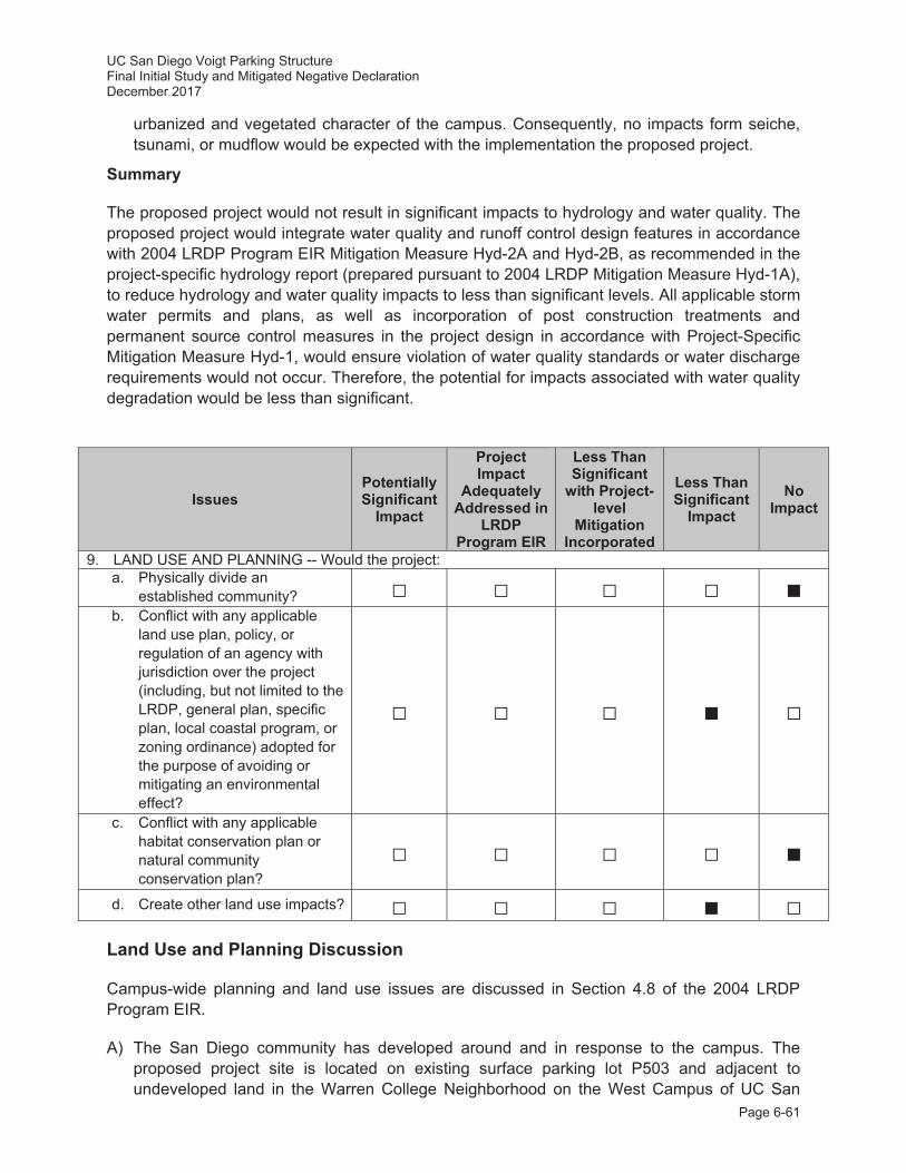
UC San Diego Voigt Parking Structure Final Initial Study and Mitigated Negative Declaration December 2017
Page 6-61
urbanized and vegetated character of the campus. Consequently, no impacts form seiche, tsunami, or mudflow would be expected with the implementation the proposed project.
Summary
The proposed project would not result in significant impacts to hydrology and water quality. The proposed project would integrate water quality and runoff control design features in accordance with 2004 LRDP Program EIR Mitigation Measure Hyd-2A and Hyd-2B, as recommended in the project-specific hydrology report (prepared pursuant to 2004 LRDP Mitigation Measure Hyd-1A), to reduce hydrology and water quality impacts to less than significant levels. All applicable storm water permits and plans, as well as incorporation of post construction treatments and permanent source control measures in the project design in accordance with Project-Specific Mitigation Measure Hyd-1, would ensure violation of water quality standards or water discharge requirements would not occur. Therefore, the potential for impacts associated with water quality degradation would be less than significant.
Issues Potentially Significant
Impact
Project Impact
Adequately Addressed in
LRDP Program EIR
Less Than Significant
with Project-level
Mitigation Incorporated
Less Than Significant
Impact No
Impact
9. LAND USE AND PLANNING -- Would the project: a. Physically divide an
established community? b. Conflict with any applicable
land use plan, policy, or regulation of an agency with jurisdiction over the project (including, but not limited to the LRDP, general plan, specific plan, local coastal program, or zoning ordinance) adopted for the purpose of avoiding or mitigating an environmental effect?
c. Conflict with any applicable habitat conservation plan or natural community conservation plan?
d. Create other land use impacts? Land Use and Planning Discussion
Campus-wide planning and land use issues are discussed in Section 4.8 of the 2004 LRDP Program EIR.
A) The San Diego community has developed around and in response to the campus. The proposed project site is located on existing surface parking lot P503 and adjacent to undeveloped land in the Warren College Neighborhood on the West Campus of UC San
UC San Diego Voigt Parking Structure Final Initial Study and Mitigated Negative Declaration December 2017
Page 6-62
Diego. The project site is located entirely within the UC San Diego campus and would provide parking for adjacent academic uses. The proposed project would not adversely affect the existing vehicular transportation network or add additional pavements that would bisect established communities or land uses areas on campus. Further, the proposed project would enhance bicycle and pedestrian connectivity in the Warren College Neighborhood. Therefore, construction of the proposed project would not divide an established community and no impact would occur.
B) With regard to local plans and policies, UC San Diego is part of the University of California system, a constitutionally created entity of the State of California. As a constitutional entity, the University of California is not subject to municipal regulations, such as the City’s General Plan or any of the surrounding community plans. The University of California is the only agency with local land use jurisdiction over campus projects. The applicable land use plan for the project site is the campus’ 2004 LRDP.
As described in Section 2.2, Project Site and Existing Land Uses the 2004 LRDP designates the project site for Academic and Park land uses (refer to Figure 3.4-5 of the 2004 LRDP Program EIR). The 2016 UC San Diego Open Space Master Planning Study further classifies the area to the west of P503 as Restoration Lands, which include slopes that have been disturbed by erosion, invasive vegetation, and past military use. (UC San Diego 2016c). As discussed in Section 3.0, Relationship to and Consistency with 2004 LRDP, the proposed parking structure is not consistent with the existing underlying Park land use area on the project site to the west of surface parking lot P503. However, with the approval of the minor LRDP Amendment (less than 4 acres), which would be included with the approval of the proposed project, the proposed parking structure would be consistent with 2004 LRDP. To further ensure that project impacts to land are less than significant, the proposed conceptual design of the proposed parking structure was reviewed by UC San Diego Campus Planning staff during concept development pursuant to 2004 LRDP Program EIR Mitigation Measure Lan-2A to ensure siting of the proposed parking structure in this location would be integrated in an acceptable way with other nearby campus land uses. This review evaluated factors such as edge effects and site connections to adjacent on and off campus land uses, pedestrian and bicycle circulation, landscaping, and alternative transportation facilities (e.g., bicycle racks, bicycle fix-it station, etc.). With the minor LRDP amendment the proposed project would be integrated into the Warren College Neighborhood and would have a less than significant impact on land use.
Under the CCA, the CCC has the authority to review and approve state and local government plans located within their jurisdiction, which is defined as the coastal zone. Part of the West Campus portion of UC San Diego, including the project site, is located within the coastal zone. The CCA requires cities and counties to prepare local coastal programs (LCPs) to implement its conservation, development, and regulatory policies at the local level in areas of the coastal zone. The City of San Diego’s North City LCP and La Jolla Community Plan and LCP are the local planning documents for the coastal zone in the project area. However, UC San Diego is not within the jurisdiction of either of these planning documents and, thus, is governed solely by the CCA. This project would be submitted to the CCC for their review under the policies of Chapter 3 of the CCA, and a CDP would be required.
C) The UC San Diego campus is not included within the City’s MSCP (City of San Diego 1997) nor is UC San Diego an enrolled agency in the NCCP Program. The 2004 LRDP does not
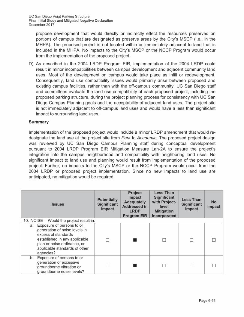
UC San Diego Voigt Parking Structure Final Initial Study and Mitigated Negative Declaration December 2017
Page 6-63
propose development that would directly or indirectly effect the resources preserved on portions of campus that are designated as preserve areas by the City’s MSCP (i.e., in the MHPA). The proposed project is not located within or immediately adjacent to land that is included in the MHPA. No impacts to the City’s MSCP or the NCCP Program would occur from the implementation of the proposed project.
D) As described in the 2004 LRDP Program EIR, implementation of the 2004 LRDP could result in minor incompatibilities between campus development and adjacent community land uses. Most of the development on campus would take place as infill or redevelopment. Consequently, land use compatibility issues would primarily arise between proposed and existing campus facilities, rather than with the off-campus community. UC San Diego staff and committees evaluate the land use compatibility of each proposed project, including the proposed parking structure, during the project planning process for consistency with UC San Diego Campus Planning goals and the acceptability of adjacent land uses. The project site is not immediately adjacent to off-campus land uses and would have a less than significant impact to surrounding land uses.
Summary
Implementation of the proposed project would include a minor LRDP amendment that would re-designate the land use at the project site from Park to Academic. The proposed project design was reviewed by UC San Diego Campus Planning staff during conceptual development pursuant to 2004 LRDP Program EIR Mitigation Measure Lan-2A to ensure the project’s integration into the campus neighborhood and compatibility with neighboring land uses. No significant impact to land use and planning would result from implementation of the proposed project. Further, no impacts to the City’s MSCP or the NCCP Program would occur from the 2004 LRDP or proposed project implementation. Since no new impacts to land use are anticipated, no mitigation would be required.
Issues Potentially Significant
Impact
Project Impact
Adequately Addressed in
LRDP Program EIR
Less Than Significant
with Project-level
Mitigation Incorporated
Less Than Significant
Impact No
Impact
10. NOISE -- Would the project result in: a. Exposure of persons to or
generation of noise levels in excess of standards established in any applicable plan or noise ordinance, or applicable standards of other agencies?
b. Exposure of persons to or generation of excessive groundborne vibration or groundborne noise levels?
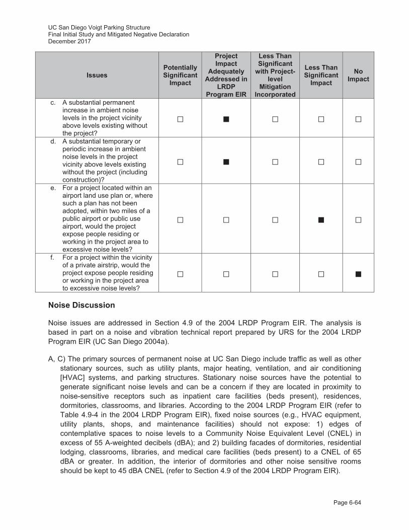
UC San Diego Voigt Parking Structure Final Initial Study and Mitigated Negative Declaration December 2017
Page 6-64
Issues Potentially Significant
Impact
Project Impact
Adequately Addressed in
LRDP Program EIR
Less Than Significant
with Project-level
Mitigation Incorporated
Less Than Significant
Impact No
Impact
c. A substantial permanent increase in ambient noise levels in the project vicinity above levels existing without the project?
d. A substantial temporary or periodic increase in ambient noise levels in the project vicinity above levels existing without the project (including construction)?
e. For a project located within an airport land use plan or, where such a plan has not been adopted, within two miles of a public airport or public use airport, would the project expose people residing or working in the project area to excessive noise levels?
f. For a project within the vicinity of a private airstrip, would the project expose people residing or working in the project area to excessive noise levels?
Noise Discussion
Noise issues are addressed in Section 4.9 of the 2004 LRDP Program EIR. The analysis is based in part on a noise and vibration technical report prepared by URS for the 2004 LRDP Program EIR (UC San Diego 2004a).
A, C) The primary sources of permanent noise at UC San Diego include traffic as well as other stationary sources, such as utility plants, major heating, ventilation, and air conditioning [HVAC] systems, and parking structures. Stationary noise sources have the potential to generate significant noise levels and can be a concern if they are located in proximity to noise-sensitive receptors such as inpatient care facilities (beds present), residences, dormitories, classrooms, and libraries. According to the 2004 LRDP Program EIR (refer to Table 4.9-4 in the 2004 LRDP Program EIR), fixed noise sources (e.g., HVAC equipment, utility plants, shops, and maintenance facilities) should not expose: 1) edges of contemplative spaces to noise levels to a Community Noise Equivalent Level (CNEL) in excess of 55 A-weighted decibels (dBA); and 2) building facades of dormitories, residential lodging, classrooms, libraries, and medical care facilities (beds present) to a CNEL of 65 dBA or greater. In addition, the interior of dormitories and other noise sensitive rooms should be kept to 45 dBA CNEL (refer to Section 4.9 of the 2004 LRDP Program EIR).
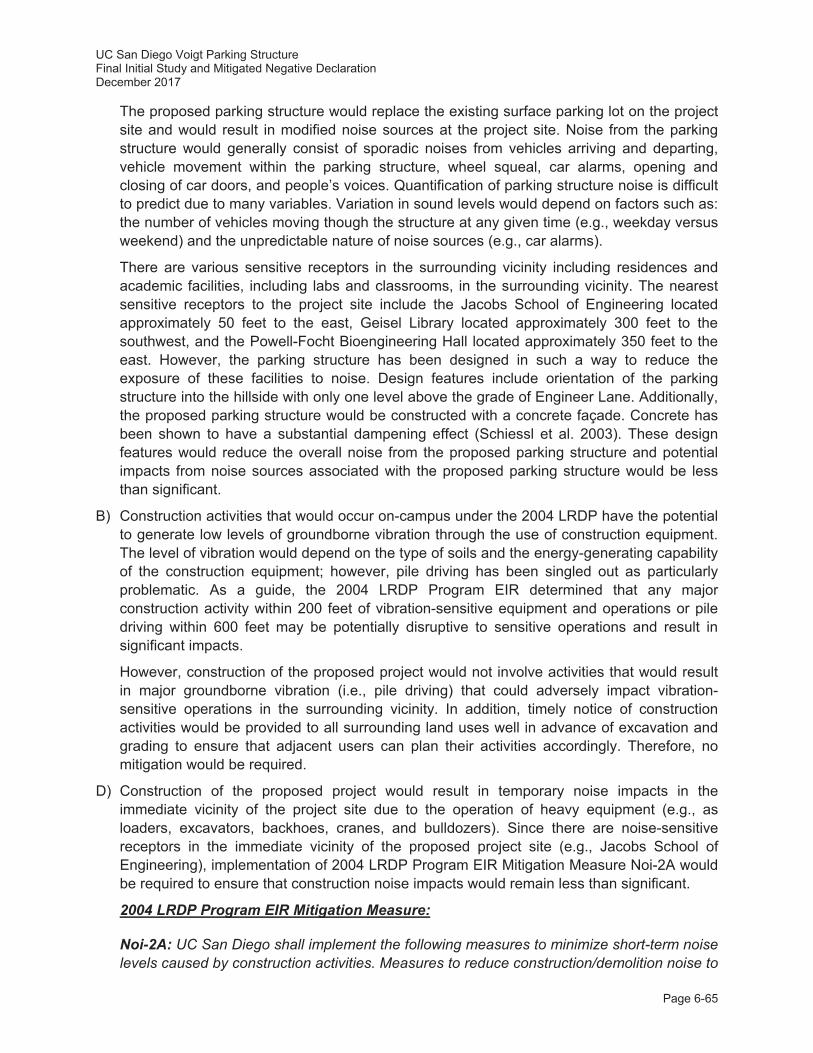
UC San Diego Voigt Parking Structure Final Initial Study and Mitigated Negative Declaration December 2017
Page 6-65
The proposed parking structure would replace the existing surface parking lot on the project site and would result in modified noise sources at the project site. Noise from the parking structure would generally consist of sporadic noises from vehicles arriving and departing, vehicle movement within the parking structure, wheel squeal, car alarms, opening and closing of car doors, and people’s voices. Quantification of parking structure noise is difficult to predict due to many variables. Variation in sound levels would depend on factors such as: the number of vehicles moving though the structure at any given time (e.g., weekday versus weekend) and the unpredictable nature of noise sources (e.g., car alarms).
There are various sensitive receptors in the surrounding vicinity including residences and academic facilities, including labs and classrooms, in the surrounding vicinity. The nearest sensitive receptors to the project site include the Jacobs School of Engineering located approximately 50 feet to the east, Geisel Library located approximately 300 feet to the southwest, and the Powell-Focht Bioengineering Hall located approximately 350 feet to the east. However, the parking structure has been designed in such a way to reduce the exposure of these facilities to noise. Design features include orientation of the parking structure into the hillside with only one level above the grade of Engineer Lane. Additionally, the proposed parking structure would be constructed with a concrete façade. Concrete has been shown to have a substantial dampening effect (Schiessl et al. 2003). These design features would reduce the overall noise from the proposed parking structure and potential impacts from noise sources associated with the proposed parking structure would be less than significant.
B) Construction activities that would occur on-campus under the 2004 LRDP have the potential to generate low levels of groundborne vibration through the use of construction equipment. The level of vibration would depend on the type of soils and the energy-generating capability of the construction equipment; however, pile driving has been singled out as particularly problematic. As a guide, the 2004 LRDP Program EIR determined that any major construction activity within 200 feet of vibration-sensitive equipment and operations or pile driving within 600 feet may be potentially disruptive to sensitive operations and result in significant impacts.
However, construction of the proposed project would not involve activities that would result in major groundborne vibration (i.e., pile driving) that could adversely impact vibration-sensitive operations in the surrounding vicinity. In addition, timely notice of construction activities would be provided to all surrounding land uses well in advance of excavation and grading to ensure that adjacent users can plan their activities accordingly. Therefore, no mitigation would be required.
D) Construction of the proposed project would result in temporary noise impacts in the immediate vicinity of the project site due to the operation of heavy equipment (e.g., as loaders, excavators, backhoes, cranes, and bulldozers). Since there are noise-sensitive receptors in the immediate vicinity of the proposed project site (e.g., Jacobs School of Engineering), implementation of 2004 LRDP Program EIR Mitigation Measure Noi-2A would be required to ensure that construction noise impacts would remain less than significant.
2004 LRDP Program EIR Mitigation Measure:
Noi-2A: UC San Diego shall implement the following measures to minimize short-term noise levels caused by construction activities. Measures to reduce construction/demolition noise to
UC San Diego Voigt Parking Structure Final Initial Study and Mitigated Negative Declaration December 2017
Page 6-66
the maximum extent feasible shall be included in contractor specifications and shall include, but not be limited to, the following:
i. The construction contractor shall be required to work in such a manner so as not to exceed a 12-hour average sound level of 75 dBA at any noise-sensitive land use (dormitories/residential/lodging, contemplative spaces, libraries, inpatient medical care facility [beds present], and on campus classrooms) between 7:00 a.m. and 7:00 p.m. Monday through Saturday.
ii. Construction equipment shall be properly outfitted and maintained with manufacturer recommended noise-reduction devices to minimize construction-generated noise.
iii. Stationary construction noise sources such as generators or pumps shall be located at least 100 feet from noise-sensitive land uses as feasible.
iv. Laydown and construction vehicle staging areas shall be located as far from noise-sensitive land uses as feasible.
v. All neighboring land uses that would be subject to construction noise shall be informed at least two weeks prior to the start of each construction project, whenever possible.
vi. Loud construction activity such as jackhammering, concrete sawing, asphalt removal, pile driving, and large-scale grading operations occurring within 100 feet of a residential or academic building shall not be scheduled during any finals week of classes to the extent feasible or consider adjusting the hours or days of construction.
vii. Loud construction activity, such as jackhammering, concrete sawing, asphalt removal, pile driving, and large-scale grading operations, occurring within 100 feet of an academic or residential use shall be scheduled during holidays, class breaks, and/or summer session, to the extent feasible.
viii. Loud construction activity located within 100 feet of a residential building or inpatient medical care facility shall be restricted to occur between the hours of 7:00 a.m. and 7:00 p.m. Monday through Friday.
E) The UC San Diego campus is not located within 2 miles of a public airport or public use airport; however, the center of campus is located approximately 2.5 miles west of MCAS Miramar, and the major flight corridor for both helicopters and planes in proximity to campus is Seawolf/Beach/Fairway, located approximately 0.5 mile north of the campus over the Carmel Valley/Del Mar area. The other flight corridors associated with MCAS operations (i.e. Julian, Interstate 15 [I-15], Ground Controlled Approach Box, etc.) are located east of the I-805, at a distance of more than two miles from the UC San Diego campus.
Flights near campus are not low enough or frequent enough to create significant vibration impacts. As disclosed in the 2004 LRDP Program EIR, MCAS Miramar operations constitute a periodic noise nuisance. The nuisance level is proportional to how well the overflights stay within the designated flight corridor. The UC San Diego campus is currently subject to periodic overflights by commercial, general aviation, and military aircraft and this condition is expected to continue in the future. The campus is, however, not located within the 60 dBA CNEL contour of any airport and is not subject to aircraft noise or vibration in excess of the regulatory limits. Implementation of the 2004 LRDP, including the proposed project, would
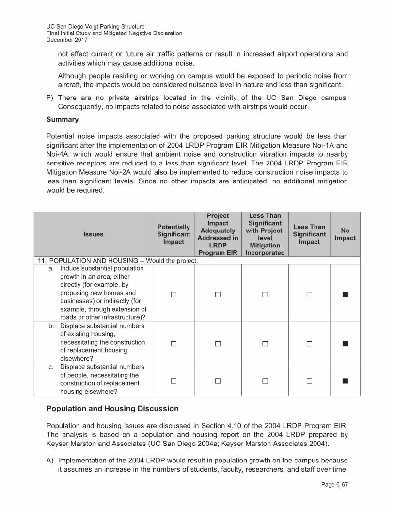
UC San Diego Voigt Parking Structure Final Initial Study and Mitigated Negative Declaration December 2017
Page 6-67
not affect current or future air traffic patterns or result in increased airport operations and activities which may cause additional noise.
Although people residing or working on campus would be exposed to periodic noise from aircraft, the impacts would be considered nuisance level in nature and less than significant.
F) There are no private airstrips located in the vicinity of the UC San Diego campus. Consequently, no impacts related to noise associated with airstrips would occur.
Summary
Potential noise impacts associated with the proposed parking structure would be less than significant after the implementation of 2004 LRDP Program EIR Mitigation Measure Noi-1A and Noi-4A, which would ensure that ambient noise and construction vibration impacts to nearby sensitive receptors are reduced to a less than significant level. The 2004 LRDP Program EIR Mitigation Measure Noi-2A would also be implemented to reduce construction noise impacts to less than significant levels. Since no other impacts are anticipated, no additional mitigation would be required.
Issues Potentially Significant
Impact
Project Impact
Adequately Addressed in
LRDP Program EIR
Less Than Significant
with Project-level
Mitigation Incorporated
Less Than Significant
Impact No
Impact
11. POPULATION AND HOUSING -- Would the project: a. Induce substantial population
growth in an area, either directly (for example, by proposing new homes and businesses) or indirectly (for example, through extension of roads or other infrastructure)?
b. Displace substantial numbers of existing housing, necessitating the construction of replacement housing elsewhere?
c. Displace substantial numbers of people, necessitating the construction of replacement housing elsewhere?
Population and Housing Discussion
Population and housing issues are discussed in Section 4.10 of the 2004 LRDP Program EIR. The analysis is based on a population and housing report on the 2004 LRDP prepared by Keyser Marston and Associates (UC San Diego 2004a; Keyser Marston Associates 2004).
A) Implementation of the 2004 LRDP would result in population growth on the campus because it assumes an increase in the numbers of students, faculty, researchers, and staff over time,

UC San Diego Voigt Parking Structure Final Initial Study and Mitigated Negative Declaration December 2017
Page 6-68
but this growth is anticipated by the University Community Plan (City of San Diego 2014). Implementation of the proposed project would contribute to the City of San Diego’s and UC San Diego’s ability to serve the growing population in the State of California and, therefore, on a statewide scale is not considered population inducing but rather responding to the demand of an increased population.
As stated in the 2004 LRDP Program EIR, while the growth of UC San Diego is consistent with locally-adopted plans, the environmental effects associated with campus growth, such as those resulting from increased traffic and increased demands on services and utilities, are addressed in the respective sections of the 2004 LRDP Program EIR. Implementation of the proposed project is, however, not expected to indirectly induce growth by expanding infrastructure or removing an obstacle to growth. Since the proposed project is an infill development that would provide the necessary parking anticipated to serve the existing and projected needs of the campus, impacts related to direct and indirect inducement of population growth are not considered significant. As such, no impacts would occur, and no mitigation would be required.
B, C) The proposed project would not result in the displacement of substantial numbers of people or existing off campus housing. Further, the proposed project would not require the construction of replacement housing elsewhere. No housing units would be displaced or added as a result of project implementation. Therefore, no impacts would occur, and no mitigation would be required.
Summary
The proposed project would not result in significant population or housing impacts. Since no impacts are anticipated, no mitigation would be required.
Issues Potentially Significant
Impact
Project Impact
Adequately Addressed in
LRDP Program EIR
Less Than Significant
with Project-level
Mitigation Incorporated
Less Than Significant
Impact No
Impact
12. PUBLIC SERVICES Would the project result in substantial adverse physical impacts associated with the provision of new or physically altered governmental facilities, need for new or physically altered governmental facilities, the construction of which could cause significant environmental impacts, in order to maintain acceptable service ratios, response times or other performance objectives for any of the public services: a. Fire Protection?
b. Police Protection?
c. Schools?
d. Parks?
e. Other public Facilities? f. Create other public service
impacts?
UC San Diego Voigt Parking Structure Final Initial Study and Mitigated Negative Declaration December 2017
Page 6-69
Public Services Discussion
Public service issues are discussed in Section 4.11 of the 2004 LRDP Program EIR.
A) An evaluation of fire service capabilities and deployment planning was conducted in 2011 (and updated in 2017) for the City of San Diego by Citygate Associates, LLC (Citygate 2011, 2017). These studies were generally intended to: 1) assess existing fire and emergency medical service capabilities, performance, and deployment/staffing models, based on current resources, demands, and staffing response guidelines; and, 2) provide recommendations for associated infrastructure triggers (i.e., thresholds to provide additional resources, if needed) and funding allocations in the context of limited fiscal resources, competing needs, growing populations, and uncertainties associated with the exact location and timing of future development. The proposed project site is located in an area served by multiple existing San Diego Fire Department fire stations including Fire Station No. 9, 35, and 41 (with FS 24 also able to respond if necessary). As described in the Citygate studies, the project site is located within an existing coverage gap area and is located outside of the 4-minute and 8-minute response times (Citygate 2011, 2017). However, the proposed project would comply with all applicable building and fire code requirements, and would include fire sprinklers, fire alarms, and appropriate fire access routes. Properly designed sprinkler systems have been found to be 98 percent effective in extinguishing incipient phase (small) fires. Therefore, if a fire were to occur in the parking structure, it likely would be quickly extinguished.
The UC San Diego Fire Marshal is responsible for campus-wide fire prevention and provision of services such as plan review and construction inspections to ensure conformance with the CBC and California Fire Code, and would be responsible for reviewing and approving plans for the proposed project. The campus would also continue to implement the UC San Diego Emergency Operations Plan (UC San Diego 2014) and campus-wide fire prevention programs, which are mandated by state and federal law (refer to the Hazards and Hazardous Materials discussion above). In addition, the UC San Diego Fire Marshal meets regularly with the City of San Diego Deputy Fire Chief to maintain a site plan/access plan which would adequately serve the UC San Diego campus. Properly designed sprinkler systems have been found to be 98 percent effective in extinguishing incipient phase (i.e., small) fires.
As described in the Hazards and Hazardous Materials discussion above, the Project site is located within 0.30 miles of areas that are susceptible to wildfires (i.e., Campus Services Complex to the east and Marshall College Apartments to the west). These areas are identified primarily as a result of their proximity to parklands and/or older wood framed construction of buildings. However, UC San Diego implements brush management activities, consistent with UC San Diego Policy & Procedure Manual 516 Environment, Health & Safety, to maintain defensible space and reduce the potential for wildfires within these areas. Additionally, the proposed project does not include buildings or facilities susceptible to fire hazards and would generally have little or no potential to require response by fire-related equipment or personnel (e.g., fire engines or ladder trucks). The proposed parking structure project would be primarily composed of cement and concrete which has a low likelihood of catching fire. These facilities would be unlikely to generate substantial demand for Emergency Management Services (EMS), due to the nature of the proposed
UC San Diego Voigt Parking Structure Final Initial Study and Mitigated Negative Declaration December 2017
Page 6-70
development. The project would not directly affect any of the factors used in predicting either regional population figures or the distribution of that population, and is therefore not growth inducing. The proposed project would likely not increase EMS demand as it is not growth-inducing.
The City of San Diego has planned the development of two new fire stations within the University City community. These two new fire stations would provide additional fire protection facilities to meet the increased demand for fire services from ongoing development in the University City community, including the proposed project in combination with other UC San Diego projects. While CEQA requires only that proposed projects mitigate for identified environmental impacts associated with the construction and operation of new fire protection facilities, UC San Diego has made a business decision in this case to extend beyond its obligations under CEQA by building a new fire station, which would ensure improved services for all into the long-term future. However, because the planned/proposed fire station at UC San Diego is not yet approved, there is no assurance that it will be approved and implemented prior to the proposed project. As a result, significant, potential, cumulative environmental impacts associated with the construction and operation of other fire protection and emergency medical facilities may still occur, and the project-related contribution to such environmental impacts may be cumulatively considerable. Project-Specific Mitigation Measure Fire-1 is identified and would address the contribution to any such environmental impacts from development at UC San Diego, including the proposed project.
Project-Specific Mitigation Measure:
Fire-1: UC San Diego is planning to design and construct a fire station on campus to meet the increased demand for fire and emergency medical services of the project, as well as other future campus development, and to ensure a heightened level of fire protection for the campus. The planned fire station is anticipated to commence operation in 2021, after transfer of the fire station and the underlying land to the City of San Diego, and would serve the campus and University City community. UC San Diego’s construction of this fire station would incorporate mitigation measures for any potentially significant environmental impacts and would therefore serve as mitigation for the project’s (and many other projects’) environmental impacts related to fire services. However, while an agreement between UC San Diego and the City of San Diego is underway and anticipated to come to fruition soon, the fire station has not yet been finally approved by either entity.
In the event the on-campus fire station is not approved, UC San Diego shall pay is proportionate share for the cost of mitigation of the environmental impacts associated with the construction and operation of a new fire station in the UC San Diego/University City area to the City of San Diego. UC San Diego’s proportionate share of funding would be determined by the percentage of new population generated by the project compared to the additional population in the community (as defined by the 2011 Citygate study) that could be served within five minutes by a new fire station. UC San Diego may meet its proportional share contribution obligation by contributing either land or money or some combination thereof.
B) UC San Diego provides its own police service for the UC San Diego campus as well as other UC San Diego properties. Pursuant to California Education Code Section 67381, the UC San Diego Police Department and the San Diego Police Department (SDPD) have
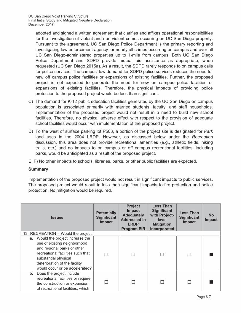
UC San Diego Voigt Parking Structure Final Initial Study and Mitigated Negative Declaration December 2017
Page 6-71
adopted and signed a written agreement that clarifies and affixes operational responsibilities for the investigation of violent and non-violent crimes occurring on UC San Diego property. Pursuant to the agreement, UC San Diego Police Department is the primary reporting and investigating law enforcement agency for nearly all crimes occurring on campus and over all UC San Diego-administered properties up to 1-mile from campus. Both UC San Diego Police Department and SDPD provide mutual aid assistance as appropriate, when requested (UC San Diego 2015a). As a result, the SDPD rarely responds to on campus calls for police services. The campus’ low demand for SDPD police services reduces the need for new off campus police facilities or expansions of existing facilities. Further, the proposed project is not expected to generate the need for new on campus police facilities or expansions of existing facilities. Therefore, the physical impacts of providing police protection to the proposed project would be less than significant.
C) The demand for K-12 public education facilities generated by the UC San Diego on campus population is associated primarily with married students, faculty, and staff households. Implementation of the proposed project would not result in a need to build new school facilities. Therefore, no physical adverse effect with respect to the provision of adequate school facilities would occur with implementation of the proposed project.
D) To the west of surface parking lot P503, a portion of the project site is designated for Park land uses in the 2004 LRDP. However, as discussed below under the Recreation discussion, this area does not provide recreational amenities (e.g., athletic fields, hiking trails, etc.) and no impacts to on campus or off campus recreational facilities, including parks, would be anticipated as a result of the proposed project.
E, F) No other impacts to schools, libraries, parks, or other public facilities are expected.
Summary
Implementation of the proposed project would not result in significant impacts to public services. The proposed project would result in less than significant impacts to fire protection and police protection. No mitigation would be required.
Issues Potentially Significant
Impact
Project Impact
Adequately Addressed in
LRDP Program EIR
Less Than Significant
with Project-level
Mitigation Incorporated
Less Than Significant
Impact No
Impact
13. RECREATION -- Would the project: a. Would the project increase the
use of existing neighborhood and regional parks or other recreational facilities such that substantial physical deterioration of the facility would occur or be accelerated?
b. Does the project include recreational facilities or require the construction or expansion of recreational facilities, which
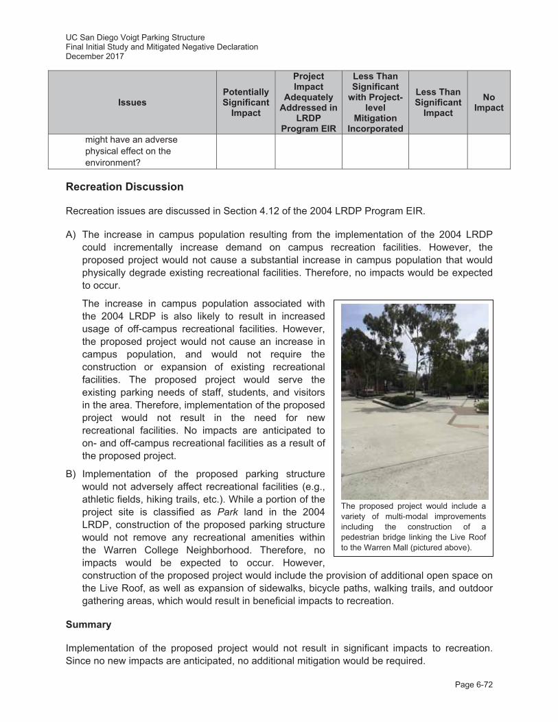
UC San Diego Voigt Parking Structure Final Initial Study and Mitigated Negative Declaration December 2017
Page 6-72
Issues Potentially Significant
Impact
Project Impact
Adequately Addressed in
LRDP Program EIR
Less Than Significant
with Project-level
Mitigation Incorporated
Less Than Significant
Impact No
Impact
might have an adverse physical effect on the environment?
Recreation Discussion
Recreation issues are discussed in Section 4.12 of the 2004 LRDP Program EIR.
A) The increase in campus population resulting from the implementation of the 2004 LRDP could incrementally increase demand on campus recreation facilities. However, the proposed project would not cause a substantial increase in campus population that would physically degrade existing recreational facilities. Therefore, no impacts would be expected to occur.
The increase in campus population associated with the 2004 LRDP is also likely to result in increased usage of off-campus recreational facilities. However, the proposed project would not cause an increase in campus population, and would not require the construction or expansion of existing recreational facilities. The proposed project would serve the existing parking needs of staff, students, and visitors in the area. Therefore, implementation of the proposed project would not result in the need for new recreational facilities. No impacts are anticipated to on- and off-campus recreational facilities as a result of the proposed project.
B) Implementation of the proposed parking structure would not adversely affect recreational facilities (e.g., athletic fields, hiking trails, etc.). While a portion of the project site is classified as Park land in the 2004 LRDP, construction of the proposed parking structure would not remove any recreational amenities within the Warren College Neighborhood. Therefore, no impacts would be expected to occur. However, construction of the proposed project would include the provision of additional open space on the Live Roof, as well as expansion of sidewalks, bicycle paths, walking trails, and outdoor gathering areas, which would result in beneficial impacts to recreation.
Summary
Implementation of the proposed project would not result in significant impacts to recreation. Since no new impacts are anticipated, no additional mitigation would be required.
The proposed project would include a variety of multi-modal improvements including the construction of a pedestrian bridge linking the Live Roof to the Warren Mall (pictured above).
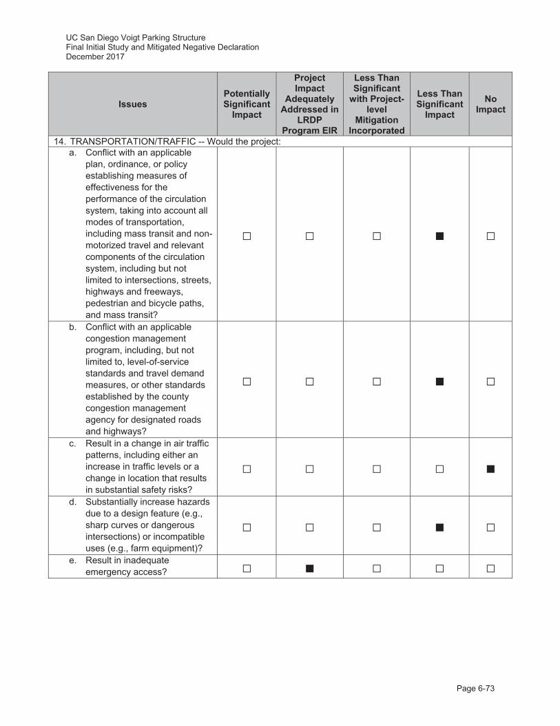
UC San Diego Voigt Parking Structure Final Initial Study and Mitigated Negative Declaration December 2017
Page 6-73
Issues Potentially Significant
Impact
Project Impact
Adequately Addressed in
LRDP Program EIR
Less Than Significant
with Project-level
Mitigation Incorporated
Less Than Significant
Impact No
Impact
14. TRANSPORTATION/TRAFFIC -- Would the project: a. Conflict with an applicable
plan, ordinance, or policy establishing measures of effectiveness for the performance of the circulation system, taking into account all modes of transportation, including mass transit and non-motorized travel and relevant components of the circulation system, including but not limited to intersections, streets, highways and freeways, pedestrian and bicycle paths, and mass transit?
b. Conflict with an applicable congestion management program, including, but not limited to, level-of-service standards and travel demand measures, or other standards established by the county congestion management agency for designated roads and highways?
c. Result in a change in air traffic patterns, including either an increase in traffic levels or a change in location that results in substantial safety risks?
d. Substantially increase hazards due to a design feature (e.g., sharp curves or dangerous intersections) or incompatible uses (e.g., farm equipment)?
e. Result in inadequate emergency access?
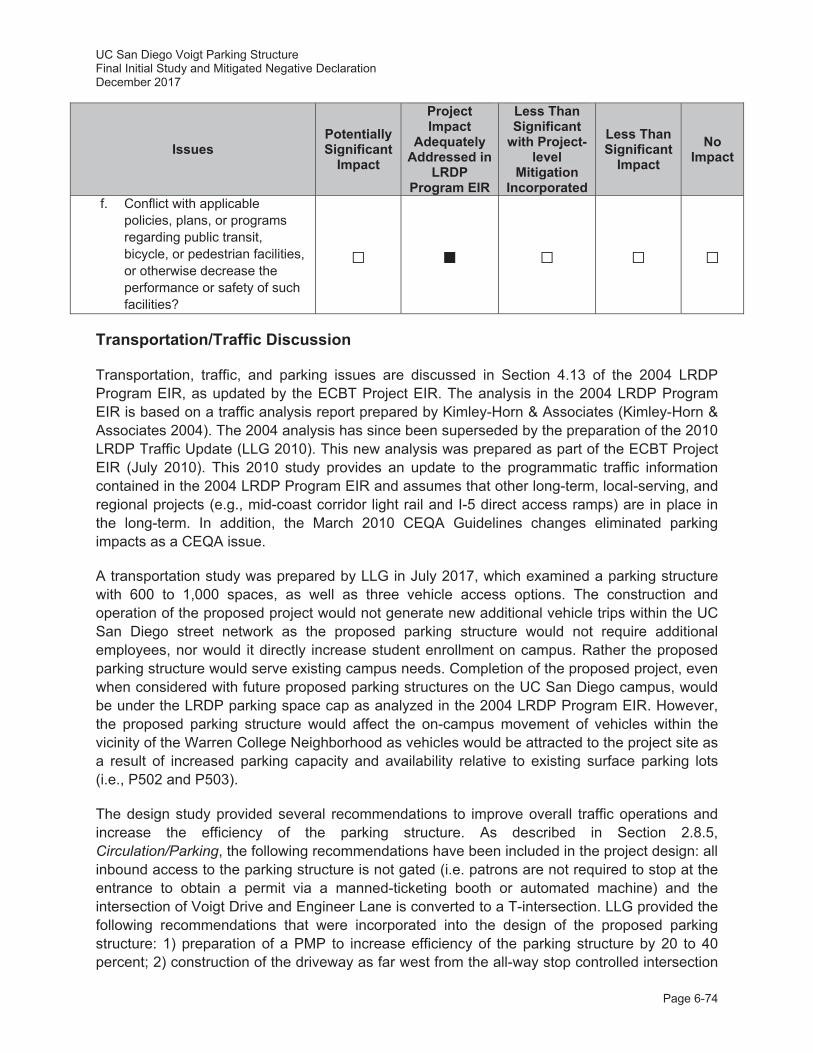
UC San Diego Voigt Parking Structure Final Initial Study and Mitigated Negative Declaration December 2017
Page 6-74
Issues Potentially Significant
Impact
Project Impact
Adequately Addressed in
LRDP Program EIR
Less Than Significant
with Project-level
Mitigation Incorporated
Less Than Significant
Impact No
Impact
f. Conflict with applicable policies, plans, or programs regarding public transit, bicycle, or pedestrian facilities, or otherwise decrease the performance or safety of such facilities?
Transportation/Traffic Discussion
Transportation, traffic, and parking issues are discussed in Section 4.13 of the 2004 LRDP Program EIR, as updated by the ECBT Project EIR. The analysis in the 2004 LRDP Program EIR is based on a traffic analysis report prepared by Kimley-Horn & Associates (Kimley-Horn & Associates 2004). The 2004 analysis has since been superseded by the preparation of the 2010 LRDP Traffic Update (LLG 2010). This new analysis was prepared as part of the ECBT Project EIR (July 2010). This 2010 study provides an update to the programmatic traffic information contained in the 2004 LRDP Program EIR and assumes that other long-term, local-serving, and regional projects (e.g., mid-coast corridor light rail and I-5 direct access ramps) are in place in the long-term. In addition, the March 2010 CEQA Guidelines changes eliminated parking impacts as a CEQA issue.
A transportation study was prepared by LLG in July 2017, which examined a parking structure with 600 to 1,000 spaces, as well as three vehicle access options. The construction and operation of the proposed project would not generate new additional vehicle trips within the UC San Diego street network as the proposed parking structure would not require additional employees, nor would it directly increase student enrollment on campus. Rather the proposed parking structure would serve existing campus needs. Completion of the proposed project, even when considered with future proposed parking structures on the UC San Diego campus, would be under the LRDP parking space cap as analyzed in the 2004 LRDP Program EIR. However, the proposed parking structure would affect the on-campus movement of vehicles within the vicinity of the Warren College Neighborhood as vehicles would be attracted to the project site as a result of increased parking capacity and availability relative to existing surface parking lots (i.e., P502 and P503).
The design study provided several recommendations to improve overall traffic operations and increase the efficiency of the parking structure. As described in Section 2.8.5, Circulation/Parking, the following recommendations have been included in the project design: all inbound access to the parking structure is not gated (i.e. patrons are not required to stop at the entrance to obtain a permit via a manned-ticketing booth or automated machine) and the intersection of Voigt Drive and Engineer Lane is converted to a T-intersection. LLG provided the following recommendations that were incorporated into the design of the proposed parking structure: 1) preparation of a PMP to increase efficiency of the parking structure by 20 to 40 percent; 2) construction of the driveway as far west from the all-way stop controlled intersection
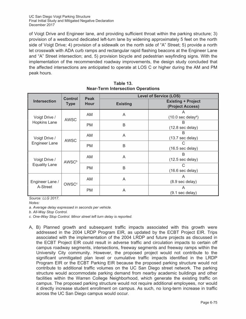
UC San Diego Voigt Parking Structure Final Initial Study and Mitigated Negative Declaration December 2017
Page 6-75
of Voigt Drive and Engineer lane, and providing sufficient throat within the parking structure; 3) provision of a westbound dedicated left-turn lane by widening approximately 5 feet on the north side of Voigt Drive; 4) provision of a sidewalk on the north side of “A” Street; 5) provide a north let crosswalk with ADA curb ramps and rectangular rapid flashing beacons at the Engineer Lane and “A” Street intersection; and, 5) provision bicycle and pedestrian wayfinding signs. With the implementation of the recommended roadway improvements, the design study concluded that the affected intersections are anticipated to operate at LOS C or higher during the AM and PM peak hours.
Table 13. Near-Term Intersection Operations
Intersection Control Type
Peak Hour
Level of Service (LOS)
Existing Existing + Project (Project Access)
Voigt Drive / Hopkins Lane AWSC
AM A A (10.0 sec delaya)
PM B B (12.8 sec delay)
Voigt Drive / Engineer Lane AWSC
AM A B (13.7 sec delay)
PM B C (16.5 sec delay)
Voigt Drive / Equality Lane AWSCb
AM A B (12.5 sec delay)
PM B C (16.6 sec delay)
Engineer Lane / A-Street OWSCc
AM A A (8.9 sec delay)
PM A A (9.1 sec delay)
Source: LLG 2017. Notes: a. Average delay expressed in seconds per vehicle. b. All-Way Stop Control. c. One-Way Stop Control. Minor street left turn delay is reported. A, B) Planned growth and subsequent traffic impacts associated with this growth were
addressed in the 2004 LRDP Program EIR, as updated by the ECBT Project EIR. Trips associated with the implementation of the 2004 LRDP and future projects as discussed in the ECBT Project EIR could result in adverse traffic and circulation impacts to certain off campus roadway segments, intersections, freeway segments and freeway ramps within the University City community. However, the proposed project would not contribute to the significant unmitigated plan level or cumulative traffic impacts identified in the LRDP Program EIR or the ECBT Parking EIR because the proposed parking structure would not contribute to additional traffic volumes on the UC San Diego street network. The parking structure would accommodate parking demand from nearby academic buildings and other facilities within the Warren College Neighborhood, which generate the existing traffic on campus. The proposed parking structure would not require additional employees, nor would it directly increase student enrollment on campus. As such, no long-term increase in traffic across the UC San Diego campus would occur.

UC San Diego Voigt Parking Structure Final Initial Study and Mitigated Negative Declaration December 2017
Page 6-76
Nevertheless, additional Average Daily Trips (ADTs) at the Voigt Drive and Engineer Lane intersection adjacent to the project site would be expected, due to changes in traffic patterns (e.g., increased convenience and availability of parking at the proposed project site).8 However, with implementation of the improvements identified in the design, each of the affected intersections would operate at LOS C or better. Consequently, consistent with City of San Diego standards for intersections and roadway segments implementation of the project would result in less than significant impacts (refer to Table 13).
Off-site impacts to transportation would be limited to minor construction activities associated to road repairs along haul routes associated with the proposed project. These activities could require minor traffic detours; however, associated impacts would be short-term and temporary.
C) The proposed project would not change existing air traffic volumes, nor would it affect existing air traffic patterns in any way. Therefore, no impacts would occur as a result of proposed project implementation.
D) The UC San Diego campus is located in an urbanized area with no farming, rural, or other non-compatible uses. The campus roadway system is largely in place with the exception of a second bridge crossing over I-5 to complete the campus loop road system. There are no plans to substantially change the campus circulation system or to change off-site circulation. beyond the modifications described above. At a program level, implementation of the 2004 LRDP and projects discussed in the ECBT Project EIR would not substantially increase hazards due to design features or incompatible uses.
Per A Policy on Geometric Design of Highways and Street 2011, also known as the American Association of State Highway and Transportation Officials (AASHTO) Green Book, a clear space easement area would be maintained clear of sight obstructions per AASHTO standards. Access from Voigt Drive would be via a right-in/right-out driveway provided via a small free-span bridge from Voigt Drive, which would minimize conflicts with bicyclists and pedestrians (LLG 2017). Therefore, implementation of the proposed project would not substantially increase hazards due to design features or incompatible uses and impacts would be less than significant.
E) The proposed project would generate short-term traffic during construction associated with delivery vehicles, heavy equipment, haul trucks, and transportation for construction workers. However, to ensure that any temporary significant emergency access impacts are avoided during construction, the proposed project would implement the 2004 LRDP Program EIR Mitigation Measure Tra-1B as replaced by the ECBT Project EIR. In addition, development pursuant to the 2004 LRDP, including development of the proposed project, is subject to review by the UC San Diego Fire Marshal. Prior to final plan approval, the Fire Marshal would review all project plans to ensure that adequate fire and emergency
8 It should be noted that the transportation study did not account for the future planned removal of surface parking lot P502, which is located directly across Voigt Drive form the Project site, and provides approximately 355 spaces. With the removal of P502 and P503, approximately 455 spaces would be removed, and the proposed parking structure would only add 445 spaces, less than the 600 to 1,000 analyzed in the transportation study.
The intersections in the immediate vicinity of the proposed parking structure – including Voigt Drive and Equality Lane (pictured above) – would operate at an acceptable LOS.
UC San Diego Voigt Parking Structure Final Initial Study and Mitigated Negative Declaration December 2017
Page 6-77
access to the project site is provided. Further, 2004 LRDP Program EIR Mitigation Measure Haz-6A (UC San Diego Fire Marshal would notify local emergency services of lane closures at his/her discretion) would be implemented during construction of the proposed project. Therefore, impacts would be less than significant.
2004 LRDP Program EIR Mitigation Measure:
Tra-1B: If a campus construction project or a specific campus event requires an on-campus lane or roadway closure, or could otherwise substantially interfere with campus traffic circulation, the contractor or other responsible party will provide a traffic control plan for review and approval by UC San Diego. The traffic control plan shall ensure that adequate emergency access and egress is maintained and that traffic is allowed to move efficiently and safely in and around the campus. The traffic control plan may include measures such as signage, detours, traffic control staff, a temporary traffic signal, or other appropriate traffic controls. If the interference would occur on a public street, UC San Diego (or its contractor) shall apply for all applicable permits from the appropriate jurisdiction.
F) UC San Diego operates one of the largest alternative transportation programs in the County, which focuses on the use of transit, ridesharing, shuttles, and bicycles to encourage and assist UC San Diego commuters’ use of alternatives to single-occupancy vehicles (refer to Sections 4.13.1.1 through 4.13.1.3 in the 2004 LRDP Program EIR and Section 3.8 in the ECBT Project EIR). Alternative transportation use continues to increase on campus. Approximately 28,000 (i.e., 57 percent) of commuters arrive on campus daily using the following modes of transportation other than a single-occupant vehicle:
Pedestrian;
Bicycle, using a UC San Diego service such as the “Pedal Club” or “Triton Bikes”;
Vanpool or carpool, which can be organized by UC San Diego’s “Zimride” program;
Car sharing network, such as “Zipcar”;
Electric vehicle, which may be parked at one of approximately 39 charging stations on campus; and
Public transit, including the 100 percent subsidized UC San Diego shuttle fleet, which is comprised of at least four compressed natural gas buses and shuttles with cleaner-burning, ultra-low-sulfur diesel fuel.
These alternative transportation commutes save the UC San Diego campus nearly 48,000 metric tons of CO2 emissions annually (based on comparison to 100 percent single-occupant vehicle use) (UC San Diego 2016b).
The trends in alternative transportation use have continued to increase at a steady level from 2001 to present and are likely to continue to increase with the new mid-coast corridor light rail scheduled to open in 2021. Once completed, the trolley extension will provide an effective campus commuting alternative, reduce roadway congestion, improve public transit services, and better connect the mid-coast corridor with areas of San Diego County served by existing trolley routes.
In accordance with 2004 LRDP Program EIR Mitigation Measure Tra-1C, UC San Diego would continue to operate and expand its robust alternative transportation program. The proposed project would be consistent with policies, plans, or programs supporting alternative transportation, including the UC Sustainable Practices Policy and would not decrease the performance of these programs. Completion of the proposed project, even
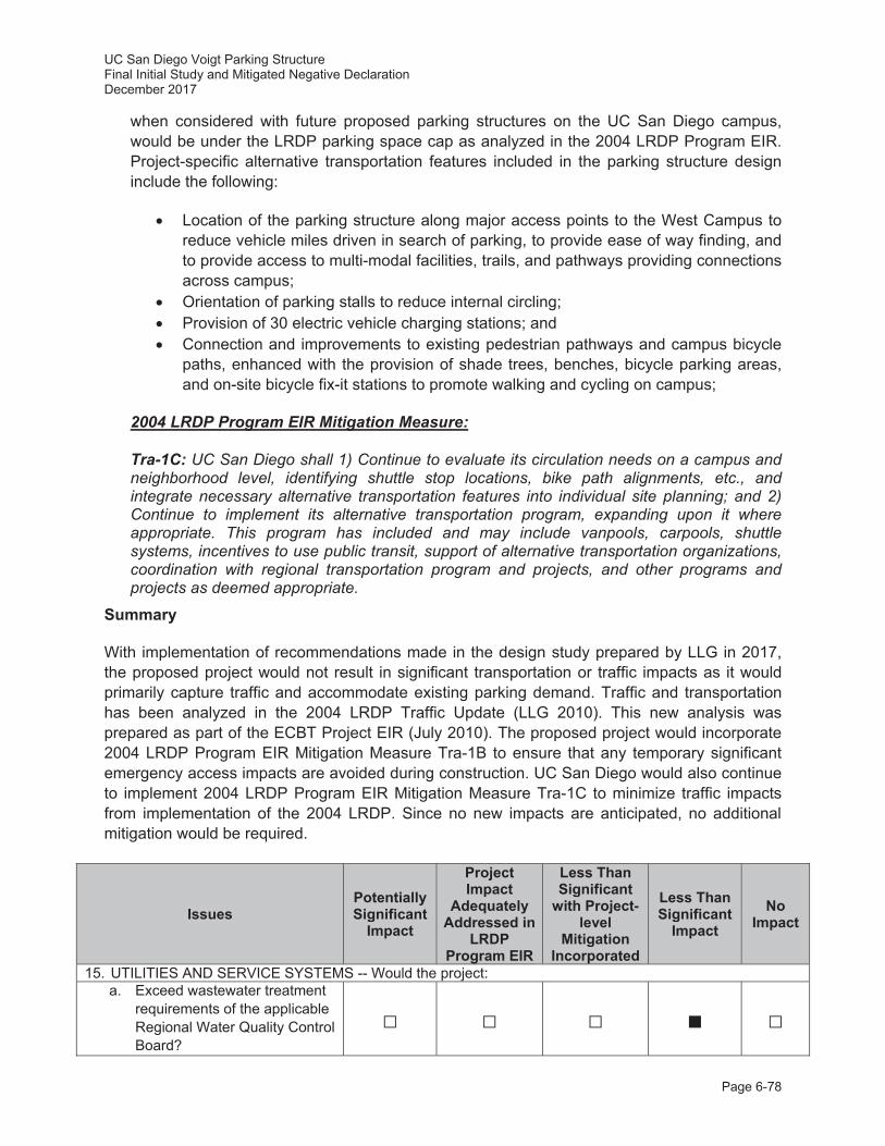
UC San Diego Voigt Parking Structure Final Initial Study and Mitigated Negative Declaration December 2017
Page 6-78
when considered with future proposed parking structures on the UC San Diego campus, would be under the LRDP parking space cap as analyzed in the 2004 LRDP Program EIR. Project-specific alternative transportation features included in the parking structure design include the following:
Location of the parking structure along major access points to the West Campus to reduce vehicle miles driven in search of parking, to provide ease of way finding, and to provide access to multi-modal facilities, trails, and pathways providing connections across campus;
Orientation of parking stalls to reduce internal circling; Provision of 30 electric vehicle charging stations; and Connection and improvements to existing pedestrian pathways and campus bicycle
paths, enhanced with the provision of shade trees, benches, bicycle parking areas, and on-site bicycle fix-it stations to promote walking and cycling on campus;
2004 LRDP Program EIR Mitigation Measure:
Tra-1C: UC San Diego shall 1) Continue to evaluate its circulation needs on a campus and neighborhood level, identifying shuttle stop locations, bike path alignments, etc., and integrate necessary alternative transportation features into individual site planning; and 2) Continue to implement its alternative transportation program, expanding upon it where appropriate. This program has included and may include vanpools, carpools, shuttle systems, incentives to use public transit, support of alternative transportation organizations, coordination with regional transportation program and projects, and other programs and projects as deemed appropriate.
Summary
With implementation of recommendations made in the design study prepared by LLG in 2017, the proposed project would not result in significant transportation or traffic impacts as it would primarily capture traffic and accommodate existing parking demand. Traffic and transportation has been analyzed in the 2004 LRDP Traffic Update (LLG 2010). This new analysis was prepared as part of the ECBT Project EIR (July 2010). The proposed project would incorporate 2004 LRDP Program EIR Mitigation Measure Tra-1B to ensure that any temporary significant emergency access impacts are avoided during construction. UC San Diego would also continue to implement 2004 LRDP Program EIR Mitigation Measure Tra-1C to minimize traffic impacts from implementation of the 2004 LRDP. Since no new impacts are anticipated, no additional mitigation would be required.
Issues Potentially Significant
Impact
Project Impact
Adequately Addressed in
LRDP Program EIR
Less Than Significant
with Project-level
Mitigation Incorporated
Less Than Significant
Impact No
Impact
15. UTILITIES AND SERVICE SYSTEMS -- Would the project: a. Exceed wastewater treatment
requirements of the applicable Regional Water Quality Control Board?
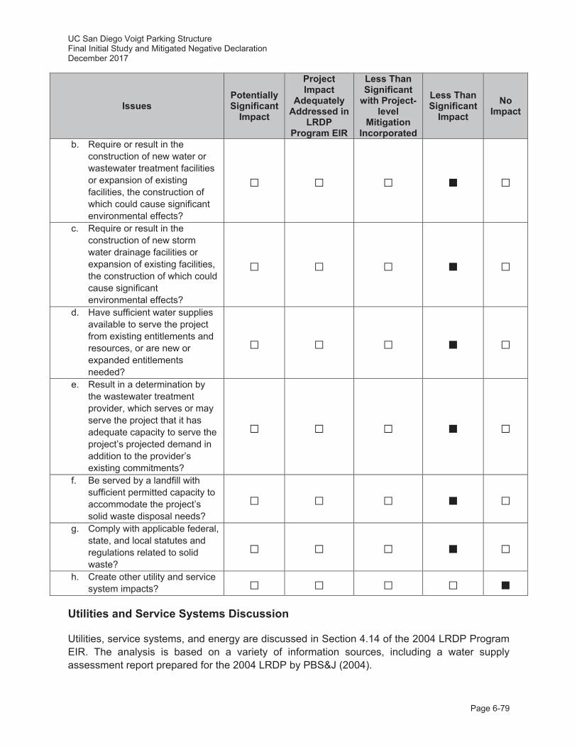
UC San Diego Voigt Parking Structure Final Initial Study and Mitigated Negative Declaration December 2017
Page 6-79
Issues Potentially Significant
Impact
Project Impact
Adequately Addressed in
LRDP Program EIR
Less Than Significant
with Project-level
Mitigation Incorporated
Less Than Significant
Impact No
Impact
b. Require or result in the construction of new water or wastewater treatment facilities or expansion of existing facilities, the construction of which could cause significant environmental effects?
c. Require or result in the construction of new storm water drainage facilities or expansion of existing facilities, the construction of which could cause significant environmental effects?
d. Have sufficient water supplies available to serve the project from existing entitlements and resources, or are new or expanded entitlements needed?
e. Result in a determination by the wastewater treatment provider, which serves or may serve the project that it has adequate capacity to serve the project’s projected demand in addition to the provider’s existing commitments?
f. Be served by a landfill with sufficient permitted capacity to accommodate the project’s solid waste disposal needs?
g. Comply with applicable federal,
state, and local statutes and regulations related to solid waste?
h. Create other utility and service
system impacts?
Utilities and Service Systems Discussion
Utilities, service systems, and energy are discussed in Section 4.14 of the 2004 LRDP Program EIR. The analysis is based on a variety of information sources, including a water supply assessment report prepared for the 2004 LRDP by PBS&J (2004).
UC San Diego Voigt Parking Structure Final Initial Study and Mitigated Negative Declaration December 2017
Page 6-80
A, E) Implementation of the proposed 2004 LRDP as well as the implementation of the proposed project would increase the amount of on campus building space, which would result in increased wastewater generation and discharge at the Point Loma Wastewater Treatment Plant (PLWTP) operated by the City. According to the City, it is anticipated that the PLWTP would have the capacity to receive and treat wastewater from UC San Diego, and the City is planning to meet wastewater treatment capacity in the region through the year 2050. The proposed parking structure would include one proposed restroom and janitorial closets, and consequently would not substantially increase wastewater generation and discharge at the PLWTP because wastewater facilities are not proposed as part of this project.
Development under the 2004 LRDP has the potential to affect compliance with the waste discharge requirements that are placed on discharges from the PLWTP. Discharges to the City’s sewer system from the campus are regulated under two permits: UC San Diego Industrial User Discharge Permit and SIO Industrial User Discharge Permit. UC San Diego would continue to comply with applicable permit regulations regarding sewage generation quantities and constituents. Therefore, implementation of the proposed project would result in a less than significant impact with regard to wastewater generation and discharge requirements.
B) The proposed parking structure would require connections to the campus storm drain, domestic water, utility water, sanitary sewer, electrical, and telecommunication systems. However, construction of the proposed project would not require the construction of new water or wastewater treatment facilities as current campus facilities are adequate in the project site. Therefore, since facility construction is not required, impacts would be less than significant.
C) Any necessary drainage facilities are included as part of the project description and the effects of implementation analyzed herein as appropriate. Impacts to storm water drainage facilities or expansion of existing facilities with implementation of the proposed project would be less than significant.
D) The City of San Diego Water Utilities Service Department provides the water supply for UC San Diego. Based on the water supply assessment report prepared for the 2004 LRDP Program EIR, the increased water demand calculated for the 2004 LRDP, including the proposed project has been included in forecasts of the water supply agencies and the City’s Urban Water Management Plan and in the water supply planning documents for the region. Therefore, the 2004 LRDP Program EIR concluded that the City's total projected water supplies through approximately 2025 would be sufficient to meet the demand resulting from the implementation of the 2004 LRDP including the proposed project.
However, since 2004, conditions have been changing with regard to the state’s water supply situation. To address these changes, UC San Diego began the conversion to reclaimed water for landscape irrigation and is one of the largest customers of the North City Water Reclamation Facility. All new construction has been required to include low-flow water fixtures and native or drought-tolerant vegetation. Retrofits of existing facilities and existing irrigation systems have been systematically implemented. As a result of implementing these water saving measures, campus potable water consumption decreased consistently from the previous year, despite the growth in new facility square footage. As described in the Greenhouse In 2013, UC San Diego completed a Water Action Plan in compliance with the UC Sustainable Water Systems Policy (UC San Diego 2013). This multi-pronged plan
UC San Diego Voigt Parking Structure Final Initial Study and Mitigated Negative Declaration December 2017
Page 6-81
targeted a variety of conservation measures in the following areas: new building construction; existing building operation and maintenance; irrigation and landscaping; training and outreach; and behavioral modification.
In January 2014, Governor Edmund G. Brown declared a drought State of Emergency and directed all State officials and Californians to take all necessary measures to conserve water in every way possible. In response to Governor Brown’s State of Emergency, the University of California President, Janet Napolitano, issued a letter to the entire UC community urging a reduction in total water consumption by 20 percent by year 2020 (Napolitano 2014).
The University of California prepared a Drought Response Report which included the drought response measures for each campus. The UC San Diego Drought Action Plan – detailing specific water consumption reduction actions – was assembled in 2014.
The 2004 LRDP Program EIR concluded that the City's total projected water supplies through approximately 2025 would be sufficient to meet the demand resulting from the implementation of the 2004 LRDP. UC San Diego has implemented campus-wide water conservation measures that have been effective in limiting the increase in potable water use despite the growth in new building square footage, and this trend will continue pursuant to the University of California policies. The proposed project would require minimal use of potable water; Reclaimed water would be used for any landscaping irrigation, including the landscaping on the Live Roof. Therefore, project-level and cumulative impacts to water supply availability as a result of the implementation of the proposed project would be less than significant.
F, G) UC San Diego implements and promotes a comprehensive campus-wide waste prevention and recycling program and would continue to do so in the future. Under the UC Sustainable Practices Policy, and in accordance with AB 939, UC San Diego has adopted a waste reduction goal of zero waste by 2020. It is likely that with its recycling program, UC San Diego would control the volume of refuse generated to a manageable amount and that adequate disposal options would be available in the future, including the expansion of the City’s Sycamore Canyon landfill. Additionally, the proposed project would contribute to UC San Diego’s achievement of these goals by providing an increased quantity of exterior recycling bins on-site and placing them in appropriate spaces in accordance with the University’s sustainability initiative. Beyond these installations, the proposed parking structure would not generate a substantial amount of solid waste. Therefore, solid waste generated by the proposed project would have a less than significant impact to landfill capacity and applicable statutes and regulations.
H) The proposed project is not anticipated to create other utility or service system impacts beyond those that have already been described above. No impacts would occur as a result of the proposed project.
Summary
Implementation of the proposed project would not result in significant impacts to utilities and service systems serving the campus or surrounding community.
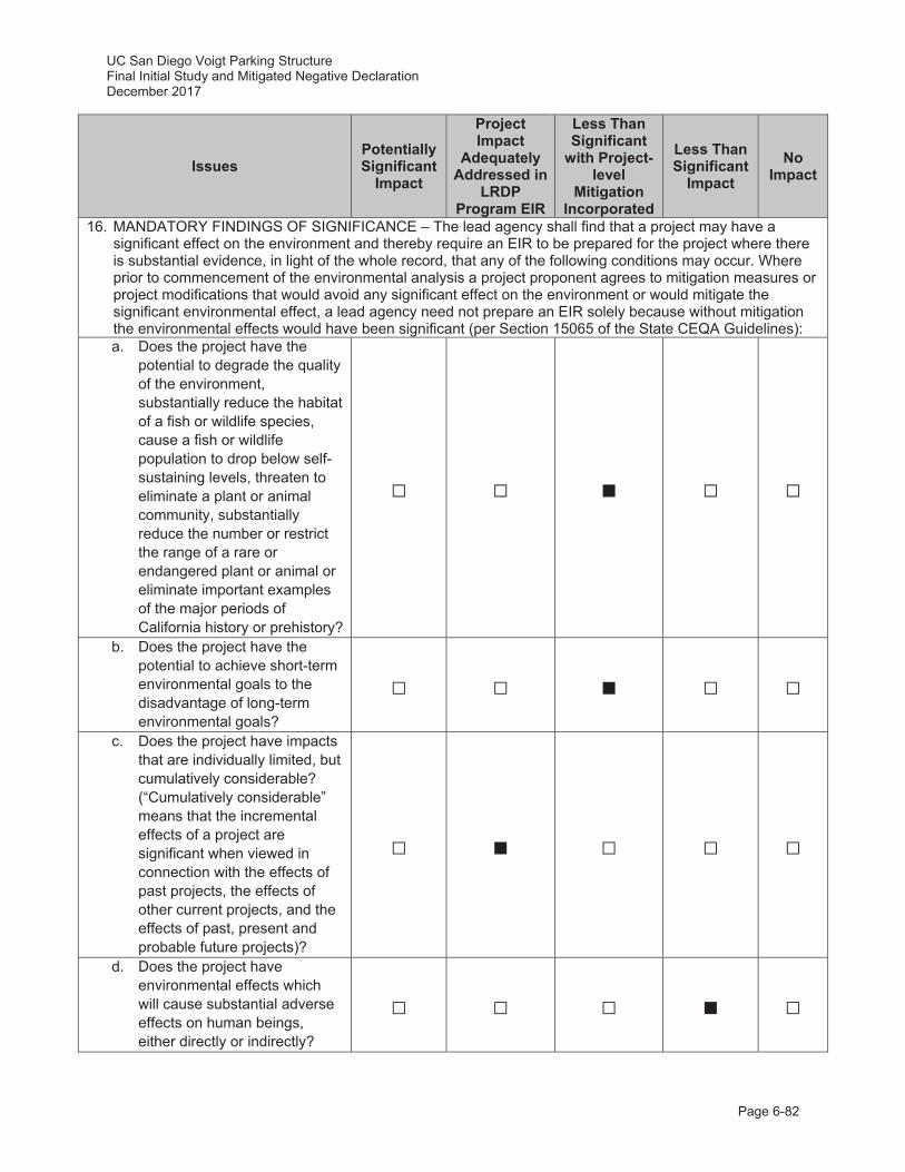
UC San Diego Voigt Parking Structure Final Initial Study and Mitigated Negative Declaration December 2017
Page 6-82
Issues Potentially Significant
Impact
Project Impact
Adequately Addressed in
LRDP Program EIR
Less Than Significant
with Project-level
Mitigation Incorporated
Less Than Significant
Impact No
Impact
16. MANDATORY FINDINGS OF SIGNIFICANCE – The lead agency shall find that a project may have a significant effect on the environment and thereby require an EIR to be prepared for the project where there is substantial evidence, in light of the whole record, that any of the following conditions may occur. Where prior to commencement of the environmental analysis a project proponent agrees to mitigation measures or project modifications that would avoid any significant effect on the environment or would mitigate the significant environmental effect, a lead agency need not prepare an EIR solely because without mitigation the environmental effects would have been significant (per Section 15065 of the State CEQA Guidelines): a. Does the project have the
potential to degrade the quality of the environment, substantially reduce the habitat of a fish or wildlife species, cause a fish or wildlife population to drop below self-sustaining levels, threaten to eliminate a plant or animal community, substantially reduce the number or restrict the range of a rare or endangered plant or animal or eliminate important examples of the major periods of California history or prehistory?
b. Does the project have the potential to achieve short-term environmental goals to the disadvantage of long-term environmental goals?
c. Does the project have impacts that are individually limited, but cumulatively considerable? (“Cumulatively considerable” means that the incremental effects of a project are significant when viewed in connection with the effects of past projects, the effects of other current projects, and the effects of past, present and probable future projects)?
d. Does the project have environmental effects which will cause substantial adverse effects on human beings, either directly or indirectly?
UC San Diego Voigt Parking Structure Final Initial Study and Mitigated Negative Declaration December 2017
Page 7-1
7.0 SUPPORTING INFORMATION SOURCES
Amec Foster Wheeler Environment & Infrastructure, Inc. (Amec Foster Wheeler). 2017. Air Quality Report for the UC San Diego Voigt Parking Structure Project. August
BWE. 2017. Preliminary Hydrology and Water Quality Study, Voigt Parking Structure – CEQA Submittal, UC San Diego Campus, Voigt Drive at Engineer Lane. La Jolla, California. July.
California EnviroStor. 2017. EnviroStor Database. Available at: http://www.envirostor.dtsc.ca.gov/public/mapfull.asp?global_id=19490005 [Accessed on: August 8, 2017].
California Building Standards Commission. 2017. CALGreen (Part 11 of Title 24). Available at: http://www.bsc.ca.gov/Home/CALGreen.aspx [Accessed on: August 8, 2017].
California Air Pollution Control Officers Association (CAPCOA). 2008. CEQA & Climate Change: Evaluating and Addressing Greenhouse Gas Emissions from Projects Subject to the California Environmental Quality Act. January. Available at: http://www.capcoa.org/wp-content/uploads/2012/03/CAPCOA-White-Paper.pdf [Accessed on July 25, 2016].
California Air Resources Board (CARB). 2008. AB 32 Draft Scoping Plan. June. Available at: http://www.arb.ca.gov/cc/scopingplan/scopingplan.htm [Accessed on August 1, 2017].
CARB. 2013. Board Meetings. Available at: http://www.arb.ca.gov/board/meetings.htm [Accessed on: August 8, 2017].
CARB. 2014. First Update to the Climate Change Scoping Plan. Available at: https://www.arb.ca.gov/cc/scopingplan/document/updatedscopingplan2013.htm [Accessed on: August 8, 2017].
City of San Diego. 1997. Multiple Species Conservation Program, Volume II. MSCP Subarea Plan. March. Available at: http://www.sandiegocounty.gov/pds/mscp/ [Accessed on August 8, 2017].
City of San Diego. 2014. University Community Plan. Available at: https://www.sandiego.gov/sites/default/files/legacy//planning/community/profiles/university/pdf/university_cp_110614.pdf [Accessed on August 1, 2017].
City of San Diego. 2011. CEQA Significance Determination Thresholds. Available at: https://www.sandiego.gov/sites/default/files/legacy/development-services/pdf/news/sdtceqa.pdf [Accessed on August 8, 2017].
Citygate Associates, LLC (Citygate). 2011. Fire Service Standards of Response Coverage Deployment Study for the City of San Diego Fire Rescue Department. Available at: http://voiceofsandiego.org/wp-content/uploads/2013/07/citygate-associates-inc-fire-service-standards.pdf [Accessed on: August 8, 2017].
UC San Diego Voigt Parking Structure Final Initial Study and Mitigated Negative Declaration December 2017
Page 7-2
Citygate. 2017. Executive Summary Standards of Response Cover Review - San Diego Fire-Rescue Department, Volume 1 of 3.
Federal Emergency Management Agency (FEMA). 2012. FEMA Flood Map Service Center | Search By Address. Available at: https://msc.fema.gov/portal/search?AddressQuery=university%20of%20california%20san%20diego#searchresultsanchor [Accessed: August 8, 2017].
Gallegos, D.R., Philips, R., Pigniolo, A., Demere, T., and Masters, P. 1989. A Cultural and Paleontological Resource Inventory Update for the University of California at San Diego and Scripps Institution of Oceanography. Unpublished report on file at the South Coastal Information Center, San Diego State University.
HELIX Environmental Planning, Inc. (HELIX). 2004. Biological Resources Technical Report for the 2004 UC San Diego LRDP Update. May.
HELIX. 2016a. 2016 Coastal California Gnatcatcher (Polioptila californica californica) Survey Report for the UC San Diego La Jolla Campus Long Range Development Plan Update Project.
HELIX. 2016b. Biological Resources Existing Conditions Report for the UC San Diego La Jolla Campus LRDP Update.
HELIX. 2017. Year 2017 Least Bell’s Vireo (Vireo bellii pusillus) Survey Report for the UC San Diego – Long Range Development Plan Project
Keyser Marston Associates. 2004. Population and Housing Report. UC San Diego 2004 Long
Range Development Plan Draft EIR. Prepared for UC San Diego.
Kimley-Horn & Associates. 2004. Traffic Impact Study for the 2004 LRDP for the University of California, San Diego. May.
Kyle Consulting. 2004. A Cultural Resource Inventory Update and Recommendations for UC San Diego and Scripps Institution of Oceanography. April.
Linscott, Law & Greenspan (LLG). 2010. 2004 Long Range Development Plan Traffic Study Update.
LLG. 2017. UC San Diego Voigt Parking Structure Traffic Study. Prepared for UC San Diego. July.
Native American Heritage Council (NAHC). 2017. Sacred Lands File Search for the Proposed Voigt Parking Structure. August 29.
Napolitano, J. 2014. Letter from the Unviersity of California President to Chancellors. January.
National Oceanic and Atmospheric Administration (NOAA). 2017. Trends in Atmospheric Carbon Dioxide. Available at: http://www.esrl.noaa.gov/gmd/ccgg/trends/global.html [Accessed: August 8, 2017].
UC San Diego Voigt Parking Structure Final Initial Study and Mitigated Negative Declaration December 2017
Page 7-3
Ninyo & Moore. 2003. Geological Technical Study for the UC San Diego 2004 Long Range Development Plan EIR, San Diego, California. September 12.
PBS&J. 2004. UC San Diego Long Range Development Plan Hydrology Study. Prepared for UC San Diego.
San Diego Air Pollution Control District (SDAPCD). 2016. San Diego County’s Attainment Status. Available at: http://www.sdapcd.org/content/sdc/apcd/en/air-quality-planning/attainment-status.html [Accessed: August 8, 2017].
Schiessl, P. et al. 2003. Environmental Effects of Concrete. State-of-art report prepared by Task Group 3.4. March.
Seneca, T. 1979. Site Record From CA-SDI-8468. On file, South Coastal Information Center, San Diego State University.
Southern California Soils & Testing, Inc. (SCST). 2016. Geotechnical Investigation Voigt Parking Structure, La Jolla, California. November.
U.S. Environmental Protection Agency (USEPA). 2005. Proposed Rule To Implement the Fine Particle National Ambient Air Quality Standards. Available at: https://www.federalregister.gov/articles/2005/11/01/05-20455/proposed-rule-to-implement-the-fine-particle-national-ambient-air-quality-standards [Accessed on August 7, 2017].
USEPA. 2016. Proposed Endangerment and Cause or Contribute Findings for Greenhouse Gases under the Clean Air Act. Available at: http://www.epa.gov/climatechange/endangerment/ [Accessed on: August 8, 2017].
USEPA and U.S. Department of Transportation National Highway Traffic Safety Administration (NHTSA). 2012. 2017 and Later Model Year Light-Duty Vehicle Greenhouse Gas Emissions and Corporate Average Fuel Economy Standards. October 15.
University of California, San Diego (UC San Diego). 2003a. UC San Diego Outdoor Lighting Policy. Available at http://fdc.ucsd.edu/documenttation/designguidelines/volume_4.htm [Accessed 1 September 2016].
UC San Diego. 2003b. UC San Diego Outdoor Lighting Design Guidelines. Available at: http://fdc.ucsd.edu/documenttation/designguidelines/volume_4.htm [Accessed 1 September 2016].
UC San Diego. 2004a. Long Range Development Plan Final Environmental Impact Report. Volumes I through III. Available at: http://physicalplanning.ucsd.edu/environmental/lrdpeir.html [Accessed 30 July 2016].
UC San Diego. 2004b. Long Range Development Plan.
UC San Diego. 2008. UC San Diego Climate Action Plan.
UC San Diego Voigt Parking Structure Final Initial Study and Mitigated Negative Declaration December 2017
Page 7-4
UC San Diego. 2009. Site Development Guidelines and Procedures for University of California, San Diego. November.
UC San Diego. 2010a. East Campus Bed Tower Project EIR. Available at: http://physicalplanning.ucsd.edu/environmental/lrdpeir.html [Accessed on 30 July 2016].
UC San Diego. 2012a. Bicycle and Pedestrian Master Planning Study. Available at: http://physicalplanning.ucsd.edu/plans/docs/2012_UCSD_BPMPS.pdf [Accessed on August 16, 2017].
UC San Diego. 2012b. UC San Diego Solid Waste Diversion Plan.
UC San Diego. 2013. Water Action Plan. Available at: http://aquaholics.ucsd.edu/_files/wateractionplan.pdf [Accessed on July 25, 2016].
UC San Diego. 2014. UC San Diego Emergency Operations Plan
UC San Diego. 2015a. UC San Diego Annual Security Report (Clery Report). Available at: http://www.police.ucsd.edu/docs/annualclery.pdf [Accessed on July 27, 2017].
UC San Diego. 2015b. UC San Diego Survey of Parking Space Occupancy Levels, Fall 2015 University-wide. Available at: http://rmp-wapps.ucsd.edu/TS/Survey/Survey%20of%20Parking%20Space%20Occupancy%20Levels/Quarterly%20Tables/Occupancy%202015-2016-2%20Fall.pdf [Accessed on October 3, 2017].
UC San Diego 2016a. Voigt Parking Structure Site Evaluation. Physical and Community Planning Office. December 12.
UC San Diego. 2016b. Sustainability Initiatives: Alternative Transportation. Available at: http://sustain.ucsd.edu/initiatives/transportation.html [Accessed on July 27, 2017].
UC San Diego. 2016c. Open Space Master Planning Study (OSMPS). Available at: http://physicalplanning.ucsd.edu/plans/docs/_UCSD_OSMPS_Book-FinalPDF_041416%20(2).pdf. [Accessed August 10, 2017].
UC San Diego. 2017a. Facilities Information System.
UC San Diego. 2017b. Voigt Parking Structure Detailed Project Program. Job #5146. February.
UC San Diego Institutional Research. 2016. Intitutional Research Related to Existing UC San Diego Campus Population for the 2015-2016 Academic Year.
UC San Diego Voigt Parking Structure Final Initial Study and Mitigated Negative Declaration December 2017
Page 8-1
8.0 INITIAL STUDY PREPARERS
This IS was prepared for and under the direction of UC San Diego Campus Planning by Amec Foster Wheeler Environment & Infrastructure, Inc. (Amec Foster Wheeler). Members of the professional staff are listed below: Project Management Rita Bright, CEQA Program Manager/Quality Assurance and Quality Control
B.A. Business Economics and Environmental Studies Nick Meisinger, Project Manager B.S. Environmental Science Aaron Goldschmidt, Senior Technical Advisor M.A. Geography Technical Analysts Taylor Lane, Air Quality Specialist B.A. Environmental Studies Erlin Worthington, Environmental Analyst B.S. Conservation and Resource Studies Aaron Johnson, GIS Specialist Production Janice Depew Production Deirdre Stites Graphics