Embed Size (px)
Citation preview

Putting It All Together:the ESRI Product Line
Natalie VinesInstructor
FedUC 2008 Tech SessionsFedUC 2008 Tech Sessions 11

OverviewOverview
ESRI has several software products to meet the various GIS ESRI has several software products to meet the various GIS needs of its users.needs of its users.–– Which product or products is the right one for the job?Which product or products is the right one for the job?
This session will clear the air by using scenarios and case This session will clear the air by using scenarios and case studies to describe which product fits certain needs.studies to describe which product fits certain needs.
Audience input and questionsAudience input and questions
FedUC 2008 Tech SessionsFedUC 2008 Tech Sessions 22

ArcGIS: A family of softwareArcGIS: A family of software
Refer to Refer to ““What is ArcGIS 9.2What is ArcGIS 9.2”” at at http://support.esri.comhttp://support.esri.comFedUC 2008 Tech SessionsFedUC 2008 Tech Sessions 33
UseUse
ServeServe
AuthorAuthor
Web MapWeb MapViewerViewer
DesktopDesktop ExplorerExplorer
ArcGIS ServerArcGIS Server
MobileMobile OpenOpenAPIsAPIs
DesktopDesktop
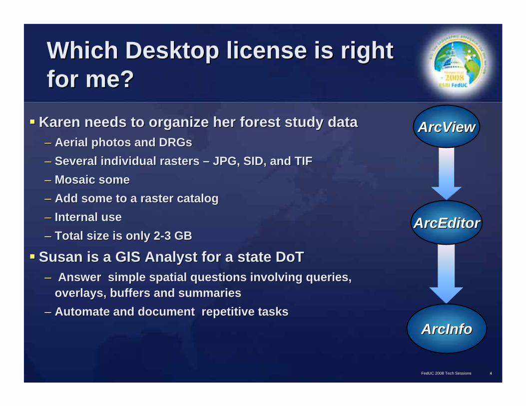
Which Desktop license is right Which Desktop license is right for me?for me?
Karen needs to organize her forest study dataKaren needs to organize her forest study data–– Aerial photos and DRGsAerial photos and DRGs–– Several individual rasters Several individual rasters –– JPG, SID, and TIF JPG, SID, and TIF –– Mosaic someMosaic some–– Add some to a raster catalog Add some to a raster catalog –– Internal use Internal use –– Total size is only 2Total size is only 2--3 GB3 GB
Susan is a GIS Analyst for a state DoTSusan is a GIS Analyst for a state DoT–– Answer simple spatial questions involving queries, Answer simple spatial questions involving queries,
overlays, buffers and summariesoverlays, buffers and summaries–– Automate and document repetitive tasksAutomate and document repetitive tasks
FedUC 2008 Tech SessionsFedUC 2008 Tech Sessions 44
ArcViewArcView
ArcEditorArcEditor
ArcInfoArcInfo

Which Desktop license is right Which Desktop license is right for me?for me?
Billy works in the assessorBilly works in the assessor’’s office for a rural countys office for a rural county–– automate plat maps and legal descriptions to create lot lines automate plat maps and legal descriptions to create lot lines
and parcel boundaries for his entire county from scratchand parcel boundaries for his entire county from scratch–– enter in each segment of the parcel boundaries using enter in each segment of the parcel boundaries using
distances, directions, and metes and boundsdistances, directions, and metes and bounds
Mike is a GIS Manager for a small cityMike is a GIS Manager for a small city–– his employees typically need access to the basic GIS toolshis employees typically need access to the basic GIS tools–– periodically require more advanced analysis and data periodically require more advanced analysis and data
management toolsmanagement tools–– They have five employees and an annual GIS budget of about They have five employees and an annual GIS budget of about
$25k$25k
FedUC 2008 Tech SessionsFedUC 2008 Tech Sessions 55
ArcViewArcView
ArcEditorArcEditor
ArcInfoArcInfo

ArcGIS Desktop FunctionalityArcGIS Desktop Functionality
See the ArcGIS Desktop 9.2 Functionality MatrixSee the ArcGIS Desktop 9.2 Functionality MatrixFedUC 2008 Tech SessionsFedUC 2008 Tech Sessions 66
ArcInfo = ArcEditor +ArcInfo = ArcEditor +
ArcEditor = ArcView +ArcEditor = ArcView +
ArcViewArcViewArcMap, ArcCatalog
Display, analyze, manage, and store vector, raster and tabular data
Basic Geoprocessing (204 tools)
Advanced GDB behavior: Topology, Geometric networks, Feature linked annotation, Relationship classes, Enterprise
Geodatabase editing Advanced Editing/COGO tools
Advanced Geoprocessing (236 tools)
Advanced CartographyWorkstation ArcInfo, Coverage editing and tools
Full Geoprocessing and analysis (289 tools)
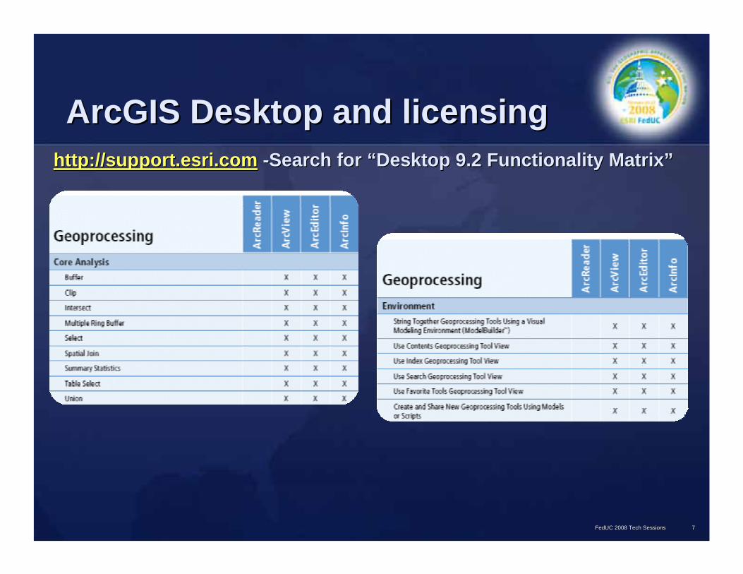
ArcGIS Desktop and licensingArcGIS Desktop and licensinghttp://support.esri.comhttp://support.esri.com --Search for Search for ““Desktop 9.2 Functionality MatrixDesktop 9.2 Functionality Matrix””
FedUC 2008 Tech SessionsFedUC 2008 Tech Sessions 77

Which Desktop license is right Which Desktop license is right for me?for me?
Karen, forest studyKaren, forest study–– Raster database of images, Raster database of images,
mosaicking, raster catalogsmosaicking, raster catalogs
Susan, DoTSusan, DoT–– Basic analysis, repetitive tasksBasic analysis, repetitive tasks
Billy, assessorBilly, assessor’’s offices office–– Parcel creation and editing from Parcel creation and editing from
legal descriptionslegal descriptions
Mike, small cityMike, small city–– Manages 5 employees with Manages 5 employees with
different functionality needsdifferent functionality needs
FedUC 2008 Tech SessionsFedUC 2008 Tech Sessions 88
ArcViewArcView
ArcEditorArcEditor
ArcViewArcView
ArcInfoArcInfoArcViewArcView ++(4)(4) (1)(1)

ArcGIS ExtensionsArcGIS ExtensionsSpecialized functionality that plugs into ArcGIS Specialized functionality that plugs into ArcGIS applicationsapplications–– 3D Analyst3D Analyst–– Spatial AnalystSpatial Analyst–– Network AnalystNetwork Analyst–– ArcGIS SchematicsArcGIS Schematics–– Business AnalystBusiness Analyst
FedUC 2008 Tech SessionsFedUC 2008 Tech Sessions 99
––PLTSPLTS––Data InteroperabilityData Interoperability––Geostatistical AnalystGeostatistical Analyst––Tracking AnalystTracking Analyst––ArcGIS Publisher ArcGIS Publisher ––Survey AnalystSurvey Analyst––ArcScan (incl ArcScan (incl w/ArcEditor)w/ArcEditor)––Maplex (incl w/ArcInfo)Maplex (incl w/ArcInfo)

Do I need to use an ArcGIS Do I need to use an ArcGIS extension?extension?
Dave is working on a public safety projectDave is working on a public safety project–– Visibility and lineVisibility and line--ofof--sight analysis for train tracks and streetssight analysis for train tracks and streets–– Incorporate a hillshade and visualize the results in 3D Incorporate a hillshade and visualize the results in 3D –– 3D Analyst3D Analyst
FedUC 2008 Tech SessionsFedUC 2008 Tech Sessions 1010

Do I need to use an ArcGIS Do I need to use an ArcGIS extension?extension?
Maggie is an analyst in an undeveloped area and needs toMaggie is an analyst in an undeveloped area and needs to–– Create stream networks to determining where new roads should goCreate stream networks to determining where new roads should go–– Determine site suitability for new structuresDetermine site suitability for new structures–– Spatial AnalystSpatial Analyst
FedUC 2008 Tech SessionsFedUC 2008 Tech Sessions 1111
Viewsheds
Stream Network and Watersheds
Travel Costanalysis

Do I need to use an ArcGIS Do I need to use an ArcGIS extension?extension?
A large school district needs toA large school district needs to–– Develop more efficient bus routes and reassess bus zonesDevelop more efficient bus routes and reassess bus zones–– Determine which students live close enough to walk or far enoughDetermine which students live close enough to walk or far enough to busto bus–– Previously, this was determined by straight line distance, but Previously, this was determined by straight line distance, but Network Network
Analyst Analyst provides a better way to calculate thisprovides a better way to calculate this
FedUC 2008 Tech SessionsFedUC 2008 Tech Sessions 1212
RouteRouteService AreaService Area
Origin-Destination (OD) Cost Matrix
Origin-Destination (OD) Cost MatrixClosest FacilityClosest Facility

A utility company needs toA utility company needs to–– Maintain both geographic and schematic views of all its infrastrMaintain both geographic and schematic views of all its infrastructure, and ucture, and
keep them in synckeep them in sync–– Monitor connectivity and disconnectivity (outages) and perform tMonitor connectivity and disconnectivity (outages) and perform tracesraces–– ArcGIS SchematicsArcGIS Schematics
Do I need to use an ArcGIS Do I need to use an ArcGIS extension?extension?
FedUC 2008 Tech SessionsFedUC 2008 Tech Sessions 1313
Geography
Geoschematic
Hierarchical

The Nuances of NetworksThe Nuances of NetworksMateo needs to perform route analysisMateo needs to perform route analysis–– to the best path from Point A to B to C to the best path from Point A to B to C –– along a transportation network for his delivery trucksalong a transportation network for his delivery trucks–– Network Analyst extensionNetwork Analyst extension
Lana needs an efficient way to store her Lana needs an efficient way to store her water/gas/electric network datawater/gas/electric network data–– maintain connectivity maintain connectivity –– perform analysesperform analyses
looking for disconnected features looking for disconnected features locate customers up or downstream from outages locate customers up or downstream from outages and breaksand breaks
–– Geometric Network in the geodatabase (ArcEditor )Geometric Network in the geodatabase (ArcEditor )
FedUC 2008 Tech SessionsFedUC 2008 Tech Sessions 1414

Large Scale ProjectsLarge Scale Projects
Torrance works for the FAATorrance works for the FAA–– create professionalcreate professional--looking airspace maps using aeronautical chartslooking airspace maps using aeronautical charts
A county tax assessor A county tax assessor –– Purchased data from a vendor Purchased data from a vendor –– Missy needs to check it for errors and qualityMissy needs to check it for errors and quality–– The deliverables are so big, she feels overwhelmed and doesnThe deliverables are so big, she feels overwhelmed and doesn’’t know where to begin t know where to begin
or how to error checkor how to error check
Lucy works in public health on a mosquito control projectLucy works in public health on a mosquito control project–– Create map books annually for the inspectors and pesticide truckCreate map books annually for the inspectors and pesticide truck operatorsoperators–– ItIt’’s a major task that consumes a great deal of time s a major task that consumes a great deal of time
Juan manages field crews at a large water utility Juan manages field crews at a large water utility –– Large database in place already Large database in place already –– Needs an easy way to assign work orders, keep track of who is doNeeds an easy way to assign work orders, keep track of who is doing what and check ing what and check
the work before it goes into the databasethe work before it goes into the database
FedUC 2008 Tech SessionsFedUC 2008 Tech Sessions 1515

Production Line Toolset (PLTS) Production Line Toolset (PLTS)
PLTS is a set of software components that work PLTS is a set of software components that work within ArcGIS Desktopwithin ArcGIS Desktop–– Can purchase all together (PLTS Foundation) Can purchase all together (PLTS Foundation) –– or individually (PLTS Components) or individually (PLTS Components) –– or as a solution (a set of components for very specific tasks)or as a solution (a set of components for very specific tasks)
FedUC 2008 Tech SessionsFedUC 2008 Tech Sessions 1616
PLTS Foundation
Enhanced EditingTools
GIS Data ReViewer
Knowledge base
MPS
ComplexDomains
PMC
DataLoader
JTX
•• Streamlines your Streamlines your production production process process
•• Enhances the Enhances the quality of your quality of your map productsmap products
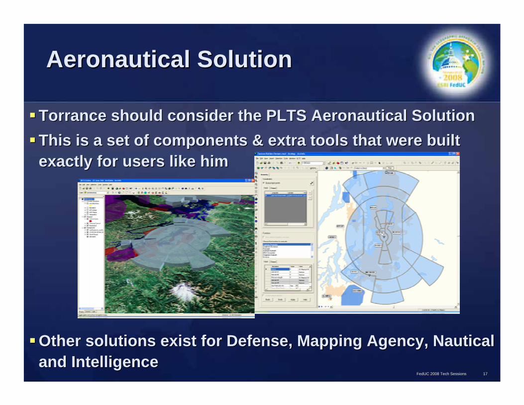
Aeronautical Solution Aeronautical Solution
Torrance should consider the PLTS Aeronautical SolutionTorrance should consider the PLTS Aeronautical SolutionThis is a set of components & extra tools that were built This is a set of components & extra tools that were built exactly for users like himexactly for users like him
Other solutions exist for Defense, Mapping Agency, Nautical Other solutions exist for Defense, Mapping Agency, Nautical and Intelligence and Intelligence
FedUC 2008 Tech SessionsFedUC 2008 Tech Sessions 1717

GIS Data ReViewer GIS Data ReViewer
Missy should look into the GIS Data ReViewer Missy should look into the GIS Data ReViewer This extension helps perform QA/QC checks on dataThis extension helps perform QA/QC checks on data–– Tools for finding errorsTools for finding errors
Check data yourself and document anomaliesCheck data yourself and document anomaliesSet the GIS Data ReViewer to check for errorsSet the GIS Data ReViewer to check for errors
–– Tools for fixing errorsTools for fixing errors–– Tools for verifying error fixesTools for verifying error fixes
FedUC 2008 Tech SessionsFedUC 2008 Tech Sessions 1818
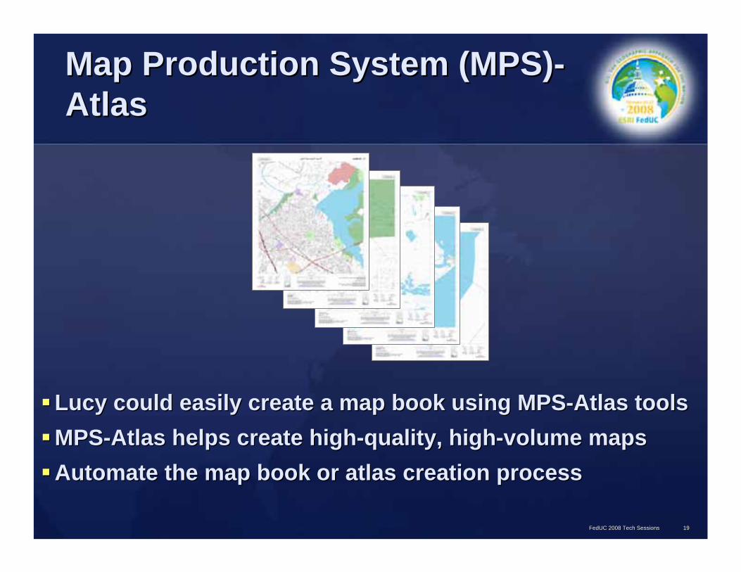
Map Production System (MPS)Map Production System (MPS)--Atlas Atlas
Lucy could easily create a map book using MPSLucy could easily create a map book using MPS--Atlas toolsAtlas toolsMPSMPS--Atlas helps create highAtlas helps create high--quality, highquality, high--volume maps volume maps Automate the map book or atlas creation process Automate the map book or atlas creation process
FedUC 2008 Tech SessionsFedUC 2008 Tech Sessions 1919

Job Tracking for ArcGIS (JTX) Job Tracking for ArcGIS (JTX)
JTX can make JuanJTX can make Juan’’s job easier by simplifying job s job easier by simplifying job management and trackingmanagement and trackingJTX provides tools for JTX provides tools for –– allocating resources allocating resources –– tracking the status/progress of jobstracking the status/progress of jobs–– Automatically recording job activity history to give managers a Automatically recording job activity history to give managers a builtbuilt--
in log of the job's progress and how it was completedin log of the job's progress and how it was completed
FedUC 2008 Tech SessionsFedUC 2008 Tech Sessions 2020

GIS for BusinessGIS for Business
Bella is in the circulation department of a major Bella is in the circulation department of a major metropolitan newspapermetropolitan newspaper–– Works with the advertising department to determine the Works with the advertising department to determine the
demographics of an areademographics of an area–– Matches their advertisersMatches their advertisers’’ needs to appropriate areas needs to appropriate areas –– Needs basemap information and demographic data, but is not in a Needs basemap information and demographic data, but is not in a
position to collect or maintain this data herselfposition to collect or maintain this data herself
FedUC 2008 Tech SessionsFedUC 2008 Tech Sessions 2121

Business AnalystBusiness AnalystProvides GIS and packaged Provides GIS and packaged data such as imagery, data such as imagery, demographic information, demographic information, business information and business information and street datastreet dataWizards help you perform Wizards help you perform sophisticated business sophisticated business analysis quickly and easilyanalysis quickly and easilyCan be used to recognize Can be used to recognize patterns, analyze your patterns, analyze your market, understand your market, understand your customers and much morecustomers and much more
FedUC 2008 Tech SessionsFedUC 2008 Tech Sessions 2222

Get out in the field with mobile Get out in the field with mobile GIS solutionsGIS solutions
Finn manages the Public Works Dept. for a small cityFinn manages the Public Works Dept. for a small city–– Handle sign requests, complaints, inspections, installationsHandle sign requests, complaints, inspections, installations–– Five people on his team go out in the field during the day and Five people on his team go out in the field during the day and
check data back in each nightcheck data back in each night
–– $5k per year to budget for these tasks$5k per year to budget for these tasks ArcPadArcPadKevin is heading up a statewide stewardship management Kevin is heading up a statewide stewardship management project and needs to streamline data collectionproject and needs to streamline data collection–– Dozens of workers, not very GIS savvy Dozens of workers, not very GIS savvy –– Need an easyNeed an easy--toto--use but robust application to edit directly into use but robust application to edit directly into
their database, update and receive updates in the fieldtheir database, update and receive updates in the field–– The state has $50k to budget for these and similar tasks The state has $50k to budget for these and similar tasks
ArcGIS Mobile SDKArcGIS Mobile SDK
FedUC 2008 Tech SessionsFedUC 2008 Tech Sessions 2323

Mobile GIS: ArcPad and the Mobile GIS: ArcPad and the Mobile SDKMobile SDK
Collect, update, and edit data out in the fieldCollect, update, and edit data out in the fieldSync with database using wireless or by checking in Sync with database using wireless or by checking in changes when finishedchanges when finished
FedUC 2008 Tech SessionsFedUC 2008 Tech Sessions 2424
Mobile GISMobile GIS
ArcPad ApplicationArcPad Application ArcGIS Mobile SDKArcGIS Mobile SDK
Customizable standalone Customizable standalone applicationapplication
SDK to create custom mobile GIS SDK to create custom mobile GIS applicationsapplications
Uses checkUses check--out/checkout/check--in in processprocess
Data is cached; updated directly Data is cached; updated directly using WiFi, Smartphone data using WiFi, Smartphone data service, or Active Syncservice, or Active Sync
Suited for Windows Mobile Suited for Windows Mobile or CE, or XP/2000or CE, or XP/2000
Suited for Smartphones, Pocket Suited for Smartphones, Pocket PCs, Tablets, WindowsPCs, Tablets, Windows
Data collection and editing Data collection and editing functionalityfunctionality
Part of ArcGIS Server; robust Part of ArcGIS Server; robust functionality, real time updatesfunctionality, real time updates

Mobile GIS: Some AlternativesMobile GIS: Some Alternatives
ArcPadArcPadArcGIS Mobile SDKArcGIS Mobile SDKArcGIS Engine applicationsArcGIS Engine applications–– Create custom mobile applications using ArcGIS Engine Create custom mobile applications using ArcGIS Engine
ArcGIS Desktop (ArcEditor or ArcInfo license)ArcGIS Desktop (ArcEditor or ArcInfo license)–– Disconnected editingDisconnected editing
ArcReaderArcReader–– Publisher extension required to publish maps but free for the usPublisher extension required to publish maps but free for the userer–– Customizable using ArcObjectsCustomizable using ArcObjects–– Has basic Has basic ““markupmarkup”” capabilitiescapabilities–– Some agencies are currently implementing it in their vehiclesSome agencies are currently implementing it in their vehicles
FedUC 2008 Tech SessionsFedUC 2008 Tech Sessions 2525
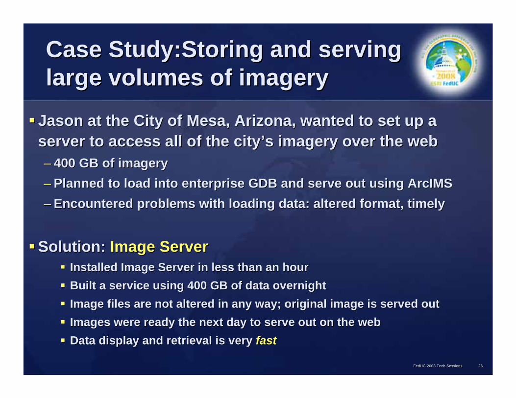
Case Study:Storing and serving Case Study:Storing and serving large volumes of imagerylarge volumes of imagery
Jason at the City of Mesa, Arizona, wanted to set up a Jason at the City of Mesa, Arizona, wanted to set up a server to access all of the cityserver to access all of the city’’s imagery over the webs imagery over the web–– 400 GB of imagery400 GB of imagery–– Planned to load into enterprise GDB and serve out using ArcIMSPlanned to load into enterprise GDB and serve out using ArcIMS–– Encountered problems with loading data: altered format, timelyEncountered problems with loading data: altered format, timely
Solution: Solution: Image ServerImage ServerInstalled Image Server in less than an hourInstalled Image Server in less than an hourBuilt a service using 400 GB of data overnightBuilt a service using 400 GB of data overnightImage files are not altered in any way; original image is servedImage files are not altered in any way; original image is served outoutImages were ready the next day to serve out on the webImages were ready the next day to serve out on the webData display and retrieval is very Data display and retrieval is very fastfast
FedUC 2008 Tech SessionsFedUC 2008 Tech Sessions 2626

Storing and serving imagery: Storing and serving imagery: Image ServerImage Server
Efficiently manages, accesses and serves large amounts of Efficiently manages, accesses and serves large amounts of filefile--based imagerybased imagery
FedUC 2008 Tech SessionsFedUC 2008 Tech Sessions 2727
•• Image processing onImage processing on--thethe--flyfly•• Multiple products served from one imageMultiple products served from one image•• Reduces time between image acquisition Reduces time between image acquisition
and distributionand distribution
Digital GlobeDigital Globe

Sharing Your Geographic DataSharing Your Geographic DataDaisy works for a large state environmental protection departmenDaisy works for a large state environmental protection department and t and needs to create a Web site toneeds to create a Web site to–– Allow the public to search the agencyAllow the public to search the agency’’s geographic datas geographic data–– Produce maps from their home computersProduce maps from their home computers–– Allow the public to complete simple tasks, like finding their adAllow the public to complete simple tasks, like finding their address or dress or
measuring distances on the mapmeasuring distances on the mapOllie spends a lot of his day creating maps requested by city emOllie spends a lot of his day creating maps requested by city employeesployees–– He is the only fullHe is the only full--time GIS staff member and hardly has time to devote to GIS time GIS staff member and hardly has time to devote to GIS
maintenance taskmaintenance task–– If only there were a way to create an internal website that helIf only there were a way to create an internal website that helped city ped city
employees create their own maps and make edits, if necessaryemployees create their own maps and make edits, if necessaryRocky works at a big electric distribution companyRocky works at a big electric distribution company–– They have a large amount of GIS dataThey have a large amount of GIS data–– Over 100 GIS Technicians who need to enter new work ordersOver 100 GIS Technicians who need to enter new work orders–– How can he store this much data and still let all those people aHow can he store this much data and still let all those people access it at one ccess it at one
time?time?
FedUC 2008 Tech SessionsFedUC 2008 Tech Sessions 2828

Introducing ArcGIS ServerIntroducing ArcGIS ServerArcGIS Server meets two major GIS needs:ArcGIS Server meets two major GIS needs:
Data ManagementData ManagementWeb Mapping ApplicationsWeb Mapping Applications
ArcGIS Server comes in three levels:ArcGIS Server comes in three levels:
FedUC 2008 Tech SessionsFedUC 2008 Tech Sessions 2929
Geoprocessing &Geoprocessing &EditingEditing
Mapping &Mapping &VisualizationVisualization
Data ManagementData Management
AdvancedAdvanced
StandardStandard
BasicBasic
Three Levels of FunctionalityThree Levels of Functionality

What are the three levels of ArcGIS What are the three levels of ArcGIS Server?Server?
Advanced Standard Basic
Multiuser Geodatabase
Web-based Replication
Web Mapping
Globe Server
Web-based Geoprocessing Limited
Web-based Editing
FedUC 2008 Tech SessionsFedUC 2008 Tech Sessions 3030

Which level is right for me?Which level is right for me?Daisy needed to make a publicly Daisy needed to make a publicly accessible website so the public could accessible website so the public could search & view her agencysearch & view her agency’’s datas data
Ollie needed to make an internally Ollie needed to make an internally accessible website so his fellow city accessible website so his fellow city workers could search, view and workers could search, view and possibly edit their data layerspossibly edit their data layers
Rocky needed to set up a database that Rocky needed to set up a database that could accommodate a large amount of could accommodate a large amount of data and many simultaneous editorsdata and many simultaneous editors
FedUC 2008 Tech SessionsFedUC 2008 Tech Sessions 3131
AdvancedAdvanced
StandardStandard
BasicBasic

ArcGIS Server Upgrade PathsArcGIS Server Upgrade PathsDoes some of this sound familiar?Does some of this sound familiar?Is it possible you already have this software?Is it possible you already have this software?Have you ever heard of ArcSDE or ArcIMS?Have you ever heard of ArcSDE or ArcIMS?
FedUC 2008 Tech SessionsFedUC 2008 Tech Sessions 3232
Provided As Part of MaintenanceProvided As Part of Maintenance
9.19.19.29.2
ArcGISServer
ArcIMS
ArcSDE
AdvancedAdvanced
StandardStandard
BasicBasic

How do people view my published How do people view my published map?map?
Using a web browser, Using a web browser, they could simply type in they could simply type in your URL or follow a link your URL or follow a link from your websitefrom your website
If they already have If they already have ArcGIS Desktop, they ArcGIS Desktop, they could view your map in could view your map in ArcMapArcMap
They could download & They could download & use ArcGIS Exploreruse ArcGIS Explorer
FedUC 2008 Tech SessionsFedUC 2008 Tech Sessions 3333

WhatWhat’’s ArcGIS Explorer?s ArcGIS Explorer?ItIt’’s a free, easy to use s a free, easy to use program available for program available for download. It brings GIS to download. It brings GIS to everyone!everyone!Enable corporate Enable corporate geoprocessing tasksgeoprocessing tasksArcGIS Explorer can use ArcGIS Explorer can use maps/tasks served by maps/tasks served by ArcGIS Server as well as ArcGIS Server as well as data stored locallydata stored locally
FedUC 2008 Tech SessionsFedUC 2008 Tech Sessions 3434

Using online content Using online content –– ArcGIS ArcGIS OnlineOnline
Online services hosted by ESRIOnline services hosted by ESRI–– Utilizes caching for fast performanceUtilizes caching for fast performance
Available servicesAvailable services–– PrePre--built 2D and 3D base mapsbuilt 2D and 3D base maps–– Reference layersReference layers–– TasksTasks
FedUC 2008 Tech SessionsFedUC 2008 Tech Sessions

Availability of ArcGIS Online Availability of ArcGIS Online servicesservices
Standard servicesStandard services–– Free to ArcGIS Desktop usersFree to ArcGIS Desktop users–– Free to ArcGIS Server users during development and testingFree to ArcGIS Server users during development and testing
Subscription required for deployment with ArcGIS ServerSubscription required for deployment with ArcGIS Server
Premium servicesPremium services–– Subscription service for all ArcGIS usersSubscription service for all ArcGIS users–– Includes high resolution imageryIncludes high resolution imagery
Content sharing programContent sharing program–– Share your services with other ArcGIS Online usersShare your services with other ArcGIS Online users
FedUC 2008 Tech SessionsFedUC 2008 Tech Sessions

Storing Your Geographic DataStoring Your Geographic Data
YouYou’’ll probably need to store or maintain many ll probably need to store or maintain many different layers to ensure your projects are successful.different layers to ensure your projects are successful.•• Street centerlinesStreet centerlines •• Active oil/gas leasesActive oil/gas leases•• Water lateralsWater laterals •• Cell phone towersCell phone towers•• Customer locationsCustomer locations •• First responder stationsFirst responder stations•• Flood zonesFlood zones •• Animal habitatsAnimal habitats•• Power polesPower poles •• Aquifer protection areasAquifer protection areas•• Aerial photographsAerial photographs •• EncampmentsEncampments•• Contour linesContour lines •• and many moreand many more……
FedUC 2008 Tech SessionsFedUC 2008 Tech Sessions 3737
•• WhatWhat’’s the best way to do that?s the best way to do that?
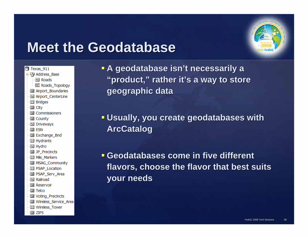
Meet the GeodatabaseMeet the GeodatabaseA geodatabase isnA geodatabase isn’’t necessarily a t necessarily a ““product,product,”” rather itrather it’’s a way to store s a way to store geographic datageographic data
Usually, you create geodatabases with Usually, you create geodatabases with ArcCatalogArcCatalog
Geodatabases come in five different Geodatabases come in five different flavors, choose the flavor that best suits flavors, choose the flavor that best suits your needsyour needs
FedUC 2008 Tech SessionsFedUC 2008 Tech Sessions 3838

Which geodatabase is right for Which geodatabase is right for me?me?
Josh works for an energy companyJosh works for an energy company–– Much of their well, lease and production data is already stored Much of their well, lease and production data is already stored in in
a Microsoft Access databasea Microsoft Access database–– He wants to store their geographic data alongside the existing He wants to store their geographic data alongside the existing
information and link the two parts togetherinformation and link the two parts together
Quentin is employed at the City of NormanQuentin is employed at the City of Norman–– He works with five other GIS staff membersHe works with five other GIS staff members–– Their job is to maintain the CityTheir job is to maintain the City’’s geographic datas geographic data–– They donThey don’’t have an enormous amount of data or a big budget, t have an enormous amount of data or a big budget,
but all six of them need to edit the Citybut all six of them need to edit the City’’s data at the same times data at the same time
FedUC 2008 Tech SessionsFedUC 2008 Tech Sessions 3939
EnterpriseGDB
FileFileGDBGDB
WorkgroupGDB
PersonalGDB
NEW
Personal(Access)
NEW
NEW

Which geodatabase is right for Which geodatabase is right for me?me?
•• Lulu works for a small electric cooperativeLulu works for a small electric cooperative•• She is the main GIS staff memberShe is the main GIS staff member•• Occasionally others use the GIS database as wellOccasionally others use the GIS database as well•• They have a fair amount of data to store, although Lulu is the oThey have a fair amount of data to store, although Lulu is the only nly
person authorized to edit their dataperson authorized to edit their data
•• Riley is a park ranger at a lake managed by the US Army Riley is a park ranger at a lake managed by the US Army Corps of EngineersCorps of Engineers•• He uses his geodatabase to make maps and complete projectsHe uses his geodatabase to make maps and complete projects•• Edits are only done by the district office that oversees his lakEdits are only done by the district office that oversees his lake e •• He needs a lowHe needs a low--cost geodatabase that can receive updates cost geodatabase that can receive updates
““pushed downpushed down”” by the district GIS supervisors via their networkby the district GIS supervisors via their network
FedUC 2008 Tech SessionsFedUC 2008 Tech Sessions 4040
EnterpriseGDB
FileFileGDBGDB
WorkgroupGDB
PersonalGDB
NEW
Personal(Access)
NEW
NEW

Which geodatabase is right for Which geodatabase is right for me?me?
Roy is the GIS manager at a large civil Roy is the GIS manager at a large civil engineering/consulting companyengineering/consulting company–– They have many GB of data to store, including aerial They have many GB of data to store, including aerial
photographs and lots of vector dataphotographs and lots of vector data–– He needs a geodatabase that will hold a lot of data and He needs a geodatabase that will hold a lot of data and
accommodate a lot of users at the same timeaccommodate a lot of users at the same time–– He also requires the geodatabase to be as secure as He also requires the geodatabase to be as secure as
possiblepossible–– He needs to make backup copies of the databaseHe needs to make backup copies of the database
FedUC 2008 Tech SessionsFedUC 2008 Tech Sessions 4141
EnterpriseGDB
FileFileGDBGDB
WorkgroupGDB
PersonalGDB
NEW
Personal(Access)
NEW
NEW

Geodatabase specificationsGeodatabase specificationsSize/Hardware Size/Hardware
limitslimitsMultiuser editing?Multiuser editing?
PersonalPersonal(Access)(Access)
2 GB limit2 GB limit NoNo
FileFile Each table = 1 TBEach table = 1 TB NoNo
Personal Personal (ArcSDE)(ArcSDE)
4 GB limit4 GB limitUses only 1 CPU and up to 1 GB RAMUses only 1 CPU and up to 1 GB RAM
NoNoUp to 3 connections, one editing at a timeUp to 3 connections, one editing at a time
WorkgroupWorkgroup 4 GB limit4 GB limitUses only 1 CPU and up to 1 GB RAMUses only 1 CPU and up to 1 GB RAM
YesYesUp to 10 connections, all of which may editUp to 10 connections, all of which may edit
EnterpriseEnterprise(SQL Server, DB2, (SQL Server, DB2, Oracle, Informix)Oracle, Informix)
No size limitNo size limit YesYes
FedUC 2008 Tech SessionsFedUC 2008 Tech Sessions 4242
EnterpriseGDB
FileFileGDBGDB
WorkgroupGDB
PersonalGDB
Personal(Access)
Works only with SQL Server 2005 Express

Product Scenario #1Product Scenario #1
The Sooner Energy Company The Sooner Energy Company –– 6 GIS analysts and 2 GIS managers6 GIS analysts and 2 GIS managers–– Need to start incorporating 3D analysis and terrains into their Need to start incorporating 3D analysis and terrains into their workwork–– Right now, everyone keeps their own data on their own computersRight now, everyone keeps their own data on their own computers–– The rest of the company (~100 employees) could benefit from the The rest of the company (~100 employees) could benefit from the
opportunity to view and perform simple spatial analysisopportunity to view and perform simple spatial analysis
What should they do?What should they do?
FedUC 2008 Tech SessionsFedUC 2008 Tech Sessions 4343

Product Scenario #1Product Scenario #1
2 ArcInfo licenses for GIS managers2 ArcInfo licenses for GIS managers
6 concurrent ArcView licenses for GIS analysts6 concurrent ArcView licenses for GIS analysts
Concurrent 3D Analyst extensionConcurrent 3D Analyst extension
ArcGIS Server Standard for WorkgroupsArcGIS Server Standard for Workgroups–– 10 user connection limit for database10 user connection limit for database–– Internally accessible web mapping siteInternally accessible web mapping site
FedUC 2008 Tech SessionsFedUC 2008 Tech Sessions 4444

Product Scenario #2Product Scenario #2A mediumA medium--sized city would like to implement ArcGIS for sized city would like to implement ArcGIS for their several departments: Planning, Water, DoT, etctheir several departments: Planning, Water, DoT, etc……–– They have been using GIS (mostly Workstation) for 20 years and wThey have been using GIS (mostly Workstation) for 20 years and want ant
to look into the newer productsto look into the newer products
Their needs:Their needs:–– ~ 20 employees need access to the GIS software for editing, anal~ 20 employees need access to the GIS software for editing, analysis ysis
and mappingand mapping–– Reduce redundant data by using a centralized databaseReduce redundant data by using a centralized database–– Dozens of nonDozens of non--GIS employees cityGIS employees city--wide would benefit from GISwide would benefit from GIS--
related web applications to perform geocoding and routing analysrelated web applications to perform geocoding and routing analyses es for tasks such as reading meters and querying city datafor tasks such as reading meters and querying city data
–– TheyThey’’d like the public to be able to view and browse certain datasetsd like the public to be able to view and browse certain datasetsonlineonline
FedUC 2008 Tech SessionsFedUC 2008 Tech Sessions 4545

What software should this city What software should this city look into?look into?
Desktop mapping, Desktop mapping, editing, and analysis editing, and analysis needs for 20 peopleneeds for 20 people
ArcGIS DesktopArcGIS Desktop–– ArcEditor or ArcInfo ArcEditor or ArcInfo
for editing in the for editing in the central databasecentral database
–– ArcView could be ArcView could be used for basic used for basic mappingmapping
–– A combination of A combination of license levels would license levels would be recommendedbe recommended
FedUC 2008 Tech SessionsFedUC 2008 Tech Sessions 4646
•• A centralized database that A centralized database that everyone can accesseveryone can access–– Multiuser editing, backup, Multiuser editing, backup,
securitysecurity
•• GIS web application for the GIS web application for the public to search for city public to search for city information based on home information based on home address (311 system)address (311 system)
•• GIS web applications for GIS web applications for employees (routing, analysis employees (routing, analysis etcetc……))
ArcGIS ServerArcGIS Server(Advanced with Network Extension)(Advanced with Network Extension)
WrapWrap--up: Where to go for more up: Where to go for more informationinformation
ESRI product overviews: ESRI product overviews: http://www.esri.comhttp://www.esri.com
ESRI training options: ESRI training options: http://training.esri.comhttp://training.esri.com
Contact your account manager at your regional officeContact your account manager at your regional office
FedUC 2008 Tech SessionsFedUC 2008 Tech Sessions 4747
WrapWrap--upupAny questions?Any questions?Thank you for attending, and Good Luck!Thank you for attending, and Good Luck!
Natalie VinesNatalie VinesInstructorInstructor
FedUC 2008 Tech SessionsFedUC 2008 Tech Sessions 4848