Embed Size (px)
Citation preview

WATERFALL RESIDENTIAL DEVELOPMENT – PORTIONS 6&7 OF FARM 1159, WATERFALL, STELLENBOSCH
PUBLIC PARTICIPATION
PUBLIC PARTICIPATION PROCESS
Public participation is the involvement of all parties who potentially have an
interest in a development or project, or may be affected by it. The principal
objective of public participation in an Environmental Impact Assessment
process, in particular this Basic Assessment, is to inform and enrich decision-
making.
PROCESS FOLLOWED TO DATE
The following process was undertaken to facilitate the 1st round Public
Participation Process for the proposed project, which commenced on Friday
15 February 2013 until Thursday 4 April 2013.
1.1.1 Newspaper advertisement
An advertisement, notifying the public of the Basic Assessment
process and requesting Interested and Affected Parties (I&APs) to
register with and submit their comments to Guillaume Nel
Environmental Consultants (GNEC), was placed in the Eikestad Nuus
Newspaper on Friday 15 February 2013. A copy of the
advertisement is attached to the Basic Assessment Document.
1.1.2 Site notice
To inform surrounding communities and immediately adjacent
landowners of the proposed development, two notices were erected
on site at visible and accessible locations close to the site Friday 15
February 2013.
Site notices were erected at the following points:
At the entrance to the site,
On the site.
1.1.3 Direct notification of identified I&APs
Identified I&APs, including key stakeholders representing the following
sectors, were directly informed of the proposed development by post
on Friday 15 February 2013.
Provincial Authorities

WATERFALL RESIDENTIAL DEVELOPMENT – PORTIONS 6&7 OF FARM 1159, WATERFALL, STELLENBOSCH
Local Authorities
Service providers
Ward Councillors
Non-governmental organizations, and
Directly adjacent landowners.
1.1.4 Hand-delivered notifications
Background Information Notification Letters were hand-delivered to
adjacent landowners within 100 metres of the proposed residential
development on Friday 15 February 2013, to notify and inform them
of the proposed project.
1.1.5 Concerns raised by I&APs
I&APs will register by completing registration forms and forwarding comments by email, fax, post and telephonically.
Comments received from I&APs will be captured on a stakeholder
database, acknowledged by personal letters and forwarded to the
relevant environmental specialists for consideration.
COMMENT AND RESPONSE REPORT
Comments and issues of concern contributed by I&APs will be listed, along
with the I&APs name and means of communication in the Comment and
Response Report.
CONCLUSION
The most significant concerns to be raised by I&APs will be summarised here
as a conclusion to the Public Participation section:
I&APs to respond and who are most likely to be affected by the
proposed development are:
NGO’s
Directly adjacent neighbours
Provincial Authorities

WATERFALL RESIDENTIAL DEVELOPMENT – PORTIONS 6&7 OF FARM 1159, WATERFALL, STELLENBOSCH Basic Assessment
E-3 COMMENT AND RESPONSE REPORT
WATERFALL RESIDENTIAL DEVELOPMENT ON PORTIONS 6 & 7 OF FARM 1159, WATERFALL IN STELLENBOSCH, WESTERN CAPE
Issues / comment raised by:
Date Means of communication
Issue / comment Response
«Name» «Date » «Means » «Comment» «Response» Mr. Dunbar Crewe-Brown
15 February 2013 E-mail Could you kindly email me the notification that you just dropped off.
E-mailed BID.
«Name» «Date » «Means » «Comment» «Response» Sahndya Naidoo (Werksmans Attorneys)
20 February 2013 E-mail Kindly send me a copy of the Basic Assessment Report and EMP.
Forward BAR and EMP.
«Name» «Date» «Means» «Comment» «Response» Sachar Radhakrishnan (Werksmans Attorneys)
21 February 2013 E-mail I refer to the above matter and our telephonic conversation. Please can you confirm receipt of the Werksmans and La Gronne registration and comment sheets as stated on our conversation.
Confirmed receipt.
«Name» «Date » «Means » «Comment» «Response» Mr. Pieter Schaafsma (for SIG)
23 February 2013 E-mail I refer to above-mentioned EIA and I would be grateful if you could register the Stellenbosch Interest Group (SIG) as an IAP. Could you please send me an electronic copy of the registration and comment sheet so that I can provide you with the necessary contact information of the SIG. An electronic copy of the BID (document) would also be helpful.
Forwarded a copy of the BID with registration form.
«Name» «Date » «Means » «Comment» «Response» Tamara Crewe-Brown 27 February 2013 E-mail Further to my telephonic conversation with
your office yesterday please can you email me the draft BAR document for Ptn 6 & 7,
Forwarded draft BAR and EMP en confirmed registration.
WATERFALL RESIDENTIAL DEVELOPMENT – PORTIONS 6&7 OF FARM 1159, WATERFALL, STELLENBOSCH Basic Assessment
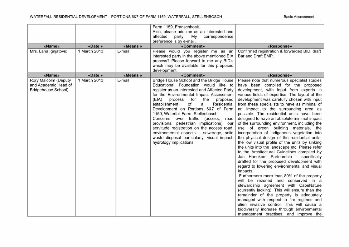
Farm 1159, Franschhoek. Also, please add me as an interested and affected party. My correspondence preference is by e-mail.
«Name» «Date » «Means » «Comment» «Response» Mrs. Lana Ignjatovic 1 March 2013 E-mail Please would you register me as an
interested party in the above mentioned EIA process? Please forward to me any BID’s which may be available for this proposed development.
Confirmed registration & forwarded BID, draft Bar and Draft EMP.
«Name» «Date » «Means » «Comment» «Response» Rory Malcolm (Deputy and Academic Head of Bridgehouse School)
1 March 2013 E-mail Bridge House School and the Bridge House Educational Foundation would like to register as an Interested and Affected Party for the Environmental Impact Assessment (EIA) process for the proposed establishment of a Residential Development on Portions 6&7 of Farm 1159, Waterfall Farm, Stellenbosch. Concerns over traffic (access, road provisions, pedestrian implications), our servitude registration on the access road, environmental aspects – sewerage, solid waste disposal particularly, visual impact, hydrology implications.
Please note that numerous specialist studies have been compiled for the proposed development, with input from experts in various fields of expertise. The layout of the development was carefully chosen with input from these specialists to have as minimal of an impact to the surrounding area as possible. The residential units have been designed to have an absolute minimal impact of the surrounding environment, including the use of green building materials, the incorporation of indigenous vegetation into the physical design of the residential units, the low visual profile of the units by sinking the units into the landscape etc. Please refer to the Architectural Guidelines compiled by Jan Hanekom Partnership - specifically drafted for the proposed development with regard to lowering environmental and visual impacts. Furthermore more than 80% of the property will be rezoned and conserved in a stewardship agreement with CapeNature (currently lacking). This will ensure than the remainder of the property is adequately managed with respect to fire regimes and alien invasive control. This will cause a biodiversity increase through environmental management practises, and improve the

WATERFALL RESIDENTIAL DEVELOPMENT – PORTIONS 6&7 OF FARM 1159, WATERFALL, STELLENBOSCH Basic Assessment
overall habitat quality. Given the prime location of the property and the surrounding luxury equestrian estates, there is definitely a demand for similar luxury estates. The broader community will also benefit from the proposed development through the creation of temporary and permanent employment opportunities. Application is made for 12 residential dwellings on the subject property. This will give rise to approximately 24 additional vehicles (approx. two per residence). It is GNECs’ opinion that this will not constitute a significant traffic impact. Also given the location of the property and the distance to retail complexes, it is also unlikely that more than two vehicular trips per residence will be made on a daily basis. GNEC is of the opinion that the legally binding Environmental Management Plan will be enforced, and will be adequate to mitigate all potential negative impacts, during the construction and/or Operational phase. Waste management activities will be implemented and managed by the Home Owners Association for the proposed residential development. Waste will be removed from the subject properties at regular intervals and removed to a registered landfill site. Effluent and sewerage will flow into a suitably sized conservancy tank and regularly serviced by an accredited/registered service provider, using a “honeysucker” to remove the waste from the premises. Please note that a comprehensive Visual Impact Assessment has been compiled for the proposed residential development.

WATERFALL RESIDENTIAL DEVELOPMENT – PORTIONS 6&7 OF FARM 1159, WATERFALL, STELLENBOSCH Basic Assessment
The conclusions of the VIA are as follows: “The property is barely and intermittently visible from the R45 travelling east towards Franschoek. Travelling west on the R45 the property is visible from the R301 intersection however, due to the distance from this viewpoint (approximately 5km) the property is barely visible. The R45 & R301 have been identified as view corridors and the intersection the only significant viewpoint. There are no view cones from significant cultural or heritage precincts” “It should be noted that agriculture has been considered on this site and it was found to be not viable. In addition, the Department of Agriculture, Forestry and Fisheries has given written notice that they have no objection to the proposed development. Should the development not occur, it is expected that the integrity of the vulnerable Boland Granite Fynbos, partially infested with alien invasive plant species, (and thus the integrity of the visual character of the site) will deteriorate incrementally. A well placed and designed low density residential development with an agreed stewardship program with Cape Nature (to manage the vulnerable Boland Granite Fynbos character) is therefore, in our view, the best practicable option for this property.
It is recommended that with the implementation of the mitigation measures set out above and, the development of well considered landscape & architectural guidelines, this development be approved by Heritage Western Cape.” The abovementioned together with the Architectural Guidelines compiled by Jan

WATERFALL RESIDENTIAL DEVELOPMENT – PORTIONS 6&7 OF FARM 1159, WATERFALL, STELLENBOSCH Basic Assessment
Hanekom Partnership specifically designing the residential units to blend into the natural environment as much of possible causes the development not to be visually significant.
«Name» «Date » «Means » «Comment» «Response» Mr. & Mrs. Dunbar Crewe-Brown
11 March 2013 E-mail Please register myself, as well as my wife as I&APs. Our preference is for e-mail communication.
Confirmed registration.
«Name» «Date » «Means » «Comment» «Response» Mr. Dunbar Crewe-brown
12 March 2013 E-mail Thanks and noted. Confirmed registration.
«Name» «Date » «Means » «Comment» «Response» Mrs. Dee Gaszynska 2 April 2013 E-mail Your letter dated 13 February 2013 entitled
“Invitation to Participate: The Rezoning, Construction and Establishment of a Residential Development on Portions 6 & 7 of Farm 1159, Waterfall, Stellenbosch, Western Cape” refers.
Noted.
«Name» «Date » «Means » «Comment» «Response» P.A. Turner (Turner Family Trust)
4 April 2013 E-mail We reside directly adjacent and to the West of Farm 1159, and will be most considerably affected by any development on this site. Please register the Turner Family Trust as an affected party in the process. We object to the proposed development of this site, including rezoning of the site from agricultural to residential, as well as the subdivision to form 12 residential erven. Introduction I am participating in the response to the EIA as a trustee of the Turner Family Trust that owns the adjacent property; Farm No 1368 portion 1, to the proposed development. I have lived in the area since 1993 and
Please note that numerous specialist studies have been compiled for the proposed development, with input from experts in various fields of expertise. The layout of the development was carefully chosen with input from these specialists to have as minimal of an impact to the surrounding area as possible. The residential units have been designed to have an absolute minimal impact of the surrounding environment, including the use of green building materials, the incorporation of indigenous vegetation into the physical design of the residential units, the low visual profile of the units by sinking the units into the landscape etc. Please refer to the Architectural Guidelines compiled by Jan Hanekom Partnership - specifically drafted for the proposed development with

WATERFALL RESIDENTIAL DEVELOPMENT – PORTIONS 6&7 OF FARM 1159, WATERFALL, STELLENBOSCH Basic Assessment
have occupied the current farm since 1999. My comments should be viewed as cause for concern that proposed development will exacerbate the negative impact of the recent developments that have taken place in the area over the past years and their impact on the environment. The proposal to subdivide and develop a residential development on the Portions 6 & 7 of farm 1159 in the Groot Drakenstein area comes as surprise and disappointment considering that the property has remained undeveloped until now. I have found that the depth of the research that has been conducted in compiling the Environmental Impact Assessment for such a proposed development to be totally inadequate given the depth of important sensitive environmental issues that such a site contains. I will attempt to illustrate these shortcomings in my response below. General Comments a. The lack of capacity letters from the
local authority for the provision of all services is missing from the EIA document. The application should be rejected on this ground as a matter of course and should not be considered until this aspect is addressed.
b. The proposed development falls within 500m of a watercourse so the provisions of the water act apply. The development will need to apply for a water use licence up front and this is not dealt with in the document
regard to lowering environmental and visual impacts. The following specialist studies has been compiled as part of the proposed development: 1) Botanical Assessment and re-assessment 2) Freshwater Impact Assessment 3) Geo-Hydrological Stream Mapping 4) Heritage Impact Assessment 5) Visual Impact Assessment The project proposes the construction of 12 luxury chalets clustered at approximately 100 meter intervals along the existing gravel road on portion 6 only. Portions 6 & 7 are proposed to be consolidated with a 2000m
2
Erf defined around each residential unit rezoned to Resort Zone 2 (in total 2.4ha) and the remainder of the property (41.1ha) will be rezoned Open Space 3 (Nature Reserve). The latter is to be managed as part of the adjoining nature reserve by the Property Owners Association in a Stewardship agreement with CapeNature. CapeNature has already confirmed that they will not oppose the proposed development subject to the fact that the remaining 41.1ha of the property will be rezoned Open Space 3 – Nature Reserve, the latter is to be managed as part of the adjoining Hottentots Holland Nature Reserve by the Property Owners Association in a Stewardship agreement with CapeNature.

WATERFALL RESIDENTIAL DEVELOPMENT – PORTIONS 6&7 OF FARM 1159, WATERFALL, STELLENBOSCH Basic Assessment
c. The proposal is in contradiction of the subdivision of agricultural land act.
d. The statement (page 19) Re Compliance with the structure plan for the area is not true. The proposal complies with an element of the plan but not with many other elements of the plan, so on balance it is not compliant at all.
e. The lack of a specialist study dealing with fauna (vertebrate and invertebrate) is a basic flaw.
e. The supposed housing need being addressed by this application is not true. The housing need is for low income housing, hardly addressed in this proposal. The high income group will buy into this area precisely because of the qualities in the area which would be compromised by this type of development.
f. The statement that this proposal is close to or an extension of Franschoek and Stellenbosch is not true Comments on potential environmental issues Noise pollution. The portion of land that is earmarked for development is a natural linear feature that is used as a natural path of movement by a number of wild animals in the area. The situation of the houses in the suggested location will create a barrier to the movement for these animals and the potential of upward of 50 people living within the confines of a hectare will certainly create noise that will disturb the fauna. The movement of up to 30 vehicles per day
The Western Cape Department of Agriculture has already confirmed that they will not oppose the proposed development on condition that a stewardship agreement is reached with CapeNature in terms of Open Space 3. The Stellenbosch Municipal Spatial Development Framework (Draft Strategies Report March 2010) guides land use management decisions. Although primarily aimed at developing strategies related to the growth of settlements, it acknowledges the important role of agriculture in driving the local economy. Of relevance to the proposed development are the following proposals: Promote the use of land outside of
existing and proposed urban settlements for agricultural production, bio-diversity conservation (GNEC is of the opinion that the proposed development will promote biodiversity conservation in the direct area through the stewardship agreement with CapeNature. The remaining 41.1ha of the property will be rezoned Open Space 3 – Nature Reserve, the latter is to be managed as part of the adjoining Hottentots Holland Nature Reserve by the Property Owners Association in a Stewardship agreement with CapeNature.) , scenic quality (The proposed development will not detract from the visual character of the surrounding areas, as defined in the compiled Visual Impact Assessment) and agri tourism.
WATERFALL RESIDENTIAL DEVELOPMENT – PORTIONS 6&7 OF FARM 1159, WATERFALL, STELLENBOSCH Basic Assessment
during the habitation of the proposed houses will create a permanent noise disturbance that will displace any fauna from the area. A lengthy construction period of 12 – 24 months would set a precedent for noise and disturbance to the area, which would permanently affect fauna. Heritage Impact No Comment Traffic Impact The peak traffic load could exceed 30 vehicles per day. The current roads cannot handle the volume of traffic, as they are single lane roads (3 m). The current road services a total of seven households. The proposed development would increase the traffic by more 100 percent. There is no room to widen these roads. The current owners would also not agree to the widening of the road. The increase in traffic would impact on the agricultural activities in the area with livestock being negatively impacted on by the increase in dust and the noise on the roads. The current servitude through the Bridge House School would also be negatively impacted upon by an increase in traffic. The safety of the movement of animals,
Encourage the use of currently fallow land for agricultural or biodiversity conservation purposes (GNEC is of the opinion that the proposed development will promote biodiversity conservation in the direct area through the stewardship agreement with CapeNature. The remaining 41.1ha of the property will be rezoned Open Space 3 – Nature Reserve, the latter is to be managed as part of the adjoining Hottentots Holland Nature Reserve by the Property Owners Association in a Stewardship agreement with CapeNature.) including land reform projects.
Additionally a comprehensive Heritage Impact Assessment (HIA) and Visual Impact Assessment (VIA) have been compiled for the proposed development, to assess the potential social and cultural impacts. The conclusions of the HIA are as follows: “In summary, the proposal addresses the indicators adequately and the mitigation proposals have already been incorporated” “On the basis of this assessment, it is proposed to be recommended that, in terms of section 38(8) of the NHRA, HWC support the proposed development and allow the development to proceed to the next phase” The conclusions of the VIA are as follows: “The property is barely and intermittently visible from the R45 travelling east towards Franschoek. Travelling west on the R45 the property is visible from the R301 intersection

WATERFALL RESIDENTIAL DEVELOPMENT – PORTIONS 6&7 OF FARM 1159, WATERFALL, STELLENBOSCH Basic Assessment
pedestrians and farm machinery on these roads would be negatively impacted by the proposed increases in volume of traffic. Visual impact The contour height of the development ranges from 180 to above 250 meters. Development of buildings at this height on the mountainside should not be approved as they are an eyesore, infringe on the buffer zone of the National reserve and are a hazard to control fires, which frequent the area. The lights from the proposed houses will have a negative visual impact at night from the R45. Impact on fauna and flora The research that was conducted for the EIA is inadequate in its assessment and conclusion that the proposed development will have no impact on the fauna in the area. The Klein Waterfall River bisects the farm 1159 .The proposed development is sighted immediately adjacent to the river along a drainage line back into the river. The Klein Waterfall River is a tributary to the Waterfall River, which in turn flows into the Berg River. The river system is home to two critically endangered species namely; Cape Bluet damselfly and the Berg River redfin (Pseudobarbus burgi) (Boulenger, 1911) (See Annexure 2).
Cape Bluet
The Cape Bluet was considered extinct until it was rediscoverd in 2003. The
however, due to the distance from this viewpoint (approximately 5km) the property is barely visible. The R45 & R301 have been identified as view corridors and the intersection the only significant viewpoint. There are no view cones from significant cultural or heritage precincts” “It should be noted that agriculture has been considered on this site and it was found to be not viable. In addition, the Department of Agriculture, Forestry and Fisheries has given written notice that they have no objection to the proposed development. Should the development not occur, it is expected that the integrity of the vulnerable Boland Granite Fynbos, partially infested with alien invasive plant species, (and thus the integrity of the visual character of the site) will deteriorate incrementally. A well placed and designed low density residential development with an agreed stewardship program with Cape Nature (to manage the vulnerable Boland Granite Fynbos character) is therefore, in our view, the best practicable option for this property.
It is recommended that with the implementation of the mitigation measures set out above and, the development of well considered landscape & architectural guidelines, this development be approved by Heritage Western Cape.” The estimated daily water demand for similar residential houses is expected to be between 1500 – 2500 litres per day. Given the fact that the residential dwellings will be situated within a natural environment, with limited gardens and no irrigation, the expected water demand per unit will be in the region of 1500

WATERFALL RESIDENTIAL DEVELOPMENT – PORTIONS 6&7 OF FARM 1159, WATERFALL, STELLENBOSCH Basic Assessment
insect has been threatened by habitat invasion (See Annexure 1).
The Berg River Redfin is only found in the tributaries of the Berg River with only a few populations of the Redfin remaining
1. The fish occur in the
presence of the Cape kurper and Cape galaxias, which are all found in the Klein Waterfall River. The Berg River redfin are susceptible to extirpation by alien fish. The Klein waterfall river is important as it is an upper tributary with a natural physical barrier to the introduction of alien fish.
Any disturbances to the river in terms of pollutants, silting or limiting the flow of the river can negatively impact on these endangered species. The proposed construction of two bridges over the Klein Waterfall River would be rigorously opposed given the sensitive nature of the river system. In addition to these extremely vulnerable species the location of a linear development of houses in the suggested location will have a major impact on the number of wild animals that currently utilized the permanent flow in the Klein- waterfall river as a vital source of water during the dry summer months. The location of the houses would limit the habitat range of these animals and would
– 200 litres/unit/day. Hence the daily water demand for the entire development is therefore expected to be 18 – 24 kilolitres.
The closest external potable water system in the form of a 63mm diameter HDPE pipe, is located close to Bridge House School approximately 3 kilometres north of the property. Connection for the development can be provided from the pipeline, but this not preferred due to costs.
It is proposed to abstract water from the existing perennial stream on the property. This water will be treated with some basic filtering and disinfection. A small reservoir in the form of six interconnected 10 000 litre tanks will be provided with a combined storage volume of 60 000 litres. This is sufficient for 48 hours of supply on full occupation.
From the storage reservoir, water will be fed with a constant pressure pump system via an underground pipe system to the individual dwellings.
The average daily sewer flow per dwelling unit is expected to be 800litres/day. On full occupation the expected daily sewer flow generated by the entire development will be 9,60kl. The expected peak flow is 0,45l/s.
The development is proposed as with a split grey and black water system. Plumbing from the residential units will be completely separated for each system.
Greywater is the leftover water from baths,
1 Garrow, C and Marr, S. 2012. Swimming on the Edge of Extinction.

WATERFALL RESIDENTIAL DEVELOPMENT – PORTIONS 6&7 OF FARM 1159, WATERFALL, STELLENBOSCH Basic Assessment
bring the animals into conflict with the human inhabitants. This includes two troops of baboon, leopard, caracul, cape fox, civet cat, genet , riverine mongoose, duiker, klipspringer etc. that inhabit the area. The presence of these animals in the region is confirmed by trip camera footage and personal sitings.
Lowland fynbos is the most threatened sector of the fynbos biome. The proposed area for development is on the fringe zone between mountain and lowland fynbos and contains several rare proteacea species that would be impacted by development. Storm water impact There is no storm water infrastructure on the farm – the report creates the impression that the storm water run-off from roads will have no effect on the environment. This is not true – any proposed development of this nature is likely to introduce an increase in the volume of storm water off- take from hard surfaces that have been introduced. The concern with this run- off is that the externalities of tar surfaces, residual sump oil and diesel will find its way into the very sensitive ecological system in the river as the storm water is most likely to simply be channeled into the river system Water The EIA refers to a borehole on the property –I am not aware of a borehole . If a borehole does exist it has not functioned for
showers, hand basins and washing machines, excluding kitchen sinks. This is expected to be approximately 70% of the total sewerage generated by the development. Grey water will be collected in a separate conservancy tank to be provided at each unit. These tanks will be emptied on a regular basis by an accredited/registered service provider under management of the Home Owners Association. With full occupation of the units it is expected that the tanks will have a minimum storage capacity of 10 days. The expected occupation for the development is 50% which equates to storage capacity of 20 days minimum.
Black water from each residential unit will be collected with a main 160 diameter gravity sewer pipe to discharge into a central black water conservancy tanks of 30 000 litres. This tank will be emptied on a regular basis by an accredited/registered service provider under management of the Home Owners Association. With full occupation of the units it is expected that the tanks will have a minimum storage capacity of 10 days. The expected occupation for the development is 50%, which equates to storage capacity of 20 days minimum.
Solid Domestic Waste will be collected by an accredited/registered service provider under management of the Home Owners Association, and transported to a licensed landfill facility.

WATERFALL RESIDENTIAL DEVELOPMENT – PORTIONS 6&7 OF FARM 1159, WATERFALL, STELLENBOSCH Basic Assessment
at least 15 years that also places a question on where potable water would be sourced for 15 houses. The Klein Waterfall River cannot sustain the drinking water or domestic water requirements for the proposed project. The threatened species in the river system should not be placed at risk due to the insertion of the proposed housing project. The surrounding agricultural properties are dependent on guaranteed clean water sources for wine and livestock production. It is not satisfactory to site a housing development with a sensitive catchment area that services these farms and the environment. The ecological system simply cannot handle the degree of intensity of land use that is proposed. Light Pollution The impact of 12 – 15 housing units will definitely create a visual impact at night from the R45. The external light radiation will have a negative impact in terms of habitat invasion on nocturnal fauna and will have a very negative impact on the destruction of countless insects at night, (see Annexure 3) There are several conclusive scientific studies that record the impact of the light on the decimation of damselfly populations both in South Africa and abroad, (see Annexure 3) Given the vulnerable nature of the Cape Bluet population in the area it would be foolhardy to allow the development and its associated light pollution externalities.
Potential Traffic and Noise impacts: It is expected that there will be a traffic and noise impact during both the construction and operational phase of the development. The traffic and noise impacts during the construction phase will however only be temporary in nature and will only last for a couple of months during construction. GNEC is also of the opinion that the legally binding environmental management plan will be sufficient to mitigate any potential impacts with regard to noise and traffic impacts during the construction phase.
Given that application is only made for 12 low density residential units, it is not expected that any significant noise and traffic impacts will occur during the operational phase of the activity. Potential impacts on Biological and Physical aspects: There will be an impact on biological and physical aspects during both the construction and operational phases of the activity. It is the opinion of GNEC however that this will be adequately mitigated through long term management and improvement of habitat quality as explained below: The layout of the development was carefully chosen with input from these specialists to have as minimal of an impact to the surrounding area and sub-surfaced water resources as possible. Please refer to the attached Geo-Hydrological Stream Mapping Assessment, Freshwater Impact Assessment and

WATERFALL RESIDENTIAL DEVELOPMENT – PORTIONS 6&7 OF FARM 1159, WATERFALL, STELLENBOSCH Basic Assessment
Solid waste, sewage and effluent The EIA reports that the Stellenbosch Municipality will remove the solid waste. Stellenbosch Municipality does not provide any solid waste removal services to the area at all. The introduction of 15 additional residences will create a large amount of domestic waste for which there is no existing service to be removed. The current access road has a ten tonne load limit when crossing the Klein Waterfall River bridge. The Stellenbosch Municipality will not be able to remove effluent as the quantity of sewage that can be removed will be so limited by the bridge’s weight limitation that it will be prohibitively expensive given the number of extra trips to remove the waste from 15 households. This will also needlessly increase the traffic volume on the inadequate road system. The report only deals with sewage but does not deal with grey water from bath, hand basins, washing machines and dish washers etc. If this volume of water also has to be extracted from the area it will create additional traffic , expense and environmental consequences. Given the sensitivity of the ecological system in the area we would oppose any system that could result in any spillage, overflow or leakage into the environment and the Klein Waterfall river system. Objection to rezoning The current land use for farm 1159 is zoned for agricultural and conservation purposes. The proposed rezoning is incongruous with
Botanical Assessments.
According to the National Vegetation Map of South Africa (Mucina & Rutherford 2006) the site falls within the boundary of the Boland Granite Fynbos. Most of the site is still covered in the naturally occurring indigenous vegetation. Boland Granite Fynbos is an ENDANGERED vegetation type according to the rating of the National Biodiversity Assessment (Rouget et al. 2004) and as such should be conserved wherever possible.
More recently it has been classified as Vulnerable D1 in the National List of Threatened Ecosystems. The site is currently covered in fairly dense 1-2m tall closed shrubland with occasional low, gnarled trees dotted through the landscape.
The natural Boland Granite Fynbos vegetation is similar over most of the site and specifically in the areas proposed for residential subdivision. It is species-rich and has high conservation value. However, it has been disturbed in the past by the growth of pine trees which have now mostly been felled. The exceptions are young pine trees that have established and continue to invade the site. In addition alien Hakea sericea is abundant in places and is vigorously invading the fynbos. There is no doubt that if not controlled soon, the problem will become extreme. Australian wattles, notably Acacia longifolia (long leaved wattle) form dense impenetrable stands in places. These trees are also vigorously invading the site, specifically towards the western end. They are seriously negatively impacting the fynbos

WATERFALL RESIDENTIAL DEVELOPMENT – PORTIONS 6&7 OF FARM 1159, WATERFALL, STELLENBOSCH Basic Assessment
the current agricultural activities of the other land use in the area and will lead to clashes in interests with the current agricultural activities. The land is adjacent to a declared nature reserve and is an important buffer zone from agricultural activities. The conversion to residential would be detrimental to the properties ongoing buffer role. The successful rezoning would also lead to a proliferation of the residential activities in a very sensitive ecology. No mention is made in the EIA of the possible use of the balance of the land outside of the proposed subdivision. If the initial development is allowed to go ahead what is the possibility that the balance of the land is simply waiting to be converted into a additional residential development at the Chasmon trust’s behest in the future. The area is part of an existing Spatial Development Plan, which includes areas that are zoned for agriculture and conservation. We urge the authorities to maintain the fabric of the current zoning and land use plan and to reject any changes to the current land use in the area. It is a common practice that where residential land use has been allowed to occur adjacent to Agricultural developments that the residents will over time impinge on the agricultural activities with regards to limiting noise, odours, etc. Objection to subdivision The fabric of maintaining the viability of agricultural or conservation land is to retain core land areas that can sustain viable populations or agricultural profitability. By allowing a pocket of residential activity within a larger viable farming region with its
which is cause for major concern.
Please refer to the Botanical Impact Assessment as compiled by Dr. Dave McDonald attached
It must be noted however that if the proposed development is authorised, more than 80% (41.1ha) of the property will be rezoned, conserved in a stewardship agreement with CapeNature (currently lacking) and managed as part of the adjacent Hottentots Holland Nature Reserve. This will ensure than the remainder of the property is adequately managed with respect to fire regimes and alien invasive control. This will cause a biodiversity increase through environmental management practises, and improve the overall habitat quality. GNEC, in our professional capacity as experienced and qualified environmental consultants believe that the proposed project be issued a positive environmental authorization; however this authorization must be accompanied with the following requirements:
Appointment of an Environmental
Control Officer (ECO) to oversee Full Compliance with the Environmental Management Plan (EMP).
Bi-monthly site audits to ensure compliance and to advise on any mitigation measures necessary to negate any environmental degradation.
The ECO must compile monthly ECO Audit Reports on the state of the environment and areas of compliance and non-compliance with the EMP. These
WATERFALL RESIDENTIAL DEVELOPMENT – PORTIONS 6&7 OF FARM 1159, WATERFALL, STELLENBOSCH Basic Assessment
associated conservation buffer zone is non – sensical and will reduce both conservation and agricultural viability. Conclusion The report highlights the following key concerns:
The EIA is adequate in addressing
environmental issues, The serious environmental conditions
that have been raised require considerable more attention to detail with regards to the environmental impact study of such a proposed development,
The proposed development is
incongruous with the current land use in the area,
The development will invade the habitat
of critically endangered species, The development will negatively impact
on the properties current buffer role to the greater conservancy area,
The residential activity will conflict with
the current agricultural activities in the area,
The proposed additional traffic will
disrupt the current school and farming activities
The management and removal of waste
and effluent is not practical and potentially creates a hazard to sensitive
reports must be made available to DEA&DP. Fines should be included in the EMP to ensure full compliance to the EMP.
Full implementation of the ARCHITECTURAL GUIDELINES compiled by Jan Hanekom Partnership
Full implementation of ALL recommendation/guidelines defined in the Specialist Reports (attached)
The remainder of the property after construction of the residential development (41.1ha) is to be rezoned Open Space 3 (Nature Reserve) and managed as part of the adjoining Hottentots Holland Nature Reserve by the Property Owners Association in a Stewardship agreement with CapeNature.
All domestic waste, effluent and sewerage is to be removed at regular intervals by a accredited service provider and transported for processing to a registered municipal landfill/processing facility.

WATERFALL RESIDENTIAL DEVELOPMENT – PORTIONS 6&7 OF FARM 1159, WATERFALL, STELLENBOSCH Basic Assessment
ecology The ecological impact of the insertion of
bridges, roads and storm water run – off will be negative to and will potentially endanger vulnerable populations and
The threat to water quality and potable
water for both human and agricultural usage by the development is also unacceptable.
Annexures Annexure 1: Cape Bluet
Two damselflies 'brought back from extinction'
Karin Theron, UCT
A beautiful purple damselfly, the Cape Bluet, and his smaller, more delicate relative damselfly, the Ceres Stream Damsel, that were thought to be extinct for decades, were rediscovered by scientists in November 2003 thanks to the felling of invasive alien trees.
According to Prof Michael Samways, an expert on South African dragonflies in the Faculty of Agricultural and Forestry Sciences at the University of Stellenbosch, these two species were believed extinct as they had not been seen for years despite intensive searches. The Cape Bluet had not been seen for 41 years and the Ceres Stream Damsel for an astounding 83 years. This is the latest in a series of remarkable rediscoveries by the Stellenbosch team, which is compiling a list of threatened

WATERFALL RESIDENTIAL DEVELOPMENT – PORTIONS 6&7 OF FARM 1159, WATERFALL, STELLENBOSCH Basic Assessment
species and a field guide.
It seems that these beautiful insects were on the brink of extinction when the Working for Water Programme began removing alien trees. Suddenly, these feared extinct species miraculously reappeared. With removal of the trees, sunlight was able to penetrate the pools, water plants were able to grow and these extremely rare damselflies, with their special adaptations to Cape conditions, were able to thrive once more.
Apart from their intrinsic and aesthetic value, dragonflies and damselflies are now recognised as indicators of riverine integrity. Among the insects most affected by aggressive alien trees are the dragonflies and their delicate relatives the damselflies. Some live in streams and others in the wetlands, where the pressure upon them is enormous. Often the impacts are compounded with cattle trampling aggravating the impact of the aliens. These impacts are particularly severe because populations of dragonflies and damselflies are already pushed to the limit through drainage and conversion of their wetland homes. With their habitats reduced and separated they find it increasingly difficult to find new localities when one pool dries out. They are left with nowhere to go. Also, their genetic flexibility is reduced as their populations become increasingly small.
Clearly, it is critical to keep removing invasive aliens to protect wetlands,

WATERFALL RESIDENTIAL DEVELOPMENT – PORTIONS 6&7 OF FARM 1159, WATERFALL, STELLENBOSCH Basic Assessment
including small pools, which are the special habitats of these unusual and fascinating insects. Research continues, with more species being brought back from the brink of extinction. The task is urgent now to record, not just how our special fauna is declining because of alien plants, but also how do we best manage our wetlands to ensure that our unique natural heritage recovers fully.
The biodiversity crisis is reaching such proportions that it is estimated that as many as a quarter of all insect species will be extinct within the next few decades. Other estimates suggest that between 7 and 30 insect species is already going extinct every week.
These figures are important for South Africa because the country is one of the most biodiversity-rich countries in the world. Within its borders are two world-class biodiversity hotspots: that Cape Floristic Region and the Succulent Karoo.
The Cape Floristic Region is rich in endemic species of insects, as well as plants, that occur in the Western Cape and nowhere else. These insects are under severe threat from many environmental pressures. Among these threats are invasive alien trees. These foreign trees shade out the habitat and cause a decline in the insect species that are normally used to very sunlit conditions. Nowhere is it so severe as along water courses. Wattle trees are the worst of offenders, because they stifle local vegetation and completely change the local ecology.

WATERFALL RESIDENTIAL DEVELOPMENT – PORTIONS 6&7 OF FARM 1159, WATERFALL, STELLENBOSCH Basic Assessment
Annexure 3: Impact of artificial light on invertebrates
Executive summary from:
Charlotte Bruce-White and Matt Shardlow 2011. A Review of the Impact of Artificial Light on Invertebrates. March 2011 ISBN 978-1-904878-99-5 © Buglife – The Invertebrate Conservation Trust
1. Executive summary
This report reviews the available literature on how humans are changing the light environment and the impact that this has on insects and other invertebrates, makes recommendations and identifies several further research areas.
Conclusions
1. Developments in lighting technology have led to major increases in the distribution and intensity of artificial light in the past few decades and its growth is continuing largely unchecked.
2. Artificial light has the potential to significantly disrupt ecosystems and it has long been of concern to conservationists. It is widely observed that some invertebrates, such as moths, are attracted to artificial lights at night. In addition the polarisation of light by shiny surfaces is a significant problem as it attracts aquatic insects, particularly egg laying females, away from water, and reflected light has the potential to attract pollinators and impact on their populations, predators

WATERFALL RESIDENTIAL DEVELOPMENT – PORTIONS 6&7 OF FARM 1159, WATERFALL, STELLENBOSCH Basic Assessment
and pollination rates.
3. Artificial light can significantly disrupt the natural light/dark patterns. Many invertebrates depend on the natural rhythms of day-night and seasonal and lunar changes to light levels. As a result artificial lighting has several negative impacts on a wide range of invertebrates including disrupting their feeding, breeding and movement that may reduce and fragment populations.
4. Invertebrates make up the majority of biodiversity on earth and are vital to ecosystems. Many invertebrates are also listed as national priority species for conservation under the UK Biodiversity Action Plan (BAP). It is therefore important to minimise the impacts of artificial light on invertebrate populations.
5. Action to reduce artificial light impacts is necessary and justified now. Although further research is required to fully understand the impacts of artificial light on invertebrates and the environment as a whole, the precautionary principle applies and enough is known to take action now. This report makes several recommendations that would reduce and mitigate the negative effects that artificial light has on invertebrates.
1.2 Recommendations
1. Lighting should be kept to a functional minimum in all areas. Better designed lighting, in the right places and at the right times is needed rather than just increasing the amount and brightness of artificial light at night. Those involved in planning lighting schemes should

WATERFALL RESIDENTIAL DEVELOPMENT – PORTIONS 6&7 OF FARM 1159, WATERFALL, STELLENBOSCH Basic Assessment
always assess whether lighting is necessary and whether alternative solutions are available. If lighting is deemed necessary then it should be used only where and when it is needed. The number of lights and brightness/wattage should be kept to a minimum and, to avoid light spillage, lamps should not emit light at angles greater than 70°.
2. Lights that emit a broad spectrum of light with a high UV component should be avoided. The majority of insects and other invertebrates are most sensitive and responsive to the short wavelength end of the light spectrum.
3. Some locations are particularly sensitive to light pollution and lighting schemes in these areas should be carefully planned to avoid negatively affecting invertebrates and the environment. In particular, lighting should not be installed near ponds, lakes, rivers and the sea; areas of high conservation value; sites supporting particularly light-sensitive species of conservation significance (e.g. Glow worms and rare moths) and habitat used by protected species of invertebrate.
4. Areas with natural or near-natural lighting regimes should be officially conserved. Additional Dark Sky Preserve areas should be identified to complement the Galloway Forest Park Dark Sky Preserve. In these areas existing light pollution should be reduced and strict limits and constraints placed on any new lighting. New lighting in natural cave systems should not be permitted and lighting in show caves should be minimised.

WATERFALL RESIDENTIAL DEVELOPMENT – PORTIONS 6&7 OF FARM 1159, WATERFALL, STELLENBOSCH Basic Assessment
5. Light pollution from domestic security lighting would be reduced through awareness raising. Many members of the public are not fully aware of the environmental impacts of lighting. Information on lighting types, installation and maintenance should be given before purchase to reduce the impact of these domestic lights. Retailers selling domestic security lighting should be properly trained and informed on the issues.
6. Sources of polarised light pollution should be identified and reduced. Light creation is not the only form of artificial light pollution. Artificial surfaces that reflect polarised light are attractive to aquatic insects. Insects attracted to hot dry surfaces can suffer a high mortality or undertake futile egg-laying. The use of agricultural sheeting in sensitive areas, particularly near open water, should be halted, or non-polarizing sheeting should be used where necessary. Car parks should be located far enough away from rivers and other water bodies so that aquatic insects are not attracted to the cars for egg-laying. Asphalt road surfaces near water bodies should be made non-polarising by incorporating a rough top layer or white granules that scatter light. New buildings should not include glass that produces horizontally polarised light. Solar panels should include a pattern of roughened or painted glass or a horizontal light-blocking grid so that they are no longer attractive to aquatic invertebrates.
7. Structures in the countryside, particularly in perilous situations such as wind farms, should not be painted with colours that attract insects.

WATERFALL RESIDENTIAL DEVELOPMENT – PORTIONS 6&7 OF FARM 1159, WATERFALL, STELLENBOSCH Basic Assessment
Pollinating insects are attracted to surfaces of particular colours. Large structures painted yellow, white or pale grey are likely to divert pollinators away from flowers and also attract their predators. In the case of wind turbines this is likely to result in an increased mortality of insects, birds and bats.
8. The potential impacts of light pollution on wildlife should be a routine consideration in the Environmental Impact Assessment process. Risks should be eliminated or minimised wherever possible.
«Name» «Date» «Means» «Comment» «Response» Alana Duffel-Canham (CapeNature)
4 April 2013 E-mail CapeNature would like to thank you for the opportunity to comment on this proposed activity and wish to make the following comments: The proposed development site is located in
a relatively pristine area adjacent to Hottentots Holland Nature Reserve. The vegetation on site consists of Boland Granite Fynbos, which is listed as Vulnerable on the list of threatened ecosystems and was previously listed as Endangered according to the South African vegetation map (Mucina & Rutherford, 2006).
Although fine-scale planning has not yet been completed for this part of the Winelands District, it is highly likely that the site would be considered as Critical Biodiversity Area (CBA) due to the type and quality of vegetation on site (the findings of the specialist confirms CapeNature’s opinion that the vegetation on site is of high conservation value) as well as the location of the site within an upland-lowland ecological corridor. There are streams in the vicinity of the site which have been determined as Ecological Support Areas (ESAs). The site also forms part of the
Please note that numerous specialist studies have been compiled for the proposed development, with input from experts in various fields of expertise. The layout of the development was carefully chosen with input from these specialists to have as minimal of an impact to the surrounding area as possible. The residential units have been designed to have an absolute minimal impact of the surrounding environment, including the use of green building materials, the incorporation of indigenous vegetation into the physical design of the residential units, the low visual profile of the units by sinking the units into the landscape etc. Please refer to the Architectural Guidelines compiled by Jan Hanekom Partnership - specifically drafted for the proposed development with regard to lowering environmental and visual impacts. The following specialist studies has been compiled as part of the proposed development: 1) Botanical Assessment and re-assessment 2) Freshwater Impact Assessment 3) Geo-Hydrological Stream Mapping

WATERFALL RESIDENTIAL DEVELOPMENT – PORTIONS 6&7 OF FARM 1159, WATERFALL, STELLENBOSCH Basic Assessment
Winelands Biosphere Reserve buffer area and general biosphere guidelines do not support residential development within core of buffer areas. Furthermore, the site lies well outside of the urban edge.
Fire management is crucial in this area and has not been adequately addressed in the report. Not only do the proposed houses provide a risk of starting fires but are also at extremely high risk of being affected by fires. There have been severe frequent fires (in fact too frequent fires) in and around the nature reserve over the last decade. Adequate fire management would require the cutting of a large firebreak, especially as the houses are spread out in a linear fashion. This would require additional vegetation clearing not addressed in the draft Basic Assessment Report.
Alien clearing is listed as a mitigation measure but clearing of alien vegetation will not be considered as a mitigation measure that offsets the environmental impact of a development as landowners are legally required to keep their properties cleared of alien invasive species.
Issues of access into the reserve have also not been addressed. Informal access to the reserve will not acceptable. There is also the risk of cats and dogs hunting small mammals, rodents, birds, etc.
Overall, CapeNature is of the opinion that the development proposal is inappropriate for this site and objects to this application.
CapeNature reserves the right to revise initial comments and request further information based on any additional information that may be received.
4) Heritage Impact Assessment 5) Visual Impact Assessment The project proposes the construction of 12 luxury chalets clustered at approximately 100 meter intervals along the existing gravel road on portion 6 only. Portions 6 & 7 are proposed to be consolidated with a 2000m
2 Erf defined around
each residential unit rezoned to Resort Zone 2 (in total 2.4ha) and the remainder of the property (41.1ha) will be rezoned Open Space 3 (Nature Reserve). The latter is to be managed as part of the adjoining nature reserve by the Property Owners Association in a Stewardship agreement with CapeNature. CapeNature has already confirmed that they will not oppose the proposed development subject to the fact that the remaining 41.1ha of the property will be rezoned Open Space 3 – Nature Reserve, the latter is to be managed as part of the adjoining Hottentots Holland Nature Reserve by the Property Owners Association in a Stewardship agreement with CapeNature.
«Name» «Date » «Means » «Comment» «Response»
Richard Atkinson 4 April 2013 E-mail I am writing to provide you with my contact details plus confirm that we will be opposing the above mentioned development. I am the owner of the farm Waterfall No. 1159 a portion of Portion 5.
Confirmed registration.

WATERFALL RESIDENTIAL DEVELOPMENT – PORTIONS 6&7 OF FARM 1159, WATERFALL, STELLENBOSCH Basic Assessment
The roadway and bridge which provide access to portions 6&7 pass over our property.
«Name» «Date » «Means » «Comment» «Response»
Sahnday Naidoo (Werksmans Attorneys) on behalf of La Garonne (Pty) Ltd
5 April 2013 E-mail & Fax Please refer to Comment received from Werksmans Attorneys attached.
Please refer to the Werksmans responding statement attached.
«Name» «Date » «Means » «Comment» «Response»
Sahnday Naidoo (Werksmans Attorneys) on behalf of La Garonne (Pty) Ltd
5 April 2013 E-mail & Fax Please refer to Comment received from Werksmans Attorneys attached.
Please refer to the Werksmans responding statement attached.
«Name» «Date » «Means » «Comment» «Response»
Mr. Richard Atkinson (previous owner) Mark & Elena Picard (new owners – same comments – please refer to comments attached) Picard Waterfall Farm, PO Box 531, Franschhoek 7690
7 April 2013 E-mail I both reside and are the registered owner of Waterfall Farm no 1159/5 which is directly to the east of Farm 1159 portions 6&7. The proposed development of these portions will therefore most seriously affect our current situation and I will elaborate below. I have also read through a number of the other objections from my neighbours and will fully support their submissions. The abovementioned development is accessed via a bridge and roadway over our property, Farm 1159 portion 5, this is a registered servitude of only 3 metres wide at this point and was intentionally done so when I purchased the property from the Chasmon Family Trust in order to preserve the pristine nature of the surrounding area and it’s proximity to the Groot Drakenstein Mountains. I purchased the farm in 1996 from the Chasmon Family Trust and we were the only residents then accessing our Farm No: 1159 via a servitude roadway through Bellingham Farm. Since then following the sale of more portions and the addition of others this has increased the number of properties using this road to four. This has also increased the need for services and one can already see the negative impact this has had on the environment in the past ten
Please note that numerous specialist studies have been compiled for the proposed development, with input from experts in various fields of expertise. The layout of the development was carefully chosen with input from these specialists to have as minimal of an impact to the surrounding area as possible. The residential units have been designed to have an absolute minimal impact of the surrounding environment, including the use of green building materials, the incorporation of indigenous vegetation into the physical design of the residential units, the low visual profile of the units by sinking the units into the landscape etc. Please refer to the Architectural Guidelines compiled by Jan Hanekom Partnership - specifically drafted for the proposed development with regard to lowering environmental and visual impacts. The following specialist studies has been compiled as part of the proposed development: 1) Botanical Assessment and re-assessment 2) Freshwater Impact Assessment 3) Geo-Hydrological Stream Mapping 4) Heritage Impact Assessment

WATERFALL RESIDENTIAL DEVELOPMENT – PORTIONS 6&7 OF FARM 1159, WATERFALL, STELLENBOSCH Basic Assessment
years with additional power lines installed and greater need for water, both for drinking and irrigation. The addition of 12 more dwellings on portions 6 & 7 would therefore have a visible and dramatic negative effect on our immediate environment which we have carefully nurtured and protected for the past 17 years. I will therefore object to a development of this nature and concur with my neighbours on the following points. 1. Access to proposed development As stated in our deed of transfer, an access road to the portions 6 and 7 of Farm Waterfall has been registered as a servitude over our property. The road access at this point is only 2 metres wide. As the registered owners of the road, we will not be in favour of having any additional traffic generated from a large scale development as proposed. We will therefore also strongly oppose any further construction of bridges or widening of the existing bridge over the Klein Drakenstein River on our property. The impact of the noise and dust pollution from the additional traffic flow has also not been clearly outlined or investigated. Notwithstanding the heavy duty vehicles that would be required for the construction of this project. Clearly outlined in the servitude requirements, is that this road may at no times be used for the purposes of parking any motor vehicles, motor cycles, bicycles, or any other vehicles, which would include earth moving machinery, construction vehicles, digger loaders, trailers etc. Therefore no vehicles would be permitted to be left there for any length of time whilst construction would be taking place. As this road width is a mere 3 metres, this type of traffic flow would result in large scale congestion, and no doubt become very contentious, and therefore
5) Visual Impact Assessment The project proposes the construction of 12 luxury chalets clustered at approximately 100 meter intervals along the existing gravel road on portion 6 only. Portions 6 & 7 are proposed to be consolidated with a 2000m
2 Erf defined around
each residential unit rezoned to Resort Zone 2 (in total 2.4ha) and the remainder of the property (41.1ha) will be rezoned Open Space 3 (Nature Reserve). The latter is to be managed as part of the adjoining nature reserve by the Property Owners Association in a Stewardship agreement with CapeNature. CapeNature has already confirmed that they will not oppose the proposed development subject to the fact that the remaining 41.1ha of the property will be rezoned Open Space 3 – Nature Reserve, the latter is to be managed as part of the adjoining Hottentots Holland Nature Reserve by the Property Owners Association in a Stewardship agreement with CapeNature. The Western Cape Department of Agriculture has already confirmed that they will not oppose the proposed development on condition that a stewardship agreement is reached with CapeNature in terms of Open Space 3. The Stellenbosch Municipal Spatial Development Framework (Draft Strategies Report March 2010) guides land use management decisions. Although primarily aimed at developing strategies related to the growth of settlements, it acknowledges the important role of agriculture in driving the local economy. Of relevance to the proposed development are the following proposals: Promote the use of land outside of existing and
proposed urban settlements for agricultural production, bio-diversity conservation (GNEC is of the opinion that the proposed

WATERFALL RESIDENTIAL DEVELOPMENT – PORTIONS 6&7 OF FARM 1159, WATERFALL, STELLENBOSCH Basic Assessment
would require it to be avoided completely by not allowing the said development to be approved. The maintenance and repair of this servitude road would be severely compromised by the large scale traffic and earth moving and construction vehicles. As the owners of this portion of land, we are strongly adverse to the condition of our road surface being badly worn due to the high traffic volumes and weight of the construction vehicles. The flow of traffic would be completely in contradiction to the quiet, well respected level of tranquillity and peace currently enjoyed on the property. It would rather assimilate living next to a busy highway, with speeding cars passing constantly. The negative impact on wildlife has not been taken into necessary consideration. High traffic volumes would result in less wildlife being present, as buck, owls, birds of prey, mongoose etc are all at great risk of being killed by passing vehicles. 2. Security issues With the proposed addition of 12 residential properties on the portions mentioned, this has a negative impact on any level of security we wish to maintain on our property, as well as the adjoining properties. A security system is currently being investigated for the entrance gate to the said properties, and is due for installation shortly. This system is not appropriate for an additional 12 properties, and would therefore result in costs being expended for a system that would be compromised by having additional “users” requiring access to the said servitude road. As all parties needing to gain access to these portions 6 & 7 will be bypassing our said
development will promote biodiversity conservation in the direct area through the stewardship agreement with CapeNature. The remaining 41.1ha of the property will be rezoned Open Space 3 – Nature Reserve, the latter is to be managed as part of the adjoining Hottentots Holland Nature Reserve by the Property Owners Association in a Stewardship agreement with CapeNature.) , scenic quality (The proposed development will not detract from the visual character of the surrounding areas, as defined in the compiled Visual Impact Assessment) and agri tourism.
Encourage the use of currently fallow land for agricultural or biodiversity conservation purposes (GNEC is of the opinion that the proposed development will promote biodiversity conservation in the direct area through the stewardship agreement with CapeNature. The remaining 41.1ha of the property will be rezoned Open Space 3 – Nature Reserve, the latter is to be managed as part of the adjoining Hottentots Holland Nature Reserve by the Property Owners Association in a Stewardship agreement with CapeNature.) including land reform projects.
Additionally a comprehensive Heritage Impact Assessment (HIA) and Visual Impact Assessment (VIA) have been compiled for the proposed development, to assess the potential social and cultural impacts. The conclusions of the HIA are as follows: “In summary, the proposal addresses the indicators adequately and the mitigation proposals have already been incorporated” “On the basis of this assessment, it is proposed to be recommended that, in terms of section 38(8) of the NHRA, HWC support the proposed development and allow the development to proceed to the next phase”

WATERFALL RESIDENTIAL DEVELOPMENT – PORTIONS 6&7 OF FARM 1159, WATERFALL, STELLENBOSCH Basic Assessment
property, this places us at huge risk of possible theft, or personal attacks by the unsavoury characters that seem to gain access to construction sites. The housing of domestic and gardening staff on these said properties is another issue that is not clearly outlined in the submission, and again requires strong consideration in terms of security issues. 3. Water usage and services Currently there is a seasonal river that runs through certain portions of Waterfall farm, and flanks our one perimeter boundary. Concerns should be raised about any possible changes to the flow of this river. As this water is a highly prized asset to our property. Any further drainage or containment of this river would result in a very negative impact environmental, as well as compromise the visual attributes of this area in general. Contamination and pollution of this water source, which is generated from a pure mountain source, is a real concern. Construction sites are notorious for their lack of regard to natural beauty or water sources, and do dump toxic waste into these sources, as well as dispose of building materials and rubble close to water sources which causes seepage and contamination. No mention has been made as to how these 12 residential properties, plus additional buildings intend on handling their waste and sewerage issues. This scale of development will result in large quantities of waste materials being generated, which if not handled in an environmentally responsible and sustainable manner, will result in a build up of toxic waste, further negatively impacting on our already compromised environment. 4. Additional services
The conclusions of the VIA are as follows: “The property is barely and intermittently visible from the R45 travelling east towards Franschoek. Travelling west on the R45 the property is visible from the R301 intersection however, due to the distance from this viewpoint (approximately 5km) the property is barely visible. The R45 & R301 have been identified as view corridors and the intersection the only significant viewpoint. There are no view cones from significant cultural or heritage precincts” “It should be noted that agriculture has been considered on this site and it was found to be not viable. In addition, the Department of Agriculture, Forestry and Fisheries has given written notice that they have no objection to the proposed development. Should the development not occur, it is expected that the integrity of the vulnerable Boland Granite Fynbos, partially infested with alien invasive plant species, (and thus the integrity of the visual character of the site) will deteriorate incrementally. A well placed and designed low density residential development with an agreed stewardship program with Cape Nature (to manage the vulnerable Boland Granite Fynbos character) is therefore, in our view, the best practicable option for this property.
It is recommended that with the implementation of the mitigation measures set out above and, the development of well considered landscape & architectural guidelines, this development be approved by Heritage Western Cape.” The estimated daily water demand for similar residential houses is expected to be between 1500 – 2500 litres per day. Given the fact that the residential dwellings will be situated within a natural environment, with limited gardens and no irrigation, the expected water demand per unit will be in the region of 1500 – 200 litres/unit/day. Hence the daily water demand for the entire
WATERFALL RESIDENTIAL DEVELOPMENT – PORTIONS 6&7 OF FARM 1159, WATERFALL, STELLENBOSCH Basic Assessment
There has been no allocation made for the laying of additional services, i.e. telephone lines, electricity cables. As the owners of the servitude road we will strongly oppose any form of cable laying or construction along this road way. The addition of any further overhead power lines will also be opposed, as they are both visually unsightly and further deviate from the rural ambiance we currently enjoy and cherish. 5. Visual impact We believe that the construction of a large scale “complex” type development will be highly compromising from a visual and aesthetic point of view. This scale and magnitude of development will clearly be visible from the R45, and will be flouted against the majestic backdrop of the Groot Drakenstein mountain range. This is not appealing in the least, neither is it in keeping with the preservation of our natural botanical heritage but more reminiscent of the construction of unsightly residential towers against Table Mountain. It will impact negatively on the natural vegetation, with possible exposure of soil erosion due to the steep nature of the terrain and surrounding environment. This proposed development is not in keeping with the spatial planning regulations and relevant land use. This proposed development could very well set the precedent for more intensive residential development to take place, thereby further restricting the valuable agricultural areas that are already rare and being compromised within the Franschhoek area. 6. My wife and I chose to purchase this farm in
1996 in order for our family to enjoy a quiet, peaceful and secure lifestyle away from the hustle and bustle of the smaller farms and more densely populated area closer to
development is therefore expected to be 18 – 24 kilolitres.
The closest external potable water system in the form of a 63mm diameter HDPE pipe, is located close to Bridge House School approximately 3 kilometres north of the property. Connection for the development can be provided from the pipeline, but this not preferred due to costs.
It is proposed to abstract water from the existing perennial stream on the property. This water will be treated with some basic filtering and disinfection. A small reservoir in the form of six interconnected 10 000 litre tanks will be provided with a combined storage volume of 60 000 litres. This is sufficient for 48 hours of supply on full occupation.
From the storage reservoir, water will be fed with a constant pressure pump system via an underground pipe system to the individual dwellings.
The average daily sewer flow per dwelling unit is expected to be 800litres/day. On full occupation the expected daily sewer flow generated by the entire development will be 9,60kl. The expected peak flow is 0,45l/s.
The development is proposed as with a split grey and black water system. Plumbing from the residential units will be completely separated for each system.
Greywater is the leftover water from baths, showers, hand basins and washing machines, excluding kitchen sinks. This is expected to be approximately 70% of the total sewerage generated by the development. Grey water will be collected in a separate conservancy tank to be provided at each unit. These tanks will be emptied on a regular basis by an accredited/registered service provider under management of the Home Owners Association. With full occupation of the

WATERFALL RESIDENTIAL DEVELOPMENT – PORTIONS 6&7 OF FARM 1159, WATERFALL, STELLENBOSCH Basic Assessment
Franschhoek. We have already experienced some negative impact from the increase in residential activity in our surrounding area and therefore strongly oppose this application on the basis of the information listed above. We reserve our rights to add any further opposition should that be relevant to the proposed development, or to engage the services of a legal representatives to further this objection on the basis, that it negatively impacts on our Property, our capital investment, our personal safety and security, and most importantly our cherished and valued lifestyle.
units it is expected that the tanks will have a minimum storage capacity of 10 days. The expected occupation for the development is 50% which equates to storage capacity of 20 days minimum.
Black water from each residential unit will be collected with a main 160 diameter gravity sewer pipe to discharge into a central black water conservancy tanks of 30 000 litres. This tank will be emptied on a regular basis by an accredited/registered service provider under management of the Home Owners Association. With full occupation of the units it is expected that the tanks will have a minimum storage capacity of 10 days. The expected occupation for the development is 50%, which equates to storage capacity of 20 days minimum.
Solid Domestic Waste will be collected by an accredited/registered service provider under management of the Home Owners Association, and transported to a licensed landfill facility. Potential Traffic and Noise impacts: It is expected that there will be a traffic and noise impact during both the construction and operational phase of the development. The traffic and noise impacts during the construction phase will however only be temporary in nature and will only last for a couple of months during construction. GNEC is also of the opinion that the legally binding environmental management plan will be sufficient to mitigate any potential impacts with regard to noise and traffic impacts during the construction phase.
Given that application is only made for 12 low density residential units, it is not expected that any significant noise and traffic impacts will occur during the operational phase of the activity. Potential impacts on Biological and Physical aspects:

WATERFALL RESIDENTIAL DEVELOPMENT – PORTIONS 6&7 OF FARM 1159, WATERFALL, STELLENBOSCH Basic Assessment
There will be an impact on biological and physical aspects during both the construction and operational phases of the activity. It is the opinion of GNEC however that this will be adequately mitigated through long term management and improvement of habitat quality as explained below: The layout of the development was carefully chosen with input from these specialists to have as minimal of an impact to the surrounding area and sub-surfaced water resources as possible. Please refer to the attached Geo-Hydrological Stream Mapping Assessment, Freshwater Impact Assessment and Botanical Assessments.
According to the National Vegetation Map of South Africa (Mucina & Rutherford 2006) the site falls within the boundary of the Boland Granite Fynbos. Most of the site is still covered in the naturally occurring indigenous vegetation. Boland Granite Fynbos is an ENDANGERED vegetation type according to the rating of the National Biodiversity Assessment (Rouget et al. 2004) and as such should be conserved wherever possible.
More recently it has been classified as Vulnerable D1 in the National List of Threatened Ecosystems. The site is currently covered in fairly dense 1-2m tall closed shrubland with occasional low, gnarled trees dotted through the landscape.
The natural Boland Granite Fynbos vegetation is similar over most of the site and specifically in the areas proposed for residential subdivision. It is species-rich and has high conservation value. However, it has been disturbed in the past by the growth of pine trees which have now mostly been felled. The exceptions are young pine trees that have established and continue to invade the site. In addition alien Hakea sericea is abundant in places and is vigorously invading the fynbos. There is no doubt that if not controlled soon, the
WATERFALL RESIDENTIAL DEVELOPMENT – PORTIONS 6&7 OF FARM 1159, WATERFALL, STELLENBOSCH Basic Assessment
problem will become extreme. Australian wattles, notably Acacia longifolia (long leaved wattle) form dense impenetrable stands in places. These trees are also vigorously invading the site, specifically towards the western end. They are seriously negatively impacting the fynbos which is cause for major concern.
Please refer to the Botanical Impact Assessment as compiled by Dr. Dave McDonald attached
It must be noted however that if the proposed development is authorised, more than 80% (41.1ha) of the property will be rezoned, conserved in a stewardship agreement with CapeNature (currently lacking) and managed as part of the adjacent Hottentots Holland Nature Reserve. This will ensure than the remainder of the property is adequately managed with respect to fire regimes and alien invasive control. This will cause a biodiversity increase through environmental management practises, and improve the overall habitat quality. GNEC, in our professional capacity as experienced and qualified environmental consultants believe that the proposed project be issued a positive environmental authorization; however this authorization must be accompanied with the following requirements:
Appointment of an Environmental Control
Officer (ECO) to oversee Full Compliance with the Environmental Management Plan (EMP).
Bi-monthly site audits to ensure compliance and to advise on any mitigation measures necessary to negate any environmental degradation.
The ECO must compile monthly ECO Audit Reports on the state of the environment and areas of compliance and non-compliance with the EMP. These reports must be made available to DEA&DP. Fines should be included in the EMP to ensure full compliance

WATERFALL RESIDENTIAL DEVELOPMENT – PORTIONS 6&7 OF FARM 1159, WATERFALL, STELLENBOSCH Basic Assessment
to the EMP. Full implementation of the ARCHITECTURAL
GUIDELINES compiled by Jan Hanekom Partnership
Full implementation of ALL recommendation/guidelines defined in the Specialist Reports (attached)
The remainder of the property after construction of the residential development (41.1ha) is to be rezoned Open Space 3 (Nature Reserve) and managed as part of the adjoining Hottentots Holland Nature Reserve by the Property Owners Association in a Stewardship agreement with CapeNature.
All domestic waste, effluent and sewerage is to be removed at regular intervals by a accredited service provider and transported for processing to a registered municipal landfill/processing facility.
«Name» «Date» «Means» «Comment» «Response»
Mr. Dunbar Crewe-Brown Capensis Investments 428 (Pty) Ltd. T/A Montpellier
30 May 2014
Please note – Response to Rezoning Application: Any proposed development should consider the following contextual situation: Outside the proclaimed urban edge of
Stellenbosch Municipality Situated within an agricultural and highly
scenic rural area Directly adjacent to a unique natural
resource proclaimed nature area, forming part of the Hottentots Holland Nature Reserve
Highly visible from the scenic drive (R45) as well as our farm
Consists of high conservation-worthy Boland Granite Fynbos
Part of an area on the slopes of a pristine mountain reserve created by the groot Drakenstein mountain chain.
The project proposes the construction of 12 luxury chalets clustered at approximately 100 meter intervals along the existing gravel road on portion 6 only. Portions 6 & 7 are proposed to be consolidated with a 2000m
2 Erf defined around
each residential unit rezoned to Resort Zone 2 (in total 2.4ha) and the remainder of the property (41.1ha) will be rezoned Open Space 3 (Nature Reserve). The latter is to be managed as part of the adjoining nature reserve by the Property Owners Association in a Stewardship agreement with CapeNature. CapeNature has already confirmed that they will not oppose the proposed development subject to the fact that the remaining 41.1ha of the property will be rezoned Open Space 3 – Nature Reserve, the latter is to be managed as part of the adjoining Hottentots Holland Nature Reserve by the Property Owners Association in a Stewardship agreement with CapeNature.
WATERFALL RESIDENTIAL DEVELOPMENT – PORTIONS 6&7 OF FARM 1159, WATERFALL, STELLENBOSCH Basic Assessment
We object to the proposed development of this site, including rezoning of the site from agriculture to residential, as well as the subdivision to form 12 residential erven, for the following reasons: To protect the rural farming environment
from the intrusion of the negative impacts of “urban sprawl” characterised by non-agricultural, single residential dwellings, with associated noise, dust and traffic impacts
The negative impacts it will have on our farm and the local neighbouring agricultural zoned portions of the land, as well as the negative impacts on the quality of this pristine, highly scenic and natural environment;
To avoid precedent being set for other agricultural zoning
To maintain the current agricultural zoning of the erven in this part of the valley and avert the spread of urban development far outside the urban edge;
To protect the agricultural workings of our and neighbouring farms
These issues are further classified as follows: Please refer to the attached comments for reference.
The Western Cape Department of Agriculture has already confirmed that they will not oppose the proposed development on condition that a stewardship agreement is reached with CapeNature in terms of Open Space 3. Please note that numerous specialist studies have been compiled for the proposed development, with input from experts in various fields of expertise. The layout of the development was carefully chosen with input from these specialists to have as minimal of an impact to the surrounding area as possible. The residential units have been designed to have an absolute minimal impact of the surrounding environment, including the use of green building materials, the incorporation of indigenous vegetation into the physical design of the residential units, the low visual profile of the units by sinking the units into the landscape etc. Please refer to the Architectural Guidelines compiled by Jan Hanekom Partnership - specifically drafted for the proposed development with regard to lowering environmental and visual impacts. The following specialist studies has been compiled as part of the proposed development: 1) Botanical Assessment and re-assessment 2) Freshwater Impact Assessment 3) Geo-Hydrological Stream Mapping 4) Heritage Impact Assessment 5) Visual Impact Assessment According to the National Vegetation Map of South Africa (Mucina & Rutherford 2006) the site falls within the boundary of the Boland Granite Fynbos. Most of the site is still covered in the naturally occurring indigenous vegetation. Boland Granite Fynbos is an ENDANGERED vegetation type according to the rating of the National

WATERFALL RESIDENTIAL DEVELOPMENT – PORTIONS 6&7 OF FARM 1159, WATERFALL, STELLENBOSCH Basic Assessment
Biodiversity Assessment (Rouget et al. 2004) and as such should be conserved wherever possible.
More recently it has been classified as Vulnerable D1 in the National List of Threatened Ecosystems. The site is currently covered in fairly dense 1-2m tall closed shrubland with occasional low, gnarled trees dotted through the landscape.
The natural Boland Granite Fynbos vegetation is similar over most of the site and specifically in the areas proposed for residential subdivision. It is species-rich and has high conservation value. However, it has been disturbed in the past by the growth of pine trees which have now mostly been felled. The exceptions are young pine trees that have established and continue to invade the site. In addition alien Hakea sericea is abundant in places and is vigorously invading the fynbos. There is no doubt that if not controlled soon, the problem will become extreme. Australian wattles, notably Acacia longifolia (long leaved wattle) form dense impenetrable stands in places. These trees are also vigorously invading the site, specifically towards the western end. They are seriously negatively impacting the fynbos which is cause for major concern.
Please refer to the Botanical Impact Assessment as compiled by Dr. Dave McDonald attached. It must be noted however that if the proposed development is authorised, more than 80% (41.1ha) of the property will be rezoned, conserved in a stewardship agreement with CapeNature (currently lacking) and managed as part of the adjacent Hottentots Holland Nature Reserve. This will ensure than the remainder of the property is adequately managed with respect to fire regimes and alien invasive control. This will cause a biodiversity increase through environmental management practises, and improve the overall habitat quality.

WATERFALL RESIDENTIAL DEVELOPMENT – PORTIONS 6&7 OF FARM 1159, WATERFALL, STELLENBOSCH Basic Assessment
Additionally a comprehensive Heritage Impact Assessment (HIA) and Visual Impact Assessment (VIA) have been compiled for the proposed development, to assess the potential social and cultural impacts. The conclusions of the HIA are as follows: “In summary, the proposal addresses the indicators adequately and the mitigation proposals have already been incorporated” “On the basis of this assessment, it is proposed to be recommended that, in terms of section 38(8) of the NHRA, HWC support the proposed development and allow the development to proceed to the next phase” The conclusions of the VIA are as follows: “The property is barely and intermittently visible from the R45 travelling east towards Franschoek. Travelling west on the R45 the property is visible from the R301 intersection however, due to the distance from this viewpoint (approximately 5km) the property is barely visible. The R45 & R301 have been identified as view corridors and the intersection the only significant viewpoint. There are no view cones from significant cultural or heritage precincts” “It should be noted that agriculture has been considered on this site and it was found to be not viable. In addition, the Department of Agriculture, Forestry and Fisheries has given written notice that they have no objection to the proposed development. Should the development not occur, it is expected that the integrity of the vulnerable Boland Granite Fynbos, partially infested with alien invasive plant species, (and thus the integrity of the visual character of the site) will deteriorate incrementally. It is recommended that with the implementation of the mitigation measures set out above and, the

WATERFALL RESIDENTIAL DEVELOPMENT – PORTIONS 6&7 OF FARM 1159, WATERFALL, STELLENBOSCH Basic Assessment
development of well considered landscape & architectural guidelines, this development be approved by Heritage Western Cape.” The Stellenbosch Municipal Spatial Development Framework (Draft Strategies Report March 2010) guides land use management decisions. Although primarily aimed at developing strategies related to the growth of settlements, it acknowledges the important role of agriculture in driving the local economy. Of relevance to the proposed development are the following proposals: Promote the use of land outside of existing and
proposed urban settlements for agricultural production, bio-diversity conservation (GNEC is of the opinion that the proposed development will promote biodiversity conservation in the direct area through the stewardship agreement with CapeNature. The remaining 41.1ha of the property will be rezoned Open Space 3 – Nature Reserve, the latter is to be managed as part of the adjoining Hottentots Holland Nature Reserve by the Property Owners Association in a Stewardship agreement with CapeNature.) , scenic quality (The proposed development will not detract from the visual character of the surrounding areas, as defined in the compiled Visual Impact Assessment) and agri tourism.
Encourage the use of currently fallow land for agricultural or biodiversity conservation purposes (GNEC is of the opinion that the proposed development will promote biodiversity conservation in the direct area through the stewardship agreement with CapeNature. The remaining 41.1ha of the property will be rezoned Open Space 3 – Nature Reserve, the latter is to be managed as part of the adjoining Hottentots Holland Nature Reserve by the Property Owners Association in a Stewardship agreement with CapeNature.)

WATERFALL RESIDENTIAL DEVELOPMENT – PORTIONS 6&7 OF FARM 1159, WATERFALL, STELLENBOSCH Basic Assessment
including land reform projects.
The estimated daily water demand for similar residential houses is expected to be between 1500 – 2500 litres per day. Given the fact that the residential dwellings will be situated within a natural environment, with limited gardens and no irrigation, the expected water demand per unit will be in the region of 1500 – 200 litres/unit/day. Hence the daily water demand for the entire development is therefore expected to be 18 – 24 kilolitres.
The closest external potable water system in the form of a 63mm diameter HDPE pipe, is located close to Bridge House School approximately 3 kilometres north of the property. Connection for the development can be provided from the pipeline, but this not preferred due to costs.
It is proposed to abstract water from the existing perennial stream on the property. This water will be treated with some basic filtering and disinfection. A small reservoir in the form of six interconnected 10 000 litre tanks will be provided with a combined storage volume of 60 000 litres. This is sufficient for 48 hours of supply on full occupation.
From the storage reservoir, water will be fed with a constant pressure pump system via an underground pipe system to the individual dwellings.
The average daily sewer flow per dwelling unit is expected to be 800litres/day. On full occupation the expected daily sewer flow generated by the entire development will be 9,60kl. The expected peak flow is 0,45l/s.
The development is proposed as with a split grey and black water system. Plumbing from the residential units will be completely separated for each system.

WATERFALL RESIDENTIAL DEVELOPMENT – PORTIONS 6&7 OF FARM 1159, WATERFALL, STELLENBOSCH Basic Assessment
Greywater is the leftover water from baths, showers, hand basins and washing machines, excluding kitchen sinks. This is expected to be approximately 70% of the total sewerage generated by the development. Grey water will be collected in a separate conservancy tank to be provided at each unit. These tanks will be emptied on a regular basis by an accredited/registered service provider under management of the Home Owners Association. With full occupation of the units it is expected that the tanks will have a minimum storage capacity of 10 days. The expected occupation for the development is 50% which equates to storage capacity of 20 days minimum.
Black water from each residential unit will be collected with a main 160 diameter gravity sewer pipe to discharge into a central black water conservancy tanks of 30 000 litres. This tank will be emptied on a regular basis by an accredited/registered service provider under management of the Home Owners Association. With full occupation of the units it is expected that the tanks will have a minimum storage capacity of 10 days. The expected occupation for the development is 50%, which equates to storage capacity of 20 days minimum.
Solid Domestic Waste will be collected by an accredited/registered service provider under management of the Home Owners Association, and transported to a licensed landfill facility. Potential Traffic and Noise impacts: It is expected that there will be a traffic and noise impact during both the construction and operational phase of the development. The traffic and noise impacts during the construction phase will however only be temporary in nature and will only last for a couple of months during construction. GNEC is also of the opinion that the legally binding environmental management plan will be sufficient to mitigate any potential impacts

WATERFALL RESIDENTIAL DEVELOPMENT – PORTIONS 6&7 OF FARM 1159, WATERFALL, STELLENBOSCH Basic Assessment
with regard to noise and traffic impacts during the construction phase.
Given that application is only made for 12 low density residential units, it is not expected that any significant noise and traffic impacts will occur during the operational phase of the activity. Potential impacts on Biological and Physical aspects: There will be an impact on biological and physical aspects during both the construction and operational phases of the activity. It is the opinion of GNEC however that this will be adequately mitigated through long term management and improvement of habitat quality as explained below: The layout of the development was carefully chosen with input from these specialists to have as minimal of an impact to the surrounding area and sub-surfaced water resources as possible. Please refer to the attached Geo-Hydrological Stream Mapping Assessment, Freshwater Impact Assessment and Botanical Assessments. GNEC, in our professional capacity as experienced and qualified environmental consultants believe that the proposed project be issued a positive environmental authorization; however this authorization must be accompanied with the following requirements:
Appointment of an Environmental Control
Officer (ECO) to oversee Full Compliance with the Environmental Management Plan (EMP).
Bi-monthly site audits to ensure compliance and to advise on any mitigation measures necessary to negate any environmental degradation.
The ECO must compile monthly ECO Audit Reports on the state of the environment and areas of compliance and non-compliance with

WATERFALL RESIDENTIAL DEVELOPMENT – PORTIONS 6&7 OF FARM 1159, WATERFALL, STELLENBOSCH Basic Assessment
the EMP. These reports must be made available to DEA&DP. Fines should be included in the EMP to ensure full compliance to the EMP.
Full implementation of the ARCHITECTURAL GUIDELINES compiled by Jan Hanekom Partnership
Full implementation of ALL recommendation/guidelines defined in the Specialist Reports (attached)
The remainder of the property after construction of the residential development (41.1ha) is to be rezoned Open Space 3 (Nature Reserve) and managed as part of the adjoining Hottentots Holland Nature Reserve by the Property Owners Association in a Stewardship agreement with CapeNature.
All domestic waste, effluent and sewerage is to be removed at regular intervals by a accredited service provider and transported for processing to a registered municipal landfill/processing facility.
«Name» «Date» «Means» «Comment» «Response»
Cor van der Walt Western Cape Department of Agriculture
Post 27 February 2013
The Western Cape Department of Agriculture (WCDOA) does not support residential developments on Agricultural zoned land specifically the rezoning ot Residential Zone 1 The proposed site is not near or abbuts a residential area and is for this purpose not a logical application. This is considered a hap-hazard development and does not conform any
Comments Noted.

WATERFALL RESIDENTIAL DEVELOPMENT – PORTIONS 6&7 OF FARM 1159, WATERFALL, STELLENBOSCH Basic Assessment
17 May 2013
future development or spatial development framework Furthermore the WCDOA does not support the fragmentation of agricultural land. Proposed rezoning: Division Stellenbosch: The western cape Department of Agriculture has no objection on condition that a stewardship agreement is reached with CapeNature in terms of Open Space 3.
«Name» «Date» «Means» «Comment» «Response» Ms GD Swanepoel Western Cape Government Department Transport and Public Works – Road Network Management
29 April 2013 Post 1. Your letter dated 15 February 2013 with reference “E12/2/4/1 – B4/37-1003/12” refers. 2. The Chasmon Family Trust is proposing to develop 12 residential erven on Portions 6 and 7 of Farm Waterfall No.1159. 3. The subject property is located south of Main Road 191 and takes access at approximately km14. 4. This Branch offers no objection to the EIA process, and will comment on the LUPO application when received from the local authority.
Comments Noted.

WATERFALL RESIDENTIAL DEVELOPMENT – PORTIONS 6&7 OF FARM 1159, WATERFALL, STELLENBOSCH Basic Assessment