Embed Size (px)
Citation preview
Bletchley and Fenny Stratford Town Council
Members of the public and representatives of the media are welcome to attend but are warned that items marked with an asterisk (*) may involve discussion of confidential
information and the council may resolve to exclude members of the public and press if this is deemed to be in the public interest
There will be a meeting of the Planning Committee on Tuesday, 17th March, 2020 at Meeting Room, Bletchley Library, Westfield Road, Bletchley, MK2 2RA commencing at 7.00 pm to transact the items of business set out in the agenda below.
Delia Shephard Clerk to the Council Tuesday, 10 March 2020 A G E N D A 1. To note Members' apologies for absence
2. To note Members' declarations of interest in matters on the agenda (Under the Relevant Authorities (Disclosable Pecuniary Interests) Regulations 2012,
made under s30 (3) of the Localism Act, Members are required to declare any disclosable pecuniary interests which they may have in any of the items under consideration at this meeting)
3. To approve the draft minutes of the preceding meeting of the Planning Committee as a correct record of proceedings
4. To receive representations from members of the public on matters on the agenda only
(Please note this item will generally be restricted to a maximum of 15 minutes in total)
5. To review and comment on the following planning applications due to be determined by Milton Keynes Council
(i) 20/00467/DISCON, Land at Eaton Leys, Galley Lane, Little Brickhill: Details submitted pursuant of conditions 10 (Surface water drainage), 11 (Storm water drainage) and 12 (Foul water strategy) attached to planning application 15/01533/OUTEIS
(Pages 1 - 26)
(ii) 20/00146/FUL 206 Queensway, Bletchley, MK2 2ST: Single storey rear extension to form additional office space.
(Pages 27 - 52)
(iii) 20/00568/DISCON, Land at Eaton Leys, Galley Lane, Little Brickhill: Details submitted pursuant to condition 24 (Landscape and Ecology Management Plan) attached to planning application15/01533/OUTEIS
(Pages 53 - 110)
(iv) 20/00626/DISCON, The Premier Academy Saffron Street Bletchley Milton Keynes MK2 3AH: Details submitted pursuant of condition 5 (Construction Environmental Management Plan CEMP) attached to planning application 18/02891/FUL
(Pages 111 - 156)
6. To note Appeal applications received by Milton Keynes Council
(i) 19/02658/FUL: APPLICATION FOR A NEW CHALET BUNGALOW IN REAR GARDEN PLUS PARKING At: 17 Clifford Avenue, Bletchley, Milton Keynes, MK2 2LT This application was presented at the Planning Meeting on 5.11.19 and the Town Council RESOLVED to make no comment. The application was refused by Milton Keynes Council on 27.11.19 for the following reasons:
(Pages 157 - 224)
Public Document Pack

( 1) By virtue of the siting, layout and site arrangement, the proposed dwelling would appear as an incongrous feature which would not relate well to the existing local pattern of development. The dwelling would appear as an inappropriate form of development in this location resulting in building which is out of character with this part of Bletchley and contrary to Policy D1, D3 and D5 of Plan: MK 2019. An appeal has now been received by MKC which will be dealt with by written representations and the Town Council has been given the opportunity to make these should we feel it necessary. The deadline for representations is 6th April 2020.
7. To note a list of planning decisions recently made by Milton Keynes Council
(Pages 225 - 226)

Application for approval of details reserved by condition.Town and Country Planning Act 1990
Planning (Listed Buildings and Conservation Areas) Act 1990
Publication of applications on planning authority websites.
Please note that the information provided on this application form and in supporting documents may be published on the Authority’s website. Ifyou require any further clarification, please contact the Authority’s planning department.
1. Site Address
Number
Suffix
Property name Eaton Leys
Address line 1 Land West of A4146
Address line 2 South of Watling Street
Address line 3 Bletchley
Town/city Milton Keynes
Postcode
Description of site location must be completed if postcode is not known:
Easting (x) 489030
Northing (y) 233691
Description
Land at Eaton Leys
2. Applicant Details
Title Mr
First name Harry
Surname White
Company name BDW Trading Ltd.
Address line 1 Barratt Northampton
Address line 2 Barratt House
Address line 3 Sandy Way, Grange Park
Town/city Northampton
Planning Portal Reference: PP-08504335
Page 1
Agenda Item 5.i
2. Applicant Details
Country United Kingdom
Postcode NN4 5EJ
Primary number
Secondary number
Fax number
Email address
Are you an agent acting on behalf of the applicant? Yes No
3. Agent Details
No Agent details were submitted for this application
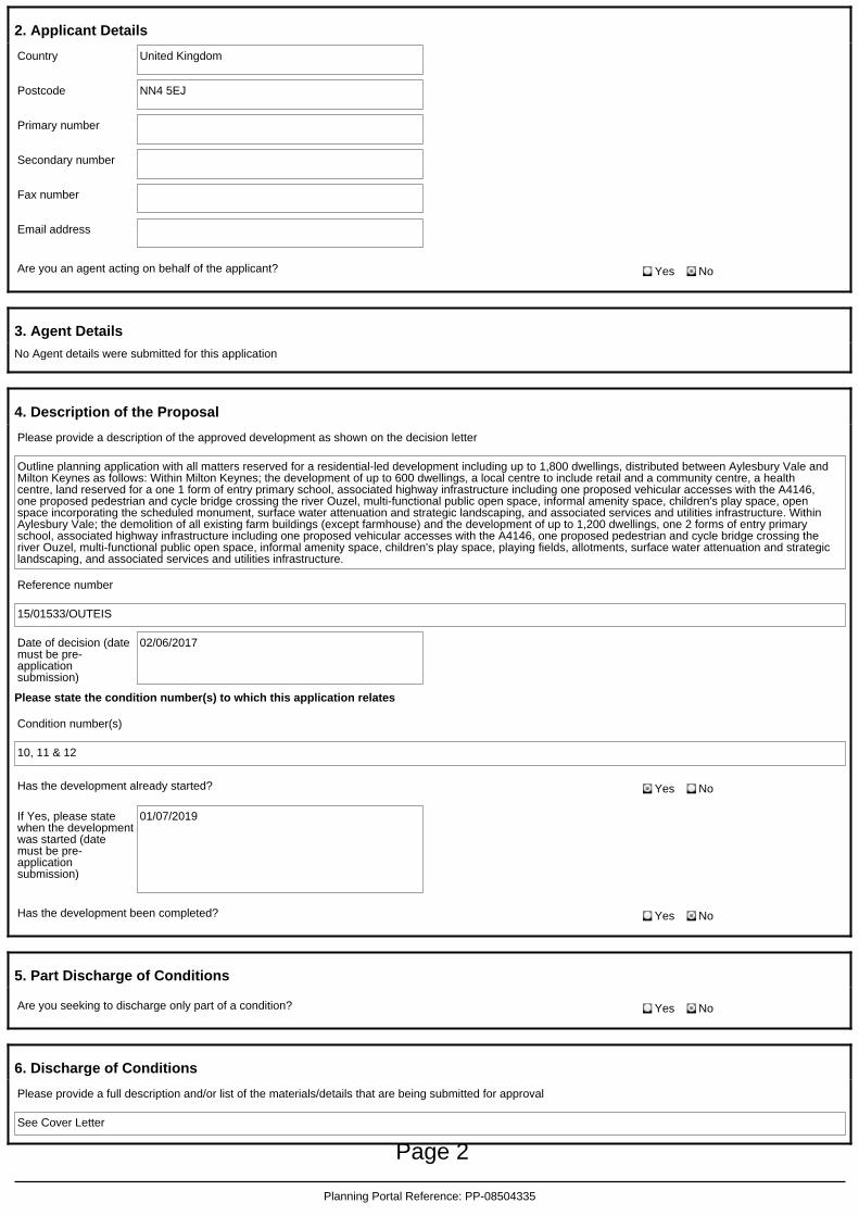
4. Description of the Proposal
Please provide a description of the approved development as shown on the decision letter
Outline planning application with all matters reserved for a residential-led development including up to 1,800 dwellings, distributed between Aylesbury Vale andMilton Keynes as follows: Within Milton Keynes; the development of up to 600 dwellings, a local centre to include retail and a community centre, a healthcentre, land reserved for a one 1 form of entry primary school, associated highway infrastructure including one proposed vehicular accesses with the A4146,one proposed pedestrian and cycle bridge crossing the river Ouzel, multi-functional public open space, informal amenity space, children's play space, openspace incorporating the scheduled monument, surface water attenuation and strategic landscaping, and associated services and utilities infrastructure. WithinAylesbury Vale; the demolition of all existing farm buildings (except farmhouse) and the development of up to 1,200 dwellings, one 2 forms of entry primaryschool, associated highway infrastructure including one proposed vehicular accesses with the A4146, one proposed pedestrian and cycle bridge crossing theriver Ouzel, multi-functional public open space, informal amenity space, children's play space, playing fields, allotments, surface water attenuation and strategiclandscaping, and associated services and utilities infrastructure.
Reference number
15/01533/OUTEIS
Date of decision (datemust be pre-applicationsubmission)
02/06/2017
Please state the condition number(s) to which this application relates
Condition number(s)
10, 11 & 12
Has the development already started? Yes No
If Yes, please statewhen the developmentwas started (datemust be pre-applicationsubmission)
01/07/2019
Has the development been completed? Yes No
5. Part Discharge of Conditions
Are you seeking to discharge only part of a condition? Yes No
6. Discharge of Conditions
Please provide a full description and/or list of the materials/details that are being submitted for approval
See Cover Letter
Planning Portal Reference: PP-08504335
Page 2
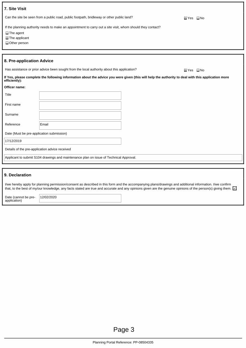
7. Site Visit
Can the site be seen from a public road, public footpath, bridleway or other public land? Yes No
If the planning authority needs to make an appointment to carry out a site visit, whom should they contact?
The agent
The applicant
Other person
8. Pre-application Advice
Has assistance or prior advice been sought from the local authority about this application? Yes No
If Yes, please complete the following information about the advice you were given (this will help the authority to deal with this application moreefficiently):
Officer name:
Title
First name
Surname
Reference Email
Date (Must be pre-application submission)
17/12/2019
Details of the pre-application advice received
Applicant to submit S104 drawings and maintenance plan on issue of Technical Approval.
9. Declaration
I/we hereby apply for planning permission/consent as described in this form and the accompanying plans/drawings and additional information. I/we confirmthat, to the best of my/our knowledge, any facts stated are true and accurate and any opinions given are the genuine opinions of the person(s) giving them.
Date (cannot be pre-application)
12/02/2020
Planning Portal Reference: PP-08504335
Page 3

Barratt Northampton, Barratt House, Sandy Way, Grange Park, Northampton, NN4 5EJ T: 01604 664500 ■ F: 01604 664501 ■ W: barratthomes.co.uk
Barratt Homes is a trading name of BDW Trading Limited. Registered in England and Wales, Registered Number 03018173 Registered Office Barratt House, Cartwright Way, Forest Business Park, Bardon Hill, Coalville, Leicester, LE67 1UF
BY PLANNING PORTAL SUBMISSION ONLY
Development Control Milton Keynes Council
13th February, 2020
Direct Dial: 01604 664 544 Mobile: 07474 930559
Reception: 01604 664 [email protected]
RE: APPLICATION FOR DETAILS RESERVED BY CONDITIONS 10, 11 & 12 PURSUANT TO OUTLINE PLANNING PERMISSION 15/01533/OUTEIS
This application is made to discharge the above noted Conditions now that development at Eaton Leys has commenced, in accordance 19/01412/REM.
This application follows from advice provided by Jessica Prest and is in direct response to the technical approval for new sewer adoption issued by Anglian Water (NSA-0064269).
Condition 10 of Outline Permission 15/01533/OUTEIS reads as such:
Prior to the commencement of each phase or part of the development hereby permitted a detailed design, and associated management and maintenance plan, for a surface water drainage scheme, based on sustainable drainage principles for the site shall be submitted to and be approved in writing by the local planning authority. The management and maintenance plan shall include a detailed time table for the provision of the surface water drainage scheme. The approved drainage scheme shall subsequently be implemented in accordance with the approved detailed design and in accordance with the approved time table for implementation and be retained thereafter.
Condition 11 of Outline Permission 15/01533/OUTEIS reads as such:
Prior to the commencement of each phase or part of the development, details of the storm water drainage design shall be submitted to and approved in writing by the Local Planning Authority. No associated dwellings shall be occupied in that phase or part of the development until the works have been carried out in accordance with the approved storm water drainage scheme.
Page 4

Condition 12 of Outline Permission 15/01533/OUTEIS reads as such:
Prior to the commencement of development of each phase or part of the development, a foul water strategy shall be submitted to and approved in writing by the Local Planning Authority. No dwellings in that phase or part shall be occupied until the works have been carried out in accordance with the approved foul water strategy for that phase or part.
Accordingly, the following are submitted to discharge Conditions 10, 11 & 12:
New Sewer Adoption: Offer Letter, Anglian Water (Reference NSA-0064269); List Of Sewers Proposed To Be Adopted, Anglian Water (Reference NSA-
0064269); Drainage Maintenance Plan; PB6358-RHD-TE-I1-DR-D-0500 Rev.T11: S104 Foul & Surface Water Drainage
Layout 1/4; PB6358-RHD-TE-I1-DR-D-0501 Rev.T10: S104 Foul & Surface Water Drainage
Layout 2/4; PB6358-RHD-TE-I1-DR-D-0502 Rev.T10: S104 Foul & Surface Water Drainage
Layout 3/4; PB6358-RHD-TE-I1-DR-D-0503 Rev.T11: S104 Foul & Surface Water Drainage
Layout 4/4; PB6358-RHD-TE-I1-DR-D-0520 Rev.T09: S104 Foul Water Drainage Manhole
Schedules; PB6358-RHD-TE-I1-DR-D-0521 Rev.T10: S104 Surface Water Drainage Manhole
Schedules; PB6358-RHD-TE-I1-DR-D-0522 Rev.T07: S104 Surface Water Drainage Manhole
Schedules; PB6358-RHD-TE-I1-DR-D-0525 Rev.T04: S104 Standard Drainage Details 1/3; PB6358-RHD-TE-I1-DR-D-0526 Rev.T01: S104 Standard Drainage Details 2/3; PB6358-RHD-TE-I1-DR-D-0527 Rev.T00: S104 Standard Drainage Details 3/3; PB6358-RHD-TE-I1-DR-D-0538 Rev.T03: S104 Surface Water Networks Catchment
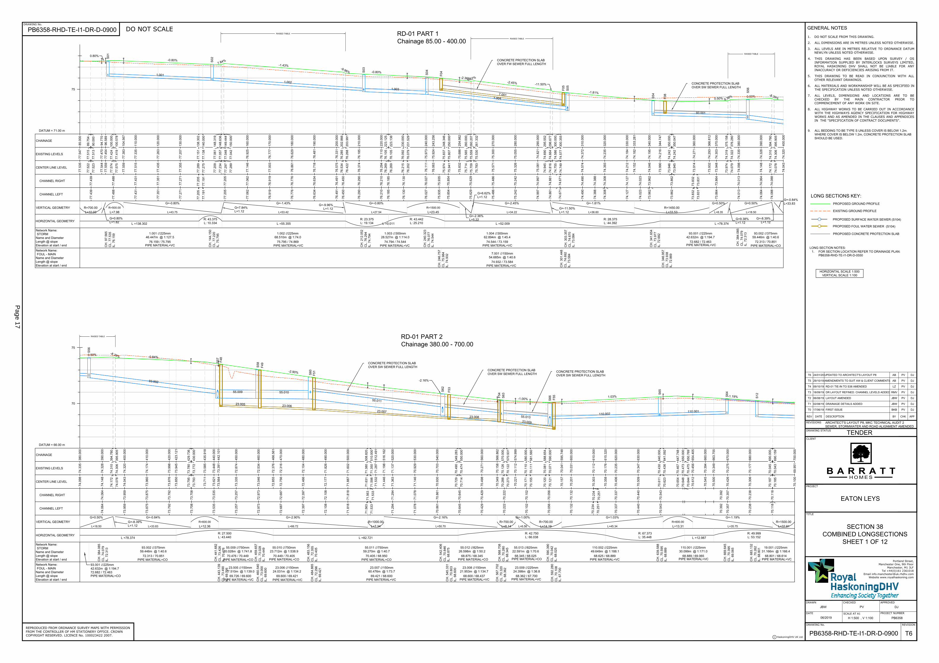
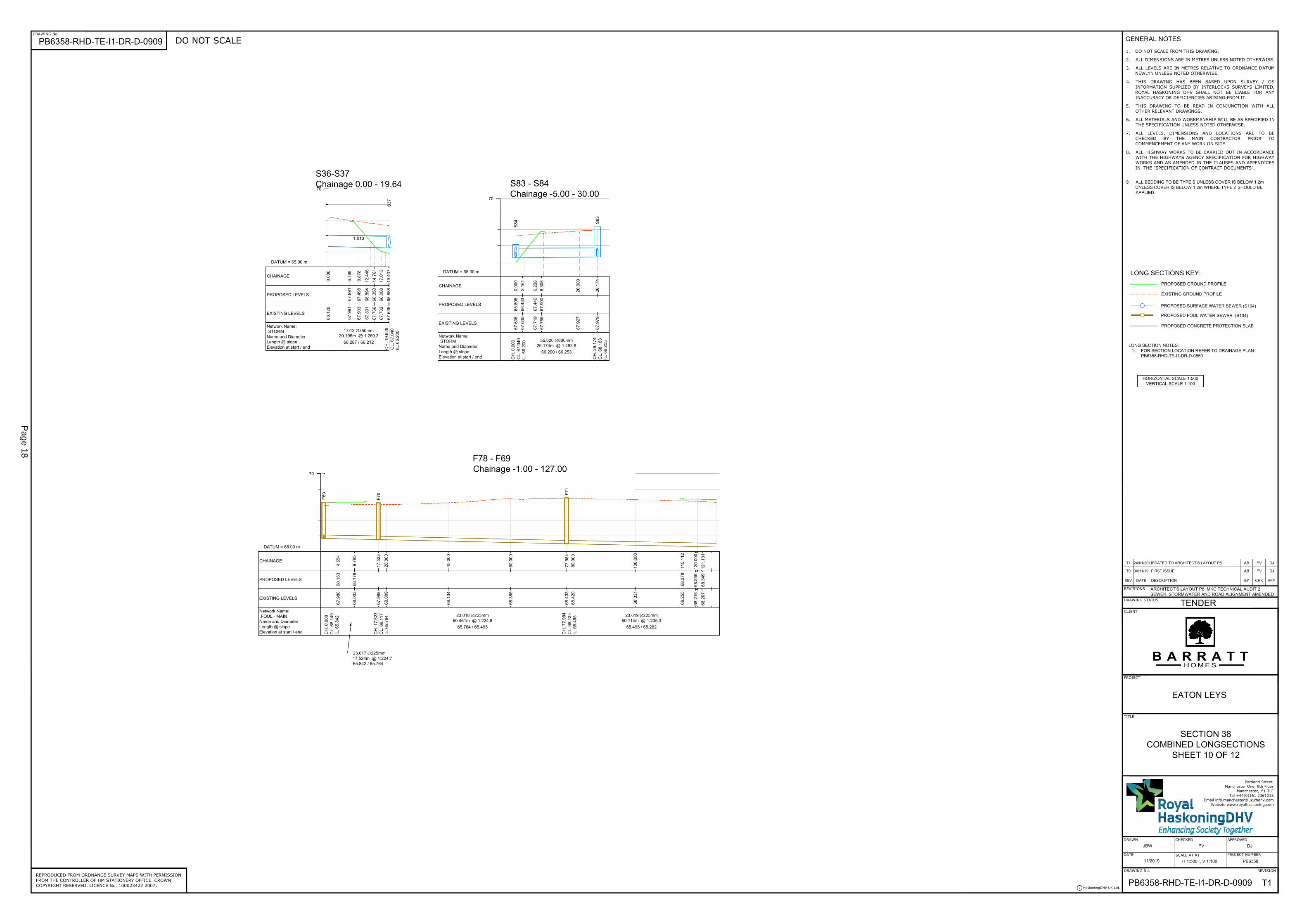
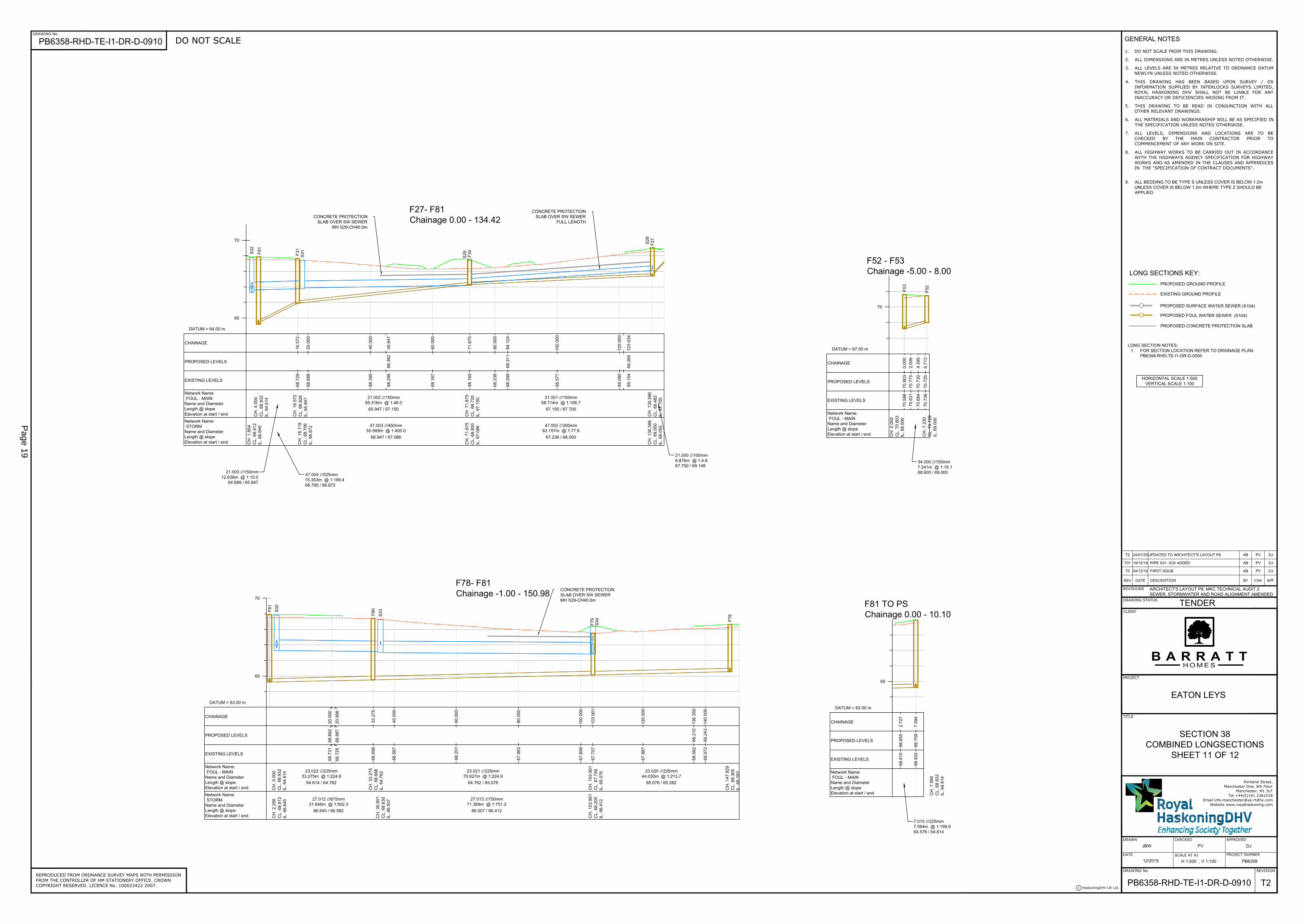
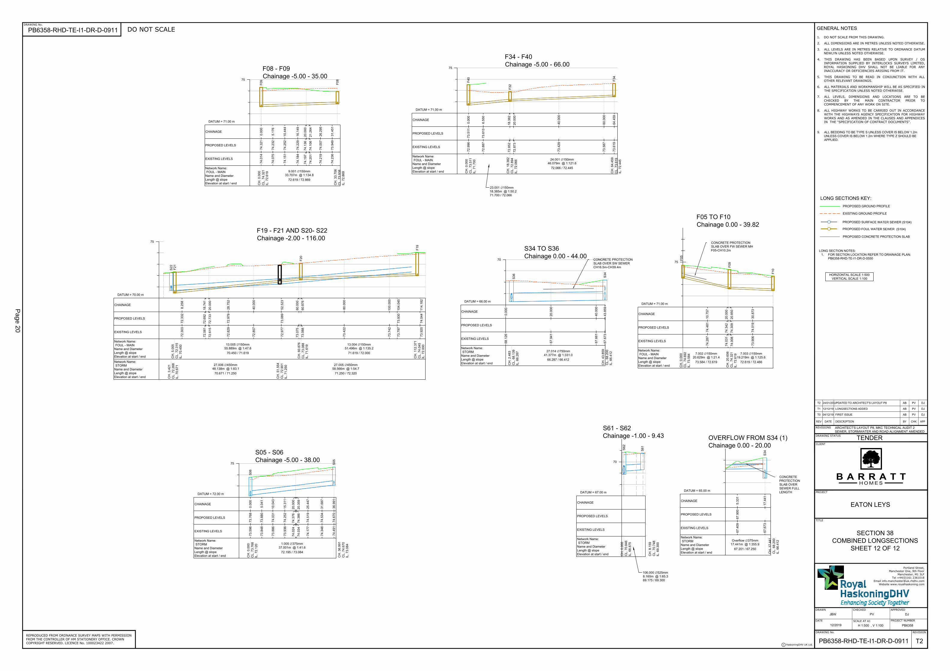
Areas; PB6358-RHD-TE-I1-DR-D-0540 Rev.T00: S104 Surface Water Flood Flow Plan; PB6358-RHD-TE-I1-DR-D-0900 Rev.T06: S38 Combined Long-Sections 1/12; PB6358-RHD-TE-I1-DR-D-0901 Rev.T07: S38 Combined Long-Sections 2/12; PB6358-RHD-TE-I1-DR-D-0902 Rev.T07: S38 Combined Long-Sections 3/12; PB6358-RHD-TE-I1-DR-D-0903 Rev.T07: S38 Combined Long-Sections 4/12; PB6358-RHD-TE-I1-DR-D-0904 Rev.T05: S38 Combined Long-Sections 5/12; PB6358-RHD-TE-I1-DR-D-0905 Rev.T05: S38 Combined Long-Sections 6/12; PB6358-RHD-TE-I1-DR-D-0906 Rev.T06: S38 Combined Long-Sections 7/12; PB6358-RHD-TE-I1-DR-D-0907 Rev.T03: S38 Combined Long-Sections 8/12; PB6358-RHD-TE-I1-DR-D-0908 Rev.T03: S38 Combined Long-Sections 9/12; PB6358-RHD-TE-I1-DR-D-0909 Rev.T01: S38 Combined Long-Sections 10/12; PB6358-RHD-TE-I1-DR-D-0910 Rev.T02: S38 Combined Long-Sections 11/12; and PB6358-RHD-TE-I1-DR-D-0911 Rev.T02: S38 Combined Long-Sections 12/12;
Page 5

We have submitted this application through the Planning Portal, with reference number PP-08504335. The application fee is £116 and will be paid by BACS upon electronic submission of this application.
If you require anything else, please do not hesitate to contact the undersigned.
Kind Regards
Harry White BSc. (Hons) AssocRTPI Strategic Projects Planner
CC: Gina Loizou (Barratt Northampton); and Jessica Prest (Flood and Water Management Team, Milton Keynes Council)
Page 6
Drainage Maintenance Plan forEaton Leys, Milton Keynes
Author: GL
Checker: KR
Issue date: 13/12/2019
Page 7
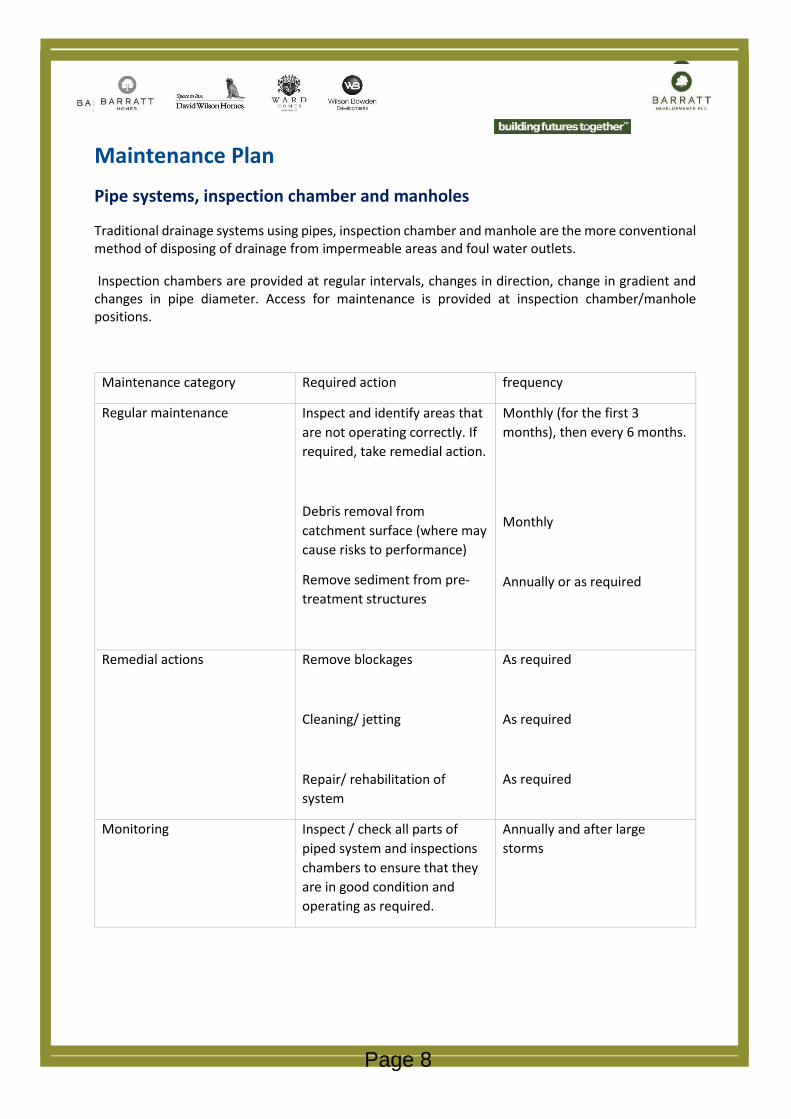
Maintenance PlanPipe systems, inspection chamber and manholes
Traditional drainage systems using pipes, inspection chamber and manhole are the more conventional method of disposing of drainage from impermeable areas and foul water outlets.
Inspection chambers are provided at regular intervals, changes in direction, change in gradient and changes in pipe diameter. Access for maintenance is provided at inspection chamber/manhole positions.
Maintenance category Required action frequency
Regular maintenance Inspect and identify areas that are not operating correctly. If required, take remedial action.
Debris removal from catchment surface (where may cause risks to performance)
Remove sediment from pre-treatment structures
Monthly (for the first 3 months), then every 6 months.
Monthly
Annually or as required
Remedial actions Remove blockages
Cleaning/ jetting
Repair/ rehabilitation of system
As required
As required
As required
Monitoring Inspect / check all parts of piped system and inspections chambers to ensure that they are in good condition and operating as required.
Annually and after large storms
Page 8

Detention basins
Detention basins are landscaped depressions that are normally dry except during and immediatelyfollowing storm events. They can online components where surface runoff from regular events is routed through the basin and provides storage of runoff and attenuation
This site uses an online detention basin as its primary attenuation feature.
Maintenance category Required action frequency
Regular maintenance Remove litter and debris
Cut grass – for spillways and access routes
Cut grass – meadow grass in and around basin
Manage other vegetation and remove nuisance plants
Inspect inlets, outlets and overflows for blockages and clear if required
Inspect banksides, structures pipework etc for evidence of physical damage
Inspect inlets and facility surface for silt accumulation. Establish appropriate silt removal frequencies.
Check any penstocks and other mechanical devices
Monthly
Monthly (during growing season) or as required
Half yearly (spring – before nesting season and autumn)
Monthly (at start, then as required)
Monthly
Monthly
Monthly (for first year) then annually as required
Annually
Page 9
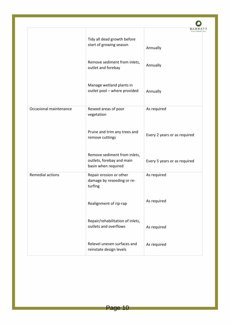
Tidy all dead growth before start of growing season
Remove sediment from inlets, outlet and forebay
Manage wetland plants in outlet pool – where provided
Annually
Annually
Annually
Occasional maintenance Reseed areas of poor vegetation
Prune and trim any trees and remove cuttings
Remove sediment from inlets, outlets, forebay and main basin when required
As required
Every 2 years or as required
Every 5 years or as required
Remedial actions Repair erosion or other damage by reseeding or re-turfing
Realignment of rip-rap
Repair/rehabilitation of inlets, outlets and overflows
Relevel uneven surfaces and reinstate design levels
As required
As required
As required
As required
Page 10

Flow control devices
A flow control device usually contains of a fixed opening or alternative form of throttle. Its purpose is to control the discharge that has been passed down stream and thereby be able to retain water upstream within the storages features.
This site contains an orifice plate on the outfall pipe within a catch pit manhole. Normally, little maintenance is required as there are no moving parts and generally if blockages occur they do so at the intake and can be due to poor installation or upstream treatment of water entering the system.
Maintenance category Required action frequency
Regular maintenance Inspect and identify areas that are not operating correctly. If required, take remedial action.
Debris removal from catchment surface (where may cause risks to performance)
Remove sediment from pre-treatment structures
Monthly (for the first 3 months), then every 6 months.
Monthly
Annually or as required
Remedial actions Remove blockages
Cleaning/ jetting
Repair/ rehabilitation of system
As required
As required
As required
Monitoring Inspect / check all parts of piped system and inspections chambers to ensure that they are in good condition and operating as required.
Annually and after large storms
Page 11

Responsibility
The parties responsible for each component of the drainage network are listed below:
Drainage type Party responsibile
Section 104 adoptable drainage situated within proposed public highway or within a Section 104 easement – after legal adoption
Anglian Water
Section 38 adoptable highway drainage and highway gullies – after legal completion
MK Highways
Private drainage situated within curtilage of private dwellings –after legal completion
Homeowner
Private drainage situated within shared area Management company
Page 12
SFA06c - 051198
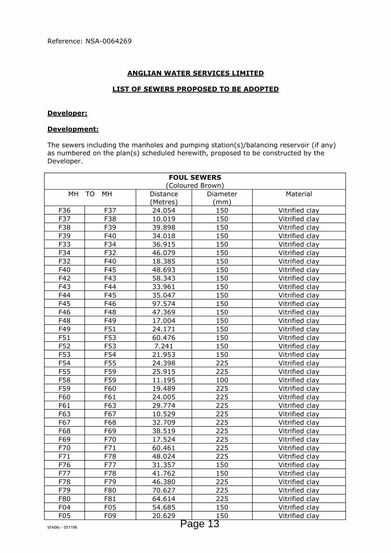
Reference: NSA-0064269
ANGLIAN WATER SERVICES LIMITED
LIST OF SEWERS PROPOSED TO BE ADOPTED
Developer:
Development:
The sewers including the manholes and pumping station(s)/balancing reservoir (if any) as numbered on the plan(s) scheduled herewith, proposed to be constructed by the Developer.
FOUL SEWERS(Coloured Brown)
MH TO MH Distance(Metres)
Diameter(mm)
Material
F36 F37 24.054 150 Vitrified clayF37 F38 10.019 150 Vitrified clayF38 F39 39.898 150 Vitrified clayF39 F40 34.018 150 Vitrified clayF33 F34 36.915 150 Vitrified clayF34 F32 46.079 150 Vitrified clayF32 F40 18.385 150 Vitrified clayF40 F45 48.693 150 Vitrified clayF42 F43 58.343 150 Vitrified clayF43 F44 33.961 150 Vitrified clayF44 F45 35.047 150 Vitrified clayF45 F46 97.574 150 Vitrified clayF46 F48 47.369 150 Vitrified clayF48 F49 17.004 150 Vitrified clayF49 F51 24.171 150 Vitrified clayF51 F53 60.476 150 Vitrified clayF52 F53 7.241 150 Vitrified clayF53 F54 21.953 150 Vitrified clayF54 F55 24.398 225 Vitrified clayF55 F59 25.915 225 Vitrified clayF58 F59 11.195 100 Vitrified clayF59 F60 19.489 225 Vitrified clayF60 F61 24.005 225 Vitrified clayF61 F63 29.774 225 Vitrified clayF63 F67 10.529 225 Vitrified clayF67 F68 32.709 225 Vitrified clayF68 F69 38.519 225 Vitrified clayF69 F70 17.524 225 Vitrified clayF70 F71 60.461 225 Vitrified clayF71 F78 48.024 225 Vitrified clayF76 F77 31.357 150 Vitrified clayF77 F78 41.762 150 Vitrified clayF78 F79 46.380 225 Vitrified clayF79 F80 70.627 225 Vitrified clayF80 F81 64.614 225 Vitrified clayF04 F05 54.685 150 Vitrified clayF05 F09 20.629 150 Vitrified clay
Page 13
SFA06c - 051198
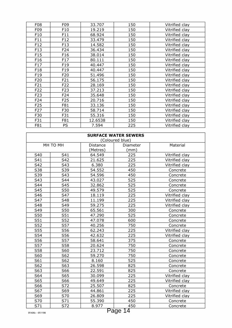
F08 F09 33.707 150 Vitrified clayF09 F10 19.219 150 Vitrified clayF10 F11 68.924 150 Vitrified clayF11 F12 33.479 150 Vitrified clayF12 F13 14.582 150 Vitrified clayF13 F24 36.434 150 Vitrified clayF15 F16 38.014 150 Vitrified clayF16 F17 80.111 150 Vitrified clayF17 F19 40.447 150 Vitrified clayF18 F19 40.447 150 Vitrified clayF19 F20 51.496 150 Vitrified clayF20 F21 56.175 150 Vitrified clayF21 F22 28.169 150 Vitrified clayF22 F23 37.213 150 Vitrified clayF23 F24 35.648 150 Vitrified clayF24 F25 20.716 150 Vitrified clayF25 F81 33.136 150 Vitrified clayF27 F30 58.714 150 Vitrified clayF30 F31 55.316 150 Vitrified clayF31 F81 12.6538 150 Vitrified clayF81 PS 7.594 225 Vitrified clay
SURFACE WATER SEWERS(Coloured blue)
MH TO MH Distance(Metres)
Diameter(mm)
Material
S40 S41 64.549 225 Vitrified clayS41 S42 21.625 225 Vitrified clayS42 S43 6.380 225 Vitrified clayS38 S39 54.552 450 ConcreteS39 S43 54.596 450 ConcreteS43 S44 43.027 525 ConcreteS44 S45 32.862 525 ConcreteS45 S50 49.579 525 ConcreteS46 S47 18.119 225 Vitrified clayS47 S48 11.199 225 Vitrified clayS48 S49 59.275 225 Vitrified clayS49 S50 65.561 300 ConcreteS50 S51 47.290 525 ConcreteS51 S52 47.078 600 ConcreteS52 S57 40.256 750 ConcreteS55 S56 62.243 225 Vitrified clayS54 S56 42.632 225 Vitrified clayS56 S57 58.641 375 ConcreteS57 S58 20.624 750 ConcreteS58 S60 23.712 750 ConcreteS60 S62 59.270 750 ConcreteS61 S62 8.160 525 ConcreteS62 S63 26.598 825 ConcreteS63 S66 22.591 825 ConcreteS64 S65 30.099 225 Vitrified clayS65 S66 49.649 225 Vitrified clayS66 S72 25.507 825 ConcreteS67 S69 44.861 225 Vitrified clayS69 S70 26.809 225 Vitrified clayS70 S71 55.390 450 ConcreteS71 S72 8.977 450 Concrete
Page 14

SFA06c - 051198
S72 S73 17.576 975 ConcreteS73 S74 27.155 975 ConcreteS74 S79 31.757 975 ConcreteS75 S79 63.716 450 ConcreteS76 S77 19.642 225 Vitrified clayS77 S78 23.635 225 Vitrified clayS78 S79 20.874 225 Vitrified clayS79 S80 41.812 1350 ConcreteS80 S83 34.324 2 x 600 ConcreteS81 S83 8.116 225 Vitrified clayS82 S83 7.225 225 Vitrified clayS83 S84 HW 26.174 2 x 600 ConcreteS15 S16 34.731 225 Vitrified clayS16 S17 44.215 300 ConcreteS17 S18 79.933 300 ConcreteS18 S20 42.967 300 ConcreteS19 S20 52.757 225 Vitrified clayS20 S21 58.566 450 ConcreteS21 S22 48.272 450 ConcreteS22 S23 27.383 450 ConcreteS23 S24 36.701 450 ConcreteS24 S25 39.690 450 ConcreteS25 S26 14.559 450 ConcreteS26 S32 36.569 450 ConcreteS27 S28 62.060 225 Vitrified clayS28 S29 63.157 300 ConcreteS29 S31 55.569 450 ConcreteS31 S32 15.350 525 ConcreteS32 S33 31.648 675 ConcreteS33 S34 71.369 750 ConcreteS34 S36 43.860 750 ConcreteS36 S37 HW 19.630 750 ConcreteS01 S02 46.447 225 Vitrified clayS02 S03 68.510 225 Vitrified clayS03 S04 28.527 300 ConcreteS04 S05 62.894 300 ConcreteS05 S06 37.001 375 ConcreteS06 S07 66.109 450 ConcreteS07 S09 38.896 450 ConcreteS08 S09 39.544 225 Vitrified clayS09 S10 15.02 450 ConcreteS10 S11 38.979 525 ConcreteS11 S13 18.466 525 ConcreteS12 S13 32.779 225 Vitrified clayS13 S14 31.167 525 ConcreteS14 S36 57.009 525 Concrete
Page 15

SFA06c - 051198
LIST OF APPROVED DRAWINGS
Number / Reference Drawing Title Date
PB6358-RHD-TE-I1-DR-D-0500 T10
FOUL AND SURFACE WATER DRAINAGE LAYOUT SHEET 1 OF 4
11/12/19
PB6358-RHD-TE-I1-DR-D-0501 T09
FOUL AND SURFACE WATER DRAINAGE LAYOUT SHEET 2 OF 4
11/12/19
PB6358-RHD-TE-I1-DR-D-0502 T09
FOUL AND SURFACE WATER DRAINAGE LAYOUT SHEET 3 OF 4
11/12/19
PB6358-RHD-TE-I1-DR-D-0503 T10
FOUL AND SURFACE WATER DRAINAGE LAYOUT SHEET 4 OF 4
11/12/19
PB6358-RHD-TE-I1-DR-D-0900 T5
SECTION 38 COMBINED LONGSECTIONS SHEET 1 OF 9
29/10/19
PB6358-RHD-TE-I1-DR-D-0901 T6
SECTION 38 COMBINED LONGSECTIONS SHEET SHEET 2 OF 9
4/11/19
PB6358-RHD-TE-I1-DR-D-0902 T5
SECTION 38 COMBINED LONGSECTIONS SHEET 3 OF 9
29/10/19
PB6358-RHD-TE-I1-DR-D-0903 T6
SECTION 38 COMBINED LONGSECTIONS SHEET 4 OF 9
4/11/19
PB6358-RHD-TE-I1-DR-D-0904 T4
SECTION 38 COMBINED LONGSECTIONS SHEET 5 OF 10
4/11/19
PB6358-RHD-TE-I1-DR-D-0905 T4
SECTION 38 COMBINED LONGSECTIONS SHEET 6 OF 9
12/12/19
PB6358-RHD-TE-I1-DR-D-0906 T5
SECTION 38 COMBINED LONGSECTIONS SHEET 7 OF 10
12/12/19
PB6358-RHD-TE-I1-DR-D-0907 T2
SECTION 38 COMBINED LONGSECTIONS SHEET 8 OF 9
29/10/19
PB6358-RHD-TE-I1-DR-D-0909 T0
SECTION 38 COMBINED LONGSECTIONS SHEET 10 OF 12
4/11/19
PB6358-RHD-TE-I1-DR-D-0910 T0
SECTION 38 COMBINED LONGSECTIONS SHEET 11 OF 12
4/12/19
PB6358-RHD-TE-I1-DR-D-0911 T1
SECTION 38 COMBINED LONGSECTIONS SHEET 12 OF 12
12/12/19
PB6358-RHD-TE-I1-DR-D-0520 T09
S104- FOUL WATER DRAINAGE MANHOLE SCHEDULES
4/12/19
PB6358-RHD-TE-I1-DR-D-0521 T09
S104 – SURFACE WATER DRAINAGE MANHOLE SCHEDULES
12/12/19
PB6358-RHD-TE-I1-DR-D-0522 T06
S104 – SURFACE WATER DRAINAGE MANHOLE SCHEDULES
12/12/19
PB6358-RHD-TE-I1-DR-D-0525 T1
S104 – STANDARD DRAINAGE DETAILS SHEET 1 OF 3
02/07/19
PB6358-RHD-TE-I1-DR-D-0526 T1
S104 – STANDARD DRAINAGE DETAILS SHEET 2 OF 3
02/07/19
PB6358-RHD-TE-I1-DR-D-0528 T01
S104 – STANDARD DRAINAGE DETAILS SHEET 4 OF 4
04/12/19
PB6358-RHD-TE-I1-DR-D-0529 T0
S104 – STANDARD DRAINAGE DETAILS SHEET 5 OF 5
12/12/19
PB6358-RHD-TE-I1-DR-D-0538 T03
SECTION 104 – SURFACE WATER NETWORKS CATCHMENT AREAS
4/12/19
PB6358-RHD-TE-I1-DR-D-0540 T0
SECTION 104 SURFACE WATER FLOOD FLOW PLAN
4/12/19
Page 16
PROPOSED GROUND PROFILE
HORIZONTAL SCALE 1:500VERTICAL SCALE 1:100
LONG SECTIONS KEY:
LONG SECTION NOTES:1. FOR SECTION LOCATION REFER TO DRAINAGE PLAN:
PB6358-RHD-TE-I1-DR-D-0550
EXISTING GROUND PROFILE
PROPOSED CONCRETE PROTECTION SLAB
DATUM = 71.00 m
RD-01 PART 1Chainage 85.00 - 400.00
75
CHAINAGE
EXISTING LEVELS
CENTER LINE LEVEL
CHANNEL RIGHT
CHANNEL LEFT
VERTICAL GEOMETRY
HORIZONTAL GEOMETRY
Network Name: STORMName and DiameterLength @ slopeElevation at start / endNetwork Name: FOUL - MAINName and DiameterLength @ slopeElevation at start / end
85.0
00
89.7
5490
.000
94.7
7096
.589
100.
000
100.
578
104.
567
110.
000
120.
000
130.
000
138.
302
140.
000
148.
319
148.
636
149.
444
150.
000
160.
000
170.
000
180.
000
190.
000
200.
000
202.
866
203.
991
210.
000
220.
000
223.
125
223.
136
230.
000
231.
529
240.
000
243.
256
248.
346
250.
000
254.
982
260.
000
260.
207
261.
332
270.
000
280.
000
290.
000
295.
552
296.
677
300.
000
300.
355
310.
000
320.
000
330.
000
333.
281
340.
000
344.
747
350.
000
350.
047
360.
000
366.
812
370.
000
375.
158
376.
280
380.
000
390.
000
394.
780
395.
905
400.
000
77.5
47
77.5
1577
.513
77.4
7077
.454
77.4
2477
.419
77.3
83
77.3
35
77.2
63
77.2
07
77.1
5177
.138
77.0
61
77.0
57
77.0
4877
.042
76.9
25
76.7
77
76.6
29
76.4
81
76.3
3176
.285
76.2
68
76.1
85
76.1
1076
.105
76.1
05
76.0
9276
.079
75.9
73
75.9
24
75.8
3775
.807
75.6
86
75.5
6575
.559
75.5
30
75.3
00
75.0
55
74.8
21
74.6
90
74.6
6474
.586
74.5
77
74.3
72
74.2
35
74.1
84
74.1
82
74.1
95
74.2
16
74.2
4274
.242
74.2
71
74.2
93
74.3
03
74.3
19
74.3
22
74.3
35
74.3
28
74.3
10
74.3
06
74.3
20
L=23.45R=1500.00
L=33.53R=1450.00
G=-2.36%L=5.22
G=6.62%L=1.12
G=-2.45%
L=34.22G=-11.50%L=1.12
G=-1.81%
L=36.60
G=-0.84%L=33.83
G=-8.39%L=1.12
G=0.50%
L=18.50
G=0.50%
L=8.35
G=9.38%L=1.12
G=-0.80%
L=27.54
G=-9.96%L=1.12G=7.84%
L=1.12
G=-1.43%
L=53.42L=10.03R=700.00
G=0.80%L=1.82
G=-0.80%
L=43.75L=7.98R=500.00
L =138.302R: 43.375L: 10.334 L =55.355
R: 23.375L: 19.134 L =0.011
R: 43.442L: 25.210 L =52.009
R: 28.375L: 44.392 L =78.374
-2.36%6.62%-2.45% -11.50%
-1.81% -8.39%0.50%0.50% 9.38%
-0.80%-9.96%
7.84%-1.43%
0.80%-0.80%
CH
. 97.
565
CL.
77.
535
IL. 7
6.15
9
CH
. 144
.150
CL.
77.
220
IL. 7
5.79
5
CH
. 212
.052
CL.
76.
294
IL. 7
4.79
4
CH
. 240
.323
CL.
76.
077
IL. 7
4.54
4
CH
. 303
.357
CL.
74.
670
IL. 7
3.08
4
CH
. 341
.654
CL.
73.
977
IL. 7
2.68
2
CH
. 384
.085
CL.
74.
079
IL. 7
2.31
31.001 ∅225mm46.447m @ 1:127.5
76.159 / 75.795
1.002 ∅225mm68.510m @ 1:74.0
75.795 / 74.869
1.003 ∅300mm28.527m @ 1:114.0
74.794 / 74.544
1.004 ∅300mm62.894m @ 1:45.4
74.544 / 73.159
93.001 ∅225mm42.632m @ 1:194.7
72.682 / 72.463
93.002 ∅375mm59.446m @ 1:40.6
72.313 / 70.851
7.001 ∅150mm54.685m @ 1:40.6
74.932 / 73.584
CH
. 246
.757
CL.
75.
984
IL. 7
4.93
2
CH
. 301
.448
CL.
74.
692
IL. 7
3.58
4
CH
. 346
.957
CL.
73.
938
IL. 7
2.86
9
S01
F04
F05
7.001
93.001
RAISED TABLE
RAISED TABLE
RAISED TABLE
77.5
35
77.5
2277
.523
77.5
4477
.559
77.5
7477
.575
77.5
59
77.5
15
77.4
35
77.3
55
77.2
8977
.275
77.2
09
77.2
34
77.2
9777
.289
77.1
46
77.0
03
76.8
61
76.7
18
76.5
7576
.534
76.4
22
76.3
74
76.2
9476
.269
76.2
69
76.2
1576
.202
76.1
11
76.0
63
75.9
7475
.941
75.8
32
75.7
1475
.709
75.7
83
75.5
71
75.3
26
75.0
81
74.9
45
74.8
1674
.755
74.7
49
74.5
74
74.3
93
74.2
12
74.1
52
74.0
46
73.9
90
73.9
4673
.945
73.9
14
73.9
32
73.9
48
73.9
74
74.0
79
74.0
98
74.1
48
74.1
72
74.0
78
74.0
43
1.001
1.002
1.003
1.004
S02
S03
S04
S05
S54
F08
S56
CONCRETE PROTECTION SLABOVER FW SEWER FULL LENGTH
CONCRETE PROTECTION SLABOVER SW SEWER FULL LENGTH
PIPE MATERIAL=VC PIPE MATERIAL=VC PIPE MATERIAL=VC PIPE MATERIAL=VC
PIPE MATERIAL=VC
PIPE MATERIAL=VC PIPE MATERIAL=CO
77.4
39
77.4
88
77.4
31
77.3
51
77.2
71
77.2
0577
.191
77.2
05
77.0
62
76.9
19
76.7
76
76.6
34
76.4
91
76.4
50
76.2
90
76.2
10
76.1
85
76.1
30
76.0
27
75.9
35
75.8
54
75.6
29
75.4
86
75.2
42
74.9
97
74.8
61
74.6
71
74.4
90
74.3
88
74.3
08
74.1
27
74.0
23
73.9
62
73.8
62
73.8
3273
.831
73.8
64
74.0
13
74.0
64
74.0
88
77.4
39
77.4
88
77.4
31
77.3
51
77.2
71
77.2
0577
.191
77.2
05
77.0
62
76.9
19
76.7
76
76.6
34
76.4
91
76.4
50
76.2
90
76.2
10
76.1
85
76.1
30
76.0
27
75.9
35
75.8
54
75.6
29
75.4
86
75.2
42
74.9
97
74.8
61
74.6
71
74.4
90
74.3
88
74.3
08
74.1
27
74.0
23
73.9
62
73.8
62
73.8
3273
.831
73.8
64
74.0
13
74.0
64
74.0
88
DATUM = 66.00 m
RD-01 PART 2Chainage 380.00 - 700.00
70
75
CHAINAGE
EXISTING LEVELS
CENTER LINE LEVEL
CHANNEL RIGHT
CHANNEL LEFT
VERTICAL GEOMETRY
HORIZONTAL GEOMETRY
Network Name: STORMName and DiameterLength @ slopeElevation at start / endNetwork Name: FOUL - MAINName and DiameterLength @ slopeElevation at start / end
380.
000
390.
000
394.
780
395.
905
400.
000
410.
000
420.
000
423.
121
429.
736
430.
000
435.
918
440.
000
442.
101
450.
000
460.
000
466.
561
470.
000
480.
000
490.
000
500.
000
508.
820
510.
000
512.
491
516.
162
520.
000
530.
000
540.
000
549.
283
550.
000
560.
000
566.
862
570.
000
570.
931
574.
999
580.
000
581.
560
588.
654
590.
000
595.
748
600.
000
610.
000
615.
320
620.
000
630.
000
640.
000
641.
092
647.
748
650.
000
650.
769
654.
405
660.
000
663.
755
670.
000
680.
000
690.
000
690.
159
700.
000
74.3
35
74.3
28
74.3
10
74.3
06
74.3
20
74.1
74
73.9
98
73.9
45
73.7
8073
.772
73.5
85
73.4
4873
.391
72.8
74
72.5
34
72.3
76
72.3
16
72.1
04
71.8
26
71.6
02
71.3
8071
.350
71.2
87
71.1
98
71.1
37
70.9
29
70.7
03
70.4
9070
.474
70.2
71
70.1
58
70.1
2670
.122
70.1
12
70.1
1070
.111
70.0
8170
.071
70.0
41
70.0
31
70.1
12
70.1
76
70.2
35
70.3
47
70.4
3070
.436
70.4
6770
.473
70.4
7570
.456
70.3
94
70.3
49
70.2
75
70.1
77
70.0
4570
.043
69.9
51
L=12.36R=600.00
L=13.31R=600.00
L=32.81R=1500.00
G=-0.84%
L=33.83G=-8.39%L=1.12
G=0.50%
L=18.50
G=1.03%
L=45.34
G=-1.00%
L=6.56 L=14.19R=700.00
L=7.34R=1000.00
G=-2.16%
L=50.70
G=-2.90%
L=66.72 L=8.14R=700.00
G=-1.19%
L=35.75
L =78.374R: 27.500L: 43.440 L =82.721
R: 42.750L: 66.038
R: 67.373L: 35.448 L =12.987
R: 49.999L: 53.152
CH
. 384
.085
CL.
74.
079
IL. 7
2.31
3
CH
. 441
.682
CL.
73.
426
IL. 7
0.47
6
CH
. 459
.657
CL.
73.
028
IL. 7
0.44
9
CH
. 483
.156
CL.
72.
355
IL. 7
0.40
5
CH
. 542
.406
CL.
70.
846
IL. 6
8.87
5
CH
. 568
.708
CL.
70.
280
IL. 6
8.34
5
CH
. 590
.390
CL.
70.
042
IL. 6
8.02
5
CH
. 639
.588
CL.
70.
595
IL. 6
8.88
9
CH
. 669
.645
CL.
70.
395
IL. 6
9.06
5
CH
. 683
.132
CL.
70.
262
IL. 6
8.80
1 19.001 ∅225mm31.166m @ 1:166.4
68.801 / 68.614
93.001 ∅225mm42.632m @ 1:194.772.682 / 72.463
93.002 ∅375mm59.446m @ 1:40.6
72.313 / 70.851
55.009 ∅750mm20.028m @ 1:741.8
70.476 / 70.449
55.010 ∅750mm23.712m @ 1:538.9
70.449 / 70.405
55.011 ∅750mm59.270m @ 1:40.7
70.405 / 68.950
55.012 ∅825mm26.598m @ 1:50.2
68.875 / 68.345
55.013 ∅825mm22.591m @ 1:70.6
68.345 / 68.025
110.001 ∅225mm30.099m @ 1:171.0
68.889 / 69.065
110.002 ∅225mm49.649m @ 1:188.1
68.625 / 68.889
CH
. 443
.139
CL.
73.
490
IL. 6
9.72
6
CH
. 460
.540
CL.
73.
000
IL. 6
9.60
0
CH
. 484
.865
CL.
72.
296
IL. 6
9.42
1
CH
. 545
.331
CL.
70.
803
IL. 6
8.60
0
CH
. 567
.702
CL.
70.
320
IL. 6
8.36
2
CH
. 592
.280
CL.
70.
108
IL. 6
7.70
023.005 ∅150mm17.510m @ 1:139.0
69.726 / 69.600
23.006 ∅150mm24.031m @ 1:134.2
69.600 / 69.421
23.007 ∅150mm60.476m @ 1:73.7
69.421 / 68.600
23.008 ∅150mm21.953m @ 1:134.7
68.600 / 68.437
23.009 ∅225mm24.398m @ 1:36.8
68.362 / 67.700
S56
S57
F48
S58
F49
S60
F51
S62
F53
F54
S63
S66
F55 S6
5
S64
S12
93.002
23.005 23.006
55.010
23.00723.008 55.013
110.001
RAISED TABLE
110.002
23.009
55.011
55.009
-0.84%-8.39%0.50%
1.03%-1.00%
-2.16%
-2.90%
-1.19%
74.0
98
74.1
48
74.1
72
74.0
78
74.0
43
73.9
60
73.8
76
73.8
50
73.7
9573
.793
73.7
11
73.6
2173
.564
73.3
35
73.0
46
72.8
55
72.7
56
72.4
66
72.1
77
71.8
87
71.6
3171
.598
71.5
32
71.4
46
71.3
63
71.1
46
70.9
30
70.7
2970
.714
70.4
98
70.3
49
70.2
8870
.273
70.2
21
70.1
7170
.155
70.1
2070
.121
70.1
57
70.2
01
70.3
03
70.3
58
70.4
06
70.5
09
70.6
1170
.623
70.6
5470
.648
70.6
4470
.612
70.5
45
70.5
00
70.4
26
70.3
06
70.1
8770
.185
70.1
00
CONCRETE PROTECTION SLABOVER SW SEWER FULL LENGTH
CONCRETE PROTECTION SLABOVER SW SEWER FULL LENGTH
CONCRETE PROTECTION SLABOVER SW SEWER FULL LENGTH
PIPE MATERIAL=CO
PIPE MATERIAL=VC PIPE MATERIAL=VC PIPE MATERIAL=VC PIPE MATERIAL=VC PIPE MATERIAL=VC
PIPE MATERIAL=VCPIPE MATERIAL=VCPIPE MATERIAL=VCPIPE MATERIAL=COPIPE MATERIAL=COPIPE MATERIAL=COPIPE MATERIAL=COPIPE MATERIAL=CO
PIPE MATERIAL=CO
70.3
92
70.3
57
70.2
38
70.1
18
70.3
92
70.3
57
70.2
38
70.1
18
74.0
64
73.9
59
73.8
75
73.7
92
73.7
08
73.5
35
73.2
57
72.9
73
72.6
87
72.3
97
72.1
08
71.8
18
71.5
6371
.533
71.2
94
71.0
78
70.8
61
70.6
45
70.4
29
70.2
22
70.1
02
70.0
56
70.1
32
70.2
3470
.251
70.3
37
70.4
40
70.5
43
74.0
64
73.9
59
73.8
75
73.7
92
73.7
08
73.5
35
73.2
57
72.9
73
72.6
87
72.3
97
72.1
08
71.8
18
71.5
6371
.533
71.2
94
71.0
78
70.8
61
70.6
45
70.4
29
70.2
22
70.1
02
70.0
56
70.1
32
70.2
3470
.251
70.3
37
70.4
40
70.5
43
DO NOT SCALE
HaskoningDHV UK Ltd.
REPRODUCED FROM ORDNANCE SURVEY MAPS WITH PERMISSIONFROM THE CONTROLLER OF HM STATIONERY OFFICE. CROWNCOPYRIGHT RESERVED. LICENCE No. 100023422 2007.
GENERAL NOTES
DRAWN CHECKED APPROVED
DATE
TITLE
REVISION
PROJECT
c
CLIENT
DRAWING No.
PROJECT NUMBERSCALE AT A1
DRAWING No.
REVISIONS
REV DATE DESCRIPTION CHK APPBY
DRAWING STATUS
Portland Street,Manchester One, 9th Floor
Manchester, M1 3LFTel +44(0)161 2361018
Email [email protected] Website www.royalhaskoning.com
1. DO NOT SCALE FROM THIS DRAWING.
2. ALL DIMENSIONS ARE IN METRES UNLESS NOTED OTHERWISE.
3. ALL LEVELS ARE IN METRES RELATIVE TO ORDNANCE DATUMNEWLYN UNLESS NOTED OTHERWISE.
4. THIS DRAWING HAS BEEN BASED UPON SURVEY / OSINFORMATION SUPPLIED BY INTERLOCKS SURVEYS LIMITED,ROYAL HASKONING DHV SHALL NOT BE LIABLE FOR ANYINACCURACY OR DEFICIENCIES ARISING FROM IT.
5. THIS DRAWING TO BE READ IN CONJUNCTION WITH ALLOTHER RELEVANT DRAWINGS.
6. ALL MATERIALS AND WORKMANSHIP WILL BE AS SPECIFIED INTHE SPECIFICATION UNLESS NOTED OTHERWISE.
7. ALL LEVELS, DIMENSIONS AND LOCATIONS ARE TO BECHECKED BY THE MAIN CONTRACTOR PRIOR TOCOMMENCEMENT OF ANY WORK ON SITE.
8. ALL HIGHWAY WORKS TO BE CARRIED OUT IN ACCORDANCEWITH THE HIGHWAYS AGENCY SPECIFICATION FOR HIGHWAYWORKS AND AS AMENDED IN THE CLAUSES AND APPENDICESIN THE "SPECIFICATION OF CONTRACT DOCUMENTS".
EATON LEYS
JBW PV DJ
06/2019 H 1:500 , V 1:100
T6
PB6358
PB6358-RHD-TE-I1-DR-D-0900
SECTION 38COMBINED LONGSECTIONS
SHEET 1 OF 12
PB6358-RHD-TE-I1-DR-D-0900
DJPVBKBFIRST ISSUE17/06/19T0
DJPVJBWDRAINAGE DETAILS ADDED02/08/19T1
9. ALL BEDDING TO BE TYPE S UNLESS COVER IS BELOW 1.2m.WHERE COVER IS BELOW 1.2m, CONCRETE PROTECTION SLABSHOULD BE USED.
DJPVJBWLAYOUT AMENDED06/08/19T2
DJPVRMVDR LAYOUT REFINED. CHANNEL LEVELS ADDED18/09/19T3
DJPVLZRD-01 TIE-IN TO S38 AMENDED09/10/19T4
DJPVABAMENDMENTS TO SUIT AW & CLIENT COMMENTS29/10/19T5
DJPVABUPDATED TO ARCHITECT'S LAYOUT P824/01/20T6
ARCHITECT'S LAYOUT P8, MKC TECHNICAL AUDIT 2SEWER, STORMWATER AND ROAD ALIGNMENT AMENDED
TENDER
Page 17
PROPOSED GROUND PROFILE
HORIZONTAL SCALE 1:500VERTICAL SCALE 1:100
LONG SECTIONS KEY:
LONG SECTION NOTES:1. FOR SECTION LOCATION REFER TO DRAINAGE PLAN:
PB6358-RHD-TE-I1-DR-D-0550
EXISTING GROUND PROFILE
PROPOSED CONCRETE PROTECTION SLAB
DATUM = 65.00 m
S36-S37Chainage 0.00 - 19.6470
CHAINAGE
PROPOSED LEVELS
EXISTING LEVELS
Network Name: STORMName and DiameterLength @ slopeElevation at start / end
DATUM = 65.00 m
F78 - F69Chainage -1.00 - 127.00
70
CHAINAGE
PROPOSED LEVELS
EXISTING LEVELS
Network Name: FOUL - MAINName and DiameterLength @ slopeElevation at start / end
DATUM = 65.00 m
S83 - S84Chainage -5.00 - 30.00
70
CHAINAGE
PROPOSED LEVELS
EXISTING LEVELS
Network Name: STORMName and DiameterLength @ slopeElevation at start / end
0.00
0
6.78
8
9.87
8
12.4
4814
.761
17.0
13
19.4
07
68.1
26
67.9
91
67.9
03
67.8
3167
.766
67.7
02
67.6
35
1.013 ∅750mm20.195m @ 1:269.3
66.287 / 66.212
CH
. 19.
629
CL.
67.
040
IL. 6
6.20
0
1.013
S37
4.55
4
9.78
5
17.5
23
20.0
00
40.0
00
60.0
00
77.9
8480
.000
100.
000
115.
112
120.
000
121.
131
68.1
63
68.1
79
68.3
78
68.3
5568
.349
67.9
88
68.0
03
67.9
98
68.0
09
68.1
34
68.3
86
68.4
3368
.420
68.3
31
68.2
55
68.2
1668
.207
CH
. 0.0
00C
L. 6
8.14
9IL
. 65.
842
CH
. 17.
523
CL.
68.
117
IL. 6
5.76
4
CH
. 77.
984
CL.
68.
433
IL. 6
5.49
5
23.017 ∅225mm17.524m @ 1:224.765.842 / 65.764
23.018 ∅225mm60.461m @ 1:224.8
65.764 / 65.495
23.019 ∅225mm50.114m @ 1:235.3
65.495 / 65.282
F70 F7
1
F69
0.00
02.
161
6.22
88.
306
20.0
00
26.1
74
65.8
9666
.433
67.4
4667
.900
67.6
0667
.645
67.7
1967
.756
67.9
27
67.9
79
55.020 ∅600mm26.174m @ 1:493.8
66.200 / 66.253
CH
. 26.
174
CL.
68.
183
IL. 6
6.25
3
CH
. 0.0
00C
L. 6
7.04
0IL
. 66.
200
S83
S84
67.9
91
67.4
98
66.8
9466
.350
66.0
08
65.8
58
DO NOT SCALE
HaskoningDHV UK Ltd.
REPRODUCED FROM ORDNANCE SURVEY MAPS WITH PERMISSIONFROM THE CONTROLLER OF HM STATIONERY OFFICE. CROWNCOPYRIGHT RESERVED. LICENCE No. 100023422 2007.
GENERAL NOTES
DRAWN CHECKED APPROVED
DATE
TITLE
REVISION
PROJECT
c
CLIENT
DRAWING No.
PROJECT NUMBERSCALE AT A1
DRAWING No.
REVISIONS
REV DATE DESCRIPTION CHK APPBY
DRAWING STATUS
Portland Street,Manchester One, 9th Floor
Manchester, M1 3LFTel +44(0)161 2361018
Email [email protected] Website www.royalhaskoning.com
1. DO NOT SCALE FROM THIS DRAWING.
2. ALL DIMENSIONS ARE IN METRES UNLESS NOTED OTHERWISE.
3. ALL LEVELS ARE IN METRES RELATIVE TO ORDNANCE DATUMNEWLYN UNLESS NOTED OTHERWISE.
4. THIS DRAWING HAS BEEN BASED UPON SURVEY / OSINFORMATION SUPPLIED BY INTERLOCKS SURVEYS LIMITED,ROYAL HASKONING DHV SHALL NOT BE LIABLE FOR ANYINACCURACY OR DEFICIENCIES ARISING FROM IT.
5. THIS DRAWING TO BE READ IN CONJUNCTION WITH ALLOTHER RELEVANT DRAWINGS.
6. ALL MATERIALS AND WORKMANSHIP WILL BE AS SPECIFIED INTHE SPECIFICATION UNLESS NOTED OTHERWISE.
7. ALL LEVELS, DIMENSIONS AND LOCATIONS ARE TO BECHECKED BY THE MAIN CONTRACTOR PRIOR TOCOMMENCEMENT OF ANY WORK ON SITE.
8. ALL HIGHWAY WORKS TO BE CARRIED OUT IN ACCORDANCEWITH THE HIGHWAYS AGENCY SPECIFICATION FOR HIGHWAYWORKS AND AS AMENDED IN THE CLAUSES AND APPENDICESIN THE "SPECIFICATION OF CONTRACT DOCUMENTS".
EATON LEYS
JBW PV DJ
11/2019 H 1:500 , V 1:100
T1
PB6358
PB6358-RHD-TE-I1-DR-D-0909
SECTION 38COMBINED LONGSECTIONS
SHEET 10 OF 12
PB6358-RHD-TE-I1-DR-D-0909
DJPVABFIRST ISSUE04/11/19T0
9. ALL BEDDING TO BE TYPE S UNLESS COVER IS BELOW 1.2mUNLESS COVER IS BELOW 1.2m WHERE TYPE Z SHOULD BEAPPLIED.
DJPVABUPDATED TO ARCHITECT'S LAYOUT P824/01/20T1
ARCHITECT'S LAYOUT P8, MKC TECHNICAL AUDIT 2SEWER, STORMWATER AND ROAD ALIGNMENT AMENDED
TENDER
Page 18
PROPOSED GROUND PROFILE
HORIZONTAL SCALE 1:500VERTICAL SCALE 1:100
LONG SECTIONS KEY:
LONG SECTION NOTES:1. FOR SECTION LOCATION REFER TO DRAINAGE PLAN:
PB6358-RHD-TE-I1-DR-D-0550
EXISTING GROUND PROFILE
PROPOSED CONCRETE PROTECTION SLAB
DATUM = 67.00 m
F52 - F53Chainage -5.00 - 8.00
70
CHAINAGE
PROPOSED LEVELS
EXISTING LEVELS
Network Name: FOUL - MAINName and DiameterLength @ slopeElevation at start / end
DATUM = 64.00 m
F27- F81Chainage 0.00 - 134.42
65
70
CHAINAGE
PROPOSED LEVELS
EXISTING LEVELS
Network Name: FOUL - MAINName and DiameterLength @ slopeElevation at start / endNetwork Name: STORMName and DiameterLength @ slopeElevation at start / end
DATUM = 63.00 m
F78- F81Chainage -1.00 - 150.98
65
70
CHAINAGE
PROPOSED LEVELS
EXISTING LEVELS
Network Name: FOUL - MAINName and DiameterLength @ slopeElevation at start / endNetwork Name: STORMName and DiameterLength @ slopeElevation at start / end
DATUM = 63.00 m
F81 TO PSChainage 0.00 - 10.10
65
CHAINAGE
PROPOSED LEVELS
EXISTING LEVELS
Network Name: FOUL - MAINName and DiameterLength @ slopeElevation at start / end
16.5
72
20.0
00
40.0
00
45.8
47
60.0
00
71.8
75
80.0
00
84.1
24
100.
000
120.
000
123.
034
68.3
82
68.3
11
69.2
65
68.7
29
68.6
88
68.3
95
68.2
96
68.1
67
68.1
69
68.2
38
68.2
99
68.5
77
69.0
80
69.1
54
CH
. 4.0
00C
L. 6
8.93
2IL
. 64.
614
CH
. 16.
572
CL.
68.
826
IL. 6
5.94
7
CH
. 71.
875
CL.
68.
720
IL. 6
7.15
0
CH
. 130
.586
CL.
69.
482
IL. 6
7.70
0
21.000 ∅100mm6.876m @ 1:4.867.750 / 69.148
21.001 ∅150mm58.714m @ 1:106.7
67.150 / 67.700
21.002 ∅150mm55.316m @ 1:46.0
65.947 / 67.150
21.003 ∅150mm12.638m @ 1:10.0
64.689 / 65.947
F27
F30
F31
F81
20.0
0020
.998
33.2
75
40.0
00
60.0
00
80.0
00
100.
000
103.
901
120.
000
136.
350
140.
000
68.8
9268
.887
68.2
10
68.2
43
68.7
3168
.729
68.6
98
68.5
67
68.2
51
67.9
83
67.8
58
67.7
57
67.8
87
68.0
62
68.0
72
CH
. 0.0
00C
L. 6
8.93
2IL
. 64.
614
CH
. 33.
275
CL.
68.
698
IL. 6
4.76
2
CH
. 103
.901
CL.
67.
748
IL. 6
5.07
6
CH
. 147
.929
CL.
68.
305
IL. 6
5.28
223.020 ∅225mm44.030m @ 1:213.7
65.076 / 65.282
23.021 ∅225mm70.627m @ 1:224.9
64.762 / 65.076
23.022 ∅225mm33.275m @ 1:224.8
64.614 / 64.762
F81
F80
F79 F7
8
0.00
02.
006
4.39
56.
713
70.8
0370
.775
70.7
3070
.725
70.5
8670
.631
70.6
8470
.736
CH
. 0.0
00C
L. 7
0.80
3IL
. 68.
600
CH
. 7.2
30C
L. 7
0.72
9IL
. 69.
000
34.000 ∅150mm7.241m @ 1:18.168.600 / 69.000
F53
F52
S31
S29
S28
CH
. 1.8
54C
L. 6
8.91
2IL
. 66.
645
CH
. 18.
119
CL.
68.
706
IL. 6
6.87
2
CH
. 71.
875
CL.
68.
800
IL. 6
7.08
6
CH
. 130
.586
CL.
69.
550
IL. 6
8.05
047.002 ∅300mm63.157m @ 1:77.6
67.236 / 68.050
47.003 ∅450mm55.569m @ 1:400.0
66.947 / 67.086
47.004 ∅525mm15.353m @ 1:199.466.795 / 66.872
S34
S33S3
2
27.013 ∅750mm71.369m @ 1:751.2
66.507 / 66.412
27.012 ∅675mm31.646m @ 1:502.3
66.645 / 66.582
CH
. 103
.901
CL.
68.
200
IL. 6
6.41
2
CH
. 35.
601
CL.
68.
630
IL. 6
6.50
7
CH
. 2.2
56C
L. 6
8.91
2IL
. 66.
645
2.72
7
7.59
4
68.6
55
68.7
59
68.8
10
68.9
32
CH
. 7.5
94C
L. 6
8.93
2IL
. 64.
614
7.010 ∅225mm7.594m @ 1:199.964.576 / 64.614
CONCRETE PROTECTIONSLAB OVER SW SEWER
FULL LENGTHCONCRETE PROTECTION
SLAB OVER SW SEWERMH S29-CH40.0m
CONCRETE PROTECTIONSLAB OVER SW SEWERMH S29-CH40.0m
S32
DO NOT SCALE
HaskoningDHV UK Ltd.
REPRODUCED FROM ORDNANCE SURVEY MAPS WITH PERMISSIONFROM THE CONTROLLER OF HM STATIONERY OFFICE. CROWNCOPYRIGHT RESERVED. LICENCE No. 100023422 2007.
GENERAL NOTES
DRAWN CHECKED APPROVED
DATE
TITLE
REVISION
PROJECT
c
CLIENT
DRAWING No.
PROJECT NUMBERSCALE AT A1
DRAWING No.
REVISIONS
REV DATE DESCRIPTION CHK APPBY
DRAWING STATUS
Portland Street,Manchester One, 9th Floor
Manchester, M1 3LFTel +44(0)161 2361018
Email [email protected] Website www.royalhaskoning.com
1. DO NOT SCALE FROM THIS DRAWING.
2. ALL DIMENSIONS ARE IN METRES UNLESS NOTED OTHERWISE.
3. ALL LEVELS ARE IN METRES RELATIVE TO ORDNANCE DATUMNEWLYN UNLESS NOTED OTHERWISE.
4. THIS DRAWING HAS BEEN BASED UPON SURVEY / OSINFORMATION SUPPLIED BY INTERLOCKS SURVEYS LIMITED,ROYAL HASKONING DHV SHALL NOT BE LIABLE FOR ANYINACCURACY OR DEFICIENCIES ARISING FROM IT.
5. THIS DRAWING TO BE READ IN CONJUNCTION WITH ALLOTHER RELEVANT DRAWINGS.
6. ALL MATERIALS AND WORKMANSHIP WILL BE AS SPECIFIED INTHE SPECIFICATION UNLESS NOTED OTHERWISE.
7. ALL LEVELS, DIMENSIONS AND LOCATIONS ARE TO BECHECKED BY THE MAIN CONTRACTOR PRIOR TOCOMMENCEMENT OF ANY WORK ON SITE.
8. ALL HIGHWAY WORKS TO BE CARRIED OUT IN ACCORDANCEWITH THE HIGHWAYS AGENCY SPECIFICATION FOR HIGHWAYWORKS AND AS AMENDED IN THE CLAUSES AND APPENDICESIN THE "SPECIFICATION OF CONTRACT DOCUMENTS".
EATON LEYS
JBW PV DJ
12/2019 H 1:500 , V 1:100
T2
PB6358
PB6358-RHD-TE-I1-DR-D-0910
SECTION 38COMBINED LONGSECTIONS
SHEET 11 OF 12
PB6358-RHD-TE-I1-DR-D-0910
DJPVABFIRST ISSUE04/12/19T0
9. ALL BEDDING TO BE TYPE S UNLESS COVER IS BELOW 1.2mUNLESS COVER IS BELOW 1.2m WHERE TYPE Z SHOULD BEAPPLIED.
DJPVABPIPE S31 -S32 ADDED19/12/19T01
DJPVABUPDATED TO ARCHITECT'S LAYOUT P824/01/20T2
ARCHITECT'S LAYOUT P8, MKC TECHNICAL AUDIT 2SEWER, STORMWATER AND ROAD ALIGNMENT AMENDED
TENDER
Page 19
PROPOSED GROUND PROFILE
HORIZONTAL SCALE 1:500VERTICAL SCALE 1:100
LONG SECTIONS KEY:
LONG SECTION NOTES:1. FOR SECTION LOCATION REFER TO DRAINAGE PLAN:
PB6358-RHD-TE-I1-DR-D-0550
EXISTING GROUND PROFILE
PROPOSED CONCRETE PROTECTION SLAB
DATUM = 67.00 m
S61 - S62Chainage -1.00 - 9.43
70
CHAINAGE
PROPOSED LEVELS
EXISTING LEVELS
Network Name: STORMName and DiameterLength @ slopeElevation at start / end
DATUM = 71.00 m
F05 TO F10Chainage 0.00 - 39.82
75
CHAINAGE
PROPOSED LEVELS
EXISTING LEVELS
Network Name: FOUL - MAINName and DiameterLength @ slopeElevation at start / end
DATUM = 71.00 m
F08 - F09Chainage -5.00 - 35.00
75
CHAINAGE
PROPOSED LEVELS
EXISTING LEVELS
Network Name: FOUL - MAINName and DiameterLength @ slopeElevation at start / end
DATUM = 71.00 m
F34 - F40Chainage -5.00 - 66.00
75
CHAINAGE
PROPOSED LEVELS
EXISTING LEVELS
Network Name: FOUL - MAINName and DiameterLength @ slopeElevation at start / end
DATUM = 70.00 m
F19 - F21 AND S20- S22Chainage -2.00 - 116.00
75
CHAINAGE
PROPOSED LEVELS
EXISTING LEVELS
Network Name: FOUL - MAINName and DiameterLength @ slopeElevation at start / endNetwork Name: STORMName and DiameterLength @ slopeElevation at start / end
DATUM = 72.00 m
S05 - S06Chainage -5.00 - 38.00
75
CHAINAGE
PROPOSED LEVELS
EXISTING LEVELS
Network Name: STORMName and DiameterLength @ slopeElevation at start / end
DATUM = 66.00 m
S34 TO S36Chainage 0.00 - 44.00
70
CHAINAGE
PROPOSED LEVELS
EXISTING LEVELS
Network Name: STORMName and DiameterLength @ slopeElevation at start / end
0.00
0
5.17
6
10.4
44
16.1
49
20.0
0021
.264
26.2
95
31.4
51
74.3
21
74.2
32
74.2
52
74.2
29
74.1
3674
.106
74.0
07
73.9
49
74.0
14
74.0
75
74.1
51
74.1
84
74.1
9774
.201
74.2
19
74.2
36
9.001 ∅150mm33.707m @ 1:134.8
72.619 / 72.869
CH
. 33.
706
CL.
73.
938
IL. 7
2.86
9
CH
. 0.0
00C
L. 7
4.32
1IL
. 72.
619
F09
F08
0.00
0
6.55
0
18.3
8220
.000
40.0
00
60.0
00
64.4
59
73.5
11
73.6
13
72.9
96
72.8
87
72.8
5272
.873
73.4
29
73.5
87
73.6
19
CH
. 0.0
00C
L. 7
3.51
1IL
. 71.
700
CH
. 18.
382
CL.
72.
894
IL. 7
2.06
6
CH
. 64.
459
CL.
73.
619
IL. 7
2.44
5
23.001 ∅150mm18.385m @ 1:50.271.700 / 72.066
24.001 ∅150mm46.079m @ 1:121.6
72.066 / 72.445
F40
F32
F34
8.25
8
18.7
4120
.000
28.7
52
40.0
00
52.5
23
60.0
0060
.876
80.0
00
100.
000
104.
045
114.
182
72.3
32
72.6
9272
.733
72.9
79
73.0
89
73.9
30
74.0
44
72.3
03
72.5
8172
.615
72.8
29
72.8
57
72.9
77
73.0
7573
.088
73.4
22
73.7
42
73.7
97
73.9
20
13.004 ∅150mm51.496m @ 1:135.2
71.619 / 72.000
13.005 ∅150mm55.889m @ 1:47.8
70.450 / 71.619
CH
. 112
.371
CL.
74.
045
IL. 7
2.00
0
CH
. 60.
876
CL.
73.
088
IL. 7
1.61
9
CH
. 5.0
05C
L. 7
2.31
5IL
. 70.
450
F21
F20
F19
27.006 ∅450mm48.138m @ 1:83.1
70.671 / 71.250
27.005 ∅450mm58.566m @ 1:54.7
71.250 / 72.320
CH
. 3.4
21C
L. 7
2.26
8IL
. 70.
671
CH
. 51.
554
CL.
72.
901
IL. 7
1.25
0
S22
0.00
0
5.04
1
10.0
43
15.3
11
20.0
0020
.359
25.4
47
31.6
87
36.9
91
73.7
68
73.8
80
74.0
31
74.2
52
74.3
7674
.386
74.5
19
74.5
34
74.6
70
73.5
96
73.8
48
73.8
86
73.9
36
74.0
2474
.034
74.1
77
74.3
48
74.4
91
CH
. 0.0
00C
L. 7
3.76
8IL
. 72.
120
CH
. 36.
991
CL.
74.
670
IL. 7
3.08
41.005 ∅375mm37.001m @ 1:41.6
72.195 / 73.084
S05
S06
CH
. 0.0
00C
L. 7
0.84
6IL
. 68.
875
CH
. 8.1
59C
L. 7
0.74
8IL
. 69.
300
106.000 ∅525mm8.160m @ 1:65.369.175 / 69.300
S61
S62
10.7
57
20.0
0020
.850
30.8
73
74.4
81
74.3
4274
.309
74.0
19
74.2
87
74.0
3174
.008
73.9
06
F10
7.003 ∅150mm19.219m @ 1:125.6
72.619 / 72.466
7.002 ∅150mm20.629m @ 1:21.4
73.584 / 72.619
CH
. 20.
606
CL.
74.
321
IL. 7
2.61
9
CH
. 0.0
00C
L. 7
4.69
2IL
. 73.
584
F05
CONCRETE PROTECTIONSLAB OVER FW SEWER MHF05-CH10.2m
0.00
0
20.0
00
40.0
00
43.8
59
68.1
26
67.9
41
67.6
61
67.6
73
S36
S34
27.014 ∅750mm41.377m @ 1:331.0
66.287 / 66.412
CH
. 43.
859
CL.
68.
200
IL. 6
6.41
2
CH
. 2.4
83C
L. 6
8.13
9IL
. 66.
287
CONCRETE PROTECTIONSLAB OVER SW SEWERCH16.5m-CH39.4m F0
9
DATUM = 65.00 m
OVERFLOW FROM S34 (1)Chainage 0.00 - 20.00
CHAINAGE
PROPOSED LEVELS
EXISTING LEVELS
Network Name: STORMName and DiameterLength @ slopeElevation at start / end
5.33
1
17.4
41
67.9
0067
.409
67.6
73C
H. 1
7.44
1C
L. 6
8.20
0IL
. 66.
412Overflow ∅375mm
17.441m @ 1:355.967.201 / 67.250
S34
CONCRETEPROTECTIONSLAB OVERSEWER FULLLENGTH
DO NOT SCALE
HaskoningDHV UK Ltd.
REPRODUCED FROM ORDNANCE SURVEY MAPS WITH PERMISSIONFROM THE CONTROLLER OF HM STATIONERY OFFICE. CROWNCOPYRIGHT RESERVED. LICENCE No. 100023422 2007.
GENERAL NOTES
DRAWN CHECKED APPROVED
DATE
TITLE
REVISION
PROJECT
c
CLIENT
DRAWING No.
PROJECT NUMBERSCALE AT A1
DRAWING No.
REVISIONS
REV DATE DESCRIPTION CHK APPBY
DRAWING STATUS
Portland Street,Manchester One, 9th Floor
Manchester, M1 3LFTel +44(0)161 2361018
Email [email protected] Website www.royalhaskoning.com
1. DO NOT SCALE FROM THIS DRAWING.
2. ALL DIMENSIONS ARE IN METRES UNLESS NOTED OTHERWISE.
3. ALL LEVELS ARE IN METRES RELATIVE TO ORDNANCE DATUMNEWLYN UNLESS NOTED OTHERWISE.
4. THIS DRAWING HAS BEEN BASED UPON SURVEY / OSINFORMATION SUPPLIED BY INTERLOCKS SURVEYS LIMITED,ROYAL HASKONING DHV SHALL NOT BE LIABLE FOR ANYINACCURACY OR DEFICIENCIES ARISING FROM IT.
5. THIS DRAWING TO BE READ IN CONJUNCTION WITH ALLOTHER RELEVANT DRAWINGS.
6. ALL MATERIALS AND WORKMANSHIP WILL BE AS SPECIFIED INTHE SPECIFICATION UNLESS NOTED OTHERWISE.
7. ALL LEVELS, DIMENSIONS AND LOCATIONS ARE TO BECHECKED BY THE MAIN CONTRACTOR PRIOR TOCOMMENCEMENT OF ANY WORK ON SITE.
8. ALL HIGHWAY WORKS TO BE CARRIED OUT IN ACCORDANCEWITH THE HIGHWAYS AGENCY SPECIFICATION FOR HIGHWAYWORKS AND AS AMENDED IN THE CLAUSES AND APPENDICESIN THE "SPECIFICATION OF CONTRACT DOCUMENTS".
EATON LEYS
JBW PV DJ
12/2019 H 1:500 , V 1:100
T2
PB6358
PB6358-RHD-TE-I1-DR-D-0911
SECTION 38COMBINED LONGSECTIONS
SHEET 12 OF 12
PB6358-RHD-TE-I1-DR-D-0911
DJPVABFIRST ISSUE04/12/19T0
9. ALL BEDDING TO BE TYPE S UNLESS COVER IS BELOW 1.2mUNLESS COVER IS BELOW 1.2m WHERE TYPE Z SHOULD BEAPPLIED.
DJPVABLONGSECTIONS ADDED12/12/19T1
DJPVABUPDATED TO ARCHITECT'S LAYOUT P824/01/20T2
ARCHITECT'S LAYOUT P8, MKC TECHNICAL AUDIT 2SEWER, STORMWATER AND ROAD ALIGNMENT AMENDED
TENDER
Page 20
PROPOSED GROUND PROFILE
HORIZONTAL SCALE 1:500VERTICAL SCALE 1:100
LONG SECTIONS KEY:
LONG SECTION NOTES:1. FOR SECTION LOCATION REFER TO DRAINAGE PLAN:
PB6358-RHD-TE-I1-DR-D-0550
EXISTING GROUND PROFILE
PROPOSED CONCRETE PROTECTION SLAB
DATUM = 65.00 m
RD-01 PART 3Chainage 680.00 - 916.34
70
75
CHAINAGE
EXISTING LEVELS
CENTER LINE LEVEL
CHANNEL RIGHT
CHANNEL LEFT
VERTICAL GEOMETRY
HORIZONTAL GEOMETRY
Network Name: STORMName and DiameterLength @ slopeElevation at start / endNetwork Name: FOUL - MAINName and DiameterLength @ slopeElevation at start / end
DATUM = 70.00 m
RD-01.2AChainage 0.00 - 12.37
75
80
CHAINAGE
PROPOSED LEVELS
EXISTING LEVELS
VERTICAL GEOMETRY
HORIZONTAL GEOMETRY
Network Name: STORMName and DiameterLength @ slopeElevation at start / end
680.
000
690.
000
690.
159
700.
000
706.
564
710.
000
716.
907
720.
000
722.
969
730.
000
736.
561
740.
000
747.
769
750.
000
754.
664
760.
000
761.
559
770.
000
780.
000
790.
000
795.
793
800.
000
810.
000
820.
000
823.
702
825.
392
827.
083
830.
000
833.
960
839.
525
840.
000
850.
000
860.
000
870.
000
880.
000
885.
263
890.
000
897.
892
900.
000
902.
643
907.
393
908.
657
910.
000
912.
251
916.
335
70.1
77
70.0
4570
.043
69.9
51
69.9
32
69.9
32
69.9
47
69.9
63
69.9
81
70.0
36
70.0
95
70.1
31
70.2
3770
.271
70.3
52
70.4
6170
.491
70.6
64
70.9
04
71.1
55
71.3
02
71.4
10
71.6
48
71.8
72
71.9
55
71.9
97
72.0
4172
.120
72.2
25
72.3
7272
.384
72.6
36
72.8
47
73.0
54
73.3
56
73.5
10
73.6
12
73.8
9473
.920
73.9
58
74.0
30
74.0
5074
.072
74.1
10
74.2
23
L=32.81R=1500.00
G=2.37%
L=62.14L=13.79R=1000.00
L=9.50R=1000.00
G=2.54%
L=70.81L=3.38R=2000.00
G=1.00%
L=24.80
G=-1.19%
L=35.75
G=1.59%
L=4.86
G=2.50%
L=4.09
R: 49.999L: 53.152
R: 92.750L: 19.654
R: 42.750L: 59.232
R: 91.900L: 38.167
R: 144.730L: 5.565
R: 497.250L: 45.738
R: 27.750L: 23.394 L =7.683
19.001 ∅225mm31.166m @ 1:166.4
68.801 / 68.614
1.010 ∅525mm19.848m @ 1:82.0
68.314 / 68.556
1.009 ∅525mm36.695m @ 1:353.0
68.556 / 68.660
1.008 ∅450mm16.807m @ 1:25.2
68.735 / 69.403
1.007 ∅450mm38.896m @ 1:36.7
69.403 / 70.463
1.006 ∅450mm66.109m @ 1:39.9
70.463 / 72.120
CH
. 683
.132
CL.
70.
262
IL. 6
8.80
1
CH
. 714
.165
CL.
70.
039
IL. 6
8.31
4
CH
. 733
.644
CL.
70.
232
IL. 6
8.55
6
CH
. 769
.320
CL.
70.
728
IL. 6
8.66
0
CH
. 785
.091
CL.
71.
182
IL. 6
9.40
3
CH
. 824
.110
CL.
72.
113
IL. 7
0.46
3
CH
. 890
.192
CL.
73.
768
IL. 7
2.12
0
CH
. 712
.244
CL.
69.
926
IL. 6
8.00
0
CH
. 772
.901
CL.
70.
877
IL. 6
8.36
1
CH
. 787
.499
CL.
71.
206
IL. 6
9.40
0
CH
. 820
.949
CL.
72.
006
IL. 7
0.71
9
CH
. 889
.860
CL.
73.
749
IL. 7
2.46
6
CH
. 907
.357
CL.
74.
321
IL. 7
2.61
97.003 ∅150mm19.219m @ 1:125.6
72.466 / 72.619
7.004 ∅150mm68.924m @ 1:39.4
70.719 / 72.466
7.005 ∅150mm33.479m @ 1:25.4
69.400 / 70.719
7.006 ∅150mm14.687m @ 1:14.1
68.361 / 69.400
S12
F76
F13 F1
2
F11
F10
F09
19.001 7.006
7.005
7.004
7.003
0.00
0
2.42
3
12.3
72
75.3
86
75.4
59
75.9
25
75.3
44
75.4
31
G=3.01%
L=2.42
G=4.69%
L=9.95
L =12.372
2.37%
2.54%
1.00%
1.59% 2.50%
70.3
06
70.1
8770
.185
70.1
00
70.0
80
70.0
80
70.1
05
70.1
26
70.1
53
70.2
23
70.2
88
70.3
23
70.4
0070
.425
70.4
92
70.5
9670
.632
70.8
33
71.0
70
71.3
08
71.4
45
71.5
45
71.7
82
72.0
20
72.1
08
72.1
49
72.1
9172
.265
72.3
66
72.5
0772
.519
72.7
74
73.0
28
73.2
83
73.5
37
73.6
71
73.7
91
73.9
9274
.043
74.1
01
74.1
88
74.2
0974
.230
74.2
66
74.3
68
S13
1.010
S11
1.009
S07
S07
S09
S10
S06
1.006
1.007
1.008
CONCRETE PROTECTION SLABOVER FW SEWER FULL LENGTH
CONCRETE PROTECTION SLABOVER FW AND SW SEWER FROM
MH F11 TO CH 817.0m AND MH S07TO CH 813.0m
CONCRETEPROTECTION SLABOVER SW SEWERFULL LENGTH
CONCRETE PROTECTION SLAB OVER SWSEWER FROM MH S13 TO CH 740.0m
PIPE MATERIAL=CO PIPE MATERIAL=CO
PIPE MATERIAL=CO
PIPE MATERIAL=CO PIPE MATERIAL=CO
PIPE MATERIAL=VCPIPE MATERIAL=VCPIPE MATERIAL=VCPIPE MATERIAL=VC
PIPE MATERIAL=VC
70.1
18
70.0
35
70.0
11
70.0
61
70.1
54
70.2
54
70.3
59
70.5
30
70.7
64
71.0
01
71.1
19
71.2
39
71.3
76
71.4
76
71.7
14
71.9
51
72.1
97
72.2
98
72.4
3872
.451
72.7
05
72.9
59
73.2
14
73.4
68
73.6
02
73.7
22
73.9
74
70.1
18
70.0
35
70.0
11
70.0
61
70.1
54
70.2
54
70.3
59
70.5
30
70.7
64
71.0
01
71.1
19
71.2
39
71.3
76
71.4
76
71.7
14
71.9
51
72.1
97
72.2
98
72.4
3872
.451
72.7
05
72.9
59
73.2
14
73.4
68
73.6
02
73.7
22
73.9
74
DATUM = 70.50 m
RD-01.2Chainage -3.38 - 247.09
75
CHAINAGE
EXISTING LEVELS
CENTER LINE LEVEL
CHANNEL RIGHT
CHANNEL LEFT
VERTICAL GEOMETRY
HORIZONTAL GEOMETRY
Network Name: STORMName and DiameterLength @ slopeElevation at start / endNetwork Name: FOUL - MAINName and DiameterLength @ slopeElevation at start / end
-3.3
79
0.00
0
0.39
1
3.81
4
7.23
8
7.79
1
8.91
610
.000
18.7
4620
.000
28.0
3430
.000
36.3
91
40.0
0042
.254
46.2
68
50.0
00
55.9
94
56.1
45
60.0
00
67.1
31
69.1
31
69.4
9970
.000
75.1
73
80.0
0080
.846
90.0
00
100.
000
110.
000
110.
053
117.
009
120.
000
130.
000
135.
840
140.
000
144.
219
150.
000
152.
598
160.
000
170.
000
171.
284
172.
020
175.
953
180.
000
180.
622
185.
188
190.
000
200.
000
210.
000
220.
000
227.
903
230.
000
232.
085
236.
268
240.
000
247.
091
77.1
18
77.0
32
77.0
22
76.9
63
76.9
63
76.9
68
76.8
8476
.903
77.0
5777
.079
77.2
1977
.254
77.3
66
77.4
1677
.434
77.4
41
77.4
19
77.3
25
77.3
21
77.2
37
77.0
80
77.1
36
77.1
2877
.117
76.9
71
76.7
8776
.749
76.3
40
75.8
93
75.4
4675
.444
75.1
33
75.0
00
74.5
53
74.2
92
74.1
14
73.9
52
73.7
59
73.6
83
73.4
76
73.1
9773
.161
73.1
4173
.052
72.9
9472
.987
72.9
45
72.9
01
72.8
08
72.7
15
72.6
23
72.5
5072
.535
72.5
28
72.5
42
72.5
70
72.6
23
G=-2.57%L=3.38
G=-2.79%
L=18.69
G=-4.47%
L=54.99L=19.75R=500.00
L=11.35R=500.00
L=16.76R=1000.00
L=9.34R=500.00
G=-2.57%L=0.39
L=6.85R=200.00
G=1.75%
L=27.47G=0.85%
L=0.55
G=-7.41%L=1.12
G=-2.20%
L=10.99G=2.81%
L=2.00G=-2.20%L=0.37
G=-0.93%
L=47.28
G=0.75%
L=10.82L=8.36R=500.00
L =22.125R: 9.250L: 9.288 L =14.221
R: 8.750L: 13.740 L =54.059
R: 8.400L: 6.956 L =55.011
R: 8.400L: 13.168 L =61.903
CH
. 25.
304
CL.
77.
144
IL. 7
6.12
6
CH
. 43.
198
CL.
77.
424
IL. 7
6.01
9
CH
. 55.
253
CL.
77.
324
IL. 7
5.95
2
CH
. 178
.656
CL.
72.
982
IL. 7
1.26
5
CH
. 225
.779
CL.
72.
576
IL. 7
0.82
073.001 ∅225mm18.119m @ 1:169.3
76.126 / 76.019
73.002 ∅225mm11.199m @ 1:167.2
76.019 / 75.952
73.003 ∅225mm59.275m @ 1:28.7
75.952 / 73.885
73.004 ∅300mm65.561m @ 1:28.2
73.810 / 71.490
55.006 ∅525mm47.290m @ 1:127.8
71.265 / 70.895
28.002 ∅150mm35.047m @ 1:20.5
72.510 / 70.800
28.001 ∅150mm33.961m @ 1:30.9
73.610 / 72.510
28.000 ∅150mm58.343m @ 1:27.9
75.700 / 73.610
CH
. 178
.501
CL.
72.
952
IL. 7
0.80
0
CH
. 146
.319
CL.
73.
865
IL. 7
2.51
0
CH
. 112
.013
CL.
75.
353
IL. 7
3.61
0
CH
. 54.
117
CL.
77.
307
IL. 7
5.70
0
DATUM = 70.00 m
RD-01.2BChainage 0.00 - 15.21
75
CHAINAGE
EXISTING LEVELS
CENTER LINE LEVEL
CHANNEL RIGHT
CHANNEL LEFT
VERTICAL GEOMETRY
HORIZONTAL GEOMETRY
Network Name: STORMName and DiameterLength @ slopeElevation at start / end
S46 S4
7
S48
F43
F44
F45
S50
S51
73.001 73.002
73.00328.000
28.00173.004
28.00255.006
0.00
0
2.40
0
10.0
00
15.2
13
72.4
39
72.5
00
72.7
47
G=2.50%
L=2.40
G=3.55%
L=12.81
L =15.213
CH
. 0.2
88C
L. 7
2.57
6IL
. 70.
820
S51
77.1
18
77.0
32
77.0
22
76.9
63
76.9
63
76.9
68
76.8
8476
.903
77.0
5777
.079
77.2
1977
.254
77.3
66
77.4
1677
.434
77.4
41
77.4
19
77.3
25
77.3
21
77.2
37
77.0
80
77.1
36
77.1
2877
.117
76.9
71
76.7
8776
.749
76.3
40
75.8
93
75.4
4675
.444
75.1
33
75.0
00
74.5
53
74.2
92
74.1
14
73.9
52
73.7
59
73.6
83
73.4
76
73.1
9773
.161
73.1
4173
.052
72.9
9472
.987
72.9
45
72.9
01
72.8
08
72.7
15
72.6
23
72.5
5072
.535
72.5
28
72.5
42
72.5
70
72.6
23
76.8
35
77.0
10
77.1
85
77.3
39
77.3
48
77.1
68
77.0
54
76.7
46
76.3
52
75.9
53
75.5
06
75.0
60
74.6
13
74.1
83
73.8
27
73.5
36
73.2
57
73.0
54
72.9
61
72.8
68
72.7
75
72.6
83
72.6
1072
.599
72.6
30
76.8
35
77.0
10
77.1
85
77.3
39
77.3
49
77.1
68
77.0
54
76.7
23
76.2
80
75.8
33
75.3
8675
.384
74.9
40
74.4
93
74.0
63
73.7
07
73.4
16
73.1
37
72.9
40
72.8
57
72.7
77
72.6
96
72.6
15
72.5
35
72.4
85
72.5
69
72.6
29
72.8
99
73.0
84
72.8
3972
.839
-2.57%
-2.79%
-4.47%
-2.57% 1.75%0.85%-7.41% -2.20% 2.81% -2.20%
-0.93%0.75%
F42
CONCRETE PROTECTIONSLAB OVER SW SEWER
FULL LENGTH
CONCRETE PROTECTIONSLAB OVER SW SEWERFULL LENGTH
CONCRETE PROTECTION SLABOVER SW SEWER FROM MHS24TO CH 60.0m
CONCRETE PROTECTIONSLAB OVER SW SEWERFULL LENGTH
2.50% 3.55%
PIPE MATERIAL=VC
PIPE MATERIAL=VC
PIPE MATERIAL=VC
PIPE MATERIAL=VC PIPE MATERIAL=VC
PIPE MATERIAL=VC
PIPE MATERIAL=VC
PIPE MATERIAL=CO
DO NOT SCALE
HaskoningDHV UK Ltd.
REPRODUCED FROM ORDNANCE SURVEY MAPS WITH PERMISSIONFROM THE CONTROLLER OF HM STATIONERY OFFICE. CROWNCOPYRIGHT RESERVED. LICENCE No. 100023422 2007.
GENERAL NOTES
DRAWN CHECKED APPROVED
DATE
TITLE
REVISION
PROJECT
c
CLIENT
DRAWING No.
PROJECT NUMBERSCALE AT A1
DRAWING No.
REVISIONS
REV DATE DESCRIPTION CHK APPBY
DRAWING STATUS
Portland Street,Manchester One, 9th Floor
Manchester, M1 3LFTel +44(0)161 2361018
Email [email protected] Website www.royalhaskoning.com
1. DO NOT SCALE FROM THIS DRAWING.
2. ALL DIMENSIONS ARE IN METRES UNLESS NOTED OTHERWISE.
3. ALL LEVELS ARE IN METRES RELATIVE TO ORDNANCE DATUMNEWLYN UNLESS NOTED OTHERWISE.
4. THIS DRAWING HAS BEEN BASED UPON SURVEY / OSINFORMATION SUPPLIED BY INTERLOCKS SURVEYS LIMITED,ROYAL HASKONING DHV SHALL NOT BE LIABLE FOR ANYINACCURACY OR DEFICIENCIES ARISING FROM IT.
5. THIS DRAWING TO BE READ IN CONJUNCTION WITH ALLOTHER RELEVANT DRAWINGS.
6. ALL MATERIALS AND WORKMANSHIP WILL BE AS SPECIFIED INTHE SPECIFICATION UNLESS NOTED OTHERWISE.
7. ALL LEVELS, DIMENSIONS AND LOCATIONS ARE TO BECHECKED BY THE MAIN CONTRACTOR PRIOR TOCOMMENCEMENT OF ANY WORK ON SITE.
8. ALL HIGHWAY WORKS TO BE CARRIED OUT IN ACCORDANCEWITH THE HIGHWAYS AGENCY SPECIFICATION FOR HIGHWAYWORKS AND AS AMENDED IN THE CLAUSES AND APPENDICESIN THE "SPECIFICATION OF CONTRACT DOCUMENTS".
EATON LEYS
JBW PV DJ
06/2019 H 1:500 , V 1:100
T7
PB6358
PB6358-RHD-TE-I1-DR-D-0901
SECTION 38COMBINED LONGSECTIONS
SHEET 2 OF 12
PB6358-RHD-TE-I1-DR-D-0901
DJPVBKBFIRST ISSUE17/06/19T0
DJPVJBWDRAINAGE DETAILS ADDED02/08/19T1
9. ALL BEDDING TO BE TYPE S UNLESS COVER IS BELOW 1.2m.WHERE COVER IS BELOW 1.2m, CONCRETE PROTECTION SLABSHOULD BE USED.
DJPVJBWLAYOUT AMENDED06/08/19T2
DJPVRMVFW 45 AND PIPE 74.004 ADJUSTED04/09/19T3
DJPVRMVDR LAYOUT REFINED. CHANNEL LEVELS ADDED18/09/19T4
DJPVABAMENDMENTS TO SUIT AW & CLIENT COMMENTS29/10/19T5
DJPVABAMENDMENTS TO SUIT CLIENT COMMENTS04/11/19T6
DJPVABUPDATED TO ARCHITECT'S LAYOUT P824/01/20T7
ARCHITECT'S LAYOUT P8, MKC TECHNICAL AUDIT 2SEWER, STORMWATER AND ROAD ALIGNMENT AMENDED
TENDER
Page 21

PROPOSED GROUND PROFILE
HORIZONTAL SCALE 1:500VERTICAL SCALE 1:100
LONG SECTIONS KEY:
LONG SECTION NOTES:1. FOR SECTION LOCATION REFER TO DRAINAGE PLAN:
PB6358-RHD-TE-I1-DR-D-0550
EXISTING GROUND PROFILE
PROPOSED CONCRETE PROTECTION SLAB
DATUM = 70.00 m
RD-01.15Chainage 0.00 - 172.72
75
80
CHAINAGE
EXISTING LEVELS
CENTER LINE LEVEL
CHANNEL RIGHT
CHANNEL LEFT
VERTICAL GEOMETRY
HORIZONTAL GEOMETRY
Network Name: STORMName and DiameterLength @ slopeElevation at start / endNetwork Name: FOUL - MAINName and DiameterLength @ slopeElevation at start / end
DATUM = 70.00 m
RD-01.17Chainage 0.00 - 79.63
75
80
CHAINAGE
EXISTING LEVELS
CENTER LINE LEVEL
CHANNEL RIGHT
CHANNEL LEFT
VERTICAL GEOMETRY
HORIZONTAL GEOMETRY
Network Name: STORMName and DiameterLength @ slopeElevation at start / endNetwork Name: FOUL - MAINName and DiameterLength @ slopeElevation at start / end
S42
61.003
S43
S39
55.001
S38
55.002
0.00
0
2.75
0
3.20
6
5.05
6
6.90
710
.000
20.0
00
30.0
00
37.4
64
39.1
3540
.000
46.1
1048
.056
50.0
00
54.7
57
60.0
00
67.6
7170
.000
70.3
30
72.9
89
73.4
67
76.2
31
79.6
25
76.0
62
75.9
34
75.9
12
75.8
26
75.7
2975
.569
75.0
90
74.6
21
74.2
59
74.1
7974
.135
73.9
1573
.855
73.7
96
73.6
51
73.4
91
73.2
6373
.205
73.1
97
73.1
17
73.1
02
73.0
16
72.9
23
L=17.29R=800.00
G=-5.00%
L=30.56
G=2.48%
L=2.76
G=-2.84%
L=12.91
G=2.48%
L=0.48L=5.32R=100.00
G=-2.53%
L=2.75
G=-2.53%
L=0.46L=3.70R=150.00
L =39.135R: 10.750L: 8.922 L =31.569
55.003 ∅525mm43.027m @ 1:472.8
72.090 / 71.999
55.004 ∅525mm32.862m @ 1:69.3
71.999 / 71.525
CH
. 0.5
51C
L. 7
6.21
8IL
. 72.
090
CH
. 43.
155
CL.
74.
167
IL. 7
1.99
9
CH
. 75.
551
CL.
73.
473
IL. 7
1.52
5
25.004 ∅150mm34.018m @ 1:28.1
72.911 / 71.700
25.003 ∅150mm39.898m @ 1:20.1
74.895 / 72.911
CH
. 76.
758
CL.
73.
511
IL. 7
1.70
0
CH
. 42.
149
CL.
74.
229
IL. 7
2.91
1
CH
. 2.0
86C
L. 7
6.10
4IL
. 74.
895
DATUM = 70.00 m
RD-01.17TChainage 0.00 - 30.50
75
CHAINAGE
EXISTING LEVELS
CENTER LINE LEVEL
CHANNEL RIGHT
CHANNEL LEFT
VERTICAL GEOMETRY
HORIZONTAL GEOMETRY
Network Name: STORMName and DiameterLength @ slopeElevation at start / endNetwork Name: FOUL - MAINName and DiameterLength @ slopeElevation at start / end
S43
25.003
55.003
F39
S44
25.00455.004
S45
F40
DATUM = 72.00 m
RD-01.16Chainage 0.00 - 86.68
75
80
CHAINAGE
EXISTING LEVELS
CENTER LINE LEVEL
CHANNEL RIGHT
CHANNEL LEFT
VERTICAL GEOMETRY
HORIZONTAL GEOMETRY
Network Name: STORMName and DiameterLength @ slopeElevation at start / endNetwork Name: FOUL - MAINName and DiameterLength @ slopeElevation at start / end
DATUM = 75.00 m
RD-01.16TChainage 0.00 - 33.05
80
CHAINAGE
EXISTING LEVELS
CENTER LINE LEVEL
CHANNEL RIGHT
CHANNEL LEFT
VERTICAL GEOMETRY
HORIZONTAL GEOMETRY
Network Name: STORMName and DiameterLength @ slopeElevation at start / end
0.00
0
2.75
0
10.0
00
18.0
31
18.7
3320
.000
21.8
7025
.008
28.3
2730
.000
40.0
00
50.0
00
55.9
0358
.034
60.0
00
66.1
9468
.046
70.0
00
80.0
0080
.017
84.2
78
85.5
50
86.6
78
86.6
78
76.2
69
76.4
13
76.7
64
77.1
24
77.1
4677
.184
77.2
3677
.308
77.3
6077
.379
77.4
96
77.6
18
77.6
9277
.711
77.7
21
77.7
5877
.769
77.7
71
77.7
9277
.792
77.8
19
77.8
27
L=6.28R=200.00
G=2.51%L=2.75
G=-0.74%
L=10.00
G=2.47%
L=2.40
G=1.07%
L=59.27
G=4.21%
L=15.98
L =18.031R: 14.400L: 10.296 L =27.575 L =8.160
R: 20.000L: 2.131
R: 20.000L: 1.852 L =11.971 L =1.129
R: 20.000L: 5.533
61.002 ∅225mm21.625m @ 1:10.0
73.025 / 75.177
61.001 ∅225mm64.549m @ 1:44.3
75.177 / 76.633
CH
. 21.
374
CL.
77.
269
IL. 7
5.17
7
CH
. 86.
532
CL.
78.
048
IL. 7
6.63
3
25.001 ∅150mm24.054m @ 1:31.1
75.094 / 75.868
CH
. 21.
802
CL.
77.
318
IL. 7
5.86
8
61.002
S41
61.001
25.001
F36
0.00
0
3.19
7
9.88
610
.000
13.3
64
13.3
78
16.8
69
18.8
3020
.000
24.0
73
30.0
00
33.0
50
G=-1.77%
L=9.89 L=6.98R=700.00
G=-2.77%
L=16.18
L =3.197R: 45.000L: 10.167 L =5.466
R: 20.000L: 5.243 L =8.977
0.00
0
9.80
710
.000
14.8
07
19.8
0720
.000
30.0
0030
.500
73.0
10
72.9
7172
.970
72.9
11
72.8
8272
.881
G=-0.50%
L=9.81
G=0.50%
L=10.69L=10.00R=996.75
CH
. 14.
299
CL.
73.
473
IL. 7
1.52
555.005 ∅525mm49.579m @ 1:190.7
71.265 / 71.525
CH
. 16.
136
CL.
73.
511
IL. 7
1.70
023.002 ∅150mm48.693m @ 1:54.1
70.800 / 71.700
S45
F40
0.00
0
2.75
0
3.48
1
4.84
0
6.19
910
.000
20.0
00
30.0
0031
.100
40.0
00
43.5
71
50.0
0051
.115
56.0
42
60.0
00
68.3
9270
.000
74.5
7876
.578
80.0
0080
.492
90.0
00
100.
000
105.
965
110.
000
111.
991
118.
016
120.
000
120.
839
130.
000
140.
000
148.
900
150.
000
157.
998
160.
000
167.
096
170.
000
172.
725
77.1
52
77.1
42
77.1
39
77.1
35
77.1
3077
.117
76.9
85
76.8
5276
.834
76.5
91
76.4
93
76.3
1876
.288
76.1
41
75.9
97
75.6
9275
.634
75.4
6775
.394
75.2
7075
.252
74.9
87
74.7
22
74.5
65
74.4
4974
.390
74.2
7374
.248
74.2
38
74.1
22
74.0
05
73.9
8173
.978
73.9
6973
.977
74.0
06
74.0
17
74.0
28
L=12.05R=500.00
G=-1.00%
L=30.88
G=0.82%
L=5.63L=18.20R=1000.00
G=-2.50%L=2.75
G=-2.50%L=0.73
G=-1.14%
L=24.90L=2.72R=200.00 L=24.94
R=1000.00G=-3.64%
L=18.54
G=5.00%
L=2.00
G=-3.41%
L=29.39
L =51.115 L =17.278R: 5000.000
L: 12.100 L =40.346 L =51.887
DATUM = 72.00 m
RD-01.15AChainage 0.00 - 17.53
75
CHAINAGE
EXISTING LEVELS
CENTER LINE LEVEL
CHANNEL RIGHT
CHANNEL LEFT
VERTICAL GEOMETRY
HORIZONTAL GEOMETRY
Network Name: FOUL - MAINName and DiameterLength @ slopeElevation at start / end
0.00
0
2.75
0
10.0
00
17.5
27
73.9
90
73.9
45
73.8
37
73.7
64
G=-2.50%L=2.75
G=-1.29%
L=14.78
CH
. 5.9
71C
L. 7
4.04
2IL
. 72.
745
24.000 ∅150mm36.915m @ 1:123.072.745 / 72.445
F33
24.000
F38
F38
77.3
08
77.2
39
77.2
21
77.1
91
77.1
7177
.128
77.0
14
76.9
0076
.887
76.7
46
76.6
67
76.4
9376
.458
76.2
91
76.1
47
75.8
4275
.784
75.6
22
75.6
17
75.7
1775
.601
75.5
84
75.2
60
74.9
19
74.7
15
74.5
9474
.546
74.4
4974
.430
74.4
21
74.3
30
74.2
30
74.1
4174
.130
74.0
91
74.0
9174
.091
74.1
24
74.1
48
74.1
70
77.0
59
76.9
45
76.8
31
76.6
75
76.4
2176
.389
76.0
79
75.7
15
75.5
32
75.1
91
74.8
50
74.6
46
74.5
33
74.3
6174
.352
74.2
61
74.1
61
74.0
63
74.0
25
74.0
79
77.1
97
77.0
83
76.9
68
76.8
12
76.5
59
76.2
16
75.8
53
75.6
69
75.3
28
74.9
87
74.7
84
74.6
71
74.4
98
74.3
98
74.2
98
74.2
01
74.1
63
74.2
17
76.2
12
76.1
43
76.1
31
76.0
73
75.9
9275
.837
75.3
37
74.8
38
74.4
65
74.3
8374
.342
74.1
82
74.0
7974
.006
73.9
37
73.7
87
73.6
39
73.4
2173
.382
73.3
81
73.3
81
73.4
12
73.4
24
73.4
92
75.7
68
75.2
69
74.7
69
74.2
74
73.8
74
73.5
70
73.3
17
75.7
68
75.2
69
74.7
69
74.2
75
73.8
74
73.5
70
73.3
17
74.1
74
74.1
05
74.0
11
73.9
14
73.9
4273
.942
76.4
38
76.5
06
76.8
12
77.1
50
77.1
7977
.228
77.2
8777
.345
77.3
8077
.398
77.5
05
77.6
12
77.6
7577
.698
77.7
19
77.7
8677
.805
77.8
26
77.9
3377
.934
77.9
79
78.0
11
78.0
38
78.0
38
76.7
52
77.1
62
77.3
32
77.4
32
77.5
32
77.6
32
77.7
32
77.8
32
76.8
72
77.2
84
77.4
52
77.5
52
77.6
52
77.7
52
77.8
52
77.9
52
78.2
82
78.2
25
78.1
0778
.105
78.0
36
78.0
36
77.9
48
77.8
9477
.861
77.7
49
77.5
84
77.5
00
78.0
23
77.7
00
77.2
78
78.0
22
77.7
00
77.2
78
73.5
54
73.5
0573
.504
73.4
9273
.492
73.5
0573
.506
73.5
5673
.559
73.5
73
73.5
75
73.6
25
73.4
36
73.4
37
73.4
87
-1.00%0.82%
-2.50%-2.50%
-1.14%
-3.64%5.00%
-3.41% -5.00%
2.48%-2.84%2.48%
-2.53%-2.53%
-2.50%-1.29%
2.51%
2.47%1.07%
4.21%
-1.77%-2.77%
-0.50% 0.50%
F42
F37
25.002
S40
23.002
55.005
S40
CH
. 12.
630
CL.
78.
048
IL. 7
6.63
3
CONCRETE PROTECTION SLABOVER FW SEWER FULL LENGTH
CONCRETE PROTECTIONSLAB OVER FW SEWER
CONCRETE PROTECTION SLABOVER FW SEWER FROM CH63.0m TO MH F39
CONCRETE PROTECTIONSLAB OVER SW SEWER
FROM CH 4.0m TO MH S45
CONCRETE PROTECTION SLABOVER SW SEWER FROM MH S45TO CH 71.0m
CONCRETE PROTECTIONSLAB OVER FW SEWERFULL LENGTH
78.2
82
78.2
25
78.1
0778
.036
78.0
3677
.948
77.8
94
77.7
4977
.723
77.5
00
CH
. 51.
337
CL.
76.
446
IL. 7
3.02
5
CH
. 57.
674
CL.
76.
218
IL. 7
2.09
0
CH
. 112
.097
CL.
74.
565
IL. 7
2.30
1
CH
. 166
.461
CL.
74.
154
IL. 7
2.43
755.001 ∅450mm54.552m @ 1:401.1
72.301 / 72.437
55.002 ∅450mm54.596m @ 1:401.4
72.165 / 72.301
61.003 ∅225mm6.380m @ 1:10.0
73.025 / 72.390
CH
. 1.8
96C
L. 7
7.30
7IL
. 75.
700
CH
. 49.
728
CL.
76.
453
IL. 7
5.09
4
CH
. 59.
766
CL.
76.
104
IL. 7
4.89
5
25.002 ∅150mm10.019m @ 1:50.375.094 / 74.895PIPE MATERIAL=VCPIPE MATERIAL=VC
PIPE MATERIAL=CO PIPE MATERIAL=CO
PIPE MATERIAL=VC PIPE MATERIAL=VC
PIPE MATERIAL=COPIPE MATERIAL=CO
PIPE MATERIAL=VC
PIPE MATERIAL=VCPIPE MATERIAL=VC
PIPE MATERIAL=VC PIPE MATERIAL=VC
PIPE MATERIAL=CO
DO NOT SCALE
HaskoningDHV UK Ltd.
REPRODUCED FROM ORDNANCE SURVEY MAPS WITH PERMISSIONFROM THE CONTROLLER OF HM STATIONERY OFFICE. CROWNCOPYRIGHT RESERVED. LICENCE No. 100023422 2007.
GENERAL NOTES
DRAWN CHECKED APPROVED
DATE
TITLE
REVISION
PROJECT
c
CLIENT
DRAWING No.
PROJECT NUMBERSCALE AT A1
DRAWING No.
REVISIONS
REV DATE DESCRIPTION CHK APPBY
DRAWING STATUS
Portland Street,Manchester One, 9th Floor
Manchester, M1 3LFTel +44(0)161 2361018
Email [email protected] Website www.royalhaskoning.com
1. DO NOT SCALE FROM THIS DRAWING.
2. ALL DIMENSIONS ARE IN METRES UNLESS NOTED OTHERWISE.
3. ALL LEVELS ARE IN METRES RELATIVE TO ORDNANCE DATUMNEWLYN UNLESS NOTED OTHERWISE.
4. THIS DRAWING HAS BEEN BASED UPON SURVEY / OSINFORMATION SUPPLIED BY INTERLOCKS SURVEYS LIMITED,ROYAL HASKONING DHV SHALL NOT BE LIABLE FOR ANYINACCURACY OR DEFICIENCIES ARISING FROM IT.
5. THIS DRAWING TO BE READ IN CONJUNCTION WITH ALLOTHER RELEVANT DRAWINGS.
6. ALL MATERIALS AND WORKMANSHIP WILL BE AS SPECIFIED INTHE SPECIFICATION UNLESS NOTED OTHERWISE.
7. ALL LEVELS, DIMENSIONS AND LOCATIONS ARE TO BECHECKED BY THE MAIN CONTRACTOR PRIOR TOCOMMENCEMENT OF ANY WORK ON SITE.
8. ALL HIGHWAY WORKS TO BE CARRIED OUT IN ACCORDANCEWITH THE HIGHWAYS AGENCY SPECIFICATION FOR HIGHWAYWORKS AND AS AMENDED IN THE CLAUSES AND APPENDICESIN THE "SPECIFICATION OF CONTRACT DOCUMENTS".
EATON LEYS
JBW PV DJ
06/2019 H 1:500 , V 1:100
T7
PB6358
PB6358-RHD-TE-I1-DR-D-0902
SECTION 38COMBINED LONGSECTIONS
SHEET 3 OF 12
PB6358-RHD-TE-I1-DR-D-0902
DJPVBKBFIRST ISSUE17/06/19T0
DJPVJBWDRAINAGE DETAILS ADDED02/08/19T1
9. ALL BEDDING TO BE TYPE S UNLESS COVER IS BELOW 1.2m.WHERE COVER IS BELOW 1.2m, CONCRETE PROTECTION SLABSHOULD BE USED.
DJPVJBWLAYOUT AMENDED06/08/19T2
DJPVRMVLAYOUT REVISED.F38 LIFTED04/09/19T3
DJPVRMVDR LAYOUT REFINED. CHANNEL LEVELS ADDED09/16/19T4
DJPVABAMENDMENTS TO SUIT AW & CLIENT COMMENTS29/10/19T5
DJPVABREALIGNMENT OF ROAD 1.17 & 1.17T02/12/19T6
DJPVABUPDATED TO ARCHITECT'S LAYOUT P824/01/20T7
ARCHITECT'S LAYOUT P8, MKC TECHNICAL AUDIT 2SEWER, STORMWATER AND ROAD ALIGNMENT AMENDED
TENDER
Page 22
PROPOSED GROUND PROFILE
HORIZONTAL SCALE 1:500VERTICAL SCALE 1:100
LONG SECTIONS KEY:
LONG SECTION NOTES:1. FOR SECTION LOCATION REFER TO DRAINAGE PLAN:
PB6358-RHD-TE-I1-DR-D-0550
EXISTING GROUND PROFILE
PROPOSED CONCRETE PROTECTION SLAB
DATUM = 70.00 m
RD-01.13Chainage -3.38 - 78.44
75
80
CHAINAGE
EXISTING LEVELS
CENTER LINE LEVEL
CHANNEL RIGHT
CHANNEL LEFT
VERTICAL GEOMETRY
HORIZONTAL GEOMETRY
Network Name: STORMName and DiameterLength @ slopeElevation at start / end
DATUM = 70.00 m
RD-01.1Chainage -3.38 - 63.70
75
80
CHAINAGE
EXISTING LEVELS
CENTER LINE LEVEL
CHANNEL RIGHT
CHANNEL LEFT
VERTICAL GEOMETRY
HORIZONTAL GEOMETRY
Network Name: STORMName and DiameterLength @ slopeElevation at start / end
DATUM = 70.00 m
RD-01.14Chainage 0.00 - 176.01
75
80
CHAINAGE
EXISTING LEVELS
CENTER LINE LEVEL
CHANNEL RIGHT
CHANNEL LEFT
VERTICAL GEOMETRY
HORIZONTAL GEOMETRY
Network Name: STORMName and DiameterLength @ slopeElevation at start / endNetwork Name: FOUL - MAINName and DiameterLength @ slopeElevation at start / end
DATUM = 70.00 m
RD-01.4Chainage -3.38 - 87.32
75
80
CHAINAGE
EXISTING LEVELS
CENTER LINE LEVEL
CHANNEL RIGHT
CHANNEL LEFT
VERTICAL GEOMETRY
HORIZONTAL GEOMETRY
Network Name: STORMName and DiameterLength @ slopeElevation at start / endNetwork Name: FOUL - MAINName and DiameterLength @ slopeElevation at start / end
S15
27.001
F19
13.003
F17
27.00313.002
F16
27.002
13.001
F15
13.00029.000
S19
32.001
F19
DATUM = 75.00 m
RD-01.13AChainage 0.00 - 11.82
80
CHAINAGE
EXISTING LEVELS
CENTER LINE LEVEL
CHANNEL RIGHT
CHANNEL LEFT
VERTICAL GEOMETRY
HORIZONTAL GEOMETRY
S55
97.001
-3.3
75
-3.3
75
0.00
000
.000
6.05
58.
054
10.0
00
20.0
00
30.0
00
36.6
44
39.1
2440
.000
42.6
37
42.6
99
48.6
3050
.000
58.5
49
59.7
7960
.000
61.0
09
61.2
88
63.7
03
77.5
59
77.4
7577
.475
77.3
2477
.374
77.3
05
76.9
52
76.5
99
76.3
64
76.2
8376
.257
76.1
89
76.1
87
76.0
8576
.069
75.9
72
75.9
5575
.951
75.9
29
75.9
23
75.8
59
77.4
15
77.2
45
76.8
92
76.5
39
76.1
98
76.0
09
75.8
83
77.4
15
77.2
45
76.8
92
76.5
39
76.1
98
76.0
09
75.8
83
77.3
66
77.1
14
76.7
98
76.4
48
76.2
62
76.1
08
75.8
04
75.5
79
75.6
16
L=11.99R=500.00
G=2.49%
L=2.00
G=-3.53%
L=28.59
G=-1.13%
L=9.92 L=2.46R=200.00
G=-2.49%
L=6.06
G=-2.49%
L=3.38
G=-2.63%
L=2.41
G=-2.36%
L=0.28
L =42.500R: 100.000
L: 3.575 L =21.003
27.001 ∅225mm34.731m @ 1:45.0
75.197 / 74.425
CH
. 29.
343
CL.
76.
591
IL. 7
5.19
7
0.00
0
3.46
2
7.65
210
.000
11.8
4314
.032
19.6
4620
.000
30.0
00
37.0
84
40.0
00
45.1
78
50.0
0050
.349
53.1
54
55.3
48
55.4
65
58.2
2360
.000
66.0
96
70.0
00
72.9
54
80.0
00
82.5
26
90.0
00
100.
000
110.
000
113.
321
120.
000
128.
534
130.
000
133.
411
140.
000
140.
916
142.
722
144.
917
149.
087
150.
000
150.
812
153.
127
154.
039
160.
000
163.
263
167.
030
170.
000
176.
010
74.1
74
74.0
63
73.9
7473
.962
73.9
7273
.994
74.0
5074
.054
74.1
54
74.2
25
74.2
54
74.3
06
74.3
5574
.358
74.3
88
74.4
15
74.4
16
74.4
5374
.478
74.5
78
74.6
48
74.7
01
74.7
94
74.8
27
74.9
26
75.0
58
75.1
89
75.2
33
75.3
21
75.4
3475
.453
75.4
98
75.5
8575
.597
75.6
21
75.6
50
75.7
0575
.717
75.7
28
75.7
58
75.7
7075
.849
75.8
92
75.9
41
75.9
81
76.0
60
74.0
23
74.1
14
74.2
14
74.3
14
74.4
15
74.5
45
74.7
08
74.8
54
74.9
86
75.1
18
75.2
49
75.2
93
75.3
81
75.5
13
75.6
45
75.7
77
75.9
09
76.0
41
73.9
03
73.9
94
74.0
94
74.1
94
74.2
95
74.4
25
74.5
88
74.7
34
74.8
66
74.9
98
75.1
29
75.1
73
75.2
61
75.3
93
75.5
25
75.6
57
75.7
89
75.9
21
74.1
74
74.0
63
73.9
7473
.962
73.9
7273
.994
74.0
5074
.054
74.1
54
74.2
25
74.2
54
74.3
06
74.3
5574
.358
74.3
88
74.4
15
74.4
16
74.4
5374
.478
74.5
78
74.6
48
74.7
01
74.7
94
74.8
27
74.9
26
75.0
58
75.1
89
75.2
33
75.3
21
75.4
3475
.453
75.4
98
75.5
8575
.597
75.6
21
75.6
50
75.7
0575
.717
75.7
28
75.7
58
75.7
7075
.849
75.8
92
75.9
41
75.9
81
76.0
60
G=-3.19%
L=3.46 L=8.38R=200.00
G=1.32%
L=103.06
G=1.00%
L=38.51
G=1.79%
L=6.86L=15.75R=2000.00
L =14.032R: 11.400L: 5.614 L =17.439
R: 11.400L: 8.094 L =7.977
R: 17.100L: 2.194L =0.117
R: 140.000L: 27.061 L =30.795
R: 47.000L: 15.213 L =4.877
R: 52.900L: 7.506L =1.806
R: 22.400L: 2.195L =4.170
R: 17.600L: 1.725L =2.314
R: 8.139L: 0.912L =9.224
R: 33.600L: 3.766 L =8.980
CH
. 173
.452
CL.
75.
994
IL. 7
4.50
029.000 ∅225mm11.775m @ 1:157.074.425 / 74.500
13.003 ∅150mm40.447m @ 1:48.7
72.000 / 72.830
13.002 ∅150mm80.111m @ 1:47.3
72.830 / 74.523
13.001 ∅150mm38.014m @ 1:122.6
74.523 / 74.833
13.000 ∅100mm18.864m @ 1:96.2
74.833 / 75.029
CH
. 0.9
56C
L. 7
4.04
5IL
. 72.
000
CH
. 39.
096
CL.
74.
205
IL. 7
2.83
0
CH
. 117
.546
CL.
75.
306
IL. 7
4.52
3
CH
. 155
.821
CL.
75.
835
IL. 7
4.83
3
CH
. 174
.554
CL.
76.
057
IL. 7
5.02
9
-3.3
750.
000
00.0
00
4.50
7
7.01
6
10.0
00
17.5
74
20.0
00
22.9
56
30.0
00
40.0
00
50.0
00
60.0
00
70.0
00
80.0
00
87.3
20
76.3
3476
.250
76.2
50
76.1
14
76.1
37
76.0
43
75.8
04
75.7
27
75.6
34
75.4
12
75.0
97
74.7
81
74.4
66
74.1
51
73.8
35
73.6
05
75.9
83
75.6
67
75.3
52
75.0
37
74.7
21
74.4
06
74.0
91
73.7
75
75.9
83
75.6
67
75.3
52
75.0
37
74.7
21
74.4
06
74.0
91
73.7
75
76.3
3476
.250
76.2
50
76.1
14
76.1
37
76.0
43
75.8
04
75.7
27
75.6
34
75.4
12
75.0
97
74.7
81
74.4
66
74.1
51
73.8
35
73.6
05
G=0.92%L=2.51
G=-3.15%
L=80.30G=-2.50%L=3.38
G=-3.02%L=4.51
L =20.949R: 12.400L: 5.382 L =64.365
32.001 ∅225mm52.757m @ 1:28.1
74.418 / 72.545
CH
. 22.
412
CL.
75.
621
IL. 7
4.41
8
CH
. 72.
586
CL.
74.
045
IL. 7
2.00
0
-3.3
7600
.000
0.00
0
0.43
0
1.92
0
3.41
0
6.17
1
7.29
6
9.36
310
.000
14.9
22
20.0
0020
.481
30.0
00
40.0
00
49.8
6650
.000
59.0
8160
.000
68.2
9770
.000
78.4
39
74.1
2574
.041
74.0
41
74.0
30
73.9
99
73.9
78
73.9
50
73.8
50
73.8
3073
.824
73.8
51
74.0
0674
.028
74.4
62
74.9
18
75.3
6775
.373
75.7
0375
.727
75.8
6875
.883
75.9
56
73.7
59
73.9
40
74.3
93
74.8
49
75.3
04
75.6
55
75.8
14
73.7
59
73.9
40
74.3
93
74.8
49
75.3
04
75.6
55
75.8
14
74.1
2574
.041
74.0
41
74.0
30
73.9
99
73.9
78
73.9
50
73.8
50
73.8
3073
.824
73.8
51
74.0
0674
.028
74.4
62
74.9
18
75.3
6775
.373
75.7
0375
.727
75.8
6875
.883
75.9
56
L=18.43R=500.00
G=0.87%
L=10.14
G=-1.00%
L=2.76
G=-8.89%L=1.12
G=-1.00%L=2.07
G=4.56%
L=29.38L=11.12R=200.00
G=-2.49%L=3.38
G=-2.49%L=0.43
L=2.98R=200.00
97.001 ∅225mm62.243m @ 1:34.8
72.463 / 74.250
CH
. 57.
265
CL.
75.
606
IL. 7
4.25
0
0.00
0
2.75
05.
875
7.37
5
8.87
511
.819
75.6
55
75.5
86
75.5
0875
.476
75.4
55
75.4
26
75.5
17
75.4
39
75.3
86
75.3
57
75.5
17
75.4
39
75.3
86
75.3
57
75.6
55
75.5
8675
.508
75.4
76
75.4
5575
.426
G=-2.50%L=2.75
G=-2.50%
L=3.13
G=-1.00%L=2.94
L=3.00R=200.00
-3.19%
1.32%
1.00%1.79%
2.49%
-3.53%
-1.13%
-2.49%-2.49%
-2.63%-2.36%
0.92%
-3.15%
-2.50%-3.02%
0.87%
-1.00%-8.89%
-1.00%
4.56%
-2.49%-2.49%
-2.50% -2.50%-1.00%
CONCRETE PROTECTION SLABOVER FW SEWER FULL LENGTH
CONCRETEPROTECTION SLABOVER FW SEWERFULL LENGTH
CONCRETE PROTECTION SLABOVER FW SEWER FULL LENGTH
CONCRETE PROTECTION SLABOVER SW SEWER FULL LENGTH
CONCRETE PROTECTION SLABOVER SW SEWER FULL LENGTH
PIPE MATERIAL=VC PIPE MATERIAL=VC
PIPE MATERIAL=VC
PIPE MATERIAL=VC
PIPE MATERIAL=VC
PIPE MATERIAL=VC
PIPE MATERIAL=VC
PIPE MATERIAL=VC
PIPE MATERIAL=VC
PIPE MATERIAL=VC
PIPE MATERIAL=VC
DO NOT SCALE
HaskoningDHV UK Ltd.
REPRODUCED FROM ORDNANCE SURVEY MAPS WITH PERMISSIONFROM THE CONTROLLER OF HM STATIONERY OFFICE. CROWNCOPYRIGHT RESERVED. LICENCE No. 100023422 2007.
GENERAL NOTES
DRAWN CHECKED APPROVED
DATE
TITLE
REVISION
PROJECT
c
CLIENT
DRAWING No.
PROJECT NUMBERSCALE AT A1
DRAWING No.
REVISIONS
REV DATE DESCRIPTION CHK APPBY
DRAWING STATUS
Portland Street,Manchester One, 9th Floor
Manchester, M1 3LFTel +44(0)161 2361018
Email [email protected] Website www.royalhaskoning.com
1. DO NOT SCALE FROM THIS DRAWING.
2. ALL DIMENSIONS ARE IN METRES UNLESS NOTED OTHERWISE.
3. ALL LEVELS ARE IN METRES RELATIVE TO ORDNANCE DATUMNEWLYN UNLESS NOTED OTHERWISE.
4. THIS DRAWING HAS BEEN BASED UPON SURVEY / OSINFORMATION SUPPLIED BY INTERLOCKS SURVEYS LIMITED,ROYAL HASKONING DHV SHALL NOT BE LIABLE FOR ANYINACCURACY OR DEFICIENCIES ARISING FROM IT.
5. THIS DRAWING TO BE READ IN CONJUNCTION WITH ALLOTHER RELEVANT DRAWINGS.
6. ALL MATERIALS AND WORKMANSHIP WILL BE AS SPECIFIED INTHE SPECIFICATION UNLESS NOTED OTHERWISE.
7. ALL LEVELS, DIMENSIONS AND LOCATIONS ARE TO BECHECKED BY THE MAIN CONTRACTOR PRIOR TOCOMMENCEMENT OF ANY WORK ON SITE.
8. ALL HIGHWAY WORKS TO BE CARRIED OUT IN ACCORDANCEWITH THE HIGHWAYS AGENCY SPECIFICATION FOR HIGHWAYWORKS AND AS AMENDED IN THE CLAUSES AND APPENDICESIN THE "SPECIFICATION OF CONTRACT DOCUMENTS".
EATON LEYS
JBW PV DJ
06/2019 H 1:500 , V 1:100
T7
PB6358
PB6358-RHD-TE-I1-DR-D-0903
SECTION 38COMBINED LONGSECTIONS
SHEET 4 OF 12
PB6358-RHD-TE-I1-DR-D-0903
DJPVBKBFIRST ISSUE17/06/19T0
DJPVJBWDRAINAGE DETAILS ADDED06/08/19T1
9. ALL BEDDING TO BE TYPE S UNLESS COVER IS BELOW 1.2m.WHERE COVER IS BELOW 1.2m, CONCRETE PROTECTION SLABSHOULD BE USED.
DJPVRMVDR LAYOUT REFINED. CHANNEL LEVELS ADDED18/09/19T2
DJPVLZRD-01.1 AMENDED09/10/19T3
DJPVABAMENDMENTS TO SUIT AW & CLIENT COMMENTS29/10/19T4
DJPVABAMENDMENTS TO SUIT AW & CLIENT COMMENTS29/10/19T5
DJPVABAMENDMENTS TO SUIT CLIENT COMMENTS04/11/19T6
DJPVABUPDATED TO ARCHITECT'S LAYOUT P824/01/20T7
ARCHITECT'S LAYOUT P8, MKC TECHNICAL AUDIT 2SEWER, STORMWATER AND ROAD ALIGNMENT AMENDED
TENDER
Page 23

PROPOSED GROUND PROFILE
HORIZONTAL SCALE 1:500VERTICAL SCALE 1:100
LONG SECTIONS KEY:
LONG SECTION NOTES:1. FOR SECTION LOCATION REFER TO DRAINAGE PLAN:
PB6358-RHD-TE-I1-DR-D-0550
EXISTING GROUND PROFILE
PROPOSED CONCRETE PROTECTION SLAB
DATUM = 63.00 m
RD-03Chainage -2.75 - 93.49
65
70
CHAINAGE
EXISTING LEVELS
CENTER LINE LEVEL
CHANNEL RIGHT
CHANNEL LEFT
VERTICAL GEOMETRY
HORIZONTAL GEOMETRY
Network Name: STORMName and DiameterLength @ slopeElevation at start / endNetwork Name: FOUL - MAINName and DiameterLength @ slopeElevation at start / end
DATUM = 65.00 m
RD-03.1Chainage 0.00 - 119.50
70
75
CHAINAGE
EXISTING LEVELS
CENTER LINE LEVEL
CHANNEL RIGHT
CHANNEL LEFT
VERTICAL GEOMETRY
HORIZONTAL GEOMETRY
Network Name: STORMName and DiameterLength @ slopeElevation at start / endNetwork Name: FOUL - MAINName and DiameterLength @ slopeElevation at start / end
F13
7.007
F24
S25
27.0107.008
S26
F25
7.009
F81
DATUM = 65.00 m
RD-03.1TChainage 0.00 - 27.69
70
75
CHAINAGE
EXISTING LEVELS
CENTER LINE LEVEL
CHANNEL RIGHT
CHANNEL LEFT
VERTICAL GEOMETRY
HORIZONTAL GEOMETRY
Network Name: STORMName and DiameterLength @ slopeElevation at start / endNetwork Name: FOUL - MAINName and DiameterLength @ slopeElevation at start / end
DATUM = 67.00 m
RD-03.3Chainage 0.00 - 81.15
70
75
CHAINAGE
EXISTING LEVELS
CENTER LINE LEVEL
CHANNEL RIGHT
CHANNEL LEFT
VERTICAL GEOMETRY
HORIZONTAL GEOMETRY
Network Name: STORMName and DiameterLength @ slopeElevation at start / endNetwork Name: FOUL - MAINName and DiameterLength @ slopeElevation at start / end
F24
13.00827.009
F23
S27
47.001
F27
F27
S28
F23
27.00813.007
F22
13.00627.007
S22
F21
13.00527.006
DATUM = 70.00 m
RD-03.3TChainage 0.00 - 22.20
75
CHAINAGE
EXISTING LEVELS
CENTER LINE LEVEL
CHANNEL RIGHT
CHANNEL LEFT
VERTICAL GEOMETRY
HORIZONTAL GEOMETRY
-2.7
50
0.00
0
0.05
0
1.57
6
3.10
1
10.0
00
17.8
28
19.6
9320
.000
25.8
63
30.0
00
33.8
98
40.0
00
50.0
00
59.4
5560
.000
70.0
00
80.0
00
84.9
48
87.4
5990
.000
90.4
80
93.4
89
70.8
64
70.7
96
70.7
95
70.7
62
70.7
42
70.6
75
70.6
00
70.5
8070
.577
70.4
90
70.4
08
70.3
16
70.1
59
69.9
02
69.6
5969
.645
69.3
87
69.1
30
69.0
03
68.9
3968
.875
68.8
63
70.6
07
70.5
07
70.3
39
70.0
90
69.8
33
69.5
76
69.3
19
69.0
61
68.8
07
70.6
07
70.5
07
70.3
37
70.0
90
69.8
33
69.5
76
69.3
19
69.0
61
68.8
07
70.8
64
70.7
96
70.7
95
70.7
62
70.7
42
70.6
75
70.6
00
70.5
8070
.577
70.4
90
70.4
08
70.3
16
70.1
59
69.9
02
69.6
5969
.645
69.3
87
69.1
30
69.0
03
68.9
3968
.875
68.8
63
G=-2.54%L=2.51
G=-2.57%
L=51.05G=-2.51%L=3.02
L=16.07R=1000.00
G=-2.49%L=0.05
G=-0.96%
L=14.73
L=3.05R=200.00
G=-2.49%L=2.75
L =22.443R: 40.000L: 39.762 L =34.034
CH
. 37.
125
CL.
70.
206
IL. 6
8.67
8
CH
. 52.
027
CL.
69.
839
IL. 6
8.15
6
CH
. 88.
695
CL.
68.
912
IL. 6
6.64
527.010 ∅450mm14.559m @ 1:27.9
68.678 / 68.156
27.011 ∅450mm36.569m @ 1:28.4
68.156 / 66.870
7.009 ∅150mm33.136m @ 1:10.0
67.980 / 64.689
7.007 ∅150mm37.113m @ 1:152.0
68.361 / 68.117
7.008 ∅150mm20.716m @ 1:151.5
68.117 / 67.980
CH
. 87.
625
CL.
68.
932
IL. 6
4.61
4
CH
. 54.
823
CL.
69.
740
IL. 6
7.98
0
CH
. -1.
776
CL.
70.
877
IL. 6
8.36
1
CH
. 34.
818
CL.
70.
238
IL. 6
8.11
7
0.00
0
2.75
0
3.74
0
5.58
7
7.43
4
8.02
410
.000
10.0
24
11.0
80
20.0
00
28.0
5330
.000
33.0
33
40.0
0040
.212
46.5
16
47.7
9950
.000
54.9
24
55.3
86
60.0
00
70.0
00
80.0
00
90.0
00
100.
000
105.
766
107.
644
109.
969
110.
000
111.
948
116.
252
117.
104
119.
504
70.2
50
70.1
81
70.1
57
70.1
19
70.0
98
70.0
9570
.191
70.1
92
70.2
05
70.3
09
70.4
0470
.427
70.4
62
70.5
4470
.546
70.5
81
70.5
7870
.565
70.5
02
70.4
94
70.4
08
70.2
22
70.0
36
69.8
49
69.6
63
69.5
56
69.5
21
69.4
9169
.491
69.4
87
69.5
46
69.5
67
69.6
27
70.2
51
70.3
69
70.4
87
70.6
04
70.6
25
70.4
68
70.2
82
70.0
96
69.9
09
69.7
23
69.6
16
69.5
51
70.1
31
70.2
49
70.3
67
70.4
84
70.5
05
70.3
48
70.1
62
69.9
76
69.7
89
69.6
03
69.4
96
69.4
31
70.2
50
70.1
81
70.1
57
70.1
19
70.0
98
70.0
9570
.191
70.1
92
70.2
05
70.3
09
70.4
0470
.427
70.4
62
70.5
4470
.546
70.5
81
70.5
7870
.565
70.5
02
70.4
94
70.4
08
70.2
22
70.0
36
69.8
49
69.6
63
69.5
56
69.5
21
69.4
9169
.491
69.4
87
69.5
46
69.5
67
69.6
27
G=-1.86%
L=52.26L=15.17R=500.00
L=8.61R=200.00
G=2.44%L=0.85
G=1.17%
L=30.19
G=4.89%L=2.00
G=-2.50%L=2.75
G=2.50%L=2.40
G=-2.50%L=0.99
G=-0.65%L=0.59
L=3.69R=200.00
L =11.080 L =16.973R: 10.400L: 4.980 L =13.483
R: 10.400L: 8.408 L =50.841
R: 16.400L: 4.203 L =9.535
27.009 ∅450mm39.044m @ 1:108.4
68.678 / 69.038
27.010 ∅450mm14.559m @ 1:27.9
68.678 / 68.156
47.001 ∅225mm62.060m @ 1:51.4
69.332 / 68.125
CH
. 58.
425
CL.
70.
460
IL. 6
9.33
2
13.008 ∅150mm35.648m @ 1:32.9
68.117 / 69.200
CH
. 118
.625
CL.
69.
482
IL. 6
7.70
0
CH
. 36.
737
CL.
70.
595
IL. 6
9.20
0
CH
. 2.1
24C
L. 7
0.23
8IL
. 68.
117
0.00
0
10.0
00
20.0
00
27.6
86
69.2
54
69.5
26
69.7
98
70.0
07
69.4
66
69.7
38
69.9
47
69.4
66
69.7
38
69.9
47
69.2
54
69.5
26
69.7
98
70.0
07
G=2.72%
L=27.69
CH
. 11.
629
CL.
69.
550
IL. 6
8.05
0
CH
. 9.1
97C
L. 6
9.48
2IL
. 67.
700
0.00
0
2.43
7
10.0
00
16.6
8919
.885
20.0
0023
.081
29.7
1730
.000
31.5
64
37.7
6540
.000
46.4
8849
.109
50.0
00
54.6
50
60.0
0060
.191
63.5
17
70.0
00
73.6
72
78.7
5180
.000
81.1
53
70.5
12
70.5
77
70.8
30
71.0
5471
.156
71.1
5971
.247
71.4
2771
.435
71.4
77
71.6
4571
.705
71.8
8171
.952
71.9
76
72.0
86
72.1
8772
.190
72.2
44
72.3
47
72.4
06
72.4
8772
.517
72.5
44
70.7
70
71.0
94
71.3
75
71.6
45
71.9
14
72.1
27
72.2
87
72.4
57
70.7
70
71.0
94
71.3
75
71.6
45
71.9
14
72.1
27
72.2
87
72.4
57
70.5
12
70.5
77
70.8
30
71.0
5471
.156
71.1
5971
.247
71.4
2771
.435
71.4
77
71.6
4571
.705
71.8
8171
.952
71.9
76
72.0
86
72.1
8772
.190
72.2
44
72.3
47
72.4
06
72.4
8772
.517
72.5
44
G=2.67%L=2.44
L=11.08R=1000.00
G=3.35%
L=14.25
G=2.71%
L=26.03L=6.39R=1000.00
G=2.38%L=2.40
G=1.60%
L=18.56
L =29.717 L =6.201 L =17.029 L =7.481
R: 16.400L: 1.847
R: 15.500L: 10.155
R: 36.400L: 8.724
CH
. 66.
809
CL.
72.
268
IL. 7
0.67
1 27.006 ∅450mm48.138m @ 1:83.170.671 / 71.250
27.007 ∅450mm27.413m @ 1:46.1
70.076 / 70.671
CH
. 3.3
04C
L. 7
0.59
5IL
. 69.
200
CH
. 40.
491
CL.
71.
683
IL. 6
9.77
6
CH
. 68.
458
CL.
72.
315
IL. 7
0.45
0 13.005 ∅150mm55.889m @ 1:47.870.450 / 71.619
13.006 ∅150mm28.231m @ 1:41.9
69.776 / 70.450
13.007 ∅150mm37.396m @ 1:64.9
69.200 / 69.776
0.00
0
10.0
00
20.0
0022
.199
72.8
23
72.5
40
72.2
5872
.196
72.6
00
72.3
1872
.256
72.4
80
72.1
9872
.136
72.8
23
72.5
40
72.2
5872
.196
G=-2.83%
L=22.20
-2.54%-2.57%
-2.51%
-2.49%-0.96%
-2.49%
-1.86%
2.44%
1.17%4.89%-2.50%
2.50%-2.50%
-0.65%
2.72%
2.67% 3.35%
2.71%
2.38%1.60%
-2.83%
CONCRETE PROTECTION SLABOVER SW SEWER FULL LENGTH
CONCRETE PROTECTION SLABOVER SW SEWER FULL LENGTH CONCRETE PROTECTION SLAB
OVER SW SEWER FULL LENGTH
CONCRETE PROTECTION SLABOVER SW SEWER FULL LENGTH
CONCRETE PROTECTION SLABOVER SW SEWER FULL LENGTH
CONCRETE PROTECTION SLABOVER SW SEWER FULL LENGTH
S32
PIPE MATERIAL=VC PIPE MATERIAL=VC PIPE MATERIAL=VC
PIPE MATERIAL=COPIPE MATERIAL=COPIPE MATERIAL=CO
PIPE MATERIAL=VC
PIPE MATERIAL=VC
PIPE MATERIAL=VCPIPE MATERIAL=VC
PIPE MATERIAL=CO PIPE MATERIAL=CO
PIPE MATERIAL=VC
PIPE MATERIAL=CO
DATUM = 65.00 m
RD-03.2Chainage 0.00 - 35.15
70
CHAINAGE
CENTER LINE LEVEL
CHANNEL RIGHT
CHANNEL LEFT
EXISTING LEVELS
VERTICAL GEOMETRY
HORIZONTAL GEOMETRY
Network Name: STORMName and DiameterLength @ slopeElevation at start / end
Network Name: STORMBEDDING TYPEPIPE COVER
Network Name: STORMName and DiameterLength @ slopeElevation at start / end
Network Name: STORMBEDDING TYPEPIPE COVER
20.0
0020
.719
22.7
32
68.9
27
68.9
5368
.951
68.9
27
68.9
5368
.951
68.9
27
68.9
5368
.951
68.9
5368
.951
68.9
43
G=0.87%
L=9.17
G=-0.48%
L=12.42L=13.56R=1000.00
R: 65.000L: 20.719 L =14.436
0.87% -0.48%
DO NOT SCALE
HaskoningDHV UK Ltd.
REPRODUCED FROM ORDNANCE SURVEY MAPS WITH PERMISSIONFROM THE CONTROLLER OF HM STATIONERY OFFICE. CROWNCOPYRIGHT RESERVED. LICENCE No. 100023422 2007.
GENERAL NOTES
DRAWN CHECKED APPROVED
DATE
TITLE
REVISION
PROJECT
c
CLIENT
DRAWING No.
PROJECT NUMBERSCALE AT A1
DRAWING No.
REVISIONS
REV DATE DESCRIPTION CHK APPBY
DRAWING STATUS
Portland Street,Manchester One, 9th Floor
Manchester, M1 3LFTel +44(0)161 2361018
Email [email protected] Website www.royalhaskoning.com
1. DO NOT SCALE FROM THIS DRAWING.
2. ALL DIMENSIONS ARE IN METRES UNLESS NOTED OTHERWISE.
3. ALL LEVELS ARE IN METRES RELATIVE TO ORDNANCE DATUMNEWLYN UNLESS NOTED OTHERWISE.
4. THIS DRAWING HAS BEEN BASED UPON SURVEY / OSINFORMATION SUPPLIED BY INTERLOCKS SURVEYS LIMITED,ROYAL HASKONING DHV SHALL NOT BE LIABLE FOR ANYINACCURACY OR DEFICIENCIES ARISING FROM IT.
5. THIS DRAWING TO BE READ IN CONJUNCTION WITH ALLOTHER RELEVANT DRAWINGS.
6. ALL MATERIALS AND WORKMANSHIP WILL BE AS SPECIFIED INTHE SPECIFICATION UNLESS NOTED OTHERWISE.
7. ALL LEVELS, DIMENSIONS AND LOCATIONS ARE TO BECHECKED BY THE MAIN CONTRACTOR PRIOR TOCOMMENCEMENT OF ANY WORK ON SITE.
8. ALL HIGHWAY WORKS TO BE CARRIED OUT IN ACCORDANCEWITH THE HIGHWAYS AGENCY SPECIFICATION FOR HIGHWAYWORKS AND AS AMENDED IN THE CLAUSES AND APPENDICESIN THE "SPECIFICATION OF CONTRACT DOCUMENTS".
EATON LEYS
JBW PV DJ
06/2019 H 1:500 , V 1:100
T5
PB6358
PB6358-RHD-TE-I1-DR-D-0904
SECTION 38COMBINED LONGSECTIONS
SHEET 5 OF 12
PB6358-RHD-TE-I1-DR-D-0904
DJPVBKBFIRST ISSUE17/06/19T0
DJPVJBWDRAINAGE DETAILS ADDED06/08/19T1
9. ALL BEDDING TO BE TYPE S UNLESS COVER IS BELOW 1.2m.WHERE COVER IS BELOW 1.2m, CONCRETE PROTECTION SLABSHOULD BE USED.
DJPVRMVDR LAYOUT REFINED. CHANNEL LEVELS ADDED18/09/19T2
DJPVABAMENDMENTS TO SUIT AW & CLIENT COMMENTS29/10/19T3
DJPVABAMENDMENTS TO SUIT CLIENT COMMENTS04/11/19T4
DJPVABUPDATED TO ARCHITECT'S LAYOUT P824/01/20T5
ARCHITECT'S LAYOUT P8, MKC TECHNICAL AUDIT 2SEWER, STORMWATER AND ROAD ALIGNMENT AMENDED
TENDER
Page 24

PROPOSED GROUND PROFILE
HORIZONTAL SCALE 1:500VERTICAL SCALE 1:100
LONG SECTIONS KEY:
LONG SECTION NOTES:1. FOR SECTION LOCATION REFER TO DRAINAGE PLAN:
PB6358-RHD-TE-I1-DR-D-0550
EXISTING GROUND PROFILE
PROPOSED CONCRETE PROTECTION SLAB
DATUM = 65.00 m
RD-01.12Chainage -2.75 - 75.78
70
CHAINAGE
EXISTING LEVELS
CENTER LINE LEVEL
CHANNEL RIGHT
CHANNEL LEFT
VERTICAL GEOMETRY
HORIZONTAL GEOMETRY
Network Name: STORMName and DiameterLength @ slopeElevation at start / endNetwork Name: FOUL - MAINName and DiameterLength @ slopeElevation at start / end
DATUM = 65.00 m
RD-01.12TChainage 0.00 - 25.42
70
CHAINAGE
EXISTING LEVELS
CENTER LINE LEVEL
CHANNEL RIGHT
CHANNEL LEFT
VERTICAL GEOMETRY
HORIZONTAL GEOMETRY
Network Name: FOUL - MAINName and DiameterLength @ slopeElevation at start / end
DATUM = 65.00 m
RD-01.11Chainage -2.75 - 173.17
70
CHAINAGE
EXISTING LEVELS
CENTER LINE LEVEL
CHANNEL RIGHT
CHANNEL LEFT
VERTICAL GEOMETRY
HORIZONTAL GEOMETRY
Network Name: STORMName and DiameterLength @ slopeElevation at start / endNetwork Name: FOUL - MAINName and DiameterLength @ slopeElevation at start / end
DATUM = 65.00 m
RD-01.11TChainage 0.00 - 31.42
70
CHAINAGE
EXISTING LEVELS
CENTER LINE LEVEL
CHANNEL RIGHT
CHANNEL LEFT
VERTICAL GEOMETRY
HORIZONTAL GEOMETRY
Network Name: STORMName and DiameterLength @ slopeElevation at start / end
S75
S76
S77
S78 S7
9
S75
131.001 131.002131.003
127.001
F63
S13
S14
1.011
1.012
F76
F78
F77
45.002
45.001
F78
23.020DATUM = 70.00 m
RD-01.10Chainage -2.75 - 7.26
75
CHAINAGE
EXISTING LEVELS
CENTER LINE LEVEL
CHANNEL RIGHT
CHANNEL LEFT
VERTICAL GEOMETRY
HORIZONTAL GEOMETRY
DATUM = 70.00 m
RD-01.8Chainage -2.75 - 10.02
75
CHAINAGE
EXISTING LEVELS
CENTER LINE LEVEL
CHANNEL RIGHT
CHANNEL LEFT
VERTICAL GEOMETRY
HORIZONTAL GEOMETRY
DATUM = 70.00 m
RD-01.6Chainage -2.75 - 10.00
75
CHAINAGE
EXISTING LEVELS
CENTER LINE LEVEL
CHANNEL RIGHT
CHANNEL LEFT
VERTICAL GEOMETRY
HORIZONTAL GEOMETRY
-2.7
50
0.00
0
5.44
17.
441
10.0
00
18.5
5520
.000
23.4
6925
.408
30.0
00
38.0
0740
.000
47.4
1250
.000
50.6
07
51.8
21
60.0
00
70.0
0070
.188
71.7
07
73.2
25
73.3
31
75.7
76
70.0
88
70.0
19
69.8
3169
.870
69.7
78
69.4
7069
.418
69.2
9369
.223
69.0
68
68.8
4968
.804
68.6
7368
.640
68.6
33
68.6
20
68.5
32
68.4
2368
.421
68.3
99
68.3
65
68.3
63
68.2
99
69.9
59
69.7
7169
.810
69.7
18
69.4
1069
.358
69.3
22
69.2
33
69.1
63
69.0
1068
.980
68.8
27
68.7
4868
.705
68.6
13
68.5
8468
.580
68.5
60
68.4
72
68.3
6368
.361
68.3
05
68.2
39
69.9
59
69.7
7169
.810
69.7
18
69.4
1069
.358
69.3
22
69.2
69
69.1
63
69.0
1068
.980
68.8
27
68.7
4868
.705
68.6
13
68.5
8468
.580
68.5
60
68.4
72
68.3
6368
.361
68.3
05
68.2
39
70.0
88
70.0
19
69.8
3169
.870
69.7
78
69.4
7069
.418
69.2
9369
.223
69.0
68
68.8
4968
.804
68.6
7368
.640
68.6
33
68.6
20
68.5
32
68.4
2368
.421
68.3
99
68.3
65
68.3
63
68.2
99
G=-2.50%L=2.75
L=25.20R=1000.00
G=-1.08%
L=19.58
G=-2.60%L=2.45
G=-2.60%L=0.11
L=3.04R=200.00
G=-3.60%
L=17.97
G=-3.45%L=5.44
G=1.97%L=2.00
L =21.305R: 16.400L: 4.914 L =23.944
R: 37.600L: 4.408 L =23.955
1.011 ∅525mm22.837m @ 1:21.5
68.314 / 67.255
1.012 ∅525mm66.156m @ 1:89.0
67.255 / 66.512
CH
. -0.
697
CL.
70.
039
IL. 6
8.31
4
CH
. 21.
904
CL.
69.
321
IL. 6
7.25
5
45.002 ∅150mm49.223m @ 1:27.4
67.150 / 65.357
45.001 ∅150mm23.729m @ 1:27.9
68.000 / 67.150
CH
. 75.
477
CL.
68.
305
IL. 6
5.28
2
CH
. 26.
220
CL.
69.
182
IL. 6
7.15
0
CH
. 2.1
72C
L. 6
9.92
6IL
. 68.
000
0.00
0
6.76
2
13.0
99
20.0
00
25.4
20
68.4
05
68.3
51
68.3
00
68.2
45
68.2
02
68.4
11
68.3
86
68.3
72
68.3
60
68.3
05
68.2
62
68.2
91
68.2
66
68.2
49
68.2
40
68.1
85
68.1
42
68.4
05
68.3
51
68.3
00
68.2
45
68.2
02
G=-0.80%
L=25.42
L =6.762R: 32.400L: 6.337 L =12.321
CH
. 13.
779
CL.
68.
305
IL. 6
5.28
2
23.020 ∅225mm44.030m @ 1:213.765.282 / 65.076
-2.7
50
0.00
0
0.12
2
3.62
27.
122
7.26
0
70.6
21
70.5
53
70.5
50
70.4
9370
.497
70.4
98
70.4
84
70.4
17
70.4
84
70.4
17
70.6
21
70.5
53
70.5
50
70.4
9370
.497
70.4
98
G=1.00%L=0.14
L=7.00R=200.00G=-2.50%
L=2.75
G=-2.50%L=0.12
-2.7
500.
000
0.77
8
4.27
8
7.77
810
.017
70.8
9070
.821
70.8
02
70.7
45
70.7
5070
.772
70.7
65
70.6
89
70.6
9370
.716
70.7
65
70.6
89
70.6
9370
.716
70.8
9070
.821
70.8
02
70.7
45
70.7
5070
.772
G=1.00%L=2.24
G=-2.50%L=2.75
G=-2.50%L=0.78
L=7.00R=200.00
-2.7
51
-2.7
5000
.000
0.00
0
0.48
4
4.48
48.
484
10.0
03
72.2
7872
.209
72.2
09
72.1
97
72.1
3772
.157
72.1
80
72.1
5372
.153
72.0
81
72.1
01
72.1
24
72.1
5372
.153
72.0
81
72.1
01
72.1
24
72.2
7872
.209
72.2
09
72.1
97
72.1
3772
.157
72.1
80
G=1.50%L=1.52
G=-2.50%L=2.75 G=-2.50%
L=0.48
L=8.00R=200.00
-2.7
50
0.00
0
9.92
210
.000
12.3
21
14.7
19
15.8
35
20.0
00
24.7
40
30.0
00
40.0
00
49.4
4550
.000
53.2
79
57.1
1360
.000
60.0
09
70.0
0071
.208
77.1
98
80.0
00
90.0
0091
.745
93.5
39
95.4
93
96.4
9310
0.00
010
2.35
4
102.
386
110.
000
114.
334
115.
268
116.
268
120.
000
130.
000
140.
000
150.
000
160.
000
160.
407
163.
776
167.
145
170.
000
170.
412
173.
172
70.3
39
70.2
70
70.0
2270
.020
69.9
68
69.9
25
69.9
08
69.8
44
69.7
70
69.6
89
69.5
35
69.3
9069
.381
69.3
38
69.3
0169
.279
69.2
79
69.2
0169
.192
69.1
45
69.1
24
69.0
4669
.033
69.0
19
69.0
04
69.1
0469
.074
69.0
54
69.0
53
68.9
88
68.9
51
68.9
43
68.8
4368
.814
68.7
37
68.6
59
68.5
82
68.5
0468
.501
68.5
03
68.5
6268
.637
68.6
4768
.714
70.2
01
69.9
5369
.951
69.8
56
69.8
39
69.7
9969
.775
69.7
70
69.7
18
69.7
0269
.621
69.4
67
69.3
2169
.315
69.2
3269
.210
69.2
10
69.1
73
69.1
3669
.132
69.1
23
69.0
7769
.055
69.0
36
69.0
20
68.9
9568
.978
68.9
64
68.9
50
68.9
35
69.0
35
69.0
2369
.005
69.0
01
68.9
85
68.9
3968
.919
68.8
94
68.8
82
68.7
7468
.745
68.6
68
68.5
90
68.5
13
68.4
3668
.432
68.4
35
68.4
9468
.568
68.5
7868
.645
70.3
39
70.0
9170
.089
69.9
94
69.9
76
69.9
2469
.912
69.9
08
69.8
72
69.8
3969
.758
69.6
04
69.4
5869
.452
69.3
7069
.347
69.3
47
69.3
14
69.3
04
69.2
8169
.270
69.2
6169
.214
69.1
9269
.170
69.1
58
69.1
2669
.115
69.1
02
69.0
88
69.0
73
69.1
73
69.1
6369
.142
69.1
28
69.0
81
69.0
7169
.057
69.0
40
69.0
20
68.9
1268
.883
68.8
05
68.7
28
68.6
50
68.5
7368
.570
68.5
72
68.6
3168
.705
68.7
1668
.783
70.3
39
70.2
70
70.0
2270
.020
69.9
68
69.9
25
69.9
08
69.8
44
69.7
70
69.6
89
69.5
35
69.3
9069
.381
69.3
38
69.3
0169
.279
69.2
79
69.2
0169
.192
69.1
45
69.1
24
69.0
4669
.033
69.0
19
69.0
04
69.1
0469
.074
69.0
54
69.0
53
68.9
88
68.9
51
68.9
43
68.8
4368
.814
68.7
37
68.6
59
68.5
82
68.5
0468
.501
68.5
03
68.5
6268
.637
68.6
4768
.714
G=-2.50%L=2.75
L=7.67R=1000.00
G=-2.50%
L=9.92
G=-1.54%
L=34.73L=4.80R=500.00
G=2.59%L=3.27
L=6.74R=200.00
G=-0.77%
L=38.38
G=10.00%
L=1.00
G=-0.77%
L=44.14
G=-0.86%
L=18.78
G=-10.00%
L=1.00
G=2.42%
L=2.76
L =18.585R: 10.750L: 8.906 L =35.268
R: 25.250L: 11.200 L =5.990
R: 37.500L: 14.546 L =1.794
R: 17.250L: 8.815L =0.032
R: 31.500L: 11.948 L =58.838
131.001 ∅225mm19.642m @ 1:175.4
68.435 / 68.323
131.002 ∅225mm23.822m @ 1:176.5
68.323 / 68.188
131.003 ∅225mm20.349m @ 1:30.7
68.188 / 67.525
127.001 ∅450mm64.440m @ 1:402.7
67.300 / 67.460
CH
. 42.
605
CL.
69.
511
IL. 6
8.43
5
CH
. 62.
147
CL.
69.
291
IL. 6
8.32
3
CH
. 85.
687
CL.
69.
066
IL. 6
8.18
8
CH
. 106
.188
CL.
69.
003
IL. 6
6.40
0
CH
. 170
.900
CL.
68.
646
IL. 6
7.46
0
CH
. 105
.692
CL.
69.
093
IL. 6
6.20
0
0.00
0
2.92
1
10.0
00
20.0
00
30.0
0031
.416
68.8
46
68.7
85
68.6
99
68.6
1268
.600
68.7
54
68.6
91
68.6
05
68.5
3068
.518
68.5
06
68.7
50
68.6
91
68.6
05
68.5
2668
.518
68.5
06
68.8
46
68.7
85
68.6
99
68.6
1268
.600
G=-0.87%
L=31.42
CH
. 16.
323
CL.
68.
646
IL. 6
7.46
0
-2.50%
-1.08% -2.60%-2.60%
-3.60%
-3.45%1.97%
-0.80%
1.00%-2.50% -2.50% 1.00%-2.50%-2.50%
1.50%-2.50% -2.50%
-2.50% -2.50%-1.54%
2.59%
-0.77%10.00%
-0.77%-0.86% -10.00% 2.42%
-0.87%
CONCRETE PROTECTION SLABOVER SW SEWER FULL LENGTHUNDER CARRIAGEWAY
CONCRETE PROTECTION SLABOVER SW SEWER FULL LENGTH
CONCRETE PROTECTION SLABOVER SW SEWER FULL LENGTH
CONCRETE PROTECTION SLABOVER SW SEWER FULL LENGTH CONCRETE PROTECTION SLAB
OVER SW SEWER FULL LENGTH
PIPE MATERIAL=VC PIPE MATERIAL=VC
PIPE MATERIAL=COPIPE MATERIAL=COPIPE MATERIAL=VC
PIPE MATERIAL=VC PIPE MATERIAL=VC PIPE MATERIAL=VC PIPE MATERIAL=CO
DO NOT SCALE
HaskoningDHV UK Ltd.
REPRODUCED FROM ORDNANCE SURVEY MAPS WITH PERMISSIONFROM THE CONTROLLER OF HM STATIONERY OFFICE. CROWNCOPYRIGHT RESERVED. LICENCE No. 100023422 2007.
GENERAL NOTES
DRAWN CHECKED APPROVED
DATE
TITLE
REVISION
PROJECT
c
CLIENT
DRAWING No.
PROJECT NUMBERSCALE AT A1
DRAWING No.
REVISIONS
REV DATE DESCRIPTION CHK APPBY
DRAWING STATUS
Portland Street,Manchester One, 9th Floor
Manchester, M1 3LFTel +44(0)161 2361018
Email [email protected] Website www.royalhaskoning.com
1. DO NOT SCALE FROM THIS DRAWING.
2. ALL DIMENSIONS ARE IN METRES UNLESS NOTED OTHERWISE.
3. ALL LEVELS ARE IN METRES RELATIVE TO ORDNANCE DATUMNEWLYN UNLESS NOTED OTHERWISE.
4. THIS DRAWING HAS BEEN BASED UPON SURVEY / OSINFORMATION SUPPLIED BY INTERLOCKS SURVEYS LIMITED,ROYAL HASKONING DHV SHALL NOT BE LIABLE FOR ANYINACCURACY OR DEFICIENCIES ARISING FROM IT.
5. THIS DRAWING TO BE READ IN CONJUNCTION WITH ALLOTHER RELEVANT DRAWINGS.
6. ALL MATERIALS AND WORKMANSHIP WILL BE AS SPECIFIED INTHE SPECIFICATION UNLESS NOTED OTHERWISE.
7. ALL LEVELS, DIMENSIONS AND LOCATIONS ARE TO BECHECKED BY THE MAIN CONTRACTOR PRIOR TOCOMMENCEMENT OF ANY WORK ON SITE.
8. ALL HIGHWAY WORKS TO BE CARRIED OUT IN ACCORDANCEWITH THE HIGHWAYS AGENCY SPECIFICATION FOR HIGHWAYWORKS AND AS AMENDED IN THE CLAUSES AND APPENDICESIN THE "SPECIFICATION OF CONTRACT DOCUMENTS".
EATON LEYS
JBW PV DJ
06/2019 H 1:500 , V 1:100
T5
PB6358
PB6358-RHD-TE-I1-DR-D-0905
SECTION 38COMBINED LONGSECTIONS
SHEET 6 OF 12
PB6358-RHD-TE-I1-DR-D-0905
DJPVBKBFIRST ISSUE17/06/19T0
DJPVJBWDRAINAGE DETAILS ADDED06/08/19T1
9. ALL BEDDING TO BE TYPE S UNLESS COVER IS BELOW 1.2m.WHERE COVER IS BELOW 1.2m, CONCRETE PROTECTION SLABSHOULD BE USED.
DJPVRMVDR LAYOUT REFINED. CHANNEL LEVELS ADDED18/09/19T2
DJPVABAMENDMENTS TO SUIT AW & CLIENT COMMENTS29/10/19T3
DJPVABPIPES 131.003 +127.001 AMENDED12/12/19T4
DJPVABUPDATED TO ARCHITECT'S LAYOUT P824/01/20T5
ARCHITECT'S LAYOUT P8, MKC TECHNICAL AUDIT 2SEWER, STORMWATER AND ROAD ALIGNMENT AMENDED
TENDER
Page 25

This page is intentionally left blank
Application for Planning Permission.Town and Country Planning Act 1990
Publication of applications on planning authority websites.
Please note that the information provided on this application form and in supporting documents may be published on the Authority’s website. Ifyou require any further clarification, please contact the Authority’s planning department.
1. Site Address
Number 206
Suffix
Property name
Address line 1 Queensway
Address line 2
Address line 3
Town/city Bletchley
Postcode MK2 2ST
Description of site location must be completed if postcode is not known:
Easting (x) 487530
Northing (y) 233743
Description
2. Applicant Details
Title Mr
First name
Surname Ravjani
Company name
Address line 1 206, Queensway
Address line 2
Address line 3
Town/city Bletchley
Country
Planning Portal Reference: PP-08434423
Page 27
Agenda Item 5.ii
2. Applicant Details
Postcode MK2 2ST
Primary number
Secondary number
Fax number
Email address
Are you an agent acting on behalf of the applicant? Yes No
3. Agent Details
Title Mr
First name Mahmoud
Surname Ageli
Company name Studio Ageli Surveying Ltd
Address line 1 Regency Court
Address line 2 220 Upper Fifth Street
Address line 3 Central Milton Keynes
Town/city Milton Keynes
Country
Postcode MK9 2HR
Primary number
Secondary number
Fax number
4. Site Area
What is the measurement of the site area?(numeric characters only).
110.00
Unit sq.metres
5. Description of the Proposal
Please describe details of the proposed development or works including any change of use.
If you are applying for Technical Details Consent on a site that has been granted Permission In Principle, please include the relevant details in the descriptionbelow.
Single storey rear extension to form additional office space
Has the work or change of use already started? Yes No
Planning Portal Reference: PP-08434423
Page 28

6. Existing Use
Please describe the current use of the site
The site is currently used as an estate agency office
Is the site currently vacant? Yes No
Does the proposal involve any of the following? If Yes, you will need to submit an appropriate contamination assessment with your application.
Land which is known to be contaminated Yes No
Land where contamination is suspected for all or part of the site Yes No
A proposed use that would be particularly vulnerable to the presence of contamination Yes No
7. Materials
Does the proposed development require any materials to be used? Yes No
Please provide a description of existing and proposed materials and finishes to be used (including type, colour and name for each material):
Walls
Description of existing materials and finishes (optional): Brickwork
Description of proposed materials and finishes: To match existing brickwork
Roof
Description of existing materials and finishes (optional): Pitched roof with tiles
Description of proposed materials and finishes: Flat roof - Either Mineral Felt, EPDM or Fibreglass GRP
Windows
Description of existing materials and finishes (optional): White UPVC double glazed
Description of proposed materials and finishes: To match existing windows
Doors
Description of existing materials and finishes (optional): n/a
Description of proposed materials and finishes: White UPVC door to match windows
Boundary treatments (e.g. fences, walls)
Description of existing materials and finishes (optional): n/a
Description of proposed materials and finishes: n/a
Vehicle access and hard standing
Description of existing materials and finishes (optional): Gravel
Description of proposed materials and finishes: To remain as gravel
Planning Portal Reference: PP-08434423
Page 29
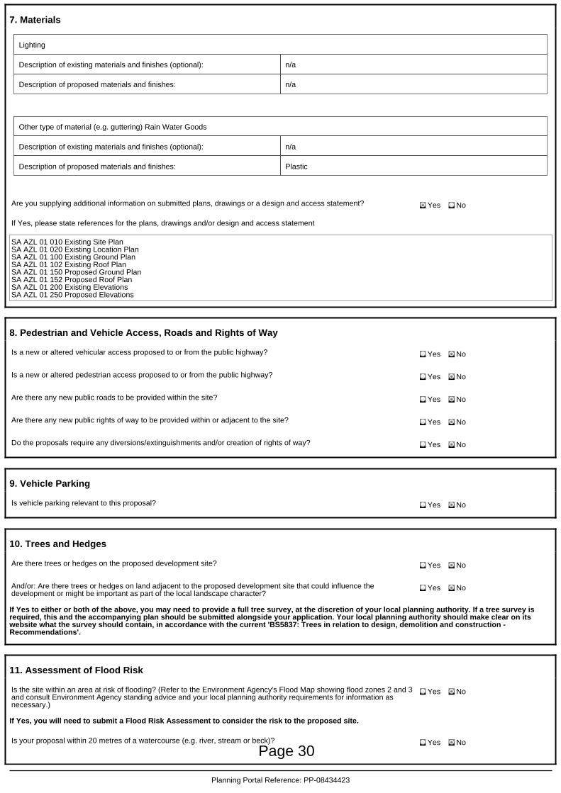
7. Materials
Lighting
Description of existing materials and finishes (optional): n/a
Description of proposed materials and finishes: n/a
Other type of material (e.g. guttering) Rain Water Goods
Description of existing materials and finishes (optional): n/a
Description of proposed materials and finishes: Plastic
Are you supplying additional information on submitted plans, drawings or a design and access statement? Yes No
If Yes, please state references for the plans, drawings and/or design and access statement
SA AZL 01 010 Existing Site PlanSA AZL 01 020 Existing Location PlanSA AZL 01 100 Existing Ground PlanSA AZL 01 102 Existing Roof PlanSA AZL 01 150 Proposed Ground PlanSA AZL 01 152 Proposed Roof PlanSA AZL 01 200 Existing ElevationsSA AZL 01 250 Proposed Elevations
8. Pedestrian and Vehicle Access, Roads and Rights of Way
Is a new or altered vehicular access proposed to or from the public highway? Yes No
Is a new or altered pedestrian access proposed to or from the public highway? Yes No
Are there any new public roads to be provided within the site? Yes No
Are there any new public rights of way to be provided within or adjacent to the site? Yes No
Do the proposals require any diversions/extinguishments and/or creation of rights of way? Yes No
9. Vehicle Parking
Is vehicle parking relevant to this proposal? Yes No
10. Trees and Hedges
Are there trees or hedges on the proposed development site? Yes No
And/or: Are there trees or hedges on land adjacent to the proposed development site that could influence thedevelopment or might be important as part of the local landscape character?
Yes No
If Yes to either or both of the above, you may need to provide a full tree survey, at the discretion of your local planning authority. If a tree survey isrequired, this and the accompanying plan should be submitted alongside your application. Your local planning authority should make clear on itswebsite what the survey should contain, in accordance with the current 'BS5837: Trees in relation to design, demolition and construction -Recommendations'.
11. Assessment of Flood Risk
Is the site within an area at risk of flooding? (Refer to the Environment Agency's Flood Map showing flood zones 2 and 3and consult Environment Agency standing advice and your local planning authority requirements for information asnecessary.)
Yes No
If Yes, you will need to submit a Flood Risk Assessment to consider the risk to the proposed site.
Is your proposal within 20 metres of a watercourse (e.g. river, stream or beck)? Yes No
Planning Portal Reference: PP-08434423
Page 30
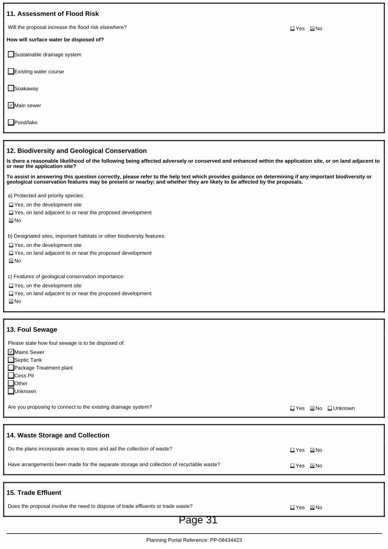
11. Assessment of Flood Risk
Will the proposal increase the flood risk elsewhere? Yes No
How will surface water be disposed of?
Sustainable drainage system
Existing water course
Soakaway
Main sewer
Pond/lake
12. Biodiversity and Geological Conservation
Is there a reasonable likelihood of the following being affected adversely or conserved and enhanced within the application site, or on land adjacent toor near the application site?
To assist in answering this question correctly, please refer to the help text which provides guidance on determining if any important biodiversity orgeological conservation features may be present or nearby; and whether they are likely to be affected by the proposals.
a) Protected and priority species:
Yes, on the development site
Yes, on land adjacent to or near the proposed development
No
b) Designated sites, important habitats or other biodiversity features:
Yes, on the development site
Yes, on land adjacent to or near the proposed development
No
c) Features of geological conservation importance:
Yes, on the development site
Yes, on land adjacent to or near the proposed development
No
13. Foul Sewage
Please state how foul sewage is to be disposed of:
Mains Sewer
Septic Tank
Package Treatment plant
Cess Pit
Other
Unknown
Are you proposing to connect to the existing drainage system? Yes No Unknown
14. Waste Storage and Collection
Do the plans incorporate areas to store and aid the collection of waste? Yes No
Have arrangements been made for the separate storage and collection of recyclable waste? Yes No
15. Trade Effluent
Does the proposal involve the need to dispose of trade effluents or trade waste? Yes No
Planning Portal Reference: PP-08434423
Page 31
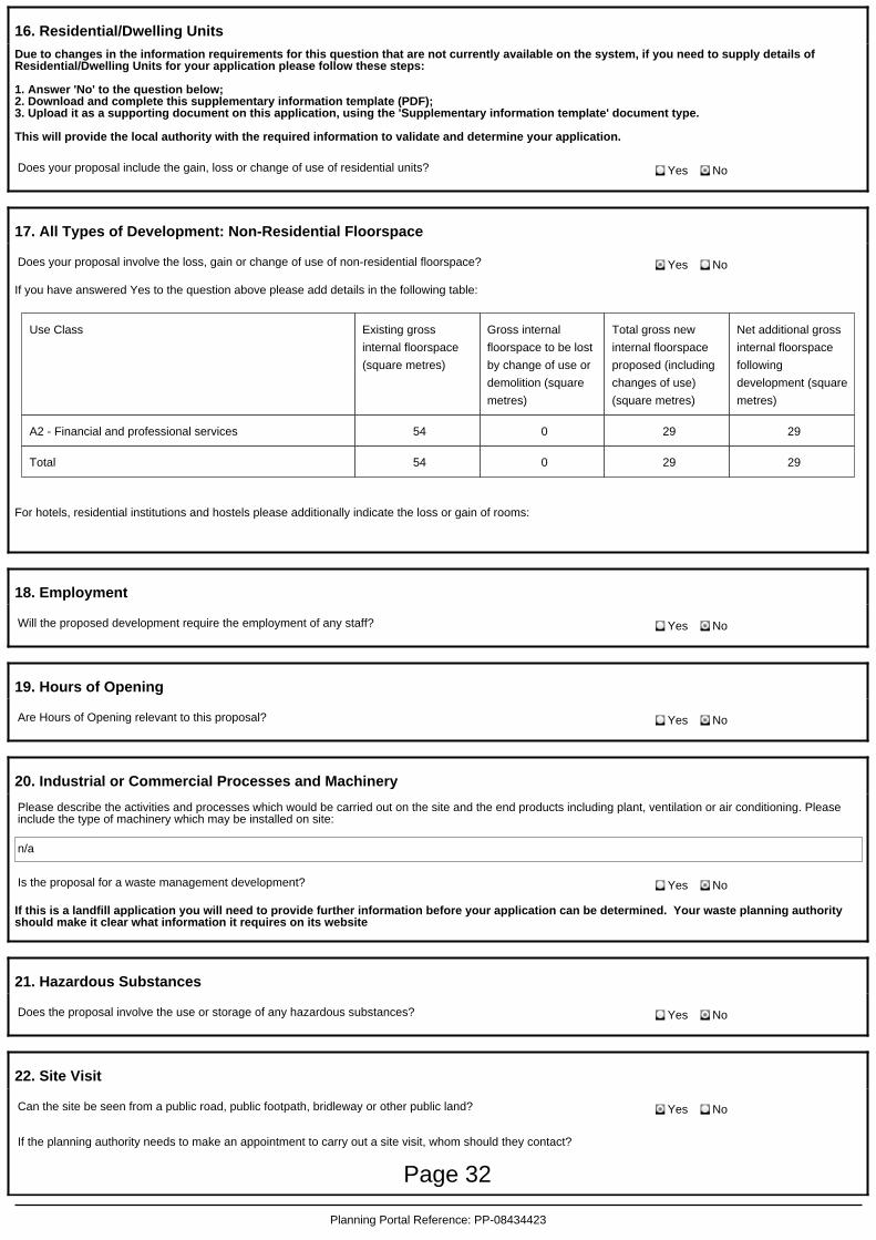
16. Residential/Dwelling Units
Due to changes in the information requirements for this question that are not currently available on the system, if you need to supply details ofResidential/Dwelling Units for your application please follow these steps:
1. Answer 'No' to the question below;2. Download and complete this supplementary information template (PDF);3. Upload it as a supporting document on this application, using the 'Supplementary information template' document type.
This will provide the local authority with the required information to validate and determine your application.
Does your proposal include the gain, loss or change of use of residential units? Yes No
17. All Types of Development: Non-Residential Floorspace
Does your proposal involve the loss, gain or change of use of non-residential floorspace? Yes No
If you have answered Yes to the question above please add details in the following table:
Use Class Existing gross
internal floorspace
(square metres)
Gross internal
floorspace to be lost
by change of use or
demolition (square
metres)
Total gross new
internal floorspace
proposed (including
changes of use)
(square metres)
Net additional gross
internal floorspace
following
development (square
metres)
A2 - Financial and professional services 54 0 29 29
Total 54 0 29 29
For hotels, residential institutions and hostels please additionally indicate the loss or gain of rooms:
18. Employment
Will the proposed development require the employment of any staff? Yes No
19. Hours of Opening
Are Hours of Opening relevant to this proposal? Yes No
20. Industrial or Commercial Processes and Machinery
Please describe the activities and processes which would be carried out on the site and the end products including plant, ventilation or air conditioning. Pleaseinclude the type of machinery which may be installed on site:
n/a
Is the proposal for a waste management development? Yes No
If this is a landfill application you will need to provide further information before your application can be determined. Your waste planning authorityshould make it clear what information it requires on its website
21. Hazardous Substances
Does the proposal involve the use or storage of any hazardous substances? Yes No
22. Site Visit
Can the site be seen from a public road, public footpath, bridleway or other public land? Yes No
If the planning authority needs to make an appointment to carry out a site visit, whom should they contact?
Planning Portal Reference: PP-08434423
Page 32

22. Site Visit
The agent
The applicant
Other person
23. Pre-application Advice
Has assistance or prior advice been sought from the local authority about this application? Yes No
24. Authority Employee/Member
With respect to the Authority, is the applicant and/or agent one of the following:(a) a member of staff(b) an elected member(c) related to a member of staff(d) related to an elected member
It is an important principle of decision-making that the process is open and transparent.
For the purposes of this question, "related to" means related, by birth or otherwise, closely enough that a fair-minded andinformed observer, having considered the facts, would conclude that there was bias on the part of the decision-maker inthe Local Planning Authority.
Do any of the above statements apply?
Yes No
25. Ownership Certificates and Agricultural Land Declaration
CERTIFICATE OF OWNERSHIP - CERTIFICATE A - Town and Country Planning (Development Management Procedure) (England) Order 2015 Certificateunder Article 14
I certify/The applicant certifies that on the day 21 days before the date of this application nobody except myself/the applicant was the owner* of anypart of the land or building to which the application relates, and that none of the land to which the application relates is, or is part of, an agriculturalholding**
* 'owner' is a person with a freehold interest or leasehold interest with at least 7 years left to run. ** 'agricultural holding' has the meaning given byreference to the definition of 'agricultural tenant' in section 65(8) of the Act.
NOTE: You should sign Certificate B, C or D, as appropriate, if you are the sole owner of the land or building to which the application relates but theland is, or is part of, an agricultural holding.
Person role
The applicant
The agent
Title Mr
First name Mahmoud
Surname Ageli
Declaration date(DD/MM/YYYY)
17/01/2020
Declaration made
26. Declaration
I/we hereby apply for planning permission/consent as described in this form and the accompanying plans/drawings and additional information. I/we confirmthat, to the best of my/our knowledge, any facts stated are true and accurate and any opinions given are the genuine opinions of the person(s) giving them.
Date (cannot be pre-application)
17/01/2020
Planning Portal Reference: PP-08434423
Page 33

123
9
117
164
2a
WESTFIELD
RO
AD
144
Surgery
128
Car Park
75
9
139
170
89
2B
21
120
Woodw
ardH
ouse
Ho
122
LeonClub
15
6
132
2
162
CAM
BRID
GE
STREET
El Sub Sta
Surgery
118
149
87
14
85
127
91
EveriteH
ouse
129
73.5m
BEDFO
RD
STREET
1
115
PO
141
101
138
145
190
1
27
143a
103
140
6to
10
8
180
73.8m
116
142
9
81 to
105 to 109
93
3
73.8m
73.5m
36
14
188
99
2
FINDLAY WAY
73.8m
5
Car Park
134
1
136
130
1
1 to
5
5
143
2a
17
BRO
OKLAN
DS
RO
AD
4
131
15
73
2
156
17a
158
1b
13
181
73.5m
204
StudioCourt
6
Centre
233
239
220
177
Bank
231
74.4m4
QUEENSWAY
7a
12
3
196
81
194
25
101
2
1
216
91
Office
1
El
219
26
Medical
2
89
1
LEON
AVENUE
211
14
Government
Sub Sta
75.9m
79
154
148 150
163161
169
9597
11
171
13
119
151
153
124126
135
137
113
Bank
205
208
206
197187
195
77
111121
152
202200
215
217
165
2216
ESS
207
209
241 to 243235
(Health Centre)
99
237
1 to 41
PRIN
CES W
AY
El Sub Sta
CAWKWELL WAY
El Sub Sta
Ska
CAWKWELL WAY
175173
9
MARQUES
19
15
17
Car Park
Day Nursery
QUEENSWAY
School
Knowles Primary
Shelter
TCB
Shelter
DW
Shelter
Agora
Centre
8Club
TCBs
2
14
10
Lennox Ho
Court
Irene
10 86 4
Gas Gov
146
Leisure Centre
Multi Car Pk
2d2c2b
2
HouseAmbassador
1 to
97
224
QUEENSWAY
FOOTPATH
FOOTPATH
Drawing Number:
Drawing Name:Existing site plan
Client:Date:Rev No: Scale:
Rev No:Date:
Drawn by:Studio Ageli SurveyingNote: Key:
Project:
1:1250@A3DA
This drawing is to be read in conjunction with all other contract documents,
prior written permission of Studio AGELI.
Contract Administrator prior to proceeding with the Works. This drawing is
specifications, and all other consultant drawings. All levels and dimensions
copyright. This is not to be used for construction and is indicative and
should be checked on site and any discrepancies notified to the Architect/
subject to site survey. No drawing shall be reproduced in any form without
220 Regency CourtUpper Fifth StreetMilton Keynes MK9 2HR01908 904472www.studioagelisurveying.co.uk
Property boundary line
SA RGB 01 010 08/01/20
01 Site plan 1:1250@A3
N
0 20m 60m 125m
PL0 08-01-20 Issued for planning (DA)
(PLANNING)PL1
NoteDrawings are general arrangement only - please also refer to allconsultants information.The property demise outline is assumed and notional.Existing building layouts including but not limited to levels,dimensions and service locations are approximate.Contractor to undertake measured and other surveys as requiredprior to construction - all information is indicative and to beconfirmed by the contractor on site.Location of any adjacent building shown indicatively - all relevantsurveys to be undertaken prior to construction.All proposed layouts including structure are indicative and must beapproved by relevant specialists / structural engineer.
Mr. Mohammed Ravjani
AZL - Aztec Lettings Bletchley
206 Queensway, Bletchley
Shared access roadPL1 07-02-20 Issued for planning (DA)
Page 34

9
17
HoLeon
149
141
145
190
143a
8
180
73.5m188
21
1
143
1b
181
73.5m
204
Studio Court
220
177
3196
194
2
216
Office
1
2
1
Government
163161
169
171
151
153
208
206
197187
202200
165
ESS
175173
Car Park
Day Nursery
Shelter
Lennox Ho
10 86 4
224
QUEENSWAY
FOOTPATH
FOOTPATH
Drawing Number:
Drawing Name:Existing location plan (block plan)
Client:Date:Rev No: Scale:
Rev No:Date:
Drawn by:Studio Ageli SurveyingNote: Key:
Project:
1:500@A3DA
This drawing is to be read in conjunction with all other contract documents,
prior written permission of Studio AGELI.
Contract Administrator prior to proceeding with the Works. This drawing is
specifications, and all other consultant drawings. All levels and dimensions
copyright. This is not to be used for construction and is indicative and
should be checked on site and any discrepancies notified to the Architect/
subject to site survey. No drawing shall be reproduced in any form without
220 Regency CourtUpper Fifth StreetMilton Keynes MK9 2HR01908 904472www.studioagelisurveying.co.uk
Shared access road
SA RGB 01 020 08/01/20
01 Location plan 1:500@A3206 Queensway, Bletchley
N
PL0 08-01-20 Issued for planning (DA)
(PLANNING)PL1
NoteDrawings are general arrangement only - please also refer to allconsultants information.The property demise outline is assumed and notional.Existing building layouts including but not limited to levels,dimensions and service locations are approximate.Contractor to undertake measured and other surveys as requiredprior to construction - all information is indicative and to beconfirmed by the contractor on site.Location of any adjacent building shown indicatively - all relevantsurveys to be undertaken prior to construction.All proposed layouts including structure are indicative and must beapproved by relevant specialists / structural engineer.
Mr. Mohammed Ravjani
AZL - Aztec Lettings Bletchley
0 10m 25m 50m
Temporary structure (to be removed)
Property boundary line
Existing staff parking
PL1 07-02-20 Issued for planning (DA)
Shared access road
Temporary structure(to be demolished)
EXISTING
ENTRANCE/
EXIT
EXISTING
ENTRANCE/
EXIT
Page 35

9
17
HoLeon
149
141
145
190
143a
8
180
73.5m188
21
1
143
1b
181
73.5m
204
Studio Court
220
177
3196
194
2
216
Office
1
2
1
Government
163161
169
171
151
153
208
206
197187
202200
165
ESS
175173
Car Park
Day Nursery
Shelter
Lennox Ho
10 86 4
224
QUEENSWAY
FOOTPATH
FOOTPATH
Drawing Number:
Drawing Name:Proposed location plan (block plan)
Client:Date:Rev No: Scale:
Rev No:Date:
Drawn by:Studio Ageli SurveyingNote: Key:
Project:
1:500@A3DA
This drawing is to be read in conjunction with all other contract documents,
prior written permission of Studio AGELI.
Contract Administrator prior to proceeding with the Works. This drawing is
specifications, and all other consultant drawings. All levels and dimensions
copyright. This is not to be used for construction and is indicative and
should be checked on site and any discrepancies notified to the Architect/
subject to site survey. No drawing shall be reproduced in any form without
220 Regency CourtUpper Fifth StreetMilton Keynes MK9 2HR01908 904472www.studioagelisurveying.co.uk
Shared access road
SA RGB 01 050 06/01/20
01 Proposed location plan 1:500@A3206 Queensway, Bletchley
N
PL0 07-02-20 Issued for planning (DA)
(PLANNING)PL0
NoteDrawings are general arrangement only - please also refer to allconsultants information.The property demise outline is assumed and notional.Existing building layouts including but not limited to levels,dimensions and service locations are approximate.Contractor to undertake measured and other surveys as requiredprior to construction - all information is indicative and to beconfirmed by the contractor on site.Location of any adjacent building shown indicatively - all relevantsurveys to be undertaken prior to construction.All proposed layouts including structure are indicative and must beapproved by relevant specialists / structural engineer.
Mr. Mohammed Ravjani
AZL - Aztec Lettings Bletchley
0 10m 25m 50m
Proposed extension
Property boundary line
Existing staff parking Shared access road
Proposed extension
EXISTING
ENTRANCE
PROPOSED
STAFF
ENTRANCE
Page 36

A B D E FC 123
1 2 3
A B D E F
1
2
3
C
Drawing Number:SA AZL 01 250
Drawing Name:Proposed elevations
Client:Date:Rev No: Scale:
Rev No:Date:
Drawn by:Studio Ageli SurveyingNote: Key:
Project:PL0
1:100@A3
10/01/20
DAMr. Mohammed Ravjani
(PLANNING)
This drawing is to be read in conjunction with all other contract documents,
prior written permission of Studio AGELI.
Contract Administrator prior to proceeding with the Works. This drawing is
specifications, and all other consultant drawings. All levels and dimensions
copyright. This is not to be used for construction and is indicative and
should be checked on site and any discrepancies notified to the Architect/
subject to site survey. No drawing shall be reproduced in any form without AZL - Aztec Lettings Bletchley
220 Regency CourtUpper Fifth StreetMilton Keynes MK9 2HR01908 904472www.studioagelisurveying.co.uk
Property boundary line
NoteDrawings are general arrangement only - please also refer to all consultants information.The property demise outline is assumed and notional in accordance with information provided by the client.The existing building layouts including but not limited to levels, dimensions and service locations are approximate and based on information supplied by the client.Contractor to undertake measured and other surveys as required prior to construction - all dimensions are indicative and are to be confirmed by the contractor on site.
15-01-20PL0 Issued for planning (DA)
5400 3610 7990 2990 3000
29903000
150
975
900
300
2575
4085
805
150
975
900
300
2575
4085
805
150
975
900
300
2575
4085
805
1875
02
03
01 Existing elevation 1:100East-facing
1:100
1:100
1875
Existing elevationNorth-facing
Existing elevationSouth-facing
01 20001
01 20003
01 20002
04 Existing roof 1:200Key plan
Temporary structure(to be removed)
Page 37
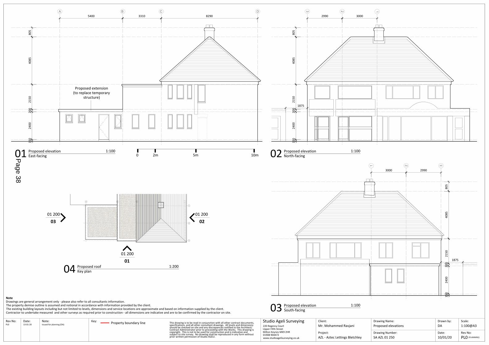
123
1 2 3
A B DC
A B D
1
2
3
C
Drawing Number:SA AZL 01 250
Drawing Name:Proposed elevations
Client:Date:Rev No: Scale:
Rev No:Date:
Drawn by:Studio Ageli SurveyingNote: Key:
Project:PL0
1:100@A3
10/01/20
DAMr. Mohammed Ravjani
(PLANNING)AZL - Aztec Lettings Bletchley
220 Regency CourtUpper Fifth StreetMilton Keynes MK9 2HR01908 904472www.studioagelisurveying.co.uk
Property boundary line 13-01-20PL0 Issued for planning (DA)
2990 3000
29903000
1875
02
03
1:100
1:100
1875
North-facing
South-facing
Proposed elevation
Proposed elevation
Proposed extension(to replace temporary
structure)
0 2m 5m 10m
This drawing is to be read in conjunction with all other contract documents,
prior written permission of Studio AGELI.
Contract Administrator prior to proceeding with the Works. This drawing is
specifications, and all other consultant drawings. All levels and dimensions
copyright. This is not to be used for construction and is indicative and
should be checked on site and any discrepancies notified to the Architect/
subject to site survey. No drawing shall be reproduced in any form without
NoteDrawings are general arrangement only - please also refer to all consultants information.The property demise outline is assumed and notional in accordance with information provided by the client.The existing building layouts including but not limited to levels, dimensions and service locations are approximate and based on information supplied by the client.Contractor to undertake measured and other surveys as required prior to construction - all dimensions are indicative and are to be confirmed by the contractor on site.
5400 3310 8290
150
2400
2150
4085
805
01 Proposed elevation 1:100East-facing
01 20001
01 20003
01 20002
04 Proposed roof 1:200Key plan
200
150
2400
2150
4085
805
200
150
2400
2150
4085
805
200
Page 38
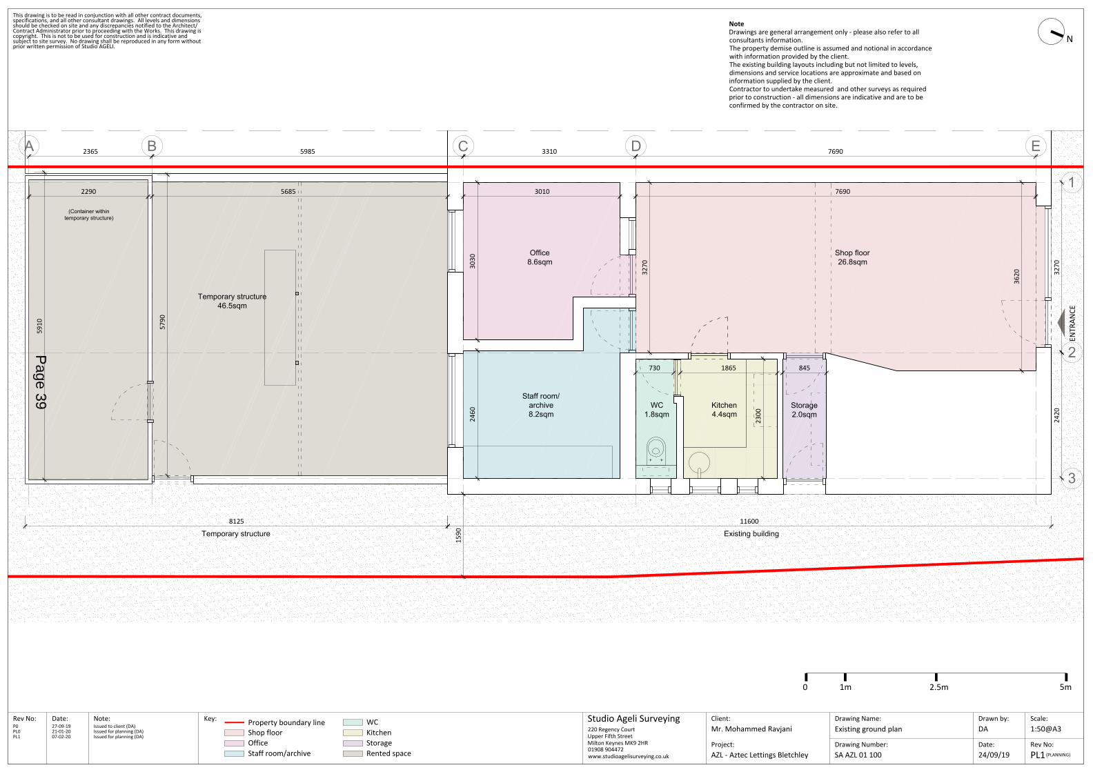
A B C D E
1
2
3
Drawing Number:SA AZL 01 100
Drawing Name:Existing ground plan
Client:Date:Rev No: Scale:
Rev No:Date:
Drawn by:Studio Ageli SurveyingNote: Key:
Project:
1:50@A3
24/09/19
DAMr. Mohammed Ravjani
This drawing is to be read in conjunction with all other contract documents,
prior written permission of Studio AGELI.
Contract Administrator prior to proceeding with the Works. This drawing is
specifications, and all other consultant drawings. All levels and dimensions
copyright. This is not to be used for construction and is indicative and
should be checked on site and any discrepancies notified to the Architect/
subject to site survey. No drawing shall be reproduced in any form without
AZL - Aztec Lettings Bletchley
220 Regency CourtUpper Fifth StreetMilton Keynes MK9 2HR01908 904472www.studioagelisurveying.co.uk
Property boundary line WCShop floor
NoteDrawings are general arrangement only - please also refer to allconsultants information.The property demise outline is assumed and notional in accordancewith information provided by the client.The existing building layouts including but not limited to levels,dimensions and service locations are approximate and based oninformation supplied by the client.Contractor to undertake measured and other surveys as requiredprior to construction - all dimensions are indicative and are to beconfirmed by the contractor on site.
OfficeStaff room/archive
KitchenStorageRented space
ENTR
ANCE
7690
5910
2300
2460
3030
3270
3620
5790
116008125
Shop floor26.8sqm
Kitchen4.4sqm
WC1.8sqm
Staff room/archive8.2sqm
Office8.6sqm
Storage2.0sqm
Temporary structure46.5sqm
(Container withintemporary structure)
Existing buildingTemporary structure
2365 5985 3310 7690
3270
2420
30102290 5685
730 1865 845
27-09-19P0 Issued to client (DA)21-01-20PL0 Issued for planning (DA)
N
PL1(PLANNING)
0 1m 2.5m 5m
1590
07-02-20PL1 Issued for planning (DA)
Page 39
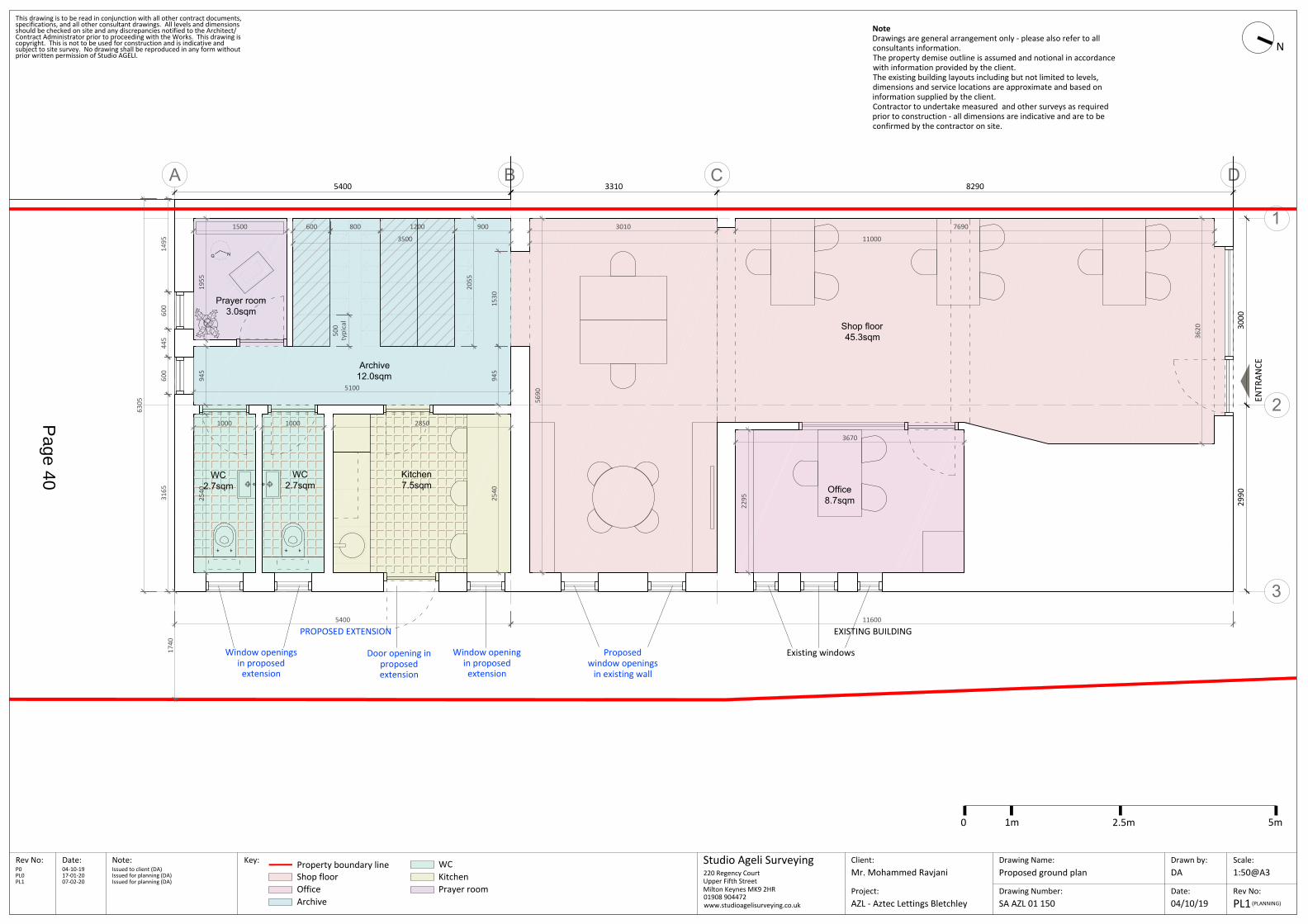
A B D
1
2
3
C
Shop floor45.3sqm
Kitchen7.5sqm
WC2.7sqm
Prayer room3.0sqm
Office8.7sqm
WC2.7sqm
NQ
Archive12.0sqm
Drawing Number:SA AZL 01 150
Drawing Name:Proposed ground plan
Client:Date:Rev No: Scale:
Rev No:Date:
Drawn by:Studio Ageli SurveyingNote:
Project:PL1
1:50@A3DAMr. Mohammed Ravjani
(PLANNING)
This drawing is to be read in conjunction with all other contract documents,
prior written permission of Studio AGELI.
Contract Administrator prior to proceeding with the Works. This drawing is
specifications, and all other consultant drawings. All levels and dimensions
copyright. This is not to be used for construction and is indicative and
should be checked on site and any discrepancies notified to the Architect/
subject to site survey. No drawing shall be reproduced in any form without
AZL - Aztec Lettings Bletchley
220 Regency CourtUpper Fifth StreetMilton Keynes MK9 2HR01908 904472www.studioagelisurveying.co.uk
NoteDrawings are general arrangement only - please also refer to allconsultants information.The property demise outline is assumed and notional in accordancewith information provided by the client.The existing building layouts including but not limited to levels,dimensions and service locations are approximate and based oninformation supplied by the client.Contractor to undertake measured and other surveys as requiredprior to construction - all dimensions are indicative and are to beconfirmed by the contractor on site.
ENTR
ANCE
04-10-19P0 Issued to client (DA)
04/10/19
17-01-20PL0 Issued for planning (DA)
Key: Property boundary line WCShop floorOfficeArchive
KitchenPrayer room
Existing windowsDoor opening inproposedextension
Window openingin proposedextension
Window openingsin proposed
extension
PROPOSED EXTENSION EXISTING BUILDING
3500
3010
1955
945
1000 1000 2850
2295
3670
5690
7690
11000
116005400
Proposedwindow openings
in existing wall
3620
1530
5400 3310 8290
3000
2990
1500
2540
2540
600 800 1200 900
5100
945
500
typi
cal
2055
N
6305
1495
600
445
600
3165
0 1m 2.5m 5m
07-02-20PL1 Issued for planning (DA)
1740
Page 40
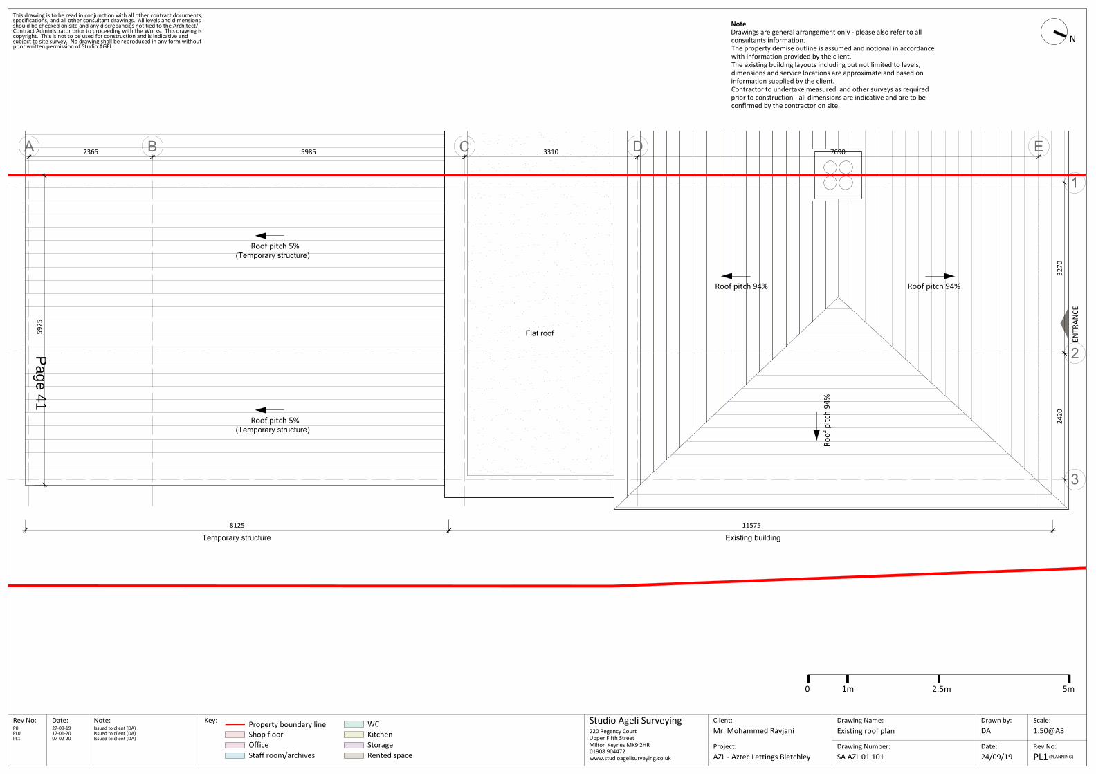
A B C D E
1
2
3
N
Drawing Number:SA AZL 01 101
Drawing Name:Existing roof plan
Client:Date:Rev No: Scale:
Rev No:Date:
Drawn by:Studio Ageli SurveyingNote: Key:
Project:PL1
1:50@A3
24/09/19
DAMr. Mohammed Ravjani
(PLANNING)
This drawing is to be read in conjunction with all other contract documents,
prior written permission of Studio AGELI.
Contract Administrator prior to proceeding with the Works. This drawing is
specifications, and all other consultant drawings. All levels and dimensions
copyright. This is not to be used for construction and is indicative and
should be checked on site and any discrepancies notified to the Architect/
subject to site survey. No drawing shall be reproduced in any form without
AZL - Aztec Lettings Bletchley
220 Regency CourtUpper Fifth StreetMilton Keynes MK9 2HR01908 904472www.studioagelisurveying.co.uk
Property boundary line WCShop floor
NoteDrawings are general arrangement only - please also refer to allconsultants information.The property demise outline is assumed and notional in accordancewith information provided by the client.The existing building layouts including but not limited to levels,dimensions and service locations are approximate and based oninformation supplied by the client.Contractor to undertake measured and other surveys as requiredprior to construction - all dimensions are indicative and are to beconfirmed by the contractor on site.
OfficeStaff room/archives
KitchenStorageRented space
ENTR
ANCE
5925
115758125
Existing buildingTemporary structure
2365 5985 3310 7690
3270
2420
27-09-19P0 Issued to client (DA)
Flat roof
(Temporary structure)
Roof pitch 94% Roof pitch 94%
Roof
pitc
h 94
%
0 1m 2.5m 5m
Roof pitch 5%
(Temporary structure)Roof pitch 5%
17-01-20PL0 Issued to client (DA)07-02-20PL1 Issued to client (DA)
Page 41

A B D
1
2
3
C
Drawing Number:SA AZL 01 151
Drawing Name:Proposed roof plan
Client:Date:Rev No: Scale:
Rev No:Date:
Drawn by:Studio Ageli SurveyingNote: Key:
Project:
1:50@A3DAMr. Mohammed Ravjani
This drawing is to be read in conjunction with all other contract documents,
prior written permission of Studio AGELI.
Contract Administrator prior to proceeding with the Works. This drawing is
specifications, and all other consultant drawings. All levels and dimensions
copyright. This is not to be used for construction and is indicative and
should be checked on site and any discrepancies notified to the Architect/
subject to site survey. No drawing shall be reproduced in any form without
AZL - Aztec Lettings Bletchley
220 Regency CourtUpper Fifth StreetMilton Keynes MK9 2HR01908 904472www.studioagelisurveying.co.uk
NoteDrawings are general arrangement only - please also refer to allconsultants information.The property demise outline is assumed and notional in accordancewith information provided by the client.The existing building layouts including but not limited to levels,dimensions and service locations are approximate and based oninformation supplied by the client.Contractor to undertake measured and other surveys as requiredprior to construction - all dimensions are indicative and are to beconfirmed by the contractor on site.
ENTR
ANCE
5400 3310 8290
3000
2990
04-10-19P0 Issued to client (DA)17-01-20PL0 Issued for planning (DA)
Property boundary line
N
PL1(PLANNING)14/01/20
115755400
Existing buildingProposed extension
0 1m 2.5m 5m
Proposed flat roofExisting flat roof
Roof pitch 94% Roof pitch 94%
Roof
pitc
h 94
%
07-02-20PL1 Issued for planning (DA)
Page 42

This is a copy of the title plan on 5 FEB 2020 at 15:43:09. This copy does not take account of any application made afterthat time even if still pending in HM Land Registry when this copy was issued.
This copy is not an 'Official Copy' of the title plan. An official copy of the title plan is admissible in evidence in a court tothe same extent as the original. A person is entitled to be indemnified by the registrar if he or she suffers loss by reasonof a mistake in an official copy. If you want to obtain an official copy, the HM Land Registry web site explains how to dothis.
HM Land Registry endeavours to maintain high quality and scale accuracy of title plan images.The quality and accuracyof any print will depend on your printer, your computer and its print settings.This title plan shows the general position,not the exact line, of the boundaries. It may be subject to distortions in scale. Measurements scaled from this plan maynot match measurements between the same points on the ground.
This title is dealt with by HM Land Registry, Leicester Office.Page 43
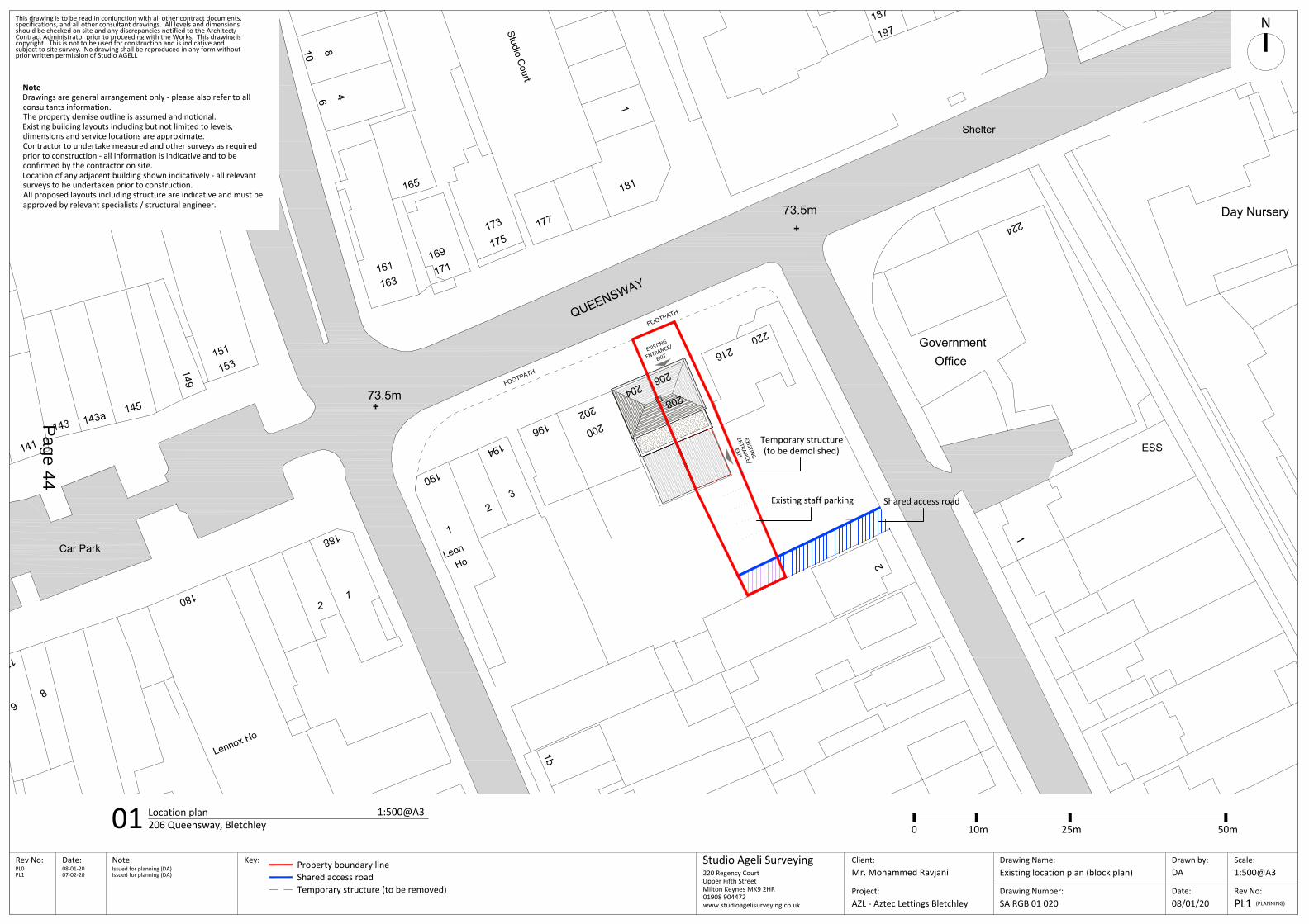
9
17
HoLeon
149
141
145
190
143a
8
180
73.5m188
21
1
143
1b
181
73.5m
204
Studio Court
220
177
3196
194
2
216
Office
1
2
1
Government
163161
169
171
151
153
208
206
197187
202200
165
ESS
175173
Car Park
Day Nursery
Shelter
Lennox Ho
10 86 4
224
QUEENSWAY
FOOTPATH
FOOTPATH
Drawing Number:
Drawing Name:Existing location plan (block plan)
Client:Date:Rev No: Scale:
Rev No:Date:
Drawn by:Studio Ageli SurveyingNote: Key:
Project:
1:500@A3DA
This drawing is to be read in conjunction with all other contract documents,
prior written permission of Studio AGELI.
Contract Administrator prior to proceeding with the Works. This drawing is
specifications, and all other consultant drawings. All levels and dimensions
copyright. This is not to be used for construction and is indicative and
should be checked on site and any discrepancies notified to the Architect/
subject to site survey. No drawing shall be reproduced in any form without
220 Regency CourtUpper Fifth StreetMilton Keynes MK9 2HR01908 904472www.studioagelisurveying.co.uk
Shared access road
SA RGB 01 020 08/01/20
01 Location plan 1:500@A3206 Queensway, Bletchley
N
PL0 08-01-20 Issued for planning (DA)
(PLANNING)PL1
NoteDrawings are general arrangement only - please also refer to allconsultants information.The property demise outline is assumed and notional.Existing building layouts including but not limited to levels,dimensions and service locations are approximate.Contractor to undertake measured and other surveys as requiredprior to construction - all information is indicative and to beconfirmed by the contractor on site.Location of any adjacent building shown indicatively - all relevantsurveys to be undertaken prior to construction.All proposed layouts including structure are indicative and must beapproved by relevant specialists / structural engineer.
Mr. Mohammed Ravjani
AZL - Aztec Lettings Bletchley
0 10m 25m 50m
Temporary structure (to be removed)
Property boundary line
Existing staff parking
PL1 07-02-20 Issued for planning (DA)
Shared access road
Temporary structure(to be demolished)
EXISTING
ENTRANCE/
EXIT
EXISTING
ENTRANCE/
EXIT
Page 44
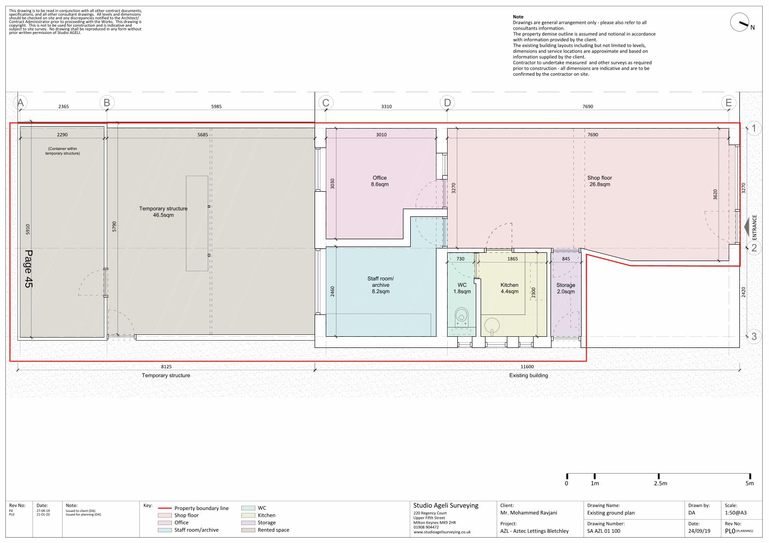
A B C D E
1
2
3
Drawing Number:SA AZL 01 100
Drawing Name:Existing ground plan
Client:Date:Rev No: Scale:
Rev No:Date:
Drawn by:Studio Ageli SurveyingNote: Key:
Project:
1:50@A3
24/09/19
DAMr. Mohammed Ravjani
This drawing is to be read in conjunction with all other contract documents,
prior written permission of Studio AGELI.
Contract Administrator prior to proceeding with the Works. This drawing is
specifications, and all other consultant drawings. All levels and dimensions
copyright. This is not to be used for construction and is indicative and
should be checked on site and any discrepancies notified to the Architect/
subject to site survey. No drawing shall be reproduced in any form without
AZL - Aztec Lettings Bletchley
220 Regency CourtUpper Fifth StreetMilton Keynes MK9 2HR01908 904472www.studioagelisurveying.co.uk
Property boundary line WCShop floor
NoteDrawings are general arrangement only - please also refer to allconsultants information.The property demise outline is assumed and notional in accordancewith information provided by the client.The existing building layouts including but not limited to levels,dimensions and service locations are approximate and based oninformation supplied by the client.Contractor to undertake measured and other surveys as requiredprior to construction - all dimensions are indicative and are to beconfirmed by the contractor on site.
OfficeStaff room/archive
KitchenStorageRented space
ENTR
ANCE
7690
5910
2300
2460
3030
3270
3620
5790
116008125
Shop floor26.8sqm
Kitchen4.4sqm
WC1.8sqm
Staff room/archive8.2sqm
Office8.6sqm
Storage2.0sqm
Temporary structure46.5sqm
(Container withintemporary structure)
Existing buildingTemporary structure
2365 5985 3310 7690
3270
2420
30102290 5685
730 1865 845
27-09-19P0 Issued to client (DA)21-01-20PL0 Issued for planning (DA)
N
PL0(PLANNING)
0 1m 2.5m 5m
Page 45
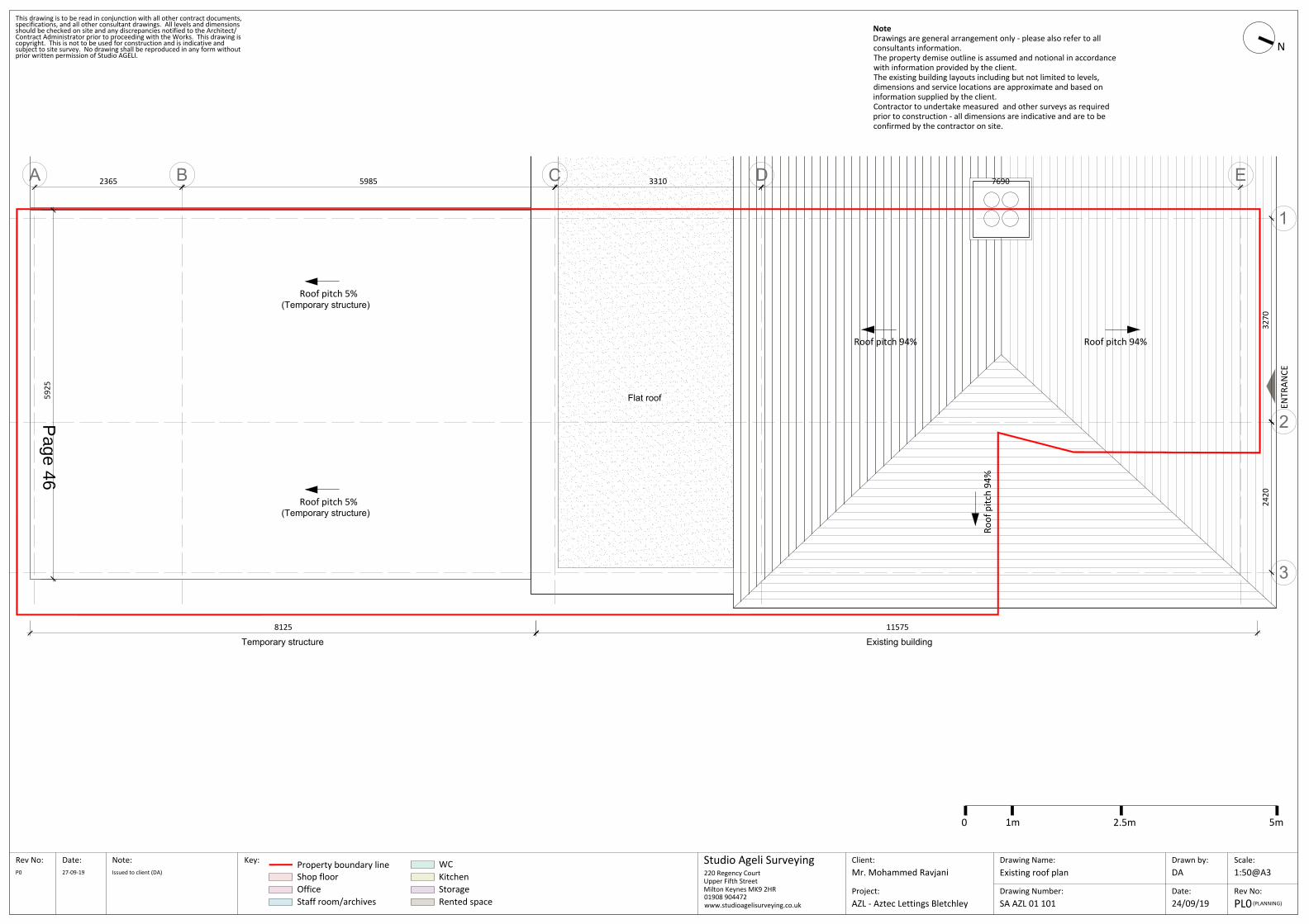
A B C D E
1
2
3
N
Drawing Number:SA AZL 01 101
Drawing Name:Existing roof plan
Client:Date:Rev No: Scale:
Rev No:Date:
Drawn by:Studio Ageli SurveyingNote: Key:
Project:PL0
1:50@A3
24/09/19
DAMr. Mohammed Ravjani
(PLANNING)
This drawing is to be read in conjunction with all other contract documents,
prior written permission of Studio AGELI.
Contract Administrator prior to proceeding with the Works. This drawing is
specifications, and all other consultant drawings. All levels and dimensions
copyright. This is not to be used for construction and is indicative and
should be checked on site and any discrepancies notified to the Architect/
subject to site survey. No drawing shall be reproduced in any form without
AZL - Aztec Lettings Bletchley
220 Regency CourtUpper Fifth StreetMilton Keynes MK9 2HR01908 904472www.studioagelisurveying.co.uk
Property boundary line WCShop floor
NoteDrawings are general arrangement only - please also refer to allconsultants information.The property demise outline is assumed and notional in accordancewith information provided by the client.The existing building layouts including but not limited to levels,dimensions and service locations are approximate and based oninformation supplied by the client.Contractor to undertake measured and other surveys as requiredprior to construction - all dimensions are indicative and are to beconfirmed by the contractor on site.
OfficeStaff room/archives
KitchenStorageRented space
ENTR
ANCE
5925
115758125
Existing buildingTemporary structure
2365 5985 3310 7690
3270
2420
27-09-19P0 Issued to client (DA)
Flat roof
(Temporary structure)
Roof pitch 94% Roof pitch 94%
Roof
pitc
h 94
%
0 1m 2.5m 5m
Roof pitch 5%
(Temporary structure)Roof pitch 5%
Page 46

123
9
117
164
2a
WESTFIELD
RO
AD
144
Surgery
128
Car Park
75
9
139
170
89
2B
21
120
Woodw
ardH
ouse
Ho
122
LeonClub
15
6
132
2
162
CAM
BRID
GE STR
EET
El Sub Sta
Surgery
118
149
87
14
85
127
91
EveriteH
ouse
129
73.5m
BEDFO
RD
STREET
1
115
PO
141
101
138
145
190
1
27
143a
103
140
6to
10
8
180
73.8m
116
142
9
81 to
105 to 109
93
3
73.8m
73.5m
36
14
188
99
2
FINDLAY WAY
73.8m
5
Car Park
134
1
136
130
1
1 to
5
5
143
2a
17
BRO
OKLAN
DS R
OAD
4
131
15
73
2
156
17a
158
1b
13
181
73.5m
204
StudioCourt
6
Centre
233
239
220
177
Bank
231
74.4m4
QUEENSWAY
7a
12
3
196
81
194
25
101
2
1
216
91
Office
1
El
219
26
Medical
2
89
1
LEON
AVENUE
211
14
Government
Sub Sta
75.9m
79
154
148 150
163161
169
9597
11
171
13
119
151
153
124126
135
137
113
Bank
205
208
206
197187
195
77
111121
152
202200
215
217
165
2216
ESS
207
209
241 to 243235
(Health Centre)
99
237
1 to 41
PRIN
CES W
AY
El Sub Sta
CAWKWELL WAY
El Sub Sta
Ska
CAWKWELL WAY
175173
9
MARQUES
19
15
17
Car Park
Day Nursery
QUEENSWAY
School
Knowles Primary
Shelter
TCB
Shelter
DW
Shelter
Agora
Centre
8Club
TCBs
2
14
10
Lennox Ho
Court
Irene
10 86 4
Gas Gov
146
Leisure Centre
Multi Car Pk
2d2c2b
2
HouseAmbassador
1 to
97
224
QUEENSWAY
Drawing Number:
Drawing Name:Existing site plan
Client:Date:Rev No: Scale:
Rev No:Date:
Drawn by:Studio Ageli SurveyingNote: Key:
Project:
1:1250@A3DA
This drawing is to be read in conjunction with all other contract documents,
prior written permission of Studio AGELI.
Contract Administrator prior to proceeding with the Works. This drawing is
specifications, and all other consultant drawings. All levels and dimensions
copyright. This is not to be used for construction and is indicative and
should be checked on site and any discrepancies notified to the Architect/
subject to site survey. No drawing shall be reproduced in any form without
220 Regency CourtUpper Fifth StreetMilton Keynes MK9 2HR01908 904472www.studioagelisurveying.co.uk
Property boundary line
SA RGB 01 010 08/01/20
01 Site plan 1:1250@A3
N
0 20m 60m 125m
PL0 08-01-20 Issued for planning (DA)
(PLANNING)PL0
NoteDrawings are general arrangement only - please also refer to allconsultants information.The property demise outline is assumed and notional.Existing building layouts including but not limited to levels,dimensions and service locations are approximate.Contractor to undertake measured and other surveys as requiredprior to construction - all information is indicative and to beconfirmed by the contractor on site.Location of any adjacent building shown indicatively - all relevantsurveys to be undertaken prior to construction.All proposed layouts including structure are indicative and must beapproved by relevant specialists / structural engineer.
Mr. Mohammed Ravjani
AZL - Aztec Lettings Bletchley
206 Queensway, Bletchley
Page 47

123
9
117
164
2a
WESTFIELD
RO
AD
144
Surgery
128
Car Park
75
9
139
170
89
2B
21
120
Woodw
ard House
Ho
122
LeonClub
15
6
132
2
162
CAM
BRID
GE STR
EET
El Sub Sta
Surgery
118
149
87
14
85
127
91
Everite House
129
73.5m
BEDFO
RD
STREET
1
115
PO
141
101
138
145
190
1
27
143a
103
140
6 to
10
8
180
73.8m
116
142
9
81 to
105 to 109
93
3
73.8m
73.5m
36
14
188
99
2
FINDLAY WAY
73.8m
5
Car Park
134
1
136
130
1
1 to
5
5
143
2a
17
BRO
OKLAN
DS R
OAD
4
131
15
73
2
156
17a
158
1b
13
181
73.5m
204
Studio Court6
Centre
233
239
220
177
Bank
231
74.4m4
QUEENSWAY
7a
12
3
196
81
194
25
101
2
1
216
91
Office
1
El
219
26
Medical
2
89
1
LEON AVENUE
211
14
Government
Sub Sta
75.9m
79
154
148 150
163161
169
9597
11
171
13
119
151
153
124126
135
137
113
Bank
205
208
206
197187
195
77
111121
152
202200
215
217
165
2216
ESS
207
209
241 to 243235
(Health Centre)
99
237
1 to 41
PRIN
CES W
AY
El Sub Sta
CAWKWELL WAY
El Sub Sta
Skatepark
CAWKWELL WAY
175173
9
MARQUESS DRIVE
19
15
17
Car Park
Day Nursery
QUEENSWAY
School
Knowles Primary
Shelter
TCB
Shelter
DW
Shelter
Agora
Centre
8Club
TCBs
2
14
10
Lennox Ho
Court
Irene
10 86 4
Gas Gov
146
Leisure Centre
Multi Car Pk
2d2c2b
2
HouseAmbassador
1 to
97
224
QUEENSWAY
FOOTPATH
FOOTPATH
Drawing Number:
Drawing Name:Existing site plan
Client:Date:Rev No: Scale:
Rev No:Date:
Drawn by:Studio Ageli SurveyingNote: Key:
Project:
1:1250@A3DA
This drawing is to be read in conjunction with all other contract documents,
prior written permission of Studio AGELI.
Contract Administrator prior to proceeding with the Works. This drawing is
specifications, and all other consultant drawings. All levels and dimensions
copyright. This is not to be used for construction and is indicative and
should be checked on site and any discrepancies notified to the Architect/
subject to site survey. No drawing shall be reproduced in any form without
220 Regency CourtUpper Fifth StreetMilton Keynes MK9 2HR01908 904472www.studioagelisurveying.co.uk
Property boundary line
SA RGB 01 010 08/01/20
01 Site plan 1:1250@A3
N
0 20m 60m 125m
PL0 08-01-20 Issued for planning (DA)
(PLANNING)PL1
NoteDrawings are general arrangement only - please also refer to allconsultants information.The property demise outline is assumed and notional.Existing building layouts including but not limited to levels,dimensions and service locations are approximate.Contractor to undertake measured and other surveys as requiredprior to construction - all information is indicative and to beconfirmed by the contractor on site.Location of any adjacent building shown indicatively - all relevantsurveys to be undertaken prior to construction.All proposed layouts including structure are indicative and must beapproved by relevant specialists / structural engineer.
Mr. Mohammed Ravjani
AZL - Aztec Lettings Bletchley
206 Queensway, Bletchley
Shared access roadPL1 07-02-20 Issued for planning (DA)
Page 48

9
170
HoLeon
149
141
145
190
143a
8
180
73.5m188
21
1
143
1b
181
73.5m
204
Studio Court
220
177
3196
194
2
216
Office
1
2
1
Government
163161
169
171
151
153
208
206
197187
202200
165
ESS
175173
Car Park
Day Nursery
Shelter
Lennox Ho
10 86 4
224
QUEENSWAY
Drawing Number:
Drawing Name:Location plan
Client:Date:Rev No: Scale:
Rev No:Date:
Drawn by:Studio Ageli SurveyingNote: Key:
Project:
1:500@A3DA
This drawing is to be read in conjunction with all other contract documents,
prior written permission of Studio AGELI.
Contract Administrator prior to proceeding with the Works. This drawing is
specifications, and all other consultant drawings. All levels and dimensions
copyright. This is not to be used for construction and is indicative and
should be checked on site and any discrepancies notified to the Architect/
subject to site survey. No drawing shall be reproduced in any form without
220 Regency CourtUpper Fifth StreetMilton Keynes MK9 2HR01908 904472www.studioagelisurveying.co.uk
Property boundary line
SA RGB 01 010 08/01/20
01 Location plan 1:500@A3206 Queensway, Bletchley
N
PL0 08-01-20 Issued for planning (DA)
(PLANNING)PL0
NoteDrawings are general arrangement only - please also refer to allconsultants information.The property demise outline is assumed and notional.Existing building layouts including but not limited to levels,dimensions and service locations are approximate.Contractor to undertake measured and other surveys as requiredprior to construction - all information is indicative and to beconfirmed by the contractor on site.Location of any adjacent building shown indicatively - all relevantsurveys to be undertaken prior to construction.All proposed layouts including structure are indicative and must beapproved by relevant specialists / structural engineer.
Mr. Mohammed Ravjani
AZL - Aztec Lettings Bletchley
0 10m 25m 50m
Page 49

9
170
HoLeon
149
141
145
190
143a
8
180
73.5m188
21
1
143
1b
181
73.5m
204
Studio Court
220
177
3196
194
2
216
Office
1
2
1
Government
163161
169
171
151
153
208
206
197187
202200
165
ESS
175173
Car Park
Day Nursery
Shelter
Lennox Ho
10 86 4
224
QUEENSWAY
FOOTPATH
FOOTPATH
Drawing Number:
Drawing Name:Proposed location plan (block plan)
Client:Date:Rev No: Scale:
Rev No:Date:
Drawn by:Studio Ageli SurveyingNote: Key:
Project:
1:500@A3DA
This drawing is to be read in conjunction with all other contract documents,
prior written permission of Studio AGELI.
Contract Administrator prior to proceeding with the Works. This drawing is
specifications, and all other consultant drawings. All levels and dimensions
copyright. This is not to be used for construction and is indicative and
should be checked on site and any discrepancies notified to the Architect/
subject to site survey. No drawing shall be reproduced in any form without
220 Regency CourtUpper Fifth StreetMilton Keynes MK9 2HR01908 904472www.studioagelisurveying.co.uk
Shared access road
SA RGB 01 050 06/01/20
01 Proposed location plan 1:500@A3206 Queensway, Bletchley
N
PL0 07-02-20 Issued for planning (DA)
(PLANNING)PL0
NoteDrawings are general arrangement only - please also refer to allconsultants information.The property demise outline is assumed and notional.Existing building layouts including but not limited to levels,dimensions and service locations are approximate.Contractor to undertake measured and other surveys as requiredprior to construction - all information is indicative and to beconfirmed by the contractor on site.Location of any adjacent building shown indicatively - all relevantsurveys to be undertaken prior to construction.All proposed layouts including structure are indicative and must beapproved by relevant specialists / structural engineer.
Mr. Mohammed Ravjani
AZL - Aztec Lettings Bletchley
0 10m 25m 50m
Proposed extension
Property boundary line
Existing staff parking Shared access road
Proposed extension
EXISTING
ENTRANCE
PROPOSED
STAFF
ENTRANCE
Page 50
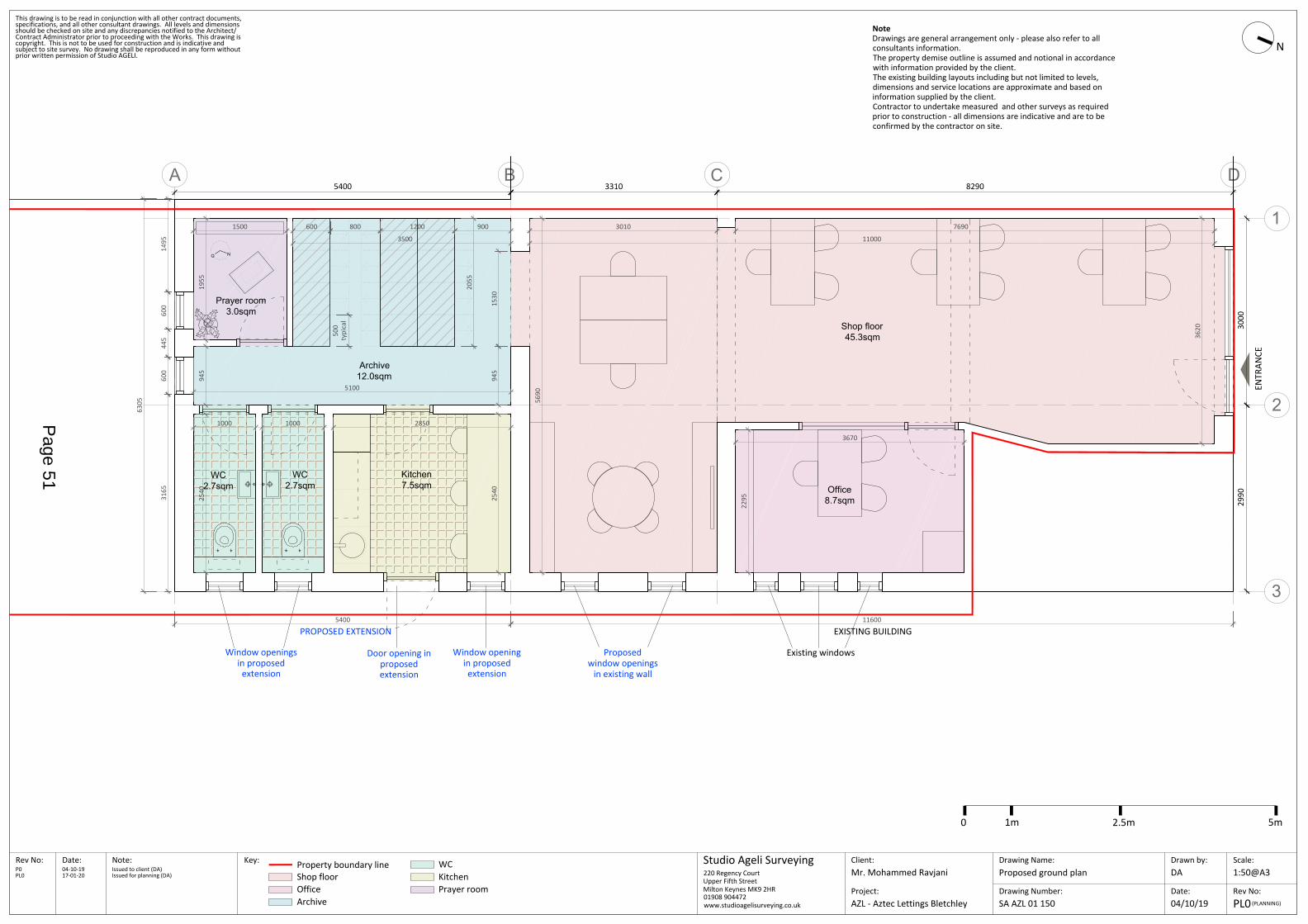
A B D
1
2
3
C
Shop floor45.3sqm
Kitchen7.5sqm
WC2.7sqm
Prayer room3.0sqm
Office8.7sqm
WC2.7sqm
NQ
Archive12.0sqm
Drawing Number:SA AZL 01 150
Drawing Name:Proposed ground plan
Client:Date:Rev No: Scale:
Rev No:Date:
Drawn by:Studio Ageli SurveyingNote:
Project:PL0
1:50@A3DAMr. Mohammed Ravjani
(PLANNING)
This drawing is to be read in conjunction with all other contract documents,
prior written permission of Studio AGELI.
Contract Administrator prior to proceeding with the Works. This drawing is
specifications, and all other consultant drawings. All levels and dimensions
copyright. This is not to be used for construction and is indicative and
should be checked on site and any discrepancies notified to the Architect/
subject to site survey. No drawing shall be reproduced in any form without
AZL - Aztec Lettings Bletchley
220 Regency CourtUpper Fifth StreetMilton Keynes MK9 2HR01908 904472www.studioagelisurveying.co.uk
NoteDrawings are general arrangement only - please also refer to allconsultants information.The property demise outline is assumed and notional in accordancewith information provided by the client.The existing building layouts including but not limited to levels,dimensions and service locations are approximate and based oninformation supplied by the client.Contractor to undertake measured and other surveys as requiredprior to construction - all dimensions are indicative and are to beconfirmed by the contractor on site.
ENTR
ANCE
04-10-19P0 Issued to client (DA)
04/10/19
17-01-20PL0 Issued for planning (DA)
Key: Property boundary line WCShop floorOfficeArchive
KitchenPrayer room
Existing windowsDoor opening inproposedextension
Window openingin proposedextension
Window openingsin proposed
extension
PROPOSED EXTENSION EXISTING BUILDING
3500
3010
1955
945
1000 1000 2850
2295
3670
5690
7690
11000
116005400
Proposedwindow openings
in existing wall
3620
1530
5400 3310 8290
3000
2990
1500
2540
2540
600 800 1200 900
5100
945
500
typi
cal
2055
N
6305
1495
600
445
600
3165
0 1m 2.5m 5m
Page 51

A B D
1
2
3
C
Drawing Number:SA AZL 01 151
Drawing Name:Proposed roof plan
Client:Date:Rev No: Scale:
Rev No:Date:
Drawn by:Studio Ageli SurveyingNote: Key:
Project:
1:50@A3DAMr. Mohammed Ravjani
This drawing is to be read in conjunction with all other contract documents,
prior written permission of Studio AGELI.
Contract Administrator prior to proceeding with the Works. This drawing is
specifications, and all other consultant drawings. All levels and dimensions
copyright. This is not to be used for construction and is indicative and
should be checked on site and any discrepancies notified to the Architect/
subject to site survey. No drawing shall be reproduced in any form without
AZL - Aztec Lettings Bletchley
220 Regency CourtUpper Fifth StreetMilton Keynes MK9 2HR01908 904472www.studioagelisurveying.co.uk
NoteDrawings are general arrangement only - please also refer to allconsultants information.The property demise outline is assumed and notional in accordancewith information provided by the client.The existing building layouts including but not limited to levels,dimensions and service locations are approximate and based oninformation supplied by the client.Contractor to undertake measured and other surveys as requiredprior to construction - all dimensions are indicative and are to beconfirmed by the contractor on site.
ENTR
ANCE
5400 3310 8290
3000
2990
04-10-19P0 Issued to client (DA)17-01-20PL0 Issued for planning (DA)
Property boundary line
N
PL0(PLANNING)14/01/20
115755400
Existing buildingProposed extension
0 1m 2.5m 5m
Proposed flat roofExisting flat roof
Roof pitch 94% Roof pitch 94%
Roof
pitc
h 94
%
Page 52
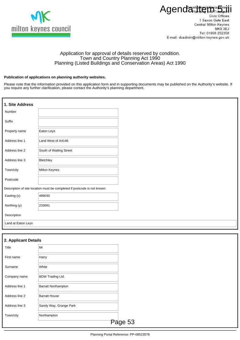
Application for approval of details reserved by condition.Town and Country Planning Act 1990
Planning (Listed Buildings and Conservation Areas) Act 1990
Publication of applications on planning authority websites.
Please note that the information provided on this application form and in supporting documents may be published on the Authority’s website. Ifyou require any further clarification, please contact the Authority’s planning department.
1. Site Address
Number
Suffix
Property name Eaton Leys
Address line 1 Land West of A4146
Address line 2 South of Watling Street
Address line 3 Bletchley
Town/city Milton Keynes
Postcode
Description of site location must be completed if postcode is not known:
Easting (x) 489030
Northing (y) 233691
Description
Land at Eaton Leys
2. Applicant Details
Title Mr
First name Harry
Surname White
Company name BDW Trading Ltd.
Address line 1 Barratt Northampton
Address line 2 Barratt House
Address line 3 Sandy Way, Grange Park
Town/city Northampton
Planning Portal Reference: PP-08523578
Page 53
Agenda Item 5.iii
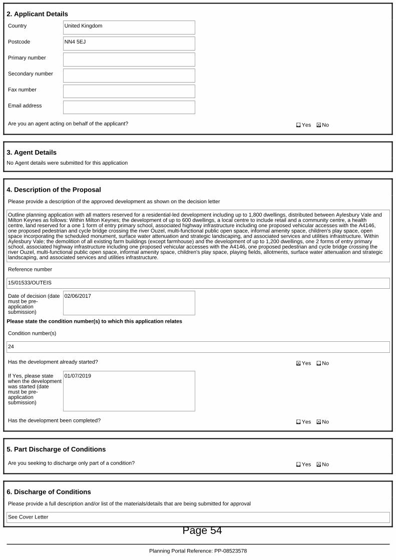
2. Applicant Details
Country United Kingdom
Postcode NN4 5EJ
Primary number
Secondary number
Fax number
Email address
Are you an agent acting on behalf of the applicant? Yes No
3. Agent Details
No Agent details were submitted for this application
4. Description of the Proposal
Please provide a description of the approved development as shown on the decision letter
Outline planning application with all matters reserved for a residential-led development including up to 1,800 dwellings, distributed between Aylesbury Vale andMilton Keynes as follows: Within Milton Keynes; the development of up to 600 dwellings, a local centre to include retail and a community centre, a healthcentre, land reserved for a one 1 form of entry primary school, associated highway infrastructure including one proposed vehicular accesses with the A4146,one proposed pedestrian and cycle bridge crossing the river Ouzel, multi-functional public open space, informal amenity space, children's play space, openspace incorporating the scheduled monument, surface water attenuation and strategic landscaping, and associated services and utilities infrastructure. WithinAylesbury Vale; the demolition of all existing farm buildings (except farmhouse) and the development of up to 1,200 dwellings, one 2 forms of entry primaryschool, associated highway infrastructure including one proposed vehicular accesses with the A4146, one proposed pedestrian and cycle bridge crossing theriver Ouzel, multi-functional public open space, informal amenity space, children's play space, playing fields, allotments, surface water attenuation and strategiclandscaping, and associated services and utilities infrastructure.
Reference number
15/01533/OUTEIS
Date of decision (datemust be pre-applicationsubmission)
02/06/2017
Please state the condition number(s) to which this application relates
Condition number(s)
24
Has the development already started? Yes No
If Yes, please statewhen the developmentwas started (datemust be pre-applicationsubmission)
01/07/2019
Has the development been completed? Yes No
5. Part Discharge of Conditions
Are you seeking to discharge only part of a condition? Yes No
6. Discharge of Conditions
Please provide a full description and/or list of the materials/details that are being submitted for approval
See Cover Letter
Planning Portal Reference: PP-08523578
Page 54

7. Site Visit
Can the site be seen from a public road, public footpath, bridleway or other public land? Yes No
If the planning authority needs to make an appointment to carry out a site visit, whom should they contact?
The agent
The applicant
Other person
8. Pre-application Advice
Has assistance or prior advice been sought from the local authority about this application? Yes No
9. Declaration
I/we hereby apply for planning permission/consent as described in this form and the accompanying plans/drawings and additional information. I/we confirmthat, to the best of my/our knowledge, any facts stated are true and accurate and any opinions given are the genuine opinions of the person(s) giving them.
Date (cannot be pre-application)
19/02/2020
Planning Portal Reference: PP-08523578
Page 55
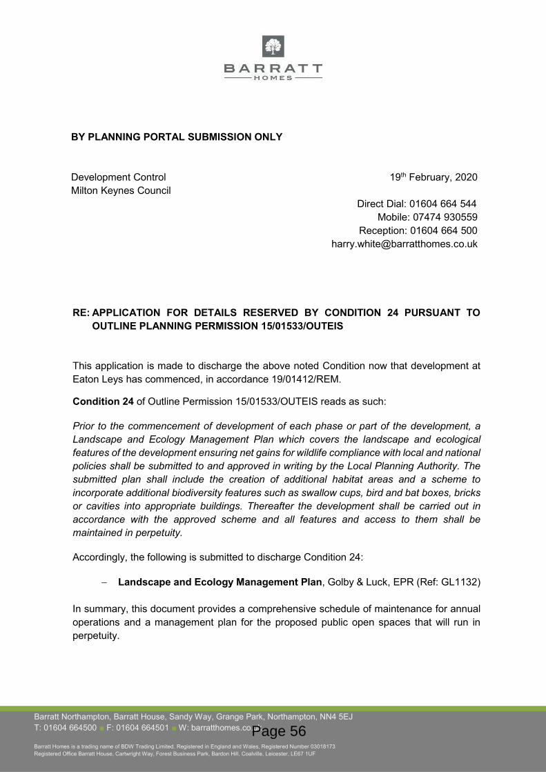
Barratt Northampton, Barratt House, Sandy Way, Grange Park, Northampton, NN4 5EJ T: 01604 664500 ■ F: 01604 664501 ■ W: barratthomes.co.uk
Barratt Homes is a trading name of BDW Trading Limited. Registered in England and Wales, Registered Number 03018173 Registered Office Barratt House, Cartwright Way, Forest Business Park, Bardon Hill, Coalville, Leicester, LE67 1UF
BY PLANNING PORTAL SUBMISSION ONLY
Development Control Milton Keynes Council
19th February, 2020
Direct Dial: 01604 664 544 Mobile: 07474 930559
Reception: 01604 664 [email protected]
RE: APPLICATION FOR DETAILS RESERVED BY CONDITION 24 PURSUANT TO OUTLINE PLANNING PERMISSION 15/01533/OUTEIS
This application is made to discharge the above noted Condition now that development at Eaton Leys has commenced, in accordance 19/01412/REM.
Condition 24 of Outline Permission 15/01533/OUTEIS reads as such:
Prior to the commencement of development of each phase or part of the development, a Landscape and Ecology Management Plan which covers the landscape and ecological features of the development ensuring net gains for wildlife compliance with local and national policies shall be submitted to and approved in writing by the Local Planning Authority. The submitted plan shall include the creation of additional habitat areas and a scheme to incorporate additional biodiversity features such as swallow cups, bird and bat boxes, bricks or cavities into appropriate buildings. Thereafter the development shall be carried out in accordance with the approved scheme and all features and access to them shall be maintained in perpetuity.
Accordingly, the following is submitted to discharge Condition 24:
Landscape and Ecology Management Plan, Golby & Luck, EPR (Ref: GL1132)
In summary, this document provides a comprehensive schedule of maintenance for annual operations and a management plan for the proposed public open spaces that will run in perpetuity.
Page 56

Furthermore, the development will deliver a Biodiversity Net Gain with 27 habitat units, a positive change of 52.01% and 6.32 hedgerow units, a positive change of 37.78%.
We have submitted this application through the Planning Portal, with reference number PP-08523578. The application fee is £116 and will be paid by BACS upon electronic submission of this application.
If you require anything else, please do not hesitate to contact the undersigned.
Kind Regards
Harry White BSc. (Hons) AssocRTPI Strategic Projects Planner
Page 57

Land at Eaton Leys, Milton Keys Landscape and Ecology Management Plan
Client: Barratt Homes Northampton
Date: 13th August 2019 (revised 19th February 2020)
Ref: GL1132
l a n d s c a p e a r c h i t e c t s
golby luck+
Page 58

T e l : 0 1 5 3 0 2 6 5 6 8 8
W e b : w w w . g o l b y a n d l u c k . c o . u k
E m a i l : i n f o @ g o l b y a n d l u c k . c o . u k
T r a d i n g O f f ic e : 2 0 7 L e i c e s t e r Ro a d, I b s t o c k , L e i c e s t e r s h i r e , L E6 7 6 H P
Go l b y a n d L u c k LT D ( C o m p a n y N o . 9 0 3 7 7 7 6 ) R e g i s t e r e d i n En g la n d a n d W a l e s Page 59
Eaton Leys
Client: Barratt Homes Northampton
REF: GL1132 i DATE: JULY 2019
CONTENTS
1. LANDSCAPE MANAGEMENT PLAN 1
2. MANAGEMENT PLAN REVIEW & MAINTENANCE SCHEDULES 21
APPENDICES
Appendix 1 - Biodiversity Net Gain Metric
Page 60

Eaton Leys
Client: Barratt Homes Northampton
REF: GL1132 1 DATE: JULY 2019
1 LANDSCAPE MANAGEMENT PLANMD
Introduction
1.1 This Landscape and Ecological Management Plan (LEMP) has been prepared by Golby +
Luck Landscape Architects and Ecological Planning & Research Ltd for Barratt Homes
Northampton Division for the proposed residential scheme at the land off Eaton Leys,
Milton in accordance with Condition 24 of permitted application no. 15/01533/OUTEIS,
which states:
(24) Prior to the commencement of development of each phase or part of the
development, a Landscape and Ecology Management Plan which covers the landscape
and ecological features of the development ensuring net gains for wildlife compliance
with local and national policies shall be submitted to and approved in writing by the Local
Planning Authority. The submitted plan shall include the creation of additional habitat
areas and a scheme to incorporate additional biodiversity features such as swallow cups,
bird and bat boxes, bricks or cavities into appropriate buildings. Thereafter the
development shall be carried out in accordance with the approved scheme and all
features and access to them shall be maintained in perpetuity.
Reason: In order to safeguard the protected species identified under the Wildlife and
Countryside Act 1981 (as amended) and to ensure that any loss of existing habitat is
successfully mitigated for. To ensure the development incorporates adequate biodiversity
enhancements in accordance with saved Policy NE4 of the Milton Keynes Local Plan 2001-
2011.
1.2 This document provides a comprehensive schedule of maintenance for annual operations
and a management plan for the proposed public open spaces that will run in perpetuity.
1.3 The initial landscape contract will include 12 months maintenance and defect liability
period. Following the initial 12-month maintenance defect liability period the landscape
areas will be covered by the approved Contractor who will take responsibility for all hard
and soft landscape elements, including the management of all retained habitats within
the site, on a running contract managed by the appointed Management Company.
Page 61

Eaton Leys
Client: Barratt Homes Northampton
REF: GL1132 2 DATE: JULY 2019
1.4 Management Company Details:
______________________________________________________________________________________
______________________________________________________________________________________
______________________________________________________________________________________
______________________________________________________________________________________
Contact: _____________________________________________________________________________
Contact Tel: __________________________________________________________________________
Emergency Contact Tel: ______________________________________________________________
Office Opening Hours: ________________________________________________________________
1.5 Full details of the Management Company, that include the funding mechanism in place
for this development site are to be submitted to and agreed with the Local Planning
Authority in advance of the transfer of land to the Management Company.
1.6 This plan will run in perpetuity and will be reviewed at 5-year intervals so that operations
can be adapted to the development of the landscaping scheme. All changes will be
approved by the Local Planning Authority.
Mitigation and Enhancement Measures
1.7 Habitat creation and enhancement within the development include:
Retention within public open spaces, protection and enhancement of existing trees and
hedgerows;
The creation of new woodland areas incorporating native tree and shrub planting;
New native hedgerows; &
Areas of meadow grassland to margins, along the River Ouzel and within the SuDS
attenuation pond.
1.8 All retained trees and hedgerows within the development will be protected during
construction in accordance with BS 5837:2012 ‘Trees in relation to design, demolition and
construction - Recommendations’.
Page 62

Eaton Leys
Client: Barratt Homes Northampton
REF: GL1132 3 DATE: JULY 2019
1.9 All construction will be undertaken in accordance with CIRIA good practice guidance to
protect water quality. Where appropriate, method statements will be produced for high-
risk activities, such as refuelling and use of concrete. All pollution-control measures during
construction will be detailed in a separate Construction Environmental Management Plan
(CEMP).
1.10 Management of new and retained habitats within public realm within the site will be
undertaken in accordance with the LEMP.
Biodiversity Net Gain 1.11 The development will deliver a Biodiversity Net Gain. Details of the habitat losses and gains
are included in the Biodiversity Metric tables in Appendix 1, but a summary follows:
Habitats
1.12 The habitats within the red line amount to 24.99ha and have a combined value of 51.90
habitat units. 50.65 units will be lost.
1.13 24.52ha of built development and associated gardens, landscaping and habitat creation
will deliver a total of 75.18 habitat units. A further 0.47 ha will be enhanced and deliver 3.72
habitat units.
1.14 As a consequence there will be a net gain of 27.00 habitat units, a positive change of
52.01%.
Hedgerows
1.15 The hedgerows in the red line extend for 2.52km and have a combined value of 16.73
hedgerow units.
1.16 0.71km of new hedgerow will be created and will deliver 4.41 hedgerow units. 2.22km will
be enhanced and deliver 18.64 hedge units
1.17 As a result there will be a net gain of 6.32 hedgerow units, a positive change of 37.78%.
Page 63
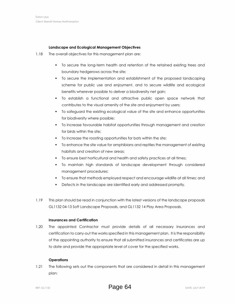
Eaton Leys
Client: Barratt Homes Northampton
REF: GL1132 4 DATE: JULY 2019
Landscape and Ecological Management Objectives
1.18 The overall objectives for this management plan are:
To secure the long-term health and retention of the retained existing trees and
boundary hedgerows across the site;
To secure the implementation and establishment of the proposed landscaping
scheme for public use and enjoyment, and to secure wildlife and ecological
benefits wherever possible to deliver a biodiversity net gain;
To establish a functional and attractive public open space network that
contributes to the visual amenity of the site and enjoyment by users;
To safeguard the existing ecological value of the site and enhance opportunities
for biodiversity where possible;
To increase favourable habitat opportunities through management and creation
for birds within the site;
To increase the roosting opportunities for bats within the site;
To enhance the site value for amphibians and reptiles the management of existing
habitats and creation of new areas;
To ensure best horticultural and health and safety practices at all times;
To maintain high standards of landscape development through considered
management procedures;
To ensure that methods employed respect and encourage wildlife at all times; and
Defects in the landscape are identified early and addressed promptly.
1.19 This plan should be read in conjunction with the latest versions of the landscape proposals
GL1132 04-13 Soft Landscape Proposals, and GL1132 14 Play Area Proposals.
Insurances and Certification
1.20 The appointed Contractor must provide details of all necessary insurances and
certification to carry-out the works specified in this management plan. It is the responsibility
of the appointing authority to ensure that all submitted insurances and certificates are up
to date and provide the appropriate level of cover for the specified works.
Operations
1.21 The following sets out the components that are considered in detail in this management
plan:
Page 64
Eaton Leys
Client: Barratt Homes Northampton
REF: GL1132 5 DATE: JULY 2019
Litter and debris removal;
Management of existing trees & hedgerows;
Amenity grassland;
Dry meadow grassland;
Floodplain (River Ouzel);
Native tree and shrub maintenance;
Amenity tree and shrub planting;
Hedgerow planting;
Sustainable drainage facilities (including wet meadow grassland and marginal
vegetation);
Children’s play areas; and
Hard landscape and street furniture maintenance; and
Environmental Considerations
1.22 All chemical weed control must be carried out by suitably trained staff in accordance with
the manufacturers recommendations and the legislation set out below:
The Food and Environment Protection Act (1985);
The Control of Pesticides Regulations 1986 (COPR) (as amended 1997);
The Control of Substances Hazardous to Health Regulations (2002);
The Environment Protection Act (1990)
1.23 It is the Contractors responsibility to ensure that all operatives are conversant with the
foregoing legislation and other relevant Codes of Practice and British Standards. The
Contractor will make any notifications as are required under the terms of The Food and
Environment Protection Act (1985), and will be responsible for any damage caused
through the inappropriate use or application of any such hazardous substances.
1.24 Horticultural peat is not to be used as mulch on any beds or as a soil conditioner.
1.25 Where appropriate arisings from the site should be recycled. In the case of fallen or
lopped tree material this can be located within areas of undergrowth, away from key
public spaces, to form eco-stacks. The creation of such features must be done so in
consultation with the appointing authority and should not be used as a measure to dump
arisings on the site.
Page 65
Eaton Leys
Client: Barratt Homes Northampton
REF: GL1132 6 DATE: JULY 2019
1.26 All arisings (unless otherwise specified) will be removed from site and deposited at an
approved tip or registered green compost facility.
1.27 Watering operations will be carried out as specified in this management plan. A water
source will be identified by the appointing authority. If no water source is available, then
watering will be carried out using a bowser.
Landscape Management Preambles
1.28 The Contractor will visit the site and take note of all existing conditions including levels,
condition of vegetation, soil conditions, and access. No claims that are based on a lack
of understanding of the site or the nature of the work required to carry out the operations
in this plan will be entertained.
1.29 At all times care will be taken to avoid interference with the established levels and
contours of the ground, and to avoid damage to footpaths, roads, drains, manholes and
existing structures and vegetation. Damage so occasioned is to be made good at the
Contractors expense.
1.30 All work will be carried out by experienced and qualified operatives holding the necessary
training certificates to undertake the prescribed works. All works detailed in the following
specifications shall be carried out in accordance with good horticultural practice, using
materials, plant and machinery appropriate to the task, undertaken in such a manner that
avoids damage and/or nuisance to the site and its surroundings. Any plant material that
dies as a result of the Contractors neglect will be replaced at their cost.
Litter Removal
1.31 Aim: To keep the site litter and rubbish free employing appropriate and considered
methods for the safety of operatives and site users, and for the benefit of the local wildlife.
1.32 The Contractor will ensure that the entire site is kept free of litter and other debris through
a regular programme of monitoring, collection and disposal, coinciding with visits to
maintain grassed areas and planting.
1.33 Particular care will be taken to remove all broken bottles, glass, tins, sharp objects and
other items likely to constitute a hazard to the public.
Page 66
Eaton Leys
Client: Barratt Homes Northampton
REF: GL1132 7 DATE: JULY 2019
1.34 The Contractor will take particular care when carrying out litter collection to ensure that
any discarded needles or syringes are removed as soon as they are discovered. Such
items must be packaged separately from other litter, and be contained within
appropriately labelled, puncture-proof sharps containers and disposed of in a safe
manner.
1.35 The Contractor must ensure that all operatives likely to come into contact with needles
and syringes have been instructed in the means of safe collection and disposal, and that
they have been issued with, and wear, adequate protective gloves and footwear to
protect against penetration of needles and other sharp objects.
1.36 All litter and debris shall be removed off site to an authorised tip specified by the
Contractor.
1.37 This shall be carried out in accordance with the Code of Practice on Litter and Refuse
issued under Section 89 of the Environment Protection Act (1990).
Management of Existing Trees and Hedgerows
1.38 Aim: To maintain, protect and enhance where possible the site existing landscape
infrastructure.
1.39 Following the completion of the construction phase and commencement of the
landscape management phase all levels and surface finishes will be checked around all
retained trees and boundary hedgerows. Where levels and/or surfaces are considered
unsatisfactory these will be rectified to a satisfactory condition.
1.40 At each visit all trees and hedgerows will be inspected and cleared of litter and debris in
accordance with the details set out above.
1.41 All works to trees will be carried out to avoid the bird nesting season (March to August
inclusive). Any works to retained trees must be approved by as suitably experienced
ecologist, with bat surveys of trees undertaken as necessary to ensure that bat roosts are
not affected. Where works to trees are required which would affect a bat roost, the works
will need to take place under a Natural England licence.
Page 67
Eaton Leys
Client: Barratt Homes Northampton
REF: GL1132 8 DATE: JULY 2019
1.42 Hedgerow trimming will take place in January or February each year to allow berries (as a
food source for birds) to remain on the shrubs for as long as possible.
1.43 Retained trees will be inspected at each visit and any deadwood considered dangerous
will be removed in accordance with the recommendations set out in BS 3998: 2010 ‘Tree
work recommendations’.
1.44 Any deadwood in trees will be either retained on site in the form of eco stacks/vegetation
piles in areas of native planting to provide refugia for reptiles and their prey species or
removed from site to a registered tip.
1.45 Hedgerows will be managed to prevent uneven growth and to maintain a dense
hedgerow structure that provides a linear habitat feature. As a general guide hedgerows
shall be trimmed to a height of 2.5 to 3 metres, and to a width of 3 metres. Hedgerows
currently narrower than 3 metres in width shall be managed to broaden width to 3 metres.
Trimmings should be removed from the site. There should be no damage to mature and
semi-mature trees present in the hedgerow.
1.46 Where necessary existing hedgerows will be gapped up using appropriate native species
(i.e Hazel, hawthorn, blackthorn, holly & guelder rose), as detailed on the soft landscape
proposals, to be planted as transplanted and/or container stock with proprietary spiral
guards and cane supports and/or shrub shelters and stakes, as necessary.
1.47 Suitable safety precautions should be taken during cutting to protect workers carrying out
the task and members of the public from any hazards that could potentially be caused by
this work.
1.48 All arisings are to be removed from site to the Contractors specified tip.
Amenity Grassland
1.49 Aim: to create clean and neat edges to the development perimeter and provide
opportunities for informal games and play within the POS network.
1.50 Prior to cutting all areas will be cleared of litter and debris in accordance with the section
detailed above.
Page 68
Eaton Leys
Client: Barratt Homes Northampton
REF: GL1132 9 DATE: JULY 2019
1.51 All operations will be carried out using machinery appropriate to the task; cylinder, rotary
or mulch mowers. Mowing operation will only be carried out during appropriate weather
conditions avoiding sustained periods of rain, or heavy frost, snow, and waterlogging.
1.52 Operations will be suspended where ground conditions prevent the use of machinery
without damage to the ground surface. Where operations are suspended due to
unsuitable conditions additional maintenance visits will be agreed in order to maintain the
sward within acceptable growth limits.
1.53 During each maintenance visit the Contractor will cut adjacent to fences, walls, kerbs,
paths, trees and other boundaries or obstacles using equipment suitable to the task.
Strimmers will not be used around the base of trees. Strimming will be restricted leaving an
un-cut sward at the base of each trees of a radius of not less than 500mm from the outside
edge of the trunk. The frequency of cuts shall remain flexible in order to accommodate
growth rates and weather conditions. As a general guide cutting is likely to be required
every two weeks in high maintenance areas, ensuring that the sward height does not
exceed 75mm and that the presence of flowering weed species is supressed. The height
of cut shall be 30mm. The Contractor is required to assess growing conditions and adjust
maintenance schedules as necessary, taking into account bulb planting where it occurs.
1.54 All cuttings are to be evenly dispersed over the ground.
1.55 Following cutting, all grass clippings and other debris shall be swept from adjacent areas
of hard standing and removed from site to an authorised tip, or dispersed over the plot.
Dry Meadow Grassland
1.56 Aim: To establish attractive flower-rich grassland and margins to support the site
biodiversity value for reptiles, invertebrates and birds.
1.57 During the 1st year of establishment meadow grassland will be cut twice in each growing
month to maintain a balance between the faster growing species and flowers. The
grassland will be mown to a height of 40-60mm with arisings cleared from the site.
1.58 In following seasons prior to cutting all areas shall be cleared of litter and debris in
accordance with the section detailed above. To maintain diversity, all meadow grass
areas will be cut annually in late July to end of August following flowering (the summer hay
Page 69

Eaton Leys
Client: Barratt Homes Northampton
REF: GL1132 10 DATE: JULY 2019
cut). An autumn cut will be carried out in November to leave the grass short over the winter
period (cut to 40-75mm). If required a spring cut should be carried out prior to the end of
May to remove the first flush of grass (cut to 40-75mm). All arisings to be left in situ for 3-5
days to dry out and then are to be removed from site unless otherwise directed.
1.59 The meadow areas are to inspected for invasive weeds, like ragwort, and controlled as
necessary. Spot sprayed with a herbicide, or hand pulled for undesirable and persistent
weed growth like docks and thistles.
Floodplain (River Ouzel)
1.60 Aim: To establish and manage new grassland habitats as part of the informal recreation
space and riverside buffering habitat supporting bats, reptiles, birds and invertebrates, and
promoting habitat connectivity across the site for the benefit of a wide range of wildlife.
1.61 During the 1st year of establishment meadow grassland will be cut twice in each growing
month to maintain a balance between the faster growing species and flowers. The
grassland will be mown to a height of 40-60mm with arisings cleared from the site.
1.62 In following seasons prior to cutting all areas shall be cleared of litter and debris in
accordance with the section detailed above. To maintain diversity, all meadow grass
areas will be cut annually in late July to end of August following flowering (the summer hay
cut). An autumn cut will be carried out in November to leave the grass short over the winter
period (cut to 40-75mm). If required a spring cut should be carried out prior to the end of
May to remove the first flush of grass (cut to 40-75mm). All arisings to be left in situ for 3-5
days to dry out and then are to be removed from site unless otherwise directed.
1.63 The meadow areas are to inspected for invasive weeds, like ragwort, and controlled as
necessary. Spot sprayed with a herbicide, or hand pulled for undesirable and persistent
weed growth like docks and thistles.
1.64 Riverbank vegetation. The bank of the River Ouzel will be managed by cutting either a
proportion of or all the tall ruderal vegetation back from the river edges. It is hoped that
over time, with cutting and removing the arisings that the nutrient levels would be reduced
on the previous areas of arable margin and a range of species will replace the dominant
nettle growth along the riverbanks.
Page 70

Eaton Leys
Client: Barratt Homes Northampton
REF: GL1132 11 DATE: JULY 2019
Native Tree and Shrub Planting
1.65 Aim: To further reinforce the sites existing planting, notably the site frontage (eastern
boundary), enhancing wildlife/habitat corridors and enhancing biodiversity.
1.66 Native tree and shrub planting will be attended to three times during the growing season
(April-September) and once during the dormant season (October-March inclusive). At
each visit the following operations are to be carried out.
1.67 Before work commences, all areas shall be inspected, and all debris removed in
accordance with the section detailed above.
1.68 All plants shall be checked and firmed up in the ground as necessary.
1.69 Any damaged shoots or branches shall be pruned off plants using secateurs, cutting back
to above a live, outward facing bud or shoot.
1.70 Weed growth within planting areas shall be eliminated during the summer visits with a
suitable translocated herbicide such as “Round-up” glyphosate herbicide, in line with the
manufacturer’s instructions and in compliance with the Pesticides Acts (1998). Tree and/or
shrub shelters, if fitted, shall be lifted as necessary to achieve weed control, and re-firmed
in the ground after completion of the work. Dead weed material shall be removed during
the following visit to site.
1.71 Grass growth within planting beds shall be treated during the winter visit with a suitable
residual herbicide such as “Kerb” (pbi), in line with the manufacturer’s instructions and in
compliance with the Pesticides Acts (1998).
1.72 Planting shelters (if fitted) shall be checked at each visit, stakes firmed up as necessary,
and ties adjusted. Any missing or vandalised shelters or ties shall be replaced and lopsided
shelters straightened.
1.73 Any dead trees and shrubs shall be removed and the resulting hole to be filled.
Replacement planting to be carried out during the winter visit.
1.74 Should growth interfere with the functionality of the SUDs facility (see below for details) or
encroach closer than 1 metre to the residential private boundaries the vegetation is to be
pruned/trimmed back and/or removed.
Page 71

Eaton Leys
Client: Barratt Homes Northampton
REF: GL1132 12 DATE: JULY 2019
Tree Planting
1.75 Aim: To enhance and reinforce the sites tree network reinforcing landscape character and
soften the setting of the development in the local landscape.
1.76 All staked trees will be inspected at each maintenance visit, and any trees which have
died or are excessively damage will be removed from site, complete with the stake, and
the ground reinstated.
1.77 Mulched areas around trees will be maintained to an acceptable standard (see details
on mulching standard set out below in reference to ornamental shrub planting).
1.78 At the start and end of each growing season all stakes, ties and guying systems will be
inspected. Any looseness, constriction or abrasion will be corrected by adjustment or
replacement as necessary. Where the support of a stake is no longer required the stake
will be removed from site.
1.79 Any trees which have died as a result of the Contractors operations or omissions will be
replaced by the Contractor at their expense during the next planting season.
1.80 Where the appointing authority has agreed that plant deaths have arisen due to
circumstances out of the control of the Contractor, replacement planting will be
instructed by the appointing authority and paid for at an agreed rate.
Amenity Shrub Planting
1.81 Aim: Create an attractive shrub planting within areas of open space, providing a setting
for the proposed development. Ensure the vegetation is established and of good form
whilst also providing additional nectar and pollen resources for the local wildlife.
1.82 During years 1-5 or until canopy closure, planting will be maintained during annual visits.
1.83 Prior to maintenance, all areas shall be cleared of litter and debris in accordance with
details set out above.
1.84 All plants will be checked and where necessary firmed into the ground.
1.85 Any damaged shoots or branches will be pruned using secateurs.
1.86 The Contractor will ensure that all shrub beds are maintained 90% free of weed growth.
This shall normally be achieved by the application of appropriate contact or residual
Page 72
Eaton Leys
Client: Barratt Homes Northampton
REF: GL1132 13 DATE: JULY 2019
herbicides, although it remains the responsibility of the Contractor to adopt other methods
where herbicide application is unsuccessful or impractical.
1.87 The Contractor will remove any dead, dying or diseased plants, during each maintenance
visit. The appointing authority will be informed of the location, number and species of all
material that has been removed. Any plants that have died as a result of the Contractor’s
operations or omissions will be replaced by the Contractor at their expense during the next
planting season.
1.88 Where the appointing authority has agreed that plant deaths have arisen due to
circumstances out of the control of the Contractor, replacement planting will be
instructed by the appointing authority and paid for at an agreed rate.
1.89 All replacement planting will be carried out using similar species to those removed unless
alternative species are agreed with the appointing authority.
1.90 In any mulched beds where the depth of cover is below 50mm additional mulch will be
added to maintain a minimum of 50mm of cover.
1.91 The Contractor will clean all hard standing, gullies, drains, and grassed areas of soil spillage,
bark mulch, and leaves. All arisings will be removed from Site to an approved tip.
Hedgerow Planting
1.92 Aim: To enhance and reinforce the linear habitat within the site whilst creating an
attractive setting for the proposed development.
1.93 Prior to maintenance, the hedge line shall be cleared of litter and debris in accordance
with the litter removal section as detailed above.
1.94 Pruning - Pruning will be carried out using mechanical cutters according to the type of
hedge. Correct equipment and attachments must be used.
1.95 All cuts will be clean, and any ragged edges will be removed using a sharp knife except
where it has agreed that a side arm flail or reciprocating knife blade mechanical cutter
may be used to carry out the work.
1.96 Unless otherwise stated, current growth will be removed back to a regular line and shape
with the width at the top edge less than at the base and the general shape as that which
existed at the completion of the last approved pruning.
Page 73

Eaton Leys
Client: Barratt Homes Northampton
REF: GL1132 14 DATE: JULY 2019
1.97 Frequency of hedge cutting will depend on the species mix and the locality of the hedge.
In general, field hedges will be cut once per year although more ornamental species may
require a second cut. Hedge growth will be monitored throughout the year and pruned if
excess growth presents an obstruction.
1.98 The base of hedges shall be inspected and if necessary, kept free of weeds throughout
the growing season by the use of translocated herbicides such as ‘Round-up’ glyphosate
herbicide, in accordance with manufacturer’s instructions and in compliance with the
Pesticides Acts (1998). If appropriate mechanical methods are to be used. Dead weed
material shall be removed during the following visit to site. In locations where the
development of a base layer is desirable herbicide application should not be carried out.
Such locations are to be agreed with by the appointing authority.
Sustainable Drainage Facilities (including wet meadow grassland and marginal vegetation)
1.99 Aim: The proposed sustainable drainage system will improve the site biodiversity
credentials providing high quality riparian and marginal habitats, whilst also providing
additional areas for water attenuation,
1.100 The sustainable drainage facilities are primarily designed to cater for the attenuation of
storm water in high rainfall events. It is therefore necessary that this feature is kept free of
debris at all times to avoid any reduction in rainwater retention capacity.
1.101 Wet meadow grassed areas in or adjacent the basins have been specified to cater for
seasonal flooding and damp conditions and will require one annual cut in November.
Arisings should be left in-situ for 48 hours before being removed from site. Tree and shrub
planting shall be subject to the maintenance specifications detailed above.
1.102 The sustainable drainage facility will be managed in accordance with CIRIA SUDs Manual
C753. At each maintenance visit the Contractor will inspect the SUDS facility and remove
any branches and leaf debris and/or any other object that are likely to restrict water
flow/capacity. All areas will be inspected and cleared of litter and other debris in
accordance with the details set out above.
1.103 The Contractor will inspect all outfall features and check grilles (if present) and remove
any obstructions.
Page 74

Eaton Leys
Client: Barratt Homes Northampton
REF: GL1132 15 DATE: JULY 2019
1.104 Hand cut submerged and emergent aquatic plants (at minimum of 0.1m above pond
base) at no greater that 30% of the pond’s area on a 5-year rotational cycle.
1.105 Excess silt is to be removed from the base of facilitates to maintain volume capacity and
safeguard functionality of the balancing ponds themselves as necessary. A suggested 5-
10-year clean-out cycle is to be adopted initially but this is to be monitored and reviewed
by the contractor.
Children’s Play Area
1.106 Aim: To create an exciting and engaging play environment for all users that is safe and
accessible for all.
1.107 Prior to the play area opening for public use the contractor will produce a play area risk
assessment in accordance with the Management of Health and Safety at Work
Regulations 1999 and RoSPA guidelines, notably Information Sheet Number 25. This will
include the identification of ‘risk’, assessing the risk and actions for risk reduction. This will
be retained by the contractor and reviewed on an annual basis.
1.108 At each maintenance visit all areas will be cleared of litter and debris in accordance with
the section set out above.
1.109 All areas for play will be inspected and maintained in accordance with requirements of BS
EN 1176/77 and best practice guidelines from the Royal Society for the Presentation of
Accidents (ROSPA).
1.110 Recorded weekly safety inspections will be carried out by RoSPA qualified play inspectors,
followed up by a 6 weekly structural check. During the winter months (November to
February) this will be reduced to monthly visits. The frequency may vary depending on use
or with any variation agreed with the appointed authority and Local Authority.
1.111 A visual assessment of all play facilities will be undertaken at each site visit by the
Contractor. Any defects or hazards considered dangerous are to be dealt with
immediately by immobilising the item and making the item safe until repair and only if
necessary will the play facilities will be closed until appropriate measures have been taken
to make the facilities safe and fit for purpose. The Local Authority is to be notified of any
closures.
Page 75

Eaton Leys
Client: Barratt Homes Northampton
REF: GL1132 16 DATE: JULY 2019
1.112 All inspections as set out above are to be carried out by a suitably qualified person (please
refer to the Register of Play Inspectors International (RPII) for requirements).
1.113 An Outdoor Annual Inspector accredited by the RPII shall carry out certified inspections
annually, and permanent record maintained to ensure continued compliance with
legislation.
1.114 Contact details for the maintenance contractor will be displayed in a suitable location at
each play facility and updated should this change promptly. The contact information
must include a direct telephone number so that any faults can be reported and dealt with
in an appropriate timeframe.
1.115 Maintenance of equipment and safety surfacing will be undertaken in strict accordance
with the manufacturer’s recommendations. This will include painting, vandalism, graffiti
and sweeping.
1.116 All replacement parts must be sourced from an accredited manufacturer/supplier and be
appropriate for the intended use.
1.117 The Contractor is to retain a record of all warranty inspections, maintenance, repairs and
modifications carried out to any part of the play apparatus and/or associated safety
surfacing.
Hard Surfaces and Street Furniture
1.118 Aim: To provide clean, safe, attractive and functional areas for pedestrians and vehicles
within and around the proposed development.
1.119 The Contractor will check at each visit that all the hard surfaces and street furniture is safe
and fit for purpose.
1.120 Hard surfaces are to be reviewed at each visit. Any damage is to be recorded and made
good either during the visit or at the following visit. If the repairs cannot be carried out or
completed the Contractor will make the area safe and/or cordon off any sections that
present a hazard. Any such areas will be made good as soon as practically possible. Every
effort should be made to match into the original materials, making sure line/levels are
correctly adhered to.
Page 76
Eaton Leys
Client: Barratt Homes Northampton
REF: GL1132 17 DATE: JULY 2019
1.121 All paths will be treated with a suitable herbicide spray in accordance with Manufacturer’s
recommendations to remove weeds and moss. Hard surfaces will be swept at each visit.
1.122 All furniture will be maintained to a standard so that it is clean, safe and fit for purpose at
all times. Any damage will be made good during the maintenance visit. Otherwise the
item will be made safe and/or cordoned off and made good as soon as practically
possible. All repairs to street furniture will be carried out using parts sourced from the
supplying manufacturer and carried out in accordance with their guidelines.
1.123 Graffiti - Monitor the site at every visit. A “no tolerance” policy will apply to graffiti which
shall be removed as soon as it appears. Where necessary, specialist contractors shall be
employed to carry out this work.
Integral Wildlife Boxes and Features
1.124 The following measures will be incorporated into new houses to conserve and enhance
key species of birds and bats that rely on nesting and roosting opportunities within
buildings. Provision of artificial nest and roost sites is required due to the lack of nesting
opportunities in modern building design. Measures to help Hedgehogs and pollinators are
also included.
House Martins
1.125 House Martins build nests under the eaves of roofs on houses and other buildings. A few
pairs nest at Eaton Leys farm.
1.126 To encourage formation of a new nesting colony in the development pairs of nesting cups
will be attached to some new houses in two locations where these face west, along the
western side of the development so that birds can fly out to collect mud to build their own
nests and to forage over the river valley grasslands. 6 pairs of nests on houses in the
northwest corner of the development and 11 pairs in the southwest corner.
A pair of Woodcrete nests are available from Wildcare - £17.00 Incl VAT or £26.50 Incl VAT
for a Schwegler version https://www.wildcare.co.uk/10678-woodstone-house-martin-
nester.html
Page 77
Eaton Leys
Client: Barratt Homes Northampton
REF: GL1132 18 DATE: JULY 2019
Swallows
1.127 Swallows nest at Eaton Leys farm and further nesting opportunities will be provided in the
housing development. Swallows prefer to nest in open buildings and structures such as
barns and porches rather than on houses.
1.128 Opportunities have been sought to include Swallow cups in garages, sheds and bin stores.
These will be placed under the protection of the overhanging roof or inside where the door
has a suitable gap to promote access by Swallows. The ideal position in the development
is along the western side so birds can access the open space along the river valley to
collect mud for building their own nests and for foraging.
A single Swallow nest bowl are available from Wildcare £12.00 Incl VAT or £16.75 for
Schwegler version. https://www.wildcare.co.uk/swallow-nest-bowl.html
Swifts
1.129 Swifts are summer visitors to the UK and nest in buildings, often in the roof space or under
eaves. A range of purpose-built nest boxes have been developed to accommodate
Swifts in new and existing buildings.
1.130 Swift nest boxes should be sited high up in an external wall, as close to the eaves as
possible. A height of at least 5m is recommended, although even 6 or 7m if possible.
There must be unobstructed access for birds entering and leaving by having a clear
distance (drop) below the box, preferably 5m or more. Cleaning and inspection is not
necessary. A northerly or well shaded aspect is recommended (avoid the immediate
vicinity of windows).
1.131 3 locations on the gable ends of 3 buildings have been selected. It is recommended to
group bricks on a building to encourage a Swift colony to form and so each location will
have 3 bricks.
1.132 The best options available for integral Swift boxes are:
Ibstock Eco-habitat for Swifts (available from NHBS for £105.00 incl. VAT)
Made of brick by a brick manufacturer, available in smooth red or smooth blue brick.
Measure approximately 2 bricks high by 1.5 bricks wide (Height 140mm, Width 326mm,
Depth 140mm).
Propose: 27 Ibstock Swift bricks (9 groups of 3)
Page 78

Eaton Leys
Client: Barratt Homes Northampton
REF: GL1132 19 DATE: JULY 2019
or
No. 17A Schwegler Swift Nest Box (Triple Cavity) (available from NHBS for £155.00 incl.
VAT).
Made of compressed plant fibres and concrete providing good insulation and long life.
Comes in natural grey but can be painted. Internal dimensions (Height 140mm, Width
300mm, Depth 140mm).
Propose: Triple cavity boxes (9 groups of 3).
or
Swift Box (available from Bird Brick Houses for £70.00 incl. VAT).
Supplied with or without brick fronts, and includes a stainless mesh interior.
A crescent shaped hole to one side of the box allows Swifts to access but restricts use by
Starlings.
Equivalent to four bricks. The ideal internal depth of a Swift box is 140mm, however if
cavity width is limited, boxes can be manufactured with a reduced depth (minimum
100mm).
Propose: 27 Bird Brick Houses Swift boxes (9 groups of 3)
Bats
1.133 Bat roosting boxes suitable for crevice dwellings bats such as Pipistrelles, will be
incorporated into the built development. The locations will be on the gable wall toward
the eaves at around 5m high, preferably with a southerly aspect. The integrated boxes
will be included on all houses around the perimeter which face the countryside. They will
not be included on houses on the eastern side near the main road nor on houses near
new access roads in order to avoid issues with street lighting.
1.134 A total of 83 integrated bat boxes will be installed at the locations and positions shown
on drawing GL1132 04-13 Soft Landscape Proposals.
1.135 The models of integral bat boxes that will be installed are either:
Page 79
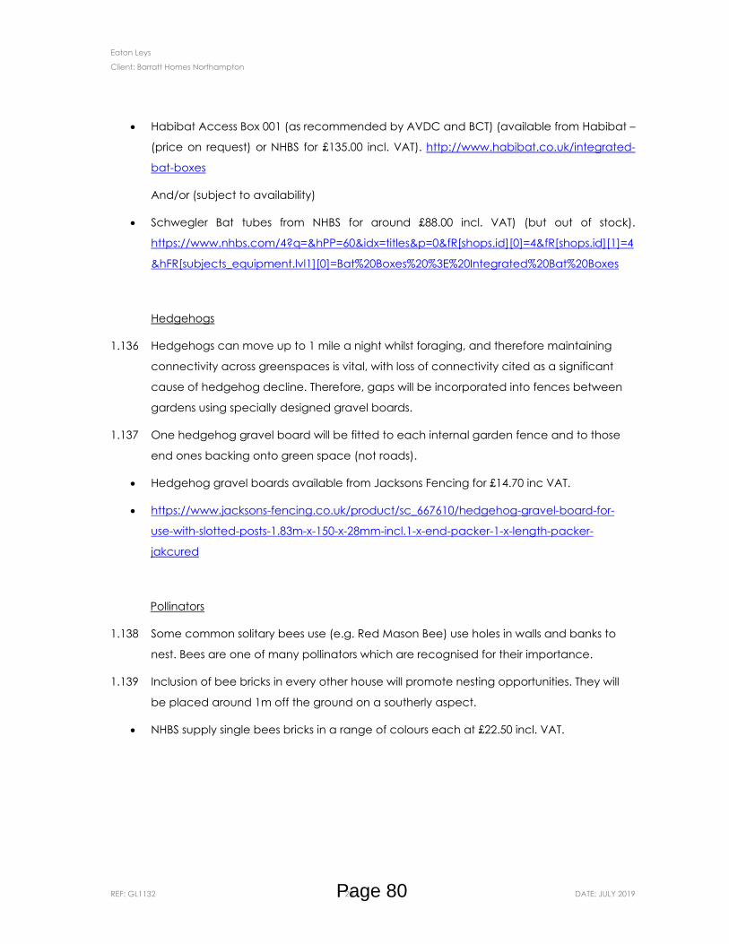
Eaton Leys
Client: Barratt Homes Northampton
REF: GL1132 20 DATE: JULY 2019
Habibat Access Box 001 (as recommended by AVDC and BCT) (available from Habibat –
(price on request) or NHBS for £135.00 incl. VAT). http://www.habibat.co.uk/integrated-
bat-boxes
And/or (subject to availability)
Schwegler Bat tubes from NHBS for around £88.00 incl. VAT) (but out of stock).
https://www.nhbs.com/4?q=&hPP=60&idx=titles&p=0&fR[shops.id][0]=4&fR[shops.id][1]=4
&hFR[subjects_equipment.lvl1][0]=Bat%20Boxes%20%3E%20Integrated%20Bat%20Boxes
Hedgehogs
1.136 Hedgehogs can move up to 1 mile a night whilst foraging, and therefore maintaining
connectivity across greenspaces is vital, with loss of connectivity cited as a significant
cause of hedgehog decline. Therefore, gaps will be incorporated into fences between
gardens using specially designed gravel boards.
1.137 One hedgehog gravel board will be fitted to each internal garden fence and to those
end ones backing onto green space (not roads).
Hedgehog gravel boards available from Jacksons Fencing for £14.70 inc VAT.
https://www.jacksons-fencing.co.uk/product/sc_667610/hedgehog-gravel-board-for-
use-with-slotted-posts-1.83m-x-150-x-28mm-incl.1-x-end-packer-1-x-length-packer-
jakcured
Pollinators
1.138 Some common solitary bees use (e.g. Red Mason Bee) use holes in walls and banks to
nest. Bees are one of many pollinators which are recognised for their importance.
1.139 Inclusion of bee bricks in every other house will promote nesting opportunities. They will
be placed around 1m off the ground on a southerly aspect.
NHBS supply single bees bricks in a range of colours each at £22.50 incl. VAT.
Page 80
Eaton Leys
Client: Barratt Homes Northampton
REF: GL1132 21 DATE: JULY 2019
2 MANAGEMENT PLAN REVIEW & MAINTENANCE SCHEDULES
2.1 The sequence of agreement, monitoring and review is set out below. It is envisaged that
at each stage agreement will be reached between the Contractor and appointing
authority (to include the Local Authority if they are not the appointed authority). It is the
responsibility of the Contractor to bring to the attention of the appointing authority any
issues that require immediate attention. Any such issues left unchecked that result in
permanent damage or degradation of the landscape and associated environment will
be put right at the Contractors expense. The stages of agreement, monitoring and review
are set out below:
Management plan and annual maintenance schedules to be agreed by all parties
involved (including the Local Authority) in the on-going management of the
landscape and features specific to this plan;
At the end of year 1 the Contractor and appointing authority (to include the Local
Authority if they are not the appointing authority) are to meet on site and review
all open spaces;
Following this monitoring stage appropriate adjustments to the management
objectives, operations and frequencies of visits are to be agreed in writing
between the contractor and appointing authority (to include the Local Authority
if they are not the appointing authority);
Monitoring visits and amendments to the plan are to continue between years 1 to
years 5;
At the end of year 5 there will be a wholesale review of this plan and any changes
to it (including the removal/insertion of operations and/or the change in frequency
of operations) will be agreed between the Contractor, experienced ecologist and
appointing authority (to include the Local Authority if they are not the appointing
authority).
2.2 The following tables set out the Year 1 maintenance schedule.
Page 81

Eaton Leys – Maintenance Schedule
Client: Barratt Homes Northampton
REF: GL1132 i DATE: JULY 2019
Management Scope: Maintenance Activity Jan Feb Mar April May June July Aug Sept Oct Nov Dec
Litter & debris removal
Pick all litter from areas of hard and soft landscape and remove from site. • • • • • • • • • • • •
Existing Trees and Hedgerows
Inspect all existing trees. • • • • • • • • • • • •
Action required works to existing trees. Where possible works should be programmed for dormant period (October to March). Carry out works in accordance with BS 3998: 2010.
• • • • • •
Cut hedgerow annually to a height of 2.5-3m to 3 metres wide. • •
Inspect hedgerow at each visit to ensure consistent structure, carryout infill planting measures as necessary.
• • • • • • •
Remove cuttings from site. •
Amenity grassland
Cut grass and remove arisings from site. • • • • • •
Control/remove weeds. • • • • • •
Repair worn areas. • • • • • •
Page 82
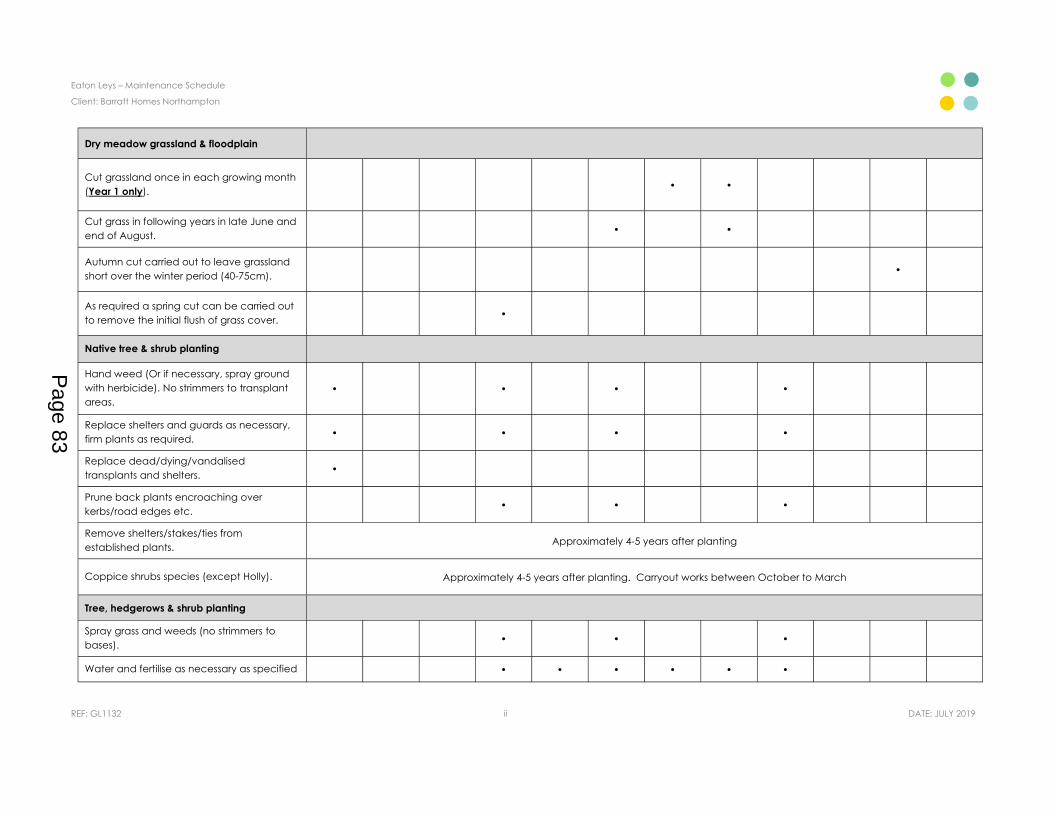
Eaton Leys – Maintenance Schedule
Client: Barratt Homes Northampton
REF: GL1132 ii DATE: JULY 2019
Dry meadow grassland & floodplain
Cut grassland once in each growing month (Year 1 only). • •
Cut grass in following years in late June and end of August. • •
Autumn cut carried out to leave grassland short over the winter period (40-75cm). •
As required a spring cut can be carried out to remove the initial flush of grass cover. •
Native tree & shrub planting
Hand weed (Or if necessary, spray ground with herbicide). No strimmers to transplant areas.
• • • •
Replace shelters and guards as necessary, firm plants as required. • • • •
Replace dead/dying/vandalised transplants and shelters. •
Prune back plants encroaching over kerbs/road edges etc. • • •
Remove shelters/stakes/ties from established plants. Approximately 4-5 years after planting
Coppice shrubs species (except Holly). Approximately 4-5 years after planting. Carryout works between October to March
Tree, hedgerows & shrub planting
Spray grass and weeds (no strimmers to bases). • • •
Water and fertilise as necessary as specified • • • • • •
Page 83
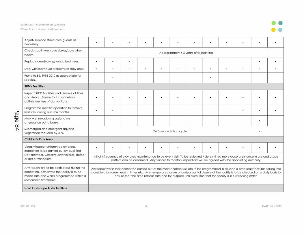
Eaton Leys – Maintenance Schedule
Client: Barratt Homes Northampton
REF: GL1132 iii DATE: JULY 2019
Adjust/ replace stakes/ties/guards as necessary. • • • • • • • • • • • •
Check stability/remove stakes/guys when ready. Approximately 4-5 years after planting
Replace dead/dying/vandalised trees. • • • • •
Deal with individual problems as they arise. • • • • • • • • • • • •
Prune to BS. 3998 2010 as appropriate for species. • •
SUD’s Facilities
Inspect SUDS facilities and remove all litter and debris. Ensure that channel and outfalls are free of obstructions.
• • • • • • • • • • • •
Programme specific operation to remove leaf litter during autumn months. • • • • •
Mow wet meadow grassland on attenuation pond banks. •
Submerged and emergent aquatic vegetation reduced by 30%. On 5-year rotation cycle •
Children’s Play Area
Visually inspect children’s play areas. Inspection to be carried out by qualified staff member. Observe any hazards, defect or act of vandalism.
• • • • • • • • • • • •
Initially frequency of play area maintenance to be every visit. To be reviewed / determined more accurately once in use and usage pattern can be confirmed. Any various to monthly inspections will be agreed with the appointing authority.
Any repairs are to be carried out during the inspection. Otherwise the facility is to be made safe and works programmed within a reasonable timeframe.
Any repair works that cannot be carried out at the maintenance visit are to be programmed in as soon a practically possible taking into consideration order lead in times etc. Any temporary closure of and/or partial closure of the facility is to be checked on a daily basis to
ensure that the area remain safe and for purpose until such time that the facility is in full working order.
Hard landscape & site furniture
Page 84
Eaton Leys – Maintenance Schedule
Client: Barratt Homes Northampton
REF: GL1132 iv DATE: JULY 2019
Any repairs are to be carried out during the inspection. Otherwise the facility is to be made safe and works programmed within a reasonable timeframe.
• • • • • • • • • • • •
Where repairs cannot be made good at time of visit and additional visit will be programmed as soon as practically possible to make any repair good and the item fit for purpose. During any such delay it is the Contractor’s responsibility to ensure that all areas are made safe and remain safe until any such repairs are completed.
• • • • • • • • • • • •
Page 85

Eaton Leys
Client: Barratt Homes Northampton
REF: GL1132
APPENDIX 1 Biodiversity Net Gain Metric
Page 86
Project details
Cell style conventions
Planning authority: Milton Keynes Council
Eaton Leys
Barratt Developments Ltd (Northampton) Residential
Robert Souter, EPR Ltd
05/02/2020
Project name:
Applicant:Application type:
Planning application reference:Assessor:
Reviewer:
Enter dataAutomatic lookup
Result
Revision:Assessment date:
Planning authority reviewer:
Main menu
The Biodiversity Metric 2.0 - Calculation ToolStart page
Instructions
Results
Reset view
View all
Page 87

Headline Results
On-site baselineHabitat units
Eaton Leys
51.90Hedgerow units 16.73
River units 0.00
0.00
On-site post-intervention(Including habitat retention, creation, enhancement & succession)
Habitat units 78.90Hedgerow units 23.05
River units 0.00
Off-site baselineHabitat units 0.00
Hedgerow units 0.00River units
Off-site post-intervention(Including habitat retention, creation, enhancement & succession)
Habitat units 0.00Hedgerow units 0.00
River units 0.00
Total net unit change(including all on-site & off-site habitat retention/creation)
Habitat units 27.00Hedgerow units 6.32
River units 0.00
Total net % change(including all on-site & off-site habitat creation + retained habitats)
Habitat units 52.01%Hedgerow units 37.78%
River units 0.00%
Return to
Page 88
Habitats Hedgerows RiversTotal site area / length 24.99 2.52 0.00
Total site units 51.90 16.73 0.00
Area / length retained 0.00 0.00 0.00Units Retained 0.00 0.00 0.00
Area / length enhanced 0.47 2.22 0.00Baseline units enhanced 1.25 15.34 0.00
Area / length succession 0.00
Units succession 0.00
Area / length lost 24.52 0.30 0.00Units lost 50.65 1.39 0.00
On-site
27.00Habitat units
37.78%Hedgerow units52.01%Habitat units
6.32Hedgerow units
0.00%River units
0
0
0Medium
High
V.High
Category
Eaton Leys
River units
Area lost by distinctiveness band
0.00
Area lost (hectares) Area lost (%)
Detailed Results
Summary Figures
Net project biodiversity units(including all on-site & off-site habitat retention/creation)
Total project biodiversity % change(including all On-site & Off-site Habitat Creation + Retained Habitats)
On-site habitat retention and enhancement
0V.Low
24.52
Post development on siteBaseline Onsite Change
100Low
Overall Change
On-
-30.0
-20.0
-10.0
0.0
10.0
20.0
30.0
Cropland
-60.0
-40.0
-20.0
0.0
20.0
40.0
60.0
Cropland
0%0%0%
100%
0%
Distinctiveness category
V.High
High
Medium
Low
V.Low
-60.0
-40.0
-20.0
0.0
20.0
40.0
60.0
Cropland Grassland Heathland and shrub Rivers and lakes Sparsely vegetated land Urban Wet land Woodland and forest Intertidal sediment Coastal saltmarsh Rocky shore Coastal lagoons
Combined Biodiversity Unit change
Existing value Proposed value Onsite Unit change Offsite Unit change Off site Proposed value Off-site Existing value
Return to results menu
Page 89

Habitat group Existing area Existing value Proposed area Proposed value Area change
Onsite Unit change Area change Unit
change
Cropland 24.5 50.6 0.0 0.0 -24.5 -50.6 -24.5 -50.6Grassland 0.0 0.0 4.0 26.6 4.0 26.6 4.0 26.6
Heathland and shrub 0.0 0.0 0.4 2.9 0.4 2.9 0.4 2.9Rivers and lakes 0.0 0.0 0.0 0.3 0.0 0.3 0.0 0.3
Sparsely vegetated land 0.4 0.0 -0.4 0.0 -0.9 0.0 -0.9 0.0Urban 0.0 0.0 20.6 49.0 20.6 49.0 20.6 49.0
Wetland 0.0 0.0 0.0 0.0 0.0 0.0 0.0 0.0Woodland and forest 0.0 0.0 0.0 0.0 0.0 0.0 0.0 0.0Intertidal sediment 0.0 0.0 0.0 0.0 0.0 0.0 0.0 0.0Coastal saltmarsh 0.0 0.0 0.0 0.0 0.0 0.0 0.0 0.0
Rocky shore 0.0 0.0 0.0 0.0 0.0 0.0 0.0 0.0Coastal lagoons 0.0 0.0 0.0 0.0 0.0 0.0 0.0 0.0
Off-site
Habitat group Existing area Off-site Existing value Proposed area Off site
Proposed valueArea
changeOffsite Unit
changeCropland 0.0 0.0 0.0 0.0 0.0 0.0
Grassland 0.0 0.0 0.0 0.0 0.0 0.0Heathland and shrub 0.0 0.0 0.0 0.0 0.0 0.0
Rivers and lakes 0.0 0.0 0.0 0.0 0.0 0.0Sparsely vegetated land 0.0 0.0 0.0 0.0 0.0 0.0
Urban 0.0 0.0 0.0 0.0 0.0 0.0Wetland 0.0 0.0 0.0 0.0 0.0 0.0
Woodland and forest 0.0 0.0 0.0 0.0 0.0 0.0Intertidal sediment 0.0 0.0 0.0 0.0 0.0 0.0Coastal saltmarsh 0.0 0.0 0.0 0.0 0.0 0.0
Rocky shore 0.0 0.0 0.0 0.0 0.0 0.0Coastal lagoons 0.0 0.0 0.0 0.0 0.0 0.0
Combined
Habitat group Existing area Existing value Proposed area Proposed value Proposed area
Proposed value
Cropland 24.5 50.6 0.0 0.0 -24.5 -50.6Grassland 0.0 0.0 4.0 26.6 4.0 26.6
Heathland and shrub 0.0 0.0 0.4 2.9 0.4 2.9Rivers and lakes 0.0 0.0 0.0 0.3 0.0 0.3
Sparsely vegetated land 0.4 0.0 -0.4 0.0 -0.9 0.0Urban 0.0 0.0 20.6 49.0 20.6 49.0
Wetland 0.0 0.0 0.0 0.0 0.0 0.0Woodland and forest 0.0 0.0 0.0 0.0 0.0 0.0Intertidal sediment 0.0 0.0 0.0 0.0 0.0 0.0Coastal saltmarsh 0.0 0.0 0.0 0.0 0.0 0.0
Rocky shore 0.0 0.0 0.0 0.0 0.0 0.0Coastal lagoons 0.0 0.0 0.0 0.0 0.0 0.0
Baseline Combined Post development Combined change
Baseline Post development Off-site Off-site Change
Page 90
0% 2%0%
On-site habitat retention by categoryarea (hectares)
Area / length retained 0% 2%0%
On-site habitat retention category biodiversity units
Cropland Grassland Heathland andshrub
Rivers and lakes Sparsely vegetatedland
Urban Wet land Woodland andforest
Intertidalsediment
Coastal saltmarsh Rocky shore Coastal lagoons
On site area change by habitat group
Existing area Proposed area Area change
Cropland Grassland Heathland andshrub
Rivers and lakes Sparsely vegetatedland
Urban Wet land Woodland andforest
Intertidalsediment
Coastal saltmarsh Rocky shore Coastal lagoons
Unit change by habitat group
Existing value Proposed value Unit change
Page 91

0% 2%0%
98%
Area / length enhanced
Area / length succession
Area / length lost
0%0%
98%
Units Retained
Baseline units enhanced
Units succession
Units lost
Page 92
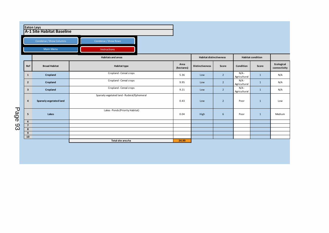
A-1 Site Habitat Baseline
Ref Broad Habitat Habitat type Area (hectares) Distinctiveness Score Condition Score Ecological
connectivity
1 Cropland Cropland - Cereal crops 5.36 Low 2 N/A -Agricultural 1 N/A
2 Cropland Cropland - Cereal crops 9.95 Low 2 N/A -Agricultural 1 N/A
3 Cropland Cropland - Cereal crops 9.21 Low 2 N/A -Agricultural 1 N/A
4 Sparsely vegetated land
Sparsely vegetated land - Ruderal/Ephemeral
0.43 Low 2 Poor 1 Low
5 Lakes Lakes - Ponds (Priority Habitat)
0.04 High 6 Poor 1 Medium
6789
10Total site area ha 24.99
Habitats and areas
Eaton Leys
Habitat distinctiveness Habitat condition
Condense / Show Rows
Main Menu Instructions
Condense / Show Columns
Page 93

Ecological baseline
Connectivity Connectivity multiplier Strategic significance Strategic significance Strategic position multiplier
Total habitat units
Area retained
Area enhanced
Area succession
Assessment not appropriate 1 Within area formally identified in local strategy
High strategic significance 1.15 Same distinctiveness or better
habitat required 12.33 0 0 0
Assessment not appropriate 1 Area/compensation not in local strategy/ no local strategy
Low Strategic Significance 1 Same distinctiveness or better
habitat required 19.90 0 0 0
Assessment not appropriate 1 Area/compensation not in local strategy/ no local strategy
Low Strategic Significance 1 Same distinctiveness or better
habitat required 18.42 0 0 0
Unconnected habitat 1 Within area formally identified in local strategy
High strategic significance 1.15 Same distinctiveness or better
habitat required 0.99 0 0.43 0
Moderately connected habitat 1.1 Area/compensation not in local strategy/ no local strategy
Low Strategic Significance 1 Same habitat required 0.26 0 0.04 0
Total Site baseline 51.90 0.00 0.47 0.00
Ecological connectivity Strategic significance Retention category biodiversity valueSuggested action to address habitat
losses
Page 94

Baseline units
retained
Baseline units
enhanced
Baseline units succession Area lost Units lost Assessor comments Reviewer comments
0.00 0.00 0.00 5.36 12.33 Within/adjacent to the Ouzel Valley Local Biodiversity Opportunity Area. Partially within the River Ouzel floodplain.
0.00 0.00 0.00 9.95 19.90
0.00 0.00 0.00 9.21 18.42
0.00 0.99 0.00 0.00 0.00
This is a dense strip of nettles growing along the top of the riverbank. Within/adjacent to the Ouzel Valley Local Biodiversity Opportunity Area. Partially within the River Ouzel floodplain.
0.00 0.26 0.00 0.00 0.00This is a pond at the junction of hedgerows beneath mature Oaks creating high level of shading. The area includes the pond itself and the surrounding trees.
0.00 1.25 0.00 24.52 50.65
CommentsRetention category biodiversity value Bespoke compensation
agreed for unacceptable
losses
Page 95
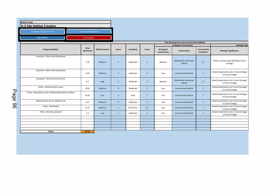
Ecological connectivity Connectivity Connectivity
multiplier Strategic significance
Grassland - Other neutral grassland
2.78 Medium 4 Moderate 2 Medium Moderately connected habitat 1.1 Within area formally identified in local
strategy
Grassland - Other neutral grassland0.56 Medium 4 Moderate 2 Low Unconnected habitat 1 Area/compensation not in local strategy/
no local strategy
Grassland - Tall herb communities0.2 High 6 Moderate 2 Medium Moderately connected
habitat 1.1 Area/compensation not in local strategy/ no local strategy
Urban - Artificial lake or pond 0.99 Medium 4 Moderate 2 Low Unconnected habitat 1 Area/compensation not in local strategy/ no local strategy
Urban - Suburban/ mosaic of developed/ natural surface16.63 Low 2 Poor 1 Low Unconnected habitat 1 Area/compensation not in local strategy/
no local strategy
Heathland and shrub - Mixed scrub 0.41 Medium 4 Moderate 2 Low Unconnected habitat 1 Area/compensation not in local strategy/ no local strategy
Urban - Woodland 0.75 Medium 4 Fairly Poor 1.5 Low Unconnected habitat 1 Area/compensation not in local strategy/ no local strategy
Urban - Amenity grassland 2.2 Low 2 Moderate 2 Low Unconnected habitat 1 Area/compensation not in local strategy/ no local strategy
Totals 24.52
Eaton Leys
Proposed habitat
Post development/ post intervention habitats Ecological connectivity Strategic significance
ScoreCondition ScoreDistinctivenessArea (hectares)
A-2 Site Habitat CreationCondense / Show Rows
Main Menu Instructions
Condense / Show Columns
Page 96
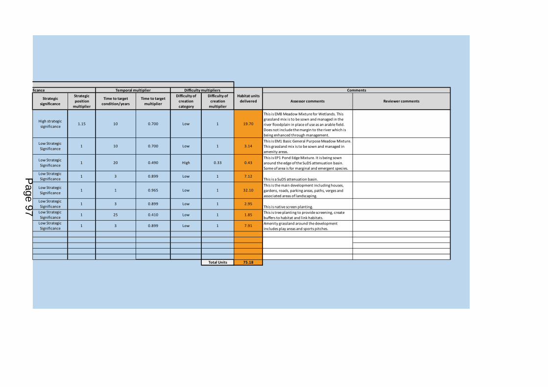
Strategic significance
Strategic position
multiplier
Time to target condition/years
Time to target multiplier
Difficulty of creation category
Difficulty of creation
multiplierAssessor comments Reviewer comments
High strategic significance 1.15 10 0.700 Low 1 19.70
This is EM8 Meadow Mixture for Wetlands. This grassland mix is to be sown and managed in the river floodplain in place of use as an arable field. Does not include the margin to the river which is being enhanced through management.
Low Strategic Significance 1 10 0.700 Low 1 3.14
This is EM1 Basic General Purpose Meadow Mixture. This grassland mix is to be sown and managed in amenity areas.
Low Strategic Significance 1 20 0.490 High 0.33 0.43
This is EP1 Pond Edge Mixture. It is being sown around the edge of the SuDS attenuation basin. Some of area is for marginal and emergent species.
Low Strategic Significance 1 3 0.899 Low 1 7.12
This is a SuDS attenuation basin.
Low Strategic Significance 1 1 0.965 Low 1 32.10
This is the main development including houses, gardens, roads, parking areas, paths, verges and associated areas of landscaping.
Low Strategic Significance 1 3 0.899 Low 1 2.95
This is native screen planting.Low Strategic Significance 1 25 0.410 Low 1 1.85 This is tree planting to provide screening, create
buffers to habitat and link habitats.Low Strategic Significance 1 3 0.899 Low 1 7.91 Amenity grassland around the development
includes play areas and sports pitches.
Total Units 75.18
Strategic significance Difficulty multipliersHabitat units
delivered
CommentsTemporal multiplier
Page 97
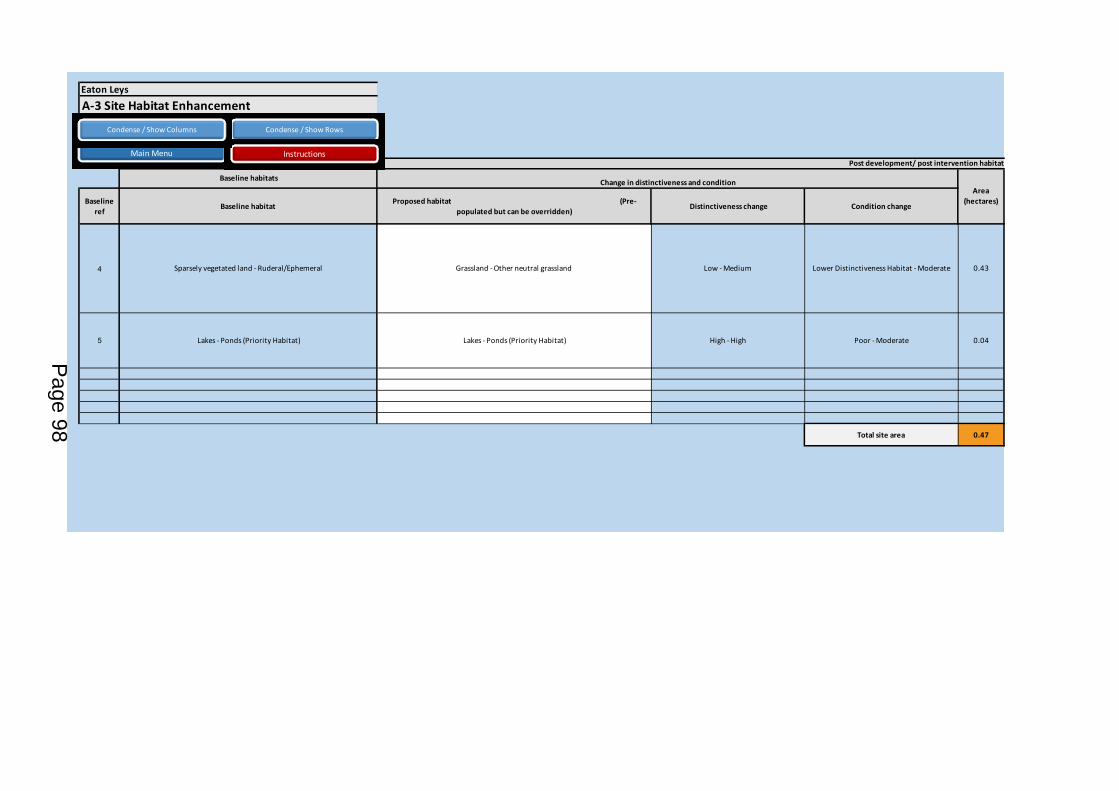
Baseline ref Baseline habitat Proposed habitat (Pre-
populated but can be overridden) Distinctiveness change Condition change
4 Sparsely vegetated land - Ruderal/Ephemeral Grassland - Other neutral grassland Low - Medium Lower Distinctiveness Habitat - Moderate 0.43
5 Lakes - Ponds (Priority Habitat) Lakes - Ponds (Priority Habitat) High - High Poor - Moderate 0.04
Total site area 0.47
Eaton LeysA-3 Site Habitat Enhancement
Baseline habitats
Post development/ post intervention habitats
Change in distinctiveness and conditionArea
(hectares)
Condense / Show Rows
Main Menu Instructions
Condense / Show Columns
Page 98
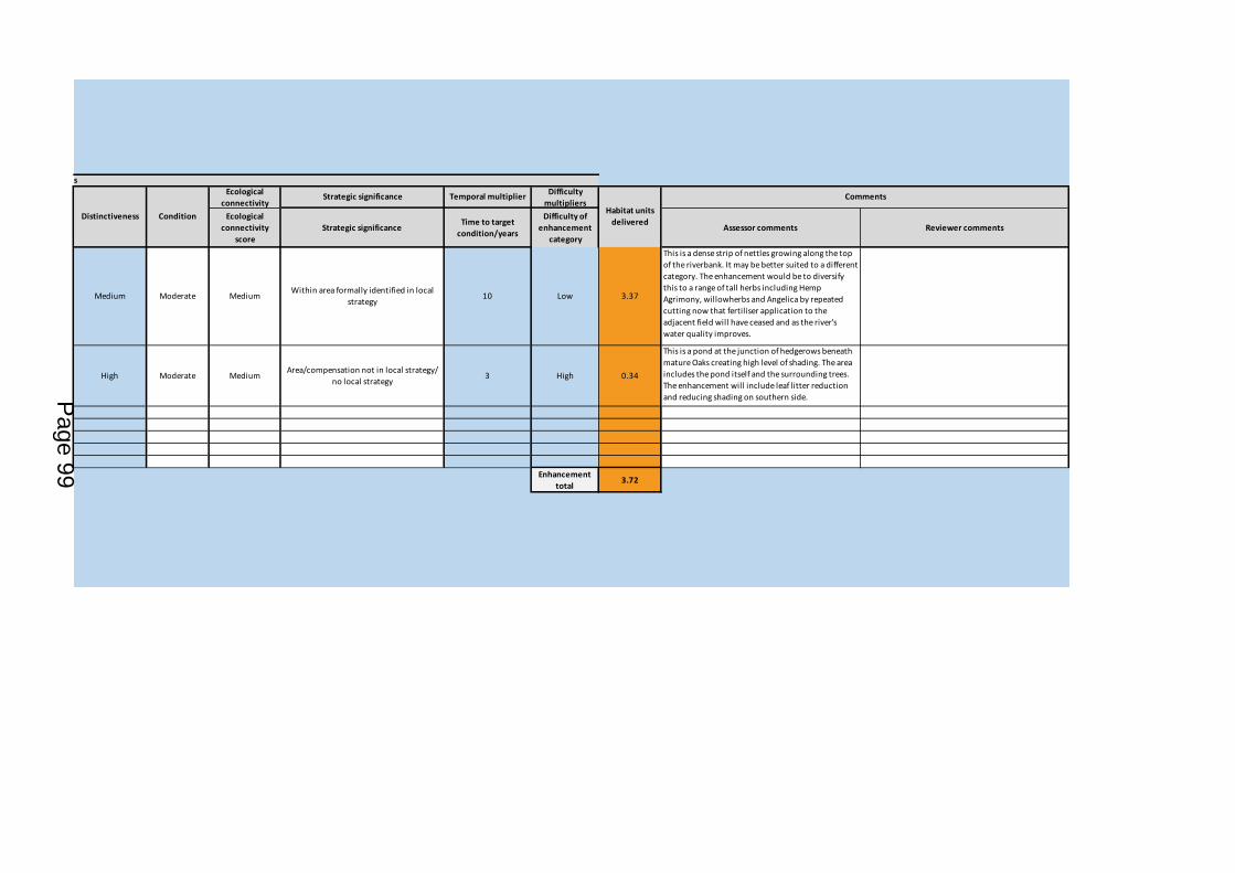
Ecological connectivity
scoreStrategic significance Time to target
condition/years
Difficulty of enhancement
categoryAssessor comments Reviewer comments
Medium Moderate Medium Within area formally identified in local strategy 10 Low 3.37
This is a dense strip of nettles growing along the top of the riverbank. It may be better suited to a different category. The enhancement would be to diversify this to a range of tall herbs including Hemp Agrimony, willowherbs and Angelica by repeated cutting now that fertiliser application to the adjacent field will have ceased and as the river's water quality improves.
High Moderate Medium Area/compensation not in local strategy/ no local strategy 3 High 0.34
This is a pond at the junction of hedgerows beneath mature Oaks creating high level of shading. The area includes the pond itself and the surrounding trees. The enhancement will include leaf litter reduction and reducing shading on southern side.
Enhancement total 3.72
CommentsTemporal multiplier Difficulty multipliers
Post development/ post intervention habitats
Strategic significanceEcological connectivity
Habitat units deliveredCondition Distinctiveness
Page 99

B-1 Site Hedge Baseline
Baseline ref Hedge number Hedgerow type length
KM Distinctiveness Score Condition Score Ecological connectivity
1 2 Native Hedgerow 0.08 Low 2 Moderate 2 Medium
2 3 Native Hedgerow - Associated with bank or ditch 0.29 Medium 4 Moderate 2 Medium
3 4 Native Hedgerow with trees 0.27 Low 2 Moderate 2 Medium
4 7 Native Hedgerow 0.4 Low 2 Poor 1 Medium
5 8 Native Hedgerow - Associated with bank or ditch 0.28 Medium 4 Moderate 2 Medium
6 9 Line of Trees 0.3 Low 2 Moderate 2 Medium
7 10 Native Hedgerow with trees - Associated with bank or ditch 0.22 Medium 4 Moderate 2 Medium
8 11 Native Hedgerow with trees - Associated with bank or ditch 0.3 Medium 4 Moderate 2 Medium
9 12 Native Hedgerow with trees - Associated with bank or ditch 0.31 Medium 4 Moderate 2 Medium
10 13 Native Hedgerow with trees - Associated with bank or ditch 0.07 Medium 4 Moderate 2 Medium
1112131415
Total Site length/KM 2.52
Eaton Leys
UK Habitats - existing habitats Habitat distinctiveness Habitat condition
Condense / Show Rows
Main Menu Instructions
Condense / Show Columns
Page 100

Ecological baseline
Connectivity Connectivity multiplier Strategic significance Strategic significance
Strategic position
multiplier
Suggested action to address habitat losses
Total hedgerow
units
Length retained
Moderately connected habitat 1.1 Within area formally identified in local strategy High strategic significance 1.15 Same distinctiveness band or better 0.4048 0
Moderately connected habitat 1.1 Area/compensation not in local strategy/ no local strategy Low Strategic Significance 1 Like for like or better 2.552 0
Moderately connected habitat 1.1 Area/compensation not in local strategy/ no local strategy Low Strategic Significance 1 Same distinctiveness band
or better 1.188 0
Moderately connected habitat 1.1 Area/compensation not in local strategy/ no local strategy Low Strategic Significance 1 Same distinctiveness band
or better 0.88 0
Moderately connected habitat 1.1 Area/compensation not in local strategy/ no local strategy Low Strategic Significance 1 Like for like or better 2.464 0
Moderately connected habitat 1.1 Area/compensation not in local strategy/ no local strategy Low Strategic Significance 1 Same distinctiveness band
or better 1.32 0
Moderately connected habitat 1.1 Area/compensation not in local strategy/ no local strategy Low Strategic Significance 1 Like for like or better 1.936 0
Moderately connected habitat 1.1 Area/compensation not in local strategy/ no local strategy Low Strategic Significance 1 Like for like or better 2.64 0
Moderately connected habitat 1.1 Area/compensation not in local strategy/ no local strategy Low Strategic Significance 1 Like for like or better 2.728 0
Moderately connected habitat 1.1 Area/compensation not in local strategy/ no local strategy Low Strategic Significance 1 Like for like or better 0.616 0
Total Site baseline 16.73 0.00
Ecological connectivity Strategic significance
Page 101
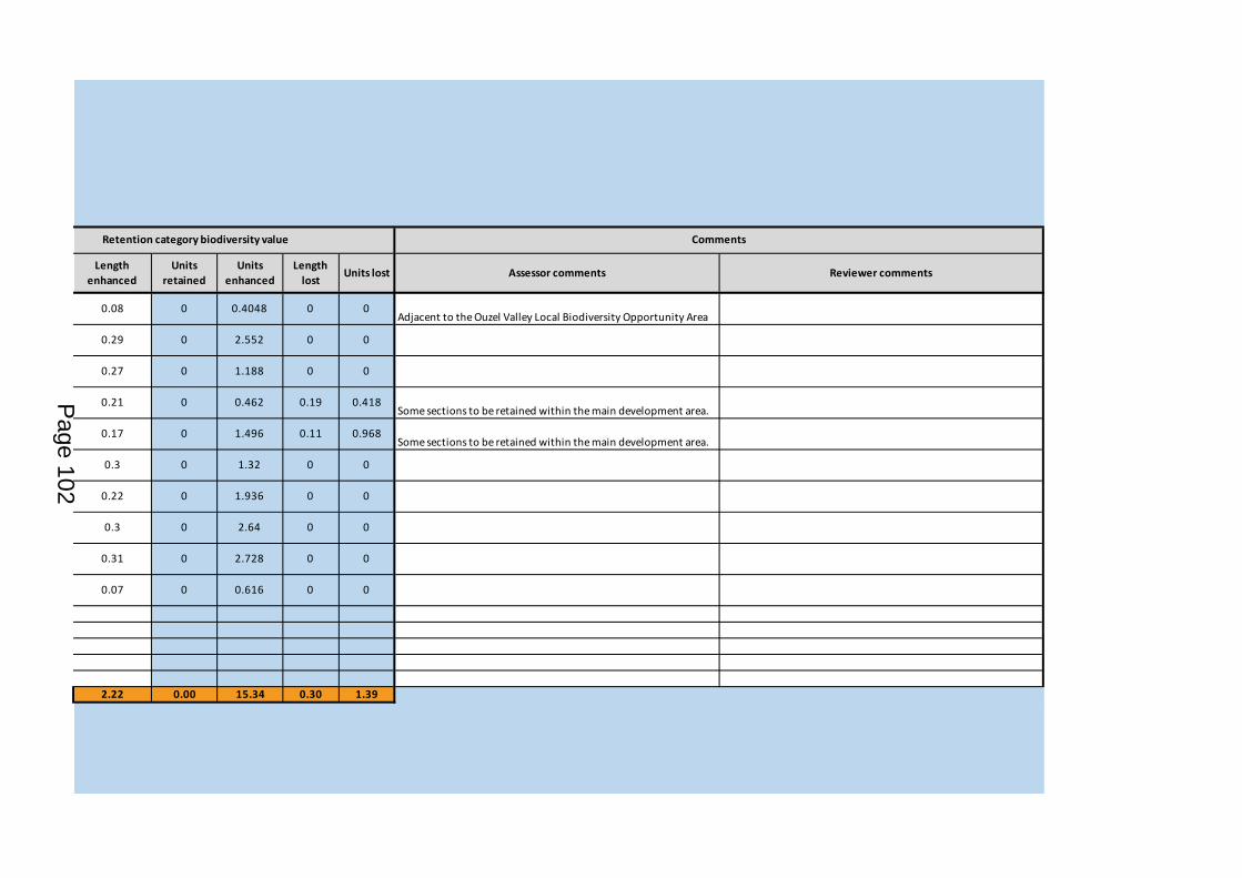
Length enhanced
Units retained
Units enhanced
Length lost Units lost Assessor comments Reviewer comments
0.08 0 0.4048 0 0Adjacent to the Ouzel Valley Local Biodiversity Opportunity Area
0.29 0 2.552 0 0
0.27 0 1.188 0 0
0.21 0 0.462 0.19 0.418Some sections to be retained within the main development area.
0.17 0 1.496 0.11 0.968Some sections to be retained within the main development area.
0.3 0 1.32 0 0
0.22 0 1.936 0 0
0.3 0 2.64 0 0
0.31 0 2.728 0 0
0.07 0 0.616 0 0
2.22 0.00 15.34 0.30 1.39
CommentsRetention category biodiversity value
Page 102
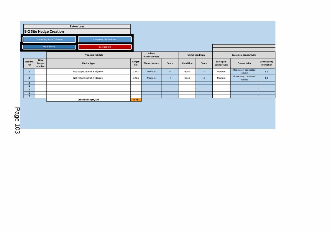
Habitat distinctiveness
Baseline ref
New hedge
numberHabitat type Length
km Distinctiveness Score Condition Score Ecological connectivity Connectivity Connectivity
multiplier
1 Native Species Rich Hedgerow 0.247 Medium 4 Good 3 Medium Moderately connected habitat 1.1
2 Native Species Rich Hedgerow 0.465 Medium 4 Good 3 Medium Moderately connected habitat 1.1
34567
Creation Length/KM 0.71
Eaton Leys
B-2 Site Hedge Creation
Proposed habitats Habitat condition Ecological connectivity
Condense / Show Rows
Main Menu Instructions
Condense / Show Columns
Page 103

Strategic significance Strategic significance
Strategic position
multiplier
Time to target condition/years
Time to target multiplier Assessor comments Reviewer comments
Area/compensation not in local strategy/ no local strategy
Low Strategic Significance 1 10 0.700 0.67 1.53
Site frontage hedgeArea/compensation not in local strategy/ no local
strategyLow Strategic Significance 1 10 0.700 0.67 2.88
Total hedging for rest of scheme
4.41
Multipliers
CommentsHedge units
delivered
Strategic significance Difficulty of creation
multiplier
Temporal multiplierSpatial quality
Page 104

Baseline ref Baseline habitat Distinctiveness movement Condition movement
1 Native Hedgerow Native Hedgerow Low - Low Moderate - Good 0.08
2 Native Hedgerow - Associated with bank or ditch Native Hedgerow - Associated with bank or ditch Medium - Medium Moderate - Good 0.29
3 Native Hedgerow with trees Native Hedgerow with trees Low - Low Moderate - Good 0.27
4 Native Hedgerow Native Hedgerow Low - Low Poor - Moderate 0.21
5 Native Hedgerow - Associated with bank or ditch Native Hedgerow - Associated with bank or ditch Medium - Medium Moderate - Good 0.17
6 Line of Trees Line of Trees Low - Low Moderate - Good 0.3
7 Native Hedgerow with trees - Associated with bank or ditch Native Hedgerow with trees - Associated with bank or ditch Medium - Medium Moderate - Good 0.22
8 Native Hedgerow with trees - Associated with bank or ditch Native Hedgerow with trees - Associated with bank or ditch Medium - Medium Moderate - Good 0.3
9 Native Hedgerow with trees - Associated with bank or ditch Native Hedgerow with trees - Associated with bank or ditch Medium - Medium Moderate - Good 0.31
10 Native Hedgerow with trees - Associated with bank or ditch Native Hedgerow with trees - Associated with bank or ditch Medium - Medium Moderate - Good 0.07
Total site length 2.22
Post development/ post intervention habitats
Change in distincitiveness and conditionLength
KMProposed
Baseline Habitats
Eaton LeysB-3 Site Hedge Enhancement
Condense / Show Rows
Main Menu Instructions
Condense / Show Columns
Page 105
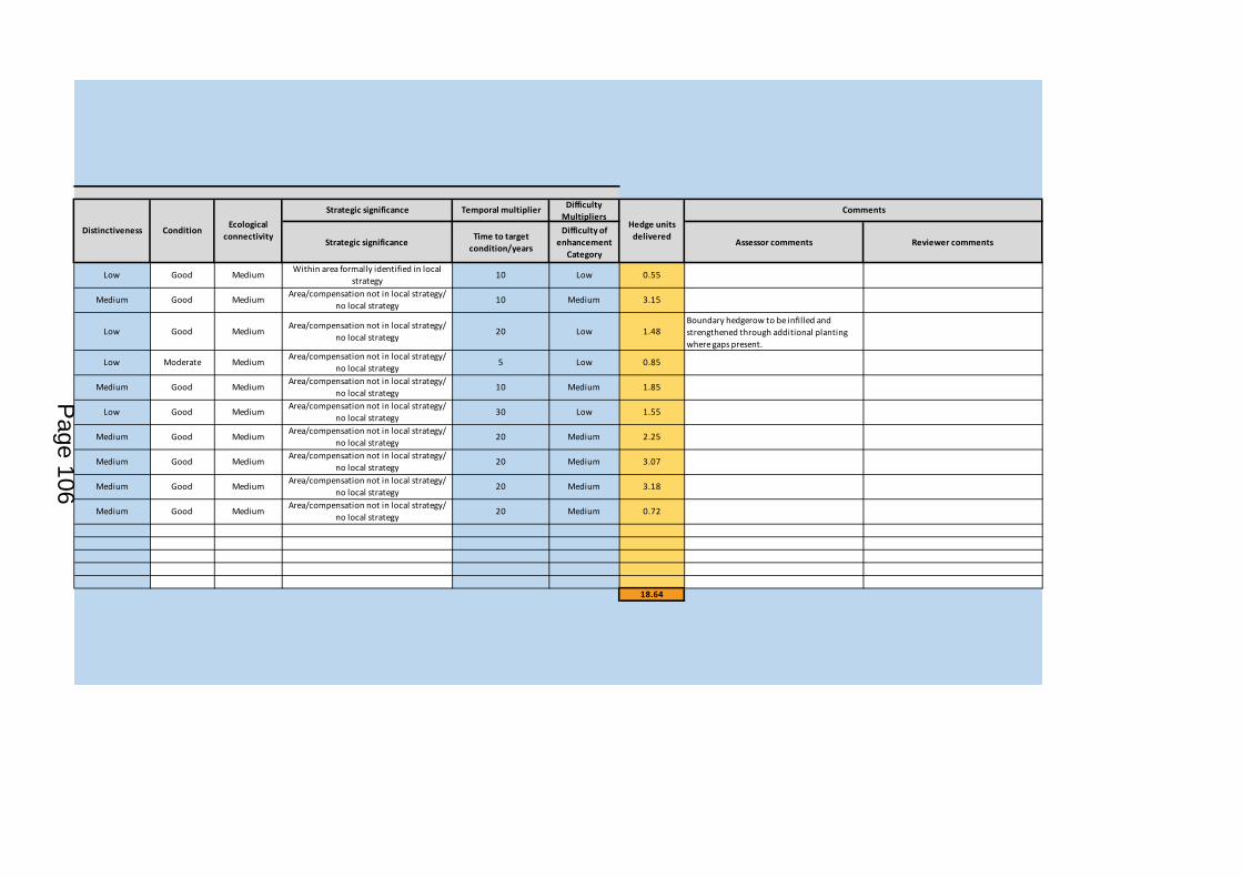
Strategic significance Time to target condition/years
Difficulty of enhancement
CategoryAssessor comments Reviewer comments
Low Good Medium Within area formally identified in local strategy 10 Low 0.55
Medium Good Medium Area/compensation not in local strategy/ no local strategy 10 Medium 3.15
Low Good Medium Area/compensation not in local strategy/ no local strategy 20 Low 1.48
Boundary hedgerow to be infilled and strengthened through additional planting where gaps present.
Low Moderate Medium Area/compensation not in local strategy/ no local strategy 5 Low 0.85
Medium Good Medium Area/compensation not in local strategy/ no local strategy 10 Medium 1.85
Low Good Medium Area/compensation not in local strategy/ no local strategy 30 Low 1.55
Medium Good Medium Area/compensation not in local strategy/ no local strategy 20 Medium 2.25
Medium Good Medium Area/compensation not in local strategy/ no local strategy 20 Medium 3.07
Medium Good Medium Area/compensation not in local strategy/ no local strategy 20 Medium 3.18
Medium Good Medium Area/compensation not in local strategy/ no local strategy 20 Medium 0.72
18.64
Difficulty Multipliers
CommentsTemporal multiplierHedge units
deliveredDistinctiveness Condition Ecological connectivity
Strategic significance
Page 106

MAP 1 Ecological Feature Calculations
Ecological Planning & Research
Ordnance Survey (c) Crown copyright 2007. All rights reserved. License number 100005596.
P14/12
CLIENT:
PROJECT:
DATE: August 2019
±
KEY
SCALE: 1:3,250 at A3
Y:\EatonLeys_MiltonKeynes\GIS\Biodiversity Calculator - Task29\Map1_Habitat_Areas_P1412_29_020819a.mxd
Barratt Northampton
Eaton Leys, Milton Keynes
I
I
I
I
I
I
I
II
I
I
I
I
II
I
I
I
I
I
I
I
I
I
I
I
13
2
10
8
12
4
3
11
9
7
0.43 Ha
0.04 Ha
Field 35.36 Ha
Field 49.95 Ha
Field 59.21 Ha
0 50 100 150 200 Metres
Site boundary
Arable
Pond
Tall ruderal
I
I Species-poor intact hedgerow
I
I Species-poor defunct hedgerow
Hedge with trees
Dry ditch
Page 107
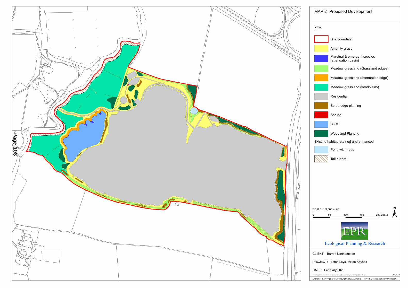
MAP 2 Proposed Development
Ecological Planning & Research
Ordnance Survey (c) Crown copyright 2007. All rights reserved. License number 100005596.
P14/12
CLIENT:
PROJECT:
DATE: February 2020
KEY
SCALE: 1:3,000 at A3
Y:\EatonLeys_MiltonKeynes\GIS\Biodiversity Calculator\Map2_Proposed_Habitat_Areas_P1412_315_060220b.mxd
Barratt Northampton
Eaton Leys, Milton Keynes
0 50 100 150 200 Metres
Site boundary
Amenity grass
Marginal & emergent species(attenuation basin)
Meadow grassland (Grassland edges)
Meadow grassland (attenuation edge)
Meadow grassland (floodplains)
Residential
Scrub edge planting
Shrubs
SuDS
Woodland Planting
Existing habitat retained and enhanced
Pond with trees
Tall ruderal
Page 108

MAP 3 Hedgerow Losses and Gains
Ecological Planning & Research
Ordnance Survey (c) Crown copyright 2007. All rights reserved. License number 100005596.
P14/12
CLIENT:
PROJECT:
DATE: February 2020
KEY
SCALE: 1:3,000 at A3
Y:\EatonLeys_MiltonKeynes\GIS\Biodiversity Calculator\Map3_HedgerowLossAndGains_P1412_315_060220a.mxd
Barratt Northampton
Eaton Leys, Milton Keynes
0 50 100 150 200 Metres
Site boundary
Retained hedge sections
Proposed hedge sections
Proposed hedge at front
Page 109

Eaton Leys – Maintenance Schedule
Client: Barratt Homes Northampton
REF: GL1132 ii DATE: JULY 2019
l a n d s c a p e a r c h i t e c t s
golby luck+
T e l : 0 1 5 3 0 2 6 5 6 8 8 W e b : w w w . g o l b y a n d l u c k . c o . u k
E m a i l : i n f o @ g o l b y a n d l u c k . c o . u k
Of f ice : 207 L e ic es te r R o ad, Ib s t ock , Le ices t e r s h i re , LE 67 6HP
Go lby and Luck L TD (Co mpany No . 9037776) R eg i s te red in Eng l and and W ales
Page 110
Application for approval of details reserved by condition.Town and Country Planning Act 1990
Planning (Listed Buildings and Conservation Areas) Act 1990
Publication of applications on planning authority websites.
Please note that the information provided on this application form and in supporting documents may be published on the Authority’s website. Ifyou require any further clarification, please contact the Authority’s planning department.
1. Site Address
Number
Suffix
Property name The Premier Academy
Address line 1 Saffron Street
Address line 2
Address line 3
Town/city Bletchley
Postcode MK2 3AH
Description of site location must be completed if postcode is not known:
Easting (x) 487671
Northing (y) 232955
Description
2. Applicant Details
Title
First name Warren
Surname Harrison
Company name
Address line 1 The Premier Academy
Address line 2 Saffron Street
Address line 3
Town/city Milton Keynes
Planning Portal Reference: PP-08566429
Page 111
Agenda Item 5.iv

2. Applicant Details
Country United Kingdom
Postcode MK2 3AH
Primary number
Secondary number
Fax number
Email address
Are you an agent acting on behalf of the applicant? Yes No
3. Agent Details
No Agent details were submitted for this application
4. Description of the Proposal
Please provide a description of the approved development as shown on the decision letter
Proposed x 2 classroom extension block
Reference number
18/02891/FUL
Date of decision (datemust be pre-applicationsubmission)
28/01/2019
Please state the condition number(s) to which this application relates
Condition number(s)
5
Has the development already started? Yes No
5. Part Discharge of Conditions
Are you seeking to discharge only part of a condition? Yes No
6. Discharge of Conditions
Please provide a full description and/or list of the materials/details that are being submitted for approval
Construction Environmental Management Plan (CEMP)
7. Site Visit
Can the site be seen from a public road, public footpath, bridleway or other public land? Yes No
If the planning authority needs to make an appointment to carry out a site visit, whom should they contact?
The agent
The applicant
Other person
Planning Portal Reference: PP-08566429
Page 112

8. Pre-application Advice
Has assistance or prior advice been sought from the local authority about this application? Yes No
9. Declaration
I/we hereby apply for planning permission/consent as described in this form and the accompanying plans/drawings and additional information. I/we confirmthat, to the best of my/our knowledge, any facts stated are true and accurate and any opinions given are the genuine opinions of the person(s) giving them.
Date (cannot be pre-application)
05/03/2020
Planning Portal Reference: PP-08566429
Page 113

Construction Environmental Management Plan
The Premier AcademySaffron Street
Bletchley MK2 3AH
Prepared by:
Page 114

CEMP – Construction Phase – The Premier Academy, Saffron Street, Bletchley MK2 3AH
3 | P a g e
Contents1 Introduction......................................................................................................................................................................................... 5
1.1 Background ........................................................................................................................................................................................ 51.2 Objectives ........................................................................................................................................................................................... 51.3 Site Description.................................................................................................................................................................................. 5
2 Construction Phasing.......................................................................................................................................................................... 72.1 Main Construction Works.................................................................................................................................................................... 72.2 Site Set Up......................................................................................................................................................................................... 7
3 Roles and Responsibilities.................................................................................................................................................................. 84 Liaison and Communication................................................................................................................................................................ 9
4.1 Communication with Regulatory Bodies ............................................................................................................................................. 94.2 Community Liaison Manager .............................................................................................................................................................. 94.3 Liaison with nearby construction sites ................................................................................................................................................ 94.4 Complaints Procedure ....................................................................................................................................................................... 9
5 Traffic Management .......................................................................................................................................................................... 105.1 Sensitive Receptors.......................................................................................................................................................................... 105.2 Vehicle Scheduling ........................................................................................................................................................................... 105.3 Site Access and Management on Arrival .......................................................................................................................................... 105.4 Loading / Unloading Procedures ...................................................................................................................................................... 115.5 Construction Traffic........................................................................................................................................................................... 115.6 Construction Traffic Volumes............................................................................................................................................................ 115.6 Hours of Work................................................................................................................................................................................... 125.7 Authorisation and / or licence Issues ............................................................................................................................................... 125.8 Wheel Washing................................................................................................................................................................................. 125.9 Plant and Equipment Transportation ................................................................................................................................................ 135.10 Deliveries .......................................................................................................................................................................................... 135.11 Traffic Management Procedures ...................................................................................................................................................... 13
6 Air Quality and Dust Management ................................................................................................................................................... 146.1 Sensitive Management.................................................................................................................................................................... 146.2 Air Quality Controls........................................................................................................................................................................... 146.3 Sensitive Receptors......................................................................................................................................................................... 14 6.4 Dust Management Controls .............................................................................................................................................................. 156.5 Dust Control Monitoring .................................................................................................................................................................... 156.6 Dust Risk Assessment...................................................................................................................................................................... 156.7 Relevant Documentation .................................................................................................................................................................. 15
7 Noise Management .......................................................................................................................................................................... 167.1 General Guidance............................................................................................................................................................................ 167.2 Noise Management Controls and Mitigation Measures .................................................................................................................... 167.3 Noise Levels ..................................................................................................................................................................................... 177.4 Relevant Documents........................................................................................................................................................................ 17
8 Vibration ........................................................................................................................................................................................... 188.1 General Guidance............................................................................................................................................................................. 188.2 Construction Phases......................................................................................................................................................................... 188.3 Relevant Documents ....................................................................................................................................................................... 18
9 Artificial Lighting Management.......................................................................................................................................................... 199.1 General Guidance............................................................................................................................................................................. 199.2 Artificial Light Management Controls ............................................................................................................................................... 199.3 Details of Timings of Lighting Requirements .................................................................................................................................... 199.4 Relevant Documents........................................................................................................................................................................ 20
10 Water Management .......................................................................................................................................................................... 2110.1 General Guidance............................................................................................................................................................................ 2110.2 Site Drainage ................................................................................................................................................................................... 21
10.2.1 Drainage Systems ...................................................................................................................................................................... 21
Page 115

CEMP – Construction Phase – The Premier Academy, Saffron Street, Bletchley MK2 3AH
4 | P a g e
10.2.2 Materials Storage Area .............................................................................................................................................................. 2110.2.3 Plant Maintenance Area ............................................................................................................................................................ 21
11 Ecology ............................................................................................................................................................................................. 2213 Waste Management.......................................................................................................................................................................... 24
13.1 Site Waste Management Plan .......................................................................................................................................................... 2413.2 Solid Waste...................................................................................................................................................................................... 2413.3 Waste Management and Duty of Care ............................................................................................................................................. 24
Appendix A: Relevant Air Legislation................................................................................................................................................................. 25Appendix B: Relevant Noise Legislation............................................................................................................................................................ 26Appendix C: Relevant Water Legislation ........................................................................................................................................................... 27Appendix D: Relevant Nature Conservation Legislation .................................................................................................................................. 27Appendix E: Complaints Policy.......................................................................................................................................................................... 28Appendix F: Site Dust Risk Assessment ........................................................................................................................................................... 37
Dust Emission Magnitude .............................................................................................................................................................................. 37Dust Soiling .................................................................................................................................................................................................... 38Human Health ................................................................................................................................................................................................ 39ECOSystems Impact...................................................................................................................................................................................... 39Outcome......................................................................................................................................................................................................... 40Risk of Dust Impacts ...................................................................................................................................................................................... 40Summary........................................................................................................................................................................................................ 40
Appendix G: Programme of Works .................................................................................................................................................................... 41
Page 116

CEMP – Construction Phase – The Premier Academy, Saffron Street, Bletchley MK2 3AH
5 | P a g e
1 Introduction
1.1 Background
In December 2018 planning permission was granted by Milton Keynes Council for a classroom extension block to The Premier Academy, Saffron Street, Bletchley MK2 3AH.
As one of the planning submission requirements, a Construction, Environmental Management Plan (CEMP) was specified as being required, to ensure there are adequate mitigation measures in place, in the interests of highway and pedestrian safety and in order to protect the amenities of existing and future residents in accordance with Policy CS13 of the Milton Keynes Core Strategy 2013 and saved policies D1 and T10 of the Milton Keynes Local Plan2001 – 2011.This document references the Construction Environmental Management Plan (CEMP).
1.2 Objectives
The overall objective of this CEMP is to ensure that robust management policies and procedures are implemented throughout the construction phase at The Premier Academy, Saffron Street, Bletchley, MK2 3AH.
• Reducing the impact of the development during the construction process on the local area• Ensure the safety of pedestrians throughout the project.• Protecting the environment and achieving compliance with environmental legislation• Delivering a resource efficient construction process, achieving both waste reduction and
improved business efficiency and cost savings; and• Developing good neighbourhood relationships and heightened employee morale.
1.3 Site Description
The Grid reference for the site is SP877329
The existing property is the Premier Academy, Saffron Street, Bletchley MK2 3AH, which is an existing primary school consisting of the school buildings, school gardens, car parks, play areas and games fields.
Page 117

CEMP – Construction Phase – The Premier Academy, Saffron Street, Bletchley MK2 3AH
6 | P a g e
The site is located to the south of Saffron Street, east of Mossmans Close and west of Drayton Road, in the heart of a residential area of Bletchley. The school is c650m East of the Blue Lagoon local wildlife reserve, c540m west of the Grand Union Canal and c575m west of Waterhall Park. The existing school is not locally or statutorily listed.
Existing School Site Boundary
Construction Site Outline
Page 118
CEMP – Construction Phase – The Premier Academy, Saffron Street, Bletchley MK2 3AH
7 | P a g e
2 Construction Phasing
This project has a proposed 26 week works schedule.
2.1 Main Construction Works
The works comprise of building a single storey, 2 classroom extension to the current school premises. This will create 110m2 of new space which will consist of General Teaching Classroom / Toilets / Medical room, Perri room and corridor.
• Site Hoarding to be set up around the perimeter• Welfare Area / Site Offices to be set up
The planned site working hours are as follows:
Monday – Friday 0800am – 6.00pmSaturday 0800am – 1.00pm
There is no planned activity for Sunday or Public Holidays and no works will take place outside these hours that can be audible at the site boundary.Procedures for emergency deviation of the agreed working hours will be put in place prior to the commencement of works.The programme of works can be found in Appendix G
2.2 Site Set Up
The site facilities will form a compound, housing
• Site Office(s)• Site Welfare facilities• Designated construction material storage area• Designated Construction Plant and Equipment storage areas• Designated Fuel Storage area
All storage areas will be located away from surface water drains and other sensitive receptors.It is envisaged that a full hoarding will be erected around the site perimeter separating the site from the car park / play area.Full Emergency Contact details will be displayed on the outside of the hoardings.
Page 119
CEMP – Construction Phase – The Premier Academy, Saffron Street, Bletchley MK2 3AH
8 | P a g e
3 Roles and ResponsibilitiesTable 3.1 below summarises the key roles required to be filled and outlines the responsibilities associated with each role for the Construction Phase.
Table 3.1 CEMP Roles and Responsibilities – Construction Phase
Role Responsibilities
Premier Academy Responsible for the submission of this CEMP to the Planning Authority and the obtaining of written approval prior to construction works commencing
Provision of personnel to fill other roles, as detailed below
Site Manager Weekly site audits to ensure this CEMP is being complied with
Responsible for communicating all aspects of site inductions, including, as necessary, toolbox talks on good practices
Review and implementation of any corrective actions required and handling of complaints
Monitor adherence to the CEMP against internal targets and report performance to both staff on the ground and to Senior Management
Page 120
CEMP – Construction Phase – The Premier Academy, Saffron Street, Bletchley MK2 3AH
9 | P a g e
4 Liaison and Communication
4.1 Communication with Regulatory Bodies
The Premier Academy will be responsible for communicating with Milton Keynes Council and other regulatory bodies as necessary.
Specifications and samples, where necessary, regarding external finishing materials and methods to be employed, will be submitted to Milton Keynes Council when defined. Details of documents, etc. will be available in the Site Office.
4.2 Community Liaison ManagerThe Premier Academy will appoint an identified contact who will be responsible for fulfilling the role of Community Liaison Manager for the development. The Community Liaison Manager’s responsibilities will include the following:
• Recording and responding to enquiries or complaints from the school, local community, including local businesses and the public;
• Communicating to the school and local community (including local businesses) the nature of the construction work that will be carried out;
• Communicating the programme of works to the school and local community (including local businesses), specifically highlighting any works that may result in complaints (e.g. noisy activities);
• Updating the school and local community (including local businesses) of any changes to the nature of works or programme of works as necessary;
• Establishing and maintaining good relationships with local stakeholder groups.
4.3 Liaison with nearby construction sites
• The Premier Academy is planning to ensure regular meetings with any nearby construction sites take place to ensure maximum co-ordination and the smooth working of the site as well as minimising any disruption to the public.
4.4 Complaints ProcedureThe Community Liaison Manager (CLM) will inform stakeholders of the complaints procedure as part of the communication programme. The complaints procedure must satisfy the following requirements:
• Publication of contact details for all relevant contacts, including their telephone and email contact details;
• Implementation and maintenance of a complaints register which records all communications (whether verbal or written) received from the general public or stakeholders;
• Classification of the nature of each communication (above) by category (e.g. complaint, enquiry, comment);
• If a communication requires action the CLM will assign the task to an appropriate Management Team member; and
• Ensure completion of actions and ensure the complaints register is updated with a record of all actions.
• The Complaints policy can be seen in Appendix E
Page 121

CEMP – Construction Phase – The Premier Academy, Saffron Street, Bletchley MK2 3AH
10 | P a g e
5 Traffic Management
5.1 Sensitive Receptors
The Premier Academy recognises that traffic movements arising as a result of site activities will require a management strategy in order to minimise the impact of such movements on the school, the surrounding road network in relation to congestion, access problems and noise. The key sensitive receptors that have been identified in relation to this aspect of the development are:
• The school, the staff and pupils and ancillary employees• Local businesses and residents• Local air quality; and• Local road network and users.
5.2 Vehicle Scheduling
• When each sub-contractor is procured onto the project, their terms and conditions of procurement will include an undertaking to comply with this Construction, Environmental Management Plan.
• All deliveries will be required to be “booked in” in advance with the Site Manager to ensure that there are no conflictions. This information will then be used by the Site Manager (SM) to create an overall daily Site Traffic Management / Monitoring Schedule which will instantly highlight any conflictions which can then be avoided by re-scheduling.
• No deliveries will be booked in during the “Rush Hour” periods in the morning andevening when the children are arriving or leaving school.
• There will be a delivery board on site which will be updated regularly.• No exceptions to this schedule will be permitted, except for the Emergency Services vehicles which will
always be exempt from any plan of this type.• Any timings of quiet periods will be discussed and agreed prior to the commencement of the project.
5.3 Site Access and Management on Arrival
• The site will have a register system, all Operatives and Visitors will be required to sign in via the Site Office.
• Inductions / briefings will be given to all site operatives and visiting personnel who enter site.• There is no allowance for parking on the site and travel by public transport is recommended.• Site access / egress will be via Mossmans Close, along the entrance of the school, car park and games
pitches. All drivers will be informed that as they will be crossing a playing pitch, they must be extra careful and to always be on the lookout for school children.
• A banksman will guide them across this area.
Page 122

CEMP – Construction Phase – The Premier Academy, Saffron Street, Bletchley MK2 3AH
11 | P a g e
5.4 Loading / Unloading Procedures
• A Banksman / Traffic Marshall will be used during each delivery to ensure the safety of the school children, other pedestrians and road users.
• Materials will be offloaded by forklift truck and taken on site.• Concrete pours will usually occupy at least half a day.
5.5 Construction TrafficThe proposed construction works at this site will commence during Spring 2020 and continue for approximately 6 months at present.
No contractors have yet been procured for the works. Each sub-contractor will be informed of the Site Traffic Management rules and will be required to inform Premier Academy of all their vehicular movements and timescales before commencing works on site. It will be preferred if qualifying operators / vehicles are FORS and CLOCS compliant.
5.6 Construction Traffic Volumes
Several key specialist sub-contractors will be uitilised for the major works elements.
• Roofing included in below• Construction approx. 26 weeks
We will be utilising the following vehicles during the construction phase
• Cement Lorry• Concrete Pump• Skip Loader Trucks• Mini Fork Lifts• 8-Wheeler delivery vehicles• Curtain Sider Lorry
Table 2: Vehicular movement schedule
We will not allow more than five deliveries / loads per day.
Vehicle Movements for Groundworks
Timescales Total During this Phase Plant / Equipment
Muck Away Approx weeks 2 & 3 Approx 5 loads 8 wheelers
Page 123

CEMP – Construction Phase – The Premier Academy, Saffron Street, Bletchley MK2 3AH
12 | P a g e
Vehicle Movements for Construction
Timescales Total During this Phase Plant / Equipment
Skip Loader Trucks Approx weeks 4,5,6 & 7 4 Digger, Dumper & Cement Mixer
Material deliveries including steel delivery, lintels and glass.
Approx Weeks 3, 4 12 & 13 4
Vehicle Movements for Roofing Works
Timescales Total During this Phase Plant / Equipment
Skip Loader Trucks Approx. weeks 8 & 9 2Delivery Trucks for Timber / tiles
1
5.6 Hours of Work
The hours of working which will include hours of delivery, will be the following,
• Monday to Friday: 08.00 to 18.00 hours• Saturday: 08.00 to 13.00 hours• Sundays/Bank and Public Holidays: No working
5.7 Authorisation and / or licence Issues
Table 3: This table identifies activities, plant or equipment that may require authorisation and / or a licence to be issued by Milton Keynes Council.
Skips Hoardings Material StorageTemporary Structures
5.8 Wheel Washing
Delivery Vehicles will be parked on hard standing and therefore should not track any mud / dirt in or out of site. A visual inspection of all vehicles and plant will take place and a light jet wash will be used on the wheels to ensure that no mud or debris is tracked onto the highway.If jet washing is required, filter protection to the drains will be used so only water goes through rather than mud.
Page 124

CEMP – Construction Phase – The Premier Academy, Saffron Street, Bletchley MK2 3AH
13 | P a g e
5.9 Plant and Equipment Transportation
• A Banksman will always be used for deliveries or collections.• Prior to the delivery of the construction vehicles, the banksmen will be positioned to ensure control and safe
conduct of the public and vehicles using the highway and school access.• Pedestrian barriers will be set up, as necessary, with appropriate signage securely attached.
5.10 Deliveries
• A Banksman will always be used for deliveries or collections.• Prior to the delivery of materials, the banksmen will be positioned to ensure control and safe conduct of the
public and vehicles using the highway and school access.• Unloading of materials will be done by Forklift Truck and taken on site.
5.11 Traffic Management Procedures
• Vehicle engines will be switched off whilst off-loading• Traffic Management Plan will be implemented.• There will be NO localised waiting.• Deliveries will be turned away if a vehicle is unloading or the arriving vehicle has not been booked in within the
agreed timeslot.• A site speed limit will be implemented and will be required to be adhered to.
Page 125
CEMP – Construction Phase – The Premier Academy, Saffron Street, Bletchley MK2 3AH
14 | P a g e
6 Air Quality and Dust Management
6.1 Sensitive Management
Air pollution and nuisance dust emissions from construction activities are issues that require close attention and consideration, with relevance to the legislation as detailed in Appendix A.Dusty emissions escaping the work area may cause nuisance through, for example, surface soiling, loss of visibility due to deposition, and effects on flora and fauna.Since it is difficult to suppress dust once it is airborne, it is preferable, where possible to prevent dust from being generated in the first place. Therefore, a philosophy for the prevention of dust formation in the first place should be adopted. Dealing with dust should follow the regime:
• Prevention• Suppression• Containment
These three principles are well established and central to the dust control strategies. They follow a hierarchy to control the emissions.
A Site Dust Risk Assessment has been completed and can be found in Appendix F
The Premier Academy will ensure that their own employees working on site and all sub-contractors follow best practice at all times to control and limit emissions of gaseous and particulate pollutants into the atmosphere from the construction activities, including vehicles and plant.
Suppression techniques will be through the use of water via a water misting suppression system, hoses and damping down localised areas during the construction works.
Regardless of regular inspections and procedures, should any airborne dust be seen to be leaving the site boundary, the source of the emission will be immediately identified, and corrective action will be taken without delay.
6.2 Air Quality ControlsThe Premier Academy is conscious of the effect that construction work has on the air quality and management controls that will be implemented throughout the construction phases are, as a minimum:
• Use of modern and fuel-efficient plant.• No plant will be left running when not in use.• All plant and machinery will be serviced in accordance with the manufacturers guidance to ensure
maximum efficiency.• There will be NO burning of waste allowed on site.
6.3 Sensitive Receptors
As this site is on the school premises, the most immediate sensitive receptors are the staff and children who attend the school. The Premier Academy is fully aware that numerous construction activities have the potential to produce dust emissions, e.g. the movement and placing of granular materials and the excavation of foundations. Such activities have the potential to affect sensitive (local) receptors.
Page 126
CEMP – Construction Phase – The Premier Academy, Saffron Street, Bletchley MK2 3AH
15 | P a g e
6.4 Dust Management Controls
Best practice pollution control measures will be put in place, to ensure adverse impacts including dust and air pollution, effects on water quality, pollution from fuel use and storage of other potentially hazardous materials do not occur and reduce the risk of environmental nuisance and complaints from any particularly susceptible local persons, businesses & residents.
• Regular monitoring of nuisance effects in relation to dust;• Regular assessment of the effectiveness of any mitigation measures put in place.
The dust management controls that will be implemented by each development team throughout the construction phases are, as a minimum:
• Where practicable, ready mixed materials (e.g. use of ready mixed concrete) will be used to replace those that would otherwise have the potential to produce dust.
• Material stockpiles (e.g. granular materials, topsoil, excavated soils) will be minimized and positioned as far away as possible from the school entrances and other sensitive receptors;
• Vehicles transporting materials capable of generating dust to and from site will be suitably sheeted on each journey to prevent release of materials and particulate matter. The sheeting material will be maintained in good order, free from excessive rips and tears;
• Regular monitoring of the road / pedestrian network in close proximity to the site entrance / exit will be implemented to ensure appropriate additional measures are applied as required to minimise dustgeneration.
• All dust control equipment will be maintained and serviced in accordance with the manufacturers’ recommendations and records kept.
6.5 Dust Control Monitoring
Other than the monitoring activities outlined above, it is not anticipated that routine monitoring to assess environmental nuisance will be required during construction works, provided the control measures outlined above are put in place. However, in the event of a complaint, The Premier Academy will take appropriate action to deal with the problem.
• The Site Manager will keep records of the results of the regular monitoring undertaken. Additionally, a record of all environmental incidents that result in air pollution and remedial action being taken will be recorded in an environmental incident logbook.
• Complaints received will be recorded and investigated by the Site Manager.
6.6 Dust Risk Assessment
A Site Dust Risk Assessment has been completed and can be found in Appendix F
6.7 Relevant Documentation
Milton Keynes Council Core Strategy policy CS13 Milton Keynes Local Plan 201 -2011 saved policy D1 and T10
Page 127

CEMP – Construction Phase – The Premier Academy, Saffron Street, Bletchley MK2 3AH
16 | P a g e
7 Noise Management
7.1 General GuidanceThe potential sources of noise from work undertaken in connection with the construction of this project are likely to include (but not be restricted to):
• Plant and machinery usage on-site;• Vehicle deliveries.The Premier Academy will implement the necessary management and operational controls in order to minimise any adverse noise impacts on the local community from works’ activities, referencing the relevant legislation as presented in Appendix B.
7.2 Noise Management Controls and Mitigation MeasuresThe Premier Academy will control construction noise in accordance with the recommendations established in the relevant British Standard for the control of noise on construction and open sites (BS5228-1:2009 and BS5228-2:2009). Noise is to be controlled at source where practicable.
Fixed items of plant will be electrically driven where possible.
• No diesel generators will be used as mains electricity will be available on site.
• All vehicles, compressors and plant will be equipped with effective silencers and noise reducing insulation in accordance with BS5228: 2009 part 1;
• Work practices will be adopted such that noise emissions are kept to a minimum, i.e. plant will be switched offwhen not in use and noise suppression covers will be closed at all times;
• Vehicle noise will be kept as low as possible (e.g. excessive revving of vehicles will not be permitted);• All engines of vehicles will be switched off when not in use as per The Premier Academy Site rules regarding
Anti-idling.• Where possible, noisy plant and equipment will be sited away from sensitive noise boundaries. Where this is
not possible, noise emissions will be controlled where possible by the erection of acoustic shielding, or by locating the plant behind site accommodation or spoil heaps;
• Loading and unloading of vehicles, dismantling of site equipment such as scaffolding or moving equipment or materials around site will be conducted in such a manner as to minimise noise generation and where possible these actions will be conducted away from noise sensitive areas;
• Deviation from approved method statements will only be with prior approval of The Premier Academy.• Noise complaints, or exceedances of action levels will be reported to and investigated by the Site Manager.• The Premier Academy shall give authority to designated site staff to take necessary steps to ensure noise and
vibration is adequately controlled and managed.• At the start of the project all site staff will be briefed on their responsibilities to minimise construction noise.• Site access will be located away from noise sensitive receptors• All materials will be handled in such a way as to minimise noise.• The screening effect of buildings and temporary stockpiles will be used to maximise their screening effect.• All noise will be controlled at source wherever possible.• No diesel generators will be used.• All plant and equipment in intermittent use will be shut down between periods of work.• If possible, all plant and equipment will be powered by mains electricity or other quieter technology.• The reuse of waste arisings on site will be maximised to minimise vehicle movements.• No vehicles or plant is allowed to have the engine idling.• All openings (windows and doors) will be kept closed when not being used.• Concrete pours will start as early as possible within normal working hours to avoid overruns.• All works will be carried out using Best practice Methods (BPM), in accordance with BS5228-1&2:2009+A1:2014.
Page 128

CEMP – Construction Phase – The Premier Academy, Saffron Street, Bletchley MK2 3AH
17 | P a g e
7.3 Noise Levels
• All works will be carried out using Best Practice Methods (BPM), in accordance with BS5228-1&2:2009+A1:2014.• If it is expected or predicted that an essential construction operation is likely to give rise to high noise levels for
a period of 2 hours; these noisy works will be confined to 2-hour windows – i.e. 2 hours on and 2 hours off, to provide respite for the local neighbours. In the event of a complaint, an investigation will be carried out to ascertain the cause of the exceed and / or the complaint.
• School hours will be avoided for noisy works where possible.
7.4 Relevant Documents• Should any noise related complaints be received, they must be relayed to the Site Manager who will keep a
record of all environmental incidents and remedial action taken in an environmental incident logbook and investigate each complaint.
• At least one Environmental toolbox talk will be conducted fortnightly to all Premier Academy operatives on site by the Site Management team.
Page 129

CEMP – Construction Phase – The Premier Academy, Saffron Street, Bletchley MK2 3AH
18 | P a g e
8 Vibration
8.1 General Guidance
Guidance given to BS 5228-2 2009 will be used to assess the likely impact of vibration on building occupants and is reproduced below.
Vibration Level (PPV) Effect
0.14 mm/sVibration might be perceptible in the most sensitive situation for most vibration frequencies associated with construction. At lower frequencies, people are less sensitive to vibration.
0.3 mm/s Vibration might be just perceptible in residential developments.
1.0 mm/sIt is likely that vibration at this level in residential/commercial environments will cause compliant, but can be tolerated if prior warning and explanation has been given to major stake holders.
10.0 mm/sVibration is likely to be intolerable for any more than a brief exposure at this level.
The activities which cause the most vibration on a construction site are piling activities using heavy plant
8.2 Construction Phases
• The Premier Academy will ensure that vibration nuisance is kept to a minimum, it will be within the acceptable level of 1mm/s PPV.
• However, should they receive a complaint, monitoring equipment will be installed to measure the level of vibration being caused and if it is deemed necessary measures will be implemented to reduce the nuisance of vibration even further.
8.3 Relevant Documents• Should any vibration related complaints be received, they must be relayed to the Site Manager who will
keep a record of all environmental incidents and remedial action taken in an environmental incident log book and investigate each complaint.
Page 130
CEMP – Construction Phase – The Premier Academy, Saffron Street, Bletchley MK2 3AH
19 | P a g e
9 Artificial Lighting Management
9.1 General GuidanceThe potential sources of artificial light intrusion whilst work is carried out in connection with the construction of this project are likely to include (but not be restricted to):• Artificial lighting usage on-site;• Vehicle deliveries.
The Premier Academy will implement the necessary management and operational controls in order to minimise any adverse effects of artificial lighting on the local community from works’ activities, referencing the guidelines from the Institute of Lighting Professionals.
The Premier Academy will seek to ensure no light spill outside of the site boundaries.
9.2 Artificial Light Management Controls
A Lighting Scheme and Artificial Light Management Controls will be made in accordance to Guidance Notes for the Reduction of Obtrusive Light from the Institute of Lighting Professionals, particularly the objective to keep glare to a minimum by ensuring that the main beam of all lights directed towards any potential observer is not more than 70°.
Lighting will be designed to limit obtrusive light to sensitive receptors surrounding the Project site whilst considering national, regional and local planning policies. Sensitive receptors include residents, business and key ecological factors (bats, birds).
The general design principles that will be used to minimise the impact of key lighting receptors and to meet environmental requirements are:
• To design for optimal light levels which provide enough illumination to safely undertake operational activities while limiting their impact on sensitive receptors;
• To locate significant sources of lighting away from sensitive landscape and ecological receptors;• To include full horizontal cut-off luminaires to prevent upward light with shields and baffles that can be
directed downwards rather than horizontal to limit light pollution onto sensitive areas;• To use columns of a minimum height. When lighting a large area, preference will be given to several
lower units rather than a tall wide beam lighting unit to limit light trespass, glare and skyglow;• To use controls toavoid unnecessary illumination and to ensure efficient luminaires are used;• To use automated devices to switch lights on and off according to activity and ambient levels;• To direct light to the area where it is needed to avoid reflectance from buildings and structures and to
avoid illuminating building facades;• The lighting will incorporate festoon lighting and portable LED lighting powered by a temporary mains
electricity supply. This is envisaged to maintain the minimum lux levels for the required job specifics, but minimize light pollution;
• All security lighting will be PIR controlled.
9.3 Details of Timings of Lighting Requirements
Artificial lights may be required during the following hours dependent upon season: Monday to Friday 4.00pm – 6.00pm
Depending on the conditions in the workplace, illumination may be required during other periods of the day, but best endeavours will be made to keep these to a minimum.
Page 131

CEMP – Construction Phase – The Premier Academy, Saffron Street, Bletchley MK2 3AH
20 | P a g e
9.4 Relevant DocumentsShould any light related complaints be received, they must be relayed to the Site Manager who will keep a record of all environmental incidents and remedial action taken in an environmental incident logbook and investigate each complaint.
Page 132
CEMP – Construction Phase – The Premier Academy, Saffron Street, Bletchley MK2 3AH
21 | P a g e
10 Water Management
10.1 General GuidanceIt is vital that surface water and effluent discharge are properly managed and controlled on-site to protect the environment. Any pollutants entering surface water drains could end up in nearby streams or rivers.Throughout the construction phase, the pollution prevention measures detailed below will be required to be implemented. The measures detailed in the following sections will be protective of sensitive receptors and ensure compliance with the applicable regulations (as presented in Appendix C).
10.2 Site Drainage
10.2.1 Drainage SystemsA surface drainage plan will be submitted for approval, if required.
10.2.2 Materials Storage AreaThe Premier Academy will establish a dedicated hazardous material storage area within its site compound (e.g. for fuels and oils). The material storage area will be provided with appropriately segregated areas for storage of different materials, each of which will be provided with secondary containment, typically to 110% of the volume of materialstored (or to meet the requirements of applicable regulations, see Appendix C).Spill kits will be available in areas of material storage. All COSSH Items to be clearly marked and stored safely. Records of all COSSH items being used will be recorded within the site files.
• Materials storage areas will be inspected on a regular basis, but at least once per week as part of the scheduled site audit.
• Ensure that refueling is carried out away from water sources and drains if possible and in accordance with the following general principles:o An emergency spill kit containing sand or suitable absorbent materials is to be kept readily available in
case of spillage in the main fuel storage area;o All bowsers must be equipped with an automatic cut-off mechanism;o All refueling operations must be supervised by trained personnel;o Valves and taps must not be left open unattended and must be locked when not ino use;o Personnel carrying out refueling are to be made aware of this code of practice; ando Refueling protocol and be trained in the use of spill kits and emergency procedures.
10.2.3 Plant Maintenance AreaPlant maintenance will, in general, be carried out off-site. Daily inspections of plant by the plant operator will identify whether maintenance is required. Routine minor maintenance such as refueling and oil top up will be carried out on-site, with suitable precautions taken, e.g. away from surface water courses, on areas of hard standing and in accordance with the refueling principles.
Page 133
CEMP – Construction Phase – The Premier Academy, Saffron Street, Bletchley MK2 3AH
22 | P a g e
11 Ecology
There is no specific ecology to be taken into account.
Page 134

CEMP – Construction Phase – The Premier Academy, Saffron Street, Bletchley MK2 3AH
23 | P a g e
12 Energy StatementAn Energy Statement will be submitted for approval by Milton Keynes Council prior to commencement of the relevant works above ground if required.
Page 135
CEMP – Construction Phase – The Premier Academy, Saffron Street, Bletchley MK2 3AH
24 | P a g e
13 Waste Management
13.1 Site Waste Management PlanA SWMP is not planned for this project.
13.2 Solid WasteWorks carried out during the construction phase will consider the waste hierarchy and there is aneed to consider reducing the amount of waste produced during the work.Prior to commencing construction, The Premier Academy will identify the means of reducing waste, including (but not limited to) consideration of the following:
• Use of offsite manufacturer for products i.e. timber frames,• Use of returnable pallets;• Retention of materials in packaging until required; and• Ensure surplus materials are returned to suppliers.
13.3 Waste Management and Duty of CareAll Waste Collections and Transfer Notes will be recorded and the Waste Duty of Care regulations will be checked and complied with.
Page 136

CEMP – Construction Phase – The Premier Academy, Saffron Street, Bletchley MK2 3AH
25 | P a g e
Appendix A: Relevant Air Legislation
Relevant Legislation Description
Clean Air Act 1993 Bans emission of dark smoke from chimneys and furnaces, sets minimum chimney heights, and creates smoke control zones.
Climate Change Act 2008 Sets 2050 as the target for reducing greenhouse gas emissions; outlines a carbon budgeting system, greenhouse gas emissions trading schemes, financial incentives for businesses to reduce waste and recycle more and powers to charge for single use bags.
Environmental Permitting (England and Wales) Regulations 2007 SI 3538
Introduces a system for environmental permits (and exemptions) for industrial activities and waste operations, including landfill and waste incineration, and sets out the powers, functions and duties of the regulator.
Environmental Protection (Controls on Ozone-Depleting Substances) Regulations 2002 SI 528
Controls the production, marketing, use of, trade in, emission and transport of specified ozone-depleting substances.
Volatile Organic Compounds in Paints, Varnishes and Vehicle Refinishing Products Regulations 2005 SI 2773
Sets maximum levels of organic solvents that can be contained in paints, varnishes and vehicle refinishing products (such as cleaners, primers and fillers).
Page 137

CEMP – Construction Phase – The Premier Academy, Saffron Street, Bletchley MK2 3AH
26 | P a g e
Appendix B: Relevant Noise Legislation
Appendix B: Relevant Noise Legislation
Relevant Legislation Description
Control of Pollution Act 1974 SI 1974/40 Part III of COPA sets out control of noise pollution, and specifically sections 60-61 set out requirements for construction sites.
Control of Noise (Codes of Practice for Construction and Open Sites) (England) Order 2002 SI 2002/461
Approves four British Standards Institution codes of practice for appropriate methods of minimising noise and vibration from construction and open sites in England. Compliance with the British Standards cited in the Order ensures compliances with COPA.
Environmental Protection Act 1990 (sections 79-81) SI 1990/43
Defines within England, Scotland and Wales the legal framework for duty of care for waste, contaminated land and statutory nuisance, which includes noise. Local authorities are empowered to deal with noise nuisance.
Clean Neighborhoods and Environment Act 2005 SI 2005/16
Sets out mechanisms by which noise nuisance caused by intruder alarms may be dealt with.
Noise Emission in the Environment by Equipment for Use Outdoors Regulations 2001 SI 1701 (as amended)
Establishes maximum noise levels for equipment used outdoors, mainly in construction and land maintenance, such as generators, lawn mowers, compaction machines and concrete breakers.
Page 138

CEMP – Construction Phase – The Premier Academy, Saffron Street, Bletchley MK2 3AH
27 | P a g e
Appendix C: Relevant Water Legislation
Appendix C: Relevant Water Legislation
Relevant Legislation Description
Water Resources Act 1991 Sets up the regime, now controlled by the Environment Agency, to conserve, manage and control pollution of water resources, abstraction and impoundment, and offences for contravening and organizing flood defenses.
Water Industry Act 1991 Consolidates previous legislation on water supply and sewerage services (including trade effluent consents) and opens up the market to allow private sector companies to compete to be appointed as water and sewerage undertakers.
Anti-Pollution Works Regulations 1999 SI 1006
Made under the WRA 1991. Sets out the contents of anti-pollution works notices, how to appeal against such notices, and how to claim compensation for access rights in connection with anti-pollution works.
Control of Pollution (Applications, Appeals and Registers) Regulations 1996 SI 2971
Made under the WRA 1991. Sets out procedures for applying for or varying consents for discharge into controlled waters and appeals to the Secretary of State. Details the information the Environment Agency has to keep in water pollution control registers.
Control of Pollution (Oil Storage) (England) Regulations 2001 SI 2954
Imposes general requirements for preventing pollution of controlled waters from oil storage, particularly fixed tanks or mobile bowsers, by setting out minimum standards for tank construction and secondary containment. Makes contravention a criminal offence.
Groundwater Regulations 1998 SI 2746
Empowers the Environment Agency in England and Wales and SEPA in Scotland to prevent direct or indirect discharge of certain dangerous substances to groundwater and control pollution resulting from the discharge of those and other substances.
Water Act 2003 Sets out the framework for abstraction licensing, regulates impoundments, increases competition in water supply and includes measures for drought management and flood defense work in England and Wales.
Environmental Damage (Prevention and Remediation) Regulations 2009 SI 153
Implement the European Directive on Environmental Liability. Makes operators responsible for an imminent threat of, or actual, environmental damage, as defined in the Regulations. With respect to controlled waters environmental damage includes an adverse effect that could result in deterioration ofthe water body’s status under the Water Framework Directive.
Page 139
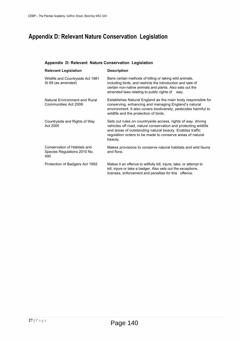
CEMP – The Premier Academy, Saffron Street, Bletchley MK2 3AH
27 | P a g e
Appendix D: Relevant Nature Conservation Legislation
Appendix D: Relevant Nature Conservation Legislation
Relevant Legislation Description
Wildlife and Countryside Act 1981 SI 69 (as amended)
Bans certain methods of killing or taking wild animals, including birds, and restricts the introduction and sale of certain non-native animals and plants. Also sets out the amended laws relating to public rights of way.
Natural Environment and Rural Communities Act 2006
Establishes Natural England as the main body responsible for conserving, enhancing and managing England’s natural environment. It also covers biodiversity, pesticides harmful to wildlife and the protection of birds.
Countryside and Rights of WayAct 2000
Sets out rules on countryside access, rights of way, driving vehicles off road, nature conservation and protecting wildlife and areas of outstanding natural beauty. Enables traffic regulation orders to be made to conserve areas of natural beauty.
Conservation of Habitats and Species Regulations 2010 No. 490
Makes provisions to conserve natural habitats and wild fauna and flora.
Protection of Badgers Act 1992 Makes it an offence to willfully kill, injure, take, or attempt to kill, injure or take a badger. Also sets out the exceptions, licenses, enforcement and penalties for this offence.
Page 140

CEMP – The Premier Academy, Saffron Street, Bletchley MK2 3AH
28 | P a g e
Appendix E: Complaints' Policy
Page 141

CEMP – The Premier Academy, Saffron Street, Bletchley MK2 3AH
29 | P a g e
The Premier Academy Saffron Street
Bletchley MK2 3AH
Complaints’ Policy2020
Page 142

CEMP – The Premier Academy, Saffron Street, Bletchley MK2 3AH
30 | P a g e
Complaints’ Policy
The Premier Academy is committed to delivering a well-managed project and promoting excellent neighbour relations. We have introduced a complaints procedure which is set out in this document.
The Premier Academy’s promise to you
We are committed to promoting transparency within our projects and we ensure we always have an open-door policy to our neighbours and staff .
The Premier Academy will ensure that complaints / communications are dealt with:
• Quickly, effectively and efficiently
• Without discrimination
• In a courteous helpful and respectfulmanner.
The Premier Academy will always:
• Keep you appraised of progress
• Ensure that staff take responsibility for resolving or dealing with your queryadequately.
• Provide as much information as possible to help you make informedchoices.
• Ensure our projects are managed with high standards of health andsafety.
• Be responsive to the needs of our neighbours andstaff.
• Act in accordance with the law.
The Premier Academy would like you to:
• Provide us with the information we require to assist you.
• Treat all our staff fairly and withrespect.
• Provide your feedback to help us to improve our services.
Page 143

CEMP – The Premier Academy, Saffron Street, Bletchley MK2 3AH
31 | P a g e
The Premier Academy’s customer care standards
Face to face contact
The Premier Academy will:
• Respect your privacy, offering complete confidentiality at all times.• Listen to you and respond to your needs.• Be welcoming, courteous and helpful at all times.
Contact by telephone
The Premier Academy will:
• Aim to answer the telephone as soon as possible during normal working hours (8am – 6pm, Monday to Friday).
• Attempt to resolve your query at the first point of contact. If this is not possible, we will refer your query to someone who can help and ensure that you have the name of the staff member dealing with the query.
Contact in writing
The Premier Academy will:
• Aim to respond to standard written enquiries within five working days (one week) of receipt, resolving the issues raised if possible. If the issue is more complicated and likely to take longer to resolve, we will provide you with an approximate timescale in which you can expect a response fromus.
• Ensure that within the response provided customers are given a named contact of the staff member dealing with the issue
Contact by email
The Premier Academy will:
• Aim to respond to emails sent to the general The Premier Academy email address [email protected] within 24 hours, except at weekends or during bank holidays. All emails should at least receive an acknowledgement within one working day stating when a full reply will be made if it is not possible to deal with the inquiry immediately.
• Aim to provide a full response to email inquiries within five working days of receipt, resolving the issues raised if possible.
• Ensure that within the response provided customers are given a named contact of the staff member dealing with the issue.
The Premier Academy is careful not to make assumptions about people’s needs or abilities but will consult you to identify individual needs. The Premier Academy will make every attempt to supply information in an appropriate format and we will make sure that disabled people and people whose first language is not English have access to interpreting, translation and communication support.
We value feedback as this helps us with making continuous improvements.3
Page 144

CEMP – The Premier Academy, Saffron Street, Bletchley MK2 3AH
32 | P a g e
The Premier Academy Complaint Form
The form allows you to make a comment or complaint regarding our site. Information which is put on the site feedback form is linked to the internal incident database and will raise an email alert to the relevant site manager. If that manager is not available, our Project Manager will deal with the enquiry/complaint within the allocated time scales.
Complaints
The Premier Academy is for most complaints to be dealt with informally to the satisfaction of the complainant however, if this is not possible this procedure sets out how a complaint will be investigated.
What is a complaint?
A complaint is an expression of dissatisfaction about a The Premier Academy activity. The Premier Academy will also answer queries from members of the public directly, if so wished.
How does the complaints procedure work?
Stage 1
You can make a complaint in a variety of ways;
• Call directly into our Site Office and request to see the SiteManager
• Telephone – 01908 683802
• Letter or email – [email protected] or write to the Community Liaison Officer at:
The Premier Academy, Saffron Street, Mossmans Close, Bletchley, Milton Keynes, MK2 3AH
• Through an advocate
All complaints will be acknowledged in writing within 5 working days, however, some level of response will be made within 2 working days. On receipt of a complaint, the person assigned to investigate it will contact the complainant to clarify the issues raised and make an appointment to meet them if required. Details of all contact and discussions with the complainant will be fully recorded.
The complainant will be given a copy of this procedure and advised of what will happen next and within what timescales.
Stage 2
If you are not satisfied with how your initial complaint has been handled The Premier Academy will adopt a formal procedure to investigate it further. The Premier Academy will record your complaint in writing by asking you to fill in a form (Complaint Form) giving full details of your grievances and acknowledge we have received this within 5 working days. The complaint will be investigated by the Project Director who will investigate the complaint in accordance with agreed standards. We will writeto you within 25 days with a full reply, or, if a more detailed investigation is needed, a progress report.
Page 145

CEMP – The Premier Academy, Saffron Street, Bletchley MK2 3AH
33 | P a g e
Stage 3
If you are still unhappy with the action, we have taken your complaint can be referred to the Chief Executive Officer, who will examine it thoroughly and review the actions taken to date.
The Chief Executive Officer will reply to you in writing explaining either what further action is being taken or that no further action is appropriate. You will receive a reply within 25 days or, if this is not possible, an estimate of how long it will take to completethe review.
CONTACT US:
Call Us: 01908 683802 (Jake Farquharson)
Email Us: [email protected] We endeavour to respond to all emails within 24 hours.
Throughout this process you will be kept informed of progress and given guidance on when you can expect a response or a further progress report.
5
Page 146
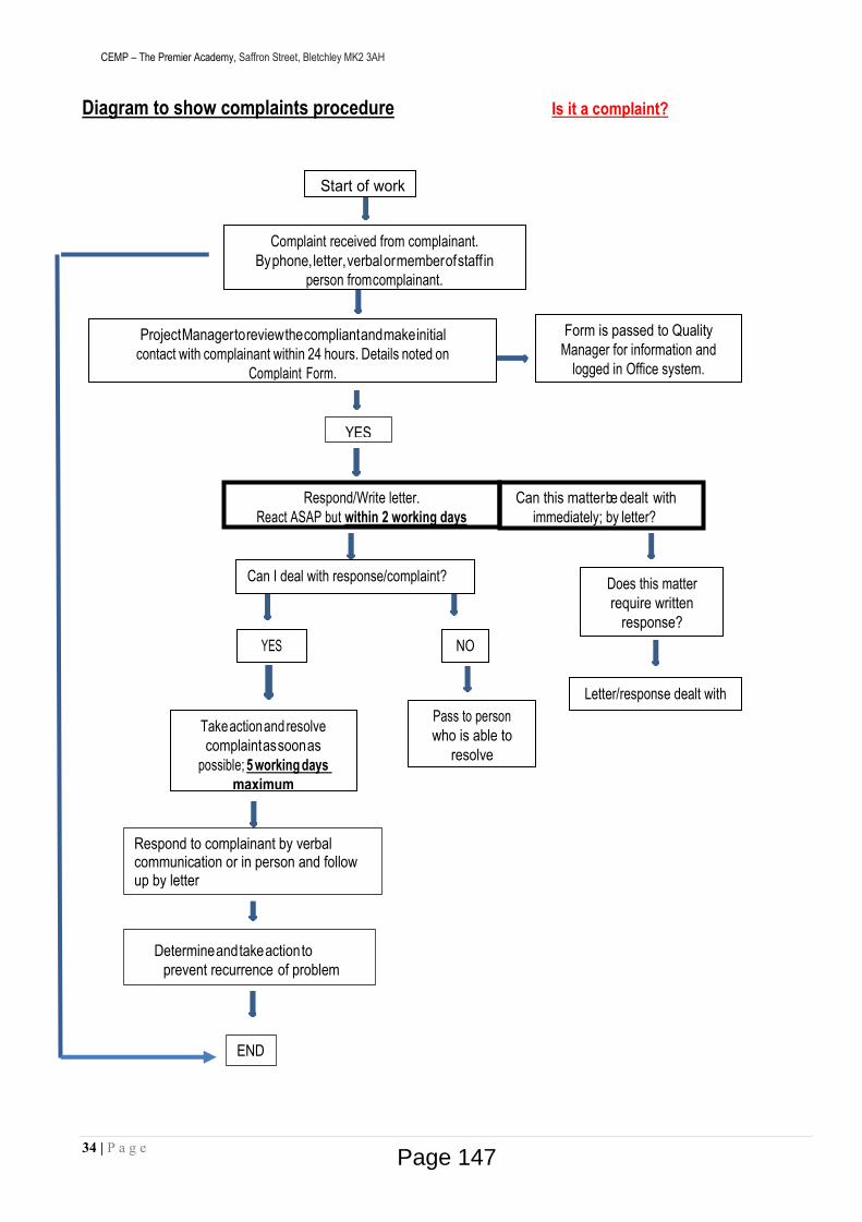
CEMP – The Premier Academy, Saffron Street, Bletchley MK2 3AH
34 | P a g e
Diagram to show complaints procedure Is it a complaint?
Letter/response dealt with
Does this matter require written
response?
Respond/Write letter.React ASAP but within 2 working days
Can this matterbe dealt with immediately; by letter?
Complaint received from complainant.Byphone,letter,verbalormemberofstaff in
person fromcomplainant.
Form is passed to Quality Manager for information and
logged in Office system.
ProjectManagertoreviewthecompliantandmakeinitial contact with complainant within 24 hours. Details noted on
Complaint Form.
Can I deal with response/complaint?
YES NO
Takeactionandresolve complaintassoonas
possible; 5 working days maximum
Pass to person who is able to
resolve
Start of work
YES
Respond to complainant by verbal communication or in person and follow up by letter
END
Determineandtakeactiontoprevent recurrence of problem
Page 147
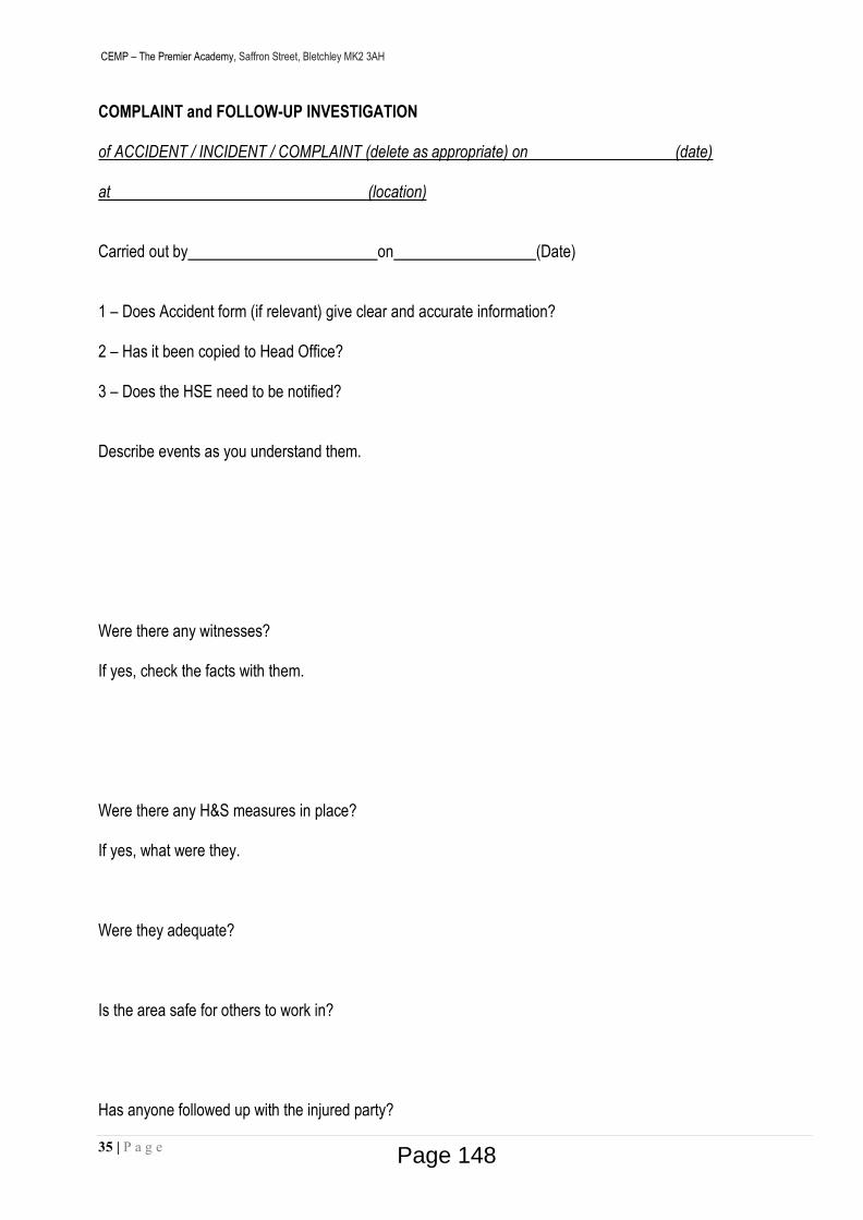
CEMP – The Premier Academy, Saffron Street, Bletchley MK2 3AH
35 | P a g e
COMPLAINT and FOLLOW-UP INVESTIGATION
of ACCIDENT / INCIDENT / COMPLAINT (delete as appropriate) on (date)
at (location)
Carried out by on (Date)
1 – Does Accident form (if relevant) give clear and accurate information?
2 – Has it been copied to Head Office?
3 – Does the HSE need to be notified?
Describe events as you understand them.
Were there any witnesses?
If yes, check the facts with them.
Were there any H&S measures in place?
If yes, what were they.
Were they adequate?
Is the area safe for others to work in?
Has anyone followed up with the injured party?
Page 148

CEMP – The Premier Academy, Saffron Street, Bletchley MK2 3AH
36 | P a g e
If a complaint has been made – state the nature of this complaint, the complainant’s details (Name, Address, Tel No. and email) and date and time complaint received.
What response was given and when?
Who has this been referred on to?
Action taken to resolve complaint (including date and time of action taken)
If Complaint unresolved give reason
Page 149
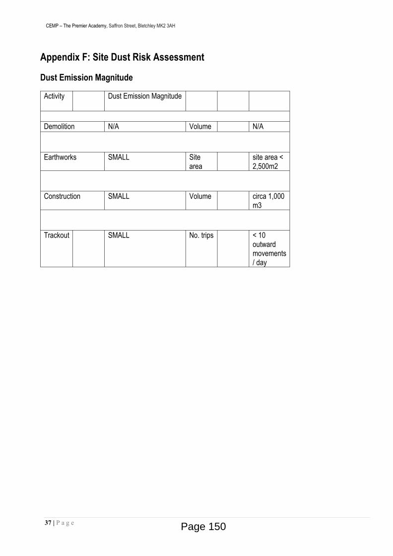
CEMP – The Premier Academy, Saffron Street, Bletchley MK2 3AH
37 | P a g e
Appendix F: Site Dust Risk Assessment
Dust Emission Magnitude
Activity Dust Emission Magnitude
Demolition N/A Volume N/A
Earthworks SMALL Site area
site area < 2,500m2
Construction SMALL Volume circa 1,000 m3
Trackout SMALL No. trips < 10 outward movements / day
Page 150

CEMP – The Premier Academy, Saffron Street, Bletchley MK2 3AH
38 | P a g e
Dust Soiling
DemolitionReceptor Sensitivity
Number of Receptors Distance from source (m)
<20 <50 <100 <350NOT APPLICABLE
EarthworksReceptor Sensitivity
Number of Receptors Distance from source (m)
<20 <50 <100 <350High >100 Low
10-100 Low1 to 10 Medium
Medium >1 MediumLow >1 Low
ConstructionReceptor Sensitivity
Number of Receptors Distance from source (m)
<20 <50 <100 <350High >100 Low
10-100 Low1 to 10 Medium
Medium >1 MediumLow >1 Low
TrackoutReceptor Sensitivity
Number of Receptors Distance from source (m)
<20 <50 <100 <350High >100
10-100 Low1 to 10 Medium
Medium >1 MediumLow >1 Low
Page 151

CEMP – The Premier Academy, Saffron Street, Bletchley MK2 3AH
39 | P a g e
Human Health
Receptor Sensitivity
Annual Mean PM Concentration
No. of Receptors Distance from source
<20 <50 <100 <200 <350Demolition – Not Applicable
EarthworksHigh 24 - 28 >100 High Medium
24 - 28 10-100 High24 - 28 1-10 High
Medium 24 - 28 >100 Low24 - 28 10-100 Low24 - 28 1-10 None
Low 24 - 28 NoneConstruction
High 24 - 28 >100 Medium24 - 28 10-100 Medium24 - 28 1-10 High
Medium 24 - 28 >100 Low24 - 28 10-100 Low24 - 28 1-10 None
Low 24 - 28 NoneTrackout
High 24 - 28 1 to 10 MediumMedium 24 - 28 1 to 10 LowLow 24 - 28 1 to 10 None
ECOSystems Impact
Receptor Sensitivity Distance from source
<20 <50Demolition
Not ApplicableEarthworks
HighMediumLow Low Low
ConstructionHighMediumLow Low LowTrackoutHighMediumLow Low Low
Page 152
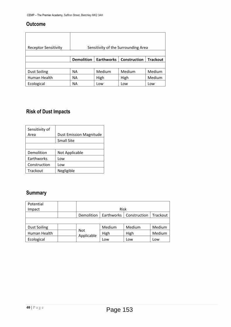
CEMP – The Premier Academy, Saffron Street, Bletchley MK2 3AH
40 | P a g e
Outcome
Receptor Sensitivity Sensitivity of the Surrounding Area
Demolition Earthworks Construction Trackout
Dust Soiling NA Medium Medium MediumHuman Health NA High High MediumEcological NA Low Low Low
Risk of Dust Impacts
Sensitivity of Area Dust Emission Magnitude
Small Site
Demolition Not ApplicableEarthworks LowConstruction LowTrackout Negligible
Summary
Potential Impact Risk
Demolition Earthworks Construction Trackout
Dust SoilingNot Applicable
Medium Medium MediumHuman Health High High MediumEcological Low Low Low
Page 153

CEMP – The Premier Academy, Saffron Street, Bletchley MK2 3AH
41 | P a g e
Appendix G: Programme of Works
Page 154
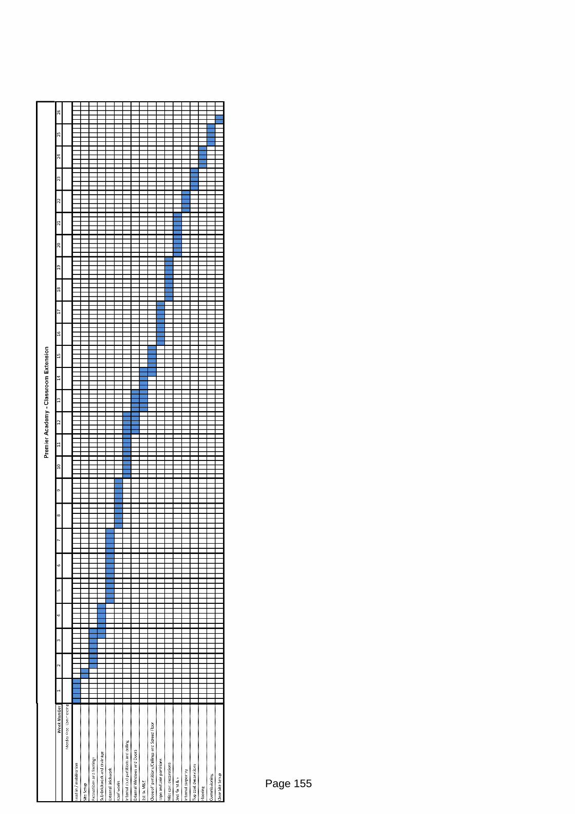
Page 155

This page is intentionally left blank
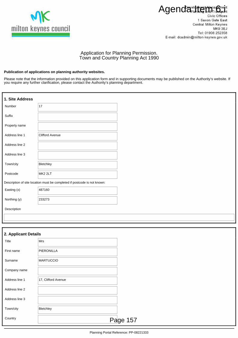
Application for Planning Permission.Town and Country Planning Act 1990
Publication of applications on planning authority websites.
Please note that the information provided on this application form and in supporting documents may be published on the Authority’s website. Ifyou require any further clarification, please contact the Authority’s planning department.
1. Site Address
Number 17
Suffix
Property name
Address line 1 Clifford Avenue
Address line 2
Address line 3
Town/city Bletchley
Postcode MK2 2LT
Description of site location must be completed if postcode is not known:
Easting (x) 487160
Northing (y) 233273
Description
2. Applicant Details
Title Mrs
First name PIERONILLA
Surname MARTUCCIO
Company name
Address line 1 17, Clifford Avenue
Address line 2
Address line 3
Town/city Bletchley
Country
Planning Portal Reference: PP-08221333
Page 157
Agenda Item 6.i

2. Applicant Details
Postcode MK2 2LT
Primary number
Secondary number
Fax number
Email address
Are you an agent acting on behalf of the applicant? Yes No
3. Agent Details
Title Mr
First name Antony
Surname Thompson
Company name Antony Thompson Arch Services
Address line 1 48 St James Close
Address line 2 Hanslope
Address line 3
Town/city Milton Keynes
Country United Kingdom
Postcode MK19 7LF
Primary number
Secondary number
Fax number
4. Site Area
What is the measurement of the site area?(numeric characters only).
383
Unit sq.metres
5. Description of the Proposal
Please describe details of the proposed development or works including any change of use.
If you are applying for Technical Details Consent on a site that has been granted Permission In Principle, please include the relevant details in the descriptionbelow.
PROPOSED NEW CHALET BUNGALOW IN REAR GARDEN PLUS PARKING FOR NEW AND EXISTING DWELLING.
Has the work or change of use already started? Yes No
Planning Portal Reference: PP-08221333
Page 158

6. Existing Use
Please describe the current use of the site
HOUSE AND GARDEN
Is the site currently vacant? Yes No
Does the proposal involve any of the following? If Yes, you will need to submit an appropriate contamination assessment with your application.
Land which is known to be contaminated Yes No
Land where contamination is suspected for all or part of the site Yes No
A proposed use that would be particularly vulnerable to the presence of contamination Yes No
7. Materials
Does the proposed development require any materials to be used? Yes No
Please provide a description of existing and proposed materials and finishes to be used (including type, colour and name for each material):
Walls
Description of existing materials and finishes (optional): N/A
Description of proposed materials and finishes: FACING BRICK TO MATCH EXISTING
TIMBER CLADDING
Roof
Description of existing materials and finishes (optional): N/A
Description of proposed materials and finishes: ROOF TILES TO MATCH AREA
Windows
Description of existing materials and finishes (optional): N/A
Description of proposed materials and finishes: WHITE UPVC/ALUMINIUM
Doors
Description of existing materials and finishes (optional): N/A
Description of proposed materials and finishes: WHITE UPVC/ALUMINIUM
Boundary treatments (e.g. fences, walls)
Description of existing materials and finishes (optional): N/A
Description of proposed materials and finishes: 1800MM TIMBER FENCING
Vehicle access and hard standing
Description of existing materials and finishes (optional): N/A
Description of proposed materials and finishes: PERMEABLE PAVING FOR DRIVE
Planning Portal Reference: PP-08221333
Page 159
7. Materials
Are you supplying additional information on submitted plans, drawings or a design and access statement? Yes No
If Yes, please state references for the plans, drawings and/or design and access statement
495/010 REV A
8. Pedestrian and Vehicle Access, Roads and Rights of Way
Is a new or altered vehicular access proposed to or from the public highway? Yes No
Is a new or altered pedestrian access proposed to or from the public highway? Yes No
Are there any new public roads to be provided within the site? Yes No
Are there any new public rights of way to be provided within or adjacent to the site? Yes No
Do the proposals require any diversions/extinguishments and/or creation of rights of way? Yes No
9. Vehicle Parking
Is vehicle parking relevant to this proposal? Yes No
Please provide information on the existing and proposed number of on-site parking spaces
Type of vehicle Existing number of spaces Total proposed (including
spaces retained)
Difference in spaces
Cars 2 4 2
10. Trees and Hedges
Are there trees or hedges on the proposed development site? Yes No
And/or: Are there trees or hedges on land adjacent to the proposed development site that could influence thedevelopment or might be important as part of the local landscape character?
Yes No
If Yes to either or both of the above, you may need to provide a full tree survey, at the discretion of your local planning authority. If a tree survey isrequired, this and the accompanying plan should be submitted alongside your application. Your local planning authority should make clear on itswebsite what the survey should contain, in accordance with the current 'BS5837: Trees in relation to design, demolition and construction -Recommendations'.
11. Assessment of Flood Risk
Is the site within an area at risk of flooding? (Refer to the Environment Agency's Flood Map showing flood zones 2 and 3and consult Environment Agency standing advice and your local planning authority requirements for information asnecessary.)
Yes No
If Yes, you will need to submit a Flood Risk Assessment to consider the risk to the proposed site.
Is your proposal within 20 metres of a watercourse (e.g. river, stream or beck)? Yes No
Will the proposal increase the flood risk elsewhere? Yes No
How will surface water be disposed of?
Sustainable drainage system
Existing water course
Soakaway
Main sewer
Planning Portal Reference: PP-08221333
Page 160

11. Assessment of Flood Risk
Pond/lake
12. Biodiversity and Geological Conservation
Is there a reasonable likelihood of the following being affected adversely or conserved and enhanced within the application site, or on land adjacent toor near the application site?
To assist in answering this question correctly, please refer to the help text which provides guidance on determining if any important biodiversity orgeological conservation features may be present or nearby; and whether they are likely to be affected by the proposals.
a) Protected and priority species:
Yes, on the development site
Yes, on land adjacent to or near the proposed development
No
b) Designated sites, important habitats or other biodiversity features:
Yes, on the development site
Yes, on land adjacent to or near the proposed development
No
c) Features of geological conservation importance:
Yes, on the development site
Yes, on land adjacent to or near the proposed development
No
13. Foul Sewage
Please state how foul sewage is to be disposed of:
Mains Sewer
Septic Tank
Package Treatment plant
Cess Pit
Other
Unknown
Are you proposing to connect to the existing drainage system? Yes No Unknown
If Yes, please include the details of the existing system on the application drawings. Please state the plan(s)/drawing(s) references.
FRONT OF DRIVE TO EXISTING HOUSE
14. Waste Storage and Collection
Do the plans incorporate areas to store and aid the collection of waste? Yes No
If Yes, please provide details:
BLACK REFUSE TO SIDE OF HOUSE
Have arrangements been made for the separate storage and collection of recyclable waste? Yes No
If Yes, please provide details:
RECYCLING REFUSE TO SIDE OF HOUSE
15. Trade Effluent
Does the proposal involve the need to dispose of trade effluents or trade waste? Yes No
Planning Portal Reference: PP-08221333
Page 161
16. Residential/Dwelling Units
Due to changes in the information requirements for this question that are not currently available on the system, if you need to supply details ofResidential/Dwelling Units for your application please follow these steps:
1. Answer 'No' to the question below;2. Download and complete this supplementary information template (PDF);3. Upload it as a supporting document on this application, using the 'Supplementary information template' document type.
This will provide the local authority with the required information to validate and determine your application.
Does your proposal include the gain, loss or change of use of residential units? Yes No
Please select the proposed housing categories that are relevant to your proposal.
Market
Social
Intermediate
Key Worker
Add 'Market' residential units
Market: Proposed Housing
Number of bedrooms
1 2 3 4+ Unknown Total
Houses 0 1 0 0 0 1
Total 0 1 0 0 0 1
Please select the existing housing categories that are relevant to your proposal.
Market
Social
Intermediate
Key Worker
Total proposed residential units 1
Total existing residential units 0
17. All Types of Development: Non-Residential Floorspace
Does your proposal involve the loss, gain or change of use of non-residential floorspace? Yes No
18. Employment
Will the proposed development require the employment of any staff? Yes No
19. Hours of Opening
Are Hours of Opening relevant to this proposal? Yes No
20. Industrial or Commercial Processes and Machinery
Please describe the activities and processes which would be carried out on the site and the end products including plant, ventilation or air conditioning. Pleaseinclude the type of machinery which may be installed on site:
N/A
Is the proposal for a waste management development? Yes No
If this is a landfill application you will need to provide further information before your application can be determined. Your waste planning authorityshould make it clear what information it requires on its website
Planning Portal Reference: PP-08221333
Page 162

21. Hazardous Substances
Does the proposal involve the use or storage of any hazardous substances? Yes No
22. Site Visit
Can the site be seen from a public road, public footpath, bridleway or other public land? Yes No
If the planning authority needs to make an appointment to carry out a site visit, whom should they contact?
The agent
The applicant
Other person
23. Pre-application Advice
Has assistance or prior advice been sought from the local authority about this application? Yes No
24. Authority Employee/Member
With respect to the Authority, is the applicant and/or agent one of the following:(a) a member of staff(b) an elected member(c) related to a member of staff(d) related to an elected member
It is an important principle of decision-making that the process is open and transparent.
For the purposes of this question, "related to" means related, by birth or otherwise, closely enough that a fair-minded andinformed observer, having considered the facts, would conclude that there was bias on the part of the decision-maker inthe Local Planning Authority.
Do any of the above statements apply?
Yes No
25. Ownership Certificates and Agricultural Land Declaration
CERTIFICATE OF OWNERSHIP - CERTIFICATE A - Town and Country Planning (Development Management Procedure) (England) Order 2015 Certificateunder Article 14
I certify/The applicant certifies that on the day 21 days before the date of this application nobody except myself/the applicant was the owner* of anypart of the land or building to which the application relates, and that none of the land to which the application relates is, or is part of, an agriculturalholding**
* 'owner' is a person with a freehold interest or leasehold interest with at least 7 years left to run. ** 'agricultural holding' has the meaning given byreference to the definition of 'agricultural tenant' in section 65(8) of the Act.
NOTE: You should sign Certificate B, C or D, as appropriate, if you are the sole owner of the land or building to which the application relates but theland is, or is part of, an agricultural holding.
Person role
The applicant
The agent
Title Mrs
First name PIERONILLA
Surname MARTUCCIO
Declaration date(DD/MM/YYYY)
13/10/2019
Declaration made
26. Declaration
I/we hereby apply for planning permission/consent as described in this form and the accompanying plans/drawings and additional information. I/we confirmthat, to the best of my/our knowledge, any facts stated are true and accurate and any opinions given are the genuine opinions of the person(s) giving them.
Planning Portal Reference: PP-08221333
Page 163

26. Declaration
Date (cannot be pre-application)
13/10/2019
Planning Portal Reference: PP-08221333
Page 164

73.2m
37
49
LB
WATER EATON ROAD
17
CLI
FFO
RD
AVE
NU
E
54
73.2m
37
59
49
71.9m
LB
WATER EATON ROAD59a
61
20
30
56
17
95
5058
CLI
FFO
RD
AVE
NU
E
54
73.2m
37LB
20
17
CLI
FFO
RD
AVE
NU
E
ANTONY THOMPSON
48, ST, JAMES CLOSE,
HANSLOPE,
MILTON KEYNES, MK19 7LF.
EMAIL:[email protected]
MOB: 07740099717
TITLE: PLANS AND ELEVATIONS A1
ARCHITECTURAL SERVICES
AS PROPOSED
GROUND FLOOR PLAN
FIRST FLOOR PLAN
FRONT ELEVATIONREAR ELEVATION
SIDE ELEVATION
SIDE ELEVATION
BLOCK PLAN 1/500
SITE LOCATION PLAN1/1250
KITCHEN
PORCH
BEDROOM
ENSUITE
LOUNGE
DINING
BATHROOM
BEDROOM
LANDING
ORANGERY
CLOAKS
Page 165
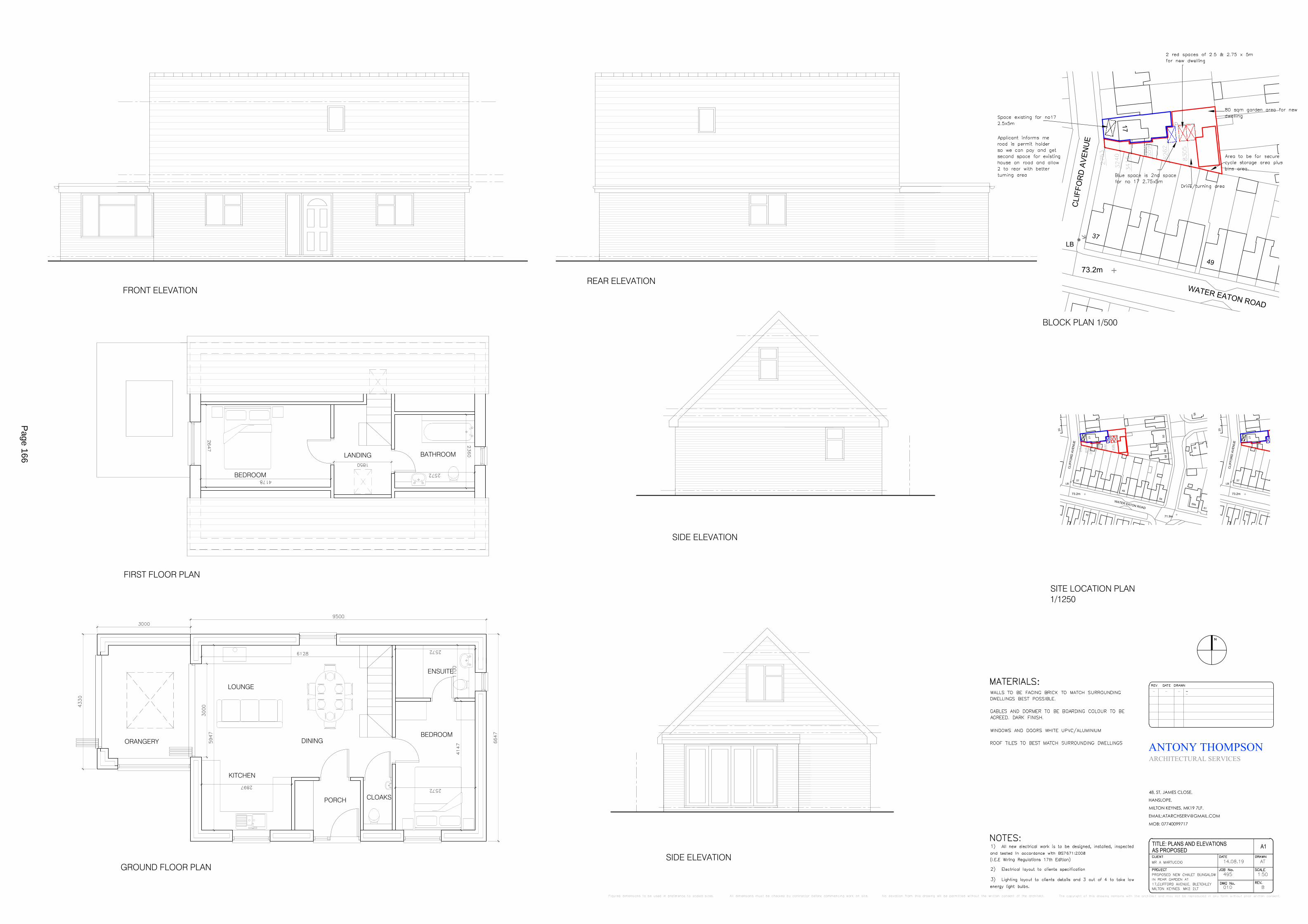
73.2m
37
49
LB
WATER EATON ROAD
17
CLI
FFO
RD
AVE
NU
E
54
73.2m
37
59
49
71.9m
LB
WATER EATON ROAD59a
61
20
30
56
17
95
5058
CLI
FFO
RD
AVE
NU
E
54
73.2m
37LB
20
17
CLI
FFO
RD
AVE
NU
E
ANTONY THOMPSON
48, ST, JAMES CLOSE,
HANSLOPE,
MILTON KEYNES, MK19 7LF.
EMAIL:[email protected]
MOB: 07740099717
TITLE: PLANS AND ELEVATIONS A1
ARCHITECTURAL SERVICES
AS PROPOSED
GROUND FLOOR PLAN
FIRST FLOOR PLAN
FRONT ELEVATIONREAR ELEVATION
SIDE ELEVATION
SIDE ELEVATION
BLOCK PLAN 1/500
SITE LOCATION PLAN1/1250
KITCHEN
PORCH
BEDROOM
ENSUITE
LOUNGE
DINING
BATHROOM
BEDROOM
LANDING
ORANGERY
CLOAKS
Page 166

DESIGN AND ACCESS STATEMENT FOR PROPOSED CHALET BUNGALOW IN REAR GARDEN OF;17 CLIFFORD AVENUE, BLETCHLEY MILTON KEYNESAppraising the Context.
1. The site is located on Clifford Avenue and in the rear garden of No 17 where they have good access to the side of the property to the rear.
2. The property has a large garden area and can be divided into garden for existing dwelling plus land for new dwelling and parking.
Development Objectives.
1. The family are looking to obtain permission for the new chalet bungalow in the rear garden for either family or mum when she can’t live in main house anymore. We have designed a chalet bungalow so not to cause to much of a visual obstruction for neighbours. We have checked distances to rear and side and they meet requirements to planning standards.
2. The building will be a 3 bed structure with 2 beds in roof area and dormer, with windows sited so to look over its own land only and to side or rear facing other buildings will be obscure glazed.
Page 167
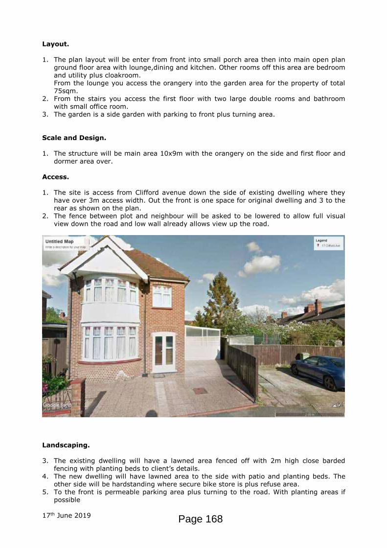
Layout.
1. The plan layout will be enter from front into small porch area then into main open plan ground floor area with lounge,dining and kitchen. Other rooms off this area are bedroom and utility plus cloakroom.From the lounge you access the orangery into the garden area for the property of total 75sqm.
2. From the stairs you access the first floor with two large double rooms and bathroomwith small office room.
3. The garden is a side garden with parking to front plus turning area.
Scale and Design.
1. The structure will be main area 10x9m with the orangery on the side and first floor and dormer area over.
Access.
1. The site is access from Clifford avenue down the side of existing dwelling where they have over 3m access width. Out the front is one space for original dwelling and 3 to the rear as shown on the plan.
2. The fence between plot and neighbour will be asked to be lowered to allow full visual view down the road and low wall already allows view up the road.
Landscaping.
3. The existing dwelling will have a lawned area fenced off with 2m high close barded fencing with planting beds to client’s details.
4. The new dwelling will have lawned area to the side with patio and planting beds. The other side will be hardstanding where secure bike store is plus refuse area.
5. To the front is permeable parking area plus turning to the road. With planting areas if possible
17th June 2019 Page 168

1
PublicAccessEDRMS
From: Caves, PhilSent: 18 November 2019 08:51To: 'Antony Thompson'Cc: Lycett, Catherine; Angelo MartuccioSubject: RE: [EXT] Re: 19/02658/FUL
Hi Antony,
Yes that looks fine.
Thanks,
Phil
From: Antony Thompson [mailto:[email protected]] Sent: 15 November 2019 14:49To: Caves, PhilCc: Lycett, Catherine; Angelo MartuccioSubject: [EXT] Re: 19/02658/FUL
PhilThe attached plan has the red line near the highway amended by angling it so we can achieve the 2.75m
or slightly more for the new dwelling pull on, it does not affect the existing house and entrance to main door or parking, if and when the family sell the existing property they would write up a shared access as no 17 needs the angle to allow the parking space to front and the new the drop kerb to access rear, there would be no fence division of the land to cause parking or entry issues.
I hope this helps and allows you to withdraw your objection.
Dimension indicated on the block plan.
Antony
On Fri, 15 Nov 2019 at 07:14, Caves, Phil <[email protected]> wrote:
Hi Anthony,
2.75m is minimum access width – so if this can be suitably provided in a red line then my objection can be removed.
Thanks,
Phil
Page 169
2
From: Antony Thompson [mailto:[email protected]] Sent: 14 November 2019 17:35To: Caves, PhilSubject: [EXT] 19/02658/FUL
Phil
Seeing your comments on the above the boundary lines can be adjusted to suit a red line of 2.75m width at access point if i submit new plans would this remove your objection.
--
Regards
Antony Thompson
Antony Thompson Architectural Services
48 St, James Close, Hanslope,
Milton Keynes. MK19 7LF.
TEL: 07740099717
Email: [email protected]
Web: www.at-as.co.uk
To help protect your privacy, …
Our EU General Data Protection Regulation (GDPR) pledge;Page 170

3
• We store your personal data securely.
• We won’t share your details with anyone else.
• We won’t contact you advertising our services.
• We will keep your details indefinitely until you ask us to remove them.
• You can ask us to remove your details from our system at any time.
• Any questions please ask.
Visit the Milton Keynes Council web site at https://www.milton-keynes.gov.uk
Any personal data will be processed in line with the Data Protection legislation, further details at https://www.milton-keynes.gov.uk/privacy
Please consider the environment and don't print this email unless you really need to
**** This email and any attachments hereto are strictly confidential and intended solely for the addressee. It may contain information which is privileged. If you are not the intended addressee, you must not disclose, forward, copy or take any action in reliance of this email or attachments. If you have received this email in error, please delete it and notify us as soon as possible.
The anti-virus software used by Milton Keynes Council is updated regularly in an effort to minimise the possibility of viruses infecting our systems. However, you should be aware that there is no absolute guarantee that any files attached to this email are virus free.****
--Regards
Antony Thompson
Antony Thompson Architectural Services48 St, James Close, Hanslope,Milton Keynes. MK19 7LF.
TEL: 07740099717
Email: [email protected]
Web: www.at-as.co.uk
To help protect your privacy, …
Our EU General Data Protection Regulation (GDPR) pledge;
• We store your personal data securely.Page 171

4
• We won’t share your details with anyone else.
• We won’t contact you advertising our services.
• We will keep your details indefinitely until you ask us to remove them.
• You can ask us to remove your details from our system at any time.
• Any questions please ask.
Page 172

1
PublicAccessEDRMS
From: Caves, PhilSent: 12 November 2019 08:26To: Lycett, CatherineCc: DC AdminSubject: 19/02658/FUL - 17 Clifford Avenue, BletchleyAttachments: 19 2658 FUL 12 11 19.docx
Comments attached
Phil CavesSenior Engineer – Highways Development Management01908 254458Milton Keynes Council l Environmental & Property l Highways l Synergy Park l Chesney Wold | Bleak Hall l Milton Keynes l MK6 [email protected]
Page 173
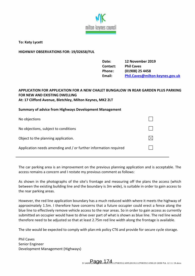
D:\Adlib\System\Work\20191112T083512.695\20191112T083513.056\19 2658 FUL 12 11 19.docx
To: Katy Lycett
HIGHWAY OBSERVATIONS FOR: 19/02658/FUL
Date: 12 November 2019Contact: Phil CavesPhone: (01908) 25 4458Email: [email protected]
APPLICATION FOR APPLICATION FOR A NEW CHALET BUNGALOW IN REAR GARDEN PLUS PARKING FOR NEW AND EXISTING DWELLINGAt: 17 Clifford Avenue, Bletchley, Milton Keynes, MK2 2LT
Summary of advice from Highways Development Management
No objections
No objections, subject to conditions
Object to the planning application.
Application needs amending and / or further information required
The car parking area is an improvement on the previous planning application and is acceptable. The access remains a concern and I restate my previous comment as follows:
As shown in the photographs of the site’s frontage and measuring off the plans the access (which between the existing building line and the boundary is 3m wide), is suitable in order to gain access to the rear parking areas.
However, the red line application boundary has a much reduced width where it meets the highway of approximately 1.5m. I therefore have concerns that a future occupier could erect a fence along the blue line to effectively remove vehicle access to the rear areas. So in order to gain access as currently submitted an occupier would have to drive over part of what is shown as blue line. The red line would therefore need to be adjusted so that at least 2.75m red line width along the frontage is available.
The site would be expected to comply with plan:mk policy CT6 and provide for secure cycle storage.
Phil CavesSenior EngineerDevelopment Management (Highways)
Page 174
\\MKC-EDMAPPP02\AdlibJobFiles\b394e1ec-e0e8-4531-8996-f5c02114becb\Input\f567bc69-abb6-4620-bac7-cf04193572f6.docx
To: Katy Lycett
HIGHWAY OBSERVATIONS FOR: 19/02658/FUL
Date: 12 November 2019Contact: Phil CavesPhone: (01908) 25 4458Email: [email protected]
APPLICATION FOR APPLICATION FOR A NEW CHALET BUNGALOW IN REAR GARDEN PLUS PARKING FOR NEW AND EXISTING DWELLINGAt: 17 Clifford Avenue, Bletchley, Milton Keynes, MK2 2LT
Summary of advice from Highways Development Management
No objections
No objections, subject to conditions
Object to the planning application.
Application needs amending and / or further information required
The car parking area is an improvement on the previous planning application and is acceptable. The access remains a concern and I restate my previous comment as follows:
As shown in the photographs of the site’s frontage and measuring off the plans the access (which between the existing building line and the boundary is 3m wide), is suitable in order to gain access to the rear parking areas.
However, the red line application boundary has a much reduced width where it meets the highway of approximately 1.5m. I therefore have concerns that a future occupier could erect a fence along the blue line to effectively remove vehicle access to the rear areas. So in order to gain access as currently submitted an occupier would have to drive over part of what is shown as blue line. The red line would therefore need to be adjusted so that at least 2.75m red line width along the frontage is available.
The site would be expected to comply with plan:mk policy CT6 and provide for secure cycle storage.
Phil CavesSenior EngineerDevelopment Management (Highways)
Page 175

1
PublicAccessEDRMS
From: [email protected]: 04 November 2019 10:42To: DC AdminSubject: Comments for Planning Application 19/02658/FUL
Planning Application comments have been made. A summary of the comments is provided below.
Comments were submitted at 10:41 AM on 04 Nov 2019 from Mr Paul Francis.
Application SummaryAddress: 17 Clifford Avenue Bletchley Milton Keynes MK2 2LT
Proposal: Erection of bungalow with parking for new and existing dwelling.
Case Officer: Katy Lycett
Click for further information
Customer DetailsName: Mr Paul Francis
Email:Address: 45 Water Eaton Road, Bletchley, Milton Keynes MK2 3DA
Comments DetailsCommenter Type: Neighbour
Stance: Customer objects to the Planning Application
Reasons for comment:Comments: We believe the proposed development does not respect
local context and street pattern, in particular the scale of the building would be entirely out of character for this area.The building will also cause overshadowing/loss of light and privacy.We already have a problem with rats and the planned bin area would be directly onto our gardens adding to the rat problem and unpleasant smells.We all take an interest in the wildlife that come through our gardens and we feel the proposed development does not protect or enhance the wildlife habitats, trees and gardens.
Page 176
1
PublicAccessEDRMS
From: [email protected]: 27 October 2019 11:19To: DC AdminSubject: Comments for Planning Application 19/02658/FUL
Planning Application comments have been made. A summary of the comments is provided below.
Comments were submitted at 11:19 AM on 27 Oct 2019 from Mr Donald Wallace.
Application SummaryAddress: 17 Clifford Avenue Bletchley Milton Keynes MK2 2LT
Proposal: Erection of bungalow with parking for new and exisitng dwelling.
Case Officer: Katy Lycett
Click for further information
Customer DetailsName: Mr Donald Wallace
Email:Address: 47 Water Eaton Road, Bletchley, Milton Keynes MK2 3DA
Comments DetailsCommenter Type: Neighbour
Stance: Customer objects to the Planning Application
Reasons for comment:Comments: - There is no scale bar on the drawings
- The plans have no context to the surrounding area, particularly in height with no scale bar it is very hard to judge the impact of the project- I believe the roof line of this development is out of scale to the surrounding properties, the mass of the proposed roof will be overbearing and overshadow to surrounding properties- Currently we are not directly overlooked by any property, this new application has a window directly overlooking the properties on Water Eaton Road. - There are mature trees in the surrounding area, these don't appear to have been included in the plan, this development is likely to have an adverse impact on these trees - The surrounding rear gardens are well established and an opportunity for local wildlife to thrive, potentially badgers, bats, foxes and birds, I would like to know how this development would impact this environment.- Bin storage area. We already have a rat problem I do not want another source of food for them at the end of our gardens.
Page 177

2
- The plan indicates that addition parking is available on the road outside with a permit parking scheme, this scheme is currently oversubscribed, parking in Clifford Avenue and the surrounding area is at a premium with cars parking on the kerbs and double yellow lines both day and night I believe this development would add the this existing problem.
In summary we strongly object to this proposal
Page 178

1
PublicAccessEDRMS
From: [email protected]: 30 October 2019 10:52To: DC AdminSubject: Comments for Planning Application 19/02658/FUL
Planning Application comments have been made. A summary of the comments is provided below.
Comments were submitted at 10:51 AM on 30 Oct 2019 from Mr Ian Woodham.
Application SummaryAddress: 17 Clifford Avenue Bletchley Milton Keynes MK2 2LT
Proposal: Erection of bungalow with parking for new and existing dwelling.
Case Officer: Katy Lycett
Click for further information
Customer DetailsName: Mr Ian Woodham
Email:Address: 48 Windsor Street, Bletchley, Milton Keynes MK2 2LN
Comments DetailsCommenter Type: Neighbour
Stance: Customer objects to the Planning Application
Reasons for comment:Comments: I wish to raise a number of concerns with this
application, which I have bulleted below for ease of reference:
1) Whilst plans for the development have been published on the Council's website planning portal, and these provide an overview of the development that is proposed, I note that not all measurements have been provided. In particular, and I consider these to be the two most critical measurements, no indication has been given as to the height of the proposed development or as to how close it will be situated to the boundary of the property. As such, I can only assume that the height will be in the region of 6 to 7 metres and will be built 1 metre from the boundary of the gardens in Windsor Street.
2) From the documents published on the Council's planning portal, I note that the development objective is not to cause too much of a visual obstruction for neighbours. However, a building of some 6 to 7 metres in height and 12.5 metres in width will create a
Page 179
2
significant visual obstruction. Currently the outlook from the rear of my property is one of greenery, consisting of lawn and flowers with a background of trees and shrubs. If the proposed development were to be approved, my outlook would be of lawn and flowers with a background of a large brick building. As you will appreciate, my existing view would be adversely impacted and thus the current amenity I enjoy of the surrounding neighbourhood would suffer detrimentally.
3) The current properties surrounding the proposed development in Windsor Street and Water Eaton Road consist of houses built in the early 1900's, (my house for example was built in 1914) and the houses in Clifford Avenue were built in the 1940's. As such, the proposed development is not in keeping with the current surrounding properties and consequently, is totally out of character. Furthermore, at present, the area is well proportioned in the number of properties already established here. Should this development go ahead, it will be too large for the space available and will simply 'overcrowd' the existing area. Consequently, the density of housing will be in excess of what I believe the average person would consider 'reasonable'.
4) Returning to the development objectives, the new property is intended for either the family or mum when she can't live in the main house anymore. However, the proposed new development is of a similar size to, or possibly bigger than, the current house so I struggle to understand where the benefit here will arise. If, as stated, this is the development objective, then an alternative solution would be to build a self-contained annex on the side of the current house which would address the issue of mum not being able to manage with the main house whilst also allowing the family and mum to live there independently of each other. I would not have any objections to such a development.
5) However, a far better alternative to a self-contained annex would be for the family to purchase an apartment in Bagshot Court. As the council will be aware, this is a complex of apartments for residents aged over 55. It is located in Clifford Avenue and as such, if mum was to reside there, she would still be in close proximity to her current neighbours and friends and of course, her family if they move into the current house. Bagshot Court was built specifically for situations like mum will be in and as such, this would be the most reasonable solution as it allows the development objectives to be fully met whilst also costing the family far less. More importantly, it would ensure that there is no impact on surrounding neighbours which in total amounts to 23 impacted properties/families (7 in Windsor Street, 3 in Clifford Avenue, 13 in Water Eaton Road).
6) Staying with the development objectives, bullet 2 states that "The building will be a 3 bed structure with 2 beds in roof area.....". Bullet 2 of the 'Layout' states "From the stairs you access the first floor with two large double bedrooms and bathroom with small office room".
Page 180

3
However, the plans show only 1 bedroom and a bathroom in the roof area. As such, this brings in to question the integrity of what is being proposed here and what will finally be built; will it be one bedroom upstairs or two and an office? I therefore have concerns as to what will eventually be built if the Council were to grant planning permission.
7) It is proposed that the windows to the side and rear, facing other buildings, will be obscure glazed. However, will the windows not need to open to meet fire regulations? I do not know the regulations here but it's my understanding that provision must be made to allow emergency escape via a window in habitable rooms. As such, regardless of the use of obscure glazing, the privacy I currently enjoy will be significantly diminished with the ability to open windows. Furthermore, even if obscure glazing is used, what is to prevent this being changed once the build is complete or possibly sometime in the future? There are many companies currently offering services to replace glass in UPVC windows so it would be very straight forward to change to clear glass and not at any great expense.
Continuing with this matter, it is stated that only windows facing other buildings will be obscure glazed. As such, this could mean that the upstairs window in the side elevation overlooking the new property's garden will be clear glazed. This would therefore give an unobscured view of my garden and into my kitchen window which currently, neither are overlooked. I would therefore lose all the privacy I currently enjoy in my garden and some privacy whilst in my kitchen.
Finally, as I mentioned above, I do not know the regulations but is there not a minimum distance between bedroom windows of adjacent properties? With the new bungalow being built within 1 metre from the boundary, there is a significant risk that this distance, assuming there is one, will not be met in regard to the houses in Windsor Street and Water Eaton Road and thus the building of this property will not be compliant with current building regulations.
In summary, I believe that this proposed development will significantly impact on the amenity myself and my neighbours currently enjoy. It will be over bearing on all of the properties (23) that surround it and will detrimentally impact on the privacy of the residents of those properties. The development is out of character with surrounding houses and will 'overcrowd' the existing area. For these reasons, I therefore consider the application should be rejected.
I trust the above points are helpful and will be taken into consideration when reviewing this planning application. However, I believe that to fully appreciate the significant negative impact this proposed development will have on the amenity of the neighbourhood, representatives of the planning committee should visit the area. I'm not sure whether this usually forms part of the process but I
Page 181

4
would be happy to facilitate a visit should your department wish to see how this development could potentially look and impact the local neighbourhood.
Page 182

Page 183
1
PublicAccessEDRMS
From: [email protected]: 24 October 2019 15:10To: DC AdminSubject: Comments for Planning Application 19/02658/FUL
Planning Application comments have been made. A summary of the comments is provided below.
Comments were submitted at 3:10 PM on 24 Oct 2019 from Mrs Lynn Wright.
Application SummaryAddress: 17 Clifford Avenue Bletchley Milton Keynes MK2 2LT
Proposal: Erection of bungalow with parking for new and exisitng dwelling.
Case Officer: Katy Lycett
Click for further information
Customer DetailsName: Mrs Lynn Wright
Email:Address: 51 Water Eaton Road, Bletchley, Milton Keynes MK2 3DA
Comments DetailsCommenter Type: Neighbour
Stance: Customer objects to the Planning Application
Reasons for comment:Comments: Again I would strongly object to this building taking
place, you may say it is a bungalow but it is being built on a two storey basis, this is overlooking our private garden and will prevent light , there is not enough parking in this area now, this is also a concern, the drainage and sewage is also an issue, the current drainage is not suffice for the properties now without adding to the pressure. The construction of the building will be intrusive and disruptive to this quiet neighbourhood, the look of the building is not in keeping with the surrounding area.
Page 184

Page 185
Page 186

Page 187

Application Number: 19/02658/FUL
Description: Erection of bungalow with parking for new and existing dwelling.
At: 17 Clifford Avenue, Bletchley, Milton Keynes, MK2 2LTFor: Mrs Pieronilla Martuccio
Target date: 10th December 2019Objector(s): 4
EXPIRY DATES28 Days Neighbour Advert Site Notice Consultee
12.11.2019 11.11.2019 13.11.2019
1.0 RECOMMENDATION
It is recommended that permission is refused.
2.0 INTRODUCTION
1.1 The Site
The application site is land to the rear of 17 Clifford Avenue in Bletchley. The local area is residential with mainly terraced and semi-detached dwellings. The application site has an existing detached dwelling on site with an existing vehicle crossover from Clifford Avenue. The host dwelling has a rear garden length of 22 meters and a maximum width of 21 metres along the shared boundary with properties to the rear. To the East of the application site is Windsor Street and to the South, Water Eaton Road.
1.2 The Proposal
The application seeks consent for a detached two bedroom detached bungalow to be located on Clifford Avenue in Bletchley. The proposed dwelling measures 6 metres in height with accomodation in the roofspace. Access is to be taken via the existing crossover and involves the demolition of the existing lean-to which currently is constructed over the existing driveway. Parking is to be provided on site for the new and existing dwelling.
The proposed bungalow is scheduled to be an independently accessed property entirely separate from number 17 Clifford Avenue.
3.0 RELEVANT POLICIES
3.1 National Policy
Page 188

National Planning Policy Framework 2019Section 2 Achieving Sustainable DevelopmentSection 4 Decision-MakingSection 5 Delivering a Sufficient Supply of HomesSection 12 Achieving Well-Designed Places
3.2 The Development Plan
Plan:MKPolicy DS2 Housing StrategyPolicy HN4 Amenity, Accessibility and Adaptability of HomesPolicy CT2 Movement and AccessPolicy CT10 Parking ProvisionPolicy D1 Designing a High Quality PlacePolicy D2 Creating a Positive CharacterPolicy D3 Design of BuildingsPolicy D5 Amenity and Street ScenePolicy SC1 Sustainable ConstructionPolicy FR2 SUDS and Flood Risk Management
Supplementary Planning DocumentsMilton Keynes Parking Standards 2016New Residential Development Design Guide 2012
3.3 Human Rights Act 1998
There may be implications under Article 8 and Article 1 of the First Protocol regarding the right of respect for a person's private and family life and home, and to the peaceful enjoyment of possessions. However, these potential issues are in this case amply covered by consideration of the environmental impact of the application under the policies of the development plan and other relevant policy guidance.
3.4 Equalities Act 2010
Due regard, where relevant, has been had to the Milton Keynes Council's equality duty as contained within the Equalities Act 2010.
4.0 RELEVANT PLANNING HISTORY
5.0 CONSULTATIONS AND REPRESENTATIONS
Highways Development Control2.75m is minimum access width - so if this can be suitably provided in a red line then my objection can be removed.
Page 189

Parish - Bletchley & Fenny StratfordNo comments received.
Ward - Bletchley East - Cllr GowansNo comments received.
Ward - Bletchley East- Cllr DarlingtonNo comments received.
Ward - Bletchley East - Cllr KhanNo comments received.
Ward - Bletchley Park - Cllr NazirNo comments received.
Ward - Bletchley Park - Cllr WalesNo comments received.
Ward - Bletchley Park - Cllr RankineNo comments received.
A total of six public representations were received from nearby occupiers raising the following issues/areas of concern:
- The proposed development does not respect local context and street pattern, in particular the scale of the building would be entirely out of character for this area.- The building will also cause overshadowing/loss of light and privacy by virtue of the scale. - The proposal would add to and existing rat problem and unpleasant smells.- The scale of the proposed dwelling is too large for ancillary accomodation for a family member. - The proposed development does not protect or enhance the wildlife habitats, trees and gardens.- The dwelling would affect the outlook of existing dwellings in the local area. - Impact upon parking in the local area.
6.0 MAIN ISSUES
Principle of DevelopmentDesign and LayoutImpact on Residential AmenityParking and Highways
7.0 CONSIDERATIONS
Page 190

Principle of Development
The application site sits within an existing residential area of Bletchley with no in-principle restrictions on development. However the significant issues are covered in later sections of this report relating to the specific details of the proposal.
Design and Layout
The proposed application has been designed to sit facing towards Clifford Avenue with parking to the front via the existing access. The design of the proposed bungalow has a relatively simple form and appearance in terms of detailing with accomodation in the roof space and associated rooflights. On this basis the physical appearance of the proposed bungalow does not raise any particular concerns in terms of the way it appears. However the issue of the siting and relationship with the local character is a more signficant concern.
Policy D3 of Plan: MK 2019 sets out criteria for the design of buildings which need to meet relevant objectives and principles. The proposed bungalow is to be located in the rear garden of number 17 Clifford Avenue and would be orientated at 90 degrees to other dwellings on Clifford Avenue. Policy D3 states that buildings should enhance the character of a particular area. On this basis, the bungalow would form a backland development which is at odds with the local pattern of development along this section of Clifford Avenue contrary to Policy D3. Furthermore, domestic scale outbuildings are present in rear gardens along Clifford Avenue and do not cause harm to the local street scene or pattern of development. The proposed bungalow, in the context of the site as a whole would create an overly large feature in the rear garden of the host dwelling whihc would not be of an appropriate scale and would be an incongrous feature in terms of the local pattern of development.
Policy D5 refers to amenity and street scene issues around new development. Amenity is addressed in the next section of this report however with regards to the street scene the proposed bungalow also raises concerns. The new dwelling and associated outdoor space would result in a cramped form of development which would be considered overbearing in this location - the proposed bungalow would create an incongrous feature to the detriment of the local character. Policy D1 also states that development proposals should respond appropriately to the site and surrounding context. The proposed bungalow does not comply with this by creating a dwelling with no continuity of street frontage nor locating the building to face the street or public space.
The scheme submitted has made no provision for any soft landscaping to be provided on site in accordance with Policy D1 of Plan: MK 2019. There are existing trees on site which will need to be removed in order to deliver this development. Furthermore no information has been provided to demonstrate compliance with Policy SC1 (Sustainable Construction). This would be required to evidence how the proposal would meet the relevant requirements in order to carry out construction in
Page 191
the most sustainable way. An option to secure this information via condition is possible where appropriate.
Policy FR2 of Plan: MK (SUDS and Flood Risk Management) highlights that the management of surface water should be planned at the largest appropriate scale for new development. New development is also required to incorporate SuDS to manage surface water and flood risk. No specific details have been provided however these could also be secured via condition where necessary.
Clifford Avenue, Water Eaton Road and Windsor Street are formed with traditional linear layouts and only small scale domestic outbuildings found in rear gardens. The introduction of a detached property to the rear of number 17 is considered to an unsympathetic proposal in the context of the local vernacular and layout of existing properties therefore contrary to Policy D3 and D5 of Plan: MK 2019.
Amenity
Policy D5 refers to amenity requirements for both existing and new properties. In this instance the amenity must be considered for; 1 - the new dwelling and occupiers, 2 - the occupiers of number 17 Clifford Avenue, 3 - the occupiers of nearby properties.
The site boundary of 17 Clifford Avenue is to be significantly reduced as part of this application resulting in a rear garden 7.3 x 9.7 metres. This revised layout provides a much more modest rear garden however is considered sufficient as dedicated outdoor amenity space. The proposed bungalow also has sufficient outdoor space for a private garden, cycle and bin storage area with approximately 80 square metres of garden being provided. The bungalow is not located directly to the rear of number 17 therefore loss of privacy is a lesser issue with regards to potential overlooking and visual intrusion.
To the rear of the proposed bungalow results in a back-to-back distance of 21.3 metres to the nearest dwelling along Windsor Street. This is concluded to be an acceptable relationship in accordance with the Milton Keynes Residential Design Guide 2012. Similarly, dwellings along Water Eaton Road will retain a distance of 18 from rear to flank - this is also acceptable.
Parking and Highway Matters
Initially submitted plans were amended to create a wider site access to reach the proposed dwelling. The bungalow provides x2 spaces on-plot for vehicles and x2 spaces on-plot for the existing dwelling. Policy CT2 sets out that on-site layouts are compatible for all potential users with appropriate parking and servicing provision in line with the Milton Keynes Parking Standards SPD 2016. The existing vehicle crossover is to be utilised by the existing and proposed dwelling. The Senior Highway Engineer has confirmed that the revised plans are acceptable and no objections have been raised.
Page 192
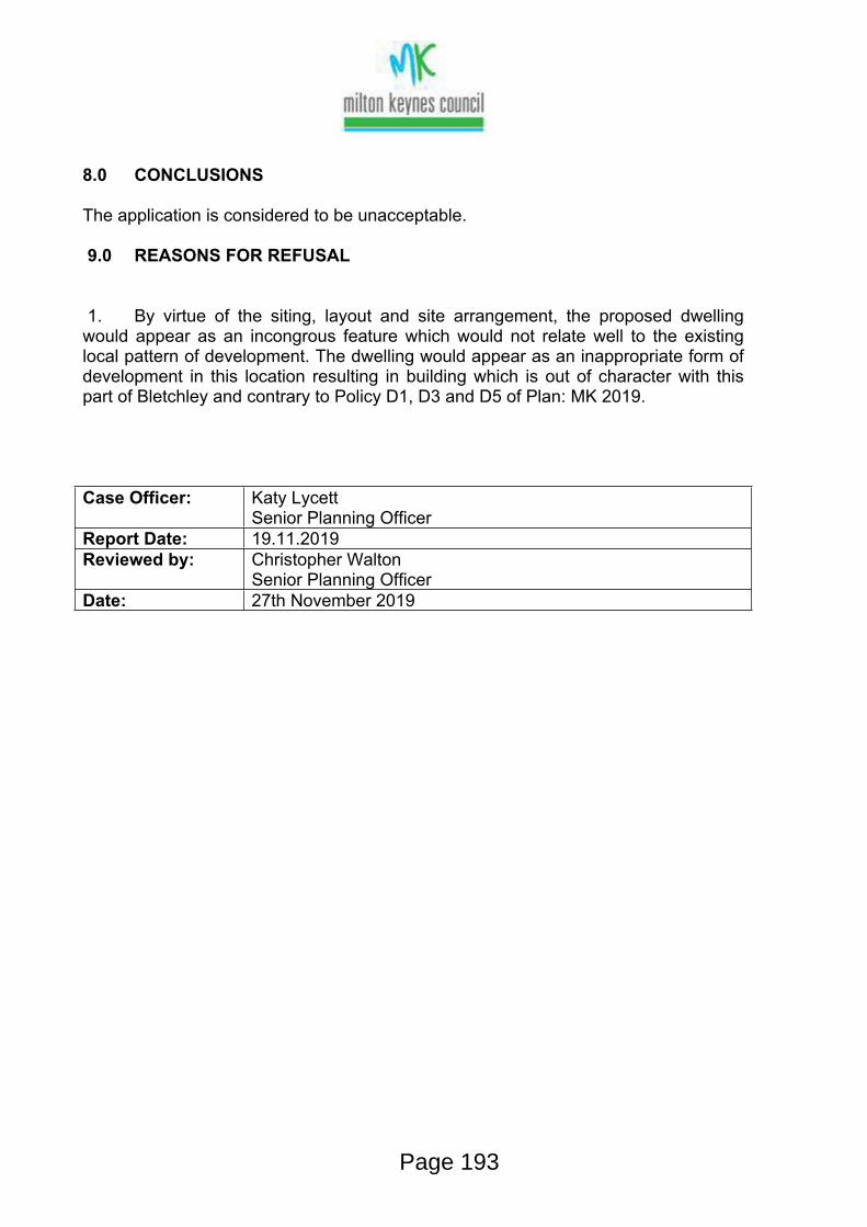
8.0 CONCLUSIONS
The application is considered to be unacceptable.
9.0 REASONS FOR REFUSAL
1. By virtue of the siting, layout and site arrangement, the proposed dwelling would appear as an incongrous feature which would not relate well to the existing local pattern of development. The dwelling would appear as an inappropriate form of development in this location resulting in building which is out of character with this part of Bletchley and contrary to Policy D1, D3 and D5 of Plan: MK 2019.
Case Officer: Katy LycettSenior Planning Officer
Report Date: 19.11.2019Reviewed by: Christopher Walton
Senior Planning OfficerDate: 27th November 2019
Page 193

TOWN AND COUNTRY PLANNING ACT 1990 (AS AMENDED)TOWN AND COUNTRY PLANNING (DEVELOPMENT MANAGEMENT PROCEDURE) (ENGLAND) ORDER 2015
Development Management,Civic Offices, 1 Saxon Gate East, Central Milton Keynes MK9 3EJ
Planning Enquiries Direct Line (01908) 252358 MK Council Tel: (01908) 691691
www.milton-keynes.gov.uk
FULL PLANNING PERMISSION REFUSED
Application no: 19/02658/FULTo: Antony Thompson Arch Services
Mr Antony Thompson48 St James CloseHanslopeMilton KeynesMK19 7LFUnited Kingdom
Applicant: Mrs Pieronilla Martuccio17, Clifford AvenueBletchleyMK2 2LT
Milton Keynes Council, under their powers provided by the above legislation, Refuse Permission for
Erection of bungalow with parking for new and existing dwelling.At: 17 Clifford Avenue Bletchley Milton Keynes MK2 2LT
in accordance with your application, valid on 15th October 2019 and the following drawings:
Received 14.10.2019
010 Plans and Elevations as Proposed
Received 18.11.2019
Revised Parking Layout 495_0100 Scheme 3 Rev B
The reason(s) for refusing your application are:
( 1) By virtue of the siting, layout and site arrangement, the proposed dwelling would appear as an incongrous feature which would not relate well to the existing local pattern of development. The dwelling would appear as an inappropriate form of development in this location resulting in building which is out of character with this part of Bletchley and contrary to Policy D1, D3 and D5 of Plan: MK 2019.
Page 194
TOWN AND COUNTRY PLANNING ACT 1990 (AS AMENDED)TOWN AND COUNTRY PLANNING (DEVELOPMENT MANAGEMENT PROCEDURE) (ENGLAND) ORDER 2015
Development Management,Civic Offices, 1 Saxon Gate East, Central Milton Keynes MK9 3EJ
Planning Enquiries Direct Line (01908) 252358 MK Council Tel: (01908) 691691
www.milton-keynes.gov.uk
Your attention is drawn to the attached notes
27th November 2019 Jon Palmer MRTPI – Head of PlanningFor and on behalf of the Council
Page 195

TOWN AND COUNTRY PLANNING ACT 1990 (AS AMENDED)TOWN AND COUNTRY PLANNING (DEVELOPMENT MANAGEMENT PROCEDURE) (ENGLAND) ORDER 2015
Development Management,Civic Offices, 1 Saxon Gate East, Central Milton Keynes MK9 3EJ
Planning Enquiries Direct Line (01908) 252358 MK Council Tel: (01908) 691691
www.milton-keynes.gov.uk
Appeals to the Secretary of StateIf you are aggrieved by the decision of your local planning authority to refuse permission for the proposed development or to grant it subject to conditions, them you can appeal to the Secretary of State for the Environment under Section 78 of the Town and Country Planning Act 1990 (as amended).
If you want to appeal, then you must do so within six months of the date of this notice. The Secretary of State can allow a longer period for giving notice of an appeal, but he will not normally be prepared to use this power unless there are special circumstances which excuse the delay in giving notice of appeal.
You can appeal using a form that you can get from The Planning Inspectorate, Temple Quay House, 2 The Square, Temple Quay, Bristol, BS1 6PN. Customer Support Unit, Tel: 0117 372 6372. Appeal forms and guidance can also be downloaded from the Planning Inspectorate’s website www.planning-inspectorate.gov.uk.
Alternatively, the Planning Inspectorate have introduced an online appeals service which you can use to make your appeal online. You can find the service through the Appeals area of the Planning Portal – https://www.planningportal.co.uk/info/200207/appeals. The Inspectorate will publish details of your appeal on the internet (on the Appeals area of the Planning Portal). This may include a copy of the original planning application form and relevant supporting documents supplied to the local planning authority by you or your agent, together with the completed appeal form and information you submit to the Planning Inspectorate. Please ensure that you only provide information, including personal information, that you are happy will be made available to others in this way. If you supply personal information belonging to a third party please ensure have their permission to do so. More detailed information about data protection and privacy matters is available on the Planning Portal.
The Secretary of State need not consider an appeal if it seems to him that the local planning authority could not have granted planning permission for the proposed development or could not have granted it without the conditions they imposed, having regard to the statutory requirements, to the provisions of any development order and to any directions given under a development order.
In practice, the Secretary of State does not refuse to consider appeals solely because the local planning authority based their decision on a direction given by him.
Purchase NoticesIf either the local planning authority or the Secretary of State for the Environment
Page 196
TOWN AND COUNTRY PLANNING ACT 1990 (AS AMENDED)TOWN AND COUNTRY PLANNING (DEVELOPMENT MANAGEMENT PROCEDURE) (ENGLAND) ORDER 2015
Development Management,Civic Offices, 1 Saxon Gate East, Central Milton Keynes MK9 3EJ
Planning Enquiries Direct Line (01908) 252358 MK Council Tel: (01908) 691691
www.milton-keynes.gov.uk
refuses permission to develop land or grants it subject to conditions, the owner may claim that they can neither put the land to a reasonably beneficial use in its existing state nor render the land capable of a reasonably beneficial use by carrying out of any development which has been or would be permitted.
In these circumstances, the owner may serve a purchase notice on the Council (District Council, London Borough Council, or Common Council of the City of London) in whose area the land is situated. This notice will require the Council to purchase their interest in the land in accordance with the provision of Part VI of the Town and Country Planning Act 1990.
Compensation In certain circumstances compensation may be claimed from the local planning authority if permission is refused or granted subject to conditions by the Secretary of State appeal or reference of the application to him.
These circumstances are set out in section 114 and related provisions of the Town and Country Planning Act 1990 (as amended).
Page 197

1
PublicAccessEDRMS
From: noreply (outbound only) <[email protected]>Sent: 04 March 2020 12:53To: DC AppealsSubject: [EXT] Confirmation of Questionnaire for APP/Y0435/W/20/3245763Attachments: QUESTIONNAIRE - 534021.pdf
Appeals Casework Portal
Your Planning appeal questionnaire has been received.
Appeal Details Questionnaire Receipt Date/Time: 04/03/2020 12:52Appeal Reference: APP/Y0435/W/20/3245763Appeal By: mrs Pieronilla MartuccioSite Address: 17 Clifford AvenueLocal Planning Authority: Milton Keynes Council
Attached is a copy of your form.
Important Information:
You must send a completed copy of the questionnaire form and supporting documents to the appellant/agent.
All further correspondence should be directed to the Case Officer dealing with the appeal. If forwarding supporting documents by email please send to Jade McNamara. Any correspondence you send to us should clearly state the appeal reference number to avoid any delays.
You can view cases online by logging on and looking at your 'Cases in Progress' or by using the 'Search for a case/Submit representation' facility.
Page 198
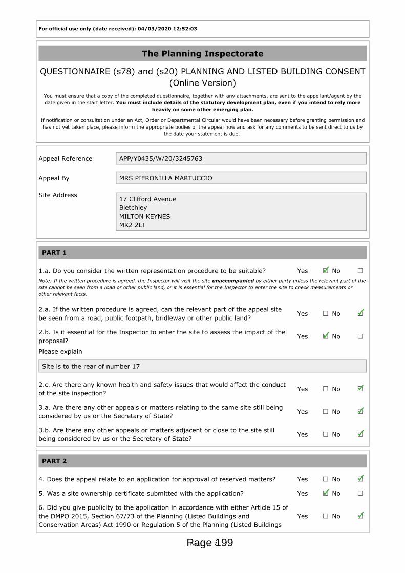
For official use only (date received): 04/03/2020 12:52:03
The Planning Inspectorate
QUESTIONNAIRE (s78) and (s20) PLANNING AND LISTED BUILDING CONSENT(Online Version)
You must ensure that a copy of the completed questionnaire, together with any attachments, are sent to the appellant/agent by thedate given in the start letter. You must include details of the statutory development plan, even if you intend to rely more
heavily on some other emerging plan.
If notification or consultation under an Act, Order or Departmental Circular would have been necessary before granting permission andhas not yet taken place, please inform the appropriate bodies of the appeal now and ask for any comments to be sent direct to us by
the date your statement is due.
Appeal Reference APP/Y0435/W/20/3245763
Appeal By MRS PIERONILLA MARTUCCIO
Site Address 17 Clifford AvenueBletchleyMILTON KEYNESMK2 2LT
PART 1
1.a. Do you consider the written representation procedure to be suitable? Yes NoNote: If the written procedure is agreed, the Inspector will visit the site unaccompanied by either party unless the relevant part of thesite cannot be seen from a road or other public land, or it is essential for the Inspector to enter the site to check measurements orother relevant facts.
2.a. If the written procedure is agreed, can the relevant part of the appeal sitebe seen from a road, public footpath, bridleway or other public land?
Yes No
2.b. Is it essential for the Inspector to enter the site to assess the impact of theproposal?
Yes No
Please explain
Site is to the rear of number 17
2.c. Are there any known health and safety issues that would affect the conductof the site inspection?
Yes No
3.a. Are there any other appeals or matters relating to the same site still beingconsidered by us or the Secretary of State?
Yes No
3.b. Are there any other appeals or matters adjacent or close to the site stillbeing considered by us or the Secretary of State?
Yes No
PART 2
4. Does the appeal relate to an application for approval of reserved matters? Yes No
5. Was a site ownership certificate submitted with the application? Yes No
6. Did you give publicity to the application in accordance with either Article 15 ofthe DMPO 2015, Section 67/73 of the Planning (Listed Buildings andConservation Areas) Act 1990 or Regulation 5 of the Planning (Listed Buildings
Yes No
Page 1 of 7Page 199
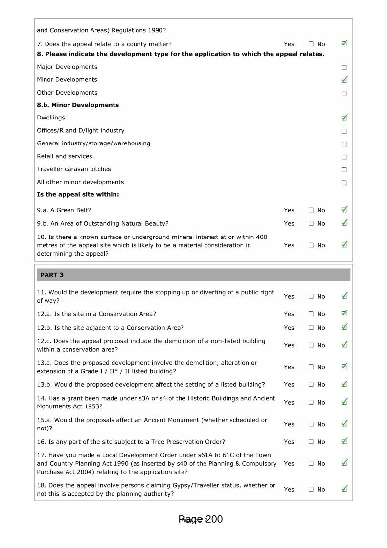
and Conservation Areas) Regulations 1990?
7. Does the appeal relate to a county matter? Yes No
8. Please indicate the development type for the application to which the appeal relates.
Major Developments
Minor Developments
Other Developments
8.b. Minor Developments
Dwellings
Offices/R and D/light industry
General industry/storage/warehousing
Retail and services
Traveller caravan pitches
All other minor developments
Is the appeal site within:
9.a. A Green Belt? Yes No
9.b. An Area of Outstanding Natural Beauty? Yes No
10. Is there a known surface or underground mineral interest at or within 400metres of the appeal site which is likely to be a material consideration indetermining the appeal?
Yes No
PART 3
11. Would the development require the stopping up or diverting of a public rightof way?
Yes No
12.a. Is the site in a Conservation Area? Yes No
12.b. Is the site adjacent to a Conservation Area? Yes No
12.c. Does the appeal proposal include the demolition of a non-listed buildingwithin a conservation area?
Yes No
13.a. Does the proposed development involve the demolition, alteration orextension of a Grade I / II* / II listed building?
Yes No
13.b. Would the proposed development affect the setting of a listed building? Yes No
14. Has a grant been made under s3A or s4 of the Historic Buildings and AncientMonuments Act 1953?
Yes No
15.a. Would the proposals affect an Ancient Monument (whether scheduled ornot)?
Yes No
16. Is any part of the site subject to a Tree Preservation Order? Yes No
17. Have you made a Local Development Order under s61A to 61C of the Townand Country Planning Act 1990 (as inserted by s40 of the Planning & CompulsoryPurchase Act 2004) relating to the application site?
Yes No
18. Does the appeal involve persons claiming Gypsy/Traveller status, whether ornot this is accepted by the planning authority?
Yes No
Page 2 of 7Page 200

19.a. Is the appeal site in or adjacent to or likely to affect an SSSI or aninternationally designated site (ie. cSAC, SAC, pSPA, SPA Ramsar)?
Yes No
19.b. Are any protected species likely to be affected by the proposals? Yes No
PART 4
Environmental Impact Assessment - Schedule 1
20.a.i. Is the proposed development Schedule 1 development as described inSchedule 1 of the Town and Country Planning (Environmental ImpactAssessment) Regulations 2011?
Yes No
Environmental Impact Assessment - Schedule 2
20.b.i. Is the proposed development Schedule 2 development as described inColumn 1, Schedule 2 of the Town and Country Planning (Environmental ImpactAssessment) Regulations 2011?
Yes No
20.c.i. Have you issued a screening opinion (SO) Yes No
Environmental Impact Assessment - Environmental Statement (ES)
20.d. Has the appellant supplied an environmental statement? Yes No
Environmental Impact Assessment - Publicity
20.e. If applicable, please attach a copy of the site notice and localadvertisement published as required for EIA development.
Applies N/A
21. Have all notifications or consultations under any Act, Order or DepartmentalCircular, necessary before granting permission, taken place?
Yes No
Please inform the appropriate bodies of the appeal now and ask for any comments to be sentto us by the date your statement is due.
PART 5
22. Do you wish to attach your statement of case? Yes No
For appeals dealt with by written representations only
23. If this appeal is not following the written representations expeditedprocedure, do you intend to send a statement of case about this appeal?
Yes No
If no, please supply where appropriate
23.a. a full list of the plans submitted with the application;
23.b. the relevant planning history;
23.c. what the decision notice would have said if it was a non-determination;
23.d. relevant development plan policies;
Copies of the following documents must, if appropriate, be attached to this questionnaire
Page 3 of 7Page 201
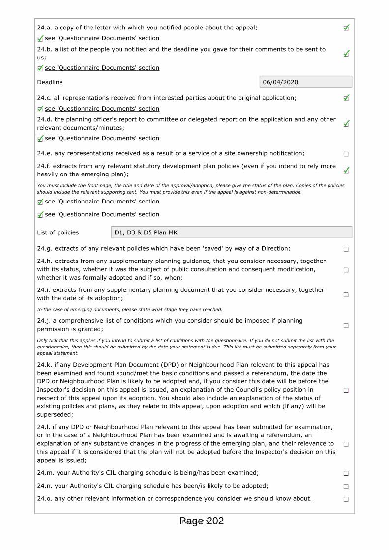
24.a. a copy of the letter with which you notified people about the appeal;
see 'Questionnaire Documents' section
24.b. a list of the people you notified and the deadline you gave for their comments to be sent tous;
see 'Questionnaire Documents' section
Deadline 06/04/2020
24.c. all representations received from interested parties about the original application;
see 'Questionnaire Documents' section
24.d. the planning officer's report to committee or delegated report on the application and any otherrelevant documents/minutes;
see 'Questionnaire Documents' section
24.e. any representations received as a result of a service of a site ownership notification;
24.f. extracts from any relevant statutory development plan policies (even if you intend to rely moreheavily on the emerging plan);
You must include the front page, the title and date of the approval/adoption, please give the status of the plan. Copies of the policiesshould include the relevant supporting text. You must provide this even if the appeal is against non-determination.
see 'Questionnaire Documents' section
see 'Questionnaire Documents' section
List of policies D1, D3 & D5 Plan MK
24.g. extracts of any relevant policies which have been 'saved' by way of a Direction;
24.h. extracts from any supplementary planning guidance, that you consider necessary, togetherwith its status, whether it was the subject of public consultation and consequent modification,whether it was formally adopted and if so, when;
24.i. extracts from any supplementary planning document that you consider necessary, togetherwith the date of its adoption;
In the case of emerging documents, please state what stage they have reached.
24.j. a comprehensive list of conditions which you consider should be imposed if planningpermission is granted;
Only tick that this applies if you intend to submit a list of conditions with the questionnaire. If you do not submit the list with thequestionnaire, then this should be submitted by the date your statement is due. This list must be submitted separately from yourappeal statement.
24.k. if any Development Plan Document (DPD) or Neighbourhood Plan relevant to this appeal hasbeen examined and found sound/met the basic conditions and passed a referendum, the date theDPD or Neighbourhood Plan is likely to be adopted and, if you consider this date will be before theInspector's decision on this appeal is issued, an explanation of the Council's policy position inrespect of this appeal upon its adoption. You should also include an explanation of the status ofexisting policies and plans, as they relate to this appeal, upon adoption and which (if any) will besuperseded;
24.l. if any DPD or Neighbourhood Plan relevant to this appeal has been submitted for examination,or in the case of a Neighbourhood Plan has been examined and is awaiting a referendum, anexplanation of any substantive changes in the progress of the emerging plan, and their relevance tothis appeal if it is considered that the plan will not be adopted before the Inspector's decision on thisappeal is issued;
24.m. your Authority's CIL charging schedule is being/has been examined;
24.n. your Authority's CIL charging schedule has been/is likely to be adopted;
24.o. any other relevant information or correspondence you consider we should know about.
Page 4 of 7Page 202
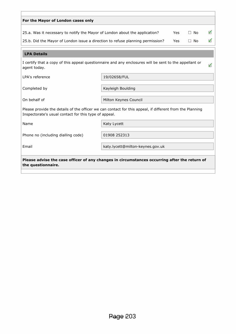
For the Mayor of London cases only
25.a. Was it necessary to notify the Mayor of London about the application? Yes No
25.b. Did the Mayor of London issue a direction to refuse planning permission? Yes No
LPA Details
I certify that a copy of this appeal questionnaire and any enclosures will be sent to the appellant oragent today.
LPA's reference 19/02658/FUL
Completed by Kayleigh Boulding
On behalf of Milton Keynes Council
Please provide the details of the officer we can contact for this appeal, if different from the PlanningInspectorate's usual contact for this type of appeal.
Name Katy Lycett
Phone no (including dialling code) 01908 252313
Email [email protected]
Please advise the case officer of any changes in circumstances occurring after the return ofthe questionnaire.
Page 5 of 7Page 203

QUESTIONNAIRE DOCUMENTS
Appeal Reference APP/Y0435/W/20/3245763
Appeal By MRS PIERONILLA MARTUCCIO
Site Address 17 Clifford AvenueBletchleyMILTON KEYNESMK2 2LT
The documents listed below were uploaded with this form:
Relates to Section: PART 5Document Description: 24.a. A copy of the letter with which you notified people about the appeal.File name: Appeal Neighbour Notification.pdf
Relates to Section: PART 5Document Description: 24.b. A document containing a list of the people you notified of the appeal.File name: Circulation list.pdf
Relates to Section: PART 5Document Description: 24.c. Copies of all representations received from interested parties about the
original application.File name: 00443650.pdfFile name: 00443175.pdfFile name: 00442865.pdfFile name: 00444050.pdfFile name: 00442670.pdfFile name: 00443996.pdfFile name: 00446133.pdfFile name: 00444867.pdfFile name: 00444875.pdf
Relates to Section: PART 5Document Description: 24.d. The planning officer's report to committee or delegated report on the
application and any other relevant documents/minutes.File name: Delegated Report.pdf
Relates to Section: PART 5Document Description: 24.f. Copies of extracts from any relevant statutory development plan
policies.File name: PlanMK Adoption Version (March 2019) Front page and index.pdf
Relates to Section: PART 5Document Description: 24.f. Copies of extracts from any relevant statutory development plan
policies.File name: Policy D1.pdfFile name: Policy D3.pdfFile name: Policy D5.pdf
Completed by Not Set
Date 04/03/2020 12:52:18
Page 6 of 7Page 204

LPA Milton Keynes Council
Page 7 of 7Page 205

1
PublicAccessEDRMS
From: noreply (outbound only) <[email protected]>Sent: 02 March 2020 12:48To: DC AppealsSubject: [EXT] Planning Inspectorate APP/Y0435/W/20/3245763: 17 Clifford Avenue, MK2
2LTAttachments: Start letter (AR13) - Development Management - 02 Mar 2020.pdf
Categories: Yellow Category
The Planning Inspectorate (England) Temple Quay House, 2 The Square, Temple Quay, Bristol, BS1 6PN
The Planning Inspectorate (Wales) Crown Buildings, Cathays Park, Cardiff, CF10 3NQ
http://www.planningportal.gov.uk/planninginspectorateTwitter: @PINSgov
This communication does not constitute legal advice. Please view our Information Charter before sending information to the Planning Inspectorate.
Page 206

Temple Quay House2 The SquareBristolBS1 6PN
Direct Line: 03034445273Customer Services:0303 444 5000
Email: [email protected]
www.gov.uk/planning-inspectorate
Your Ref: 19/02658/FULOur Ref: APP/Y0435/W/20/3245763
Development ManagementMilton Keynes CouncilCivic Offices1 Saxon Gate EastCentral Milton KeynesMK9 3EJ
02 March 2020
Dear Development Management,
Town and Country Planning Act 1990Appeal by mrs Pieronilla MartuccioSite Address: 17 Clifford Avenue, Bletchley, MILTON KEYNES, MK2 2LT
I have received appeal forms and documents for this site. I am the case officer. If you have any questions, please contact me. I have checked the papers and confirm that the appeal(s) is valid. If I later find out that this is not the case, I will write to you again.
The procedure and starting date
The appellant(s) has requested the Written representations procedure. In accordance with s319A of the Act we have applied the criteria and considered all representations received, including the appellant(s) preferred choice. We consider that the Written representations procedure is suitable and we intend to determine this appeal by this procedure.
The date of this letter is the starting date for the appeal(s). The timetable for the appeal(s) begins from this date.
Sending documents to us and looking at the appeal(s)
A timetable is set out below. No reminders will be sent, and any documents sent after the deadlines will normally be returned.
You can use the Internet to submit documents, to see information and to check the progress of cases through GOV.UK. The address of the search page is https://www.gov.uk/appeal-planning-inspectorate.
If emailing documents, please use the email address above. If posting documents (other than the Questionnaire) please send 2 copies of everything. Whichever method you use, please make sure that all documents/emails are clearly marked with the full reference number.
Page 207
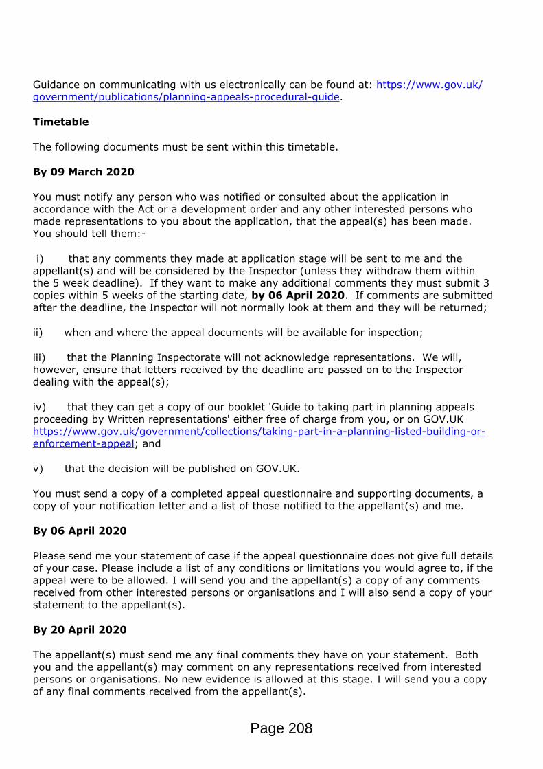
Guidance on communicating with us electronically can be found at: https://www.gov.uk/government/publications/planning-appeals-procedural-guide.
Timetable
The following documents must be sent within this timetable.
By 09 March 2020
You must notify any person who was notified or consulted about the application in accordance with the Act or a development order and any other interested persons who made representations to you about the application, that the appeal(s) has been made. You should tell them:-
i) that any comments they made at application stage will be sent to me and the appellant(s) and will be considered by the Inspector (unless they withdraw them within the 5 week deadline). If they want to make any additional comments they must submit 3 copies within 5 weeks of the starting date, by 06 April 2020. If comments are submitted after the deadline, the Inspector will not normally look at them and they will be returned;
ii) when and where the appeal documents will be available for inspection;
iii) that the Planning Inspectorate will not acknowledge representations. We will, however, ensure that letters received by the deadline are passed on to the Inspector dealing with the appeal(s);
iv) that they can get a copy of our booklet 'Guide to taking part in planning appeals proceeding by Written representations' either free of charge from you, or on GOV.UK https://www.gov.uk/government/collections/taking-part-in-a-planning-listed-building-or-enforcement-appeal; and
v) that the decision will be published on GOV.UK.
You must send a copy of a completed appeal questionnaire and supporting documents, a copy of your notification letter and a list of those notified to the appellant(s) and me.
By 06 April 2020
Please send me your statement of case if the appeal questionnaire does not give full details of your case. Please include a list of any conditions or limitations you would agree to, if the appeal were to be allowed. I will send you and the appellant(s) a copy of any comments received from other interested persons or organisations and I will also send a copy of your statement to the appellant(s).
By 20 April 2020
The appellant(s) must send me any final comments they have on your statement. Both you and the appellant(s) may comment on any representations received from interested persons or organisations. No new evidence is allowed at this stage. I will send you a copy of any final comments received from the appellant(s).
Page 208

Site visit
We will arrange for one of our Inspectors to visit the appeal site. If it is decided that the Inspector should be accompanied by the main parties, we will send you details of these arrangements nearer the time. If, however, an unaccompanied or an 'access required' site visit can be made, you will not be informed in advance. Inspectors will not accept any documents or discuss the merits of the appeal(s) at the site visit.
Planning obligations - section 106 agreements
If you intend to submit a planning obligation, you must read the guidance provided on GOV.UK - https://www.gov.uk/government/publications/planning-appeals-procedural-guide. A certified copy must be submitted to me no later than 7 weeks from the date of this letter.
Withdrawing the appeal(s)
If you hear that the appeal(s) is to be withdrawn, please telephone me immediately. If I receive written confirmation of this from the appellant(s), I will write to you.
Costs
The appellant(s) has been directed to GOV.UK for further information regarding costs – http://planningguidance.communities.gov.uk/blog/guidance/appeals/. You should also be aware that costs may be awarded to either party.
Additionally, a Planning Inspector or the Secretary of State may on their own initiative make an award of costs, in full or in part, if they judge that a party has behaved unreasonably resulting in unnecessary appeal expense.
Further information
Further information about the appeals process can be accessed at GOV.UK - https://www.gov.uk/government/publications/planning-appeals-procedural-guide. I recommend that you read the relevant guidance.
Yours sincerely,
Jade McNamaraJade McNamara
Page 209

1
PublicAccessEDRMS
From: noreply (outbound only) <[email protected]>Sent: 19 February 2020 12:44To: DC AppealsSubject: [EXT] Planning Inspectorate APP/Y0435/W/20/3245763: 17 Clifford Avenue, MK2
2LTAttachments: 211B - Case Officer - Development Management - 19 Feb 2020.pdf; 100A -
Confirmation of Valid Appeal - antony thompson - 19 Feb 2020.pdf
The Planning Inspectorate (England) Temple Quay House, 2 The Square, Temple Quay, Bristol, BS1 6PN
The Planning Inspectorate (Wales) Crown Buildings, Cathays Park, Cardiff, CF10 3NQ
http://www.planningportal.gov.uk/planninginspectorateTwitter: @PINSgov
This communication does not constitute legal advice. Please view our Information Charter before sending information to the Planning Inspectorate.
Page 210
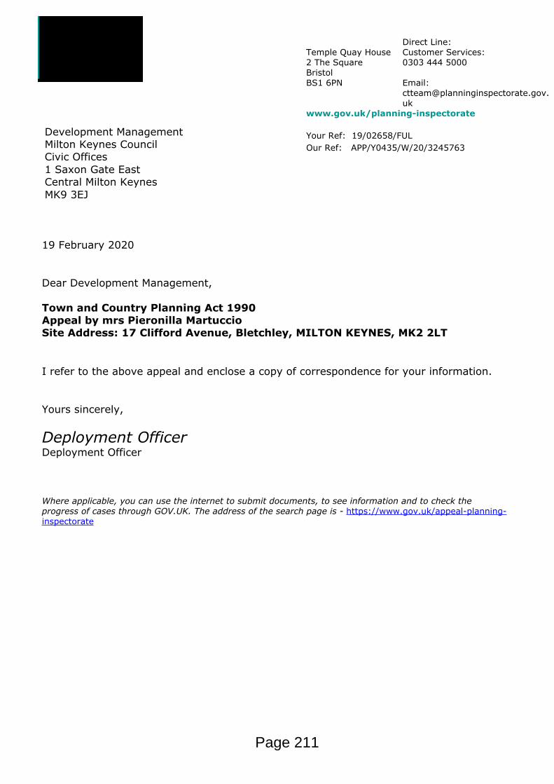
Temple Quay House2 The SquareBristolBS1 6PN
Direct Line: Customer Services:0303 444 5000
Email: [email protected]
www.gov.uk/planning-inspectorate
Your Ref: 19/02658/FULOur Ref: APP/Y0435/W/20/3245763
Development ManagementMilton Keynes CouncilCivic Offices1 Saxon Gate EastCentral Milton KeynesMK9 3EJ
19 February 2020
Dear Development Management,
Town and Country Planning Act 1990Appeal by mrs Pieronilla MartuccioSite Address: 17 Clifford Avenue, Bletchley, MILTON KEYNES, MK2 2LT
I refer to the above appeal and enclose a copy of correspondence for your information.
Yours sincerely,
Deployment OfficerDeployment Officer
Where applicable, you can use the internet to submit documents, to see information and to check the progress of cases through GOV.UK. The address of the search page is - https://www.gov.uk/appeal-planning-inspectorate
Page 211

Temple Quay House2 The SquareBristolBS1 6PN
Direct Line: Customer Services:0303 444 5000
Email: [email protected]
www.gov.uk/planning-inspectorate
Your Ref: Our Ref: APP/Y0435/W/20/3245763
Mr antony thompsonMr48 St. James CloseHanslopeMILTON KEYNESMK19 7LF
19 February 2020
Dear Mr Thompson,
Town and Country Planning Act 1990Appeal by mrs Pieronilla MartuccioSite Address: 17 Clifford Avenue, Bletchley, MILTON KEYNES, MK2 2LT
We have received the above referenced appeal.
We have checked the documents submitted and confirm that the appeal is valid. If we later find out that this is not the case we will write to you again.
We are now waiting for a suitable Planning Inspector to become available. Once we are able to appoint an Inspector you will be allocated a named case officer who will write to you starting the appeal and setting out details of the timetable and procedure (the ‘start letter’). They will also confirm when the Inspector’s site visit/hearing will take place.
Information about the latest average timescales for appeals, including the average time from when an appeal is confirmed as valid to the start of the appeal timetable, can be found at: https://www.gov.uk/guidance/appeals-average-timescales-for-arranging-inquiries-and-hearings
Appeals Casework Portal
Details of your appeal will be available to view on the Appeals Casework Portal as soon as a ‘start’ letter has been issued.
Important information
Please note that we are not able to respond to queries relating to the time taken to issue a ‘start’ letter.
The Planning Inspectorate deals with approximately 20,000 appeals a year in locations all over England. In order to process these as efficiently as possible our staff work hard to ensure that they identify Inspectors in the appropriate location with the appropriate
Page 212

experience to determine cases.
Please be assured that when we are able to appoint an Inspector to determine your appeal we will contact you again at that time.
Information about the appeals process can be accessed at GOV.UK - https://www.gov.uk/government/publications/planning-appeals-procedural-guide. I recommend that you read the relevant guidance.
Yours sincerely,
Deployment OfficerDeployment Officer
Page 213

For official use only (date received): 28/01/2020 13:55:19
The Planning Inspectorate
PLANNING APPEAL FORM (Online Version)WARNING: The appeal and essential supporting documents must reach the Inspectorate within the appeal period. If your appeal
and essential supporting documents are not received in time, we will not accept the appeal.
Appeal Reference: APP/Y0435/W/20/3245763
A. APPELLANT DETAILS
The name of the person(s) making the appeal must appear as an applicant on the planning application form.
Name mr angelo martuccio
Address 31 CloudberryWalnut TreeMILTON KEYNESMK7 7DL
Phone number
Preferred contact method Email Post
B. AGENT DETAILS
Do you have an Agent acting on your behalf? Yes No
Name Mr antony thompson
Company/Group Name Mr
Address 48 St. James CloseHanslopeMILTON KEYNESMK19 7LF
Phone number
Preferred contact method Email Post
C. LOCAL PLANNING AUTHORITY (LPA) DETAILS
Name of the Local Planning Authority Milton Keynes Council
LPA reference number 19/02658/FUL
Page 1 of 7Page 214
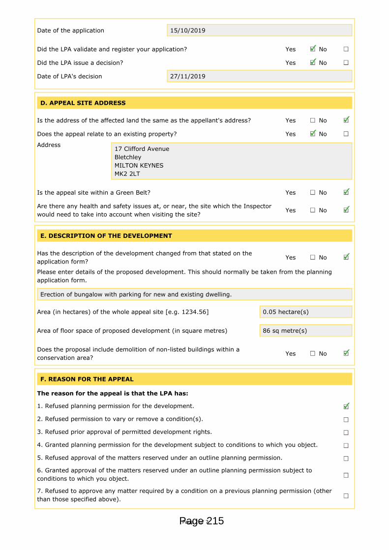
Date of the application 15/10/2019
Did the LPA validate and register your application? Yes No
Did the LPA issue a decision? Yes No
Date of LPA's decision 27/11/2019
D. APPEAL SITE ADDRESS
Is the address of the affected land the same as the appellant's address? Yes No
Does the appeal relate to an existing property? Yes No
Address 17 Clifford AvenueBletchleyMILTON KEYNESMK2 2LT
Is the appeal site within a Green Belt? Yes No
Are there any health and safety issues at, or near, the site which the Inspectorwould need to take into account when visiting the site?
Yes No
E. DESCRIPTION OF THE DEVELOPMENT
Has the description of the development changed from that stated on theapplication form?
Yes No
Please enter details of the proposed development. This should normally be taken from the planningapplication form.
Erection of bungalow with parking for new and existing dwelling.
Area (in hectares) of the whole appeal site [e.g. 1234.56] 0.05 hectare(s)
Area of floor space of proposed development (in square metres) 86 sq metre(s)
Does the proposal include demolition of non-listed buildings within aconservation area?
Yes No
F. REASON FOR THE APPEAL
The reason for the appeal is that the LPA has:
1. Refused planning permission for the development.
2. Refused permission to vary or remove a condition(s).
3. Refused prior approval of permitted development rights.
4. Granted planning permission for the development subject to conditions to which you object.
5. Refused approval of the matters reserved under an outline planning permission.
6. Granted approval of the matters reserved under an outline planning permission subject toconditions to which you object.
7. Refused to approve any matter required by a condition on a previous planning permission (otherthan those specified above).
Page 2 of 7Page 215
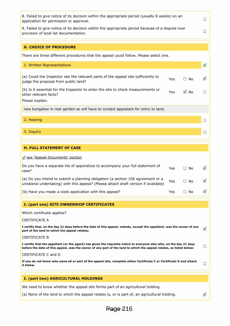
8. Failed to give notice of its decision within the appropriate period (usually 8 weeks) on anapplication for permission or approval.
9. Failed to give notice of its decision within the appropriate period because of a dispute overprovision of local list documentation.
G. CHOICE OF PROCEDURE
There are three different procedures that the appeal could follow. Please select one.
1. Written Representations
(a) Could the Inspector see the relevant parts of the appeal site sufficiently tojudge the proposal from public land?
Yes No
(b) Is it essential for the Inspector to enter the site to check measurements orother relevant facts?
Yes No
Please explain.
new bungalow in rear garden so will have to contact appealant for entry to land.
2. Hearing
3. Inquiry
H. FULL STATEMENT OF CASE
see 'Appeal Documents' section
Do you have a separate list of appendices to accompany your full statement ofcase?
Yes No
(a) Do you intend to submit a planning obligation (a section 106 agreement or aunilateral undertaking) with this appeal? (Please attach draft version if available)
Yes No
(b) Have you made a costs application with this appeal? Yes No
I. (part one) SITE OWNERSHIP CERTIFICATES
Which certificate applies?
CERTIFICATE A
I certify that, on the day 21 days before the date of this appeal, nobody, except the appellant, was the owner of anypart of the land to which the appeal relates;
CERTIFICATE B
I certify that the appellant (or the agent) has given the requisite notice to everyone else who, on the day 21 daysbefore the date of this appeal, was the owner of any part of the land to which the appeal relates, as listed below:
CERTIFICATE C and D
If you do not know who owns all or part of the appeal site, complete either Certificate C or Certificate D and attachit below.
I. (part two) AGRICULTURAL HOLDINGS
We need to know whether the appeal site forms part of an agricultural holding.
(a) None of the land to which the appeal relates is, or is part of, an agricultural holding.
Page 3 of 7Page 216
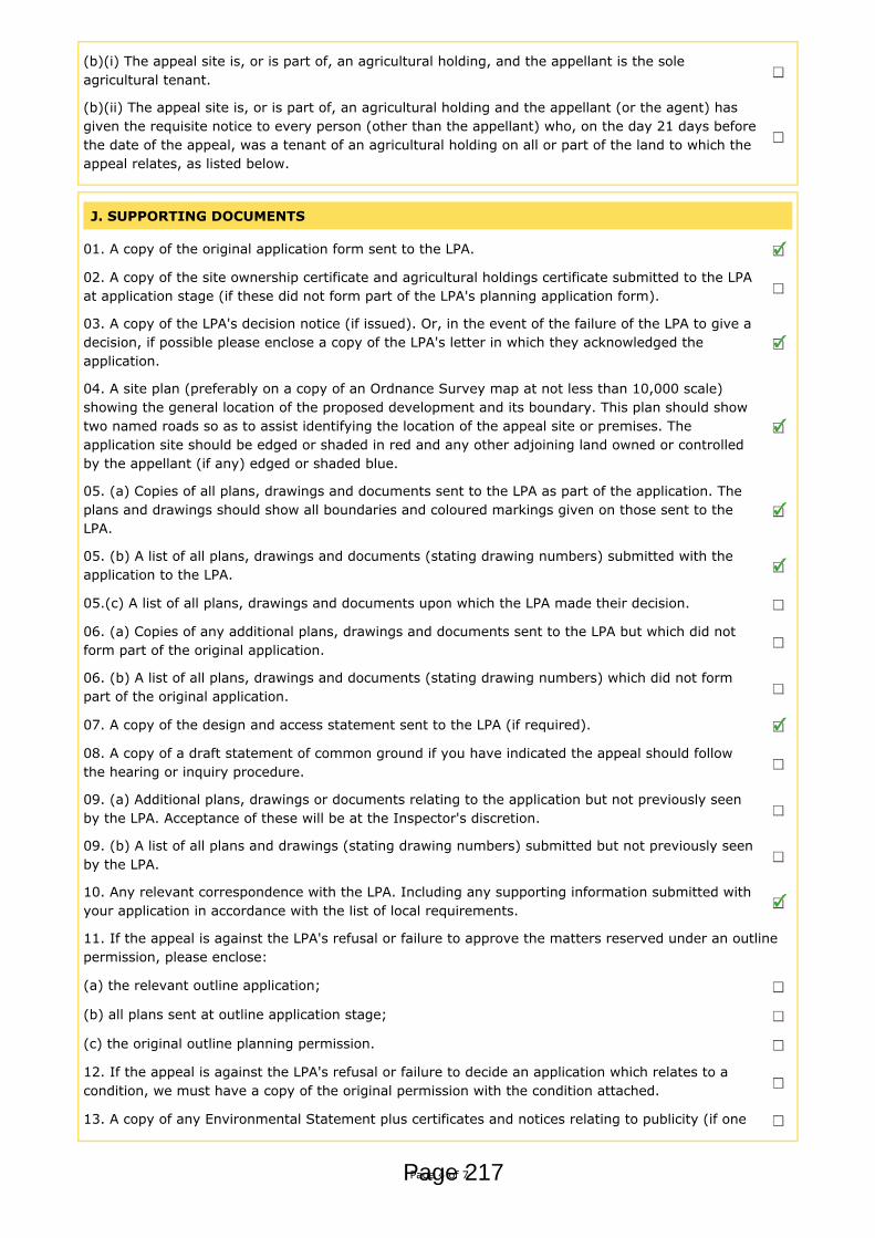
(b)(i) The appeal site is, or is part of, an agricultural holding, and the appellant is the soleagricultural tenant.
(b)(ii) The appeal site is, or is part of, an agricultural holding and the appellant (or the agent) hasgiven the requisite notice to every person (other than the appellant) who, on the day 21 days beforethe date of the appeal, was a tenant of an agricultural holding on all or part of the land to which theappeal relates, as listed below.
J. SUPPORTING DOCUMENTS
01. A copy of the original application form sent to the LPA.
02. A copy of the site ownership certificate and agricultural holdings certificate submitted to the LPAat application stage (if these did not form part of the LPA's planning application form).
03. A copy of the LPA's decision notice (if issued). Or, in the event of the failure of the LPA to give adecision, if possible please enclose a copy of the LPA's letter in which they acknowledged theapplication.
04. A site plan (preferably on a copy of an Ordnance Survey map at not less than 10,000 scale)showing the general location of the proposed development and its boundary. This plan should showtwo named roads so as to assist identifying the location of the appeal site or premises. Theapplication site should be edged or shaded in red and any other adjoining land owned or controlledby the appellant (if any) edged or shaded blue.
05. (a) Copies of all plans, drawings and documents sent to the LPA as part of the application. Theplans and drawings should show all boundaries and coloured markings given on those sent to theLPA.
05. (b) A list of all plans, drawings and documents (stating drawing numbers) submitted with theapplication to the LPA.
05.(c) A list of all plans, drawings and documents upon which the LPA made their decision.
06. (a) Copies of any additional plans, drawings and documents sent to the LPA but which did notform part of the original application.
06. (b) A list of all plans, drawings and documents (stating drawing numbers) which did not formpart of the original application.
07. A copy of the design and access statement sent to the LPA (if required).
08. A copy of a draft statement of common ground if you have indicated the appeal should followthe hearing or inquiry procedure.
09. (a) Additional plans, drawings or documents relating to the application but not previously seenby the LPA. Acceptance of these will be at the Inspector's discretion.
09. (b) A list of all plans and drawings (stating drawing numbers) submitted but not previously seenby the LPA.
10. Any relevant correspondence with the LPA. Including any supporting information submitted withyour application in accordance with the list of local requirements.
11. If the appeal is against the LPA's refusal or failure to approve the matters reserved under an outlinepermission, please enclose:
(a) the relevant outline application;
(b) all plans sent at outline application stage;
(c) the original outline planning permission.
12. If the appeal is against the LPA's refusal or failure to decide an application which relates to acondition, we must have a copy of the original permission with the condition attached.
13. A copy of any Environmental Statement plus certificates and notices relating to publicity (if one
Page 4 of 7Page 217
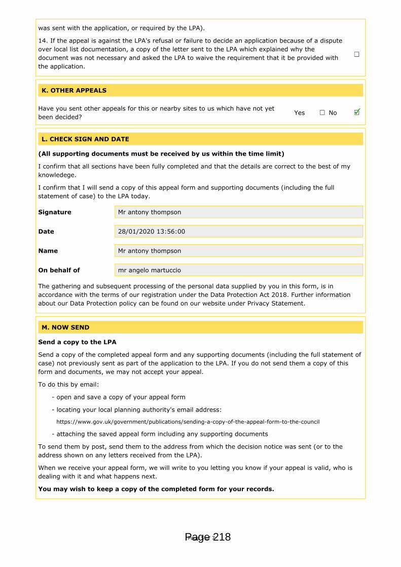
was sent with the application, or required by the LPA).
14. If the appeal is against the LPA's refusal or failure to decide an application because of a disputeover local list documentation, a copy of the letter sent to the LPA which explained why thedocument was not necessary and asked the LPA to waive the requirement that it be provided withthe application.
K. OTHER APPEALS
Have you sent other appeals for this or nearby sites to us which have not yetbeen decided?
Yes No
L. CHECK SIGN AND DATE
(All supporting documents must be received by us within the time limit)
I confirm that all sections have been fully completed and that the details are correct to the best of myknowledege.
I confirm that I will send a copy of this appeal form and supporting documents (including the fullstatement of case) to the LPA today.
Signature Mr antony thompson
Date 28/01/2020 13:56:00
Name Mr antony thompson
On behalf of mr angelo martuccio
The gathering and subsequent processing of the personal data supplied by you in this form, is inaccordance with the terms of our registration under the Data Protection Act 2018. Further informationabout our Data Protection policy can be found on our website under Privacy Statement.
M. NOW SEND
Send a copy to the LPA
Send a copy of the completed appeal form and any supporting documents (including the full statement ofcase) not previously sent as part of the application to the LPA. If you do not send them a copy of thisform and documents, we may not accept your appeal.
To do this by email:
- open and save a copy of your appeal form
- locating your local planning authority's email address:
https://www.gov.uk/government/publications/sending-a-copy-of-the-appeal-form-to-the-council
- attaching the saved appeal form including any supporting documents
To send them by post, send them to the address from which the decision notice was sent (or to theaddress shown on any letters received from the LPA).
When we receive your appeal form, we will write to you letting you know if your appeal is valid, who isdealing with it and what happens next.
You may wish to keep a copy of the completed form for your records.
Page 5 of 7Page 218

N. APPEAL DOCUMENTS
We will not be able to validate the appeal until all the necessary supporting documents are received.
Please remember that all supporting documentation needs to be received by us within the appropriatedeadline for the case type. Please ensure that any correspondence you send to us is clearly marked withthe appeal reference number.
You will not be sent any further reminders.
The documents listed below were uploaded with this form:
Relates to Section: FULL STATEMENT OF CASEDocument Description: A copy of the full statement of case.File name: 202001281025.pdfFile name: Appeal letter.doc
Relates to Section: SUPPORTING DOCUMENTSDocument Description: 01. A copy of the original application sent to the LPA.File name: 00440873.pdf
Relates to Section: SUPPORTING DOCUMENTSDocument Description: 03. A copy of the LPA's decision notice (if issued). Or, in the event of the
failure of the LPA to give a decision, if possible please enclose a copy of theLPA's letter in which they acknowledged the application.
File name: 00447006.pdf
Relates to Section: SUPPORTING DOCUMENTSDocument Description: 04. A site plan (preferably on a copy of an Ordnance Survey map at not less
than 10,000 scale) showing the general location of the proposed developmentand its boundary. This plan should show two named roads so as to assistidentifying the location of the appeal site or premises. The application siteshould be edged or shaded in red and any other adjoining land owned orcontrolled by the appellant (if any) edged or shaded blue.
File name: 495_010_plans scheme 3 rev b.pdf
Relates to Section: SUPPORTING DOCUMENTSDocument Description: 05.a. Copies of all plans, drawings and documents sent to the LPA as part of
the application. The plans and drawings should show all boundaries andcoloured markings given on those sent to the LPA.
File name: 495_010_plans scheme 3 rev b.pdf
Relates to Section: SUPPORTING DOCUMENTSDocument Description: 05.b. A list of all plans, drawings and documents (stating drawing numbers)
submitted with the application to the LPA.File name: Dwg no list.doc
Relates to Section: SUPPORTING DOCUMENTSDocument Description: 07. A copy of the design and access statement sent to the LPA.File name: design and access statement.pdf
Relates to Section: SUPPORTING DOCUMENTSDocument Description: 10. Any relevant correspondence with the LPA, including any supporting
information submitted with your application in accordance with the list oflocal requirements.
File name: 202001281359.pdf
Completed by MR ANTONY THOMPSON
Page 6 of 7Page 219

Date 28/01/2020 13:56:00
Page 7 of 7Page 220
1
PublicAccessEDRMS
From: noreply (outbound only) <[email protected]>Sent: 13 February 2020 10:16To: DC AppealsSubject: [EXT] Planning Inspectorate APP/Y0435/W/20/3245763: 17 Clifford Avenue, MK2
2LTAttachments: 211B - Case Officer - Development Management - 13 Feb 2020.pdf; 107A -
Appellant name not identical to applicant - antony thompson - 13 Feb 2020.pdf
The Planning Inspectorate (England) Temple Quay House, 2 The Square, Temple Quay, Bristol, BS1 6PN
The Planning Inspectorate (Wales) Crown Buildings, Cathays Park, Cardiff, CF10 3NQ
http://www.planningportal.gov.uk/planninginspectorateTwitter: @PINSgov
This communication does not constitute legal advice. Please view our Information Charter before sending information to the Planning Inspectorate.
Page 221
Temple Quay House2 The SquareBristolBS1 6PN
Direct Line: 0303 444 5000Customer Services:0303 444 5000
Email: [email protected]
www.gov.uk/planning-inspectorate
Your Ref: 19/02658/FULOur Ref: APP/Y0435/W/20/3245763
Development ManagementMilton Keynes CouncilCivic Offices1 Saxon Gate EastCentral Milton KeynesMK9 3EJ
13 February 2020
Dear Development Management,
Town and Country Planning Act 1990Appeal by mr angelo martuccioSite Address: 17 Clifford Avenue, Bletchley, MILTON KEYNES, MK2 2LT
I refer to the above appeal and enclose a copy of correspondence for your information.
Yours sincerely,
Validation Officer A8Validation Officer A8
Where applicable, you can use the internet to submit documents, to see information and to check the progress of cases through GOV.UK. The address of the search page is - https://www.gov.uk/appeal-planning-inspectorate
Page 222
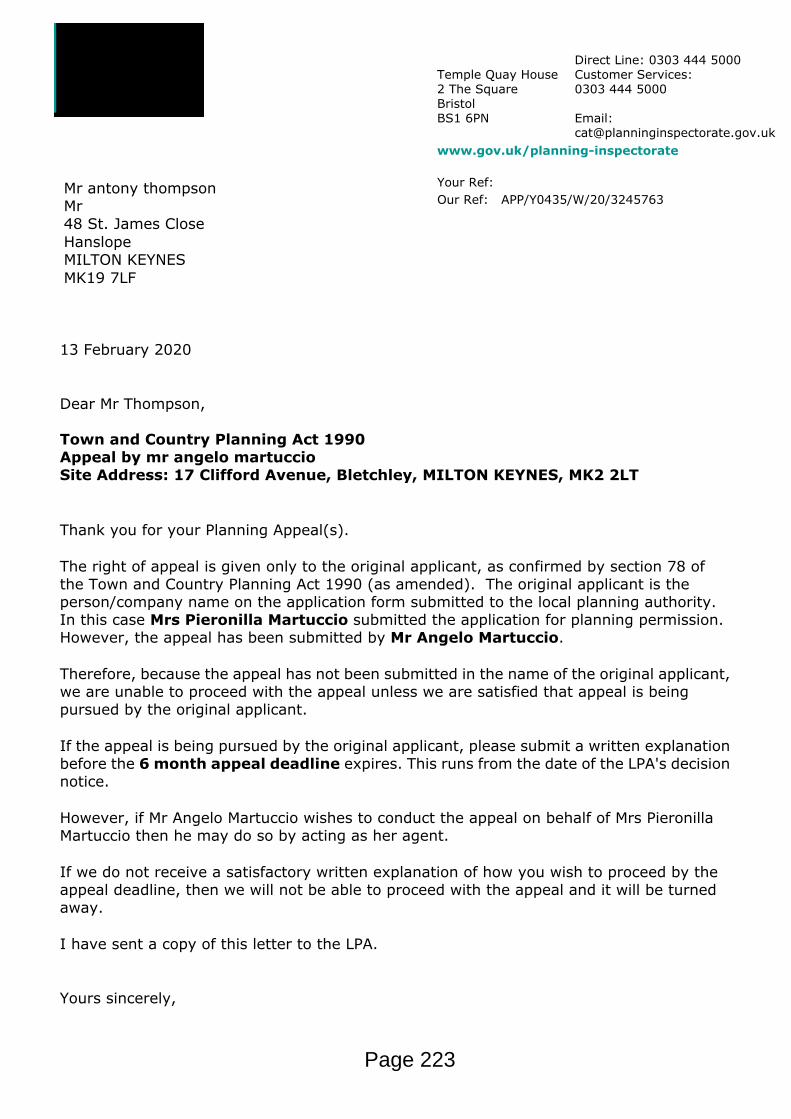
Temple Quay House2 The SquareBristolBS1 6PN
Direct Line: 0303 444 5000Customer Services:0303 444 5000
Email: [email protected]
www.gov.uk/planning-inspectorate
Your Ref: Our Ref: APP/Y0435/W/20/3245763
Mr antony thompsonMr48 St. James CloseHanslopeMILTON KEYNESMK19 7LF
13 February 2020
Dear Mr Thompson,
Town and Country Planning Act 1990Appeal by mr angelo martuccioSite Address: 17 Clifford Avenue, Bletchley, MILTON KEYNES, MK2 2LT
Thank you for your Planning Appeal(s).
The right of appeal is given only to the original applicant, as confirmed by section 78 of the Town and Country Planning Act 1990 (as amended). The original applicant is the person/company name on the application form submitted to the local planning authority. In this case Mrs Pieronilla Martuccio submitted the application for planning permission. However, the appeal has been submitted by Mr Angelo Martuccio.
Therefore, because the appeal has not been submitted in the name of the original applicant, we are unable to proceed with the appeal unless we are satisfied that appeal is being pursued by the original applicant.
If the appeal is being pursued by the original applicant, please submit a written explanation before the 6 month appeal deadline expires. This runs from the date of the LPA's decision notice.
However, if Mr Angelo Martuccio wishes to conduct the appeal on behalf of Mrs Pieronilla Martuccio then he may do so by acting as her agent.
If we do not receive a satisfactory written explanation of how you wish to proceed by the appeal deadline, then we will not be able to proceed with the appeal and it will be turned away.
I have sent a copy of this letter to the LPA.
Yours sincerely,
Page 223

Validation Officer A8Validation Officer A8
Page 224

MK Council Decisions 20/00100/FUL, 11 Hunter Drive, Bletchley, MK2 3LP. Single storey rear and side extensions – Permit 20/00358/DISCON, Bletchley Flyover Buckingham Road Bletchley. Details submitted pursuant to discharge Condition 3 (Schedule of External Materials) attached to planning application 19/03082/PANOTH- Approved 19/03450/PNHSE, 38 Albert Street Bletchley Milton Keynes MK2 2UG. Prior notification for a proposed single storey rear conservatory extension measuring 6m from the rear wall of the existing dwelling with a maximum ridge height of 3.30m and a maximum eaves height of 3m – Planning approval not required. 19/03214/REM, Skew Bridge Cottage, Drayton Road, Bletchley, Milton Keynes, MK3 5JU. Reserved matters approval in relation to appearance, landscaping, layout and scale for the erection of 10 dwellings and associated infrastructure approved under 16/02174/OUT – Permit 20/00094/DISCON, Phase 7A Newton Leys Development Denny Lane Newton Leys Milton Keynes. Details submitted pursuant to discharge of Conditions 6 Roads and Footways), 9 (Levels), 11 (Landscaping), 12 (Boundary Treatments), 13 (Landscape Management Plan) and 17 (Foul & Surface Water Drainage Strategy) attached to planning permission 19/01331/REM – Refused : The reason(s) for refusing your application are : ( 1) Details submitted pursuant to discharge of Condition 17 (Foul & Surface Water Drainage Strategy) attached to planning permission 19/01331/REM: 11071H - 105(1)B - Private Drainage & External Works Layout (Sheet 1 of 5). Received on 15th January 2020 11071H - 105(2)B - Private Drainage & External Works Layout (Sheet 2 of 5). Received on 15th January 2020 11071H - 105(3)B - Private Drainage & External Works Layout (Sheet 3 of 5). Received on 15th January 2020 11071H - 105(4)B - Private Drainage & External Works Layout (Sheet 4 of5). Received on 15th January 2020 11071H - 105(5)B - Private Drainage & External Works Layout (Sheet 5 of 5). Received on 15th January 2020 TOWN AND COUNTRY PLANNING ACT 1990 (AS AMENDED) TOWN AND COUNTRY PLANNING (DEVELOPMENT MANAGEMENT PROCEDURE) (ENGLAND) ORDER 2015 Development Management, Civic, 1 Saxon Gate East, Central Milton Keynes MK9 3EJ Planning Enquiries Direct Line (01908) 252358 MK Council Tel: (01908) 691691 www.milton-keynes.gov.uk 11071H - 113A - Section 104 Layout. Received on 15th January 2020 11071H - 115B - Drainage Area Plan. Received on 15th January 2020 11071H - 116 - Gully Area Plan. Received on 15th January 2020 11071H - 125 - Private Drainage Construction Details. Received on 15th January 2020 MicroDrainage Calculations x11. Received on 15th January 2020 The details as presented are refused. Reason: Due to the absence of a maintanence plan the details as submitted do not meet the requirements of the condition attached
Page 225
Agenda Item 7

to 19/01331/REM. The details are therefore contrary to Policy FR1 of Plan:MK (2019). The remainder of the application was given consent.
Page 226