Embed Size (px)
Citation preview

PROYECTO SISTEMA DE INFORMACION GEOGRÁFICA PARA LA PLANEACIÓN Y EL ORDENAMIENTO TERRITORIAL NACIONAL –SIGOT-
(PROJECT GEOGRAPHIC INFORMATION SYSTEM FOR NATIONAL AND
REGIONAL COMPREHENSIVE LAND-USE PLANNING AND MANAGEMENT)
EXECUTIVE SUMMARY 02/2009
BACKGROUND The Sistema de Información Geográfica para la Planeación y el Ordenamiento Territorial Nacional SIGOT, constitutes a network of institutions, technological resources and data to facilitate access and use of geoinformation, with the aim of contributing to an efficient and timely decision-making by authorities at national, regional and local levels, and promote good governance for sustainable development. The SIGOT project, which started year 2005, is a practical application of the policies of the Infraestructura Colombiana de Datos Espaciales ICDE, (Colombian Infrastructure of Spacial Data) –in terms of standards, metadata and Web portals. The System aims to organize the production, flow and dissemination of spatial information to support the planning processes at different levels of government in an optimized and effective way. The production of data and geographic information is coordinated and shared by the various agencies and leading stakeholders at national level. SIGOT provides information for the management of development at national, regional and local government levels and contributes to the geographic knowledge of the country and intends to build good practices in land use and development planning. THE MANAGEMENT MODEL The SIGOT is an inter-institutional initiative that has the support and commitment of a group of government authorities and institutions that directly support its management:
SIGOT_Project_-_Executive_Summary_v1.4 1 2/23/2009

Presidential Agency for Social Action and International Cooperation - Social Action; National Administrative Department of Statistics; National Planning Department; Ministry of Environment, Housing and Territorial Development; Ministry of Agriculture and Rural Development; Ministry of National Education; Ministry of Culture; Ministry of Transport and Colombian Federation of Municipalities, as well as the participation of a large group of reference authorities at national, regional and local levels. The Geographic Institute Agustin Codazzi (IGAC) heads an Inter-institutional Committee for Management and shoulders leadership functions and technical facilitation of the data flow. SIGOT is a technical cooperation partnership arrangement between the Colombian Government, through the Presidential Agency for Social Action and International Cooperation, and the Swedish Agency for International Development (ASDI), with a first phase to be implemented over a period of four years . Swedesurvey – the oversea agency of Lantmäteriet (Real Estate Registry and Geographic Institute of Sweden) is assisting IGAC in project implementation. The concept design and the system requirements have been defined in a participatory manner by the entities of the Management Group and the contribution of the concerned stakeholders. The available strategic information in the system has been selected in a corporate manner by each sector and institution, within the framework of their respective competences and responsibilities and with the aim to contribute in the planning and management processes and protocols.
SIGOT_Project_-_Executive_Summary_v1.4 2 2/23/2009

Likewise, the stakeholders established the usability criteria of the system: access to Internet; deployment of thematic maps by municipality and/or department; region or national coverage; access to basic mapping; printing of maps and data; export of maps to be used in other platforms; creation of new thematic layers and comparison over time, among others. ACCESS The planning authorities as well as the general public, can use SIGOT through a user–friendly web site with an free access to the information.
SIGOT_Project_-_Executive_Summary_v1.4 3 2/23/2009
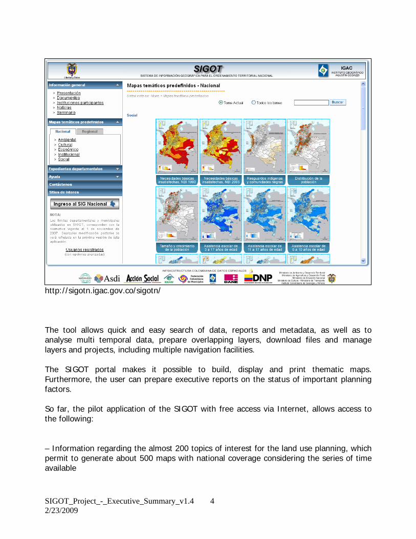
http://sigotn.igac.gov.co/sigotn/ The tool allows quick and easy search of data, reports and metadata, as well as to analyse multi temporal data, prepare overlapping layers, download files and manage layers and projects, including multiple navigation facilities. The SIGOT portal makes it possible to build, display and print thematic maps. Furthermore, the user can prepare executive reports on the status of important planning factors. So far, the pilot application of the SIGOT with free access via Internet, allows access to the following: – Information regarding the almost 200 topics of interest for the land use planning, which permit to generate about 500 maps with national coverage considering the series of time available
SIGOT_Project_-_Executive_Summary_v1.4 4 2/23/2009
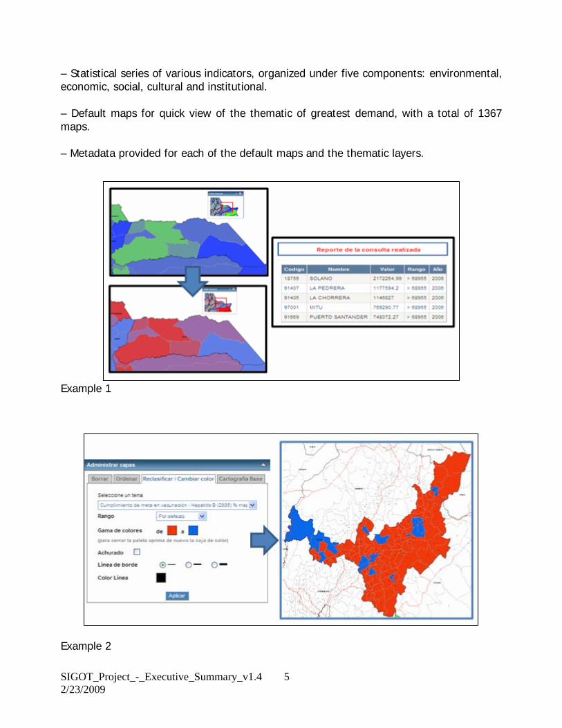
– Statistical series of various indicators, organized under five components: environmental, economic, social, cultural and institutional. – Default maps for quick view of the thematic of greatest demand, with a total of 1367 maps. – Metadata provided for each of the default maps and the thematic layers.
Example 1
Example 2
SIGOT_Project_-_Executive_Summary_v1.4 5 2/23/2009
USEFULNESS SIGOT helps authorities and planning agencies on several ways: – It facilitates the development of diagnostics in the planning and monitoring processes, as well as the evaluation of development plans and land use planning. – It supports the definition of goals and strategies in the development plans. – It supports the land use planning processes at municipal, regional and national level. – It promotes and encourages the move from a sector oriented planning process to a cross-sector and integrated approach character to processes with territorial approach. – It facilitates decision-making and the formulation of public policies, collecting and providing access to a broad base of land information available in the country, into a single Web page. – It serves as a tool that allows us to observe the change and evolution of the conditions of development over time. – It strengthens processes of modeling and analysis generating sound principles for the spatial analysis. – It promotes the use of geodata in the country as a whole. PILOT STUDIES AND TRAINING CONDUCTED AT REGIONAL AND LOCAL LEVELS In 2007, the project began pilot exercises, with the purpose to complement the national application with the vision of the users at regional and local levels and with the purpose to facilitate the preparation of the mandatory development plans. This initiative was supported by the governments of Nariño, Cauca and Valle del Cauca, with workshops involving civil servants responsible for the structural issues of development: education, health, infrastructure, services, environment, government, tourism, culture, etc.
SIGOT_Project_-_Executive_Summary_v1.4 6 2/23/2009

Popayan, Dept. Cauca
Pasto, Depto. Nariño
SIGOT_Project_-_Executive_Summary_v1.4 7 2/23/2009

Synthesis of the institutional component The purpose of this regional exercise is to advance in the construction of guidelines of territorial development with regional players in this context, from the articulation of strategic planning tools (visualization exercises) of each department and the departmental bets in the frame of the competitiveness agenda. At the same time this process allows to precise the information requirements that must be satisfied by the SIGOT with the purpose to be a useful tool in the processes of land use planning at regional and local levels. It was also possible for the participants to map several themes and to synthesize data which has not been possible to achieve previously. This synthesis makes it possible to avoid duplications of work and to harmonize planning efforts between different administrative levels (local, regional, etc).
SIGOT_Project_-_Executive_Summary_v1.4 8 2/23/2009

Also workshops have been conducted to define guidelines for spatial development and to serve as a framework for the process of updating the land use plans reflected in synthesis for every component: economic, institutional, environmental, social and Functional.
SIGOT_Project_-_Executive_Summary_v1.4 9 2/23/2009

Outline of the economic component In 2008, the project provided training to civil servants, to promote that the national application is being utilized in the formulation and monitoring of the development plans and the preparation of the land-use plans. Work during 2009 will continue with to consolidate the SIGOT databank at hand. A long-term and important goal is to strengthen the institutional recognition of the system for secure data to keep the system up-to-date. Consequently, actions will be taken to spread the message to top management as well as to familiarize users at regional and local governments. Likewise, an in-depth evaluation of achievements will be made to set standards and strategies for the second phase, planned for during 2010-2013.
SIGOT_Project_-_Executive_Summary_v1.4 10 2/23/2009