Embed Size (px)
Citation preview

PROTECT BELPER: Response to AVBC/2011/0016 within the Further Proposed Changes to the Submitted Core Strategy: BULLSMOOR

Page 1 of 25
Prepared by
Ms Kim Bird
5 Coppice Brook ,Belper, Derbyshire DE56 1JQ
Mr Colin Brassington
72 Sandbed Lane, Belper, Derbyshire, DE56 0SJ
Ms Natasha Churchman
2 Stanton Avenue,Belper, Derbyshire DE56 1EE
Mr David Clark
68 Sandbed Lane, Belper, Derbyshire, DE56 0SJ
Mr Terry Conn
173 Nottingham Road, Belper, Derbyshire, DE56 1JJ
Dr Andrew Francis
70 Sandbed Lane, Belper, Derbyshire, DE56 0SJ
Ms Jules Gordon
5 Coppice Brook ,Belper, Derbyshire DE56 1JQ
Mrs Helen Jackson
136 Sandbed Lane, Belper, Derbyshire, DE56 0SN
Mr Robert Large
216 Kilbourne Road, Belper, Derbyshire, DE56 1SB
Mr Dan Levy
2 Stanton Avenue,Belper, Derbyshire DE56 1EE
Mrs Kim Lowe
220 Kilbourne Road, Belper, Derbyshire, DE56 1SB
Mrs Valerie Pickard
160 Kilbourne Road, Belper, Derbyshire, DE56 1SB
Dr Kate Pudney
173 Nottingham Road, Belper, Derbyshire, DE56 1JJ
Miss Louise Standing
122 Kilbourne Road, Belper, Derbyshire, DE56 1SA
Ms Susan Smedley
158 Kilbourne Road, Belper, Derbyshire, DE56 1SB
Mrs Janet Wignall
Hillside ,Stanton Avenue, Belper, Derbyshire, DE56 1EE
Mr Tony Wignall
Hillside ,Stanton Avenue, Belper, Derbyshire, DE56 1EE
Contact: Mrs V Pickard, [email protected]

Page 2 of 25
Response to the Further Proposed Changes to the Local Plan Part 1 Core Strategy for Amber Valley, October 2014: BULLSMOOR SG14 INTRODUCTION This document has been prepared by ‘Protect Belper’ as a representation to Amber Valley Borough Council (AVBC)’ in response to Further Proposed Changes to the Submitted Core Strategy (Part 1 of the AVBC Local Plan) with regards to Bullsmoor. This is a supplementary response to our previous representation of 8 September 2014 which was supported by a 2000+ petition from local residents. The petition specifically included Bullsmoor. This additional response is in relation to policy SG14 for the development of 150 houses on greenfield farmland within the Buffer Zone of the World Heritage Site. Protect Belper are not responding to the industrial proposal for Bullsmoor as we consider this should not be included in part one of the core strategy which addresses predicted housing need. This supplementary response is designed to examine in detail Policy SG14 a) to i) and introduce additional elements from the November updated AVBC URS Sustainability Analysis. This identified a more adverse situation in the performance criteria than in the previous analysis. In addition we will assess the latest housing target for 5 and 15 year horizons and analyse the current numbers. Network Rail’s response to AVBC council arouses a concern yet again that ‘catchment’ flood issues need to be examined rather than just site specific issues. Derwent Valley Mills response regarding ‘field by field analysis’ has led us to commence our own study and we find the main part of Bullsmoor is clearly visible from public vantage points within the World Heritage Valley. We believe the evidence is compelling and urge the AVBC to remove Bullsmoor as a strategic site for housing from the Core Strategy. We also agree with English Heritage that this site, along with Pottery Farm, Cherry House Farm, Hilltop Farm and fields contiguous to these sites should be considered for redefinition as Green Belt. Protect Belper 05/12/2014

Page 3 of 25
HOUSING NUMBERS ALLOCATION The need to allocate additional strategic sites at all is not justified. Commitments from Derby City and South Derbyshire authorities, taken alongside Amber Valley’s existing completed, committed, allocated, projected and preferred (already included) sites, more than meet the needs of the Derby HMA. Amber Valley Derby South Derbys Total Stated ’11 – ’28 Need 7021
F&KRH 14212
F&KRH 8993
F&KRH 30226
Stated ’11 – ’28 Capacity 7461 FPCLPP1
App B pp 49
11000 F&KRH
12341 F&KRH
FPCLPP1 pp 4
31736
Over Capacity (Capacity–Need) +440 -3212 +3348 +576 Additional Proposed Strategic Site Capacity
+2190 FPCLPP1
App B pp 50
+2766
(Figures from examination document Foster & Kingaby review of latest Hearn report 24/11/14 and the Further Proposed Changes to Local Plan Part 1 Core Strategy for Amber Valley). It seems unreasonable that the residents of Amber Valley should be subject to high levels of commuter traffic, loss of green space amenity and be open to other risks, such as flooding and pollution, without a clear explanation of why there is a perceived outstanding Derby HMA need. AVBC cannot justify the use of Greenfield sites or additional strategic sites purely to fulfil the 5 year Housing Need, as there is not a real gap between need and availability (We would expect this gap to widen if account is taken of the projected need as reviewed by Foster & Kingaby on 24/11/14). Total 5 year calculated need (including catch-back) 3850 5 year, 5% NPPF required buffer 142 3992 Already committed 3523 - 469 Already allocated 544 + 75 Projected 5 year windfall (5 x 50) 250 + 325 It is only the artificial 20% (568) increase for previous under-build that is creating pressure at the front end of the Strategy process. If AVBC works with developers to effectively deliver the already committed and allocated sites, they will more than meet the actual 5 year housing need, with windfall opportunities providing effective backup without including greenfield sites.

Page 4 of 25
Policy SG14a: OUTSTANDING UNIVERSAL VALUE WORLD HERITAGE STATUS This Policy states that any development proposal needs to involve: “Appropriate design and masterplanning informed by visual sensitivity study that protects the Outstanding Universal Value of the Derwent Valley Mills World Heritage Site, the setting of Belper and Milford Conservation Area, Pottery Farm (listed grade II), and other heritage assets” “Further Proposed Changes” 2.1.7 states: “Although the site lies within the defined World Heritage Site Buffer Zone, it is considered that given the topography of the land and its distance from the World Heritage Site, there is potential for some development without detracting from its Outstanding Universal Value (OUV)”. Regarding “its distance from the World Heritage Site”:
• The Buffer Zone is not intended to become less important the further it is away from the core site. UNESCO Operational Guidelines 2008 refer to ‘setting’ which gives an ‘added layer of protection to the WHS’. This includes spatial and historic relationships. The medieval history recording farm activity in Bullsmoor which supported the development of early Belper is significant as is the relationship between field production to the Manor House and its Deer Park. The present day links through biodiversity to the Belper Conservation Area continue to be valid. The field use of paths and stiles as local amenity is still relevant.
• The Hilltop Farm site for a significantly smaller development (75 dwellings) was dismissed on appeal largely on account of its setting in the World Heritage Site. The Inspector, Gyllian Grindley, in reaching her decision, referred to this ‘green, natural landscape’ of Belper as ‘intact’ and ‘an important part of the setting and significance of the DVMWHS’. Bullsmoor, which is contiguous with Hilltop Farm, is included in her assessment. In Paragraph 11, she states:
‘The whole area between Bullsmoor, Nottingham Road, Park Side, Mill Lane, Kirk’s Lane and Pinchom’s Hill is crossed by a surprising number of well-used public footpaths. It is from these that I consider persons can and do “experience” the local context of the WHS, embracing its present and past relationships with the adjacent landscape.’ (Para 11)
Regarding “given the topography of the land”: • This would seem to refer to the assumption that the Bullsmoor Site is more hidden
from view because of the lie of Belper within valleys and hills. AVBC provides no evidence of this assumption. In fact, perusal to horizon from numerous vantage points within the Bullsmoor site shows that there are clear distant views. These views are to the Chevin (the most southerly high point of the Pennine Chain), Alport Heights (a National Trust property), Chevin Road and Handley Wood, Bessalone, the Heage Ridgeway and Pinchom’s Hill.

Page 5 of 25
A field by field study from a seated vantage point upon the Chevin reveals views of most of the Bullsmoor site. (See Google Earth map Appendix A * on page 16). Using an 8 metre surveying pole (as a representation of built housing height) all fields (x5) excepting the field to the east of the factory are visible. If additional vantage points are adopted (in our proposed phase 2 study) all the fields will be proved visible from public locations within the Derwent Valley. Indeed the block of housing would be clearly seen by the naked eye. It will be in stark contrast to the current green valley vista.
• Even so, we note English Heritage’s assessment that the experience of this setting ‘is not wholly confined to visual factors such as sight lines and views, nor static views, but also determined by historical and spatial associations between its features, and, by our understanding of the historic relationship between places, even when they are not inter-visible.’ (response to Consultation on Core Strategy Part 1, September 2014).
AVBC’s draft Core Strategy policies and Sustainability Appraisal recognise but do not resolve the conflict between the need to preserve the heritage of our landscape and the push for development. The Sustainability Appraisal Report October 2014(URS) on Topic 9 concludes that ‘There is also the potential for significant negative effects on the historic environment due to significant development, particularly in Belper and Kedleston. Scheme design could mitigate these effects to some extent.’ (our bold).
• The phrase “to some extent” is weak. Allowing any negative effects within the WHS Buffer Zone is incongruous to the purpose of the Buffer Zone which is to provide a statutory ‘additional layer of protection to the WHS’.
Environmental Policy E3: Historic Environment states: “The Borough Council will support development that protects, conserves or enhances the Outstanding Universal Value, integrity, authenticity and significance of the Derwent Valley Mills World Heritage Site and its setting”.
• AVBC has supplied no evidence to show how development could ‘enhance’ or ‘conserve’ the
‘green, open setting of the WHS’. Paragraph 13 of the appeal decision for Hilltop Farm applies equally to the much larger development proposed for Bullsmoor: ‘…the loss of the green open natural landscape setting here would not make a positive contribution to the heritage asset, or better reveal the significance of the asset – quite the reverse.’
It is therefore clear that development on Bullsmoor would not comply with: Policy E2 Quality and Design of Development which states in Section (j) that new proposals should not “involve the development of existing open land having amenity value, the established use of which contributes to the visual character of the surrounding urban area and where built development would be visually inappropriate” Policy E4 Landscape Character which unequivocally states: “Development proposals that will have an unacceptable impact on landscape character, visual amenity and sensitivity will not be permitted”

Page 6 of 25
Policy SG14b ENHANCING BIODIVERSITY, LANDSCAPE CHARACTER, GREEN
INFRASTRUCTURE This Policy states that any development proposal needs to involve: “Appropriate design and master planning which protects and enhances biodiversity, landscape character, green infrastructure and which does not conflict with or limit existing business activity on the neighbouring site” Both Environmental Policy E6: Biodiversity and AVBC’s Sustainability Appraisal (Objective 5) seek to protect and enhance biodiversity, ecological corridors, natural waterways and hedgerows as well as conserve and recover priority species and habitats.
• The Bullsmoor site is a distinctive diverse landscape largely comprising of green fields with a significant number of old hedgerows, mature trees and wetland areas. The site also has old stone walls and stone squeeze stiles which form an intrinsic part of the landscape of pre-industrial revolution Britain.
• The Inspector’s report on Hilltop Farm makes several references to this landscape character. She specifically noted of the Bullsmoor area “...The appeal site and the rest of the abutting open land alongside the Coppice Brook and The Park represent a tongue of green, natural landscape that weaves into the eastern side of the settlement and, to my mind, forms an intrinsic part of understanding the setting of the WHS”
There has been no recent bio-monitoring on a continuous basis of the ecology of Bullsmoor, which is adjacent to Coppice Brook. It is known that the site supports bats (pipistrelle spp.), hedgehogs and many birds that are on the RSPB red and amber list (e.g. swifts, swallows, house martins, tree sparrows, house sparrows, song thrushes, bullfinches, owls, sparrow hawks, kestrels, buzzards and even a red kite), as well as frogs, water voles and freshwater shrimps in Coppice Brook. Its diverse field and hedgerow plant species support numerous butterfly and bee species and other insect pollinators. These fields and hedgerows are also an important ecological corridor which links Belper Parks to the open land of Pottery Farm and beyond, providing habitats for feeding, nesting and burrowing.
From previously stating there are no BAP (Biodiversity Action Plan) priority species & habitats, the resubmitted “Sustainability appraisal report” notes the following:
• "Site thought to contain BAP priority species or habitats" • “Derbyshire Wildlife Trust state that this site is immediately adjacent to Local Wildlife
sites and that the western part of the site is immediately adjacent to Coppice Brook which supports considerable biodiversity interest. They also highlight that the site has an extensive network of hedgerows and a number of springs, small copses and wet woodland associated with these springs.”
• “Local residents state that protected species are present on the site, which include water voles, bats, owls, swallows and hedgehogs”.
Page 7 of 25
This indicates that the site has been grossly underestimated in terms of wildlife by AVBC and that therefore there should be an added layer of protection in terms of biodiversity as detailed in Sustainability Appraisal Objective 5. Policy SG14c RETENTION AND ENHANCEMENT OF EXISTING TREES &
HEDGEROWS
This Policy states that any development proposal needs to involve: “The retention and enhancement of existing trees and hedgerows within the site”
AND
Policy SG14h RETENTION AND IMPROVEMENT OF EXISTING FOOTPATHS
This Policy states that any development proposal needs to involve: “The retention and improvement of existing footpaths on or adjacent to the site to link, where the opportunity exists, to existing footpaths”
• The site includes 6 fields (See Appendix A page 16). Each one of those fields has field boundaries of hedges, mixed deciduous trees and stone walls, with several stone squeeze stiles on the footpaths. There is an important line of trees and hedges through the middle of one of the central fields along a drainage course.
• As shown in Appendix A (page 16), the site is crossed by a number of footpaths, which are well used by walkers, dog walkers, children walking to school (which they do in large numbers), runners, and, with the bridle way of Kirks Lane, horse riders and cyclists. There are also a number of other paths in the fields which have become well used over time. These open rural footpaths form part of an extensive network of open countryside paths in the area which contribute to physical and emotional wellbeing. It is this network of rural footpaths in close proximity to where people live which enable them to engage and connect with their natural surroundings thus enhancing their wellbeing.
Amber Valley’s SA Objective 2 is to “Improve the Health and Wellbeing of local people” and the “Summary of the effects of further proposed changes” states that “The proposed further changes would not have a significantly different effect on health and wellbeing.” (Sustainability Appraisal Report October 2014).
• The reality of new housing sites is usually that of suburban footpaths between high
fences, which would certainly not be a substitute for open paths or footways by old hedgerows and stone walls. This would be detrimental to the historic landscape as well as contributing to an adverse effect on health and wellbeing. The public would not, in the words of the Inspector’s report which dismissed the Hilltop Farm appeal, “‘experience’ the local context of the WHS, embracing its present and past relationships with the adjacent landscape.” which “is crossed by a surprising number of well used public footpaths.”
It is vitally important to retain the visual experience of the field edges, stone walls, hedges, stiles, copses and pathways which form the landscape setting for the WHS.

Page 8 of 25
The retention and enhancement of all hedges, trees, stone walls and spring sites is also essential for “conserving and enhancing levels of biodiversity” (SA Objective 5). Policy SG14d PROVISION OF NEW SCHOOL FACILITIES This Policy states that any development proposal needs to involve: “A financial contribution towards the provision of a new school including construction and land costs or the expansion of existing facilities”
• Belper School and Sixth Form Centre is a foundation secondary school located just 200 yards from Bullsmoor fields. This school takes 1350 pupils and is above average size.
• The Pottery Primary School is located 100 yards from the Bullsmoor fields. There are currently 340 pupils registered at the school. The Primary School’s intake yearly has been reduced from 60 to 45 pupils due to Health and Safety considerations.
BELPER SCHOOL AND SIXTH FORM CENTRE: The senior school is above average in size. It will struggle to expand further after its recent building of new Language & Art blocks, as there is no extra space unless sport and recreation space were used. A contribution towards expansion is of no merit if there is insufficient space to begin with – especially if there were to be further loss of open space amenity due to housing development. POTTERY PRIMARY SCHOOL: At a Town Council Meeting in August 2014, attended by approximately 500 residents, one of the local primary head teachers advised that the schools are already at capacity and it has in fact been working with the local authority to reduce class sizes. AVBC state in their Sustainability Appraisal 9: Economy and Employment: ‘’..... development at Bullsmoor in Belper could put pressure on Pottery Primary School which is already at capacity on a constrained site’. The only land available to the Pottery Primary School is the playground and this is obviously not a viable option for the long term development of our children.
• The historic and green context of the Bullsmoor area is important to the children in this largely built up valley. The schools sit on one side adjacent to the built up fabric of the area and on the other side they are adjacent to a historic green ribbon which is well used by pupils walking to/from school. The local children are therefore sharing a regional landscape that reflects the heritage of Derbyshire. To remove even more of the ‘rural setting’ will be harmful to the healthy development of not only this generation, but also future generations.
• AVBC sustainability report advises the schools’ situation to be ‘green’ and thus performs well. This is only from a proximity perspective. If a school is full and/or overburdened, if recreational and open amenity space is removed, then this assessment is ill founded.

Page 9 of 25
Policy SG14e EASEMENT ALONG WATERCOURSES - POLICY E1 MANAGING
FLOOD RISK This Policy states that any development proposal needs to involve: “An appropriate easement along watercourses on the site free of built development’’. The AVBC Strategic Flood Risk Assessment(2009) Level One states in section 9.19: “......Belper is deemed to be a low flood risk area, with the exception of land in Flood Categories 3a and 3b (high risk) and in Flood Category 2 (medium risk) along the River Derwent and Coppice Brook’’. The assessment of low risk to housing in the area is based on a ‘site assessment‘ only. The proposed houses will sit on a valley side and will be protected by gravity. The lower ground and indeed downstream will not be at this low risk. Unfortunately the lack of a ‘catchment level’ analysis could lead to downstream flood hazards being overlooked. The land above Bullsmoor contains a number of natural springs. These evidence the geological fault high on this side of the valley. The Borough Surveyor in the 1899 Report on Water Supplies observes ‘’beds of rock overlap like the tiles of a roof, and the water runs off’’. He also quotes from the 1879 Geological Survey ‘All down the Derwent particularly on its east bank copious springs of water issue from joints of rock along the line of junction ...’ Over 700 years of farm land management have seen a matrix of ditches and field soughs introduced to manage this water using the Bullsmoor fields as a soak away. The fields are so effective that the SUDS pond above Kirks Lane has an overflow pipe directing excess water into the Bullsmoor fields! The technical dangers of building on such land are understood within the AVBC SFRA section 10.56: ‘’Developers should be made aware of the possibility of large underground structures, including deep foundations, impeding or interfering with the flow of groundwater in superficial geological deposits (e.g. gravel beds) raising the water table upstream of the obstruction and resulting in water logging or even the emergence of groundwater above ground level. Geophysical investigations may be necessary in some cases to ensure that such problems do not arise.’’ The Coppice Brook flooding is entirely due to urban runoff from the estates on the North side of the valley. The AVBC SFRA section 9.9 states ‘Surface water flooding resulting from storm runoff is an issue in...Belper’. Locally this causes flooding to houses during heavy periods of rain. A major concern is the 2000 metre journey of the Brook ending with it joining the River Derwent. This is the confluence of two category 3a (Environment Agency rated) high flood risk waters. Its route takes it under Queen Street, under the Railway line, under the A6, and through a Supermarket car park. The Supermarket forms part of the River Derwent flood plain.
Page 10 of 25
Network Rail has in fact responded to AVBC: ‘You would need to be satisfied that there would be no adverse issues with this culvert as regards the surface water disposal strategy. As such if the allocation is confirmed subject to additional capacity at the culvert being required such betterment would need to be at the expense of the developer but also should ideally be carried out at the same time as our works’. The Culvert carrying the Brook through its descent is made of Victorian brick and is not tested for the rigours of 21st century climate change. The AVBC SFRA 3.1.3 says ‘The only hydraulically modelled Main River in Amber Valley Borough is the Derwent. Confirmation is sought as to the need to produce hydraulic models for other Main Rivers within the Borough’. At a catchment level there are serious and hazardous flood issues to be considered. A site specific study is inadequate for this strategic situation. To attempt to manage the risks retrospectively, after first accepting this land as part of the core strategy, is flawed. National policy within PPS25 recommends the moving of development from areas of higher flood risk to areas of lower flood risk (the ‘sequential test’). To attempt to manage issues during build is the equivalent of changing a socket whilst the electricity is still live. We strongly recommend the commencement of a full catchment study. We strongly recommend the provision of an AVBC SFRA Level 2. Again quoting from AVBC SFRA level 1 12.2 ‘’The following recommendations are made in relation to the proposed Level 2 SFRA: On the assumption that the bulk of the future development in the Borough required to meet the growth targets in the Regional Plan will be concentrated in and around the Borough’s four principal towns - Alfreton, Belper, Heanor and Ripley - the Level 2 assessments should include each of these centres of population’’. Adopting the land for housing takes away the option to reduce our current flood issue that could, due to climate change, need a remedial action. An initiative called ‘Ontrent’ acknowledges the areas flood issues. It has strategies that, with the farmer’s cooperation, can reduce flooding. Its sponsors are Natural England and the Environment agency. They know that rivers in flood can have their waters lowered by the imaginative use of farmland. These positive approaches cannot occur if the land is used for housing.

Page 11 of 25
Policy SG14f & g SATISFACTORY ACCESS TO SITE AND MITIGATION OF IMPACTS ON TRAFFIC AND TRAFFIC ASSESSMENT
These Policies state that any development proposal needs to involve: “The creation of a satisfactory access to the site and measures to mitigate against any potential traffic impacts on the surrounding highway network”. “The submission of a comprehensive transport assessment.”
In 2013, Signet Planning’s Representation to AVBC proposed three possible entrance sites to the development in their pre-submission document;
• through Vaillant (access option 1); • between houses on the bend immediately below the traffic island (access option 2); • at the site of the traffic island on Kilbourne Road at the junction with John O’Gaunt’s Way
(access option 3).
Although Signet Planning (2013) identifies the need to establish an access as a “site constraint”, how they intend to resolve this is not properly addressed in their published site evaluation. These three access points are unsatisfactory for the following reasons; • Access option 1. This requires access through the Vaillant plant. Lorries, construction traffic
and family cars do not mix and would present safety issues to all users as well as pedestrians and cyclists.
• Access options 2 and 3. These points are very close to a blind bend. Traffic exiting Belper via the A609 will have no view of the proposed site access until it is almost upon them. See illustrative photographs. Access options 2 and 3 are opposite a nursery, leisure centre, senior school and primary school. The increased volume of domestic and construction traffic would present an unacceptable risk to pedestrians, most of whom are children, mums with pushchairs and young people.
• Access option 3. The traffic island is already exceptionally busy. Our independent traffic count for the one hour between 8-9 am on 24th Nov 2014 (Protect Belper 2014) showed 1385 vehicles. This equates to over 23 vehicles per minute using the traffic island over the one hour period. The addition of 150 dwellings would further impede the traffic flow in and out of Belper.
In 2005 the Inspector commented that “The concern with the Bullsmoor allocation at Belper is with access, which is considered to be inadequate with potential adverse impact on traffic on the A609 road and with impact on the landscape”. AVBC have requested the submission of a comprehensive transport assessment (2014). Our view is that this assessment will show there has been a worsening of the traffic situation since 2005, which justifies the concerns of the Inspector. SG14g Transport Assessment: A comprehensive transport assessment needs to assess the cumulative effects of local development. There are currently further developments proposed for the town including about 120 homes and care home/sheltered accommodation facilities on Derwent Street, the effects of which on the wider highway network need to be considered.
Illustrative photographs
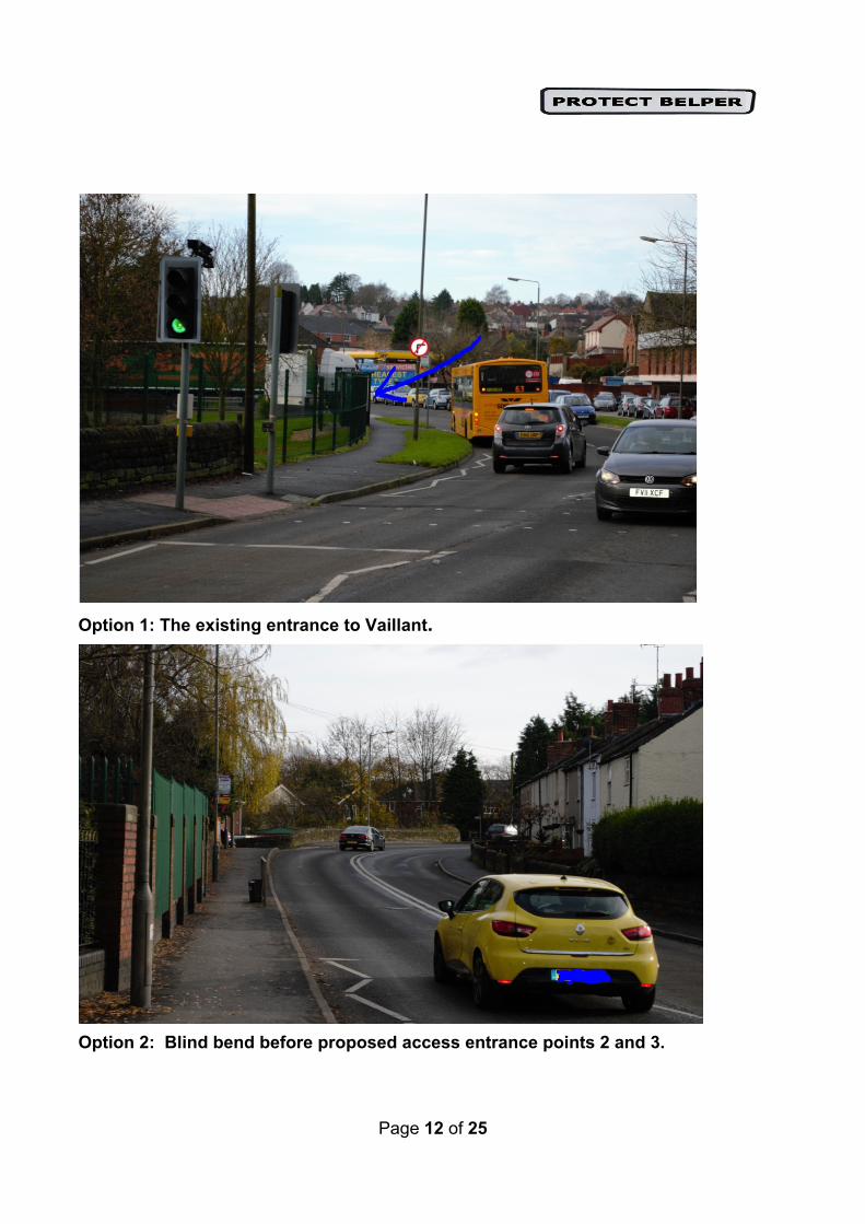
Page 12 of 25
Option 1: The existing entrance to Vaillant.
Option 2: Blind bend before proposed access entrance points 2 and 3.

Page 13 of 25
First sight of proposed entrance points 2 and 3 exiting Belper on A609.

Page 14 of 25
Policy SG14 i) POLLUTION & NUISANCE .
This Policy states that any development proposal needs to involve: “A design which mitigates against any pollution or nuisance associated with any industrial use’’. The inclusion of Bullsmoor in the Core Strategy will lead to unacceptable pollution of the Coppice Brook if the development goes ahead. 3.3% of the proposed land has been identified, within the AVBC commissioned SA report, as being potentially contaminated. This contamination is around the boundary of the Valliant factory. This factory is surrounded by a moat of ditches which lead to the Coppice Brook that flows through the factory grounds and indeed floods into them. Coppice Brook is an ancient water course that flows from Ripley, alongside Bullsmoor, through the Belper Parks Local Nature Reserve and drains into the River Derwent. Bullsmoor is a large site of 7.8 hectares (AVBC 2011 Draft Development Brief: Bullsmoor) and will create considerable water run-off into the Coppice Brook. Gray J (2014 http://www.sustainablebuild.co.uk/pollutionfromconstruction.html) suggests that the construction industry is responsible for more water pollution incidents than any other industry. When land is cleared it causes soil erosion that leads to silt-bearing run-off and sediment pollution. Silt and soil that runs into natural waterways turns them turgid, which restricts sunlight filtration and destroys aquatic life. Surface water run-off also carries other pollutants from the site, such as diesel and oil, toxic chemicals and building materials like cement. When these substances get into waterways they poison water life and any animal that drinks from them. Pollution would also have an effect on local children. Throughout the spring, summer and early autumn, many children play in and around the Coppice Brook getting fresh air and generally having fun. It is not acceptable that they will be playing in a stream contaminated by building waste and chemicals. Coppice Brook flows through the Belper Parks Local Nature Reserve. Derbyshire Wildlife Trust state that the brook supports considerable biodiversity interest. AVBC’s (2013) published vision for the reserve is to return Belper Parks to a place where its native flora and fauna will flourish, growing both in number and diversity, and provide a breathing place in the middle of an increasingly urbanised town for local people and visitors to enjoy their natural heritage. In 2013 the scheme was successful in holding six Green Flags with plans to achieve nine by 2015. In addition, there will be a significant increase in air, noise and light pollution associated with both the construction and the final development.
By allowing development of this site, AVBC will be going against their own stated aims, putting the health of children at risk, and breaching policy E6, by allowing pollution of the Coppice Brook to destroy the biodiversity that currently exists.

Page 15 of 25
COPPICE BROOK DOWNSTREAM FROM BULLSMOOR
COPPICE BROOK IN FULL SPATE
Page 16 of 25
CONCLUSION No firm evidence has been given to justify the deliverability of this sensitive greenfield site within the 5 year period. There is evidence, however, of considerable local opposition to development, ie a 2000+ petition, 484 responses to AVBC’s first consultation on Bullsmoor and approximately 500 attendees at the Town Council special meeting.
The fact that the Bullsmoor site is currently allocated for employment (an allocation which has yet to be reviewed for Part 2 of the Core Strategy) should not now be used to justify developing this site for housing. We agree with English Heritage, who argues that this land, along with Pottery Farm, Cherry House Farm and other contiguous fields that form the setting of the WHS and enhance the OUV of the DVMWHS, should be re-assessed for inclusion in the Greenbelt. The window for adoption of Green Belt designation is within a ‘Local Plan’. The Protect Belper response to Further Proposed Changes to the Submitted Core Strategy (Part 1 of the Amber Valley Borough Local Plan) is thus an appropriate time to request this. Finally, based on the recently revised figures, the allocation of these 150 houses is not required. Given all the evidence provided in this report, the proposed change to include the Bullsmoor site, is neither sound nor justified.

Page 17 of 25