Embed Size (px)
Citation preview

Proposed Tikujiniwadi – Borivali Road Tunnel – Pre-Feasibility Report MSRDC
November 2017
Proposed Road Tunnel betweenTikujiniwadi (Thane) & Borivali(Mumbai) in Maharashtra, IndiaPre-Feasibility Report
This report provides the rationale for the proposed project basedon the current and future needs of the population commutingbetween two suburbs of Mumbai Metropolitan Region

Proposed Tikujiniwadi – Borivali Road Tunnel – Pre-Feasibility Report MSRDC
November 2017
Contents1. INTRODUCTION .............................................................................................................................................. 1
2. EXISTING CONNECTIVITY BETWEEN WESTERN & EASTERN SUBURBS OF MUMBAI .................... 1
3. NEED TO STRENGTHEN CONNECTIVITY .................................................................................................. 2
4. ANALYSIS OF ALTERNATIVES .................................................................................................................... 2
5. SIMILAR PROJECTS IN INDIA ...................................................................................................................... 4
6. PROJECT DESCRIPTION .............................................................................................................................. 6
7. ALIGNMENTS OF PROPOSED ROAD TUNNEL ......................................................................................... 6
8. BENEFITS OF THE PROPOSED PROJECT ................................................................................................ 6
9. APPROACH AND METHODOLOGY FOR GEOTECHNICAL INVESTIGATION ANDENVIRONMENTAL MONITORING ..........................................................................................................................10
9.1 Machinery to be used for drilling ................................................................................................................10
9.2 Equipment’s for environmental baseline monitoring ..............................................................................12
9.3 Schedule for Geotechnical investigation ..................................................................................................12
10. SITE SELECTION FOR GEOTECHNICAL INVESTIGATION THROUGH JOINT SURVEY ....................13
11. IMPACT ASSESSMENT – DESKTOP ASSESSMENT ...............................................................................21
12. IMPACTS OF NOISE AND VIBRATION ON VEGETATION AND WILDLIFE ...........................................24
12.1 Impact on Vegetation and Wildlife habitats due to manual entrance into the National Park .......24
12.2 Mitigation Measures .................................................................................................................................25
12.2.1 Mitigation measures for Potential Noise pollution: ........................................................................25
12.2.2 Mitigation measures for potential Air Pollution ..............................................................................25
12.2.3 Mitigation measures for the impacts related to manual intervention: .........................................25
13. CONCLUSION.................................................................................................................................................26

Proposed Tikujiniwadi - Borivali Road Tunnel – Pre-Feasibility Report MSRDC
1
1. INTRODUCTION
Thane Ghodbundar Road (SH-42) is a major link road connecting Mumbai-Ahmadabad Road(NH-8) part of Golden Quadrilateral near Ghodbundar to Mumbai-Agra Road (NH-3) nearKapurbawadi. This link passes through Municipal Limits of Mira Bhayander Municipal Corporationarea from Ch.00/000 to Ch.04/400 and thereafter it passes through Thane city urban area fromCh.04/400 to Ch.14/900. This is an important East-West link and carries heavy commercial trafficbetween NH-3 and NH-8. This road faces massive traffic congestion at various spots during peaktraffic time. Congestion of traffic causes undesired burning of automobile fuel, which is a nationalloss in addition to the contribution of pollution, which would be a contributing factor for air qualityin the adjacent Sanjay Gandhi National Park. Keeping in view, these factors in addition toreducing travel time and easy access between Thane and Western suburbs of Mumbai, it isproposed to construct twin tube 3 lane tunnel between Thane and Borivali under Sanjay GandhiNational Park.
The Maharashtra State Road development Corporation (MSRDC) is proposing to construct Twintube, 3 Lanes (each side) highway tunnel of about 10.8 km, which passes through below theSanjay Gandhi National Park (SGNP), connecting Western Express Highway (WEH) near Borivaliand Ghodbunder road (of Thane) Near Tikujiniwadi. The feasibility of tunnel boring machinetechnology will be explored for doing the tunneling work as it causes very low vibrations and willhave minimal impact on the surface environment. The tunnels may be connected by central 3 mwide baby tunnel; the vertical clearance in each tunnel is proposed to be minimum 5.50 m. Thetwo twin tunnel would be about 2D apart in base and each tunnel will consist of threeunidirectional lanes.
2. EXISTING CONNECTIVITY BETWEEN WESTERN & EASTERNSUBURBS OF MUMBAI
Major arterial roads in this region are Western Express Highway leading to NH8 and EasternExpress Highway leading to NH3. Both these Highways; especially Western Express Highway(5+5 lane wide) experiences huge traffic jams between 8am to 12pm in the morning and 6 pm to11 pm in the evening with average travel speed reduced to less than 20 km/hr, resulting in hugefuel loss, causing major air and noise pollution in the city.
At present main east-west connecting links between these two major arterial roads from Bandrato Dahisar on Western Express Highway and Sion to Mulund on Eastern Express Highway, asshown in are as below;
1. Bandra – Sion Road2. SCLR ( Santacruz - Chembur Link Road)3. AGLR (Andheri-Ghatkopar (Kurla) Link Road)4. JVLR ( Jogeshwari – Vikroli Link Road)
All these links are overcrowded and experience huge traffic jams. Further, there is no east-westlink available between JVLR and Thane-Ghodbandar Road i.e. between Jogeshwari to MiraBhyander on Western Express Highway – NH8 and Vikroli to Thane on Eastern Express highway-NH3. The next link available is Thane-Ghodbunder road connecting Thane on NH3 andGhodbunder on NH8. Due to non-availability of east-west connectivity, vehicles coming from NH8(Ahmedebad) and Western Suburbs, (Goregaon to Mira Bhyander) and going to Thane or to

Proposed Tikujiniwadi – Borivali Road Tunnel – Pre-Feasibility Report MSRDC
2
eastern suburbs have to travel upto Ghodbunder, take Thane-Ghodbunder Link and then to theirdestination in eastern suburbs. Similarly vehicles from Nashik, Kalyan-Dombivali, Navi Mumbai,Thane, and Eastern Suburbs going to western suburbs have to take Thane-Ghodbunder link andfrom Ghodbunder they have to travel to their destination. Thus large numbers of vehicles have totake huge detour leading to wastage of time, fuel and resulting in more air and noise pollution.Considering present east-west traffic volume and future increase; at least two to three newconnectivity links between JVLR and Thane Ghodbunder road needs to be developed.
3. NEED TO STRENGTHEN CONNECTIVITY
Current population of MMR region is about 18.5 million (2011 census) and out of this populationabout 70% population resides in Mumbai Suburb (east–west) and Thane region. Majordevelopments are also happening in this region. The need for connectivity between two suburbshas been studied with respect to projected increase in population, traffic volumes and responsefrom existing transportation network as summarized as below.
A study conducted by Mumbai Metropolitan Region Development Authority (MMRDA) titled“Comprehensive Transportation Study for Mumbai Metropolitan Region” has analysis threepreferred deferent development scenarios. Some of the results of analysis providing a feel ofincrease in traffic are as follows.
After reviewing the growth of population, employment and external goods vehicle travel by 2031as compared to 2005 (1.63 times growth in population, 2.04 times growth in employment and 4.00times growth in external goods travel), a growth factor of 3.00 has been assumed for internalgoods vehicle travel by 2031. External travel demand, vehicle entering, leaving or passingthrough the MMR play a crucial role, connecting the study area with the state and the rest of Indiaprincipally along the national and state highway, Eastern Express highway, Sion-Panvel Highway,Thane-Godbandar Road, etc.) corridors connecting the ports (Wadala Truck Terminal Road, RafiAhmed Kidwai Road, PD’Mello Road, NH4B, SH54, etc.) economic growth in the catchment areasof the connective road systems.
Over a period of 16 years (2005-21), it is estimated that, the private vehicle (two wheeler and car)model share will increase from 12.8% to around 21.5%. IPT trips (Auto Rickshaw and Taxi) areaexpected to decrease from 9.1% to around 5.6 % in three different growth scenarios reflecting theincrease in private vehicle ownership and walk to metro.
Therefore considering the potential increase in demand and limited available connectivitystrengthening of existing roads have been proposed by removing bottlenecks and additionalconnectivity is proposed.
4. ANALYSIS OF ALTERNATIVES
Distance between existing east-west link roads i.e. NH8 near Borivali and Thane-Ghodbunderroad is about 25 km. Therefore, in order to reduce the load on Thane-Ghodbander road and tomeet future requirements the 2 to 3 link road should be provided between east and west. Almostentire area between Western Express Highway and Eastern Express Highway is covered byArrey Dairy (forest) and SGNP, hence, no east-west link could be developed in this area in spiteof genuine necessity. Considering this difficulty following alternates, in the best favour ofenvironment, are being explored.

Proposed Tikujiniwadi - Borivali Road Tunnel – Pre-Feasibility Report MSRDC
3
a. Capacity enhancement of Thane-Ghodbander road by providing widening orelevated road
Elevated road on Thane-Ghodbander road chg. 0/400 to 4/500 passing through SGNP atsome locations is underway. This work is being performed to avoid the present situation oftraffic congestion and cannot bear the load of further increase in traffic volume over theyears.
Further to this, Right of Way (ROW) in the Thane Municipal Corporation has already beenfully utilized by providing 3+3 lanes road and 1 lane of service road on either side. Thisstretch cannot be further widened.
b. Goregaon-Mulund Link Road (Elevated or Tunnel under Aarey Dairy) – by MCGM.
A new link road which has been proposed by MCGM is under consideration and beingstudied by the consultants. However, this road doesn’t shorten the route for commuterstravelling between Thane and Borivali. Instead the Travelling length and travel time for thecommuters is increased. In the present condition, commuters need to travel approx. 23 kmvia Ghodbunder road to reach Borivali from Thane. After completion of GMLR it would bemore than 30 km, which won’t serve the purpose of providing a shortest route to connectNH3 with Western suburb (Borivali) and vice-versa. Therefore, considering the expectedtravel demand from Thane to Western Suburbs (Dahisar to Goregoan), Thane – BorivaliTunnel is critical.
c. Tikujiniwadi - Borivali Link (Tunnel under SGNP) by MSRDC
Elevated road between Tikujiniwadi and Borivali, would be cheaper than tunnelconnectivity. However, elevated road option is not being considered as the same, if passesthrough SGNP, may lead to significant disturbance to wild life and use of forest land.
On the other hand tunnel construction would not require any forest land (or very minimumland), no displacement of people, no tree cutting etc. and lead to no or very little air andnoise pollution during construction as well as during operations (muck removal and /disposal during construction will be planned meticulously). The proposed tunnel alignmentcan be finalized only after survey and investigations, for which permission is being sought.
d. Borivali-Thane ropeway over SGNP by MMRDA
An aerial tour over Sanjay Gandhi National Park (SGNP) with amazing scenic view of theforest has been proposed by The Mumbai Metropolitan Region Development Authority(MMRDA). The ropeway from Borivali to Thane is proposed in a bid to make the park abigger attraction for the tourists. This is not a bid to decongest the east-west suburbconnecting roads.
http://www.hindustantimes.com/mumbai/borivli-thane-ropeway-planned-over-sgnp/story-2Gbt7j0d2fKDTeWVznlhPN.html

Proposed Tikujiniwadi – Borivali Road Tunnel – Pre-Feasibility Report MSRDC
4
5. SIMILAR PROJECTS IN INDIA
Other recent project involving protected forest area in India cleared in recent past. Reference andrespective weblink from public domain are as below;
5.1 Dedicated Freight Corridor in Western India gets Forest Clearance
The Dedicated Freight Corridor (DFC) project in western India, spanning over about 1,500kilometres and covering six states, has received forest clearance from the Central Forest AdvisoryCommittee on December 22, 2015. The clearance is for 58 hectares (ha) of forestland inMaharashtra in the reserved and protected forest areas of Thane (16 ha) and Dahanu (31 ha)forest divisions. It includes 10.8 ha of forestland diversion in Mumbai’s Sanjay GandhiNational Park (SGNP).
http://www.downtoearth.org.in/news/dedicated-freight-corridor-in-western-india-gets-forest-clearance-39903
5.2 Sevoke-Rongpo BG Rail line (52-km) project gets Clearance from NationalBoard for Wildlife
The National Board for Wildlife (NBWL), the apex body chaired by the Prime Minister of India,gave its final nod to the Sevoke-Rongpo new broad-gauge railway line earlier during mid 2015.The NBWL standing committee, in its June 2, 2015 meeting urged that the Northern FrontierRailways be allowed to start work immediately.
http://www.railnews.co.in/52-km-sevoke-rongpo-bg-rail-line-project-gets-clearance-from-national-board-for-wildlife/
5.3 Maharashtra State Board for Wildlife approves two projects
Maharashtra State Board for Wildlife (SBWL) has cleared two major projects, includingupgradation of the railway line through Melghat Tiger Reserve (MTR) and a lift irrigation schemethrough Koka Wildlife Sanctuary.
Of the 176 km broad gauge line that will pass from Akola to Khandwa, over 38 km line passesthrough wildlife-rich area of tiger reserve and buffer zone.
Chief wildlife warden (CWLW) and member-secretary of SBWL, Shree Bhagwan, hasrecommended that existing underpasses need to be extended up to required width, besidescreating new underpasses. Fencing should also be provided along the length of the railway line. Ithas also recommended relocation of Pili, Harisal and Mangia villages by the railways and thatprovision of the amount for relocation is included in the project cost itself. The board also clearedSurewada lift irrigation project situated on left bank of Wainganga river near Surewada inBhandara. The project consists of 8.10 km underground rising main and 16.14-km-long maincanal with 40 km distribution system. The project aims to provide irrigation for a 7,050 hectarearea in 28 villages. Out of the 8.10 km, 0.650 km-long raising main falls within Koka sanctuary.
The proposed canal work will be passing through the sanctuary, buffer zone and the eco-sensitivezone of Navegaon - Nagzira Tiger Reserve (NNTR).http://www.projectstoday.com/News/Maharashtra-State-Board-for-Wildlife-approves-two-projects

Proposed Tikujiniwadi - Borivali Road Tunnel – Pre-Feasibility Report MSRDC
5
Figure 1: Connecting Road between Eastern and Western Suburban areas of Mumbai

Proposed Tikujiniwadi – Borivali Road Tunnel – Pre-Feasibility Report MSRDC
6
6. PROJECT DESCRIPTION
The proposed 10.8 km road tunnel will start from Tikujiniwadi near Patlipada in Thane-Godbunder road and end at the Western Express Highway end near Magathena Bus depot withtwin tube tunnel. The proposed tunnel option will explore the possibility of another shorter andeconomical alignment to connectivity of two National Highways NH-3 and NH-8 which will notonly save the time but will also help in reducing the traffic congestion from current route. Atpresent, motorists have to travel 25 km in order to reach the Thane Tikujiniwadi area from Borivalivia the Western Express Highway (WEH) and Thane- Godbunder road. Thane and Borivali will beconnected in 20 minutes by this tunnel.
The objective of the proposed project is conducting detailed feasibility study and preparation ofdetailed project report for the construction of twin tube, 3 Lanes each highway Tunnel betweenTikujiniwadi in Thane city to Western Express Highway. Approximate project cost would be aboutINR 2500 Crores.
7. ALIGNMENTS OF PROPOSED ROAD TUNNEL
The alternative locations / routes will be analysed during the survey so as to leave least impact onthe environment. The tentative options as identified during the preliminary assessment. Threeportals on either end were identified and respective alignments were evaluated. Many possiblealignments due to involvement of forest and defense land in large extent were rejected. Otherpossible alignments (Option-1, Option-2 and Option-3) are shown in Figure-2 and discussedsubsequently.
8. BENEFITS OF THE PROPOSED PROJECT
In view of increasing traffic load on thane Ghodbander road, it is necessary to look for analternative. Therefore road tunnel passing below Sanjay Gandhi National park is being proposedwhich will provide fast and smooth movement of traffic from Thane to Borivali. The distancebetween thane and Borivali is also expected to reduce by over 10 km. This will also result inavoidance of traffic jams and saving fossil fuel and protecting environment due to reducedvehicular emissions.
· Distance saving for Thane to Borivali by about 10 Km.· No disruption to existing township· Travel time saving 20 to 25 minutes
Road tunnels were adopted in past only where other practicable means of road were not possiblemostly for the highways in hilly terrains. Urban road tunnels were often discouraged due to anexpensive option. However, it is increasingly difficult to provide the additional road space that maybe required. Tunnels reduce noise, air pollution, community disharmony and are visually attractiveunlike surface roads. The intangible costs, such as effect on community health, air pollution andnoise, make tunneling viable if they are assessed. Construction costs are used to comparealternative transportation routes and in case other factors are considered, then tunneling wouldbecome a viable option. Currently the local community has to bear these costs as they are notrecognized or accounted for in the normal evaluation of alternatives.

Proposed Tikujiniwadi - Borivali Road Tunnel – Pre-Feasibility Report MSRDC
7
Figure 2: Comparative Evaluation of the Portals and Tunnel Alignment Alternatives
Portals and alignment marked on Map (1:50000 scale) – also attached separately
Portals and alignment marked on Satellite Imagery
Satellite Imagery Source: Google Earth
The three alignments were studied comprehensively and compared. After the detailedassessment, Option 2 is being persuaded for further studies.
Option -3
Option-1
Option -2

Proposed Tikujiniwadi - Borivali Road Tunnel – Pre-Feasibility Report MSRDC
8
Table -1: Salient Features of Various Alternates to be studied for Alignment
Option 1 Option 2 Option 3
Location From Western Express Highway near MagathaneDP road to Shastri Nagar junction on Pokhranroad no. 1
From NH8 near Magathane DP road toTikujiniwadi near Patlipada
From Ekta Nagar in Western side to Shastri Nagarjunction on pokhran road no. 1
Land availabilityfor developmentof portal/ Cut ncover
Private/ Government land on Western side andGovernment (Defence) land on Eastern side
Private/ Government land on both Western andEastern side
Private/ Government land on Western side andGovernment (Defence) land on Eastern side
Topography andLanduse
The proposed western end is far away from theNational park boundary and is habitated atpresent. However, there is a redevelopment planof BMC of the region.
The proposed eastern end lies outside theNational park in the defence land.
The topography along the alignment is Undulatingon a hilly terrain under green cover.
The proposed western end is far away from theNational park boundary and is habitated atpresent. However, there is a redevelopmentplan of BMC of the region.
The proposed eastern end lies outside theNational park in the forest area.
The topography along the alignment isUndulating on a hilly terrain under green cover.
The proposed western end location is on theborder of SGNP (north-western corner). Thetopography of the area undulating rocky areasloping towards north west direction.Eastern portal is outside the SGNP. Open landparcel sloping towards eastern direction.
Approx. Lengthof proposedalignment (km)
9.68 10.85 12.56
GroundElevationApprox. mabove msl
470 m (max.) 357 m (max.) 397 m (max.)
Proximity to eco-sensitive area
> 95% of total proposed alignment is withinSGNP. However, no National park land requiredfor the construction.
> 95% of total proposed alignment is withinSGNP. However, no National park land requiredfor the construction.
> 95% of total proposed alignment is within SGNP.However, no National park land required for theconstruction.
PopulationDensity
Significant population of slum area at the Westernend at present which is the part of BMC’sredevelopment plan.
Significant population of slum area at theWestern end at present which is the part ofBMC’s redevelopment plan.
No population along the proposed alignment.

Proposed Tikujiniwadi - Borivali Road Tunnel – Pre-Feasibility Report MSRDC
9
Option 1 Option 2 Option 3
Population along the proposed alignment aboveYeoor hills
Developing residential societies of Patlipadanear eastern end.
DirectConnectivity toNationalHighway
Direct Connectivity to NH8 and Pokhran roadnumber 2 at both western and eastern endrespectively through Cut n cover.
Direct Connectivity to NH8 and ThaneGhodbunder road at both western and easternend respectively through Cut n cover / accessroads.
Connectivity to NH8 on western side throughelevated structures and Pokhran road on easternend through access roads.
Proximity toidentified waterSources
Alignment is crossing one identified streamflowing from south to north in the middle east ofthe forest area
Alignment is crossing one identified streamflowing from south to north in the middle east ofthe forest area
Alignment is crossing one identified stream flowingfrom south to north in the middle east of the forestarea
Loss ofagricultural land
Nil Nil Nil
Proximity to ASIsites
No No No

Proposed Tikujiniwadi - Borivali Road Tunnel – Pre-feasibility Report MSRDC
10
9. APPROACH AND METHODOLOGY FOR GEOTECHNICALINVESTIGATION AND ENVIRONMENTAL MONITORING
The survey activity will include geotechnical investigation and environmental monitoring by corerecovery drilling of bore holes, by calyx drilling machine simultaneously on both the portals, forgeological assessment at few locations, environmental baseline monitoring including samplecollection of ambient air quality, noise, surface water, soil, etc. and lab analysis of samples.
Keeping in view the sensitivity of the forest and wildlife in addition to the homogeneous lithologyof the area, drilling of boreholes throughout the alignment may not be required. Sample boreholes of NX Dia may be restricted to the portal area and possible locations along the routes in thepark. The cores shall be collected throughout the length of the drill hole. This data will besupported by surface rock samples which may collected during trekking along the suitablealignment as a part of survey. These samples shall be collected at the change of geology on anaverage at 1.0-2.0 Km distance based on the accessibility inside the forest area. The locationsfor drilling of boreholes have been selected in consultation with forest authorities during jointsurvey with a criteria that no tree felling is sought for the survey work. The proposed locations ofdrilling for study of Option-2 as identified during walkthrough survey conducted during 5th and 6th
January 2017 with SGNP representative are mentioned in subsequent section of this report.These locations have been identified based on the ease of accessibility and out of these onlyabout 9 (7 in Tulsi/Krishnagiri and 2 in Yeur range inside the national park along the alignment)best suitable locations have been identified during the survey.
9.1 Machinery to be used for drillingThe drilling equipment and machinery will depend upon the type of strata encountered.
Figure 3: Machinery to be used for soil borehole drilling

Proposed Tikujiniwadi - Borivali Road Tunnel – Pre-feasibility Report MSRDC
11
Figure 4: Soil SPT Testing
Figure 5: Core recovery boxes (to be used in case of rock encountered)

Proposed Tikujiniwadi - Borivali Road Tunnel – Pre-feasibility Report MSRDC
12
9.2 Equipment’s for environmental baseline monitoring
Figure 6: High volume dust sampler
9.3 Schedule for Geotechnical investigation
An indicative schedule for the geotech investigation is as proposed below. The schedule forEnvironmental Baseline monitoring will be proposed separately once the Terms ofReferences are approved from competent authority for the study.
Table -2: Indicative Schedule for Geotech Investigation
Schedule for environment monitoring will be prepared once the work is started.

Proposed Tikujiniwadi - Borivali Road Tunnel – Pre-feasibility Report MSRDC
13
10. SITE SELECTION FOR GEOTECHNICAL INVESTIGATIONTHROUGH JOINT SURVEY
MSRDC had originally submitted an application for seeking prior permission for carrying outinvestigative survey vide letter no. MSRDC/02/JMD(III)/Tunnel/File No. 01/3136 dated 8-Jun-16. However, due to alignment change another request was submitted by MSRDC to theoffice of CCF cum Director – Sanjay Gandhi National Park (SGNP) for joint walkthroughsurvey. A permission for joint survey for the purpose was granted by CCF and Director ofSGNP vide letter no. 4033 dated 3-Jan-17 was accorded in response to above referredMSRDC request.
Accordingly, a walk through joint survey was conducted along the proposed alignment byforest and project representatives on 5-Jan-17 and 6-Jan-17. During the joint survey,locations for geotechnical investigations were identified with the criteria of minimal reversibleimpact on environment.
Joint team of forest representatives and project representatives as below met at SGNPfollowed by the survey was conducted;
SGNP Representatives
Assistant Conservator of Forest (Protection & Wildlife)
Smt. Priyanka Barge - Range Forest Officer (Tulsi Range)
Mr. Rajendra Pawar - Range Forest Officer (Krishnagiri Range)
Mr. Sanjay Waghmode - Range Forest Officer (Yeoor Range)
MSRDC Representatives
Mr. Shridhar Arlikar, Executive Engineer
Mr. Aniruddha Borde, Assistant Engineer
AECOM (Consultant to MSRDC)
Mr. Atul Kumar,
Mr. Manas Shirsat,
Ms. Rashmi Dutta,
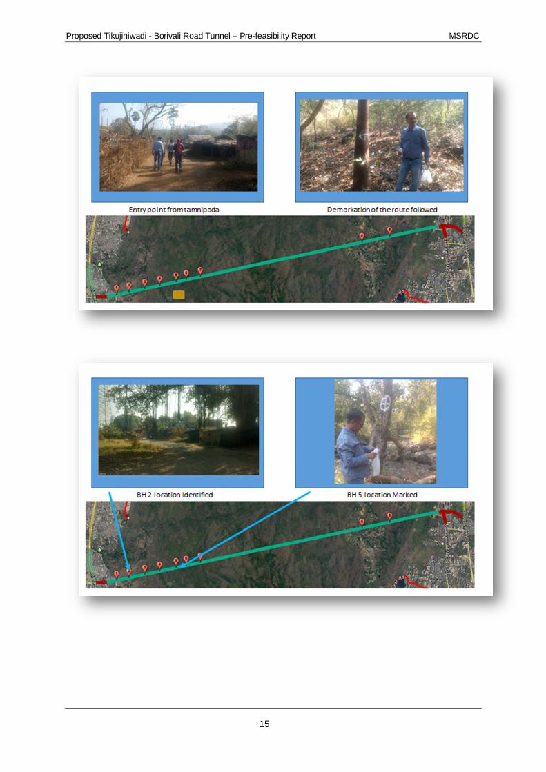
Series of photographs tied up with identified Geotech investigation locations on the proposedalignment during the joint survey is presented as below. The photographic log below, represents thatthe identified locations have enough open space for the installation of drilling machine and no treefelling is required, a flat surface and not a part of dense forest.

Proposed Tikujiniwadi - Borivali Road Tunnel – Pre-feasibility Report MSRDC
14
Overall Proposed alighnemtn of tunnel and identified borehole locations
Proposed Tikujiniwadi - Borivali Road Tunnel – Pre-feasibility Report MSRDC
15

Proposed Tikujiniwadi - Borivali Road Tunnel – Pre-feasibility Report MSRDC
16

Proposed Tikujiniwadi - Borivali Road Tunnel – Pre-feasibility Report MSRDC
17

Proposed Tikujiniwadi - Borivali Road Tunnel – Pre-feasibility Report MSRDC
18

Proposed Tikujiniwadi - Borivali Road Tunnel – Pre-feasibility Report MSRDC
19

Proposed Tikujiniwadi - Borivali Road Tunnel – Pre-feasibility Report MSRDC
20
The identified locations for Geotech investigation and drilling bore holes are as listed below;
Table -3: Exploratory Borehole Locations and Quantity of Samples to be collectedfrom SGNP area
S.NO BoreHole no. Easting Northing Depth
Length (m) ofdrill hole for
SIZE OF ROCKSAMPLES
RockSampleVol (m3)
Leng
thm
t.
DiaSoil Rock
1 FBH-1 276255.8 2126766 21 1 20 20 54.7 0.05
2 FBH-2 276641.8 2126841 31 1 30 30 54.7 0.07
3 FBH-3 277135.6 2126940 33 1 32 32 54.7 0.08
4 FBH-4 277606.5 2127032 39 1 38 38 54.7 0.09
5 FBH-5 278118.2 2127136 45 1 44 44 54.7 0.10
6 FBH-6 278437.7 2127202 49 1 48 48 54.7 0.11
7 FBH-7 278879.7 2127288 60 1 59 59 54.7 0.14
8 FBH-8 284817.2 2128460 86 1 85 85 54.7 0.20
9 FBH-9 283950.3 2128283 98 1 97 97 54.7 0.23
TOTAL 453 453 1.07Surface SamplesAbout 2 kg rock Samples at each change of geology / 1Km length.
The drill holes from FBH-1 to FBH-9 shall be carried out in the park area and the cumulativequantity of Surface Rock, Soil and Rock Core samples to be collected and transported out ofSanjay Gandhi National Park will not exceed 2.00 m3.

Proposed Tikujiniwadi - Borivali Road Tunnel – Pre-feasibility Report MSRDC
21
11. IMPACT ASSESSMENT – DESKTOP ASSESSMENT
The purpose of this desktop study for “impact assessment” is to identify potential impacts onthe existing environmental conditions within the national park, due to the proposed surveywork. Based on the impacts identified, the mitigation measures, corresponding to the impacts,have also been suggested in the report.
These investigations are necessary to identify the types of soils and materials present belowthe ground surface in the area, in order to determine feasibility to construct the majorcomponents. These major components would require specific and accurate geotechnicalinformation, such as different amounts and types of support from the underlying earthenmaterials.
The aim of this assessment is to protect park resources, to minimize the extent of surface andsubsurface disturbance, and to ensure that sites are left as close to pre-disturbanceconditions to the extent possible. Hand equipment and pedestrian access is preferred. It isrecognized that mechanized equipment may be a reasonable or sole alternative dependingupon the type of project and site characteristics. This report will also help in help in definingthe terms for obtaining permission for taking up proposed non forestry activities inside SanjayGandhi National Park, Borivali.
The rationalizing and upgrading the transport system is imperative especially long distanceroutes. In the process of development there has been intensive use of natural resources. Veryoften the process of development has adversely affected the environment leading toecological imbalances. The importance of conserving and enhancing the environmentalassets has assumed urgency.
The Impact Assessment process began with the scoping process to identify the significantenvironmental impacts due to the proposed survey work inside SGNP. The type andmagnitude of the impacts, however, depend on the specific attributes of the givenenvironment. As far as possible, based on the secondary data, attempts have been made toquantitatively predict the impacts due to the proposed survey work. However, for non-quantitative impacts, qualitative assessment has been done. Potential impacts onenvironment due to the proposed activities have been summarized in Table-4. The impactsdue to the project location are generally irreversible but minor in nature. However, impactsrelated to the survey work are very short term, which can be set-off by observing a set ofprecautionary measures

Proposed Tikujiniwadi - Borivali Road Tunnel – Pre-feasibility Report MSRDC
22
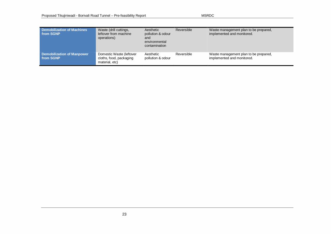
Table-4: Impact Matrix of Potential Environmental Impacts
Major Proposed Activities Potential Aspect Potential Impact Reversible / nonreversible
Mitigation Measure
Mobilization of Machines insideSGNP
Noise from movement ofmachine transport vehicles
Increase in Noiselevel
Reversible Movement to be managed on predefined roadsclosest to the park boundary. All the movementduring day time. Route to be decided in consultationwith SGNP authorities.
Mobilization of Machines insideSGNP
Fugitive dust emission dueto movement of vehicle
Degradation ofambient airquality
Reversible Movement to speed to be maintained within 20 kmph.Movement during day time only.
Mobilization of Manpowerinside SGNP
Domestic waste generationfrom food, etc.
Aestheticpollution & odour
Reversible Waste management plan to be prepared,implemented and monitored.
Mobilization of Manpowerinside SGNP
Noise due talking andshouting by drilling workers
Increase in Noiselevel
Reversible Training to the manpower for maintaining disciplineinside SGNP.
Drilling Activity Clearing of shrubs(minimum to the extentpossible)
Loss ofvegetation
Reversible Drilling locations to be selected requiring minimumclearing of vegetation.
Drilling Activity Noise & Vibrationgeneration from rock drilling
Increase in Noiselevel
Reversible - Drilling activity to be restricted to day time only;- Drilling locations to be selected away from
controlled drilling core area of the forest;- Drilling area close to core area will be provided
with noise barriers.Drilling Activity Fugitive dust emission from
rock drillingDegradation ofambient airquality
Reversible Water spray around drilling area to supress thefugitive dust emission.
Drilling Activity Emission from fuelcombustion for generatingcompressed air
Degradation ofambient airquality
Reversible - Compliance certificate on applicable emissionstandard from the power generator;
- Pollution under control certificate as perapplicable motor vehicle act for the vehicle.
Drilling Activity Noise generation from Aircompressor / diesel powergenerator
Degradation ofambient noiselevel
Reversible - Compressor should be noiseless- Acoustic enclosure to be provided with power
generator;
Environmental BaselineMonitoring
Noise generation from highvolume sampler
Increase in Noiselevel
Reversible High volume samplers to be installed in areas near tohuman population inside SGNP, where baselinenoise is already high compared to core forest area.
Proposed Tikujiniwadi - Borivali Road Tunnel – Pre-feasibility Report MSRDC
23
Demobilization of Machinesfrom SGNP
Waste (drill cuttings,leftover from machineoperations)
Aestheticpollution & odourandenvironmentalcontamination
Reversible Waste management plan to be prepared,implemented and monitored.
Demobilization of Manpowerfrom SGNP
Domestic Waste (leftovercloths, food, packagingmaterial, etc)
Aestheticpollution & odour
Reversible Waste management plan to be prepared,implemented and monitored.

Proposed Tikujiniwadi - Borivali Road Tunnel – Pre-feasibility Report MSRDC
24
12. IMPACTS OF NOISE AND VIBRATION ON VEGETATIONAND WILDLIFE
Drilling equipment and machinery would generate the noise from the associated activities.The potential impact of the proposed construction activities on the ambient noise quality ofnearby areas will include the following:
The geotechnical investigation and collection of soil samples would utilize constructionequipment commonly used on roadway construction projects which typically range from 80 to89 dBA at a distance of 50 feet. Construction noise is expected to increase during peakconstruction time with operation of equipment and machinery engaged for constructionactivities. Drilling may have local site-specific impacts but probably not long-term effects
Wildlife may be sensitive receptors to noise and vibrations. Animals rely on meaningfulsounds for communication, navigation, avoiding danger, and finding food. The level ofdisturbance may be qualified as damage, which may harm health, reproduction, survivorship,habitat use, distribution, abundance or genetic distribution, or disturbance which causes adetectable change in behaviour. Behavioural and physiological responses of wildlife to noisehave the potential to cause injury, energy loss, decrease food intake, habitat avoidance andabandonment, and reproductive losses.
The potential impact of high noise generation is mainly disturbance to the habitations in theproximity. The SGNP is a house of a wide variety of flora and fauna and wildlife, includingmany species of insects, types of mammals, and a myriad of bird species. Inside the Park,there are two lakes: Vihar and Tulsi but these are over 3 km away from proposed locations. Inaddition archaeological sites within the Park trace back to the Golden Age of Buddhism in 1stcentury BC. Religious sites are scattered around the park; the most famous being the KanheriCaves, 109 caves in an area overlooking the Park that bring up to 10,000 visitors per year.Incidentally this archaeological site is also over 3 km away from proposed survey locations.
No significant noise impacts from the geotechnical investigations or soil surveys areanticipated because activities would be conducted in accordance with National AmbientQuality Standards and would be temporary and short term. Furthermore, the equipment wouldnot operate continuously at any single location. Noise associated with the field survey wouldbe limited to vehicle noise accessing the site. Once on site, the field survey activities are notexpected to result in excessive noise, as activities would involve a field surveyor walking thesite by foot with a survey road and making visual observations. There would be no significantimpacts to noise as a result of project related noise.
12.1 Impact on Vegetation and Wildlife habitats due to manualentrance into the National Park
The rich flora and fauna of Sanjay Gandhi National Park attracts more than 2 million visitorsevery year. The park is home to a number of endangered species of flora and fauna. Theforest area of the park houses over 1000 plant species, 251 species of migratory, land andwater birds, 50,000 species of insects and 40 species of mammals. In addition, the park alsoprovides shelter to 38 species of reptiles, 9 species of amphibians, 150 species of butterfliesand a large variety of fish.

Proposed Tikujiniwadi - Borivali Road Tunnel – Pre-feasibility Report MSRDC
25
Project activities such as drilling would temporarily produce activity and manual entrance thatwould disturb wildlife and cause them to disperse. This local displacement would create ashort-term impact to large and small mammals. Displacement would affect a small number ofoverwintering breeding birds. Overall, effects on wildlife would be short-term and minor.
12.2 Mitigation Measures
The mitigation measures to the identified impacts have been mentioned in the table 3.1 Thissection describes environmental commitments that would be implemented as part ofthe project. The avoidance/minimization measures discussed below would be included aspart of the project, and would further decrease the severity of any short term ortemporary impacts on resources.
12.2.1 Mitigation measures for Potential Noise pollution:
The mitigation measures to be adopted for mitigation of excess noise are as below;· Movement to be managed on predefined roads closest to the park boundary.
Vehicular movement to be restricted to day time;· Route for movement to be decided in consultation with SGNP authorities;· Training to the manpower for maintaining discipline inside SGNP;· Drilling activity to be restricted to day time only;· Drilling locations to be selected away from controlled drilling core area of the forest;· Drilling area close to core area will be provided with noise barriers;· Compressor should be noiseless;· Acoustic enclosure to be provided with power generator;· High volume samplers to be installed in areas near to human population inside
SGNP, where baseline noise is already high compared to core forest area· All equipment will have sound control devices no less effective than those provided on
the original equipment. No equipment will have an unmuffled exhaust.· Truck loading and unloading will be conducted so that associated noise impacts are
kept to a minimum by carefully selecting routes to avoid going through residentialneighbourhoods to the greatest extent possible.
In case of noise complaints by the public, the field manager will be notified andimplementation of noise mitigation measures will be reviewed, if necessary.
12.2.2 Mitigation measures for potential Air Pollution
Suggested mitigation measures for impacts identified on air quality are as below;· Movement to speed to be maintained within 20 kmph. Movement during day time
only;· Water spray around drilling area to supress the fugitive dust emission;· Compliance certificate on applicable emission standard from the power generator;· Pollution under control certificate as per applicable motor vehicle act for the vehicle.
12.2.3 Mitigation measures for the impacts related to manualintervention:
Mitigation measures required towards impacts identified due to manual intervention inside theSGNP are as follows;
· Training to the manpower for maintaining discipline inside SGNP in order to avoid orterminate activities on-site that attract or harass wildlife;

Proposed Tikujiniwadi - Borivali Road Tunnel – Pre-feasibility Report MSRDC
26
· Waste management plan to be prepared, implemented and monitored. All work areasare to be closely policed for litter, and food and food waste may be stored only withinan approved bear-proof facility, or secure building or vehicle. Food waste is to be keptseparate from construction waste and removed daily;
Temporary work space may require clear marking with flagging to contain the work area,minimize soil and vegetation disturbance, and to prevent trespass violations by the contractor
Generally, clearing vegetation beyond herb layers and surface litter is to be avoided, andalternate or surrogate locations sought. Where, absolutely necessary to work adjacent toexisting trees and shrubs, the permittee shall exercise all possible care to avoid injury tovegetation.
Protect roots of trees to drip line during excavation to prevent disturbance or damage. Avoidunnecessary traffic, dumping, and storage of materials over root zone. The drilling locationsto be identified requiring minimum clearing of vegetation.
13. CONCLUSION
Proposed work is limited to geotechnical investigation and environmental monitoring work forconducting Environmental Impact Assessment study. The geotechnical investigation locationshave been identified during joint survey with criteria of minimal reversible impact with no treefelling. The minimal reversible impacts have been identified, evaluated and mitigationmeasures have been identified. Implementation of the measures described in Section 11.4above as Avoidance / Minimization Measures would result in to further reduction of impactsdue to proposed geo-technical investigation and environmental baseline monitoring.