Embed Size (px)
Citation preview

1
PROPOSED SYLLABUS FOR
M.A. / M.Sc. COURSE IN
GEOGRAPHY AND DISASTER MANAGEMENT (SEMESTER SYSTEM)
2009-2010
Department of Geography and Disaster Management TRIPURA UNIVERSITY (A Central University)
SURYAMANINAGAR - 799130, TRIPURA WEST TRIPURA
INDIA

2
BACKGROUND OF THE REVISED SYLLABUS
The Department of Geography and Disaster Management, Tripura University has started its journey in December, 2004. Since its inception the Department offers M.A. / M.Sc. and Ph. D. courses in Geography and Disaster Management. The first syllabus was prepared in the year 2004 and hence the revision of the syllabus was necessary to keep pace with the modern changes in the subject. Salient features of the proposed course and syllabus are as follows:
BASIC STRUCTURE
The M.A./M.Sc. Course in Geography and Disaster Management shall be a full-time course of two years’ duration spreading over four Semesters, each of six months. There shall be 1600 marks in total and each Semester shall carry 400 marks.
There shall be 16 Papers (11 Theoretical and 5 Practical) to cover the whole Syllabus. Each Semester shall contain four Papers. Each Paper shall be divided into three Groups (Group A, B and C) out of which Group C shall contain Internal Assessment. The distribution of marks shall be 40+40+20.
Among 5 practical papers students will have to submit a field report (204B) on any branch of Geography and a dissertation (404B) related to the concerned special papers. The field report and dissertation will be evaluated on the basis of (a) Written Report and (b) Seminar presentation and Viva-voce (25+15 marks).
INTERNAL ASSESSMENT
20 marks will be allotted for Internal Assessment for each paper that shall be divided equally in two groups (A and B) for assessment (10+10). Internal Assessment will be done by the concerned teacher(s) during the concerned semester period on the basis of any one of the following method : written examination/ micro project preparation / seminar/viva-voce / class work.
FIELD REPORT AND DISSERTATION (AREA-STUDY)
A Field report (204B) on any branch of Geography will have to be prepared on the basis of field study on any geographical area in Indian jurisdiction during the second semester. The area of such study shall be determined by concerned teachers and /or Department according to the theme and accessibility of the area from time to time. The report including maps, diagrams, photographs should not exceed 50 pages of A4 size paper typed on one and half space in Times New Roman font (12pt). The report is to be produced individually by the students and this must be accompanied by a certificate from the supervisor(s). Two copies of the report should be submitted to the Head of the Department by the students of 2nd Semester collectively. A Dissertation (404B) will have to be submitted by the students at the end of fourth semester. The theme/problem of study for preparing such dissertation must be related to any branch of the concerned special papers. Special papers will be allotted to the students according their options after

3
the completion of their third semester examination. Text of the dissertation should not exceed 8,000 words, and should include the following sections: Introduction, Statement of problem(s) and Objectives, Methodology, Information/Analysis, Discussions, Conclusions, References/ Bibliography. The text should be typed on A4 size paper with left margin of 1.5”; right, top and bottom margin of 1”each; spacing -1.5, font -Times New Roman, size- 12pt. Outer and Inner Cover pages may be prepared according the choice of the students and/or supervisor/s. The dissertation should be produced by the students individually and this must be stated clearly in a certificate from the supervisor(s). Two copies of dissertation should by submitted to the Supervisor / Head of the Department by individual candidate.
QUESTION PATTERN:
THEORETICAL
Six questions will be given to each group out of which one question will be of short answer type. Each question will contain 10 marks. Students will have to answer four questions from each group out of which short answer type question will be compulsory. Short answer type question will contain 5 questions with 2 marks each. Answer for each group will have to be written in separate answer books.
PRACTICAL
Practical papers will also contain two groups. Each group will carry 40 marks out of which 5 marks will be allotted for Laboratory Note Book and Viva-voce. Evaluation of all practical papers will be done both by the Internal and External Examiners.
SEMESTERWISE DISTRIBUTION OF MARKS
Name of the Semester
Total Marks Theory Marks Practical Marks Duration
First 400 300 100 6 months Second 400 300 100 6 months Third 400 300 100 6 months Fourth 400 200 200 6 months

4
1st SEMESTER
101 Evolution of the Earth’s Surface and Geo-dynamism
GEO-101A Geo-tectonics 40 GEO-101B Basics of Geomorphology 40 GEO-101C Internal Assessment 20
102 Climatology and Oceanography
GEO-102A Climatology 40 GEO-102B Oceanography 40 GEO-102C Internal Assessment 20
103 Environment and Disaster Management
GEO-103A Environment and Ecosystem 40 GEO-103B Natural Disasters and Disaster Management 40 GEO-103C Internal Assessment 20
104
Practical Practical
GEO-104A Geomorphology and Geology Climatology
40
GEO-104B Human Geography – I Human Geography - II
40
GEO-104C Internal Assessment 20 2nd SEMESTER
201 Advanced Geomorphology and Hydrology
GEO-201A Tertiary and Quaternary Geomorphology 40 GEO-201B Hydrology 40 GEO-201C Internal Assessment 20
202 Soil and Biogeography GEO-202A Soil Science 40 GEO-202B Plant Geography and Zoo Geography 40 GEO-202C Internal Assessment 20
203 Human Geography GEO-203A Social and Cultural Geography 40 GEO-203B Historical and Political Geography 40 GEO-203C Internal Assessment 20
204 Practical Field Report
GEO-204A Surveying Computer Assisted Mapping
40
GEO-204B On any Geographical Unit 40 GEO-204C Internal Assessment 20
3rd SEMESTER
301 Methods of Geography GEO-301A Research Methodology 40 GEO-301B Application of Digital Technology (Remote
Sensing and GIS) 40
GEO-301C Internal Assessment 20 302 Regional Geography and
Regional Planning GEO-302A Regionalisation and Regional Geography of
India 40
GEO-302B Regional Geography of North-East India and Tripura
40
GEO-302C Internal Assessment 20 303 Resource Study GEO-303A Agricultural and Industrial Geography 40
GEO-303B Population Geography 40 GEO-303C Internal Assessment 20
304 Practical Field Report
GEO-304A Visual Image Interpretation Digital Image Interpretation
40
GEO-304B Basic GIS Advanced GIS
40
GEO-304C Internal Assessment 20

5
4th SEMESTER
401 Philosophy of Geography GEO-401A Geographical Thought 40 GEO-401B Recent trends in Geography 40 GEO-401C Internal Assessment 20
402 Special Paper: 1 Fluvial Geomorphology
GEO-402A Fluvial Processes and Landforms 40 GEO-402B Fluvial Dynamics and Hazard Management 40 GEO-402C Internal Assessment 20
402 Special Paper: 2 Tectonic Geomorphology and Disaster Management
GEO-402A Quaternary Environment and Geo-tectonic events
40
GEO-402B Tectonic Landforms and Hazard Management 40 GEO-402C Internal Assessment 20
402 Special Paper: 3
Environmental Geomorphology and Hazards
GEO-402A Fundamentals of Environmental Geomorphology
40
GEO-402B Geomorphic Hazards and Management 40 GEO-402C Internal Assessment
20
402 Special Paper: 4 Regional Development and Planning
GEO-402A Development and Planning Regional Development
40
GEO-402B Rural Development Urban Development and Planning
40
GEO-402C Internal Assessment
20
402 Special Paper: 5 Geography of Tourism
GEO-402A Tourism: Concept and Development Tourism Infrastructure
40
GEO-402B Tourism Management Development of Tourism in India
40
GEO-402C Internal Assessment
20
403 Practical (General) GEO-403A Basic and Advanced Statistics 40 GEO-403B Quantitative Mapping
40
GEO-403C Internal Assessment
20
404 Practical (Special Paper)
GEO-404A Special Laboratory Practical 40 GEO-404B Special Paper Dissertation 40 GEO-404C Internal Assessment 20

6

7
Department of Geography and Disaster Management
Tripura University
Syllabus for M.A./M.Sc. Geography
Semester I
101 Evolution of the Earth’s Surface and Geo-dynamism
80 3 hrs GEO-101A Geo-tectonics GEO-101B Basics of Geomorphology
20 GEO-101C Internal Assessment 102 Climatology and
Oceanography 80 3 hrs GEO-102A Climatology
GEO-102B Oceanography 20 GEO-102C Internal Assessment
103 Environment and Disaster Management
80 3 hrs GEO-103A Environment and Ecosystem GEO-103B Natural Disasters and Disaster Management
20 GEO-103C Internal Assessment 104
Practical
80 4 hrs GEO-104A Geomorphology and Geology Climatology
4 hrs GEO-104B Human Geography – I Human Geography - II
20 GEO-104C Internal Assessment

8
GEO-101A: Geo-Tectonics (40 Marks)
1. Modern approaches to geo-tectonics.
2. Interior of the Earth as evidenced from seismology.
3. Global Isostatic Adjustment; Glaciation, Glacio-Isostasy.
4. Continental Drift Theory: Wegener and Du Toit.
5. Plate Tectonics and its applications: Orogenesis and Sea floor spreading
6. Earthquake, Tsunami and Vulcanicity.
7. Tectonic Movements and Landforms: Fold and Fault
REFERENCES:
1. Barbank, D.W and Anderson--Tectonic Geomorphology. Cambridge University Press. UK 2. Ron H. Vernon -- A Practical Guide to Rock Microstructure. Cambridge University Press, UK 3. Gass I.G. et al -- Understanding the Earth. Artemis Press (Pvt.) Ltd. U.K. 4. Windley B. -- The Evolving continents. John Wiley & Sons, New York. 5. Condie, Kent. C. -- Plate Tectonics and Crystal Evolution. Pergamon Press Inc. 6. Ahmad, E— -- Physical Geography. Kalyani Publishers, India 7. Pethic, J -- An Introduction to Coastal Geomorphology. 8. Lliboutry, L— -- Quantitative Geophysics and Geology. Springer International 9. Gerrard, J.H., -- Rocks and Landforms: London, Unwin Hyman 10. Steers --The Unstable Earth

9
GEO – 101B : Basics of Geomorphology (40 Marks)
1. Backgrounds of Geomorphology.
2. Weathering and Mass Movement: Processes and Landforms.
3. Normal Cycle of erosion and its alternative models.
4. Drainage Basin as a unit of investigation.
5. Fluvial Processes and Landforms.
6. Form-Process relationship in Arid and Semi-arid regions.
7. Processes and Landforms in Glacial and Periglacial regions.
8 Classification of Coasts and shorelines; Processes and Landforms in Coastal regions.
REFERENCES:
1 Singh Savindra : Physical Geography
2 Dayal P. : A Text Book on Geomorphology
3 Small R.J. : The Study of Landforms
4 Selby M.J. : Earth’s Changing Surface
5 Sparks : Geomorphology
6 Wooldridge and Morgan : An outline on Geomorphology
7 Singh Savindra : Geomorphology
8 Thornbury W. D. : Principles of Geomorphology
GEO – 1C. Internal Assessment (20 Marks)

10
GEO - 102A : Climatology (40 Marks)
1. Development of modern Climatology; Nature and Scope of Climatology, Concepts of Meteorology.
2. Air masses and Fronts : Classification and modifications of air masses; Characteristics and types of fronts.
3. Atmospheric moisture: Mechanism of Precipitation; Forms of condensation; Hydrological Cycle.
4. Monsoon: its origin and characteristics; Jet stream and Monsoon; MONEX.
5. Weather disturbances and Forecasting: Tropical and extra-tropical cyclones; Thunderstorms and Tornados; Weather Forecasting;
6. Climatic hazards: ENSO phenomena, Drought and Flood.
7. Concepts of Micro, Meso and Macro Climate; Urban Heat Island; Applied Climatology.
8. Climatic changes: Theories and Cycles.
REFERENCES:
1. Barry, B. J. L. and Chorley, R. J. (1998): Atmosphere, Weather and Climate, 7th Edition,
Routledge, London.
2. Byers, H. R. : General Meteorology,
3. Critchfield, H.J. (1983): General Climatology, 4th Edition, Prentice Hall India Ltd., New Delhi
4. Das, P.K. (1995): Monsoons, 2nd Edition, National Book Trust, India
5. Lutgens, Frederic K. & Tarbuck, Edward J. (1995): 'The Atmosphere: An Introduction to
Meteorology', Prentice Hall, New Jersey
6. Lal, D. S.(1998): 'Climatology', Chaitanya Publishing House, Allahabad
7. Mason, B. J. (): Cloud, Rain and Rainmaking, McGraHill, New York
8. Peterson, S. (1969): Introduction to Meteorology, McGraw Hill, New York
9. Peterson, S. (1956): Weather Analysis and Forecasting, Methun, New York
10. Savindra Singh (2005): Climatology, Prayag Pustak Bhawan, Allahabad
11. Trewartha, G. T. (1968): An Introduction to Climate, 4th Edition, McGraw Hill, New York.

11
GEO – 102B: Oceanography (40 Marks)
1. Definition and Scope of Oceanography.
2. Configuration of the Ocean Floors.
3. Oceanic Circulation: Currents, Tides and Waves.
4. Temperature, Density and Salinity of Ocean water.
5. Evolution and Characteristics of Continental Terraces, Sub-marine Canyons.
6. Ocean Deposits and Coral Reefs.
7. Global Trends and Mechanism in Sea level rise.
8. Ocean Resources.
REFERENCES:
1. Sharma R.C and Vatal M. – Oceanography for Geographers.
2. Singh Savindra -- Oceanography.
3. Siddharth K. – Oceanography.
4. Pinet P.R. – Oceanography.
5. Pethick John – An introduction to Coastal Geomorphology.
6. Paul Asish – Coastal Geomorphology.
7. Shephard – An introduction to Marine Geography.
GEO – 102C Internal Assessment (20 Marks)

12
GEO -10 3A: Environment and Ecosystem (40 Marks)
1. Physical components of the Environment: Lithosphere, Hydrosphere, Atmosphere and Biosphere ; Socio-cultural components of the Environment: Housing and Sanitation, Health and Nutrition, Levels of income and education, Demographic characteristics.
2. Symbiosis between man and environment; Effect of physical environment on man.
3. Approaches in environmental studies; Concept of Holism; Global resource crisis and sustainable development
4. Ecology and Ecosystem: Flow, fixation and balance of energy in the Biosphere; Biomass pyramid and Energy Pyramid; Significance or Renewable Energy and Recycling of materials.
5. Environmental consensus at the National and international level.
6. Global Warming-Causes and Consequences; Kyoto Protocol and Montreal Protocol.
7. Wasteland and Wetland Management.
Environmental Impact Assessment and Environmental Management Planning
REFERENCES:
1. Kumar A. -- Environmental Science
2. Koushik and Koushik -- Environmental study
3. Kormandy -- Concepts in Ecology
4. Chopra, G -- Environmental crisis and management
5. Saxena, H.M -- Environmental Geography
6. Singh. S -- Environmental Geography
7. Biswas, B.C -- Environmental crisis and techno-economic alternatives

13
GEO – 103B: Natural Disasters and Disaster Management (40 Marks)
1. Concept of Natural, Quasi-natural and man-made hazards, Perception of Degradation, Hazards and Disaster.
2. Climatic Hazard : tropical Cyclone, Flood, Drought – Precautions and Mitigation.
3. Geomorphic Hazard : Landslide and River bank Erosion – Mechanism and Control.
4. Tectonic / Marine Hazard : Tsunamis – Mechanism, Control, Coastal Erosion – Management and Conservation by Coastal Regulation Zoning (CRZ).
5. Water Resource Management : Issues related to big dams and linkage of rivers in India, Rain water harvesting and Watershed Management.
REFERENCES:
1. Valdia, K.S -- Geology , Environment and Society
2. Valdia, K.S -- Coping with Natural Hazards
3. Biswas, B.C -- Natural Disaster Management
4. Bharatdwaj -- Natural hazard and Disaster management
5. Bharatdwaj -- Nature and Environment
6. Singh, R.B -- Natural Hazards and Disasters Management-Vulnerability and Mitigation
GEO – 103C. Internal Assessment (20 Marks)

14
GEO - 104A (Practical): Geomorphology, Geology and Climatology
Marks -40 Time - 4 hrs
1. Morphometric Analysis from Topographical Sheets :
(a) Relative Relief,
(b) Dissection Index,
(c) Slope Analysis,
(d) Drainage Density and Stream Frequency,
(e) Ruggedness Index,
(f) Long Profile and Cross Profile,
(g) Percentage Hypsometric Curve.
2. Drawing of sections and interpretation of Geological Maps inclusive of Folds, Faults and
Intrusions.
3. Preparation of Climatic Maps and Diagrams: Climograph, Hythergraph, Wind Rose, Aridity
Index, P-E and T-E Ratio, Ombrothermic Graph.
4. Preparation of Station Models and interpretation.
5. Weather Map interpretation and Forecasting.
6. Laboratory Note Book and Viva-voce.
REFERENCES:
1. Monkhouse F.J. – Maps and Diagrams.
2. Singh R.L. – Practical Geography.
3. Sarkar, A. – Practical Geography.
4. Dury – Map interpretation.
5. Platt –Geological Maps.

15
GEO – 104B (Practical): Human Geography
Marks -40 Time - 4 hrs
1. Crop combination by Weaver’s Method; Cropping Intensity.
2. Dominant – Distinctive Functions of Towns; Functional Classification of towns by Ternary Diagram.
3. Measurement of transport cost by Isodapen; Detour Index.
4. Computation of Location Quotient; Accessibility by Shortest Path Matrix.
5. Population Composition by Age – Sex Pyramid; Disparity Index by Sapher’s Method.
6. Population Distribution by Dots and Spheres Method; Population density by chorochromatic method.
7. Population Growth and Projection; Standard Score.
8. Nearest Neighbour Analysis; Flow Chart.
9. Laboratory Note Book and Viva-voce.
REFERENCES:
1. Mahmood, A. – Statistics for geographers.
2. Hagget P. – Models in Geography.
3. Sarkar, A - Practical Geography
4. Monkhouse, F. J. - Maps and Diagrams
GEO – 104C (Internal Assessment) (20 Marks)

16

17
Department of Geography and Disaster Management
Tripura University
Syllabus for M.A./M.Sc. Geography
Semester II 201 Advanced
Geomorphology and Hydrology
80 3 hrs GEO-201A Tertiary and Quaternary Geomorphology
GEO-201B Hydrology 20 GEO-201C Internal Assessment
202 Soil and Biogeography
80 3 hrs GEO-202A Soil Science GEO-202B Plant Geography and Zoo
Geography 20 GEO-202C Internal Assessment
203 Human Geography 80 3 hrs GEO-203A Social and Cultural Geography GEO-203B Historical and Political Geography
20 GEO-203C Internal Assessment 204 Practical
Field Report
80 4 hrs GEO-204A Surveying Computer Assisted Mapping
4 hrs GEO-204B On any Geographical Unit 20 GEO-204C Internal Assessment

18
GEO – 201A: Tertiary and Quaternary Geomorphology (40 Marks)
1. Scales of landform analysis and temporal dimensions; Geological time scale; Tertiary and
Quaternary Periods; Environmental conditions of Tertiary and Quaternary periods -
climatic change, greenhouse to ice house and life forms;
2. Change of landform - Tertiary period processes, evidences of Tertiary period geomorphic
processes;
3. Quaternary landforms - Early Pleistocene period, the Ice Age, post glacial period
landforms; development of shorelines.
4. Tertiary-Quaternary landforms of India - tectonism and post tectonic landforms;
Geological provinces and landform evolution in North-East India;
5. Origin and landform evolution of Bengal basin; Geological evidences of landform
evolution in Tripura.
REFERENCES:
1. Gass. I.G. et al – Understanding the Earth. Artemis Press (Pvt.) Ltd., U.K. 2. Ahmad, E - Physical Geography, Kalyani Publishers, India 3. Windley B. - The evolving continents. John Wiley & Sons, New York. 4. Condie, Kent. C. - Plate tectonics and Crystal evolution, Pergamon Press Inc. 5. Easterbrook, D.J. - Principles of geomorphology, New York, McGraw-Hill 6. Costa, J.E. and Baker, V.R. - Surficial geology: building with the earth, New York, John Wiley
and Sons 7. Billings, M.P. – Structural Geology. 8. Bloom, A - Geomorphology: A Systematic analysis of Late Cenozoic Landforms, 9. Nandi, D.R - Geodynamics of North-East India, ACB Publishers, India 10. Pethic, J - An Introduction to Coastal Geomorphology. 11. Lliboutry, L - Quantitative Geophysics and Geology, Springer International 12. Gerrard, J. H. - Rocks and landforms, London, Unwin Hyman 13. Steers - The unstable Earth. 14. King, C.A.M - Beaches and Coasts (Second Edition)

19
GEO – 201B: Hydrology (40 Marks)
1. Hydrology : Definition and scope, Hydrologic Cycle, Hydrologic Budget.
2. Hydrologic measurements and data sources : Units of measurement, hydrologic data (Rainfall and Snowfall data, Stream flow data, Evaporation and Transpiration data) , hydrologic measurements (Wind, Temperature, Humidity, Precipitation, Snow, Evaporation and Transpiration, Soil moisture, Infiltration, Stream flow).
3. Run off : Components of run off, Factors affecting run off, Run off cycle, Rainfall-Runoff relationship, Flow Duration Curve, Estimation of Run off.
4. Hydrograph analysis: Components of hydrograph, Different types of hydrograph.
5. Floods - Estimation and control: Size of floods, Estimation of peak flood, Flood frequency studies, Methods of flood control and measures, Flood forecasting and Warning.
REFERENCES: 1. Addison, H. (1961): Land Water and Flood, Chapman and Hall, London. 2. Chorley, R.J. (ed) (1969): Introduction to Physical Hydrology, Methuen, London. 3. Chorley, R.J. (1967): Water, Earth and Man, Methuen, London. 4. Chow, V.T., Maidment, D.R. and Mays L.W. (1988): Applied Hydrology, McGraw- Hill Book Company, New York. 5. Jones, J.A.A. (1997): Global Hydrology: Processes, Resources and Environmental Management, Orient Longman, London. 6. Kale, V.S. and Gupts, A. (2001): Introduction to Geomorphology, Orient Longman. 7. Raghunath, H.M. (2006): Hydrology: Principles, Analysis, Design; New Age International, New Delhi. 8. Todd, D.K. (1959): Ground water Hydrology, John Wiley, New York. 9. Viessman, W. and Lewis, G.L. (2007): Introduction to Hydrology, Pearson Education.
GEO – 201C. Internal Assessment 20 Marks

20
GEO – 202A : Soil Science (40 Marks)
1. Weathering and soils: Soil formation, Soil profile, Soil taxonomy.
2. Physical properties of soil - texture, structure, colour, porosity and permeability.
3. Chemical and Biological soils - soil clays. Cation exchange, humus, organic matter, pH
4. Theories of soil formation: Podzol, Chernozem and Laterite - their subtypes.
5. Soils and environmental problems – soil erosion (with special reference to USLE and RUSLE), Salinization, Pollution.
6. Management of soil erosion and pollution.
REFERENCES:
1. Brady, N.C. and Weil, R.R. (1996): The Nature and Properties of soil, Longman
2. Joffe, Jacob Samuel (1949): The ABC of soils, New Brunswick
3. Biswas,T.D. and Mukherjee, S.K. (1987): Textbook of soil science, Tata-MCGraw-Hill
4. Morgan, R.P.C.(1995): Soil Erosion and conservation, Longman
5. Wild, A.(1993): Soils and the Environment: An Introduction, Cambridge University Press
6. Miller, R.W. and Donahue, R.L. (1990): Soils, Prentice-Hall of India
7. Pitty, A.F. (1978): Geography and Soil properties. Oxford University Press.
8. Bridges, E.M. (1986): Principles and Applications of soil geography, Halsted Press.
9. Daji, J.A. (1970): A textbook of soil science, Asia Publishing House
10. Bunting, B.T. (1976). The Geography of soils, Hutchinson, London
11. Brikeland, P.W. (1984). Soils and geomorphology, Oxford University Press

21
GEO – 202B: Plant Biogeography and Zoo Biogeography (40 Marks)
1. Scope, Meaning and Development of Biogeography; Revolution of plant and animal life.
2. Concept of Ecology, Ecosystem, Plant adaptation, Succession and Climax.
3. Environmental control on the distribution of plants and animals and their responses to the environment;
4. Dispersal and Migration of plants and animals: Means and Barriers.
5. Biogeographical regions; Aquatic environment and distribution of major marine flora and fauna.
6. Biodiversity: Concept and Significance, Natural and Human factors of depletion of Forest, Grassland, Desert, Wetland and Mangroves.
7. Conservation of wild life and forest; Afforestation, Reforestation, Social forestry, Agroforestry, Tropical forest action plan and Environmental policies in India.
8. Taxonomic classification of Plants and Animals.
REFERENCES:
1. Bradshaw, M.J. (1979): Earth and living Planet, ELBS, London.
2. Cox, C.D. and Moore, P.D. (1993): Biogeography : An ecological and evolutionary approach , 5th
Edition, Blackwell.
3. Hoyt, J.B. (1992): Man and the Earth, Prentice Hall, U.S.A.
4. Huggett, R.J. (1998): Fundamentals of Biogeography, Routledge, U.S.A.
5. Illies, J. (1974): Introduction to Zoogeography, Mcmillan, London.
6. Lapedes, D.N. (ed) (1974): Encyclopedia of Environmental Science, McGraw Hill.
7. Mathur, H.S. (1998): Essentials of Biogeography, Anuj Printers, Jaipur.
8. Pears, N. (1985): Basic Biogeography, 2nd edition Longman, London.
9. Simmon, I.G. (1974): Biogeography, Natural and Cultural, Longman, London.
GEO – 202C. Internal Assessment 20 Marks

22
GEO – 203A: Social and Cultural Geography (40 Marks)
1. Elements of Social Geography: Ethnicity, Race, Caste, Tribe, Religion and Language – Historical Processes, Geographical pattern and classification.
2. Indian Tribes: Major groups, characteristics and distribution.
3. Social structure and social processes.
4. Concepts of Social space and Material space; Concepts of Welfare, social well being and social pathology.
5. Cultural elements and systems, Processes of cultural diffusion; Cultural Hearth and Cultural Realm; Problems of Cultural segregation and diffus ion.
6. Culture and technological development – socio-cultural transformations and Cultural Globalisation.
7. Geography of Inequality: International, Intra-national and Intra-urban patterns; Concepts of Poverty Line, Poverty Cycle, Standard of Living and Quality of Life.
8. Human Development Index, Gender Development Index and Gender Empowerment Measures.
REFERENCES:
1. Broek, J.C. and Webb, J.W. (1978): Geography of Mankind, McGraw Hill, New York.
2. Crang, Mike. (1998): Cultural Geography, Routledge Publications, London.
3. Harmandorf (1989): Tribes of India: The Struggle for survival, Oxford University Press, New Delhi.
4. Hazra, (ed) (1997): Dimensions in Human Geography, Rawat Publication, Jaipur.
5. Hutchinson, and Smith, D. (1996): Ethnicity, Oxford University Press, New Delhi.
6. Jordon, and Lester, G. (1979): The Human Mosaic, Harpar and Row, New York.
7. Massey, et al (ed) (1999): Human Geography Today, Polity Press, Cambridge.
8. Mukherjee, A.B. and Aijazuddin, A. (1985): India: Culture, Society and Economy, Inter-India
Publication, New Delhi.

23
GEO – 203B: Historical and Political Geography (40 Marks)
1. Scope and content of Historical Geography and its relation with other branches of Geography.
2. Nature of source materials of Historical Geography with special reference to India.
3. Territorial organization of the Janapadas in ancient India; Regional and Economic Geography of Medieval India as derived from the travel accounts.
4. Economic Geography of India during Mughal Period with emphasis on agriculture, industry, trade and urbanization; Characteristics of colonial economy with special reference to Eastern India.
5. Political Geography and Geopolitics; Geographical perspectives on formation of state, nation and nation-state, capitals, frontiers and boundaries, buffer zone and buffer state, land-locked nation.
6. Global strategic views of Mackinder and Spykman; their relevance in contemporary world.
7. Politics of world resources: Role of WTO and other political / economic blocks in international trade; Relevance of north-south dialogue and importance of SAARC.
8. Geographical implications of partition of India; Bases of regionalization of Indian states since independence.
REFERENCES: 1. Ali, S.M. (1966): The Geography of the Puranas, Peoples Publishing House, New Delhi. 2. Baden-Powel (1960): Land Systems of British India, Publication Division, Govt. of India, New Delhi. 3. Bhagwati, J.N. (ed) (1976): New International Economic Order – The North-South Debate, M.I.T. Press, London. 4. Carter, H. (1983): An introduction to Urban Historical Geography, Edward Arnold, Baltimore. 5. Cunningham, A. (1975): The ancient geography of India, Bharatiya Publishing House, Varanasi. 6. Dikshit, R.D. (1982): Political Geography: A Contemporary Perspective, Tata McGraw Hill Publishing Co., New Delhi. 7. Glassner, M.I. (19930: Political Geography, John Wiley, New York. 8. Habeeb, I. (1963): The agrarian system of Mughal India, Oxford University Press, London. 9. Habeeb, I. (1982): An Atlas of the Mughal Empire, Oxford University Press, London. 10. Norton, W. (1984): Historical analysis in Geography, Longman, New York. 11. Panikkar, K.M. (1956): Geographical factors in Indian History, Bharatiya Vidya Bhavan, Mumbai. 12. Pounds, N.T. (1972): Political Geography, McGraw Hill, New York. 13. Prescott, J.R.V. (1972): Political Geography, Methuen and Co. London. 14. Short, J.R. (1982): An introduction to Political Geography, Routledge and Kegan Paul, London. 15. Schwartzberg, J. (1980): Historical Atlas of South Asia, Chicago University Press, Chicago. 16. Sircar, D.C. (1960): Studies in the Geography of Ancient and Medieval India, Motilal Banarasi Das Publishers, New Delhi. 17. Taylor, P.J. (ed) (1993): Political Geography of the 20th Century – A Global Analysis, New York. 18. Taylor, P. (1985): Political Geography, Longman, London.
GEO – 203C. Internal Assessment 20 Marks

24
GEO – 204A(Practical): Surveying and Computer Assisted Mapping
Marks – 40 Time – 4 Hours
1 Traversing by Prismatic Compass.
2 Determination of height by Theodolite:
(a) Intersection method, (b) Tacheometric method.
3 Preparation of slope map / contouring by:
(a) Dumpy Level (b) Abney Level , (c) GPS / Total Station.
4 Drawing of Cartograms; Simple and Compound Bar Graphs; Pie Graphs;
Histograms; Scatter Diagrams.
5 Scanning and Digitization of maps.
6 Thematic mapping.
Laboratory Notebook and Viva-Voce.
GEO – :204B Field Report 40 Marks
Preparation of Field Report : (25 marks)
Presentation and Viva-voce : (15 marks)
GEO – 204C Internal Assessment 20 Marks

25
Department of Geography and Disaster Management
Tripura University
Syllabus for M.A./M.Sc. Geography
Semester III
301 Methods of Geography
80 3 hrs GEO-301A Research Methodology GEO-301B Application of Digital Technology
(Remote Sensing and GIS) 20 GEO-301C Internal Assessment
302 Regional Geography and Regional Planning
80 3 hrs GEO-302A Regionalisation and Regional Geography of India
GEO-302B Regional Geography of North-East India and Tripura
20 GEO-302C Internal Assessment 303 Resource Study 80 3 hrs GEO-303A Agricultural and Industrial Geography
GEO-303B Population Geography 20 GEO-303C Internal Assessment
304 Practical Field Report
80 4 hrs GEO-304A Visual Image Interpretation Digital Image Interpretation
4 hrs GEO-304B Basic GIS Advanced GIS
20 GEO-304C Internal Assessment

26
GEO – 301A: Research Methodology (40 Marks)
1. Meaning and objectives of research: Fundamental vs. Applied (problem oriented) research:
mode of geographic explanation-cognitive morphometric, temporal, cause and effect,
functional, ecological system analysis: scientific method in geography:
2. Research processes—problem identification; literature search, specification of aims and
objectives, generating hypothetic research questions and sample design.
3. Nature and sources of data; method of data collection—questionnaire preparation and
selection of respondents; processing and analysis of data, correlation and regression analysis;
Principal component analysis; Factor analysis; Tests of significance; Hypothesis testing.
4. Research design—its various components and different types; Formulation of a research
project proposal and its presentation.
5. Writing research report: Significance, steps and Methods, reference citing and footnoting;
formatting a report and precautions in writing a report.

27
GEO – 301B: Application of Digital Technology (RS and GIS) (40 Marks)
1. Fundamental principles and stages in remote sensing: History of Development of Remote Sensing; Remote sensing in India; Interaction of electromagnetic radiation with earth’s surface features; energy interaction with the atmosphere, platforms, sensors and data products from satellite (Analogue and digital); Satellite missions: Landsat series, SPOT series, IRS series and Meteorological satellites.
2. Basic Principles of Aerial photography and photogrammetry: Aerial photography; stereoscopic coverage; Stereo vision, stereo model and stereoscope, geometry of vertical photographs; photogrammetry; Application of Aerial photographys in Resource and Disaster mapping and management; elements of image interpretation and classification; determination of photo scale and relative height from stereo images; Ortho-photo maps and mosaicing; Map substitute; comparative assessment of thematic maps, aerial photographs and satellite images in representation of geographic feature and change detection studies.
3. Digital Image processing : digital image and digital image data formats; Basic components of image pro9cessing; Image rectification: Geometric and radiometric correction; Image enhancement techniques; Density slicing and spatial filtering; Edge enhancement in spatial domain; Geo-referencing of scanned maps and satellite images; Mosaicing and layering of images and maps of different temporal situation and scales; digital image classification : Supervised and unsupervised.
4. Geographical information system: basic principles of GIS; History of G.I.S.; GIS objectives; basic components of GIS: Hardware, software, Data, People and Methods; Information domain: Spatial and Non-spatial; Data Models: Vector data model and Raster data model; Data products, Data layers coverage and entry.; Attribute data attachment; Query and analysis; Spatial analysis; creating a thematic map.
GEO – 301C. Internal Assessment 20 Marks

28
GEO – 302A: Regionalisation and Regional Geography of India (40 Marks)
1. Concept of Region and Regional Planning; Bases of regionalization of India: Macro, Meso and Micro regions, Delineation of Regions in India, Types of regions : Formal and functional , Planning regions, City regions.
2. Planning Process: Sectoral, Temporal and Spatial Planning, Long term and Short term Perspective planning, Regional Disparities in economic development and human development in India.
3. Concept of Physical Regions, Economic Regions and Cultural Regions; Special Purpose Regions: River Valley Regions, Metropolitan Regions, Hill Area Development and Tribal Area Development Plans.
4. Regional Development strategies: Growth pole and Growth centre theory, Myrdal’s theory
5. Physical regions of India: Physiographic, Natural Vegetation and Soil regions; Climate and Indian monsoon.
6. Agricultural and Industrial regions of India; Changing nature of India’s economic base: Agriculture and Industry.
7. Regional account of the Western Himalayas, the Deccan Trap, the Ganga delta and the Coromondal coast.
REFERENCES:
1. Mishra, R.P (ed): Regional Planning- Concepts, Tools, Techniques and case studies.
2. Chand and Puri : Regional Planning in India.
3. Bhat L.S : Regional Planning in India.
4. Singh, RL (ed) : India- A Regional Geography.
5. Deshpande, CD: India- A Regional Interpretation.
6. Spate, OHK & AT Learmonth: A General and Regional Geography.
7. Tirtha, Ranjit: Geography of India.

29
GEO – 302B: Geography of North-East India and Tripura (40 Marks)
North East India
1. Physical characteristics of North-East India: Geology, Physiography, Drainage, Climate, Natural Vegetation and Soil.
2. Natural Resource: Water, Forest, Power and Mineral resources.
3. Human resource.
4. Constraints of development and Natural hazards, inadequate transport network and Geo-Politics.
Tripura
Physical characteristics of Tripura: Geology, Physiography, Drainage, Climate, Natural
Vegetation and Soil.
Natural Resources and Agricultural Resources.
Human Resource.
Constraints and prospects of development: Natural Gas, Rubber Plantation, Handicrafts and
Cottage Industry, Tourism, Power.
REFERENCES:
GEO – 302C. Internal Assessment 20 Marks

30
GEO – 303A: Agricultural and Industrial Geography (40 Marks)
1. Resource: Concept, Classification; Conservation and Management of resources: Meaning and approaches to conservation; Resources conservation and management method: Soil, Water, Coal, forest.
2. Sectors of economy: Primary, Secondary, Tertiary and Quaternary.
3. Determinants of agricultural land use: Physical, Socio-economic and technological; Concept and techniques of delineation of Agricultural Regions, Crop combination, Cropping pattern, Crop diversification, Agricultural productivity and Efficiency.
4. Von Thunen’s theory of agricultural location and its recent modifications; Innovation and diffusion in agriculture.
5. Changing pattern of world agriculture: Tropical, Temperate and Mediterranean.
6. Classification of Industries: Resource based and foot loose industries; Theories of Industrial location: Weber, Losch and Hoover.
7 Distribution of industries with special reference to India: Tea, Cotton, Iron and steel, Automobile and Petro-chemical industries; Petroleum as source of power and non-conventional energy.
8. Indian industrial policy and Globalization; WTO and international trade.
REFERENCES:

31
GEO – 303B: Population and Settlement Geography (40 Marks)
1. Dynamics of population change: Fertility, Mortality and Migration.
2. Population composition and structure: Age, Sex, Literacy, Occupation, Language and Religion, Population composition of India.
3. Population distribution and growth in India; Theories and approaches on population growth: Malthus, Marx and Neo-Malthus.
4. Demographic Transition; Pro-natal and Anti-natal Policies.
5. Rural Settlements and rural service centers: site, situation and ecological determinants of
rural settlements, Types and Pattern of rural settlement, Spatial distribution and
hierarchy.
6. Rural house forms and types with special reference to India.
7. Urban Settlement: characteristics and hierarchy; Funtional classification of Indian towns.
8. Theories on spacing of urban settlement: Concentric zone, Multiple nuclei and Sector models; Morphology of Indian towns
REFERENCES:
1. Zelinsky Wilbur: A Prologue to population Geography,Prentice Hall, 1966. 2. Chandna, R.C.: Geography of population; concept, Determinants and Patterns,
Kalyani Publishers, New York 2000. 3. Clark, John I: Population Geography, Pergamon Press, Oxford 1973. 4. Singh R.L and Singh, K. N.: Readings in rural Settlement Geography, National
Geographical Society of India, Varanasi 1975 5. Brock, J.O.M and Welb: Geography of Mankind, McGraw Hill, London 1978. 6. Singh, R.Y: Geography of Settlements, Rawat Jaipur 1988. 7. Negi, S. B. : Human Geography. 8. Hussain, Majid : Human Geography.
GEO – 303C. Internal Assessment 20 Marks

32
GEO – 304A (Practical): Visual and Digital Image Interpretation
Marks – 40 Time – 4 Hours
1. Compilation of thematic overlays/ maps from aerial photo graphs with reference to resource
Mapping and Hazard Mapping.
2. Geometry of aerial photographs and satellite images; principles of ortho-rectification and
mosaicing; Relative height determination from the images; Determination of photo scale.
3. Compilation of thematic overlays /mapping from the satellite images with special reference
to Resource and hazard Mapping.
4. Scanning and digitization of maps of different dates and scales;
5. Identification of individual IRS—LISS spectral bands from the spectral signature of digital
image data; Preparation of standard false colur composite; Generation of spectral library of
individual terrestrial features based on spectral resolution of image data.
6. Geo-referencing of scanned maps and satellite images; On line transference of reference
spheroids (WGS-84 and Everest) –projections (Universal Transverse Mercator and
Polyconic) and attachment of ground Control Points (GCP’s); mosaicing and layering of
images, aerial photographs and maps of different years and scales;
7. Supervised image classification; Accuracy level assessent using spectral separability; Editing
class levels; Generation of classification report.

33
GEO – 304B. Basic and Advanced GIS
Marks – 40 Time – 4 Hours
1. Computer application in drawing of cartograms: Bar graph, Pie -graph, Histogram and Scatter diagram
2. Scanning and digitization of maps
3. Generation of vector layers, buffers and attribute tables for usage and/or map data
4. Editing attribute tables using data related to natural resources and hazards;
5. Querying the data base;
6. Preparation of thematic maps on the issues pertaining to: Land use and land cover, land form/slope, soil, forest, wet land, flood prone areas, waste land, land slides, drought, change detection of geographical features over time
GEO – 304C. Internal Assessment 20 Marks

34

35
Department of Geography and Disaster Management
Tripura University
Syllabus for M.A./M.Sc. Geography
Semester IV
401 Philosophy of Geography 80 3 hrs GEO-401A Geographical Thought GEO-401B Recent trends in Geography
20 GEO-401C Internal Assessment 402 Special Papers (1, 2, 3, 4 & 5)
80 3 hrs GEO-402A Theoretical
GEO-402B Theoretical 20 GEO-402C Internal Assessment
403 Practical (General) 80 3 hrs GEO-403A Basic and Advanced Statistics GEO-403B Quantitative Mapping
20 GEO-403C Internal Assessment 404 Practical (Special Paper)
80 4 hrs GEO-404A Special Laboratory Practical
4 hrs GEO-404B Special Paper Dissertation 20 GEO-404C Internal Assessment
Special Paper 1. Fluvial Geomorphology
Special Paper 2. Tectonic Geomorphology and Disaster Management
Special Paper 3. Environmental Geomorphology and Hazards
Special Paper 4. Regional Development and Planning
Special Paper 5. Geography of Tourism

36
GEO – 401A: Geographical Thought (40 Marks)
1. General character and changing nature of geographical knowledge during ancient and medieval period.
2. Foundation of modern geography; colonial expansion and development of geography; Emergence of scientific geography—Humboldt, Ritter, Ratzel, Richtofen and Huntington; Evolution of the study of man; Environmental determinism vs. Possibilism.
3. Background of the current problems in geography; conceptional and metholological development during the 20th century—quantitative revolution, radicalism and post modernism; nature of dichotomies in geography.
4. Landscape morphology of earl Sauer; Areal differentiation of Hartshorne and spatial organization of Shaefer; trends and approaches in geography with special reference to systems and systems approach.
GEO – 401B: Recent Trends in Geography (40 Marks)
1. Applied geography.
2. Recent trends in Physical geography.
3. Recent trends in Human geography.
4. Expanding horizon of geography: - Geography of Inequality, feminist geography and welfare geography.
GEO – 401C. Internal Assessment 20 Marks

37
SPECIAL PAPER -1 FLUVIAL GEOMORPHOLOGY
GEO – 402A. Fluvial Processes and Landforms (40 Marks)
1. The Hydraulics of streams : Types of flow; Stream energy; Transportation of the sediment load; Stream competency and capacity; Regimes of flow.
2. The fluvial processes and resultant landforms: Erosional processes ; Channel development; Depositional processes. Erosional and Depositional landforms
3. Channel morphology: Longitudinal Profile; Transverse Profile; Graded Profile.
4. The channel patterns: Meandering and Braided patterns.
GEO – 402B: Fluvial Dynamics and Hazard Management (40 Marks)
1. Fluvial dynamics and relater hazards: Flood, Bank erosion, Channel shifting, Landslide and
Sedimentation ; their causes and consequences
2. Concept of Fluvial hazard management. Some case studies from Bhagirathi, Kosi, Tista,
Brahmaputra, Gumti and Manu.
3. Flood – magnitude / frequency, structural and non-structural adjustments to flood hazard,
flood plain land use regulation.
4. Bank erosion – Protection measures.
5. Channel shifting – Prediction and disaster management.
6. Landslides – Prediction, Precautions and measures.
7. Sedimentation – Estimation of rate of soil erosion and mitigation measures.
8. Effects of reservoirs on fluvial systems.
9. Remote Sensing and GIS application to fluvial environment.
GEO – 402C. Internal Assessment 20 Marks

38
REFERENCES:
1. Addison, H. -- Land Water and Flood.
2. Bloom A.L. – Geomorhology.
3. Bridge J.S. – Rivers and Flood plains : Forms, Processes and Sedimentary record.
4. Chorley, R.J. (ed) -- Introduction to Physical Hydrology.
5. Chow, V.T., Maidment, D.R. and Mays L.W. -- Applied Hydrology.
6. Dayal P. – A Text Book on Geomorphology.
7. Jones, J.A.A. -- Global Hydrology: Processes, Resources and Environmental Management.
8. Kale V.S. and Gupta A. – An Introduction to Geomorphology.
9. Knighton D. – Fluvial Forms and Processes.
10. Leopold and Wolman – Fluvial Processes.
11. Morissawa – Streams.
12. Morissawa – Rivers.
13. Mukhopadhyay S.C. – The Tista Basin : A Study in Geomorphology.
14. Mukhopadhyay M. – River Geography.
15. Raghunath, H.M. -- Hydrology: Principles, Analysis, Design.
16. Robert A. – River Processes : An Introduction to Fluvial Dynamics.
17. Singh Savindra – Geomorphology.
18. Small R.J. – The Study of Landforms.
19. Selby M.J. – Earth’s changing surface.
20. Sparks – Geomorphology.
21. Sharma S, De S. (edited) – Geomorphology and Environment.
22. Thornbury W.D. – Principles of Geomorphology.
23. Wooldridge and Morgan – An outline on Geomorphology.

39
SPECIAL PAPER -2 TECTONIC GEOMORPHOLOGY AND DISASTER MANAGEMENT
GEO – 402A: Quaternary Environment and Geotectonic Events (40 Marks)
1. Structure of the earth-Interior and discontinuity, seismic waves, earth’s crust, origin of
continents and ocean basin; Mechanics of lithosphere plates--homogeneous elastic plate
model, bending of an oceanic plate, Correlation between topography and Bougure anomaly;
Isostasy--isostatic equilibrium, vertical movement due to erosion or sedimentation, time
necessary for isostatic adjustment; Sediment depositions--bedding patterns and their
significances, rock microstructures
2. Orogenic process--types of folding, gravitational nappes, post orogenic subsidence and
tectonic stress; Fold topography-anticline and syncline
3. Mechanics of fault--classification of faults, normal stress and shear stress; Fault topography-
primary and secondary topography; Drainage development on tectonic topography-structural
control on fold and faulted areas; Structural control on tectonic hill slope morphology;
Volcanic landform; Tectonic setting of coast; sea level change by tectonic influence;
influence of tectonic events on coastal geomorphology
4. Eastern Himalayas-Quaternary geology; Tectonic evolution; Structure and landform; Geo-
tectonic provinces of North-East India; Geomorphic units of North-East India; Structural
controls on major river systems; Characteristics of tectonic domains-Fold ranges and their
development; Major faults of North-East India;
5. The Bengal basin-development and geo-tectonic provinces, geology and sediment
depositions;

40
GEO – 402B: Tectonic Landforms and Hazard Management (40 Marks)
1. Active tectonic models of landscape development; Establishing timing and in the landscape-
Dating methods; Short-term deformation-Geodesy; Paleoseismisity; Rates of Erosion and
uplift; Geomorphic markers; Numerical modelling of landscape evolution;
2. Brahmaputra valley and Surma basin--tectonic evolution; stratigraphy, structure and
topography; Magalaya plateau and Mikir Hill-tectonic evolution, Dauki fault system--
geomorphology; Tripura-Mizoram fold belt--geology, structure and topography;
3. Seismic events-tectonic earth quakes and faults, Volcanic and other types of earth quakes;
Earth-quake registration--dissipated energy, seismic efficiency and magnitude. Earthquake
prediction-Rock fractures, focal and real fracture mechanism, stick-slip motion and earth-
quake recurrence, seismic hazard estimation from historical evidences and paleoseismisity,
Long-term and short term earth quake prediction.
4. Tsunami-mechanism and impact, major tsunami events of the worlds, prediction and
management; Flood and Landslide due to tectonic influence and their management special
reference of Brahmaputra system and Meghalaya plateau.
5. Seismic zones of India, Great earth quakes in India; Tectonic hazards in North-East India -
Seismisity, Microseismisity, Plaeosismisity; Landslides and flooding; Management
programmes in North-East India.
GEO – 402C. Internal Assessment 20 Marks

41
REFERENCES:
1. Barbank, D.W and Anderson--Tectonic Geomorphology. Cambridge University Press. UK
2. Ron H. Vernon-- A Practical Guide to Rock Microstructure. Cambridge University Press. UK
3. Gass I.G. et al --Understanding the Earth. Artemis Press (Pvt.) Ltd. U.K.
4. E.Ahmad—Physical Geography, Kalyani Publishers
5. Windley B. --The Evolving continents. John Wiley & Sons, New York.
6. Condie, Kent. C.--Plate Tectonics and Crystal Evolution Pergamon Press Inc.
7. Easterbrook, D.J.--Principles of geomorphology: New York, McGraw-Hill
8. Costa, J. E. and Baker, V. R.: Surficial geology: building with the earth: New York, John Wiley
and Sons
9. Billings—Structural Geology
10. Bloom, A—Geomorphology: A systematic analysis of Late Cenozoic Landforms
11. Ahmad, E—Physical Geography. Kalyani Publishers India
12. Nandi, D.R--Geodynamics of North-East India, ACB Publishers, India
13. Pethic, J-An Introduction to Coastal Geomorphology.
14. Lliboutry, L—Quantitative Geophysics and Geology. Springer International
15. Gerrard, J.H., Rocks and landforms: London, Unwin Hyman
16. Steers--The unstable Earth
17. King, C.A.M-- Beaches and coasts (2nd ed.):

42
SPECIAL PAPER-3 ENVIRONMENTAL GEOMORPHOLOGY AND HAZARDS
GEO – 402A: Fundamentals of Environmental Geomorphology (40 Marks)
1. Introduction to Environmental Geomorphology: Geomorphology vs. Environmental
geomorphology; Environmental impacts on Geomorphological processess.
2. Geomorphological Resources: Geomorphological raw materials; Contribution of
geomorphology in the search for other natural resources.
3. Geology and geomorphology: Lithology and landforms; structure and landforms.
4. Hydrology and Geomorphology: Hydrology vs. landform development; Environmental
conditions governing precipitation, evaporation, runoff and Hydrological Cycle
5. Climatic Geomorphology: Concept, Weathering and Landforms, Diagnostic landforms (Arid,
tropical and quaternary) , Geomorphological processes and climatic control, climate change and
geomorphology, morphogenetic regions.
6. Anthropogenic Geomorphology: Meaning and concept, Man’s impacts on geomorphological
and geohydrological processes, Geomorphological consequences of hunting, animal farming,
agriculture , resource exploitation and engineering works.
GEO – 402B: Geomorphological Hazards and their management (40 Marks)
1. Soil erosion and hazards: Physical bases of erosion. Water erosion. Aeolian erosion. Estimation of
Soil Erosion, Management of soil erosion.
2. Landslide hazards: Mechanism, types and causes of landslides. Methods for landslide
investigation. Landslide hazard assessment. Controlling measures.
3. Fluvial hazards: River bank erosion - causes, mechanism and remedial measures; River instability.
4. Flood hazards: Causes and impact of flood. Assessment of flood. Flood hazard zonation.
Management of flood.
5. Coastal hazards : Geomorphology; Mechanism and control of coastal erosion; Sea level rise and its
impacts on coastal geomorphology.
6. Seismic hazards: Seismic risk. Morpho-neotectonics. Geomorphology and seismic susceptibility.
Earthquake-triggered mass movements. Prediction and mitigation of seismic hazard.
7. Vulnerability and Geomorphological Risks
8. Geomorphology and Environmental Impact Assessment: Concepts. Methodology. Types of
projects. Investigation phases. Mapping. Indicators. Evaluation of hazards and assets. Quantification
of impact. Environmental education.

43
REFERENCES: 1. Faniran, A. and Jeje, L. K. (1983): Humid Tropical Geomorphology, Longman, London. 2. Thomas, M. F. (1994): Geomorphology in the Tropics: A study of weathering and denudation in low
latitudes. John Wiley and Sons, Chichester. 3. Kale, V. S. and Gupta, A. (2001): Introduction to Geomorphology, Orient Longman, Calcutta. 4. Goudie, A. (1985): Duricrusts in tropical and sub-tropical landscapes. Alien Unwin 5. Savindra Singh (2002): Geomorphology, Prayag Pustak Bhawan, Allahabad 6. Bloom, A. L. (2002). Geomorphology: A systematic analysis of late Cenozoic landforms. Prentice-Hall
of India, New Delhi 7. Panizza, M. (2002): Environmental Geomorphology, Elsevier 8. Gutierrez Elorza, M., (2005): Climatic Geomorphology, Elsevier 9. Bull, William B. (1991): Geomorphic Responses to Climate Change. The Blackburn Press. 10. Ollier, C. D. : Weathering 11. Tripathi, R. P. and Singh, H.P. (1993): Soil Erosion and Conservation. Willey Eastern Limited 12. Singh, S., Sharma, H. S. and De, S. K. (2004): Geomorphology and Environement. Acb Publications,
kolkata 13. Thornbury, W. D. (1986): Principles of Geomorphology. Willey Eastern Limited 14. Zaruba, Q. and Mencl, V. (1976): Landslides and their control. Elsevier Science 15. Raghunath, H.M. (2006) : Hydrology. New Age International Ltd. 16. Singh, S, Starkel, L. and Syiemlieh, H. J. (2008): Environmental Changes and Geomorphic Hazards.
Bookwell
GEO – 402C. Internal Assessment 20 Marks

44
(SPECIAL PAPER –4 REGIONAL DEVELOPMENT AND PLANNING)
GEO – 402A: Development and Planning and Regional Development
(40 Marks)
1. Concept of region; Theories of Development and planning.
2. Classification and delineation of regions; planning regions of India.
3. Basic principles of Regional Planning; Types of planning, Micro-level Planning with examples from India.
4. Concepts of Metropolis, Metropolitan area, Metropolitan region, Megacity and Megalopolis.
5. Concept of Regional Development; Locational theories of Weber, Losch and Christaller.
6. Regional Development theory of growth center and growth pole.
7. Indicators for measurement of Regional Development; Strategies for Regional Development.
8. Regional Disparity and Diversity with example from India.
GEO – 402B. Rural - Urban Development and Planning (40 Marks)
1. Concept and approaches of rural development
2. Strategies of rural development: Case studies from India and West Bengal
3. Backward regions : Identifications, delineation and strategies for development
4. Identification of tribal area; Development of tribal area and problems of tribal area development
5. Definition and functions of towns and cities; the process and measurement of urbanization; Rural-Urban Fringe, Rural Urban Continuum
6. Urban Planning Policy in India; Metropolitan Development: case studies of Kolkata, Mumbai and Delhi.
7. New towns: Concept and development of new Towns in India with special reference to Durgapur and Jamshedpur
8. Transport network and urban development; Urban problems and degradation.
GEO – 402C. Internal Assessment 20 Marks

45
SPECIAL PAPER - 5 GEOGRAPHY OF TOURISM
GEO – 402 A Tourism : Concept, Development and Infrastructure (40 Marks)
1. Definition and concept of tourism: Nature and importance
2. Concept of tourism as an industry; components and typology of tourism, tourist resource and tourists
3. Tourism and economic development; role of transport in tourism development
4. Environment, development and tourism; Eco-friendly and sustainable tourism development
5. Infrastructure of tourism development: transport, communication and hoteleering.
6. Role of transport in tourism development; History of travel and transport; Transport devices and pattern of tourists; Mode of transport and tourism.
7. Hoteleering: Typology of accommodation and their characteristics; Classification of hotels
8. Infrastructure: Role of public and private sectors.
GEO – 402 B (Tourism Management and Development of Tourism in India
(40 Marks)
1. Tourism management, Travel management and management of hotels.
2. Tourism and transport planning
3. Tourism planning
4. Tourism Action Plan and Policy
5. History of development of tourism in India
6. Tourist resources of India: Performing arts, people and heritage of India
7. Tourism industry and India economy; Development of eco-friendly and sustainable tourism in India.
8. Tourism in India: Planning, policy and perspectives
GEO – 402C Internal Assessment 20 Marks
46
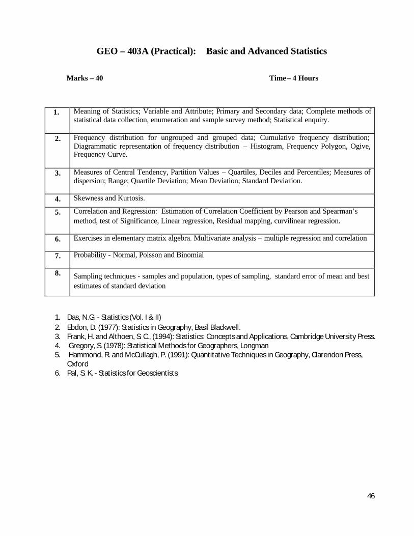
GEO – 403A (Practical): Basic and Advanced Statistics
Marks – 40 Time – 4 Hours
1. Meaning of Statistics; Variable and Attribute; Primary and Secondary data; Complete methods of statistical data collection, enumeration and sample survey method; Statistical enquiry.
2. Frequency distribution for ungrouped and grouped data; Cumulative frequency distribution; Diagrammatic representation of frequency distribution – Histogram, Frequency Polygon, Ogive, Frequency Curve.
3. Measures of Central Tendency, Partition Values – Quartiles, Deciles and Percentiles; Measures of dispersion; Range; Quartile Deviation; Mean Deviation; Standard Devia tion.
4. Skewness and Kurtosis.
5. Correlation and Regression: Estimation of Correlation Coefficient by Pearson and Spearman’s method, test of Significance, Linear regression, Residual mapping, curvilinear regression.
6. Exercises in elementary matrix algebra. Multivariate analysis – multiple regression and correlation
7. Probability - Normal, Poisson and Binomial
8. Sampling techniques - samples and population, types of sampling, standard error of mean and best estimates of standard deviation
1. Das, N.G. - Statistics (Vol. I & II) 2. Ebdon, D. (1977): Statistics in Geography, Basil Blackwell. 3. Frank, H. and Althoen, S. C., (1994): Statistics: Concepts and Applications, Cambridge University Press. 4. Gregory, S. (1978): Statistical Methods for Geographers, Longman 5. Hammond, R. and McCullagh, P. (1991): Quantitative Techniques in Geography, Clarendon Press,
Oxford 6. Pal, S. K. - Statistics for Geoscientists

47
GEO – 403B: Quantitative Mapping
Marks – 40 Time – 4 Hours
1. Mean Centre:- (a). Mean Centre of population; (b) Mean center of settlement; (c) Locational shift of Mean center;(d) standard distance from Mean center.
2. Concentration (a) Locational quotient; (b) Lorenz curve to study inequality and Gini Co-efficient;(c) Standard Score to study distribution; (d) Nearest neighbour analysis and chi square test.
3. Population analysis: (a) Population potential by gravity model; (b) Mapping of population potential;(c) Rank size rule to study rank and population of urban centers; (d) Mapping of actual and expected urban population.
4. Laboratory Note book and Viva-voce
GEO – 403C. Internal Assessment 20 Marks

48
SPECIAL PAPER PRACTICAL-1 (FLUVIAL GEOMORPHOLOGY)
GEO – 404A: Laboratory Practical
Marks – 40 Time – 4 Hours
1. Delineation of a drainage basin on a topographical map and calculation of Stream Order after Horton and Strahler, Bifurcation Ratio, correlation between Stream order and stream number and stream length, their interpretation.
2. Morphometric Analysis of a river basin as depicted on a topographical map (1:50,000) – Relative Relief, Dissection Index, Average Slope, Drainage Density, Roughness Index – their correlation and interpretation.
3. Drawing of long profile of the main river and its major tributaries and calculation of gradient.
4. Drawing of Rating Curve and Hydrograph from the given data and their interpretation
5. Description of the channel morphology of a particular area on the basis of its velocity, cross-sectional area, wetted perimeter, hydraulic radius, discharge.
6. Laboratory Note Book and Viva-Voce.
GEO – 404B: Dissertation Marks – 40
GEO – 404C: Internal Assessment Marks – 20

49
SPECIAL PAPER PRACTICAL-2 (TECTONIC GEOMORPHOLOGY AND DISASTER MANAGEMENT)
GEO – 404A: Laboratory Practical
Marks – 40 Time – 4 Hours
MAPPING AND APPLICATION OF REMOTE SENSING 1. Surveying: Subsurface rock structure and potential ground water exploring analysis-four
pin and two pin survey by SRM; 2. Seismic data recording and 2D and 3D interpretation 3. Thin section making, Microscopic examination of important rock-types of tectonic zone; 4. Microstructure of rocks; Grain-size Analysis 5. Assemblages of sedimentary structures and their paleoenvironmental significance.
Digital Mapping
6. Toposheet study-Identification of structural patterns-folds and lineaments: Identification of structural control on drainage;
7. Digital image processing-Geometric correction and rectification, geo-referencing; Classification-clustering, supervised, and density slicing ; Identification of structural patterns-folds and lineaments: Identification of structural control on drainage
8. Multi source spatial data management for tectonic mapping-identification of major lineaments and their type, drainage mapping and determination of structural control; Digital elevation model and digital terrain model;
9. Mapping of seismic events from different sources; Hazard zone identification and mapping;
Laboratory Note Book and Viva-Voce.
GEO – 404B: Dissertation Marks – 40
GEO – 404C: Internal Assessment Marks – 20

50
SPECIAL PAPER PRACTICAL-3 (ENVIRONMENTAL GEOMORPHOLOGY AND HAZARDS)
GEO – 404A: Laboratory Practical
Marks – 40 Time – 4 Hours
1. Cartography based: Rainfall depth and persistency analysis, Stage-discharge rating curve,
determination of topographic erosivity, annual flood frequency analysis, Flood Hazard
Zonation, Landslide hazard zonation .
2. Field based: Micro-slope mapping and identification by Abney level, Contouring of a
slope by Total Station, Measurement of soil and water resistance by Resistivity meter, Soil
moisture determination by Tensiometer.
3. Laboratory based: Grain size analysis, determination of soil pH and organic carbon,
Atterberg limits.
4. Laboratory Note Book and Viva-Voce.
GEO – 404B: Dissertation Marks – 40
GEO – 404C:Internal Assessment Marks – 20

51
SPECIAL PAPER PRACTICAL-4
(REGIONAL DEVELOPMENT AND PLANNING)
GEO – 404A Laboratory Practical
Marks – 40 Time – 4 Hours
1.
2.
3.
4.
GEO – 404B: Dissertation Marks – 40
GEO – 404C:Internal Assessment Marks – 20
SPECIAL PAPER PRACTICAL-5
(GEOGRAPHY OF TOURISM)
GEO – 404A Laboratory Practical
Marks – 40 Time – 4 Hours
1.
2.
3.
4.
GEO – 404B: Dissertation Marks – 40
GEO – 404C:Internal Assessment Marks – 20