Embed Size (px)
Citation preview

PROJECT DESCRIPTIONS: North Hälawa
Valley and Luluku Project Areas
Hälawa-Luluku Interpretive Development Project
July 28th, 2014
Hälawa-Luluku Interpretive Development Project
Honolulu, Hawai‘i
A cooperative program of the Federal Highway Administration,
State of Hawai`i Department of Transportation and the Office of Hawaiian Affairs
ATTACHMENT B OHA RFQ No. HLID-2015-01: Project Descriptions

ATTACHMENT B OHA RFQ No. HLID-2015-01: Project Descriptions

PROJECT DESCRIPTIONS: North Hälawa
Valley and Luluku Project Areas
Hälawa-Luluku Interpretive Development Project
Prepared By:
Hälawa-Luluku Interpretive Development Team, Office of Hawaiian Affairs
Jonathan Ching, D. Arch Project Coordinator Kamakana C. Ferreira, MA Project Planner Sarah Antone Project Assistant Dane Teves Intern
ATTACHMENT B OHA RFQ No. HLID-2015-01: Project Descriptions

Document Revision Log
Date Comments
Feb 2013 Original Draft completed Draft submitted to now cancelled Prime and Subs on February 19th, 2013
April 26, 2013 Draft: Edits made internally by HLID based on meetings with SHPD, Cancelled Prime (S&N), HDOT, FHWA, and Sub-Consultants during the months of February, March, and April 2013. Key Meeting Dates: 02-28-2013 Site Visit w/Prime and Subs; 03-07-2013 Site Visit Debrief w/Prime and Subs; 03-19-2013 SHPD Meeting; 04-17-2013 SHPD Debrief w/FHWA and HDOT. Draft submitted for FHWA and HDOT Review on April 29th, 2013
July 2013 Comments on April 26 Draft from FHWA received on 05-21-2013 Comments on April 26 Draft from HDOT received on 07-16-2013 Revised July 2013 Draft submitted to FHWA and HDOT for review on 07-24-2013
August 7th, 2013
Comments on July 2013 Draft from FHWA received on 08-02-2013 Comments on July 2013 Draft from HDOT received on 08-06-2013 Revised July 2013 Draft submitted to FHWA and HDOT for review on 08-07-2013
November 15th, 2013
Additional revisions made to exclude name of cancelled Prime after 10/2013 Additional revisions made based on comments received from OHA Compliance Additional revisions made after refinement of CMM RFP Scope
July 28th, 2014
Adjusted TMK designation and maps for Parcel 20. Parcel 20 is no longer a subdivision of TMK 4-5-41:017. Inclusion of “Conceptual Renderings” for proposed project elements
ATTACHMENT B OHA RFQ No. HLID-2015-01: Project Descriptions

iii
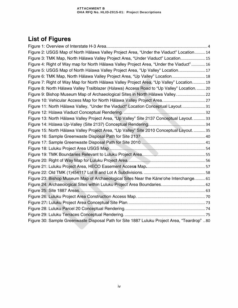
TABLE OF CONTENTS List of Figures ..........................................................................................................................iv
List of Tables ............................................................................................................................ v
ACKNOWLEDGEMENTS ..........................................................................................................vi
EXECUTIVE SUMMARY ..........................................................................................................vii
ABBREVIATIONS ..................................................................................................................... x
The HLID Project ...................................................................................................................... 1
Background ............................................................................................................................ 1
Mitigation Areas ...................................................................................................................... 2
Overview of the 1987 Memorandum of Agreement (MOA) ..................................................... 5
Overview of the Cooperative Agreement and Description of the Hälawa-Luluku Interpretive
Development (HLID) Project ................................................................................................... 6
The Interpretive Development Plan (IDP) ............................................................................... 7
Consultation Process .............................................................................................................. 9
North Hälawa Valley Project Area ..........................................................................................11
Location .................................................................................................................................11
Archaeological Site Locations ................................................................................................21
Vision and Working Group Mana‘o ........................................................................................23
Identified Impacts and Recommendations .............................................................................24
Project Elements ...................................................................................................................25
Proposed Vegetation Clearance Procedure Around Archaeological Sites (North Hälawa
Valley) ...................................................................................................................................36
Archaeological Project Elements ...........................................................................................42
Summary of North Hälawa Valley Project Elements and Archaeological Project Elements ....50
Luluku Project Area ................................................................................................................51
Location .................................................................................................................................51
Archaeological Site Locations ................................................................................................59
Vision and Working Group Mana‘o ........................................................................................64
Identified Impacts and Recommendations .............................................................................66
Project Elements ...................................................................................................................68
Proposed Vegetation Clearance Procedure (Luluku) .............................................................74
Archaeological Project Elements ...........................................................................................81
Summary of Luluku Project Area Project Elements and Archaeological Project Elements .....86
ATTACHMENT B OHA RFQ No. HLID-2015-01: Project Descriptions
iv
List of Figures Figure 1: Overview of Interstate H-3 Area. ............................................................................................. 4
Figure 2: USGS Map of North Hälawa Valley Project Area, “Under the Viaduct” Location .......... 14
Figure 3: TMK Map, North Hälawa Valley Project Area, “Under Viaduct” Location. ...................... 15
Figure 4: Right of Way map for North Hälawa Valley Project Area, “Under the Viaduct” ............. 16
Figure 5: USGS Map of North Hālawa Valley Project Area, "Up Valley" Location. ........................ 17
Figure 6: TMK Map, North Hälawa Valley Project Area, “Up Valley” Location. .............................. 18
Figure 7: Right of Way Map for North Hälawa Valley Project Area, “Up Valley” Location. ........... 19
Figure 8: North Hälawa Valley Trailblazer (Hālawa) Access Road to “Up Valley” Location. ........ 20
Figure 9: Bishop Museum Map of Archaeological Sites in North Hälawa Valley. .......................... 22
Figure 10: Vehicular Access Map for North Hälawa Valley Project Area. ....................................... 27
Figure 11: North Hälawa Valley, "Under the Viaduct" Location Conceptual Layout. ..................... 31
Figure 12: Hälawa Viaduct Conceptual Rendering. ............................................................................ 32
Figure 13: North Hälawa Valley Project Area, “Up Valley” Site 2137 Conceptual Layout. ........... 33
Figure 14: Hälawa Up-Valley (Site 2137) Conceptual Rendering. .................................................... 34
Figure 15: North Hälawa Valley Project Area, “Up Valley” Site 2010 Conceptual Layout. ........... 35
Figure 16: Sample Greenwaste Disposal Path for Site 2137. ........................................................... 40
Figure 17: Sample Greenwaste Disposal Path for Site 2010. ........................................................... 41
Figure 18: Luluku Project Area USGS Map ......................................................................................... 54
Figure 19: TMK Boundaries Relevant to Luluku Project Area........................................................... 55
Figure 20: Right of Way Map for Luluku Project Area. ....................................................................... 56
Figure 21: Luluku Project Area, HECO Easement Access Map. ...................................................... 57
Figure 22: Old TMK (1)454117 Lot B and Lot A Subdivisions. ......................................................... 58
Figure 23: Bishop Museum Map of Archaeological Sites Near the Käne‘ohe Interchange. ......... 61
Figure 24: Archaeological Sites within Luluku Project Area Boundaries. ........................................ 62
Figure 25: Site 1887 Areas. .................................................................................................................... 63
Figure 26: Luluku Project Area Construction Access Map. ............................................................... 70
Figure 27: Luluku Project Area Conceptual Site Plan. ....................................................................... 73
Figure 28: Luluku Parcel 20 Conceptual Rendering. .......................................................................... 74
Figure 29: Luluku Terraces Conceptual Rendering. ........................................................................... 75
Figure 30: Sample Greenwaste Disposal Path for Site 1887 Luluku Project Area, “Teardrop” .. 80
ATTACHMENT B OHA RFQ No. HLID-2015-01: Project Descriptions

v
List of Tables Table 1: North Hälawa Valley Project Area archaeological sites, UTM coordinates and area ... 21
Table 2: North Hälawa Valley impact and vision coding matrix ....................................................... 25
Table 3: North Hälawa Valley Phase I project elements at “Under the Viaduct” location ............ 28
Table 4: North Hälawa Valley Phase I project elements “Up Valley”, Site -2137 location ........... 29
Table 5: North Hälawa Phase II project elements, “Up Valley” location ......................................... 30
Table 6: North Hälawa Valley archaeological site recommendations ............................................. 43
Table 7: North Hälawa Valley Project Area summary ....................................................................... 50
Table 8: Luluku Project Area UTM coordinates and area coverage ............................................... 60
Table 9: Luluku impact and vision coding matrix ............................................................................... 68
Table 10: Luluku Phase I project elements ......................................................................................... 71
Table 11: Luluku Phase II project elements ........................................................................................ 72
Table 12: Summary of archaeological site descriptions .................................................................... 82
Table 13: 1987 MOA Site 1887 Active Preservation recommendations for individual features . 78
Table 14: Luluku Project Area summary ............................................................................................. 86
ATTACHMENT B OHA RFQ No. HLID-2015-01: Project Descriptions

vi
ACKNOWLEDGEMENTS
E Hoʿomaikaʿi i Nä Alakaÿina me ka Aho Nui ana a me ke Käkoʿo no kakou apau:
(Appreciation for the leadership and patience for those that support this project)
The Hälawa-Luluku Interpretive Development (HLID) team would like to first acknowledge our
kūpuna (ancestors), kanaka maoli (Native Hawaiian people), and especially the HLID Working
Group for their manaʿo (wisdom), aho nui (patience), and aloha (gratitude).
The Working Group:
Ms. Donna Bullard Mrs. Donna Camvel
Mr. Wali Camvel Ms. Mahealani Cypher
Ms. Phyllis “Coochie” Cayan Mr. Steven Helela
Ms. Lela Hubbard Ms. Marion Kelly
Ms. Clara “Sweet” Matthews Ms. Havana McLafferty
Mr. Robert “Boot” Matthews Ms. Ella Paguyo
Mr. John Talkington Ms. Vienna Nahinu
Ms. Laulani Teale
The HLID team is committed to delivering this project to the community with cultural sensitivity.
We also acknowledge that many have dedicated their lives to this effort and other efforts like
this. We understand the love, passion and commitment that our people put into their work. As
such, it continues to be an honor and privilege to serve our community and deliver a project
driven by their visions to rehabilitate and mitigate our beloved project sites.
We believe that our lands and people are resilient. By doing the right thing, for the right reason
(and at the right time), we can collectively overcome any obstacle for the benefit of our future
generations.
E ola mau nö nä pua Ko‘olau i ke kü‘ana mai
The flowers of the Ko‘olau will thrive in the face of adversity
-The Hälawa Luluku Interpretive Development Team
ATTACHMENT B OHA RFQ No. HLID-2015-01: Project Descriptions

vii
EXECUTIVE SUMMARY
This document provides the Hälawa-Luluku Interpretive Development (HLID) team’s description
of proposed plans for the North Hälawa Valley and Luluku project areas. Essentially, this
document outlines the scope of work for potential contractors and clearly identifies project area
boundaries. The purpose of the HLID project is to mitigate some of the impacts to cultural and
archaeological resources caused by the construction of Interstate H-3. The
introduction/background section provides an overview of the 1987 Memorandum of Agreement
(MOA) between the Federal Highways Administration (FHWA), State Historic Preservation
Division (SHPD), and Advisory Council on Historic Preservation (ACHP) which mandates
prescribed mitigation actions for Interstate H-3 construction. The background section discusses
how the scope of the project area has been refined to include certain portions of Luluku and
North Hälawa Valley. An overview of the Cooperative Agreement between OHA and HDOT
which created HLID is next provided to clarify our purpose and role in fulfilling the 1987 MOA.
Through years of community outreach and the accumulation of archaeological data, an
Interpretive Development was created to clearly identify impacts to cultural and archaeological
resources caused by Interstate H-3 and to express the vision of the Working Group for healing
the land as well as the community. The document is then divided into the two project areas
(North Hälawa Valley and Luluku) with subsequent uniform subsections. A breakdown of each
subsection is provided below:
1) Location: Clearly identifies where the HLID project boundaries are, who owns the land,
conservation subzone assignments, and access points. Tax Map Key, USGS
quadrangle, and HDOT right-of-way maps are provided for location reference.
2) Archaeological Site Location: Clearly identifies which archaeological sites are
affected by our proposed plan and areas to be preserved or rehabilitated.
Archaeological inventory maps are included to show where sites fall on our project area
and other sites in the vicinity. A breakdown of site numbers, area sizes, and UTM
(Universal Transverse Mercator) coordinates are presented in a table.
3) Vision and Working Group Manaʿo: Clearly states the vision for the project areas as
detailed in the 2008 Interpretive Development Plan. A brief historic overview is provided
to show how traditional and historic land uses are aligned with the projected vision. In
the case of Luluku, a brief discussion is provided that states anticipated permits needed
to bring the Working Group’s vision of having full functioning loʿi terraces.
4) Identified Impacts and Recommendations: Clearly identifies impacts and
recommendations as presented in the 2008 Interpretive Development Plan (IDP).
5) Project Elements: Clearly identifies new structures and activity areas proposed to be
built in the project areas. To help systematically address the impacts in the IDP and to
ensure the vision of the Working was being met, the impacts and visions from the IDP
were coded into separate categories. Project elements were then designed to address
ATTACHMENT B OHA RFQ No. HLID-2015-01: Project Descriptions

viii
each code and prioritized by the Working Group. Project elements, codes
(impacts/vision), phase, and projected costs are included in a series of tables. Project
elements have been phased into two phases based on priority and cost. A conceptual
plan and renderings follow these tables as a visual guide. Proposed construction access
routes, vegetation clearance areas, and greenwaste disposal pickup areas are also
provided. During all contemporary construction, HLID recommends the inclusion of
archaeological and cultural monitors. Subsequently, an archaeological monitoring plan
and report will need to be generated by a contracted professional archaeologist.
6) Vegetation Clearance Procedure: Clearly identifies methods and areas for vegetation
clearance. A detailed nine step procedure is proposed to ensure all necessary laws are
complied with and to protect archaeological features: identification of vegetation
clearance areas; eradication focus; creation of 5 foot buffer zone around archaeological
features; temporary access trails; use of machinery and larger tools outside the buffer
zone; removal of large trees; disposal of greewaste; archaeological and cultural
monitors; and interim measures. A sample greenwaste path for disposal is presented to
show buffer zones and paths where wheelbarrows can carry cut grass away from the
site in a way that minimizes impact to the archaeological features.
7) Archaeological Project Elements: Clearly identifies HLID’s preservation
recommendations and subsequent procedures for fulfilling recommended treatments for
all archaeological sites within the project boundaries. In the case of Luluku, individual
recommendations for each feature of Site 50-80-10-1887 are provided per the 1987
MOA. These recommendations are presented in a table. A procedure designed to
follow Hawaii Administrative Rules and National Park Service standards for preservation
and rehabilitation is provided to guide archaeologists and cultural Master Masons
performing the work. Since many of the sites are comprised of built stone structures, the
work of a Master Mason is required to ensure structural integrity and historic style is
maintained.
Work for the archaeologist and Master Mason is clearly laid out in separate parts. An
emphasis is placed on documenting architectural styles and site condition to preserve
historic integrity. The sites will first need to be assessed and photographed by both the
archaeologist and the cultural Master Masons to locate areas in need of stabilization,
protection, repair, or replacement. These results will be gathered into a “condition
assessment” by the archaeologist. The cultural Master Masons are part of this process
to integrate Native Hawaiian values into the assessment. Furthermore, since they will
be the ones carrying out the actual rehabilitation work, it makes sense for HLID to have
them on early in the process to better inform design and necessary planning. Ultimately,
a culminating preservation plan will be generated by the archaeologists in accordance
with the procedure put forth by HLID. This plan will later be amended to include photos
after the actual rehabilitation work is complete.
ATTACHMENT B OHA RFQ No. HLID-2015-01: Project Descriptions

ix
8) Project Area Summary: In a table, all project elements, their locations, priority,
phasing, projected and total costs are clearly identified.
ATTACHMENT B OHA RFQ No. HLID-2015-01: Project Descriptions

x
ABBREVIATIONS ACHP Advisory Council on Historic Preservation
AD Anno Domini
APE Area of Potential Effect
BPBM Bernice Pauahi Bishop Museum
CIA Cultural Impact Assessment
CDUA Cultural District Use Application
CDUP Cultural District Use Permit
CLR Cultural Landscape Inventory Report
CWRM Commission on Water Resource Management
DD Design and Development
DHHL Department of Hawaiian Home Lands
DLNR Department of Land and Natural Resources
EA Environmental Assessment
EIS Environmental Impact Statement
FHWA Federal Highway Administration
GPS Global Positioning System
HAR Hawaii Administrative Rules
H-CIMA Hawaiian Cultural Impact Mitigation Approach
HDOT State of Hawai‘i Department of Transportation
HLID Hälawa-Luluku Interpretive Development
HECO Hawaiian Electric Company
HoLIS Honolulu Land Information System
ATTACHMENT B OHA RFQ No. HLID-2015-01: Project Descriptions

xi
LLC Limited Liability Company
MOA Memorandum of Agreement
NHPA National Historic Preservation Act
NHHPC Native Hawaiian Historic Preservation Council
NPDES National Pollutant Discharge Elimination System
NPS National Park Service
NRHP National Registry of Historic Places
OCCL Office of Conservation and Coastal Lands
OHA Office of Hawaiian Affairs
OIBC Oahu Island Burial Council
PAIFS Petition to Amend Instream Flow Standard
Pre DD Pre-Design and Development
SCAP Stream Channel Alteration Permit
SDWP Stream Diversion Works Permit
SHPD State Historic Preservation Division
SHPO State Historic Preservation Officer
SMP Stewardship Management Plan
SIHP State Inventory of Historic Places
SLH Session Laws of Hawaii
TMK Tax Map Key
USGS United States Geological Survey
UTM Universal Transverse Mercator
WG Working Group
ATTACHMENT B OHA RFQ No. HLID-2015-01: Project Descriptions

1
The HLID Project
Background
The Hälawa-Luluku Interpretive Development (HLID) team, acting on behalf of the Office of
Hawaiian Affairs, was formed to plan and implement projects that mitigate some of the impacts
to cultural resources caused by the construction of Interstate H-3. The HLID project is
responsible for recommending actions for mitigation in an “after-the-fact” context and address
related concerns of the Native Hawaiian community. The history of Interstate H-3 is diverse
with multiple levels of complexity. As such, we are providing a brief introduction to this history.
The construction of the 16.1 mile long Interstate started in the early 1960s, after Hawai‘i became
a state, by the HDOT with a preliminary planning stage. Historically, Interstate H-3 was also the
first project required to complete an Environmental Impact Statement in the state of Hawai‘i.
Although physical construction was expected to begin in the 1970s, construction did not begin
until circa 1980 due to community protest and a series of legal challenges. Interstate H-3 would
later be opened many years later in 1997.
The construction of Interstate H-3 has been successful in linking major military installations
(Pearl Harbor and Hickam Air Force Base1 with Kaneohe Marine Corps Base Hawaii) on the
island of Oÿahu for the purposes of bolstering national defense. It is this purpose that made
construction of the Interstate eligible for federal funding through the “National System of
Defense and Interstate Highways” created by the Federal Highway Act of 1944. Thus, although
not technically an “interstate” per se, the reason for calling H-3 an interstate is now apparent.
The Interstate has also created an additional route to quickly and efficiently traverse the Koÿolau
Mountain Range. The design and construction of Interstate H-3 has been highlighted as a
marvel of modern engineering; as such, it is held in high regard by professionals in related
fields.
All of these accomplishments and successes came at a monetary and cultural cost. With regard
to monetary costs, the Interstate H-3 is considered one of the most expensive Interstate
Highways ever constructed, totaling approximately 1.3 billion dollars. The cultural costs
however, are both tangible and intangible by nature, making it difficult to be measured by a
dollar value. The cultural costs include significant physical, spiritual, cultural, and environmental
effects to the ‘äina (land), the cultural resources, and ka po‘e ÿo Hawaiÿi (the people of Hawai‘i).
Many Native Hawaiians consistently protested the construction of the Interstate H-3 since the
mid-1960s. Originally, the leeward portion of Interstate H-3 was proposed to be routed through
Moanalua Valley. However, successful protest by the Moanalua Gardens Foundation resulted
in the relocation of the leeward portion of Interstate H-3 from Moanalua Valley to Hälawa Valley.
1 As of 2010, Pearl Harbor and Hickam Air Force Base are now viewed as a single entity: Joint Base Pearl Harbor-
Hickam)
ATTACHMENT B OHA RFQ No. HLID-2015-01: Project Descriptions

2
With regard to the Hälawa realignment, efforts of the Stop H-3 Association during the 70’s
managed to stall construction on the Windward portion of the Interstate; subsequently, this
forced several portions of the Interstate to be rerouted. The late 70’s were crucial years for
Hawaiian nationalist movements as development projects were growing in the state of Hawai‘i.
Furthermore, Hawai‘i’s population grew by 25% in the 70’s resulting in an abrupt increase in
urbanization. Many Native Hawaiians advocating for similar causes (i.e.: preserving land,
property, history, and cultural resources) banded together to strengthen the Native Hawaiian
voice. The Office of Hawaiian Affairs was created out of this “Hawaiian Renaissance” at the
1978 Constitutional Convention.
Throughout the construction process associated with Interstate H-3 throughout the 80’s,
numerous archaeological sites were encountered which increased community protest.
Eventually, a Memorandum of Agreement (MOA) between FHWA, SHPO, and ACHP was
created to ensure Section 106 compliance of the National Historic Preservation Act (NHPA).
OHA and HDOT are recognized as signatories to this MOA as well with specific roles to fulfill.
Fortunately, Native Hawaiians are a people of hope and action. HLID has been blessed with
the involvement of a handful of dedicated people that comprise our Working Group (WG) – a
group of interested members of the community who were selected to assist in recommending
processes, strategies and interpretation for Hälawa, Luluku, Ha‘ikü, and KukuioKāne to OHA.
Due to budget constraints and a diversity of land property ownership, the current HLID project is
focused on North Hälawa Valley and Luluku. The WG has helped to develop visions to enable
the long-term healing of these project sites. These visions have become a driving force that has
influenced the plans, overall design, and mitigation recommendations associated with the HLID
project.
The healing process that these plans enable will take root in the mitigation recommendations
that HLID is proposing for implementation and is anticipated to evolve over time. The long term
implementation of the proposed mitigation actions will be carried out by Stewards who manage
the project sites in perpetuity through agreements with HDOT which has delegated authority to
oversee the State lands on which the project sites exist. It is HLID’s directive to provide a
strong foundation for the Stewards to build upon as it is they, our people who will ultimately
serve as the primary vehicle to implement this healing process in perpetuity.
This project provides a unique opportunity for a collaborative effort between the community and
government agencies to take actions to better the conditions of the natural and cultural
resources of public lands. In this regard, HLID’s approach aims to: address multiple-
organizational and community-driven objectives; achieve mutual benefits for all parties involved;
and comply with Federal, State, and County rules and regulations.
Mitigation Areas
Interstate Route H-3 is a trans-Ko`olau freeway from Mökapu Peninsula to Hälawa Interchange.
The Highway falls within the ahupua`a of Hälawa, He`eia, Käne‘ohe, and Kailua (Figure 1).
ATTACHMENT B OHA RFQ No. HLID-2015-01: Project Descriptions

3
For the purposes of this mitigation program, an eligible “Project Area” is defined by the FHWA
and HDOT to include only the lands within the highway right-of-way or under the purview of
HDOT along the Interstate H-3 corridor.
ATTACHMENT B OHA RFQ No. HLID-2015-01: Project Descriptions

4
Figure 1: Overview of Interstate H-3 Area.
ATTACHMENT B OHA RFQ No. HLID-2015-01: Project Descriptions

5
Although the Interstate H-3 affected a large area, four distinct areas were initially identified to be
included for interpretative mitigation and implementation: 1) North Hālawa Valley; 2) Luluku; 3)
Haʿikü; and 4) Kukui o Kāne Heiau. Over the course of the past ten (10) years, the extent of the
mitigation areas have evolved as reflected below:
1. North Hälawa Valley (included in Prime’s scope of work)
Mitigation work shall occur for the North Hälawa project sites under HLID’s purview.
2. Luluku Agricultural Terraces (included in Prime’s scope of work)
Mitigation work shall occur for the Luluku project sites under HLID’s purview.
3. Ha‘ikü Valley (not included in Prime’s scope of work)
Käne a me Kanaloa Heiau (Site No. 333) and Kanehekili (Kahekili) Heiau (Site No. 332)
were identified for mitigation. As put forth in the 2008 IDP, a preservation plan for these two
sites will be created. However, additional research may be required to ascertain the
necessary information to complete the preservation plan. To be clear, actions associated
with Haÿiku are not included in the Prime’s scope of work.
4. Kukui o Käne Heiau (not included in Prime’s scope of work)
The WG and families associated with Kukui o Käne Heiau (Site No. 2038) have expressed
that no HLID mitigation efforts are needed as they plan to continue care for the heiau.
Therefore, Kukui o Käne Heiau IS NOT currently considered a part of HLID’s
implementation.
Note: The “Prime” will refer to our primary Architectural & Engineering professional services
contractor. This work is to exclude all archaeological and cultural Master Mason (ancient stone
structure rehabilitative/repair work) work which will be carried out under separate contracts.
Overview of the 1987 Memorandum of Agreement (MOA)
The 1987 MOA is an Agreement between: the Hawai‘i State Historic Preservation Officer
(SHPO), the Advisory Council on Historic Preservation (ACHP), and the Federal Highways
Administration (FHWA) with consultation from the State of Hawai‘i Department of Transportation
(HDOT) and the Office of Hawaiian Affairs (OHA). The MOA enables a collaborative approach
to the mitigation resulting from the construction of Interstate H-3 and serves as an instrument to
ensure satisfactory compliance with Section 106 of the National Historic Preservation Act
(NHPA). The MOA states that the measures listed in the Stipulations of the agreement are to
be carried out in consultation with all signatories.
The Agreement states that the mitigation of impacts to cultural resources caused by Interstate
H-3 construction shall be implemented in accordance with stipulations addressing the historic
properties associated with the construction of Interstate H-3. In summary, the stipulations
relevant to the HLID project required: 1) archaeological inventory surveys and data recovery for
Hälawa and Luluku; 2) a preservation plan for Luluku; 3) an Interpretive Development Plan
(IDP); and 4) Burial Treatment Plan. To date, HLID understands that the conditions of the MOA
ATTACHMENT B OHA RFQ No. HLID-2015-01: Project Descriptions

6
are close to being met and that all signatories are currently working towards closing out any
remaining actions. SHPD has confirmed this understanding and also feels that current
mitigation efforts do not require a new Section 106 process to be opened as long as mitigation
is confined to the Highway Right of Way. Since the MOA is designed to ensure Section 106
compliance, completion of all MOA stipulations completes the Section 106 process.
Reports (ie: archaeological) and plans (ie: IDP) generated to satisfy specific stipulations in the
1987 MOA have been used to inform HLID’s Project Descriptions. The vision set forth in this
document is meant to satisfy the desires of the community as represented by HLID’s Working
Group. For reference, the roles of the 1987 MOA signatories have been provided below:
Hawaii Department of Transportation: Land Owners; State agency which implements FHWA
projects. FHWA delegates their authority to DOT to represent FHWA on routine decisions to
move the project forward.
Federal Highways Administration: Financier; Federal agency with legal and financial
responsibility for Section 106, National Historic Preservation Act, compliance.
Office of Hawaiian Affairs: Retains the responsibility of procuring and coordinating the required
services of interested Native Hawaiian organizations to assist with the preparation and
implementation of interpretive development planning for North Hälawa Valley and Luluku based
on FHWA/HDOT financing. This is accomplished through the Hälawa-Luluku Interpretive
Development (HLID) coordinator. OHA, as a Native Hawaiian Organization (NHO), also serves
as a recognized consulting party for the Section 106 process.
State Historic Preservation Officer: as required by Section 106, advises and assists FHWA in
carrying out their Section 106 responsibilities.
Advisory Council on Historic Preservation: Federal agency charged with historic preservation
leadership within the Federal Government. Section 106 requires Federal agencies to consider
the effects of their actions on historic properties and provide the ACHP an opportunity to
comment on Federal projects prior to implementation.
Overview of the Cooperative Agreement and Description of the Hälawa-Luluku
Interpretive Development (HLID) Project
HLID is a non-business entity created via a Cooperative Agreement (#1385) between OHA and
HDOT signed on August 10th, 1999. HLID was created to design and develop recommendations
to mitigate adverse impacts to cultural resources caused by Interstate H-3 for FHWA and
HDOT. Throughout the project’s history, HLID has served and acted as a liaison between OHA,
HDOT, FHWA and the community. HLID is funded by FHWA (90%) and HDOT (10%). OHA
serves as an administrative arm to the project and has the accounting function of tracking and
receiving reimbursement for HLID related costs, providing additional support services as
needed. Under the conditions of the Cooperative Agreement, HLID and its staff serve to receive
expertise from OHA, the community, and other sources to provide sound recommendations to
ATTACHMENT B OHA RFQ No. HLID-2015-01: Project Descriptions

7
the land owner (HDOT) to enable the implementation of mitigation measures resulting from the
construction of Interstate H-3. The Cooperative Agreement specifically states that HLID is to:
1) complete an Interpretive Development Plan (IDP); 2) complete a Stewardship Management
Plan (SMP); and, 3) implement select project elements from the IDP. The Cooperative
Agreement has been amended twice to adjust to the changing demands of the project: once in
2010 (CA# 2550) and the latest in 2012 (CA# 2550.01)
HDOT and OHA have unique missions and very different ways in addressing and achieving
goals and objectives. HLID is to serve as the bridge between entities, take into account
community needs and develop and implement HDOT approved mitigation projects within
designated project areas. Neither organization has completed a project of this nature and its
unique conditions will require collaboration, patience, flexibility, innovation, and trust from all
parties involved.
HLID Purpose: The primary purpose of the Hälawa-Luluku Interpretive Development (HLID)
project is to provide consultation and services to make recommendations to our partnering
organizations to enable the mitigation of adverse impacts to the cultural resources and
archaeological sites affected by the construction of Interstate Highway H-3.
Creation of HLID: In 2000, the Hälawa-Luluku Interpretive Development (HLID) Project
commenced with the hiring of a Project Coordinator under the auspices of OHA. The
Coordinator worked on the creation and compilation of the planning process that resulted in the
Interpretive Development Plan (IDP) as required by stipulation of the MOA. The IDP represents
the culmination of several years of research, dialog and planning to arrive at an approach to
appropriately mitigate the adverse impacts associated with the construction of Interstate H-3.
The Interpretive Development Plan (IDP)
The IDP, as required by Stipulation B of the 1987 MOA, was preceded by the Plan to Plan and
the Strategic Plan (done by R.M Towill for HLID). These plans included working in close
coordination between: the community, the Working Group (community representatives who
committed time and energy to the project), Sub-contractors, and representatives from
FHWA/HDOT and OHA. Throughout this process, a Cultural Landscape Inventory Report
(CLR), various archaeological reports (completed by Bishop Museum), and other specialized
reports (ie: Drainage Study) were completed to inform the IDP document from a historical and
scientific perspective. Most importantly, in consultation with the Working Group, impacts
caused by Interstate H-3 were clearly stated in the IDP with recommended mitigation measures.
Thus, the IDP serves as a guide for the implementation of mitigation measures.
Previously, in the Plan-to-Plan, Strategic Plan, and IDP, the HLID project had three Phases: 1)
The Planning Phase; 2) the Design and Development Phase; and, 3) the Construction and
Implementation Phase. However, to avoid confusion throughout the remainder of the project
the term “phase” will now be changed to “component” to maintain clarity as we move forward.
ATTACHMENT B OHA RFQ No. HLID-2015-01: Project Descriptions

8
The Components of the HLID Project are:
1) The Planning Component:
The Planning Component included the Strategic Plan, Plan to Plan processes and
documentation including a Cultural Landscape Inventory Report and culminated with the
Interpretive Development Plan. FHWA and HDOT recognize the December 2008 version as
the official final document, though revisions were made and an additional version was
prepared but not accepted on May 22, 2009.
2) The Design Development Component:
The Pre-Design and Development (DD) Plan (not required by HLID’s Cooperative
Agreement) serves as an addendum to the IDP that adds considerable cultural depth to the
plan, history, and guidance for bringing conceptual ideas to fruition. This includes taking a
cultural approach towards needed permits and regulatory processes that will enable
construction (Environmental permitting including an EA, CIA, CDUA, etc.). The Pre-DD is
intended to provide a strong foundation to build upon as we embark on finalizing the plans
for the Construction and Implementation component.
HLID has also evaluated the conceptual project suggestions as provided in the December 12th, 2008 Interpretive Development Plan (IDP) and filtered down these abstract concepts into the “Project Descriptions” document. The “Project Descriptions” document is designed to inform our Contractors of what we intend to build and implement. Projects identified in the IDP were preliminary suggestions and concepts which included community input. HLID and the Architect & Engineering firm will engage in the design work, permitting, and environmental review, and evaluate the mitigation elements filtered into the “Project Descriptions” for compliance with federal, state and county laws and overall constructability.
Additionally, HLID will continue to develop a Stewardship Management Plan and pursue the
selection of a stewarding entity. The plan will contain HLID’s recommendations and
guidelines for long-term stewardship and management of the project sites including: The
formal selection of the Stewardship entity(s); Preservation Plan guidelines for long term
maintenance; Cultural Use Guidelines; Land Use and Strategic Activity Guidelines; Access
and Risk Management Guidelines; and a Use and Occupancy Agreement in collaboration
with the HDOT. HLID is also recommending a stewardship model that is intended to
maximize the resources and networks of the stewarding community via our proposed
Stewardship Consortium Model.
3) The Construction and Implementation Component:
The Construction and Implementation component of the project will be fast tracked as
allowed by the permitting process and culminate with the construction of the projects
elements that are both allowable and within HLID’s project budget. It is anticipated that the
Stewarding entity(s) will have been on board allowing for them to build the capacity for
perpetual management of the constructed project elements and the natural and cultural
resources of the sites. A Construction Management firm will likely be contracted to build and
ATTACHMENT B OHA RFQ No. HLID-2015-01: Project Descriptions

9
manage the approved design plans put forth by our A&E Prime. Additional contractors may
also be necessary for the interior (Educational/Cultural) design of the Administrative Centers
and initial landscaping.
As of July 2013, HLID has a permit to operate within North Hälawa Valley and Luluku (H-
3/Likelike Interchange) for the purposes of cultural mitigation. In order to continue with our
mitigation efforts as required by the 1987 MOA and 1999 CA, we must obtain a permit for all
HLID project areas which will allow for HLID and our contractors to perform necessary work.
Once the HLID project is completed and all requirements of the 1987 MOA and CA are fulfilled,
stewards will be tasked with maintaining the buildings and associated project areas. These
stewards will be selected prior to HLID project completion by HDOT and HLID with a set of
specific (scored) criteria. The stewards will enter into a stewardship agreement with HDOT
through a Revocable Permit (RP) when the HLID project is completed to ensure perpetual
maintenance of the project areas. Stewards, operating per HLID’s Stewardship Management
Plan (SMP) to ensure maintenance of the sites and contemporary structures, will monitor
visitors and cultural practitioners as they utilize the sites for cultural activities, farming, and
scenic enjoyment.
Consultation Process
An interview process was initiated with the release of an HLID Informational Package in 2002.
The purpose of the mailing was to seek responses from interested persons who would be willing
to serve on the Working Group. Approximately 84 persons were mailed, and 28 responses
were received. Interviews (based on an objective questionnaire) were conducted by phone and
in-person. The information documented in the interviews was evaluated and recommendations
were made for Working Group members. A total of ten pre-Working Group community meetings
took place in 2002. To select the Working Group, HLID administrators first compiled a list of
interested parties based on initial contact with the community through preliminary presentations
to various interested groups and organizations. Selected individuals were also recommended
by other persons in the community and by government agencies (OHA, Department of Hawaiian
Home Lands, HDOT, FHWA, and SHPD). Other community-based groups working to preserve
and protect lands affected by the Interstate H-3 project were also identified and consulted. A
total of 15 individuals were selected following the interview process to serve on the Working
Group:
Ms. Donna Bullard Mrs. Donna Camvel
Mr. Wali Camvel Ms. Mahealani Cypher
Ms. Phyllis “Coochie” Cayan Mr. Steven Helela
Ms. Lela Hubbard Ms. Marion Kelly
Ms. Clara “Sweet” Matthews Ms. Havana McLafferty
Mr. Robert “Boot” Matthews Ms. Ella Paguyo
Mr. John Talkington Ms. Vienna Nahinu
Ms. Laulani Teale
ATTACHMENT B OHA RFQ No. HLID-2015-01: Project Descriptions

10
Originally, all members attended and participated in approximately 21 meetings over a 25 month
period from May 2003 to June 2005. Two separate Advisory meetings, two focus meetings, and
two public meetings also took place during these years. These meetings planned the process
for the major phases of the project including the Plan to Plan, Strategic Plan, and the
Interpretive Development Plan. The goal was to provide the Office of Hawaiian Affairs with a
recommended Interpretive Development Plan that preserves and interprets select cultural and
historical resources within the project area.
Notification to the general public concerning times and places for scheduled meetings were
disseminated via the following:
Ka Wai Ola O OHA (Office of Hawaiian Affairs newspaper)
Honolulu Advertiser/Star-Bulletin
MidWeek
Hawai‘i Tribune-Herald
West Hawai‘i Today
Maui News
Garden Island
HLID website, www.HLID.org
Hawaiian Civic Clubs
Alu Like
Papa Ola Lokahi
Kamehameha Schools
Throughout this project, consultation with the community has been a paramount concern. HLID
serves to ensure the visions of the Working Group are carried out with integrity. Comments and
responses to the Plan-toPlan (2003), Strategic Plan (2005), and IDP (2008) from the Working
Group have also been included in the appendices of the final drafts of said documents.
Planning by the Working Group was done by a consensus and oriented to achieve a strong
direction for the project. Periodic meetings with the Working Group have continued since the
completion of the IDP in 2008 to ensure their wishes are being incorporated into the planning
documents and to offer guidance on the actual implementation of culturally appropriate
mitigation. Comments and interviews from the WG between 2009 and 2011 resulted in
recommended revisions to the 2008 IDP and the development of the Pre-Design and
Development (Pre-DD) Plan. Only one meeting was held in 2012 on November 30th. As of the
January 22, 2013 meeting, the construction project layout currently put forth by the HLID team
were found to be acceptable to the Working Group; however, final design details are to be
determined at a later meeting.
ATTACHMENT B OHA RFQ No. HLID-2015-01: Project Descriptions

11
North Hälawa Valley Project Area
Location
HLID is working at two locations owned by the State of Hawaiʿi under the purview of the HDOT
in the ahupua‘a of Hälawa, moku of ʿEwa, mokupuni of O‘ahu. The first location, referred to as
“under the viaduct”, is just off of Hälawa Valley Road at the entrance to Hawaiian Cement under
the Interstate H-3 (Figure 2, USGS Map). This location crosses two TMK’s: (1)99010010 and
(1)99073028 (Figure 3). Although a portion of the project area “under the viaduct” location
(Parcel 4) is encapsulated within TMK (1)99010010 (owned by Queen Emma Trust), the portion
of land under the viaduct, which is part of the freeway “right-of-way” is State lands under the
purview of the HDOT. The “under the viaduct” project area consists of HDOT Parcel 4 (Rev 1)
and Parcel 5 (see “Rights of Way” map, Figure 4) and is made up of 8 bays separated by the
viaduct support pillars. “Right of Way” maps are included in this report because they are used
by the HDOT and have been used to define archaeological investigation limits in the past.
Parcel 5 is exclusively located on TMK (1)99073028 (approximately .344 acres). Parcel 4 (Rev
1) is approximately 2.224 acres and part of TMK (1)99073028. The “under the viaduct” location
(a commercial zone, outside of the conservation district) has been developed to include a paved
road, fencing, and parking areas for vehicles. This limits the likelihood of encountering any
historic properties during the construction process, but should be considered by the teams who
are providing pertinent services as part of due diligence.
The second North Hälawa project area location, referred to as “up valley” (Figure 5, USGS
Map), is part of TMK: (1)99011002 (Figure 6). The area of land under the freeway is actually
part of the freeway right-of-way [Figure 7: Parcel 18 (Rev 1)], and does not have a TMK.
However, HDOT does have purview over the State owned land within the North Hälawa Valley
from ridge to ridge. The project area at the “up valley” location is confined to the boundaries of
archaeological Sites SIHP# 50-80-10-2137 and 50-80-10-2010 (see Figures 6 and 7). Although
the majority of the site area falls within TMK (1)99011002, a small portion of each site near the
Trailblazer Access Road passes into the freeway “right-of-way”. Site 2137 (approximately 3.21
acres) and Site 2010 (approximately 5.33 acres) are referred to as Hale O Papa and Luakini
Heiau by the Working Group, respectively.
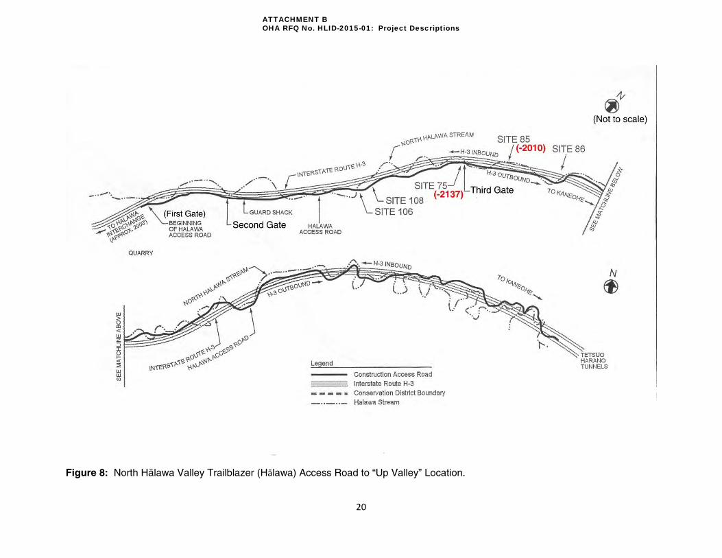
Traveling mauka, past the “under the viaduct” location and Hawaiian Cement, there is a gate
(Gate 1) restricting access to the “Trailblazer Access Road” under the Interstate H-3 (Figure 8).
This road, with a series of bridges and consecutively numbered gates, was constructed in the
late 1970s to accommodate construction vehicles and personnel during Interstate H-3
construction. Access is restricted to the general public and requires HDOT permission. The “up
valley” location is situated near Gate 3 of the “Trailblazer Access Road (Figure 8).
A number of trenches that may have been left behind from the archaeological investigations
within Site 2137 and 2010 boundaries could pose a safety concern. Exact trench locations and
sizes can be ascertained from the Hartzell et al. 20032 report. These trenches will be addressed
2 Hartzell, Leslie L.; Lebo, Susan A.; Lennstrom, Heidi A.; McPherron, Shannon P.; Olszewski, Deborah. 2003. Imu,
Adzes, and Upland Agriculture: Inventory Survey Archaeology in North Hālawa Valley, O’ahu. Bishop Museum.
ATTACHMENT B OHA RFQ No. HLID-2015-01: Project Descriptions

12
through work that is anticipated to occur by contractors during archaeological rehabilitative work
or by Bishop Museum (based on determination by HDOT).
The construction of Interstate H-3 became a vector for increased growth of non-native plant
populations that continually introduces new invasive species into the valley. Exposed grades
along the access road provide a medium for wind-blown weed seeds to establish and carry
deeper into the valley. Vegetation in the area falls under the Kukui Forest and Schinus
Scrubland zones/types (Appleby et al. 1994). It has been brought to HLID’s attention that
recently uhi uhi (Caesalpina kavaiensis), an endangered plant species, has been planted in
flagged locations on Site 2137. The flagging consists of wooden stakes wrapped with
fluorescent flagging tape. It is understood that the plants were provided by a USDA program
and is being further investigated to determine the terms, guidelines and regulations associated
with this out planting effort. Subsequently, Section 7 of the Endangered Species Act will need
to be followed to protect the specimens. A complete vegetation list from the 1977 “Final
Supplement to the Interstate Route H-3 Environmental Impact Statement” (FHWA-HI-EIS-77-
01-F(S) is available in Volume V, Appendix F (pgs 17-32).
Currently, temporary tents and tables have been set up by cultural practitioners and community
members near the “Portuguese oven” (Archaeological Feature 13) on Site -2137. These
community members have been actively caring for the land at the “up valley” location and have
thus kept invasive overgrowth to a minimum. A series of unmapped trails extend throughout the
archaeological sites and the valley that provides access for community members.
North Hälawa Stream meanders through the valley and passes under the Trailblazer Access
Road but does not intersect the “up valley” project area location. In comparison to maps that
pre-date the construction of Interstate H-3, it is apparent that Interstate construction has altered
the path of the stream. Members of the community have stated that the rate and consistency of
flow as compared to times that they remembered prior to the construction has diminished. The
area is considered to be in a flood zone and will require subsequent safety precautions for
visitors, community members, and cultural practitioners. Installation of a Flood Warning System
will be procured by HLID under a separate contract from the Prime.
The “up valley” location is also situated in the Conservation District, sub zone Resource;
subsequently, HLID will need to obtain a Conservation District Use Permit (CDUP) on HDOT’s
behalf to enable any action the proposed actions to occur on the “up valley” sites. Due to the
use of state funds, land, and that it is located on lands zoned for conservation, an
Environmental Assessment (EA) is required for the project. This work is to be prepared and
completed by our Prime and their team. An Environmental Impact Statement (EIS) is not
expected at this time as concurred upon by FHWA and HDOT. However, a Cultural Impact
Assessment (CIA) is required to be done in conjunction with the EA as part of Act 50, SLH
2000. CIA work will be carried out by an archaeological contractor operating under a separate
contract from the Prime. Any necessary archaeological information for the EA will also be
supplied to the Prime by the archaeological contractor. HLID requires that meetings take place
between the archaeological contractor and the environmental assessment team (organized by
the Prime) to facilitate information exchange. HLID will coordinate these meetings. This
ATTACHMENT B OHA RFQ No. HLID-2015-01: Project Descriptions

13
integrative approach to data sharing should minimize redundancy in all prepared reports/studies
and allow for a more holistic understanding of the Project Areas. Wherever possible, HLID
requires that the archaeological contractor ascertain “Traditional Ecological Knowledge” (TEK)
as defined by the United States Fish & Wildlife Service during the CIA. This pursuit will likely
necessitate more community consultation then typically required for a CIA.
ATTACHMENT B OHA RFQ No. HLID-2015-01: Project Descriptions

14
Figure 2: USGS Map of North Hälawa Valley Project Area, “Under the Viaduct” Location. (USGS 1999)
ATTACHMENT B OHA RFQ No. HLID-2015-01: Project Descriptions

15
Figure 3: TMK Map, North Hälawa Valley Project Area, “Under Viaduct” Location. (HoLIS 2013)
ATTACHMENT B OHA RFQ No. HLID-2015-01: Project Descriptions

16
Figure 4: Right of Way map for North Hälawa Valley Project Area, “Under the Viaduct” Location. (yellow highlighted area delineates Right of Way)
ATTACHMENT B OHA RFQ No. HLID-2015-01: Project Descriptions

17
Figure 5: USGS Map of North Hālawa Valley Project Area, "Up Valley" Location.
Note: Shapes of Site 2010 and 2137 boundaries are approximations only. Exact sizes and
shapes will be supplied to the Prime after the Condition Assessment is completed by the
archaeological contractor.
ATTACHMENT B OHA RFQ No. HLID-2015-01: Project Descriptions

18
Figure 6: TMK Map, North Hälawa Valley Project Area, “Up Valley” Location. (HoLIS 2013)
Note: Shapes of Site 2010 and 2137 boundaries are approximations only. Exact sizes and shapes will be supplied to the Prime after
the Condition Assessment is completed by the archaeological contractor.
ATTACHMENT B OHA RFQ No. HLID-2015-01: Project Descriptions

19
Figure 7: Right of Way Map for North Hälawa Valley Project Area, “Up Valley” Location. (yellow highlighted area delineates Right of Way)
Note: Shapes of the boundaries of Site 2010 and 2137 are approximations only. Exact sizes and shape will be supplied to the Prime after the Condition Assessment performed by the archaeological contractor.
ATTACHMENT B OHA RFQ No. HLID-2015-01: Project Descriptions
20
Figure 8: North Hälawa Valley Trailblazer (Hālawa) Access Road to “Up Valley” Location.
ATTACHMENT B OHA RFQ No. HLID-2015-01: Project Descriptions

21
Archaeological Site Locations Sites SIHP#s 50-80-10-2137 and -2010 will be directly affected by the proposed scope of work
for the North Hälawa Valley project area. These sites are just two of over 70 sites that were
identified in the data recovery reports done for the construction of Interstate H-3 in North
Hälawa Valley (Figure 9). All sites fall (at least partially) within the Highway Right of Way.
According to HDOT, this area was eligible for mitigation per the 1987 MOA. At the time of
Interstate H-3 construction, no “area of potential effect” was defined. Now, the area defined as
the Highway Right of Way is being used to define the areas eligible for mitigation. The only
reason why the two sites in Hālawa are an exception to this rule is because HDOT owns the
valley from ridge to ridge and the areas hosting mitigation have already undergone
archaeological investigation.
Sites 2137 and 2010 were recommended for “interpretive preservation” by archaeologists
(Hartzell et al. 1999: 341)3. Through discussions with community members, it was decided that
sites 2137 and 2010 were satisfactory to serve as the focus for mitigation work in North Hälawa
Valley. Both sites are located “Up Valley” in TMK (1)99011002 along the Trailblazer Access
road. Travelling mauka (northeast) along the Trailblazer Access road the archaeological sites
are situated near Gate 3. Site -2137 is located to the right (east) of the road while Site -2010 is
located to the left (northwest). Although not specifically mentioned in the work for Hälawa in the
2008 IDP, Site 2010 was to be included with Site 2137 because there are viewed as a pair.
Although UTM coordinates and area has been included in the Bishop Museum archaeology
reports for each site (see Table 1), the exact perimeter has not been geo-referenced. Only
approximate acreage cover and locations are provided in this Project Descriptions. UTM
locations and areas are provided in Table 1 as well. A qualified archaeologist operating under a
separate contract from the Prime will locate the boundaries of these sites with GPS (Global
Positioning System) to ascertain exact size (in square meters) within the North Hälawa Valley
“up valley” project area location to provide accurate geo-referenced mapping for future use.
It is anticipated that the archaeologist will be clearing vegetation around the immediate vicinity
of archaeological features for proper access, documentation and analysis while performing their
field work.
Table 1: North Hälawa Valley Project Area archaeological sites, UTM coordinates and area
Site # (State) 50-80-10-
Bishop Museum # 50-Oa-
Area (m2)
Area (Acres)
Archaeological Recommendation
UTM Coordinates Zone 3- (E/N)
-2137 B01-75 14,000 3.21 Interpretive 614534/2366138
-2010 B01-85 21,600 5.33 Interpretive 614646/2366337
3 Hartzell, Leslie L.; Lebo, Susan A.; Lennstrom, Heidi A.; McPherron, Shannon P; Olszewski, Deborah
1999. Imu, Adzes, and Upland Agriculture: Inventory Survey Archaeology in North Hālawa, Valley, O’ahu. Bishop Museum, Department of Anthropology. Honolulu, Hawai’i.
ATTACHMENT B OHA RFQ No. HLID-2015-01: Project Descriptions

22
Figure 9: Bishop Museum Map of Archaeological Sites in North Hälawa Valley. (modified from Hartzell et al. 2004)
ATTACHMENT B OHA RFQ No. HLID-2015-01: Project Descriptions

23
Vision and Working Group Mana‘o
As described in the 2003 Plan to Plan and 2005 Strategic Plan, the first task of the Working
Group was to establish the proposed vision for the project areas. North Hälawa Valley serves
as a healing and learning center through the preservation of traditional cultural practices. North
Hälawa Valley is observed as a healing place for the mind and body, a place for learning and a
place of worship. Practitioners, students and visitors are immersed into an environment that is
experiencing healing through the efforts of volunteers working on restoring native vegetation,
and the stabilization and restoration of cultural sites. Knowledge and education are promoted
through the teaching of traditional and contemporary practices on the land.
Discussions with the WG revealed that while 70+ sites have been identified, many more sites
remain unknown and could have been adversely impacted by the construction of the Interstate
H-3. Based on Bishop Museum’s recommendations, it was determined that only two (2) of the
sites, 2010 and 2137 were prioritized for interpretation and mitigation. North Hälawa Valley
projects within the IDP have thus developed around the WG’s recommendation to include sites
2010 and 2137.
While the physical path of Interstate H-3 and the Trailblazer Access road are clearly
recognizable, other scars are discernible from a Native Hawaiian perspective. The ‘eha or pain
exists on a deeper spiritual, cultural, and familial level. This wahi pana can provide a unique
learning environment by sharing the contrast between the built and spiritual environment,
serving as a reminder that while the Interstate H-3 relieves commuter traffic, it came at a heavy
to ‘äina (land), our most precious resource.
ATTACHMENT B OHA RFQ No. HLID-2015-01: Project Descriptions

24
Identified Impacts and Recommendations
The impacts found within the IDP and suggested mitigation measures are provided below.
These IDP mitigation recommendations were instrumental in determining the current course of
action for the North Hälawa Project Area.
Impacts:
Destruction of cultural (habitation, agriculture) and worship sites
Destruction of pre- and post- Contact era built structures
Obstruction and disruption of active cultural practice
Changes to the landform; increased slope instability of potion of the valley
Reduction of access into the valley and cultural sites
Increase in hazards (landslides)
Impact to flora and fauna and the introduction of non-native species
Runoff from eroded areas and pollution from erosion-control measures
Altered stream alignment and stream flow
Disturbance of burials
Exposures of sacred and natural resource area to abuse (such as artifact and plant theft)
Impact of trash, light and noise
Obstruction of views into the valley, views of the Ko‘olau summit, and night sky
Recommendations:
Limit motorized traffic to HDOT service vehicles and program vehicles
Provide access through implementation and enforcement of visitation rules to these
sites.
Install stream flow warning system to advise of flash floods
Use bicycles and valley shuttle. Allow walking-hiking (no private vehicles beyond visitor
center)
Install tool shed and compost toilet or Sanitoi in North Hälawa Valley. Construct small
maintenance building in North Hälawa Valley (under viaduct near Hale o Papa)
Preserve (stabilize, restore, reconstruct) and interpret sites
Construct parking in Hälawa at entry to the valley at Hälawa Valley Road (30 parking
stalls) for visitors
Establish nursery to propagate native plant seedlings for out-planting in the valley
Restore native species in North Hälawa Valley; establish program for the reforestation of
native plants in North Hälawa Valley
Construct support utilities in Hälawa to support interpretive programs
Establish camping area, with composting toilets, for spiritual, religious and cultural
practice
Prepare educational displays on freeway pillars telling real story of the destruction
brought about by Interstate H-3. Interactive displays – audio visual.
Construct education Center in North Hälawa Valley at Bridge 17, program facility to
accommodate 50-60 persons in classroom environment utilizing hälau type structures
with electricity (solar)
ATTACHMENT B OHA RFQ No. HLID-2015-01: Project Descriptions

25
Project Elements
To help systematically address the impact in the IDP and to ensure the vision of the Working
Group was being met, the impacts and visions were coded into separate categories. A table is
provided below showing the coding for each:
Table 2: North Hälawa Valley impact and vision coding matrix
Code Impact
I.1 Burial Disturbance
I.2 Altered Stream Alignment, flow and pollution
I.3 Degradation and destruction of culturally significant sites
I.4 Changes to the landform
I.5 Reduced Accessibility
I.6 Increase in hazardous conditions
I.7 Ineffective/Ill maintained erosion measures
I.8 Impact to flora and fauna (Environment)
I.9 Increased pollution (physical, light, noise, etc.)
Code Vision
V.1 Healing Place for the Mind, Body, and Spirit
V.2 Place for Learning
V.3 Preservation of Cultural Practices
V.4 Recognition of the Site as a Wahi Pana
Project elements were then designed to address codes and prioritized by the Working Group.
The North Hälawa Valley project elements presented on the next pages were selected based on
highest priority, budget, and Working Group consensus. As a result of budget, the project will
be split into two phases. Phase I (inclusive of permitting, management, and construction) is to
be funded by the remaining HLID budget for North Hälawa Valley. Phase II project elements
will be completed by stewards pending the availability of funds that are not part of the HLID
budget. The Prime is responsible for obtaining necessary permits to enable construction and
ensuring compliance with the Americans with Disabilities Act (ADA) for all facilities and outdoor
areas. HLID is currently in the process of obtaining the necessary Use & Occupancy permits
from HDOT to allow HLID and any of their contractors to perform necessary work to complete
project elements from the IDP. Comments from Highway-O (Oʿahu) and/or Highway Rights of
Way may alter the scope of proposed actions for the HLID project.
Construction will take place “under the viaduct” and “up-valley”. Construction access “under the
viaduct” will be provided via Hälawa Valley Street. “Up-valley” construction access (to be
granted by HDOT) will be made possible via the Trailblazer Access road under the Interstate H-
3. This will also require passing through “Hawaiian Cement” (a subsidiary of Knife River
Corporation). Construction staging for both areas will be “under the viaduct” (Figure 10) and out
of any flood-zone. All “Under the Viaduct” project elements will be completed in Phase I
(Conceptual Plan provided in Figure 11). A conceptual rendering is also included (Figure 12).
HDOT has plans to begin construction on a proposed access road linking the “Under the
ATTACHMENT B OHA RFQ No. HLID-2015-01: Project Descriptions

26
Viaduct” location with the Trailblazer Access Road in early 2015. This road is also shown in the
conceptual site plan (Figure 11). Due to the close proximity of proposed buildings to existing
viaduct pillars, contemporary structures “under the viaduct” may need to be portable structures
to satisfy the requirements of HDOT’s structural engineers. All grading and construction plans
must be approved by HDOT. All building specifications must meet the latest governing building
code for the City and County of Honolulu and HDOT structural engineer limits for the
construction of structures in the vicinity of viaduct pillars. Fencing will also need to be placed
around the horizontal clearance of footing edges to restrict vehicle parking in these areas.
A table of Project Elements (separated by Phases) is provided on the next pages which address
identified impacts and work towards achieving the established vision (Tables 3, 4, and 5). A
conceptual site plan is provided for reference at the “Up-Valley” location (Figures 13 and 15). A
conceptual rendering is also included for Site -2137 (Figure 14). Due to the lack of water utility
piping, a 5,000 to 10,000 gallon water tank (with supporting structure) will be placed near the
proposed Hälau for visitor use. Since the “up valley” location resides in a flood plain, a flood
warning system will need to be installed somewhere on the site premises as well.
Our Prime will also be required to obtain all necessary construction permits. Ground disturbing
work (i.e.: grading, foundation, digging) is expected “under the viaduct” and “up valley”.
However, “up valley” construction will be isolated at Site -2137 and kept within 30 feet of the
Trailblazer Access road to minimize impact to the archaeological site. Geo-tech (soil coring)
and topography data acquisition will need to be done for the new construction area to better
inform design and location choices for project elements. This work, to be carried out by the
Prime, will be inclusive of Phase I and Phase II project elements. Together the project element
descriptions, geo-tech reports and topographical data will enable the Prime to provide adequate
information to inform the environmental review.
Vegetation on archaeological Sites 2137 and 2010 will be extensively cleared during Phase I by
the cultural Master Masons. Initial clearing to delineate buffer zones around archaeological
features will be done by the archaeologist. Work by the cultural Master Masons is envisioned to
involve the use of heavy machinery (i.e.: tree chipper, mulcher, stump grinder), hand-held
equipment (Chainsaws, Trimmers, etc.) and hand tools (machete, handsaws, etc.). Vegetation
clearing vehicles can gain access to the sites via the Trailblazer Access Road. A more detailed
description of vegetation control and green waste removal guidelines are outlined in the
following section. During construction and vegetation clearing, HLID recommends the inclusion
of archaeological and cultural monitors.
Archaeological and cultural monitors will be present during all construction and vegetation
clearance. This will safeguard cultural sites and potentially allow for the discovery of new sites
previously unrecorded during ground disturbing work. The archaeological contractor will thus be
asked to prepare an archaeological monitoring plan (AMP) for SHPD review and approval.
Cultural monitor guidelines will be sought through OHA and the Native Hawaiian Historic
Preservation Council (NHHPC).
ATTACHMENT B OHA RFQ No. HLID-2015-01: Project Descriptions

27
Figure 10: Vehicular Access Map for North Hälawa Valley Project Area. (not to scale) (Google Maps 2013)
ATTACHMENT B OHA RFQ No. HLID-2015-01: Project Descriptions

28
Table 3: North Hälawa Valley Phase I project elements at “Under the Viaduct” location Note: (*) Project elements to be part of Phase II if not enough funds are available in Phase I
Project Element Code Phase Description Cost
Administrative
Center
(2000 sq ft)
I.3, I.4, I.5, I.7, I.8, I.9, V.1, V.2, V.3, V.4,
I
This structure is envisioned for use as a teaching/learning facility where visitors would check in with the Stewards prior to any access. Scheduling, orientation and the discussion of the purpose for the visit and the appropriate protocols would occur here. This would also serve as the Steward’s administrative headquarters and front-line security face for the Valley. This facility would need to be outfitted with bathroom facilities, sensitive electronic rated power, and water accordingly to facilitate use. The building style can be exemplary of contemporary Hawaiian design and possibly split into two adjacent structures. This structure can serve as the repository of project related information and can contain a display summarizing the site significance and the projects elements. This structure could be built to include a storage area as well. One of the design options for the Admin Center should be based on a portable design. In preliminary talks with HDOT, they have expressed concern with building permanent type structures under the viaduct due to the close proximity to pillar footings. For these reasons, a portable structure is perhaps the most feasible given the current situation.
$400,000
Utilities for
Administrative
Center
I.5,
V.1,
V.2,
I.2,
I.8,
V.3,
V.4
I
Tying into grid power is an alternative to supplying the site with electrical power. This option should also be explored and compared to the initial and long term costs of the renewable energy alternative. This is a secondary option to the above. Tap into sewer and water for bathrooms, sinks, and other necessary water spigots.
$15,000
Parking for
Admin Center
(w/fencing)
I.5,
V.2,
V.3.
V.5
I
Parking areas will be need to be provided for staff, volunteers and visitors to park their vehicles since access into the valley will be provided with a
program vehicle. Fencing will also need to be placed around the horizontal clearance of footing edges to restrict vehicle parking in these areas TBD
“Hale Ukana“
Storage
(20 x 20)
I.5,
V.1,
V.2,
V.3.
V.4
I
It is envisioned to have a small structure that will serve as a storage space for any objects, supplies, and other storable goods as necessary. It shall be designed to be securable, protecting its contents from the elements and theft. This structure could also be incorporated into the design of the Administrative Center. One of the design options for the storage structure should be based on a portable design. In preliminary talks with HDOT, they have expressed concern with building permanent type structures under the viaduct due to the close proximity to pillar footings. For these reasons, a portable structure is perhaps the most feasible given the current situation.
$40,000
Trash Bins I.5
I Receptacles and dumpster stalls needed for waste disposal (available for regular City &County trash pickup).
$10,000
Nursery
Facilities
(Kit Type)
I.3,
I.4,
I.5,
I.7,
I.8,
I.9,
V.1,
V.2,
V.3.
I
The Nursery Facilities (2-3) shall be securable, and will consist of a propagation area and associated grow-out/transition areas for the Native Hawaiian (indigenous and endemic), food, medicinal, utilitarian, floral and erosion control plants as specified by the Stewards in association with HLID's recommendations. There shall also be associated storage spaces, utilities, automated misting/watering components and any other amenities to enable efficient and cost effective production. The facilities and products will be used to supplement: landscaping, education, food, medicine, utilitarian objects and uses, traditional and contemporary propagation practices, research and development, erosion control measures, farming, agro forestry, and sustainable economic development. Other forms of plant propagation and growing methodologies may be incorporated into the allowable uses of the nursery facilities. If necessary, this structure could also be built under the viaduct near the Administrative Center. If placed “up-valley”, structure would be more natural/open and should be close to Hale Hälawai to minimize impact to Site 2137.
$20,000
Aquaponic
Facility
(Kit Type)
I.3,
I.4,
I.5,
I.7,
I.8,
I.9,
V.1,
V.2, V.3.
I*
Multiple aquaponic systems to assist in propagation and growth of food, medicinal, utilitarian, erosion control, and Native Hawaiian plants as specified by the Stewards in association with HLID's recommendations. There shall be appropriate storage, security, utilities and equipment to enable efficient and cost effective production and operation. The products will be used to supplement: landscaping, education, food, medicine, utilitarian objects and uses, traditional and contemporary propagation practices, research and development, erosion control measures, farming, agro forestry, and sustainable economic development. Wicking garden bed technology will also be allowable in conjunction with the aquaponic facility to enable better use of water and nutrients for application in the drier areas where the soil quality has been degraded or compromised. Structure is to be placed near the Administrative Center “under the viaduct”.
$20,000
ATTACHMENT B OHA RFQ No. HLID-2015-01: Project Descriptions

29
Table 4: North Hälawa Valley Phase I project elements “Up Valley”, Site -2137 location
Project Element Code Phase Description Cost
“Hale Häläwai”
Halau
(20 or 30 X 60)
V.1, V.2,
V.3. V.4
I
The Meeting House will serve as a traditional center meeting structure for the site. This space is intended to facilitate uses including: Orientation, Execution of Protocol, Education, Meetings, Workshops, Cultural Retreats, etc. The design is envisioned to accommodate open air use with the ability to adapt to mitigate undesirable weather conditions. Storage (hale ukana) may be built in as part of Häläwai structure. Outdoor cooking areas (i.e.: barbeque, imu) can be set up adjacent to the structure or as a paved extension.
$400,000
EZ Corner Tents
V.1, V.2, V.3, V.3 I
Tent structures (and benches?) can be set up by stewards and taken down regularly depending on outdoor activities, weather, and visitors. These structures are quick to set up requiring few stakes (not penetrating the ground more than 2 feet) for support. If granted permission by SHPD, small permanent footings may be placed in the ground to aid in tent assembly/disassembly.
TBD
“Hale Ukana “
Storage
(20 x 20)
I.5, V.1,
V.2, V.3.
V.4 I
It is envisioned to have a small structure that will serve as a storage space for any objects, supplies, and other storable goods as necessary. It shall be designed to be securable, protecting its contents from the elements and theft. Currently, this unit will be incorporated into the Hale Häläwai design.
$100,000
“Hale Ho‘opau
Pilikia”
Composting
Toilets
I.5
I
Two composting toilets will be constructed to facilitate the needs of the Stewards and the visitors who will experience the sites. The capacity of the units will be based upon the high estimate of expected average users per day +15%. The units will be incorporated into the Hale Häläwai design, but may be separated to mitigate unpleasant odors at the Hale Häläwai. Care will be given to mitigate the potential site contamination in the event of unit failure or leakage.
$52,000
Renewable
Power
Generation
I.5, V.1,
V.2, V.4
I
Photovoltaic, Wind-Turbine and other sources of on-site, renewable power generation will be constructed as auxiliary elements for all constructed structures. This will be used to supplement all power needs for the project. A back-up power generator shall also be incorporated and wired into the system accordingly to augment any power needs or serve as an alternate source or power in emergency situations. High-output, conditioned portable generators may be acceptable (to be determined during the DD and Construction and Implementation phases).
$60,000
Rooftop Water
Catchment and
Storage
I.2, I.5,
I.8 V.1,
V.2, V.3,
V.4
I
Each roof top system can be designed to collect all collected rainwater to be stored and used for irrigation purposes when needed.
Include on Hale
Water Storage
Tank
(5000-10,000
gallons)
I.5, V.3
I
Due to the high cost of running a water line all the way into the valley, a portable or fixed water tank is needed to supply water to people visiting the upper valley sites. A fixed water tank, potentially placed very close to the Halau, may need a support structure.
$10,000
Native Out
planting
I.2, I.3,
I.4, I.5,
I.7, I.8,
I.10,
V.1, V.2,
V.3, V.4,
V.5
I Native plants can be grown in a nursery or procured by stewards for native out planting within the bounds of the North Hālawa Valley Project Area, “up valley” location. Native (endemic and indigenous) plants are anticipated to be planted as a part of a Landscaping Plan to replace the invasive and non-native plant removal in and around the project sites. A plant list will be created to begin native out planting. HLID anticipates beginning the out planting pursuit in Phase I in conjunction with the vegetation clearance. The planting plan will address maintenance and replacement guidelines including ungulate control.
TBD
Vegetation
Clearance
I.3, I.7,
V.1 I Vegetation will be cleared in areas at Sites -2010 and -2137. (to be completed by cultural Master Masons)
$80,000
Trails and
Erosion Control
I.3, I.7,
V.1 I Trails will need to be made to allow visitors to access various areas throughout the cultural site. Actual trails to be determined at a later time after
archaeological “Condition Assessment” is complete. (to be completed by Master Masons) $65,000
ATTACHMENT B OHA RFQ No. HLID-2015-01: Project Descriptions

30
Table 5: North Hälawa Phase II project elements, “Up Valley” location Note: (*) optional component for Phase I depending on available funds. Unless specified, project element is intended for Site -2137.
Project Element Code Phase Description Cost
“Hale ‘Äina”
(20 x 20)
I.5,V.1,
V.2,V.3V.4 II
This smaller structure is envisioned to house any food/medicinal preparations to support the needs of the Stewards and Visitors. This shall be located in close proximity to an outdoor cooking area. Similar to the Hale Häläwai, this structure will accommodate open air uses with the ability to adapt to mitigate undesirable weather conditions. Structure should also be close to Hale Häläwai to minimize impact to Site 2137.
$100,000
Natural
(outdoor)
Nursery
Facilities
I.3, I.4, I.5,
I.7, I.8, I.9,
V.1, V.2,
V.3.
II*
The Nursery Facilities (2-3) shall be an outdoor natural/open-type area, and will consist of a propagation area and associated grow-out/transition areas for the Native Hawaiian (indigenous and endemic), food, medicinal, utilitarian, floral and erosion control plants as specified by the Stewards in association with HLID's recommendations. There shall also be associated storage spaces, utilities, automated misting/watering components and any other amenities to enable efficient and cost effective production. The facilities and products will be used to supplement: landscaping, education, food, medicine, utilitarian objects and uses, traditional and contemporary propagation practices, research and development, erosion control measures, farming, agro forestry, and sustainable economic development. Other forms of plant propagation and growing methodologies may be incorporated into the allowable uses of the nursery facilities. If necessary, this structure could also be built under the viaduct near the Administrative Center. If placed “up-valley”, structure would be more natural/open and should be close to Hale Häläwai to minimize impact to Site 2137.
TBD
Outdoor
Aquaponic
Facility
I.3, I.4, I.5,
I.7, I.8, I.9,
V.1, V.2,
V.3. II*
Multiple outdoor aquaponic systems to assist in propagation and growth of food, medicinal, utilitarian, erosion control, and Native Hawaiian plants as specified by the Stewards in association with HLID's recommendations. There shall be appropriate storage, security, utilities and equipment to enable efficient and cost effective production and operation. The products will be used to supplement: landscaping, education, food, medicine, utilitarian objects and uses, traditional and contemporary propagation practices, research and development, erosion control measures, farming, agro forestry, and sustainable economic development. Wicking garden bed technology will also be allowable in conjunction with the aquaponic facility to enable better use of water and nutrients for application in the drier areas where the soil quality has been degraded or compromised. Structure is to be placed near the Administrative Center “under the viaduct”.
TBD
Potable and
Non-Potable
Water
I.2, I.5, I.8
V.1, V.2,
V.3, V.4 II
This can be used for the nursery, aquaponic facilities, spigots for watering the landscaping and supporting other cultural uses. This project element addresses the change in water flow of the Kamananui Stream (North Hälawa Stream). Alternatives include: tying into a domestic water line; pulling water from an artesian well located near the Hawaiian Cement facility; pulling water from a well associated with the tunnel structure at the top of Hälawa Valley, and others that are yet to be explored. (quote is based on tapping into established water lines near Hālawa Valley Road and extending a pipeline with booster pumps.
$600,000
Grid Power
I.5, V.1,
V.2 II
Tying into grid power is an alternative to supplying the site with electrical power. This option should also be explored and compared to the initial and long term costs of the renewable energy alternative. This is a secondary option to the above.
$600,000
Stewardship
Residence
I.3, I.4, I.5, I.7, I.8, I.9, V.1, V.2, V.3. V.4
II
This structure is envisioned to facilitate a representative of the Stewarding organization. This enables a constant presence in the valley to provide added security, consistent monitoring of conditions and change, and deeper levels of cultural/spiritual connection. The structure is envisioned to be accompanied by a small nursery, aquaponic system and appropriate utilities including photovoltaic, wind-turbines, potable water and a small composting toilet. From a practical standpoint, the best location for a residence would be near the Administrative Center “under the viaduct”. Another possibility could be between Gates 1 and 3 along the Trailblazer Access Road. If placed here, structure would likely be a portable unit.
$350,000
Grey water
Treatment
System
I.5
II
This will be designed to facilitate composting, recycling, and all other waste disposal for the project sites, structures and programs including the Kauhale at the Hale o Papa, the Stewardship Residence, the nurseries and aquaponic facilities and the Administrative Structure. $10,000
Parking
I.5, V.1,
V.2, II* Parking could be added near the Hale o Papa (Handicapped Stalls, room for large vans and vehicles). Parking substrate and delineation to vary based on location (asphalt, pavers, etc.)
$10,000
“Hale Hana
Pono”
(20 x 20)
I.3,1.4,I.7
I.8,V.1,V.2,
V.3,V.4 II
Site 2010: This smaller structure is envisioned to house any food/medicinal preparations at Site -2010 to facilitate access and support the needs of the Stewards and Visitors. This shall be located in close proximity to an outdoor cooking area. Similar to the Hale Häläwai, this structure will accommodate open air uses with the ability to adapt to mitigate undesirable weather conditions.
$100,000
ATTACHMENT B OHA RFQ No. HLID-2015-01: Project Descriptions

31
Figure 11: North Hälawa Valley, "Under the Viaduct" Location Conceptual Layout.
ATTACHMENT B OHA RFQ No. HLID-2015-01: Project Descriptions

32
Figure 12: Hälawa Viaduct Conceptual Rendering.
ATTACHMENT B OHA RFQ No. HLID-2015-01: Project Descriptions

33
Figure 13: North Hälawa Valley Project Area, “Up Valley” Site 2137 Conceptual Layout.
ATTACHMENT B OHA RFQ No. HLID-2015-01: Project Descriptions

34
Figure 14: Hälawa Up-Valley (Site 2137) Conceptual Rendering.
Note: Although not pictured, site will likely include an interpretive sign.
ATTACHMENT B OHA RFQ No. HLID-2015-01: Project Descriptions

35
Figure 15: North Hälawa Valley Project Area, “Up Valley” Site 2010 Conceptual Layout.
Note: Although not pictured, site will likely include an interpretive sign.
ATTACHMENT B OHA RFQ No. HLID-2015-01: Project Descriptions

36
Proposed Vegetation Clearance Procedure Around Archaeological Sites (North
Hälawa Valley)
This vegetation clearance procedure will be reviewed by SHPD when the archaeological
contractor submits their archaeological monitoring plan. Long-term maintenance of vegetation
on the site after completion of the HLID Project will be maintained by stewards operating per
instructions set in a Preservation Plan and Landscape Plan. These plans will be developed by
the archaeologist and Prime, respectively. Initial clearing by the archaeologist will be done to
delineate buffer zones and locate archaeological features. Full clearing of the site will be done
by the cultural Master Mason.
1) Identification of vegetation clearance areas: Vegetation clearance will take place
within the site boundaries for Sites -2137 and -2010 during Phase I. Access to these
sites can be gained via the Trailblazer Access Road and set up a staging area under the
Interstate H-3. As mentioned prior, it is believed that the endangered (native) plant
known as uhi uhi (Caesalpina kavaiensis) exists on flagged portions of Site 2137.
Subsequently, a buffer zone will be established around the endangered plant per
Section 7 of the Endangered Species Act. When the new flora survey is completed by
our environmental sub-contractors during the EA process, uhi uhi locations will be
identified on a map to be shared with the vegetation clearance crew to maintain
avoidance. Since the area to be cleared exceeds 1 acre, a National Pollution Discharge
Elimination System (NPDES) permit will need to be obtained since clearing could
potentially affect natural erosion processes. This permit will be obtained by our Prime.
At this time, based on the size of Sites 2137 and 2010, 8 acres are estimated to be in
need of clearing during Phase I.
2) Eradication Focus: Since the North Hälawa Valley Project Area (“up valley” location) is
located within a conservation district (subzone General), certain requirements exist
pertaining to what needs to be removed and what is allowed to stay. Particularly,
vegetation clearance activities should focus on noxious weeds, invasive plants, and
dead/diseased non-native tree removal. Invasive plants will be identified during the flora
survey of the EA. Based on the old inventory list from the 1977 EIS, noxious weeds are
not listed as present. However, since such a considerable amount of time has passed
since the old survey, a new flora survey by our Prime will better inform planning
decisions. This survey is to take place before the clearing work by the cultural Master
Masons.
Native trees with a trunk less than six inches in diameter (measured at the ground level)
may be removed. HLID will only recommend the removal of native trees of this size if
they are interfering with the structural integrity of stone walls or posing a public safety
hazard. Larger native trees exceeding the six inch threshold may also be removed only
if they pose a hazard to public safety and after their presence has been documented.
The removal of endemic, indigenous, and Polynesian introduced plants is discouraged
by HLID and will be kept to a feasible minimum. An old list of endemic, indigenous, and
Polynesian introduced plants is provided in the 1977 EIS flora inventory survey (FHWA-
ATTACHMENT B OHA RFQ No. HLID-2015-01: Project Descriptions

37
HI-EIS-77-01-F[S], Appendix F). A new flora survey will be completed by the Prime to
update the inventory list prior to clearing work by the cultural Master Masons. This list
will be supplied to the archaeological contractor for inclusion in the archaeological
monitoring plan
3) Creation of 5 foot buffer around archaeological features: To preserve the integrity
of all archaeological features, no machinery or large tools (i.e.: machete, pickaxe) will be
used within five feet of historic stone structures (Figures 16 and 17, 5 ft buffer zone).
This area will be the “light vegetation clearance area”. Since the overgrown grass tends
to conceal the previously identified archaeological features, a path around all the walls
will need to be cleared to properly delineate the 5 foot buffer. Weeds in this area are to
be cut and not pulled out of the ground to prevent damage to archaeological features.
Flags or flagging tape can be used to accentuate the boundaries. This boundary will
also be delineated on a map to be provided to the vegetation clearance crew. Hand
clearing entails the use of small sickles and clippers. Cut vegetation should be cut to
pieces that are less than 3 feet in length and placed in designated piles that do not burry
any archaeological features. Clipped vegetation should not be dragged but carried to
avoid inadvertently displacing rocks and boulders. A wheelbarrow will periodically empty
these piles throughout the work day and transport greewnwaste to designated mass
pickup piles. HLID also foresees that in some cases, large trees may be located within
the buffer zone. It is only in this instance that chainsaws or larger hand tools (saw, axe)
may be used within the buffer zone with caution.
4) Designate temporary access trails: Archaeological plan view drawings can be used to
identify breaks in stone structures and areas that can be traversed without impacting the
archaeological features during initial intensive vegetation clearance. A path is to be
designated by the cultural Master Masons to facilitate extensive vegetation clearing. A
map of this path will be supplied to the archaeological contractor for inclusion in the
archaeological monitoring plan Sample paths are proposed that take advantage of
breaks in stone walls and gaps in archaeological features for efficient access (Figure 16
and 17). These proposed maps may be altered in the field or with further project scope
refinements. In the Site 2137 Greenwaste Path, the following gaps and breaks in
archaeological features will be utilized: 1) gaps between Features 6 and 7; 2) breaks in
Features 16 and 15; 3) gap between Features 62 and 18. In the Site 2010 Greenwaste
Path, the following gaps and breaks in features will be utilized: 1) break in Feature 61;
2) break in Feature 14; 3) gap between Features 9 and 7. Wooden ramps can be placed
over breaks and gaps on the greenwaste path to facilitate the transport of equipment
and wheelbarrows. Wheelbarrows can be used to haul away greenwaste periodically
throughout the workday. This method has been effectively utilized at Poliʿahu Heiau and
Malae Heiau (Site 50-30-08-104) at Wailua River State Park located in Līhuʿe, Kauaʿi.
5) Use of Machinery and larger tools outside the buffer zone: Chainsaws, weed-
whackers, and machetes can be used beyond the 5 foot buffer zones to minimize impact
to archaeological resources. Cut vegetation should be reduced to less than 3 feet in
ATTACHMENT B OHA RFQ No. HLID-2015-01: Project Descriptions

38
length and placed in designated piles. Clipped vegetation should not be dragged but
carried to avoid inadvertently displacing rocks and boulders that are part of
archaeological features. A wheelbarrow will periodically empty these piles throughout
the day.
6) Removal of large trees: Prior to beginning tree trimming work, a herbicide can be
injected into a trees circulatory system to weaken tree strength. This method also allows
for the decay of the root system. Recommendations and comments about the use of
herbicides will be sought from a certified arborist and the Department of Land and
Natural Resources (DLNR). In areas where the root system has become intertwined in
the rock walls, herbiciding could effectively aid in root removal with minimal impacts to
archaeological features. Alternatively, trees intertwined in the walls can be cut down to
the stump and left until actual archaeological rehabilitative work. At that time, the Master
Masons may need to actually deconstruct the walls to effectively remove the tree root
system. In instances where large trees are intertwined in or close to archaeological
features, chainsaws and large tools (axe, saws) may be utilized within the 5 foot light
vegetation clearance buffer zone. 30 days after injection, tree trimmers can begin the
trimming process. Trees will need to be roped so that cut sections can be lowered
gradually to minimize possible harm to personnel, the archaeological site, and the
ground. A certified (licensed) ISA arborist will be part of the Master Mason team to
complete tree removal work.
7) Disposal of greenwaste: Designated areas for mass greenwaste dumping will be set
at both Site -2137 and -2010 (see Figures 16 and 17). Cut vegetation can be fed into a
chipper at these locations to reduce clipping size further. Chippings and compost can
also be used to line access trails and walking paths, or to condition the soil. Compost
effectively insulates and aerates the soil to improve nutrient richness. A dump truck will
need to transport these piles daily to the Hawaiian Earth Products greenwaste facility
located at Campbell Industrial Park. A disposal fee of $41 per ton will be factored into
associated vegetation clearance budget. This facility has been designated as a
preferred “greenwaste facility” by the state of Hawaii Department of Environmental
Services. The greenwaste piles are optimally situated close to the Trailbalzer Access
Road to facilitate easy pickup.
8) Archaeological and Cultural Monitors: To minimize impact to archaeological
resources and to ensure that rocks and features are not displaced, HLID recommends
the use of archaeological monitors during the vegetation clearance process. Displaced
rocks from walls or other features should be put back and stabilized to prevent further
movement. During the archaeological rehabilitative work, master masons can assess
any displaced features or rocks noted by the archaeologist during monitoring.
Consistent violations of the buffer zone rule and damage to archaeological features will
subsequently be reported to HLID by the archaeological monitor. HLID will issue two
written warnings for infractions. A third infraction may result in termination of contract
ATTACHMENT B OHA RFQ No. HLID-2015-01: Project Descriptions

39
and participation on the HLID project. Cultural monitors will be present to ensure all
work activities are done in manner sensitive Native Hawaiian beliefs.
9) Interim Measures: After vegetation clearing, a landscaping fabric can be temporarily
placed over cleared areas. This will inhibit weed growth and keep the area better
prepared for future stewards. Lingering vegetation covered by the substrate will be
suffocated and thus subsequently turned into a natural compost to better enrich the soil.
The fabric can be weighted down with tree logs or pinned with stakes. To minimize
costs, cleared areas may be alternatively covered with a 2 to 4 inch layer of mulch
gathered from accumulated greenwaste.
ATTACHMENT B OHA RFQ No. HLID-2015-01: Project Descriptions

40
Figure 16: Sample Greenwaste Disposal Path for Site 2137.
(Note: Numbers represent archaeological features; for more detail see archaeological plan view drawings)
ATTACHMENT B OHA RFQ No. HLID-2015-01: Project Descriptions

41
Figure 17: Sample Greenwaste Disposal Path for Site 2010.
(Note: Numbers represent archaeological features; for more detail see archaeological plan view maps)
ATTACHMENT B OHA RFQ No. HLID-2015-01: Project Descriptions

42
Archaeological Project Elements
Archaeological sites fall into either a Preservation or Rehabilitation category based on traditional
site function, integrity and the presence or absence of burials (Table 6). Specific rehabilitation
actions for each site feature will be based off of functions designated within the archaeological
reports for North Hälawa Valley. A budget has been set for the rehabilitation work for the North
Hälawa Valley project area to eventually be bid upon by a Master Mason who will complete the
work. Any proposed work needed to be performed that exceeds the budget will need to be
completed in a later phase as funding and capacity allows in accordance with the Stewarding
entity’s management plan.
The contracted archaeologist will be developing a Preservation Plan for the North Hälawa Valley
project area that will conform to all applicable National Historic Preservation Act (NHPA)
requirements and relevant Hawaii Administrative Rules (HAR Chapter 6E). The preservation
plan for the project area will detail instructions for preservation and rehabilitation. Because a
considerable amount of time has passed since the completion of the archaeological work, the
preservation plan itself is to be preceded by a “condition assessment” plan which will require
SHPD review. To ensure compliance, HLID’s archaeologist will need to consult with SHPD as
appropriate throughout the planning and construction phases associated with rehabilitation and
preservation. The preservation plan will include HLID’s interpretations of the cultural resources
(derived from the 2008 Interpretive Development Plan) and will abide by the National Park
Service treatment (NPS) methodologies. Rehabilitative work beyond Phase I is to be carried
out by the Stewards per the Stewardship Management Plan (SMP). Long-term maintenance, as
outlined in the Preservation Plan, will be included in the SMP as well. The recommended
treatment actions will be justified by archaeological interpretation and community input. A table
is provided on the next page summarizing the archaeological descriptions, HLID’s
recommendations, and phasing. Following this table, are plans for the two major NPS
treatments (preservation and rehabilitation) emphasized in our work. Although Site -2010 is
slated for rehabilitation in Phase II, the site will be preserved (stabilized and protected) during
Phase I.
ATTACHMENT B OHA RFQ No. HLID-2015-01: Project Descriptions

43
Table 6: North Hälawa Valley archaeological site recommendations Note: (*) Because Site 2010 will be rehabilitated in Phase II, the site will need to be preserved (stabilized and protected) in Phase I
after initial vegetation clearance.
(**) Also significant for traditional cultural value
Site# 50-80-10-
NRHP Criteria
Integrity Date Function Features HLID Recommendation
Phase
-2137 D** Excellent Traditional and Post- Contact
Agricultural, Habitation, Religious, Burial
Petroglyphs, habitation, terraces, imu, rock alignments and mounds
Rehabilitation I
-2010 C, D Excellent Post-Contact Agricultural, Habitation, Religious, Burial
Fire pit, boulder alignment
Rehabilitation* II
ATTACHMENT B OHA RFQ No. HLID-2015-01: Project Descriptions

44
Preservation Plan
Archaeological features selected for rehabilitation (repair, replacement, or alteration) and
preservation (stabilization, maintenance) will be detailed in the Preservation Plan. Although the
Hawaii Administrative Rules separates “rehabilitation” from “preservation” treatment, the
treatments are governed by the same HAR, 13-277. Thus, HAR requirements for “preservation
plans” apply to rehabilitation. However, HAR 13-277-6 (regarding long term preservation) says
that “long term preservation measures shall follow the appropriate Secretary of the Interior’s
Standards for Historic Preservation Projects”. For this reason, NPS guidelines will be used to
satisfy this mandate and direct the scope of work for the archaeologist writing the Preservation
Plan for Sites -2137 and -2010. An overview of the archaeological contractor’s work will follow
the listed steps below to complete the Preservation Plan:
1) Background Research: The Preservation Plan is to include an extensive historical
overview of the area; the history of land use (prehistoric, early historic, land
commission awards, and Post 1850); a listing and summary of prior archaeological
work (inclusive of maps showing where prior archaeology has taken place and a
chronological table); moʿolelo or oral histories associated with the area and place
names; descriptions of the environment (topography, vegetation, geology climate,
hydrology); and maps depicting location with project area highlighted (minimally a
TMK and USGS 1:24,000 map). A summary detailing current land ownership of the
project area will also be provided. All previous archaeological reports and historical
literature owned by OHA may be loaned to the archaeologist writing the Preservation
Plan. The Preservation Plan background section will also apprise the reader of the
1987 MOA and the purpose of the HLID Project.
2) Public Consultation: A detailed overview of the public consultation process will
also be provided by the archaeologist to ensure their opinions support the selected
preservation treatment. The 1987 MOA has listed OHA as an official consulting
party. HLID, on OHA’s behalf, has continually been working with the community and
the Working Group since 2003. This process has been accompanied with a list of
meeting attendees and meeting minutes. All consultation records will be made
available to the archaeologist. OHA’s compliance department will also review all of
HLID’s plans.
If further consultation is required by SHPD, the archaeologist will work with HLID to
satisfy requirements. Subsequently, the process and results will be detailed in the
Preservation Plan by the archaeologist.
3) HAR 13-277-3 (Condition Assessment Plan): Since so much time has passed
since the original archaeological work, it is necessary to document the current
condition of the sites. Although not required by an HAR, procedures for the condition
assessment are to be detailed in a Condition Assessment Plan written by the
archaeological contractor for SHPD review. The plan is to include: a background
ATTACHMENT B OHA RFQ No. HLID-2015-01: Project Descriptions

45
research section (see item #1 above); site locations (with a TMK and USGS 1:24,000
map); prior archaeological descriptions and recommendations (with plan view
drawings and applicable profiles); methods for assessing and mapping the sites; and
the reason for assessing the sites.
Master Masons will be part of the Condition Assessment fieldwork and their
participation is to be described in the Condition Assessment Plan. Although SHPD
has expressed that the Master Masons are not needed for this kind of consultation,
HLID finds it appropriate to include them from a cultural perspective. Furthermore,
this kind of collaboration is in-line with currently popular archaeological trends that
incorporate indigenous perspectives.
4) Condition Assessment Fieldwork and Report: During the “condition assessment”,
the archaeologist will locate the boundaries of sites with GPS to ascertain exact area
sizes and obtain exact locations for geo-referencing future maps. Any established
buffer zones will also need to be mapped with GPS and graphically displayed
accordingly. The archaeologist will first need to clear vegetation around
archaeological features to make this assessment possible. The clearing will also
delineate the buffer zone around archaeological features.
The archaeologist and Master Masons will identify which portions of the sites require
preservation (stabilization) or rehabilitation. The Master Masons are to note
designations for features on the “Identification of Rehabilitation Features Worksheet”.
A copy of this worksheet will be supplied to the archaeologist for inclusion in the
Preservation Plan. For features recommended for preservation, the CMM will make
recommendations in this worksheet to ensure adequate protection of the historical
integrity of features. The archaeologist will synthesize this data in the Preservation
Plan.
Features selected for rehabilitation will likely consist of habitation areas, imu,
boundary markers, terraces, retaining walls, and rock alignments. The form and
detail of architectural materials and features important to defining the historic
character of archaeological features on our project sites will be identified during the
condition assessment. Through research by the archaeologist and
recommendations of the Master Masons, the rehabilitation design will be done to
mimic the original structures. Features targeted for rehabilitation will be located with
GPS and mapped accordingly by the archaeologist. The Master Masons will have a
Rehabilitation Questionnaire to fill out to aid in determining the function and
architectural style of features to be rehabilitated. A copy of the Questionnaire will be
supplied to the archaeologist for inclusion in the Preservation Plan appendix.
However, the archaeologist must write a synthesis based on the Master Mason
worksheet and questionnaire to present proposed rehabilitative work in a cohesive
manner within the Preservation Plan.
ATTACHMENT B OHA RFQ No. HLID-2015-01: Project Descriptions
46
From the prior archaeological reports, a breakdown listing function, size, and
approximate age for each feature will be generated and accompanied by a plan view
drawing. Revised plan view drawings will be supplied to the Master Mason for the
creation of a Conceptual Plan View Drawing (part of Rehabilitation Questionnaire).
This information will also be matched against similar architectural styles within the
ahupua‘a or moku or mokupuni. In some cases, it may be necessary to deconstruct
a portion of the archaeological features to fully understand the architectural style. If
this is needed, the process will be documented and summarized in the condition
assessment report by the archaeologist. Likewise, the deconstructed portion will be
reconstructed once the necessary data is gathered. The master masons and
archaeologists will be asked to share their mana‘o (wisdom) on what time period and
geographic style they think the architectural designs are consistent with. All of these
findings will be documented. This will take place for the Phase I and II features
selected for rehabilitation.
The physical condition of the archaeological features will also be assessed by the
archaeologist. Photographs will be taken and submitted with the Preservation Plan
on compact disc (CD). These photos will be compared with photos from the Bishop
Museum archaeological reports to observe how much the sites have changed in
recent times. If necessary this “condition assessment” can be folded into an
archaeological inventory survey (AIS) if SHPD requires such. However, HLID does
not anticipate this as long as our project remains within the designated project
boundaries which have already been surveyed.
The cultural Master Masons will also identify hazardous conditions during the
Condition Assessment of features selected for rehabilitation. Unfilled excavation test
pits left over from the Bishop Museum AIS may need to be backfilled with dirt by the
Master Masons. Since people from the community and general public will be visiting
the site in the future, a geo-tech engineer may need to assess the soil compaction
(density) to ensure it can support weight. This is actually a safety concern for
potential visitors as poor compaction may cause a sink hole when people walk over
re-filled areas. The archaeologist will also consult with SHPD on the matter and
document final actions. Since the test pits went through many of the archaeological
features, these areas can be utilized to examine profiles and assist in documenting
architectural style. Repair and replacement recommendations for these missing
sections are provided in the next steps.
During actual rehabilitation work, HLID will have archaeological and cultural monitors
present. This is also to be described in the Preservation Plan. Subsequently, the
archaeologist will need to generate an Archaeological Monitoring Plan to be
approved by SHPD. “After” photos to be included in the Archaeological Monitoring
Report will be taken after the completion of rehabilitation work to compare them with
“before” pictures. This may be folded into the archaeological monitoring plan already
expected to be required for new construction areas. Cultural monitor guidelines will
ATTACHMENT B OHA RFQ No. HLID-2015-01: Project Descriptions

47
be sought through OHA and the Native Hawaiian Historic Preservation Council
(NHHP).
5) HAR 13-277-4: The archaeologist will delineate buffer zones around both sites and
depict the buffer on a map of sufficient scale for SHPD approval. The rationale for
buffer size will be based on terrain, surrounding land use, and site function. The
buffer will likely be delineated with natural endemic plant species. All site maps and
drawings will clearly depict the approved buffer zone. Upon an assessment of the
surrounding area, details on landscaping may be required to maintain the buffer
zone. Long-term maintenance will fall to the stewards as outlined in a yet to be
drafted SMP and Landscaping Plan. The Landscaping Plan is to be completed by
the Prime.
6) HAR13-277-5: Interim protection measures shall protect the sites and their buffer
zones during any construction activities. Pre-construction briefings for any type of
construction crew will take place to ensure that they are aware of the historic sites.
HLID also recommends the need for an archaeological and cultural monitor to be on
site during construction in case there are any inadvertent discoveries.
7) HAR 13-277-6: Long term preservation measures are to include a vegetation
clearing program, litter control measures, access details, proposed site uses, site
integrity maintenance program, and public outreach strategy. After Phase I,
vegetation will be removed by hand or with power tools (i.e.: weed-whacker,
chainsaw) and done in a manner which does not alter the archaeological site
integrity. The stewarding entity will be implementing preservation maintenance in
perpetuity per the Stewardship Management Plan (SMP). The SMP will follow
guidelines set in the Preservation Plan to be approved by SHPD and submitted with
the CDUA. Many of the elements in the Preservation Plan will also be reiterated in a
Management Plan required for the CDUA as well. The CDUA (and all necessary
supporting documents) is to be completed by the Prime.
8) HAR 13-277-7: HLID plans to prescribe culturally appropriate sign typology to
illustrate site significance in consultation with the Working Group and Stewarding
entity. These signs will meet Department of Interior standards for Interpretive Sign
Construction per USBR Sign Guidelines Chapter IV and will require SHPD approval.
A display will also be included within the “Administrative Center” which will inform the
visitors about the sites present and particular protocol to follow. The construction of
the signs will be HLID’s responsibility; however, mention (description, purpose) of the
signs and sample pictures are to be included in the Preservation Plan.
Throughout archaeological work, the archaeologist must be available to attend meetings
with the environmental contractors (operating under the Prime) for the purposes of
exchanging information. These meetings will be arranged by HLID. This type of
integrative approach is designed to maximize data collection, reduce redundancy, and
ATTACHMENT B OHA RFQ No. HLID-2015-01: Project Descriptions
48
to understand the Project Areas more holistically. Information exchange at these
meetings may include but not limited to the sharing of maps, background information, or
fieldwork findings.
Master Mason Kuleana: In terms of our project sites, ultimately we anticipate the need to
rehabilitate Site -2137 and -2010 for active religious, agricultural, and educational use. This will
require the work of a Master Mason who amongst other qualifications, has demonstrated
experience with traditional dry stack masonry; Native Hawaiian cultural sensitivity; and has the
ability to mimic the style of architecture.
It is anticipated that the Master Masons will serve as consultants to work with the qualified
archaeologist to:
1) Determine areas that need to be rehabilitated and the extent of the rehabilitation
that needs to occur to enable the vision for the project areas. This will be done with the
completion of an “Identification of Rehabilitation Features Worksheet”. The Master
Mason will perform an analysis in conjunction with the geo-referencing of the sites via
GPS by the archaeologist to determine which areas are to be rehabilitated. The analysis
will identify the areas that require rehabilitative work (repair, replacement, or alterations),
the nature of that work, and vegetation that needs to be removed (with the details of how
the vegetation will be removed). The completed worksheet will be submitted to HLID
and the contracted archaeologist.
2) Complete Rehabilitation Questionnaire:
a) Identify form and detail of architectural materials
b) Locate specifically areas requiring repair, replacement, or alterations
c) Plans/Sections and Elevations and optional models of the Architectural style of
known features. (Creating the documentation for previously undocumented
architectural styles for sites)
d) Deconstruction of sites where necessary to determine its architectural style
(Documentation required in the manner stated above)
e) Identify hazardous conditions (i.e: pits, bee hives)
f) Establish location of visitor walking trails throughout site to allow access to
rehabilitation areas
g) Detail Native Hawaiian cultural approach to proposed rehabilitation work
The Master Mason “Rehabilitation Questionnaire” is specifically designed to ascertain
architectural information and must be completed for any feature recommended for
rehabilitation. The Questionnaire will require the Master Masons to generate a
Conceptual Plan View drawing for each site area depicting what the completed
rehabilitation will look like.
3) Final scope for the construction/rehabilitation portion of project: The Master
Masons will produce a set of CMM Rehabilitation Plans made up of the Identification
ATTACHMENT B OHA RFQ No. HLID-2015-01: Project Descriptions
49
Worksheet and Rehabilitation Questionnaire for inclusion in the Preservation Plan by the
archaeologist to be approved by SHPD. The plans will then be used to finalize which
areas will be rehabilitated and to what extent the rehabilitation needs to be taken to
enable safe and meaningful use of the site in accordance with their respective visions.
Based on the outcome and anticipated cost, prioritization may need to occur to enable
construction with HLID’s budget.
4) Information needed for permitting and SHPD plan approval: Other permitting
processes will also need to be completed to enable any work to commence. This
information will be determined by our Prime in accordance with all of the permitting and
regulatory process that will be necessary. Once the CMM Rehabilitation Plans are
approved by HDOT, passes Environmental Review and necessary permitting, the plans
will become known as HLID Rehabilitation Plans.
5) Repair Stone Archaeological Features: With the approval of the Preservation Plan,
Environmental Assessment, and Permits, the Master Masons will then repair the stone
archaeological features as designed by them during construction work. For this reason,
the Master Mason team is being procured as a Design/Build project.
ATTACHMENT B OHA RFQ No. HLID-2015-01: Project Descriptions

50
Summary of North Hälawa Valley Project Elements and Archaeological Project
Elements
Table 7: North Hälawa Valley Project Area summary
Project Element Location Priority Phase Phase I Cost Phase II Cost
Admin. Center Viaduct 1 I $400,000
Utilities (Admin) Viaduct 1 I $15,000
Parking (Admin) Viaduct 1 I Existing
Storage Viaduct 1 I $40,000
Trash Receptacle/Stall Viaduct 1 I $10,000
Nursery Viaduct 2 I* II $20,000
Aquaponics Viaduct 2 I* II $20,000
Meeting House Up Valley (2137) 1 I $400,000
EZ Up Tents Up Valley (2137) 1 I TBD
Storage Up Valley (2137) 1 I $100,000
Composting Toilets Up Valley (2137) 1 I $52,000
Renewable Power Up Valley (2137) 1 I $60,000
Water Catchment Up Valley (2137) 1 I W/Mtg House
Water Tank (Mobile) Up Valley (2137) 1 I $10,000
Vegetation Clearing Up Valley 1 I $80,000
Archaeology Rehab Site 2137
Up Valley (≈3.2 acres)
1 I $350,000
Trails and Erosion Control
Up Valley 1 I
$65,000
Flood Warning System Up Valley 1 I TBD
Outdoor Nursery/Aquaponic
Up Valley (2137) 2 I* II
TBD
Archaeology Rehab (stabilize) Site 2010
Up Valley (≈5.3 acres)
2 II TBD
Dining House Up Valley (2137) 2 II $100,000
Potable and Non-Potable Water
Up Valley 2 II
$600,000
Grid Power Up Valley 2 II $600,000
Stewardship Residence
Up Valley 2 II
$350,000
Grey Water Treatment Up Valley 2 II $10,000
Parking Up Valley (2137) 2 II* $10,000
Hale Hana Pono Up valley (2010) 2 II $100,000
Total
$1,582,000
$1,210,000
Total (w/estimated management and contingency cost)
$2,246,400
Note: (*) Optional Phase I Project Elements (Pending Availability Funds) Concessions can be made to any of the Phase I Elements during design to keep costs within
the HLID budget.
ATTACHMENT B OHA RFQ No. HLID-2015-01: Project Descriptions

51
Luluku Project Area
Location
HLID is working with two portions of land owned by HDOT near the Käne‘ohe Interchange
located at the base of the Ko‘olau mountain range in the ‘ili of Luluku, in the ahupua‘a of
Käne‘ohe, moku of Ko‘olaupoko, mokupuni of O‘ahu (USGS Map, Figure 18). The first piece of
land, informally referred to as the “teardrop”, is associated with two separate Parcels: 1) Parcel
14 (approximately 8 acres); and 2) Parcel 15 – part of TMK (1)45041003 ( approximately 2
acres) (Figure 19). A HDOT Rights of Way map is provided to show location of HDOT Parcels
14 and 15 (Figure 20). The teardrop is encapsulated by the Likelike Highway off-ramp (Ramp
B) extending from the Interstate H-3. The area of the teardrop enclosed by the Likelike off-ramp
is approximately 10 acres. The actual HLID Project Area boundary for the “teardrop” is
encapsulated within a fence which follows the border of the off-ramp loop closely. HDOT is
currently in the process of generating a map with the fence line. This map will later be supplied
to the Prime. The actual area may be slightly less than 10 acres.
The “teardrop” retains many cultural and archaeological sites associated with the area including
agricultural terraces and retention walls, burials, and other sites with cultural significance.
Luluku Stream, which served as an irrigation source in pre-Contact times, cuts through the
archaeological sites. Because of its location and surroundings, this portion of land is difficult to
access, but contains the most significant natural and cultural resources of the Luluku project
area. Although restricted to the general public, permitted access is currently made possible via
a dirt road and trail extending from Ho‘omaluhia Botanical Park and Parcel 20. The Northeast
boundary of Parcel 20 is bordered by an existing guardrail and an old bypass road. Recently
(as of 06-10-2013), Hawaiian Electric Company (HECO) contracted Erik Builders to clear the
vegetation on this bypass road to aid in gaining access to an easement on Parcel 14.
HECO currently gains access to their easement on Parcel 14 via a dirt road that connects to
Hoʿomaluhia Park Access Road at the “caution pedestrians” sign past gate 2. This road is not
mapped with GPS, but an approximate location is provided on Figure 21. The easement is
designed for powerline maintenance and to facilitate access to electric power poles #62, 63, and
64. Power pole #63 is on Parcel 20, while #62 and #61 are on Parcel 14. HLID is currently
working with HDOT to find a way to allow use of this access road for HLID and any of their
contractors. The road terminates at pole #62; however, a foot trail (banana road trail) leads
from pole #62 to #61 on Parcel 14. This trail cuts through area 3 of archaeological site 50-80-
10-1887.
A vehicle access point to the “teardrop” is also available towards the northeast corner of Parcel
20. To utilize this access point, a portion of the freeway guardrail, which is locked, can be
removed upon permission by HDOT. However, any contractors seeking to use this access point
will also need to comply with any HDOT requirements for traffic control. A locked access point
in the fence exists within the “teardrop” boundary towards the northwest apex. A dirt trail allows
access to this gate.
ATTACHMENT B OHA RFQ No. HLID-2015-01: Project Descriptions

52
A number of trenches left behind from the archaeological investigations within the teardrop do
pose a safety concern. Exact trench locations and sizes can be ascertained from the
Leidemann et al. 2004 report4. These trenches will either be filled by the contracted master
masons during archaeological rehabilitative work or by Bishop Museum. HDOT is currently
trying to resolve the issue with Bishop Museum.
Dumped vehicles and containers possibly containing hazardous materials (i.e: gasoline,
refrigerant, petroleum) located near archaeological Site 50-80-10-1897 within the northeast
portion of the “teardrop” needs to be assessed by the Prime with a set of recommendations for
mitigation. Plans will then need to be made to minimize adverse effects to visitors.
The second piece of land, totaling 10.87 acres, is referred to as “parcel 20”. This piece of land
was originally a subdivision (Lot B) of TMK (1)45041017 (Figure 22). However, recently Parcel
20 has been included as part of the Highway Right of Way and no longer has a TMK
designation. Lot A of TMK (1)45041017 is owned by Ko‘olau Land Partners, LLC, and is not a
part of this mitigation project. Parcel 20 can be accessed via Ho‘omaluhia Park Access Road.
HLID will likely need to establish an agreement with Koʿolau Land Partners to utilize HECO’s
access road. A gate to the Hoʿomaluhia Botanical Garden is opened to the public daily between
8:00 am and 4:00 pm. The website for the Garden should be consulted for exact times and
days. A series of trails and dirt roads extend through the Parcel 20; some of which connect to
Parcels 14 and 15. Not all of these trails are currently mapped. Parcel 20 is bordered by the
Interstate H-3 to the west and by a residential area to the northeast. The remainder of Parcel
20 neighbors Ho‘omaluhia Botanical Garden.
The project area lies within Vegetation Zone D-1 as delineated by Ripperton and Hosaka’s5
1942 Bulletin. This area is characterized by low shrubs, large stands of introduced guava,
occasional ‘öhi‘a lehua (Metrosideros), hala, kukui, and various ferns and grasses. A majority of
the invasive flora has become overgrown and unruly; thus creating some access difficulties and
concerns regarding vegetation/landscaping management. For a full list of flora present, see the
report6 by Allen et al. 1987, Table 2 (pgs 20-25). The Luluku Project Area is also situated within
a conservation district; subsequently, HLID will need to apply for a Conservation District Use
Permit (CDUP). Specifically, the Luluku Project Area is part of a preservation zone under the
subzone category known as the “General Sub-zone”. This sub-zone category is the least
restrictive category within the conservation use district or preservation zones.
4 Leidemann, Helen; Dockall, John; Lennstrom, Heidi; Lebo, Susan.
2004. Continuity and Change in Upland Kaneohe Agriculture: Data Recovery and Monitoring Investigations at Site 50-80-10-1887, Luluku Ili, Oahu. Bishop Museum, Department of Anthropology. Honolulu, Hawaii. 5 Ripperton, J.C, and E.Y Hosaka
1942. Vegetation Zones of Hawaii. Hawaii Agricultural Experiment Station Bulletin 89. University of Hawaiʿi, Honolulu. 6 Allen, Jane; Riford, Mary; Bennett, Thecla; Murakami, Gail.
1987. Five Upland Ili: Archaeological and Historical Investigations in the Kaneohe Interchange, Interstate Highway H-3, Island of Oahu. Bishop Museum, Department of Anthropology. Honolulu, Hawai’i.
ATTACHMENT B OHA RFQ No. HLID-2015-01: Project Descriptions

53
Due to the use of state funds, land, and conservation lands a State of Hawaiʿi Environmental
Assessment (EA) is required for the project. The environmental assessment is to be carried out
by the Prime. An Environmental Impact Statement (EIS) is not expected at this time. However,
a Cultural Impact Assessment (CIA) is required to be done in conjunction with the EA as part of
Act 50, SLH 2000. The CIA will be carried out by the archaeological contractor operating under
a separate contract from the Prime. Any archaeological information required for the EA will be
submitted to the Prime by the archaeological contractor. HLID requires that meetings take
place between the archaeological contractor and the environmental assessment team
(organized by the Prime) to facilitate information exchange. HLID will coordinate these
meetings. This integrative approach to data sharing should minimize redundancy in all
prepared reports/studies and allow for a more holistic understanding of the Project Areas.
Wherever possible, HLID requires that the archaeological contractor ascertain “Traditional
Ecological Knowledge” (TEK) as defined by the United States Fish & Wildlife Service. This
pursuit will likely necessitate more community consultation then typically required for a CIA.
ATTACHMENT B OHA RFQ No. HLID-2015-01: Project Descriptions
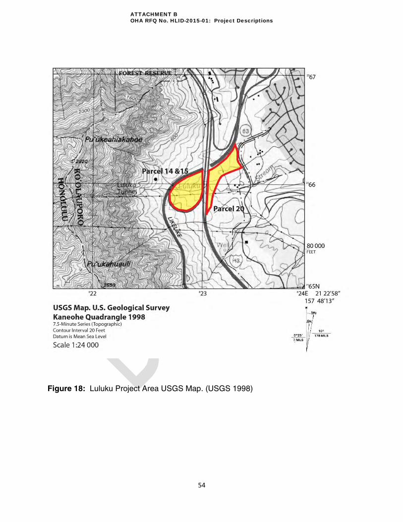
54
Figure 18: Luluku Project Area USGS Map. (USGS 1998)
ATTACHMENT B OHA RFQ No. HLID-2015-01: Project Descriptions
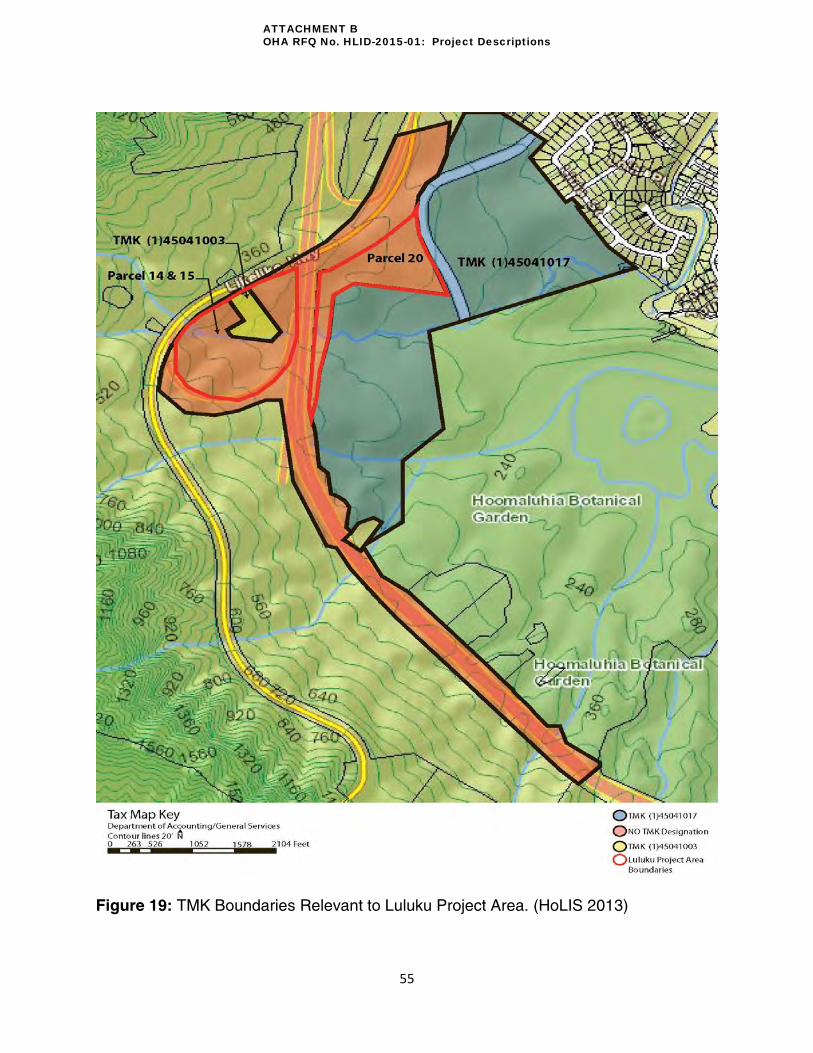
55
Figure 19: TMK Boundaries Relevant to Luluku Project Area. (HoLIS 2013)
ATTACHMENT B OHA RFQ No. HLID-2015-01: Project Descriptions

56
Figure 20: Right of Way Map for Luluku Project Area. (yellow highlights delineate Right of Way)
ATTACHMENT B OHA RFQ No. HLID-2015-01: Project Descriptions

57
Figure 21: Luluku Project Area, HECO Easement Access Map.
Note: HECO powerpoles represented by red dots; HECO powerlines in yellow
Note: TMK 4-5-41:17 is no longer subdivided. Parcel 20 is now part of the Highway Right of Way which does not have a TMK.
ATTACHMENT B OHA RFQ No. HLID-2015-01: Project Descriptions

58
Figure 22: Old TMK (1)454117 Lot B and Lot A Subdivisions.
Note: TMK 4-5-41:17 is no longer subdivided. Parcel 20 is now part of the Highway Right of Way which does not have a TMK.
ATTACHMENT B OHA RFQ No. HLID-2015-01: Project Descriptions

59
Archaeological Site Locations
Sites SIHP #s 50-80-10-1887, -1905, -1895, -1897, -1900, and -4483 will be affected by the
proposed scope of work for the Luluku project area (Figures 23 and 24). Sites -1887, -1905, -
1895-, -1897, and -1900 are also part of the Luluku Archaeological Discontiguous District Site
SIHP# 50-80-10-2914. All sites fall within the Highway Right of Way. According to HDOT, this
area was open for mitigation per the 1987 MOA. At the time of Interstate H-3 construction, no
“area of potential effect” was defined. Now, it is only the Highway Right of Way that suffices for
defining where mitigation is to occur for this project. It is for this reason that the entire
archaeological district is not included as part of this mitigation project. Portions (specific
features) of Site -1887 and all of -1905 were chosen for this project because they were
recommended for “interpretive display” by archaeologists (Allen et al. 1987: 262). For a specific
list of features and areas targeted for rehabilitation, please see the “Rehabilitation Site” section
for Luluku in this Project Descriptions. All other sites in their vicinity have been recommended
for preservation in place. With conclusive evidence of burials at Site -1905 in the Leidemann et
al. (2003) report7, the site was later recommended for preservation only.
All of Site -1905, -1900 and most of Site -1887 (mauka) are encompassed in the teardrop fence-
line, but a portion of Site -1887 (makai) passes under the Interstate H-3 and extends east into
Parcel 20. In the archaeological report by Leidemann et al. 2004, Site 1887 has been divided
into a total of 12 areas (Figure 25). The only exception to this is Feature 131, a historic
Japanese bomb shelter, which is not part of any area. The feature sits between Areas 7 and 9.
The following Areas and Features will be rehabilitated in Phase I: 1) selected portions of Area
1, approximately .6 acres (see Table 13 for complete list of features to be rehabilitated in this
area); 2) selected portions of Area 2, approximately 1.6 acres (see Table 13 for complete list of
features to be rehabilitated in this area); and 3) Area 7, Features 1, 2, and 132 (less than 1
acre). Although Feature 131 (no Area designation) has been designated as eligible for active
preservation per the 1987 MOA, it will be safeguarded by the Prime to protect future visitors of
endangerment. HLID suggests Areas 3 (approximately .8 acres) be considered for rehabilitation
in Phase II. The remainder of features and areas not listed in Table 13 is set for preservation.
Areas 3, 7, 8, 9, 10, 11, and 12-South of Site 1887 are within the teardrop. Site 1887 continues
on southeastward into Lot A of TMK (1)45041017. The areas of Site 1887 under the Interstate
(Area 4), in Lot A (Area 6), and Area 12-North are not part of the Luluku project area. A majority
of Area 5 of Site 1887 is on Parcel 20.
Sites -1895, -1897, -4483 span across multiple boundaries. A majority of Site -1895 lies outside
the southeastern bounds of the Likelike off-ramp. Only a small part of -1895 lies in the
“teardrop”. The majority of Site 1897 spans TMK (1) 45041017 Lot A and Lot B. Heading west
from Lot B, Site 1897 passes under the Interstate H-3 and extends into a small portion of the
teardrop. Once more, the areas under the Interstate H-3 and inside Lot A are beyond the
bounds of the Luluku project area. A majority of Site 4483 lies within Parcel 20; however, small
7 Leidemann, Helen; Hartzell, Leslie; Gordon, Ines; Lebo, Susan; Dockall, John; Lennstrom, Heidi; Mcpherron,
Shannon; Dolan, Barbara. 2003. Continuity and Change in Upland Kaneohe Habitation: Data Recovery and Monitoring Investigations in Luluku, Kapalai, and Punaluu Maka Ili, Oahu. Bishop Museum, Department of Anthropology. Honolulu, Hawaii.
ATTACHMENT B OHA RFQ No. HLID-2015-01: Project Descriptions

60
portions do extend beyond the northeastern and northern bounds of Parcel 20. A part of 4483
also passes under the Interstate extending into the northeast corner of the teardrop. According
to Allen et al. (2002), this site is considered destroyed.
Although UTM coordinates and area has been included in the Bishop Museum archaeology
reports for each site (see Table 8), the exact perimeter has not been geo-referenced nor has the
acreage of the sites been parceled according to project area boundaries. Only approximate
acreage cover and locations are provided in this report. A table summarizing UTM location and
area is provided in Table 8.
It is anticipated that the archaeologist will be clearing vegetation around the immediate vicinity
of archaeology features for proper access, documentation and analysis while performing their
work.
Table 8: Luluku Project Area UTM coordinates and area coverage
Site # (State) 50-80-10-
Bishop Museum # 50-Oa-
Area (m2)
Area (Acres)
Archaeological Recommendation
UTM Coordinates Zone 40- (E/N)
-1887 G5-85 161300 39.9 Interpretive Display 622520/2366700 (NW corner) 622770/2366370 (SE corner)
-1905 G5-71 199 .049 Preservation 622549/2366216
-1895 G5-93 2417 .6 Preservation 622670/2366011
-1897 G5-95 9232 2.28 Preservation 622795/2366254
-1900 G5-98 1394 .344 Preservation 622590/2366033
-4483 G5-152 18000 4.5 Preservation Not provided
ATTACHMENT B OHA RFQ No. HLID-2015-01: Project Descriptions

61
Figure 23: Bishop Museum Map of Archaeological Sites Near the Käne‘ohe Interchange. (modified from Leidemann et al. 2003)
ATTACHMENT B OHA RFQ No. HLID-2015-01: Project Descriptions

62
Figure 24: Archaeological Sites within Luluku Project Area Boundaries. Note: (*) Phase II rehab areas only suggested. All rehab areas have specific features to be
rehabilitated per the 1987 MOA; for these features, please see Table 13.
ATTACHMENT B OHA RFQ No. HLID-2015-01: Project Descriptions

63
Figure 25: Site 1887 Areas. (modified from Leidemann et al. 2004, Fig. 2.1) Note: See Table 13 of this document for exact feature numbers recommended for rehabilitation. Phase II rehab areas are only suggested.
ATTACHMENT B OHA RFQ No. HLID-2015-01: Project Descriptions

64
Vision and Working Group Mana‘o
The Luluku Project Area was once part of a large complex of agricultural terraces in pre-
Contact times that were later divided and partially destroyed by the construction of the Likelike
Highway in the 1950s. This legacy of disruption has been continued with the construction of
Interstate H-3. The vision for Luluku has thus been to restore the “agricultural district”. The
Luluku agricultural terraces shall be restored through the perpetuation of culturally appropriate
science, engineering, and agricultural practices. The planting of primarily native Hawaiian kalo
(taro) using ancient and contemporary techniques in water resource management and
sustainable agricultural practices will take place once restoration is complete. The relationship
between the land and its people are of both historical and cultural importance in the context of
interpretations which emphasizes Luluku’s ability to feed many people in the Käne‘ohe district
and areas beyond.
The WG has expressed their thoughts regarding the agricultural terraces and has
recommended that the area be mitigated as a discontiguous district. They recognize its cultural
significance and have recommended that to the extent possible the project site should be
realized as its role within the original existing continuous agricultural district. This recognition is
justified by the archaeological and historical evidence that suggest that this wahipana had an
abundance of water, access to the stream, fertile soil and a complex system of lo‘i kalo and
agricultural terracing. The archaeological report suggests that portions of the archaeological
site SIHP# 1887 (within the “teardrop”) contains terracing that seems to have been designed
with significance much deeper than just agriculture.
To bring this vision to fruition, the loʿi terraces will need water diverted from Luluku stream. Any
subsequent permits, studies, or engineering designs needed to enable this will be obtained by
the Prime. The master masons who will be performing the loʿi rehabilitative work will be
consulted with in order to identify the best location to connect to the stream. Local farmers
could potentially comment as well since they understand the hydrology of the area on an
intimate level. Archaeology reports can assist in locating old ʿauwai. Information from the
Master Masons and archaeologists will be supplied to the Prime via HLID.
Historically, Luluku has retained a land use that focused on agriculture due to its natural
resources and geographical location. As a result, people have maintained an agricultural
relationship with these lands over time. Though the intensity and depth of this relationship has
changed the significance, the cultural importance remains; thus, creating an opportunity to
rehabilitate this relationship in tandem with the land and its resources. Luluku’s reputation and
contemporary potential to feed (figurative to suggest: food/medicine/education/Hawaiian
culture/spirituality) the people in Käne‘ohe and its surrounding areas still apply and so drive the
focus of this project site.
The site represents an inland component of the prehistoric settlement in Käne‘ohe and may
provide indirect evidence relevant to understanding island-wide population expansion. It also
constitutes the most extensive early wetland agricultural complex known on O‘ahu and contains
a stratigraphic sequence reflecting a long period of continued use and development that
ATTACHMENT B OHA RFQ No. HLID-2015-01: Project Descriptions

65
probably began in early Hawaiian history. Significance is further enhanced by the excellent
state of preservation of a large portion of site SIHP #1887. Although the surrounding area has
been altered by 20th-century developments (roads and plantations), small areas of native
vegetation still exist nearby in a rural setting, suggesting the relative integrity of Site 1887 (G5-
85) within its physical and cultural environment.
ATTACHMENT B OHA RFQ No. HLID-2015-01: Project Descriptions

66
Identified Impacts and Recommendations
The impacts found within the IDP and suggested mitigation measures are provided below.
These IDP mitigation recommendations were instrumental in determining the current course of
action for the Luluku Project Area.
Impacts:
Increase in soil erosion during construction
Reduction of access to the site
Change of land use from agriculture
Introduction and expansion of non-native plants species, increased number of potential
sites for establishment of new alien species
Destruction of portions of the project site by Interstate H-3
Reduced productive farm acreages and displacement of farmers who grew banana in
the area and loss of productive, managed banana farm lands
Contributed to the loss of knowledge and history of the area
Disrupted water resources of the area through the channelization of streams under the
highway, changing the stream course and access to the streams
Altered water flows and flow capabilities through the terrace system
Damaged potions of the terrace walls, mäno (water source) and ‘auwai (ditch)
Damage areas deemed culturally significant by archaeologists identified as test pits and
trenches in varying sizes
Disrupted the spatial relationship of lo‘i and ‘auwai to streams in the ‘ili
Damaged portions of the ahupua‘a walls
Abandonment of the lo‘i kalo
Interrupted the arrangement and pattern of terraces in relation to the stream, ‘auwai, and
lowland flats
Increased trash from the highway
Impacted short distance views from within Luluku due to the bifurcation (division) of the
project site, and blocked views toward Kaneohe town and Kaneohe Bay
Destroyed symbols of Hawaiian history and culture
Bifurcation (division) of the project site and separation of archaeological sites
Allowed drainage from the freeway decks to ground below
Caused removal of burial features
Recommendations
Provide access to Luluku site, must implement/enforce visitation to these areas – issue
of legal access to site
Install access road and parking (15 spaces) at entry point to accommodate access to the
site
Implement managed access and security (partially through agreement with Parks and
Recreation, Ho‘omaluhia Botanical Garden)
Restore stream (environment, water flow, vegetation) to pre Luluku tunnel levels
ATTACHMENT B OHA RFQ No. HLID-2015-01: Project Descriptions

67
Restore the Luluku lo‘i system and provide public access to the Luluku agricultural
complex
Build a cultural resources complex that include a visitor center, education facilities,
public gathering area, and maintenance facilities
Develop interpretive materials for orientation, education, cultural, and natural themes
Vegetation – implement a restoration and maintenance program
ATTACHMENT B OHA RFQ No. HLID-2015-01: Project Descriptions

68
Project Elements
To help systematically address the impacts in the IDP and to ensure the vision of the Working
Group was being met, the impacts and visions were coded into separate categories. A table is
provided below showing the coding for each:
Table 9: Luluku impact and vision coding matrix
Code Impact
I.1 Burial Disturbance
I.2 Altered Stream Alignment, flow and pollution
I.3 Degradation and destruction of culturally significant sites
I.4 Changes to the landform
I.5 Reduced Accessibility
I.6 Increase in hazardous conditions
I.7 Ineffective/Ill maintained erosion measures
I.8 Impact to flora and fauna (Environment)
I.9 Increased pollution (physical, light, noise, etc.)
I.10 Reduction of Productive Agriculture
I.11 Incomplete Archaeological Work
Code Vision
V.1 Rehabilitated Cultural Sites for Agricultural Production
V.2 Perpetuate Hawaiian Thought through Ag./NREM
V.3 Preservation of Cultural Practices
V.4 Recognition of the Site as a Wahi Pana
V.5 Become a Cultural & Educational Resource for Ko‘olaupoko
Project elements were then designed to address each code and prioritized by the Working
Group. The project elements presented on the following pages were selected based on highest
priority, budget, and Working Group consensus. As a result of budget, the project will be split
into two phases. Phase I (inclusive of permitting, management, and prioritized construction) is
to be funded by the remaining HLID budget for Luluku. Phase II project elements will be
completed by stewards pending the availability of funds that are not part of the HLID budget.
The Prime is responsible for obtaining necessary permits to enable construction and ensuring
compliance with the Americans with Disabilities Act (ADA) for all facilities and outdoor areas.
HLID is currently in the process of obtaining the necessary Use & Occupancy permits from
HDOT to allow HLID and any contractor to perform necessary work to complete project
elements from the IDP. Comments from Highway-O (Oʿahu) and/or Highway Rights of Way
may alter the scope of proposed actions for the HLID project.
All construction for contemporary structures is to take place on Parcel 20 only. Construction
access in Parcel 20 will be provided via Ho‘omaluhia Park Access Road and staging will be
limited to the immediate vicinity around the planned “Administrative Center”. To get to the
access road, construction crews will need to travel through a residential area on Luluku Road
(Figure 26). Phase I and II project elements and descriptions for Parcel 20 are provided in the
ATTACHMENT B OHA RFQ No. HLID-2015-01: Project Descriptions
69
tables on the next pages (Table 10 and 11). A conceptual site plan is provided for reference
(Figure 27) and accompanied with a set of conceptual renderings (Figure 28 and 29). Ground
disturbing work (i.e.: grading, foundation, digging) is expected for the Administrative Center,
storage, parking, and composting toilets. No contemporary construction will take place in the
teardrop as this area will be the focus of archaeological preservation and rehabilitative efforts
(see later section). Geo-tech (soil coring) and topography data acquisition will need to be done
for the new construction area to better inform of design and location choices for project
elements. This work, to be carried out by the Prime, will be inclusive of Phase I elements.
Together, the project element descriptions, geo-tech reports and topographical data will enable
the Prime to provide adequate information to inform the environmental review.
Vegetation on archaeological sites within the “teardrop” to be rehabilitated will be extensively
cleared during Phase I by the cultural Master Masons. This is envisioned to involve the use of
heavy machinery (i.e.: tree chipper, mulcher, stump grinder), hand-held equipment (chainsaws,
trimmers, etc.) and hand tools (machete, handsaws, etc.). Vegetation clearing vehicles can
gain access to the “teardrop” through an access point (provided HDOT consent and approval)
near the “teardrop” (northwest) apex along the Interstate H-3 (Figure 26). However, if this
access point is utilized, all appropriate HDOT traffic control procedures must be followed. HLID
is currently trying to work with HDOT to gain additional access to the “teardrop” via HECO’s
access road on Lot A of KLP land. In Parcel 20, vegetation clearance in Phase I will also be
done in the immediate vicinity of the proposed “Administrative Center” by the Prime. A more
detailed description of vegetation control and green waste removal guidelines are outlined in the
following section. During construction and vegetation clearing, HLID recommends the inclusion
of archaeological and cultural monitors operating under a separate contract.
Archaeological and cultural monitors will be present during all construction and vegetation
clearance. This will safeguard cultural sites and potentially allow for the discovery of new sites
previously unrecorded during ground disturbing work. The archaeological contractor will thus be
asked to prepare an Archaeological Monitoring Plan (AMP) for SHPD review. Cultural monitor
guidelines will be sought through OHA and the Native Hawaiian Historic Preservation Council
(NHHPC).
ATTACHMENT B OHA RFQ No. HLID-2015-01: Project Descriptions

70
Figure 26: Luluku Project Area Construction Access Map. (not to scale) (Google Maps 2013)
Note: Location of HECO Road and Dirt Road were early approximations that were not GPS’d.
ATTACHMENT B OHA RFQ No. HLID-2015-01: Project Descriptions
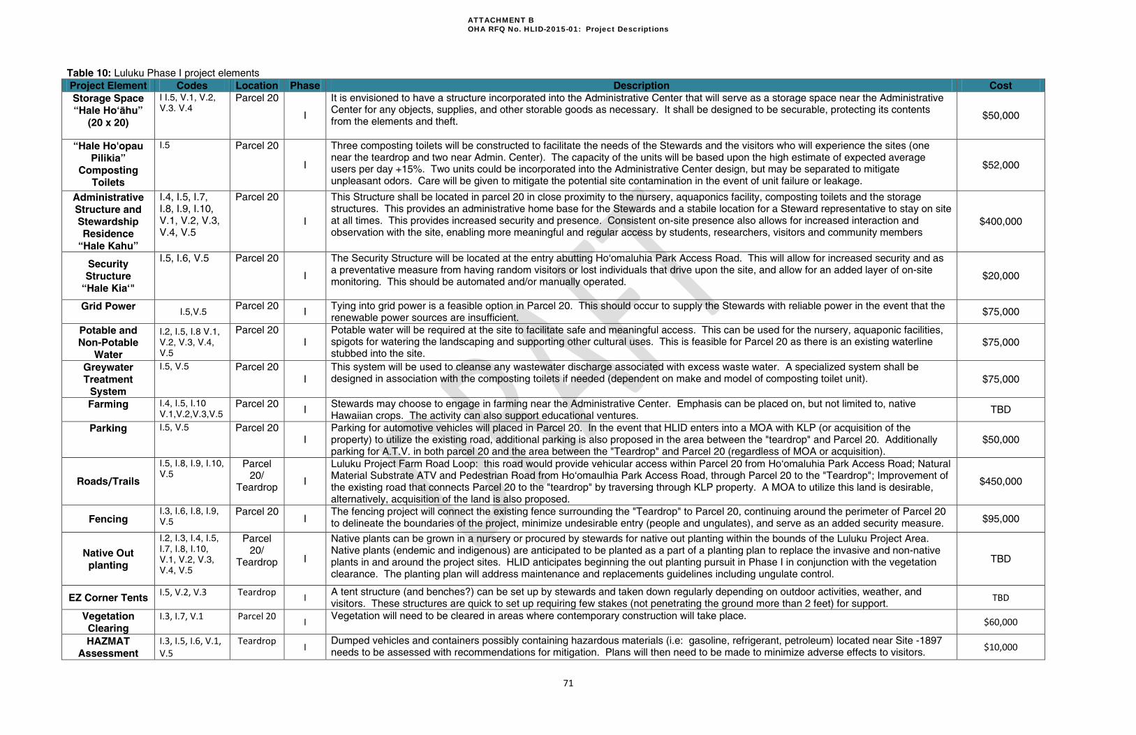
71
Table 10: Luluku Phase I project elements
Project Element Codes Location Phase Description Cost
Storage Space
“Hale Ho‘ähu”
(20 x 20)
I I.5, V.1, V.2,
V.3. V.4 Parcel 20
I
It is envisioned to have a structure incorporated into the Administrative Center that will serve as a storage space near the Administrative Center for any objects, supplies, and other storable goods as necessary. It shall be designed to be securable, protecting its contents from the elements and theft.
$50,000
“Hale Ho'opau
Pilikia”
Composting
Toilets
I.5 Parcel 20
I
Three composting toilets will be constructed to facilitate the needs of the Stewards and the visitors who will experience the sites (one near the teardrop and two near Admin. Center). The capacity of the units will be based upon the high estimate of expected average users per day +15%. Two units could be incorporated into the Administrative Center design, but may be separated to mitigate unpleasant odors. Care will be given to mitigate the potential site contamination in the event of unit failure or leakage.
$52,000
Administrative
Structure and
Stewardship
Residence
“Hale Kahu”
I.4, I.5, I.7, I.8, I.9, I.10, V.1, V.2, V.3, V.4, V.5
Parcel 20
I
This Structure shall be located in parcel 20 in close proximity to the nursery, aquaponics facility, composting toilets and the storage structures. This provides an administrative home base for the Stewards and a stabile location for a Steward representative to stay on site at all times. This provides increased security and presence. Consistent on-site presence also allows for increased interaction and observation with the site, enabling more meaningful and regular access by students, researchers, visitors and community members
$400,000
Security
Structure
“Hale Kia‘"
I.5, I.6, V.5 Parcel 20
I
The Security Structure will be located at the entry abutting Ho‘omaluhia Park Access Road. This will allow for increased security and as a preventative measure from having random visitors or lost individuals that drive upon the site, and allow for an added layer of on-site monitoring. This should be automated and/or manually operated.
$20,000
Grid Power I.5,V.5
Parcel 20 I
Tying into grid power is a feasible option in Parcel 20. This should occur to supply the Stewards with reliable power in the event that the renewable power sources are insufficient.
$75,000
Potable and
Non-Potable
Water
I.2, I.5, I.8 V.1,
V.2, V.3, V.4,
V.5
Parcel 20
I
Potable water will be required at the site to facilitate safe and meaningful access. This can be used for the nursery, aquaponic facilities, spigots for watering the landscaping and supporting other cultural uses. This is feasible for Parcel 20 as there is an existing waterline stubbed into the site.
$75,000
Greywater
Treatment
System
I.5, V.5 Parcel 20
I
This system will be used to cleanse any wastewater discharge associated with excess waste water. A specialized system shall be designed in association with the composting toilets if needed (dependent on make and model of composting toilet unit). $75,000
Farming I.4, I.5, I.10
V.1,V.2,V.3,V.5 Parcel 20
I Stewards may choose to engage in farming near the Administrative Center. Emphasis can be placed on, but not limited to, native Hawaiian crops. The activity can also support educational ventures.
TBD
Parking I.5, V.5 Parcel 20 I
Parking for automotive vehicles will placed in Parcel 20. In the event that HLID enters into a MOA with KLP (or acquisition of the property) to utilize the existing road, additional parking is also proposed in the area between the "teardrop" and Parcel 20. Additionally parking for A.T.V. in both parcel 20 and the area between the "Teardrop" and Parcel 20 (regardless of MOA or acquisition).
$50,000
Roads/Trails
I.5, I.8, I.9, I.10,
V.5 Parcel
20/ Teardrop
I
Luluku Project Farm Road Loop: this road would provide vehicular access within Parcel 20 from Ho‘omaluhia Park Access Road; Natural Material Substrate ATV and Pedestrian Road from Ho‘omaulhia Park Access Road, through Parcel 20 to the "Teardrop"; Improvement of the existing road that connects Parcel 20 to the "teardrop" by traversing through KLP property. A MOA to utilize this land is desirable, alternatively, acquisition of the land is also proposed.
$450,000
Fencing I.3, I.6, I.8, I.9,
V.5 Parcel 20
I The fencing project will connect the existing fence surrounding the "Teardrop" to Parcel 20, continuing around the perimeter of Parcel 20 to delineate the boundaries of the project, minimize undesirable entry (people and ungulates), and serve as an added security measure. $95,000
Native Out
planting
I.2, I.3, I.4, I.5,
I.7, I.8, I.10,
V.1, V.2, V.3,
V.4, V.5
Parcel 20/
Teardrop I
Native plants can be grown in a nursery or procured by stewards for native out planting within the bounds of the Luluku Project Area. Native plants (endemic and indigenous) are anticipated to be planted as a part of a planting plan to replace the invasive and non-native plants in and around the project sites. HLID anticipates beginning the out planting pursuit in Phase I in conjunction with the vegetation clearance. The planting plan will address maintenance and replacements guidelines including ungulate control.
TBD
EZ Corner Tents I.5, V.2, V.3 Teardrop
I A tent structure (and benches?) can be set up by stewards and taken down regularly depending on outdoor activities, weather, and visitors. These structures are quick to set up requiring few stakes (not penetrating the ground more than 2 feet) for support.
TBD
Vegetation
Clearing
I.3, I.7, V.1 Parcel 20 I
Vegetation will need to be cleared in areas where contemporary construction will take place. $60,000
HAZMAT
Assessment
I.3, I.5, I.6, V.1, V.5
Teardrop I
Dumped vehicles and containers possibly containing hazardous materials (i.e: gasoline, refrigerant, petroleum) located near Site -1897 needs to be assessed with recommendations for mitigation. Plans will then need to be made to minimize adverse effects to visitors.
$10,000
ATTACHMENT B OHA RFQ No. HLID-2015-01: Project Descriptions

72
Table 11: Luluku Phase II project elements Note: (*) optional component for Phase I depending on available funds. Unless specified, project element is intended for Parcel 20 location
Project Element Codes Location Phase Description Cost
Nursery
Facilities
“Hale ‘Öhi‘a”
(Kit Type)
I.2, I.3, I.4, I.5,
I.7, I.8, I.10,
V.1, V.2, V.3,
V.4, V.5
Parcel 20
II*
The Nursery Facilities (2-3) shall be securable, and will consist of a propagation area and associated grow-out/transition areas for the Native Hawaiian (indigenous and endemic), food, medicinal, utilitarian, floral and erosion control plants as specified by the Stewards in association with HLID's recommendations. There shall also be associated storage spaces, utilities, automated misting /watering components and any other amenities to enable efficient and cost effective production. The facilities and products will be used to supplement: landscaping, education, food, medicine, utilitarian objects and uses, traditional and contemporary propagation practices, research and development, erosion control measures, farming, agro forestry, and sustainable economic development. Other forms of plant propagation and growing methodologies may be incorporated into the allowable uses of the nursery facilities.
$20,000
Natural Nursery
Facilities
“Hale Lehua”
I.2, I.3, I.4, I.5, I.7, I.8,
I.10, V.1, V.2, V.3, V.4, V.5
Parcel 20
II*
A Natural Nursery Facility would be an area where the natural vegetation, topography and natural conditions can be shaped to facilitate nursery conditions. These areas would require minimal materials to construct, utilizing the natural elements and conditions to its full advantage. An example of the elements needed include: grow tables, simple storage and ungulate control.
Value Engineer
Aquaponic
Facility(Kit Type)
I.2, I.3, I.4, I.5,
I.7, I.8, I.10,
V.1, V.2, V.3,
V.4, V.5
Parcel 20
II*
The Aquaponic Facility shall be securable and consist on multiple aquaponic systems to assist in propagation and growth of Native Hawaiian (indigenous and endemic), food, medicinal, utilitarian, floral and erosion control plants as specified by the Stewards in association with HLID's recommendations. There shall be appropriate storage, utilities and equipment to enable efficient and cost effective production and operation. The products of the facility will be used to supplement: landscaping, education, food, medicine, utilitarian objects and uses, traditional and contemporary propagation practices, research and development, erosion control measures, farming, agro forestry, and sustainable economic development. Wicking garden bed technology will also be allowable in conjunction with the aquaponic facility to enable better use of water and nutrients for application in the drier areas where the soil quality has been degraded or compromised.
$20,000
Renewable
Power
Generation
I.5, V.2, V.5
Parcel 20
II*
Photovoltaic, Wind-Turbine, Hydro-turbine and other sources of on-site, renewable power generation will be constructed as auxiliary elements for all constructed structures. This will be used to supplement all power needs for the project. A back-up power generator shall also be incorporated and wired into the system accordingly to augment any power needs or serve as an alternate source or power in emergency situations. High-output, conditioned portable generators may be acceptable (to be determined during the DD and Construction and Implementation phases). For both the "teardrop" and Parcel 20.
$60,000
Halau/Meeting
House (Size to be
Determined)
I.5 I.7, I.8, I.9,
V.1, V.2, V.3,
V.4, V.5
Parcel 20
II
The Meeting House will serve as a traditional center meeting structure. This space is intended to facilitate uses including: Orientation, Execution of Protocol, Education, Meetings, Workshops, Cultural Retreats, etc. The design is envisioned to accommodate open air use with the ability to adapt to mitigate undesirable weather conditions.
$200,000
Dining Facility
“Hale 'Äina”
(20 x 20)
I.5, V.2, V.3.
V.5
Parcel 20
II
This smaller structure is envisioned to house any food/medicinal preparations to facilitate access and support the needs of the Stewards and Visitors. This can be a structure on its own or be incorporated into the Administrative structure. Additionally, an outdoor cooking area shall be located in close proximity. If applicable, this structure will accommodate open air uses with the ability to adapt to mitigate undesirable weather conditions.
TBD
Outdoor
Learning Areas
“Kahua ‘Ike”
I.3, I.4, I.7, I.8, I.9, I.10,
V.1, V.2, V.3, V.4, V.5
Teardrop
II
At Parcel 14/15 (the “teardrop”), outdoor learning areas are envisioned to facilitate outdoor educational activities, workshops, and other uses that allow people to reconnect with the site, the surroundings and "tune into the vibe" of Luluku. These areas will be integral with the programs developed by the Stewards to implement HLID mitigation recommendations.
TBD
ATTACHMENT B OHA RFQ No. HLID-2015-01: Project Descriptions

73
Figure 27: Luluku Project Area Conceptual Site Plan. Note: (**) HLID Suggested Phase II Rehabilitation Areas
ATTACHMENT B OHA RFQ No. HLID-2015-01: Project Descriptions

74
Figure 28: Luluku Parcel 20 Conceptual Rendering.
ATTACHMENT B OHA RFQ No. HLID-2015-01: Project Descriptions

75
Figure 29: Luluku Terraces Conceptual Rendering.
Note: Depiction of Site -1887, Area 2 near Feature 37. Site likely to include an interpretive sign for the area.
ATTACHMENT B OHA RFQ No. HLID-2015-01: Project Descriptions

76
Proposed Vegetation Clearance Procedure (Luluku) This vegetation clearance procedure will be reviewed by SHPD when the archaeological
contractor submits their archaeological monitoring plan. Long-term maintenance of vegetation
on the site after completion of the HLID project will be maintained by stewards operating per
instructions set in a Preservation Plan and Landscape Plan. These plans will be developed by
the archaeologist and Prime, respectively. Initial clearing around archaeological sites by the
archaeologist will be done to delineate buffer zones and locate archaeological features. Full
clearing of the archaeological sites to be rehabilitated will be done by the cultural Master Mason.
1) Identification of vegetation clearance areas: Vegetation clearance will take place on
selected portions of Parcel 20 and the “teardrop” (see Figure 25). In Parcel 20,
clearance will be restricted to the lower northeast corner of the property boundary where
the proposed Administrative Center will be placed. This clearing will be done by the
Prime. The existing dirt road loop will effectively serve as the southern boundary for the
extent of vegetation clearance. Since no archaeological sites with integrity exist in this
section of Parcel 20, no areas will require flagging for avoidance during vegetation
clearance work.
In the “teardrop”, vegetation clearance will be restricted to the vicinity of Phase 1
rehabilitation areas: Site 50-80-10-1887 Areas 1 and 2. This will be done by the cultural
Master Mason. A path will also need to be cleared which permits access from the
entrance of the “teardrop” to the fence access point for Site 1887. This will also be done
by the cultural Master Mason. This path should be large enough to allow a small truck to
transport personnel to the site and remove greenwaste periodically. The proposed path
in the “teardrop” is depicted on Figure 26. Sites 50-80-10-1895, -1900, -1905 and Phase
II Areas of 1887 will need to be flagged accordingly by the archaeologist to clearly
delineate buffer zones so they are avoided by the Master Masons. This type of flagging
of protected areas (inclusive of their respective buffers) during the interim will be
described in the forthcoming Preservation Plan to satisfy HAR 13-277 requirements. A
map depicting archaeological sites within the Luluku Project Area boundaries will be
provided to the cultural Master Masons for reference by the archaeologist. The figure
will be very similar to Figure 22 of this document, but further magnified for clarity.
Since the area to be cleared exceeds 1 acre, a National Pollution Discharge Elimination
System (NPDES) permit will need to be obtained by the Prime since clearing could
potentially affect natural erosion processes. At this time, it is estimated that at least 3
acres will need to be cleared in Phase I.
2) Eradication Focus: Since the Luluku Project Area is located within a conservation
district (subzone General), certain requirements exist pertaining to what needs to be
removed and what is allowed to stay. Particularly, vegetation clearance activities should
focus on noxious weeds, alien plants, and dead/diseased non-native tree removal. Alien
plants are identified as a Post European introduction (Post-Euro) on the 1987 Luluku
vegetation inventory table and highlighted in orange. Based on this list, noxious weeds
ATTACHMENT B OHA RFQ No. HLID-2015-01: Project Descriptions

77
are not a current concern. Native trees with a trunk less than six inches in diameter
(measured at the ground level) may be removed. HLID will only recommend the
removal of native trees of this size if they are interfering with the structural integrity of loʿi
walls or posing a public safety hazard. Larger native trees exceeding the six inch
threshold may also be removed only if they pose a hazard to public safety and after their
presence has been documented. The removal of endemic, indigenous, and Polynesian
introduced plants is discouraged by HLID and will be kept to a feasible minimum. A list
of endemic, indigenous, and Polynesian introduced plants is provided in the 1987 Luluku
vegetation inventory table. A new flora survey will be completed by the Prime to update
the inventory list prior to clearing work by the cultural Master Masons. This list will be
supplied to the archaeological contractor for inclusion in the archaeological monitoring
plan.
3) Creation of 5 foot buffer around loʿi walls: To preserve the integrity of the basalt
terrace walls, no machinery will be used within five feet of loʿi walls (Figure 30, 5 ft buffer
zone). This area will be the “light vegetation clearance area”. Since the overgrown
grass tends to conceal the previously identified archaeological features, a crew will have
to initially carve a path around all the walls to properly delineate the 5 foot buffer.
Weeds in this area are to be cut and not pulled out of the ground to prevent damage to
archaeological features. Flags or flagging tape can be used to accentuate the
boundaries. This boundary will also be delineated on a map to be provided to the
vegetation clearance crew. Hand clearing entails the use of small sickles and clippers.
Cut vegetation should be cut to pieces that are less than 3 feet in length and placed in
designated piles that do not bury any archaeological features. Clipped vegetation
should not be dragged but carried to avoid inadvertently displacing loʿi rocks and
boulders. A wheelbarrow will periodically empty these piles throughout the work day and
transport greenwaste to designated mass pickup piles. HLID also foresees that in some
cases, large trees may be located within the buffer zone. It is only in this instance that
chainsaws or larger hand tools (saw, axe) may be used within the buffer zone with
caution.
4) Designate temporary access trails: Archaeological plan view drawings can be used to
identify breaks in loʿi walls and areas that can be traversed without impacting the
archaeological sites during initial intensive vegetation clearance. A path is to be
designated by the cultural Master Masons to facilitate extensive vegetation clearing. A
map of this path will be supplied to the archaeological contractor for inclusion in the
archaeological monitoring plan. A sample path is proposed which takes advantage of
breaks in loʿi walls and tumbled rock faces for efficient access (Figure 30). This
proposed map may be altered in the field or with further project scope refinements. In
the Primary Greenwaste Path, breaks in loʿi walls can be found at features 40, 35, 136,
29 of Site -1887, Area 2. Tumbled rock faces exist at features 140, 141, and 13. In Area
1 of Site -1887, the South end boarding Luluku Steam is utilized because the loʿi walls
do no extend to this extremity. However, a wooden ramp may be needed over a portion
of Feature 5 near Excavation Unit (trench) 54. An alternative Secondary Greenwaste
ATTACHMENT B OHA RFQ No. HLID-2015-01: Project Descriptions

78
Path is also suggested if additional access is deemed necessary. In this case, wooden
ramps would need to be set up over the loʿi walls of Features 33 and 31. Wooden ramps
are placed over loʿi walls to facilitate the transport of equipment and wheelbarrows.
Wheelbarrows can be used to haul away greenwaste periodically throughout the
workday. This method has been effectively utilized at Poliʿahu Heiau and Malae Heiau
(Site 50-30-08-104) at Wailua River State Park located in Līhuʿe, Kauaʿi.
5) Use of Machinery and larger tools outside the buffer zone: Chainsaws, weed-
whackers, and machetes can be used beyond the 5 foot buffer zones to minimize impact
to archaeological resources. Cut vegetation should be reduced to less than 3 feet in
length and placed in designated piles. Clipped vegetation should not be dragged but
carried to avoid inadvertently displacing loʿi rocks and boulders. A wheelbarrow will
periodically empty these piles throughout the day.
6) Removal of large trees: Prior to beginning tree trimming work, a herbicide can be
injected into a trees circulatory system to weaken tree strength. This method also allows
for the decay of the root system. However, given that the project area will be a
functioning loʿi, other methods of tree removal will be considered. Recommendations
and comments will be sought from a certified arborist and the Department of Land and
Natural Resources (DLNR). In areas where the root system has become intertwined in
the loʿi walls, herbiciding could effectively aid in root removal with minimal impacts to
archaeological features. Alternatively, trees intertwined in the walls can be cut down to
the stump and left until actual archaeological rehabilitative work. At that time, the Master
Masons may need to actually deconstruct the walls to effectively remove the tree root
system. In instances where large trees are intertwined in or close to loʿi walls,
chainsaws and large tools (axe, saws) may be utilized within the 5 foot light vegetation
clearance buffer zone. 30 days after injection, tree trimmers can begin the trimming
process. Trees will need to be roped so that cut sections can be lowered gradually to
minimize possible harm to personnel, the archaeological site, and the ground. A
certified (licensed) ISA arborist will be part of the Master Mason team to complete tree
removal work.
7) Disposal of greenwaste: A designated area for mass greenwaste dumping will be set
at both Parcel 20 and the “teardrop” (see Figure 30). Cut vegetation can be fed into a
chipper at these locations to reduce clipping size further. Chippings and compost can
also be used to line access trails and walking paths, or to condition the soil of loʿi.
Compost effectively insulates and aerates the soil to improve nutrient richness. A dump
truck will need to transport these piles daily to the Hawaiian Earth Products greenwaste
facility located on Kapaʿa Quarry Road. A disposal fee of $41 per ton will be factored
into associated vegetation clearance budget. This facility has been designated as a
preferred “greenwaste facility” by the state of Hawaii Department of Environmental
Services. The greenwaste pile at Parcel 20 will be situated near the dirt road loop to
ATTACHMENT B OHA RFQ No. HLID-2015-01: Project Descriptions

79
facilitate easy pickup. A dump-truck will need to travel along Hoʿomaluhia Park Access
Road to reach this destination.
In the “teardrop” area, the greenwaste pile can be placed near the northeast apex of the
Interstate H-3 off-ramp to the Likelike far from any archaeological sites with integrity. An
existing guardrail can be removed along the Likelike, granted HDOT permission, to allow
a dumptruck to pick up large quantities of greenwaste from this destination daily. Like
Parcel 20, the greenwaste will also be taken to the Hawaiian Earth Products facility on
Kapaʿa Quarry Road.
8) Archaeological and Cultural Monitors: To minimize impact to archaeological
resources and to ensure that rocks and features are not displaced, HLID recommends
the use of archaeological monitors during the vegetation clearance process. Displaced
rocks from walls or other features should be put back and stabilized to prevent further
movement. During the archaeological rehabilitative work, Master Masons can assess
any displaced features or rocks noted by the archaeologist during monitoring.
Consistent violations of the buffer zone rule and damage to archaeological features will
subsequently be reported to HLID by the archaeological monitor. HLID will issue two
written warnings for infractions. A third infraction may result in termination of contract
and participation on the HLID project. Cultural monitors will be present to ensure all
work activities are done in a manner sensitive Native Hawaiian belief. Guidelines for
cultural monitors will be sought through OHA and the Native Hawaiian Historic
Preservation Council (NHHP).
9) Interim Measures: After vegetation clearing, a landscaping fabric can be placed over
loʿi patches. This will inhibit weed growth and keep the area better prepared for future
stewards. Lingering vegetation covered by the substrate will be suffocated and thus
subsequently turned into a natural compost to better enrich the soil. The fabric can be
weighted down with tree logs or pinned with stakes. To minimize costs, loʿi patches may
be alternatively covered with a 2 to 4 inch layer of mulch gathered from accumulated
greenwaste.
ATTACHMENT B OHA RFQ No. HLID-2015-01: Project Descriptions

80
Figure 30: Sample Greenwaste Disposal Path for Site 1887 Luluku Project Area, “Teardrop” Location.
ATTACHMENT B OHA RFQ No. HLID-2015-01: Project Descriptions

81
Archaeological Project Elements
Archaeological sites fall into either a Preservation or Rehabilitation category based on traditional
site function, archaeological recommendation (preservation vs interpretive), integrity and the
presence of burials (Table 12). The 1987 MOA also lists specific features of Site 1887 to be
rehabilitated (Table 13). A budget has been set for the rehabilitation and preservation work for
the Luluku project area to eventually be bid upon by a cultural Master Mason who will complete
the work. Any proposed work needed to be performed that exceeds the budget will need to be
completed in a later phase as funding and capacity allows in accordance with the Stewarding
entities management plan.
The contracted archaeologist will be developing a Preservation Plan for the Luluku Project Area
that will conform to all applicable National Historic Preservation Act (NHPA) requirements and
relevant Hawaii Administrative Rules (HAR Chapter 6E) when developing the preservation plan.
The preservation plan for the Luluku project area will detail instructions for preservation
(protection and stabilization) and rehabilitation (repair, replacement, or alteration). Because a
considerable amount of time has passed since the completion of the archaeological work, the
preservation plan itself is to be preceded by a “condition assessment” plan which will require
SHPD review. To ensure compliance, the Contractor’s team and HLID will need to collaborate
with SHPD as appropriate throughout the planning and construction phases associated with
rehabilitation and preservation. The preservation plan will include HLID’s interpretations of the
cultural resources and will abide by the National Park Service treatment (NPS) methodologies.
Preservation/Rehabilitative work beyond Phase I is to be carried out by the Stewards per the
Stewardship Management Plan (SMP). Long-term maintenance, as outlined in the Preservation
Plan, will be included in the SMP as well. The recommended treatment actions will be justified
by archaeological interpretation and community input. The only site not recommended for
rehabilitative/preservation work is Site -4483. According to an archaeological study8 in 2002
(Allen et al.), the site is considered destroyed and has already yielded the necessary
archaeological information to satisfy mitigation. However, if this recommendation is
unacceptable to SHPD, the proposed farming area can be moved out of the bounds of Site -
4483. A table is provided on the next page summarizing the archaeological descriptions, HLID’s
recommendations, and phasing. Following this table, are plans for the two major NPS
treatments (preservation and rehabilitation) emphasized in our work.
8 Allen, Jane; Lennstrom, Heidi; Dolan, Barbara; Leidemann, Helen.
2002. Four Sites in Upland and Kaneohe: Supplemental Survey and Archaeological Monitoring for Interstate Route H-3. Bishop Museum, Department of Anthropology. Honolulu, Hawaii.
ATTACHMENT B OHA RFQ No. HLID-2015-01: Project Descriptions

82
Table 12: Summary of archaeological site descriptions
Note: (*) Eligible as Luluku Archaeological Discontiguous District (SIHP# 50-80-10-2914)
(**) Only specific features of Site 1887 are recommended for active preservation. All other features not listed on Table 13 are
slated for passive (avoidance and stabilization) preservation
(ⱡ) HLID suggests that Area 3 and a portion of Area 5 be rehabilitated in Phase II by the stewards if funding allows.
Site# 50-80-10-
NRHP Criteria
Integrity Date Function Features HLID Recommendation
Phase
-1887 *A, C, D Mostly Excellent, Some Poor
Traditional and Post- Contact
Agricultural, Habitation
Lo‘I terraces, rock alignments, pits
**Rehabilitation I and II(ⱡ)
-1905 *A, C, D Excellent Post- Contact Burial Rectangular rock alignments
Avoidance and Stabilization
I
-1895 *A, C, D Good Traditional and Post- Contact
Habitation, burial
imu Avoidance and Stabilization
I
-1897 *A, C, D Good to Fair Traditional and Post- Contact
Habitation, burial, charcoal kiln
Cobble and rock mounds, rock alignments
Avoidance and Stabilization
I
-1900 *A, C, D Good Undetermined Agricultural Linear rock mound, rock dam, trail segment/marker
Avoidance and Stabilization
I
-4483 D Poor (Destroyed)
Traditional and Post- Contact
Habitation Imu, charcoal kiln, postmolds
Farming I
ATTACHMENT B OHA RFQ No. HLID-2015-01: Project Descriptions

78
Table 13: 1987 MOA Site 1887 Active Preservation recommendations for individual features
Feature Area Recommendation Function
1 1 and 7 Interpretive Display Retention wall (extends into Area 7)
2 7 Interpretive Display Activity area (rock face)
3 1 Interpretive Display Agricultural terrace, pondfield
4 1 Interpretive Display Agricultural terrace, pondfield
5 1 Interpretive Display Agricultural terrace, pondfield
6 1 Replant Taro Agricultural Terrace, Pondfield
7 1 Replant Taro Agricultural Terrace, Pondfield
8 1 Replant Taro Agricultural Terrace, Pondfield
9 1 Interpretive Display Agricultural Terrace and stream exclusion (platform)
10 1 Interpretive Display Agricultural terrace, pondfield
11 2 Interpretive Display Agricultural Terrace, pondfield (extends slightly westward beyond Area 1)
12 2 Interpretive Display Agricultural terrace, pondfield
13 2 Interpretive Display Agricultural terrace, with irrigation ditch
14 2 Interpretive Display Agricultural terrace, pondfield
15 2 Interpretive Display Agricultural terrace, pondfield (with mound)
16 2 Interpretive Display Agricultural terrace, pondfield (with mound)
16A 2 Replant Taro Agricultural terrace, pondfield (with mound)
17 2 Interpretive Display Agricultural terrace, pondfield
18 2 Interpretive Display Agricultural terrace, pondfield
19 2 Interpretive Display Agricultural terrace, pondfield
20 2 Interpretive Display Agricultural terrace, pondfield
21 2 Replant Taro Agricultural terrace, pondfield
21A 2 Replant Taro Agricultural terrace
22 2 Interpretive Display Agricultural terrace, pondfield
23 2 Interpretive Display Agricultural terrace, pondfield
24 2 Interpretive Display Agricultural terrace, pondfield
25 2 Replant Taro Agricultural terrace, pondfield
26 2 Replant Taro Agricultural terrace, pondfield
27 2 Interpretive Display Agricultural terrace, pondfield
28 2 Replant Taro Agricultural terrace, pondfield
29 2 Interpretive Display Agricultural terrace, pondfield
30 2 Replant Taro Agricultural terrace, pondfield (with mound)
30A 2 Replant Taro Agricultural terrace, pondfield (with mound)
31 2 Interpretive Display Agricultural terrace, pondfield
32 2 Interpretive Display Agricultural terrace, pondfield
33 2 Replant Taro Agricultural terrace, pondfield (with mound)
34 2 Interpretive Display Agricultural terrace, pondfield
35 2 Interpretive Display Agricultural terrace, pondfield
36 2 Replant Taro Agricultural terrace, pondfield (with mound)
37 2 Interpretive Display Stream exclusion structure (platform)
38 2 Interpretive Display Agricultural terrace, pondfield (with mound)
39 2 Interpretive Display Agricultural terrace, pondfield
ATTACHMENT B OHA RFQ No. HLID-2015-01: Project Descriptions

79
Feature Area Recommendation Function
40 2 Interpretive Display Agricultural terrace, pondfield
41 2 Interpretive Display Agricultural terrace, pondfield
42 2 Interpretive Display Agricultural terrace, pondfield
49 2 Interpretive Display Agricultural terrace, pondfield
98 2 Interpretive Display Agricultural terrace, pondfield
99* 11 Interpretive Display Possible dryland agricultural terrace (with rock alignments)
100* 11 Interpretive Display Possible dryland agricultural terrace (with rock alignments)
102* 11 Interpretive Display Trail or ʿauwai (rock alignment)
131* N/A Interpretive Display Historic Japanese bomb shelter
132 7 Interpretive Display Seepage well (rock facing; possible source for channeling water to lower lo’i via gully/ditch)
Note: With the exception of Features 99, 100, 102, and 131, all other features either listed as
“Interpretive Display” or “replant taro” will be rehabilitated for contemporary agricultural use.
The archaeology report by Leidemann et al. (2004) states that eligible areas were at one time
possibly dryland agricultural but then later converted to wetland. For this reason, HLID foresees
that a variety of traditional Hawaiian crop and utilitarian plants (ie: sweet potato, ʿölena), not just
taro, may be planted in these areas. Local farmers of the Koʿolau area may be asked for their
recommendation on which traditional crops are likely to thrive in the area.
In contrast to this rehabilitative work, Feature 131 (a historic Japanese bomb shelter), will have
a sign denoting its historic significance and location. This sign will meet applicable preservation
standards in HAR 13-277-7. Care instructions will also be included in the Luluku project area
Preservation Plan. Because the feature does have a passage that leads to a subterranean
shelter, the opening will need to be gated in some way to prevent visitors from potentially
endangering themselves. The Prime will develop a means to safeguard the entrance to this
bomb shelter and take necessary steps to allow for construction of the safeguard. Options will
be pursued in consultation with SHPD and the land owners (HDOT). A notification to visitors
about the feature and potential hazard will likely be included at the Administrative center.
ATTACHMENT B OHA RFQ No. HLID-2015-01: Project Descriptions

80
Preservation Plan
Archaeological features selected for rehabilitation (repair, replacement, or alteration) and
preservation (stabilization, maintenance) will be detailed in the Preservation Plan. Although the
Hawaii Administrative Rules separates “rehabilitation” from “preservation” treatment, the
treatments are governed by the same HAR, 13-277. Thus, HAR requirements for “preservation
plans” apply to rehabilitation. However, HAR 13-277-6 (regarding long term preservation) says
that “long term preservation measures shall follow the appropriate Secretary of the Interior’s
Standards for Historic Preservation Projects”. For this reason, NPS guidelines will be used to
satisfy this mandate and direct the scope of work for the archaeologist writing the Preservation
Plan. Preservation (protection and stabilization) is recommended for Sites SIHP# -1905, -1895,
-1897, and -1900. All features of Site 1887 except those listed in Table 13 will also be slated for
stabilization and protection in Phase I. Features in Table 13 will be rehabilitated by the cultural
Master Masons, except Feature 131. Feature 131 is to be safeguarded by the Prime. An
overview of the archaeological contractor’s work will follow the listed steps below to complete
the Preservation Plan.
1) Background Research: The Preservation Plan is to include an extensive historical
overview of the area; the history of land use (prehistoric, early historic, land commission
awards, and Post 1850); a listing and summary of prior archaeological work (inclusive of
maps showing where prior archaeology has taken place and a chronological table);
moʿolelo or oral histories associated with the area and place names; descriptions of the
environment (topography, vegetation, geology climate, hydrology); and maps depicting
location with project area highlighted (minimally a TMK and USGS 1:24,000 map). A
summary detailing current land ownership of the project area will also be provided. All
previous archaeological reports and historical literature owned by OHA may be loaned to
the archaeologist writing the Preservation Plan. The Preservation Plan background
section will also apprise the reader of the 1987 MOA.
2) Public Consultation: A detailed overview of the public consultation process will also be
provided to ensure their opinions support the selected preservation treatment. The 1987
MOA has listed OHA as an official consulting party. HLID, on OHA’s behalf, has
continually been working with the community and the Working Group since 2003. This
process has been accompanied with a list of meeting attendees and minutes. OHA’s
compliance department will also review all of HLID’s plans. If further consultation is
required by SHPD, the archaeologist will work with HLID to satisfy requirements.
Subsequently, the process and results will be detailed in the Preservation Plan by the
archaeologist.
3) HAR 13-277-3 (Condition Assessment Plan): Since so much time has passed since
the original archaeological work, it is necessary to document the current condition.
Although not required by an HAR, procedures for the condition assessment are to be
detailed in a Condition Assessment Plan written by the archaeological contractor for
SHPD review. The plan is to include: a background research section (see item #1
ATTACHMENT B OHA RFQ No. HLID-2015-01: Project Descriptions

81
above); site locations (with a TMK and USGS 1:24,000 map); prior archaeological
descriptions and recommendations (with plan view drawings and applicable profiles);
methods for assessing and mapping the sites; and the reason for assessing the sites.
4) Condition Assessment Fieldwork and Report: During the “condition assessment”,
the archaeologist will locate the boundaries of sites with GPS to ascertain exact area
sizes and obtain exact locations for geo-referencing future maps. Any established buffer
zones will also need to be mapped with GPS and graphically displayed accordingly. The
archaeologist will first need to clear vegetation around archaeological features to make
this assessment possible. The clearing will also delineate the buffer zone around
archaeological features.
The archaeologist and Master Masons will identify which portions of the sites require
preservation (stabilization) or rehabilitation. The Master Masons are to note
designations for features on the “Identification of Rehabilitation Features Worksheet”. A
copy of this worksheet will be supplied to the archaeologist for inclusion in the
Preservation Plan. For features recommended for preservation, the CMM will make
recommendations in this worksheet to ensure adequate protection of the historical
integrity of features. The archaeologist will synthesize this data in the Preservation Plan.
Features selected for rehabilitation will likely consist of habitation areas, imu, boundary
markers, terraces, retaining walls, and rock alignments. The form and detail of
architectural materials and features important to defining the historic character of
archaeological features on our project sites will be identified during the condition
assessment. Through research by the archaeologist and recommendations of the
Master Masons, the rehabilitation design will be done to mimic the original structures.
Features targeted for rehabilitation will be located with GPS and mapped accordingly by
the archaeologist. The Master Masons will have a Rehabilitation Questionnaire to fill out
to aid in determining the function and architectural style of features to be rehabilitated. A
copy of the Questionnaire will be supplied to the archaeologist for inclusion in the
Preservation Plan appendix. However, the archaeologist must write a synthesis based
on the Master Mason worksheet and questionnaire to present proposed rehabilitative
work in a cohesive manner within the Preservation Plan.
From the prior archaeological reports, a breakdown listing function, size, and
approximate age for each feature will be generated and accompanied by a plan view
drawing. Revised plan view drawings will be supplied to the Master Mason for the
creation of a Conceptual Plan View Drawing (part of Rehabilitation Questionnaire). This
information will also be matched against similar architectural styles within the ahupua‘a
or moku or mokupuni. In some cases, it may be necessary to deconstruct a portion of
the archaeological features to fully understand the architectural style. If this is needed,
the process will be documented and summarized in the condition assessment report by
the archaeologist. Likewise, the deconstructed portion will be reconstructed once the
necessary data is gathered. The master masons and archaeologists will be asked to
ATTACHMENT B OHA RFQ No. HLID-2015-01: Project Descriptions

82
share their mana‘o (wisdom) on what time period and geographic style they think the
architectural designs are consistent with. All of these findings will be documented. This
will take place for the Phase I and II features selected for rehabilitation.
The physical condition of the archaeological features will also be assessed by the
archaeologist. Photographs will be taken and submitted with the Preservation Plan on
compact disc (CD). These photos will be compared with photos from the Bishop
Museum archaeological reports to observe how much the sites have changed in recent
times. If necessary this “condition assessment” can be folded into an archaeological
inventory survey (AIS) if SHPD requires such. However, HLID does not anticipate this
as long as our project remains within the designated project boundaries which have
already been surveyed.
The cultural Master Masons will also identify hazardous conditions during the Condition
Assessment of features selected for rehabilitation. Unfilled excavation test pits left over
from the Bishop Museum AIS may need to be backfilled with dirt by the Master Masons.
Since people from the community and general public will be visiting the site in the future,
a geo-tech engineer may need to assess the soil compaction (density) to ensure it can
support weight. This is actually a safety concern for potential visitors as poor
compaction may cause a sink hole when people walk over re-filled areas. The
archaeologist will also consult with SHPD on the matter and document final actions.
Since the test pits went through many of the archaeological features, these areas can be
utilized to examine profiles and assist in documenting architectural style. Repair and
replacement recommendations for these missing sections are provided in the next steps.
During actual rehabilitation work, HLID will have archaeological and cultural monitors
present. This is also to be described in the Preservation Plan. Subsequently, the
archaeologist will need to generate an Archaeological Monitoring Plan to be approved by
SHPD. “After” photos to be included in the Archaeological Monitoring Report will be
taken after the completion of rehabilitation work to compare them with “before” pictures.
This may be folded into the archaeological monitoring plan already expected to be
required for new construction areas. Cultural monitor guidelines will be sought through
OHA and the Native Hawaiian Historic Preservation Council (NHHP).
5) HAR 13-277-4: The archaeologist will delineate a buffer zone around each site and
depict the buffer on a map of sufficient scale for SHPD approval. The rationale for buffer
size will be based on terrain, surrounding land use, and site function. The buffer will
likely be delineated with natural endemic plant species. All site maps and drawings will
clearly depict the approved buffer zone. Upon an assessment of the surrounding area,
details on landscaping may be required to maintain the buffer zone. Long-term
maintenance will fall to the stewards as outlined in a yet to be drafted SMP and
Landscape Plan. The Landscaping Plan is to be completed by the Prime.
ATTACHMENT B OHA RFQ No. HLID-2015-01: Project Descriptions

83
6) HAR13-277-5: Interim protection measures shall protect the sites and their buffer zones
during any construction activities. Pre-construction briefings for any construction will
take place to ensure that they are aware of the historic sites. HLID also recommends
the need for an archaeological and cultural monitor to be on site during construction in
case there are any inadvertent discoveries.
7) HAR 13-277-6: Long term preservation measures are to include a vegetation clearing
program, litter control measures, access details, proposed uses, site integrity
maintenance program, and public outreach strategy. After Phase I, vegetation will be
removed by hand or with power tools (i.e.: weed-whacker, chainsaw) and done in a
manner which does not alter the sites’ archaeological integrity. The stewarding entity
will be implementing preservation maintenance in perpetuity per the SMP. The SMP will
follow guidelines set in the Preservation Plan to be approved by SHPD and submitted
with the CDUA. Many of the elements in the Preservation Plan will also be reiterated in
the Management Plan required for the CDUA as well. The CDUA (and all necessary
supporting documents) is to be completed by the Prime.
8) HAR 13-277-7: HLID plans to prescribe culturally appropriate sign typology to illustrate
site significance in consultation with the Working Group and Stewarding entity. These
signs will meet Department of Interior standards for Interpretive Sign Construction per
USBR Sign Guidelines Chapter IV and will require SHPD approval. A display will also
be included within the “Administrative Center” which will inform the visitors about the
sites present and particular protocol to follow. The construction of the signs will be
HLID’s responsibility; however, mention (description, purpose) of the signs and sample
pictures are to be included in the Preservation Plan.
Throughout archaeological work, the archaeologist must be available to attend meetings
with the environmental contractors (operating under the Prime) for the purposes of
exchanging information. These meetings will be arranged by HLID. This type of
integrative approach is designed to maximize data collection, reduce redundancy, and
to understand the Project Areas more holistically. Information exchange at these
meetings may include but not limited to the sharing of maps, background information, or
fieldwork findings.
Master Mason Kuleana: In terms of our project sites, ultimately we anticipate the need to
rehabilitate portions of Site 1887 for active agricultural, religious, and educational use. This will
require the work of a Master Mason who amongst other qualifications, has demonstrated
experience with traditional dry stack masonry, native Hawaiian cultural sensitivity, and has the
ability to mimic the style of ancient stone architecture.
It is anticipated that the Master Masons will serve as consultants to work with the qualified
Archaeologist to determine:
ATTACHMENT B OHA RFQ No. HLID-2015-01: Project Descriptions

84
1) Determine areas that need to be rehabilitated and the extent of the rehabilitation
that needs to occur to enable the vision for the project areas. This will be done with the
completion of a “Identification of Rehabilitation Features Worksheet”. The Master Mason
will perform an analysis in conjunction with the geo-referencing of the sites via GPS by
the archaeologist to determine which areas are to be rehabilitated. The analysis will
identify the areas that require rehabilitative work (repair, replacement, or alterations), the
nature of that work, and vegetation that needs to be removed (with the details of how the
vegetation will be removed). The completed worksheet will be submitted to HLID and
the contracted archaeologist.
2) Complete Rehabilitation Questionnaire:
a) Identify form and detail of architectural materials
b) Locate specifically areas requiring repair, replacement, or alterations
c) Plans/Sections and Elevations and optional models of the Architectural style of
known features. (Creating the documentation for previously undocumented
architectural styles for sites)
d) Deconstruction of sites where necessary to determine its architectural style
(Documentation required in the manner stated above)
e) Identify hazardous conditions (i.e: pits, bee hives)
f) Establish location of visitor walking trails throughout site to allow access to
rehabilitation areas
g) Detail Native Hawaiian cultural approach to proposed rehabilitation work
h) Locate water inlet and return points from Luluku stream to allow for active use of
Area 2 of Site 1887.
The Master Mason “Rehabilitation Questionnaire” is specifically designed to ascertain
architectural information and must be completed for any feature recommended for
rehabilitation. The Questionnaire will require the Master Masons to generate Conceptual
Plan View drawings for each site area depicted what the completed rehabilitation will
look like.
Water inlet and return points will be described to the Prime verbally and on a map. The
Prime will be responsible for producing any engineering data or drawings necessary to
obtain the permits necessary to use water from the Luluku Stream. The Prime is also
responsible for obtaining these permits. It is anticipated that the Prime will need the
following permits to enable this action:
Stream Channel Alteration Permit
Stream Diversion Works Permit
Army Corps of Engineers Standard Permit (Section 404)
Petition to Amend Inflow Stream Standard
Clean Water Act Section 401 and 402 Permits
Coastal Zone Management Permit
ATTACHMENT B OHA RFQ No. HLID-2015-01: Project Descriptions

85
Any permits not listed that may be required, will be completed by the Prime. Any “Best
Management Practices” required to obtain these permits are also to be completed by the
Prime.
3) Final scope for the construction/rehabilitation portion of project: The Master
Masons will produce a set of CMM Rehabilitation Plans made up of the Identification
Worksheet and Rehabilitation Questionnaire for inclusion in the Preservation Plan by the
archaeologist to be approved by SHPD. The plans will then be used to finalize which
areas will be rehabilitated and to what extent the rehabilitation needs to be taken to
enable safe and meaningful use of the site in accordance with their respective visions.
Based on the outcome and relative cost, prioritization may need to occur to enable
construction with HLID’s budget.
4) Information needed for permitting and SHPD plan approval: Other permitting
processes would also need to be completed to enable any work to commence. This
information will be determined by our Prime in accordance with all of the permitting and
regulatory process that will be necessary. Once the CMM Rehabilitation Plans are
approved by HDOT, passes Environmental Review and necessary permitting, the plans
will become known as HLID Rehabilitation Plans.
5) Repair Stone Archaeological Features: With the approval of the Preservation Plan,
Environmental Assessment, and Permits, the Master Masons will then repair the stone
archaeological features as designed by them during construction work. For this reason,
the Master Mason team is being procured as a Design/Build project.
ATTACHMENT B OHA RFQ No. HLID-2015-01: Project Descriptions
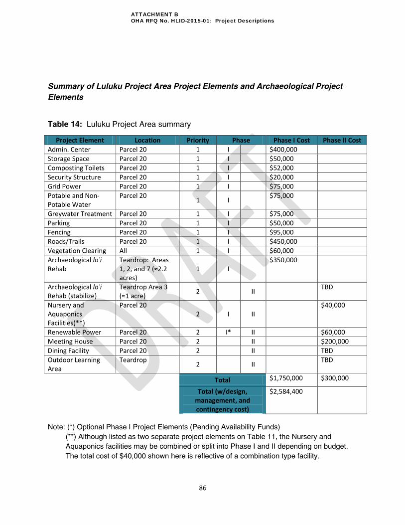
86
Summary of Luluku Project Area Project Elements and Archaeological Project
Elements
Table 14: Luluku Project Area summary
Project Element Location Priority Phase Phase I Cost Phase II Cost
Admin. Center Parcel 20 1 I $400,000
Storage Space Parcel 20 1 I $50,000
Composting Toilets Parcel 20 1 I $52,000
Security Structure Parcel 20 1 I $20,000
Grid Power Parcel 20 1 I $75,000
Potable and Non-Potable Water
Parcel 20 1 I
$75,000
Greywater Treatment Parcel 20 1 I $75,000
Parking Parcel 20 1 I $50,000
Fencing Parcel 20 1 I $95,000
Roads/Trails Parcel 20 1 I $450,000
Vegetation Clearing All 1 I $60,000
Archaeological loʿi Rehab
Teardrop: Areas 1, 2, and 7 (≈2.2 acres)
1 I $350,000
Archaeological loʿi Rehab (stabilize)
Teardrop Area 3 (≈1 acre)
2 II TBD
Nursery and Aquaponics Facilities(**)
Parcel 20 2 I II
$40,000
Renewable Power Parcel 20 2 I* II $60,000
Meeting House Parcel 20 2 II $200,000
Dining Facility Parcel 20 2 II TBD
Outdoor Learning Area
Teardrop 2 II
TBD
Total $1,750,000 $300,000
Total (w/design, management, and contingency cost)
$2,584,400
Note: (*) Optional Phase I Project Elements (Pending Availability Funds)
(**) Although listed as two separate project elements on Table 11, the Nursery and
Aquaponics facilities may be combined or split into Phase I and II depending on budget.
The total cost of $40,000 shown here is reflective of a combination type facility.
ATTACHMENT B OHA RFQ No. HLID-2015-01: Project Descriptions

87
Concessions can be made to any of the Phase I Elements during design to keep costs within
the HLID budget.
ATTACHMENT B OHA RFQ No. HLID-2015-01: Project Descriptions