Embed Size (px)
Citation preview
SUMMARY
With hundreds of thousands of users all around the world, MapInfo Professional is one of the most popular GIS solutions on the market. With the increase in big data sets and advances in hardware, more demands are being placed on GIS professionals than ever before.
Pitney Bowes has risen to the challenge to empower the professional. MapInfo Professional v12.5 is a next-generation release that empowers GIS professionals to work better, faster and stronger with multi-threading, improved usability, greater output capabilities and much more!
How Does v12.5 Compare to Previous Versions?Two releases of MapInfo Professional are scheduled in 2014: 32-bit (June 2014) and 64-bit (October 2014). This data sheet covers both releases.
MapInfo Professional v12.5 adds:New Layout Designer (Both 32 and 64 bit)• Produce great-looking output faster and easier than before
• Active layout – interact directly with the map inside the layout
- No need to switch back and forth between map and layout windows
- Pan and zoom the map in the layout
- Turn layers on and off
- Modify labels
- Full layer control functionality inside the layout window
• Snap to gridlines and easily align objects on the layout
• Auto-wrapping text boxes
• Easy access toolbar
• Add images with transparency and translucency to your layouts
• WYSIWYG – the layout window display matches up to your printed output
Faster Object Processing (Both 32 and 64 bit)• Multi-threading of selected object processing capabilities to use more or all of the
available processors
- Split
- Erase
- Erase outside
- Buffer
Additional Data Format Support (Both 32 and 64 bit)• ESRI geodatabase read and write support
• Improved Geography Markup Language (GML) read and write support
- GML versions 2.1.2, 3.1.1 and 3.2.1 (open/import)
- GML Simple Features Level SF-0 Profile (export)
PRODUCT DATA SHEET
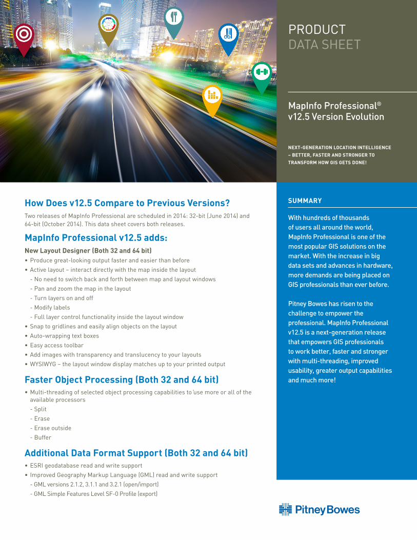
MapInfo Professional® v12.5 Version Evolution NEXT-GENERATION LOCATION INTELLIGENCE
– BETTER, FASTER AND STRONGER TO
TRANSFORM HOW GIS GETS DONE!
PRODUCT DATA SHEET
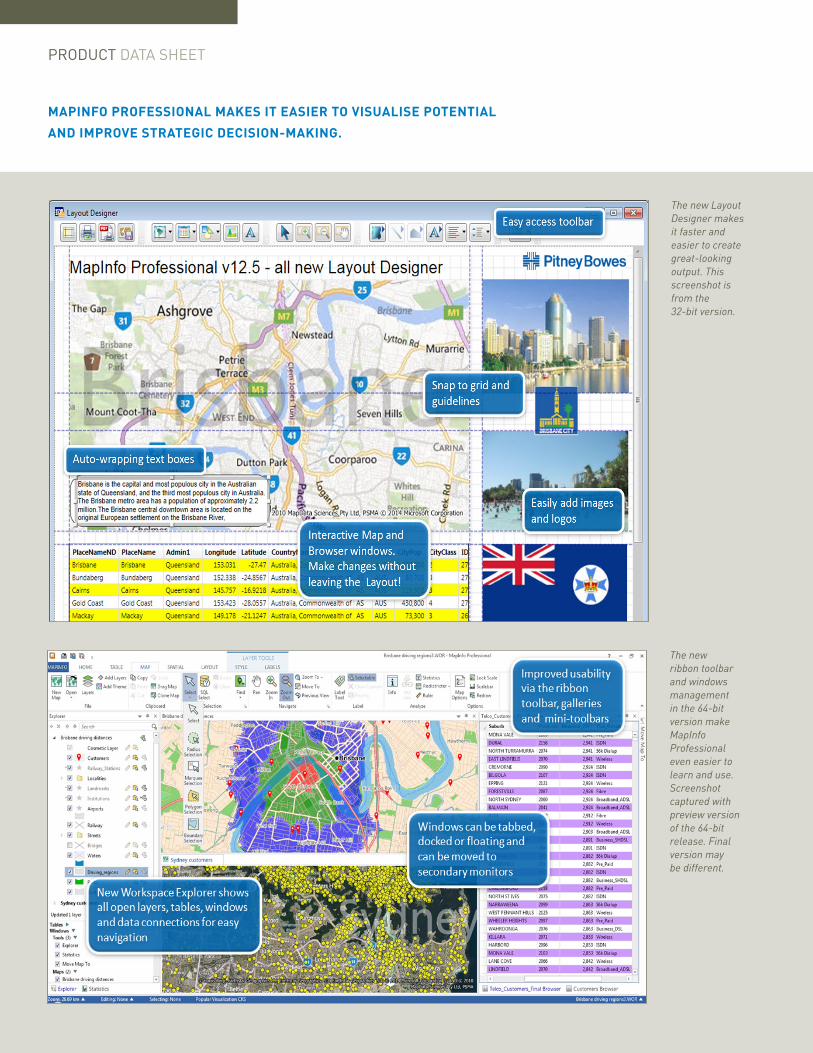
MAPINFO PROFESSIONAL MAKES IT EASIER TO VISUALISE POTENTIAL
AND IMPROVE STRATEGIC DECISION-MAKING.
The new ribbon toolbar and windows management in the 64-bit version make MapInfo Professional even easier to learn and use.Screenshot captured with preview version of the 64-bit release. Final version may be different.
The new Layout Designer makes it faster and easier to create great-looking output. This screenshot is from the 32-bit version.
MapInfo Professional v12.5Version Evolution
SPECIFICATIONS v12.5
Operating SystemsDESKTOP
• Windows 7 Ultimate 32-bit SP1
• Windows 7 Ultimate 64-bit SP1
• Windows 8 and 8.1 32-bit
• Windows 8 and 8.1 64-bit
SERVER
• Windows 2008 Server R2 64-bit SP1 with XenApp 6.0
• Windows 2008 Server R2 64-bit SP1
• Windows 2012 Server 64-bit
Database ServersSPATIAL
• Microsoft SQL Server 2008 (also called SQL Server Spatial)
• Microsoft SQL Server 2012 (also called SQL Server Spatial)
• Oracle Spatial 11Gr2, 12cR1
• PostgreSQL 9.0.3 with PostGIS 1.5
• PostgreSQL 9.x with PostGIS 2.1.x
• FDO 3.8
XY
• Microsoft Access 2007, 2010
• Microsoft Office 2013
Database ConnectivityODBC DRIVERS
• Microsoft SQL Server 2012 Native Client v11 (32 and 64 bit)
• Microsoft Access ODBC (32 and 64 bit)
• PostgreSQL ANSI ODBC driver 9.01.02 (32 and 64 bit)
ORACLE OCI CLIENT
• Oracle Instant Client v12.1.0.1.0 (32 and 64 bit)
FDO TOOL KIT
MapInfo Professional v12.5 (64-bit) adds:The above mentioned capabilities of the 32-bit version, plus:
Fully redesigned user interface• All new ribbon-based user interface
• Easier to learn and easier to use
• Improved productivity – fewer mouse clicks
• Easy access to functions through tabs and galleries
• Context-sensitive tabs appear with functionality as needed
• Mini toolbars for quick access to common tools
• New Workspace Explorer including the ability to search for a layer
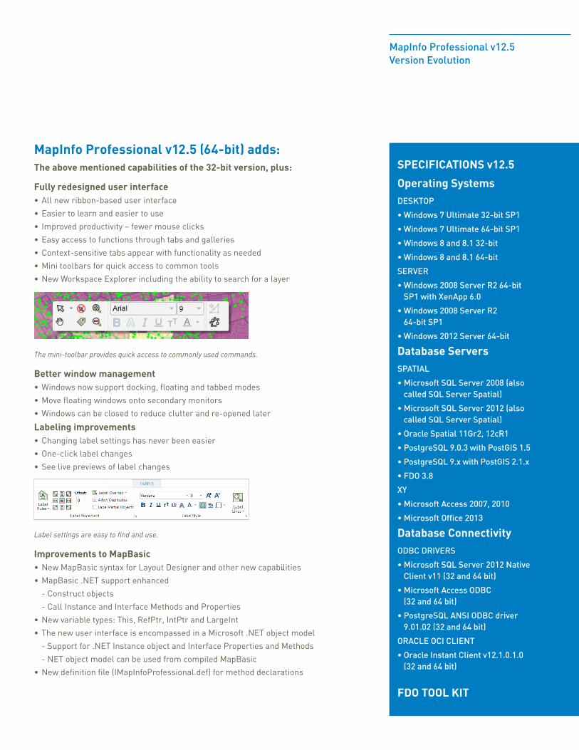
The mini-toolbar provides quick access to commonly used commands.
Better window management• Windows now support docking, floating and tabbed modes
• Move floating windows onto secondary monitors
• Windows can be closed to reduce clutter and re-opened later
Labeling improvements• Changing label settings has never been easier
• One-click label changes
• See live previews of label changes
Label settings are easy to find and use.
Improvements to MapBasic• New MapBasic syntax for Layout Designer and other new capabilities
• MapBasic .NET support enhanced
- Construct objects
- Call Instance and Interface Methods and Properties
• New variable types: This, RefPtr, IntPtr and LargeInt
• The new user interface is encompassed in a Microsoft .NET object model
- Support for .NET Instance object and Interface Properties and Methods
- NET object model can be used from compiled MapBasic
• New definition file (IMapInfoProfessional.def) for method declarations

SPECIFICATIONS v12
Operating Systems DESKTOP • Windows XP Professional 32-bit
Service Pack 3 (SP3)
• Windows 7 Ultimate 32-bit SP1
• Windows 7 Ultimate 64-bit SP1 with 32-bit compatibility mode
• Windows 8 32-bit
• Windows 8 64-bit
SERVER
• Windows 2008 Server R2 64-bit SP1 with XenApp 6.0
• Windows 2008 Server R2 64-bit SP1
• Windows 2012 Server 64-bit
Database ServersSPATIAL
• Microsoft SQL Server 2008 (also called SQL Server Spatial)
• Microsoft SQL Server 2012 (also called SQL Server Spatial)
• Oracle Spatial 11Gr2, 10Gr2
• PostgreSQL 9.0.3 with PostGIS 1.5
• PostgreSQL 9.x with PostGIS 2.0.x
• FDO 3.8
XY
• Microsoft Access 2007, 2010
• Microsoft Office 2013
• Microsoft SQL Server 2005
Database ConnectivityODBC DRIVERS
• Microsoft SQL Server 2008 Native Client v10
• Oracle ODBC Driver 11.2
• PostgreSQL ANSI ODBC driver 9.01.02
ORACLE OCI CLIENT • Oracle Instant Client v11.2.0.2.0 FDO TOOLKIT
PRODUCT DATA SHEET
MapInfo Professional v12.0 added:Extensively Improved Labeling Capabilities• All-new labeling algorithms to create more automatic labels without
manual intervention
• Curved labels – easily drag curved labels, place more labels automatically
• Region labels – better auto-positioning, confine labels within the region, use abbreviations where it doesn’t fit, automatically resize the labels based on the region size
Layer Control enhancements• Numerous usability improvements for working with layers and labels
Label examples.
Improved Scalebar• New option for transparent background and border
• Option for automatic sizing to use “nice” rounded-off numbers
• Improved sizing - scalebar height adjusted if cartographic scale is not showing
Easier Printing to Cartographic Scale• Cartographic scale now displayed concurrently with map scale throughout software
• Status bar option for cartographic scale – easier to select
Cartographic Legend Enhancements• Control over order of objects within a frame
• Better-looking cartographic legends with automated word wrapping
• Customise the sizes of the style swatches for each layer
Other Improvements• Tile servers – option to snap the map zoom to the closest cartographic scale
• In-product notifications about MapInfo news and maintenance releases
• Quickly align objects in the Layout window with new right-click shortcuts
• New tools for drawing orthogonal polygons, correcting undershoots and overshoots, compare the structure of multiple tables, and a Polybuilder tool for converting digitized linework into vector polygons
Data Access• New Quick Translator replaces the Universal Translator for easier importing
and exporting
• Support for SQLite, PostGIS v2.0, WFS v1.1
• Improved support for SQL Server Geography data type
• Option to connect to Oracle using Operating System authentication
• Improved UI for opening multiple DBMS tables
• Increased size of an individual record in a native MapInfo table to 63,500 bytes
MapInfo Professional v11.5 added:Browser Window Improvements• Excel-like functionality to sort and filter directly within the browser, refresh data
within the browser and quick access toolbar for changing text style, select all/deselect all, insert row and pick field
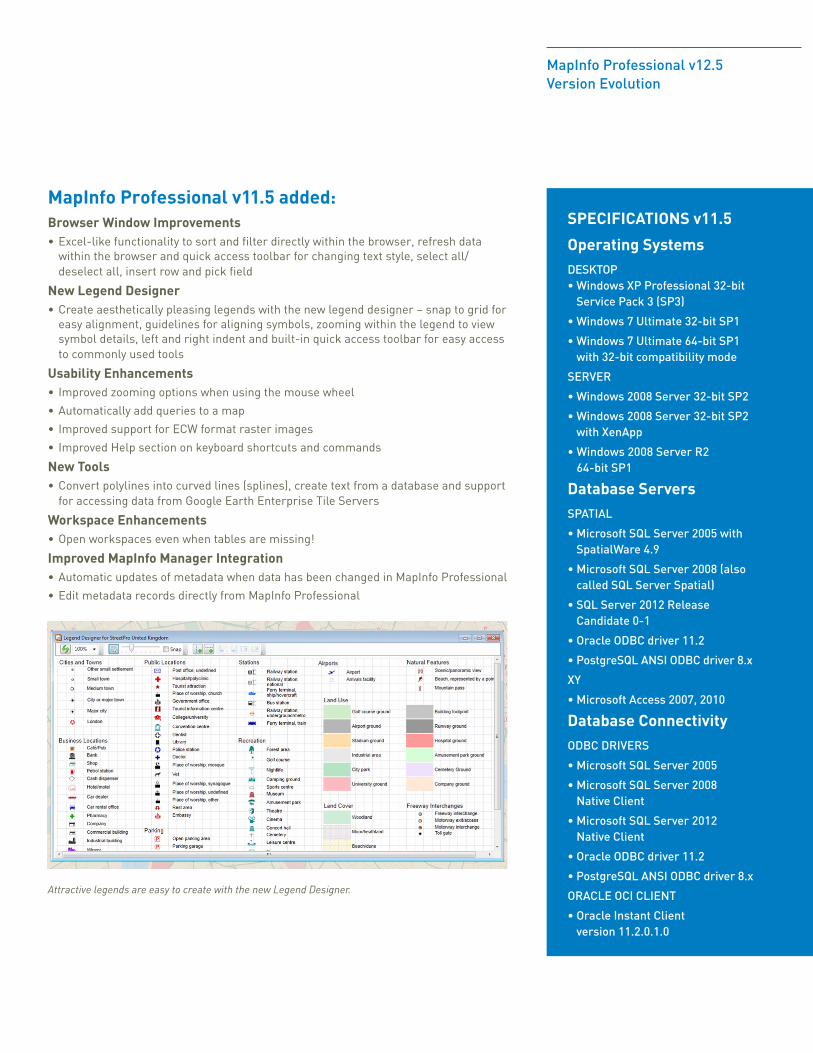
New Legend Designer• Create aesthetically pleasing legends with the new legend designer – snap to grid for
easy alignment, guidelines for aligning symbols, zooming within the legend to view symbol details, left and right indent and built-in quick access toolbar for easy access to commonly used tools
Usability Enhancements• Improved zooming options when using the mouse wheel
• Automatically add queries to a map
• Improved support for ECW format raster images
• Improved Help section on keyboard shortcuts and commands
New Tools• Convert polylines into curved lines (splines), create text from a database and support
for accessing data from Google Earth Enterprise Tile Servers
Workspace Enhancements• Open workspaces even when tables are missing!
Improved MapInfo Manager Integration• Automatic updates of metadata when data has been changed in MapInfo Professional
• Edit metadata records directly from MapInfo Professional
Attractive legends are easy to create with the new Legend Designer.
MapInfo Professional v12.5Version Evolution
SPECIFICATIONS v11.5
Operating Systems DESKTOP • Windows XP Professional 32-bit
Service Pack 3 (SP3)
• Windows 7 Ultimate 32-bit SP1
• Windows 7 Ultimate 64-bit SP1 with 32-bit compatibility mode
SERVER
• Windows 2008 Server 32-bit SP2
• Windows 2008 Server 32-bit SP2 with XenApp
• Windows 2008 Server R2 64-bit SP1
Database ServersSPATIAL
• Microsoft SQL Server 2005 with SpatialWare 4.9
• Microsoft SQL Server 2008 (also called SQL Server Spatial)
• SQL Server 2012 Release Candidate 0-1
• Oracle ODBC driver 11.2
• PostgreSQL ANSI ODBC driver 8.x
XY
• Microsoft Access 2007, 2010
Database ConnectivityODBC DRIVERS
• Microsoft SQL Server 2005
• Microsoft SQL Server 2008 Native Client
• Microsoft SQL Server 2012 Native Client
• Oracle ODBC driver 11.2
• PostgreSQL ANSI ODBC driver 8.x
ORACLE OCI CLIENT
• Oracle Instant Client version 11.2.0.1.0

MAPINFO PROFESSIONAL CONTINUES TO SET THE STANDARD FOR
EASY-TO-USE MAPPING CREATION, VISUALISATION, AND ANALYSIS.
Spreadsheet-like browser capabilities allow easy sorting and filtering directly within the browser window.
The new labeling options introduced in v12.0 allow better placement of automatic labeling with less manual manipulation of labels required.
PRODUCT DATA SHEET
MapInfo Professional v12.5Version Evolution
SPECIFICATIONS v11
Operating SystemsDESKTOP • Windows XP SP3 (required)
for .NET 4.0
• Windows 7 Ultimate SP1
• Windows 7 Ultimate 64-bit SP1 with 32-bit compatibility mode
SERVER
• Windows 2008 Server 64-bit SP2
• Windows 2008 R2 64-bit SP1
• Windows 2008 (64-bit) Server SP2 with XenApp (aka Citrix)
Database ServersSPATIAL
• SQL Server 2005 with SpatialWare 4.9
• SQL Server 2008
• Oracle Spatial 11Gr2, 10Gr2
• PostgreSQL 8.3 with PostGIS v1.3
• PostGIS v9.0 with PostGIS v1.5.2
XY
• Microsoft Access 2007, 2010
• Microsoft SQL Server 2005
• Microsoft SQL Server 2008 XY on a spatialised DB
• Oracle Spatial 10Gr2, 11Gr2
Database ConnectivityODBC DRIVERS
• Microsoft SQL Server 2005
• Microsoft SQL Server 2008 Native Client
• Oracle ODBC driver 11.2
• PostgreSQL ANSI ODBC driver 8.x
ORACLE OCI CLIENT
• Oracle Instant Client version 11.2.0.1.0
MapInfo Professional v11.0 added:New Table Browser• Improved navigation makes data entry easier
• Improved appearance and better visualisation
• Sort data quickly within the Browser
New Bing Premium Services• Additional Bing services available as an optional extra – access worldwide Bing street
maps – find a location and move the map to that location
Enhanced Support for 64-Bit Operating Environments• Use up to 4GB of RAM instead of 2GB for “memory hungry” operations
Updated Preferences Dialog• More intuitive grouping of options for better navigation
Open MWS Map Data in MapInfo Professional• Share workspaces with MapInfo Stratus and MapInfo MapXtreme applications
• Support for multiple map windows, styles, thematic layers and legends
New MapCAD Tools• Scale objects – increase/decrease size of geographic objects by a specified factor
• Orthogonal points – position points orthogonally to a reference line
• Measurement line – generates measurement lines with cumulated distance and distance to objects
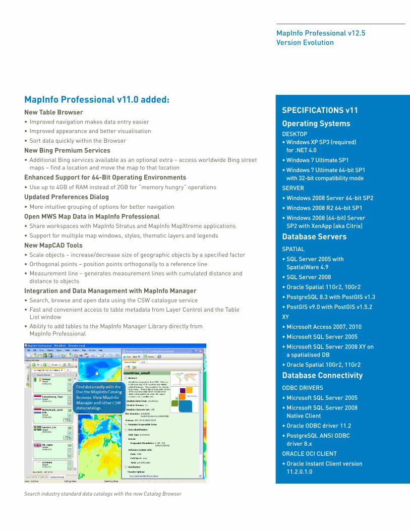
Integration and Data Management with MapInfo Manager• Search, browse and open data using the CSW catalogue service
• Fast and convenient access to table metadata from Layer Control and the Table List window
• Ability to add tables to the MapInfo Manager Library directly from MapInfo Professional
Search industry standard data catalogs with the new Catalog Browser

© 2014 Pitney Bowes Inc. All rights reserved. Pitney Bowes, the Corporate logo, MapInfo Professional, MapBasic, MapXtreme, MapInfo Manager and MapInfo Stratus are [registered] trademarks of Pitney Bowes Inc. or a subsidiary. All other trademarks are the property of their respective owners. 14-PBS-05594-DCS-AMER
For more information call +44.800.840.0001 or visit us online: www.mapinfo.com or www.pitneybowes.co.uk/software
PRODUCTDATA SHEET
MapInfo Professional® v12.5 Version Evolution
Examples of Bing Maps from around the world. Note that the Bing Roads map is part of the Premium Services option.
Premium ServicesMapInfo Professional v12.5 users can opt for additional Bing™ Maps functionality at an extra cost, gaining access to the Bing worldwide street mapping tile service at the click of a button. This capability offers the ability to easily overlay the street map with your own layers for quick map building. The need to manage large amounts of data is avoided. In addition, a handy “Move Map To” (gazetteer search) capability provides quick navigation to places of interest anywhere in the world. Simply enter an address, suburb, point of interest or any location, and zoom directly to that location.
The MapInfo SuiteMapInfo Professional is the cornerstone of the MapInfo suite of location intelligence products. Maps and data created in MapInfo Professional can be published to the web for customers or citizens to access or can be shared internally across the organisation using the MapInfo web mapping and enterprise GIS applications. Extensions for grid, 3D mapping and routing are also a part of the suite. For more information on the MapInfo suite of location intelligence applications, visit www.mapinfo.com.
UNITED STATES/CANADA
800.327.8627 800.268.3282
[email protected] [email protected]
EUROPE/UNITED KINGDOM
+44.800.840.0001
INDIA
+91.11.4219.5501
ASIA PACIFIC/AUSTRALIA
+61.2.9475.3500