Embed Size (px)
Citation preview

Pressure decreases exponentially (note logarithmic y-axis) because air is a compressible fluid (i.e. density is variable).

Temperature structure more complex than pressure structure
Temperature decreases with altitude in the troposphere because pressure decreases with altitude.
Not ideal gas law:
PV = nRT
P decreases, but V increases how does T change?
T increases with altitude in the stratosphere because of UV absorption by ozone.


Potential temperature θ
Dry Adiabatic Lapse Rate
Potential temperature is the T of air if it is brought to the ground by the dry adiabatic lapse rate.
It can be used to determine the stability of the atmosphere.

Altitude (km
)
Equilibrium state of the atmosphere and surface in the absence of all energy fluxes other than radiative fluxes.
Problems with Radiative Eq’m
• Too hot in lower troposphere and surface• Too cold in upper troposphere• Tropospheric lapse rate too large
(Stratosphere temperatures pretty good)

Radiative-Convective Eq’m
Account for convection by assuming that convection limits the lapse rate to adiabatic and calculate the new equilibrium (a good assumption for a dry world)


Still missing: moist convection (aka clouds)Most convection is associated with clouds, which affect energy balance
through:– latent heat release– changes in planetary albedo– redistribution of water vapor
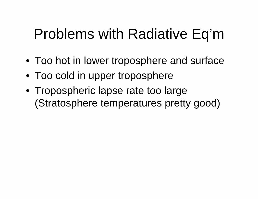
Accounting for the wetadiabatic lapse rate, temperature profile is much closer to observed values

Dashed lines on far left side are reflected sunlight fluxes.
Net longwave radiative cooling is less than half the total cooling.
Latent heat (LH) flux (moist convection) dominant over sensible heat (SH) flux (dry convection)

This curve describes the equilibrium between liquid water and the partial pressure of water vapor

Classes of typical cloud types.


Large stratocumulus deck off of California and Mexico.
Image courtesy of MODIS.

Stratocumulus deck off the coast of Angola and Namibia.
Image courtersy of MODIS.

Vortex streets occur around the Canary Islands within the stratocumulus deck.
Large scale flow dynamics affects the microphysics!
Image courtesy of MODIS.

Shallow cumulus in Antigua (Caribbean)


Cumulonimbus over Africa – the cirrus shield hides the strong convective clouds

Cumulus clouds with cloud-top temperatures below –5°C are typically mixed-phase, containing both ice crystals and supercooled liquid drops.


Clouds can exist as continental-scale features. Cloud properties are controlled by the interaction between microphysics (10-6 m) and dynamics (up to 106 m)

Cloud Base, Lifted Condensation Level (LCL)
Cloud Drop (20 μm)
Updraft (~1-10 m/s)
Condensation: Conversion of water vapor in a parcel of airto liquid on a CCN after reaching saturation
Cloud Drop Formation

Cloud droplet (Dp= 20 μm)
Rain drop
(Dp=2000 μm)
It takes 1 MILLION cloud droplets to make 1 rain drop!!

Large Collector Drop (50 um)
Small Rain Drop (100 um)
Rain Drop (1000 um)
Cloud Drop (10 um)
Collision: Bumping into each other due to differences in
gravitational settling velocities
Coalescence: Merging of smaller droplets with the larger, faster
falling collector drops
Collision-Coalescence

Cloud droplet
Rain drop

Heterogeneous deposition
Condensation freezing
(Homogeneous freezing at –40C)
Contact freezing
Immersion freezing
Ice Nucleation Mechanisms
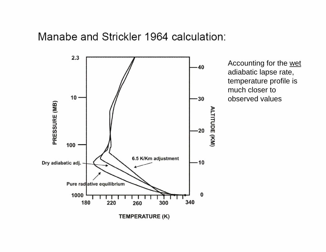
121%100%-20°C
115%100%-15°C
110%100%-10°C
105%100%-05°C
100%100%0°C
RH wrt H2O(ice) RH wrt H2O(liq)Temperature
Relative Humidities of Ice and Liquid Water
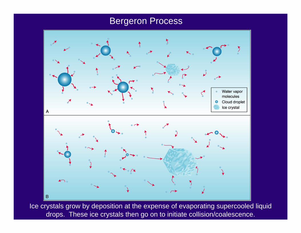
Ice crystals grow by deposition at the expense of evaporating supercooled liquid drops. These ice crystals then go on to initiate collision/coalescence.
Bergeron Process


Some ice habits
Classification from Magono and Lee, 1966.

Magono and Lee, 1966.
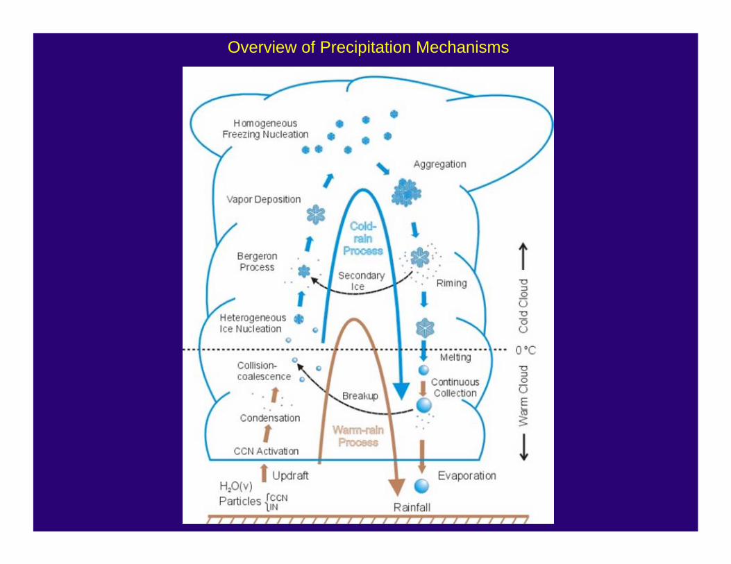
Overview of Precipitation Mechanisms

Zonally-averaged DJF potential temperature:
The atmosphere is, on average, statically stable (with periods of instablility – c.f. radiative-convective equilibrium)

Zonally- and annually-averaged mean vertical wind (positive = downwards)

Cold front

Warm front

Cloud regimes in thermally direct circulations.

Large stratocumulus deck off of California and Mexico.
Image courtesy of MODIS.

Stratocumulus are forced from the top down – by radiative cooling of the clouds.
This makes for air that is unstable (turbulent) below cloud top.
This turbulence replenishes the moisture of the cloud (which is slowly lost to the warm air above by entrainment).
The moisture is trapped in this thin layer by the warm air above, allowing the clouds to persist. If this lid were not around, then the moisture would be diluted and the cloud less persistent.

Shallow cumulus are forced from the surface – by small differences in temperature.
Plumes of positively buoyant, moist air originate from the surface layer and penetrate into the warmer, subsiding air. These clouds live for short periods (tens of minutes).
The moisture is trapped in this thin layer by the warm air above, allowing the clouds to persist. If this lid were not around, then the moisture would be diluted and the cloud less persistent.


In a conditionally stable atmosphere, there are three important heights:
LCL = lifting condensation level
LFC = level of free convection
EL = equilibrium level
Notice the dry adiabat and saturated adiabat. The thick line connecting the closed circles is the temperature sounding (actual temperature profile).
The bottom “negative area” is defined as CIN = Convective Inhibition.
The middle “positive area” is defined as CAPE = Convective Available Potential Energy.
= CIN
= CAPE