Embed Size (px)
Citation preview

TEXAS WATER COMMISSION
Joe D. Carter, Chairman
William E. Berger, Commissioner0. F. Dent, Commissioner
CIRCULAR NO. 65-01
DRAINAGE AREAS OF TEXAS STREAMS
COASTAL AREAS BETWEEN THE BRAZOS
RIVER AND THE RIO GRANDE
Prepared by the U. S. Geological Surveyin cooperation with theTexas Water Commission
April 1965

TABLE OF CONTENTS
Page
INTRODUCTION 1
ADMINISTRATION AND ACKNOWLEDGMENTS I
TOPOGRAPHY 1
CONCEPTS OF DRAINAGE AREAS 2
METHOD OF DRAINAGE-AREA DETERMINATION 2
TABULATION OF DATA 5
FUNCTION OF COORDINATING OFFICE 5
COASTAL AREAS BETWEEN THE BRAZOS RIVER AND THE RIO GRANDE 7
TABLES OF DRAINAGE-AREA DATA
1. Brazos-Colorado Coastal Area 8
2. Colorado-Lavaca Coastal Area 10
3. Lavaca-Guadalupe Coastal Area 11
4. S?n Antonio-Nueces Coastal Area 12
5. Nueces-Rio Grande Coastal Area 15
ILLUSTRATIONS
Figures
1. Contour map of Texas showing principal physiographic provinces 3
2 . River bas ins and coas tal areas of Texas 4

DRAINAGE AREAS OF TEXAS STREAMS
INTRODUCTION
An accurate figure for drainage area is one of the most significant factorsused in hydrologic investigations of a river basin and in the hydraulic computations for the design of structures on a stream. This report is being compiled sothat drainage-area information of uniform accuracy and reliability will be available to all users of these data for any foreseeable hydraulic, hydrologic, or general engineering use.
In 1951 the Subcommittee on Hydrology, Federal Inter-Agency River Basin Com-ittee, delegated the Corps of Engineers, U. S. Army as the official coordinating
agency for drainage areas in the Arkansas and Red River basins, and the U. S.Geological Survey as the official coordinating agency for all other river basinsin Texas.
In November 1954 the data for the Red and Arkansas Rivers were published bythe Corps of Engineers in a pamphlet entitled "Drainage Area Data, Arkansas, White,and Red River Basins."
m
ADMINISTRATION AND ACKNOWLEDGMENTS
In December 1960 the Sabine River Compact Administration requested the U. S.Geological Survey to update drainage-area determinations in the Sabine River Basin,The Administration made funds available to match the U. S. Geological Survey on adollar for dollar basis. The work was done by the Surface Water District officesin Texas and Louisiana, and the pamphlet, "Drainage Area Data for Sabine RiverBasin, Texas and Louisiana" was released August 1961.
The compilation of drainage-area data for the balance of the State is a re
sult of a cooperative agreement between the U. S. Geological Survey and the TexasWater Commission.
Computations were made in the District Office of the U. S. Geological Surveyin Austin, Texas, under the general direction of Trigg Twichell, district engineerof the Surface Water Branch.
TOPOGRAPHY
The topography of Texas generally reflects the surface geology of the State.The northwestern part of the State is occupied by the High Plains, with a generalsurface gradient dipping in a southeasterly direction. Elevations range above4,000 feet along the Texas-New Mexico State line and above 2,500 feet along theeast escarpment. From the High Plains the land surface drops by successive steps,generally in a southeasterly direction, to sea level along the coast of the Gulfof Mexico. The greatest abrupt change in elevation is along the High Plains CapRock Escarpment where in places the elevation of the land surface drops nearly
1,000 feet in just a few miles. In the El Paso-Trans-Pecos Region of West Texas,topographic features include the southern extension of the Rocky Mountain Range.
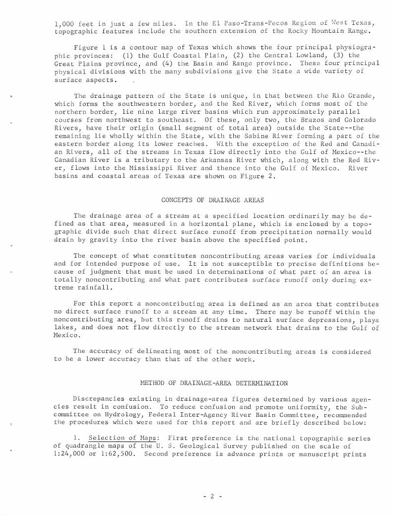
Figure 1 is a contour map of Texas which shows the four principal physiographic provinces: (1) the Gulf Coastal Plain, (2) the Central Lowland, (3) theGreat Plains province, and (4) the Basin and Range province. These four principalphysical divisions with the many subdivisions give the State a wide variety ofsurface aspects.
The drainage pattern of the State is unique, in that between the Rio Grande,which forms the southwestern border, and the Red River, which forms most of thenorthern border, lie nine large river basins which run approximately parallelcourses from northwest to southeast. Of these, only two, the Brazos and ColoradoRivers, have their origin (small segment of total area) outside the State--theremaining lie wholly within the State, with the Sabine River forming a part of theeastern border along its lower reaches. With the exception of the Red and Canadi
an Rivers, all of the streams in Texas flow directly into the Gulf of Mexico—theCanadian River is a tributary to the Arkansas River which, along with the Red River, flows into the Mississippi River and thence into the Gulf of Mexico. Riverbasins and coastal areas of Texas are shown on Figure 2.
CONCEPTS OF DRAINAGE AREAS
The drainage area of a stream at a specified location ordinarily may be defined as that area, measured in a horizontal plane, which is enclosed by a topographic divide such that direct surface runoff from precipitation normally woulddrain by gravity into the river basin above the specified point.
The concept of what constitutes noncontributing areas varies for individualsand for intended purpose of use. It is not susceptible to precise definitions because of judgment that must be used in determinations of what part of an area istotally noncontributing and what part contributes surface runoff only during extreme rainfall.
For this report a noncontributing area is defined as an area that contributesno direct surface runoff to a stream at any time. There may be runoff within thenoncontributing area, but this runoff drains to natural surface depressions, playalakes, and does not flow directly to the stream network that drains to the Gulf ofMexico.
The accuracy of delineating most of the noncontributing areas is consideredto be a lower accuracy than that of the other work.
METHOD OF DRAINAGE-AREA DETERMINATION
Discrepancies existing in drainage-area figures determined by various agencies result in confusion. To reduce confusion and promote uniformity, the Subcommittee on Hydrology, Federal Inter-Agency River Basin Committee, recommendedthe procedures which were used for this report and are briefly described below:
1. Selection of Maps: First preference is the national topographic seriesof quadrangle maps of the U. S. Geological Survey published on the scale of1:24,000 or 1:62,500. Second preference is advance prints or manuscript prints
- 2 -

of the national series of quadrangle maps, and third preference is Army Map Service topographic maps, scale 1:250,000. About half of the State is mapped withlarge-scale, modern topographic maps.
2. Establishment of Boundaries: The delineation of the boundary is the mostimportant step in the process of drainage-area determinations and the biggestsingle factor affecting the accuracy of final results. Drainage boundaries weredelineated with utmost care by personnel experienced in hydrology and cartography.Delineations were reviewed by the engineering staff of the Texas Water Commission,and for some basins by the engineering staffs of the Corps of Engineers, U. S.Army and the U. S. Bureau of Reclamation.
3. Continuity Between Maps: An index map of the entire area was preparedto show the relative position of the different maps used. To assure accurate determinations, the maps were checked for gaps or overlaps between adjacent sheets,continuity of topographic or cultural detail between adjacent sheets, and agreement of latitude and longitude at borders of adjacent maps.
4. Planimetering: All areas and subareas within a quadrilateral were measured by planimeter. A quadrilateral encompasses the area bounded by latitude andlongitude lines within a quadrangle. Actual areas within each quadrilateral havebeen computed accurately and are available from Smithsonian Geographical Tables,and from Bulletin 650 and other publications of the U. S. Geological Survey.Thus an exact check was provided between total planimetered area and actual areawithin each quadrilateral.
TABULATION OF DATA
Within the coastal areas between the Brazos River and the Rio Grande, drainage areas were determined at sites of existing and discontinued continuous-record gaging stations and partial-record gaging stations, at sites of existingand authorized major dams, and at the mouths of principal tributaries.
Points at which drainage areas were determined are tabulated sequentially inthe downstream direction along the main stem, with a point on a tributary that enters between two main-stem points tabulated between them. A similar order is followed for all tributaries. The tabulation includes the name of the stream at the
point where the drainage area was determined; identification of the point, suchas gaging station, dam or mouth; and the latitude and longitude of the point. Asan added means of identification, the permanently assigned station number is shownfor each gaging station and partial-record station. These numbers were assignedusing the same criteria as above for downstream direction.
Drainage areas are given in square miles. Although areas are measured to thenearest hundreth of a square mile, the areas are rounded off in the listings tothe nearest square mile for areas of more than 100 square miles, to tenths forareas from 10 to 100 square miles, and to hundreths for areas of less than 10square miles.
FUNCTION OF COORDINATING OFFICE
The U. S. Geological Survey at Federal Center Building, 300 East EighthStreet, Austin, Texas, as coordinating agency, serves as a repository for workmaps and computations and also serves as a clearing house for dissemination ofdrainage-area data.
- 5 -

Anyone cognizant of a significant discrepancy or contradiction betweenfigures of drainage areas now in use should consult the U. S. Geological Surveyand seek to reach an understanding and agreement between interested agencies represented in the area involved.
- 6 -

COASTAL AREAS BETWEEN THE BRAZOS RIVER
AND THE RIO GRANDE
The very flat coastal areas are a part of the Gulf Coastal Plain physiographic province. In general, elevations range from 100 feet to sea level. Thereare few defined stream channels in the sand dune area extending from Baffin Bayinto northern Hidalgo and Willacy Counties; this area is largely noncontributing.
Over 90 percent of the drainage areas were delineated on recent large-scaletopographic maps; the work is considered of permanent value. Drainage areas forthe remainder were delineated on small-scale topographic maps which may be subjectto minor revisions when large-scale topographic maps become available. Drainage-area determinations tabulated on the following pages were completed in October1964.
Drainage-area determinations for other areas have been published in Circularsof the Texas Water Commission as follows:
Sabine River Basin and Sabine-Neches Coastal Area,Circular No. 62-02 .
Neches River Basin and Neches-Trinity Coastal Area,Circular No. 62-03.
San Jacinto River Basin and San Jacinto-Brazos
Coastal Area, Circular No. 62-05.
Trinity River Basin and Trinity-San JacintoCoastal Area, Circular No. 63-01.
San Antonio River Basin,Circular No. 63-07.
- 7 -

Table 1 .--Brazos-Colorado Coastal Area
Total
Name of streamPoint of determination of
drainage area
drainage
area
(sq. mi.)
Coastal Area Intervening coastal area from
mouth of Brazos River to
mouth of San Bernard River 45.6
Little Bernard Creek At mouth
lat. 29°43,55", long. 96°12'42" 22 .1
East Bernard Creek At mouth
lat. 29°37'20", long. 99°07'41" 68 .5
Middle Bernard Creek At mouth
lat. 29°33'01", long. 96°02*34" 80.1
West Bernard Creek At mouth
lat. 29°22'54", long. 95°58*01" 179
Snake Creek At mouth
lat. 29°19'45", long. 95°55'22" 55.0
San Bernard River Above mouth of Peach Creek
lat. 29°20'06", long. 95056'57" 659
Peach Creek At mouth
lat. 29°20'06", long. 95°56*57" 61.7
San Bernard River U.S.G.S. gage 8-1175, San BernardRiver near Boling
lat. 29°18'47", long. 95°53'36" 727
Cedar Creek At mouth
lat. 29°14'15", long. 95°47'53" 45.2
San Bernard River At mouth
lat. 28°51'39", long. 95°26'12" 1,005
Coastal Area Intervening coastal area frommouth of San Bernard River to
mouth of Caney Creek 156
Caney Creek At mouth
lat. 28°45'40", long. 95°39'17" 317
Coastal Area Intervening coastal area from
mouth of Caney Creek to mouthof Live Oak Bayou 21.9
Peyton Creek At mouth
lat. 28°48'41", long. 95°49'14" 115

Table 1 .--Brazos-Colorado Coastal Area--Continued
Name of streamPoint of determination of
drainage area
Total
drainagearea
(sq. mi.)
Live Oak Bayou
Coastal Area
Coastal Area
Coastal Area
At mouth
lat. 28°44'39", long. 95°46'03"
Intervening coastal area frommouth of Live Oak Bayou tomouth of Colorado River
Intervening coastal area frommouth of Colorado River to
mouth of West Branch of
Colorado River
Total area from mouth of Brazos
River to mouth of West Branch
of Colorado River
188
97.4
18.1
1,850
- 9 -

Name of stream
Coastal Area
Tres Palacios Creek
Coastal Area
Cashs Creek
Coastal Area
Table 2 .--Colorado-Lavaca Coastal Area
Point of determination of
drainage area
Total
drainagearea
(sq. mi.)
113
281
0.44
27.0
10.3
Turtle Creek
Intervening coastal area from
mouth of West Branch of
Colorado River to mouth of
Tres Palacios Creek
At mouth
lat. 28°45'29", long. 96°10'21"
Intervening coastal area from
mouth of Tres Palacios Creek
to mouth of Cashs Creek
At mouth
lat. 28045'31", long. 96°10'48"
Intervening coastal area from
mouth of Cashs Creek to mouth
of Turtle Creek
At mouth
lat. 28°43'14", long. 96°15'50" 43.4
Coastal Area Intervening coastal area from
mouth of Turtle Creek to mouth
of Carancahua Creek 49.5
East Carancahua Creek At confluence with
West Carancahua Creek
lat. 28°46'21", long. 96°25'13" 130
West Carancahua Creek At confluence with East
Carancahua Creek
lat. 28°46'21", long. 96°25'13" 147
Carancahua Creek At mouth
lat. 28°45'12", long. 96°27'02" 291
Coastal Area Intervening coastal area from
mouth of Carancahua Creek
to mouth of Lavaca River 123
Coastal Area Total area from mouth of
West Branch of Colorado River
to mouth of Lavaca River 939
- 10 -

Table 3 .--Lavaca-Guadalupe Coastal Area
Total
Name of streamPoint of determination of
drainage areadrainage
area
(sq. mi.)
Coastal Area Intervening coastal area frommouth of Lavaca River to
mouth of Garcitas Creek 46.2
Marcado Creek At mouth
lat. 28°49'51", long. 96°44'36" 21.5
Arenosa Creek At mouth
lat. 28°49'31", long. 96°43'08" 178
Garcitas Creek At Garcitas damsite
lat. 28°48'58", long. 96°42*52" 341
Garcitas Creek At mouth
lat. 28°43,15", long. 96°39'40" 370
Coastal Area Intervening coastal area frommouth of Garcitas Creek to
mouth of Placedo Creek 0.22
Placedo Creek At mouth
lat. 28°42'05", long. 96°39'39" 120
Coastal Area Intervening coastal area frommouth of Placedo Creek to
mouth of Little Chocolate Bayou 23.4
Little Chocolate Bayou At mouth
lat. 28°35'10", long. 96°38'23" 9.93
Coastal Area Intervening coastal area frommouth of Little Chocolate Bayouto mouth of Chocolate Bayou 0.15
Chocolate Bayou At mouth
lat. 28°34'47", long. 96°38*38" 84.2
Coastal Area Intervening coastal area frommouth of Chocolate Bayou tomouth of North Channel of
Guadalupe River 343
Coastal Area Intervening coastal area frommouth of North Channel of
Guadalupe River to mouth ofSouth Channel of GuadalupeRiver 0.99
Coastal Area Total area from mouth of Lavaca
River to mouth of South Channelof Guadalupe River 998
- 11 -

Table 4.--San Antonio-Nueces Coastal Area
Total
Name of streamPoint of determination of
drainage area
drainagearea
(sq. mi.)
Coastal Area Intervening coastal area frommouth of South Channel of
Guadalupe River to mouth ofBurgentine Creek 104
Burgentine Creek At Burgentine Damlat. 28°16'13", long. 96°54'30" 36.0
Burgentine Creek At mouth
lat. 28°15'53", long. 96°54'42" 36.1
Coastal Area Intervening coastal area frommouth of Burgentine Creek tomouth of Artesian Creek 0.05
Artesian Creek At mouth
lat. 28°16'09", long. 96°54'53" 80.2
Coastal Area Intervening coastal area frommouth of Artesian Creek to
mouth of Salt Creek 1.97
Salt Creek At mouth
lat. 28°15'21", long. 96°56'32" 54.1
Coastal Area Intervening coastal area frommouth of Salt Creek to mouth
of Cavasso Creek 10.8
Cavasso Creek At mouth
lat. 28°13'15", long. 96°59'14" 34.7
Coastal Area Intervening coastal area frommouth of Cavasso Creek to
mouth of Copano Creek 23.4
Copano Creek At mouth
lat. 28°12'05", long. 97°02*15" 135
Coastal Area Intervening coastal area frommouth of Copano Creek tomouth of Mission River 37.0
Coastal Area Intervening coastal area frommouth of South Channel of Guadalupe
River to mouth of Mission River 517
Sarco Creek At mouth
lat. 28°24'19", long. 97°24*01" 80.1
- 12 -

Table 4.--San Antonio-Nueces Coastal Area — Continued
Total
Name of streamPoint of determination of
drainage area
drainage
area
(sq. mi.)
Blanco Creek At Blanco damsite
lat. 28°22'17", long. 97°21'01" 327
Blanco Creek At confluence with Medio Creek
lat. 28°18'46", long. 97°19'08" 357
Dry Medio Creek At mouth
lat. 28°35'16", long. 97°48'54" 30.3
Toro Creek At mouth
lat. 28°33'09", long. 97°48,08" 28.7
San Domingo Creek At mouth
lat. 28°31'10", long. 97°47'01" 45.0
Medio Creek At Beeville damsite
lat. 28°29'26", long. 97°40'04" 202
Medio Creek U.S.G.S. gage 8-1893, Medio Creeknear Beeville
lat. 28°28'58", long. 97°39*23" 204
Medio Creek At confluence with Blanco Creek
lat. 28°18'46", long. 97°19'08" 328
Mission River U.S.G.S. gage 8-1895,Mission River at Refugio
lat. 28°17,30", long. 97°16'44" 690
Melon Creek At mouth
lat. 28011'28", long. 97°11'49" 156
Mission River At mouth
lat. 28°09'47", long. 97°10'16" 1,015
Coastal Area Intervening coastal area frommouth of Mission River to
mouth of Aransas River 24.0
Poesta Creek At confluence with
West Aransas Creek
lat. 28°16,49", long. 97°40'16" 123
West Aransas Creek At confluence with Poesta Creek
lat. 28°16*49", long. 97°40,16" 112
Aransas River U.S.G.S. gage 8-1897, AransasRiver near Skidmore
lat. 28°16'56", long. 97°37'14" 247
- 13 -

Table 4.--San Antonio-Nueces Coastal Area--Continued
Total
Name of streamPoint of determination of
drainage area
drainage
area
(sq. mi.)
Papalote Creek At mouth
lat. 28°09'52", long. 97°32'27" 129
Aransas River At Woodsboro damsite
lat. 28°09'51", long. 97°28'30" 476
Chiltipin Creek At mouth
lat. 28°04'26", long. 97°15'34" 236
Aransas River At mouth
lat. 28°04'27", long. 97°13*15" 856
Coastal Area Intervening coastal area frommouth of Aransas River to
mouth of Nueces River 240
Coastal Area Total area from mouth o
River to mouth of Nue
f San Antonio
ces River 2,652
- 14 -

Table 5.--Nueces-Rio Grande Coastal Area
Drainage area
Point of determination of
drainage area
(sq. mi.)Name of stream Probable
non- Total
contributing
Coastal Area Intervening coastal area frommouth of Nueces River to
mouth of Oso Creek-- 57.9
Oso Creek At mouth
lat. 27°38'25", long. 97°20'37"-- 202
Pintas Creek At mouth
lat. 27°44'05", long. 97°45'55"--
51.8
Petronila Creek At mouth
lat. 27°28'27", long. 97°32'15"-- 5 70
Chiltipin Creek At mouth
lat. 27°29'37", long. 97°36'09" -- 11.8
Tunas Creek At mouth
lat. 27°28'25", long. 97°32'22" -- 78.4
Coastal Area Intervening coastal area from
mouth of Nueces River to
mouth of San Fernando Creek-- 1,238
Rosita Creek At mouth
lat. 27°45'26", long. 98°14'55" -- 138
San Diego Creek U.S.G.S. gage 8-2118,San Diego Creek at Alice
lat. 27°45*59", long. 98°04'31" -- 319
San Diego Creek At mouth
lat. 27°46,31", long. 98°02'24"-- 351
San Fernando Creek At State Hwy 44 near Alicelat. 27°46'20", long. 98°02'00"
-- 507
San Fernando Creek Discontinued U.S.G.S. gage 8-2120,San Fernando Creek near Alice
lat. 27°43'30", long. 97°59'15" -- 515
Tranquitas Creek At mouth
lat. 27°31'06", long. 97°48'18"-- 53.2
Santa Gertrudis Creek At mouth
lat. 27°27'11", long. 97°46'18" -- 522
San Fernando Creek At mouth
lat. 27°25'20", long. 97°44'43" 14.1 1,279
- 15 -

Table 5.--Nueces-Rio Grande Coastal Area--Continued
Drainage area
Point of determination of
drainage area
(sq. mi.)Name of stream Probable
non- Total
contributing
Coastal Area Intervening coastal area frommouth of San Fernando Creek to
mouth of Los Olmos Creek 164 393
Macho Creek At mouth
lat. 27°24*00", long. 98°18'25" --255
Los Olmos Creek At U.S. Hwy 281,Brooks County, Texaslat. 27°15*51", long. 98°08'08" 4.49 480
Los Olmos Creek At mouth
lat. 27°16'21", long. 97°48'09" 95.4 668
Arroyo Colorado At intersection with Arroyo
Colorado cutoff
lat. 26°20'15", long. 97o26*10" 1.62 323
Coastal Area Intervening coastal area frommouth of Los Olmos Creek to
mouth of Rio Grande 4,906 6,866
Coastal Area Total area from mouth of Nueces
River to mouth of Rio Grande 5,179 10,442
- 1.6 -