Embed Size (px)
Citation preview
Operational Procedures of Agencies Contributing to the ISC
Geological Survey of Canada:Canadian National Seismic Network
Taimi Mulder
Canadian Hazards Information ServiceGeological Survey of Canada
Sidney, BC, Canada
Excerpt from theSummary of the Bulletin of the International Seismological Centre:
Mulder, T., Geological Survey of Canada: Canadian National Seismic Network, Summ. Bull. Internatl.
Seismol. Cent., July - December 2011, 48 (7–12), pp. 29–38, Thatcham, United Kingdom, 2015,
doi:10.5281/zenodo.998832.

5
Operational Procedures of Contributing Agencies
5.1 Geological Survey of Canada: Canadian National Seismic Network
Taimi MulderCanadian Hazards Information ServiceGeological Survey of CanadaSidney, BCCanada
5.1.1 Overview
The Geological Survey of Canada (GSC) has a mandate to monitor seismicity in Canada for the purposesof public safety and to mitigate hazard. This is primarily done with data from the national seismicnetwork providing input into the National Building Code of Canada and through outreach and liaisonactivities with federal and provincial emergency preparedness organisations.
GSC is responsible for prompt issuance of earthquake notifications and for maintenance of the waveformarchive and seismic catalogue. GSC mainly uses the seismic catalogue for input into the national hazardmap and building codes and the waveform data to understand better the local conditions for disastermitigation. The waveform and catalogue data are also widely used by universities and institutionsworldwide to further the understanding of the earthquakes and earthquake hazard.
5.1.2 Seismicity and Hazard
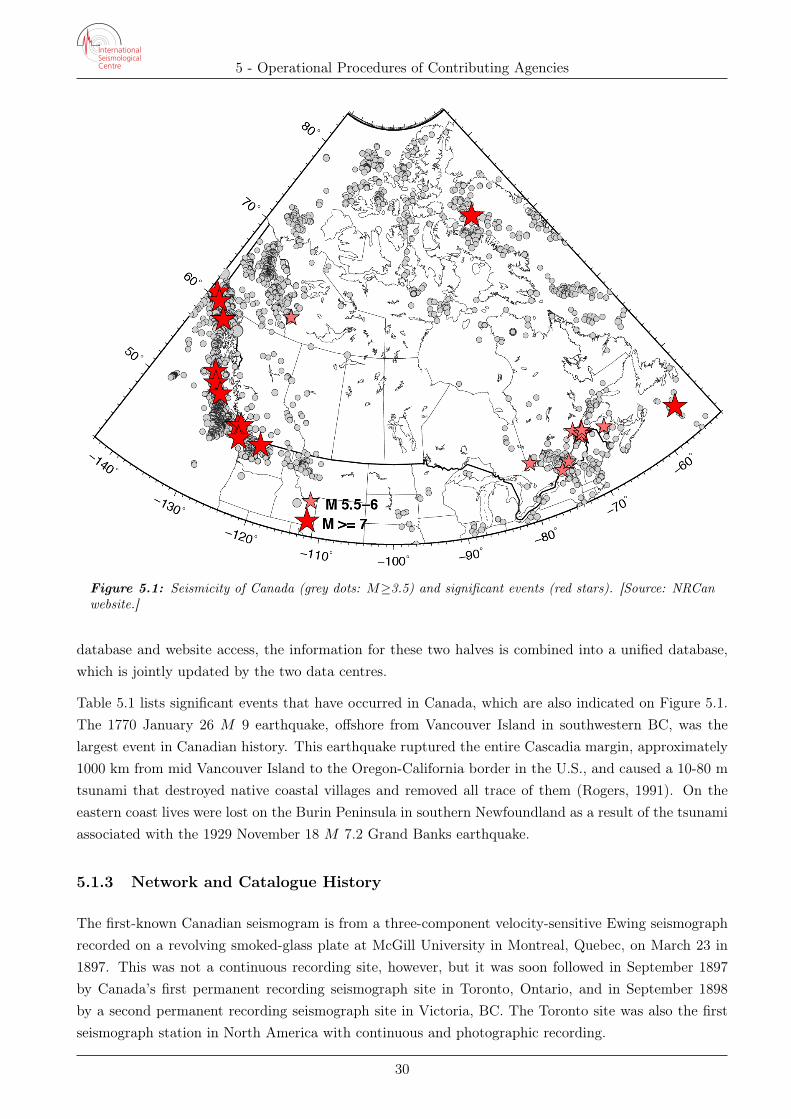
Seismicity in Canada is concentrated in two distinct regions, as seen in Figure 5.1. Along the west coastthe Pacific plate meets the North American plate, and a series of small plates comprising the Juan deFuca plate system is caught between these two large plates. The stress associated with the Pacific-NorthAmerican plate interaction extends inland into the Rocky Mountains and north along the boundarybetween the Yukon and Northwest Territories. In southwestern British Columbia (BC) the main Juande Fuca plate is being subducted beneath the western edge of the North American plate. This westernmargin is thus the most seismically active region of Canada.
Eastern Canada also hosts significant seismicity. The St Lawrence River, which runs partially along theCanada-U.S. border on the east coast of the North American continent, follows a failed rift margin. Thisregion and its surrounds have mainly been reactivated in response to intraplate stress and post-glacialrebound. Most of central Canada is relatively aseismic, which has led to a division of responsibility forcatalogue production into the western and eastern halves, each managed out of the respective officeslocated in Sidney, British Columbia (BC), and in Ottawa, Ontario (ON). For the purposes of the archival
29
5 - Operational Procedures of Contributing Agencies
Figure 5.1: Seismicity of Canada (grey dots: M≥3.5) and significant events (red stars). [Source: NRCanwebsite.]
database and website access, the information for these two halves is combined into a unified database,which is jointly updated by the two data centres.
Table 5.1 lists significant events that have occurred in Canada, which are also indicated on Figure 5.1.The 1770 January 26 M 9 earthquake, offshore from Vancouver Island in southwestern BC, was thelargest event in Canadian history. This earthquake ruptured the entire Cascadia margin, approximately1000 km from mid Vancouver Island to the Oregon-California border in the U.S., and caused a 10-80 mtsunami that destroyed native coastal villages and removed all trace of them (Rogers, 1991). On theeastern coast lives were lost on the Burin Peninsula in southern Newfoundland as a result of the tsunamiassociated with the 1929 November 18 M 7.2 Grand Banks earthquake.
5.1.3 Network and Catalogue History
The first-known Canadian seismogram is from a three-component velocity-sensitive Ewing seismographrecorded on a revolving smoked-glass plate at McGill University in Montreal, Quebec, on March 23 in1897. This was not a continuous recording site, however, but it was soon followed in September 1897by Canada’s first permanent recording seismograph site in Toronto, Ontario, and in September 1898by a second permanent recording seismograph site in Victoria, BC. The Toronto site was also the firstseismograph station in North America with continuous and photographic recording.
30
5 - Operational Procedures of Contributing Agencies
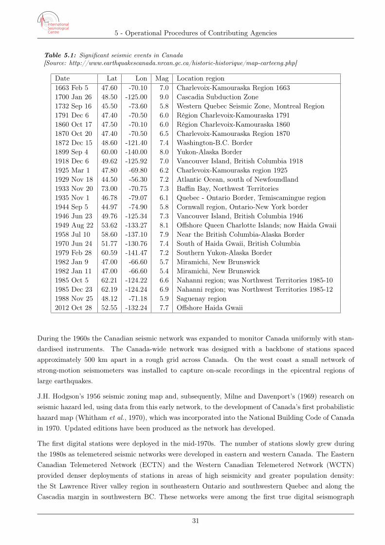
Table 5.1: Significant seismic events in Canada[Source: http://www.earthquakescanada.nrcan.gc.ca/historic-historique/map-carteeng.php]
Date Lat Lon Mag Location region1663 Feb 5 47.60 -70.10 7.0 Charlevoix-Kamouraska Region 16631700 Jan 26 48.50 -125.00 9.0 Cascadia Subduction Zone1732 Sep 16 45.50 -73.60 5.8 Western Quebec Seismic Zone, Montreal Region1791 Dec 6 47.40 -70.50 6.0 Région Charlevoix-Kamouraska 17911860 Oct 17 47.50 -70.10 6.0 Région Charlevoix-Kamouraska 18601870 Oct 20 47.40 -70.50 6.5 Charlevoix-Kamouraska Region 18701872 Dec 15 48.60 -121.40 7.4 Washington-B.C. Border1899 Sep 4 60.00 -140.00 8.0 Yukon-Alaska Border1918 Dec 6 49.62 -125.92 7.0 Vancouver Island, British Columbia 19181925 Mar 1 47.80 -69.80 6.2 Charlevoix-Kamouraska region 19251929 Nov 18 44.50 -56.30 7.2 Atlantic Ocean, south of Newfoundland1933 Nov 20 73.00 -70.75 7.3 Baffin Bay, Northwest Territories1935 Nov 1 46.78 -79.07 6.1 Quebec - Ontario Border, Temiscamingue region1944 Sep 5 44.97 -74.90 5.8 Cornwall region, Ontario-New York border1946 Jun 23 49.76 -125.34 7.3 Vancouver Island, British Columbia 19461949 Aug 22 53.62 -133.27 8.1 Offshore Queen Charlotte Islands; now Haida Gwaii1958 Jul 10 58.60 -137.10 7.9 Near the British Columbia-Alaska Border1970 Jun 24 51.77 -130.76 7.4 South of Haida Gwaii, British Columbia1979 Feb 28 60.59 -141.47 7.2 Southern Yukon-Alaska Border1982 Jan 9 47.00 -66.60 5.7 Miramichi, New Brunswick1982 Jan 11 47.00 -66.60 5.4 Miramichi, New Brunswick1985 Oct 5 62.21 -124.22 6.6 Nahanni region; was Northwest Territories 1985-101985 Dec 23 62.19 -124.24 6.9 Nahanni region; was Northwest Territories 1985-121988 Nov 25 48.12 -71.18 5.9 Saguenay region2012 Oct 28 52.55 -132.24 7.7 Offshore Haida Gwaii
During the 1960s the Canadian seismic network was expanded to monitor Canada uniformly with stan-dardised instruments. The Canada-wide network was designed with a backbone of stations spacedapproximately 500 km apart in a rough grid across Canada. On the west coast a small network ofstrong-motion seismometers was installed to capture on-scale recordings in the epicentral regions oflarge earthquakes.
J.H. Hodgson’s 1956 seismic zoning map and, subsequently, Milne and Davenport’s (1969) research onseismic hazard led, using data from this early network, to the development of Canada’s first probabilistichazard map (Whitham et al., 1970), which was incorporated into the National Building Code of Canadain 1970. Updated editions have been produced as the network has developed.
The first digital stations were deployed in the mid-1970s. The number of stations slowly grew duringthe 1980s as telemetered seismic networks were developed in eastern and western Canada. The EasternCanadian Telemetered Network (ECTN) and the Western Canadian Telemetered Network (WCTN)provided denser deployments of stations in areas of high seismicity and greater population density:the St Lawrence River valley region in southeastern Ontario and southwestern Quebec and along theCascadia margin in southwestern BC. These networks were among the first true digital seismograph
31
5 - Operational Procedures of Contributing Agencies
networks, as they had the digitizers sited at the seismic stations.
By 1985 the station coverage in southwestern BC was sufficiently dense that the number of earthquakesbeing routinely located in western Canada was increased significantly. In a later development, the early1990s saw the first seismic data being transmitted by satellite in Canada. Today GSC operates 78short-period sites, 285 broadband sites and 113 strong-motion (accelerometer) sites.
The Canadian Seismic Catalogue reflects the development of the main seismic network and the smallersub-networks. This catalogue includes several historic earthquakes in the pre-1900s, several earthquakesin the late 1800s and 1900s located from phase reports from the sparse analogue seismic network inCanada and international phase reports, and then the greatly increased numbers of earthquakes at lowerthresholds since the 1970s that were located using the significantly increased number of seismic stationsand digital waveform technologies. As a result the level of catalogue completeness varies over time andspace.
This combined catalogue has been corrected toMw equivalent magnitudes and forms the basis for seismiczoning maps for the current 2015 National Building Code of Canada (NBCC). Research is also beingcarried out to understand the properties of earthquakes in various regions of Canada to improve andprovide further advances in seismic provisions of the building code.
Current research using the GSC network includes studies of seismic tremor in the subduction zone alongthe west coast of Canada, investigations into Canadian tectonic plate margins and significant events suchas the recent Mw 7.8 Haida Gwaii earthquake therein, the mechanics of oil and gas “fracking” and manyother research activities such as investigations into temporal changes of earthquake characteristics.
5.1.4 Seismic Station Network and Waveform Data
GSC shares real-time waveform data with other co-operating agencies that have instruments sited inCanada: Canadian Universities, Plate Boundary Observatory (PB), Oceans Network Canada (NV) andUSArray (TA); and with adjoining network neighbours: Alaska (AK), Washington (UW), Montana(MN), New York and New England (LD). GSC archives data for the Canadian Universities. GSC alsooffers assistance internationally to study earthquakes in other countries such as recently in Haiti, andCanada hosts several monitoring stations of the Comprehensive Nuclear Test-Ban Treaty Organization(CTBTO).
In a separate development, the Polaris Consortium was a collaborative project between Natural Re-sources Canada (NRCan), industry and universities conceived in 2000 and ending in 2014. Key Polarisstations have now been integrated into the Canadian National Seismic Network (CN) but with a numberof the stations retaining their original network code (PO).
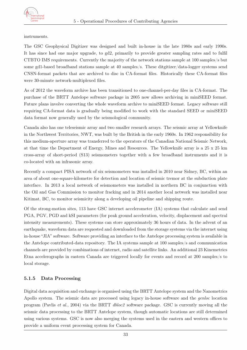
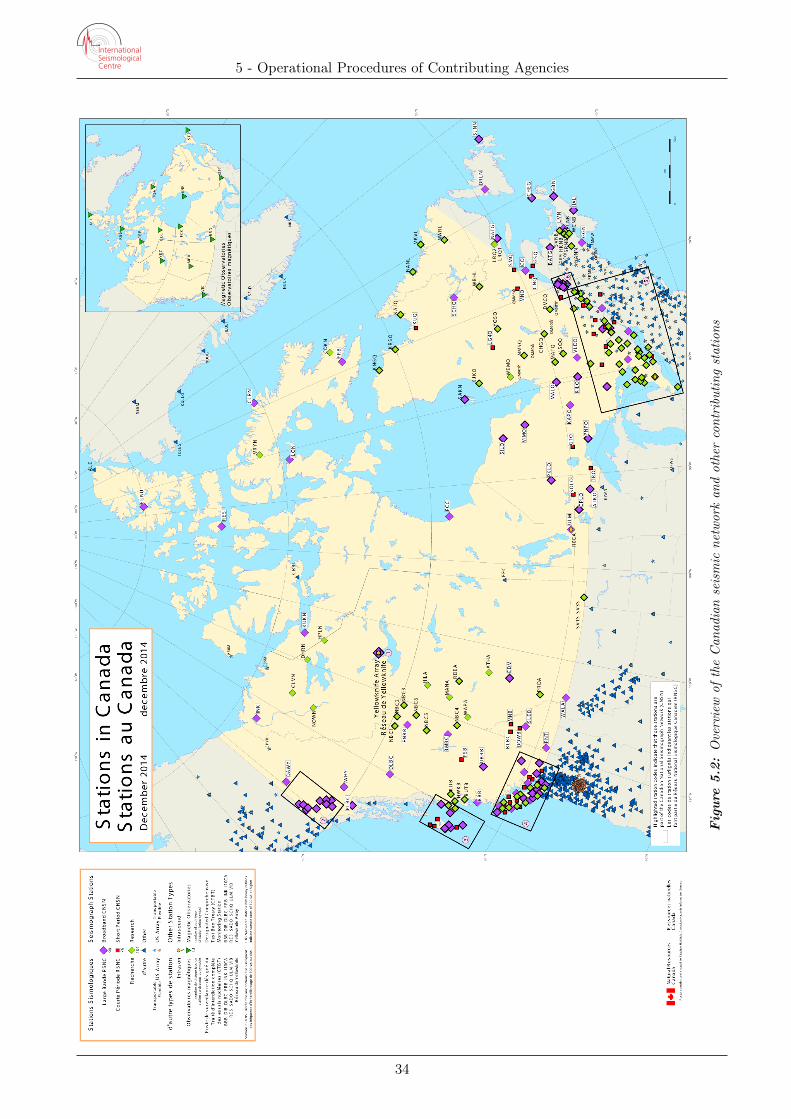
Currently the Canadian National Seismic Network (Figures 5.2 and 5.3) consists of a variety of instru-ment types from various manufacturers. Short-period seismometers include Teledyne-Geotech S13 andMark Products L4 instruments. Broadband seismometers include Guralp CMG-3T, CMG-ESP, CMG-40T, Nanometrics Trillium and a few Streckeisen STS-1 instruments. Digitizers and data-loggers area combination of GSC Geophysical Digitizers (spd, gd1, and gd2) and Nanometrics Taurus and Tri-dent systems. The recent upgrade of the Yellowknife array included the installation of Guralp DM24
32
5 - Operational Procedures of Contributing Agencies
instruments.
The GSC Geophysical Digitizer was designed and built in-house in the late 1980s and early 1990s.It has since had one major upgrade, to gd2, primarily to provide greater sampling rates and to fulfilCTBTO IMS requirements. Currently the majority of the network stations sample at 100 samples/s butsome gd1-based broadband stations sample at 40 samples/s. These ditgitizer/data-logger systems sendCNSN-format packets that are archived to disc in CA-format files. Historically these CA-format fileswere 30-minute network-multiplexed files.
As of 2012 the waveform archive has been transitioned to one-channel-per-day files in CA-format. Thepurchase of the BRTT Antelope software package in 2005 now allows archiving in miniSEED format.Future plans involve converting the whole waveform archive to miniSEED format. Legacy software stillrequiring CA-format data is gradually being modified to work with the standard SEED or miniSEEDdata format now generally used by the seismological community.
Canada also has one teleseismic array and two smaller research arrays. The seismic array at Yellowknifein the Northwest Territories, NWT, was built by the British in the early 1960s. In 1962 responsibility forthis medium-aperture array was transferred to the operators of the Canadian National Seismic Network,at that time the Department of Energy, Mines and Resources. The Yellowknife array is a 25 x 25 kmcross-array of short-period (S13) seismometers together with a few broadband instruments and it isco-located with an infrasonic array.
Recently a compact PISA network of six seismometers was installed in 2010 near Sidney, BC, within anarea of about one-square-kilometre for detection and location of seismic tremor at the subduction plateinterface. In 2013 a local network of seismometers was installed in northern BC in conjunction withthe Oil and Gas Commission to monitor fracking and in 2014 another local network was installed nearKitimat, BC, to monitor seismicity along a developing oil pipeline and shipping route.
Of the strong-motion sites, 113 have GSC internet accelerometer (IA) systems that calculate and sendPGA, PGV, PGD and kSI parameters (for peak ground acceleration, velocity, displacement and spectralintensity measurements). These systems can store approximately 36 hours of data. In the advent of anearthquake, waveform data are requested and downloaded from the storage systems via the internet usingin-house “JIA” software. Software providing an interface to the Antelope processing system is available inthe Antelope contributed-data repository. The IA systems sample at 100 samples/s and communicationchannels are provided by combinations of internet, radio and satellite links. An additional 23 KinemetricsEtna accelerographs in eastern Canada are triggered locally for events and record at 200 samples/s tolocal storage.
5.1.5 Data Processing
Digital data acquisition and exchange is organised using the BRTT Antelope system and the NanometricsApollo system. The seismic data are processed using legacy in-house software and the genloc locationprogram (Pavlis et al., 2004) via the BRTT dbloc2 software package. GSC is currently moving all theseismic data processing to the BRTT Antelope system, though automatic locations are still determinedusing various systems. GSC is now also merging the systems used in the eastern and western offices toprovide a uniform event processing system for Canada.
33
5 - Operational Procedures of Contributing Agencies
Fig
ure
5.2:
Overview
oftheCan
adianseismic
networkan
dothercontributing
stations
34
5 - Operational Procedures of Contributing Agencies
Fig
ure
5.3:
Details
ofCan
adiansub-networks
andothercontributing
stations
35
5 - Operational Procedures of Contributing Agencies
Dataflow: Automatic Locations and Significant Event Notifications
For eastern Canada (Ottawa data-centre), software developed in-house by GSC is used. Detections aregenerated based on FFT frequency-band filtering of waveform packets. Four short-term-average/long-term-average (STA/LTA) frequency bands filter the summed power of each packet in the selected fre-quency bands in the FFT output. These detections are passed to the Autoloc processing software thatgenerates automatic event locations. These Autoloc solutions are used for event alert purposes: theAneas software package uses the Autoloc solutions to send out notifications, based on client criteria, toindividual clients. Clients are notified by email, ftp, scp, fax, SMS or digital paging devices.
The STA/LTA detections are also passed to the ULF detection system. This system presents screeneddetections to analysts wherein waveforms are analysed by frequency, amplitude and coda shape todistinguish real-events from noise. This generates a daily ULF event-list, which drives the analystprocessing system. Analysts inspect these events using the DAN location program. Noise detections arediscarded and real events are located. The final event files are saved and the location parameters areloaded into the INGRES database for the Canadian Seismic Catalogue.
For western Canada (Sidney data-centre) event notifications are determined via the Antelope real-timesystem. Detections are based on STA/LTA thresholds in selected frequency bands for user-determinedSTA and LTA window-lengths. These detections are fed into a grid associator that formulates eventhypotheses and retains those with a sufficient goodness-of-fit. These locations are then fed into the genloclocation program with the final estimated location determined using the appropriate velocity model forthe region.
These real-time detections, arrivals and origin determinations are written to a database. The automaticorigins also drive the routine event-analysis system. Analysts inspect the origins, adjusting the automaticphase picks and adding new phase picks for real events and locating the events with the genloc programvia the Antelope dbloc2 module. The final data are kept in the Antelope Datascope database and thelocation parameters are loaded into the INGRES database for the Canadian Seismic Catalogue.
Canadian Seismic Duty personnel (the “on-call seismologists”) carry cellular phones, by which they receiveautomatic locations from the above mentioned sources as well as from the United States GeologicalSurvey (USGS) and the West Coast and Atlantic Tsunami Warning Center (WCATWC). Duty personnelare on duty for one week at a time and are available on an on-call (24/7) basis. Six duty personnelare mandated for rotating on-call duty at the Ottawa office and at the Sidney office. However, due tostaffing shortages, it is not currently possible to maintain this complement of duty personnel. Detailsof earthquakes of magnitude four or more and all felt events are posted on the website soon after theevent occurrences and significant event notices are sent to media and emergency response organisationsas required.
Event Analysis – Seismic Catalogue
Events of magnitude 3.5 or more in the Canadian Seismic Catalogue were indicated in Figure 5.1, whichshowed the virtually aseismic region though the centre of Canada extending from the north-northwestto the south. Although estimations of the event locations and magnitudes are determined at the two
36
5 - Operational Procedures of Contributing Agencies
data centres, west in Sidney and east in Ottawa, the resulting analyses are combined into the unifiedINGRES database to produce the Canadian Seismic Catalogue.
Daily Review
Analysts at either data centre process events on a daily basis during normal office hours. The dailyroutine involves the discrimination of earthquakes from mining and quarry blasts and noise events.Earthquakes and a small fraction of blast events have their locations determined but noise events arediscarded. The waveforms are usually scanned for a subset of stations to search for any missed events,primarily small events recorded at three or fewer stations or events where adjacent recording stationsare not yet incorporated into the automatic processing.
Monthly Review
Historically the monthly event review involves several tasks: checking for events above the completenesslevel for the seismic subregion but missing from the catalogue; maintaining consistency of the velocitymodels and event locations within those subregions based on defining stations and their distances fromthe hypocentral estimates; assessing general database health; and ensuring that event types are properlyassigned.
Due to declining staff levels and the increasing numbers of stations that increase the workload, theanalyst monthly review has regrettably languished over recent years. Some of these tasks are neverthelessaccomplished using automatic database checks or by the increased diligence of analysts during the dailyreview. Furthermore, in-house research provides feedback on the state of the catalogue and the yearlyreviews of the annual seismicity map and for seismic hazard provide valuable opportunities to addresspotential issues in the catalogue.
5.1.6 Magnitudes
The following magnitude types used in the Canadian Seismic Catalogue are listed below together witha short description of their domains:
ML – western and northern Canada; select small events in eastern Canada for which mN cannot becalculated
ML(Sn) – offshore Vancouver Island, British Columbia, and offshore from the Atlantic coast
mbLg – historically used for events in the Rocky Mountains and Alberta
mN – eastern Canada.
MS – teleseismic surface-wave determinations
Mw – events > 3.5 - 4.0 Canada-wide, determined by interactive modelling of waveforms
Estimated Mw (Mw’) – for events offshore from south-western Canada – a correction is applied to theML(Sn) value obtained for these events, based on Risteau et al., 2007
37
5 - Operational Procedures of Contributing Agencies
5.1.7 Data Availability
Data and resource material are available through the NRCan website:
http://www.earthquakescanada.nrcan.gc.ca
5.1.8 References
Milne, W. G., and A. G. Davenport, 1969. Distribution of Earthquake Risk in Canada. Bulletin of theSeismological Society of America, 59:729-754.
Pavlis, G. L., F. Vernon, D. Harvey, and D. Quinlan, 2004. “The generalized earthquake location(GENLOC ) package: an earthquake-location library”, Computers & Geosciences, 30:1079-1091.
Ristau, J., G.C. Rogers, and J.F. Cassidy, 2007. “Stress in Western Canada from Regional MomentTensor Analysis”, Canadian Journal of Earth Sciences, 44(2):127-148.
Rogers, G.C., 1991. “The History of Earthquake Studies in British Columbia: From Indian Legend toSatellite Technology, Pioneering Geology in the Canadian Cordillera”, Geological Survey of Canada OpenFile 1992-19, pp.61-66.
Whitham, K., W.G. Milne, and W.E.T. Smith, 1970. “The New Seismic Zoning Map of Canada”, 1970Edition, Canadian Underwriter, Vol. 15.
38