Embed Size (px)
Citation preview

Maryland Department of Natural Resources Resource Assessment Service
MARYLAND GEOLOGICAL SURVEY Jeffrey P. Halka, Director
Report of Investigations No. 79
PRELIMINARY ASSESSMENT OF FACTORS AFFECTING WELL YIELDS IN THE FRACTURED-ROCK TERRANE OF FREDERICK COUNTY AND PORTIONS OF
CARROLL AND MONTGOMERY COUNTIES, MARYLAND
by
Katherine Burgy and
Mark T. Duigon
Prepared in cooperation with the Maryland Department of the Environment
and the United States Department of the Interior, Geological Survey
DNR Publication No. 12-5102012-567
2012
CONTENTS Page
Key results ...................................................................................................................................................... 1 Introduction .................................................................................................................................................... 2
Background .............................................................................................................................................. 2 Water sources and demand for water ................................................................................................ 2 Ensuring enough water and preparing for drought ............................................................................ 2
The “Wolman Report” and assessing Maryland water resources ...................................................... 2 Purpose and scope .................................................................................................................................... 2 Location of study area .............................................................................................................................. 3 Previous investigations ............................................................................................................................. 3
Acknowledgments .................................................................................................................................... 3 Geologic setting ........................................................................................................................................ 3 Methods of investigation ................................................................................................................................ 4
Well selection ........................................................................................................................................... 4 Assignment of lithologic units ................................................................................................................. 4
Data analysis ............................................................................................................................................ 5 Results ............................................................................................................................................................ 6 Well yields in relation to well-site characteristics .................................................................................. 6
Well use ............................................................................................................................................. 6 Physiographic province ..................................................................................................................... 6
Depth to bedrock (overburden thickness)........................................................................................... 7 Position of water table relative to bedrock-overburden interface ...................................................... 7 Lithologic unit .................................................................................................................................... 7
Topography ....................................................................................................................................... 8 Distance from mapped faults ............................................................................................................. 9 Discussion ...................................................................................................................................................... 10
Factors affecting well yields .................................................................................................................... 10 Recommendations for further study ......................................................................................................... 10
Summary and conclusions............................................................................................................................... 11 References ...................................................................................................................................................... 11 Appendix
1. Records of wells used in this report .................................................................................................. 51
ILLUSTRATIONS
Figure Page
1. Diagram showing ground water in fractured-rock terrane .............................................................. 15 2. Diagram showing typical well construction in fractured-rock terrain............................................. 16 3. Map showing the physiographic provinces of Maryland and location of the pilot study area.................................................................................................................... 17 4. Map showing locations of wells in the study area........................................................................... 18 5. Geologic map source compilation used in this study ...................................................................... 19 6. Lithologic-unit map used in this study............................................................................................ 20 7a. Distribution of well depths for domestic wells in the Triassic Basin in the study area................... 21 7b. Distribution of average well yields for well-depth ranges for domestic wells in the Triassic Basin in the study area .......................................................................................... 21
ii

ILLUSTRATIONS—CONTINUED
Figure Page 8a. Distribution of well depths for domestic wells in siliciclastic rocks in the Piedmont part of the study area ................................................................................................................ 22 8b. Distribution of average well yields for well-depth ranges for domestic wells in siliciclastic rocks in the Piedmont part of the study area...................................................... 22 9a. Distribution of well depths for domestic wells in siliciclastic rocks in the Blue Ridge
part of the study area ................................................................................................................ 23 9b. Distribution of average well yields for well-depth ranges for domestic wells in siliciclastic rocks in the Blue Ridge part of the study area................................................... 23 10a. Distribution of well depths for domestic wells in carbonate rocks in the Piedmont part of the study area ................................................................................................................ 24 10b. Distribution of average well yields for well-depth ranges for domestic wells in carbonate rocks in the Piedmont part of the study area ........................................................ 24 11. Box-and-whisker plot of well yields, grouped by well use............................................................. 25 12. Box-and-whisker plot of well depths, grouped by well use ............................................................ 26 13. Graph of cumulative percentage of well yields, grouped by well use and physiographic province............................................................................................................. 27 14. Box-and-whisker plot of well yields, grouped by well use and physiographic province................ 28 15. Graph of depth to bedrock versus casing depth for commercial and institutional well uses .......... 29 16. Graph of depth to bedrock versus casing depth for domestic well use ........................................... 29 17. Graph of depth to bedrock versus casing depth for public-supply and industrial well uses ........... 30 18. Graph of commercial and institutional well yields versus depth to bedrock .................................. 31 19. Graph of domestic well yields versus depth to bedrock.................................................................. 31 20. Graph of public-supply and industrial well yields versus depth to bedrock ................................... 32 21. Graph of cumulative percentage of depth to bedrock, grouped by well use
and physiographic province...................................................................................................... 33 22. Graph of water level in relation to the bedrock/overburden interface versus yield for commercial and institutional well uses ............................................................................... 34 23. Graph of water level in relation to the bedrock/overburden interface versus yield for domestic well use ................................................................................................................ 35 24. Graph of water level in relation to the bedrock/overburden interface versus yield for public-supply and industrial well uses ................................................................................ 36 25. Generalized composition and relative permeability of saprolite..................................................... 37 26. Box-and-whisker plot of well yields in commercial and institutional wells, grouped by lithologic unit and physiographic province ......................................................................... 38 27. Box-and-whisker plot of well yields in domestic wells, grouped by lithologic unit and physiographic province...................................................................................................... 39 28. Box-and-whisker plot of well yields in public-supply and industrial wells, grouped by lithologic unit and physiographic province ......................................................................... 40 29. Box-and-whisker plot of well yields in commercial and institutional wells, grouped by topography and physiographic province.............................................................................. 41 30. Box-and-whisker plot of well yields in domestic wells, grouped by topography and physiographic province...................................................................................................... 42 31. Box-and-whisker plot of well yields in public-supply and industrial wells, grouped by topography and physiographic province.............................................................................. 43 32. Graph of well yield versus distance from a fault surface for wells in the Blue Ridge Province................................................................................................................. 44 33. Graph of well yield versus distance from a fault surface for wells in the Piedmont Province.............................................................................................................. 44
iii

iv
TABLES
Table Page 1. Lithologic units and corresponding geologic units of represented wells ........................................ 45 2. Well uses and number of wells in each category ............................................................................ 46 3. 10th, 25th, 50th, 75th, and 90th percentile well-yield values for different well uses ........................... 46 4. 10th, 25th, 50th, 75th, and 90th percentile well-depth values for different well uses .......................... 46 5. 10th, 25th, 50th, 75th, and 90th percentile well-yield values by well use and physiographic province............................................................................................................. 47 6. 10th, 25th, 50th, 75th, and 90th percentile well-yield values for commercial and institutional wells, by lithology and physiographic province ................................................... 47 7. 10th, 25th, 50th, 75th, and 90th percentile well-yield values for domestic wells, by lithology and physiographic province ................................................................................. 48 8. 10th, 25th, 50th, 75th, and 90th percentile well-yield values for public-supply and industrial wells, by lithology and physiographic province........................................................ 48 9. 10th, 25th, 50th, 75th, and 90th percentile well-yield values for commercial and institutional wells, by topographic position and physiographic province................................. 49 10. 10th, 25th, 50th, 75th, and 90th percentile well-yield values for domestic wells, by topographic position and physiographic province ............................................................... 49 11. 10th, 25th, 50th, 75th, and 90th percentile well-yield values for public-supply and industrial wells, by topographic position and physiographic province..................................... 50

PRELIMINARY ASSESSMENT OF FACTORS AFFECTING WELL YIELDS IN THE FRACTURED-ROCK TERRANE OF FREDERICK COUNTY AND PORTIONS OF CARROLL AND MONTGOMERY COUNTIES, MARYLAND
by
Katherine Burgy and
Mark T. Duigon
KEY RESULTS
A pilot study was conducted in an area comprising Frederick County and the nearby areas surrounding Poolesville (Montgomery County), Taneytown, Mt. Airy, and Westminster (Carroll County), Maryland, to evaluate factors related to well yields. Data from 2,315 wells were analyzed in a preliminary assessment to determine what, if any, relation exists between well yield and geology, well depth, well construction, or other factors affecting ground-water availability in the fractured-rock terrane. The key results of the study are:
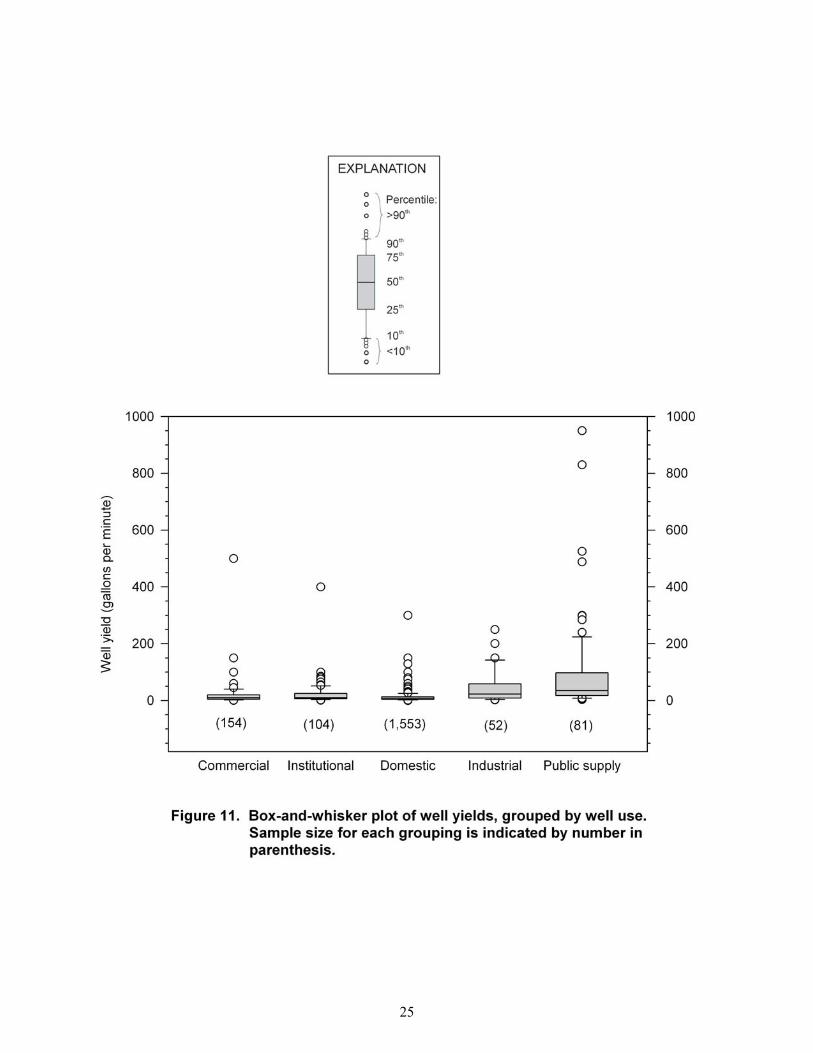
• Well use is a significant factor in the determination of well yield. Differences in the construction of public-supply and industrial wells allow for greater variation in well depth and diameter. These well uses also benefit from better location selection and siting. Well yields are significantly higher (P< 0.05) in public-supply wells and industrial wells than in domestic wells. Commercial and institutional wells do not have statistically different yields, nor do industrial and institutional wells. Domestic well yields are significantly different (lower) from all other well uses.
• Commercial, domestic, industrial, institutional, and public-supply wells in the Piedmont have greater median well yields and variability in well yields than wells in the Blue Ridge, although these differences were not statistically significant.
• Lithology and topography are site factors that may have a statistically significant impact on well yield; however, this is not consistently demonstrated throughout all well-use groups.
• Depth to bedrock (overburden thickness) and position of the water table relative to the bedrock-overburden interface do not demonstrate any statistically significant influence on well yield.
• Distance to a mapped fault appears to have no effect on well yield, but this result may be unduly influenced by the map scale of this study.
1

INTRODUCTION
BACKGROUND
Water Sources and Demand for Water
In Maryland, drinking-water supplies come from either surface- or ground-water resources. In the fractured-rock terrane of Maryland, ground water occurs in joints or fractures in the solid rock. These joints and fractures have limited storage capacity; therefore, the overburden above the bedrock is a major source of recharge (fig. 1). To produce water, wells in the fractured-rock terrane must intersect water-bearing fractures (fig. 2). Previous research has established that it is not only the number of fractures intersected by the well, but the aperture, length, and connectivity to other fractures that determines the productivity of a well (Caswell, 1979). In 2010, the total population in the State of Maryland was approximately 5.7 million people (U.S. Census Bureau, 2012). This represented a 9-percent increase in population from the 2000 census. The counties in the study area, including Frederick, Carroll, and Montgomery Counties, experienced population increases of 19.5, 10.8, and 11.3 percent, respectively. According to the 2011 Maryland Department of the Environment’s (MDE) report to the Governor titled, “Maryland’s Capacity Development Program for Public Drinking Water Systems”, 86 percent of Maryland’s population is served by community water systems and 14 percent is served by individual wells. Of the 3,432 public-water systems in the State, 3,373 use ground water as their sole water source. Future demand for water is expected to increase, reflecting a projected growth in Maryland’s population to roughly 6.4 million people by 2025 (U.S. Census Bureau, 2012).
Ensuring Enough Water and Preparing for Drought
Droughts in 1998-1999 and 2001-2002, along with increasing population projections, prompted the State of Maryland to reevaluate the availability of water resources within the State. The effects of drought resulted in the implementation of building restrictions and moratoriums in several municipalities, the failure of hundreds of domestic wells within the State, and threatened the ability of public-water systems to meet demand as sources became increasingly stressed.
The “Wolman Report” and Assessing Maryland Water Resources
In July 2008, the Advisory Committee on the Management and Protection of the State’s Water Resources issued its final report identifying the challenges Maryland faces regarding use of its water resources and outlining a strategy to achieve sustainability (State of Maryland, 2008). The committee, informally known as the Wolman Committee, recognized several issues that may affect ground-water availability, including increased demand due to projected population growth and agricultural irrigation; changing land-use patterns that may threaten water quality; competition between ground-water users, including domestic, recreational, agricultural, and power-producers; and climate change, leading to significantly warmer and drier periods. The report recommended both basic data acquisition and development of a Statewide water-supply plan, including the availability of ground water in fractured-rock terranes.
PURPOSE AND SCOPE
This report presents an evaluation of the relation between various site and well-construction factors and well yields in the fractured-rock aquifers in Frederick County and parts of Montgomery and Carroll Counties. This study is intended to provide a starting point for additional studies covering the remaining fractured-rock terrane of Maryland. Analysis of factors that influence well yield will help in the selection of well sites and for water-supply planning and development.
2
LOCATION OF STUDY AREA
This study was conducted in a pilot area comprising Frederick County and the nearby areas surrounding Poolesville (Montgomery County), and Taneytown, Mt. Airy, and Westminster (Carroll County). In Maryland, the fractured-rock terrane extends from the Fall Line westward to Garrett County and encompasses the Piedmont, Blue Ridge, Valley and Ridge, and Appalachian Plateau physiographic provinces (figs. 3 and 4). The study area was selected because it is an area of rapid growth with increasing water demand, there are a variety of water uses, and there is a range of geologic and hydrologic terranes with diverse land use. The study area is located in a region that was severely affected by the droughts of 1999 and 2002.
PREVIOUS INVESTIGATIONS
Earlier workers have examined the highly variable yields of wells completed in the fractured rocks of Maryland with respect to site factors (such as lithology and topographic setting) and construction factors (such as well depth). The Maryland Geological Survey (MGS) published a series of bulletins describing water resources of various counties in the 1950s and early 1960s (Dingman and Meyer, 1954; Overbeck, 1954; Dingman and Ferguson, 1956; Meyer, 1958; Overbeck and Slaughter, 1958; Slaughter, 1962), and updated some of the county studies in the late 1970s to mid-1990s (Nutter, 1977; Duigon and Dine, 1987; Otton and others, 1988; Duigon and Dine, 1991; Dine and others, 1995). Nutter and Otton (1969) described ground-water occurrence in the Maryland Piedmont, and associated certain geologic units with areas of higher or lower than average well yields. A series of quadrangle atlases (e.g., Otton and others, 1975; Duigon, 1981; Duigon and others, 1994a-b; Weigle and Hilleary, 1981) included maps of areas where well yields could be expected to be higher or lower than average, based on the distribution of yields of wells in the geologic units underlying the areas of the quadrangles.
ACKNOWLEDGMENTS
This report is part of a regional assessment of the water resources of Maryland’s fractured-rock terrane, which was designed to address some of the recommendations of the Advisory Committee on the Management and Protection of the State’s Water Resources. Cooperative funding came from MDE and the U.S. Geological Survey (USGS) Maryland-Delaware-D.C. Water Science Center. Phung Pham (MGS) and Sarah Cook (formerly MGS) inventoried wells and conducted other tasks for MGS. Heather Quinn (MGS) provided many insightful discussions. Donajean Appel (MGS) assisted with data input and with editing and manuscript preparation. Steve Curtin (USGS) and other USGS staff provided database management. Colleague reviews by Brandon Fleming (USGS), Tom Devilbiss (Carroll County Department of Land Use, Planning, and Development), and Harry Hansen (MGS [retired]) provided insightful comments.
GEOLOGIC SETTING
Maryland exhibits diverse geologic and physiographic terranes (fig. 3) consisting of rocks and sediments that range in age from over 1 billion years (Wetherill and others, 1966; Aleinikoff and others, 2004) to recent decades (Costa, 1975). The Fall Line, which extends through the State from eastern Cecil County to Washington, D.C., marks the eastern edge of the outcropping fractured-rock terrane in Maryland. Eastward of the Fall Line, these rocks dip progressively deeper beneath unconsolidated sediments that form the Coastal Plain. This study encompasses parts of the Blue Ridge and Piedmont physiographic provinces in Maryland, both of which have distinct characteristics. The Piedmont consists of gently rolling hills, with elevations typically between 400 and 700 feet (ft) above sea level (Duigon and Dine, 1987). Brezinski (2004d) described the Piedmont as metamorphosed phyllites, schists, basalts, marbles, and granites which underwent intense deformation and metamorphism during the formation of the Appalachian Mountains. The rocks underwent a generally lower degree of metamorphism in the western portion of the Piedmont and higher-grade metamorphism towards the East (Reger and Cleaves, 2008). The Piedmont includes siliciclastic rocks of Triassic age in northeastern Frederick, northwestern Carroll, and western Montgomery Counties. The Triassic rocks are located in two separate basins, the Gettysburg Basin to the
3

north of the study area and the Culpeper Basin, located to the south. In the Gettysburg Basin, units include the New Oxford and Gettysburg Formations, and in the Culpeper Basin, the units include the Balls Bluff Siltstone, Leesburg Formation and Manassas Formation (Nutter, 1975). The Blue Ridge province primarily consists of a large, anticlinal fold whose limbs form both the Catoctin Mountain and South Mountain ridges, which consist of Lower Cambrian quartzite. The two ridges are separated by Precambrian gneiss and metamorphosed, volcanic rock of the Middletown Valley (Reger and Cleaves, 2008).
METHODS OF INVESTIGATION
This study is based on an evaluation of data from 2,315 wells. Data were obtained from the USGS Ground-Water Site Inventory (GWSI) portion of the USGS National Water Inventory System (NWIS) database. Most of the data represent wells that have been inventoried over time for a variety of projects; additional wells were inventoried in the area specifically for this project. Field inventorying for water wells typically consists of a visit to the site, where the well-permit number is obtained from the well tag or other means. Since 1973, State regulations require a metal tag with the well-permit number stamped on it to be affixed to the well casing, and the location of the well is recorded on the well-completion report, either on a map (for older wells) or by determining the latitude and longitude (for wells inventoried more recently). These data are combined with information provided by the well driller in the State-required well-completion report, which describes specifics of the well’s construction, including the depth, casing, and yield. After the field inventory, the well is assigned a local well name (e.g., FR Df 35), and the information is then entered into GWSI.
WELL SELECTION
Wells in this study were retrieved from GWSI, based on the geographic location of the study area. Further restrictions on the retrieved data were made based on the completeness of the available well records. Wells without yield data were eliminated from consideration; however, if a well was listed as a dry hole in the well-completion report, the well was included, and the well yield assigned a value of zero. Well yields are determined by several techniques and by various time-duration pumping tests. Most public-supply wells are subject to long-term pumping tests (24 hours or longer), while domestic wells are usually evaluated by a short-term pumping test (30 minutes to a few hours). The variability in well-yield determination adds some uncertainty to the data; however, the error is assumed to be evenly distributed among the data (Mark Duigon, MGS [retired], personal commun., 2012). For the final dataset, the well-driller’s completion reports were reviewed and any missing information was updated, if available. Additional information was obtained from data files at MGS. The wells selected for this report represent a composite of the ground-water conditions in the study area across a 60-year time span, including all seasons and local weather and climate conditions. These data provide a robust view of both the hydrogeologic conditions and ground-water availability from fractured-rock wells in the study area. It is assumed that water levels, yields, and other data reflect an average representation of hydrogeologic conditions.
ASSIGNMENT OF LITHOLOGIC UNITS
Although the geology of the study area has been mapped by many geologists (Jonas and Stose, 1938; Edwards, 1993a-b; Muller, 1994; Brezinski, 2004a-d; Brezinski and Edwards, 2004; Brezinski and others, 2004; Brezinski and Southworth, 2004; Reger and Edwards, 2004; Reger and others, 2004; Brezinski and Fauth, 2005; Southworth and others, 2007; Brezinski, 2009; Brezinski and Bell, 2009; Brezinski and Fauth, 2009) and many of the geologic maps have been digitized in several quadrangles, a complete and current digital map of the geology of the region is not available as of 2012 (fig. 5). Due to the lack of a single geologic-base map, the authors found grouping wells by geologic unit to be prohibitively difficult. Geologic units were not contiguous or necessarily equivalent across maps due to changes in interpretations of local geologic history over time and among many different mappers. While the authors of this study used these quadrangle geological maps to investigate discrepancies in well-completion reports or for clarification of well location and position, it was determined that a map offering full
4

coverage of the study area would be more suitable. Furthermore, it was recognized that several geologic units had similar lithologic qualities that would lend themselves to being evaluated together. Many workers have identified lithology and geologic units as an important factor influencing well yield (Taylor and Royer, 1981; Knopman and Hollyday, 1993; Henriksen, 1995; Moore and others, 2002). This study followed an approach similar to that of Moore and others (2002) by combining several geologic units into major lithologic types that have similar characteristics. Considering that the study area includes over 36 recognized geologic formations, only some of which are correlative across different base maps, we chose to use gross lithology as a starting point for investigation. Therefore, to evaluate the effect of geologic/lithologic factors on well yield, the authors used the 2001 “Preliminary Lithogeochemical Map of Near-Surface Rock Types in the Chesapeake Bay Watershed, Virginia and Maryland” (Peper and others, 2001) as a base map (fig. 6). This map, which provided full coverage of the study area, was developed by classifying geologic map units from the 1968 “Geologic Map of Maryland” (Cleaves and others, 1968) by composition, mineralogy, and texture, with a focus on key water-reactive mineral components. It displays the distribution of near-surface rock types as lithogeochemical units and was intended as a tool for hydrologists to investigate relationships between rock types and water quality. The geologic unit penetrated by each well was originally identified from data retrieved from GWSI. For wells missing the geologic unit assignment, driller’s reports and comparisons to geologic maps in the study area were made in order to complete the records. Geologic units were then assigned to one of four lithologic categories: carbonate, fine-grained siliciclastic, coarse-grained siliciclastic, or igneous (tab. 1) based on the classification scheme of the Peper and others’ (2001) map. Well yields for each lithologic group were then evaluated. As a preliminary evaluation, we also selected domestic wells (which had the largest sample size) and compared well yields and depths of wells completed in the Triassic-age rocks to those completed in non-Triassic-age siliciclastic rocks of the Piedmont and Blue Ridge, as well as the carbonate rocks of the Piedmont (figs. 7 to 10) Wells completed in the Triassic rocks, on average, have greater well yields than wells located in equivalent rock types in the Piedmont and Blue Ridge. Not unexpectedly, wells located in carbonate rocks have the largest average yields for equivalent depths. Rocks of the Triassic and Piedmont terranes with similar lithologies are combined in this report to evaluate factors affecting well yield. Several geologic units, such as the Sams Creek Formation, New Oxford Formation and Gettysburg Shale, are listed in multiple lithologic categories. Each of these units contain several distinct lithologies. For example, the New Oxford Formation typically consists of a dark reddish siltstone/shale and micaceous arkose lithology (which would be classified as a fine-grained siliciclastic rock) and a basal quartz-pebble conglomerate with pebbles and cobbles reaching up to 5 inches in diameter (coarse-grained siliciclastic) (Reger and others, 2004). Wells that were identified in these units were further investigated using driller’s reports to determine which lithologic category was more appropriate. Additional descriptions of these units can be found on the individual quadrangle maps (fig. 5).
DATA ANALYSIS
Data analysis includes descriptive statistics of wells and subsets of wells, and statistical tests for trends (Spearman rank-correlation test) and differences between groups (Kruskal-Wallis One-Way Analysis of Variance on Ranks [ANOVA] and Mann-Whitney Rank Sum Test). Differences between well groups were considered to be statistically different if P<0.05 (that is, if there was less than a 5-percent chance of incorrectly concluding that there is a true association between the variables). In this report, references to statistical significance refer to the Kruskal-Wallis ANOVA test at the P<0.05 significance level, unless otherwise specified. Well yields for different categories of wells were also visually compared using box-and-whisker plots and other graphical representations. After an initial evaluation, we determined that several well-use categories (as defined by GWSI) lacked enough wells (less than five) to provide meaningful analysis. For that reason, the well-use categories of aquaculture, fire, irrigation, recreation, and stock were not included in the analysis. Well-use categories are presented in table 2. Other well uses were similar in nature, both in quantities of water needed and well construction, and were, therefore, combined into a larger data set (figs. 11 and 12; tabs. 3 and 4). Yields from public-supply and industrial wells were not significantly different from each other and could, therefore, be reasonably combined into a single group. Similarly, the yields of commercial and institutional wells, and industrial and institutional wells were not significantly different from each other. Commercial and institutional wells were combined into a single group
5

based on the additional similarity of well depth and the fact that institutional and public-supply wells were not statistically similar. Domestic wells comprise the vast majority of the dataset and have unique well-construction and water needs. In order to preserve this dataset and prevent undue influence on other smaller datasets, domestic wells were evaluated in a separate category (tab. 2). For the reasons previously mentioned, wells in a topographic setting with less than five wells in the dataset were removed from further study. Previous studies have concluded that, for fractured rock, the variation in well yield remains large regardless of specific factors such as lithology or topography. Consequently, the yield of any individual well is not accurately predictable (Cederstrom, 1972; Duigon and Dine, 1987). Nonetheless, studies have also concluded that large datasets may still be used to infer reasonable well yields for groups of similar wells (Knopman and Hollyday, 1993). For this study, the selected wells are not randomly sampled and are, in part, dependent upon representation in the GWSI database.
RESULTS
WELL YIELDS IN RELATION TO WELL-SITE CHARACTERISTICS
Well Use
Well yields are significantly higher (P< 0.05) in public-supply wells and industrial wells than in domestic wells. Commercial and institutional wells do not have statistically different yields, nor do industrial and institutional wells. Domestic well yields are significantly different (lower) from all other well uses (figs. 11 and 12; tabs. 3 and 4) The yield of a well in fractured rock is largely dependent upon the size and distribution of the water-bearing fractures intersecting the well bore. As Moore and others (2002) point out, measured well yield is also frequently a function of the well owner’s water requirements, and not a measurement of the site’s maximum yield potential. The required well yield may significantly influence the construction and development of a particular well; more care is given to the selection of drill sites and construction parameters for wells intended for public supply than for those intended for domestic consumption. Public-supply wells and, to a similar extent, institutional, commercial, and industrial wells, have higher demands placed on them, greater freedom in siting the well (due to larger or multiple properties), greater funds available for construction and development (allowing the potential to drill deeper or larger diameter wells), and the greatest interest in extracting and maximizing the potential yield. Domestic wells, by comparison, are typically drilled in order to meet a minimum yield and depth requirement set by local government regulations (Duigon and Dine, 1987). Drilling for domestic wells is typically stopped upon reaching the minimum amount of water and storage capacity needed, and the location is limited to the extent of the homeowner’s property, which may or may not be ideally situated for maximum water yield. Other considerations on small properties that may affect well placement (and subsequent yield) include house location and distance to house from well, distance from septic systems, road setbacks, and other property boundaries in accordance with local zoning (Duigon and Dine, 1987).
Physiographic Province
This study also suggests that well yield is related to the physiographic province of the well (fig. 13). Physiographic province integrates the combined influence of multiple, independent factors such as lithology, topography, and geologic structure, which can be useful when differentiating wells into similar groupings for comparison (Reger and Cleaves, 2008). Commercial, domestic, industrial, and public-supply wells in the Piedmont have greater median well yields and variability in well yields than wells in the Blue Ridge (fig. 14 and tab. 5), although these differences were not statistically significant. Despite these findings, this study organizes well groups by well use and physiographic province for visual comparison.
6

Depth to Bedrock (Overburden Thickness)
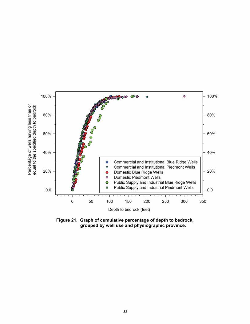
Well yields were evaluated with respect to depth to bedrock. In central Maryland, depth to bedrock is typically estimated by the length of casing of a well, since well-construction regulations in central Maryland require wells to have a minimum casing length of 20 ft and a minimum seating distance of 2 ft into competent bedrock (Code of Maryland Regulations, 2012). While casing length is commonly used as a surrogate for depth to bedrock, it is not necessarily reliable. In this study, depth-to-bedrock values were determined from interpreting well-completion reports, instead of using casing length as a surrogate. Several wells appear to be either partially cased into the overburden, or (more commonly) cased very deeply into the bedrock (figs. 15 to 17). Several factors may contribute to this, including older wells that may predate health regulations, inaccuracies in the reported bedrock location, and misinterpretations of bedrock or overburden material. In Maryland, overburden thickness (referred to as “saprolite” by Nutter and Otton [1969], but which usually only consists of the weathered portion of the overburden) typically ranges from 0 to 100 ft in depth, with an average depth of 45 ft (Nutter and Otton, 1969). Both Dingman and others (1954) and Nutter and Otton (1969) note that decomposed and weathered rock is typically thickest beneath rolling uplands and hills and thinnest beneath lowland areas due to higher erosion rates in the valleys. Despite the difference in overburden thickness between topographic highs and lows, we saw no significant relation between thicknesses of overburden and well yield (figs. 18 to 20). There was a general trend of somewhat greater-than-average overburden depth across well types in the Blue Ridge than in the Piedmont, but greater variability and the thickest overburdens were seen in the Piedmont (fig. 21). As noted previously, yields in Piedmont wells were also slightly higher than those in the Blue Ridge. In igneous and metamorphic rock, depth to bedrock (overburden thickness) is an indicator of the total volume of available ground water because water is stored primarily in the overburden, from which water is transmitted to wells via fractures and contacts (secondary porosity). These conduits have very little storage capacity; therefore, recharge from the overburden is a critical process necessary for sufficient well yield (Dowd and Marshall, 1995). While the exact nature of the connections between fractures and overburden may not be well understood, the importance of it as storage available for drawdown is recognized (Heath, 1989; Dowd and Marshall, 1995).
Position of Water Table Relative To Bedrock-Overburden Interface
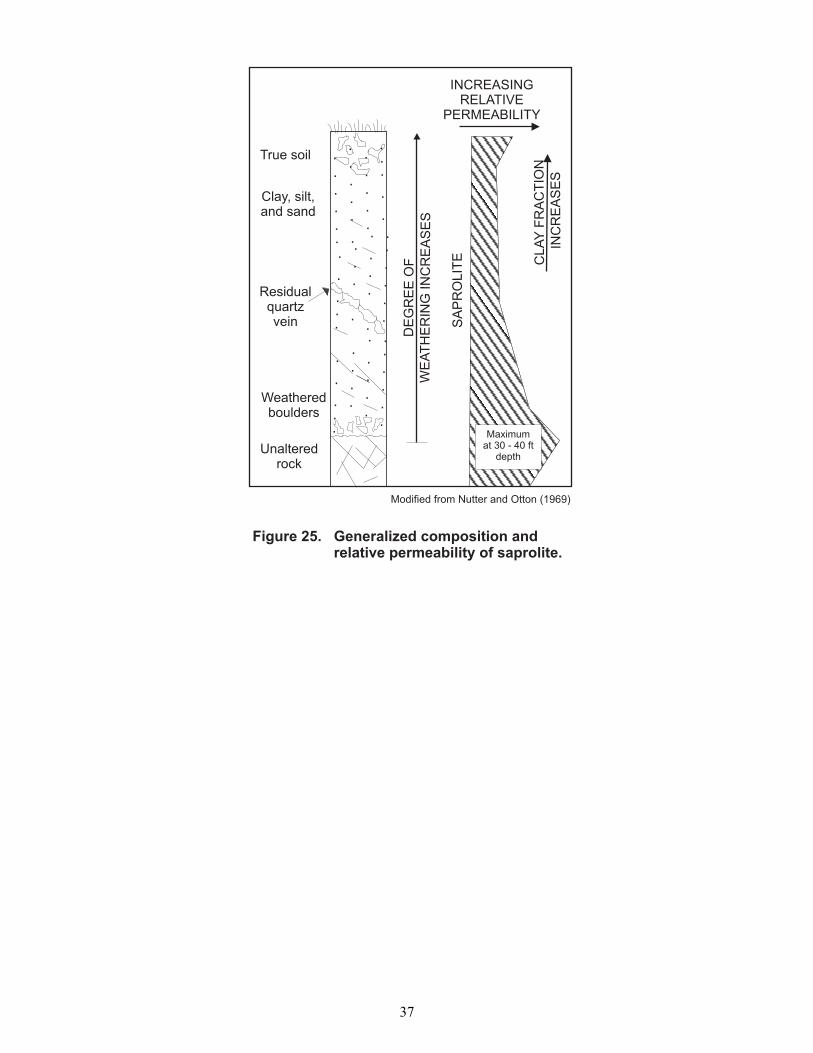
The location of the water table relative to the bedrock/overburden interface does not seem to have any significant correlation with well yield (figs. 22 to 24). With few exceptions, the water table can be found within 100 ft of the bedrock/overburden interface, and, for the majority of wells, the location of the water table is within 50 ft of the interface. Overburden characteristics are dependent upon the lithology, texture, and structure of the parent-rock material. Permeability of overburden is typically greatest within the soil zone (0 to 3 ft) and decreases with depth until near the saprolite/bedrock interface, where it appears to increase (fig. 25). The increase, which has been noted by many drillers in the region, may be due to coarser-grain sizes (boulders and sand) at the unweathered bedrock surface (Nutter and Otton, 1969). In fractured-rock terrane, fracture frequency and width is typically greatest at shallow depths, normally within the first 300 ft below land surface (Taylor and Royer, 1981). Assuming the well has intersected these fractures, the supply of water to the well is also dependent upon the connectivity of the fractures to each other and to a source of recharge such as the saturated overburden or a surface-water body. Henriksen (1995) considered ground-water levels, recharge rates, and infiltration processes in near-surface/bedrock systems to be especially important, and Cederstrom (1972) also noted that wells that tap surface-water or saturated recharge zones, unsurprisingly, have higher yields. Parizek and Siddiqui (1976) found that in carbonate aquifer systems, yields of wells were very closely related to the water-table position and the location of the production zones or fractured openings in the well.
Lithologic Unit
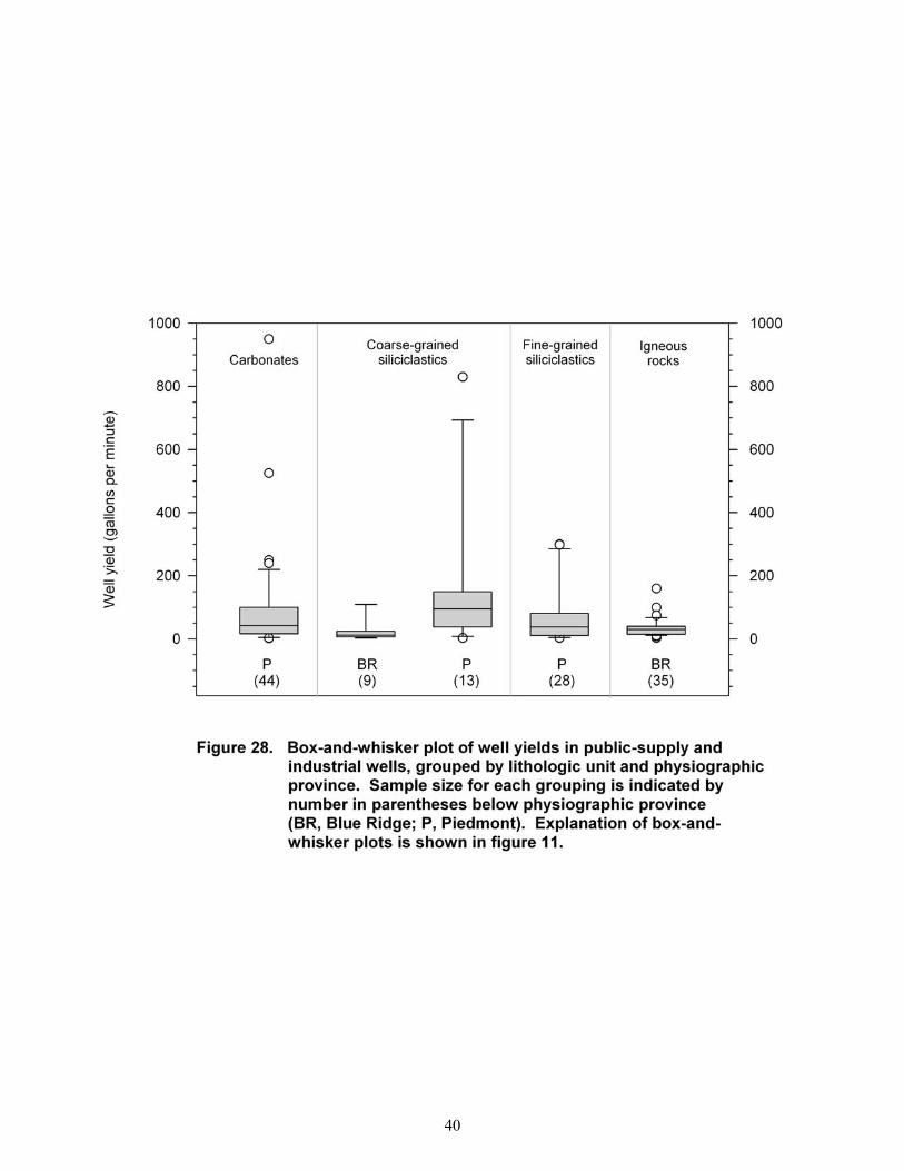
Wells located in carbonate or coarse-grained siliciclastic lithologies have generally higher yields than wells located in fine-grained siliciclastics or igneous lithologies (figs. 26 to 28; tabs. 6 to 8) (carbonate lithologies, as grouped in this study, only appear in the Piedmont terrane).Wells in the Piedmont show more variability in yield.
7

Commercial and institutional wells in both coarse- and fine-grained siliciclastic rocks (fig. 26; tab. 6) in the Piedmont appear to have more variability in yield and higher median well yields than those in the Blue Ridge; however, these differences are not statistically significant (median well yields of 10 gallons per minute [gpm] for both coarse-grained siliciclastic and fine-grained siliciclastic lithologies in the Piedmont, compared to 5 gpm and 3 gpm in the Blue Ridge). Igneous lithologies have the same median well yield (10 gpm) for both the Blue Ridge and the Piedmont. Wells in carbonate rocks in the Piedmont have the highest yields among commercial and institutional wells at 15 gpm. Domestic wells (fig. 27; tab. 7) are similar to the commercial and institutional wells in that carbonate lithologies produce the highest median well yield (10 gpm). Fine-grained and coarse-grained siliciclastic rocks and igneous rocks have similar median well yields in the Piedmont (8 gpm), whereas there is more variation in wells in the Blue Ridge (3.5, 5, and 7 gpm, respectively). There are statistically significant differences between the well yields of wells in carbonate lithologies and fine-grained siliciclastics in the Blue Ridge and Piedmont, as well as igneous lithologies of both provinces, and coarse-grained siliciclastics in the Blue Ridge. However, there is not a significant difference between well yields located in carbonate and coarse-grained siliciclastics in the Piedmont. Yields from coarse-grained siliciclastic public-supply and industrial-supply wells are significantly higher in wells in the Piedmont (median yield, 95 gpm) than in the Blue Ridge (median yield, 12 gpm). Wells in carbonate rocks also have a median yield of 43 gpm in the Piedmont (fig. 28; tab. 8). Fine-grained siliciclastic wells have a median well yield of 38 gpm in the Piedmont, followed by igneous rocks of the Blue Ridge (30 gpm), although these differences are not statistically significant. Previous researchers have found similar results and suggest that while lithology is an important factor, there is a high degree of variability within each lithologic unit. Natural heterogeneity, including variation in composition, bedding, fracturing, and dissolution, could explain differences in yield between and within geologic units or lithologies. This may be especially true for wells that are clustered fairly close together spatially, yet report very different yields (Lattman and Parizek, 1964; Summers, 1972; Gustafson, 1986; Banks and others, 1993; Knopman and Hollyday, 1993; Krasny, 1993; Henriksen, 1995). Cederstrom (1972) also points out that well-yield variability within a single lithology or geologic unit may also be due in fact to the availability of recharge and the heterogeneity of the fractures as well.
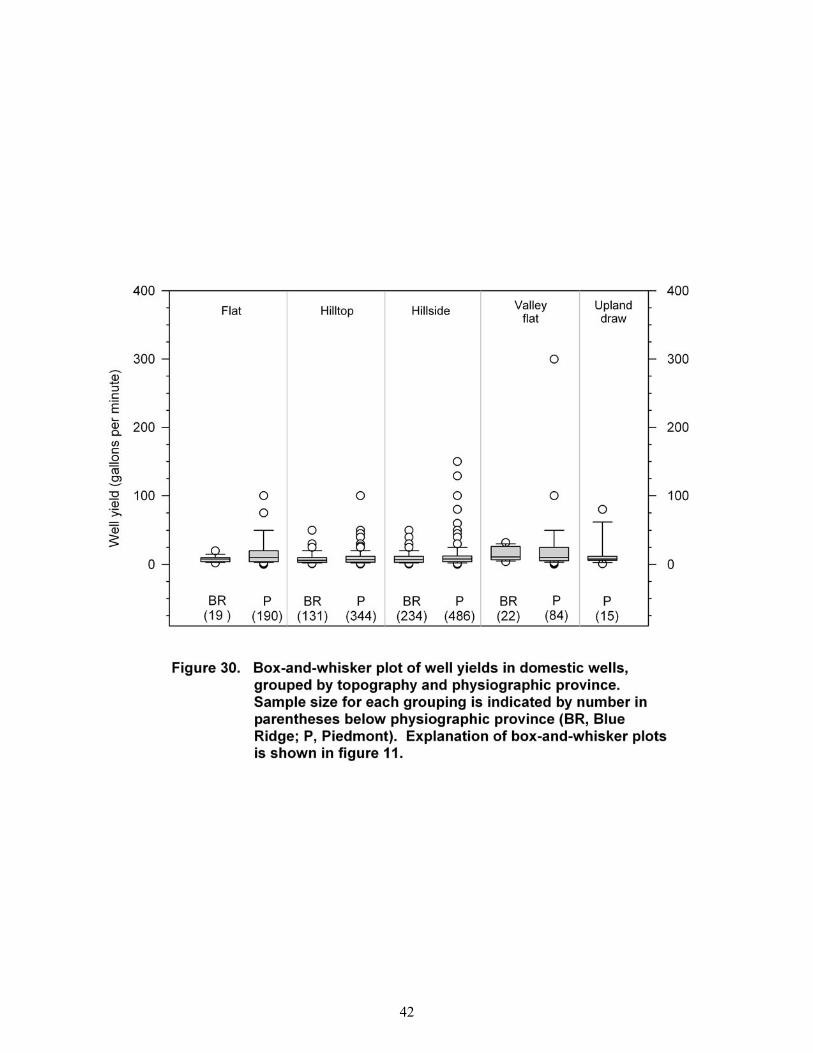
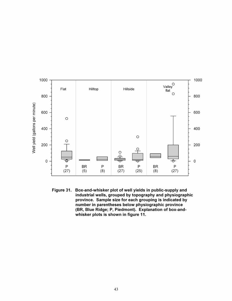
Topography
Wells in valleys and flats typically have higher yields in the study area (figs. 29 to 31; tabs. 9 to 11). The highest median yields for commercial and institutional wells occur in Piedmont upland draws and valleys (15 gpm and 14 gpm, respectively); flats have a somewhat lower median yield (12 gpm). Hillsides and hilltops in the Piedmont and Blue Ridge have the lowest median yields. However, none of these groups are significantly different from each other. Domestic wells located in valleys in the Piedmont and Blue Ridge have the highest median well yield (10 and 11 gpm, respectively), along with Piedmont flats (10 gpm). Upland draws (8 gpm), Blue Ridge flats (8 gpm), hillsides (8 gpm in the Piedmont and 7 gpm in the Blue Ridge) and hilltops (7 gpm in the Piedmont and 6 gpm in the Blue Ridge) have slightly lower yields. In the Blue Ridge, only the yields from wells in valleys and hilltops are significantly different. Valleys and flats in the Piedmont are also statistically different from hilltop locations in the Blue Ridge. Public-supply and industrial wells demonstrate a lack of statistically significant differences between topographic locations. Piedmont and Blue Ridge wells have the largest median well yields (60 gpm), followed by wells located in the flat portions of the Piedmont (50 gpm). Hillsides in the Blue Ridge and Piedmont have median well yields of 25 gpm and 20 gpm, respectively, and hilltops in the Blue Ridge and Piedmont have a median yield of 12 gpm and 23 gpm, respectively. Generally speaking, ground-water circulation and the water table are controlled by the topography of a region and mimic topography in a muted way (Duigon and Dine, 1987). Moore and others (2002) note that as elevation and slope increase, there is a tendency for well yields to decrease. This may be a result of the increased depth to water, a decreased saturated thickness of overburden, or a predominance of competent rock with few fractures. Valleys and draws tend to have higher yields than hillsides or slopes (Taylor and Royer, 1981; Yin and Brook, 1992; Henriksen, 1995; Moore and others, 2002). This is a likely result because valleys tend to form where underlying rocks are already weakened or fractured, causing preferential erosion. The remaining rock may also
8

have a higher percentage of fractures. Furthermore, valleys have larger collection areas for recharge than hill slopes and also function as sites for water discharge. It should be noted that all topographic information in this study was taken directly from the well-inventory data provided to GWSI. Although the topographic terms are standardized, individual interpretations of a given site are not. Due to subjective differences in the GWSI-user base, these data can be inconsistent. This may be further complicated for wells in the Piedmont of Maryland by the sometimes-obscure nature of the well location in relation to local topography. For example, what may appear to be a flat surface can, in fact, be a hilltop in the gently rolling hills of the Piedmont. Any topographic location that represented less than five wells was eliminated from further consideration. Henriksen (1995) found that only wells in the valleys and flats, combined, were significantly different from other well locations. The current study had similar findings based on its preliminary analysis. However, after reviewing many well-drillers’ methods, Yin and Brook (1992) suggest that topography alone is not a good predictor of well yield, and, therefore, the “lay of the land” approach to determining ideal well locations for high yields is not particularly useful.
Distance From Mapped Faults
Geologic structures, including faults, folds, fractures, bedding planes, and foliation, have been theorized by many workers to influence well yields in the fractured-rock terrane (Cederstrom, 1972; Caswell, 1979; Taylor and Royer, 1981; Dowd and Marshall, 1995; Allen and Michel, 1998; Rawling and others, 2001; Luczaj, 2010). This study focused only on large, map-scale faults identified on the geological base maps used in this study (fig. 5). An examination of the 153 wells located (as measured by geographic information system [GIS] or physical map inspection) within a 500-ft radius of a mapped fault showed no clear relation between distance from a fault and well yield (figs. 32 and 33). This result, however, may be obfuscated by a combination of factors including inaccuracies in well and fault locations due to mapping or scale issues, uncertainty in accurate strike and dip measurements, and evidence that the faults are actually intersected by the well bore. Although several researchers have found faults and structures to be positively correlated with increased well yields, perhaps as zones of increased fracture density, others have suggested that faults act as barriers to ground-water flow and may, in some cases, compartmentalize aquifers (Caswell, 1979; Allen and Michel, 1998; Luczaj, 2010). The differences in results are most likely attributable to differences in lithology and deformational history. Areas where crystalline rocks were deformed in a more brittle regime may be favorable for increasing well yield as the rock is more highly fractured. On the other hand, plastic deformation may produce a fine gouge that is impermeable to ground water (Cederstrom, 1972). Well yield may also be influenced by the physical orientation of a fault. Taylor and Royer (1981) found that well yield decreased with increasing dip of strata and postulated that this may be due to the fact that openings or bedding-plane fractures in horizontal (or nearly horizontal) strata are more likely to be intersected by the vertical borehole than more steeply dipping planes. More horizontal strata also allow easier access for water to the borehole as the cone of depression develops during pumping of the well. However, as Moore and others (2002) point out, there are significant physical difficulties to obtaining accurate data due to geo-referencing inaccuracies in the locations of wells and the faults themselves. Especially in the Piedmont and Blue Ridge provinces of Maryland, the exact location and accurate identification of faults is hampered by a lack of good outcrop exposure due to thick overburden and dense vegetative cover. The nature of the faults, including orientation of strike and dip and relative motion can be very difficult to isolate, as many mapped faults are based on the omission or repetition of stratigraphy rather than a visible fault contact. Furthermore, in order for a fault or joint to contribute water to a well, it must intersect the borehole, an occurrence difficult to document in wells lacking geophysical logs. Knopman and Hollyday (1993) conclude that more accurate identification of fault zones, fracture size and concentration, dip of rock strata, and folding patterns could increase our ability to predict water availability.
9
DISCUSSION
There are two approaches to assessing ground-water availability: one based on water budgets and one based on well yields. The water-budget approach can provide estimates of ground-water availability in the area under consideration; however, by estimating total ground-water discharge to the stream draining the basin, it does not actually answer the question of how much water a well drilled at a particular location might yield. This study investigated several factors related to well siting and construction in order to provide a preliminary assessment of factors related to well yield.
FACTORS AFFECTING WELL YIELDS This study suggests that well use is the largest factor affecting well yield in the study area. Well use has a large impact on expected yield as construction factors such as depth and diameter allow for greater storage and an increased likelihood of fracture intersection with the borehole. Lithologic unit and topography are two additional site factors that may have a statistically significant impact on well yield; however, this is not consistently demonstrated throughout all well-use groups. Commercial and institutional well uses do not appear to be influenced by either factor. Public-supply and industrial wells do not demonstrate significantly different well yields based upon topographic location; however, there are differences between wells located in coarse-grained siliciclastic lithologies in the Piedmont and Blue Ridge (Piedmont yields are significantly higher). Data from domestic wells indicate that carbonate lithologies produce better yields than fine-grained siliciclastic- or igneous- rock types in the Blue Ridge and the Piedmont, and coarse-grained siliciclastic lithologies of the Blue Ridge. However, well yields in carbonates were indistinguishable from those in coarse-grained siliciclastics in the Piedmont. Well yields in Blue Ridge valleys and hilltops were significantly different for domestic wells, as were valleys and flats in the Piedmont from hilltops in the Blue Ridge. These factors should be considered by municipalities and other well-water users to ascertain which areas are likely to be most productive (Taylor and Royer, 1981).
RECOMMENDATIONS FOR FURTHER STUDY
Although this study did not demonstrate a correlation between distance to a mapped fault and well yield, there is published evidence of a correlation between distance to a fracture trace and well yield (Cohen, 2007). One suggested avenue of future research is Fracture (or Lineament) Trace Analysis (FTA). FTA uses aerial photography or other remote-sensing techniques to image the surface features of a given area or property. The premise of the technique is that underlying geologic characteristics, such as faults, fractures, zones of weakness, or geologic contacts, are all areas where water may be preferentially concentrated and thus may be identifiable by changes in vegetation, soil color, or other visible features that can be exploited to locate optimum sites for well drilling and development. Several researchers have found a positive correlation between distance to fractures or lineaments and well yield using FTA (Lattman and Parizek, 1964; LaRiccia and Rauch, 1977; Dinger and others, 2002; Cohen, 2007). FTA holds promise as a worthwhile future study. Another factor significant to well yield may be distance of wells from surface-water bodies. Several researchers suggest a positive correlation between greater well yields and shorter distances to a surface-water body (Moore and others, 2002; Cohen, 2007). The surface water may provide additional or exceptional recharge to water wells and, therefore, allow for greater yields. The drawback to a direct connection between surface water and ground water, especially in karst terrane, is that it results in the introduction of contaminants to the well. Furthermore, excessive pumping of a well that is supplied in part by surface water may reduce flow or lower water levels to a degree that it affects biological, recreational, or energy uses of the surface-water body. Considering the amount of karst topography in the region, this may be an especially interesting and fruitful avenue of investigation (Brezinski, 2004d). At the scale of this investigation, there are likely many more unmapped or unidentified faults than those currently recognized. A smaller scale study, focused on a particular quadrangle or smaller area of interest may produce more definitive results regarding the relation between faults and well yield in the Blue Ridge and Piedmont of Maryland. There are several springs located along faults in the Hagerstown Valley, suggesting that certain faults may act as good conduits for ground water in Maryland (Mark Duigon, Maryland Geological Survey
10
[retired], personal commun., 2012). The area surrounding these springs may be a good starting point for future work. This study considered well yields in relation to individual factors. Evaluation of the combined effects of factors was beyond the scope of this study. Factor analysis and principle components analysis are two mathematically-based data-evaluation methods that can be used to assess the effects of multiple variables or observations. These methods can identify and extract common causes of variation within data and could be applied to the variables of this study with potentially useful results. Lastly, as a result of the difficulties in finding a digital geologic map that reflects current geologic interpretations of the study area and provides complete coverage of the region, additional geologic mapping is suggested as a course of future study. Geologic maps reflect our understanding of an area’s geologic history as well as the current conditions. They are instrumental to a variety of geologic studies, from predictions of karst development or availability of mineral resources, to water quality and ground-water-contaminant transport.
SUMMARY AND CONCLUSIONS
A pilot study was conducted in an area comprising Frederick County and the nearby areas surrounding Poolesville (Montgomery County), Taneytown, Mt. Airy, and Westminster (Carroll County), Maryland. Data from 2,315 wells were obtained from the USGS Ground Water Site Inventory portion of the National Water Information System and were analyzed to provide preliminary evaluation of the relations between well yields and well use, physiographic province, depth to bedrock, position of the water table, lithologic unit, topography, and distance to mapped faults. Results of this study indicate well use, lithology, and topography demonstrate various levels of influence on the yield of wells in fractured-rock terrane. Well yields are significantly higher (P< 0.05) in public-supply wells and industrial wells than in domestic wells. Commercial and institutional wells do not have statistically different yields, nor do industrial and institutional wells. Domestic well yields are significantly different (lower) from all other well uses. Physiographic province does not appear to have a statistically significant influence on wells in the same well-use category. Depth to bedrock (overburden thickness), position of the water table relative to the bedrock/overburden interface, and distance to a mapped fault do not demonstrate any significant influence on well yield. It is possible to get a general estimate of what a well might produce by analyzing a large group of similarly located wells; however, the inability to predict individual well yields remains. Further study based on fracture (lineament) trace analysis, factor analysis, or principle components may elucidate connections between well-site and construction factors and well yield. This study also demonstrated the need for additional geologic mapping in the fractured-rock terrane.
REFERENCES
Aleinikoff, J.N., Horton, J. W., Jr., Drake, A.A., Jr., Wintsch, R.P., Fanning, C.M., and Yi, Keewook, 2004, Deciphering multiple Mesoproterozoic and Paleozoic events recorded in zircon and titanite from the Baltimore Gneiss, Maryland: SEM imaging, SHRIMP U-Pb geochronology, and EMP analysis, in Tollo, R.P., McLelland, James, Corriveau, Louise, and Bartholomew, M.J. (eds.), Proterozoic tectonic evolution of the Grenville orogen in North America: Geological Society of America Memoirs, v. 197, p. 411-434.
Allen, D.M., and Michel, F.A., 1998, Evaluation of multi-well test data in a faulted aquifer using linear and radial flow models: Ground Water, v. 36, no. 6, p. 938-948.
Banks, David, Rohr-Torp, E., and Skarphagen, H., 1993, Groundwater resources in the hard rock; experiences from the Hvaler study, southeastern Norway, in Banks, S.B., and Banks, D., (eds.) Hydrogeology of Hard Rocks, Proceedings, 24th Congress, International. Association of Hydrogeologists, Ǻs, Oslo, Norway.
Bolton, D. W., 1998, Ground-water quality in the Piedmont region of Baltimore County, Maryland: Maryland Geological Survey Report of Investigations No. 66, 191 p.
Brezinski, D. K., 2004a, Geologic map of the Catoctin Furnace quadrangle, Frederick County, Maryland: Maryland Geological Survey Quadrangle Geologic Map, scale 1:24,000, (Version CATOCGEO2004.1).
11
——— 2004b, Geologic map of the Frederick quadrangle, Frederick County, Maryland: Maryland Geological Survey Quadrangle Geologic Map, scale 1:24,000, (Version FREDEGEO2004.1).
——— 2004c, Geologic map of part of the Point of Rocks quadrangle, Frederick County, Maryland: Maryland Geological Survey Quadrangle Geologic Map, scale 1:24,000, (Version PTOFRGEO2004.1).
——— 2004d, Stratigraphy of the Frederick Valley and its relationship to karst development: Maryland Geological Survey Report of Investigations No. 75, 101 p.
——— 2009, Geologic map of the Keedysville and parts of Shepherdstown, Harpers Ferry and Charlestown quadrangles, Washington and Frederick Counties, Maryland: Maryland Geological Survey Quadrangle Geologic Map, scale 1:24,000, (Version K_SHCGEO2009.1).
Brezinski, D. K., and Bell, S. C., 2009, Geologic map of the Funkstown quadrangle, Washington County, Maryland: Maryland Geological Survey Quadrangle Geologic Map, scale 1:24,000, (Version FUNKSGEO2009.1).
Brezinski, D. K., and Edwards, J., Jr., 2004, Geologic map of the Woodsboro quadrangle, Frederick and Carroll Counties, Maryland: Maryland Geological Survey Quadrangle Geologic Map, scale 1:24,000, (Version WOODSGEO2004.1).
Brezinski, D. K., and Fauth, J. L., 2005, Geologic map of the Middletown quadrangle, Frederick and Washington Counties, Maryland: Maryland Geological Survey Quadrangle Geologic Map, scale 1:24,000, (Version MIDDLGEO2005.1).
——— 2009, Geologic map of the Myersville quadrangle and Maryland portion of the Smithsburg quadrangle, Washington and Frederick Counties, Maryland: Maryland Geological Survey Quadrangle Geologic Map, scale 1:24,000, (Version MY_SHGEO2009.1).
Brezinski, D. K., and Southworth, Scott, 2004, Geologic map of the Buckeystown quadrangle, Frederick and Montgomery Counties, Maryland: Maryland Geological Survey Quadrangle Geologic Map, scale 1:24,000, (Version BUCKEGEO2001.2).
Brezinski, D. K., Southworth, Scott, and Edwards, Jonathan, Jr., 2004, Geologic map of the Walkersville quadrangle, Frederick County, Maryland: Maryland Geological Survey Quadrangle Geologic Map, scale 1:24,000, (Version WALKEGEO2004.1).
Caswell, W.B., 1979, Maine’s groundwater situation: Ground Water, v. 17, no. 3, p. 235-243. Cederstrom, D.J., 1972, Evaluation of yields of wells in consolidated rocks, Virginia to Maine: U.S. Geological
Survey Water-Supply Paper 2021, 40 p. Cleaves, E.T., Edwards, Jonathan. Jr., and Glaser, J.D., 1968, Geologic map of Maryland: Maryland
Geological Survey, scale 1:250,000, 1 sheet. Code of Maryland Regulations, 2012, Well Casing: Title 26 (Department of the Environment), Subtitle 04
(Regulation of Water Supply, Sewage Disposal, and Solid Waste), chap. 04 (Well Construction), Regulation 07D (3). Accessed June 1, 2012.
Cohen, R.M., 2007, Evaluating ground water supplies in fractured metamorphic rock of the Blue Ridge province in northern Virginia in National Ground Water Association Fractured Rock Conference: State of the Science and Measuring Success in Remediation, September 2007, Portland, Maine, p. 450-464.
Costa, J.E., 1975, Effects of agriculture on erosion and sedimentation in the Piedmont province, Maryland: Geological Society of America Bulletin, v. 86, no. 9, p. 1281-1286.
Dine, J.R., Adamski, J.C., and Duigon, M.T., 1995, Water resources of Howard County, Maryland: Maryland Geological Survey Bulletin 38, 128 p.
Dinger, J.S., Andrews, R.E., Wunsch, D.R., and Dunno, G.A., 2002, Remote sensing and field techniques to locate fracture zones for high-yield water wells in the Appalachian Plateau, Kentucky in Proceedings of the National Ground Water Association Fractured Rock Aquifer 2002 Conference, March 13-15, 2002, Denver, Colorado, p. 195-199.
Dingman, R.J., and Ferguson, H.F., 1956, The ground water resources of the Piedmont part, in Dingman, R.J., Ferguson, H.F., and Martin, R.O.R., The water resources of Baltimore and Harford Counties: Maryland Department of Geology, Mines and Water Resources Bulletin 17, p. 1-128.
Dingman, R.J., and Meyer, Gerald, 1954, The ground water resources, in Dingman, R.J., Meyer, Gerald, and Martin, R.O.R., The water resources of Howard and Montgomery Counties: Maryland Department of Geology, Mines and Water Resources Bulletin 14, p. 1-139.
Dowd, J.F., and Marshall, J.E., 1995, Recharge to high yield wells in the Piedmont, in Proceedings of the 1995 Georgia Water Resources Conference, April 11-12, 1995, Athens, Georgia, p. 233-236.
12

Duigon, M.T., 1981, Hampstead quadrangle: Hydrogeology: Maryland Geological Survey Quadrangle Atlas No. 12, 6 p. and 5 sheets, scale 1:24,000.
Duigon, M.T., Cooper, B.F., and Tompkins, M.D., 1994a, Sykesville quadrangle: Hydrogeology: Maryland Geological Survey Quadrangle Atlas No. 24, scale 1:24,000 and 1:36,000, 6 sheets.
——— 1994b, Woodbine and Damascus quadrangles: Hydrogeology: Maryland Geological Survey Quadrangle Atlas No. 25, scale 1:24,000 and 1:36,000, 6 sheets.
Duigon, M.T., and Dine, J.R., 1987, Water resources of Frederick County, Maryland: Maryland Geological Survey Bulletin 33, 106 p.
——— 1991, Water resources of Washington County, Maryland: Maryland Geological Survey Bulletin 36, 109 p.
Edwards, Jonathan, Jr., 1993a, Geologic map of the Manchester quadrangle, Carroll County, Maryland: Maryland Geological Survey Quadrangle Geologic Map, scale 1:24,000, 1 sheet.
——— 1993b, Geologic map of the Westminster quadrangle, Carroll County, Maryland: Maryland Geological Survey Quadrangle Geologic Map, scale 1:24,000, 1 sheet.
Gustafson, Gunnar, 1986, Hydrogeological preinvestigations in rock: theoretical basis and applications: Swedish Rock Engineering Research Foundation (SveBeFo), Stockholm, Sweden, No. 84186.
Heath, R.C., 1989, The Piedmont ground water system, in Groundwater in the Piedmont: Proceedings, Conference on Ground Water in the Piedmont of the Eastern United States, October 16-18, 1989, Charlotte, North Carolina, Clemson University, p.1-13.
Henriksen, H., 1995, Relation between topography and well yield in boreholes in crystalline rocks, Sogn og Fjordane, Norway: Ground Water, v. 33, no. 4, p. 635-643.
Jonas, A.I., and Stose, G.W., 1938, Geologic map of Frederick County and adjacent parts of Washington and Carroll Counties: Maryland Geological Survey Quadrangle Geologic Map, scale 1:62,500, 1 sheet.
Knopman, D.S., and Hollyday, E.F., 1993, Variation in specific capacity in fractured rocks, Pennsylvania: Ground Water, v. 31, no. 1, p. 135-145.
Krasny, J., 1993, Hydrogeological map of the Czech Republic: A quantitative and standardized approach to representation of groundwater in hard rocks, in Banks, S.B. and Banks, D., (eds.), Hydrogeology of Hard Rocks: Proceedings, 24th Congress International Association of Hydrogeologists, Ǻs, Oslo, Norway, v. 2, p. 1051-1057.
LaRiccia, M.P., and Rauch, H.W., 1977, Water well productivity related to photo-lineaments in carbonates of Frederick Valley, Maryland, in LaRiccia, M.P., and Rauch, H.W., Hydrologic problems in karst regions: Western Kentucky University, p. 228-234.
Lattman, L.H., and Parizek, R.R., 1964, Relationship between fracture traces and the occurrence of ground water in carbonate rocks: Journal of Hydrology, v. 2, p. 73-91.
Luczaj, John, 2010, The significance of faulting to the hydrogeology of the Cambro-Ordovician aquifer system in northeastern Wisconsin: Wisconsin Ground Water Association Newsletter, v. 24, no. 4, 5 p.
Maryland Department of the Environment, 2011, Federal Safe Drinking Water Act report to Governor Martin O’Malley on Maryland’s capacity development program for public drinking water systems: Baltimore, Maryland Department of the Environment Water Supply Program, 12 p. http://www.mde.state.md.us/programs/Water/Water_Supply/Documents/2011%20Capacity%20Development%20Report%20to%20Governor_final.pdf
Meyer, Gerald, 1958, The ground water resources, in Meyer, Gerald and Beall, R.M., The water resources of Carroll and Frederick Counties: Maryland Department of Geology, Mines and Water Resources, Bulletin 22, p. 1-228.
Moore, R.B., Schwarz, G.E., Clark, S.F., Jr., Walsh, G.J., and Degnan, J.R., 2002, Factors related to well yield in the fractured-bedrock aquifer of New Hampshire: U.S. Geological Survey Professional Paper 1660, 51 p.
Muller, P. D., 1994, Geologic map of the Finksburg quadrangle, Carroll and Baltimore Counties, Maryland: Maryland Geological Survey Quadrangle Geologic Map, scale 1:24,000, 1 sheet.
Nutter, L.J., 1975, Hydrogeology of the Triassic rocks of Maryland: Maryland Geological Survey Report of Investigations No. 26, 37 p.
——— 1977, Ground-water resources of Harford County, Maryland: Maryland Geological Survey Bulletin No. 32, 44 p.
13

14
Nutter, L.J., and Otton, E.G., 1969, Ground-water occurrence in the Maryland Piedmont: Maryland Geological Survey Report of Investigations No. 10, 56 p.
Otton, E.G., Cleaves, E.T., Crowley, W.P., Kuff, K.R., and Reinhardt, Juergen, 1975, Cockeysville quadrangle: geology, hydrology, and mineral resources: Maryland Geological Survey Quadrangle Atlas No. 3, 4 p. and 8 sheets, scale 1:24,000.
Otton, E.G., Willey, R.E., McGregor, R.A., Achmad, Grufron, Hiortdahl, S.N., and Gerhart, J.M., 1988, Water resources and estimated effects of ground-water development, Cecil County, Maryland: Maryland Geological Survey Bulletin No. 34, 133 p.
Overbeck, R.M., 1954, The ground-water resources, in Amsden, T.W., Overbeck, R.M., and Martin, R.O.R., The geology and water resources of Garrett County: Maryland Department of Geology, Mines, and Water Resources Bulletin 13, p. 117-254.
Overbeck, R.M., and Slaughter, T.H., 1958, The ground-water resources, in Overbeck, R.M., Slaughter, T.H., and Hulme, A.E., The water resources of Cecil, Kent and Queen Anne’s Counties: Maryland Department of Geology, Mines, and Water Resources Bulletin 21, p. 1-382.
Parizek, R.R., and Siddiqui, S.H., 1976, Determining the sustained yields of wells in carbonate and fractured aquifers: Ground Water, v. 8, no. 5, p. 12-20.
Peper, J.D., McCartan, L.B., Horton, J.W., Jr., and Reddy, J.E., 2001, Preliminary lithogeochemical map of near-surface rock types in the Chesapeake Bay watershed, Virginia and Maryland: U.S. Geological Survey Open-File Report 01-187, v. 1.0, 26 p.
Rawling, G.C., Goodwin, L.B., and Wilson, J.L., 2001, Internal architecture, permeability structure, and hydrologic significance of contrasting fault-zone types: Geology, v. 29, p. 43-46.
Reger, J. P., Brezinski, D. K., Southworth, Scott, and Quinn, H. A., 2004, Geologic map of the New Windsor quadrangle, Carroll County, Maryland: Maryland Geological Survey Quadrangle Geologic Map, scale 1:24,000, (Version NEWWIGEO2004.1).
Reger, J.P., and Cleaves, E.T., 2008, Physiographic map of Maryland: Maryland Geological Survey Open-File Report 08-03-1, 63 p.
Reger, J. P., and Edwards, J., Jr., 2004, Geologic map of the Union Bridge quadrangle, Frederick and Carroll Counties, Maryland: Maryland Geological Survey Quadrangle Geologic Map, scale 1:24,000, (Version UNIONGEO2004.1).
Slaughter, T.H., 1962, The ground-water resources, in Slaughter, T.H., and Darling, J.M., The water resources of Allegany and Washington Counties: Maryland Department of Geology, Mines and Water Resources Bulletin 24, p. 1-243.
Southworth, S., Brezinski, D.K., Drake, A.A., Jr., Burton, W.C., Orndorff, R.C., Froelich, A.J., Reddy, J.E., Denenny, D., and Daniels, D.L., 2007, Geologic map of the Frederick 30´ × 60´ quadrangle, Maryland, Virginia, and West Virginia: U.S. Geological Survey Scientific Investigations Map 2889, scale 1:100,000.
State of Maryland, 2008, Water for Maryland’s future: what we must do today, Volume 1, Final Report (2nd ed.): Final Report of the Advisory Committee on the Management and Protection of the State’s Water Resources, 37 p.
Summers, W.K., 1972, Specific capacities of wells in crystalline rocks: Ground Water, v. 10, no. 6, p. 37-47. Taylor, L. E., and Royer, D. W., 1981, Summary groundwater resources of Adams County, Pennsylvania:
Pennsylvania Geological Survey, 4th series, Water Resource Report 52, 50 p. U.S. Census Bureau, 2012, State & county quickfacts: Maryland: Accessed March 2, 2012, from
http://quickfacts.census.gov. U.S. Geological Survey, 2004, User's manual for the National Water Information System of the U.S. Geological
Survey: Ground Water Site-Inventory System: U.S. Geological Survey Open-File Report 2004-1238, Version 4.3; http://pubs.usgs.gov/of/2004/1238/. Accessed June 18, 2012.
Weigle, J.M., and Hilleary, J.T., 1981, Taneytown-Emmitsburg quadrangles, Carroll County, Maryland: Maryland Geological Survey Quadrangle Atlas No. 16, 5 sheets, scale 1:24,000 and 1:35,888.
Wetherill, G.W., Tilton, G.R., Davis, G.L., Hart, S.R., and Hopson, C.A., 1966, Age measurements in the Maryland Piedmont: Journal of Geophysical Research, v. 71, no. 8, p. 2139-2155.
Yin, Zhi-Yong, and Brook, G.A., 1992, The topographic approach to locating high-yield wells in crystalline rocks: does it work?: Ground Water, v. 30, no. 1, p. 96-102.

Watertable
Saprolite
FracturesZone of saturation
Modified from Bolton, 1998
Figure 1. Diagram showing ground water in fractured-rock terrane. (Modified fromBolton, 1998)
15

Annular seal(Cement grout,concrete, bentonite,or clay slurry)
Openborehole
Well cap
Watertable
Fractures
Figure 2. Diagram showing typicalwell construction infractured-rock terrane.
Well casing(PVC or steel)
Overb
urd
en
Bed
rock
16

Figure 3. Map showing the physiographic provinces of Maryland and location of the pilot study area.17

Figure 4. Map showing locations of wells in the study area.
18

Figure 5. Geologic map source compilation used in this study.
19
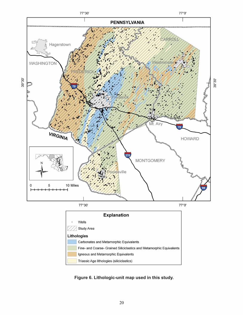
Figure 6. Lithologic-unit map used in this study.
20
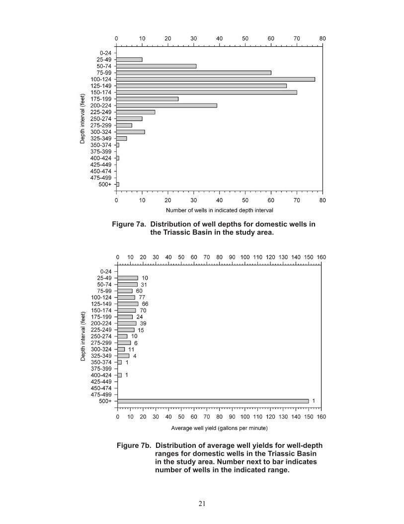
Figure 7a. Distribution of well depths for domestic wells inthe Triassic Basin in the study area.
Figure 7b. Distribution of average well yields for well-depthranges for domestic wells in the Triassic Basinin the study area. Number next to bar indicatesnumber of wells in the indicated range.
21

Figure 8a. Distribution of well depths for domestic wells insiliciclastic rocks in the Piedmont part of thestudy area.
Figure 8b. Distribution of average well yields for well-depthranges for domestic wells in siliciclastic rocks inthe Piedmont part of the study area. Number nextto bar indicates number of wells in the indicatedrange.
22
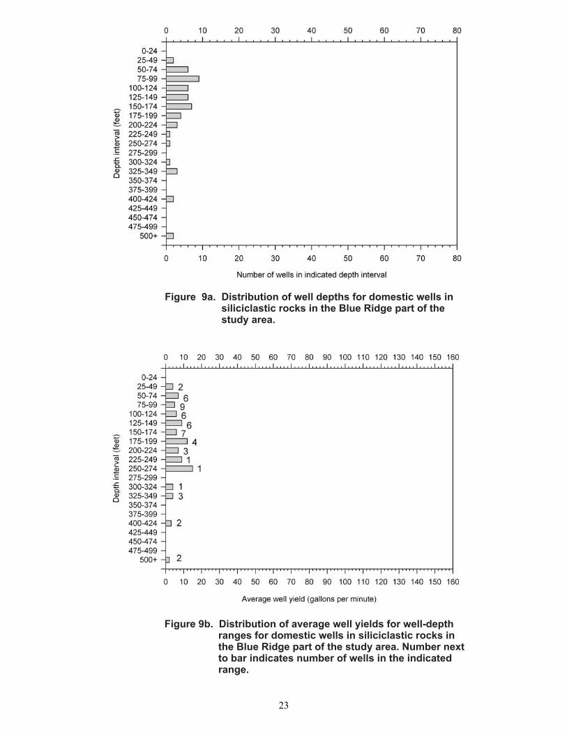
Figure 9a. Distribution of well depths for domestic wells insiliciclastic rocks in the Blue Ridge part of thestudy area.
Figure 9b. Distribution of average well yields for well-depthranges for domestic wells in siliciclastic rocks inthe Blue Ridge part of the study area. Number nextto bar indicates number of wells in the indicatedrange.
23
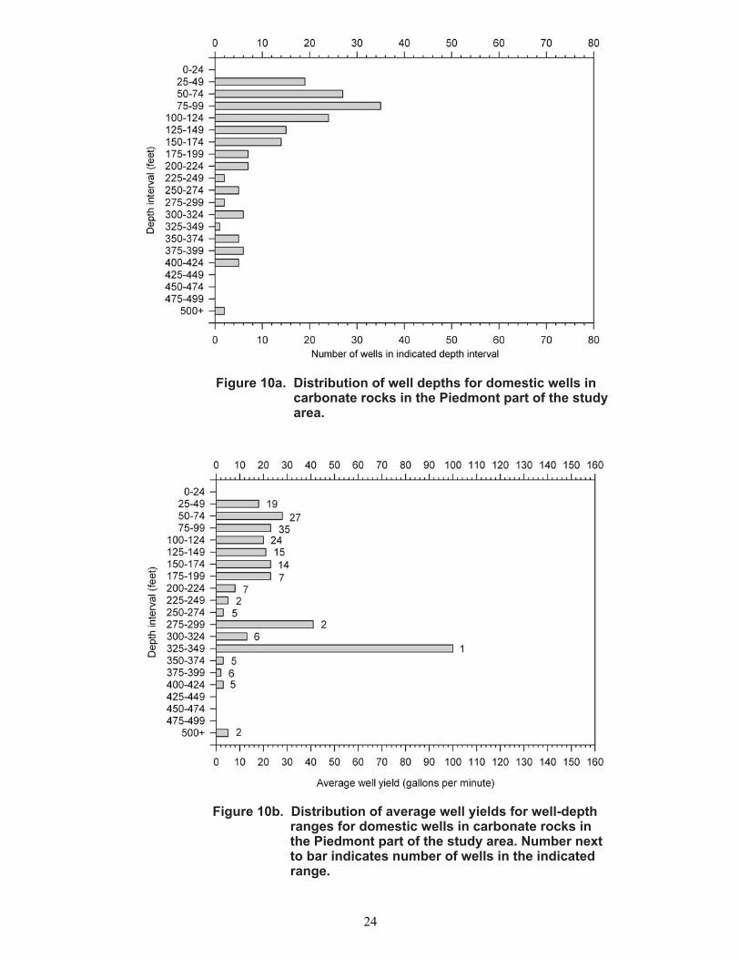
Figure 10a. Distribution of well depths for domestic wells incarbonate rocks in the Piedmont part of the studyarea.
Figure 10b. Distribution of average well yields for well-depthranges for domestic wells in carbonate rocks inthe Piedmont part of the study area. Number nextto bar indicates number of wells in the indicatedrange.
24
25

26
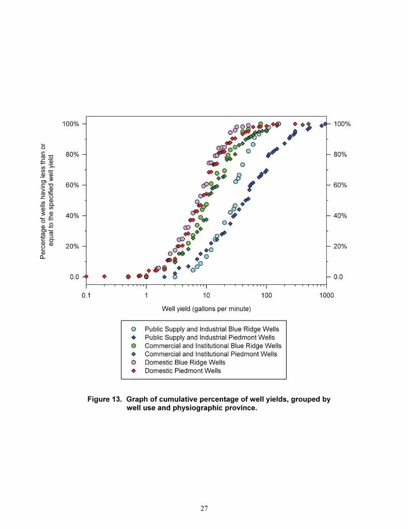
27
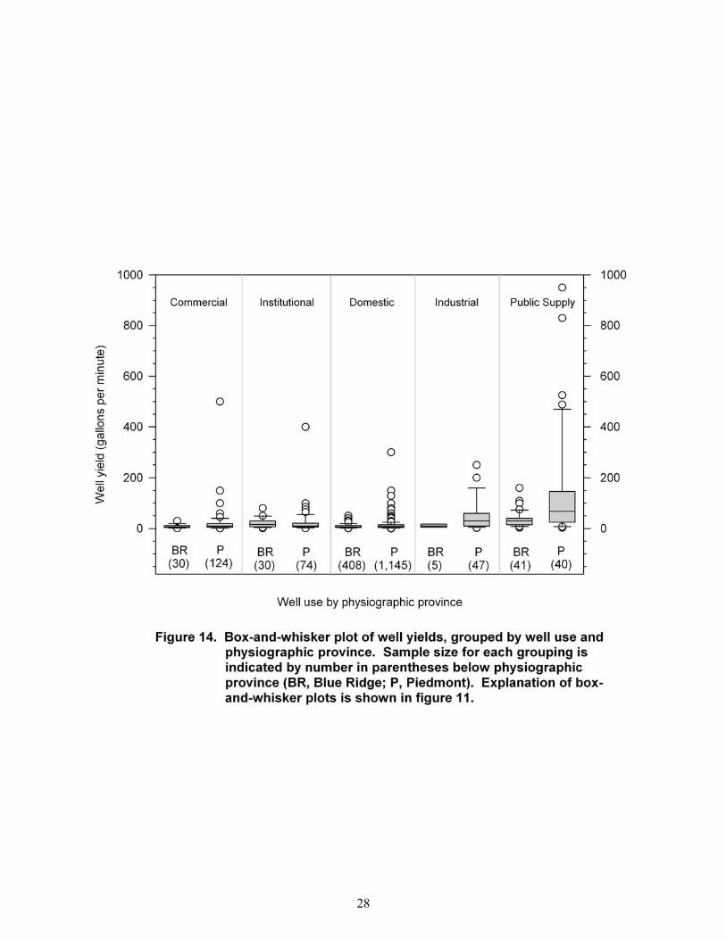
28
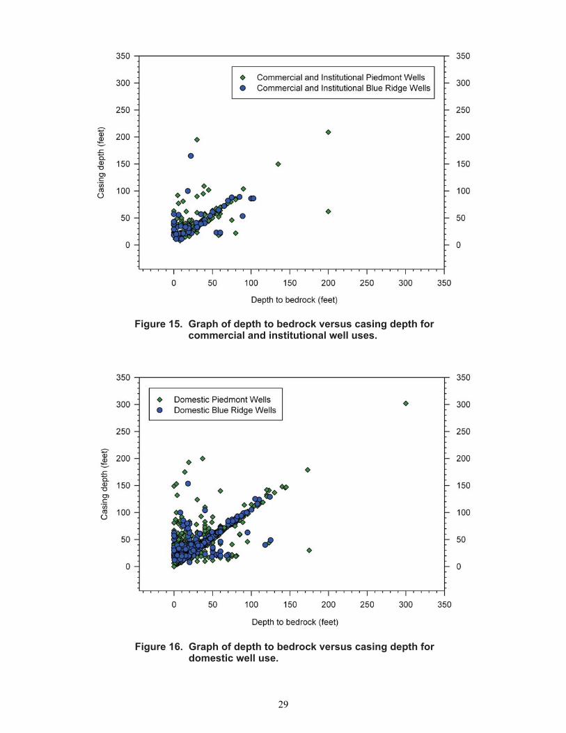
Figure 15. Graph of depth to bedrock versus casing depth forcommercial and institutional well uses.
Figure 16. Graph of depth to bedrock versus casing depth fordomestic well use.
29
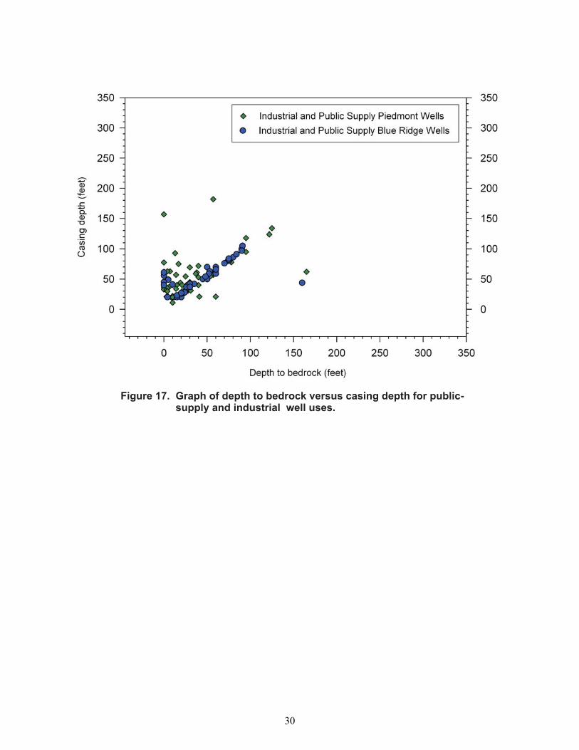
Figure 17. Graph of depth to bedrock versus casing depth for public-supply and industrial well uses.
30

Figure 18. Graph of commercial and institutional well yieldsversus depth to bedrock.
Figure 19. Graph of domestic well yields versus depth to bedrock.
31
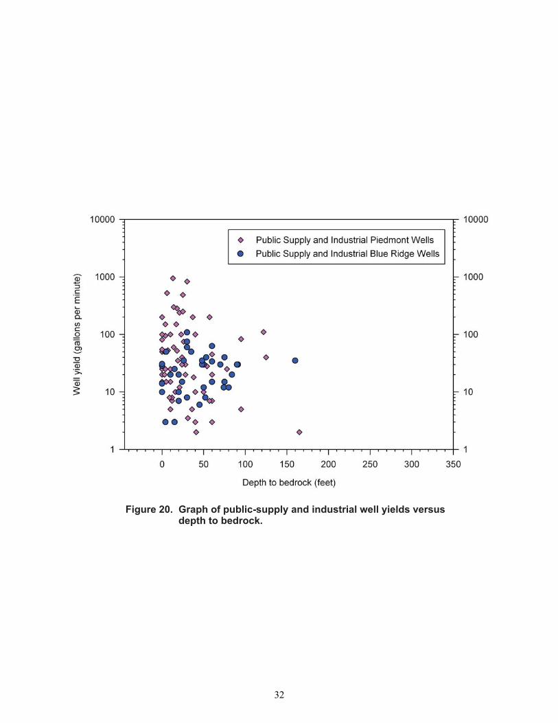
Figure 20. Graph of public-supply and industrial well yields versusdepth to bedrock.
32
33

34

35

36
..
..
..
..
..
..
..
..
..
..
..
..
..
..
..
..
..
..
..
..
..
..
..
..
.
..
..
.
..
..
..
..
..
..
True soil
Clay, silt,and sand
Residualquartzvein S
AP
RO
LIT
E CLA
YF
RA
CT
ION
INC
RE
AS
ES
INCREASINGRELATIVE
PERMEABILITY
Weatheredboulders
Unalteredrock
DE
GR
EE
OF
WE
AT
HE
RIN
GIN
CR
EA
SE
SMaximum
at 30 - 40 ftdepth
Figure 25. Generalized composition andrelative permeability of saprolite.
Modified from Nutter and Otton (1969)
37

38

39
40

41
42
43

Figure 32. Graph of well yield versus distance from a fault surfacefor wells in the Blue Ridge Province.
Figure 33. Graph of well yield versus distance from a fault surfacefor wells in the Piedmont Province.
44

Table 1. Lithologic units and corresponding geologic units of represented wells
[Geologic units that appear in more than one column contain more than one distinct lithology. See text for further explanation.]
Carbonate and
metamorphic equivalents
Fine-grained siliciclastics and metamorphic
equivalents
Coarse-grained siliciclastics and
metamorphic equivalents Igneous and
metamorphic equivalents
Frederick Limestone Grove Limestone Leesburg Limestone
Conglomerate Member of Bull Run Formation
Sams Creek Metabasalt Tomstown Dolomite Wakefield Marble
Araby Formation Balls Bluff Siltstone Gettysburg Shale Gillis Formation Harpers Formation Ijamsville Formation Marburg Formation New Oxford Formation Pleasant Grove Schist Sams Creek Metabasalt Urbana Formation
Antietam Formation Colluvium Gettysburg Shale Loudoun Formation Manassas Sandstone New Oxford Formation New Oxford Formation Basal Conglomerate Quaternary Alluvium Saprolite Sugarloaf Mountain Quartzite Swift Run Formation Terrace Deposits Weverton Formation
Catoctin Metabasalt Gneiss Complex Diabase Dikes and Sills Jurassic Diabase Libertytown Metarhyolite Loch Raven Schist Metarhyolite and associated pyroclastic sediments Morgan Run Formation Prettyboy Schist Sams Creek Metabasalt
45
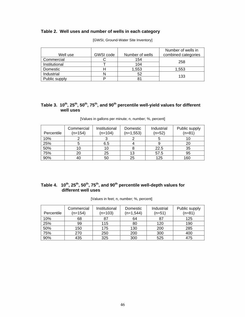
Table 2. Well uses and number of wells in each category
[GWSI, Ground-Water Site Inventory]
Well use GWSI code Number of wells Number of wells in
combined categories Commercial C 154 Institutional T 104 258
Domestic H 1,553 1,553 Industrial N 52 Public supply P 81 133
Table 3. 10th, 25th, 50th, 75th, and 90th percentile well-yield values for different well uses
[Values in gallons per minute; n, number; %, percent]
Percentile Commercial
(n=154) Institutional
(n=104) Domestic (n=1,553)
Industrial (n=52)
Public supply (n=81)
10% 2 3 2 5 10 25% 5 6.5 4 9 20 50% 10 10 8 22.5 35 75% 20 25 13 57.5 95 90% 40 50 25 125 160
Table 4. 10th, 25th, 50th, 75th, and 90th percentile well-depth values for different well uses
[Values in feet; n, number; %, percent]
Percentile Commercial
(n=154) Institutional
(n=103) Domestic (n=1,544)
Industrial (n=51)
Public supply (n=81)
10% 68 87 64 87 125 25% 99 115 80 120 190 50% 150 175 130 200 285 75% 270 250 200 300 400 90% 435 325 300 525 475
46

Table 5. 10th, 25th, 50th, 75th, and 90th percentile well-yield values by well use and physiographic province
[Values in gallons per minute; n, number; %, percent]
Commercial Institutional Domestic Industrial Public supply
Percentile Blue Ridge
(n=30) Piedmont (n=124)
Blue Ridge(n=30)
Piedmont (n=74)
Blue Ridge(n=408)
Piedmont (n=1,145)
Blue Ridge(n=5)
Piedmont (n=47)
Blue Ridge(n=41)
Piedmont (n=40)
10% 2 2 5 3 2 2 3 5 10 8.5 25% 4 5 7 6 4 4 6 10 15 25 50% 7 10 16 10 7 8 10 30 30 67.5 75% 12 20 30 20 12 15 15 60 40 142.5 90% 20 40 45 55 20 25 20 150 63 394
Table 6. 10th, 25th, 50th, 75th, and 90th percentile well-yield values for commercial and institutional wells, by lithology and physiographic province
[Values in gallons per minute; n, number; %, percent; n/a, not applicable]
Carbonates and metamorphic equivalents
Coarse-grained siliciclastics and
metamorphic equivalents
Fine-grained siliciclastics and
metamorphic equivalents
Igneous and metamorphic equivalents
Percentile Blue Ridge Piedmont
(n=60) Blue Ridge
(n=11) Piedmont
(n=28) Blue Ridge
(n=7) Piedmont
(n=90) Blue Ridge
(n=42) Piedmont
(n=20) 10% n/a 2 2 3 1 2 5 4.25 25% n/a 5 4 8 1 5 7 5.5 50% n/a 15 5 10 3 10 10 10 75% n/a 35 12 18 7 20 23 15 90% n/a 92.5 20 50 20 30 30 20
47
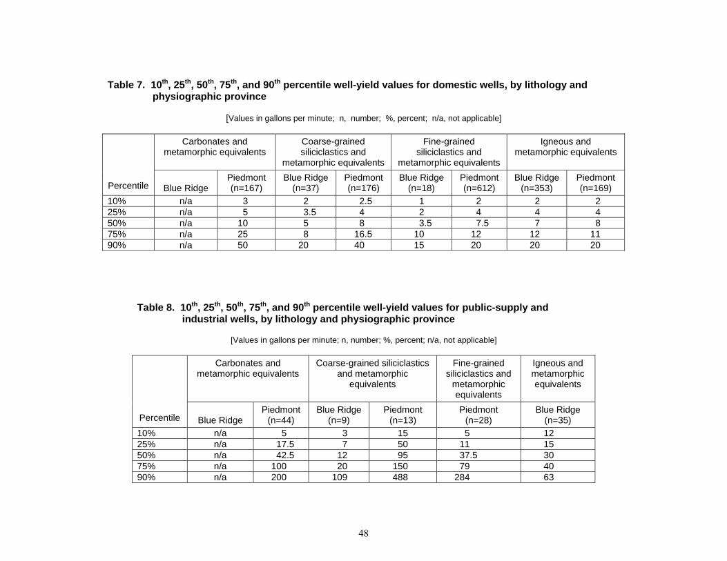
Table 7. 10th, 25th, 50th, 75th, and 90th percentile well-yield values for domestic wells, by lithology and physiographic province
[Values in gallons per minute; n, number; %, percent; n/a, not applicable]
Carbonates and metamorphic equivalents
Coarse-grained siliciclastics and
metamorphic equivalents
Fine-grained siliciclastics and
metamorphic equivalents
Igneous and metamorphic equivalents
Percentile Blue Ridge Piedmont (n=167)
Blue Ridge (n=37)
Piedmont (n=176)
Blue Ridge (n=18)
Piedmont (n=612)
Blue Ridge (n=353)
Piedmont (n=169)
10% n/a 3 2 2.5 1 2 2 2 25% n/a 5 3.5 4 2 4 4 4 50% n/a 10 5 8 3.5 7.5 7 8 75% n/a 25 8 16.5 10 12 12 11 90% n/a 50 20 40 15 20 20 20
Table 8. 10th, 25th, 50th, 75th, and 90th percentile well-yield values for public-supply and industrial wells, by lithology and physiographic province
[Values in gallons per minute; n, number; %, percent; n/a, not applicable]
Carbonates and metamorphic equivalents
Coarse-grained siliciclastics and metamorphic
equivalents
Fine-grained siliciclastics and
metamorphic equivalents
Igneous and metamorphic equivalents
Percentile Blue Ridge Piedmont
(n=44) Blue Ridge
(n=9) Piedmont
(n=13) Piedmont
(n=28) Blue Ridge
(n=35) 10% n/a 5 3 15 5 12 25% n/a 17.5 7 50 11 15 50% n/a 42.5 12 95 37.5 30 75% n/a 100 20 150 79 40 90% n/a 200 109 488 284 63
48
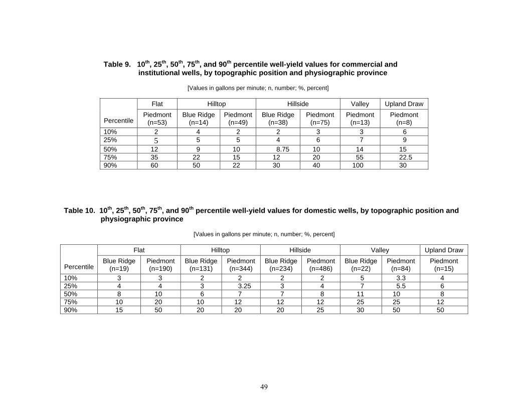
Table 9. 10th, 25th, 50th, 75th, and 90th percentile well-yield values for commercial and institutional wells, by topographic position and physiographic province
[Values in gallons per minute; n, number; %, percent]
Flat Hilltop Hillside Valley Upland Draw
Percentile Piedmont
(n=53) Blue Ridge
(n=14) Piedmont
(n=49) Blue Ridge
(n=38) Piedmont
(n=75) Piedmont
(n=13) Piedmont
(n=8) 10% 2 4 2 2 3 3 6 25% 5 5 5 4 6 7 9 50% 12 9 10 8.75 10 14 15 75% 35 22 15 12 20 55 22.5 90% 60 50 22 30 40 100 30
Table 10. 10th, 25th, 50th, 75th, and 90th percentile well-yield values for domestic wells, by topographic position and physiographic province
[Values in gallons per minute; n, number; %, percent]
Flat Hilltop Hillside Valley Upland Draw
Percentile Blue Ridge
(n=19) Piedmont (n=190)
Blue Ridge (n=131)
Piedmont (n=344)
Blue Ridge (n=234)
Piedmont (n=486)
Blue Ridge (n=22)
Piedmont (n=84)
Piedmont (n=15)
10% 3 3 2 2 2 2 5 3.3 4 25% 4 4 3 3.25 3 4 7 5.5 6 50% 8 10 6 7 7 8 11 10 8 75% 10 20 10 12 12 12 25 25 12 90% 15 50 20 20 20 25 30 50 50
49

Table 11. 10th, 25th, 50th, 75th, and 90th percentile well-yield values for public-supply and
industrial wells, by topographic position and physiographic province
[Values in gallons per minute; n, number; %, percent]
Flat Hilltop Hillside Valley
Percentile Piedmont
(n=27) Blue Ridge
(n=5) Piedmont
(n=8) Blue Ridge
(n=27) Piedmont
(n=25) Blue Ridge
(n=8) Piedmont
(n=27) 10% 10 10 3 6 3.5 30 5 25% 25 12 7.5 10 10 45 28 50% 50 12 22.5 25 20 60 60 75% 125 15 54 35 95 87.5 200 90% 200 20 100 50 110 160 488
50

Appendix 1. Records of wells used in this report.
Abbreviations and codes used in Appendix 1:
Column headings: BLS Below land surface gpm Gallons per minute
ft feet
Physiographic provinces: P Piedmont
BR Blue Ridge
Topographic settings: F Flat G Floodplain H Hilltop S Hillside T Terrace V Valley flat W Upland draw
Well use:
C Commercial D Dewater F Fire H Domestic I Irrigation J Industrial (cooling) N Industrial O Observation P Public supply Q Aquaculture R Recreation S Stock T Institutional U Unused Z Other
Lithology
I Igneous rocks and metamorphic equivalents
FSC Fine-grained siliciclastic rocks and metamorphic equivalents
CSC Coarse-grained siliciclastic rocks and metamorphic equivalents
C Carbonate rocks
51
Appendix 1, continued.
Well numberPermit number
Longitude, decimal degrees
Latitude decimal degrees
Physiographic province
Topographic setting
Well use
Depth to bedrock (ft BLS)
Depth of well
(ft BLS)
Casing depth
(ft BLS)Yield (gpm)
Static water level
(ft BLS)
Pumping water level
(ft BLS)
Static water level minus
depth to bedrock (ft )
Lithology code
CL Ab 1 CL-00-1949 -77.229164 39.674721 P F H - 79 7.5 12 24 65 - FSCCL Ab 2 CL-00-8702 -77.204719 39.715832 P F H - 46 10.5 4 11 - - FSCCL Ab 3 CL-01-0339 -77.203056 39.716389 P H H - 100 14 4 20 100 - FSCCL Ab 4 CL-00-2256 -77.203331 39.715557 P H H 6 125 8 3.5 20 125 14 FSCCL Ab 5 CL-00-5728 -77.208611 39.713612 P F H 6 92 12 2.5 25 92 19 FSCCL Ab 6 CL-00-2275 -77.198059 39.698055 P H H 4 78 4 25 40 50 36 FSCCL Ab 7 CL-00-2636 -77.184166 39.678055 P H H 10 201 10 3 49 201 39 FSCCL Ab 13 CL-67-0409 -77.180557 39.674168 P H H 6 95 20 50 23 93 17 FSCCL Ab 78 CL-73-2365 -77.22583 39.681667 P S H 10 240 20 40 23 240 13 - CL Ab 101 CL-81-3696 -77.213059 39.69389 P F H - 150 21 10 20 95 - FSCCL Ab 102 CL-73-1497 -77.211388 39.688057 P F H 10 250 21 5 60 250 50 - CL Ac 1 CL-00-6111 -77.162778 39.67 P S H - 45 - 3 40 45 - FSCCL Ac 2 CL-01-1458 -77.145278 39.668611 P F H 4 108 15.7 4 11.5 - 7.5 FSCCL Ac 4 CL-00-8961 -77.123611 39.682778 P F H 14 81 17 7 27 - 13 CSCCL Ac 5 CL-00-4117 -77.1475 39.688333 P F H 6 88 21 3 15.5 - 9.5 CSCCL Ac 6 CL-00-1947 -77.147222 39.688889 P F H 10 103 25 3 22 - 12 CSCCL Ac 7 CL-00-2679 -77.136667 39.698611 P H H - 80 20 1.5 20 - - FSCCL Ac 8 CL-00-7816 -77.125278 39.714722 P S H 7 61 - 7.5 19 - 12 FSCCL Ac 11 CL-00-7879 -77.164444 39.706111 P F U 5 107 - 3 20 107 15 FSCCL Ac 12 CL-00-4235 -77.138889 39.689167 P F H 6 60 10.5 4 9 - 3 CSCCL Ac 68 CL-73-0639 -77.142219 39.674999 P H H 12 115 18 10 40 100 28 - CL Ba 59 CL-93-0358 -77.300835 39.6175 P S H - 300 39 5 45 100 - FSCCL Bb 9 CL-00-2294 -77.171387 39.66111 P F N 78 300 78 25 8 125 -70 FSCCL Bb 41 CL-67-0338 -77.175003 39.658054 P V P - 600 131 298 39 400 - FSCCL Bb 54 CL-67-0528 -77.237221 39.5975 P H H 18 160 37 4 51 158 33 FSCCL Bb 175 CL-94-0548 -77.231392 39.618889 P S H 3 140 37 15 59 83 -3 FSCCL Bb 176 CL-88-1433 -77.171112 39.629166 P S H 6 250 20 12 29 39 23 FSCCL Bc 3 CL-00-9057 -77.103306 39.593306 P H H 16 93 16 12 58 75 42 ICL Bc 4 CL-00-3408 -77.11 39.593611 P S H - 75 5 8 40 - - ICL Bc 5 CL-01-0210 -77.140278 39.649722 P S H - 98 3 8 12 90 - FSCCL Bc 6 CL-00-5512 -77.131972 39.637167 P S H 0 97 12 3 6 - 6 FSCCL Bc 7 CL-00-3447 -77.135667 39.639361 P H H 0 78 6.5 0.75 30 - 30 CSCCL Bc 8 CL-01-4493 -77.152583 39.646722 P F H 0 133 12 6 12 133 12 FSCCL Bc 13 CL-01-5175 -77.101944 39.634722 P S H 11 50 14 25 4 15 -7 CSCCL Bc 16 CL-72-0308 -77.112503 39.632778 P S U 40 673 60 50 17 17 -23 CSCCL Bc 171 CL-73-3069 -77.144997 39.599445 P S H 55 280 55 3 45 80 -10 ICL Bd 13 CL-00-6553 -77.058052 39.652222 P H S - 47 4 15 17 17 - ICL Bd 87 CL-73-2917 -77.061386 39.592499 P S H - 85 50 8 40 45 - ICL Bd 124 CL-88-1687 -76.983681 39.611164 P H H 94 110 100 10 23 34 -71 ICL Bd 175 CL-88-0449 -77.014168 39.58889 P S P 14 241 57 300 - - - FSCCL Bd 179 CL-81-0294 -76.993057 39.560555 P F P 95 623 118 83 -1.5 84 -96.5 FSCCL Bd 181 CL-88-1581 -77.043198 39.59922 P H H 20 300 40 4 80 199 60 ICL Bd 182 CL-88-1580 -77.043037 39.599472 P H H 30 200 124 5 93 132 63 ICL Bd 183 CL-88-1585 -77.042656 39.600025 P S H 60 200 140 12 88 92 28 ICL Bd 184 CL-88-1579 -77.041756 39.600037 P H H 15 160 28 12 62 73 47 I
52

Appendix 1, continued.
Well numberPermit number
Longitude, decimal degrees
Latitude decimal degrees
Physiographic province
Topographic setting
Well use
Depth to bedrock (ft BLS)
Depth of well
(ft BLS)
Casing depth
(ft BLS)Yield (gpm)
Static water level
(ft BLS)
Pumping water level
(ft BLS)
Static water level minus
depth to bedrock (ft )
Lithology code
CL Bd 185 CL-88-1589 -77.041946 39.600235 P S H 26 320 40 4 75 201 49 ICL Bd 186 CL-94-1731 -77.041664 39.600113 P H H 5 175 62 10 65 69 60 ICL Bd 187 CL-88-1587 -77.043076 39.600548 P S H 120 400 142 2 44 296 -76 ICL Bd 188 CL-73-9322 -77.019531 39.609852 P H H 28 603 42 1 100 270 72 ICL Bd 190 CL-94-4218 -77.027954 39.601971 P H H 4 300 39 2 96 300 92 ICL Bd 192 CL-88-0072 -77.012398 39.625965 P S H 25 100 30 10 39 51 14 FSCCL Bd 193 CL-88-0071 -77.012764 39.626156 P S U 45 100 48 10 37 46 -8 FSCCL Bd 194 CL-73-5720 -77.004044 39.619862 P H H 14 300 21 3 75 300 61 ICL Bd 195 CL-73-4138 -77.000969 39.619541 P H H 12 100 22 12 - - - ICL Bd 196 CL-73-2823 -77.000763 39.619427 P S H 31 190 43 19 40 185 9 ICL Be 1 CL-00-1480 -76.93914 39.61547 P W H 10 90 11 4 40 - 30 FSCCL Be 3 CL-00-5640 -76.94758 39.62597 P H H 40 80 10 20 40 - 0 FSCCL Be 4 CL-00-5894 -76.93481 39.59786 P H H 10 258 10 11 108 223 77.99 FSCCL Be 5 CL-01-2831 -76.95378 39.59356 P S H 18 95 19.5 8 50 - 32 FSCCL Be 6 CL-01-0017 -76.968792 39.592692 P V H 3 22 4 16 17 17 14 ICL Be 7 CL-00-0038 -76.996067 39.588461 P W C 48 58 48 20 4 15 -44 FSCCL Be 10 CL-00-3952 -76.997864 39.613992 P F H - 55 - 24 40 - - ICL Be 11 CL-01-2054 -76.97465 39.622633 P H H - 54 6 15 30 - - FSCCL Be 13 CL-00-6604 -76.959647 39.617639 P W H 20 53 22 12 19 - -1 FSCCL Be 14 CL-01-2941 -76.962211 39.612472 P W S 2 69 52 20 20 25 18 FSCCL Be 15 CL-00-4785 -76.965131 39.611847 P H H 18 70 - 4 35 - 17 FSCCL Be 24 CL-00-0692 -76.999058 39.604631 P W C - 46 - 8 9 20 - FSCCL Be 122 CL-73-6764 -76.976456 39.623776 P H H 8 175 20 4 15 97 7 ICL Be 123 CL-88-2448 -76.984169 39.610653 P H H 85 150 90 10 9 85 -76 ICL Be 125 CL-88-1777 -76.983452 39.611431 P H H 92 115 100 10 47 60 -45 FSCCL Be 126 CL-81-0299 -76.950958 39.603004 P H H 21 300 25 2.5 70 275 49 FSCCL Be 127 CL-73-9242 -76.950729 39.60387 P H H 14 350 20 4.5 72 192 58 FSCCL Be 128 CL-81-0619 -76.946907 39.595104 P H H 50 150 57 15 32 62 -18 FSCCL Be 129 CL-81-0325 -76.946388 39.595123 P H H 8 250 20 4 48 220 40 FSCCL Be 130 CL-74-0688 -76.946075 39.59528 P H H 16 125 20 12 38 53 22 FSCCL Be 131 CL-81-5675 -76.945831 39.59454 P H H 11 300 18 3 50 246 39 FSCCL Be 132 CL-73-9401 -76.944466 39.595711 P H H 35 265 43 3 49 101 14 FSCCL Be 133 CL-73-8982 -76.94545 39.595554 P H H 51 150 61 10 51 113 0 FSCCL Be 134 CL-73-9027 -76.946701 39.595806 P H H 56 130 56 25 60 92 4 FSCCL Be 135 CL-73-6875 -76.946907 39.598637 P H H 20 350 60 5 40 85 20 FSCCL Be 135a CL-73-6875 -76.946907 39.598637 P H H 20 350 60 5 40 85 20 FSCCL Be 136 CL-73-2703 -76.946892 39.598991 P H H 15 300 19 1 50 300 35 FSCCL Be 137 CL-92-0230 -76.948608 39.58374 P S H 62 300 66 6 43 249 -19 FSCCL Be 138 CL-88-0663 -76.946495 39.587761 P S H 144 550 146 4 66 288 -78 FSCCL Be 139 CL-88-0663 -76.946388 39.587776 P S U - 200 - 0 - - - FSCCL Be 140 CL-88-0665 -76.945038 39.587517 P H H 14 250 20 8 70 98 56 FSCCL Be 141 CL-88-0665 -76.945 39.587502 P H U - 300 - 0 - - - FSCCL Be 142 CL-88-0665 -76.945 39.587502 P H U - 200 - 0 - - - FSCCL Be 143 CL-81-2901 -76.947082 39.590103 P H H 4 200 20 10 65 80 61 FSCCL Be 144 CL-73-9975 -76.94236 39.589775 P H H 76 140 83 10 35 106 -41 FSC
53

Appendix 1, continued.
Well numberPermit number
Longitude, decimal degrees
Latitude decimal degrees
Physiographic province
Topographic setting
Well use
Depth to bedrock (ft BLS)
Depth of well
(ft BLS)
Casing depth
(ft BLS)Yield (gpm)
Static water level
(ft BLS)
Pumping water level
(ft BLS)
Static water level minus
depth to bedrock (ft )
Lithology code
CL Be 145 CL-74-0444 -76.942375 39.589489 P H H 50 370 63 1.5 86 199 36 FSCCL Be 146 CL-74-0588 -76.942566 39.58913 P H H 10 300 20 2.5 81 260 71 FSCCL Be 147 CL-81-0545 -76.942741 39.588818 P H H 8 300 20 1.5 80 275 72 FSCCL Be 148 CL-81-0545 -76.94278 39.58889 P H U - 450 - 0 - - - FSCCL Be 149 CL-81-0545 -76.94278 39.58889 P H U - 400 - 0 - - - FSCCL Be 150 CL-94-3772 -76.941132 39.588837 P H H 30 400 38 1.5 50 400 20 FSCCL Be 151 CL-81-0093 -76.94101 39.588783 P H U 8 175 19 8.5 60 73 52 FSCCL Cb 2 CL-01-1091 -77.175552 39.576668 P S U 35 200 35 5 31 - -4 FSCCL Cc 49 CL-71-0255 -77.101669 39.530556 P H T 80 96 22 7 40 96 -40 ICL Cd 1 CL-00-7488 -77.0294 39.5808 P H H 53 108 53 7 40 90 -13 ICL Cd 2 CL-00-2477 -77.0373 39.5819 P H H 5 65 35 2 20 - 15 ICL Cd 3 CL-00-2769 -77.0025 39.5736 P V H 79 80 79 100 8 75 -71 CSCCL Cd 4 CL-00-0707 -77.0031 39.5689 P S H 110 125 115 5 20 120 -90 ICL Cd 5 CL-00-2091 -77.006 39.5639 P S H 37 55 37 25 35 40 -2 ICL Cd 6 CL-00-6093 -77.006 39.5641 P S H 30 80 62 50 35 75 5 ICL Cd 14 CL-01-2343 -77.0141 39.5533 P V U 0 55 51 20 15 25 15 ICL Cd 16 CL-00-9072 -77.008057 39.558613 P V N 23 169 26 100 30 40 7 CCL Cd 18 CL-00-5582 -77.070274 39.551109 P V N 10 65 11 100 20 40 10 CCL Cd 19 CL-00-6964 -77.0337 39.5512 P S H - 88 30 3 62 - - ICL Cd 23 CL-01-4794 -77.071114 39.567223 P S J 28 167 30 2 28 30 0 ICL Cd 27 CL-66-0360 -77.0408 39.561 P V U 16 127 38 12 48 115 32 ICL Cd 28 CL-66-0360 -77.0394 39.5606 P V H 65 127 68 10 61 125 -4 CCL Cd 36 CL-73-1106 -77.080559 39.546391 P V H 40 65 44 25 15 63 -25 CCL Cd 42 CL-73-3098 -77.035553 39.541943 P H H 17 94 52 10 47 85 30 ICL Cd 145 CL-73-3252 -77.055557 39.549446 P V N 41 300 21 2 41 245 0 ICL Cd 181 CL-81-2221 -77.036392 39.578888 P S H 6 165 50 10 30 120 24 ICL Cd 182 CL-74-0353 -77.03333 39.576946 P H H - 264 21 6 31 152 - ICL Cd 183 CL-94-5121 -77.016754 39.536137 P S H 90 160 92 20 35 41 -55 ICL Cd 184 CL-94-5122 -77.0187 39.537117 P H H 84 100 86 20 45 63 -39 ICL Cd 185 CL-94-5123 -77.0187 39.537178 P H H 95 110 97 12 41 68 -54 ICL Cd 186 CL-94-4732 -77.017311 39.538036 P S H 300 320 302 12 62 105 -238 ICL Cd 187 CL-94-4731 -77.016182 39.537823 P H H 96 280 98 15 69 87 -27 ICL Ce 2 CL-00-2599 -76.991386 39.578335 P V N 57 850 57 200 32 40 -25 CCL Ce 2a CL-02-0705 -76.991386 39.578335 P V N 57 850 182 7 85 250 -13.56 CCL Ce 3 CL-00-2598 -76.992999 39.578748 P V N 37 116 59 200 24 29 -13 CCL Ce 4 - -76.990717 39.579344 P S C - 885 - 500 - - - CCL Ce 13 CL-01-2066 -76.9467 39.5473 P S H 15 64 18.7 10 14 35 -1 FSCCL Ce 14 CL-01-3100 -76.9573 39.5525 P H H 6 66 6 12 20 - 14 FSCCL Ce 15 CL-01-3430 -76.9568 39.5548 P H C 30 79 34 22 40 45 10 FSCCL Ce 17 CL-00-1879 -76.9416 39.5729 P H H 20 132 18 5 75 110 55 FSCCL Ce 21 CL-01-5047 -76.9779 39.58 P H H 8 112 29 2 41 - 33 ICL Ce 22 CL-01-2366 -76.9779 39.58 P H H - 265 19 11 40 260 - ICL Ce 27 CL-00-0575 -76.9924 39.5524 P S H - 90 - 12 60 - - FSCCL Ce 28 CL-01-1448 -76.9924 39.5524 P S H 20 130 24 1 100 - 80 FSCCL Ce 29 CL-01-4949 -76.9911 39.5434 P W C 20 94 46 30 35 - 15 FSC
54

Appendix 1, continued.
Well numberPermit number
Longitude, decimal degrees
Latitude decimal degrees
Physiographic province
Topographic setting
Well use
Depth to bedrock (ft BLS)
Depth of well
(ft BLS)
Casing depth
(ft BLS)Yield (gpm)
Static water level
(ft BLS)
Pumping water level
(ft BLS)
Static water level minus
depth to bedrock (ft )
Lithology code
CL Ce 30 CL-00-4970 -76.9952 39.5352 P H H 55 60 57 5 20 40 -35 FSCCL Ce 31 CL-00-1638 -76.9949 39.5344 P H H 13 48 12 20 15 - 2 FSCCL Ce 41 - -76.993639 39.579417 P F U - 320 9 45 - - - FSCCL Ce 42 - -76.993639 39.579417 P V U - 822 8 8 - - - FSCCL Ce 44 CL-00-7981 -76.9923 39.5819 P S I 0 255 250 6 60 230 60 FSCCL Ce 45 - -76.996333 39.58275 P S I - 140 90 300 - - - FSCCL Ce 49 CL-00-0190 -76.996861 39.567306 P S C - 200 92 150 55 100 - CCL Ce 204 CL-68-0303 -76.952499 39.570557 P S S - 455 40.75 7 50 440 - CCL Ce 206 CL-73-2293 -76.986023 39.54343 P H H 52 128 57 10 60 95 8 FSCCL Ce 207 CL-95-1158 -76.985764 39.54316 P H H 24 300 43 2.4 55 86 31 FSCCL Ce 209 CL-95-1334 -76.978874 39.54052 P H H 15 500 21 1 109 324 94 FSCCL Ce 211 CL-95-1334 -76.978889 39.540554 P H U - 600 - 0 - - - FSCCL Ce 212 CL-95-1334 -76.978889 39.540554 P H U - 600 - 0 - - - FSCCL Ce 213 CL-95-1334 -76.978889 39.540554 P H U - 600 - 0 - - - FSCCL Ce 214 CL-88-3314 -76.979202 39.54084 P H H 35 375 37 20 40 300 5 FSCCL Ce 216 CL-81-6013 -76.974617 39.543377 P H H 12 350 36 1.1 36 198 24 FSCCL Ce 217 CL-81-6005 -76.975365 39.542622 P H H 15 325 40 1.4 45 175 30 FSCCL Ce 218 CL-81-6005 -76.975281 39.542499 P H U - 250 - 0 - - - FSCCL Ce 219 CL-81-6569 -76.975784 39.543083 P H H 4 100 19 1 16 44 12 FSCCL Ce 220 CL-88-0579 -76.977432 39.543098 P H H 25 275 42 4 25 134 0 FSCCL Ce 221 CL-81-4238 -76.954498 39.531006 P S H 16 205 20 4 38 200 22 FSCCL Ce 222 CL-94-2184 -76.951233 39.52166 P S H 49 270 82 3 58 260 9 FSCCL Ce 223 CL-94-1991 -76.951508 39.521919 P S H 8 270 83 3 58 260 50 FSCCL Ce 224 CL-94-1942 -76.951859 39.522232 P H H 8 350 24 3.5 49 340 41 FSCCL Ce 225 CL-74-0439 -76.941963 39.577797 P H H 5 400 19 2 88 400 83 FSCCL Ce 226 CL-73-2980 -76.941963 39.57711 P H H 20 160 21 5 40 160 20 FSCCL Ce 227 CL-92-0361 -76.944221 39.575485 P S H - 80 23 10 40 44 - FSCCL Ce 228 CL-88-2854 -76.949722 39.58205 P S H 50 180 64 18 40 46 -10 FSCCL Ce 229 CL-88-2854 -76.949722 39.581944 P S U - 280 - 0 - - - FSCCL Ce 230 CL-95-0346 -76.941254 39.578724 P S H 13 250 44 10 40 250 27 FSCCL Ce 231 CL-73-5704 -76.941391 39.578609 P S U 35 160 19 5 47 70 12 FSCCL Ce 233 CL-73-4586 -76.940781 39.579132 P S H 10 145 20 4 50 85 40 FSCCL Ce 236 CL-88-0755 -76.948265 39.565693 P H H 16 350 20 1 50 300 34 FSCCL Ce 237 CL-88-0646 -76.949371 39.565296 P S H 19 350 24 1 62 300 43 FSCCL Ce 238 CL-88-0748 -76.948509 39.565487 P H H 12 175 20 8 56 62 44 FSCCL Ce 239 CL-94-3554 -76.933105 39.536572 P H H 89 300 99 6.5 51 107 -38 ICL Ce 240 CL-74-0056 -76.933105 39.536408 P H H 108 403 112 4 70 318 -38 ICL Ce 242 CL-94-4155 -76.934059 39.535477 P H H 25 220 30 10 40 200 15 ICL Ce 244 CL-88-1144 -76.954636 39.549038 P H H 36 200 42 8 48 86 12 FSCCL Ce 245 CL-92-0673 -76.953926 39.549244 P H U 56 300 62 3.5 63 242 7 FSCCL Ce 246 CL-95-0425 -76.954132 39.549324 P H H 13 300 77 5 50 105 37 FSCCL Ce 247 CL-95-0425 -76.95417 39.549446 P H U - - - 0 - - - FSCCL Ce 248 CL-92-0671 -76.954689 39.54895 P H H 45 350 51 2 42 300 -3 FSCCL Ce 249 CL-94-1878 -76.954864 39.548576 P H H 11 350 20 1 46 251 35 FSCCL Ce 250 CL-92-0674 -76.954689 39.548298 P H H 25 350 30 2 31 300 6 FSC
55

Appendix 1, continued.
Well numberPermit number
Longitude, decimal degrees
Latitude decimal degrees
Physiographic province
Topographic setting
Well use
Depth to bedrock (ft BLS)
Depth of well
(ft BLS)
Casing depth
(ft BLS)Yield (gpm)
Static water level
(ft BLS)
Pumping water level
(ft BLS)
Static water level minus
depth to bedrock (ft )
Lithology code
CL Ce 251 CL-88-2966 -76.959633 39.546848 P H H 35 400 39 1 45 360 10 FSCCL Ce 252 CL-88-2808 -76.959496 39.547073 P H H 35 200 40 3 30 105 -5 FSCCL Ce 253 CL-88-2807 -76.959564 39.546963 P H H 35 450 40 0.8 31 360 -4 FSCCL Ce 254 CL-88-2828 -76.958786 39.547768 P H H 55 200 59 10 50 98 -5 FSCCL Ce 255 CL-88-2038 -76.958694 39.547909 P H H 35 275 40 7.5 56 63 21 FSCCL Dc 10 CL-73-1002 -77.084999 39.426666 P F H - 145 105 10 30 145 - ICL Dc 56 CL-72-0545 -77.118057 39.418888 P H H 18 72 20 5 18 23 0 ICL Dc 74 CL-72-0048 -77.103615 39.476666 P S H - 100 22 7 55 80 - ICL Dc 82 CL-73-0048 -77.103889 39.475555 P S H 10 105 20 8 35 45 25 ICL Dc 91 CL-72-0783 -77.106392 39.490002 P S H - 133 22 7 50 70 - ICL Dc 102 CL-00-0103 -77.095558 39.464722 P W H - 54 - 8 - - - ICL Dc 123 CL-73-0741 -77.126389 39.419445 P S H - 110 23 15 40 - - ICL Dc 125 CL-73-1261 -77.091392 39.431389 P S H 20 300 22 3 120 - 100 ICL Dc 127 CL-73-0380 -77.114998 39.456665 P V H 20 80 60 15 30 45 10 ICL Dc 131 CL-73-1615 -77.088608 39.453609 P H H 18 120 24 8 40 120 22 ICL Dc 132 CL-73-1757 -77.1 39.446667 P H H 25 200 30 3 40 200 15 ICL Dc 133 CL-73-1850 -77.103615 39.446388 P V H 13 188 83 4 79 133 66 ICL Dc 135 CL-73-2029 -77.101944 39.490002 P V H 3 220 153 10 60 220 57 ICL Dc 142 CL-73-1005 -77.113609 39.481945 P S H 10 98 41 15 38 83 28 ICL Dc 148 CL-72-0375 -77.084442 39.461113 P H H - 75 28 10 35 - - ICL Dc 152 CL-67-0297 -77.114441 39.459721 P S H - 66 24 10 34 56 - ICL Dc 153 CL-70-0392 -77.104164 39.42889 P S H 15 60 21 30 30 60 15 ICL Dc 154 CL-73-0154 -77.102501 39.439167 P H H - 128 25 8 58 128 - ICL Dc 157 CL-73-2289 -77.083611 39.428055 P F H 3 65 24 30 20 65 17 ICL Dc 162 CL-73-1709 -77.120834 39.418888 P S H - 265 22 5 40 265 - ICL Dc 163 CL-71-0236 -77.092781 39.480556 P V H 15 60 20 30 10 60 -5 ICL Dc 164 CL-71-0262 -77.09111 39.482498 P W H 15 100 20 10 25 100 10 ICL Dc 166 CL-00-2114 -77.119163 39.46389 P H H - 137 12 2 60 137 - ICL Dc 168 CL-81-2464 -77.089996 39.452778 P H H - 125 - 13 35 35 - - CL Dc 169 CL-81-1415 -77.086113 39.450832 P S H - 165 64 12 68 68 - - CL Dd 1 - -77.054443 39.452778 P S T - 189 - 3.5 - - - ICL Dd 9 CL-00-7023 -77.07917 39.491665 P H T 58 205 18 1 62 - 4 FSCCL Dd 21 CL-69-0397 -77.05278 39.425835 P - H 5 141 23 3 75 125 70 ICL Dd 22 CL-72-0076 -77.02417 39.422222 P - H 12 56 35 10 10 30 -2 ICL Dd 23 CL-71-0301 -77.035004 39.430557 P - H 3 306 42.25 2.5 55 304 52 ICL Dd 25 CL-72-0067 -77.013336 39.416943 P - H 3 100 100 8 20 100 17 ICL Dd 26 CL-70-0244 -77.014725 39.432499 P - H 8 175 82 8 34 165 26 ICL Dd 27 CL-66-0548 -77.023331 39.442223 P - H 14 172 26 5 60 160 46 ICL Dd 33 CL-68-0009 -77.076668 39.465557 P S H 20 115 25 6 24 113 4 ICL Dd 35 CL-68-0491 -77.068054 39.465557 P S H - 98 20 6 75 90 - ICL Dd 49 CL-73-1064 -77 39.489166 P H H 9 130 59 12 45 120 36 FSCCL Dd 78 CL-73-1801 -77.019722 39.466389 P W H 15 85 25 6 38 50 23 FSCCL Dd 79 CL-73-1874 -77.01889 39.489445 P S H 62 200 64 4 35 42 -27 FSCCL Dd 84 CL-73-1327 -77.071945 39.453609 P S H 8 85 85 15 45 60 37 ICL Dd 87 CL-73-3417 -77.080002 39.468334 P V H 8 85 30 8 30 85 22 I
56

Appendix 1, continued.
Well numberPermit number
Longitude, decimal degrees
Latitude decimal degrees
Physiographic province
Topographic setting
Well use
Depth to bedrock (ft BLS)
Depth of well
(ft BLS)
Casing depth
(ft BLS)Yield (gpm)
Static water level
(ft BLS)
Pumping water level
(ft BLS)
Static water level minus
depth to bedrock (ft )
Lithology code
CL Dd 93 CL-73-0803 -77.048058 39.416943 P - H - 85 60 10 30 35 - ICL Dd 100 CL-73-2945 -77.037498 39.476112 P S H - 100 21 5 60 100 - FSCCL Dd 101 CL-73-1014 -77.049164 39.417221 P - H - 125 24 8 15 50 - ICL Dd 102 CL-73-0889 -77.074448 39.469444 P H H - 120 59 6 40 120 - ICL Dd 108 CL-73-1374 -77.072502 39.473332 P H H 8 160 32 10 75 - 67 ICL Dd 109 CL-73-1811 -77.043335 39.459999 P H H 50 205 92 6 60 90 10 FSCCL Dd 110 CL-73-0305 -77.019722 39.435555 P - H - 105 32 9 45 45 - ICL Dd 116 CL-72-0863 -77.012222 39.463333 P S H 2 265 20 2 40 260 38 FSCCL Dd 117 CL-73-1860 -77.015274 39.462502 P H H 10 125 22 5 30 100 20 FSCCL Dd 118 CL-73-0107 -77.055557 39.440834 P - H - 109 63 8 43 - - ICL Dd 133 CL-73-1194 -77.050835 39.456944 P S H 7 120 20 12 45 120 38 FSCCL Dd 137 CL-70-0342 -77.067497 39.450279 P V C 17 306 25 5 40 300 23 FSCCL Dd 146 CL-69-0502 -77.010002 39.497223 P H C 25 212 32 2 65 210 40 ICL Dd 149 CL-67-0127 -77.022781 39.475277 P H C 75 74 46 16 28 - -47 FSCCL Dd 151 CL-67-0132 -77.071945 39.489166 P F H 3 120 5 4 45 120 42 ICL Dd 156 CL-68-0096 -77.001114 39.426666 P - H - 81 48 6 30 50 - ICL Dd 159 CL-68-0197 -77.003891 39.454723 P W H - 180 20 1 30 180 - FSCCL Dd 162 CL-67-0121 -77.003891 39.481945 P V H 17 245 21.75 1 9 230 -8 FSCCL Dd 164 CL-72-0745 -77.067497 39.47889 P H H - 95 40 12 45 - - ICL Dd 166 CL-73-1596 -77.023331 39.421112 P - H 16 203 38 12 52 170 36 ICL Dd 185 CL-00-3772 -77.060837 39.459999 P H H - 107 12 2 60 - - FSCCL Dd 186 CL-69-0009 -77.057503 39.467499 P S H - 66 23 8 20 25 - FSCCL Dd 189 CL-71-0426 -77.056663 39.447777 P - H 9 150 44 6 25 140 16 ICL Dd 192 CL-88-1675 -77.006386 39.417778 P H H - 405 124 3 64 270 - ICL Dd 193 CL-88-2108 -77.004723 39.418335 P S H - 205 78 10 24 51 - ICL De 1 CL-01-4167 -76.944168 39.41861 P S C 73 180 - 19 35 110 -38 FSCCL De 4 CL-00-1794 -76.943337 39.468334 P S C 45 161 102 13 25 150 -20 ICL De 12 CL-00-0110 -76.998337 39.498333 P H H - 76 12 20 - - - ICL Ec 2 CL-00-7298 -77.14917 39.366943 P S H 20 68 - 2 32 - 12 FSCCL Ec 3 CL-00-7814 -77.144722 39.366943 P S H 10 55 10 3 35 - 25 FSCCL Ec 4 CL-00-8312 -77.157776 39.364445 P S U 70 93 - 2 25 93 -45 FSCCL Ec 5 CL-00-9823 -77.164719 39.364445 P H U 24 95 24 5 53 88 29 FSCCL Ec 7 CL-02-0589 -77.109444 39.37389 P S S 50 70 31 22 39 50 -11 FSCCL Ec 8 CL-02-1256 -77.089722 39.374443 P S H 30 129 10 5 48 129 18 FSCCL Ec 9 - -77.105553 39.36861 P V H - 41 30 3.3 - - - FSCCL Ec 13 - -77.160278 39.366943 P S U - 253 23 20 34 - - FSCCL Ec 14 - -77.158058 39.36639 P S U - 100 - 6 34 - - FSCCL Ec 16 CL-68-0340 -77.147499 39.374168 P S U 37 430 40 38 20 430 -17 FSCCL Ec 18 - -77.127777 39.366943 P S U - - - 1 - - - FSCCL Ec 19 - -77.128052 39.366943 P S U - - - 1 - - - FSCCL Ec 20 CL-72-0333 -77.144165 39.37389 P S U 18 300 20 7 50 300 32 FSCCL Ec 21 - -77.122498 39.387779 P S H - 95 74 9 35 - - ICL Ec 29 CL-73-2389 -77.084168 39.414722 P S H 20 200 23 5 10 60 -10 ICL Ec 31 CL-73-1068 -77.103889 39.377777 P H H - 200 24 1.5 20 200 - ICL Ec 35 CL-73-1221 -77.105408 39.378458 P H H 51 140 53 10 70 140 19 FSC
57

Appendix 1, continued.
Well numberPermit number
Longitude, decimal degrees
Latitude decimal degrees
Physiographic province
Topographic setting
Well use
Depth to bedrock (ft BLS)
Depth of well
(ft BLS)
Casing depth
(ft BLS)Yield (gpm)
Static water level
(ft BLS)
Pumping water level
(ft BLS)
Static water level minus
depth to bedrock (ft )
Lithology code
CL Ec 37 CL-71-0228 -77.085831 39.411945 P S H 18 122 25.5 9 5 50 -13 ICL Ec 38 CL-67-0361 -77.083885 39.415279 P H H - 88 23 8 54 65 - ICL Ec 46 CL-67-0608 -77.115837 39.38028 P H H 18 124 21 2 48 - 30 ICL Ec 47 CL-69-0286 -77.155281 39.362499 P S H 75 125 22 4 75 110 0 FSCCL Ec 48 CL-68-0027 -77.15583 39.362221 P S H 60 220 20 5 50 220 -10 FSCCL Ec 52 CL-68-0308 -77.087502 39.370556 P H H 26 133 26 6 60 133 34 FSCCL Ec 54 CL-69-0138 -77.10611 39.36861 P S H 40 93 69.5 10 40 88 0 FSCCL Ec 56 CL-72-0578 -77.124443 39.413334 P H H - 90 48 10 35 55 - ICL Ec 59 CL-70-0363 -77.121948 39.387501 P S H 145 150 147 12 70 75 -75 ICL Ec 62 CL-72-0430 -77.159721 39.371387 P H U 20 350 42 1 40 - 20 ICL Ec 66 CL-71-0387 -77.156113 39.358334 P S H 15 145 30 1 10 130 -5 FSCCL Ec 67 CL-71-0306 -77.15583 39.358055 P S H 35 320 40 1 80 320 45 FSCCL Ec 68 CL-72-0356 -77.141388 39.363888 P S H 15 160 18 4 30 160 15 FSCCL Ec 69 CL-72-0762 -77.09861 39.404167 P H H - 158 18 2 50 158 - ICL Ec 70 CL-71-0200 -77.084442 39.370277 P S H 40 89 42 7 30 50 -10 FSCCL Ec 74 CL-00-2271 -77.112503 39.410832 P S H - 64 34 8 - - - ICL Ec 75 CL-73-2722 -77.089531 39.383057 P V U - 248 21 25 26 210 - ICL Ec 77 CL-72-0849 -77.096108 39.39611 P S H 21 96 23 11 30 70 9 ICL Ec 82 CL-73-4731 -77.101387 39.413055 P S H - 300 21 1 50 300 - ICL Ec 88 CL-68-0027 -77.15583 39.362221 P S U 30 - - 0 - - - ICL Ec 89 CL-68-0027 -77.15583 39.362221 P S U 40 - - 0 - - - ICL Ec 90 CL-68-0027 -77.15583 39.362221 P S U 20 - - 0 - - - ICL Ec 91 CL-68-0279 -77.15583 39.362221 P S U 3 - - 0 - - - ICL Ec 92 CL-81-1764 -77.16111 39.359165 P W C 27 205 39 6 20 50 -7 FSCCL Ec 93 CL-73-9335 -77.147499 39.357224 P V P 10 400 20 5 62 400 52 FSCCL Ec 95 CL-73-2535 -77.147224 39.357498 P V P 3 150 21 50 12 75 9 FSCCL Ec 96 CL-04-0987 -77.14917 39.356945 P V U - 78 22 10 5 25 - FSCCL Ec 97 CL-05-0505 -77.14917 39.356945 P V U 15 295 20.5 5 40 - 25 FSCCL Ec 98 CL-04-7799 -77.14917 39.356945 P V U - 96 21 8 14 - - FSCCL Ec 99 CL-04-7800 -77.14917 39.356945 P V U - 125 21 7 50 125 - FSCCL Ec 100 CL-04-7378 -77.14917 39.356945 P V U 35 140 12 1.9 - - - FSCCL Ec 101 CL-05-0506 -77.14917 39.356945 P V U - - - 0 - - - FSCCL Ec 102 CL-73-9874 -77.145554 39.357777 P S T 40 325 56 5 30 325 -10 FSCCL Ec 103 CL-73-6740 -77.146942 39.355835 P H T 11 185 21 5 50 185 39 FSCCL Ec 103a CL-73-9460 -77.146942 39.355835 P H T 11 300 21 8 50 300 39 FSCCL Ec 104 CL-73-6740 -77.145836 39.354999 P H U 11 185 - 0 - - - FSCCL Ec 106 CL-81-0573 -77.140556 39.395832 P H H - 260 28 2 29 154 - FSCCL Ec 108 CL-81-5018 -77.146385 39.392223 P H H 34 225 39 12 42 45 8 FSCCL Ec 109 CL-81-5025 -77.144722 39.393612 P S H 34 285 40 12 42 45 8 - CL Ec 110 CL-81-3219 -77.147224 39.398613 P S H 45 245 51 12 86 93 41 - CL Ec 111 CL-81-3177 -77.146668 39.395001 P S H 70 403 82 5.4 74 341 4 - CL Ec 112 CL-81-4345 -77.140556 39.396389 P S H - 400 38 3 37 130 - - CL Ec 113 CL-74-0487 -77.141945 39.393612 P H H - 400 28 5 25 180 - - CL Ec 114 CL-81-2356 -77.141388 39.392776 P S H 26 80 28 25 40 75 14 - CL Ec 115 CL-81-0404 -77.142502 39.395557 P S H - 320 28 3 25 190 - -
58
Appendix 1, continued.
Well numberPermit number
Longitude, decimal degrees
Latitude decimal degrees
Physiographic province
Topographic setting
Well use
Depth to bedrock (ft BLS)
Depth of well
(ft BLS)
Casing depth
(ft BLS)Yield (gpm)
Static water level
(ft BLS)
Pumping water level
(ft BLS)
Static water level minus
depth to bedrock (ft )
Lithology code
CL Ec 116 CL-81-3226 -77.144447 39.396668 P S H - 280 84 4 46 141 - - CL Ec 142 CL-81-3225 -77.14448 39.396841 P S H 80 200 89 7.5 45 126 -35 FSCCL Ed 1 - -77.010834 39.355278 P S U - 100 20 25 - - - FSCCL Ed 2 - -77.011108 39.354721 P S U - 100 30 20 - - - FSCCL Ed 4 CL-00-4289 -77.00972 39.354721 P S U 8 176 8 5.25 8 85 0 FSCCL Ed 10 CL-02-3059 -77.062775 39.361111 P S H 50 64 11.5 25 30 30 -20 ICL Ed 26 CL-71-0469 -77.035835 39.374443 P H H 40 64 18 8 40 50 0 FSCCL Ed 27 CL-70-0315 -77.034447 39.375832 P - H 30 100 33 30 35 100 5 ICL Ed 32 CL-73-1696 -77.017776 39.404167 P - H - 100 22 10 35 - - ICL Ed 34 CL-67-0144 -77.013886 39.408333 P - H - 96 70 8 46 82 - ICL Ed 39 CL-72-0113 -77.017502 39.36861 P H H 15 56 30 10 40 40 25 FSCCL Ed 54 CL-73-1047 -77.01667 39.400555 P - H - 100 53 25 17 60 - ICL Ed 80 CL-71-0152 -77.03333 39.413887 P - H - 150 78 6 33 149 - ICL Ed 82 CL-67-0147 -77.07222 39.391945 P - H - 80 23 10 28 38 - ICL Ed 83 CL-71-0276 -77.026947 39.366943 P H H 60 100 65 15 30 100 -30 FSCCL Ed 84 CL-70-0430 -77.057777 39.368889 P S H 39 70 39 15 40 50 1 ICL Ed 85 CL-72-0292 -77.049721 39.405556 P - H - 200 27 2 60 200 - ICL Ed 89 CL-73-0635 -77.060837 39.361111 P S H 40 140 28 30 40 140 0 ICL Ed 90 CL-71-0046 -77.076111 39.411945 P - H - 130 130 7 43 130 - ICL Ed 93 CL-67-0254 -77.056663 39.377224 P - H 35 65 35 10 30 35 -5 ICL Ed 95 CL-73-1365 -77.017776 39.364166 P S H 35 110 93 10 35 100 0 FSCCL Ed 96 CL-72-0170 -77.019165 39.366943 P H H 75 140 88 10 30 140 -45 FSCCL Ed 97 CL-68-0047 -77.068886 39.371944 P H H 30 88 30 5 55 65 25 ICL Ed 99 CL-69-0060 -77.074722 39.376388 P - H - 110 18 4 40 110 - ICL Ed 100 CL-73-2061 -77.006111 39.384724 P - H 50 145 60 20 30 70 -20 ICL Ed 105 CL-72-0111 -77.003052 39.369446 P H H 25 203 30 4 45 198 20 ICL Ed 110 CL-69-0101 -77.028336 39.382221 P - H 5 65 20 10 40 50 35 ICL Ed 112 CL-71-0388 -77.057503 39.369999 P S H 49 100 50 8 55 55 6 ICL Ed 113 CL-72-0392 -77.015274 39.369721 P H H 3 120 20 8 50 120 47 FSCCL Ed 120 CL-73-7789 -77.08139 39.368889 P H H 24 120 26 5 40 115 16 ICL Ed 121 CL-81-1831 -77.076386 39.367779 P S H 14 350 20 2 60 330 46 ICL Ed 122 CL-73-6790 -77.071945 39.365276 P S H 20 305 28 2 48 90 28 ICL Ed 123 CL-73-0759 -77.068611 39.363609 P S H 36 400 47 15 120 - 84 ICL Ed 124 CL-81-2447 -77.058334 39.364445 P H C 58 125 61 10 50 58 -8 ICL Ed 125 CL-81-1340 -77.041664 39.371387 P H H 2 145 61 12 34 130 32 ICL Ed 126 CL-81-5802 -77.031113 39.371113 P H H 50 260 57 6 38 176 -12 FSCCL Ed 127 CL-73-2239 -77.020836 39.360001 P S C 5 60 23 20 20 20 15 ICL Ed 128 CL-73-7299 -77.019447 39.360279 P S N 10 120 40 15 45 120 35 ICL Ed 129 CL-88-0938 -77.012497 39.361111 P H H 24 165 39 10 35 80 11 ICL Ed 130 CL-88-0564 -77.012779 39.354443 P V H 15 145 23 10 7 12 -8 ICL Ed 131 CL-88-1195 -77.04361 39.365833 P S H 30 150 40 12 45 50 15 FSCCL Ed 132 CL-73-7789 -77.08139 39.368889 P H U - - - 0 - - - FSCCL Ed 133 CL-73-1804 -77.027222 39.363056 P H P 40 150 40 3 30 150 -10 FSCCL Ed 134 CL-73-2984 -77.028336 39.361946 P H P 60 115 65 7 - - - FSCCL Ed 135 CL-73-9722 -77.029442 39.363056 P S P 50 165 51 10 51 75 1 FSC
59

Appendix 1, continued.
Well numberPermit number
Longitude, decimal degrees
Latitude decimal degrees
Physiographic province
Topographic setting
Well use
Depth to bedrock (ft BLS)
Depth of well
(ft BLS)
Casing depth
(ft BLS)Yield (gpm)
Static water level
(ft BLS)
Pumping water level
(ft BLS)
Static water level minus
depth to bedrock (ft )
Lithology code
CL Ed 136 CL-05-7723 -77.03611 39.361111 P S N 38 200 61 18 30 - -8 FSCCL Ed 137 CL-05-7416 -77.038612 39.361389 P S U 56 300 56 1.5 38 75 -18 FSCCL Ed 138 CL-05-7621 -77.038612 39.361389 P S U 32 215 32 2 44 - 12 FSCCL Ed 139 CL-74-0385 -77.039444 39.365833 P H H 18 165 21 10 46 88 28 FSCCL Ed 140 CL-81-0384 -77.060837 39.361946 P S H 30 185 38 10 50 185 20 ICL Ed 141 CL-73-5213 -77.058334 39.364445 P H C 55 165 68 6 45 160 -10 ICL Ed 142 CL-73-3973 -77.058334 39.364445 P H C 40 165 58 5 55 165 15 IFR Ad 2 FR-01-4515 -77.463333 39.712502 BR W H 35 36 35 10 15 25 -20 IFR Ad 3 FR-00-6084 -77.45 39.689445 BR S H 6 130 33 2.5 70 110 64 IFR Ad 4 FR-00-6682 -77.461388 39.704723 BR V H - 86 45 5 35 50 - IFR Ad 5 FR-01-5063 -77.456108 39.7 BR V H 15 50 16 10 15 40 0 IFR Ad 6 FR-01-4437 -77.455559 39.7 BR V H 12 47 13 5 12 30 0 IFR Ad 7 FR-00-9642 -77.464165 39.70861 BR V H 32 62 32 10 5 25 -27 IFR Ad 8 FR-01-0459 -77.464165 39.71667 BR V H 30 45 35.5 10 10 15 -20 IFR Ad 9 FR-01-0480 -77.463333 39.704166 BR V H 1 45 20 6 10 30 9 IFR Ad 10 FR-01-1098 -77.436668 39.708332 BR V H 44 60 45 7 30 50 -14 IFR Ad 12 - -77.459724 39.704166 BR S T - 200 - 30 - - - IFR Ad 13 - -77.459999 39.703888 BR V T - 185 - 30 5 - - IFR Ad 14 - -77.459724 39.703888 BR V T - 185 - 30 5 - - IFR Ad 15 FR-01-4613 -77.454719 39.674168 BR S H 10 35 11 8 15 28 5 IFR Ad 16 FR-01-8014 -77.452499 39.685276 BR S H 35 55 37 8 16 40 -19 IFR Ad 17 FR-02-1170 -77.471664 39.675556 BR S H 44 56 46 12 20 35 -24 IFR Ad 18 FR-01-7898 -77.419441 39.705276 BR S H 20 38 22 8 20 31 0 IFR Ad 19 FR-02-3518 -77.429726 39.716389 BR S H 25 70 34 10 20 50 -5 IFR Ad 20 FR-02-4156 -77.484444 39.695278 BR S H 15 70 21 15 18 45 3 IFR Ad 21 FR-02-5151 -77.490837 39.691387 BR S H 38 45 40.5 10 18 36 -20 IFR Ad 23 FR-73-1438 -77.491943 39.688888 BR S H 4 102 19 4 45 - 41 IFR Ad 24 FR-73-7153 -77.487221 39.694443 BR S H 10 250 20 3 10 245 0 IFR Ad 25 FR-73-0699 -77.463059 39.70861 BR S H 37 200 39 6 30 100 -7 IFR Ad 26 FR-73-8005 -77.459442 39.701668 BR S H 30 300 41 3.5 25 300 -5 IFR Ad 27 FR-73-7054 -77.459168 39.701389 BR S H 68 140 20 20 20 135 -48 IFR Ad 28 FR-73-0528 -77.449722 39.703609 BR S H 10 322 41 2 20 - 10 IFR Ad 29 FR-73-7029 -77.448891 39.703888 BR S H 36 150 41 10 5 150 -31 IFR Ad 30 FR-73-3144 -77.43 39.718613 BR S H 21 175 25 8 20 100 -1 IFR Ad 31 FR-73-2249 -77.449722 39.689445 BR S H 8 223 17 30 29 35 21 IFR Ad 32 FR-73-7090 -77.449722 39.689999 BR S H 34 250 39 8 48 250 14 IFR Ad 33 FR-73-4712 -77.4375 39.679443 BR H U 5 200 17 15 52 62 47 IFR Ad 34 FR-73-5767 -77.436386 39.679165 BR H H 10 400 19 2 60 90 50 IFR Ad 35 FR-73-5457 -77.467224 39.677502 BR S H 30 150 34 25 29 150 -1 IFR Ad 37 FR-73-3239 -77.468613 39.677223 BR S H 35 100 39 10 3 100 -32 IFR Ad 38 FR-73-0646 -77.471108 39.675835 BR S H 49 320 64 3 52 - 3 IFR Ad 39 FR-65-0149 -77.45639 39.68 BR F T 0 115 43 30 45 - 45 IFR Ad 40 FR-73-3721 -77.459442 39.704723 BR S T 3 300 20 7 20 295 17 IFR Ae 1 FR-00-0846 -77.358612 39.674168 P S H 79 179 75 5 16 179 -63 CFR Ae 3 FR-00-6384 -77.368057 39.672222 P H H 24 53 32.75 10 25 - 1 C
60
Appendix 1, continued.
Well numberPermit number
Longitude, decimal degrees
Latitude decimal degrees
Physiographic province
Topographic setting
Well use
Depth to bedrock (ft BLS)
Depth of well
(ft BLS)
Casing depth
(ft BLS)Yield (gpm)
Static water level
(ft BLS)
Pumping water level
(ft BLS)
Static water level minus
depth to bedrock (ft )
Lithology code
FR Ae 4 FR-00-3738 -77.358887 39.676945 BR H H - 125 125 20 40 100 - CSCFR Ae 5 FR-00-0855 -77.334724 39.688332 P H H 3 100 6 7 21 100 18 FSCFR Ae 9 FR-00-4141 -77.345833 39.715 P H H - 75 10 1.5 20 75 - FSCFR Ae 10 FR-01-9863 -77.354164 39.713333 P S S - 150 31 10 37 94 - FSCFR Ae 14 FR-00-9906 -77.35083 39.686943 P S H 73 164 77 1 14 164 -59 FSCFR Ae 16 FR-01-4611 -77.41667 39.672222 BR S H - 50 46 6 10 40 - CSCFR Ae 17 FR-00-6376 -77.406387 39.68 BR S H - 87 85 20 52 57 - IFR Ae 20 FR-01-7845 -77.414444 39.702221 BR S H 18 35 19 10 12 32 -6 IFR Ae 21 FR-01-3825 -77.350555 39.718887 P V H 28 42 32 4 10 12.5 -18 FSCFR Ae 22 FR-01-4796 -77.350281 39.718334 P S H 42 65 42 3 11 14 -31 FSCFR Ae 24 FR-00-0095 -77.335281 39.689167 P V H - 83 10 15 30 - - FSCFR Ae 27 FR-01-2899 -77.343056 39.713333 P V H 30 40 38 8 10 34 -20 FSCFR Ae 28 - -77.353332 39.681946 BR S T - 850 - 80 10 - - CSCFR Ae 31 - -77.373337 39.7 BR V P - 161 20 160 4.5 12 - IFR Ae 35 FR-00-8937 -77.383057 39.667221 P S H - 23 23 3 15 23 - FSCFR Ae 37 FR-65-0432 -77.380554 39.698612 BR S P 30 212 43 109 10 175 -20 CSCFR Ae 38 FR-69-0288 -77.371391 39.699722 BR V P - 250 76 100 39 - - IFR Ae 40 FR-73-5184 -77.398331 39.668056 BR H H 15 325 41 1 45 55 30 CSCFR Ae 41 FR-73-5147 -77.396385 39.691113 BR S H 100 300 105 5 87 300 -13 CSCFR Ae 42 FR-73-5784 -77.394165 39.692223 BR S H 125 200 49 30 50 200 -75 CSCFR Ae 43 FR-73-3906 -77.348053 39.7 P H H 65 170 72 5 35 170 -30 CSCFR Ae 44 FR-73-8113 -77.356392 39.698612 BR S H 9 125 21 15 30 115 21 IFR Ae 45 FR-73-5146 -77.35611 39.697777 BR S H 43 325 48 5 40 325 -3 IFR Ae 46 FR-73-2025 -77.348892 39.71611 P H H 25 320 32 4 30 320 5 FSCFR Ae 47 FR-73-2806 -77.339165 39.718613 P F H 3 433 21 1 15 332 12 IFR Ae 48 FR-73-3694 -77.339165 39.719166 P F H 8 275 20 3 22 275 14 IFR Ae 49 FR-73-4725 -77.370834 39.668335 P S H 173 200 179 30 40 200 -133 CFR Ae 50 FR-71-0001 -77.402779 39.715557 BR S T 3 85 11 8 15 - 12 IFR Ae 51 FR-04-8064 -77.405556 39.691387 BR S T 15 145 35 40 10 - -5 IFR Ae 52 FR-73-8689 -77.405281 39.691387 BR S T 15 335 33 6 45 300 30 IFR Ae 53 FR-73-8351 -77.393608 39.693333 BR S P 84 400 91 20 6 220 -78 IFR Ae 54 FR-73-8245 -77.334999 39.686943 P V C 12 225 81 10 100 200 88 FSCFR Ae 55 FR-03-6224 -77.334724 39.68639 P V N 16 117 - 10 23 105 7 FSCFR Ae 56 FR-73-8095 -77.355003 39.676109 P S U 14 700 28 20 60 700 46 FSCFR Ae 57 FR-73-3688 -77.345276 39.676109 P V T 10 300 22 55 20 300 10 FSCFR Ae 58 FR-73-2668 -77.345558 39.676109 P V T 11 300 21 55 30 300 19 FSCFR Ae 59 FR-73-8096 -77.34417 39.676666 P V T 10 425 50 400 40 425 30 FSCFR Ae 60 FR-73-8105 -77.341392 39.68111 P V U 10 475 47 500 40 475 30 FSCFR Af 2 FR-00-6437 -77.283608 39.671944 P H H 2 50 41.8 0.5 25 - 23 FSCFR Af 4 FR-00-4267 -77.311111 39.711666 P H H 6 66 6 40 - - - FSCFR Af 5 FR-01-7602 -77.308891 39.703609 P H H 4 135 12 3 27 130 23 FSCFR Af 6 FR-00-8553 -77.286941 39.708057 P H H 20 81 23 1 40 81 20 FSCFR Af 7 FR-01-3997 -77.28611 39.70861 P H H 4 146 12 9 23 140 19 FSCFR Af 8 FR-01-0211 -77.288887 39.696667 P S H - 100 7 30 15 75 - FSCFR Af 9 FR-00-0115 -77.274445 39.689724 P F H - 67 4 3 7 67 - FSC
61
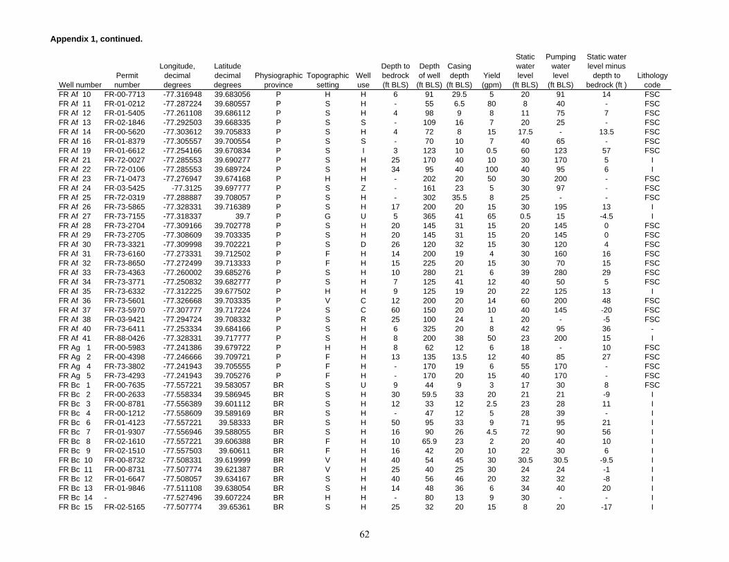
Appendix 1, continued.
Well numberPermit number
Longitude, decimal degrees
Latitude decimal degrees
Physiographic province
Topographic setting
Well use
Depth to bedrock (ft BLS)
Depth of well
(ft BLS)
Casing depth
(ft BLS)Yield (gpm)
Static water level
(ft BLS)
Pumping water level
(ft BLS)
Static water level minus
depth to bedrock (ft )
Lithology code
FR Af 10 FR-00-7713 -77.316948 39.683056 P H H 6 91 29.5 5 20 91 14 FSCFR Af 11 FR-01-0212 -77.287224 39.680557 P S H - 55 6.5 80 8 40 - FSCFR Af 12 FR-01-5405 -77.261108 39.686112 P S H 4 98 9 8 11 75 7 FSCFR Af 13 FR-02-1846 -77.292503 39.668335 P S S - 109 16 7 20 25 - FSCFR Af 14 FR-00-5620 -77.303612 39.705833 P S H 4 72 8 15 17.5 - 13.5 FSCFR Af 16 FR-01-8379 -77.305557 39.700554 P S S - 70 10 7 40 65 - FSCFR Af 19 FR-01-6612 -77.254166 39.670834 P S I 3 123 10 0.5 60 123 57 FSCFR Af 21 FR-72-0027 -77.285553 39.690277 P S H 25 170 40 10 30 170 5 IFR Af 22 FR-72-0106 -77.285553 39.689724 P S H 34 95 40 100 40 95 6 IFR Af 23 FR-71-0473 -77.276947 39.674168 P H H - 202 20 50 30 200 - FSCFR Af 24 FR-03-5425 -77.3125 39.697777 P S Z - 161 23 5 30 97 - FSCFR Af 25 FR-72-0319 -77.288887 39.708057 P S H - 302 35.5 8 25 - - FSCFR Af 26 FR-73-5865 -77.328331 39.716389 P S H 17 200 20 15 30 195 13 IFR Af 27 FR-73-7155 -77.318337 39.7 P G U 5 365 41 65 0.5 15 -4.5 IFR Af 28 FR-73-2704 -77.309166 39.702778 P S H 20 145 31 15 20 145 0 FSCFR Af 29 FR-73-2705 -77.308609 39.703335 P S H 20 145 31 15 20 145 0 FSCFR Af 30 FR-73-3321 -77.309998 39.702221 P S D 26 120 32 15 30 120 4 FSCFR Af 31 FR-73-6160 -77.273331 39.712502 P F H 14 200 19 4 30 160 16 FSCFR Af 32 FR-73-8650 -77.272499 39.713333 P F H 15 225 20 15 30 70 15 FSCFR Af 33 FR-73-4363 -77.260002 39.685276 P S H 10 280 21 6 39 280 29 FSCFR Af 34 FR-73-3771 -77.250832 39.682777 P S H 7 125 41 12 40 50 5 FSCFR Af 35 FR-73-6332 -77.312225 39.677502 P H H 9 125 19 20 22 125 13 IFR Af 36 FR-73-5601 -77.326668 39.703335 P V C 12 200 20 14 60 200 48 FSCFR Af 37 FR-73-5970 -77.307777 39.717224 P S C 60 150 20 10 40 145 -20 FSCFR Af 38 FR-03-9421 -77.294724 39.708332 P S R 25 100 24 1 20 - -5 FSCFR Af 40 FR-73-6411 -77.253334 39.684166 P S H 6 325 20 8 42 95 36 - FR Af 41 FR-88-0426 -77.328331 39.717777 P S H 8 200 38 50 23 200 15 IFR Ag 1 FR-00-5983 -77.241386 39.679722 P H H 8 62 12 6 18 - 10 FSCFR Ag 2 FR-00-4398 -77.246666 39.709721 P F H 13 135 13.5 12 40 85 27 FSCFR Ag 4 FR-73-3802 -77.241943 39.705555 P F H - 170 19 6 55 170 - FSCFR Ag 5 FR-73-4293 -77.241943 39.705276 P F H - 170 20 15 40 170 - FSCFR Bc 1 FR-00-7635 -77.557221 39.583057 BR S U 9 44 9 3 17 30 8 FSCFR Bc 2 FR-00-2633 -77.558334 39.586945 BR S H 30 59.5 33 20 21 21 -9 IFR Bc 3 FR-00-8781 -77.556389 39.601112 BR S H 12 33 12 2.5 23 28 11 IFR Bc 4 FR-00-1212 -77.558609 39.589169 BR S H - 47 12 5 28 39 - IFR Bc 6 FR-01-4123 -77.557221 39.58333 BR S H 50 95 33 9 71 95 21 IFR Bc 7 FR-01-9307 -77.556946 39.588055 BR S H 16 90 26 4.5 72 90 56 IFR Bc 8 FR-02-1610 -77.557221 39.606388 BR F H 10 65.9 23 2 20 40 10 IFR Bc 9 FR-02-1510 -77.557503 39.60611 BR F H 16 42 20 10 22 30 6 IFR Bc 10 FR-00-8732 -77.508331 39.619999 BR V H 40 54 45 30 30.5 30.5 -9.5 IFR Bc 11 FR-00-8731 -77.507774 39.621387 BR V H 25 40 25 30 24 24 -1 IFR Bc 12 FR-01-6647 -77.508057 39.634167 BR S H 40 56 46 20 32 32 -8 IFR Bc 13 FR-01-9846 -77.511108 39.638054 BR S H 14 48 36 6 34 40 20 IFR Bc 14 - -77.527496 39.607224 BR H H - 80 13 9 30 - - IFR Bc 15 FR-02-5165 -77.507774 39.65361 BR S H 25 32 20 15 8 20 -17 I
62
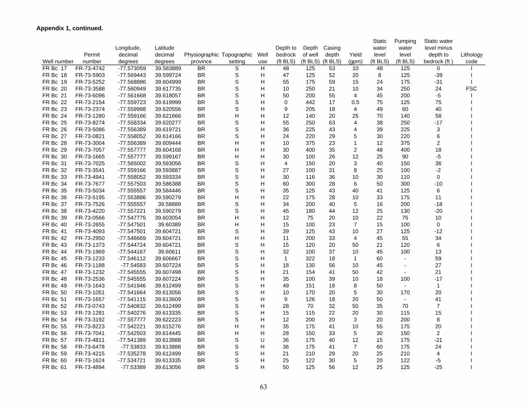
Appendix 1, continued.
Well numberPermit number
Longitude, decimal degrees
Latitude decimal degrees
Physiographic province
Topographic setting
Well use
Depth to bedrock (ft BLS)
Depth of well
(ft BLS)
Casing depth
(ft BLS)Yield (gpm)
Static water level
(ft BLS)
Pumping water level
(ft BLS)
Static water level minus
depth to bedrock (ft )
Lithology code
FR Bc 17 FR-73-4742 -77.573059 39.583889 BR S H 48 125 53 10 48 125 0 IFR Bc 18 FR-73-5903 -77.569443 39.599724 BR S H 47 125 52 20 8 125 -39 IFR Bc 19 FR-73-5252 -77.568886 39.604999 BR S H 55 175 59 15 24 175 -31 IFR Bc 20 FR-73-3588 -77.560949 39.617735 BR S H 10 250 21 10 34 250 24 FSCFR Bc 21 FR-73-6096 -77.561668 39.618057 BR S H 50 200 55 4 45 200 -5 IFR Bc 22 FR-73-2154 -77.559723 39.619999 BR S H 0 442 17 0.5 75 125 75 IFR Bc 23 FR-73-2374 -77.559998 39.620556 BR S H 9 205 18 4 49 60 40 IFR Bc 24 FR-73-1280 -77.559166 39.621666 BR H H 12 140 20 25 70 140 58 IFR Bc 25 FR-73-8274 -77.558334 39.620277 BR S H 55 250 63 4 38 250 -17 IFR Bc 26 FR-73-5086 -77.556389 39.619721 BR S H 36 225 43 4 39 225 3 IFR Bc 27 FR-73-0821 -77.558052 39.614166 BR S H 24 220 29 5 30 220 6 IFR Bc 28 FR-73-3004 -77.556389 39.609444 BR H H 10 375 23 1 12 375 2 IFR Bc 29 FR-73-7057 -77.557777 39.604168 BR H H 30 400 35 2 48 400 18 IFR Bc 30 FR-73-1665 -77.557777 39.599167 BR H H 30 100 26 12 25 90 -5 IFR Bc 31 FR-73-7025 -77.565002 39.593056 BR S H 4 150 20 3 40 150 36 IFR Bc 32 FR-73-3541 -77.559166 39.593887 BR S H 27 100 31 8 25 100 -2 IFR Bc 33 FR-73-4941 -77.558052 39.593334 BR S H 30 116 36 10 30 110 0 IFR Bc 34 FR-73-7677 -77.557503 39.586388 BR S H 60 300 28 6 50 300 -10 IFR Bc 35 FR-73-5034 -77.555557 39.584446 BR S H 35 125 43 40 41 125 6 IFR Bc 36 FR-73-5195 -77.553886 39.590279 BR H H 22 175 28 10 33 175 11 IFR Bc 37 FR-73-7526 -77.555557 39.58889 BR S H 34 200 40 5 16 200 -18 IFR Bc 38 FR-73-4220 -77.557221 39.590279 BR S H 45 180 44 12 25 130 -20 IFR Bc 39 FR-73-0566 -77.547775 39.603054 BR H H 12 75 20 10 22 75 10 IFR Bc 40 FR-73-2655 -77.547501 39.60389 BR H H 15 100 23 7 15 100 0 IFR Bc 41 FR-73-4093 -77.547501 39.604721 BR S H 39 125 43 10 27 125 -12 IFR Bc 42 FR-73-2950 -77.546669 39.604721 BR H H 11 200 33 4 45 55 34 IFR Bc 43 FR-73-1373 -77.544724 39.604721 BR S H 15 120 20 50 21 120 6 IFR Bc 44 FR-73-1969 -77.544167 39.60611 BR S H 32 100 37 10 45 100 13 IFR Bc 45 FR-73-1233 -77.546112 39.606667 BR S H 1 322 18 1 60 - 59 IFR Bc 46 FR-73-1188 -77.54583 39.607224 BR S H 18 130 56 10 45 - 27 IFR Bc 47 FR-73-1232 -77.545555 39.607498 BR S H 21 154 41 50 42 - 21 IFR Bc 48 FR-73-2536 -77.545555 39.607224 BR S H 35 100 39 10 18 100 -17 IFR Bc 49 FR-73-1643 -77.541946 39.612499 BR S H 49 151 18 8 50 - 1 IFR Bc 50 FR-73-1051 -77.541664 39.613056 BR S H 10 170 20 5 30 170 20 IFR Bc 51 FR-73-1657 -77.541115 39.613609 BR S H 9 126 18 20 50 - 41 IFR Bc 52 FR-73-0743 -77.540832 39.612499 BR S H 28 70 32 50 35 70 7 IFR Bc 53 FR-73-1281 -77.540276 39.613335 BR S H 15 115 22 20 30 115 15 IFR Bc 54 FR-73-3192 -77.557777 39.622223 BR S H 12 200 20 3 20 200 8 IFR Bc 55 FR-73-8223 -77.542221 39.615276 BR H H 35 175 41 10 55 175 20 IFR Bc 56 FR-73-7041 -77.542503 39.614445 BR H H 28 150 33 5 30 150 2 IFR Bc 57 FR-73-4811 -77.541389 39.613888 BR S U 36 175 40 12 15 175 -21 IFR Bc 58 FR-73-6478 -77.53833 39.613888 BR S H 36 175 41 7 60 175 24 IFR Bc 59 FR-73-4215 -77.535278 39.612499 BR S H 21 210 29 20 25 210 4 IFR Bc 60 FR-73-1624 -77.534721 39.613335 BR S H 25 122 30 5 20 122 -5 IFR Bc 61 FR-73-4894 -77.53389 39.613056 BR S H 50 125 56 12 25 125 -25 I
63
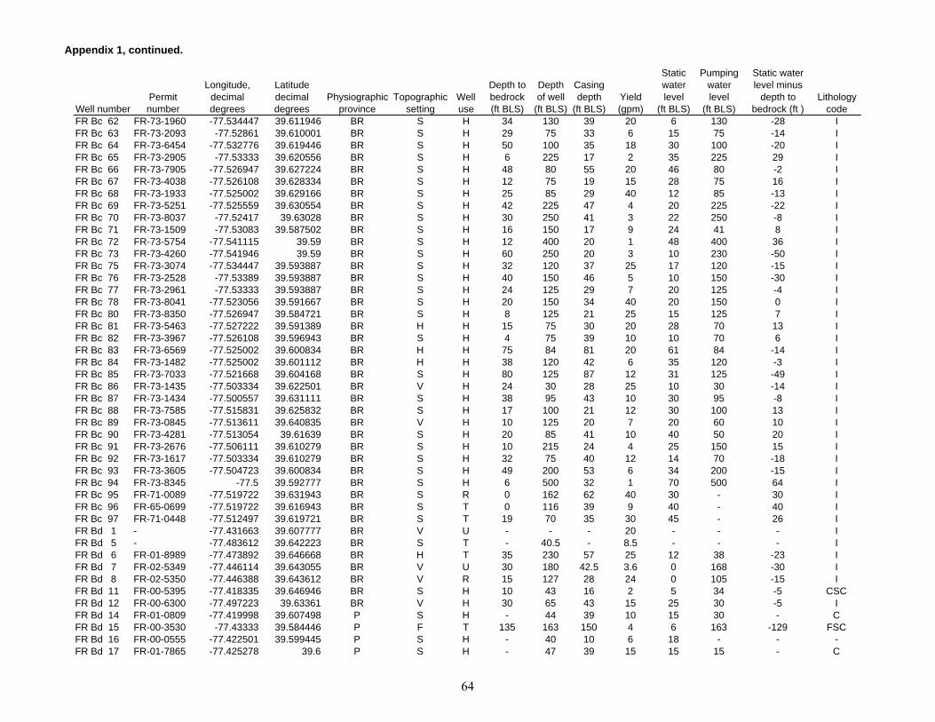
Appendix 1, continued.
Well numberPermit number
Longitude, decimal degrees
Latitude decimal degrees
Physiographic province
Topographic setting
Well use
Depth to bedrock (ft BLS)
Depth of well
(ft BLS)
Casing depth
(ft BLS)Yield (gpm)
Static water level
(ft BLS)
Pumping water level
(ft BLS)
Static water level minus
depth to bedrock (ft )
Lithology code
FR Bc 62 FR-73-1960 -77.534447 39.611946 BR S H 34 130 39 20 6 130 -28 IFR Bc 63 FR-73-2093 -77.52861 39.610001 BR S H 29 75 33 6 15 75 -14 IFR Bc 64 FR-73-6454 -77.532776 39.619446 BR S H 50 100 35 18 30 100 -20 IFR Bc 65 FR-73-2905 -77.53333 39.620556 BR S H 6 225 17 2 35 225 29 IFR Bc 66 FR-73-7905 -77.526947 39.627224 BR S H 48 80 55 20 46 80 -2 IFR Bc 67 FR-73-4038 -77.526108 39.628334 BR S H 12 75 19 15 28 75 16 IFR Bc 68 FR-73-1933 -77.525002 39.629166 BR S H 25 85 29 40 12 85 -13 IFR Bc 69 FR-73-5251 -77.525559 39.630554 BR S H 42 225 47 4 20 225 -22 IFR Bc 70 FR-73-8037 -77.52417 39.63028 BR S H 30 250 41 3 22 250 -8 IFR Bc 71 FR-73-1509 -77.53083 39.587502 BR S H 16 150 17 9 24 41 8 IFR Bc 72 FR-73-5754 -77.541115 39.59 BR S H 12 400 20 1 48 400 36 IFR Bc 73 FR-73-4260 -77.541946 39.59 BR S H 60 250 20 3 10 230 -50 IFR Bc 75 FR-73-3074 -77.534447 39.593887 BR S H 32 120 37 25 17 120 -15 IFR Bc 76 FR-73-2528 -77.53389 39.593887 BR S H 40 150 46 5 10 150 -30 IFR Bc 77 FR-73-2961 -77.53333 39.593887 BR S H 24 125 29 7 20 125 -4 IFR Bc 78 FR-73-8041 -77.523056 39.591667 BR S H 20 150 34 40 20 150 0 IFR Bc 80 FR-73-8350 -77.526947 39.584721 BR S H 8 125 21 25 15 125 7 IFR Bc 81 FR-73-5463 -77.527222 39.591389 BR H H 15 75 30 20 28 70 13 IFR Bc 82 FR-73-3967 -77.526108 39.596943 BR S H 4 75 39 10 10 70 6 IFR Bc 83 FR-73-6569 -77.525002 39.600834 BR H H 75 84 81 20 61 84 -14 IFR Bc 84 FR-73-1482 -77.525002 39.601112 BR H H 38 120 42 6 35 120 -3 IFR Bc 85 FR-73-7033 -77.521668 39.604168 BR S H 80 125 87 12 31 125 -49 IFR Bc 86 FR-73-1435 -77.503334 39.622501 BR V H 24 30 28 25 10 30 -14 IFR Bc 87 FR-73-1434 -77.500557 39.631111 BR S H 38 95 43 10 30 95 -8 IFR Bc 88 FR-73-7585 -77.515831 39.625832 BR S H 17 100 21 12 30 100 13 IFR Bc 89 FR-73-0845 -77.513611 39.640835 BR V H 10 125 20 7 20 60 10 IFR Bc 90 FR-73-4281 -77.513054 39.61639 BR S H 20 85 41 10 40 50 20 IFR Bc 91 FR-73-2676 -77.506111 39.610279 BR S H 10 215 24 4 25 150 15 IFR Bc 92 FR-73-1617 -77.503334 39.610279 BR S H 32 75 40 12 14 70 -18 IFR Bc 93 FR-73-3605 -77.504723 39.600834 BR S H 49 200 53 6 34 200 -15 IFR Bc 94 FR-73-8345 -77.5 39.592777 BR S H 6 500 32 1 70 500 64 IFR Bc 95 FR-71-0089 -77.519722 39.631943 BR S R 0 162 62 40 30 - 30 IFR Bc 96 FR-65-0699 -77.519722 39.616943 BR S T 0 116 39 9 40 - 40 IFR Bc 97 FR-71-0448 -77.512497 39.619721 BR S T 19 70 35 30 45 - 26 IFR Bd 1 - -77.431663 39.607777 BR V U - - - 20 - - - IFR Bd 5 - -77.483612 39.642223 BR S T - 40.5 - 8.5 - - - IFR Bd 6 FR-01-8989 -77.473892 39.646668 BR H T 35 230 57 25 12 38 -23 IFR Bd 7 FR-02-5349 -77.446114 39.643055 BR V U 30 180 42.5 3.6 0 168 -30 IFR Bd 8 FR-02-5350 -77.446388 39.643612 BR V R 15 127 28 24 0 105 -15 IFR Bd 11 FR-00-5395 -77.418335 39.646946 BR S H 10 43 16 2 5 34 -5 CSCFR Bd 12 FR-00-6300 -77.497223 39.63361 BR V H 30 65 43 15 25 30 -5 IFR Bd 14 FR-01-0809 -77.419998 39.607498 P S H - 44 39 10 15 30 - CFR Bd 15 FR-00-3530 -77.43333 39.584446 P F T 135 163 150 4 6 163 -129 FSCFR Bd 16 FR-00-0555 -77.422501 39.599445 P S H - 40 10 6 18 - - - FR Bd 17 FR-01-7865 -77.425278 39.6 P S H - 47 39 15 15 15 - C
64

Appendix 1, continued.
Well numberPermit number
Longitude, decimal degrees
Latitude decimal degrees
Physiographic province
Topographic setting
Well use
Depth to bedrock (ft BLS)
Depth of well
(ft BLS)
Casing depth
(ft BLS)Yield (gpm)
Static water level
(ft BLS)
Pumping water level
(ft BLS)
Static water level minus
depth to bedrock (ft )
Lithology code
FR Bd 18 FR-01-7962 -77.423614 39.599167 P S H 35 50 43 10 15 18 -20 CSCFR Bd 19 FR-01-0482 -77.419724 39.596111 P S H 20 38 22 10 23 28 3 FSCFR Bd 20 FR-00-7083 -77.422775 39.598057 P S H 6 48 33 10 16 - 10 CSCFR Bd 21 FR-00-1033 -77.425552 39.583889 P S H 50 77 36 10 22 - -28 FSCFR Bd 22 FR-00-4660 -77.431663 39.589169 P S C 0 52 36 15 20 30 20 CSCFR Bd 23 FR-00-4603 -77.431663 39.589169 P S H 0 52 36 5 25 30 25 CSCFR Bd 24 FR-00-7043 -77.430557 39.589169 P S H - 114 8 2 50 100 - CFR Bd 25 FR-00-8556 -77.486946 39.600834 BR S H 21 27 22 8 10 - -11 IFR Bd 27 FR-02-5351 -77.464165 39.64611 BR H T 10 144 11 7 10 126 0 IFR Bd 30 FR-03-1559 -77.424446 39.643055 P S R 60 161 62.5 103 13.45 31.46 -46.55 IFR Bd 31 - -77.470276 39.645001 BR H T 19 150 24 22 6 140 -13 IFR Bd 32 - -77.464447 39.649445 BR H U 27 250 32 5 20 - -7 IFR Bd 33 - -77.470558 39.64611 BR H T 19 250 31 50 85 199 66 IFR Bd 34 FR-03-2795 -77.451111 39.634445 BR V H 18 230 18 32 5 200 -13 IFR Bd 35 FR-03-9187 -77.487503 39.644444 BR S P 60 250 66 33.9 - - - IFR Bd 36 FR-03-9186 -77.488335 39.643612 BR S P 60 250 59 63 1 - -59 IFR Bd 37 FR-05-0745 -77.485558 39.647778 BR T T 89 350 53.5 23 51 - -38 IFR Bd 38 FR-05-0746 -77.485001 39.648613 BR T T 103 450 86.2 23 50 - -53 IFR Bd 40 FR-66-0492 -77.480553 39.651669 BR S - - 180 75.5 40 58.34 87.5 - IFR Bd 41 FR-66-0489 -77.479721 39.6525 BR S - 37 160 46.1 33 54.23 - 17.23 IFR Bd 42 - -77.482498 39.650555 BR S U - 120 - 26 9 - - IFR Bd 43 FR-66-0490 -77.483055 39.642502 BR S - 10 120 27 74 29 70 19 IFR Bd 44 FR-66-0491 -77.484726 39.642776 BR S Z 36 250 45.5 8.5 20.41 53 -15.59 IFR Bd 45 FR-69-0274 -77.421669 39.5975 P F H 45 320 52 3 40 320 -5 CSCFR Bd 46 FR-70-0206 -77.425003 39.600277 P S H 60 75 72 25 35 75 -25 CFR Bd 47 FR-69-0114 -77.420555 39.597221 P F H 90 370 98 1 40 370 -50 CSCFR Bd 48 FR-69-0437 -77.428055 39.584168 P S H 0 115 81 12 30 - 30 CSCFR Bd 49 FR-71-0428 -77.440277 39.62611 BR V R 18 202 30 19 9.68 22 -8.32 CSCFR Bd 50 FR-71-0582 -77.420281 39.596943 P F H 60 68 63 50 22 68 -38 CSCFR Bd 51 FR-71-0573 -77.420555 39.5975 P F H 37 45 40 50 12 45 -25 CSCFR Bd 52 FR-72-0200 -77.427498 39.584999 P S H 100 121 115 15 48 - -52 CSCFR Bd 53 FR-69-0503 -77.423614 39.598888 P S H 112 167 118 12 30 167 -82 CSCFR Bd 55 FR-73-1875 -77.495552 39.60611 BR S H 17 200 22 2 40 200 23 IFR Bd 56 FR-73-7957 -77.495834 39.604999 BR S H 10 275 28 4 55 275 45 IFR Bd 57 FR-73-7134 -77.494163 39.605835 BR S H 28 500 41 1 28 500 0 IFR Bd 58 FR-73-5319 -77.495003 39.604721 BR S H 12 320 21 1 62 320 50 IFR Bd 59 FR-73-7002 -77.493614 39.604721 BR S H 10 140 22 5 25 135 15 IFR Bd 60 FR-73-8178 -77.491386 39.600277 BR S H 12 300 20 2 30 300 18 IFR Bd 61 FR-73-7684 -77.492226 39.600834 BR S H 8 500 19 1 40 500 32 IFR Bd 62 FR-73-4679 -77.487221 39.601112 BR S H 12 100 20 8 60 100 48 IFR Bd 63 FR-73-4678 -77.486389 39.601944 BR S H 12 355 20 8 75 355 63 IFR Bd 64 FR-73-3904 -77.485001 39.601944 BR S H 45 75 51 20 50 75 5 IFR Bd 65 FR-73-7902 -77.482498 39.60611 BR S H 29 100 39 20 38 100 9 IFR Bd 66 FR-73-7227 -77.491943 39.632221 BR S H 37 200 41 3 65 200 28 IFR Bd 67 FR-73-2913 -77.491669 39.63333 BR S H 16 125 20 10 26 51 10 I
65
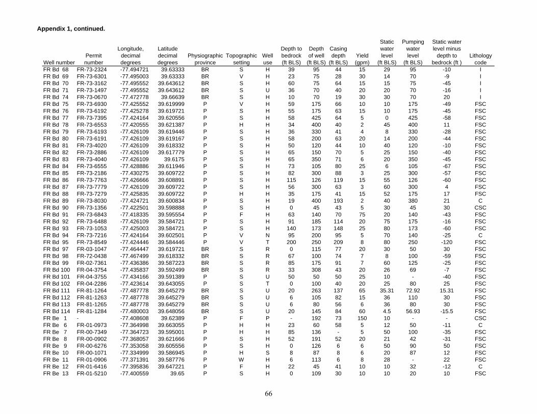
Appendix 1, continued.
Well numberPermit number
Longitude, decimal degrees
Latitude decimal degrees
Physiographic province
Topographic setting
Well use
Depth to bedrock (ft BLS)
Depth of well
(ft BLS)
Casing depth
(ft BLS)Yield (gpm)
Static water level
(ft BLS)
Pumping water level
(ft BLS)
Static water level minus
depth to bedrock (ft )
Lithology code
FR Bd 68 FR-73-2324 -77.494721 39.63333 BR S H 39 95 44 15 29 95 -10 IFR Bd 69 FR-73-6301 -77.495003 39.63333 BR V H 23 75 28 30 14 70 -9 IFR Bd 70 FR-73-3162 -77.495552 39.643612 BR S H 60 75 64 15 15 75 -45 IFR Bd 71 FR-73-1497 -77.495552 39.643612 BR S U 36 70 40 20 20 70 -16 IFR Bd 74 FR-73-0670 -77.472778 39.66639 BR S H 10 70 19 30 30 70 20 IFR Bd 75 FR-73-6930 -77.425552 39.619999 P V H 59 175 66 10 10 175 -49 FSCFR Bd 76 FR-73-6192 -77.425278 39.619721 P S H 55 175 63 15 10 175 -45 FSCFR Bd 77 FR-73-7395 -77.424164 39.620556 P S H 58 425 64 5 0 425 -58 FSCFR Bd 78 FR-73-6553 -77.420555 39.621387 P H H 34 400 40 2 45 400 11 FSCFR Bd 79 FR-73-6193 -77.426109 39.619446 P S H 36 330 41 4 8 330 -28 FSCFR Bd 80 FR-73-6191 -77.426109 39.619167 P S H 58 200 63 20 14 200 -44 FSCFR Bd 81 FR-73-4020 -77.426109 39.618332 P S H 50 120 44 10 40 120 -10 FSCFR Bd 82 FR-73-2886 -77.426109 39.617779 P S H 65 150 70 5 25 150 -40 FSCFR Bd 83 FR-73-4040 -77.426109 39.6175 P S H 65 350 71 6 20 350 -45 FSCFR Bd 84 FR-73-6555 -77.428886 39.611946 P S H 73 105 80 25 6 105 -67 FSCFR Bd 85 FR-73-2186 -77.430275 39.609722 P S H 82 300 88 3 25 300 -57 FSCFR Bd 86 FR-73-7763 -77.426666 39.608891 P S H 115 126 119 15 55 126 -60 FSCFR Bd 87 FR-73-7779 -77.426109 39.609722 P S H 56 300 63 3 60 300 4 FSCFR Bd 88 FR-73-7279 -77.425835 39.609722 P H H 35 175 41 15 52 175 17 FSCFR Bd 89 FR-73-8030 -77.424721 39.600834 P S H 19 400 193 2 40 380 21 CFR Bd 90 FR-73-1356 -77.422501 39.598888 P S H 0 45 43 5 30 45 30 CSCFR Bd 91 FR-73-6843 -77.418335 39.595554 P F H 63 140 70 75 20 140 -43 FSCFR Bd 92 FR-73-6488 -77.426109 39.584721 P S H 91 185 114 20 75 175 -16 FSCFR Bd 93 FR-73-1053 -77.425003 39.584721 P S H 140 173 148 25 80 173 -60 FSCFR Bd 94 FR-73-7216 -77.424164 39.602501 P V N 95 200 95 5 70 140 -25 CFR Bd 95 FR-73-8549 -77.424446 39.584446 P V T 200 250 209 8 80 250 -120 FSCFR Bd 97 FR-03-1047 -77.464447 39.619721 BR S R 0 115 77 20 30 50 30 FSCFR Bd 98 FR-72-0438 -77.467499 39.618332 BR S R 67 100 74 7 8 100 -59 FSCFR Bd 99 FR-02-7361 -77.436386 39.587223 BR S R 85 175 91 7 60 125 -25 FSCFR Bd 100 FR-04-3754 -77.435837 39.592499 BR S R 33 308 43 20 26 69 -7 FSCFR Bd 101 FR-04-3755 -77.434166 39.591389 P S U 50 50 50 25 10 - -40 FSCFR Bd 102 FR-04-2286 -77.423614 39.643055 P S T 0 100 40 20 25 80 25 FSCFR Bd 111 FR-81-1264 -77.487778 39.645279 BR S U 20 263 137 65 35.31 72.92 15.31 FSCFR Bd 112 FR-81-1263 -77.487778 39.645279 BR S U 6 105 82 15 36 110 30 FSCFR Bd 113 FR-81-1265 -77.487778 39.645279 BR S U 6 80 56 6 36 80 30 FSCFR Bd 114 FR-81-1284 -77.480003 39.648056 BR S U 20 145 84 60 4.5 56.93 -15.5 FSCFR Be 1 - -77.408608 39.62389 P F P - 192 73 150 10 - - CSCFR Be 6 FR-01-0973 -77.364998 39.663055 P H H 23 60 58 5 12 50 -11 CFR Be 7 FR-00-7349 -77.364723 39.595001 P H H 85 136 - 5 50 100 -35 FSCFR Be 8 FR-00-0902 -77.368057 39.621666 P S H 52 191 52 20 21 42 -31 FSCFR Be 9 FR-00-6276 -77.353058 39.605556 P S H 0 126 6 6 50 90 50 FSCFR Be 10 FR-00-1071 -77.334999 39.586945 P H S 8 87 8 6 20 87 12 FSCFR Be 11 FR-01-0906 -77.371391 39.587776 P W H 6 113 6 8 28 - 22 FSCFR Be 12 FR-01-6416 -77.395836 39.647221 P F H 22 45 41 10 10 32 -12 CFR Be 13 FR-01-5210 -77.400559 39.65 P S H 0 109 30 10 10 20 10 FSC
66
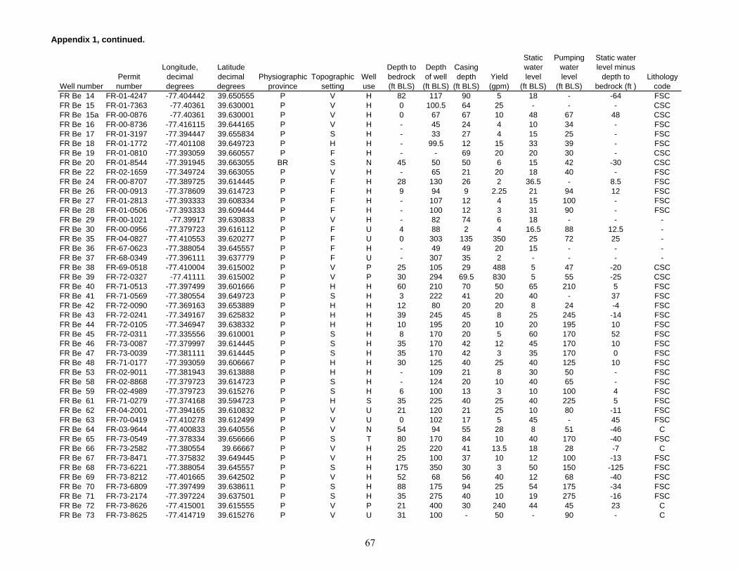
Appendix 1, continued.
Well numberPermit number
Longitude, decimal degrees
Latitude decimal degrees
Physiographic province
Topographic setting
Well use
Depth to bedrock (ft BLS)
Depth of well
(ft BLS)
Casing depth
(ft BLS)Yield (gpm)
Static water level
(ft BLS)
Pumping water level
(ft BLS)
Static water level minus
depth to bedrock (ft )
Lithology code
FR Be 14 FR-01-4247 -77.404442 39.650555 P V H 82 117 90 5 18 - -64 FSCFR Be 15 FR-01-7363 -77.40361 39.630001 P V H 0 100.5 64 25 - - - CSCFR Be 15a FR-00-0876 -77.40361 39.630001 P V H 0 67 67 10 48 67 48 CSCFR Be 16 FR-00-8736 -77.416115 39.644165 P V H - 45 24 4 10 34 - FSCFR Be 17 FR-01-3197 -77.394447 39.655834 P S H - 33 27 4 15 25 - FSCFR Be 18 FR-01-1772 -77.401108 39.649723 P H H - 99.5 12 15 33 39 - FSCFR Be 19 FR-01-0810 -77.393059 39.660557 P F H - - 69 20 20 30 - CSCFR Be 20 FR-01-8544 -77.391945 39.663055 BR S N 45 50 50 6 15 42 -30 CSCFR Be 22 FR-02-1659 -77.349724 39.663055 P V H - 65 21 20 18 40 - FSCFR Be 24 FR-00-8707 -77.389725 39.614445 P F H 28 130 26 2 36.5 - 8.5 FSCFR Be 26 FR-00-0913 -77.378609 39.614723 P F H 9 94 9 2.25 21 94 12 FSCFR Be 27 FR-01-2813 -77.393333 39.608334 P F H - 107 12 4 15 100 - FSCFR Be 28 FR-01-0506 -77.393333 39.609444 P F H - 100 12 3 31 90 - FSCFR Be 29 FR-00-1021 -77.39917 39.630833 P V H - 82 74 6 18 - - - FR Be 30 FR-00-0956 -77.379723 39.616112 P F U 4 88 2 4 16.5 88 12.5 - FR Be 35 FR-04-0827 -77.410553 39.620277 P F U 0 303 135 350 25 72 25 - FR Be 36 FR-67-0623 -77.388054 39.645557 P F H - 49 49 20 15 - - - FR Be 37 FR-68-0349 -77.396111 39.637779 P F U - 307 35 2 - - - - FR Be 38 FR-69-0518 -77.410004 39.615002 P V P 25 105 29 488 5 47 -20 CSCFR Be 39 FR-72-0327 -77.41111 39.615002 P V P 30 294 69.5 830 5 55 -25 CSCFR Be 40 FR-71-0513 -77.397499 39.601666 P H H 60 210 70 50 65 210 5 FSCFR Be 41 FR-71-0569 -77.380554 39.649723 P S H 3 222 41 20 40 - 37 FSCFR Be 42 FR-72-0090 -77.369163 39.653889 P H H 12 80 20 20 8 24 -4 FSCFR Be 43 FR-72-0241 -77.349167 39.625832 P H H 39 245 45 8 25 245 -14 FSCFR Be 44 FR-72-0105 -77.346947 39.638332 P H H 10 195 20 10 20 195 10 FSCFR Be 45 FR-72-0311 -77.335556 39.610001 P S H 8 170 20 5 60 170 52 FSCFR Be 46 FR-73-0087 -77.379997 39.614445 P S H 35 170 42 12 45 170 10 FSCFR Be 47 FR-73-0039 -77.381111 39.614445 P S H 35 170 42 3 35 170 0 FSCFR Be 48 FR-71-0177 -77.393059 39.606667 P H H 30 125 40 25 40 125 10 FSCFR Be 53 FR-02-9011 -77.381943 39.613888 P H H - 109 21 8 30 50 - FSCFR Be 58 FR-02-8868 -77.379723 39.614723 P S H - 124 20 10 40 65 - FSCFR Be 59 FR-02-4989 -77.379723 39.615276 P S H 6 100 13 3 10 100 4 FSCFR Be 61 FR-71-0279 -77.374168 39.594723 P H S 35 225 40 25 40 225 5 FSCFR Be 62 FR-04-2001 -77.394165 39.610832 P V U 21 120 21 25 10 80 -11 FSCFR Be 63 FR-70-0419 -77.410278 39.612499 P V U 0 102 17 5 45 - 45 FSCFR Be 64 FR-03-9644 -77.400833 39.640556 P V N 54 94 55 28 8 51 -46 CFR Be 65 FR-73-0549 -77.378334 39.656666 P S T 80 170 84 10 40 170 -40 FSCFR Be 66 FR-73-2582 -77.380554 39.66667 P V H 25 220 41 13.5 18 28 -7 CFR Be 67 FR-73-8471 -77.375832 39.649445 P V H 25 100 37 10 12 100 -13 FSCFR Be 68 FR-73-6221 -77.388054 39.645557 P S H 175 350 30 3 50 150 -125 FSCFR Be 69 FR-73-8212 -77.401665 39.642502 P V H 52 68 56 40 12 68 -40 FSCFR Be 70 FR-73-6809 -77.397499 39.638611 P S H 88 175 94 25 54 175 -34 FSCFR Be 71 FR-73-2174 -77.397224 39.637501 P S H 35 275 40 10 19 275 -16 FSCFR Be 72 FR-73-8626 -77.415001 39.615555 P V P 21 400 30 240 44 45 23 CFR Be 73 FR-73-8625 -77.414719 39.615276 P V U 31 100 - 50 - 90 - C
67
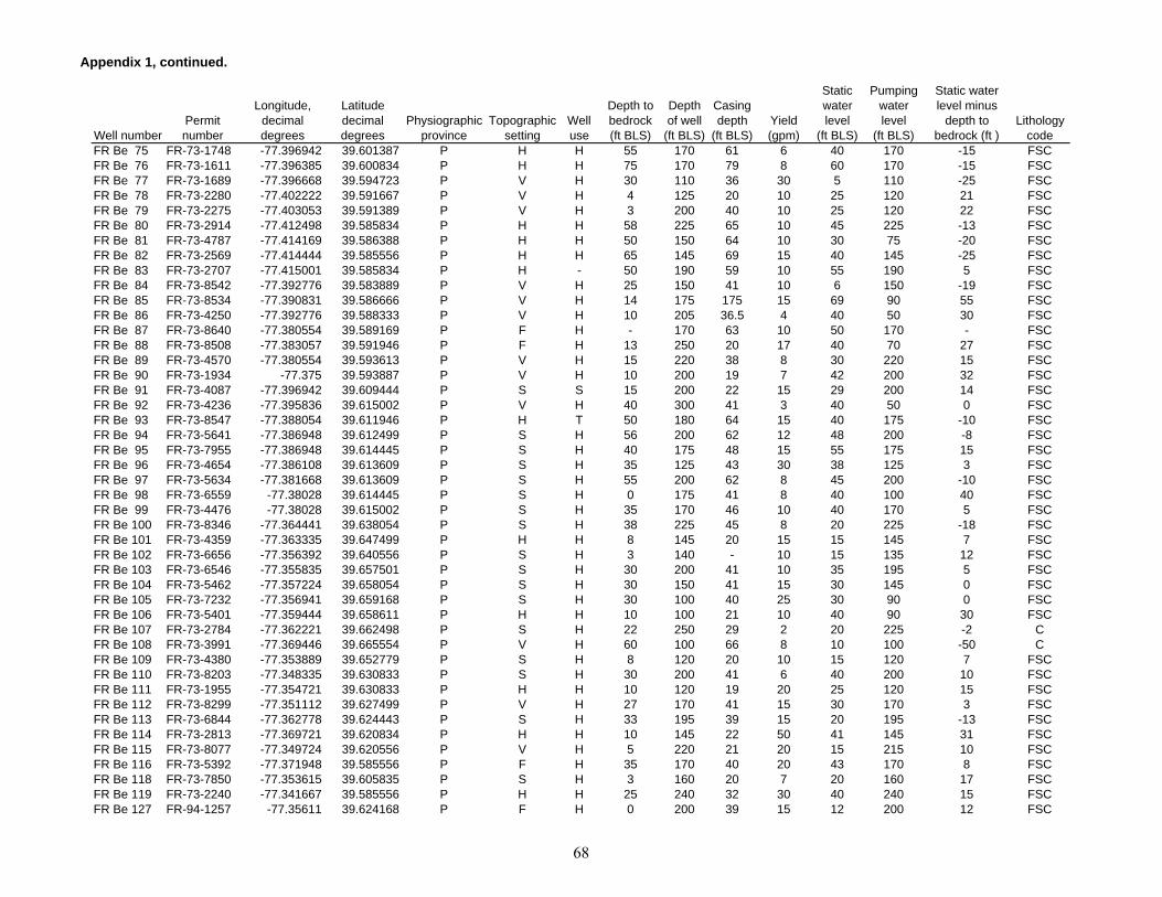
Appendix 1, continued.
Well numberPermit number
Longitude, decimal degrees
Latitude decimal degrees
Physiographic province
Topographic setting
Well use
Depth to bedrock (ft BLS)
Depth of well
(ft BLS)
Casing depth
(ft BLS)Yield (gpm)
Static water level
(ft BLS)
Pumping water level
(ft BLS)
Static water level minus
depth to bedrock (ft )
Lithology code
FR Be 75 FR-73-1748 -77.396942 39.601387 P H H 55 170 61 6 40 170 -15 FSCFR Be 76 FR-73-1611 -77.396385 39.600834 P H H 75 170 79 8 60 170 -15 FSCFR Be 77 FR-73-1689 -77.396668 39.594723 P V H 30 110 36 30 5 110 -25 FSCFR Be 78 FR-73-2280 -77.402222 39.591667 P V H 4 125 20 10 25 120 21 FSCFR Be 79 FR-73-2275 -77.403053 39.591389 P V H 3 200 40 10 25 120 22 FSCFR Be 80 FR-73-2914 -77.412498 39.585834 P H H 58 225 65 10 45 225 -13 FSCFR Be 81 FR-73-4787 -77.414169 39.586388 P H H 50 150 64 10 30 75 -20 FSCFR Be 82 FR-73-2569 -77.414444 39.585556 P H H 65 145 69 15 40 145 -25 FSCFR Be 83 FR-73-2707 -77.415001 39.585834 P H - 50 190 59 10 55 190 5 FSCFR Be 84 FR-73-8542 -77.392776 39.583889 P V H 25 150 41 10 6 150 -19 FSCFR Be 85 FR-73-8534 -77.390831 39.586666 P V H 14 175 175 15 69 90 55 FSCFR Be 86 FR-73-4250 -77.392776 39.588333 P V H 10 205 36.5 4 40 50 30 FSCFR Be 87 FR-73-8640 -77.380554 39.589169 P F H - 170 63 10 50 170 - FSCFR Be 88 FR-73-8508 -77.383057 39.591946 P F H 13 250 20 17 40 70 27 FSCFR Be 89 FR-73-4570 -77.380554 39.593613 P V H 15 220 38 8 30 220 15 FSCFR Be 90 FR-73-1934 -77.375 39.593887 P V H 10 200 19 7 42 200 32 FSCFR Be 91 FR-73-4087 -77.396942 39.609444 P S S 15 200 22 15 29 200 14 FSCFR Be 92 FR-73-4236 -77.395836 39.615002 P V H 40 300 41 3 40 50 0 FSCFR Be 93 FR-73-8547 -77.388054 39.611946 P H T 50 180 64 15 40 175 -10 FSCFR Be 94 FR-73-5641 -77.386948 39.612499 P S H 56 200 62 12 48 200 -8 FSCFR Be 95 FR-73-7955 -77.386948 39.614445 P S H 40 175 48 15 55 175 15 FSCFR Be 96 FR-73-4654 -77.386108 39.613609 P S H 35 125 43 30 38 125 3 FSCFR Be 97 FR-73-5634 -77.381668 39.613609 P S H 55 200 62 8 45 200 -10 FSCFR Be 98 FR-73-6559 -77.38028 39.614445 P S H 0 175 41 8 40 100 40 FSCFR Be 99 FR-73-4476 -77.38028 39.615002 P S H 35 170 46 10 40 170 5 FSCFR Be 100 FR-73-8346 -77.364441 39.638054 P S H 38 225 45 8 20 225 -18 FSCFR Be 101 FR-73-4359 -77.363335 39.647499 P H H 8 145 20 15 15 145 7 FSCFR Be 102 FR-73-6656 -77.356392 39.640556 P S H 3 140 - 10 15 135 12 FSCFR Be 103 FR-73-6546 -77.355835 39.657501 P S H 30 200 41 10 35 195 5 FSCFR Be 104 FR-73-5462 -77.357224 39.658054 P S H 30 150 41 15 30 145 0 FSCFR Be 105 FR-73-7232 -77.356941 39.659168 P S H 30 100 40 25 30 90 0 FSCFR Be 106 FR-73-5401 -77.359444 39.658611 P H H 10 100 21 10 40 90 30 FSCFR Be 107 FR-73-2784 -77.362221 39.662498 P S H 22 250 29 2 20 225 -2 CFR Be 108 FR-73-3991 -77.369446 39.665554 P V H 60 100 66 8 10 100 -50 CFR Be 109 FR-73-4380 -77.353889 39.652779 P S H 8 120 20 10 15 120 7 FSCFR Be 110 FR-73-8203 -77.348335 39.630833 P S H 30 200 41 6 40 200 10 FSCFR Be 111 FR-73-1955 -77.354721 39.630833 P H H 10 120 19 20 25 120 15 FSCFR Be 112 FR-73-8299 -77.351112 39.627499 P V H 27 170 41 15 30 170 3 FSCFR Be 113 FR-73-6844 -77.362778 39.624443 P S H 33 195 39 15 20 195 -13 FSCFR Be 114 FR-73-2813 -77.369721 39.620834 P H H 10 145 22 50 41 145 31 FSCFR Be 115 FR-73-8077 -77.349724 39.620556 P V H 5 220 21 20 15 215 10 FSCFR Be 116 FR-73-5392 -77.371948 39.585556 P F H 35 170 40 20 43 170 8 FSCFR Be 118 FR-73-7850 -77.353615 39.605835 P S H 3 160 20 7 20 160 17 FSCFR Be 119 FR-73-2240 -77.341667 39.585556 P H H 25 240 32 30 40 240 15 FSCFR Be 127 FR-94-1257 -77.35611 39.624168 P F H 0 200 39 15 12 200 12 FSC
68

Appendix 1, continued.
Well numberPermit number
Longitude, decimal degrees
Latitude decimal degrees
Physiographic province
Topographic setting
Well use
Depth to bedrock (ft BLS)
Depth of well
(ft BLS)
Casing depth
(ft BLS)Yield (gpm)
Static water level
(ft BLS)
Pumping water level
(ft BLS)
Static water level minus
depth to bedrock (ft )
Lithology code
FR Bf 1 FR-00-7615 -77.330833 39.654999 P S H 9 103 7.6 3.5 10 103 1 FSCFR Bf 2 FR-00-8425 -77.315277 39.636944 P S H 3 110 6 1 39 110 36 FSCFR Bf 3 FR-00-1790 -77.305 39.654446 P H H 4 132 132 2 41 132 37 FSCFR Bf 4 FR-00-0582 -77.319725 39.614723 P S H 25 82 - 5.5 30 82 5 FSCFR Bf 5 FR-00-9881 -77.318611 39.605556 P H H 5 68 12 10 21 40 16 FSCFR Bf 7 FR-01-9475 -77.277496 39.589722 P W H 3 87 17.3 6 16 87 13 FSCFR Bf 8 FR-00-3937 -77.276108 39.59 P S - 13 217 9.5 12 37 172 24 FSCFR Bf 9 FR-00-9882 -77.327774 39.645279 P V H 7 92 12 8 23 - 16 FSCFR Bf 10 FR-00-8099 -77.275833 39.660557 P V H - 72 10 3 12 70 - FSCFR Bf 16 FR-00-4897 -77.285553 39.631111 P G S 3 165 8 15 19 115 16 FSCFR Bf 19 FR-00-9384 -77.280281 39.649723 P H S 9 201 8 3.5 3 201 -6 FSCFR Bf 21 FR-72-0096 -77.318611 39.604168 P H H 0 170 40 4 45 170 45 FSCFR Bf 22 FR-72-0092 -77.272499 39.658054 P H H 31 95 36 5 25 94 -6 FSCFR Bf 23 FR-71-0538 -77.315559 39.638054 P H H 10 170 20 5 25 170 15 FSCFR Bf 24 FR-71-0405 -77.3125 39.591667 P H H 0 85 21 9 45 80 45 FSCFR Bf 25 FR-72-0270 -77.312775 39.591667 P H H 6 105 21 7 25 100 19 FSCFR Bf 26 FR-72-0371 -77.306114 39.60611 P H H 33 295 38 7 48 295 15 FSCFR Bf 27 FR-72-0298 -77.318611 39.600277 P H H 25 145 29 5 45 145 20 IFR Bf 28 FR-66-0371 -77.319168 39.60611 P S T 0 205 20 20 30 - 30 FSCFR Bf 29 FR-73-7716 -77.321114 39.62611 P H H 70 125 22 30 30 50 -40 IFR Bf 30 FR-73-2703 -77.315277 39.625832 P S H 15 175 23 10 - - - FSCFR Bf 31 FR-73-2045 -77.319168 39.631668 P S H 15 150 22 6 22 150 7 IFR Bf 32 FR-73-2774 -77.314163 39.629444 P S H 15 100 22 20 22 100 7 FSCFR Bf 33 FR-73-7923 -77.322777 39.634998 P F H 5 200 22 15 55 - 50 FSCFR Bf 34 FR-73-7246 -77.323608 39.640556 P F H 30 275 41 25 2 275 -28 FSCFR Bf 35 FR-73-8269 -77.330833 39.657223 P H H 10 220 41 5 30 220 20 FSCFR Bf 36 FR-73-7433 -77.285278 39.596111 P S H 8 290 21 5 50 285 42 FSCFR Bf 37 FR-81-4865 -77.308609 39.656113 P S H 2 275 19 6 48 275 46 - FR Cb 1 FR-01-6375 -77.603615 39.53611 BR S C 30 116 33 5 60 90 30 CSCFR Cb 2 FR-01-5545 -77.605003 39.522499 BR S R 20 155 - 2 50 155 30 CSCFR Cb 3 - -77.607224 39.525833 BR S R - 70 28 20 35 - - CSCFR Cb 5 FR-00-5540 -77.583885 39.52639 BR S U 20 50 20 1 35 50 15 CSCFR Cb 6 FR-00-1678 -77.588059 39.546391 BR S H 18 88 21 4 30 - 12 IFR Cb 9 FR-04-1469 -77.587776 39.526112 BR H C 0 95 29 6 25 - 25 IFR Cb 11 FR-67-0047 -77.605278 39.5275 BR S P 0 400 40 14 30 - 30 CSCFR Cb 12 FR-67-0047 -77.605553 39.527222 BR S P 0 295 45 28.6 30 - 30 CSCFR Cb 13 FR-67-0047 -77.6 39.525002 BR W P 0 384 61 30.6 40 - 40 IFR Cb 14 FR-67-0047 -77.6 39.525002 BR W U 0 380 31 23.4 30 - 30 IFR Cb 15 FR-73-6655 -77.600281 39.525276 BR W P 160 300 44 35 37 300 -123 IFR Cb 16 FR-73-6552 -77.601112 39.517776 BR S C 15 145 21 10 50 145 35 IFR Cb 17 FR-73-5062 -77.586388 39.511944 BR S H 18 300 21 2 55 240 37 IFR Cb 18 FR-05-7253 -77.584999 39.511112 BR H R 0 130 23 5 30 - 30 IFR Cb 19 FR-72-0700 -77.584168 39.510555 BR H H 31 302 38 2 40 - 9 IFR Cb 20 FR-88-0673 -77.594963 39.529888 BR S H 14 350 39 9 14 116 0 IFR Cb 21 FR-88-2731 -77.586212 39.520981 BR H H 18 500 41 2.5 38 500 20 I
69

Appendix 1, continued.
Well numberPermit number
Longitude, decimal degrees
Latitude decimal degrees
Physiographic province
Topographic setting
Well use
Depth to bedrock (ft BLS)
Depth of well
(ft BLS)
Casing depth
(ft BLS)Yield (gpm)
Static water level
(ft BLS)
Pumping water level
(ft BLS)
Static water level minus
depth to bedrock (ft )
Lithology code
FR Cc 1 FR-01-8254 -77.544441 39.571945 BR S H 8 89 23.2 2 20 70 12 IFR Cc 2 FR-00-9075 -77.526947 39.551945 BR S H 20 42 24 10 15 - -5 IFR Cc 3 FR-02-1916 -77.550835 39.574165 BR V U 5 92 7 6 10 89 5 IFR Cc 4 - -77.549446 39.579166 BR H H - 53 - 12 3 - - IFR Cc 7 FR-01-1010 -77.517776 39.523056 BR S H 0 23 23 20 10 10 10 CSCFR Cc 10 FR-02-0996 -77.547226 39.521946 BR S H 28 40 35 10 19 31 -9 IFR Cc 11 FR-01-9589 -77.547775 39.564445 BR S H 30 125 36 16 95 125 65 IFR Cc 12 FR-01-9826 -77.532501 39.581665 BR S H 0 74 30 15 6 20 6 IFR Cc 13 FR-02-2492 -77.555557 39.525002 BR S H 3 25 25 5 20 25 17 IFR Cc 20 FR-65-0338 -77.557221 39.582222 BR S C - 190 17 3 45 - - IFR Cc 21 FR-69-0318 -77.549446 39.582222 BR S R 15 145 27 4 20 145 5 IFR Cc 22 FR-73-5180 -77.551109 39.575001 BR V H 75 175 87 30 10 175 -65 IFR Cc 23 FR-69-0219 -77.549721 39.572498 BR S F 10 400 19 1 35 400 25 IFR Cc 24 FR-73-1209 -77.542503 39.575001 BR S H 35 185 39 5 50 165 15 IFR Cc 25 FR-73-2187 -77.51667 39.564445 BR S H 60 160 46 10 15 160 -45 IFR Cc 26 FR-73-4218 -77.51667 39.563888 BR S H 32 425 33 10 50 200 18 IFR Cc 27 FR-73-6432 -77.512222 39.569168 BR S H 18 245 25 12 41 63 23 IFR Cc 28 FR-73-7949 -77.5 39.58139 BR S C 47 300 54 15 40 300 -7 IFR Cc 29 FR-73-1215 -77.500275 39.579166 BR S H 0 100 35 3 48 58 48 IFR Cc 30 FR-73-7086 -77.5 39.551388 BR S H 55 150 63 8 35 150 -20 CSCFR Cc 31 FR-73-1660 -77.500275 39.558056 BR S H 58 151 23 8 100 - 42 CSCFR Cc 32 FR-73-5408 -77.500275 39.555557 BR S H 3 175 19 4 31 175 28 CSCFR Cc 33 FR-73-2550 -77.569443 39.560833 BR S U 55 300 62 8 12 300 -43 CSCFR Cc 34 FR-72-0403 -77.564446 39.513054 BR S C 100 150 86 8 30 - -70 IFR Cc 35 FR-73-1215 -77.500275 39.579166 BR S - 0 300 - 0 - - - IFR Cc 36 FR-81-0320 -77.543419 39.510922 BR S H 30 300 39 3 43 300 13 IFR Cc 37 FR-81-3909 -77.534515 39.513222 BR S H 41 405 53 2 125 405 84 IFR Cc 38 FR-73-4857 -77.535973 39.505337 BR H H 35 275 41 5 44 275 9 IFR Cc 39 FR-73-5334 -77.536041 39.50605 BR H H 12 250 20 2 50 240 38 IFR Cc 40 FR-73-8579 -77.535744 39.507145 BR S H 30 235 56 15 68 235 38 IFR Cc 41 FR-81-4566 -77.535698 39.508507 BR S H 33 400 61 2 26 238 -7 IFR Cc 42 FR-81-3788 -77.580032 39.515869 BR S H 26 150 41 6 20 150 -6 IFR Cc 43 FR-81-3791 -77.579063 39.516624 BR S H 34 400 41 2 56 146 22 IFR Cc 44 FR-81-3792 -77.578628 39.516884 BR S H 46 525 55 1 43 165 -3 IFR Cc 45 FR-94-0341 -77.580177 39.527535 BR H H 29 200 39 6 42 200 13 IFR Cc 46 FR-88-4509 -77.579392 39.529556 BR S H 28 475 40 1 -2 103 -30 IFR Cc 47 FR-88-4816 -77.578781 39.530323 BR H H 24 410 40 12 5 365 -19 IFR Cd 1 FR-00-7200 -77.419167 39.514168 P H H - 85 22 3 17 42 - FSCFR Cd 2 FR-00-8108 -77.445274 39.53389 P S H - 38 25 3 20 37 - CSCFR Cd 4 FR-00-3423 -77.417503 39.540554 P F H 50 78.5 22 8 4 15 -46 FSCFR Cd 5 FR-01-6557 -77.438057 39.503056 P F H - 82 14 6 40 60 - FSCFR Cd 7 FR-01-4072 -77.425003 39.530834 P V H 40 62 42 6 25 50 -15 FSCFR Cd 8 FR-01-0095 -77.432503 39.524445 P F H - 48 46 10 13 15 - FSCFR Cd 9 FR-00-6531 -77.431114 39.521668 P V H - 64 60 4 35 50 - CSCFR Cd 10 FR-00-5576 -77.445 39.516945 P V H 30 41 41 12 25 - -5 CSC
70

Appendix 1, continued.
Well numberPermit number
Longitude, decimal degrees
Latitude decimal degrees
Physiographic province
Topographic setting
Well use
Depth to bedrock (ft BLS)
Depth of well
(ft BLS)
Casing depth
(ft BLS)Yield (gpm)
Static water level
(ft BLS)
Pumping water level
(ft BLS)
Static water level minus
depth to bedrock (ft )
Lithology code
FR Cd 11 FR-01-9957 -77.446388 39.517502 P V H 0 34 33 8 8 22 8 CSCFR Cd 12 FR-00-9108 -77.449722 39.518612 P S H - 23 - 5 15 - - CSCFR Cd 13 FR-00-7020 -77.452225 39.51889 P F H - 21 21 3 10 21 - CSCFR Cd 14 FR-01-2163 -77.448891 39.518612 P V H - 21 21 4 10 - - CSCFR Cd 15 FR-08-979A -77.448059 39.518333 P V H - 15 15 4 7 12 - CSCFR Cd 17 FR-01-2388 -77.434723 39.568054 P S H 15 63 23 5 2 55 -13 CSCFR Cd 18 FR-01-4940 -77.417503 39.543888 P F H 23 44 23 5 25 - 2 FSCFR Cd 19 FR-02-4278 -77.43333 39.576668 P F H 8 105 11 5 20 90 12 CSCFR Cd 20 FR-69-0021 -77.419441 39.550556 P S H 15 270 20 2 30 270 15 CFR Cd 21 FR-69-0524 -77.432503 39.582779 P S H 40 67 44 3 35 60 -5 CFR Cd 22 FR-70-0173 -77.432221 39.511112 P H H - 122 19 25 30 - - FSCFR Cd 23 FR-69-0040 -77.433609 39.510555 P S H 12 130 40.5 4 40 - 28 FSCFR Cd 24 FR-69-0039 -77.433609 39.511112 P S H 12 115 43.5 5 30 - 18 FSCFR Cd 25 FR-70-0239 -77.43333 39.510834 P S H - 182 17 5 30 - - FSCFR Cd 26 FR-71-0159 -77.433609 39.577778 P V H - 52 18 300 10 - - CSCFR Cd 27 FR-72-0249 -77.4375 39.502777 P V H 0 125 21 12 35 120 35 FSCFR Cd 28 FR-72-0297 -77.434166 39.521668 P H H 120 170 130 10 28 170 -92 CSCFR Cd 29 FR-72-0041 -77.437775 39.521389 P S H 75 115 81 100 40 115 -35 CSCFR Cd 30 FR-71-0410 -77.435554 39.520557 P H H 70 103 86 50 20 - -50 CSCFR Cd 31 FR-73-0145 -77.437225 39.530834 P V H 10 42 21 100 35 - -5 CSCFR Cd 32 FR-71-0058 -77.4375 39.523888 P F H 70 165 83 100 30 165 -40 CSCFR Cd 33 FR-04-1470 -77.41667 39.541111 P F H 14 100 14 4 50 75 36 FSCFR Cd 34 FR-04-4485 -77.416946 39.539722 P F H - 172 15 20 25 - - FSCFR Cd 37 FR-04-0949 -77.416946 39.536945 P F H - 75 31 12 35 - - FSCFR Cd 39 FR-70-0430 -77.43333 39.580002 P V T 39 520 109 1 0 - -39 FSCFR Cd 40 FR-04-1080 -77.426666 39.575279 P V Q 15 300 38 20 25 - 10 FSCFR Cd 41 FR-73-5051 -77.425003 39.575001 P V Q 15 400 23 40 10 20 -5 FSCFR Cd 42 FR-73-5052 -77.421669 39.57111 P V Q 1 405 37 70 25 35 24 FSCFR Cd 43 FR-73-7861 -77.427223 39.575832 P V Q 18 325 26 60 20 300 2 FSCFR Cd 44 FR-73-7937 -77.422226 39.574722 P V Q 2 305 41 50 10 280 8 FSCFR Cd 45 FR-73-7935 -77.419998 39.571945 P V Q 12 305 26 60 15 290 3 FSCFR Cd 46 FR-01-1354 -77.428055 39.534168 P V U 5 111 - 20 8 16 3 FSCFR Cd 47 FR-03-0054 -77.498611 39.580833 BR S U 35 120 25 20 8 20 -27 FSCFR Cd 48 FR-73-3700 -77.498886 39.564167 BR H H 4 150 20 8 40 145 36 CSCFR Cd 49 FR-73-5072 -77.499443 39.56361 BR H H 10 175 25 20 40 170 30 CSCFR Cd 50 FR-73-3375 -77.499168 39.562779 BR H H 4 150 20 6 30 145 26 CSCFR Cd 51 FR-73-8506 -77.433891 39.579445 P V C 58 150 52 30 6 130 -52 FSCFR Cd 52 FR-73-4858 -77.433609 39.579166 P V H 35 175 39 30 3 175 -32 FSCFR Cd 53 FR-73-8268 -77.418053 39.551388 P V H 29 300 41 3 15 300 -14 CFR Cd 54 FR-73-1803 -77.421944 39.548611 P V H 18 400 25 7 20 400 2 CSCFR Cd 55 FR-73-4463 -77.422501 39.546944 P F H 33 400 41 2 45 400 12 CSCFR Cd 56 FR-73-7399 -77.420281 39.548054 P S H 19 625 39 0.5 40 200 21 CSCFR Cd 57 FR-73-0683 -77.419998 39.547222 P S H 10 395 19 1 35 395 25 CSCFR Cd 58 FR-73-0682 -77.419724 39.547501 P S H 10 300 20 1 30 300 20 CSCFR Cd 59 FR-73-2891 -77.419167 39.548611 P F H 25 118 30 50 20 118 -5 CSC
71

Appendix 1, continued.
Well numberPermit number
Longitude, decimal degrees
Latitude decimal degrees
Physiographic province
Topographic setting
Well use
Depth to bedrock (ft BLS)
Depth of well
(ft BLS)
Casing depth
(ft BLS)Yield (gpm)
Static water level
(ft BLS)
Pumping water level
(ft BLS)
Static water level minus
depth to bedrock (ft )
Lithology code
FR Cd 60 FR-73-3367 -77.417778 39.542778 P F H 34 95 39 12 23 95 -11 FSCFR Cd 61 FR-73-7863 -77.422501 39.543888 P S H 80 300 87 2 25 300 -55 CSCFR Cd 62 FR-73-7554 -77.44278 39.543888 P S C 25 205 39 20 25 90 0 FSCFR Cd 63 FR-73-8055 -77.444168 39.542778 P S H 95 180 46 5 30 180 -65 FSCFR Cd 64 FR-73-1802 -77.43333 39.536667 P S H 15 80 23 15 12 80 -3 FSCFR Cd 65 FR-73-8389 -77.418335 39.540833 P F H 27 200 41 30 20 200 -7 FSCFR Cd 66 FR-73-8486 -77.417503 39.536667 P F H 37 100 44 15 10 100 -27 FSCFR Cd 67 FR-73-8472 -77.417503 39.53389 P F H 55 100 20 75 10 15 -45 FSCFR Cd 68 FR-73-6646 -77.419998 39.533054 P F H 60 250 65 4 35 250 -25 FSCFR Cd 69 FR-73-1153 -77.436943 39.525555 P F H 75 115 78 10 18 115 -57 CSCFR Cd 70 FR-73-3449 -77.43 39.524445 P F H 88 165 96 50 20 165 -68 CSCFR Cd 71 FR-73-0726 -77.428612 39.525276 P F H 55 100 64 10 30 95 -25 FSCFR Cd 72 FR-73-2909 -77.426666 39.525833 P F H 60 95 66 12 25 95 -35 FSCFR Cd 73 FR-73-8523 -77.432221 39.523334 P F H 50 100 58 5 30 95 -20 CSCFR Cd 74 FR-73-0153 -77.448891 39.522221 P S C 30 120 39 5 10 120 -20 CSCFR Cd 75 FR-70-0366 -77.455276 39.521668 BR S C 28 270 32 1 2 270 -26 CSCFR Cd 76 FR-73-1607 -77.438614 39.519444 P F H 123 162 141 20 43 162 -80 CSCFR Cd 77 FR-73-6227 -77.442223 39.518055 P F H 120 175 133 15 41 175 -79 CSCFR Cd 78 FR-73-2327 -77.450554 39.516945 P S H 90 210 96 3 29 40 -61 CSCFR Cd 79 FR-73-5768 -77.445274 39.5075 P S H 50 365 60 5 20 30 -30 CSCFR Cd 80 FR-73-1011 -77.445274 39.506943 P S H 40 120 46 10 10 120 -30 CSCFR Cd 81 FR-73-8364 -77.448059 39.50528 P S H 105 350 114 2 45 350 -60 CSCFR Cd 82 FR-73-4166 -77.431946 39.508335 P S H 15 205 40.5 4 20 30 5 FSCFR Cd 83 FR-73-3697 -77.432503 39.509167 P S H 1 342 41 2 65 75 64 FSCFR Cd 84 FR-73-7573 -77.434166 39.50861 P S H 22 220 60 6 30 200 8 FSCFR Cd 85 FR-73-6410 -77.433891 39.507778 P S H 2 185 45 5 55 175 53 FSCFR Cd 86 FR-73-8205 -77.433891 39.5075 P S H 30 300 41 3 5 300 -25 FSCFR Cd 87 FR-73-7985 -77.43528 39.50639 P F H 40 300 46 3 38 300 -2 FSCFR Cd 88 FR-65-0524 -77.441109 39.500557 P F H - 69 30 20 30 - - FSCFR Cd 89 FR-73-7399 -77.420281 39.548054 P S H - - - 0 - - - CSCFR Cd 90 FR-73-7399 -77.420281 39.548054 P S H - - - 0 - - - CSCFR Cd 91 FR-73-7399 -77.420281 39.548054 P S H - - - 0 - - - CSCFR Cd 92 FR-73-7399 -77.420281 39.548054 P S H - - - 0 - - - CSCFR Cd 93 FR-81-1946 -77.385559 39.546112 P S H - 100 63 20 20 100 - FSCFR Ce 5 FR-01-3075 -77.363609 39.572498 P H H - 150 15 10 30 50 - FSCFR Ce 6 FR-01-1684 -77.354721 39.500557 P F H - 264 25 2 20 100 - CFR Ce 8 FR-02-2021 -77.363609 39.519722 P W H 6 275 20 80 16 16 10 CFR Ce 9 FR-02-1753 -77.410278 39.528889 P F H - 115 - 9 5 6 - FSCFR Ce 10 FR-01-7308 -77.413055 39.515835 P F H 2 113 23.5 10 6 28 4 FSCFR Ce 12 FR-00-9062 -77.388054 39.535557 P F H 15 138 15 10 50 90 35 FSCFR Ce 13 FR-01-6631 -77.400833 39.525276 P S H 2 126 12 30 30 40 28 FSCFR Ce 14 FR-01-3076 -77.381111 39.554722 P F H - 152 27 4 30 75 - FSCFR Ce 15 - -77.383057 39.555279 P F H - 147 - 6 - - - FSCFR Ce 18 FR-69-0150 -77.344719 39.52111 P F H 35 395 41 1.5 30 395 -5 CFR Ce 20 FR-69-0384 -77.34417 39.520832 P F H 8 58 16 30 - - - C
72

Appendix 1, continued.
Well numberPermit number
Longitude, decimal degrees
Latitude decimal degrees
Physiographic province
Topographic setting
Well use
Depth to bedrock (ft BLS)
Depth of well
(ft BLS)
Casing depth
(ft BLS)Yield (gpm)
Static water level
(ft BLS)
Pumping water level
(ft BLS)
Static water level minus
depth to bedrock (ft )
Lithology code
FR Ce 21 FR-70-0124 -77.34417 39.520279 P F H 40 145 77 20 60 100 20 CFR Ce 22 FR-66-0596 -77.34417 39.515278 P H U 20 325 25 3.5 28 325 8 CFR Ce 23 FR-70-0289 -77.343887 39.515556 P H H 8 395 42 3 40 395 32 CFR Ce 30 FR-71-0607 -77.338333 39.535278 P S H - 140 139 10 70 100 - CFR Ce 31 FR-72-0227 -77.345833 39.537777 P S H 42 162 58 6 30 - -12 CSCFR Ce 32 FR-71-0437 -77.400559 39.52639 P H H - 223 43 27 30 - - FSCFR Ce 33 FR-72-0238 -77.337776 39.53611 P V H 130 868 137 0.2 150 - -14 CFR Ce 34 FR-73-0175 -77.386665 39.5625 P F H 5 100 38 15 30 - 25 FSCFR Ce 35 FR-73-0207 -77.354446 39.573055 P H S 10 220 23 70 - - - FSCFR Ce 36 FR-73-0190 -77.39389 39.529999 P S H 2 295 19 12 - - - FSCFR Ce 37 FR-73-0096 -77.381668 39.540001 P H H 10 170 20 20 50 170 40 FSCFR Ce 38 FR-73-0199 -77.412224 39.523613 P S H 2 125 21 20 25 120 23 FSCFR Ce 39 FR-71-0104 -77.36528 39.576111 P H H 20 165 34 100 48 165 28 FSCFR Ce 40 FR-00-7543 -77.415558 39.537224 P H H - 55 16 3 10 50 - FSCFR Ce 41 FR-01-1354 -77.416115 39.537224 P H H 5 110 5 20 8 16 3 FSCFR Ce 42 FR-04-3308 -77.416115 39.540001 P F T - 160 21 100 30 - - FSCFR Ce 43 FR-00-6465 -77.41667 39.540554 P F H 8 72 12 10 10 18 2 FSCFR Ce 45 FR-02-9265 -77.416115 39.537498 P H H - 109 26 10 26 35 - FSCFR Ce 46 FR-69-0054 -77.416389 39.537498 P H H - 130 35 8 30 - - FSCFR Ce 49 FR-70-0112 -77.394722 39.527779 P F H - 95 27 10 28 95 - FSCFR Ce 50 FR-71-0519 -77.381943 39.540279 P H H 10 220 20 12 40 - 30 FSCFR Ce 51 FR-72-0645 -77.382774 39.538887 P H H 10 170 20 8 45 165 35 FSCFR Ce 52 FR-73-0086 -77.386948 39.533611 P H H 2 225 21 5 40 220 38 FSCFR Ce 53 FR-66-0111 -77.394165 39.525002 P S H - 189 32 10 30 - - FSCFR Ce 54 FR-73-1626 -77.383614 39.570835 P S H 10 145 20 6 60 145 50 FSCFR Ce 55 FR-73-4505 -77.385559 39.56139 P S H 25 115 39 25 6 115 -19 FSCFR Ce 56 FR-73-5410 -77.386948 39.554722 P S H 23 170 27 10 15 170 -8 FSCFR Ce 57 FR-73-2619 -77.398888 39.551388 P H H 10 145 22 15 20 145 10 FSCFR Ce 58 FR-73-0978 -77.399445 39.548611 P H H 23 120 27 8 22 120 -1 CSCFR Ce 59 FR-73-6808 -77.413055 39.538055 P F C 18 505 39 20 42 60 24 FSCFR Ce 61 FR-73-8315 -77.416115 39.536945 P F H 5 100 20 20 25 100 20 FSCFR Ce 62 FR-73-6034 -77.411941 39.533611 P F H 3 180 55 5 30 175 27 FSCFR Ce 63 FR-73-1749 -77.412224 39.523056 P F H 2 125 20 25 30 120 28 FSCFR Ce 64 FR-73-6539 -77.398888 39.524445 P S H 31 180 36 8 35 180 4 FSCFR Ce 65 FR-73-5762 -77.393608 39.528332 P F H 10 250 20 4 54 250 44 FSCFR Ce 66 FR-73-5347 -77.395279 39.531666 P S H 34 270 40 8 32 270 -2 FSCFR Ce 67 FR-73-2936 -77.387497 39.533054 P S H 10 245 20 6 45 245 35 FSCFR Ce 68 FR-73-1296 -77.388336 39.535557 P H H 15 160 23 20 30 160 15 FSCFR Ce 69 FR-73-1344 -77.385277 39.538887 P H H 15 170 22 10 51 170 36 FSCFR Ce 70 FR-73-8292 -77.3825 39.540554 P H H 30 370 41 3 50 370 20 FSCFR Ce 71 FR-73-7767 -77.375275 39.508057 P S H 18 403 39 2 30 385 12 CFR Ce 72 FR-73-2485 -77.376389 39.505833 P S H 30 362 38 4 60 65 30 CFR Ce 73 FR-73-3155 -77.375 39.504444 P S H 10 404 62 4 30 40 20 CFR Ce 74 FR-73-5610 -77.373337 39.503613 P F H 38 250 40 4 30 110 -8 CFR Ce 75 FR-73-4828 -77.370552 39.500832 P F H 18 160 27 15 20 30 2 C
73
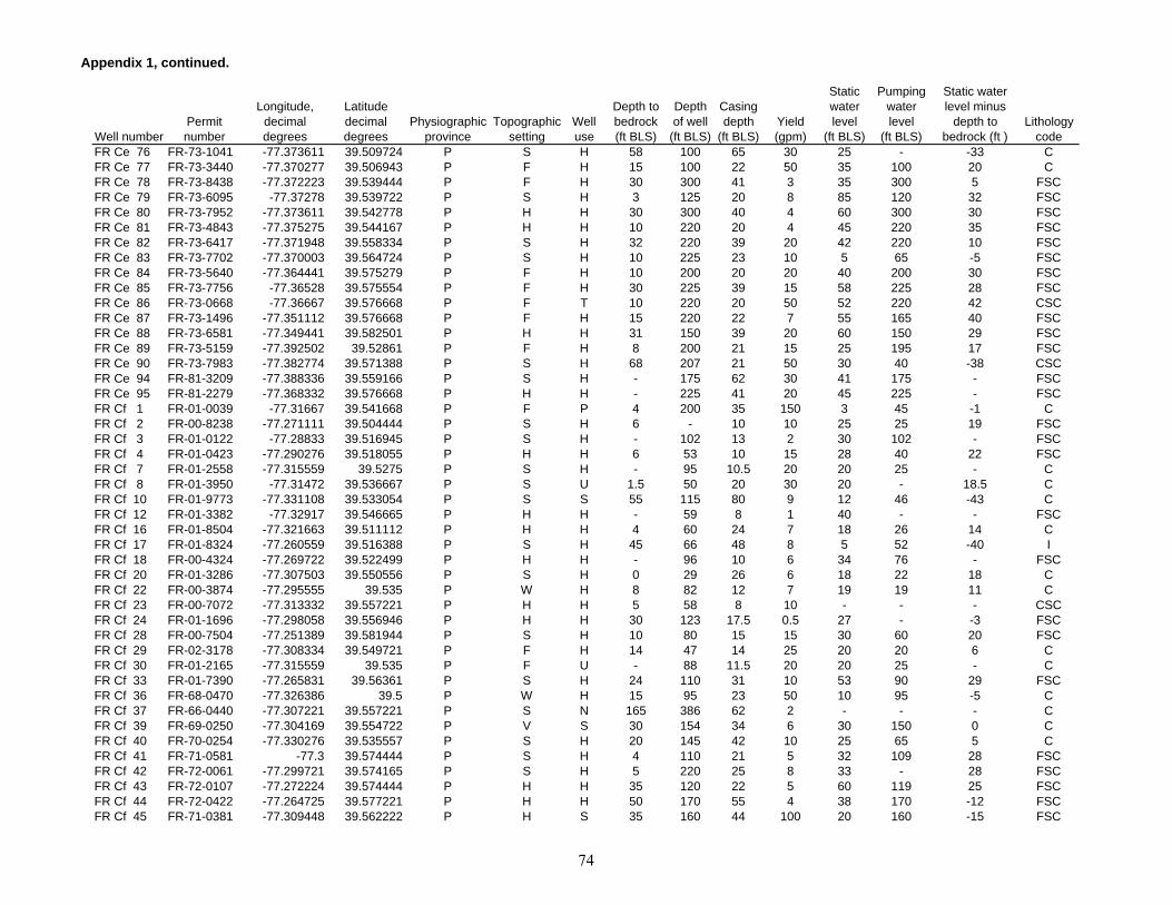
Appendix 1, continued.
Well numberPermit number
Longitude, decimal degrees
Latitude decimal degrees
Physiographic province
Topographic setting
Well use
Depth to bedrock (ft BLS)
Depth of well
(ft BLS)
Casing depth
(ft BLS)Yield (gpm)
Static water level
(ft BLS)
Pumping water level
(ft BLS)
Static water level minus
depth to bedrock (ft )
Lithology code
FR Ce 76 FR-73-1041 -77.373611 39.509724 P S H 58 100 65 30 25 - -33 CFR Ce 77 FR-73-3440 -77.370277 39.506943 P F H 15 100 22 50 35 100 20 CFR Ce 78 FR-73-8438 -77.372223 39.539444 P F H 30 300 41 3 35 300 5 FSCFR Ce 79 FR-73-6095 -77.37278 39.539722 P S H 3 125 20 8 85 120 32 FSCFR Ce 80 FR-73-7952 -77.373611 39.542778 P H H 30 300 40 4 60 300 30 FSCFR Ce 81 FR-73-4843 -77.375275 39.544167 P H H 10 220 20 4 45 220 35 FSCFR Ce 82 FR-73-6417 -77.371948 39.558334 P S H 32 220 39 20 42 220 10 FSCFR Ce 83 FR-73-7702 -77.370003 39.564724 P S H 10 225 23 10 5 65 -5 FSCFR Ce 84 FR-73-5640 -77.364441 39.575279 P F H 10 200 20 20 40 200 30 FSCFR Ce 85 FR-73-7756 -77.36528 39.575554 P F H 30 225 39 15 58 225 28 FSCFR Ce 86 FR-73-0668 -77.36667 39.576668 P F T 10 220 20 50 52 220 42 CSCFR Ce 87 FR-73-1496 -77.351112 39.576668 P F H 15 220 22 7 55 165 40 FSCFR Ce 88 FR-73-6581 -77.349441 39.582501 P H H 31 150 39 20 60 150 29 FSCFR Ce 89 FR-73-5159 -77.392502 39.52861 P F H 8 200 21 15 25 195 17 FSCFR Ce 90 FR-73-7983 -77.382774 39.571388 P S H 68 207 21 50 30 40 -38 CSCFR Ce 94 FR-81-3209 -77.388336 39.559166 P S H - 175 62 30 41 175 - FSCFR Ce 95 FR-81-2279 -77.368332 39.576668 P H H - 225 41 20 45 225 - FSCFR Cf 1 FR-01-0039 -77.31667 39.541668 P F P 4 200 35 150 3 45 -1 CFR Cf 2 FR-00-8238 -77.271111 39.504444 P S H 6 - 10 10 25 25 19 FSCFR Cf 3 FR-01-0122 -77.28833 39.516945 P S H - 102 13 2 30 102 - FSCFR Cf 4 FR-01-0423 -77.290276 39.518055 P H H 6 53 10 15 28 40 22 FSCFR Cf 7 FR-01-2558 -77.315559 39.5275 P S H - 95 10.5 20 20 25 - CFR Cf 8 FR-01-3950 -77.31472 39.536667 P S U 1.5 50 20 30 20 - 18.5 CFR Cf 10 FR-01-9773 -77.331108 39.533054 P S S 55 115 80 9 12 46 -43 CFR Cf 12 FR-01-3382 -77.32917 39.546665 P H H - 59 8 1 40 - - FSCFR Cf 16 FR-01-8504 -77.321663 39.511112 P H H 4 60 24 7 18 26 14 CFR Cf 17 FR-01-8324 -77.260559 39.516388 P S H 45 66 48 8 5 52 -40 IFR Cf 18 FR-00-4324 -77.269722 39.522499 P H H - 96 10 6 34 76 - FSCFR Cf 20 FR-01-3286 -77.307503 39.550556 P S H 0 29 26 6 18 22 18 CFR Cf 22 FR-00-3874 -77.295555 39.535 P W H 8 82 12 7 19 19 11 CFR Cf 23 FR-00-7072 -77.313332 39.557221 P H H 5 58 8 10 - - - CSCFR Cf 24 FR-01-1696 -77.298058 39.556946 P H H 30 123 17.5 0.5 27 - -3 FSCFR Cf 28 FR-00-7504 -77.251389 39.581944 P S H 10 80 15 15 30 60 20 FSCFR Cf 29 FR-02-3178 -77.308334 39.549721 P F H 14 47 14 25 20 20 6 CFR Cf 30 FR-01-2165 -77.315559 39.535 P F U - 88 11.5 20 20 25 - CFR Cf 33 FR-01-7390 -77.265831 39.56361 P S H 24 110 31 10 53 90 29 FSCFR Cf 36 FR-68-0470 -77.326386 39.5 P W H 15 95 23 50 10 95 -5 CFR Cf 37 FR-66-0440 -77.307221 39.557221 P S N 165 386 62 2 - - - CFR Cf 39 FR-69-0250 -77.304169 39.554722 P V S 30 154 34 6 30 150 0 CFR Cf 40 FR-70-0254 -77.330276 39.535557 P S H 20 145 42 10 25 65 5 CFR Cf 41 FR-71-0581 -77.3 39.574444 P S H 4 110 21 5 32 109 28 FSCFR Cf 42 FR-72-0061 -77.299721 39.574165 P S H 5 220 25 8 33 - 28 FSCFR Cf 43 FR-72-0107 -77.272224 39.574444 P H H 35 120 22 5 60 119 25 FSCFR Cf 44 FR-72-0422 -77.264725 39.577221 P H H 50 170 55 4 38 170 -12 FSCFR Cf 45 FR-71-0381 -77.309448 39.562222 P H S 35 160 44 100 20 160 -15 FSC
74

Appendix 1, continued.
Well numberPermit number
Longitude, decimal degrees
Latitude decimal degrees
Physiographic province
Topographic setting
Well use
Depth to bedrock (ft BLS)
Depth of well
(ft BLS)
Casing depth
(ft BLS)Yield (gpm)
Static water level
(ft BLS)
Pumping water level
(ft BLS)
Static water level minus
depth to bedrock (ft )
Lithology code
FR Cf 47 FR-03-4608 -77.313614 39.530834 P S P - 297 36 20 3 178 - CFR Cf 48 FR-73-7972 -77.310554 39.530834 P V N 40 70 53 100 15 60 -25 CFR Cf 49 FR-05-5162 -77.301666 39.522499 P S N 36 348 42 5 - 226 - CFR Cf 50 FR-72-0623 -77.303886 39.578335 P S U 8 395 19 15 38 395 30 CFR Cf 51 FR-73-3804 -77.300835 39.583057 P S H 10 225 20 7 38 225 28 FSCFR Cf 53 FR-02-0905 -77.269722 39.573891 P S N 122 200 124 110 38 150 -84 FSCFR Cf 54 FR-73-6805 -77.267219 39.575001 P S C 6 150 77 60 40 140 34 FSCFR Cf 56 FR-81-4568 -77.329719 39.547501 P S H 6 175 79 40 20 100 14 FSCFR Cg 2 - -77.233055 39.530834 P F H - 71 11 4.5 - - - IFR Cg 3 FR-01-8739 -77.233055 39.53278 P F H 36 100 36 6 40 - 4 IFR Cg 4 FR-00-3471 -77.233612 39.525833 P F H 80 100 - 7 36 36 -44 IFR Cg 5 FR-00-9383 -77.228332 39.576668 P S H 10 81 21 10 22 60 12 FSCFR Cg 6 FR-01-2220 -77.231941 39.529999 P F H 10 58 21 12 24 39 14 IFR Cg 7 FR-00-2276 -77.217499 39.571388 P S S 8 98 8 1.8 10 - 2 IFR Cg 9 FR-01-3951 -77.217499 39.570835 P S H - - - 7 31 86 - FSCFR Cg 10 FR-01-9359 -77.222778 39.571667 P S H - 120 17 14 48 - - FSCFR Cg 11 - -77.177223 39.509167 P S H - 349 - 8 - - - IFR Cg 12 - -77.16861 39.513332 P V H - 64 - 25 - - - IFR Cg 16 FR-05-3176 -77.180832 39.5275 P S H 14 250 18 2.5 30 249 16 IFR Cg 17 - -77.181389 39.527222 P S U - 270 - 0.5 - - - IFR Cg 18 - -77.181663 39.5275 P S U - 260 - 1 - - - IFR Cg 20 FR-72-0131 -77.245834 39.561943 P V H 35 165 41 8 10 165 -25 FSCFR Cg 21 FR-73-2208 -77.229721 39.53333 P S C 68 110 75 3 8 110 -60 FSCFR Cg 22 FR-73-1870 -77.233055 39.540279 P S T 3 125 20 12 40 120 37 FSCFR Cg 23 FR-73-3785 -77.232224 39.541111 P F R 30 145 61 6 30 40 0 FSCFR Cg 24 FR-73-7880 -77.220276 39.555 P H H 81 280 20 1 35 280 -46 FSCFR Cg 25 FR-73-7207 -77.219444 39.556389 P H H 15 220 20 3 30 210 15 FSCFR Cg 26 FR-73-1307 -77.21917 39.558334 P H H 3 402 36 1 - - - FSCFR Cg 27 FR-73-1932 -77.218056 39.560833 P S H 60 180 45 2 35 170 -25 FSCFR Cg 28 FR-73-3634 -77.21667 39.561943 P S H 58 395 63 1 66 395 8 FSCFR Cg 29 FR-73-8152 -77.209442 39.51667 P S H 25 220 41 4 25 220 0 IFR Ch 2 FR-73-3174 -77.142502 39.503334 P S H 20 282 38 2 48 58 28 IFR Ch 3 FR-73-3860 -77.14167 39.504166 P S H 28 153 20 3 26 140 -2 IFR Ch 4 FR-73-0550 -77.137779 39.507221 P S H 10 500 24 2 35 - 25 IFR Ch 5 FR-73-2050 -77.15583 39.515835 P S H 123 182 44 3 95 105 -28 IFR Db 1 FR-00-7477 -77.586113 39.459999 BR H S 6 49 14.5 35 6 6 0 IFR Db 4 FR-00-3293 -77.614166 39.495556 BR S H 21 70 21 6 39 58 18 IFR Db 5 FR-00-3218 -77.61994 39.497215 BR S H - 69.5 51 5 39 59 - IFR Db 6 FR-73-4556 -77.601944 39.454723 BR H H 40 150 41 5 50 97 10 IFR Db 7 FR-73-6540 -77.60083 39.435555 BR S H 44 100 48 20 35 100 -9 IFR Db 8 FR-70-0284 -77.619163 39.483055 BR S R 12 130 54 15 35 110 23 IFR Db 9 FR-73-3223 -77.592224 39.467777 BR S N 75 250 82 15 31 96 -44 IFR Db 10 FR-94-0115 -77.599464 39.450279 BR H H 49 200 60 20 46 200 -3 IFR Db 11 FR-73-8445 -77.600403 39.450302 BR S H 20 185 62 6 30 150 10 IFR Db 12 FR-88-4876 -77.600403 39.45137 BR H H 70 525 84 1.5 85 165 15 CSC
75

Appendix 1, continued.
Well numberPermit number
Longitude, decimal degrees
Latitude decimal degrees
Physiographic province
Topographic setting
Well use
Depth to bedrock (ft BLS)
Depth of well
(ft BLS)
Casing depth
(ft BLS)Yield (gpm)
Static water level
(ft BLS)
Pumping water level
(ft BLS)
Static water level minus
depth to bedrock (ft )
Lithology code
FR Db 13 FR-73-7436 -77.601769 39.452213 BR S H 87 145 94 20 86 145 -1 IFR Db 14 FR-88-1569 -77.601891 39.453194 BR S H 56 200 63 12 50 200 -6 IFR Db 15 FR-73-7214 -77.587898 39.46732 BR H H 44 300 51 2 45 300 1 IFR Db 16 FR-73-5282 -77.587936 39.468288 BR H H 30 125 41 8 30 120 0 IFR Db 17 FR-73-5250 -77.587776 39.468533 BR H H 60 385 66 2 50 300 -10 IFR Db 18 FR-73-3557 -77.585869 39.466972 BR H H 57 200 62 5 29 200 -28 IFR Db 19 FR-73-2889 -77.583962 39.468864 BR H H 55 195 60 8 48 195 -7 IFR Db 20 FR-73-3559 -77.583908 39.469391 BR H H 82 175 91 25 66 175 -16 IFR Db 21 FR-73-3130 -77.58448 39.468723 BR H H 40 150 46 15 52 150 12 IFR Db 22 FR-73-4255 -77.584984 39.468742 BR H H 108 250 116 20 36 80 -72 IFR Db 23 FR-73-7999 -77.585312 39.467499 BR S H 74 425 79 1 53 425 -21 IFR Db 24 FR-94-4467 -77.589394 39.419628 BR H H 50 300 59 4 27 300 -23 IFR Db 25 FR-73-5090 -77.590385 39.419792 BR H H 22 100 27 4 35 78 13 IFR Db 26 FR-88-0026 -77.613388 39.42717 BR H H 50 175 55 6 31 175 -19 IFR Db 27 FR-88-0027 -77.614151 39.427933 BR H H 54 300 63 5 30 300 -24 IFR Db 28 FR-88-0022 -77.614357 39.430103 BR H H 56 175 63 5 31 175 -25 IFR Db 29 FR-88-0024 -77.613556 39.427864 BR H H 56 600 63 1 30 160 -26 IFR Dc 1 FR-00-6004 -77.504997 39.426945 BR S H - 50 7 8 14 14 - IFR Dc 2 - -77.544167 39.445278 BR S U - 104 - 15 50 - - IFR Dc 3 FR-02-0551 -77.575836 39.492779 BR S H 35 58 35.5 10 44 49 9 IFR Dc 4 FR-01-2162 -77.5 39.439445 BR H H - 112 14 3 20 110 - IFR Dc 5 FR-01-2160 -77.500275 39.442223 BR H H - 113 15 8 15 35 - IFR Dc 6 FR-01-1210 -77.50222 39.452221 BR S H - 130 13 2 30 125 - IFR Dc 7 FR-00-9503 -77.53833 39.494446 BR S H - 66 45 10 15 25 - IFR Dc 8 FR-00-6422 -77.529724 39.491943 BR S H 0 21 21 7 5 12 5 CSCFR Dc 9 FR-01-9697 -77.537224 39.455002 BR F H 20 93 8 10 33 33 13 IFR Dc 10 FR-00-6161 -77.576942 39.434166 BR S H - 129 56 10 35 35 - IFR Dc 11 FR-01-1938 -77.575554 39.4375 BR H H 0 50 50 5 10 10 10 CSCFR Dc 12 FR-01-8227 -77.571663 39.440834 BR V H 40 60 - 8 30 35 -10 IFR Dc 13 FR-01-0944 -77.558052 39.446945 BR S C 6 69 12 10 14 60 8 IFR Dc 14 FR-00-5695 -77.559723 39.449165 BR S H 20 45 21 10 6 33 -14 IFR Dc 15 FR-00-9088 -77.574997 39.456665 BR S H - 103 38 10 30 50 - IFR Dc 16 FR-01-8163 -77.52639 39.438888 BR F P - 130 - 30 30 60 - IFR Dc 17 FR-00-8920 -77.50222 39.428055 BR S U 12 67 67 5 38 45 4.7 IFR Dc 19 FR-00-7979 -77.579719 39.452221 BR H H - 117 17 6 30 50 - IFR Dc 26 FR-00-6424 -77.502502 39.436943 BR S H - 95 10 1 45 90 - IFR Dc 27 - -77.501663 39.422779 BR S U - 100 - 25 - - - IFR Dc 31 - -77.554169 39.444168 BR S U - 375 - 30 60 - - IFR Dc 37 FR-04-8794 -77.514442 39.447224 BR V P 30 465 42 60 40 - 10 IFR Dc 38 FR-65-0491 -77.514442 39.447224 BR V P - 160 32.5 40 9 - - IFR Dc 39 FR-65-0491 -77.514168 39.447224 BR V P - 160 44 60 10 - - IFR Dc 40 FR-69-0071 -77.568886 39.4925 BR H C 40 395 46 4 30 395 -10 IFR Dc 41 FR-70-0509 -77.567497 39.492222 BR H U 110 375 44 4 50 180 -60 IFR Dc 42 FR-73-7278 -77.566391 39.491943 BR H N 10 220 41 20 46 185 36 IFR Dc 43 FR-69-0500 -77.568886 39.490276 BR S U 12 286 19 8 35 286 23 I
76
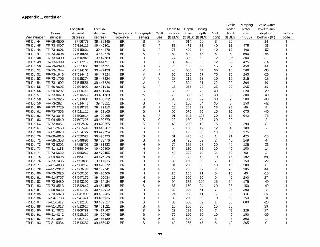
Appendix 1, continued.
Well numberPermit number
Longitude, decimal degrees
Latitude decimal degrees
Physiographic province
Topographic setting
Well use
Depth to bedrock (ft BLS)
Depth of well
(ft BLS)
Casing depth
(ft BLS)Yield (gpm)
Static water level
(ft BLS)
Pumping water level
(ft BLS)
Static water level minus
depth to bedrock (ft )
Lithology code
FR Dc 44 FR-69-0500 -77.56778 39.489445 BR S N 4 614 20 3 20 - 16 IFR Dc 45 FR-73-8007 -77.516113 39.442501 BR S P 53 475 63 40 18 475 -35 IFR Dc 46 FR-73-8006 -77.515831 39.44278 BR S P 75 400 84 40 18 400 -57 IFR Dc 47 FR-73-8006 -77.515556 39.44278 BR S U 50 500 63 6 5 500 -45 IFR Dc 48 FR-73-6400 -77.516945 39.44389 BR H P 74 300 80 12 105 300 31 IFR Dc 49 FR-73-6399 -77.517219 39.444721 BR H P 80 425 86 12 66 425 -14 IFR Dc 50 FR-73-6398 -77.51667 39.444721 BR H P 75 450 80 15 89 450 14 IFR Dc 51 FR-73-1944 -77.514168 39.447498 BR V P 48 500 54 30 10 500 -38 IFR Dc 52 FR-73-1943 -77.514442 39.447224 BR V P 30 265 37 75 10 265 -20 IFR Dc 53 FR-73-1706 -77.515274 39.447224 BR V U 28 215 33 10 10 215 -18 IFR Dc 54 FR-73-1602 -77.515556 39.447224 BR V U 10 304 31 22 20 304 10 IFR Dc 55 FR-66-0605 -77.504997 39.431946 BR S P 15 265 23 25 30 265 15 IFR Dc 56 FR-69-0207 -77.509445 39.431946 BR S P 50 220 70 30 30 220 -20 IFR Dc 57 FR-73-0070 -77.510277 39.431389 BR W P 70 300 76 30 30 300 -40 IFR Dc 58 FR-73-2825 -77.513886 39.430832 BR S P 90 300 97 30 7 300 -83 IFR Dc 59 FR-73-2824 -77.514442 39.43111 BR S P 48 150 54 35 6 150 -42 IFR Dc 60 FR-73-3729 -77.518333 39.433613 BR S P 26 205 37 35 35 45 9 IFR Dc 61 FR-73-7558 -77.521111 39.429165 BR S P 60 675 70 15 20 675 -40 IFR Dc 62 FR-73-8045 -77.508614 39.429165 BR S P 91 642 105 30 15 642 -76 IFR Dc 63 FR-04-6540 -77.507225 39.430279 BR S C 20 130 23 20 22 - 2 IFR Dc 64 FR-72-0051 -77.502502 39.420555 BR S R 42 290 49 15 50 290 8 IFR Dc 67 FR-81-2653 -77.567497 39.446667 BR S H - 100 42 12 4 100 - IFR Dc 68 FR-81-0079 -77.574722 39.447224 BR S H - 175 98 10 30 175 - IFR Dc 70 FR-88-4810 -77.530327 39.493393 BR S H 31 425 43 1 21 425 -10 IFR Dc 71 FR-88-1353 -77.549896 39.483776 BR S H 51 425 59 2 45 149 -6 IFR Dc 72 FR-73-5201 -77.55703 39.481232 BR H H 70 125 78 20 49 125 -21 IFR Dc 73 FR-81-3155 -77.556404 39.479599 BR H H 54 150 63 20 40 150 -14 IFR Dc 74 FR-73-5682 -77.555069 39.478455 BR H H 48 323 60 2 50 60 2 IFR Dc 75 FR-94-0098 -77.553719 39.476128 BR H H 19 242 42 10 78 192 59 IFR Dc 76 FR-73-7435 -77.553886 39.47625 BR H H 32 150 39 7 10 150 -22 IFR Dc 77 FR-81-4883 -77.560257 39.478672 BR H H 34 200 60 10 40 200 6 IFR Dc 78 FR-81-2312 -77.560432 39.477741 BR H H 29 205 39 3 75 185 46 IFR Dc 80 FR-73-2023 -77.560158 39.476269 BR H H 20 165 21 5 10 40 -10 IFR Dc 81 FR-81-5757 -77.547272 39.466034 BR H H 18 300 80 6 45 290 27 IFR Dc 82 FR-73-5480 -77.543297 39.464184 BR H H 94 175 100 15 54 175 -40 IFR Dc 83 FR-73-8513 -77.542847 39.464455 BR S H 87 150 94 20 38 150 -49 IFR Dc 84 FR-88-0088 -77.541496 39.458012 BR H H 33 200 41 7 24 200 -9 IFR Dc 85 FR-73-6978 -77.541908 39.457535 BR H H 24 205 41 5 50 80 26 IFR Dc 86 FR-94-1738 -77.541374 39.455936 BR H H 30 250 39 10 50 250 20 IFR Dc 87 FR-81-1417 -77.512138 39.462517 BR S H 80 600 89 1 60 600 -20 IFR Dc 88 FR-81-1017 -77.512917 39.461121 BR S H 16 150 26 15 55 - 39 IFR Dc 90 FR-81-3872 -77.509788 39.467197 BR S H 28 225 39 7 45 225 17 IFR Dc 91 FR-81-4242 -77.515137 39.465748 BR S H 76 150 86 10 46 150 -30 IFR Dc 92 FR-81-3964 -77.51429 39.465389 BR S H 60 300 70 6 46 300 -14 IFR Dc 93 FR-81-5334 -77.513382 39.465042 BR S H 40 265 45 6 40 265 0 I
77

Appendix 1, continued.
Well numberPermit number
Longitude, decimal degrees
Latitude decimal degrees
Physiographic province
Topographic setting
Well use
Depth to bedrock (ft BLS)
Depth of well
(ft BLS)
Casing depth
(ft BLS)Yield (gpm)
Static water level
(ft BLS)
Pumping water level
(ft BLS)
Static water level minus
depth to bedrock (ft )
Lithology code
FR Dc 94 FR-88-3230 -77.511459 39.464584 BR S H 86 525 92 1 57 191 -29 IFR Dc 95 FR-94-4990 -77.5121 39.464741 BR S H 40 400 104 1.6 50 400 10 IFR Dc 96 FR-81-2769 -77.516861 39.467091 BR H H 20 225 79 5 60 100 40 IFR Dc 97 FR-81-3268 -77.516975 39.467526 BR H H 10 150 21 10 30 150 20 IFR Dc 98 FR-81-3175 -77.517624 39.467457 BR H H 76 200 84 6 46 200 -30 IFR Dc 99 FR-81-4122 -77.518318 39.46841 BR H H 72 200 80 12 42 200 -30 IFR Dc 100 FR-81-3199 -77.518402 39.468185 BR H H 75 150 80 50 30 150 -45 IFR Dc 101 FR-73-8723 -77.521805 39.471119 BR H H 95 200 63 4 65 175 -30 IFR Dc 102 FR-81-1033 -77.521217 39.471008 BR H H 58 225 63 6 53 86 -5 IFR Dc 103 FR-73-6970 -77.52179 39.470955 BR H H 80 400 84 2 63 400 -17 IFR Dc 104 FR-73-6681 -77.521355 39.471355 BR H H 81 175 86 10 60 175 -21 IFR Dc 105 FR-73-2830 -77.506653 39.477909 BR H H - 100 42 20 30 90 - IFR Dc 106 FR-81-2612 -77.568939 39.44862 BR H H 22 450 41 2 18 145 -4 IFR Dc 107 FR-81-1679 -77.569794 39.447578 BR H H 56 300 63 4 25 300 -31 IFR Dc 108 FR-73-6416 -77.570068 39.44717 BR H H 47 125 52 20 45 125 -2 IFR Dc 109 FR-73-8059 -77.570953 39.445797 BR H H 55 125 63 20 25 125 -30 IFR Dc 110 FR-81-2356 -77.572601 39.448593 BR H H 82 300 93 4 40 300 -42 IFR Dc 111 FR-73-7846 -77.572166 39.448212 BR H H 10 125 22 15 30 50 20 IFR Dc 112 FR-81-0878 -77.573402 39.447006 BR H H 56 200 63 10 17 81 -39 IFR Dc 113 FR-73-7920 -77.582207 39.466122 BR H H 57 475 63 1 55 475 -2 IFR Dc 114 FR-81-2158 -77.582481 39.46645 BR H H 26 305 44 3 42 105 16 IFR Dc 115 FR-81-5550 -77.582741 39.466476 BR H H 15 420 78 6 70 420 55 IFR Dc 116 FR-81-3090 -77.556457 39.451069 BR H H 31 225 39 20 55 225 24 CSCFR Dc 117 FR-81-3163 -77.557968 39.449368 BR S H 46 125 52 20 21 125 -25 IFR Dc 118 FR-94-1287 -77.523315 39.424072 BR S H 53 200 59 10 24 200 -29 IFR Dc 119 FR-94-1288 -77.522446 39.424026 BR S H 31 200 39 10 20 200 -11 IFR Dc 120 FR-94-1284 -77.522568 39.425468 BR S H 72 175 79 10 43 175 -29 IFR Dc 121 FR-94-1283 -77.522636 39.425522 BR S H 60 250 70 8 42 250 -18 IFR Dc 122 FR-94-1277 -77.520035 39.423237 BR S H 90 200 99 8 30 200 -60 IFR Dc 123 FR-94-1268 -77.520454 39.423405 BR S H 52 150 59 20 24 150 -28 IFR Dc 124 FR-94-1289 -77.521126 39.42329 BR S H 51 250 59 30 22 250 -29 IFR Dc 125 FR-73-3001 -77.523018 39.419437 BR S H 15 250 21 4 26 250 11 IFR Dc 126 FR-94-1265 -77.518784 39.421894 BR S H 52 175 59 20 31 175 -21 IFR Dc 127 FR-88-0329 -77.577049 39.416763 BR H H 45 525 56 2 43 152 -2 IFR Dc 128 FR-81-5885 -77.551392 39.441509 BR S H 36 180 38 15 37 180 1 IFR Dc 129 FR-73-7640 -77.550903 39.44006 BR S H 46 175 52 5 40 175 -6 IFR Dc 130 FR-73-6889 -77.550522 39.439507 BR H H 54 150 60 20 53 150 -1 IFR Dc 131 FR-81-5973 -77.551544 39.436127 BR S H 31 200 38 6 54 96 23 IFR Dc 132 FR-73-5498 -77.550316 39.435173 BR S H 15 405 20 3 30 375 15 IFR Dc 133 FR-73-4082 -77.550781 39.434799 BR S H 10 400 20 2 40 400 30 IFR Dc 135 FR-73-7322 -77.58165 39.430225 BR S H 41 200 47 4 40 200 -1 IFR Dc 136 FR-73-4275 -77.581978 39.431572 BR H H 15 150 32 4 27 130 12 IFR Dc 137 FR-73-4280 -77.582497 39.432266 BR H H 25 140 30 4 28 130 3 IFR Dc 138 FR-73-4069 -77.582725 39.432613 BR H H 4 100 21 10 40 95 36 IFR Dc 139 FR-81-1573 -77.569252 39.448368 BR H H 57 500 63 2 10 143 -47 I
78

Appendix 1, continued.
Well numberPermit number
Longitude, decimal degrees
Latitude decimal degrees
Physiographic province
Topographic setting
Well use
Depth to bedrock (ft BLS)
Depth of well
(ft BLS)
Casing depth
(ft BLS)Yield (gpm)
Static water level
(ft BLS)
Pumping water level
(ft BLS)
Static water level minus
depth to bedrock (ft )
Lithology code
FR Dd 1 - -77.444168 39.43111 P F T - - - 75 - - - CFR Dd 3 FR-01-0805 -77.453331 39.440834 P S T 45 140 45 65 30 - -15 CSCFR Dd 5 - -77.467224 39.44611 BR F U - 996 - 70 - - - CSCFR Dd 7 FR-00-6768 -77.495834 39.421665 BR S H 18 154 153.5 5 53 73 35 CSCFR Dd 8 FR-00-9443 -77.497498 39.422222 BR S C 18 100 100 2 40 94 22 CSCFR Dd 9 FR-02-2652 -77.469719 39.429165 P S H 16 209 23 3 - 209 - CSCFR Dd 10 - -77.496666 39.421391 BR S U - 500 8 10 15 - - CSCFR Dd 13 FR-01-5755 -77.495003 39.441944 BR V P 35 85 42 50 5 11 -30 IFR Dd 14 FR-01-5111 -77.475281 39.425835 BR S H 50 85 27 10 30 60 -20 FSCFR Dd 15 FR-00-3580 -77.466392 39.435276 BR S H 0 124 - 3 6 110 6 CSCFR Dd 16 FR-00-7489 -77.470833 39.429722 P H H - 88 35 3 30 70 - FSCFR Dd 17 FR-00-8522 -77.472221 39.430832 BR H H - 122 9 2.5 20 40 - FSCFR Dd 18 FR-00-8327 -77.475555 39.45 BR S H 8 88 12 2.5 48 77 40 CSCFR Dd 20 FR-00-5369 -77.477501 39.45639 BR S H - 90 6 3.5 36 80 - CSCFR Dd 21 FR-01-1215 -77.470833 39.457222 BR S H - 105 18 1 20 100 - FSCFR Dd 22 FR-01-2513 -77.464996 39.456944 BR H H - 130 28 15 30 50 - FSCFR Dd 23 FR-01-1590 -77.464165 39.456944 BR H H 70 90 22 3 25 80 -45 FSCFR Dd 24 FR-01-4599 -77.458885 39.455833 BR H H 5 80 13 5 35 70 30 CSCFR Dd 25 FR-01-3047 -77.456108 39.450832 P S H 19 93 23 12 23 76 4 FSCFR Dd 26 FR-01-4022 -77.449448 39.445 P F H - 70 60 3 - - - CSCFR Dd 29 FR-00-7021 -77.477501 39.452221 BR S H 21 62 21 6 30 45 9 CSCFR Dd 30 FR-00-3728 -77.467224 39.448055 BR S H 30 70 30 6 35 55 5 FSCFR Dd 31 FR-00-9943 -77.469444 39.464722 BR S H - 104 12 2 30 104 - CSCFR Dd 33 FR-01-8452 -77.44278 39.463612 P H H - 75 25 9 32 48 - FSCFR Dd 35 FR-00-5057 -77.435554 39.469723 P H S - 100 14 6 25 80 - FSCFR Dd 37 FR-00-9916 -77.43333 39.470833 P H H - 90 15 5 10 86 - FSCFR Dd 40 FR-00-8873 -77.424446 39.477501 P V T - 34 - 3 2 30 - FSCFR Dd 41 FR-00-8581 -77.430832 39.485554 P S H - 69 33 4 20 50 - FSCFR Dd 43 FR-01-6558 -77.453888 39.49361 P F H 0 25 25 4 10 23 10 CSCFR Dd 44 FR-01-8451 -77.457779 39.489723 P S P - 214 100 50 25 50 - CSCFR Dd 45 FR-01-0139 -77.420281 39.471943 P H H 70 81 75 15 60 - -10 CFR Dd 46 FR-00-9076 -77.420281 39.433613 P S H 20 65 24 10 30 40 -10.53 CFR Dd 47 FR-01-0382 -77.485275 39.424168 BR H H 55 160 22 2 43 150 -12 FSCFR Dd 48 FR-00-9421 -77.484444 39.421944 BR S H - 135 16 0.5 25 130 - FSCFR Dd 49 FR-00-6680 -77.486664 39.419167 BR H H - 128 20 2.5 50 120 - FSCFR Dd 50 FR-01-2439 -77.47139 39.422222 BR H H - 75 15 8 33 65 - CSCFR Dd 51 FR-01-2438 -77.471664 39.421665 BR S H 40 77 23 4 30 65 -10 CSCFR Dd 52 FR-01-3309 -77.481392 39.426388 BR S H - 100 11 5 10 50 - FSCFR Dd 53 FR-01-7490 -77.485558 39.427502 BR S H 18 36 20 5 9 30 -9 CSCFR Dd 54 FR-00-8026 -77.486946 39.444443 BR S H 30 60 36 15 20 - -10 CSCFR Dd 56 FR-00-9476 -77.486389 39.445 BR S U - 80 33 3 25 50 - CSCFR Dd 57 FR-01-1901 -77.493889 39.44389 BR S H 20 84 50 3 22 25 2 IFR Dd 59 FR-01-4519 -77.444168 39.41667 P S C 12 125 15.5 10 35 70 23 CSCFR Dd 60 FR-01-2164 -77.448891 39.417221 P S C - 30 22 20 15 20 - CSCFR Dd 61 FR-00-4759 -77.449722 39.416943 P S H 30 41 32 15 17 19 -13 CSC
79

Appendix 1, continued.
Well numberPermit number
Longitude, decimal degrees
Latitude decimal degrees
Physiographic province
Topographic setting
Well use
Depth to bedrock (ft BLS)
Depth of well
(ft BLS)
Casing depth
(ft BLS)Yield (gpm)
Static water level
(ft BLS)
Pumping water level
(ft BLS)
Static water level minus
depth to bedrock (ft )
Lithology code
FR Dd 63 FR-01-9348 -77.467781 39.422779 P F C 25 214 28 10 10 180 -15 CSCFR Dd 65 FR-02-2294 -77.444443 39.499168 P F H - 56 22 10 8 22 - CSCFR Dd 66 FR-01-3077 -77.436943 39.422222 P V H - 92 9 25 10 - - CFR Dd 68 FR-01-1300 -77.495552 39.446945 BR S C 55 76 23 12 17 - -38 IFR Dd 70 FR-01-0807 -77.453888 39.471943 P S H - 98 39 2 10 80 - CFR Dd 73 FR-01-0812 -77.460831 39.479443 BR S H - 140 14 1.5 20 120 - FSCFR Dd 74 - -77.469719 39.486111 BR V U - 21.1 - 4.4 8.51 8.76 - FSCFR Dd 76 FR-01-1056 -77.459442 39.477779 BR H H - 105 9 20 30 40 - FSCFR Dd 77 FR-00-9493 -77.477501 39.420834 BR H H - 73 18 6 20 30 - FSCFR Dd 79 FR-04-9969 -77.495552 39.448334 BR S P - 455 62 40 12 - - IFR Dd 82 FR-04-5773 -77.451386 39.474167 P V T 40 200 46 35 35 - -5 CFR Dd 83 - -77.460281 39.440277 P S U - 84 - 3 - - - CFR Dd 84 FR-70-0032 -77.459724 39.440556 P V U - 320 - 0.5 - - - CFR Dd 85 FR-70-0232 -77.459999 39.439999 P S U - 220 - 3 - - - CFR Dd 86 FR-70-0232 -77.459168 39.439445 P S S 50 129 83 100 50 129 0 CFR Dd 88 FR-69-0034 -77.449448 39.495834 P F S - 204 39 5 35 - - CFR Dd 89 FR-70-0417 -77.455002 39.472778 BR S H 110 255 124 15 51 - -59 FSCFR Dd 90 FR-70-0355 -77.418335 39.451389 P F Z 20 160 48 12 30 160 10 FSCFR Dd 91 FR-70-0017 -77.430557 39.457222 P S R 18 245 25 5 15 245 -3 FSCFR Dd 92 FR-69-0430 -77.432777 39.454166 P V H 20 45 27.5 50 30 45 10 CFR Dd 93 FR-69-0183 -77.433052 39.453888 P V H 40 70 49 50 35 70 -5 CFR Dd 94 FR-70-0151 -77.429726 39.451389 P F H 50 220 57 3 35 220 -15 CFR Dd 95 FR-70-0353 -77.430557 39.450832 P F H 32 145 40 20 35 145 3 CFR Dd 96 FR-70-0380 -77.438332 39.448334 P V H - 150 18 40 - - - CFR Dd 97 FR-70-0031 -77.438332 39.450279 P S H - 162 17 20 30 - - CFR Dd 98 FR-70-0236 -77.436943 39.449165 P F H - 90 38 50 - - - CFR Dd 99 FR-70-0093 -77.438057 39.450279 P F H 20 98 83 40 45 - 25 CFR Dd 100 FR-70-0470 -77.436386 39.449722 P F H 20 100 39 50 20 - 0 CFR Dd 101 FR-70-0060 -77.437225 39.451111 P F H - 142 86 8 35 - - CFR Dd 102 FR-69-0429 -77.424721 39.451668 P F H 50 320 61 5 40 320 -10 CFR Dd 103 FR-69-0479 -77.423889 39.451111 P F H 60 81 74 100 40 81 -20 CFR Dd 104 FR-70-0023 -77.424721 39.451389 P F H 40 195 73 10 35 195 -5 CFR Dd 105 FR-70-0024 -77.424721 39.451111 P F H 95 102 102 8 35 102 -60 CFR Dd 106 FR-70-0073 -77.424164 39.451946 P F H 43 210 50 6 40 210 -3 CFR Dd 107 FR-70-0113 -77.423332 39.450554 P F H 10 220 40 4 35 220 25 CFR Dd 108 FR-70-0362 -77.424164 39.451389 P F H 85 88 86 30 35 88 -50 CFR Dd 109 FR-69-0334 -77.422501 39.452499 P F H 45 58 48 20 40 58 -5 CFR Dd 110 FR-69-0247 -77.424164 39.449165 P F H 15 240 20 6 40 240 25 CFR Dd 111 FR-69-0372 -77.424164 39.449722 P F H 35 95 41 15 35 95 0 CFR Dd 112 FR-69-0331 -77.423332 39.450279 P F H 35 395 44 2 35 395 0 CFR Dd 113 FR-69-0067 -77.423614 39.45 P F H 35 315 41 50 35 315 0 CFR Dd 114 FR-69-0215 -77.423058 39.450832 P F H 15 60 20.5 50 30 60 15 CFR Dd 115 FR-69-0530 -77.424446 39.449165 P F H 20 145 28 20 35 145 15 CFR Dd 116 FR-69-0529 -77.424446 39.448612 P F H 10 220 20 7 40 220 30 CFR Dd 117 FR-69-0428 -77.422775 39.451946 P F H 30 83 37 50 38 83 8 C
80

Appendix 1, continued.
Well numberPermit number
Longitude, decimal degrees
Latitude decimal degrees
Physiographic province
Topographic setting
Well use
Depth to bedrock (ft BLS)
Depth of well
(ft BLS)
Casing depth
(ft BLS)Yield (gpm)
Static water level
(ft BLS)
Pumping water level
(ft BLS)
Static water level minus
depth to bedrock (ft )
Lithology code
FR Dd 118 FR-70-0295 -77.424446 39.45 P F H 45 133 71 10 35 133 -10 CFR Dd 119 FR-70-0393 -77.424446 39.449444 P F H 17 70 27 100 32 70 15 CFR Dd 120 FR-69-0362 -77.424446 39.452499 P F H 50 145 61 40 35 145 -15 CFR Dd 121 FR-70-0328 -77.424164 39.452778 P F H 70 220 78 5 40 220 -30 CFR Dd 122 FR-70-0370 -77.423058 39.452778 P F H 90 100 95 20 32 100 -58 CFR Dd 123 FR-69-0373 -77.425552 39.449722 P H H 50 80 61 40 35 80 -15 CFR Dd 124 FR-69-0046 -77.425278 39.450279 P F H 60 105 69 25 35 105 -25 CFR Dd 125 FR-69-0213 -77.426109 39.450554 P F H 75 395 84 5 40 395 -35 CFR Dd 126 FR-70-0202 -77.426109 39.45 P H H 48 100 53 15 35 100 -13 CFR Dd 127 FR-69-0427 -77.426941 39.451668 P F H 35 365 44 4 35 365 0 CFR Dd 128 FR-69-0374 -77.426109 39.451668 P F H 40 245 50 4 35 245 -5 CFR Dd 129 FR-69-0478 -77.431389 39.449722 P F H 25 85 31 50 35 85 10 CFR Dd 130 FR-67-0289 -77.426392 39.448334 P H H 110 170 115 100 45 170 -65 CFR Dd 131 FR-69-0531 -77.42778 39.448334 P F H 20 185 30 15 35 185 15 CFR Dd 132 FR-70-0072 -77.428612 39.448612 P F H 27 180 35 50 35 180 8 CFR Dd 133 FR-70-0359 -77.42778 39.448891 P F H 25 70 35 50 30 70 5 CFR Dd 134 FR-70-0155 -77.46667 39.41861 P V H 35 45 28 20 25 40 -10 CSCFR Dd 135 FR-72-0124 -77.424721 39.477779 P S H 35 90 40 6 20 90 -15 FSCFR Dd 136 FR-71-0560 -77.432503 39.485001 P H H - 105 21 12 30 100 - FSCFR Dd 137 FR-72-0014 -77.431663 39.483891 P H H - 105 22 15 30 90 - FSCFR Dd 138 FR-72-0015 -77.432221 39.484165 P H H - 105 22 15 30 95 - FSCFR Dd 139 FR-72-0332 -77.419998 39.490833 P H H 30 220 40 2 45 220 15 FSCFR Dd 140 FR-72-0474 -77.440559 39.497776 P S H 45 80 50 40 10 80 -35 FSCFR Dd 141 FR-72-0157 -77.440834 39.460556 P S S - 122 47 50 40 - - FSCFR Dd 142 FR-69-0420 -77.466392 39.420834 P S H 58 285 67 6 60 250 2 CSCFR Dd 143 FR-72-0458 -77.423332 39.489445 P H H 35 120 41 4 25 120 -10 FSCFR Dd 144 FR-72-0490 -77.419441 39.49139 P H H 35 195 41 6 55 195 20 FSCFR Dd 145 FR-72-0497 -77.431663 39.485279 P H H 30 120 34 20 35 120 5 FSCFR Dd 146 FR-72-0541 -77.441666 39.459721 P H T 20 130 30 30 18 - -2 FSCFR Dd 147 FR-72-0730 -77.444443 39.462223 P S H 5 160 39 15 35 - 30 FSCFR Dd 148 - -77.42083 39.456944 P H U - 355 20 7 - - - FSCFR Dd 150 - -77.421669 39.45861 P H P - 205 20 100 33 - - CFR Dd 153 - -77.422501 39.457222 P H U - 205 22 4 - - - CFR Dd 154 FR-72-0637 -77.422501 39.490555 P H H 3 182 22 5 38 - 35 FSCFR Dd 155 FR-70-0170 -77.458611 39.416943 P S H 35 145 42 50 38 145 3 CSCFR Dd 156 FR-70-0511 -77.41861 39.49139 P H H - 165 21 5 45 160 - FSCFR Dd 157 FR-69-0344 -77.419167 39.489445 P H H - 165 21 7 45 - - FSCFR Dd 158 FR-71-0585 -77.41861 39.488888 P H H - 180 21 10 65 175 - FSCFR Dd 159 FR-70-0102 -77.419724 39.490276 P H H 30 100 30 5 25 90 -5 FSCFR Dd 160 FR-70-0465 -77.41861 39.492222 P S H - 160 18 8 40 150 - FSCFR Dd 161 FR-69-0426 -77.418335 39.491943 P S H - 65 19 12 30 - - FSCFR Dd 162 FR-73-0398 -77.420555 39.489723 P H H - 170 36 6 40 130 - FSCFR Dd 163 FR-66-0412 -77.420281 39.490555 P H H 75 165 41 5 50 158 -25 FSCFR Dd 164 FR-66-0822 -77.418892 39.489723 P S H 75 185 19 8 65 - -10 FSCFR Dd 165 FR-69-0408 -77.417503 39.488609 P V H 19 125 19 7 40 - 21 FSC
81

Appendix 1, continued.
Well numberPermit number
Longitude, decimal degrees
Latitude decimal degrees
Physiographic province
Topographic setting
Well use
Depth to bedrock (ft BLS)
Depth of well
(ft BLS)
Casing depth
(ft BLS)Yield (gpm)
Static water level
(ft BLS)
Pumping water level
(ft BLS)
Static water level minus
depth to bedrock (ft )
Lithology code
FR Dd 167 FR-71-0500 -77.417778 39.489723 P S H 55 195 61 12 35 195 -20 FSCFR Dd 168 FR-69-0436 -77.419998 39.491943 P H H - 108 24 6 50 90 - FSCFR Dd 170 FR-66-0810 -77.421112 39.490833 P H H - 165 13 3 70 - - FSCFR Dd 173 FR-04-4282 -77.421944 39.490002 P H H 13 135 13 3 40 - 27 FSCFR Dd 174 FR-72-0459 -77.420281 39.4925 P H H 37 220 43 7 52 220 15 FSCFR Dd 175 FR-69-0333 -77.419167 39.491943 P H H 15 165 20 50 40 155 25 FSCFR Dd 176 FR-69-0438 -77.496666 39.421391 BR S P 30 400 - 8 40 - 10 CSCFR Dd 177 FR-73-5317 -77.477501 39.479721 BR S H 30 225 34 9 54 225 24 CSCFR Dd 179 FR-05-1109 -77.491669 39.472221 BR S P 20 190 27 20 30 - 10 CSCFR Dd 180 FR-73-2531 -77.493332 39.459168 BR S P 52 275 59 8 50 275 -2 IFR Dd 181 FR-73-1900 -77.495003 39.45 BR S T 6 125 21 20 15 120 9 IFR Dd 182 FR-73-1770 -77.478889 39.421391 BR S H 20 400 38 2 29 400 9 FSCFR Dd 183 FR-73-8382 -77.477219 39.421665 BR S I 15 205 48 20 20 200 5 FSCFR Dd 184 FR-72-0481 -77.474724 39.421112 BR H C 20 150 23 5 35 150 15 CSCFR Dd 185 FR-73-8305 -77.462219 39.419167 P S C 200 485 62 9 50 450 -150 CFR Dd 187 FR-65-0593 -77.461113 39.419998 P F U 80 125 50 10 15 - -65 CFR Dd 188 FR-04-2737 -77.444168 39.416943 P F C 20 205 19 1 100 - 80 CSCFR Dd 189 FR-01-2146 -77.46833 39.423889 P F U 5 - 21 30 18 18 13 CSCFR Dd 190 FR-03-7629 -77.468887 39.424168 P F U - 64 60 40 20 20 - CSCFR Dd 191 FR-73-0071 -77.472504 39.425835 P S C 40 220 44 1 10 220 -30 FSCFR Dd 192 FR-73-8185 -77.475281 39.426388 BR S C 30 425 40 3 16 425 -14 FSCFR Dd 193 FR-73-6570 -77.474724 39.439445 BR S C 4 250 33 1 40 200 36 FSCFR Dd 193a FR-73-1455 -77.474724 39.439445 BR S C 4 250 33 20 10 - 6 FSCFR Dd 194 FR-73-8151 -77.474441 39.439445 BR S C 35 525 41 2 1 525 -34 FSCFR Dd 195 FR-71-0357 -77.480278 39.426945 BR S C 0 186 18 4 2 185 2 FSCFR Dd 196 FR-73-1778 -77.424164 39.423332 P F I 9 125 20 12 25 120 16 FSCFR Dd 197 FR-73-2750 -77.446114 39.463333 P H T 15 122 40 6 32 42 17 FSCFR Dd 198 FR-69-0203 -77.428612 39.474724 P F P 125 220 134 40 40 220 -85 FSCFR Dd 199 FR-67-0245 -77.430557 39.487221 P H T 0 145 21 20 60 - 60 FSCFR Dd 200 FR-73-6528 -77.428055 39.489445 P S H 15 205 39 40 48 195 33 FSCFR Dd 201 FR-73-5582 -77.427498 39.491665 P S H 9 125 19 5 30 85 21 FSCFR Dd 202 FR-73-2467 -77.425278 39.490833 P S H 35 120 39 10 20 120 -15 FSCFR Dd 203 FR-73-3446 -77.417221 39.49139 P H H 28 203 39 8 45 55 17 FSCFR Dd 204 FR-73-4963 -77.417778 39.490276 P H H 10 150 20 10 35 140 25 FSCFR Dd 205 FR-73-4034 -77.41667 39.488888 P H H 60 175 75 7 35 170 -25 FSCFR Dd 206 FR-69-0546 -77.495834 39.446945 BR S C 32 450 40 6 45 - 13 IFR Dd 207 FR-73-8075 -77.495834 39.447498 BR S C 29 145 41 12 45 100 16 IFR Dd 208 FR-73-0669 -77.458054 39.418335 P S U 25 270 30 10 8 270 -17 IFR Dd 209 FR-73-2513 -77.485001 39.423889 BR H T 70 295 82 1 62 295 -8 FSCFR Dd 214 FR-73-6168 -77.470833 39.482224 BR S H - 200 41 5 55 200 - CSCFR Dd 215 FR-88-0607 -77.445 39.471668 P S H - 400 64 3 40 141 - FSCFR Dd 216 FR-81-1722 -77.477776 39.47889 BR S H - 300 63 4 70 300 - CSCFR Dd 217 FR-73-7996 -77.465553 39.46389 BR S H 1 403 55 4 45 380 44 FSCFR Dd 218 FR-81-3547 -77.444168 39.471943 P S H 6 300 44 10 40 200 34 FSCFR De 1 FR-01-2231 -77.414169 39.448334 P F H 18 87 18 25 20 25 2 C
82

Appendix 1, continued.
Well numberPermit number
Longitude, decimal degrees
Latitude decimal degrees
Physiographic province
Topographic setting
Well use
Depth to bedrock (ft BLS)
Depth of well
(ft BLS)
Casing depth
(ft BLS)Yield (gpm)
Static water level
(ft BLS)
Pumping water level
(ft BLS)
Static water level minus
depth to bedrock (ft )
Lithology code
FR De 3 FR-01-0978 -77.33667 39.431946 P H H 6 41 - 5 18 20 12 FSCFR De 4 FR-01-0120 -77.334168 39.452778 P S H 8 97 14 10 20 25 12 CFR De 5 FR-01-2735 -77.346664 39.422222 P H H - 40 34 10 15 - - CSCFR De 6 FR-01-3826 -77.367775 39.464722 P F U 23 40 28 10 25 - 2 CSCFR De 7 FR-01-6280 -77.359726 39.471111 P F H 40 123 51 45 30 - -10 CFR De 9 FR-01-5852 -77.356667 39.474998 P S H 38 65 59 22 32 40 -6 CFR De 10 FR-00-9930 -77.35611 39.475834 P S H 19 111 18 2.5 30 100 11 CFR De 11 FR-00-4190 -77.371109 39.474167 P F H 3 83 6 10 16 - 13 CFR De 12 FR-01-4256 -77.371391 39.485001 P F H 23 84 23 15 30 30 7 CFR De 13 FR-00-8891 -77.354164 39.486111 P F U 21 70 21 100 15 15 -6 CFR De 15 FR-01-6192 -77.368332 39.465 P F H 13 71 45 30 48 48 35 CFR De 16 FR-01-7513 -77.403053 39.485001 P S H 14 55 18 13 5 5.3 -9 CFR De 17 FR-00-8269 -77.385002 39.474724 P S H - 43 21 10 15 20 - CFR De 20 FR-01-7512 -77.402779 39.465832 P S C - 37 30 10 12 - - CFR De 21 FR-00-4439 -77.39917 39.447498 P H U - 22 4.5 10 10 - - CFR De 25 FR-00-9424 -77.397781 39.441666 P H C - 100 14.5 20 30 - - CFR De 26 FR-02-3104 -77.410004 39.455833 P S H 10 70 19 6 20 60 10 CFR De 27 - -77.399445 39.439724 P F U - 200 - 80 28 - - CFR De 28 - -77.399719 39.440277 P S C - 735 - 30 28 - - CFR De 29 - -77.401108 39.441387 P V N - 30 - 30 - - - CFR De 30 - -77.400833 39.440277 P S U - 235 - 30 20 - - CFR De 31 - -77.400833 39.440277 P S U - 350 - 30 - - - CFR De 32 - -77.410004 39.419998 P F U - 68 - 50 - - - CFR De 33 - -77.344444 39.493057 P V S - 72 - 10 - - - CFR De 34 FR-02-2022 -77.344444 39.493057 P V H 15 330 26 100 25 30 10 CFR De 35 - -77.355278 39.485001 P V U - - 20 60 10 - - CFR De 36 - -77.384445 39.466946 P V H - 169 59 15 - - - CFR De 37 FR-01-5831 -77.356941 39.474445 P S H 21 96 26 22 - 70 - CFR De 40 FR-01-6562 -77.361114 39.455833 P S S 30 105 52.5 10 50 60 20 CFR De 41 - -77.375832 39.435001 P F H - 90 - 7 35 - - CFR De 43 - -77.375557 39.436943 P H S 68 595 123 22 80 - 12 CFR De 44 - -77.35611 39.485001 P V P - 92 - 100 16 24 - CFR De 47 FR-65-0017 -77.349167 39.486668 P F P - 165 14.5 135 24.13 35.41 - CFR De 48 FR-66-0555 -77.355278 39.485001 P V U - 72 56 250 15 20 - CFR De 49 FR-70-0002 -77.333885 39.493332 P F H 40 105 47 7 30 100 -10 CFR De 51 FR-04-4852 -77.357498 39.489166 P S Z 10 175 11.5 50 22 24 12 CFR De 52 FR-69-0375 -77.375 39.494167 P H H 15 160 26 3 40 160 25 CFR De 53 FR-69-0419 -77.396111 39.481945 P F C - 280 42 2 40 - - CFR De 54 FR-69-0018 -77.402779 39.468056 P S C 20 103 16 30 - - - CFR De 55 FR-69-0414 -77.383057 39.449722 P S H 15 100 33 5 40 - 25 CFR De 57 FR-70-0019 -77.39917 39.46667 P H S 40 80 48 100 35 80 -5 CFR De 58 FR-70-0020 -77.413055 39.473888 P H H 35 70 41 30 30 70 -5 CFR De 59 FR-68-0080 -77.404724 39.453888 P H U 12 294 24 1 30 - 18 CFR De 60 FR-68-0080 -77.404167 39.453609 P H U 11 204 20 1 30 - 19 CFR De 61 FR-68-0080 -77.403892 39.454166 P H N 12 204 20 8 23.5 - 11.5 C
83
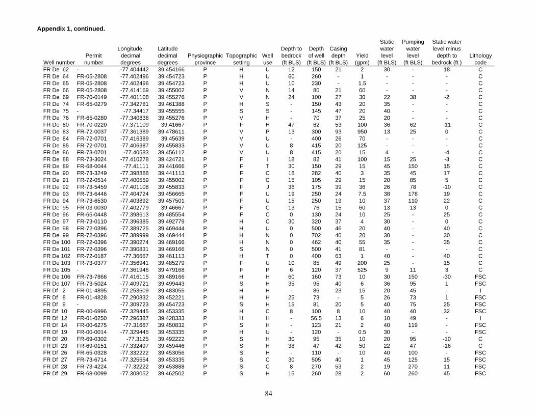
Appendix 1, continued.
Well numberPermit number
Longitude, decimal degrees
Latitude decimal degrees
Physiographic province
Topographic setting
Well use
Depth to bedrock (ft BLS)
Depth of well
(ft BLS)
Casing depth
(ft BLS)Yield (gpm)
Static water level
(ft BLS)
Pumping water level
(ft BLS)
Static water level minus
depth to bedrock (ft )
Lithology code
FR De 62 - -77.404442 39.454166 P H U 12 150 21 2 30 - 18 CFR De 64 FR-05-2808 -77.402496 39.454723 P H U 60 260 - 1 - - - CFR De 65 FR-05-2808 -77.402496 39.454723 P H U 10 230 - 1.5 - - - CFR De 66 FR-05-2808 -77.414169 39.455002 P V N 14 80 21 60 - - - CFR De 69 FR-70-0149 -77.401108 39.455276 P V N 24 100 27 30 22 38 -2 CFR De 74 FR-65-0279 -77.342781 39.461388 P H S - 150 43 20 35 - - CFR De 75 - -77.34417 39.455555 P S S - 145 47 20 40 - - CFR De 76 FR-65-0280 -77.340836 39.455276 P V H - 70 37 25 20 - - CFR De 80 FR-70-0220 -77.371109 39.41667 P F H 47 62 53 100 36 62 -11 CFR De 83 FR-72-0037 -77.361389 39.478611 P V P 13 300 93 950 13 25 0 CFR De 84 FR-72-0701 -77.416389 39.45639 P V U - 400 26 70 - - - CFR De 85 FR-72-0701 -77.406387 39.455833 P V U 8 415 20 125 - - - CFR De 86 FR-73-0701 -77.40583 39.456112 P V U 8 415 20 15 4 - -4 CFR De 88 FR-73-3024 -77.410278 39.424721 P F I 18 82 41 100 15 25 -3 CFR De 89 FR-68-0044 -77.41111 39.441666 P F T 30 150 29 15 45 150 15 CFR De 90 FR-73-3249 -77.398888 39.441113 P F C 18 282 40 3 35 45 17 CFR De 91 FR-72-0514 -77.400559 39.455002 P F C 15 105 29 15 20 85 5 CFR De 92 FR-73-5459 -77.401108 39.455833 P F J 36 175 39 36 26 78 -10 CFR De 93 FR-73-6446 -77.404724 39.456665 P F U 19 250 24 7.5 38 178 19 CFR De 94 FR-73-6530 -77.403892 39.457501 P F U 15 250 19 10 37 110 22 CFR De 95 FR-03-0030 -77.402779 39.46667 P F C 13 76 15 60 13 13 0 CFR De 96 FR-65-0448 -77.398613 39.485554 P F C 0 130 24 10 25 - 25 CFR De 97 FR-73-0110 -77.396385 39.492779 P H C 30 320 37 4 30 - 0 CFR De 98 FR-72-0396 -77.389725 39.469444 P H U 0 500 46 20 40 - 40 CFR De 99 FR-72-0396 -77.389999 39.469444 P H N 0 702 40 20 30 - 30 CFR De 100 FR-72-0396 -77.390274 39.469166 P H N 0 462 40 55 35 - 35 CFR De 101 FR-72-0396 -77.390831 39.469166 P S N 0 500 41 81 - - - CFR De 102 FR-72-0187 -77.36667 39.461113 P H T 0 400 63 1 40 - 40 CFR De 103 FR-73-0377 -77.356941 39.485279 P F U 10 85 49 200 25 - 15 CFR De 105 - -77.361946 39.479168 P F P 6 120 37 525 9 11 3 CFR De 106 FR-73-7866 -77.416115 39.489166 P H H 60 160 73 10 30 150 -30 FSCFR De 107 FR-73-5024 -77.409721 39.499443 P S H 35 95 40 6 36 95 1 FSCFR Df 2 FR-01-4895 -77.253609 39.483055 P H H - 86 23 15 20 45 - IFR Df 8 FR-01-4828 -77.290832 39.452221 P H H 25 73 - 5 26 73 1 FSCFR Df 9 - -77.309723 39.454723 P S H 15 81 20 5 40 75 25 FSCFR Df 10 FR-00-6996 -77.329445 39.453335 P H C 8 100 8 10 40 40 32 FSCFR Df 12 FR-01-0250 -77.296387 39.428333 P H H - 56.5 13 6 10 49 - IFR Df 14 FR-00-6275 -77.31667 39.450832 P S H - 123 21 2 40 119 - FSCFR Df 19 FR-00-0014 -77.329445 39.453335 P H U - 120 - 0.5 30 - - FSCFR Df 20 FR-69-0302 -77.3125 39.492222 P S H 30 95 35 10 20 95 -10 CFR Df 23 FR-69-0151 -77.332497 39.459446 P S H 38 47 42 50 22 47 -16 CFR Df 26 FR-65-0328 -77.332222 39.453056 P S H - 110 - 10 40 100 - FSCFR Df 27 FR-73-6714 -77.325554 39.453335 P S C 30 505 40 1 45 125 15 FSCFR Df 28 FR-73-4224 -77.32222 39.453888 P S C 8 270 53 2 19 270 11 FSCFR Df 29 FR-68-0099 -77.308052 39.462502 P S H 15 260 28 2 60 260 45 FSC
84

Appendix 1, continued.
Well numberPermit number
Longitude, decimal degrees
Latitude decimal degrees
Physiographic province
Topographic setting
Well use
Depth to bedrock (ft BLS)
Depth of well
(ft BLS)
Casing depth
(ft BLS)Yield (gpm)
Static water level
(ft BLS)
Pumping water level
(ft BLS)
Static water level minus
depth to bedrock (ft )
Lithology code
FR Df 30 FR-73-7635 -77.270554 39.47361 P H C 74 150 80 12 20 150 -54 FSCFR Df 31 FR-66-0670 -77.254723 39.482498 P S C 0 100 19 8 45 45 45 FSCFR Df 32 FR-67-0566 -77.250832 39.420555 P H T 15 105 15 5 - 40 - FSCFR Df 33 FR-72-0433 -77.271668 39.423611 P H C 49 302 59 45 35 - -14 FSCFR Df 34 - -77.31028 39.417499 P S R 30 245 78 15 25 200 -5 FSCFR Df 35 FR-73-0852 -77.317497 39.421391 P S O 20.5 302 26 3 30 - 9.5 FSCFR Df 36 FR-73-6714 -77.325554 39.453335 P S U - 300 - 0 - - - FSCFR Df 37 FR-73-6714 -77.325554 39.453335 P S - - 300 - 0 - - - FSCFR Df 38 FR-73-6714 -77.325554 39.453335 P S U - 300 - 0 - - - FSCFR Df 39 FR-73-6714 -77.325554 39.453335 P S U - 405 - 0 - - - FSCFR Df 40 FR-81-0779 -77.25 39.46389 P S H 17 120 21 10 12 38 -5 IFR Df 41 FR-81-0771 -77.252777 39.463333 P H H 23 260 24 1 12 105 -11 IFR Dg 7 - -77.244721 39.47361 P S H - 42 20 15 34 - - FSCFR Dg 8 FR-00-5297 -77.240555 39.482777 P S H 20 62 23 6 25 52 5 FSCFR Dg 9 - -77.240555 39.484444 P H S 6 57 12 12 20 - 14 FSCFR Dg 13 FR-00-3840 -77.185837 39.479168 P H T 50 90 50 10 40 75 -10 FSCFR Dg 14 FR-00-9936 -77.177498 39.49361 P W H 42 71 42 5 35 - -7 FSCFR Dg 15 FR-01-1579 -77.172226 39.469166 P T H - 90 22 15 30 46 - FSCFR Dg 19 - -77.248611 39.419724 P H U - 186 24 5 30 - - FSCFR Dg 20 FR-73-1486 -77.247498 39.485554 P S C 60 70 64 10 26 70 -34 FSCFR Dg 21 FR-66-0509 -77.245003 39.48333 P S F 0 114 62 20 30 - 30 FSCFR Dg 22 FR-73-3184 -77.24028 39.484722 P F C 12 250 26 3 30 245 18 FSCFR Dg 23 FR-73-6120 -77.193054 39.496666 P S T 30 320 35 1 80 320 50 FSCFR Dg 24 FR-73-6129 -77.190552 39.476666 P S H 85 125 59 15 55 110 -30 FSCFR Dg 25 FR-73-7371 -77.186386 39.476387 P S H 35 110 61 80 12 75 -23 FSCFR Dg 26 FR-73-5285 -77.184998 39.473057 P S H 15 225 20 4 40 220 25 FSCFR Dg 27 FR-73-7780 -77.173058 39.478054 P H H 40 125 61 30 20 100 -20 FSCFR Dg 28 FR-71-0125 -77.2 39.434723 P S T 40 100 46 10 25 35 -15 FSCFR Dg 29 FR-73-2413 -77.248054 39.431946 P H T 50 400 55 10 105 400 55 IFR Dg 30 FR-73-2406 -77.248337 39.432221 P S T 12 300 22 15 15 300 3 IFR Dh 6 FR-73-2510 -77.16333 39.493332 P F H 43 202 59 4 35 45 -8 FSCFR Dh 8 FR-73-2480 -77.154999 39.491943 P S H 71 162 80 7 78 80 7 FSCFR Dh 9 FR-73-7660 -77.154999 39.490555 P H H 15 120 27 20 30 120 15 FSCFR Dh 10 FR-73-0847 -77.152496 39.493057 P H H 50 220 55 2 61 220 11 FSCFR Dh 11 FR-73-4013 -77.143608 39.499168 P H H 35 320 39 1 30 320 -5 FSCFR Dh 12 FR-73-4261 -77.142776 39.499168 P S H 35 320 40 5 30 320 -5 FSCFR Dh 13 FR-73-5893 -77.144165 39.497223 P H H 60 300 62 4 49 112 -11 FSCFR Dh 14 FR-73-7541 -77.139168 39.499443 P S H 5 200 21 5 40 90 35 FSCFR Dh 15 FR-73-4405 -77.142219 39.495277 P S H 2 183 18 5 23 33 21 FSCFR Dh 16 FR-73-6155 -77.134445 39.493332 P H H 43 320 39 1.5 45 310 2 FSCFR Dh 17 FR-73-8316 -77.128609 39.477779 P S H 50 100 61 60 20 80 -30 FSCFR Dh 18 FR-73-4066 -77.128334 39.476387 P S H 4 150 44 12 35 145 31 FSCFR Dh 19 FR-73-2892 -77.125 39.470001 P H H 45 200 47 5 50 54 5 FSCFR Dh 20 FR-73-1735 -77.125832 39.47028 P S U 20 120 20 1 40 - 20 FSCFR Dh 21 FR-73-2094 -77.126114 39.47028 P S H 20 120 20 1 40 120 20 FSC
85
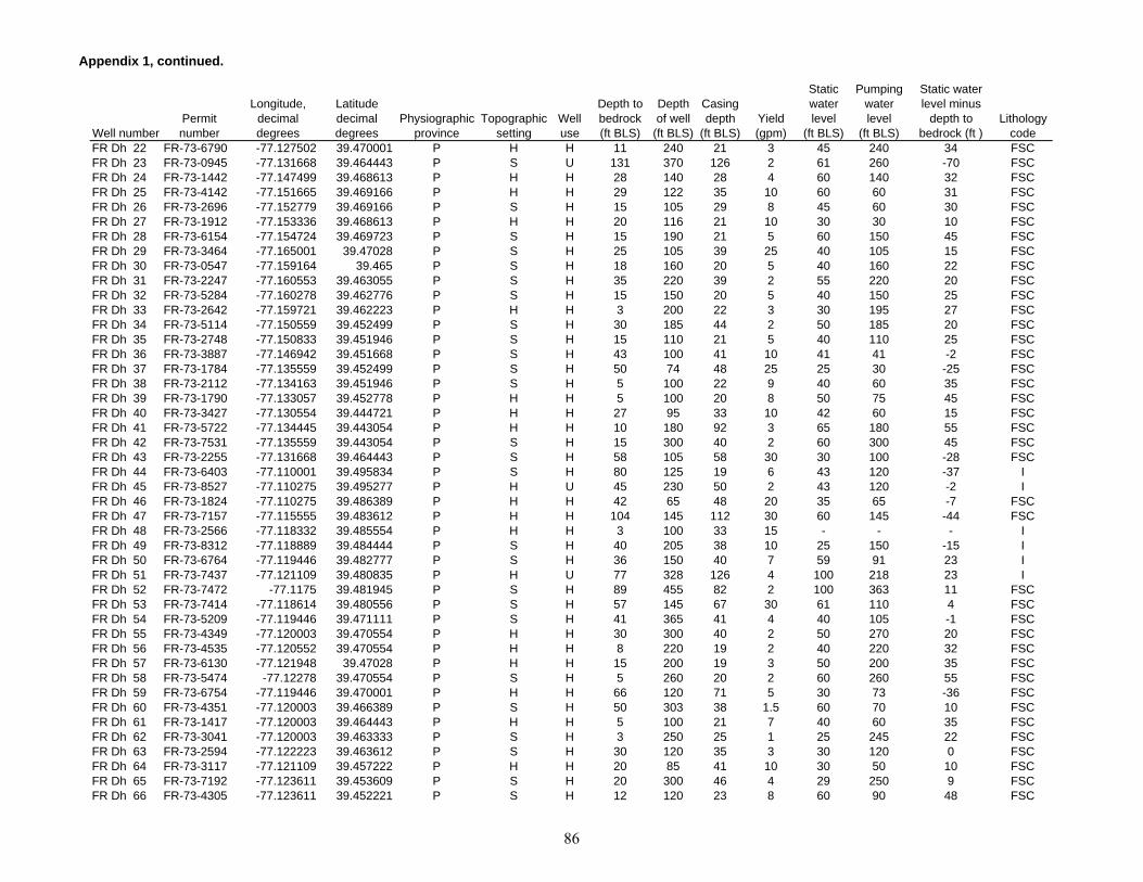
Appendix 1, continued.
Well numberPermit number
Longitude, decimal degrees
Latitude decimal degrees
Physiographic province
Topographic setting
Well use
Depth to bedrock (ft BLS)
Depth of well
(ft BLS)
Casing depth
(ft BLS)Yield (gpm)
Static water level
(ft BLS)
Pumping water level
(ft BLS)
Static water level minus
depth to bedrock (ft )
Lithology code
FR Dh 22 FR-73-6790 -77.127502 39.470001 P H H 11 240 21 3 45 240 34 FSCFR Dh 23 FR-73-0945 -77.131668 39.464443 P S U 131 370 126 2 61 260 -70 FSCFR Dh 24 FR-73-1442 -77.147499 39.468613 P H H 28 140 28 4 60 140 32 FSCFR Dh 25 FR-73-4142 -77.151665 39.469166 P H H 29 122 35 10 60 60 31 FSCFR Dh 26 FR-73-2696 -77.152779 39.469166 P S H 15 105 29 8 45 60 30 FSCFR Dh 27 FR-73-1912 -77.153336 39.468613 P H H 20 116 21 10 30 30 10 FSCFR Dh 28 FR-73-6154 -77.154724 39.469723 P S H 15 190 21 5 60 150 45 FSCFR Dh 29 FR-73-3464 -77.165001 39.47028 P S H 25 105 39 25 40 105 15 FSCFR Dh 30 FR-73-0547 -77.159164 39.465 P S H 18 160 20 5 40 160 22 FSCFR Dh 31 FR-73-2247 -77.160553 39.463055 P S H 35 220 39 2 55 220 20 FSCFR Dh 32 FR-73-5284 -77.160278 39.462776 P S H 15 150 20 5 40 150 25 FSCFR Dh 33 FR-73-2642 -77.159721 39.462223 P H H 3 200 22 3 30 195 27 FSCFR Dh 34 FR-73-5114 -77.150559 39.452499 P S H 30 185 44 2 50 185 20 FSCFR Dh 35 FR-73-2748 -77.150833 39.451946 P S H 15 110 21 5 40 110 25 FSCFR Dh 36 FR-73-3887 -77.146942 39.451668 P S H 43 100 41 10 41 41 -2 FSCFR Dh 37 FR-73-1784 -77.135559 39.452499 P S H 50 74 48 25 25 30 -25 FSCFR Dh 38 FR-73-2112 -77.134163 39.451946 P S H 5 100 22 9 40 60 35 FSCFR Dh 39 FR-73-1790 -77.133057 39.452778 P H H 5 100 20 8 50 75 45 FSCFR Dh 40 FR-73-3427 -77.130554 39.444721 P H H 27 95 33 10 42 60 15 FSCFR Dh 41 FR-73-5722 -77.134445 39.443054 P H H 10 180 92 3 65 180 55 FSCFR Dh 42 FR-73-7531 -77.135559 39.443054 P S H 15 300 40 2 60 300 45 FSCFR Dh 43 FR-73-2255 -77.131668 39.464443 P S H 58 105 58 30 30 100 -28 FSCFR Dh 44 FR-73-6403 -77.110001 39.495834 P S H 80 125 19 6 43 120 -37 IFR Dh 45 FR-73-8527 -77.110275 39.495277 P H U 45 230 50 2 43 120 -2 IFR Dh 46 FR-73-1824 -77.110275 39.486389 P H H 42 65 48 20 35 65 -7 FSCFR Dh 47 FR-73-7157 -77.115555 39.483612 P H H 104 145 112 30 60 145 -44 FSCFR Dh 48 FR-73-2566 -77.118332 39.485554 P H H 3 100 33 15 - - - IFR Dh 49 FR-73-8312 -77.118889 39.484444 P S H 40 205 38 10 25 150 -15 IFR Dh 50 FR-73-6764 -77.119446 39.482777 P S H 36 150 40 7 59 91 23 IFR Dh 51 FR-73-7437 -77.121109 39.480835 P H U 77 328 126 4 100 218 23 IFR Dh 52 FR-73-7472 -77.1175 39.481945 P S H 89 455 82 2 100 363 11 FSCFR Dh 53 FR-73-7414 -77.118614 39.480556 P S H 57 145 67 30 61 110 4 FSCFR Dh 54 FR-73-5209 -77.119446 39.471111 P S H 41 365 41 4 40 105 -1 FSCFR Dh 55 FR-73-4349 -77.120003 39.470554 P H H 30 300 40 2 50 270 20 FSCFR Dh 56 FR-73-4535 -77.120552 39.470554 P H H 8 220 19 2 40 220 32 FSCFR Dh 57 FR-73-6130 -77.121948 39.47028 P H H 15 200 19 3 50 200 35 FSCFR Dh 58 FR-73-5474 -77.12278 39.470554 P S H 5 260 20 2 60 260 55 FSCFR Dh 59 FR-73-6754 -77.119446 39.470001 P H H 66 120 71 5 30 73 -36 FSCFR Dh 60 FR-73-4351 -77.120003 39.466389 P S H 50 303 38 1.5 60 70 10 FSCFR Dh 61 FR-73-1417 -77.120003 39.464443 P H H 5 100 21 7 40 60 35 FSCFR Dh 62 FR-73-3041 -77.120003 39.463333 P S H 3 250 25 1 25 245 22 FSCFR Dh 63 FR-73-2594 -77.122223 39.463612 P S H 30 120 35 3 30 120 0 FSCFR Dh 64 FR-73-3117 -77.121109 39.457222 P H H 20 85 41 10 30 50 10 FSCFR Dh 65 FR-73-7192 -77.123611 39.453609 P S H 20 300 46 4 29 250 9 FSCFR Dh 66 FR-73-4305 -77.123611 39.452221 P S H 12 120 23 8 60 90 48 FSC
86

Appendix 1, continued.
Well numberPermit number
Longitude, decimal degrees
Latitude decimal degrees
Physiographic province
Topographic setting
Well use
Depth to bedrock (ft BLS)
Depth of well
(ft BLS)
Casing depth
(ft BLS)Yield (gpm)
Static water level
(ft BLS)
Pumping water level
(ft BLS)
Static water level minus
depth to bedrock (ft )
Lithology code
FR Ea 1 FR-00-9422 -77.669724 39.335278 BR S H - 69 20 3 25 50 - IFR Ea 2 FR-00-1476 -77.669724 39.333057 BR S H - 43 33 2.5 23 - - IFR Ea 3 FR-73-7244 -77.66667 39.337776 BR S H 76 115 84 12 46 80 -30 IFR Eb 1 FR-01-1628 -77.59639 39.395279 BR S H 12 76 76 8 12 30 0 IFR Eb 2 FR-00-7296 -77.588608 39.389999 BR F H 0 62 62 3 35 50 35 CSCFR Eb 3 FR-01-2454 -77.611389 39.401112 BR H H - 72 24 6 40 60 - IFR Eb 4 FR-01-7298 -77.608612 39.403332 BR H U 20 108 22 30 50 78 30 IFR Eb 5 FR-00-5035 -77.608612 39.404999 BR H H - 100 22 10 30 60 - IFR Eb 6 FR-01-5504 -77.636108 39.373612 BR F H 20 100 20 20 8 12 -12 IFR Eb 7 - -77.636948 39.375557 BR F U 0 23.9 23.9 5 - - - IFR Eb 9 FR-00-6664 -77.628334 39.340279 BR S S 20 75 23 9 8 60 -12 IFR Eb 10 FR-01-6104 -77.630837 39.34111 BR S H - 100 20 7 14.5 85 - IFR Eb 11 FR-00-5083 -77.62722 39.389999 BR F H - 70 26 4 30 40 - IFR Eb 12 FR-00-4902 -77.609169 39.402779 BR F U 6 80 30 5 15 18 9 IFR Eb 14 FR-00-4189 -77.619721 39.345833 BR F H 12 85 85 10 22 - 10 IFR Eb 15 FR-01-1539 -77.632225 39.394722 BR F H - 65 12 8 35 50 - IFR Eb 16 FR-01-1023 -77.595001 39.393055 BR F H 18 64 18 10 25 - 7 IFR Eb 17 FR-00-1263 -77.644165 39.333889 BR V H - 77 15 5 42 68 - IFR Eb 18 FR-01-6158 -77.642219 39.336388 BR H C 22 99 22 20 30 30 -19 IFR Eb 19 FR-00-9113 -77.60833 39.339169 BR F H 0.5 54 12 8 25 25 24.5 IFR Eb 20 FR-01-1627 -77.611114 39.34528 BR S C 6 56 56 3 10 40 4 IFR Eb 21 FR-01-1383 -77.610275 39.345001 BR H H 28 50 50 6 12 18 -16 IFR Eb 22 - -77.64389 39.356945 BR F H - 55 - 4 - - - IFR Eb 25 - -77.625 39.364166 BR F H - 108 - 7 40 - - IFR Eb 29 FR-73-7365 -77.639999 39.351944 BR V H 18 250 34 4 30 240 12 IFR Eb 30 FR-73-6310 -77.639168 39.350555 BR V H 3 125 20 12 10 25 7 IFR Eb 31 FR-73-3222 -77.638611 39.350277 BR V H 50 150 55 20 16 150 -34 IFR Eb 32 FR-73-2314 -77.638886 39.35 BR V H 26 125 28 12 12 31 -14 IFR Eb 33 FR-68-0108 -77.609169 39.402779 BR H T 23 87 22 8 20 24 -3 IFR Eb 34 FR-73-1806 -77.616943 39.348332 BR S T 30 203 33 2 50 155 20 IFR Eb 35 FR-04-5596 -77.593887 39.352501 BR H N 20 183 20 10 40 60 20 IFR Eb 36 FR-73-7910 -77.591942 39.353611 BR S T 58 300 65 6 38 300 -20 IFR Eb 37 FR-02-8131 -77.638726 39.405535 BR S U 0 255 26 15 - - - IFR Eb 38 FR-04-5900 -77.639442 39.406666 BR S H 35 205 39 6 160 195 125 CSCFR Eb 39 FR-73-7248 -77.588249 39.414402 BR H H 23 200 33 10 25 200 2 IFR Eb 40 FR-73-8495 -77.588798 39.413792 BR H H 36 400 41 3 25 400 -11 IFR Eb 41 FR-73-7711 -77.58741 39.414764 BR H H 12 250 22 50 20 110 8 IFR Eb 42 FR-73-5639 -77.589966 39.411934 BR H H 19 225 20 4 41 112 22 IFR Eb 43 FR-88-4413 -77.601456 39.413818 BR H H 33 300 41 6 40 300 7 IFR Eb 44 FR-88-4411 -77.600784 39.413212 BR H H 32 400 39 3 42 132 10 IFR Eb 45 FR-88-4417 -77.600365 39.413254 BR H H 32 675 39 1 37 160 5 IFR Ec 1 FR-00-4714 -77.578888 39.373612 BR S H 8 100 100 2 10 40 2 IFR Ec 3 - -77.571945 39.415554 BR H H - 75 - 5 - - - IFR Ec 5 FR-01-7340 -77.556946 39.358334 BR F H - 110 35 10 8 12 - IFR Ec 6 FR-01-9689 -77.510834 39.363335 BR H C 22 165 165 10 85 - 63 CSC
87
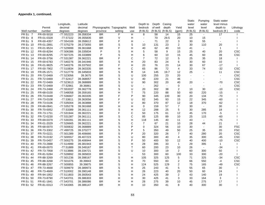
Appendix 1, continued.
Well numberPermit number
Longitude, decimal degrees
Latitude decimal degrees
Physiographic province
Topographic setting
Well use
Depth to bedrock (ft BLS)
Depth of well
(ft BLS)
Casing depth
(ft BLS)Yield (gpm)
Static water level
(ft BLS)
Pumping water level
(ft BLS)
Static water level minus
depth to bedrock (ft )
Lithology code
FR Ec 7 FR-00-5018 -77.552223 39.358334 BR F H 8 58 14 15 25 - 17 IFR Ec 8 FR-01-0328 -77.57222 39.355835 BR V H - 70 29.5 20 10 15 - IFR Ec 9 FR-00-4357 -77.554169 39.358612 BR F H - 71 22 3 30 55 - IFR Ec 10 FR-01-2891 -77.575279 39.373055 BR S S 10 131 23 2 30 110 20 IFR Ec 11 FR-01-9524 -77.529999 39.361668 BR F H 40 62 40 10 41 - 1 IFR Ec 12 FR-00-8294 -77.506386 39.335834 P S H 5 58 9 15 25 40 20 CSCFR Ec 13 FR-00-8295 -77.507225 39.333889 P S H 6 60 10 15 45 60 39 CSCFR Ec 14 FR-00-3756 -77.531387 39.362221 BR F C 7 72 12 5 25 35 18 IFR Ec 15 FR-00-6783 -77.540276 39.341946 BR S H 20 83 24 6 30 60 10 IFR Ec 16 FR-01-9825 -77.540276 39.337502 BR F H 20 76 23 14 30 67 -17 IFR Ec 17 FR-00-7902 -77.510834 39.363335 BR H C 65 86 72 4 33 74 -32 CSCFR Ec 19 FR-05-1571 -77.512779 39.345833 BR S R 14 145 19.7 12 25 - 11 CSCFR Ec 20 FR-72-0469 -77.523056 39.3675 BR S U 100 255 23 20 - - - CSCFR Ec 21 FR-72-0469 -77.52417 39.368057 BR S U 40 220 21 46 - - - CSCFR Ec 22 FR-72-0469 -77.523613 39.368889 BR S U 90 302 20 40 20 - -70 CSCFR Ec 23 FR-72-0469 -77.52861 39.36861 BR S U - 262 - 0 - - - CSCFR Ec 24 FR-73-2468 -77.553337 39.362778 BR S U 20 302 38 2 10 30 -10 CSCFR Ec 25 FR-68-0100 -77.548058 39.359165 BR H T 75 220 88 50 60 220 -15 IFR Ec 26 FR-73-0448 -77.536667 39.363335 BR F P 90 345 100 30 20 134 -70 IFR Ec 27 FR-73-0108 -77.53611 39.363056 BR F U 82 345 93 15 22 345 -60 IFR Ec 28 FR-73-0106 -77.535004 39.363888 BR F U 80 370 87 12 18 370 -62 IFR Ec 29 FR-66-0841 -77.535278 39.361668 BR H H 0 159 57 7 30 - 30 IFR Ec 30 FR-70-0052 -77.53389 39.361111 BR S H 12 288 25 5 30 285 18 IFR Ec 31 FR-73-1751 -77.531944 39.362221 BR F C 50 175 61 12 45 170 -5 IFR Ec 32 FR-72-0230 -77.531387 39.361111 BR S C 85 125 89 10 25 115 -60 IFR Ec 33 FR-69-0379 -77.530281 39.361111 BR S H 118 145 40 11 43 - -75 IFR Ec 34 FR-01-2029 -77.526665 39.362221 BR S C 7 67 21 10 28 44 21 IFR Ec 35 FR-68-0070 -77.500832 39.368889 BR S P 0 324 56 10 30 - 30 FSCFR Ec 36 FR-73-3302 -77.499725 39.370277 BR S P 5 350 49 50 25 35 20 FSCFR Ec 37 FR-70-0221 -77.501389 39.406666 BR S P 20 320 26 7 40 280 20 CSCFR Ec 38 FR-70-0192 -77.500557 39.407223 BR S U 80 300 40 4 35 300 -45 CSCFR Ec 39 FR-70-0457 -77.500275 39.406944 BR S P 50 400 50 12 40 400 -10 CSCFR Ec 40 FR-73-2888 -77.514999 39.381943 BR S H 28 395 33 1 29 395 1 IFR Ec 41 FR-69-0070 -77.51889 39.349167 BR S T 60 200 23 10 26 - -34 IFR Ec 42 FR-73-7958 -77.513886 39.334721 BR S U 10 300 19 2 60 300 50 IFR Ec 43 FR-81-5284 -77.528892 39.365833 BR H - 53 300 60 100 33 300 -20 IFR Ec 44 FR-88-3269 -77.501236 39.398167 BR S H 105 325 125 5 71 325 -34 CSCFR Ec 45 FR-88-3268 -77.501076 39.39843 BR S H 70 550 83 2 66 550 -4 CSCFR Ec 46 FR-88-3267 -77.500855 39.39875 BR S H 124 525 129 2 75 165 -49 CSCFR Ec 47 FR-73-4668 -77.509979 39.389973 BR S H 25 243 41 5 55 65 30 IFR Ec 48 FR-73-4669 -77.510002 39.390148 BR S H 26 223 40 20 50 60 24 IFR Ec 49 FR-94-1952 -77.511803 39.393543 BR S H 24 425 39 2 43 140 19 IFR Ec 50 FR-73-8790 -77.543701 39.386303 BR H H 30 425 41 3 33 164 3 IFR Ec 51 FR-81-1841 -77.543701 39.386086 BR H H 28 275 39 10 45 275 17 IFR Ec 52 FR-81-0313 -77.543365 39.386147 BR H H 10 350 41 8 40 300 30 I
88
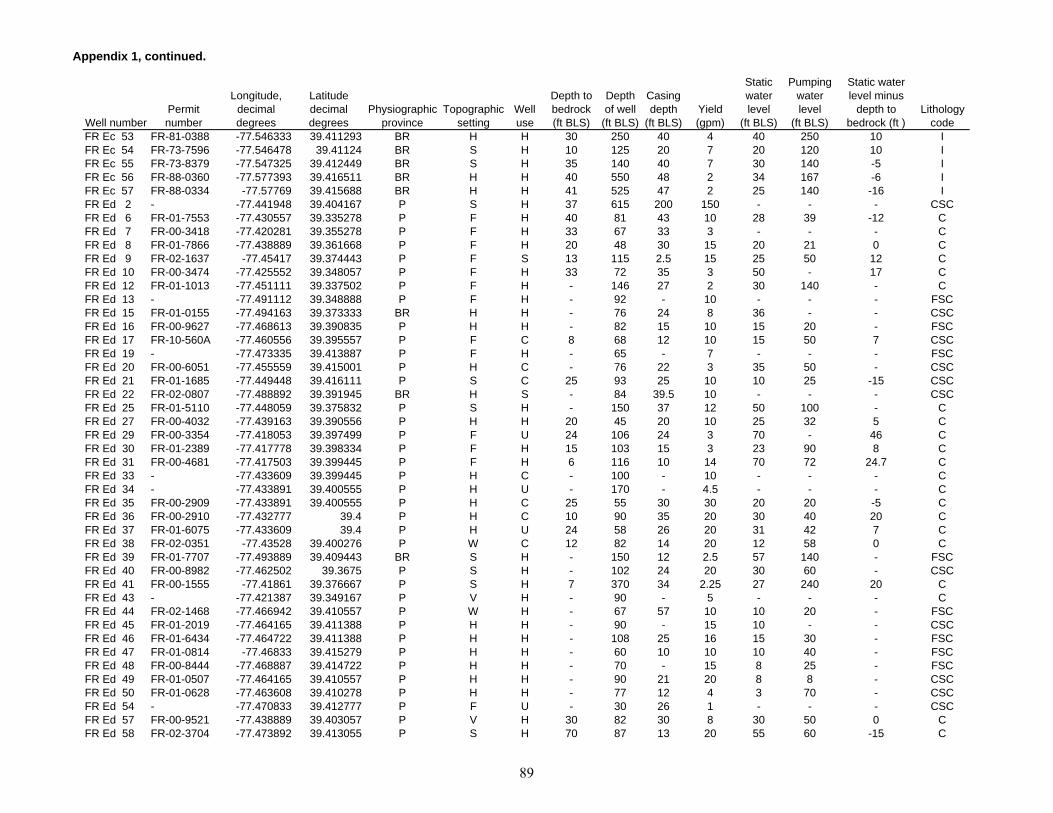
Appendix 1, continued.
Well numberPermit number
Longitude, decimal degrees
Latitude decimal degrees
Physiographic province
Topographic setting
Well use
Depth to bedrock (ft BLS)
Depth of well
(ft BLS)
Casing depth
(ft BLS)Yield (gpm)
Static water level
(ft BLS)
Pumping water level
(ft BLS)
Static water level minus
depth to bedrock (ft )
Lithology code
FR Ec 53 FR-81-0388 -77.546333 39.411293 BR H H 30 250 40 4 40 250 10 IFR Ec 54 FR-73-7596 -77.546478 39.41124 BR S H 10 125 20 7 20 120 10 IFR Ec 55 FR-73-8379 -77.547325 39.412449 BR S H 35 140 40 7 30 140 -5 IFR Ec 56 FR-88-0360 -77.577393 39.416511 BR H H 40 550 48 2 34 167 -6 IFR Ec 57 FR-88-0334 -77.57769 39.415688 BR H H 41 525 47 2 25 140 -16 IFR Ed 2 - -77.441948 39.404167 P S H 37 615 200 150 - - - CSCFR Ed 6 FR-01-7553 -77.430557 39.335278 P F H 40 81 43 10 28 39 -12 CFR Ed 7 FR-00-3418 -77.420281 39.355278 P F H 33 67 33 3 - - - CFR Ed 8 FR-01-7866 -77.438889 39.361668 P F H 20 48 30 15 20 21 0 CFR Ed 9 FR-02-1637 -77.45417 39.374443 P F S 13 115 2.5 15 25 50 12 CFR Ed 10 FR-00-3474 -77.425552 39.348057 P F H 33 72 35 3 50 - 17 CFR Ed 12 FR-01-1013 -77.451111 39.337502 P F H - 146 27 2 30 140 - CFR Ed 13 - -77.491112 39.348888 P F H - 92 - 10 - - - FSCFR Ed 15 FR-01-0155 -77.494163 39.373333 BR H H - 76 24 8 36 - - CSCFR Ed 16 FR-00-9627 -77.468613 39.390835 P H H - 82 15 10 15 20 - FSCFR Ed 17 FR-10-560A -77.460556 39.395557 P F C 8 68 12 10 15 50 7 CSCFR Ed 19 - -77.473335 39.413887 P F H - 65 - 7 - - - FSCFR Ed 20 FR-00-6051 -77.455559 39.415001 P H C - 76 22 3 35 50 - CSCFR Ed 21 FR-01-1685 -77.449448 39.416111 P S C 25 93 25 10 10 25 -15 CSCFR Ed 22 FR-02-0807 -77.488892 39.391945 BR H S - 84 39.5 10 - - - CSCFR Ed 25 FR-01-5110 -77.448059 39.375832 P S H - 150 37 12 50 100 - CFR Ed 27 FR-00-4032 -77.439163 39.390556 P H H 20 45 20 10 25 32 5 CFR Ed 29 FR-00-3354 -77.418053 39.397499 P F U 24 106 24 3 70 - 46 CFR Ed 30 FR-01-2389 -77.417778 39.398334 P F H 15 103 15 3 23 90 8 CFR Ed 31 FR-00-4681 -77.417503 39.399445 P F H 6 116 10 14 70 72 24.7 CFR Ed 33 - -77.433609 39.399445 P H C - 100 - 10 - - - CFR Ed 34 - -77.433891 39.400555 P H U - 170 - 4.5 - - - CFR Ed 35 FR-00-2909 -77.433891 39.400555 P H C 25 55 30 30 20 20 -5 CFR Ed 36 FR-00-2910 -77.432777 39.4 P H C 10 90 35 20 30 40 20 CFR Ed 37 FR-01-6075 -77.433609 39.4 P H U 24 58 26 20 31 42 7 CFR Ed 38 FR-02-0351 -77.43528 39.400276 P W C 12 82 14 20 12 58 0 CFR Ed 39 FR-01-7707 -77.493889 39.409443 BR S H - 150 12 2.5 57 140 - FSCFR Ed 40 FR-00-8982 -77.462502 39.3675 P S H - 102 24 20 30 60 - CSCFR Ed 41 FR-00-1555 -77.41861 39.376667 P S H 7 370 34 2.25 27 240 20 CFR Ed 43 - -77.421387 39.349167 P V H - 90 - 5 - - - CFR Ed 44 FR-02-1468 -77.466942 39.410557 P W H - 67 57 10 10 20 - FSCFR Ed 45 FR-01-2019 -77.464165 39.411388 P H H - 90 - 15 10 - - CSCFR Ed 46 FR-01-6434 -77.464722 39.411388 P H H - 108 25 16 15 30 - FSCFR Ed 47 FR-01-0814 -77.46833 39.415279 P H H - 60 10 10 10 40 - FSCFR Ed 48 FR-00-8444 -77.468887 39.414722 P H H - 70 - 15 8 25 - FSCFR Ed 49 FR-01-0507 -77.464165 39.410557 P H H - 90 21 20 8 8 - CSCFR Ed 50 FR-01-0628 -77.463608 39.410278 P H H - 77 12 4 3 70 - CSCFR Ed 54 - -77.470833 39.412777 P F U - 30 26 1 - - - CSCFR Ed 57 FR-00-9521 -77.438889 39.403057 P V H 30 82 30 8 30 50 0 CFR Ed 58 FR-02-3704 -77.473892 39.413055 P S H 70 87 13 20 55 60 -15 C
89
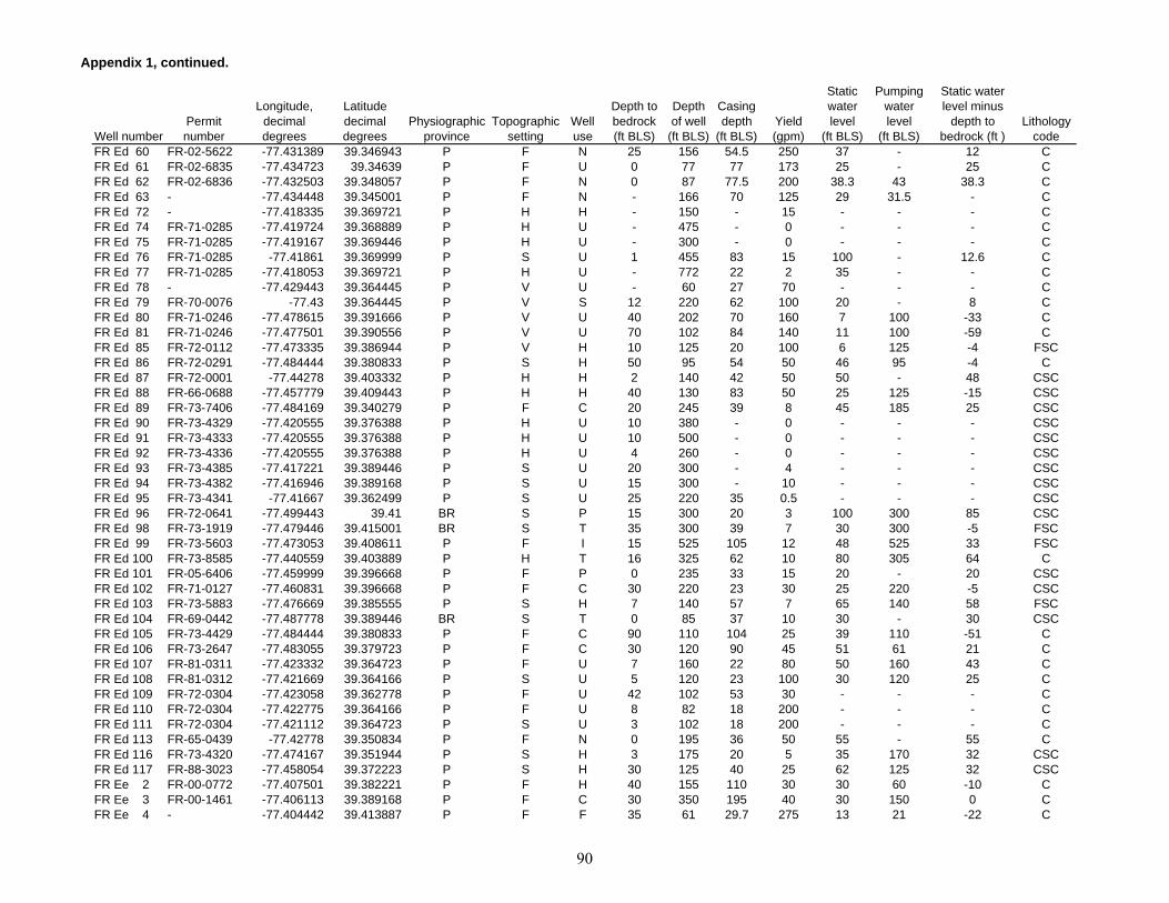
Appendix 1, continued.
Well numberPermit number
Longitude, decimal degrees
Latitude decimal degrees
Physiographic province
Topographic setting
Well use
Depth to bedrock (ft BLS)
Depth of well
(ft BLS)
Casing depth
(ft BLS)Yield (gpm)
Static water level
(ft BLS)
Pumping water level
(ft BLS)
Static water level minus
depth to bedrock (ft )
Lithology code
FR Ed 60 FR-02-5622 -77.431389 39.346943 P F N 25 156 54.5 250 37 - 12 CFR Ed 61 FR-02-6835 -77.434723 39.34639 P F U 0 77 77 173 25 - 25 CFR Ed 62 FR-02-6836 -77.432503 39.348057 P F N 0 87 77.5 200 38.3 43 38.3 CFR Ed 63 - -77.434448 39.345001 P F N - 166 70 125 29 31.5 - CFR Ed 72 - -77.418335 39.369721 P H H - 150 - 15 - - - CFR Ed 74 FR-71-0285 -77.419724 39.368889 P H U - 475 - 0 - - - CFR Ed 75 FR-71-0285 -77.419167 39.369446 P H U - 300 - 0 - - - CFR Ed 76 FR-71-0285 -77.41861 39.369999 P S U 1 455 83 15 100 - 12.6 CFR Ed 77 FR-71-0285 -77.418053 39.369721 P H U - 772 22 2 35 - - CFR Ed 78 - -77.429443 39.364445 P V U - 60 27 70 - - - CFR Ed 79 FR-70-0076 -77.43 39.364445 P V S 12 220 62 100 20 - 8 CFR Ed 80 FR-71-0246 -77.478615 39.391666 P V U 40 202 70 160 7 100 -33 CFR Ed 81 FR-71-0246 -77.477501 39.390556 P V U 70 102 84 140 11 100 -59 CFR Ed 85 FR-72-0112 -77.473335 39.386944 P V H 10 125 20 100 6 125 -4 FSCFR Ed 86 FR-72-0291 -77.484444 39.380833 P S H 50 95 54 50 46 95 -4 CFR Ed 87 FR-72-0001 -77.44278 39.403332 P H H 2 140 42 50 50 - 48 CSCFR Ed 88 FR-66-0688 -77.457779 39.409443 P H H 40 130 83 50 25 125 -15 CSCFR Ed 89 FR-73-7406 -77.484169 39.340279 P F C 20 245 39 8 45 185 25 CSCFR Ed 90 FR-73-4329 -77.420555 39.376388 P H U 10 380 - 0 - - - CSCFR Ed 91 FR-73-4333 -77.420555 39.376388 P H U 10 500 - 0 - - - CSCFR Ed 92 FR-73-4336 -77.420555 39.376388 P H U 4 260 - 0 - - - CSCFR Ed 93 FR-73-4385 -77.417221 39.389446 P S U 20 300 - 4 - - - CSCFR Ed 94 FR-73-4382 -77.416946 39.389168 P S U 15 300 - 10 - - - CSCFR Ed 95 FR-73-4341 -77.41667 39.362499 P S U 25 220 35 0.5 - - - CSCFR Ed 96 FR-72-0641 -77.499443 39.41 BR S P 15 300 20 3 100 300 85 CSCFR Ed 98 FR-73-1919 -77.479446 39.415001 BR S T 35 300 39 7 30 300 -5 FSCFR Ed 99 FR-73-5603 -77.473053 39.408611 P F I 15 525 105 12 48 525 33 FSCFR Ed 100 FR-73-8585 -77.440559 39.403889 P H T 16 325 62 10 80 305 64 CFR Ed 101 FR-05-6406 -77.459999 39.396668 P F P 0 235 33 15 20 - 20 CSCFR Ed 102 FR-71-0127 -77.460831 39.396668 P F C 30 220 23 30 25 220 -5 CSCFR Ed 103 FR-73-5883 -77.476669 39.385555 P S H 7 140 57 7 65 140 58 FSCFR Ed 104 FR-69-0442 -77.487778 39.389446 BR S T 0 85 37 10 30 - 30 CSCFR Ed 105 FR-73-4429 -77.484444 39.380833 P F C 90 110 104 25 39 110 -51 CFR Ed 106 FR-73-2647 -77.483055 39.379723 P F C 30 120 90 45 51 61 21 CFR Ed 107 FR-81-0311 -77.423332 39.364723 P F U 7 160 22 80 50 160 43 CFR Ed 108 FR-81-0312 -77.421669 39.364166 P S U 5 120 23 100 30 120 25 CFR Ed 109 FR-72-0304 -77.423058 39.362778 P F U 42 102 53 30 - - - CFR Ed 110 FR-72-0304 -77.422775 39.364166 P F U 8 82 18 200 - - - CFR Ed 111 FR-72-0304 -77.421112 39.364723 P S U 3 102 18 200 - - - CFR Ed 113 FR-65-0439 -77.42778 39.350834 P F N 0 195 36 50 55 - 55 CFR Ed 116 FR-73-4320 -77.474167 39.351944 P S H 3 175 20 5 35 170 32 CSCFR Ed 117 FR-88-3023 -77.458054 39.372223 P S H 30 125 40 25 62 125 32 CSCFR Ee 2 FR-00-0772 -77.407501 39.382221 P F H 40 155 110 30 30 60 -10 CFR Ee 3 FR-00-1461 -77.406113 39.389168 P F C 30 350 195 40 30 150 0 CFR Ee 4 - -77.404442 39.413887 P F F 35 61 29.7 275 13 21 -22 C
90

Appendix 1, continued.
Well numberPermit number
Longitude, decimal degrees
Latitude decimal degrees
Physiographic province
Topographic setting
Well use
Depth to bedrock (ft BLS)
Depth of well
(ft BLS)
Casing depth
(ft BLS)Yield (gpm)
Static water level
(ft BLS)
Pumping water level
(ft BLS)
Static water level minus
depth to bedrock (ft )
Lithology code
FR Ee 8 - -77.403892 39.344166 P S H - 100 - 10 - - - CFR Ee 10 FR-02-1848 -77.389999 39.370834 P S C 22 100 32.5 30 45 50 23 CFR Ee 11 FR-01-1459 -77.388611 39.362221 P S H 10 109 15 14 60 95 50 CFR Ee 12 FR-02-0132 -77.385559 39.358891 P S H - 83 37 10 40 - - FSCFR Ee 13 FR-00-3369 -77.378609 39.35611 P V R 9 253 12 12 8 - -1 FSCFR Ee 14 - -77.382774 39.357498 P S H - 50 23 10 26 - - FSCFR Ee 15 FR-01-3945 -77.401108 39.337502 P S H 24 105 17 3 40 105 16 FSCFR Ee 19 FR-01-6696 -77.3675 39.365555 P S H 0 76 6 5 12 40 12 FSCFR Ee 20 FR-01-2390 -77.338059 39.386665 P F H - 95 6 4 16 80 - FSCFR Ee 21 FR-66-0082 -77.338059 39.394722 P S T 3 74 40 5 35 55 32 FSCFR Ee 22 FR-00-3648 -77.34111 39.39611 P V H 11 68 11 3 40 - 29 FSCFR Ee 23 FR-00-5222 -77.356392 39.392776 P H H - 100 6 3 45 70 - FSCFR Ee 24 FR-00-9475 -77.360275 39.395557 P S H 55 108 57 10 30 50 -25 FSCFR Ee 27 FR-01-7930 -77.409721 39.387222 P F C 20 282 24 4 60 - 40 CFR Ee 28 FR-02-3529 -77.406944 39.393055 P F H 19 116 22.5 5 60 - 41 CFR Ee 29 - -77.40667 39.392776 P F H - 68 - 0.1 - - - CFR Ee 30 FR-01-7435 -77.40667 39.392776 P F H 29 87 78 10 57 70 28 CFR Ee 32 - -77.383888 39.355835 P H H - 162 - 5 - - - FSCFR Ee 35 FR-00-9749 -77.378891 39.4 P F H 10 90 15 10 63 - 53 CFR Ee 36 FR-02-1782 -77.380554 39.398334 P F H - 87 22 10 41 60 - CFR Ee 37 FR-02-0723 -77.378059 39.384998 P V H - 117 8 10 38 100 - FSCFR Ee 38 FR-02-7730 -77.410278 39.384998 P F P - 305 19 50 50 75 - CFR Ee 40 FR-04-2240 -77.410553 39.385555 P F U 8 200 8 2 153 - 145 CFR Ee 41 FR-04-2713 -77.410278 39.384724 P F U 7 200 7 0 - - - CFR Ee 42 FR-66-0657 -77.412224 39.384724 P F P - 60 29 35 45 54 - CFR Ee 44 FR-68-0075 -77.408608 39.396946 P F C - 165 21.5 100 60 - - CFR Ee 45 FR-67-0530 -77.400833 39.392223 P F N 18 292 22 52 76.1 115.4 58.1 CFR Ee 48 FR-67-0530 -77.405281 39.391388 P F U 18 125 20 10 85 - 44.3 CFR Ee 49 FR-02-5830 -77.409447 39.390556 P F C 2 140 11 100 50 70 48 CFR Ee 50 FR-02-6152 -77.407219 39.394444 P F U 31 82 31 100 32 - 1 CFR Ee 52 FR-68-0084 -77.407219 39.39389 P F H 53 180 53 50 80 180 27 CFR Ee 52a FR-04-7888 -77.407219 39.39389 P F H 53 95 53 50 48 - -5 CFR Ee 53 FR-04-6747 -77.407219 39.390278 P F U 20 110 45 100 30 - 10 CFR Ee 54 FR-66-0737 -77.408608 39.389999 P F C 38 590 95 2 85 590 47 CFR Ee 55 FR-68-0183 -77.407219 39.390278 P F C 5 520 92 0.5 90 520 85 CFR Ee 56 FR-05-7311 -77.406387 39.393612 P F C 32 115 34 25 64 - 32 CFR Ee 59 FR-68-0191 -77.406387 39.393612 P F C 80 130 86 5 80 100 0 CFR Ee 60 FR-05-0773 -77.409447 39.388889 P F C 18 665 27 3 40 - 22 CFR Ee 61 FR-02-5961 -77.407219 39.387779 P F U 2 180 11 300 35 60 33 CFR Ee 62 FR-65-0399 -77.403892 39.393333 P F U 3 340 182 6 - 200 - CFR Ee 64 FR-65-0459 -77.403892 39.393055 P F N - 120 23.5 52 21 80 - CFR Ee 65 FR-68-0176 -77.410004 39.386665 P F C 8 63 23 60 35 63 27 CFR Ee 67 FR-69-0209 -77.408608 39.390556 P F C 10 310 50 8 9 300 -1 CFR Ee 68 FR-68-0401 -77.408333 39.398888 P F C - 200 71 10 30 - - CFR Ee 69 FR-03-4498 -77.404999 39.388611 P F U - 178 28 4 35 - - C
91
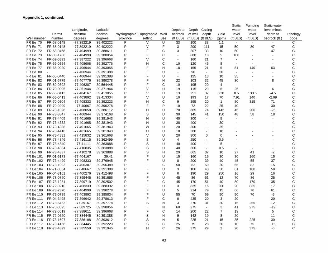
Appendix 1, continued.
Well numberPermit number
Longitude, decimal degrees
Latitude decimal degrees
Physiographic province
Topographic setting
Well use
Depth to bedrock (ft BLS)
Depth of well
(ft BLS)
Casing depth
(ft BLS)Yield (gpm)
Static water level
(ft BLS)
Pumping water level
(ft BLS)
Static water level minus
depth to bedrock (ft )
Lithology code
FR Ee 70 FR-68-0148 -77.392219 39.402222 P V U 33 100 33 1.1 - - - CFR Ee 71 FR-68-0148 -77.392219 39.402222 P V F 3 200 111 15 50 80 47 CFR Ee 72 FR-68-0468 -77.404999 39.388611 P F C 3 207 33 10 50 - 47 CFR Ee 73 FR-03-1766 -77.404999 39.388054 P F C - 600 18 5 100 - - CFR Ee 74 FR-69-0393 -77.387222 39.396668 P V C - 160 21 7 - - - CFR Ee 75 FR-69-0354 -77.408608 39.392776 P H C 10 120 46 8 - - - CFR Ee 77 FR-68-0020 -77.406944 39.393055 P F H 18 155 21 5 81 140 63 CFR Ee 80 - -77.406944 39.391388 P F U - 96 - 50 - - - CFR Ee 81 FR-65-0440 -77.406944 39.391388 P F U - 125 13 10 35 - - CFR Ee 82 FR-01-6779 -77.407776 39.390278 P F H 22 103 32 45 30 - 8 CFR Ee 83 FR-69-0392 -77.406387 39.564445 P F C 10 195 20 4 - - - CFR Ee 84 FR-70-0005 -77.351944 39.371944 P V U 19 115 29 6 25 - 6 CFR Ee 85 FR-65-0413 -77.404167 39.413055 P V U 13 251 37 238 8.5 133.5 -4.5 CFR Ee 86 FR-65-0413 -77.403892 39.413334 P V U 10 193 17 70 7.91 140 -2.09 CFR Ee 87 FR-70-0304 -77.408333 39.392223 P H C 9 395 20 1 80 315 71 CFR Ee 88 FR-70-0299 -77.40667 39.390278 P F P 10 72 22 25 40 - 30 CFR Ee 89 FR-73-1028 -77.408058 39.386112 P H U 70 365 74 142 45 206 -25 CFR Ee 90 FR-73-3847 -77.406944 39.374168 P S U 30 145 41 150 48 58 18 CFR Ee 91 FR-73-4409 -77.401665 39.381943 P H U 40 300 - 5 - - - CFR Ee 92 FR-73-4332 -77.401665 39.381943 P H U 38 400 - 30 - - - CFR Ee 93 FR-73-4338 -77.401665 39.381943 P W U 20 300 - 35 - - - CFR Ee 94 FR-73-4410 -77.401665 39.381943 P H U 10 380 - 10 - - - CFR Ee 95 FR-73-4331 -77.415832 39.361668 P V U 20 300 0 0 - - - CFR Ee 96 FR-73-4346 -77.416115 39.362499 P S U 4 250 - 0.5 - - - CFR Ee 97 FR-73-4340 -77.41111 39.363888 P S U 40 400 - 5 - - - CFR Ee 98 FR-73-4334 -77.410835 39.363888 P S U 40 300 - 0.5 - - - CFR Ee 99 FR-73-4337 -77.410278 39.363888 P S H 29 665 37 10 27 41 -2 CFR Ee 101 FR-01-5173 -77.404167 39.41 P F U 15 160 16 30 30 160 15 CFR Ee 102 FR-73-4499 -77.408333 39.376945 P F U 8 200 39 40 45 55 37 CFR Ee 103 FR-73-1093 -77.406387 39.396389 P F C 50 82 59 20 65 82 15 CFR Ee 104 FR-71-0354 -77.40667 39.391388 P F U 3 100 43 50 61 100 58 CFR Ee 105 FR-04-3161 -77.400276 39.412498 P F U 0 190 29 250 16 29 16 CFR Ee 106 FR-73-0750 -77.399445 39.391666 P F U 45 86 51 12 70 86 25 CFR Ee 107 FR-73-1284 -77.399719 39.392502 P F C 45 170 51 40 80 170 35 CFR Ee 108 FR-72-0210 -77.408333 39.388332 P F U 3 835 16 200 20 835 17 CFR Ee 109 FR-73-2370 -77.404999 39.390278 P F U 5 214 79 15 66 70 61 CFR Ee 110 FR-73-0739 -77.403892 39.385834 P F U 55 70 59 50 50 70 -5 CFR Ee 111 FR-04-3498 -77.396942 39.378613 P F C 0 435 20 3 20 - 20 CFR Ee 112 FR-73-6453 -77.39167 39.397778 P S N 3 270 31 20 15 265 12 CFR Ee 113 FR-73-8325 -77.389725 39.398056 P F N 60 275 - 3 41 275 -19 CFR Ee 114 FR-72-0519 -77.388611 39.396668 P F C 14 200 22 7 19 - 5 CFR Ee 115 FR-72-0520 -77.384445 39.391388 P S N 9 142 19 8 20 - 11 CFR Ee 116 FR-73-1697 -77.386108 39.393612 P S N 5 225 21 15 35 225 30 CFR Ee 117 FR-73-4168 -77.384445 39.392223 P S C 25 75 28 20 10 75 -15 CFR Ee 118 FR-73-4829 -77.385559 39.391945 P H C 26 375 29 2 20 375 -6 C
92

Appendix 1, continued.
Well numberPermit number
Longitude, decimal degrees
Latitude decimal degrees
Physiographic province
Topographic setting
Well use
Depth to bedrock (ft BLS)
Depth of well
(ft BLS)
Casing depth
(ft BLS)Yield (gpm)
Static water level
(ft BLS)
Pumping water level
(ft BLS)
Static water level minus
depth to bedrock (ft )
Lithology code
FR Ee 119 FR-73-3248 -77.386108 39.391666 P S C 4 450 19 6 12 450 8 CFR Ee 120 FR-73-7584 -77.38472 39.391666 P H C 12 225 39 10 20 225 8 CFR Ee 121 FR-73-5955 -77.38472 39.391666 P H C 10 425 39 2 20 425 10 CFR Ee 122 FR-73-5190 -77.384163 39.391945 P S N 10 300 20 5 18 300 8 CFR Ee 123 FR-73-4554 -77.384445 39.374168 P F P 26 200 40 75 35 190 9 FSCFR Ee 124 FR-73-4555 -77.409164 39.373055 P F U 15 350 18 35 35 340 20 FSCFR Ee 125 FR-73-2639 -77.3825 39.353054 P H R 25 300 31 1 20 300 -5 FSCFR Ee 126 FR-73-7186 -77.369721 39.398334 P S H 51 125 61 50 18 41 -33 CFR Ee 127 FR-67-0335 -77.35833 39.392502 P S T 0 300 23 1 30 - 30 FSCFR Ee 128 FR-73-6740 -77.348892 39.394722 P S C 14 405 19 0.75 30 395 16 FSCFR Ee 129 FR-73-1739 -77.363335 39.352501 P S R 0 300 24 50 33 43 33 FSCFR Ee 130 FR-71-0217 -77.362503 39.378056 P S C 50 220 60 3 20 220 -30 FSCFR Ee 132 FR-73-6453 -77.39167 39.397778 P S U - 515 - 0 - - - FSCFR Ee 133 FR-73-6453 -77.39167 39.397778 P S U - 220 - 0 - - - FSCFR Ef 1 FR-01-5094 -77.270554 39.38139 P S T 30 75 30 10 15 20 -15 IFR Ef 3 FR-00-7037 -77.279442 39.3825 P H H 15 80 23.5 4 9 65 -6 IFR Ef 4 FR-01-2496 -77.299721 39.410278 P H H - 100 - 1 22 100 - IFR Ef 5 FR-01-3946 -77.252777 39.343613 P S H 28 54 30 5 20 54 -8 FSCFR Ef 8 - -77.270279 39.370834 P V N - - - 35 1 - - FSCFR Ef 9 - -77.270279 39.370834 P V U - 54 - 5 1 - - FSCFR Ef 11 FR-00-8552 -77.291664 39.347221 P V H 4 32 - 5 2 32 -2 IFR Ef 12 FR-01-8831 -77.321945 39.360832 P S H 10 91 9.5 1 30 91 20 FSCFR Ef 13 FR-00-0105 -77.311668 39.345554 P S H 0 112 0 10 40 40 40 - FR Ef 14 FR-01-9251 -77.31472 39.373612 P H H 20 119 23 10 45 69 25 FSCFR Ef 15 FR-01-8208 -77.297226 39.385555 P H U 30 80 30 20 32 65 2 FSCFR Ef 18 FR-01-4602 -77.324165 39.40361 P S H 15 75 24 7 30 60 15 IFR Ef 20 FR-01-3641 -77.32917 39.406387 P S H 70 - 16 8 70 80 0 IFR Ef 21 FR-00-9628 -77.301941 39.407501 P S H - 50 6 10 28 35 - IFR Ef 23 FR-02-1936 -77.264168 39.400276 P S H 8 167 8 2 20 167 12 IFR Ef 24 FR-00-9090 -77.273888 39.3825 P H H - 79 17.5 5 20 40 - IFR Ef 26 FR-73-0852 -77.328056 39.415279 P S U 2 442 21 3 30 - 28 IFR Ef 27 FR-73-0852 -77.325836 39.414722 P S U 2 300 38 5 30 - 28 IFR Ef 28 FR-71-0369 -77.311943 39.412498 P S P 21 400 40 12 32 - 11 FSCFR Ef 29 FR-73-3442 -77.273888 39.383888 P S T 4 310 49 5 30 300 26 IFR Ef 30 FR-73-3424 -77.274445 39.384167 P S T 11 120 20 10 50 120 39 FSCFR Ef 31 FR-73-3455 -77.275002 39.384445 P S T 4 310 49 5 30 300 26 IFR Ef 32 FR-04-6476 -77.275833 39.38361 P H T 38 400 46 11 30 - -8 FSCFR Ef 33 FR-73-4879 -77.26889 39.383888 P S C 23 60 24 40 40 60 -3 IFR Ef 34 FR-69-0051 -77.267776 39.382778 P S T 10 104 12 15 25 - 15 IFR Ef 35 FR-67-0472 -77.270554 39.381943 P S C 23 265 46 8 15 - -8 IFR Ef 36 FR-73-2439 -77.297501 39.386112 P S C 30 180 30 10 30 180 0 IFR Ef 37 FR-73-2401 -77.296669 39.386112 P S U 18 100 19 15 30 100 12 IFR Ef 38 FR-68-0045 -77.321388 39.343334 P S T 45 100 44 6 65 80 20 FSCFR Ef 39 FR-73-5336 -77.268608 39.362778 P H T 30 150 60 20 30 40 0 FSCFR Ef 40 FR-67-0495 -77.274445 39.348888 P F C 60 77 58 2 45 77 -15 FSC
93

Appendix 1, continued.
Well numberPermit number
Longitude, decimal degrees
Latitude decimal degrees
Physiographic province
Topographic setting
Well use
Depth to bedrock (ft BLS)
Depth of well
(ft BLS)
Casing depth
(ft BLS)Yield (gpm)
Static water level
(ft BLS)
Pumping water level
(ft BLS)
Static water level minus
depth to bedrock (ft )
Lithology code
FR Ef 41 FR-71-0438 -77.266388 39.340557 P W T 80 200 22 10 10 190 -70 FSCFR Ef 43 FR-73-6080 -77.31667 39.367222 P H H 8 225 21 2 50 225 42 FSCFR Ef 44 FR-73-6614 -77.297501 39.386112 P S C 20 140 33 6 25 140 5 IFR Ef 46 FR-71-0369 -77.311943 39.412498 P S P 31 300 31 3.5 45 - 14 FSCFR Ef 47 FR-71-0099 -77.266388 39.340557 P W T 0 230 20 10 12 - 12 FSCFR Ef 51 FR-73-2491 -77.319931 39.341518 P S H 45 117 53 12 - - - FSCFR Eg 3 FR-00-5996 -77.181946 39.365833 P S H 10 70 10 3 50 - 40 FSCFR Eg 4 FR-00-9856 -77.209999 39.370556 P S C 14 29 15 4 4 29 -10 FSCFR Eg 6 FR-01-9806 -77.23111 39.37389 P S C 20 42 23.5 10 15 16 -5 FSCFR Eg 7 FR-01-4023 -77.235001 39.336945 P S H 7 90 7 10 30 40 23 FSCFR Eg 8 FR-01-4468 -77.229164 39.334721 P H T 50 120 - 3 40 120 -10 FSCFR Eg 9 FR-01-6528 -77.182777 39.348332 P S C 30 90 32 12 30 54 0 FSCFR Eg 10 FR-00-3495 -77.223335 39.368889 P H H 30 110 10 10 30 98 0 FSCFR Eg 16 FR-01-1208 -77.240837 39.41639 P H H 5 72 - 2 42 66 37 IFR Eg 19 FR-67-0319 -77.218887 39.387779 P S R 20 70 21 30 20 70 0 IFR Eg 20 FR-73-7721 -77.182777 39.413887 P S H 54 145 61 8 60 145 6 FSCFR Eg 21 FR-73-7932 -77.18 39.413055 P S H 25 200 31 4 25 200 0 FSCFR Eg 22 FR-73-6811 -77.178337 39.412224 P S H 46 205 61 4 65 190 19 FSCFR Eg 23 FR-73-7432 -77.177223 39.413334 P S H 38 140 42 15 35 135 -3 FSCFR Eg 24 FR-73-3233 -77.176109 39.413055 P H H 52 120 57 7 61 120 9 FSCFR Eg 25 FR-73-3587 -77.175835 39.412498 P H H 52 145 57 6 46 145 -6 FSCFR Eg 26 FR-73-6968 -77.170555 39.413612 P S H 38 125 40 6 30 125 -8 FSCFR Eg 27 FR-73-8016 -77.169998 39.413612 P H H 31 165 39 4 52 140 21 FSCFR Eg 28 FR-73-6991 -77.16667 39.398888 P S H 43 145 44 10 40 135 -3 FSCFR Eg 29 FR-05-0709 -77.191391 39.36861 P S C 30 44 30 10 30 35 0 FSCFR Eg 30 FR-73-3962 -77.171387 39.367779 P S N 60 120 63 45 35 120 -25 FSCFR Eg 31 FR-73-3963 -77.171112 39.367779 P F N 30 140 45 60 100 140 10 FSCFR Eg 32 FR-73-3964 -77.171112 39.36861 P F N 40 205 72 10 40 205 0 FSCFR Eg 33 FR-73-0148 -77.171669 39.353611 P F C 3 120 19 10 45 120 42 FSCFR Eg 34 FR-73-6048 -77.190002 39.399166 P H H - 150 21 10 30 145 - FSCFR Eg 35 FR-73-8754 -77.188057 39.400833 P S H - 160 43 15 37 150 - FSCFR Eh 1 - -77.164444 39.379723 P V P 14 125 34 60 6 8 -8 FSCFR Eh 2 - -77.164719 39.380554 P V P - 96 30 106 20 60 - FSCFR Eh 3 FR-00-8430 -77.162224 39.395001 P H H 40 106 - 8 30 80 -10 FSCFR Eh 5 FR-01-8296 -77.160835 39.397778 P V H 20 53 11 8 10 35 -10 FSCFR Eh 6 FR-01-8854 -77.164719 39.380554 P V U 30 55 37.5 24.7 - - - FSCFR Eh 7 FR-01-9181 -77.164719 39.380554 P V U 37 89 38 24.5 - - - FSCFR Eh 8 FR-01-9182 -77.164719 39.380554 P V U 36 79.5 41.5 26.7 - - - FSCFR Eh 9 FR-01-9183 -77.164719 39.380554 P V U 21 99.5 49 26.7 - - - FSCFR Eh 10 FR-73-2380 -77.16333 39.383888 P V P 18 260 23 284 10.5 33.8 -7.5 FSCFR Eh 11 FR-81-0088 -77.165276 39.3825 P S U 50 103 22 40 30 90 -36.63 FSCFR Eh 12 FR-81-0087 -77.165276 39.38333 P S U 70 200 40 15 40 180 -30 FSCFR Eh 13 FR-81-0090 -77.163055 39.382221 P S P 0 180 62 100 40 160 40 FSCFR Eh 14 FR-81-0089 -77.163887 39.38139 P S U 65 143 40 7 40 133 -25 FSCFR Eh 16 FR-73-5289 -77.161941 39.412224 P S H 85 185 60 7 50 60 -35 FSC
94

Appendix 1, continued.
Well numberPermit number
Longitude, decimal degrees
Latitude decimal degrees
Physiographic province
Topographic setting
Well use
Depth to bedrock (ft BLS)
Depth of well
(ft BLS)
Casing depth
(ft BLS)Yield (gpm)
Static water level
(ft BLS)
Pumping water level
(ft BLS)
Static water level minus
depth to bedrock (ft )
Lithology code
FR Eh 17 FR-73-7903 -77.160835 39.413055 P S H 70 150 80 10 40 150 -30 FSCFR Eh 18 FR-73-6871 -77.160553 39.413887 P S H 69 185 73 10 55 185 -14 FSCFR Eh 19 FR-73-5295 -77.162224 39.414166 P S H 20 265 67 8 50 75 30 FSCFR Eh 20 FR-73-5298 -77.162781 39.415554 P S H - 345 42 3 40 335 - FSCFR Eh 21 FR-73-5294 -77.163612 39.415001 P H H 30 285 64 4 50 75 20 FSCFR Eh 22 FR-73-1345 -77.164169 39.413612 P H H 10 350 23 1 60 - 50 FSCFR Fb 1 FR-00-5176 -77.645836 39.333057 BR H H 5 63 12 15 12 41 7 IFR Fb 2 FR-00-1475 -77.587776 39.324165 BR H H - 115 41 2.5 24 32 - IFR Fb 3 FR-00-7202 -77.619446 39.33139 BR F H - 88 13 4 35 67 - IFR Fb 4 FR-01-5833 -77.650314 39.31931 BR S H 17 80 80 5 20 50 3 IFR Fb 5 FR-00-8422 -77.663887 39.328056 BR S H - 109 107 3 30 90 - IFR Fb 6 FR-00-6532 -77.66333 39.325832 BR S H - 50 12 3 20 35 - IFR Fb 7 FR-00-6426 -77.657501 39.322224 BR S H - 112 42 3 55 82 - IFR Fb 8 FR-00-7905 -77.623886 39.327778 BR F H 16 70 70 5 20 30 4 IFR Fb 9 FR-02-3312 -77.63333 39.315556 BR S U 9 67 9 7 25 47 16 IFR Fb 11 - -77.627777 39.318054 BR V U - 315 12 100 5 - - IFR Fb 13 FR-73-5481 -77.646385 39.330555 BR H H 46 125 50 12 31 125 -15 IFR Fb 14 FR-73-6100 -77.626663 39.327221 BR H C 34 325 41 10 28 325 -6 IFR Fb 15 FR-72-0104 -77.621876 39.310702 BR G C 40 537 40 30 16 - -24 IFR Fb 16 FR-69-0535 -77.612363 39.308974 BR G U 35 125 37 15 17 40 -18 IFR Fb 17 FR-73-3627 -77.612295 39.30887 BR G P 24 350 28 15 9 350 -15 IFR Fb 18 FR-73-2326 -77.601387 39.321945 BR H H 38 295 45 2 33 295 -5 IFR Fb 19 FR-73-5109 -77.60083 39.321667 BR H H 18 350 20 2 40 285 22 IFR Fc 4 FR-01-4941 -77.510559 39.295277 P S H 23 94 23 10 - - - CFR Fc 6 FR-01-1009 -77.529999 39.28611 P S H 77 93 77 30 30 - -47 CSCFR Fc 9 FR-01-0314 -77.581947 39.327778 BR S H 18 71 71 3 40 55 22 IFR Fc 14 FR-01-0806 -77.537498 39.274723 P S H - 77 77 10 20 40 - FSCFR Fc 16 FR-05-1703 -77.525833 39.275276 P F C 31 46 32 35 15 - -16 CFR Fc 17 FR-68-0224 -77.525559 39.274445 P F C - 98 70 100 15 - - CFR Fc 18 FR-03-6663 -77.526665 39.276112 P F N - 150 22 10 40 - - CFR Fc 19 FR-67-0394 -77.526947 39.275833 P F N 28 130 31 20 - - - CFR Fc 20 FR-68-0025 -77.528053 39.275833 P F U 20 305 25 5 30 - 10 CFR Fc 21 FR-68-0025 -77.528053 39.275833 P F U 15 225 30 20 25 80 10 CFR Fc 24 - -77.530281 39.270832 P T R 29 135 41 40 - - - CFR Fc 26 FR-69-0376 -77.528892 39.278057 P V P 4 345 30 25 25 325 21 CFR Fc 27 FR-69-0377 -77.529167 39.272499 P V H 30 65 36 50 24 40 -6 CFR Fc 28 FR-03-7290 -77.538055 39.2775 P S U 303 423 307 50 63 - -240 CFR Fc 30 - -77.553332 39.294966 BR T H - 150 42 7 - - - IFR Fc 31 FR-72-0029 -77.531944 39.278057 P H P 0 583 157 25 70 - 70 CSCFR Fc 32 FR-72-0165 -77.526108 39.273888 P F C 35 75 44 40 25 50 -10 CFR Fc 33 FR-72-0255 -77.522499 39.266109 P S H 9 115 41 40 36 - 27 CFR Fc 34 FR-66-0697 -77.523613 39.267502 P V H 22 165 14 40 40 - 18 CFR Fc 35 FR-65-0592 -77.520279 39.275276 P S C - 70 31 20 15 70 - CFR Fc 36 FR-03-3501 -77.531387 39.315834 BR H U 0 735 17 0.07 190 - 190 CFR Fc 38 FR-03-5168 -77.524719 39.318333 BR S T 9 140 35 12 14 72 5 CSC
95
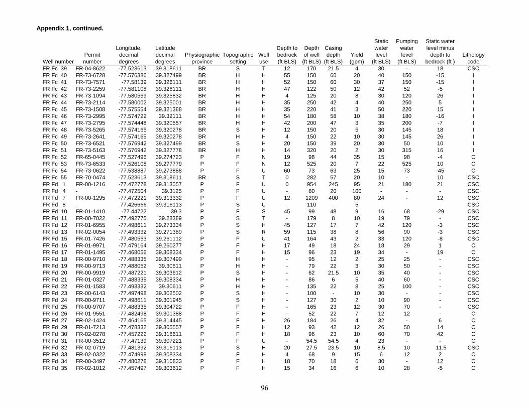
Appendix 1, continued.
Well numberPermit number
Longitude, decimal degrees
Latitude decimal degrees
Physiographic province
Topographic setting
Well use
Depth to bedrock (ft BLS)
Depth of well
(ft BLS)
Casing depth
(ft BLS)Yield (gpm)
Static water level
(ft BLS)
Pumping water level
(ft BLS)
Static water level minus
depth to bedrock (ft )
Lithology code
FR Fc 39 FR-04-8622 -77.523613 39.318611 BR S T 12 170 21.5 4 30 - 18 CSCFR Fc 40 FR-73-6728 -77.576386 39.327499 BR H H 55 150 60 20 40 150 -15 IFR Fc 41 FR-73-7571 -77.58139 39.326111 BR H H 52 150 60 30 37 150 -15 IFR Fc 42 FR-73-2259 -77.581108 39.326111 BR H H 47 122 50 12 42 52 -5 IFR Fc 43 FR-73-1094 -77.580559 39.325832 BR H H 4 125 20 8 30 120 26 IFR Fc 44 FR-73-2114 -77.580002 39.325001 BR H H 35 250 42 4 40 250 5 IFR Fc 45 FR-73-1508 -77.575554 39.321388 BR H H 35 220 41 3 50 220 15 IFR Fc 46 FR-73-2995 -77.574722 39.32111 BR H H 54 180 58 10 38 180 -16 IFR Fc 47 FR-73-2795 -77.574448 39.320557 BR H H 42 200 47 3 35 200 -7 IFR Fc 48 FR-73-5265 -77.574165 39.320278 BR S H 12 150 20 5 30 145 18 IFR Fc 49 FR-73-2641 -77.574165 39.320278 BR H H 4 150 22 10 30 145 26 IFR Fc 50 FR-73-6521 -77.576942 39.327499 BR S H 20 150 39 20 30 50 10 IFR Fc 51 FR-73-5163 -77.576942 39.327778 BR H H 14 320 20 2 30 315 16 IFR Fc 52 FR-65-0445 -77.527496 39.274723 P F N 19 98 44 35 15 98 -4 CFR Fc 53 FR-73-6533 -77.526108 39.277779 P F N 12 525 20 7 22 525 10 CFR Fc 54 FR-73-0622 -77.538887 39.273888 P F U 60 73 63 25 15 73 -45 CFR Fc 55 FR-70-0474 -77.523613 39.318611 BR S T 0 282 57 20 10 - 10 CSCFR Fd 1 FR-00-1216 -77.472778 39.313057 P F U 0 954 245 95 21 180 21 CSCFR Fd 4 - -77.472504 39.3125 P F U - 60 20 100 - - - CSCFR Fd 7 FR-00-1295 -77.472221 39.313332 P F U 12 1209 400 80 24 - 12 CSCFR Fd 8 - -77.426666 39.316113 P S U - 110 - 5 - - - CSCFR Fd 10 FR-01-1410 -77.44722 39.3 P F S 45 99 48 9 16 68 -29 CSCFR Fd 11 FR-00-7022 -77.492775 39.28389 P S T - 179 8 10 19 79 - CSCFR Fd 12 FR-01-6955 -77.498611 39.273334 P S H 45 127 17 7 42 120 -3 CSCFR Fd 13 FR-02-0054 -77.493332 39.271389 P S R 59 115 38 8 56 90 -3 CSCFR Fd 15 FR-01-7426 -77.480553 39.261112 P F U 41 164 43 2 33 120 -8 CSCFR Fd 16 FR-01-9971 -77.479164 39.260277 P F H 17 49 18 24 18 29 1 CFR Fd 17 FR-01-1495 -77.468056 39.308334 P F H 15 96 23 19 34 - 19 CFR Fd 18 FR-00-9710 -77.488335 39.307499 P H H - 95 12 2 25 25 - CSCFR Fd 19 FR-00-9713 -77.488052 39.30611 P H H - 79 22 3 30 50 - CSCFR Fd 20 FR-00-9919 -77.487221 39.303612 P S H - 62 21.5 10 35 40 - CSCFR Fd 21 FR-01-0327 -77.488335 39.308334 P H H - 86 6 5 40 60 - CSCFR Fd 22 FR-01-1583 -77.493332 39.30611 P H H - 135 22 8 25 100 - CSCFR Fd 23 FR-00-6143 -77.497498 39.302502 P S H - 100 - 10 30 - - CSCFR Fd 24 FR-00-9711 -77.498611 39.301945 P S H - 127 30 2 10 90 - CSCFR Fd 25 FR-00-9707 -77.488335 39.304722 P F H - 165 23 12 30 70 - CSCFR Fd 26 FR-01-9551 -77.482498 39.301388 P F H - 52 22 7 12 12 - CFR Fd 27 FR-02-1424 -77.464165 39.314445 P F H 26 184 26 4 32 - 6 CFR Fd 29 FR-01-7213 -77.478332 39.305557 P F H 12 93 42 12 26 50 14 CFR Fd 30 FR-02-0278 -77.457222 39.318611 P F H 18 96 23 10 60 70 42 CFR Fd 31 FR-00-3512 -77.47139 39.307221 P F U - 54.5 54.5 4 23 - - CFR Fd 32 FR-02-0719 -77.481392 39.316113 P S H 20 27.5 23.5 10 8.5 10 -11.5 CSCFR Fd 33 FR-02-0322 -77.474998 39.308334 P F H 4 68 9 15 6 12 2 CFR Fd 34 FR-00-3497 -77.480278 39.310833 P F H 18 70 18 6 30 - 12 CFR Fd 35 FR-02-1012 -77.457497 39.303612 P F H 15 34 16 6 10 28 -5 C
96
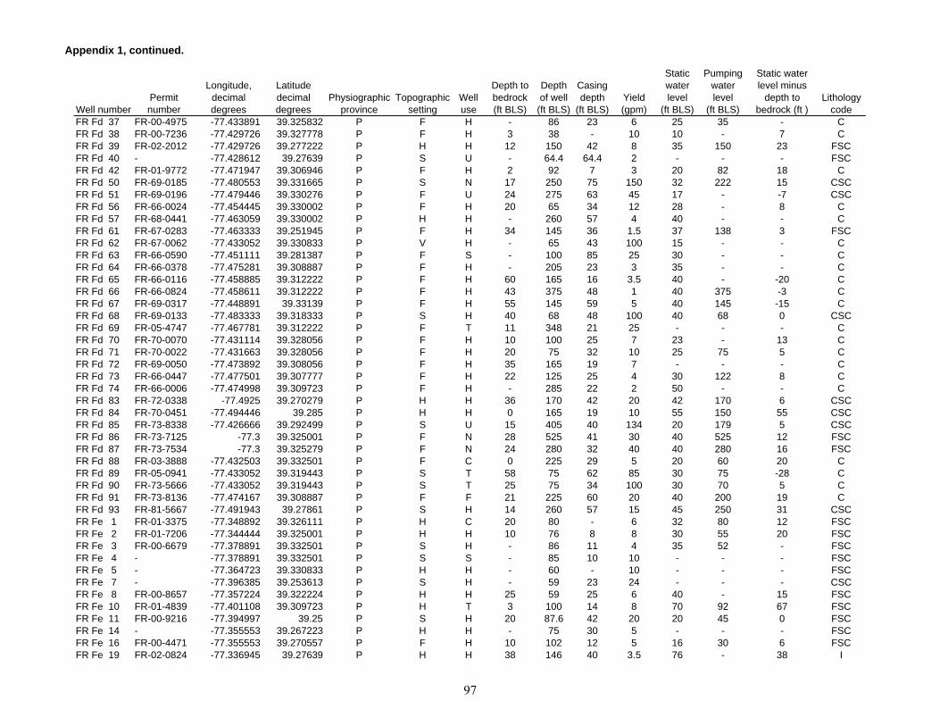
Appendix 1, continued.
Well numberPermit number
Longitude, decimal degrees
Latitude decimal degrees
Physiographic province
Topographic setting
Well use
Depth to bedrock (ft BLS)
Depth of well
(ft BLS)
Casing depth
(ft BLS)Yield (gpm)
Static water level
(ft BLS)
Pumping water level
(ft BLS)
Static water level minus
depth to bedrock (ft )
Lithology code
FR Fd 37 FR-00-4975 -77.433891 39.325832 P F H - 86 23 6 25 35 - CFR Fd 38 FR-00-7236 -77.429726 39.327778 P F H 3 38 - 10 10 - 7 CFR Fd 39 FR-02-2012 -77.429726 39.277222 P H H 12 150 42 8 35 150 23 FSCFR Fd 40 - -77.428612 39.27639 P S U - 64.4 64.4 2 - - - FSCFR Fd 42 FR-01-9772 -77.471947 39.306946 P F H 2 92 7 3 20 82 18 CFR Fd 50 FR-69-0185 -77.480553 39.331665 P S N 17 250 75 150 32 222 15 CSCFR Fd 51 FR-69-0196 -77.479446 39.330276 P F U 24 275 63 45 17 - -7 CSCFR Fd 56 FR-66-0024 -77.454445 39.330002 P F H 20 65 34 12 28 - 8 CFR Fd 57 FR-68-0441 -77.463059 39.330002 P H H - 260 57 4 40 - - CFR Fd 61 FR-67-0283 -77.463333 39.251945 P F H 34 145 36 1.5 37 138 3 FSCFR Fd 62 FR-67-0062 -77.433052 39.330833 P V H - 65 43 100 15 - - CFR Fd 63 FR-66-0590 -77.451111 39.281387 P F S - 100 85 25 30 - - CFR Fd 64 FR-66-0378 -77.475281 39.308887 P F H - 205 23 3 35 - - CFR Fd 65 FR-66-0116 -77.458885 39.312222 P F H 60 165 16 3.5 40 - -20 CFR Fd 66 FR-66-0824 -77.458611 39.312222 P F H 43 375 48 1 40 375 -3 CFR Fd 67 FR-69-0317 -77.448891 39.33139 P F H 55 145 59 5 40 145 -15 CFR Fd 68 FR-69-0133 -77.483333 39.318333 P S H 40 68 48 100 40 68 0 CSCFR Fd 69 FR-05-4747 -77.467781 39.312222 P F T 11 348 21 25 - - - CFR Fd 70 FR-70-0070 -77.431114 39.328056 P F H 10 100 25 7 23 - 13 CFR Fd 71 FR-70-0022 -77.431663 39.328056 P F H 20 75 32 10 25 75 5 CFR Fd 72 FR-69-0050 -77.473892 39.308056 P F H 35 165 19 7 - - - CFR Fd 73 FR-66-0447 -77.477501 39.307777 P F H 22 125 25 4 30 122 8 CFR Fd 74 FR-66-0006 -77.474998 39.309723 P F H - 285 22 2 50 - - CFR Fd 83 FR-72-0338 -77.4925 39.270279 P H H 36 170 42 20 42 170 6 CSCFR Fd 84 FR-70-0451 -77.494446 39.285 P H H 0 165 19 10 55 150 55 CSCFR Fd 85 FR-73-8338 -77.426666 39.292499 P S U 15 405 40 134 20 179 5 CSCFR Fd 86 FR-73-7125 -77.3 39.325001 P F N 28 525 41 30 40 525 12 FSCFR Fd 87 FR-73-7534 -77.3 39.325279 P F N 24 280 32 40 40 280 16 FSCFR Fd 88 FR-03-3888 -77.432503 39.332501 P F C 0 225 29 5 20 60 20 CFR Fd 89 FR-05-0941 -77.433052 39.319443 P S T 58 75 62 85 30 75 -28 CFR Fd 90 FR-73-5666 -77.433052 39.319443 P S T 25 75 34 100 30 70 5 CFR Fd 91 FR-73-8136 -77.474167 39.308887 P F F 21 225 60 20 40 200 19 CFR Fd 93 FR-81-5667 -77.491943 39.27861 P S H 14 260 57 15 45 250 31 CSCFR Fe 1 FR-01-3375 -77.348892 39.326111 P H C 20 80 - 6 32 80 12 FSCFR Fe 2 FR-01-7206 -77.344444 39.325001 P H H 10 76 8 8 30 55 20 FSCFR Fe 3 FR-00-6679 -77.378891 39.332501 P S H - 86 11 4 35 52 - FSCFR Fe 4 - -77.378891 39.332501 P S S - 85 10 10 - - - FSCFR Fe 5 - -77.364723 39.330833 P H H - 60 - 10 - - - FSCFR Fe 7 - -77.396385 39.253613 P S H - 59 23 24 - - - CSCFR Fe 8 FR-00-8657 -77.357224 39.322224 P H H 25 59 25 6 40 - 15 FSCFR Fe 10 FR-01-4839 -77.401108 39.309723 P H T 3 100 14 8 70 92 67 FSCFR Fe 11 FR-00-9216 -77.394997 39.25 P S H 20 87.6 42 20 20 45 0 FSCFR Fe 14 - -77.355553 39.267223 P H H - 75 30 5 - - - FSCFR Fe 16 FR-00-4471 -77.355553 39.270557 P F H 10 102 12 5 16 30 6 FSCFR Fe 19 FR-02-0824 -77.336945 39.27639 P H H 38 146 40 3.5 76 - 38 I
97
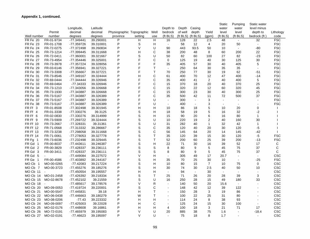
Appendix 1, continued.
Well numberPermit number
Longitude, decimal degrees
Latitude decimal degrees
Physiographic province
Topographic setting
Well use
Depth to bedrock (ft BLS)
Depth of well
(ft BLS)
Casing depth
(ft BLS)Yield (gpm)
Static water level
(ft BLS)
Pumping water level
(ft BLS)
Static water level minus
depth to bedrock (ft )
Lithology code
FR Fe 20 FR-01-9734 -77.349441 39.290001 P H H 16 128 22 2.5 48 - 32 FSCFR Fe 23 FR-01-1708 -77.359726 39.310001 P S H - 58 12 4 20 50 - FSCFR Fe 24 FR-72-0275 -77.372498 39.260834 P V U 90 443 93.5 50 10 - -80 FSCFR Fe 25 FR-73-1214 -77.399445 39.311668 P H C 38 200 48 8 60 200 22 FSCFR Fe 26 FR-72-0411 -77.360001 39.321667 P S U 50 82 60 100 27 82 -23 FSCFR Fe 27 FR-73-4954 -77.354446 39.325001 P F C 0 125 19 40 30 125 30 FSCFR Fe 28 FR-73-3978 -77.357224 39.328056 P F F 35 405 57 30 40 405 5 FSCFR Fe 29 FR-03-6146 -77.356941 39.327221 P F T - 250 64 30 35 35 - FSCFR Fe 30 FR-73-3308 -77.356667 39.327221 P F T 70 250 77 30 19 62 -51 FSCFR Fe 31 FR-73-8546 -77.349167 39.324444 P H C 61 400 70 12 47 400 -14 FSCFR Fe 32 FR-69-0444 -77.344444 39.326946 P F C 35 400 41 2 40 400 5 FSCFR Fe 33 FR-69-0464 -77.34333 39.326946 P F C 15 370 18 20 40 370 25 FSCFR Fe 34 FR-73-1210 -77.343056 39.326668 P F C 15 320 22 12 60 320 45 FSCFR Fe 35 FR-73-1930 -77.343887 39.326668 P F C 15 300 23 30 40 300 25 FSCFR Fe 36 FR-73-5167 -77.343887 39.326389 P F C 35 500 42 11 72 500 37 FSCFR Fe 37 FR-73-5167 -77.343887 39.326389 P F U - 300 - 3 - - - FSCFR Fe 38 FR-73-5167 -77.343887 39.326389 P F U - 400 - 3 - - - FSCFR Ff 3 FR-01-8508 -77.302498 39.301945 P H H 10 86 18 5 10 20 0 IFR Ff 4 FR-01-3338 -77.330276 39.3125 P S H 18 58 19 5 16 32 -2 IFR Ff 6 FR-02-0830 -77.330276 39.314999 P S H 15 90 20 6 16 80 1 IFR Ff 9 FR-73-5909 -77.269722 39.324444 P S U 10 220 19 2 40 160 30 IFR Ff 10 FR-73-2667 -77.328331 39.31361 P S U 31 282 40 1 32 42 1 IFR Ff 12 FR-71-0568 -77.313332 39.286667 P S C 35 120 40 20 30 120 -5 IFR Ff 13 FR-73-3238 -77.298058 39.311668 P S C 56 145 64 20 14 145 -42 IFR Ff 14 FR-71-0061 -77.278053 39.327778 P S T 35 120 39 15 30 120 -5 FSCFR Fg 1 FR-73-6036 -77.232498 39.329445 P S T 52 200 60 25 39 200 -13 FSCFR Gd 1 FR-00-8037 -77.443611 39.246387 P S H 22 71 30 16 39 52 17 CFR Gd 2 FR-00-3829 -77.428337 39.236111 P S S 8 80 9 5 45 75 37 CFR Gd 3 FR-00-3411 -77.428337 39.236111 P S S 8 80 9 5 45 75 37 CFR Gd 5 - -77.449084 39.227572 P V H - 305 49 17 20.7 - - CSCFR Ge 1 FR-00-4586 -77.403892 39.244167 P S H 35 70 25 30 10 - -25 FSCMO Cb 1 MO-00-0265 -77.42083 39.217224 P S H 10 80 15 7 10 75 0 CSCMO Cb 7 MO-00-3723 -77.455276 39.185276 P S H 30 74 30 2.5 40 50 10 CSCMO Cb 11 - -77.450554 39.195557 P H H - 94 - 30 - - - CSCMO Cb 14 MO-01-2458 -77.426392 39.218334 P S T 25 71 26 20 28 39 3 CSCMO Cb 15 MO-02-8678 -77.452102 39.21559 P S U 16 250 28 15 49 180 33 CSCMO Cb 18 - -77.485617 39.178576 P V R - 140 50 20 15.6 - - CSCMO Cb 20 MO-09-0053 -77.419724 39.220001 P S C - 148 42 12 39 122 - CSCMO Cb 21 MO-00-5547 -77.445831 39.18 P H T - 150 28 3 19 86 - CSCMO Cb 22 MO-06-0438 -77.446663 39.180279 P W T - 100 22 25 31 80 - CSCMO Cb 23 MO-08-0206 -77.43 39.223332 P H H - 114 24 8 38 93 - CSCMO Cb 24 MO-09-0097 -77.425003 39.22028 P H C - 125 24 15 30 100 - CSCMO Cb 25 MO-02-0176 -77.448608 39.16861 P H H 4 100 18 3 21 71 17 CSCMO Cb 26 MO-72-0191 -77.465979 39.195083 P V U 20 885 38 75 1.6 - -18.4 CSCMO Cb 27 MO-02-0191 -77.46623 39.195097 P V U - 75 18 8 1.7 - - CSC
98

Appendix 1, continued.
Well numberPermit number
Longitude, decimal degrees
Latitude decimal degrees
Physiographic province
Topographic setting
Well use
Depth to bedrock (ft BLS)
Depth of well
(ft BLS)
Casing depth
(ft BLS)Yield (gpm)
Static water level
(ft BLS)
Pumping water level
(ft BLS)
Static water level minus
depth to bedrock (ft )
Lithology code
MO Cb 28 - -77.454445 39.191113 P H H - 310 37 15 26 - - CSCMO Cb 29 MO-73-0284 -77.449165 39.210556 P V C 10 1004 40 100 47.8 197.8 37.8 CSCMO Cb 30 MO-73-0173 -77.454445 39.185555 P H I 12 115 40 8 54 101 42 CSCMO Cb 31 MO-73-1131 -77.423058 39.220001 P S H 15 110 45 10 28 66 13 CSCMO Cb 32 MO-73-0899 -77.423332 39.217777 P S H 6 85 - 8 31 69 25 CSCMO Cb 33 MO-73-0293 -77.422226 39.179722 P H H 16 100 - 6 30 86 14 CSCMO Cb 36 MO-73-0281 -77.421045 39.215193 P S H 2 100 60 15 45 - 43 CSCMO Cb 37 MO-73-2213 -77.465279 39.188057 P S H 2 140 87 129 35 140 33 CSCMO Cc 1 MO-00-3371 -77.349724 39.247223 P H H 20 90 30 10 30 50 10 FSCMO Cc 2 MO-00-0835 -77.370552 39.247776 P S H - 125 - 45 26 63 - FSCMO Cc 3 MO-00-3256 -77.370834 39.246944 P S H 40 112 66 30 35 50 -5 FSCMO Cc 4 MO-00-3240 -77.363609 39.248612 P V H 20 48 20 4.5 25 35 5 FSCMO Cc 5 MO-00-4585 -77.348892 39.246666 P H H - 100 33 3 22 95 - FSCMO Cc 6 MO-00-9514 -77.365555 39.176109 P S H - 165 32 0.5 18 - - FSCMO Cc 9 MO-00-1105 -77.352501 39.190834 P S H - 55 18 30 20 35 - FSCMO Cc 10 MO-00-3675 -77.371666 39.203335 P H H 30 74 40 30 30 40 0 FSCMO Cc 11 - -77.361114 39.214443 P H H - 88 10 9 40 - - FSCMO Cc 13 - -77.394722 39.198334 P H T - 100 - 7 20.16 - - FSCMO Cc 16 - -77.376663 39.217224 P H U - 400 - 0.25 - - - FSCMO Cc 17 - -77.376389 39.217777 P S H - 86 - 4 - - - FSCMO Cc 18 MO-00-3637 -77.369446 39.207779 P H H - 74 68 10 40 60 - FSCMO Cc 21 - -77.411392 39.179443 P H I - 62 16 14 29.54 - - FSCMO Cc 22 - -77.415276 39.173611 P H H - 86 46 20 28 60 - FSCMO Cc 23 MO-00-0259 -77.412224 39.231945 P H H 7 85 - 20 45 70 38 FSCMO Cc 24 MO-00-4447 -77.352776 39.244167 P H H - 86 48 12 42 65 - FSCMO Cc 25 MO-03-8281 -77.392776 39.224445 P H T 56 200 58 5 22 160 -34 FSCMO Cc 26 MO-03-2638 -77.33667 39.191666 P S T 60 92 70 10 10 40 -50 FSCMO Cc 27 MO-03-1147 -77.335831 39.176388 P S U 44 110 48 20 38 65 -6 FSCMO Cc 28 MO-07-0049 -77.415001 39.169998 P S H - 120 92 15 26 111 - FSCMO Cc 30 MO-73-0590 -77.379166 39.203056 P V H 26 124 46 15 41 111 15 FSCMO Cc 31 MO-73-0502 -77.409447 39.182499 P S N 60 160 21 20 40 160 -20 FSCMO Cc 32 MO-73-1646 -77.386108 39.205002 P S H 31 200 46 3 - - - FSCMO Cc 33 MO-73-0692 -77.415001 39.174446 P S H - 80 43 40 30 80 - FSCMO Cc 34 MO-73-0910 -77.360275 39.214443 P H H 22 125 55 15 54 118 32 FSCMO Cc 35 MO-73-0560 -77.404442 39.188332 P H H - 300 38 1 50 300 - FSCMO Cc 37 MO-67-0040 -77.358055 39.215 P H T 56 98 58 15 26 81 -30 FSCMO Cc 38 MO-73-0987 -77.376946 39.223057 P S H 31 105 42 5 26 88 -5 FSCMO Cc 39 MO-73-0579 -77.379166 39.227501 P S S - 105 43 10 29 86 - FSCMO Cc 40 MO-73-0776 -77.375 39.222221 P S H 35 125 42 5 26 113 -9 FSCMO Cc 41 MO-73-1198 -77.394997 39.200554 P S H 36 210 46 1.5 21 195 -15 FSCMO Cc 42 MO-73-0458 -77.40889 39.196945 P S H 11 160 42 2 38 149 27 FSCMO Cc 45 MO-71-0013 -77.396111 39.169445 P S H - 125 89 10 30.2 111 - FSCMO Cc 46 MO-69-0145 -77.396942 39.196945 P S H 30 125 37 3 26 118 -4 FSCMO Cc 47 MO-69-0187 -77.378891 39.220554 P S T 20 145 24 6 35 60 15 FSCMO Cc 50 MO-73-1637 -77.34861 39.248055 P H H 37 210 45 1.5 36 179 -1 FSC
99
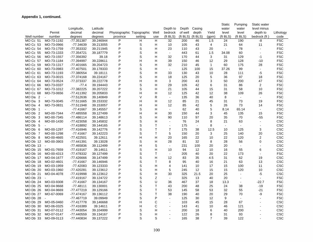
Appendix 1, continued.
Well numberPermit number
Longitude, decimal degrees
Latitude decimal degrees
Physiographic province
Topographic setting
Well use
Depth to bedrock (ft BLS)
Depth of well
(ft BLS)
Casing depth
(ft BLS)Yield (gpm)
Static water level
(ft BLS)
Pumping water level
(ft BLS)
Static water level minus
depth to bedrock (ft )
Lithology code
MO Cc 51 MO-73-1192 -77.351387 39.246944 P H H 32 200 46 1.5 24 190 -8 FSCMO Cc 53 MO-73-0966 -77.34639 39.213055 P S H 10 105 43 4 21 64 11 FSCMO Cc 54 MO-73-1759 -77.353332 39.211945 P S H 23 110 43 20 - 78 - FSCMO Cc 55 MO-73-1333 -77.354721 39.187779 P S H - 443 61 1.5 34.08 60 - FSCMO Cc 56 MO-73-1557 -77.356392 39.18 P S H 32 170 44 3 31 129 -1 FSCMO Cc 57 MO-73-1184 -77.394997 39.228611 P H H 39 150 46 12 29 128 -10 FSCMO Cc 59 MO-73-1317 -77.401665 39.204723 P S H 32 210 45 1 60 175 28 FSCMO Cc 60 MO-73-0983 -77.407501 39.178333 P S H - 125 100 15 37.26 99 - FSCMO Cc 61 MO-73-1193 -77.380554 39.18111 P S H 33 130 43 10 28 111 -5 FSCMO Cc 63 MO-73-0015 -77.374168 39.224167 P S H 18 125 20 5 36 97 18 FSCMO Cc 64 MO-73-0524 -77.373337 39.222778 P H H 3 200 43 3 50 200 47 FSCMO Cc 66 MO-73-0337 -77.4 39.194443 P S H 29 105 42 6 31 86 2 FSCMO Cc 67 MO-73-1012 -77.382225 39.207222 P S H 21 105 44 15 31 58 10 FSCMO Cc 68 MO-73-0656 -77.411392 39.205833 P H H 12 125 42 12 38 109 26 FSCMO Da 2 - -77.512636 39.140849 P V R - 135 36 40 8 - - FSCMO Da 3 MO-73-0045 -77.511665 39.153332 P H H 12 85 21 45 31 73 19 FSCMO Da 4 MO-73-0831 -77.511948 39.153057 P H H 12 85 42 5 26 73 14 FSCMO Db 1 - -77.41667 39.145557 P S H - 62 40 5 8.14 65.14 - CSCMO Db 2 MO-00-7344 -77.485558 39.127499 P H H 30 150 44 3 45 135 15 FSCMO Db 3 MO-00-7345 -77.486114 39.148613 P S H 90 110 97 20 35 70 -55 FSCMO Db 4 MO-00-1430 -77.423058 39.145832 P S H - 76 24 8 21 63 - CSCMO Db 5 - -77.418892 39.144165 P S T - 175 - 8 - - - CSCMO Db 6 MO-00-1297 -77.416946 39.142776 P S T 7 175 38 12.5 10 125 3 CSCMO Db 7 MO-00-1298 -77.41667 39.142223 P S T 5 150 20 3 25 140 20 CSCMO Db 8 MO-00-4665 -77.422501 39.12611 P H H 20 165 22 10 22 120 2 CSCMO Db 12 MO-00-3903 -77.441391 39.13028 P S H 28 81 32 8 28 56 0 CSCMO Db 13 - -77.465836 39.112499 P H S - 231 100 20 20 - - CSCMO Db 15 MO-01-7659 -77.419167 39.14611 P S H 10 94 12 10 16 55 6 CSCMO Db 16 MO-00-4313 -77.478332 39.127499 P S T - 205 40 20 22 173 - FSCMO Db 17 MO-04-1677 -77.426666 39.147499 P S H 12 83 35 4.5 31 62 19 CSCMO Db 18 MO-02-4601 -77.41667 39.146946 P S T 8 95 40 16 21 63 13 CSCMO Db 19 MO-03-1959 -77.42083 39.123333 P S H 4 141 10 17 15 100 11 CSCMO Db 20 MO-03-1960 -77.420281 39.123612 P S H 5 245 12 15 15 120 10 CSCMO Db 21 MO-04-4078 -77.419998 39.123612 P S H 30 325 21.5 20 25 - -5 CSCMO Db 23 - -77.419167 39.124722 P S Z - 325 13 40 20 - - FSCMO Db 24 MO-03-9308 -77.41667 39.134167 P S U 36 467 37 18 13.3 - -22.7 FSCMO Db 25 MO-04-9668 -77.48111 39.130001 P S T 43 200 48 25 24 38 -19 FSCMO Db 26 MO-04-9669 -77.477219 39.129166 P S T 53 145 58 53 32 55 -21 FSCMO Db 27 MO-67-0069 -77.474167 39.136112 P S T 38 190 40 20 29 70 -9 FSCMO Db 28 - -77.467719 39.09949 P S P - 125 30 12 9 - - FSCMO Db 29 MO-05-0460 -77.417778 39.146668 P H C - 103 45 15 28 67 - CSCMO Db 30 MO-06-0325 -77.416389 39.14611 P H C - 143 41 10 46 121 - CSCMO Db 31 MO-07-0112 -77.443054 39.104999 P S H - 200 18 6 40 200 - CSCMO Db 32 MO-07-0147 -77.440559 39.134167 P S H - 122 26 8 31 93 - CSCMO Db 33 MO-09-0113 -77.440834 39.137222 P S S - 165 38 7 39 122 - CSC
100

Appendix 1, continued.
Well numberPermit number
Longitude, decimal degrees
Latitude decimal degrees
Physiographic province
Topographic setting
Well use
Depth to bedrock (ft BLS)
Depth of well
(ft BLS)
Casing depth
(ft BLS)Yield (gpm)
Static water level
(ft BLS)
Pumping water level
(ft BLS)
Static water level minus
depth to bedrock (ft )
Lithology code
MO Db 34 MO-01-0166 -77.416946 39.146389 P H C - 185 25 5 36 171 - CSCMO Db 35 MO-09-0154 -77.445831 39.103054 P S H - 125 43 4 35 102 - FSCMO Db 36 MO-04-4079 -77.41861 39.108891 P V U - 280 23 150 2.4 156.4 - FSCMO Db 37 - -77.428055 39.117222 P S S - 340 26 20 0.35 - - FSCMO Db 38 - -77.419167 39.123612 P S U - 210 - 65 - - - FSCMO Db 39 - -77.432503 39.095001 P H H - 140 - 2 - - - FSCMO Db 40 - -77.432221 39.093613 P S H - 170 - 5 62.67 - - FSCMO Db 42 - -77.425835 39.094444 P S H - 120 - 8 - - - FSCMO Db 43 MO-05-0389 -77.474724 39.165554 P S H - 82 52 4 5 - - FSCMO Db 44 MO-02-0083 -77.445274 39.156666 P S H - 120 20 20 29 93 - CSCMO Db 46 MO-02-0162 -77.49778 39.162777 P S H - 102 23 10 58.6 73.6 - FSCMO Db 47 MO-73-1584 -77.422226 39.135834 P V P - 600 62 50 33 143 - CSCMO Db 48 MO-73-0426 -77.452774 39.136391 P S H 6 325 42 6 32 - 26 FSCMO Db 49 MO-73-0740 -77.449448 39.134445 P S H 6 245 41 3 50 245 44 CSCMO Db 50 MO-73-1889 -77.458885 39.15889 P H H 15 100 42 12 30 79 15 CSCMO Db 51 MO-73-0369 -77.446114 39.163334 P S H - 155 45 5 30 - - CSCMO Db 52 MO-73-1463 -77.43972 39.141666 P V S 22 150 45 6 20 105 -2 CSCMO Db 53 MO-73-1469 -77.453056 39.163887 P H H 8 230 - 3 45 230 37 CSCMO Db 59 MO-73-1497 -77.471108 39.160278 P S H 2 140 84 15 40 140 38 FSCMO Db 60 MO-73-1462 -77.463333 39.104168 P S I - 170 45 4 41 130 - FSCMO Db 61 MO-73-1544 -77.455276 39.120556 P S H 31 150 50 20 29 71 -2 CSCMO Db 68 MO-73-1869 -77.476944 39.133888 P G U 30 250 40 150 13.2 - -16.8 CSCMO Db 71 MO-73-1894 -77.457222 39.162224 P H H 30 125 42 20 35 120 5 CSCMO Db 72 MO-73-0634 -77.464165 39.104168 P S H 12 155 45 2 58 136 46 FSCMO Db 77 MO-73-1316 -77.472504 39.161388 P S H 70 205 83 25 30 40 -40 FSCMO Db 78 MO-73-0944 -77.426392 39.11639 P S H 12 125 45 3 31 109 19 CSCMO Db 80 MO-73-2145 -77.424446 39.147221 P F H 3 120 42 25 8.2 120 5.2 CSCMO Db 81 MO-73-2338 -77.45 39.158611 P S H 2 200 44 4 6.4 200 4.4 CSCMO Db 82 MO-73-2127 -77.488609 39.163887 P H H 0 200 149 20 60 200 60 CSCMO Db 83 MO-88-1536 -77.498054 39.14611 P H H 63 170 72 40 55 160 -8 CSCMO Dc 2 MO-00-4919 -77.360001 39.09111 P S H 48 - 50 7 80 80 -8 CSCMO Dc 3 MO-00-1116 -77.385559 39.162777 P S H 20 70 22 20 16 22 -4 FSCMO Dc 6 - -77.416115 39.148334 P S H - 72 - 3 - - - CSCMO Dc 7 MO-00-9163 -77.413055 39.131943 P S H 20 135 28 15 42 75 22 CSCMO Dc 8 - -77.368614 39.125832 P S S - 203 - 6 - - - CSCMO Dc 11 - -77.404167 39.124722 P S S - 97 - 8 - - - CSCMO Dc 13 -77.368332 39.105278 P S S - 137 - 20 - - - CSCMO Dc 14 MO-06-0163 -77.396668 39.158333 P W H - 74 22 16 22 58 - CSCMO Dc 15 MO-03-5127 -77.408058 39.123333 P S S - 155 22 10 30 140 - CSCMO Dc 16 MO-03-5552 -77.405281 39.120834 P S H 10 155 15 10 30 120 20 CSCMO Dc 17 MO-03-5831 -77.406944 39.120556 P S I - 317 23.5 80 25 40 - CSCMO Dc 18 MO-70-0014 -77.412224 39.141666 P H P 7 597 63 53 29 166 22 CSCMO Dc 19 MO-70-0046 -77.414719 39.142776 P S P 4 450 63 95 38 125 34 CSCMO Dc 20 MO-05-0553 -77.347221 39.135555 P S H - 165 - 7 39 136 - CSCMO Dc 21 MO-06-0179 -77.390556 39.099724 P H H - 120 22 4 19 111 - FSC
101

Appendix 1, continued.
Well numberPermit number
Longitude, decimal degrees
Latitude decimal degrees
Physiographic province
Topographic setting
Well use
Depth to bedrock (ft BLS)
Depth of well
(ft BLS)
Casing depth
(ft BLS)Yield (gpm)
Static water level
(ft BLS)
Pumping water level
(ft BLS)
Static water level minus
depth to bedrock (ft )
Lithology code
MO Dc 22 MO-66-0144 -77.364998 39.123612 P S H 20 145 22 18 41 123 21 CSCMO Dc 23 MO-07-0038 -77.375275 39.10611 P S H - 165 24 6 47 149 - CSCMO Dc 24 MO-07-0149 -77.403053 39.115555 P S H - 160 23 6 10 160 - CSCMO Dc 25 MO-08-0016 -77.40667 39.140835 P S H - 143 31 12 26 121 - CSCMO Dc 26 MO-07-0304 -77.402496 39.114445 P S H - 143 20 3 18 116 - CSCMO Dc 27 MO-68-0230 -77.385834 39.099167 P S H 3 64 30 30 40 50 37 FSCMO Dc 28 MO-04-4441 -77.415001 39.115833 P H C 20 400 20 30 - - - FSCMO Dc 29 MO-03-9309 -77.411392 39.134167 P V U 37 315 33 60 11.78 187.62 -25.22 FSCMO Dc 31 MO-73-0075 -77.405281 39.142776 P S P - 285 82 100 12.2 80.8 - CSCMO Dc 32 - -77.391945 39.14611 P S H 16 106 21 5 - 79 - CSCMO Dc 33 MO-01-0156 -77.343613 39.132221 P S U 55 105 20 10 21 67 -34 CSCMO Dc 34 MO-01-0074 -77.396668 39.130001 P S H - 145 28 8 41 122 - CSCMO Dc 35 MO-00-0103 -77.405281 39.138054 P S H 60 165 42 20 26 131 -34 CSCMO Dc 36 MO-00-0072 -77.397499 39.0975 P H S - 205 47 11 31 185 - CSCMO Dc 37 MO-02-0036 -77.376114 39.105278 P H H - 200 22 3 41 180 - CSCMO Dc 38 MO-00-0165 -77.343056 39.128056 P H H - 105 22 7 20 89 - CSCMO Dc 39 MO-03-0121 -77.392502 39.146389 P H H 6 160 60 12 66 141 60 CSCMO Dc 40 MO-73-1124 -77.413055 39.151112 P V H 8 130 43 40 28 105 20 CSCMO Dc 41 MO-73-0489 -77.40361 39.120556 P V H 8 125 42 30 30 111 22 CSCMO Dc 42 MO-73-0549 -77.388611 39.100834 P S I 31 120 40 15 31 112 0 CSCMO Dc 43 MO-73-0728 -77.416115 39.151112 P V H 2 131 46 15 12 20 10 CSCMO Dc 44 MO-73-0597 -77.396668 39.158611 P S H 22 65 24 20 21 50 -1 CSCMO Dc 45 MO-73-1367 -77.390556 39.153889 P S H 45 160 63 2 58.67 160 13.67 FSCMO Dc 46 MO-73-1368 -77.389168 39.15139 P S H 24 130 44 10 44 130 -8 FSCMO Dc 47 MO-73-0645 -77.395836 39.084168 P F H 19 165 25 10 43 146 24 FSCMO Dc 48 MO-73-0950 -77.359169 39.10389 P W H 12 105 30 7 29 86 17 CSCMO Dc 49 MO-73-0417 -77.391945 39.097778 P S H 8 205 41 3 12 - 4 FSCMO Dc 50 MO-05-5253 -77.416115 39.15139 P S T 16 105 38 10 41 76 25 CSCMO Dc 55 MO-03-5558 -77.413612 39.148334 P V H 12 92 45 12 28 46 16 CSCMO Dc 56 MO-73-1139 -77.403892 39.110001 P S H 39 125 42 1 12 121 -27 CSCMO Dc 58 MO-03-0075 -77.407501 39.143055 P S P - 285 82 100 12.2 80.8 - CSCMO Dc 59 MO-73-1896 -77.411941 39.154724 P S U 2 260 42 4 5.37 260 3.37 CSCMO Dc 63 MO-73-0711 -77.405556 39.162777 P S H - 100 42 10 50 - - FSCMO Dc 64 MO-73-1774 -77.403892 39.165001 P S H - 150 48 4 50.5 83 - FSCMO Dc 65 MO-73-1915 -77.401665 39.131111 P S H 9 130 48 4 29 93 20 CSCMO Dc 67 MO-66-0479 -77.402222 39.163055 P S H 50 81 52 15 13.4 58 -36.6 FSCMO Dc 68 MO-73-1840 -77.390556 39.155834 P S H 12 250 42 3 40 245 28 FSCMO Dc 69 MO-73-1770 -77.349441 39.105835 P S H 10 150 50 7 41 89 31 CSCMO Dc 70 MO-73-1749 -77.346108 39.095276 P S H 10 110 46 8 36 72 26 CSCMO Dc 71 MO-73-1701 -77.390831 39.163612 P S H 16 210 46 2 34 169 18 FSCMO Dc 72 MO-73-2284 -77.408333 39.131111 P V U 7 275 41 12 - - - FSCMO Dc 73 MO-73-1941 -77.402779 39.14611 P H H 8 130 43 3 29.3 98 21.3 CSCMO Dc 74 MO-73-1861 -77.344719 39.127777 P S N 15 130 40 3 79 101 64 CSCMO Dc 75 MO-73-1616 -77.385559 39.130001 P S H 2 260 42 4 30.66 260 28.66 CSCMO Dc 76 MO-73-0034 -77.344719 39.132778 P S H 12 110 16 3 19 96 7 CSC
102

Appendix 1, continued.
Well numberPermit number
Longitude, decimal degrees
Latitude decimal degrees
Physiographic province
Topographic setting
Well use
Depth to bedrock (ft BLS)
Depth of well
(ft BLS)
Casing depth
(ft BLS)Yield (gpm)
Static water level
(ft BLS)
Pumping water level
(ft BLS)
Static water level minus
depth to bedrock (ft )
Lithology code
MO Dc 77 MO-73-1902 -77.395279 39.133888 P S H 10 130 73 8 29 98 19 CSCMO Dc 78 MO-73-2082 -77.402222 39.165001 P S H - 180 - 4 20 180 - FSCMO Dc 79 MO-73-2229 -77.371109 39.103054 P S H 7 130 42 3 29 98 22 CSCMO Dc 80 MO-73-1149 -77.366943 39.098332 P S H 10 100 42 5 41.92 88 31.92 CSCMO Dc 81 MO-73-0490 -77.349167 39.10389 P S H 6 105 - 6 47 91 41 CSCMO Dc 82 MO-73-2330 -77.382225 39.09639 P S H 28 170 - 5 32 105 4 FSCMO Dc 83 MO-73-2420 -77.396942 39.098332 P S H 11 190 42 6 49 148 38 CSCMO Dc 84 MO-73-2494 -77.404167 39.162777 P S H 29 130 42 4 36 91 7 FSCMO Dc 85 MO-73-1968 -77.35 39.136665 P S H 15 160 65 20 45 160 30 CSCMO Dc 87 MO-94-0288 -77.403892 39.149723 P V H - 250 250 2.3 30 240 - - MO Dc 89 MO-81-2738 -77.381668 39.098332 P H H 15 190 50 4 35 125 20 FSCMO Ec 1 MO-00-3008 -77.341392 39.078335 P V H 45 84 48 6 33 84 -12 CSCMO Ec 2 MO-00-3830 -77.340553 39.075554 P V H 17 75 21 2 15 75 -2 CSCMO Ec 3 - -77.340279 39.076389 P V H - 38 - 4 - - - CSCMO Ec 4 MO-00-3006 -77.341392 39.078888 P S H 24 95 31 2.5 35 95 11 CSCMO Ec 5 MO-00-7664 -77.347778 39.079166 P S H 35 157 38 12 60 83 25 CSCMO Ec 6 MO-08-0033 -77.340553 39.069168 P V Z - 124 40 30 28 36 - CSCMO Ec 9 MO-06-0395 -77.339722 39.076668 P S H - 118 - 10 50 100 - CSCMO Ec 10 MO-73-2833 -77.416115 39.080833 P G U 23 855 26 400 8.65 23.45 -14.35 CSCMO Ed 12 MO-73-0596 -77.331108 39.078888 P S H 16 165 23 3 35.5 140 19.5 -
103
Martin O’Malley John R. Griffin Governor Secretary Anthony G. Brown Joseph P. Gill Lt. Governor Deputy Secretary
A message to Maryland’s citizens The Maryland Department of Natural Resources (DNR) seeks to balance the preservation and enhancement of the living and physical resources of the state with prudent extraction and utilization policies that benefit the citizens of Maryland. This publication provides information that will increase your understanding of how DNR strives to reach that goal through the earth science assessments conducted by the Maryland Geological Survey.
Martin O’Malley Governor
MARYLAND DEPARTMENT OF NATURAL RESOURCES Resource Assessment Service Tawes State Office Building
580 Taylor Avenue Annapolis, Maryland 21401
Toll free in Maryland: 1-877-620-8DNR Out of State call: 1-410-260-8021
TTY users: Call via the Maryland Relay Internet Address: www.dnr.Maryland.gov
MARYLAND GEOLOGICAL SURVEY 2300 St. Paul Street
Baltimore, Maryland 21218 Telephone Contact Information: 410-554-5500
Internet Address: www.mgs.md.gov
DNR Publication Number 12-5102012-567 September 2012
The facilities and services of the Maryland Department of Natural Resources are available to all without regard to race, color, religion, sex, sexual orientation, age, national origin or physical or mental disability.
This document is available in alternative format upon request from a qualified individual with a disability. Printed on recycled paper