Embed Size (px)
Citation preview

PRE-FEASIBILITY REPORT
Of
GUDIPADU LIMESTONE BLOCKGudipadu Village, Yadiki Mandal,
Anantapur District, Andhra Pradesh
AREA OF MINING LEASE – 40.816 HANON-FOREST LAND
For
LIMESTONE PRODUCTION – 0.5 MTPA
By
M/s. PENNA CEMENT INDUSTRIES LIMITED
Prepared By
B.S. ENVI-TECH (P) LIMITEDSecunderabad – 500 017

PRE – FEASIBILITY REPORT
1. Executive Summary
Penna Cement Industries Limited (PCIL) proposes to produce 0.50MTPA of Limestone from its new mine i.e., Gudipadu LimestoneBlock spreading over an area of 40.816 Ha. in survey nos. 79(P), 82,83, 84, 92, 96, 97 & 98 of Gudipadu Village, Yadiki Mandal,Anantapur District, A.P. which was auction by the Govt. of AndhraPradesh as per Auction Rules, 2015.
The limestone from the subject area is proposed to supplement theproduction in the operating Gudipadu mine i.e ML-1 which is over anextent of 392.62 ha. The subject area is adjacent to the northboundary of Gudipadu ML-1. The subject area is excepted toaugment the reserves available to meet the increased demand of theexpansion captive cement plant near Boyareddypalli. The presentclinker production of 1.50 million tonnes is proposed to be increasedto 3.78 million tonnes per year. When this enhanced production ofclinker goes on stream the requirement of limestone would be 5.30MTPA and the required reserves for 50 years is estimated to be 275million tonnes.
The mineable reserves in the subject mining lease area are estimatedto be about 26.656 million tonnes. With the above reserves and at theplanned production rate of 0.5 MTPA, the deposit will have life of 53years.
PCIL proposed to adopt opencast mechanised method of mining inthe mining lease area to win the limestone production.
The limestone from the mine will be transported to the crusherlocated at a distance 2.5 km. the crushed limestone will betransported through existing closed belt conveyor to the cementplant.
The waste generated from the mine is only small quantity of blackcotton soil and will be used for afforestation.
No overburden waste is generated from the mine. It is estimated thatabout 48800cu. m of top soil will be generated during the life ofmine. The soil generated will be completely used for spreading in thebarrier zone for Plantation.

The mined out area of Gudipadu Limestone Block will be convertedinto water reservoir to store the rain water.
Total water requirement in the mining lease will be 30 m3/day. Waterrequirement will be met from adjacent mine pit of ML-1.
The power requirement will be obtained from dedicated power supplyfrom the State Grid of APSEB located at Gooty with a substationestablished near the plant.
26 persons will be employed at different levels. The Mines Managershall be in charge of the mine holding First Class Manager’scertificate of competency issued under MMR, 1961.
The capital cost of the project is estimated to be about Rs 20 crores

2. Introduction of the Project / Background information
i. Identification of project and project proponent. In case of miningproject, a copy of mining lease / letter of intent should be given.
PCIL is one of the largest privately held cement companies in India,with an installed cement capacity of 7 Million Tonnes Per Annum.
Founded in 1991, Penna Cement has established itself as one of themost trusted cement brands, with significant footprints in southernand western India. Our clientele ranges from small house owners toestablished real estate developers and from various stategovernments to global construction majors.
Over the last two decades, we have grown organically by developingin-house expertise and capabilities, across the entire value chain inthe cement industry. All our cement plants are equipped with state-of-the-art technology, enabling the company to deliver the superiorquality products.
On August 10th 1994, PCIL commissioned first plant inTalaricheruvu, Ananthpur with an initial capacity of 0.2 MTPA. Overthe last two decades, PCIL have installed 4 cement plants and onecaptive power plant and increased our capacity to more than sevenmillion tonnes. Four cement plants are strategically located, to caterto customers all across Southern India.
PCIL is accredited with ISO: 9001- 2008, IS: 18001:2007 andISO:14001:2004. It is a professionally managed and well establishedcement manufacturing company enjoying the confidence ofconsumers because of its superior quality product and excellentcustomer service. PCIL is running cement plants and mine with latesteco-friendly technology.
PENNA CEMENT INDUSTRIES LTDBOYAREDDIPALLI CEMENT PLANT
PENNA CEMENT INDUSTRIES LTD., (PCIL), is operating a CementPlant at Boyareddypalli Village, Yadiki Mandal, Anantapur District,Andhra Pradesh with the following production capacities
• 1.5 MTPA Clinker production capacity• 2.0 MTPA Cement production and• 10 MW Waste Heat Recovery based captive Power Plant

The limestone requirement of the cement plant is met from captivelimestone mine i.e., GUDIPADU LIMESTONE MINE spread over anarea of 392.62 Ha with present limestone production capacity of 2.3MTPA. Limestone mine is located at 4.1 km at Gudipadu andKundanakota villages, Yadiki Mandal, Ananthapur District, AndhraPradesh
PCIL proposes to increase of Clinker production capacity of theCement Plant from 1.50 MTPA to 4.0 MTPA which requireslimestone of 5.3 MTPA
The subject area is expected to augment the reserves available tomeet the increased demand of the expansion captive cement plantnear Boyareddypalli.
The mining lease over an area of 40.816 ha. in survey nos. 79(P), 82,83, 84, 92, 96, 97 & 98 of Gudipadu Village, Yadiki Mandal,Anantapur District, A.P. was auction by the Govt. of Andhra Pradeshas per Auction Rules, 2015. On the basis of e-Action Industries andCommerce (M-III) department, Government of Andhra Pradesh hasdeclared M/s Penna Cement Industries Limited has successful bidderand issued letter of intent vide Memo No. 6138/M.III(1)/2016,Dt.02.09.2016. The copy of the Memo from Govt of Andhra Pradeshis enclosed as Annexure-1
Subject proposal
Penna Cement Industries Limited (PCIL) proposes to produce 0.50MTPA of Limestone from its new mine i.e., Gudipadu LimestoneBlock spreading over an area of 40.816 Ha located at GudipaduVillage, Yadiki Mandal, Anantapur District, Andhra Pradesh..
Gudipadu Limestone Block is covered in an extent of 40.816 ha ofnon-forest land of which 16.093 Ha is Govt waste Land and 24.723Ha is agricultural non irrigated PCIL’s own land.
DETAILS OF MINING LEASESMiningLease
Area Reserves(MillionTonnes)
Jurisdiction(Village)Acres Ha.
GudipaduLimestone
Block
100.85 40.816 26.656 Gudipadu

ii. Brief description of nature of the project
PCIL proposes to produce 0.5 MTPA of Limestone from the GudipaduLimestone Block by adopting opencast mechanized method of mining.
iii. Need for the project and its importance to the country and orregion.
The limestone produced from Gudipadu Limestone Block is meant forthe captive consumption in the cement plant of PCIL.
iv. Imports Vs. Indigenous production.
The limestone produced from Gudipadu Limestone Block is meant forthe captive consumption in the cement plant of PCIL.
v. Export possibility.
No exports are proposed.
vi. Domestic / export markets
The limestone produced from Gudipadu Limestone Block is meant forthe captive consumption in the cement plant of PCIL. Hence noexports are proposed.
vii. Employment generation (direct and indirect) due to the project.
26 persons will be employed at different levels for operating the mine

3. Project Description
i. Type of project including interlinked and interdependentprojects, if any.
The project is for limestone production of 0.50 MTPA from GudipaduLimestone Block which is spreading over an area of 40.816 ha andfalls under the jurisdiction of Gudipadu Village, Yadiki with aboutproved mineral reserve of 26.658 Million will last for 53 years. Thelimestone produced from the mine is of good grade limestone and isdirectly utilized for the cement production
Status of the interlinked/interdependent projects:-
Project Location Capacity ApprovalsCementPlant
BoyareddypalliVillage, YadikiMandal,AnantapurDistrict, AndhraPradesh.
Increase OfProductionClinker: 1.5 to4.0 MillionTonnes perAnnumCEMENT: 2.0to 4.6 MillionTonnes perAnnum
EnvironmentalClearance is underprocess
It is a Category-B project, which necessitates obtaining EnvironmentClearance from State Level Environment Impact AssessmentAuthority (SEIAA) of Andhra Pradesh.
ii. Location (map showing general location, specific location, andproject boundary & project site layout) with coordinates.
Gudipadu Limestone Block is falling under the jurisdiction ofGudipadu Village, Yadiki Mandal, Anantapur District of AndhraPradesh and is located at about 5 to 6 km from the cement plant ofPCIL.
The mine lease area falls between 15° 6'46.27" - 15° 7'10.70" Northlatitude and 77°57'54.86" - 77°58'42.06" East longitude. The minesite is covered in Survey of India topo sheet no 57 E/16.
Nearest railway line connecting Tadpatri to Gooty Jn. of SouthCentral Railway line is at a distance of 16.8 km in SW direction.

Anantapur is the major city which is located at a distance of 62.0 kmin SW to the Mine site. Nearest major Railway is Tadipatri at adistance of 23.0 km in Southern direction.
There are no wild life sanctuaries, national parks, elephant/tigerreserves within 10-km radius of the study area.
Nearest Settlements:
Kottapalli – 0.4 km - S Gudipadu – 2.1 km – SSE Kavulupalli – 2.0 km –W
Nearest Reserved Forests from the Mine site• Yadiki R F- 7.5 km – WNW• Deva gudipadu RF- 9.7 km – WNW• Owk R F- 6.9 km - N
The nearest industries to the mine site are
o Ultra tech cement Ltd – 10.3 km – SSEo Limestone Mine – 7.5 km – SEo PCIL Plant - 5.0 km – SSWo BMM Plant – 3.1 km - SSE
Fig - 1 shows the location of Gudipadu Limestone Block inAnantapur district of Andhra Pradesh.
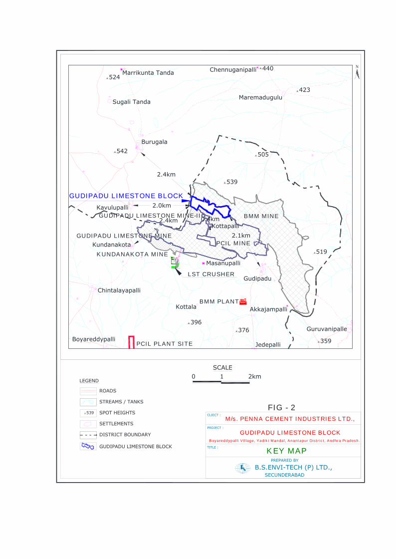
Fig - 2 shows the key plan of the Gudipadu Limestone Block.
Fig – 3 shows the 10 km radius of the study area. Salient features ofthe mine site are given in Table – 1.
iii.Details of alternate sites considered and the basis of selectingthe proposed site, particularly the environmental considerationsgone into should be highlighted.
No alternate sites were considered as the deposit is site specific.
iv. Size or magnitude of operation.
PCIL proposes to produce 0.5 MTPA of Limestone from GudipaduLimestone Block.

Mining operations will be carried out by deploying the Heavy EarthMoving Machinery
The lease area comprises of grey to dark grey limestone withvariegated argillaceous limestone at places. The entire area is oflimestone bearing Quartzite the bottom most formation has beenintersected in few boreholes. The soil in the ML is a very thin layerand mostly interlocked in the fractures. The general strike of thelimestone beds in the lease area is WNW-ESE with low dips of 30 to 60
due north/ north westerly. Most of the area is covered with blackcotton soil which is a thin veneer with an average thickness of 0.30m. There are sporadic out crops of dark grey limestone in the leasearea. The lithological sequence of the lease area as per theexploration carried out is as under.
Black Cotton SoilMassive Dark Gray LimestoneLight Gray / Ash Gray LimestonePurple Limestone / Shale
The dark gray limestone forms the main zone which forms the graderequired/ suitable to the plant for clinkerisation. It has thegradational contact with the low grade variegated limestone whichhas moderately high silica and low CaO content. The dark gray andbuff limestone are blended in suitable propositions to arrive at theROM in the plant requirement.
The total mineral reserves in the mining lease area of GudipaduLimestone Block are estimated to be about 26.656 million tonnes.
Based on the mineral reserves of 26.656 million tonnes of GudipaduLimestone Block, at the proposed production rate of 0.5 MTPA, thelife of the mine will be about 53 years.

ANDHRA PRADESH
LOCATION MAP
Chittoor
SPSR Nellore
Prakasam
GunturKrishna
Kurnool
Anantapur
YSR Kadapa
West Godavari
East Godavari
Vishakhapatnam
Vizianagaram
Srikakulam
FIG - 1
INDIA
ANANTAPUR DISTRICT
LEGEND
RAILWAY TRACK
RIVER & CANAL
ROAD
DISTRICT BOUNDARY
STATE HIGHWAY
TALUK HEADQUARTER
DISTRICT HEADQUARTER
TOWN
STREAMS
NATIONAL HIGHWAY
GUDIPADU LIMESTONE BLOCK
7
N
Obalapuram
Palturu
HonnuraNimbagallu
BeluguppaKanekallu
Naranjigundlapalle
Rayadurg
Golla
Setturu
Cherlapalle
Kundurpi
Amarapuram
Hemavathi
Rolla
Parigi
Roddam
Lepakshi
Kalyandurg
Madakasira
Hindupur
GadekalluVidapanakallu
Kanur
GulapalemGuntakal
Gooty
UravakondaKhadarupeta
Rayalacheruve Yadiki
Tarimela
Pamidi
Garladinne
Kuderu
Tadpatri
Singanamala
Putluru
Mutssukota
Sanagalaguduru
EllanuruNarapala
TadimarriZangalapalle
Atmakuru
NutimaduguTogarakunta
MaruruKanaganapalle
Anantapur
Peruru Dharmavaram Chinnekuntapalle
Mudigubba
Malakavemula
TalupulaReddivaripalle
Kalasamudram
Danayaneheruvu
KokkantiPeddaballe
Nallacheruvu
TanakulluKokkanti
Muhaminadabad
Komonda
Kondakomarla
Goranda
Palasamudram
Chilamatturu
KadiriPenukonda
Puttaparti
Gutturu PatnamPamudurti
Bukkapatnam
Ramgiri
Shri Satya SaiTemple
NagasamudramChannekottapalle
7
7
GUDIPADU LIMESTONE BLOCK
Note:- Not to Scale
539
SETTLEMENTS
SPOT HEIGHTS
STREAMS / TANKS
ROADS
LEGEND
GUDIPADU LIMESTONE BLOCK
DISTRICT BOUNDARY
B.S.ENVI-TECH (P) LTD.,
CLIECT :
TITLE :
SECUNDERABAD
PREPARED BY
KEY MAP
SCALE2km10
FIG - 2
PROJECT :
M/s. PENNA CEMENT INDUSTRIES LTD.,
N
Boyareddypalli Village, Yadiki Mandal, Anantapur District, Andhra Pradesh.
GUDIPADU LIMESTONE BLOCK
396376
423
440
542 505
539
524
359
519Kundanakota
Kavulupalli
Burugala
Sugali TandaMaremadugulu
BMM MINE
Kottala Akkajampalli
ChennuganipalliMarrikunta Tanda
Chintalayapalli
BoyareddypalliJedepalli
Gudipadu
Masanupalli
Guruvanipalle
KUNDANAKOTA MINE
PCIL PLANT SITE
BMM PLANT
LST CRUSHER
GUDIPADU LIMESTONE BLOCK
GUDIPADU LIMESTONE MINEPCIL MINE
2.4km
2.0km
2.4km
2.1km
N 49000
LST CRUSHER
ANFO MIXING SHED ROOMANFO STORE
MINES OFFICE COMPLEX
HSD BUNK
WALL
WALLMINES ADMIN BUILDING
CRUSHER CONTROL ROOM
CONVEYOR TO PLANT
E 49800N 49000
LST CRUSHER
ANFO MIXING SHED ROOMANFO STORE
MINES OFFICE COMPLEX
HSD BUNK
WALL
WALLMINES ADMIN BUILDING
CRUSHER CONTROL ROOM
CONVEYOR TO PLANT
E 49800
0.4kmKottapalli
GUDIPADU LIMESTONE MINE-II

M/s
. PE
NN
A C
EM
EN
T I
ND
US
TR
IES
LT
D.,
SH
OW
ING
10
km R
AD
IUS
TO
PO
GR
AP
HIC
AL
MA
PTI
TLE:
CLI
ENT:
Boy
ared
dypa
lli V
illag
e, Y
adik
i Man
dal,
Ana
ntap
ur D
istr
ict,
And
hra
Prad
esh.
GU
DIP
AD
U L
IME
ST
ON
E B
LOC
KPR
OJE
CT:
B.S
.EN
VI-
TE
CH
(P
) LT
D.,
SE
CU
ND
ER
AB
AD
PR
EP
AR
ED
BY
:
03
6km
SCALE
REF
ER T
O T
HIS
MAP
AS:-
1:5
0,00
0
Publ
ishe
d un
der
the
dire
ctio
n of
SH
EET
57/E
/16
FIRST
EDIT
ION
the
Sur
veyo
r G
ener
al o
f In
dia
- 19
77
464
396
369
376
423
440
542
389
387
505
539
524
426
349
359
464
474
429
519
398
Kun
dana
kota
Kav
ulup
alli
Virar
eddi
palli
Kam
alap
adu
Nitt
uru
Van
kam
etta
palli
Bur
ugal
a
Sug
ali T
anda
Mar
riku
nta
Tand
a
Laks
him
palli
FORES
T
SET
TLEM
ENTS
SPO
T H
EIG
HTS
CO
NTO
URS
STR
EAM
S /
TAN
KS
RO
AD
S
LEG
END Sur
vey
of I
ndia
Top
oshe
ets
GU
DIP
AD
U L
IMES
TON
E BLO
CK
Mar
emad
ugul
u
57 E 11
57 F 9
1 J57
3 I57
12 E57
13 F57
15 E57
OW
K R
ES
ER
VE
D F
OR
ES
T
DIS
TRIC
T BO
UN
DARY
Inde
x to
Chi
kkep
alli
YA
DIK
IR
F
57 E 16
57 I 4
Kot
tala
Pedd
a V
anka
Lokk
iram
apur
am
Akk
ajam
palli
422
Nal
laba
pana
palli
Chi
ntam
anup
alli
Che
nnug
anip
alli
Mar
riku
nta
Tand
a
Kur
iapa
lli
Siv
aram
apur
am
Kon
a U
ppal
apad
u
Obu
lapu
ram
Kat
timan
ipal
li
350
450
380
350
300
280
350
350
430
400
440
450
50054
0
470
480
460
400
270
300
350
520
500
450
520
500
450
400
280
400 350
280
500
270
480
360
440
470
450
420
550
430
530
510
Chi
ntal
ayap
alli
Boy
ared
dypa
lli
Jede
palli
Gud
ipad
u
Mas
anup
alli
Viran
napa
lli
Kam
bhag
iris
wam
i
Pikk
illap
alle
Tan
da
Kon
dam
anay
anip
alle
Upp
alap
adu Ju
nutu
la
Pein
ikal
a
Kon
dam
idip
alle
Gur
uvan
ipal
le
Kam
mav
arip
alle
290
GU
DIP
AD
U L
IME
ST
ON
E M
INE
-II
KU
ND
AN
AK
OT
A M
INE PC
IL P
LAN
T S
ITE
BM
M P
LAN
T
ULT
RA
TE
CH
PLA
NT
GU
DIP
AD
U L
IME
ST
ON
E M
INE
LST
CR
US
HE
R
FIG
- 3
GU
DIP
AD
U L
IME
ST
ON
E B
LOC
K
DEVAGUDIPADU R F
LIM
ES
TO
NE
MIN
E
78°
0'
15°
10'
77°
55'
15°
5'
77°
55'
78°
0'
15°
10'
15°
5'
To Ray
alac
heru
vu8.
8 km
To Tadi
patr
i16
.0 k
m
SH-5
7
BM
M M
INE
420
Kot
tapa
lli
PC
IL M
INE

TABLE – 1SALIENT FEATURES OF THE MINE SITE
Feature DetailsAltitude 448 m above mslLongitude Between 77°57'54.86"E - 77°58'42.06"ELatitude Between 15° 6'46.27"N - 15° 7'10.70"N
Village, District, State Boyareddypalli village,Yadiki Mandal,Ananthapur District, Andhra Pradesh.
IMD STATION Anantapur – 62 km - SWDistrict head quarter Anantapur – 62 km - SWMaximum Temperature oC 42.2Minimum Temperature oC 11.1Relative Humidity, % 23-76Annual rainfall, mm 561.0Topography PlainSoil Type Hilly TerrainNearest water body Pedda Vanka – 5.2 km - E
Nearest Highway
National Highway NH – 7 (renamed as NH-44)Connecting Anantapur – Kurnool -28.0 km –WNWState Highway - SH-57 connecting Bellary –Nellore - 9.3 km - SSW
Nearest Railway station Major railway station - Tadipatri – 23.0 km – SRayalacheruvu – 16.8 km - SW
Nearest Industries
Ultra tech cement Ltd – 10.3 km - SSELimestone Mine – 7.5 km – SEPCIL Plant - 5.0 km – SSWBMM Plant – 3.1 km - SSE
National parks/bird sanctuaries None within 10 Km Radius
Nearest Village Kottapalli – 0.4 km - SGudipadu – 2.1 km – SSE
Nearest City Anantapur – 62.0 km - SW
Nearest Air port
Bellary Airport – 116.8 km – WKadapa Airport – 109.0 km – SEShamshabad (Hyderabad) – 237.0 km – NRenigunta (Tirupati) Airport – 234.0 km - SE
Nearest ForestYadiki RF – 7.5 km – WNWOwk R F - 6.9 km – NDeva gudipadu – 9.7 km – WNW
Historical places None Within 10 Km Radius* All distances mentioned in the above table are aerial distances.

v. Project description with process details (a schematic diagram/flow chart showing the project layout, components of the projectetc., should be given)
Opencast mining method is followed by deploying heavy machinerysuch as hydraulic excavator and dumper. An average bench height of8m is planned and will be maintained. The mine advancement andoperations will be continued from the center part of the applied areaand it is proposed to extend the bench advancement towards west,northern segment part of the lease.
The benches will be regularly dressed to prevent overhangs orundercut. An ultimate bench slope of 650 while the ultimate pit slopeof 450 will be maintained during the entire mining operations.
The mechanised method will consist of the following operations.
• Cleaning the top surface• Drilling and blasting• Excavation and loading by excavator• Haulage by dumpers up to crusher at a distance of 2.5 km
Drilling will be carried out with DTH machines of 150mm dia ofRevathi C60H. A Spacing and burden of is maintained presently bydrilling blast holes of 150 mm dia with sub grade drilling of 10%.Blast holes are normally drilled in rows and they are blasted by usingdelay action shock tube detonators. Multi delay firing is adopted inorder to achieve best fragmentation and optimum results. The blastholes are loaded with 20% booster explosives and 80% withslurry/ANFO. The overall powder factor works out to 7 tons/kg.Accordingly for 0.50 million tonnes production for charging the blastholes, booster and ANFO are used in 20:80 proportions. On the basisof the powder factor requirement of slurry explosives and ANFO peryear are of the order of 8,100 kgs of Booster and 32,400 kgs of ANFOfor 0.5 mil tons of limestone rising.
Loading is done by deploying Excavators and transportation oflimestone is done by 35 tonner dumpers.
The bench parameters are as follows:Bench height in limestone : 8 mWorking Bench width : 30-40 mWorking Bench angle : 65°Ultimate Pit slope angle : 45°

Flow chart of mining operations is given in Fig - 4.
vi. Raw material required along with estimated quantity, likelysource, marketing area of final product/s, mode of transport ofraw material and finished product.
No raw material is required.Fig - 4
vii. Resource optimization/recycling and reuse envisaged in theproject, if any, should be briefly outlined.
No reject or sub-grade material will be generated from the mine. Thewaste generated from the mine is mainly black cotton soil and will beused for afforestation.
Drilling
Blasting
Excavation
Loading into dumpers/tippers
Transportation to Crusher atCement Plant
MINING METHODOLOGY(OPEN CAST MECHANISED MINING)
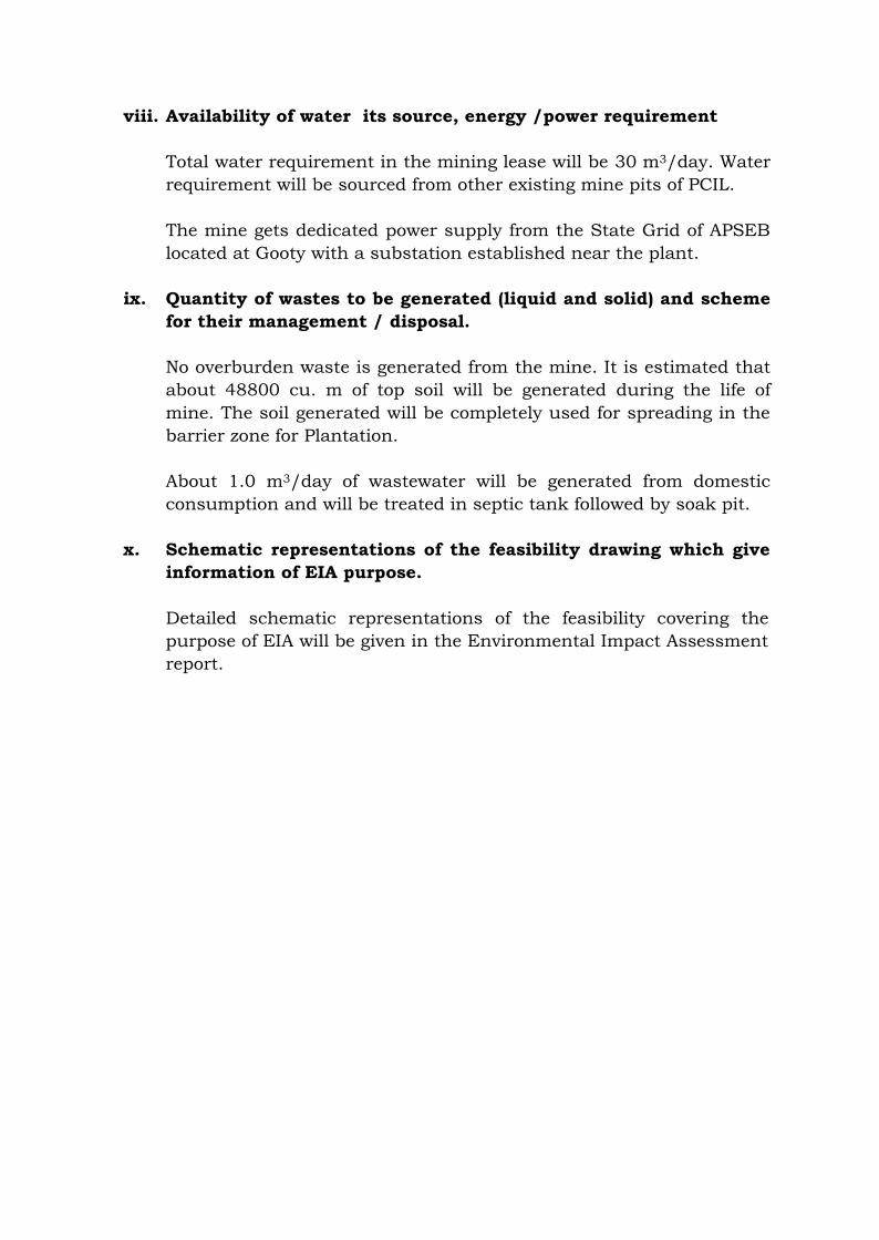
viii. Availability of water its source, energy /power requirement
Total water requirement in the mining lease will be 30 m3/day. Waterrequirement will be sourced from other existing mine pits of PCIL.
The mine gets dedicated power supply from the State Grid of APSEBlocated at Gooty with a substation established near the plant.
ix. Quantity of wastes to be generated (liquid and solid) and schemefor their management / disposal.
No overburden waste is generated from the mine. It is estimated thatabout 48800 cu. m of top soil will be generated during the life ofmine. The soil generated will be completely used for spreading in thebarrier zone for Plantation.
About 1.0 m3/day of wastewater will be generated from domesticconsumption and will be treated in septic tank followed by soak pit.
x. Schematic representations of the feasibility drawing which giveinformation of EIA purpose.
Detailed schematic representations of the feasibility covering thepurpose of EIA will be given in the Environmental Impact Assessmentreport.


4. Site Analysis
i. Connectivity
The nearest village to the mine is Kottapalli which is located at adistance of 0.4 km in S. Nearest railway line connecting Tadpatri toGooty Jn. of South Central Railway line is at a distance of 16.8 km inSW direction. National Highway - NH-7(renamed as NH-44)connecting Anantapur – Kurnool is at 28.0 km in WNW direction.State Highway - SH-57 connecting Bellary – Nellore is at 9.3 km inSSW direction The Nearest major Railway is Tadipatri is at a distanceof 23.0 km in Southern direction. Anantapur, the DistrictHeadquarters is 62 km away and is connected with good BT road.Buses ply regularly on this route.
ii. Land form, land use and land ownership.
The leasehold area of the Gudipadu Limestone Block is plain landwhich is covered in an extent of 40.816 ha of non-forest land of which16.093 Ha is Govt waste Land and 24.723 Ha is agricultural nonirrigated Company’s own land.
Topography (along with map)
The mining lease area is a sloping terrain with a maximum elevationis 448 m above MSL and a minimum of 422 m RL with a generalslope towards East and South direction. The western part of thelease area is elevated, plateau type, linear. No perennial nallahs orstreams are seen within the lease area.
The surface plan of the mining lease area is shown in Fig - 5

ML
BO
UN
DA
RY
I N D
E X
7.5m
BA
RR
IER
ZO
NE
& U
PL
CO
NTO
UR
WIT
H V
ALU
E (m
)
500M
50
0
250
150
100
200
430
428
426
424
422
432
434
436
438
440
442
444
446
448
44844
6
444
444 44
4
44244
0438
436
434
432
430
428
426
42442
2M
L B
OU
ND
AR
Y
7.5m
BA
RR
IER
ZO
NE
& U
PL
CO
NTO
UR
WIT
H V
ALU
E (m
)
CLI
EC
T :
TIT
LE :
SU
RFA
CE
PLA
N
FIG
- 5
PR
OJE
CT
:
M/s
. PE
NN
A C
EM
EN
T I
ND
US
TR
IES
LT
D.,
Boy
ared
dypa
lli V
illag
e, Y
adik
i Man
dal,
Ana
ntap
ur D
istr
ict,
And
hra
Pra
desh
.
GU
DIP
AD
U L
IME
ST
ON
E B
LOC
K

iii. Existing land use pattern (agriculture, non-agriculture, forest,water bodies (including area under CRZ), shortest distances fromthe periphery of the project to periphery of the forests, nationalpark, wild life sanctuary, eco sensitive areas, water bodies(distance from the HFL of the river), CRZ, in case of notifiedindustrial area, a copy of the Gazette notification should begiven.
Vegetation is very scanty in the area, even in the adjoining Forestareas, in the NE direction to the lease; it is open bushy type withsporadic trees.
Yadiki RF is at a distance of 6.9 km in N, and Yadiki RF is at adistance of 7.5 km in WNW. Pedda Vanka Nala is at a distance of 5.2km in E.
The Gudipadu limestone lease area falls in topo-sheet no. 57/E/16.Due to availability of rich limestone deposits, major cement plants,which are located within 25 km, are given below
MAJOR CEMENT INDUSTRIESMajor Cement
IndustriesDistance
(km)Direction w.r.t mine
Ultra Tech Cement 10.3 SSEBMM Cement 3.1 SSE
National Highway - NH-7(renamed as NH-44) connecting Anantapur –Kurnool is at 28.0 km in WNW direction. State Highway - SH-57connecting Bellary – Nellore is at 9.3 km in SSW direction. Anantapuris the major city located at a distance of 62.0 km in SW direction.
iv. Existing infrastructure.
PCIL is already having other mining leases in operation. The companyhas provided garage to undertake minor repairs and maintenance ofall mining equipment. Periodical and weekly maintenance will bedone by qualified persons.
The structures that would be built are magazine ANFO shed and themain haul roads which are outside the lease. These structures will beprotected and safe guarded till the mining in the lease is closed.Necessary maintenance will be carried out to keep the haul roads andthe road connecting the mine and the plant.

The mine office with first aid rooms, rest shelters, toilets, tool/storeroom etc. is situated in close proximity within Gudipadu ML-I.
v. Soil classification
The limestone deposit in the mine lease area is covered with thincover of black cotton soil varying thickness from 0.2 m to 0.4 m.
vi. Climatic data from secondary sources
The climate of the area is tropical which is manifested in hot andhumid summer, moderate monsoon and mild winter seasons. Thearea experiences extreme climatic conditions with wide variation inclimatic conditions during summer and mild winter seasons. May isgenerally the hottest month in the year. The maximum temperatureduring the day time was recorded as 42.20 and December the coldestmonth with temperature falling down to 18.10. The period betweenMarch and November is very humid and muggy daytime. The monthsof December to February are considered to have pleasant climate.Majority of the rainfall occurs during the months of June toSeptember through South West monsoon is with moderate to lowannual average rainfall of 561mm.
vii. Social infrastructure available.
After commissioning of Cement plant by PCIL at Boyireddypalli thereis a change in the life styles of the surrounding villages. There is anincrease in the overall basic facilities such as roads, schools, healthcenters etc., A better quality of life for the locals has been created andwhich is further expected to improve over a period of time.
The existing operations (cement plant & mining) have provided manyindirect / direct job opportunities to unskilled and skilled labourers.Owing to implementation of the new additional mine in the area therewill be a positive impact in socio cultural aspects.
5. Planning Brief
i. Planning concept (type of industries, facilities, transportationetc.) town and country planning / development authorityclassification.
ii. Population projection
The project would bring following benefits to the people of thesurrounding villages:
Generation of employment and improved standard of living; Increased revenue to the state by way of royalty, taxes and duties; Improved green cover; Superior communication and transport facilities etc.
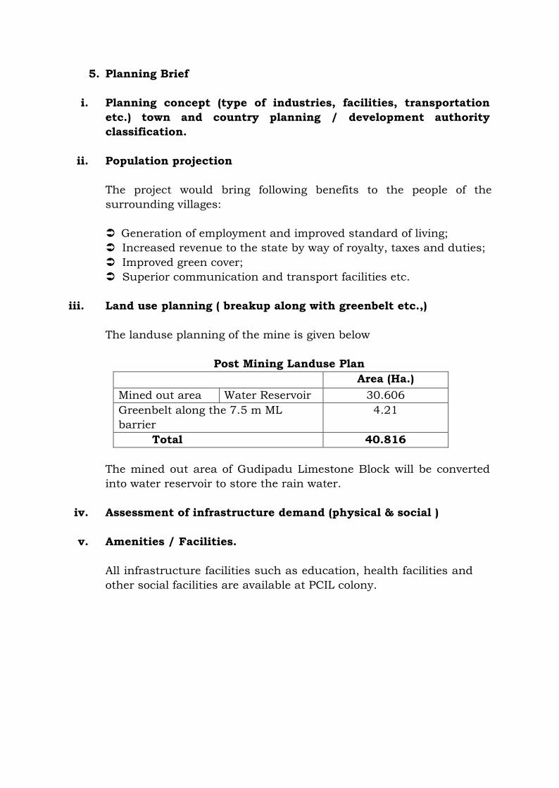
iii. Land use planning ( breakup along with greenbelt etc.,)
The landuse planning of the mine is given below
Post Mining Landuse PlanArea (Ha.)
Mined out area Water Reservoir 30.606Greenbelt along the 7.5 m MLbarrier
4.21
Total 40.816
The mined out area of Gudipadu Limestone Block will be convertedinto water reservoir to store the rain water.
iv. Assessment of infrastructure demand (physical & social )
v. Amenities / Facilities.
All infrastructure facilities such as education, health facilities andother social facilities are available at PCIL colony.

6. Proposed infrastructure
i. Industrial area ( processing area)
ii. Residential area ( non-processing area)
iii. Green belt.
The phased afforestation programme within the leasehold includesgreen belt plantation along the barrier zone around the boundary ofthe ML area in 4.21 Ha.
About 1500 saplings per hectare will be planted . All efforts will bemade to improve the aesthetic beauty of the area by plantingmaximum number of saplings and maintain them till they sustain bythemselves with good survival rate.
iv. Social infrastructure.
The mining activity carried out in the area rather has a positive socio-economic impact upon the nearby human settlement as indirectemployment potential is created due to mining and allied activities inthe area. Apart from these, the company promotes health andeducation awareness in the area time to time by organizing healthand education camps.
In addition PCIL has taken various social welfare programmes in thesurrounding villages. The focus areas include:
Economic development (Self Help Groups) Drinking Water Sanitation Health & Hygiene Relief & Rehabilitation Temples & Religion Related Assistance Education
v. Connectivity (traffic and transportation road/ rail/ metro/ waterways etc.,)
The nearest village to the mine is Kottapalli which is located at adistance of 0.4 km in S. Nearest railway line connecting Tadpatri toGooty Jn. of South Central Railway line is at a distance of 16.8 km inSW direction. National Highway - NH-7(renamed as NH-44)connecting Anantapur – Kurnool is at 28.0 km in WNW direction.
State Highway - SH-57 connecting Bellary – Nellore is at 9.3 km inSSW direction The Nearest major Railway is Tadipatri is at a distanceof 23.0 km in Southern direction. Anantapur, the DistrictHeadquarters is 62 km away and is connected with good BT road.Buses ply regularly on this route.
vi. Drinking water management (source & supply of water)
Total water requirement in the mining lease will be 30 m3/day. Waterrequirement will be sourced from other existing mine pits of PCIL.
vii. Sewerage system
Domestic wastewater from mines office will be treated in septic tankfollowed by soak pit.
viii. Industrial waste management
Not Applicable
ix. Solid waste management.
No overburden waste is generated from the mine. It is estimated thatabout 48800 cu. m of top soil will be generated during the life ofmine. The soil generated will be completely used for spreading in thebarrier zone for Plantation.
x. Power requirement & supply / source.
Power requirement in the mines will be for illumination. It is suppliedfrom the State Grid of APSEB located at Gooty with a substationestablished near the plant.

7. Rehabilitation and resettlement (R & R) Plan
i. Policy to be adopted (central / state) in respect of the projectaffected persons including home oustees, land oustees andlandless labourers (a brief out line to be given).
The mine area does not cover any habitation. Hence the miningactivities do not involve any displacement of human settlement. Nopublic buildings, places, monuments etc., exist within the lease areaor in the vicinity. The mining operations will not disturb/relocateany village. Hence no reclamation/ rehabilitation is envisaged.
8. Project schedule & Cost Estimates
i. Likely date of start of construction and likely date of completion(time schedule for the project to be given).
After obtaining all Statutory Clearances
ii. Estimated project cost along with analysis in terms of economicviability of the project.
The estimated project cost for the proposed limestone production willbe about Rs 20 crores

9. Analysis of proposal (Final Recommendations)
i. Financial and social benefits with special emphasis on thebenefit to the local people including tribal population, if any, inthe area.
Employment: Preference will be given for locals for employmentbased on qualifications & requirement. 26 people will be directlyemployed and another 50 will be indirectly employed.
Medical facilities: Medical facilities will be provided for employees aswell as people of nearby villages.
Educational facilities: Basic educational and vocational facilitieswill be provided for the children of employees as well as nearbyvillages.
Infrastructure facilities: Approach roads will be developed at parwith mine roads.