Embed Size (px)
Citation preview

POWER AND WATER AUTHORITY
D. Karp Hydrogeologist Water Resources Division Darwin April 1996 Report 33 /1996 D
BORE COMPLETION REPORT BORE 30254
BUNHUNARRA OUTSTATION

CONTENTS
1. INTRODUCTION 2. HYDROGEOLOGY
2.1 AQUIFER OCCURRENCE 2.2 SURFACE WATER
3. WATER QUALITY 4. WATER DEMAND 5. RESULTS 6. RECOMMENDATIONS
REFERENCES
LIST OF TABLES
1. WATER QUALITY DATA
LIST OF FIGURES
1. LOCAL GEOLOGY MAP BUCKINGHAM BAY SCALE 1 : 100 000 2. RELATIONSHIP BETWEEN pH VALUE AND ALKALINITY
ATTACHMENTS
1. COMPOSITE LOG- BORE 30254 2. TEST REPORT - BORE 30254 3. BORE LOCATION MAP 4. STEP DRAWDOWN TEST - BORE 30254 5. CONSTANT DISCHARGE TEST- BORE 30254
DISTRIBUTION
Aboriginal and Torres Strait Islander Commission, Nhulunbuy 1 Aboriginal Essential Services, Darwin 1 Gapuwiyak-Ngadangaay Homeland Resource Centre, Lake Evella 2 Water Resources Library, Darwin 3 Water Resources Library, Alice Springs 1 Water Resources Bore Data File 1 Hydrogeology Section, Darwin 2

AMG oc ID km Us Uc/d m mm m3/d mg/L pH SWL
Australian Map Grid degree Celsius internal diameter kilometres litres per second litres per capita per day metre millimetre cubic metres per day milligrams per litre acidity standing water level
LIST OF ABBREVIATIONS

1. INTRODUCTION
The objective of this work was to drill and construct two production bores providing an adequate water supply for the community. The work was carried out by Water Resources Division of Power and Water Authority, Darwin on behalf of the Ngadangaay Homeland Resource Centre.
A desktop study was conducted and aboriginal sacred site clearance gained, followed by field reconnaissance during which prospective sites were pegged and access checked. Drilling and bore construction were undertaken in August and September 1995 and test pumping followed in November 1995.
The Bunhunarra is an outstation of Gapuwiyak - Ngadangaay Homeland Resource Centre. It is located approximately 30 km northwest of Gapuwiyak - Lake Evella and is accessed via a dirt road throughout the year. It is covered by topographic map of Buckingham Bay 1: 1 00 000 map sheet 6073 and located at AMG co - ordinates 578474- 8 632003.
The geomorphology of Arnhem Land was divided into eight categories (Lynch. B.T., et al., 1996) based on association between geology and landforms. The project area lies within two major geomorphology units of Arnhem Land;
-Coastal floodplains;
-Steep rocky plateaux and hills (mostly quartz sandstone);
The "Coastal floodplains" are extended along the coastal margin of Arnhem Land. During the Quaternary age sea level rose an estimated 35 m and major river valleys, for example Buckingham River, were inundated. This resulted in deposition of estuarine, littoral mud in inundated areas and the alluvial sediments further inland. The sea level rise was followed by coastal emergence in the region or fall in sea level of approximately 7 m. As a result of this the broad coastal floodplains formed on exposed estuarine sediments. This unit is spread west of Bunhunarra outstation.
The "Steep rocky plateaux and hills (mostly quartz sandstone)" are developed east of the W arranyin outstation and cover 60% of the area. This unit is formed over quartz sandstone with elevation rising up to 120 m. The landscape of the area with a joints pattern, a series of strike ridges and gorges strongly reflects the nature of quartz sandstone. Some sandy soil were accumulated in drainage depressions and on colluvial footslopes.
The climate of the region is monsoonal with hot, humid summers and mild dry winters. Average annual rainfall is approximately 1600 mm and average annual evaporation greater than 2400 mm.

2. HYDROGEOLOGY
The regional geology is covered by the 1 : 1 00 000 map of Buckingham Bay Sheet 6273 completed by Northern Territory Geological Survey (Fig. 1) and the 1: 250 000 Geological Series Map Arnhem Bay/Gove, NT Sheet SD/53 - 3/4 and associated explanatory notes (Dunnet, D., 1965).
Warranyin is located on the northeast part of the Arafura Basin. It is underlain by the outcropping Buckingham Bay Sandstone of the Neoproterozoic age of the Wessel Group. The Buckingham Bay Sandstone ,the basal unit of the group, mainly consists of strongly cross-bedded friable medium grained quartz sandstone with a basal conglomerate in places.
The Cainozoic sediments in the vicinity of the outstation is developed as gravel, sand, silt, clay and black soil.
2.1 AQUIFER OCCURRENCE
The Neoproterozoic Buckingham Bay Sandstone is considered to contain low yielding aquifer controlled by secondary porosity. Previous drilling in this formation shows that a supply of up to 0.5 Us can be obtained in selected places. Production bores for the Bunhunarra outstation encountered shallow aquifers between 16.0 m and 28.0 m with supply up to 0.7 Us (cumulative airlift).
Cainozoic sediments in the area are low yielding aquifers. Supply is controlled by primary porosity and the extent and thickness of sediments. Aquifers of capacity 0.05 to 0.5 Us can be located.
2.2 SURFACE WATER
Small springs of fresh water were located along the edge of sandstone in Buckingham river valley in the vicinity of the outstation. It is not known if springs flow throughout the year or if it is a seasonal phenomena.

..
(_)
6 N 0 z ;;:( (_)
Cz
km 2 0 2 ~-;;;;J
I
LEGEND
Gravel, sand. sil t: ac ti ve channel. flood plain and s wamp deposits
Black soil: old vegetated coas tal deposits
Sand, silt. clay, commonly shelly: active inter tidal and supratidal sediments
Gravel, sand. silt, clay, ferruginous cemented detritus: undifferentiated Cainozoic deposits
4 I
Gzl Ferricrete
o 30044
Mudstone: grey and green when fresh. red when wea thered, micaceous, interbedded wi th fine- to medium -grained flaggy sands tone; sandstone, sandstone rubble dominates in most weathered ou tcrops Sandstone: white to red. fine-to coarse grained. mostly medium-to thick-bedded. commonly cross-bedded, rare mudstone interbeds: common basal breccia or coglomerate
Bore with registered number
Geological boundary
Watercourse
- -- - - - - - - · Track
/ usr / long/ bunhunar .dgn
1 : 100 000 LOCAL GEOLOGY MAP
BUCKINGHAM BAY 6073
6 km
I
· MAP LOCALITY
BUCKINGHAM BAY 6073
~~~~
Base mapping by Northern Terr itory Geological Survey Division, Department of Mines and Energy, Darwin, March 19 9 6.
Fig. 1

3. WATER QUALITY
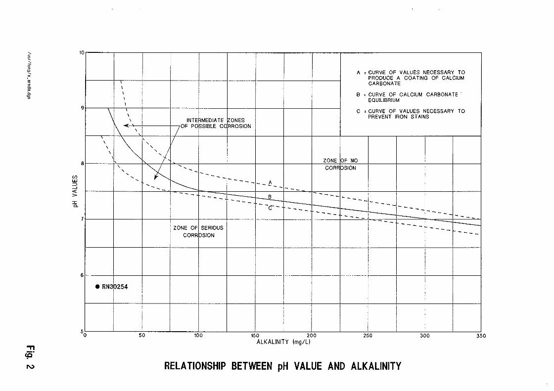
The quality of groundwater (Table 1) from bore 30254 is suitable for human consumption being within acceptable limits according to guidelines for potable water published by the Australian Water Resources Council/National Health and Medical Research Council (AWRC/NHMRC), 1987. Water from bore 30254 is corrosive (Fig.2) with pH 5.8 alkalinity 11 mg/L and total dissolved solids concentration 42 mg/L. This water will cause corrosion to conventional copper or brass plumbing fittings. Consideration should be given to the use of corrosion resistant materials (including PVC pipes) in the storage, head works and reticulation system.

: )> I ::J ~Q. 0~ ~- <D 3 ~. c :::1
3 3 (i) ~ oCQ 0 0 3 3 3 U>
<DD :::1 <D o.::.
-1 <D -· > Q. ~ CCJ<D,......_ r- < § m <D
u;<D - -~ Q 0 I D :j=
0 <D
=E 0 ~ > ~~ -1 ~ ~ m 0 o :;a <D <D f)
..., Q. . '-' ,......_
c:~ >;;v c:o =<~ 0~ >?S ..... ->~
.:::::
l'"".ll .
' .
~ en ~ 0 <D <D Q.
:::1 0 :::1
I ::r <D 0 §' (i) 0 <D Q.
3" ~
* *
I o- I (;, I
I I co ' (n ;
I I I
I I i I I i
~
0 0 0
w
I 0 0
I
I 0 w
I s 0
.t:>.
8 .t:>. 0 0
~
0
0 0-6 (XJ
------ ~-----
w 0
BORE REGISTERED NUMBER ~ (}1 .t:>.
I
~ co ---- DATE OF SAMPLING ~
~
-a (}1
I I
I (}1 pH (XJ I
ELECTRICAL CONDUCTIVITY .t:>. -a (uS at 25 deg C) Field/Lab
I .t:>. TOTAL DISSOLVED SOLIDS ~
(mg/1 by evaporation at 180 deg C) I ;
SODIUM. No ' .t:>.
'
i
I i ~ POTASSIUM. K !
i I I
I
! ~ CALCIUM. Co I
i ~ MAGNESIUM Mg '
i
I 1r ' IRON (TOTAL), Fe i It I
i
I ~
~ ~OTAL HARDNESS (as CaC03) I
i
I i ~ ~OTAL ALKALINITY (as CaC03) ~
' ' i ~ ~ILICA, Si02 ! 0
I CHLORIDE, Cl I
co
I w pULPHATE, S04
I NITRATE, N03 i ~
I I
I, ~ BICARBONATE, HC03 .t:>.
i
I CARBONATE, C03 i 0
I I
0 FLUORIDE, F :.....
I ~ Nact (calc from chloride) w I
' c <J>
'-0 ::>
<0
' ct> I ., ; 0. o;· 0.
<0 ::>
., us· 1\.)
C/) LU ;::) ....J <( > :I: a.
10
9
8
7
6
50
I I I I
\ I
\ \
\ '\
\
~ \
\ \
' ' ' ' .....
e RN3 p2s4
50
A = CURVE OF VALUES NECESSARY TO PRODUCE A COATING OF CALCIUM CARBONATE
B = CURVE OF CALCIUM CARBONATE . EQUILIBRIUM
C :CURVE OF VALUES NECESSARY TO PREVENT IRON STAINS
INTE RMEDIATE ~ONES /OF PO ~SIBLE CC RROSION
' I ',,!
ZONE bF NO
~ .....
CORR PSI ON ..... __
-- --1'---- ----- ........ A ........ ---..... _ ------ ----=-r----:---B --------- --- ----- --- -c-- r--- --- --------- 1------- t-- --------- ------- - -
ZONE OF SERIOUS ---- ----CORR ~SION ----
100 150 200 250 300 350 ALKALINITY (mg/Ll
RELATIONSHIP BETWEEN pH VALUE AND ALKALINITY

4. WATER DEMAND
The present and future water demand for Bunhunarra outstation could be met with a supply from bore 30254. Based on a population of 50, and an assumed demand of 250 Uc/d (Draft "Guidelines for levels of service to rural communities and outstations" PAWA, 1995), the calculated consumption would be 12.5 m3/d compared to a potential supply from bore 30254 of 34.5 m3/d .

5.RESULTS
During this project three bores were drilled and only one was constructed as a production bore (bore 30254);
- Bore 30254 located at AMG co-ordinates 577000 - 8 631700 - Bore 30255 located at AMG co-ordinates 577000 - 8 316000 - Bore 30073 located at AMG co-ordinates 578500- 8 631900
Bore 30254 was drilled to a total depth of 49.8 m and encountered 0.6 Us (cumulative airlift) of potable water from 9.0 to 28.9 m. The bore was constructed with PVC class 12 casing and slotted casing with 1 mm slots from 13.5 m to 22.0 m and from 27.5 m to 28.0 m. For the construction detail see attached Composite Log of Bore 30254.
A twenty four hours constant discharge test and recovery test were performed on the bore to establish the maximum rate and pump setting. The test report (see attached Test Report Bore 30254) indicated that a pumping rate of 0.4 Us and a pump setting of 13.0 m below ground level should be adopted.
Bore 30255 penetrated sandstone to a total depth of 20.0 m and drilling was unsuccessful.
Bore 30073 encountered sandstone to a depth of 50.0 m and drilling was unsuccessful.
The quality of groundwater from bore 30254 is suitable for human consumption. However, the water will cause corrosion to conventional plumbing materials. Consideration should be given to the use of PVC pipes in the supply and reticulation system.

6. RECOMMENDATIONS
It is recommended that :
Bore 30254 be equipped as a production bore;
pump setting depth for Bore 30254 should be 13.0 m below ground level for a pumping rate of 0.4 Us;
consideration should be given to the use of corrosion resistant fittings in the water supply and reticulation;
absorption trenches and septic tanks should not be constructed within 100 m of the bore.

REFERENCES
1.AUSTRALIAN WATER RESOURCES COUNCIUNATIONAL HEALTH AND MEDICAL RESEARCH COUNCIL, 1987: Guidelines for Drinking Water in Australia. Australian Government Printing Service, Canberra.
2.Dunnet, D., 1965, " 1:250 000 Geological Series Explanatory Notes Arnhem Bay/Gave, N.T.,Sheet SE/53-3/4". Bureau of Mineral Resources, Geology and Geophysics, Canberra, A.C.T.
3.Krassay, A.A., 1994 "The Cretaceous Geology of Northeastern Arnhem Land, Northern Territory". Record 1994/40 Australian Geological Survey Organisation, Canberra, A.C.T.
4.Lynch,B.T.&Wilson,P.L., "Land Systems of Arnhem Land" Department of Lands, Planning and Environmment, Darwin, NT.

DEPTH (m)
BORE CONSTRUCTION
GRAPHIC LOG
STRATA DESCRIPTION
AQUIFERS (WATER STRUCK>
0 --
--
5---
-
-
10-----
15-
---
-
20-----
25-----
30----
-35-
-
---
40----
-45-
-
---
o~::..:..:m:_,....--,
rl' 1-z: UJ ::2: UJ 0.
~---.~-~~G~L'~:~~---------------------------------,------------~c-0
j ;~2~~~~t Sandy Soils: white .1. S~~ 1~4~5 m c-
(c~''?:~-:r Sandstone: hard white - - : ..... ..... Sandstone: soft white ~
. . . . Sandstone: hard _J
ttl 1.:.:.:.:. 1-(.1)
0
E E
C"'?
..... Sandstone: white
~ 1: : : : : Sandstone: weathered .... . . . . . ..... . . . . ..... . . . . . . . . .
• • 0. .... . . . . . .... . . . . . . . . . • 0 •••
•• 0 • . . . . . . . . . .... . . . . .
..... . . . . . . . . . . . . . ..... . . . . . . . . . ••• 0 • . . . . . . . . . . . . . 0 •••• . . . . • • • 0. .... . . . . . ..... . . . . • 0 •••
• 0 ••
. . . . . Sandstone: hard white, some fractured zones .... . . . . . • • 0.
•••• 0
..... ....
. . . . . .... . . . . . . . . . . . . . . ••• 0
•••• 0 ....
..... . . . . •• 0 •• . . . . .... . . . . . ..... . . . . . . . . . •• 0 • . . . .
• • • • 0 .... . . . . . ....
• 0 •••
• 0 ••
• • • • 0
jVVv- 0.1 L/ s
po.4 Lis
po.s L/s
c-5 1-
c-1-
c-1-10
c-1-
c-ci-15
c-1-
I-
I-
c- 20 c-c-I-
I-
1-25
c-1-
c---30 -----35 --
--
c-40 1-
c-I-
I-
c- 45 I-
f--
~
:.-
I COMPOSITE LOG OF BORE 30254 /usr /fong/log30250.dgn

0
U) 10 w 0:: 1-w :2 z
~ 0
~ 0 20
30
)
X X X X X X X X X X X X X ~ = 0.16 Lis.
X X X X X X
xxx ><>¢¢<
X Q = 0.24 Lis
~ Q = 0.4 Lis
X X
X
X
)<.,
Q = 0.7 Lis AVAILABLE DRAWDOWN = 24.2 m X FORKED
-- -- - ----·- ~--- --- --·-- ---- ---- ---- ---- -- -- -- ----- --- -- -- -- --- ---- - -- - -------------
-----, T-----~----,-~--,--,- r-,-,-~
1 10 100 1000 STEP DRAWDOWN TEST
26.11.95 TIME IN MINUTES BUNHUNARRA
RN 30254
WATER RESOURCES DIVISION
TEST REPORT - BORE RN. 30254
Bore Location: Bunhunarra Map: Buckingham Bay 1:100,000 Sheet: 6073. Grid Reference: 770 - 317.
Client : ATSIC Purpose: Domestic.
********************************************************************************
RECOMMENDATION: Pumping Rate: 0.4 L/s. Pump Setting: 13 m.
For alternative pumping rates or settings contact:General recommendations are on the reverse side. In all correspondence please quote bore RN 30254.
Water Resources, Palm Court, Darwin NT.
********************************************************************************
BORE DATA:
Finished depth: 29m. Completion Date: 23.9.95. Standing Water Level: 1.4 m on 24.11.95. Construction Details:
Interval. Description. 0 8.0 m 203 mm ID steel 0 - 13.5 m 142 mm ID class
Test Date: Test Rates:
Test Duration:
casing. 12 PVC.
27.11.95. 0.4 L/s.
24 hrs.
13.5 - 22.0 m 22.0 - 27.5 m
142 mm 142 mm
ID ID
class class
12 PVC with 1 mm slots. 12 PVC.
27.5 - 28.0 m 142 28.0 - 29.0 m 142
mm ID mm ID
class class
12 PVC with 1 mm slots. 12 PVC.
Notes: 1. Top of casing as constructed was 0.30 m above ground. 2. All depths are measured from natural ground level. 3. Test rates are not necessarily indicative of sustainable yield
for production pumping.
WARNING: MINIMUM INTERNAL BORE DIAMETER IS 142 mm. MINIMUM INTERNAL BORE DIAMETER TO RECOMMENDED PUMP SETTING IS 142 mm.
********************************************************************************
COMMENTS:
1. The above recommendations are based on a 24 hour constant rate test at 0.4 L/s and assume hydrological conditions remain constant.
2. Provision to monitor water levels and obtain water samples while pumping should be incorporated when equipping this bore.
3. Water levels in this bore are subject to tidal influence.
4. This bore should not be pumped for more than 8 hours per day.
5. This bore may flow from wet season recharge. The annular space between pump column and casing should be suitably sealed to prevent uncontrolled flow.
6. Water quality analysis indicates a corrosive nature due to low pH and TDS which will affect pumping equipment and reticulation fittings of a ferrous composition.
7. High iron levels can be reduced by aeration of discharge.
********************************************************************************
WATER ANALYSIS: 95/96/0799
Prepared by: P Rees 14.12.95
Checked by: B.Thatcher 5.02.96
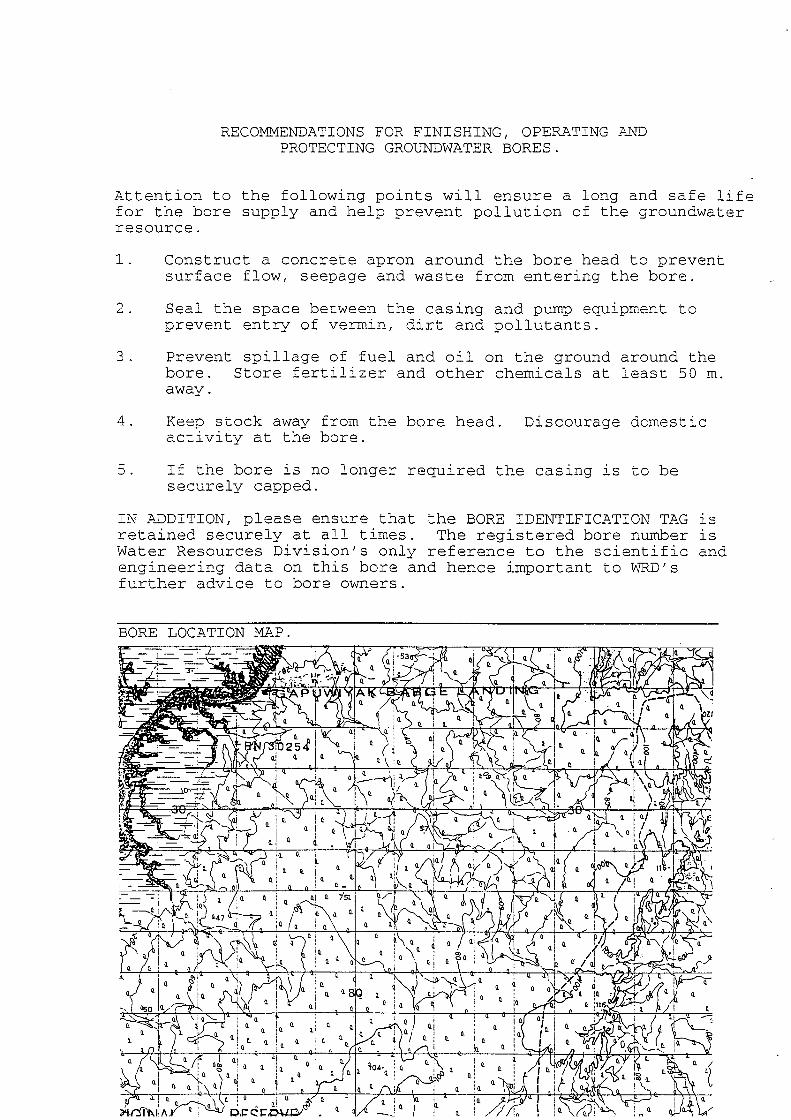
RECOMMENDATIONS FOR FINISHING, OPERATING AND PROTECTING GROUNDWATER BORES.
Attention to the following points will ensure a long and safe life for the bore supply and help prevent pollution of the groundwater resource.
1. Construct a concrete apron around the bore head to prevent surface flow, seepage and waste from entering the bore.
2. Seal the space between the casing and pump equipment to prevent entry of vermin, dirt and pollutants.
3. Prevent spillage of fuel and oil on the ground around the bore. Store fertilizey and other chemicals at least 50 m. away.
4. Keep stock away from the bore head. activity at the bore.
Discourage domestic
5. If the bore is no longer required the casing lS to be securely capped.
IN P~DITION, please ensure that the BORE IDENTIFICATION TAG lS retained securely at all times. The registered bore number lS Water Resources Division's only reference to the scientific and engineering data on this bore and hence important to wKD's further advice to bore owners.
BORE LOCATION MP~P.

0
(/) 4 w 0:: 1-w :E z
~ 0
! 0 8
12
.& .& .&
~
X
X
X A
X XX
'>s~ X
X
X X
-'--~ -- -- -
1 10 CONSTANT DISCHARGE TEST
28.11.95
X X
...... .&
~
.& .& ...... .&
.&
.&
.&
.&
.& Recovery t /t1
.&
~ X Xx ) Q = 0.4 Lis. xx
f- xxxx~ ~ ~XXx''X .,.~
- -
100 1000 10000 TIME IN MINUTES BUNHUNARRA
RN 30254